drought assessment in the pampanga river basin, the ... · angat dam (b) with trans-basin tunnels...
TRANSCRIPT

Drought assessment in the Pampanga River basin, the Philippines – Part 1: Characterizing a role of dams in
historical droughts with standardized indices
M.A. Gusyeva, A. Hasegawaa, J. Magomeb, D. Kuribayashia, H. Sawanoa and S. Leec
a International Centre for Water Hazard and Risk Management (ICHARM) under the auspices of UNESCO, Public Works Research Institute (PWRI), Tsukuba, Japan
b International Research Centre for River Basin Environment (ICRE), Interdisciplinary Graduate School of Medicine and Engineering, University of Yamanashi, Japan
c National Urban Disaster Management Research Center, Land Management and Urban Research Division, Korea Research Institute for Human Settlements, Republic of Korea
Email: [email protected]; [email protected]
Abstract: Droughts are frequent disasters in the Philippines with the most severe 1998 drought, which caused food shortages nationwide and major losses of rice production in the Pampanga River basin. For the Pampanga River basin, irrigated rice agriculture contributes about 30% of the rice production in the Philippines and relies on the complex water infrastructure system consisting of barrages, irrigation canals, Pantabangan and Angat multi-purpose dams, and trans-basin tunnels to increase inflows into these two dams. Both Pantabangan and Angat dams supply irrigation water for both wet and dry season rice production, which did not exist prior to the construction of these two dams, while the Angat dam supplies water to the Metro Manila City with population of about 12 million people.
We conducted drought assessment with standardized indices in the Pampanga River basin by characterizing historical droughts (Part 1), introducing a comparative approach of standardized indices for climate change quantification (Part 2), and evaluating climate change impacts (Part 3). In Part 1, we computed standardized indices with collected field data (i.e., precipitation, reservoir inflows and water volumes, and dam discharges) to identify natural and socio-economic droughts at the Pantabangan and Angat dams. We utilized the standardized precipitation index (SPI) to characterize meteorological droughts and developed a standardized inflow index (SII) from reservoir inflows for hydrological drought assessment. To characterize socio-economic droughts, we developed a standardized reservoir storage index (SRSI), which was computed with reservoir inflow and water volume data, and compared SRSI values with standardized discharge index (SDI) values, which were estimated from dam discharges that were released to meet irrigation and municipal water demands.
From the results of our drought assessment, we identified several meteorological, hydrological and socio-economic droughts between 1980 and 2012 with standardized indices. The use of several standardized indices allows us to identify the most extreme conditions based on the combined meteorological, hydrological and socio-economic droughts. The newly developed SII and SRSI indices match historical natural and socio-economic droughts in the Pampanga river basin and reflect increased inflows in the Pantabangan dam after the construction of trans-basin tunnel. As a result, the full-set of standardized indices represents the existing dam infrastructure and operation and could also be utilized for drought forecasting in the Pampanga river basin.
Keywords: Pantabangan dam, Angat dam, natural drought, socio-economic drought, standardized inflow index (SII), standardized reservoir storage index (SRSI)
21st International Congress on Modelling and Simulation, Gold Coast, Australia, 29 Nov to 4 Dec 2015 www.mssanz.org.au/modsim2015
1586
Gusyev et al., Drought assessment in the Pampanga River basin, the Philippines - Part 1: Characterizing a role of dams in historical droughts with standardized indices
1. INTRODUCTION
Despite many existing drought assessment approaches, there is still no universally applicable method to describe all drought related processes due to complexity of drought phenomena (Mishra and Singh, 2010). In many instances, a natural drought is defined as a deviation of hydro-meteorological parameters (e.g., precipitation, soil moisture, river flow, groundwater level) from a pre-selected normal condition. The deviation from “normal” state of the system allows us to characterize drought duration, which is the time when the parameter is below the threshold, and drought intensity by the magnitude of the deviation (Yevjevich, 1967). A shortage of weather-related water supply is usually caused by a deviation of precipitation, soil moisture and river discharge that constitute meteorological, agricultural and hydrological droughts, respectively (Smakhtin and Schipper, 2008). To incorporate a human dimension, socio-economic drought is defined as a lack of weather-related water supply (or natural drought) to meet anthropogenic water demand for domestic, industrial and agricultural activities (Yevjevich, 1967; Mishra and Singh, 2010).
Characterizing droughts with standardized indices is an attractive approach due to consistent and flexible methodology developed by McKee et al. (1993) and many standardized indices have been introduced with a particular set of input parameters (e.g., Shukla and Wood, 2008; Nalbantis and Tsakiris, 2008; Dai, 2011; Telesca et al., 2012; Bloomfield and Marchant, 2013). For example, a standardized precipitation index (SPI) characterizes meteorological droughts (McKee et al., 1993) and a standardized streamflow index (SSI) - hydrological droughts (Telesca et al., 2012). However, the socio-economic drought characterization is a challenging task due to unavailability of appropriate standardized index that accounts for water imbalance between anthropogenic water demands and reduced weather-related water supply. In addition, a standardized index is needed to support the reservoir water storage evaluation.
In this study, we attempt to characterize socio-economic droughts at the Pantabangan and Angat dams by the use of several standardized indices. These two dams are located in headwaters of the Pampanga River basin and are main sources of water supply to the downstream areas. For natural droughts, we compute SPI from observed precipitation and introduce a standardized inflow index (SII) to describe variability of reservoir inflows. To characterize socio-economic droughts, we introduce a standardized reservoir storage index (SRSI), which includes reservoir inflows and available water storage, and compare SRSI with a standardized discharge index (SDI), which estimated from observed dam discharges. Using the full-set of standardized indices we compare identified droughts at two dams with historical water shortages in downstream areas.
2. STUDY AREA
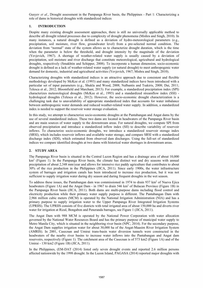
The Pampanga River basin is situated in the Central Luzon Region and has a drainage area of about 10,000 km2 (Figure 1). In the Pampanga River basin, the climate has distinct wet and dry seasons with annual precipitation of about 2,348 mm/year and allows for intensive rice paddy agriculture that contributes to about 30% of the rice production in the Philippines (JICA, 2011). Since early 1900s, the water infrastructure system of barrages and irrigation canals has been introduced to increase rice production, but it was not sufficient to supply irrigation water during dry season and during frequent droughts in the wet season.
To address these issues, the Pantabangan dam was commissioned in 1974 to drain 937 km2 of Nueva Ejica headwaters (Figure 1A) and the Angat Dam - in 1967 to drain 546 km2 of Bulacan Province (Figure 1B) in the Pampanga River basin (JICA, 2011). Both dams are multi-purpose dams including flood control and electricity production while their primary water supply purpose is different. The Pantabangan Dam with 2,966 million cubic meters (MCM) is operated by the National Irrigation Administration (NIA) and has a primary purpose to supply irrigation water to the Upper Pampanga River Integrated Irrigation Systems (UPRIIS). The UPRIIS consists of five districts with total irrigated area of about 150,000 ha and diverts river water for irrigation at Rizal, Bongabon and Peneranda barrages, see Figure 1 (JICA, 2011).
The Angat Dam with 988 MCM is operated by the National Power Corporation with water allocation governed by the National Water Resources Board and has the primary purpose of municipal water supply to Metro Manila City, which is situated in the neighboring river basin (NPC, 2014). For the secondary purpose, the Angat Dam supplies irrigation water for about 30,000 ha of the Angat-Maasim River Irrigation System (AMRIS). In 2001, Casecnan and Umirai trans-basin water diversion tunnels were constructed in the headwaters of the nearby river basins to increase water inflows into the Pantabangan and Angat dam reservoirs, respectively (Figure 1). The catchment area of the Casecnan is of 573 km2 (Figure 1A) and of the Umirai - 130 km2 (Figure 1B) (JICA, 2011).
In the Philippines, (EM-DAT (2014) listed only seven drought events and reported 2.6 million persons affected nationwide by the 1998 drought. In the Luzon Island, PAGASA (2014) reported major droughts with
1587

Gusyev et al., Drought assessment in the Pampanga River basin, the Philippines - Part 1: Characterizing a role of dams in historical droughts with standardized indices
socio-economic impacts in 1968-1969, 1972-1973, 1982-1983, 1987, 1989-1990, 1991-1992, and 1997-1998 for the period from 1968 to 1998. The 1998 drought completely damaged 290,000 ha of rice and corn area caused losses of 622,108 million tonnes (Mt) of rice and 565,240 Mt of corn (PAGASA, 2014). In the Pampanga river basin, the 1998 drought affected 16,106 ha of rice paddies and caused rice production losses of 23,000 Mt (BAS, 2013).
In our assessment, we selected Pantabangan and Angat dams as study sites and conducted field surveys in 2013 and 2014 to collect hydro-meteorological and socio-economic data in the Pampanga River basin, the Philippines. From offices of Pantabangan and Angat, we obtained daily precipitation, reservoir inflow, reservoir water volume, dam water discharge, and trans-basin inflow data (PDO, 2013; NPC, 2014). From NIA, we collected historical cropping calendars of AMRIS and UPRIIS as well as planned and actual irrigated areas of the wet and dry seasons from 1989 to 2012. In addition, AMRIS provided monthly averages of estimated irrigation diversion requirement (IDR) and of diverted water record at the Bustos barrage between 2000 and 2012 (AMRIS, 2014). The Philippine Atmospheric, Geophysical and Astronomical Services Administration (PAGASA) provided 3-month SPI values estimated with 57-year data at PAGASA long-term rainfall stations (PAGASA, 2014).
3. METHODOLOGY
3.1. Drought characterization
We characterized natural and socio-economic droughts with standardized indices, see Figure 2. For the natural droughts, SPI identified meteorological droughts and SII represented hydrological droughts. The socio-economic droughts were characterized with SRSI and SDI. These standardized indices have the same range of values indicating wet climates with positive values and dry climates with negative values: “near normal” up to -0.99, “moderate drought” from -1.0 to -1.49, “severe drought” from -1.50 to -1.99, and “extreme drought” from -2.0 (McKee et al.,1993). These negative values of standardized indices were utilized to identify severity of natural and socio-economic droughts. Comparing historical discharges and water demands allowed us to determine suitability of SRSI and SDI for the socio-economic drought assessment.
3.2. Standardized indices
We estimated standardized indices using WMO (2012) code with different input parameters. The monthly total precipitation was used as an input for the SPI computation (McKee et al., 1993). In a similar fashion, we utilized monthly total reservoir inflows, Vin [MCM], as an input for SII. Monthly precipitation and inflow totals were obtained by adding daily precipitation and reservoir inflow data, respectively. To illustrate the importance of diversion inflows, SII values are computed without Casecnan inflows for the Pantabangan dam. For the SRSI calculation input, we added the same inflows, Vin, and an average reservoir water volume,
Figure 2. Drought characterization with standardized indices.
Figure 1. National Irrigation Administration (NIA) irrigation districts and infrastructure, and Pantabangan dam (A) and Angat dam (B) with trans-basin tunnels in the Pampanga
River basin, the Philippines.
1588

Gusyev et al., Drought assessment in the Pampanga River basin, the Philippines - Part 1: Characterizing a role of dams in historical droughts with standardized indices
Vrs [MCM]. In addition, we combined Pantabangan and Angat daily discharges into monthly totals for estimating SDI in a similar way as SII.
In the WMO (2012) code, these input data were fitted with Gamma distribution using coefficients by Thom (1966) to compute cumulative distribution function (CDF) (McKee et al., 1993). These CDFs were converted to Z-score distributions (McKee et al., 1993) to obtain standardized indices (SPI, SII, SRSI and SDI). These equations are demonstrated by Hasegawa et al. (2015) and are not repeated here. For the code output, we computed standardized indices for the 1-, 3-, 6-, 9- and 12-month time steps.
3.3. Irrigation Water Demand estimation
A simple approach was selected based on available data for the IWD [L3/T] estimation:
IWD = IA x IDR= IA x (Kc x ETo – ER) / IE (1)
where IA[L2] is the irrigated area, IDR[L/T] is the irrigation diversion requirement, ETo[L/T] is the reference crop evapotranspiration, Kc[-] is the crop coefficient, ER[L/T] is the effective rainfall and IE[-] is the irrigation system efficiency. Monthly IWD values were estimated for the period from January 1991 to December 1999 by multiplying two monthly time-series of estimated IDR and historical NIA irrigated area. The ETo values were estimated from simplified equation by Cuenca (1989) using only limited data such as pan evaporation, relative humidity, and wind speed. The Penman-Monteith equation (FAO, 1998) could not be used due to lack of local observed meteorological data. To estimate Kc values, we utilized UPRIIS data to prepare a representative cropping calendar for regular dry (December to April) and regular wet (June to October) seasons. From the representative cropping calendar, the Kc values were estimated from FAO (1998) with number of days for each rice growing stage: seedling, newly planted, vegetative, reproductive and maturing. The irrigation efficiency was obtained from NIA (AMRIS, 2014). Gusyev et al. (2015) implemented equation (1) in the BTOP model to simulate Pantabangan and Angat operation discharges.
4. RESULTS AND DISCUSSION
4.1. Standardized indices droughts
Figure 3 demonstrates 3-month standardized indices for the Pantabangan and Angat dams. For meteorological droughts, 3-month SPI values demonstrate extreme droughts of the Pantabangan dam in 1983, 1988, 1991, 1997 and 1998 (Figure 3A) and of the Angat dam in 1991, 1992, 1993, 1997 and 2010 (Figure 3B). From 3-month SPI results, we observe a similar timing of meteorological drought occurrences at both dams while the drought severities are slightly different. According to the lowest 3-month SPI values in Figure 3, the Pantabangan dam experienced the most severe meteorological drought in 1988 and the Angat dam in 2010. These 3-month SPI results show a similar timing and magnitude with 3-month SPI values, which were estimated by PAGASA (2014) using long-term precipitation data between 1951 and 2012. From PAGASA (2014) data, the 3-month SPI values are below -2.0 indicating extreme drought in 1983 and 2002, and are about -1.8 indicating severe drought in 1987 and 2004 for the Nueve Ecija and Bulacan provinces. In addition, moderate droughts are reported by 3-moth SPI values of about -1.2 (September 1998), -1.4 (October 2004), and -1.1 (October 2010) (PAGASA, 2014).
For hydrological droughts, 3-month SII values of Pantabangan dam follow the 3-month SPI pattern of extreme drought occurrences while 3-month SII values of Angat dam have slightly higher drought severities in 1987, 1988, 1997 and 1998. For both dams, SII values are more negative without inflows of trans-basin tunnels for both dams. The influence of trans-basin inflows via Casecnan tunnel is demonstrated for the case of Pantabangan dam (Figure 3A). In Figure 3A, 3-month SII values demonstrate an increasing trend from 2002. Comparing 3-month SII with and without trans-basin inflows in Figure 3A, SII values indicate more frequent and severe hydrological droughts between 2002 and 2012, which demonstrate the importance of trans-basin inflows.
To characterize socio-economic droughts, 3-month SRSI values are demonstrated in Figure 3. For the Pantabangan dam, 3-month SRSI values indicate extreme droughts in 1983-1984, 1987, and 1988 as well as a severe drought in March-April 1998 with SRSI value of about -1.8. The 3-month SDI values indicate extreme droughts in 1983-1984, 1988, 1996, 1998 and 2002, severe drought in 1990, and moderate droughts in 1992, 1994 and 1996 (Figure 3A). In the case of Angat dam, 3-month SRSI values demonstrate extreme droughts in 1992, 1997-1998 and 2010, severe droughts in 1989 and 1993, and moderate droughts in 1983, 2004, and 2005. In both dams, drought values of 3-month SRSI have a time lag and compared with drought values of 3-
1589

Gusyev et al., Drought assessment in the Pampanga River basin, the Philippines - Part 1: Characterizing a role of dams in historical droughts with standardized indices
month SII. For example, 3-month SII value of -1.52 indicates moderate drought in November 1998 while 3-month SRSI value of -1.97 is the lowest in April 1998, see Figure 3A.
Figure 3. Standardized indices of 3-month step for the Pantabangan (A) and Angat (B) dams.
It is important to note that the 3-month SRSI values may be uncorrelated with 3-month SPI and SII values. This is due to the fact that low SPI and SII values do not represent available reservoir water, which can be used to meet the water demand during meteorological and hydrological droughts. For example, 3-month SRSI value of 1.1 indicates moderately available water supply in June 1991 at the Pantabangan dam while 3-month SPI and SII values indicate extreme and moderate droughts, respectively (Figure 3A). It is also important to note that the opposite is possible. For the Angat dam, both 3-month SPI and SII values are about -0.5 indicating near normal conditions in May 2004 while 3-month SRSI value is about -1.4, which indicates moderate drought (Figure 3B). This pattern occurs due to high water discharges from the Angat dam to meet irrigation and municipal water demands as demonstrated by 3-month SDI values of about -1.9 in July 2004 (Figure 3B). Both 3-month SDI values show a sharp decline from January to July 2004 indicating heavy water discharges from the Angat dam and fall below SRSI value of -1.8. This indicates that 3-month SRSI values are suitable for the socio-economic drought evaluation of water supply infrastructure. In addition, the use of several standardized indices allows us to identify the most extreme drought conditions based on the combined meteorological, hydrological and socio-economic droughts.
4.2. Historical socio-economic droughts
Despite many natural droughts reported in the Pampanga River basin by PAGASA (2014), only several socio-economic droughts have been identified. The 1983 drought is not investigated due to the absence of local data at the Pantabangan and Angat dams. For the Pantabangan dam, the 1998 drought had a social-economic impact and is compared with normal operation during the 1992 drought (Figure 4). In Figure 4A, the Pantabangan effective water storage is 50% of its full capacity at the begging of the 1991-1992 dry season and is sufficient to irrigate 79,292 ha. For the 1997-1998 dry season, the Pantabangan effective water storage is 20% of its capacity at the beginning of dry season and only 48,484 ha are schedule for irrigation, see Figure 4B. In April 1998, the reservoir is exhausted at the end of dry season resulting in the affected irrigated area of 44,293 ha, see shaded area in Figure 4B. For the 1998 socio-economic drought, BAS (2013) reported affected irrigation area of 10,210 ha and totally damaged area of 1,325 ha in the Nueva Ejica province of the Pampanga River Basin. The discrepancy between the estimated and historical affected area are likely due to the overestimation of the IDR values using monthly time steps and/or underreporting of the affected area in Nueva Ejica province by BAS (2013).
For the Bulacan province, the Angat Dam has experienced similar depleted conditions resulting in socio-economic droughts in 1998, 2004, and 2010. In the November 1997, the Angat reservoir did not have enough water to provide irrigation discharges and the decision was made not to plant rice for dry season (AMRIS,
1590

Gusyev et al., Drought assessment in the Pampanga River basin, the Philippines - Part 1: Characterizing a role of dams in historical droughts with standardized indices
2014). As result, the Angat Dam did not supply any water for the dry and wet seasons of 1998 except in December 1997. As a result, BAS (2013) reported only 4,396 ha of affected irrigation area and 1,896 ha totally damaged for the Bulacan province. However, Pascua (2007) estimated that this decision affected about 22,000 farmers of Bulacan Province resulting in potential economic losses of about 20 million US$ for Bulacan farmers and of about 0.6 million US$ for AMRIS due to uncollected irrigation service fees. To alleviate these consequences of the 1998 socio-economic drought, Bulacan farmers were contracted by AMRIS to clear and improve irrigation efficiency of AMRIS canal system (AMRIS, 2014). In 2004 and 2010, the Angat dam situation of water discharges was similar to Pantabangan dam in 1998. The reservoir water volume had fallen short towards the end of dry season and no water was discharged for the wet season rice cultivation from May to August in 2004 and 2010 (AMRIS, 2014). In 2004, Pascua (2007) reported that about 5,000 ha of rice paddies were not planted and 11,000 ha had rice production losses during the wet season in 2004. From these results, our drought assessment with standardized indices has demonstrated the significance of local data in historical socio-economic drought characterization.
Figure 4. The Pantabangan Dam natural drought in 1992 (A) and socio-economic drought in 1998 (B).
5. CONCLUSIONS
In this study, natural and socio-economic drought assessment was conducted with standardized indices for the Pantabangan and Angat dams and compared to historical droughts in the Pampanga River, the Philippines. In our methodology, the socio-economic drought was defined as water shortage between water supply and demand sides using collected data of Pantabangan and Angat dams. For the drought assessment, we utilized 3-month SPI values to characterize meteorological droughts and developed standardized inflow index (SII) for hydrological droughts. To characterize socio-economic droughts, we introduced standardized reservoir storage index (SRSI) to identify available water at the Pantabangan and Angat dams. In addition, standardized discharge index (SDI) was estimated from dam discharges that were released to meet irrigation and municipal water demands.
From standardized indices, we identified several meteorological, hydrological and socio-economic droughts between 1980 and 2012. Out of many natural droughts, we observed only a few socio-economic droughts due to the available water in Pantabangan and Angat reservoirs. The construction of trans-basin tunnels was reflected by SII and SRSI wherein more water became available in both dams. The newly developed SRSI index matched historical droughts and allowed us to evaluate socio-economic in the NIA UPRIIS and AMRIS irrigated areas. The use of multiple standardized indices allowed us to identify the most extreme conditions based on the combined meteorological, hydrological and socio-economic droughts. In future climates, natural droughts may further reduce inflows into reservoirs while anthropogenic water demand may increase due to population growth, industrial development and agricultural area expansion. Therefore, Part 2 investigates the use of standardized indices under climates change and Part 3 of this study evaluates climate change impacts on the two dams using BTOP model.
ACKNOWLEDGEMENT
This work was conducted under the framework of the “Precise Impact Assessments on Climate Change” of the Program for Risk Information on Climate Change (SOUSEI Program) supported by the Ministry of Education, Culture, Sports, Science, and Technology-Japan (MEXT). We thank two Anonymous Reviewers and Dr. A. Sugiura for their useful and constructive comments that greatly improved this manuscript.
1591

Gusyev et al., Drought assessment in the Pampanga River basin, the Philippines - Part 1: Characterizing a role of dams in historical droughts with standardized indices
REFERENCES
Angat-Maasim River Irrigation System (AMRIS) (2014). Irrigation water demand data. AMRIS, National Irrigation Administration (NIA), Bulacan, the Philippines. Personal Communication.
Bloomfield, J.P., and B.P. Marchant (2013). Analysis of groundwater drought building on the standardized precipitation index approach. Hydrol. Earth Syst. Sci. 17: 4769-4787
Cuenca, R.H. (1989). Irrigation system design: An engineering approach, Prentice-Hall, N.J.
Dai, A. (2011). Drought under global warming: A review. WIREs Climatic Change 2: 45–65.
EM-DAT (2014). The OFDA/CRED International Disaster Database. Université Catholique de Louvain, Brussels, Belgium, www.emdat.be, Accessed in 2014.
Food and Agriculture Organization (FAO) (1998). Crop Evapotranspiration. FAO 56 Irrigation and Drainage Paper. FAO of the United Nations, Rome, Italy, 286 p.
Gusyev, M.A., A. Hasegawa, J. Magome, H. Umino, and H. Sawano (2015). Drought assessment in the Pampanga River basin, the Philippines – Part 3: Evaluating climate change impacts on dam infrastructure with standardized indices. In Proceedings of the 21st International Congress on Modelling and Simulation (MODSIM 2015), November 29th – December 4th, Queensland, Australia.
Japan International Cooperation Agency (JICA) (2011). The study on integrated water resources management for poverty alleviation and economic development in the Pampanga River basin. Final Report for the National Water Resources Board, the Republic of the Philippines, Volume I, JICA, Japan, 137 p.
Hasegawa, A., M.A. Gusyev, T. Ushiyama, J. Magome, and Y. Iwami (2015). Drought assessment in the Pampanga River basin, the Philippines – Part 2: A comparative SPI approach for quantifying climate change hazards. In Proceedings of MODSIM 2015, November 29th – December 4th, Queensland, Australia.
Mishra, A.K. and V.P. Singh (2010). A review of drought concepts. Journal of Hydrology 391: 202-216.
McKee, T.B., N.J. Doesken, and J. Kleist (1993). The relationship of drought frequency and duration to time scales. American Meteorological Society, In Proceedings of the 8th Conference on Applied Climatology 17 (22): 179-183.
National Power Corporation (NPC) (2014). Angat dam hydrological data. Angat Dam Office, Bulacan, the Philippines. Personal Communication.
Nalbantis, I., and G. Tsakiris (2008). Assessment of Hydrological Drought Revisited, Water Resources Management, 23 (5), 881–897.
Philippine Atmospheric, Geophysical and Astronomical Services Administration (PAGASA) (2014). 3-month Standardized Precipitation Index (SPI) and other drought related data. Metro Manila, the Philippines. Personal Communication.
Pantabangan Dam Office (PDO) (2013). Pantabangan dam hydrological data. Dam and Reservoir Division, Upper Pampanga River Integrated Irrigation Systems (UPRIIS), National Irrigation Administration (NIA). Nueva Ejica, the Philippines. Personal Communication.
Pascuea, D.D. (2004). Water Allocation Between Irrigation and Municipal Use. 4th INWEPF Steering Meeting and Symposium.
Shukla, S. and A.W. Wood (2008). Use of standardized runoff index for characterizing hydrological drought. Geophys. Res. Lett. 35, L02405.
Smakhtin, V.U. and E.L. Schipper (2008). Droughts: The impact of semantics and perceptions, Water Policy 10: 141-143.
Thom, H.C.S (1958). A note on gamma distribution. Monthly Weather Review 86 (4): 117-122.
Telesca, L., M. Lovallo, I. Lopez-Moreno, and S. Vicente-Serrano (2012). Investigation of scaling properties in monthly streamflow and Standardized Streamflow Index (SSI) time series in the Ebro basin (Spain). Physica A: Statistical Mechanics and its Applications 391(4): 1662-1678.
World Meteorological Organization (WMO) (2012). Standardized Precipitation Index User Guide (M. Svoboda, M. Hayes, and D. Wood). WMO-No. 1090, Geneva.
Yevjevich, V. (1967). An objective approach to definitions and investigations of continental hydrologic droughts. Hydrology Papers 23, Colorado State University, Fort Collins, Colorado.
1592