drayton hall: archaeology at the privy, 2007...lynn lewis, trust senior archaeologist, generously...
TRANSCRIPT

Drayton Hall: Archaeology at the
Privy, 2007 Martha A. Zierden
Ronald W. Anthony
Archaeological Contributions 40 The Charleston Museum
June 2008

ii
Drayton Hall: Archaeology at the Privy, 2007
By Martha A. Zierden
And Ronald W. Anthony The Charleston Museum
Under the Direction of
Carter C. Hudgins Matthew Webster
Lynn G. Lewis Drayton Hall, National Trust for Historic Preservation
College of Charleston/The Charleston Museum Archaeological Field School 2007
Archaeological Contributions 40
The Charleston Museum June 2008

iii
Table of Contents Chapter I: Introduction Exploration of the Privy Building . . . . . . . . . . . . . . . . . . . . . . . . . . . . . 2 1980 Exploration of the Privy . . . . . . . . . . . . . . . . . . . . . . . . . . . . . 3 Historic Structures Analysis . . . . . . . . . . . . . . . . . . . . . . . . . . . . . . . . . . . 5 Plan of Work . . . . . . . . . . . . . . . . . . . . . . . . . . . . . . . . . . . . . . . . . . . . . . . 6 Chapter II: Archaeological and Historical Background Site Description . . . . . . . . . . . . . . . . . . . . . . . . . . . . . . . . . . . . . . . . . 7 Development of Drayton Hall . . . . . . . . . . . . . . . . . . . . . . . . . . . . . 9 Previous Archaeological Research . . . . . . . . . . . . . . . . . . . . . . . . . . . . . 14 Chapter III: Fieldwork General Field Methods . . . . . . . . . . . . . . . . . . . . . . . . . . . . . . . . . . . 17 Description of Excavated Proveniences. . . . . . . . . . . . . . . . . . . . . . . . . . . 19 Chapter IV: Analysis of the Materials Laboratory Methods . . . . . . . . . . . . . . . . . . . . . . . . . . . . . . . . . . . . . . . . . 35 Analysis . . . . . . . . . . . . . . . . . . . . . . . . . . . . . . . . . . . . . . . . . . . . . . . 35 Early 19th Century Proveniences . . . . . . . . . . . . . . . . . . . . . . . . . . . . . 37 Late 19th to 20th Century Assemblage . . . . . . . . . . . . . . . . . . . . . . . . . . . . . 50 Chapter V: Interpretations Occupational History and Material Culture . . . . . . . . . . . . . . . . . . . . . . . 61 Operation of the Privy . . . . . . . . . . . . . . . . . . . . . . . . . . . . . . . . . . . 64 Colono Ware . . . . . . . . . . . . . . . . . . . . . . . . . . . . . . . . . . . . . . . . . . . . . . . 68 Project Summary . . . . . . . . . . . . . . . . . . . . . . . . . . . . . . . . . . . . . . . . . 73 References Cited . . . . . . . . . . . . . . . . . . . . . . . . . . . . . . . . . . . . . . . . . . . . . . . 77

iv
List of Figures
1. Aerial view of Drayton Hall . . . . . . . . . . . . . . . . . . . . . . . . . . . . . . . . . . 1 2. Views of the privy building . . . . . . . . . . . . . . . . . . . . . . . . . . . . . . . . . 3 3. Map of 1980 excavations, 2007 excavations . . . . . . . . . . . . . . . . . . . . . . 4 4. Lewis Gibbes sketch of privy . . . . . . . . . . . . . . . . . . . . . . . . . . . . . . . . . . 5 5. U.S.G.S. topographic map, showing Drayton Hall . . . . . . . . . . . . . . . . 7 6. View of Drayton Hall and reflecting pond . . . . . . . . . . . . . . . . . . . . . . 8 7. Charles Drayton’s sketch map . . . . . . . . . . . . . . . . . . . . . . . . . . . . . . . . . . 10 8. Plan of fields and gardens by Charles Drayton . . . . . . . . . . . . . . . . . . . . . . 11 9. Early 20th century view of west lawn . . . . . . . . . . . . . . . . . . . . . . . . . . . . 12 10. Early 20th century view of main house . . . . . . . . . . . . . . . . . . . . . . . . . . . . 13 11. Beginning excavations . . . . . . . . . . . . . . . . . . . . . . . . . . . . . . . . . . . . . . . . 17 12. Screening and backdirt management . . . . . . . . . . . . . . . . . . . . . . . . . . . . 18 13. Training students on total station . . . . . . . . . . . . . . . . . . . . . . . . . . . . . . . . . . 18 14. Beginning excavation on north façade . . . . . . . . . . . . . . . . . . . . . . . . . . . . 19 15. Features and units on east façade . . . . . . . . . . . . . . . . . . . . . . . . . . . . 20 16. Full exposure of feature 7 . . . . . . . . . . . . . . . . . . . . . . . . . . . . . . . . . . 21 17. Excavation of feature 7 . . . . . . . . . . . . . . . . . . . . . . . . . . . . . . . . . . . . . . . . 22 18. Unit DH 138 . . . . . . . . . . . . . . . . . . . . . . . . . . . . . . . . . . . . . . . . . . . . . . 23 19. Feature 1, feature 22 . . . . . . . . . . . . . . . . . . . . . . . . . . . . . . . . . . . . . . . . 24 20. Feature 4 . . . . . . . . . . . . . . . . . . . . . . . . . . . . . . . . . . . . . . . . . . . . . . . . . . . . 25 21. Unit DH 149 . . . . . . . . . . . . . . . . . . . . . . . . . . . . . . . . . . . . . . . . . . . . . . 26 22. Unit DH 137, 1980 excavations . . . . . . . . . . . . . . . . . . . . . . . . . . . . . . . . . . 27 23. Profile, planview, terminus of ditch 2 . . . . . . . . . . . . . . . . . . . . . . . . . . . . 28 24. Features 11 and 17 . . . . . . . . . . . . . . . . . . . . . . . . . . . . . . . . . . . . . . . . 29 25. Cleaning ditch 2, feature 23 . . . . . . . . . . . . . . . . . . . . . . . . . . . . . . . . . . 30 26. Excavations completed . . . . . . . . . . . . . . . . . . . . . . . . . . . . . . . . . . . . . . . . 30 27. Site map of units and major features . . . . . . . . . . . . . . . . . . . . . . . . . . . . 31 28. White saltglazed stoneware . . . . . . . . . . . . . . . . . . . . . . . . . . . . . . . . . . 38 29. Examples of Chinese Export Porcelain . . . . . . . . . . . . . . . . . . . . . . . . . . . . 39 30. Creamware . . . . . . . . . . . . . . . . . . . . . . . . . . . . . . . . . . . . . . . . . . . . . . 40 31. Pearlware . . . . . . . . . . . . . . . . . . . . . . . . . . . . . . . . . . . . . . . . . . . . . . 40 32. North Devon gravel tempered ware . . . . . . . . . . . . . . . . . . . . . . . . . . . . 41 33. Buckley earthenware . . . . . . . . . . . . . . . . . . . . . . . . . . . . . . . . . . . . . . . . 41 34. Brown saltglazed stoneware . . . . . . . . . . . . . . . . . . . . . . . . . . . . . . . . . . 43 35. Westerwald stoneware . . . . . . . . . . . . . . . . . . . . . . . . . . . . . . . . . . . . . . . . 43 36. Example of colono ware . . . . . . . . . . . . . . . . . . . . . . . . . . . . . . . . . . . . . . . . 43 37. Olive green bottle glass . . . . . . . . . . . . . . . . . . . . . . . . . . . . . . . . . . . . . . . . 44 38. Examples of earthenwares . . . . . . . . . . . . . . . . . . . . . . . . . . . . . . . . . . 44 39. Goblet base from feature 4 . . . . . . . . . . . . . . . . . . . . . . . . . . . . . . . . . . 45 40. Window glass without degradation . . . . . . . . . . . . . . . . . . . . . . . . . . . . 47 41. Delft tile fragments . . . . . . . . . . . . . . . . . . . . . . . . . . . . . . . . . . . . . . . . 47

v
42. Clothing items . . . . . . . . . . . . . . . . . . . . . . . . . . . . . . . . . . . . . . . . . . . . . 48 43. Brass adornment . . . . . . . . . . . . . . . . . . . . . . . . . . . . . . . . . . . . . . . . . . . . . 48 44. Whetstone . . . . . . . . . . . . . . . . . . . . . . . . . . . . . . . . . . . . . . . . . . . . . 49 45. Yellow glass bead . . . . . . . . . . . . . . . . . . . . . . . . . . . . . . . . . . . . . . . 51 46. Adze . . . . . . . . . . . . . . . . . . . . . . . . . . . . . . . . . . . . . . . . . . . . . . . . . . . 53 47. Examples of whiteware . . . . . . . . . . . . . . . . . . . . . . . . . . . . . . . . . . . . . . . 53 48. Examples of ‘black’ glass . . . . . . . . . . . . . . . . . . . . . . . . . . . . . . . . . 54 49. 19th Century clear glass . . . . . . . . . . . . . . . . . . . . . . . . . . . . . . . . . . . . . . . 55 50. Glass cream jar . . . . . . . . . . . . . . . . . . . . . . . . . . . . . . . . . . . . . . . . . . . . . 55 51. “Victory” bottle . . . . . . . . . . . . . . . . . . . . . . . . . . . . . . . . . . . . . . . . . . . . . 55 52. Tin can lid in situ . . . . . . . . . . . . . . . . . . . . . . . . . . . . . . . . . . . . . . . 56 53. Chimney lamp glass . . . . . . . . . . . . . . . . . . . . . . . . . . . . . . . . . . . . . . . 56 54. Views of privy from Lewis Gibbes . . . . . . . . . . . . . . . . . . . . . . . . . . . 62 55. Soil profile from drain excavation . . . . . . . . . . . . . . . . . . . . . . . . . . . 63 56. Interface of vault opening and brick drain . . . . . . . . . . . . . . . . . . . . . 64 57. Soil profile in ditch 5 . . . . . . . . . . . . . . . . . . . . . . . . . . . . . . . . . . . . . . . 65 58. Terminus of drain . . . . . . . . . . . . . . . . . . . . . . . . . . . . . . . . . . . . . . . 65 59. Water feature on Charles Drayton’s sketch . . . . . . . . . . . . . . . . . . . . . 66 60. Views of feature 7 . . . . . . . . . . . . . . . . . . . . . . . . . . . . . . . . . . . . . . . 66 61. Views of north façade, feature 4 . . . . . . . . . . . . . . . . . . . . . . . . . . . 67 62. Exceptional colono wares from Drayton Hall . . . . . . . . . . . . . . . . . . . . . 69 63. Historic period Native American pottery . . . . . . . . . . . . . . . . . . . . . 70 64. Lesesne lustered colono ware . . . . . . . . . . . . . . . . . . . . . . . . . . . . . . . . . 72 65. River burnished colono ware . . . . . . . . . . . . . . . . . . . . . . . . . . . . . . . . . 72 66. Completed excavation of drain system . . . . . . . . . . . . . . . . . . . . . . . . . . . 75
List of Tables 1. Provenience Guide . . . . . . . . . . . . . . . . . . . . . . . . . . . . . . . . . . . . . . . . 32 2. 19th Century Assemblages . . . . . . . . . . . . . . . . . . . . . . . . . . . . . . . . . . 49 3. Recent Artifacts from Zone 1 . . . . . . . . . . . . . . . . . . . . . . . . . . . . . . . . . . 51 4. Postbellum Assemblages . . . . . . . . . . . . . . . . . . . . . . . . . . . . . . . . . . 57 5. Quantification of the Assemblages . . . . . . . . . . . . . . . . . . . . . . . . . . . . 58 6. Feature 2 Assemblage . . . . . . . . . . . . . . . . . . . . . . . . . . . . . . . . . . . . . . . . 61 7. Feature 65B Assemblage . . . . . . . . . . . . . . . . . . . . . . . . . . . . . . . . . . 62 8. Feature 7 Assemblage . . . . . . . . . . . . . . . . . . . . . . . . . . . . . . . . . . . . . . . . 67 9. Colono ware quantification . . . . . . . . . . . . . . . . . . . . . . . . . . . . . . . . . . 71

vi
Acknowledgements
Archaeological exploration of the Drayton Hall privy was a joint field project of The Charleston Museum and the College of Charleston. The field school was directed by Dr. Barbara Borg of the College of Charleston and Martha Zierden and Ron Anthony of the Museum. Barbara directed all academic aspects of the course and was a valuable research companion in the field. It is always a pleasure to collaborate with Barbara.
The archaeological exploration of the privy was envisioned, developed, and directed by Dr. Carter Hudgins and Mr. Matthew Webster of the Preservation Division, Drayton Hall. Their vision for the building moved beyond the immediate stabilization needs to include detailed architectural, archaeological, and documentary research. Their goal was to revisit all of the physical evidence for interpretation of the building, from construction to changing use to current condition. It was a pleasure to be part of this visionary project. Prior to our arrival, Carter Hudgins re-established the grid and directed interns in the re-excavation of the 1980 units. During our project, he guided every aspect of the fieldwork and provided valuable training in use of the total station. After completion of the field school, he continued excavation of challenging units and returned the site to original condition. We enjoyed working with Carter on every aspect of the project. Richard Marks Restoration stabilized the building prior to excavations. Lynn Lewis, Trust Senior Archaeologist, generously shared her notes and expertise on the 1980 excavations, and on every aspect of Drayton Hall archaeology. She spent the first week in the field with us, and was invaluable in interpreting new finds and revisiting old proveniences. She provided training and background to the students, enriching their field school experience. The Drayton Hall staff made us welcome and helped us along the way. John Kidder, Buildings and Grounds Superintendant, solved many logistical problems and answered several questions about recent changes to the area. Craig Tuminaro, Director of Museum Interpretation, worked with us to enhance visitor interpretation of the excavations. Dr. George McDaniel, Executive Director, provided guidance and made us welcome, as always. Woods fellow Sarah Stroud and interns Jill Foster and Sarah Kidder worked with us throughout the project. We appreciate the help of youth volunteers Ashley Richardson and Caitlin Otto. The staff of The Charleston Museum supported the project throughout the field and lab work. As always, we appreciate the help of Dr. John Brumgardt, Director, Mr. Carl Borick, Assistant Director, and Ms. Vickie Styles, Administrative Services Officer. Laboratory analysis was directed by Ron Anthony, and conducted by experienced volunteers and student interns. Barbara Aldrich and Lee Stevens analyzed many of the proveniences, and Dr. William Turner completed conservation of non-ferrous metals.

vii
College of Charleston interns Thomas Meacher and Britton Williams washed and analyzed the material. The successful excavation project was due to the efforts of the students enrolled in the 2007 field school. We are grateful for the camaraderie, good humor, and hard work of the crew: Drew Beckham, Judi Bushell, Jeanna Crockett, Cara Frigerio, Christine Heacock, Jennifer McCormick, Thomas Meacher, Jessica Phillips, Daniel Robinson, Jennifer Self, and Jasmine Utsey.
Crewmember birthday cake, highlighting the privy dig. Features to scale include units on the north
(feature 4) and east (feature 7) sides, screening and backdirt station, and units DH 137/140.

1
Chapter I Introduction
Drayton Hall, owned and operated by the National Trust for Historic Preservation, is an important Charleston landmark for many reasons. Begun by John Drayton in 1738, the house passed through seven generations of the Drayton family before sale to the National Trust for Historic Preservation in 1975. The principal physical feature of the property, the plantation main house, was completed in the 1740s and is the oldest and finest surviving example of Georgian Palladian architecture in the southern United States (Lane 1996: 70-72; www.draytonhall.org). The Drayton family owned several cash-crop-producing tracts throughout colonial South Carolina and Georgia, but Drayton Hall served as a country seat for the family. Early 19th century owner Charles Drayton left detailed records that attest to his efforts as a horticulturalist and physician. The only Ashley River plantation spared during the Civil War, the house remained largely unaltered after 1875. The discovery of phosphate as a commercially viable material prior to the Civil War provided family income that paid for much-needed repair, but mining operations on the property compromised certain portions of the archaeological fabric even as it added new features to the historic landscape. Following the collapse of the phosphate industry, the house was used sporadically as a summer retreat. The African American population of the property dwindled, as families searched for other labor opportunities. The last owners, Charles and Frank Drayton, determined that private, non-profit ownership was in the best interest of the property. The house has been preserved, rather than restored, and has been operated as an historic house museum.
Figure 1: Aerial View of Drayton Hall. The Ashley River is at the top of the photo.

2
The role of archaeology in the preservation of a property such as Drayton Hall is two-fold. First, the archaeological record - the layers of soil and artifacts - is part of the total historic fabric, worthy of preservation. All standing structures have an associated archaeological component, whereas not all archaeological sites have extant architectural components. Further, the archaeological component is non-renewable, and is damaged or destroyed by any ground-disturbing activity. At the same time, the ground-altering activities of today, just as those of the 18th and 19th centuries, are part of the ongoing changes and additions to a continually occupied archaeological site.
Secondly, archaeological research is an additional source of broad interpretive data for an historic site, ranging from tangible artifacts and foundations to abstract ideas. The key word is interpretation, for current anthropological theory suggests that all types of data are subject to interpretation, to be read by many viewers. Archaeological data, like architectural data, documentary information, maps, plats, oral history, etc., contribute to a clearer understanding of a historical question, but archaeological answers do not supercede those from other disciplines. This site report, along with numerous other documents, artifacts, and reports, is one contribution to the multifaceted exploration of the evolution of Drayton Hall.
Exploration of the Privy Building
The Charleston Museum and the College of Charleston returned to Drayton Hall for two weeks in June 2007; this season focused on the privy building and the drainage system exposed by Trust Senior Archaeologist Lynn Lewis in 1980. Archaeological exploration of the ground around the privy at Drayton Hall was part of a larger historic structure analysis initiated by the Drayton Hall Preservation Department. Preservation Director Matt Webster supervised the overall project, and Carter Hudgins planned the archaeological component and managed the on-site activities. The purpose of the project was three-fold: 1. To assess structural failures of the 18th century privy’s foundation, chimney, and drainage system 2. To create a conservation work plan that specifically addresses those structural failures and mitigates the effect of that work on related underground features 3. to educate and train undergraduate students in the methodology of conducting archaeological and architectural investigations.
The excavation plan considered mitigation of any subsurface disturbance that might be
associated with assessment and stabilization of the above-ground fabric. The primary purpose, though, was to expose and interpret below-ground features relating to construction, function, and evolution of the building itself. The research builds on the work conducted by Lewis, specifically exposure of an extensive brick drain on the west side of the building.

3
Archaeologists Martha Zierden and Ron Anthony from The Charleston Museum returned
to Drayton Hall with students from the College of Charleston 2007 archaeological field school, directed by Barbara Borg. The field crew, consisting of 11 undergraduate students, arrived on site June 11 and remained in the field until June 25. Dr. Hudgins and various Drayton Hall interns conducted excavations prior to, and after the departure of, the field school. The field school experience included house tours, total station training, and rotation of small crews to Colonial Dorchester State Historic Site for survey experience. The equivalent of twenty excavation units were proposed; 14 were excavated. Hard-packed soil, afternoon storms, and complex stratigraphy hampered productivity. 1980 Exploration of the Privy In 1980, an archaeological crew directed by Lynn Lewis explored the privy building, by excavating test units inside and outside the privy building. The work was prompted by concerns about the conditions of the building and plans to stabilize the structure. Testing around the steps, prior to their stabilization, revealed that the entry steps were original. Excavations on the interior exposed a brick trough running along the back wall. This interior trough aligned with arched openings on the east and west sides of the building, and confirmed the function of the building as a privy. The back wall of the structure served as the wall for the trough, and the front (internal) wall was clearly original. Lewis further discovered that the northern portion of the structure foundation was deeper than the southern, to accommodate the trough. The trough featured a brick-lined bottom. The trough is 2’ wide and currently 2.5’ deep, but Lewis notes that the original floor and seating arrangement would have
Figure 2: the privy before excavation. View shows the east side of the building. The 19th century chimney stack is visible. Note also the electrical boxes and water lines along the eastern side of the structure.

4
made the trough deeper. Artifacts recovered from the trough fill included several fragments of whiteware, which Lewis interpreted as filling at the time of abandonment. Lewis’ excavations on the exterior were more extensive, and provided further documentation that the building was a privy. A brick drainage system initiated at the western arch, and continued northwest thirty-two feet. The drain was 2’ wide (3’ wide on the exterior), constructed of brick walls, six courses high, supporting a brick arch. Lewis did not excavate inside the drain, but suggests that the bottom was not brick-lined.
According to Lewis, the drain was not original, and abutted the foundation arch in ‘haphazard fashion’. Further, the construction trench for the drain contained a large number of artifacts, in contrast to the construction trench for the building itself, which contained almost none. An absence of refined earthenware in the construction trench (DH 65B) suggested that the feature was created before 1760. She further noted that drainage of the interior trough was poor, and that the brick drain was likely added to alleviate this situation. A small test near the arch on the eastern side did not reveal any brick features.
Lewis also noted that the western end of the drain was poorly defined. The bricks were uneven, and there was no immediate evidence of a cistern or further drainage feature. She did note that a large area appeared to have been dug out and filled with slag and gravel, to create a leaching field. The ultimate destination of the wastewater remained unknown.
Excavations along the north (back) side revealed another opening, this one a small, roughly rectangular hole punched into the brick foundation. The opening was roughly 1.0 by 1.5’, and was not finished. Dark soil continued to a bed of sterile white sand and intact phosphate rock. There was no clear evidence of the function of this breach, but Lewis proposed that it was created to allow flushing of the privy. Siltation of the soil feature suggested the area was left open for some time.
Lewis interpreted the building as contemporary with the main house, originally
functioning as a privy. She suggests the brick drain on the west side was installed between 1742 and 1765. Lewis’ excavations are highlighted in the figure below.
Figure 3: Map of excavations, directed by Lynn Lewis in 1980 (highlighted)

5
Historic Structure Analysis of the Privy At some point, likely in the late 19th century, the privy building was altered and its function changed. Sketches by Lewis R. Gibbes, made in 1846, suggest that the changes occurred after this date. Inside the building, the seats were removed and the floor replaced, with a change in the direction of the floorboards and in the height of the floor. A fireplace and chimney was added to the east side of the building, filling an original window. The roofline was reoriented, and apparently covered with wood shingles. Lewis speculates that the changes followed the earthquake of 1886. It was evidently used as an office during this period. Long time resident Richmond Bowens (born at Drayton Hall in 1908) resided in this building as a young man. The privy faces two immediate threats. These were noted shortly after the National Trust acquired Drayton Hall, and they have worsened in recent years. The chimney on the east side
has been settling, and is close to tilting outside of its center third, presenting great probability for failure. This failure would, in turn, cause significant damage to the eastern wall and roofing system of the original building. Secondly, the structure shows signs of water infiltration, noted by collapsing soil around the foundation and biological growth on the brickwork. Hudgins and Webster suggest that the brick drainage system, which once served to flush waste from the privy, now seems to serve as a channel for water to enter the privy pit, due to changes in grade southwest of the building. Webster and Hudgins further speculate that the water infiltration may be a cause of the chimney failure, especially given the possibility of a second drain to the east. Lewis noted the problem of water infiltration during her 1980 excavation.
Figure 4: Lewis Gibbes sketch of the garden house (top) and privy (bottom)

6
Plan of Work The 2007 project included re-excavation of Lewis’ 1980 units, and strategic placement of additional units, to address the threats described above and to further document the features described by Lewis. To address the issue of the chimney, units were placed along the east side of the building. Excavations here would also allow exploration of the eastern arch and any associated drainage features. Excavations along the northern side were designed to further explore the post-construction opening in the rear foundation and its possible function. Excavations beyond the limits of the brick drain were planned to determine disposition of wastewater beyond the limits of the brick. At the time of her project, Lewis was uncertain if the terminus of the brick was the result of post-occupational disturbance, or if the feature was complete. Further, Charles Drayton’s early 19th century map of the property suggests a water feature in the vicinity. Finally, re-exposure of the drain allowed careful mapping and data recording, in reference to structural failure, plus an opportunity to excavate fill inside the drain. Lewis had carefully avoided this excavation, to minimize the possibility of collapse of the brickwork.

7
Chapter II Archaeological and Historical Background
Site Description
The current Drayton Hall tract occupies 115 acres of the original 750 acres deeded to John Drayton in separate tracts in 1738. The long, narrow tract fronts the western side of the Ashley River, about 12 miles northwest of the City of Charleston. The present western boundary of the property is Highway 61, known as Ashley River Road, a historic thoroughfare that runs along a ridge of high land from Charleston to Summerville, between the Ashley and Stono Rivers. From the entry on Highway 61 to the bank of the Ashley River, the land drops rather precipitously, from nearly 30' above sea level at the highway to 11' above sea level at the riverfront (USGS Drayton @ 10.96' msl). With the exception of approximately 10 acres around the main house, which is maintained as lawn, the remainder of the tract is wooded. Hurricane Hugo had a tremendous impact on the wooded areas, prompting the 1990 survey, among other mitigation measures. While a few large trees of some antiquity are to be found, the majority of the wooded areas consist of volunteer regeneration from the 20th century, characterized by pine and mixed hardwoods with a dense understory of ferns and vines. Much of the high land at Drayton Hall, particularly the tracts west of Highway 61 and south of the central avenue, was mined for phosphate in the late 19th century.
Halfway down the main entry road, on the north side, is a large reserve pond. The pond,
plus the marshes and fields on either side of the remaining entryway, are remnants of the diked
Figure 5: Topographic map showing location of the current Drayton Hall tract. (U.S.G.S. Johns Island).

8
marshes and fields laid out in the 18th century for growing rice. The extent of rice growing at Drayton Hall is unclear; Charles Drayton’s 1790s sketch of the property shows an extensive system of fields, dikes and ditches. Yet family accounts suggest that commercial crop production was not a priority for Drayton Hall.
From this point, the original centrally-located drive has been altered for visitor flow, bending sharply to the left, and circling the main house complex to the north. Visitor and support buildings are nestled in wooded tracts in the area north of the drive. The area around the main house, currently maintained as lawn, contains only one other standing colonial structure. This is the brick privy building, located north of the house. Colonial ditches that surround the house and drive, as well as a few large live oak trees, also survive from the 18th century. The
landward side of the house contains two dominant features, added to the landscape in the last century. The first is a three-tiered ornamental mound, in the center of the former drive, adjacent to the west facade of the house. Fill for this mound came from the second feature. The reflecting pond, located southwest of the house, was created by excavating a stream bed in the late 19th century.
The lawn on the river side of the house is highlighted by a central walk, the axis mundi,
terminating in a wooden footbridge that crosses the 18th-century ha-ha, or ditch. The area between the ha-ha and the river is currently lawn interspersed with azaleas planted by Ms. Charlotta Drayton in the early 20th century. In the ensuing century, this area was heavily overgrown, but significant loss of trees in 1989 (Hurricane Hugo) opened the area to sunlight. This has resulted in a great deal of stress to the shade-loving azaleas, and the current landscape plan calls for deliberate placement of new shade trees.
Figure 6: View of Drayton Hall from the reflecting pond, facing northeast. The mound created from the fill of the pond is visible behind the oak tree. The large oak on the right dates to the early 18th century

9
The banks along the Ashley River are actively eroding, and exhibit pronounced
topography. Drayton Hall has taken active steps in the last decade to stem this erosion. Remains of the 18th-century garden house are located on the riverbank, on the north side of the lawn and axis mundi. Remains of ditches and docks relating to the phosphate industry are located north of the garden house foundation and stretch to neighboring Magnolia Plantation.
Development of Drayton Hall
In 1706, the Anglican-dominated colony was organized into parishes, which served both religious and government functions. Drayton Hall was located in St. Andrew's Parish, and the church building was located only a short distance away on Ashley River Road (Linder 2000). The Drayton Hall tract was first granted in 1676, but was forfeited (returned to the Lords Proprietors), and re-granted twice again, before it was acquired by Francis Yonge in 1718. Yonge kept the land about 15 years, and likely built the first house on the property (Espenshade and Roberts 1991:8). When the tract was offered for sale in 1734 after his death, a contemporary advertisement listed "296 acres all good land, with an indifferent Dwelling House and convenient Barn and other necessary out-Houses; and about 20 head of very good Cattle" (South Carolina Gazette, October 5, 1734; Espenshade and Roberts 1991). The property then changed hands twice more before John Greene sold a 350 acre tract to John Drayton in 1738. At this time, the property was advertised by Greene as having "a very good Dwelling-house, kitchen and several out houses, with a very good orchard, consisting of all sorts of fruit trees" (South Carolina Gazette, January 12, 1738). There is further suggestion in the advertisement that Greene was in residence on the land at the time of the sale (Espenshade and Roberts 1991:8; Stockton 1985:5). Archaeological evidence for a dwelling house that pre-dates the Drayton Hall mansion was recovered in the vicinity of the north flanker and under the northwest corner of the house.
John Drayton acquired adjoining tracts, and built the grand house in the Palladian style
some time between 1738 and 1742. Drayton purchased other plantation tracts (eventually more than 50 properties and 50,000 acres (Lewis n.d.), including Ashley Wood and Jerico Plantation across the river. Indigo was the staple crop on these two plantations (Espenshade and Roberts 1991:19). Rice, indigo, and cattle, the major cash crops of the colonial economy, were raised on the other tracts. Rice and other provision crops were raised at Drayton Hall, as well, but these were used principally to feed the plantation residents. John Drayton was a third-generation Carolinian, and was well connected financially, socially, and politically; he constructed Drayton Hall as a business center and seat of entertainment.
John Drayton married four times and had seven children who survived infancy. His
fourth wife, Rebecca Perry, was seventeen at the time she married 59-year-old Drayton. She bore him three children before his death in 1779, four years after their marriage. According to family tradition, he left the plantation to Rebecca, possibly to spite his sons for their Revolutionary-era politics, which had displeased him (Lewis n.d.). She, in turn, deeded Drayton

10
Hall to Dr. Charles Drayton, Drayton’s second son, in 1783 and moved back to Charleston, where she lived to be 80 years old, never remarrying.
At this time of transition, British forces briefly occupied Drayton Hall during their march on Charleston. In his move from James Island to Charleston Neck, Sir Henry Clinton determined to cross the Ashley River in an optimal location. Located 13 miles from Charleston, Drayton Hall was far enough from the main American position to avoid a surprise attack. Clinton moved his army overland, converging with reinforcements, while the navy’s sailors traveled through Wappoo Cut and then up the Ashley to meet them (Borick 2003:96-105). John Peebles of the Royal Engineers detailed the march to Drayton Hall in March 1780, and described Drayton Hall as “One of the best houses I have seen in America, with handsome improvements” and said of John Drayton that “he was a great rebel and is lately dead & left his fourth wife a widow who lives in the house with her children. The old rascal was very rich, had 10 plantations & about 1,000 Negros” (Abstract on file Drayton Hall, quoted in Espenshade and Roberts 1991:21). The majority of the army stayed only one night at Drayton Hall, and crossed over to the other side of the Ashley (Borick 2003:102-104). A few regiments stayed much longer to secure communications; they were evidently encamped long enough to engender criticism from Charles Drayton for treatment of the plantation.
Sharing in the post-Revolutionary prosperity was Dr. Charles Drayton, the second owner of Drayton Hall. He assumed control of the property and took up residence in January 1784. His tenure is the best known, for he kept a detailed diary that describes construction of buildings and landscape elements. In particular, the first Charles Drayton was an avid horticulturalist, and a companion of noted French botanist Andre Michaux. According to Espenshade and Roberts, Charles Drayton built the bowling green near the house in 1785 and the serpentine ditches in the garden in 1799. He repaired and modified many outbuildings, and built a new barn and slave quarters. (The latter evidently replaced the colonial village, and were constructed on the ridge beyond the reserve pond.) Charles evidently continued the family practice of using Drayton Hall as a management center for plantation business. The family holdings by this point included many plantations, both in the immediate area and as far removed as Georgia and Kentucky (Lewis n.d.). Charles traveled frequently to supervise production at the various tracts, and the crops were shipped to Charleston where the family’s agent sold and shipped them.
Figure 7: Charles Drayton’s 1790s sketch of the landscape, showing fields and gardens (courtesy Drayton Hall and van Valkenburgh 2003:16).

11
The number of enslaved African American people on Drayton Hall likewise increased
during Dr. Charles Drayton’s tenure, from 41 in 1790 to 172 in 1800 and a slight increase to 181 ten years later. The next available census figures date to 1860, when 44 slaves are listed. This increase may reflect the experimentation with cotton on the plantation (Espenshade and Roberts 1991:30). Drayton’s participation in cotton production is reflected in detailed descriptions of cotton gins in his diary (Porcher and Fick 2005:198-202; Lewis n.d.).
Lewis (1985:124) notes that there are several references in Charles Drayton’s diaries to growing cotton as a cash crop, and this practice continued under his son Charles until the Civil War. Edgar states “the first cotton boom of 1794 to 1819 enriched almost all who planted cotton” (Edgar 1998:271). The development of long staple Sea Island cotton and the invention of the cotton gin in 1793 by Eli Whitney had major impacts on the state’s economy. Cotton could be grown on lands not suited to rice. South Carolina’s economy became more and more irrevocably tied to the fortunes of staple crops, particularly cotton (Porcher and Fick 2005; Rosengarten 1986).
Charles Drayton’s diary details construction of or repair to many service buildings,
almost all of them vanished. The number and variety of buildings supports the suggestion that Drayton Hall was a working plantation during this time. The diary contains references to the following structures (in order of appearance): dove cote, potato cellar, two offices, magazine, loom house, poultry house, garden barn, a “reverbatory furnace for burning shells to lime”, brick kiln, cotton barn, cotton gin house, boathouse, a “new range of Negro houses”, barn, rice mill and lodge, stables, wash house, mill, and a pigeon house. Some of these were likely located in the locus 22 area (Zierden and Anthony 2005).
The most pertinent document produced by Charles Drayton is his hand-drawn survey of
the 1790s, showing Drayton Hall and its landscape setting, surrounded by the larger natural and agricultural context. Landscape planner Michael van Valkenburgh notes that the document is particularly significant for landscape reconstruction, as it includes both field layout and the outline of the ornamental garden (2003:15). The plan shows the main house and flanker buildings, fronted by a shield-shaped symmetrical layout, centered on the axis of the house and the entry road from the land ide. The entry road terminates in a circular drive (replaced with the mound in the early 20th century). The shield-shaped garden on the water side is separated from the river by a curved line, presumably the ha-ha still extant in the landscape. The layout has been described as a ferme ornee. Between the ha-ha and the river is a smaller area, with an asymmetrical, more naturalistic, pattern. This latter area includes the 1747 garden house and a
Figure 8

12
network of serpentine paths. Van Valkenburgh suggests that the plan reflects a carefully designed and highly sophisticated landscape. Numerous diary entries indicate that Drayton was constantly updating his garden (van Valkenburgh 2003:16-17; Lewis n.d.). The 1840s sketchbook of Lewis Reeves Gibbes, a Professor of Mathematics at the College of Charleston and cousin to Charles Drayton, provides antebellum views of the house, outbuildings, and roadway (see figures 5, 54).
The rectangular fields shown outside the formal landscape in Drayton’s plan were used
for a variety of crops (figure 7) Drayton recorded corn, rice, rye, wheat, buckwheat, Irish potatoes, sweet potatoes, peas, Dutch and French beans, lettuce, cabbage, spinach, radishes, parsley, cucumbers, tomatoes, squash, cauliflower, asparagus, chili peppers, strawberries, nectarines, peaches, and oranges (Charles Drayton diary in Espenshade and Roberts 1991:29).
Charles Drayton (I) died in 1820, and left Drayton Hall to his son Charles Drayton. The younger Charles Drayton increased the family’s holdings by purchasing additional plantation lands. He died intestate in 1844, and the property passed to his widow, Mary Middleton Schoolbred Drayton, and his sons James S. Drayton, Charles Drayton, Thomas M. Drayton, and John Drayton. The latter two sons eventually acquired controlling interest, and they retained the property through the Civil War.
The Civil War proved to be devastating to the owners of Drayton Hall, both financially and psychologically. Though a medical doctor, Dr. John Drayton considered himself a planter as well, and much dependent on income from his plantations. The loss of slave labor forced a new economic order, and John Drayton considered razing the house for the sale of the bricks (Galbraith 1984). But the discovery of phosphate deposits on the west bank of the Ashley River, and the utility of this soft rock for fertilizer, provided a brief, but important financial recovery for the Drayton family and many plantation owners throughout the lowcountry. Dr. John Drayton and his nephew Charles Drayton leased out the rights to mine phosphate at Drayton Hall as early as 1866. These activities continued through the late 19th and early 20th centuries.
Figure 9: Early 20th century view of the land side of Drayton Hall

13
Phosphate rock, composed of fossil animal remains, lime, silica, fluorine, and
carbonaceous material, could be mixed with nitrogen and potash to make fertilizer and gun powder. The rock can still be gathered along the Ashley River at low tide. If the deposits were at a depth of three feet or less, it could be mined by hand. If deeper, a steam shovel was brought in to remove overburden. After excavation, the phosphate was washed to remove mud, then conveyed to a wharf or shed to await shipment. Narrow gauge railroads were often built to move the rock (Shick and Doyle 1985; Kovacik and Winberry 1987:116). Portions of Drayton Hall were mined by hand, others by machine. The leases for Drayton Hall land stipulated that the lessee could cut timber as necessary, for both the mining operations and for fuel for employees. But they were not to disturb or injure any of the “ornamental or shade trees, nor disturb the garden or the yard. They were also forbidden to cut any trees within 100 yards of the riverbank” (Espenshade and Roberts 1991:47).
The phosphate mining operations had a major impact on the Drayton Hall landscape and the Drayton Hall archaeological record. Much of the tract west of Ashley River Road was strip mined, and the area south of the house was mined by hand. Additional facilities were constructed, including washing sheds, railroads, boilers, and a shipping complex. The slave cabins were re-occupied as a barracks for convict laborers. At least nine freedman houses were built during the 1870s-1880s. Many of the freed people remained on the property after the Civil War, and worked in the phosphate operations. Mr. Richmond Bowens recalls his father working in the phosphate operation, while his mother worked as a house servant for Miss Charlotta Drayton.
Figure 10: Pre-1886 view of Drayton Hall with flankers and circular drive

14
Income from phosphate allowed the Drayton Hall house to survive, though the flankers and the garden house were destroyed by a series of natural disasters in the late 19th century (the 1886 earthquake and a series of hurricanes between 1893 and 1911). Many of the freedmen and their families remained in residence on the property, working in a more diverse, if financially limiting, economy. The depression of the 1930s meant hard times for both the tenants and the Drayton family. The younger Charles Drayton died in 1915, leaving the property to his wife and children. Controlling interest eventually lay in daughter Charlotta, who enjoyed the place as a weekend and summer retreat, living in the house without the ‘modern conveniences’ - heating, plumbing, and electricity. Charlotta Drayton died in 1969, leaving the property to her two nephews, Charles Henry Drayton III and Francis Drayton. Realizing the financial burden of maintaining the property, the brothers sold Drayton Hall to the National Trust for Historic Preservation in 1974.
* Historical occupation of the property is summarized to provide a setting for the
archaeological project. The summary above is neither exhaustive nor original, and is developed from previous studies by Lewis (1978), Espenshade and Roberts (1991), van Valkenbergh (2003) and the web site maintained by Drayton Hall (www.draytonhall.org).
Previous Archaeological Research
Drayton Hall has been the subject of numerous archaeological studies since acquisition by the National Trust in 1974. The present project attempts to build on the many fine studies previously conducted at Drayton Hall. The majority of these have been conducted, or supervised, by Trust senior archaeologist Lynne Lewis, well known for her work at Drayton Hall (Lewis 1978, 1985). Lewis is currently completing a synthesis of archaeology at Drayton Hall (Lewis, personal communication, 2003). Only the projects most relevant to the present study are discussed below. A complete inventory of archaeological investigations is on file at Drayton Hall.
In 1974, Lewis began a 19-month field study of the main house at Drayton Hall. The area around the main house and the house interior were investigated. The south flanker was excavated to determine its use. The ornamental mound and drive were tested to confirm the 20th-century date of construction. Some refuse deposits north of the main house were also tested. This study was documented in a book published by the National Trust (Lewis 1978). This study suggests that the south flanker was used as a kitchen.
In 1980, a field school from New York University, directed by Dr. Bert Salwen, conducted survey and limited testing on the east lawn and garden. The students documented 20th century serpentine beds bordering the central walk and defined concentrations of refuse north of the house.
In 1980-81, Lynne Lewis investigated the north flanker and the privy structure. Current interpretation is that the north flanker served as laundry and servants’ quarters. The north flanker

15
appears to have been constructed later than the house and the south flanker. There is tentative evidence for a structure pre-dating the main house in this area.
In 1989, Thomas Wheaton of New South Associates tested the brick concentration on the Ashley River’s edge, suspected to be the 1740s orangerie. This brief project concluded that the site is an orangerie, that the site is intact, and that further research and preservation are warranted (Wheaton 1989).
In 1990, Christopher Espenshade and a crew of four archaeologists from Brockington & Associates of Charleston conducted a systematic survey of the entire (115 acre) Drayton Hall tract. The survey was prompted by heavy damage to the property, particularly the wooded tracts, by Hurricane Hugo in September 1989. The survey entailed complete tract coverage with shovel tests excavated every 20 meters. Twenty-two loci, dating from the prehistoric period to the 20th century, were identified (Espenshade and Roberts 1991). These loci definitions were used during the Museum’s 2003-2005 project.
In 2003, The Charleston Museum and the College of Charleston archaeological field school was invited to Drayton Hall for archaeological exploration, in conjunction with a detailed landscape study, prepared by the firm of Michael Van Valkenbergh and Associates (Zierden and Anthony 2004; van Valkenbergh 2003). The excavations in 2003 utilized the site grid established by Lynne Lewis in 1974, with some adjustments. The loci definitions proposed by Espenshade in 1990 and the site grid developed by Lynn Lewis in 1974 were utilized during that project. Archaeological testing in 2003 focused on the waterfront area (locus 20) in the vicinity of the azalea garden, as well as the area defined as locus 22 (Zierden and Anthony 2004).
The Museum and the College of Charleston continued testing Locus 22 in 2005.
Excavations in Locus 22 in 2003 and 2005 revealed the foundation of a large building interpreted as a barn and a smaller building of unknown dimensions. A cluster of posts and other features in the northwest corner of the area may be evidence of dwellings for slaves, but this interpretation is tentative. The artifacts retrieved from Locus 22 span the 18th century, and an absence of 19th century material suggest this area was abandoned around the turn of the century.
In 2005, the National Trust devised a strategic plan for Drayton Hall. This was followed
a year later by development of a five-year plan to manage existing archaeological collections and to conduct research-driven excavations. This plan calls for “long-term care, preservation, and research of Drayton Hall’s archaeological resources” (Hudgins and Webster 2006). Archaeological exploration of the privy, in conjunction with historic structures analysis, is part of that strategy.

16

17
Chapter III Fieldwork
General Fieldwork Methods
All equipment used during the current project was provided by The Charleston Museum and the College of Charleston. The equipment was transported to Drayton Hall on the first day of the project, and stored in the Museum truck and the privy building during the course of the fieldwork. Screens and wheelbarrows were left in the field after the first day, and all other items were secured.
Carter Hudgins and Drayton Hall staff prepared the site for excavation prior to our arrival. The area surrounding the privy, bordered by trees, walkways, and roadways, was secured with a rope-and-stantion fence and interpretive signage. The exterior fabric of the building was secured with a beam and bolt system by Richard Marks Restoration. The site grid established by Lewis in 1975 was re-established by Hudgins using a Sokkia total station. Backdirt and dry screening stations were prepared inside the roped area. A water screening station was established at the
overflow parking lot, and used throughout the project. Following completion of the project, all equipment was returned to the Museum. Artifacts and other samples were removed to The Charleston Museum for washing, sorting, analysis, and preparation for permanent curation at Drayton Hall.
Hudgins reestablished the site grid with a total station, and all proposed units were
established prior to our arrival. The site grid is referenced to the United States Coast and Geodetic Survey triangulation monument (Drayton #1) located on the banks of the Ashley River, roughly centered on the allee from the main house. The principal base line (east-west line) runs through the basement of the house from the Drayton #1 marker. The grid used at Drayton is a Chicago grid, with beginning coordinates at the southwest corner of the site. Lewis assigned the Drayton #1 marker the coordinates of N500 E1235. In order to infinitely expand the grid beyond the immediate limits of the built landscape, Hudgins added 10,000 to the grid coordinates, so that the Drayton #1 marker is now N10500E11235.
Figure 11: Beginning excavations. The structure has been secured by Richard Marks Restoration and the 1980 excavations have been reopened. The excavation area is secured with ropes.

18
Units surrounding the privy were standardized as 5’by 5’ squares. Some of the available square footage was truncated by the building and chimney. A series of contiguous units were established along the south, east, and north sides of the structure. Lewis’ 1980 units were re-established, and new units were located adjacent to these along the west side of the privy. All units received grid coordinates, based on the southwest corner of the unit. The units, however, were numbered using single context planning in accordance to previous work at Drayton Hall. Under this system, the first unit opened was DH 137.
Vertical control was maintained with
the total station and with a manual transit, and elevations were taken at the top and bottom of each defined provenience. A temporary dataum point was established on top of the ornamental mound in front of the house. This point was used daily, and all measurements were taken relative to this point. The absolute elevation of this point is 20.448’ msl.
All excavations were conducted by hand
using shovels and trowels. Excavations followed natural zones, and deeper zone deposits were subdivided into arbitrary levels. Features received separate, ordinal designations, following single context planning. Munsell Soil Color Charts were used to standardize soil color description for each provenience.
Sod and other ground cover was carefully removed from each unit, and placed in the shade,
to be replaced at the end of the project. Most excavated soils were dry screened through ¼ inch mesh until soil moisture hampered visibility. At this point, the remaining materials were water-screened and sorted. Dirt was transported by wheelbarrow to a central location for screening, leaving the edges of the units free from backfill. Sorting in the field included separation of architectural rubble and phosphate nodules from other cultural materials (by prior agreement with Drayton Hall and Trust archaeologist Lewis). Phosphate and other natural concretions were separated and discarded. Brick and mortar were weighed by provenience and then discarded, with the weights recorded. Selected samples were retained from each provenience, as were all diagnostic examples. All features were screened through 1/8’ mesh.
Figure 12: Screening and backdirt station.
Figure 13: Training on the total station. Vertical control was maintained with the total station and with the manual transit, visible in the background

19
Environmental analyses are considered integral to archaeological research, even if finds are
not available for immediate study. To this end, any bone was carefully collected from each excavated provenience. One-quart soil samples were collected from representative proveniences and all features.
Record keeping included narrative notes and completion of a variety of forms on a daily basis. Planview and profile maps were made for each unit, as appropriate. Munsell Color Charts were used to identify soil colors and stratigraphic changes. Field data were also recorded with the total station and imported directly to a GIS program; mapping with the total station followed manual mapping of each designated feature. Photographs were taken with color slide film (Kodachrome 200 for warm tones and archival stability). Digital photography was used extensively, for documentation and publication.
Excavated materials were bagged by provenience, and each provenience was assigned a
number. Under the system used by The Charleston Museum, proveniences receive a Field Specimen number (FS#), assigned in ordinal fashion on a daily basis. The FS# system is organized by site, and the system continues year-to-year in multi-phase projects. Following two previous seasons of excavation at Drayton Hall by the Museum, the first Field Specimen number assigned in 2007 was FS#321 and the last was FS#442. Description of Excavated Proveniences
The units prepared for excavation are shown in figure 18. The units surrounded the building foundation, avoiding areas of obvious recent disturbance, including electrical and water lines (see figure 1). Excavation began simultaneously on the east, north and west sides of the building. Each of these areas, the expected discoveries, and the features encountered will be discussed separately.
The East Side of Structure 2: Five units, each 5’by5’, were excavated on the east side of the structure. Units were initially established along the entire face of the building, but the presence of an electrical box south of the chimney stack suggested that area should be avoided. Likewise, the unit containing the actual chimney stack was left intact, out of concern for stability of the chimney. Five units were excavated.
Of particular interest was a vaulted opening in the foundation, on the north side of the
chimney. The brickwork visible above grade suggested an opening similar to that connected to the brick drain on the west side. It was expected that a feature similar to ditch 2, or some other type of
Figure 14: Beginning excavation of pre-established units on the north side of the structure.

20
ditch or entry feature, might be associated with this opening. DH 141 (coordinates N10745 E10535) was located adjacent to the northeast corner of the structure, exposing most of the opening. The unit immediately east of this, DH 139, was excavated first. This revealed relatively shallow stratigraphy and, at the base of zone 1, a disturbed trench containing electrical line. Excavation of DH143 to the east revealed another conduit trench. Avoidance of these sensitive features left an area 5’ wide unexcavated in the two units. Units DH144 (N10740E10545) and DH145 (N10740E10545) were excavated to the south of DH 139 and 143.
Generally, the east side of the structure exhibited shallow stratigraphy and very sparse cultural material. Small phosphate nodules were found throughout the excavations. The sod and underlying root mat were screened as level 1 of zone 1. Zone 1 was a dark sandy loam (10yr3/1); level 2 was identical, but without the root mat and an increase in phosphate nodules. Zone 1 exhibited an undulating bottom throughout the 5-unit block, but averaged .5’ in depth. The base of zone 1 was marked by a thin lens of fragmentary coal, more or less contiguous across the area. As the coal was unconsolidated and less than .1’ thick, it was not isolated, but was excavated with zone 2. Zone 2 was slightly lighter and browner than the above deposit (10yr3/2). Zone 2 averaged .35’ in depth. The soils below were slightly lighter, (10yr3/2 to 10yr3/3), with mottles of light soil (10yr6/3); these were excavated as zone 3, which averaged .3’ in depth. Though shallow, zone 3 was excavated in multiple levels, with three levels defined in units 139 and 141; fewer levels were segregated in subsequent units. Sterile subsoil was encountered 1.2’ below surface. The subsoil in most areas around the privy building was a light brown to brownish gray, less yellow than other lowcountry subsoils. The subsoil was also relatively soft and unconsolidated, with numerous phosphate and ferric nodules.
Figure 15: Features exposed on the east side of structure 2. Feature 7 is visible on the right.

21
Several features were noted at the base of zone 3, intruding into sterile subsoil. Most significant was a linear ditch aligned with the arched opening in the foundation (feature 7; DH 157A). This was difficult to define in upper levels, and was complicated by moisture retention around the building foundation. When upper levels were excavated, the features resolved to a narrow builders trench surrounding the structure, overlying the ditch relating to the vault. The builders trench was designated feature 2 (DH 160A), and was intruded by feature 7. Feature 7 was eventually defined as linear, with regular straight sides and a flat bottom, continuing to the interface of the building. The ditch was 2.6’ wide and an unknown length; 5.8’ were exposed, from the edge of the structure to edge of the conduit disturbance in units 139 and 145. [Subsequent excavation of these trenches revealed an additional foot of the feature, and suggests that the feature terminates in a narrow, relatively shallow ditch.]
Excavation of feature 7 began with a 2’ wide cross-section, exposed in units 139 and 145. The feature 7a deposits were excavated first, an area 1’ wide and .7’ deep. This revealed a fill of homogenous brown soil, excavated as feature 7b. The excavated cross-section featured straight sides, a relatively flat bottom, and rounded corners, 1.5’ deep. Based on this sample, portion of feature 7 exposed in unit 141 was excavated to the edge of the privy foundation. Following natural stratigraphy, feature 7a was segregated from feature 7b. Feature 7 was 1.9’ deep at the face of the building, as measured from the point of initiation at the base of zone 3. These excavations exposed the base of the foundation and the footer course of the privy. A .3’ wide section of the soil fill inside the opening was excavated separately as 7c. Excavation of the feature was halted at this point, to maintain structural stability. The remaining soils are considered associated with fill inside the structure.
Figure 16: full exposure of feature 7 by Drayton Hall staff
Figure 17: Excavation of feature 7; closeup of vault opening after excavation

22
Several small, relatively amorphous features were identified in the five units. All were
filled with dark gray-brown soil found in zone 3; the majority was also mottled with light brown-gray sand. Feature 6 (DH 164) was located in the northeast corner of unit 143, and was generally rounded. The exposed portion measured 3.6’ north/south, and 3.0’ east/west, truncated by the overlying conduit trenches. Feature 6 was not excavated. Features 12 (DH 168) and 13 (DH 169) were located in unit 144. These were truncated by the overburden from the conduit trench, and only the eastern half of each was exposed. Features 12 and 13 appear to be posts. They are small circular stains, .8’ and 1.1’ in diameter; feature 12 appears to be the more recent. Both were filled with dark soil (10yr3/2) mottled with light brown (10yr6/3). Neither was excavated. Features 14 (DH 170) and 15 (DH 171) were located in the south side of unit 145, intruding into corners of the unit. Feature 14 was similar to features 12 and 13 in size and soil content, filled with dark soil mottled with light sand (10yr3/2 with 10yr6/3). Feature 15 was larger and more amorphous, and appeared to retreat quickly with excavation of the upper .15’. It was finally defined as a roughly square stain, possibly a post, filled with brown sand (10yr4/2). Neither feature was excavated.
The final feature in the east side units was feature 9 (DH 158), a square feature with regular sides. The exposed portion measured .7’ square, and intruded into the north and east profiles of the unit. It is possible that the feature is a shovel test placed by New York University in 1980.
North Side of Structure 2: Excavations along the north face of the privy were intended to explore any features associated with construction. Of principal interest was an opening in the center of the foundation, exposed by Lynn Lewis in 1980. Unlike the well-constructed, vaulted entries located in the east and west walls, the opening in the north wall was irregular, and appears to been created some time after construction, by roughly removing a section of brickwork. Lewis excavated the southern 2’ of a 5’ by 5’ unit in the center of the north wall, exposing the hole and an associated ditch (the upper .5’ was excavated from the entire unit).
Three units were excavated on the north side of the privy. Backfill was removed from the 1980 excavation (DH 59), exposing the opening in the foundation and the profile of the associated ditch. Unit 138 was located to the east of Unit 59, abutting Unit 141. Units 142 and 148 were excavated to the north of unit 59, to fully expose the ditch associated with the foundation opening.
The portion of unit 138 available for excavation measured 5’ across the face of the building and 2.2’ wide. General stratigraphy along the north side was similar to that to the east, with the exception that several features were encountered at the base of zone 1. Zone 1 was excavated in two levels; level 1 consisted of loose soil around the sod plus the root mat. Level 2 consisted of fewer roots and an increase in phosphate nodules, but otherwise the same brown sand (10yr3/1). Zone 1 continued to a depth of .5’ below surface. Absent from the north side of the privy was the lens of coal noted east of the privy. Instead, the transition to zone 2 was marked by a layer of brown soil with heavy phosphate inclusions. This was excavated with zone 2 level 1. The underlying soil contained a moderate amount of phosphate, but not as much as the above lens. Zone 2 was excavated in two levels. The zone 2 soils were lighter and browner (10yr4/2) than that

23
above and below. Zone 2 varied in thickness from .5’ to .8’. Zone 3 below was identical to that encountered elsewhere on site, a dark gray-brown loamy sand (10yr3/3) mottled with light sand.
Features present at the base of zone 1 were mapped and excavated to a depth of .4’. Excavation of surrounding zones then continued, and additional levels of the intruding features were excavated, if necessary. Additional features were defined at the base of zone 3, intruding into sterile subsoil, which was encountered 1.5’ below ground surface.
Features encountered at the base of zone 1 included a construction trench for the privy (feature 2, DH 160A), the access/drainage ditch associated with opening in the north wall (feature 4), and a round post stain (feature 1, DH 159A). Feature 1 was round, .9’ in diameter. Fill was mottled dark sand (10yr2/2) and light soil (10yr5/3). Feature 1 was initially excavated to a depth of .4’ below point of initiation; it was eventually 1.4’ deep. At the interface with sterile soil, the feature resolved into a well-defined postmold and posthole. These were excavated as feature 1a and 1b, respectively.
\ A series of smaller post stains, characterized by brown sand (10yr3/3) fill and clusters of
red brick fragments, were present at the base of zone 3. These were features 8 (DH 165), 20 (DH 176), and 22 (DH 178). Of these, only feature 22 was excavated. This feature was truncated by feature 1, and approximately 25% of the feature remained in the excavated profile of feature 1. Feature 22 was .7’ deep. Feature 20 was not excavated, but was well-defined in the north profile of unit DH 141. A larger, more amorphous stain, also in the north profile of Unit 141, was designated feature 21 (DH 177). It was not excavated.
Feature 2 was excavated in multiple levels. At the base of zone 1, this feature was .5’ wide. It was initially excavated to the base of zone 3. Soils in the builders trench were a dark gray brown loamy sand (10yr3/2). Like other deposits adjacent to the building, soils in feature 2 were quite moist. Feature 2 was somewhat better defined at the base of zone 3, and excavation of the feature continued. The construction trench soon narrowed to .2’.
Figure 18: DH 138 at base of zone 1, showing features 1 and 2; features 1 and 2 at the base of zone 3.
Figure 19: Feature 22 and feature 1

24
and continued for a depth of 2.3’, where it was possible to excavate. The base of the feature 2 was noted at the base of the privy foundation, 2.6’ below ground surface.
Research on the north side focused on the large pit, or ditch, associated with the opening in the foundation. The bottom of the ditch was well-defined at the base of Lewis’ excavation, and featured straight sides and a rounded bottom. The surrounding subsoil, however, was loose and unconsolidated, and light gray in color. This led to speculation that the soil might be an artificial fill. Excavation of the light soil at the base of the ditch revealed a homogenous level of large phosphate nodules, at the same level as the base of the privy foundation. There was no compelling evidence for cultural features below this point, and the phosphate is interpreted as a natural layer.
The remainder of feature 4 (DH 162) was encountered in units 142 and 148, at the base of zone 1. Feature 4 presented as a large rectangular pit with rounded corners. The fill was an area of dark grayish brown sand (10yr3/2) overlying a concentration of lighter marl and phosphate (7.5yr5/6). The dark overburden was excavated as feature 4a. It contained a moderate amount of brick rubble, but the brick was unconsolidated and showed no evidence of mortar. The surrounding concentration of phosphate was excavated as feature 4b. The feature was initially excavated to the base of zone 3, approximately 1.0’. When the remainder of unit 142, and unit 148 to the north, was excavated to sterile, additional features were present.
Feature 4 was well-defined at the base of zone 3 as a large pit or trench, with straight sides and rounded corners. A more narrow ditch or trench continued from the northern terminus of feature 4, trending to the northwest. This was designated feature 16 (DH 172). Fill for the feature was similar to the above zone 3, a dark loam mottled with lighter sand (10yr3/2). A linear feature of the same fill was located along the northern profile of unit 148; this was designated feature 18 (DH 174). Feature 19 (DH 175) was an amorphous oval stain of mottled dark gray and light gray sand.
Excavation of feature 4 proceeded after redefinition at the top of sterile subsoil. The feature continued for an additional 1.1’, and terminated in a flat base. Feature 7 and feature 4 are
Figure 20: Feature 4 at the base of zone 1, and at the base of zone 3 (upper levels of feature 4 have been excavated).
25
therefore similar in size and configuration, though feature 4 and the associated opening in the foundation are somewhat later than feature 7.
Inspection of the profile suggested that feature 16 was much shallower, and this was confirmed upon excavation. Feature 16 exhibited an undulating bottom, and was .2’ deep. The upper layers of feature 4 appear to post-date feature 16, so the precise relation of these two features is unknown. The remaining features were not excavated.
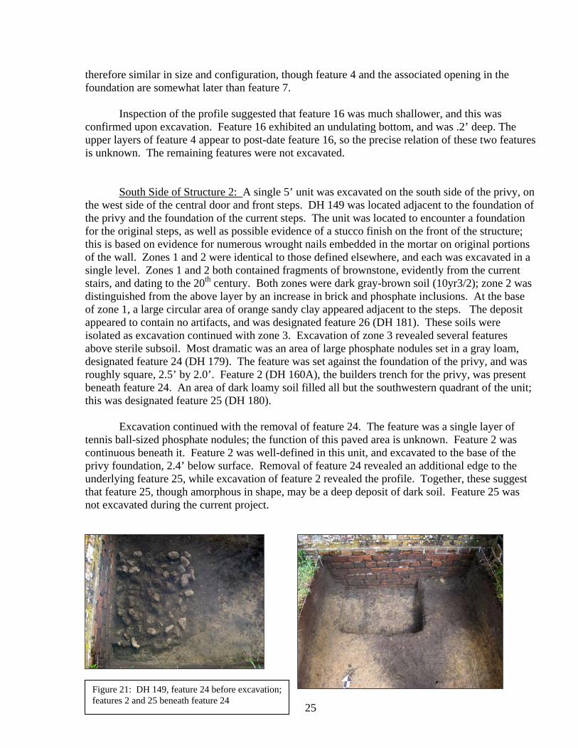
South Side of Structure 2: A single 5’ unit was excavated on the south side of the privy, on the west side of the central door and front steps. DH 149 was located adjacent to the foundation of the privy and the foundation of the current steps. The unit was located to encounter a foundation for the original steps, as well as possible evidence of a stucco finish on the front of the structure; this is based on evidence for numerous wrought nails embedded in the mortar on original portions of the wall. Zones 1 and 2 were identical to those defined elsewhere, and each was excavated in a single level. Zones 1 and 2 both contained fragments of brownstone, evidently from the current stairs, and dating to the 20th century. Both zones were dark gray-brown soil (10yr3/2); zone 2 was distinguished from the above layer by an increase in brick and phosphate inclusions. At the base of zone 1, a large circular area of orange sandy clay appeared adjacent to the steps. The deposit appeared to contain no artifacts, and was designated feature 26 (DH 181). These soils were isolated as excavation continued with zone 3. Excavation of zone 3 revealed several features above sterile subsoil. Most dramatic was an area of large phosphate nodules set in a gray loam, designated feature 24 (DH 179). The feature was set against the foundation of the privy, and was roughly square, 2.5’ by 2.0’. Feature 2 (DH 160A), the builders trench for the privy, was present beneath feature 24. An area of dark loamy soil filled all but the southwestern quadrant of the unit; this was designated feature 25 (DH 180).
Excavation continued with the removal of feature 24. The feature was a single layer of tennis ball-sized phosphate nodules; the function of this paved area is unknown. Feature 2 was continuous beneath it. Feature 2 was well-defined in this unit, and excavated to the base of the privy foundation, 2.4’ below surface. Removal of feature 24 revealed an additional edge to the underlying feature 25, while excavation of feature 2 revealed the profile. Together, these suggest that feature 25, though amorphous in shape, may be a deep deposit of dark soil. Feature 25 was not excavated during the current project.
Figure 21: DH 149, feature 24 before excavation; features 2 and 25 beneath feature 24

26
West side of Structure 2 and Ditch 2: Excavations on the western side of the privy were designed to more fully explore the brick vault revealed by Lewis in 1980. Lewis’ excavations had revealed a sudden, and possibly uneven, termination of the drain leading from the western opening. There was some expectation that this feature, or at least the drainage system, would continue in some manner. A detailed early 19th century map of the Drayton property does not show the privy building, but does show water features in the general vicinity.
Prior to our arrival, Hudgins and DH staff excavated the backfill from most of the old units, re-exposing the feature. At the initiation of the field project, approximately 30’ of ditch 2 was re-exposed, while unit DH67 remained filled. There was some disagreement between the grid re-established by Hudgins and that imposed by Lewis in 1980; it was therefore anticipated that some portion of unit 67 would be encountered in new excavations to the west.
A group of three units was excavated adjacent to DH 67. Units DH 137 and DH 140 were located on the western edge of DH67, while DH 146 expanded to the east. Units 137 and 140 were excavated simultaneously, while DH 146 was a later extension. Excavation of these units revealed a stratigraphic sequence different from other areas of the site; the upper zones suggest multiple episodes of filling. Sod and root mat in a dark gray-brown matrix was excavated as zone 1, in two levels to a depth of .3 feet. At this point, an area of dark soil mottled with brick and phosphate inclusions was evident in the eastern 1.2’ of the units. This was designated feature 3, and tentatively interpreted as the backfilled portion of DH 67. After sampling, these soils were excavated and discarded.
A shallow deposit of brown sand (10yr4/2) was
designated zone 2; this quickly resolved to an area of hardpacked gold sand, mottled with dark soil (7.5yr5/6, 10yr7/6, 10yr3/2). These soils were removed from both units, in alternating fashion. Plastic was recovered from the zone 3 soils. At the same time, the existing profiles of the re-excavated units were compared to a photograph of the excavation in 1980. This revealed that the ground surface has accreted at least one half foot since the time of the excavation. The mottled soils encountered in units 137/140 are currently present above the old units, and this was not the case in 1980. Based on this evidence, zones 1-3 were re-designated as “overburden”.
The mottled soil was followed by a dark, loamy soil, with a moderate scatter of artifacts. This deposit
Figure 22: location of DH137 relative to 1980 excavations.

27
was initially designated zone 1, and excavation of this deposit alternated between the two open units. These excavations continued for an additional foot, and the soil remained consistent throughout. The fill contained fragmentary artifacts from the 18th century and larger items from the late 19th to early 20th centuries. Some areas of the fill exhibited a high content of slag and fragmentary ferric material in loamy gray sand, suggesting relatively recent deterioration of ferrous material.
A test excavation revealed that this dark dirt continued for another .6’, ending on a lens of phosphate rock. Given the depth of the deposit, the homogenous nature of the fill, and the type and date of artifacts, we speculated that the soil may be a deliberate fill episode, with finite boundaries, rather than the natural topsoil described as zone 1 elsewhere on site. Zone 1 was re-named Feature 10 (DH 166A).
Unit 146 was excavated to the east, to search for an edge to the feature 10 deposit. The overburden zones (1-3) were excavated and discarded. This revealed feature 10, which covered the entire limits of the unit. The upper .7’ of soil was excavated and sampled. Based on probing, it appeared that the feature continued another foot. There was no probed evidence of a brick foundation at this depth. Excavation of unit 146 was suspended. Likewise, investigations in DH 137 and DH 140 were discontinued at this point.
Hudgins and a number of interns resumed exploration of this area in August. They excavated the backfill from DH 67, and then resumed excavation of the feature 10 soils; these received the designation DH166A. Approximately 2’ below surface, there was a distinct change in the color, texture, and content of the soil deposit. The soil in the lower levels (excavated in two levels, as DH166B and DH166C) was more homogenous and slightly lighter gray (10yr4/1). Moreover, the fill in DH 166C contained artifacts from
Figure 23: location of terminius of ditch 2, relative to DH 67, DH 137,140 and 146. Above; soil profile showing mottled soil overburden, deposit of zone 10, and DH 166b and 166c below.

28
the late 18th century rather than the early 20th century. DH166C appears to be a separate, earlier feature. Based on the portion explored in units 67, it appears to be a ditch or water feature of some type, trending north/south. The re-exposed brick vault appears to terminate at the interface (Carter, does the term ‘Ditch 2’ apply to the brick drain and the associated builders trench?). Though some bricks were displaced, ditch 2 exhibits a finished end at the interface with DH166.
Ongoing surface observation and selective probing located a concentration of brick beneath the surface, approximately 25’ northwest of the terminus of ditch 2. Two units were excavated here: DH 147 (N10785E10465) and DH 150 (N10790E10470). The two units exhibited the same stratigraphic sequence. Zone 1 was excavated in a single level here. Zone 1 was excavated in a single level, to a depth of .4’ below surface. This was a dark gray-brown sand (10yr3/2-3/3). Zone 2 was lighter and browner (10yr3/4), and marked by an increased concentration of brick and phosphate; these soils were an additional .3’. A solid layer of brick rubble was encountered next. As this deposit covered the entire floor of both units, it was photographed and designated feature 11 (DH 167).
The brick of feature 11 was soft and orange/red (2.5yr4/8). The majority appeared to be bats. There was no evidence of mortar, or of use. The brick layer was relatively uniform across the two units, the thickness varying with the size of the brick fragments. Occasional 18th century artifacts were found in association with the brick, including a large fragment of North Devon Gravel Tempered Ware and a musket sideplate.
Feature 11 appears to be a paving, or filling, incident. Given the lack of structural integrity and the high stratigraphic position (below zone 2), we decided to excavate the feature and continue investigations below this level. Feature 11 ranged in thickness from .2’ to .8’, and was excavated as a single provenience in each unit. Samples of the brick were retained, and all brick was weighed. The discarded brick was set aside at Drayton Hall for future analysis or reuse.
The soil below feature 11 was a dark loamy sand (10yr2/1), mottled with light sand, and so was designated zone 3. The zone was relatively shallow (.3’), with an uneven bottom. Sterile soil was present beneath zone 3, except for an amorphous depression, trending northeast/southwest through the two units. This was delineated and excavated as feature 17 (DH 173). The feature ranged from .3’ to 1.6’ in depth. It was interpreted as a natural low area.
Figure 24a&b: Feature 11 in DH 147; base feature 17 in DH 150 (feature 11 in profile)

29
Additional Exploration of Ditch 2: Excavation of the backfill from the 1980 units presented an opportunity to excavate proveniences unexplored in the earlier project. In 1980, the majority of the units were excavated to sterile subsoil, exposing the brick vault. In unit 65, however, the construction trench for the drain was not excavated. This provenience was excavated as Stratum B (DH 65B)to subsoil, exposing the entirety of the drain. Stratum B was a dark gray-brown soil with heavy phosphate inclusions. It was very dry and hard-packed.
The second task was retrieval of a sample of the soil filling the brick drain. At the time of initial exposure, the top of the drain had collapsed at the interface with the privy foundation, leaving an opening approximately 4’ in width. Drayton Hall interns cleaned the backfill from the
drain interior, exposing original fill. A sample of this fill was excavated as Feature 23 (DH 152A). Excavating top to bottom along the fill profile, a .2’ section was removed initially. This deposit contained many small bones, and a rubber button dating the deposit to the late 19th century. An additional .5’ was excavated as feature 23.
Continued excavation of the privy area, June-
August 2007: Dr. Hudgins and Drayton Hall interns continued the archaeological exploration of the privy area after the Museum project was completed. Excavation of DH 67 and exploration of the terminus of ditch 2 is described above. Hudgins also excavated the soils surrounding the two conduit lines present in DH 139, 143, and 145. Soils were separated into three natural zones, following the previous designations. This exposed the terminus of feature 7, and an additional sample was retrieved. All of the additional excavations were photographed and mapped. Excavations were terminated and the project backfilled in mid-August.
Figure 25: cleaning ditch 2; excavating sample of feature 23
Figure 26: Excavations completed by Dr. Hudgins in August 2007

30
Figure 27: site map, showing units excavated and major features encountered.

31
Table 1 Provenience Guide
FS# Unit1 Provenience date of deposition/TPQ DH Context # 321 DH 137 zone 1 overburden colonoware modern DH 137A 322 DH 138 zone 1 level 1 wire nail modern DH 138A 323 DH 139 zone 1 level 1 rat trap spring modern DH 139A 324 DH 138 zone 1 level 2 clear glass modern DH 138B 325 DH 137 zone 1 level 2 plastic modern DH 137B 326 DH 139 zone 1 level 2 wire modern DH 139B 327 DH 140 zoneO level 1 phosphate modern DH 140A 330 DH 137 zone O level 2 window glass modern DG 140B 331 DH 140 zone O-2, lev 1 plastic modern DH 140C 334 DH 141 zone 1 level 1 strap hinge modern DH 141A 337 DH 141 zone 1 level 2 wire nail modern DH 141B 341 DH 142 zone 1 roof paint modern DH 142A 343 DH 142 zone 1 level 2 modern glass modern DH 142B 344 DH 143 zone 1 brown glass modern DH 143A 346 DH 143 zone 1 level 2 7-up glass modern DH 143B 350 DH 142 zone 1 level 2 clear glass modern DH 142C 366 DH 147 zone 1 plastic modern DH 147A 367 DH 145 zone 1 wire nail modern DH 145A 376 DH 148 zone 1 modern glass modern DH 148A 386 DH 149 zone 1 modern glass modern DH 149A 387 DH 150 zone 1 no matl. modern DH 150A 429 DH 139 zone 1 slipware modern DH 139C 331 DH 140 zone 2 level 1 plastic postbellum/mod. DH 140B 333 DH 138 zone 2 level 1 slate, nails postbellum DH 138C 339 DH 141 zone 2 level 1 wire nail postbellum DH 141C 349 DH 143 zone 2 level 1 brown glass postbellum DH 143C 352 DH 139 zone 2 wire nail postbellum DH 139D 365 DH 142 zone 2 colonoware postbellum DH 142D 368 DH 147 zone 2 tr. Print pw postbellum DH 147B 370 DH 145 zone 2 tr. Print pw postbellum DH 145B 371 DH 144 zone 2 pebble postbellum DH 144A 377 DH 148 zone 2 .22 shell postbellum DH 148B 380 DH 148 zone 2 level 2 window glass postbellum DH 148C 388 DH 150 zone 2 1983 penny postbellum/mod. DH 150B 389 DH 149 zone 2 milk glass postbellum DH 149B 393 DH 138 zone 2 level 2 tr. Print pw postbellum DH 138D 430 DH 139 zone 2/conduit cut nail postbellum/mod. DH 139E 433 DH 145 zone 2 amber glass postbellum DH 145C 345 DH 141 zone 3 level 1 tr. Print pw antebellum DH 141D 347 DH 141 zone 3 level 2 wire nail antebellum? DH 141E 354 DH 139 zone 3 undec. Ww antebellum DH 139E 355 DH 143 zone 3 colonoware antebellum DH 143D 356 DH 141 zone 3 level 3 brick antebellum DH 141F 357 DH 139 zone 3 level 3 window glass antebellum DH 139F 363 DH 142 zone 3 no mat. DH 142E 374 DH 144 zone 3 no mat. DH 144B 379 DH 147 zone 3 FGGCEW late 18th cent. DH 147C 383 DH 148 zone 3 olive green glass late 18th cent. DH 148D

32
392 DH 148 zone 3 level 2 wire nail mid-19th cent. DH 148E 394 DH 138 zone 3 cut nail antebellum DH 138E 397 DH 139 zone 3 resid. Window glass antebellum? DH 139G 398 DH 149 zone 3 wire nail mid-19th century DH 149C 421 DH 150 zone 3 redware late 18th century DH 150C 432 DH 143 zone 3 slag mid-19th century? DH 143E 434 DH 145 zone 3 window glass mid-19th century? DH 145D 328 DH 138 Feature 1 no matl. modern DH 159A 408 DH 138 Feature 1a clear glass modern DH 159A 410 DH 138 Feature 1b clear glass modern DH 159B 329 DH 138 Feature 2 no matl. 18th cent. DH 160A 409 DH 138 Feature 2 brick 18th cent. DH 160A 420 DH 141 Feature 2 window glass 18th cent. DH 160B 438 DH 141 Feature 2 brick 18th cent. DH 160B 425 DH 149 Feature 2 brick 18th cent. DH 160C 418 DH 138 feature 2 base brick 18th cent. DH 160A 338 DH 140 Feature 3/overburden plastic modern DH 161A 351 DH 142 Feature 4A nail, 1980 penny postbellum/mod. DH 162A 358 DH 142 Feature 4B molded goblet stem postbellum? DH 162B 369 DH 142 Feature 4C aqua glass mid-19th cent. DH 162C 372 DH 142 Feature 4D table glass antebellum? DH 162D 402 DH 142 Feature 4 creamware antebellum? DH 162E 378 DH 145 Feature 7 no matl. mid-19th cent. DH 157A 404 DH 139/141 Feature 7 non-wire nail early 19th cent. DH 157B 412 DH 141 Feature 7a olive green glass mid-19th cent. DH 157C 413 DH 141 Feature 7b pipestem early 19th cent. DH 157D 417 DH 141 Fea 7/brick olive green glass early 19th cent. DH 157E 424 DH 141 Feature 7c green glass early 19th cent. DH 157F 435 DH 139 Fea 7 levl 1 brick early 19th cent. DH 157G 348 DH 140 Feature 10 lev 1 battery core early 20th cent. DH 166A 359 DH 140 Feature 10 cut nail early 20th cent DH 166A 360 DH 140 Feature 10 wire nail early 20th cent DH 166A 439 DH 140 (fea 10) DH 166A wire nail early 20th cent. DH 166A 427 DH 67 DH 67G (fea 10) Victory bottle early 20th cent. DH 67G 396 DH 150 Feature 11 porcelain 18th cent. DH 167A 373 DH 147 Feature 11 porcelain 18th cent. DH 167B 382 DH 145 Feature 14 no matl ?antebellum DH 170A 381 DH 145 Feature 15 no mat. ?late 18th cent. DH 171A 391 DH 148 Feature 16 no matl. ? antebellum DH 172A 390 DH 147 Feature 17 orange brick 18th cent. DH 173A 405 DH 150 Feature 17 green bottle glass 18th cent DH 173B 414 DH 147 Feature 17 nail 18th cent. DH 173A 415 DH 141 Feature 22 brick 18th cent? DH 178A 416 DH 58 Feature 23a Goodyear button mid-19th cent. DH 152A 422 DH 145 Feature 24 brick early 19th cent. DH 179A 419 DH 65 DH 65B porcelain mid-18th cent. DH 65B 440 DH 67 DH 166B “black” glass 18th/late 19th c. DH 166B 441 DH 67 DH 166C tr. Pr. pw early 19th cent. DH 166C 427 DH 65 Fea 10 ‘Victory’ bottle early 20th centy DH 166A

33
Feature Designations Feature # Context# Unit Description FS# 1a DH 159A DH 138 round post/postmold 328, 408, 410 1b DH 159B 2 DH 160A DH 138, 141 construction trench to privy 409, 418, 420, 425 3 DH 161 DH 137, 140 possible backfill? 338 4 DH 162 DH 59, 142 entry trench to opening in north foundation 351, 403, etc. 5 DH 163 DH 142 changed to zone 2 not exc. 6 DH 164 DH 143 small pit not exc. 7 DH 157A DH 139, 141, 145 entry pit to east vault opening 404, 424, etc. 8 DH 165 DH 141 small rectangular post not exc. 9 DH 158 DH 139 1980 shovel test not exc. 10 DH 166A, 67G DH 137, 140, 146, 67 large pit of 20th cent. Refuse 340, 360, etc. 11 DH 167 DH 147, 150 layer of eroded red brick 373, 396 12 DH 168 DH 144, 143 unknown pit not exc. 13 DH 169 DH 143 possible post not exc. 14 DH 170 DH 145 unknown pit 382 15 DH 171 DH 145 unknown pit 381 16 DH 172 DH 142, 148 ditch associated with fea. 4 391, 406 17 DH 173 DH 147, 150 depression below fea. 11 390 18 DH 174 DH 148 unknown linear pit not exc. 19 DH 175 DH 148 amorphous oval area not exc. 20 DH 176 DH 141 small post not exc. 21 DH 177 DH 141 small amorphous stain not exc. 22 DH 178 DH 138 square post beneath fea. 1 415 23 DH 152a DH 58 fill inside ditch 2 (brick drain) 416, 423 24 DH 179 DH 149 square area paved in phosphate cobbles 24 25 DH 180 DH 149 irregular area of dark soil not exc. 26 DH 181 DH 149 area of tan sand near steps not exc.

35
Chapter IV Analysis of the Materials
Laboratory Methods Following excavation, all materials were removed to The Charleston Museum, where they were washed, sorted, and analyzed. All bagged materials were sorted by the field provenience number (FS#) and inventoried. Each artifact from each provenience was then washed in warm water with a soft brush and re-bagged when dry. Washing and sorting was followed by analysis by provenience, which included identification and counting and/or weighing of each artifact by type. Washing and sorting commenced immediately after the field project and continued through the fall, and was conducted by students from the College of Charleston. Most of the College interns were those enrolled in the 2007 summer field school at Drayton Hall; they provided valuable connection between the fieldwork and the laboratory work. Students volunteered 350 hours on the laboratory analysis. Conservation included electrolytic reduction of all non-ferrous and some ferrous metals. These were placed in electrolytic reduction, the non-ferrous with a current of 12 ampheres. Electrolytic reduction was usually accomplished in less than a week. They were then placed in distilled water baths to remove surface chlorides, dried in ethanol, and gently polished before being coated with Incralac to protect the surfaces. Faunal materials were washed, separated from other materials, and weighed by provenience. They remain in separate bags within the general provenience bag, available for faunal analysis in the future. Collected soil samples, ranging from one to two quarts in size, were inventoried, double-bagged, and boxed for permanent curation. These are available for future environmental or chemical analysis. Upon completion of the analysis and final report, all cultural materials, soil samples, and architectural samples were packed in standard-sized boxes for return to Drayton Hall, where they will remain in curation as the property of the National Trust for Historic Preservation. Field notes, photographs, and catalogue cards were also returned to Drayton Hall; copies were retained by The Charleston Museum. Analysis Identification of the artifacts was the first step in the analysis of the materials. The Museum’s type collection, Noel Hume (1969), Stone (1974), Ferguson (1992), and Deagan (1987, 2002) were the primary sources used. Ceramics references included Towner (1978), Gaimester (1997), Austin (1994), Sussman (1997), and Cushion (1976). In addition, many of the articles featured in the journal Ceramics In America (2000 – 2007) were invaluable in further identifying recovered material. Other references were consulted for specific artifact types. Lorrain (1968), Huggins (1971), Kechum (1975), Switzer (1974), and Sutton and Arkush (2006) were used to

36
identify bottle glass. Epstein (1968) and Luscomb (1967), and South (1964) were used for button identification, while Beaudry (2007) and Baumgarten (2002) were used for general clothing identification. Fontana and Greenleaf (1962) and Sutton and Arkush (2006) were consulted for nails, while Lounsbury (1994) was used for general architectural issues. Ceramics were separated into types and identified by vessel form, where possible. Any cross-mends and matches were noted, but a complete cross-sorting by minimum number of vessels (MNIV) was not undertaken. Nails were identified by manufacture type, head type, and size, where possible. Architectural rubble – brick, mortar, and plaster – was weighed by provenience in the field. Samples were retained and the remainder discarded. The 2007 assemblage from the privy was small, and contained slightly more than 3,000 artifacts from nearly 300 square feet of excavation. Despite the small size of this assemblage, all of the materials retrieved were subdivided temporally, based on the stratigraphic sequence and Terminus Post Quem, and characteristics of the material assemblage. The individual assemblages will be discussed separately and then summarized relative to each other.
Zone 1 was deposited, or redeposited in the late 20th century, likely since acquisition of the property by the National Trust. Zone 2 and associated features, principally Feature 10, contain a mixture of materials, and appear to be associated with the late 19th to early 20th centuries. Though the proveniences contain occasional artifacts from the late 19th century, Zone 3, the deepest cultural deposit, is interpreted as an early 19th century event in many areas of the site. The features associated with the drainage and function of the privy also appear to date to the early 19th century, though the datable artifacts retrieved are sparse. These include feature 7, associated with the entry vault on the east side of the structure; feature 4, associated with the opening on the rear of the building, and the features associated with Ditch 2, the brick vault exposed by Lewis in 1980. It must be noted, however, that few artifacts were retrieved from features 7 and 4, and the upper zones of feature 4 contained artifacts associated with the mid-19th century; therefore the early date for Feature 4 is somewhat tenuous. Other early 19th century contexts excavated in 2007 include DH166C, DH65B, and Feature 11. Feature 2, the construction trench for the privy, contained no datable materials, and therefore was not useful in determining a date of construction, or reconstruction, for the building. The small pit features on the south and east sides of the building did not contain any materials, but their stratigraphic position beneath zone 3 suggests a 19th century origin. For basic descriptive purposes, the artifacts from each of the temporal periods were sorted into functional categories, based on South’s (1977) model for the Carolina Artifact Pattern. South’s methodology has been widely adopted by historical archaeologists in ensuing decades, allowing for direct intersite comparison; all of the downtown Charleston data have been organized in this manner; so, too, were the data from excavations in locus 22 in 2003 and 2005 (see Zierden and Anthony 2006). For nearly thirty years, archaeologists have worked to classify the artifacts they recover by function, or how they were used in the everyday life of their owners. Artifacts are quantified in relative proportion to each other within eight broad categories. Broad regularities, or patterns, in these proportions prescribe the average retinue of activities on British colonial and antebellum sites. While some have criticized this methodology as being too broad, it has been widely adopted by historical archaeologists working in the southeastern United States. In Charleston, it has been used principally as a tool for organizing and comparing assemblages; there has not been any effort to

37
identify specific patterns by quantifications, in the manner suggested by South. Lynn Lewis has used this methodology for Drayton Hall in the past (Lewis 1978). Under Stanley South’s model, the Carolina Artifact Pattern prescribes broad regularities in the daily life of lowcountry residents. Artifacts are sorted, and then quantified, within eight broad groups, based on function. The largest is usually those artifacts related to kitchen activities, such as food preparation, service, and storage. The Kitchen group includes most ceramics, bottle and table glass, cooking vessels, and cutlery. Food storage containers, from crocks to bottles to tin cans, are also included. The second group relates to Architecture and the buildings themselves. This group includes nails, window glass, and architectural hardware of all types. Much smaller groups include Arms and weaponry items, and Furniture items, principally brass hardware. The Clothing group includes items from clothes, such as buttons and buckles, and items used to make or repair clothing, such as straight pins and scissors. The Personal group includes items of personal possession and adornment. Though small, this group can be quite varied, and includes keys, coins, jewelry, combs and brushes. The Tobacco group includes clay pipes and other items for smoking tobacco. The final group is somewhat larger and more eclectic, and includes items from a range of domestic Activities. Included in the Activities group are farm tools, toys, fishing gear, equestrian hardware, storage items, and artifacts from any other specialized activity. Early 19th Century Proveniences
The majority of the artifacts recovered around the privy were from a series of features associated with the drainage network on the west side of the building. The only deposit with a significant artifact assemblage was the area of dark soil associated with the terminus of Ditch 2, excavated by Dr. Hudgins in units DH 67. Contexts DH166B and 166C were lenses of dark grey-brown soil, beneath the deposits designated as Feature 10 (including 166A). The fill inside Ditch 2, designated Feature 23, contained small artifacts that evidently washed into the drain. Beyond this complex, the dark soil and compact layer of orange brick located in DH 147 and DH150 contained a small, but significant number of 18th and early 19th century materials. These proveniences are quantified together as Early 19th century features. Also described in this section are the smaller assemblages from features 4 and 7 (the pits located at entry points in the privy foundation) and from Zone 3 across the site.
The Kitchen Group: Kitchen materials comprise 42% of the assemblage; as is typical of Federal period assemblages, the majority of these were ceramics. The group contained a moderate number of 18th century wares, but was dominated by creamware. Lesser amounts of pearlwares suggest an early 19th century date of deposition.
The earliest European ceramic found at Drayton Hall is delft; while the site in general has yielded significant examples of this ware, the privy area included only four fragments. Delft tableware was common in the early colonial period, and persisted to some extent through the late 18th century. British delft features a soft yellow-to-buff-colored earthenware paste and an opaque, sometimes chalky-textured glaze consisting of tin oxide in a lead glaze. The glaze can be white, but often exhibits a light ‘robin’s egg’ blue background color. Individual vessels may be undecorated, or feature hand-painted decoration in blue or a range of colors, the latter classified as polychrome.

38
Such wares were common on 17th century sites, but they were fragile. Teacups and small vessels faded in popularity after 1750, but larger vessels such as plates, bowls, platters, and punch bowls continued throughout the century (Austin 1994).
Though French tin-enameled wares, known as Faience, are often recovered on 18th -century sites in South Carolina, none were found during the present project. Faience was imported into Charleston, and other English colonies, at the time of the Revolution, and is most common in the last quarter of the 18th century (Waselkov and Walthall 2002); a few fragments were recovered from locus 22 in 2003.
The tin-enameled tablewares of the early 18th century (1740-1775) were replaced by dinner and tea wares of white salt-glazed stoneware, developed in the second quarter of the 18th century. The fine, molded table and tea wares were first developed in the 1740s, and these largely replaced the smaller delft vessels. Plates and soup bowls, as well as tea wares, are the most common forms recovered in Charleston, reflecting the rising importance of individual place settings and matched sets. Serving vessels are also recovered in lesser amounts. While much of the salt-glazed stoneware was undecorated, molded and sprigged examples are found, as well. Typical plate rim forms include the ‘dot, diaper and basket’, the bead and reel, and barley patterns (Noel Hume 1969:116). Eight fragments of these wares were recovered from the privy features. The most popular tea and table ware of the 18th century was Chinese export porcelain. Chinese porcelain is made from a combination of kaolin clay and a finely ground feldspathic rock, and can be distinguished from other ceramic wares by a high-gloss glaze fused to the body. The body is extremely tight-grained, and the glaze clings to it in a thin translucent line on both sides. Chinese porcelain was decorated in a number of colors, but only the blue cobalt could withstand the firing temperature and was applied under the glaze. Other colors were applied over the glaze after firing. Tea wares, particularly saucers and handle-less tea bowls, are the most common forms recovered, but plates are also recovered in large numbers. The underglazed blue wares are the most common.
Relatively rare and expensive in the late17th to early 18th centuries, Chinese porcelains were increasingly popular and available as the 18th century progressed. Too, the increasing wealth of the lowcountry planters meant that more people were able to afford these wares. Robert Leath suggests that porcelain had become fairly commonplace in South Carolina by the 1730s, and a decade later was advertised regularly among merchandise in the South Carolina Gazette. Merchant David Crawford, for example, advertised “…a large assortment of China ware as breakfast cups and saucers, dishes, plates and bowls of all sorts, tea and coffee cups and saucers, also 3 compleat sets of color’d china for a tea table” (Leath 1999:50). Porcelains often comprise over 20% of the ceramics in late 18th century townhouse assemblages (Zierden 2002, 2006b). The majority of these are blue-on-white underglaze decorated, but most sites yield examples of the more expensive overglazed (or enameled) porcelains.
Figure 28: white saltglazed stoneware

39
The privy features contained 17 fragments of blue underglaze porcelain and two enameled fragments. One fragment of ‘famille rose’ pattern was recovered from the lower levels of Feature 10. This fragment of a platter or large plate features a bold floral decoration in rose-pink enamel. More typical of late 18th century wares is the plate rim from Feature 23, featuring a blue underglazed floral design on the rim and a dart border. The dart border was common on wares from 1730 to 1780 (Miller et al. 2000:9).
Together, tablewares produced in the colonial period comprised only 15% of the assemblage
ceramics. Dominating the early 19th century feature assemblage were the refined earthenwares developed by the Staffordshire potters in the third quarter of the 18th century. The most important development was the gradual perfection of a thin, hard-fired cream-colored earthenware that could be dipped in a clear glaze. The ware fired at a lower temperature than the white stonewares, and is thus classified as refined earthenware. Potters Thomas Astbury and Thomas Wieldon pioneered this venture, but it was Josiah Wedgwood who ultimately perfected these wares and marketed them successfully. The original cream-bodied ware was introduced in 1740 and featured a clouded or swirled underglaze design in purple, brown, yellow, green, and gray. In 1759, Wedgwood produced a wholly-green ware. All of these are loosely categorized as Whieldon ware by American archaeologists. The Whieldon wares were manufactured until 1770 and are consistently present in 18th -century lowcountry contexts, but in small numbers. None were recovered from the privy features.
Creamware was the dominant ceramic of the early features, comprising 63% of all ceramics
in the assemblage. Recognizable vessel forms included plates, mugs, and -not unexpected, given the association with a privy- chamber pots. This is in keeping with the almost universal popularity of cream-colored earthenware in the late 18th century. After Josiah Wedgewood ventured into business on his own in 1759, he found the green glazed ware was not so popular, and he turned his attention to refinement of the cream-colored ware, later called Queensware (after a set given the queen of England). Wedgwood appears to have perfected this ware by 1762, although diverse archaeological sites have produced nearly irrefutable evidence of earlier use (cf. Deagan 1975). Regardless of the initial manufacture date, by the 1770s these wares could be found in the four corners of the colonial world, and are ubiquitous on archaeological sites of the period. In her study of 18th -century consumerism, Ann Smart Martin (1994b:169-185) has commented that Wedgwood himself marveled at how quickly creamware “spread over the whole Globe and how universally it is liked.” What is remarkable in Martin’s view is that Wedgwood managed to compress the cycle of luxury-to-common consumption into a very short period. By continually bringing out new styles, Wedgwood satisfied both the middle class consumer eager to display their knowledge of manners and the fashionably wealthy who sought to distance themselves from the middling sort (Martin 1994a, 1994b, 1996). Creamware came in highly decorated and expensive styles, and in relatively plain and affordable patterns. Like other colonial residents, Charlestonians flocked to the new ware, and
Figure 29: Examples of Chinese Export Porcelain

40
purchased it in quantity through the early 19th century. Evidently, quantities of this ware were discarded when the drainage system was abandoned.
The creamwares that flooded the colonial market in the 1770s were augmented a decade later with another Staffordshire product, pearlwares. Throughout the 1770s, Wedgwood continued to experiment with production of a whiter ware, the creamwares having a yellowish, or creamy, color. In, 1780, he introduced a new ware, which he termed “pearl white”. Thus 1780 marks the beginning of the era when British refined earthenwares feature a bluish tint to the glazing and blue pooling in the cracks and crevices. It was not Wedgwood’s intention to replace the earlier creamware, and the two wares were manufactured concurrently; however other potteries produced the new ware in quantity, and pearlwares gradually supplanted the creamwares in archaeological assemblages. In general, pearlwares are 17% of Charleston ceramic assemblages, compared 25% creamware (Zierden 2002). Pearlwares were infrequent in the privy features, but the presence of a small assemblage suggests a post-1800 date of deposition for the features. As with other Charleston sites of the late 18th century, pearlwares from the privy features come in a wide range of decorative styles, compared to creamware. Earliest (1780-1810) were hand-painted designs under the glaze in blue, often in chinoiserie. Hand-painted tea wares in a polychrome palette (brown, sage green, cobalt blue, orange-rust, and yellow) often feature delicate floral designs. Two fragments of hand-painted pearlware were recovered here. Perhaps the most readily-recognizable historic ceramic is shell-edged pearlware. This ceramic features rims molded in a feathery design, which was hand painted in blue or green. Most shell-edged pearlwares are flatwares – plates, soup bowls, and platters. The earlier pieces feature careful, individual brush
Figure 30a-b: examples of creamware. Left, Royal pattern; right, feather-edged
Figure 31: Examples of pearlware: Transfer printed (left), spattered (right)

41
strokes, accenting the individual feathers. By the early 19th century, the hand painting had deteriorated to a single swiped band around the rim. The early 19th -century wares also featured rims molded in designs other than feathers. Two fragments of shell edged pearlware were recovered.
Two additional decorative styles were applied to pearlware after 1795, and they dominate early 19th -century ceramics. Transfer or bat printing involved the creation of detailed designs in a myriad of patterns. The North Staffordshire potters, led by Josiah Spode, successfully produced this blue-on-white ware in 1784. This development, coupled with a significant reduction in the importation of porcelains from Canton after 1793, resulted in a large market for the new wares (Copeland 1994:7; Miller 1991). Transfer-printed wares, the most expensive of all the decorated refined earthenwares, are usually recovered in a wide variety of forms; plates of all sizes, bowls of all sizes, tea cups and coffee cups, with or without handles, mugs and saucers. The list of service pieces is equally lengthy, including platters, tureens, and tea wares. Four fragments were recovered here. The feature assemblage also included two fragments of a saucer featuring a spattered pattern.
Equally common in the privy features were the much cheaper annular wares. Also developed
in 1795, this pearlware features machine-turned stripes in a range of colors on small low-shouldered bowls and mugs. The range of vessel forms is limited, compared to the other pearlware styles, and this ware was the least expensive (Miller 1980). The bowls were suitable for one-pot meals, such as soups, stews, and pilaus. Variants of annular ware include mocha ware, with dendritic patterns in the wide stripes, and cabled ware, featuring swirls and dots in heavy colored slips. Three fragments of annular pearlware were recovered.
The early 19th century proveniences also yielded a small number fragments from utilitarian ceramics. European earthenwares comprised 6% of the ceramic assemblage, while stonewares contributed another 2%. Each type was represented by a few sherds. North Devon gravel tempered ware consists of smooth red and gray clay with heavy quartz inclusions, hence its name. The interior of the vessel is coated with a thick apple-green lead glaze. The lowcountry examples are usually cream pans or one-gallon pots. Feature 11 contained two large fragments
from pans. Buckley ware features an agate-like body of red and yellow clays, but the heavy vessels are ribbed on the interior and/or exterior and covered with a thick, black lead glaze. A single fragment was recovered. Charleston forms include cream pans and bowls, glazed only on the interior, and large storage jars glazed on both sides (Noel Hume 1969:135).
The most common utilitarian ceramic on 18th - century sites
Figure 32: (above) North Devon Gravel Tempered Ware Figure 33: (right) Buckley earthenware

42
in Charleston is the body of wares known collectively as combed-and-trailed slipwares. Noel Hume attributes most of these wares to factories in Staffordshire and Bristol, but British archaeologist David Barker suggested Buckley or Liverpool as a source for much of the slipware imported to Charleston (Barker, personal communication 1991; Barker 1999). Most of these wares feature a buff- to yellow body and are decorated with combed lines in iron oxide or manganese under a clear to pale yellow glaze. The simplest were trails of brown glaze over the buff body, sometimes combed into elaborate designs. Other variations occur with light trailed stripes over a black slip, or with “…skillfully marbleized blend of white, dark, and light-brown slips.” Noel Hume (1969:136) declines to date these variants with accuracy, but the dark-based variety is more common in early 18th century proveniences in Charleston (Zierden and Reitz 2005). Noel Hume further suggests that the importation of slipwares ended with the American Revolution, though they were produced through the 1790s. Slipwares are recovered in large numbers on Charleston sites, and average 10% of the ceramics for this period in Charleston. They are not so common at the privy, however, as they comprise less than 2% of the ceramics recovered (3 fragments). The slipwares recovered at Drayton Hall are large flatware pieces – shallow bowls of all sizes – that feature an unglazed exterior and molded rim reminiscent of piecrust. The interior features slips and spriggles of white, dark, and brown clay, often combed in elaborate designs. The hollow wares, most often mugs or cups of various size but also pitchers and candlesticks, are thinner and glazed on both sides. They are most often decorated with a series of brown dots near the rim and combed trailings around the exterior. Red-bodied slipwares trimmed with trailings of white clay are also common in 18th -century lowcountry contexts. Some of these vessels feature splotches of green or brown glaze. All of these are attributed to potteries in the North American colonies, likely Philadelphia and, to a lesser extent, Salem, North Carolina. Carl Steen has recently suggested that the many Philadelphia potters were the source of these wares, and the South Carolina Gazette regularly advertised ships arriving from that port. The most common Charleston examples are called Trailed Philadelphia Earthenwares by Steen (1999), and match the description above. Cream pans and heavy, small bowls are the predominant common vessel forms recovered in Charleston. They are most common in the third quarter of the 18th century (Zierden and Reitz 2005), and provide archaeological proof of inter-colonial trade, a venture rarely discussed in the documentary record (Steen 1999:68). A single fragment was recovered from the privy features.
The 19th century feature assemblage included a number of lead-glazed earthenwares, in a variety of forms and glazes. The most common examples featured a dark brown or black lead glaze. A few examples of greenish or yellow lead glaze were also recovered. Lead glazed earthenwares comprised 4% of the ceramics; 8 fragments were recovered.
Other utilitarian ceramics were stonewares. Noel Hume suggests that these wares were
manufactured in the Rhineland and imported into England; they were then shipped to the colonies in large numbers in the 17th and first half of the 18th centuries. After 1760, the Rhineland’s virtual monopoly was broken by the potters of Staffordshire (Noel Hume1969:276). The most common ware was brown saltglazed stoneware. While the 17th -century “bellarmine” jugs decorated with a bearded face are the best-known, the undecorated bottles of the 18th century are the most common in Charleston. Two fragments were recovered from the privy features.

43
Somewhat less common were fragments of Westerwald stoneware. This ceramic is gray-bodied and decorated in blue. Vessel forms for the mid-18th century include chamber pots, small crocks, and mugs of various sizes; earlier 18th century sites contain jugs with bulbous bodies and reed necks, and porringers. A single fragment was recovered in the privy features.
The 2007 excavations yielded a broad range of European ceramics associated with the 18th century, but locally made colonowares are a significant portion of the assemblage. Taken together, the varieties of colonoware comprise 7% of the ceramics recovered from the early 19th century features, and this pottery is found throughout the later deposits. This assemblage includes a number of wares produced by Native Americans of the historic period, as well as the more commonly-defined wares associated with African American sites in the lowcountry. The Drayton Hall colonowares were subjected to detailed analysis by Ronald Anthony, and are discussed in depth in Chapter V; thus they are not discussed further here. The early 19th century feature assemblage also contained a few fragments of ceramic from non-English sources. A single fragment of Spanish Olive Jar was recovered here, and other fragments came from later proveniences. Olive Jars are the amphora-shaped vessels ubiquitous on Spanish colonial sites, and are commonly recovered in other lowcountry settings. The long, narrow vessels feature a rounded to pointed bottom, wide shoulders, and a restricted neck. The vessels are thick, with a buff to pinkish sandy clay body and a finger-ridged exterior. The vessels are often glazed on the interior and feature a think white slip on the exterior (Deagan 1987:30-35). They were manufactured from 1490 to 1800, and were used to transport and store liquid goods of all kinds. A lead-glazed earthenware commonly recovered on lowcountry sites has recently been attributed to French potters. This is a relatively thin-walled vessel with a sandy buff-to-pink colored paste and apple-to-olive green lead glaze with dark inclusions on the interior. Pots and jars in a variety of sizes have been noted, along with flat-bottomed pans. Following the example of scholars working on French colonial sites along the Gulf Coast, this ware has been catalogued as French Green Glazed Coarse Earthenware (since 2002; prior to positive identification as French, it was catalogued and described as “Southern European Ware.” This was based on recovery of significant amounts at Lesesne Plantation on Daniels Island and consultation with Stanley South and Ken Lewis (Calhoun et al. 1985). At the time, South reported that the ware was recovered at Brunswick Town, North Carolina, as well. This French coarse earthenware averages 2% of ceramics in Charleston for
Figure 34: Brown saltglazed stoneware Figure 35: Westerwald stoneware
Figure 36: example of colono ware

44
the second half of the 18th century. Two fragments were recovered from the early 19th century features.
Olive green bottle glass comprised the majority of the other kitchen wares. These English glass wine bottles became common after 1650, and were hand-blown until the 1820s. During the 17th and 18th centuries, the bottles gradually became narrower and taller, compared to the original squat ‘onion bottle’. These bottles, which were often refilled from larger barrels or otherwise reused, are ubiquitous in fragmentary form on 18th century English colonial sites (Noel Hume 1969). The early 19th century features contained 61 fragments of olive green glass, including a bottle base attributed to the late 18th century. Another fragment of green glass appears to have been worked on the edge, possibly creating a shaving or scraping tool.
Other smaller bottles included
those in clear and aqua glass, for condiments and medicines. Particularly distinctive were the small aqua vials for holding medicines. These bottles were also hand-blown until the 1820s. The feature assemblage contained a single fragment of each. The final kitchen item was a fragment of table glass, featuring the typical smoothed rim.
The Feature 4/Feature 7 assemblage was much smaller than that of the other features, and
was segregated principally because of issues surrounding the age and function of the features. Both features contained very sparse material assemblages, and the kitchen group was relatively small (49.6% of the assemblage). But unlike the early features, the majority of these artifacts were fragments of glass. Only 16 ceramics were recovered from the two features (8.7% of the total assemblage). These included a single fragment of creamware and a single sherd of Combed and trailed slipware. Six fragments of Yaughan colono ware and two fragments of historic-period Native American pottery were also recovered.
Ceramics were equally sparse in zone 3 across the site; this zone deposit from 13 units
yielded only 36 ceramics. These included 18th century coarse earthenwares as well as early 19th century refined earthenwares. Early ceramics included two fragments of Combed and Trailed slipware and two fragments of lead-glazed earthenware. A single fragment each of French green glazed coarse earthenware and Spanish Olive Jar were recovered. Overall, the refined earthenware group was slightly later than the
Figure 37: Examples of olive green glass bottles. The fragment appears to have a worked edge.
Figure 38: Examples of earthenware: Spanish olive jar, French green glazed coarse earthenware, American redware.

45
assemblages from the features; the group included three creamwares, five transfer print pearlwares, and two fragments of undecorated whiteware. Also recovered from Zone 3 were six fragments of Yaughan colono ware. Ceramics comprised 7% of the total assemblage for Zone 3.
Glass artifacts were relatively more common in both assemblages. Glass comprised 41% of
the Feature4/7 assemblage (75 fragments) and 13% of the Zone 3 assemblage. In both assemblages, clear bottle glass was more common than olive green glass, again suggesting a slightly later date of deposition overall. Features 4/7 contained seven fragments of olive green glass and one fragment of amber glass. Clear glass was more common (20 fragments) and a single sherd of aqua glass was recovered. The assemblage contained a large amount of table glass; this included several fragments of tumblers and a goblet from the deepest levels of feature 4, plus a goblet stem from the upper fill
levels of the same pit (46 fragments in all). Zone 3 contained only a moderate amount of glass; the assemblage included six fragments of olive green glass, a single sherd of clear glass, and 21 fragments of aqua condiment or pharmaceutical glass.
The predominance of glass over
ceramics in the vault features and in the surrounding zone 3 suggests two things. The most immediate interpretation is that the area
around the privy was not a locus for discard of refuse from kitchen or food-related activities. The glass artifacts may instead reflect casual activities in the vicinity of the privy, or that privy location was on the periphery of such activities. But a higher proportion of glass to ceramics is usually a signature of mid-19th century assemblages, resulting from the explosion of mass-produced glassware after 1820. The proportions of ceramics to glass in Features 4 and 7, and in some areas of zone 3, could reflect a later date of deposition.
The Architecture Group: Architectural materials comprised at least half of the early 19th
century assemblages. Items relating to buildings and architecture comprised 52% of the early features assemblage, 46% of the Feature 4/7 assemblage, and 76% of the Zone 3 assemblage. For all assemblages, the group was composed almost entirely of nails and window glass; the early feature assemblage was the largest and most diverse. Over half of the nails recovered from the early features were unidentifiable (57), while another group were classified as fragments (68). For the sake of consistency, and calculation of MNI, nails are counted if a head is present, no matter the size or condition of the artifact. Those missing the head are classified as fragments, again regardless of the size.
Some of the recovered nails were identifiable by type of manufacture. Most were hand
wrought (46), and thus dated before 1780. Hand-wrought nails feature a square shaft and either a spatulate or pointed end. The heads vary according to proposed use, and the most common is the ‘rose head’, featuring five hammered facets spreading out and down from a central point (Noel
Figure 39: Goblet base from Feature 4

46
Hume 1969:252). Flooring nails featured an L-head or a T-head. Beginning in 1790, nails were produced in America by slicing the shaft from a sheet of iron, producing a rectangular, rather than square shaft. Until 1815, the heads were still hand applied; after that date the head was part of the manufacturing process, and took on a regular, rounded rectangular shape. From 1815 until the 1830s the nail shaft featured a slight waist below the head (Noel Hume 1969; Sutton and Arkush 2006). Two machine cut nails were identified in the early feature assemblage, but the head type could not be determined.
The final development in the evolution of nail types was creation of round-shafted nails from
steel wire. This technology arrived in New York by the mid-1850s, and the earliest products were small brads. Wire nails in a variety of regular sizes appear in the last quarter of the 19th century, and are an important dating marker for archaeological deposits. No wire nails were recovered from the early features.
The nail group was similar for the smaller Feature4/7 assemblage. This assemblage included
fifteen unidentifiable nails, one cut nail and twenty nail fragments. The somewhat larger Zone 3 assemblage included 14 unidentifiable nails and 52 nail fragments. There also were 14 hand wrought nails and four machine cut nails. Seven wire nails were recovered from the deepest level of zone 3 in DH 141, adjacent to the northeast corner of the privy and above feature 7. This suggests later repair or alteration to the building, and may have a bearing on interpretation of feature 7. Alternately, the nails may be present as a result of the conduit trenching in this vicinity.
The other major component of the architecture group was flat glass from window panes.
Window glass from the 18th through early 19th centuries is usually aqua, while more modern flat glass is clear. Like bottles of the same era, colonial flat glass was hand blown. Crown glass began as a bubble of blown glass, gradually worked into a disc. These discs featured a thick edge, which was trimmed away and wasted, and a central pontil scar, or bulls-eye, which could be up to one inch thick. The resulting circles of glass were known as ‘crowns’ and were shipped to America in crates, to be cut to size by the purchaser (Noel Hume 1969:234). Other, earlier, glass was made by blowing large cylinders that were then cut open, spread out, and allowed to cool on a flat surface (Sutton & Arkush 2006:194); quality of this glass varied (Noel Hume 1969:233). The broad glass method was revived, with improvements, in 1832. The new method produced larger sheets of better quality. Window glass tends to increase in thickness throughout the 19th century (Roenke 1978; Orser et al. 1982).
Fragments of both clear and aqua window glass were recovered from 19th century deposits,
though the aqua was much more common. One distinction noted in the field and the laboratory, however, is that a portion of the aqua glass exhibited very little post-depositional degradation. Most of the aqua glass fragments recovered from archaeological contexts exhibit some patination, abrasion, or both. A significant portion of the aqua glass recovered around the privy exhibited no such wear. Though subjective, this distinction was noted during analysis. The early 19th century features yielded 139 fragments of aqua flat glass and only one fragment of clear window glass. Features 4/7 fielded 51 fragments, and roughly one third of these exhibited no wear. The zone 3 deposits were more varied; this assemblage contained 73 fragments of aqua glass, an additional 28 with no patina or abrasion, and 10 fragments of clear flat glass.

47
The early features also contained two fragments of delft tile, both decorated in blue. One
fragment exhibited minimal decoration, with a small stroke of blue in the corner. The second, much smaller fragment, exhibited a detailed floral pattern.
The Arms Group: The three early 19th century assemblages together produced a single arms
item. This was a musket sideplate, retrieved from feature 11. The sideplate was brass, but was otherwise undecorated.
The Clothing, Personal, and Furniture Groups: The three artifact groups composed of small
items, often considered luxuries, were relatively small in the privy assemblage. A total of seven clothing items were recovered from the three 19th century assemblages. Six artifacts were recovered from the early 19th century features, comprising .98% of that assemblage. A single artifact was retrieved from features 4 and 7, comprising .54% of that assemblage. None were recovered from Zone 3.
Figure 41: Delft tile fragments recovered from 19th century contexts.
Figure 40: examples of aqua window glass, exhibiting not patina and little wear. These fragments were recovered from the base of Feature 7.

48
The clothing items retrieved from the early 19th century proveniences were typical of the period. A single tin-plated brass button was recovered. A small, ornate buckle, likely for vest or breeches, was discovered and another fragmentary buckle was recovered. A corset hook and two grommets, typical of 19th century clothing, were recovered. A single glass bead was recovered from feature 4. This was a barrel bead of dark blue glass with white stripes on the exterior.
The first level of feature 23, the fill inside the brick drain (ditch 2 sampled in DH 58)
contained some late 19th century artifacts, as a result of a breach in the brick at the interface with the building. A few late 19th century artifacts were retrieved from this level. The most notable was a hard rubber button. This button was marked with the name “Goodyear”. Nelson Goodyear patented the production of hard rubber buttons between 1849 and 1851, though they were manufactured through the remainder of the 19th century (Sutton and Arkush 2006:218).
A single furniture item was recovered from the three proveniences; this comprised .16% of
the early features assemblage. This was a very unusual artifact, and was categorized in the furniture group for lack of a more precise function. The artifact was cast brass, in a roughly triangular pattern, with large cutout areas that were roughly finished. The principal surface featured three attachment holes, and a smaller portion protruded at a 45 degree angle, with two additional attachment holes. Suggested uses include a porringer handle, or perhaps decorative furniture hardware. A small, unidentified lead collar was recovered from Feature 4, and was counted in the furniture group, though its function is unknown. No furniture was recovered from Zone 3.
A single personal item was recovered from Features 4/7. This was a coin. The coin was
worn and illegible, but appears to be a modern coin.
The Tobacco Group: Fragments of white kaolin tobacco pipes are a common component of British colonial assemblages, and they decrease in proportion to other items through time. They are small portions of the early 19th century assemblages. Pipe Fragments comprise 2.2% of the early 19th century features (14 fragments), 2.3% of the Zone 3 assemblage (12 fragments), and only .54% of the Feature 4/7 assemblage (1 fragment).
Figure 42: Clothing items from 19th century contexts: blue glass bead, small buckle, tinned button
Figure 43: brass handle/adornment

49
The Activities Group: The activities group is the most diverse of the eight artifact categories. This reflects a range of activities on a colonial site that typically occur outside of the house. Activities include food storage, transportation, construction, gardening, maintenance and repair. Typical artifacts in this group include tools, flower pots, barrel straps, and lead scrap. The activities groups averaged 1% of the 19th century assemblages. The early 19th century features assemblage included ten artifacts (1.6% of the assemblage). There were four fragments of iron, representing the bands on wooden barrels. These are typically one inch wide, and constructed of relatively thin, flexible iron. Some of the straps exhibit fastening rivets. Three fragments of red clay flower pots were recovered. Clay flower pots are commonly recovered on 18th and 19th century sites. Those large enough to exhibit stylistic elements can be dated, but those recovered from the Drayton Hall privy area did not exhibit formal attributes. A single piece of scrap lead was recovered. The final artifact in this group appears to be a whetstone. This is a small (2”) coarse stone. It is rectangular in profile, and roughly conical. Several grooves appear in the narrow end of the stone.
Two scraps of lead were recovered from the Feature 4/7 proveniences, comprising 1.09% of
the total assemblage. The zone 3 proveniences yielded five activities artifacts (.97% of the assemblage). These included a fence staple and four fragments of barrel straps.
Figure 44: whetstone, top and side views
Table 2: 19th Century Assemblages # Early feat, % # Features 7, 4 % # Zone 3 % Kitchen, total 42.4 49.6 20.4 Ceramic 195 (31.8) 16 (8.7) 36 (7.0) Glass 64 (10.4) 75 (40.9) 69 (13.4) Architecture 321 52.4 87 46.5 390 76.2 Arms 1 .16 -- 0.0 -- 0.0 Clothing 6 .98 1 .54 -- 0.0 Personal -- 0.0 1 .54 -- 0.0 Furniture 1 .16 -- 0.0 -- 0.0 Tobacco pipes 14 2.2 1 .54 12 2.3 Activities 10 1.6 2 1.09 5 .97

50
The Late 19th - 20th Century Assemblages The most recent deposits were excavated as Zone 1. Artifacts in these proveniences were sparse, and the assemblage was evenly divided between architectural debris (nails and window glass) and bottle glass. In addition, Zone 1 contained a large number of modern items that were not quantified, but are listed below. These, plus visual comparison of photos from 1980 and the present, suggest that fill has been added to the area around the privy since 1980, to combat poor drainage in this high-traffic area. Therefore, the majority of artifacts contained in zone 1 are from disturbed deposits, possibly redeposited from elsewhere on site. The deposits defined as Zone 2 contained a similar number of artifacts, but in different proportions, and appear to be intact deposits. The largest cultural deposit from the recent past was Feature 10, a large pit of dark soil containing a significant number of early 20th century artifacts. This feature appears to be a collection of refuse and soil used to fill a low area that was a remnant of the water feature associated with the privy drain. Feature 10 measured at least 10’ in diameter, and at least 1.5’ in depth. Because the majority of the artifacts present in Zone 1 are likely the result of redeposition, this assemblage will be summarized separately. Almost 500 artifacts were recovered from the 13 excavated units. Kitchen materials comprised 50% of the artifact recovered, and the majority of these were fragments of bottle glass. Only 18 ceramics were recovered from Zone 1, and these ranged from early 18th century earthenwares, such as North Devon gravel-tempered ware and brown saltglazed stoneware to whitewares and stonewares of the mid-19th century. Eight of the 18 ceramics were colono wares, including three fragments of Yaughan variety, one fragment of River burnished pottery, and four fragments of historic period Native American pottery. Other ceramics included Albany-slipped stoneware (1), tranfer print pearlware (2), undecorated whiteware (2), and Mid-Atlantic earthenware (2). A single sherd each of two ceramic types typical of the nineteenth century were recovered; Rockingham ware and Yellow ware. All of the ceramics were fragmentary, exhibiting no formal attributes.
The most numerous artifacts were fragments of bottle glass; 231 were recovered. The majority (191) was from modern clear glass bottles, such as soda bottles and liquor bottles. Twelve fragments of brown glass were likely from beer bottles. A single fragment of bright green glass was likely from Sprite or 7-up, while the three cobalt blue fragments were from medicine containers. Fragments of late 18th to 19th century glass included 8 fragments of olive green glass, from spirits bottles, and 11 fragments of aqua glass, from pharmaceutical or condiment bottles. Five fragments of glass were from tableware. These included four clear glass fragments from tumblers and a small fragment of milk glass. The final artifact was several fragments from a 1-cup glass measuring cup.
Architectural materials comprised 47% of the Zone 1 materials, and consisted principally of nails and window glass. Wire nails of the late 19th century were more common in this assemblage than in any others. Thirty-two wire nails were identified in zone 1, while only 13 machine-cut nails and six wrought nails were recovered. Eleven nails were unidentifiable (likely either cut or wrought), and 58 nail fragments were recovered. The window glass group also reflected the late date of deposition. The assemblage included eighty-seven fragments of clear flat glass and only 28

51
fragments of aqua flat glass. As discussed above, 16 of the aqua fragments exhibited no wear or patina. Two brass nails, for slate roofing, were recovered.
Two .22 bullet casings were recovered, and these
together comprised .4% of the Zone 1 assemblage. The single clothing item (.2% of the assemblage) was a fragment of a scissor handle. A yellow glass bead was also recovered. No personal or furniture items were recovered. A single pipestem was retrieved (.2% of the assemblage). Six artifacts were identified as Activities-related. These include a fragment of clay flower pot, a fragment of brass wire, a section of barbed wire fencing, and two bolts. The final item was an unidentified iron tool.
In addition to the artifacts quantified as the Zone 1 assemblage, several very modern items
were retrieved. These are listed below. The Zone 2 assemblage numbered 500 artifacts, as well, but exhibited different proportions
and characteristics. Artifacts were particularly numerous in the outlying units to the northwest (DH 147 and DH 150), and less so in the units surrounding the privy. Kitchen materials comprised 38% of the assemblage, and ceramics were more numerous. The majority of these, though, were types manufactured in the 18th and early 19th centuries.
Six fragments of Chinese porcelain were recovered, and three of these were 18th century
varieties. One overglaze decorated fragment was small, but featured an elaborate design in green, black, and red enamels. Two fragments featured blue underglaze decoration. Three fragments were identified as Canton. “Canton” refers to the poorer-quality Chinese export porcelain that reached the United States and Europe in the first four decades of the 19th century. This ware is distinguished from the blue-on-white wares of the previous century by thicker vessels, a grayer paste and glaze, and an overall bolder, darker, and sloppier painted execution (Noel Hume 1969:262). With the opening of the China trade in 1784, these wares were shipped to America in great quantity.
Refined earthenwares were the most common ceramic in Zone 2. Creamware and whiteware
were present, but the pearlwares manufactured between 1790 and 1830 were the most common. Several fragments of blue transfer printed pearlware were recovered form zone 2. Whiteware is the term used to describe refined earthenwares manufactured after 1830. The Staffordshire earthenware
Figure 45: glass bead from Zone 1
Table 3: Recent artifacts recovered from Zone 1 (north side privy) (west side/drain) (south side) (east side) Plastic fragments battery core plastic electric wire Paint chips sewer pipe receptical paint chips Rubber ball plastic container tumbler 1974 penny (Feature 10) aluminum pull top battery core plastic hair roller rubber hose drainage pipe foil liner

52
potters, including Josiah Wedgwood, continued to refine their glaze formulas so that by c. 1820 the blue tinge in the pearlware glaze had been removed from the wares, leaving a white china. Much to the confusion of archaeologists, the same decorative motifs continue from pearlware to whiteware. Blue transfer printing gets lighter and sparser, and after 1830 appears in colors other than blue: black, brown, mulberry red, forest green, and purple are common colors of the mid-19th century. Annular wares likewise continue through the 19th century, with some discernable stylistic differences. Shell edged and hand-painted wares also remain popular after 1820, though the color palette of the latter shifts from the muted earth-tones of the late 18th century to the bold colors found on the transfer printed wares. Throughout the antebellum period, undecorated whitewares increased in popularity, and mid-century assemblages are characterized by heavy, undecorated wares, often in paneled or octagonal forms.
Noticeably absent from the late 19th century assemblages are any fragments of white
porcelain. Manufactured in America after 1851, this ware is commonly found on sites of the late 19th century. These all-white dishes were used for everyday ware and come in a variety of forms. White porcelain forms include vessels for hygiene (basins, soap dishes) and decoration (vases), as well as dining. After 1880, they were often gold-trimmed. Also absent from the late assemblages are other ceramics typical of the mid-19th century, including Rockingham ware and Yellow ware.
Colono ware was present in the zone 2 deposits; ten fragments of Yaughan ware were
recovered. Also recovered were three fragments of historic period Native American pottery. Fragments of glass containers were common in the Zone 2 soils. There were twice as many
glass fragments as ceramics. There were equal amounts of the olive green glass typical of the 18th century (48 fragments) and clear container glass that characterizes the 19th century (45 fragments). Other 19th century glasswares included aqua container glass from condiment or pharmaceutical bottles (10 fragments) and brown and amber glass from beer and ale (16 fragments). Later 19th to early 20th century glass included two fragments of milk glass, developed after 1870. A single fragment of bright green glass (typical of lemon-lime sodas) was recovered.
Architectural materials dominated the zone 2 assemblage (65%). This suggests significant
renovation or changes to the building during this time. Artifacts again were window glass and nails. Cut nails and wire nails of the 19th century were the most common (28 and 10, respectively), while only nine wrought nails were identified. Unidentifed nails (10) and nail fragments (56) were also common.
Window glass was the most common artifact, and the majority of the fragments were aqua
(123). An additional 84 fragments of aqua flat glass exhibited no wear. Thirty seven clear fragments were recovered.
Very few artifacts from the other functional categories were recovered. Three bullet casings
(.22), two buttons, and one pipestem were recovered. The single coin dated to 1983. An axe head was the only Activities item recovered.

53
Feature 10 (DH 166A, DH 166b) is a large refuse pit filled in the early 20th century, and it
contains a relatively large artifact assemblage (698). Unlike the contemporary zone deposits, kitchen artifacts were abundant relative to architectural materials. Kitchen materials comprised 51% of the feature 10 artifacts. As is typical of late 19th century material assemblages, glass artifacts were more common than ceramics.
In contrast to the zone deposits, the ceramic
assemblage from feature 10 contained numerous 19th century types. Whiteware, manufactured after 1830, was the dominant ceramic type. This assemblage (32 fragments) included hand painted wares, transfer printed wares, and annular wares. The annular wares were bowls, while the hand painted and transfer print examples include plates and other flatware, as well as hollow ware forms. Three fragments of the earlier transfer-print pearlware was recovered, and the assemblage included a single sherd of creamware.
Feature 10 contained three sherds of yellow
ware and a single fragment of Rockingham ware. Rockingham, or Bennington, ware is distinguished by a yellow paste and blotched brown and yellow glaze, and the ware comes in a variety of forms. Pitchers and teapots are the most common forms. This ware was mass-produced in America and other countries for a century beginning in the 1830s (Claney 1996:107). A comparable vessel, but one more common on Charleston sites, is Yellow Ware, again manufactured in America and elsewhere for more than a century beginning in 1810. This ware also features a buff to yellow body, but with a plain mustard-yellow lead glaze. Some of the larger vessels, such as mixing bowls and chamber pots, feature white bands on the exterior or wide white stripes with dendritic (mocha) designs in blue or green.
Figure 46
Figure 47

54
A small amount of porcelain was present, including three 18th century examples and two from the 19th century. The 19th century examples included a single sherd each of Canton porcelain, developed in 1800, and American white porcelain, developed in 1851. Four stoneware fragments were recovered, all of them from the 19th century. These miscellaneous stonewares all exhibited the Albany-slipped interior typical of 19th century wares.
Very few 18th century wares were recovered. Earthenwares included a single sherd of French
green glazed coarse earthenware and one fragment of unglazed redware. Colono wares were present, and included two fragments of Yaughan and two sherds of historic period Native American pottery.
Nearly 300 fragments of container
glass were retrieved from Feature 10, and the majority are from the 19th century. The olive green glass group (117 fragments) included those likely from 19th century “black” glass, as well as from 18th century hand-blown bottles. Green glass bottles continued to be an essential part of 19th century foodways; they were hand-blown until 1820, and then blown into a mold.
For the remainder of the 19th century, the bodies of glass bottles were molded, and the necks
and lips finished by hand. Mold seams on these bottles are visible on the bottom and sides of the containers, and disappear at the hand-blown neck. Clear container glass increases in quantity through the 19th century, and was the most common variety (132 fragments). Brown or amber glass from beer or ale was present, as well (29 fragments). Aqua container glass, from condiments or medicines, was less common (12 fragments). Two fragments of a ‘nickle cologne’ bottle were retrieved. Late 19th century types include three fragments of cobalt blue glass (usually associated with medicines) and two fragments of manganese glass. Manganese was added to glass sand between 1880 and 1917 to give glass a clearer color. When exposed to the sun, however, the manganese content with cause the glass to turn purple (Sutton and Arkush 2006:190). A final recognizable glass fragment came from a South Carolina Dispensary bottle, a common lowcountry find. In j1893, Governor Ben Tillman began regulating the sale and consumption of alcohol with a state monopoly. Bottles with the distinctive “SCD” logo were manufactured between 1893 and 1907. (Huggins 1971).
mplFigure 48: examples of “black glass” from feature 10

55
Two complete glass vessels were recovered. The first was a broad, shallow jar with ridged
sides and a screw-on neck. These date after the development of the Owens machine in 1917 (Sutton and Arkush 2006:186). By far, the most distinctive artifact was a small decorative bottle in the form of a manned bi-plane. The wings are missing from both sides, but the pilot remains and is easily recognized. The tail consists of four mimimal rudders. Embossing on one side reads “Spirit of Goodwill”, while the other side reads “Victory.” A screw top was affixed to the bottle at the location of the front propeller. The bottle was made by the Victory Glass Company between 1928 and 1931, to commemorate World War I (www.bottlebooks.com/questions/Nov2001).
Table glass is present in Feature 10. The group includes a molded goblet stem and base and
four miscellaneous fragments. Four fragments of pressed glass were recovered. Pressed glass was developed in 1825 (Miller et al. 2000), but is typical of the second half of the 19th century.
Figure 49: “Nickel” cologne bottle; SC Dispensary bottle, late 19th century bottle neck
Figure 50: cream jar
Figure 51: Left and right sides of Victory bottle

56
One kitchen artifact commonly recovered in proveniences of this period, and relatively scarce in the Feature 10 assemblage is tin cans. A single section of iron, likely representing a
crushed can, was recovered. The second artifact was a large iron lid, possibly from a glass jar and possibly a flattened container. This artifact was in an advanced state of corrosion, and so was photographed and discarded. Tin cans were developed in 1810, and came into common use during the Civil War. At the same time, fish canneries developed on the West Coast. The increased use of processed and preserved foods to feed soldiers and civilians was aided by the development of transportation networks for shipping these products long distances (Rock 1984). By the second half of the 19th century, fish, vegetables, fruits, and meats were available in cans.
Another
artifact typical of the late 19th century is chimney glass from kerosene lamps. These are easily broken, and often discarded. While some of the bases and body fragments can be identified, the molded chimney rims are most diagnostic. Hand-crimped tops were developed in 1870, and machine-crimped tops followed in 1879 fragments of chimney glass. These are classified as Furniture, so that this group comprises 2.7% of the total assemblage.
Architectural materials were less common in Feature 10 (283 artifacts, 40% of the
assemblage), and those present were more fragmentary and degraded than in other proveniences. Most of the nails were fragmentary (129 nail fragments), and others were unidentifiable by method of manufacture (22). Only eight nails could be identified, and all were 19th century examples. There were seven machine cut nails and one wire nail in the feature. Window glass was common (124 fragments), and was equally divided between clear and aqua examples. Other building materials included three examples of miscellaneous hardware and three fragments of barbed wire. All barbed wire dates after 1875 (Sutton and Arkush 2006:170; Clifton 1970).
A single clothing item was recovered from Feature 10, a small brass button (.14% of the
assemblage). Six pipestems were recovered (.85% of the assemblage). The activities group was relatively large and varied. Four fragments of clay flower pot were included in the assemblage, and twelve fragments of iron barrel straps were recovered. The remaining artifacts were less traditionally associated with 19th century activities, and were placed here as ‘miscellaneous items’. They do, however, reflect activities and materials typical of the early 20th century. Included in this group are batteries and battery cores, rubber hosing, iron and brass wire. Together, the Activity items comprise 6.7% of the Feature 10 assemblage.
Figure 52
Figure 53

57
Table 4: Postbellum Assemblages
# Feature 10 % # Zone 2 % # Zone 1 % Kitchen 49.0 34.9 50.2 Ceramics 63 (9.0) 69 (12.6) 18 (3.6) Glass 298 (40.0) 122 (22.3) 231 (46.5) Architecture 283 40.5 357 65.3 237 47.7 Arms -- 0.0 3 .19 2 .4 Clothing 1 .14 2 .39 1 .2 Personal -- 0.0 1 .19 -- 0.0 Furniture -- 0.0 -- 0.0 -- 0.0 Tobacco pipe 6 .85 1 .19 1 .2 Activities 47 6.7 1 .19 6 1.2

58
Table 5 Quantification of the Assemblage
Early 19th Century Late 19th/20th Century
Early feat. Feat.7/4 Zone 3 Feat. 10 Zone 2 Zone 1 Porcelain, b/w 17 2 1 Porcelain, o/g 2 1 2 Porcelain, Canton 1 4 Porcelain, white 1 Brown SG stoneware 2 1 2 1 Westerwald stoneware 1 2 Gray SG stoneware 1 White SG stonware 8 Scratch blue stoneware Nottingham Elers Ware Misc. 19th Cent. Stonware 4 1 1 Creamware 123 1 3 1 3 Pearlware, undec 2 1 Pearlware, shell edge 2 Pearlware, hand paint 2 Pearlware, transfer print 2 5 3 222 Pearlware, Annular 3 Whiteware, undecorated 1 2 32 7 2 Whiteware, transfer print 1 Whiteware, annular 8 Whiteware, tinted 1 Yellow ware 1 3 1 Rockingham ware 1 1 Delft 4 1 Slipware, Staffordshire 3 1 1 1 Slipware, American 1 1 Mid-Atlantic e.ware 1 Lead-glazed earthenware 1 2 2 Unglazed earthenware 1 1 1 N. Devon Gravel-temp. 3 1 Buckley French coarse e.ware 2 1 Olive Jar 1 1 Colono ware, Yaughan 6 6 6 2 10 3 Colono, Lesesne lustered 4 Colono, River Burnished 2 1 Residual 1 Historic Native American 2 2 2 3 4 Olive green glass 61 7 6 117 48 8 Clear container glass 1 20 1 132 45 191 Aqua container glass 1 1 21 12 10 11 Amber/brown glass 1 29 16 12 Table glass 1 46 9 4
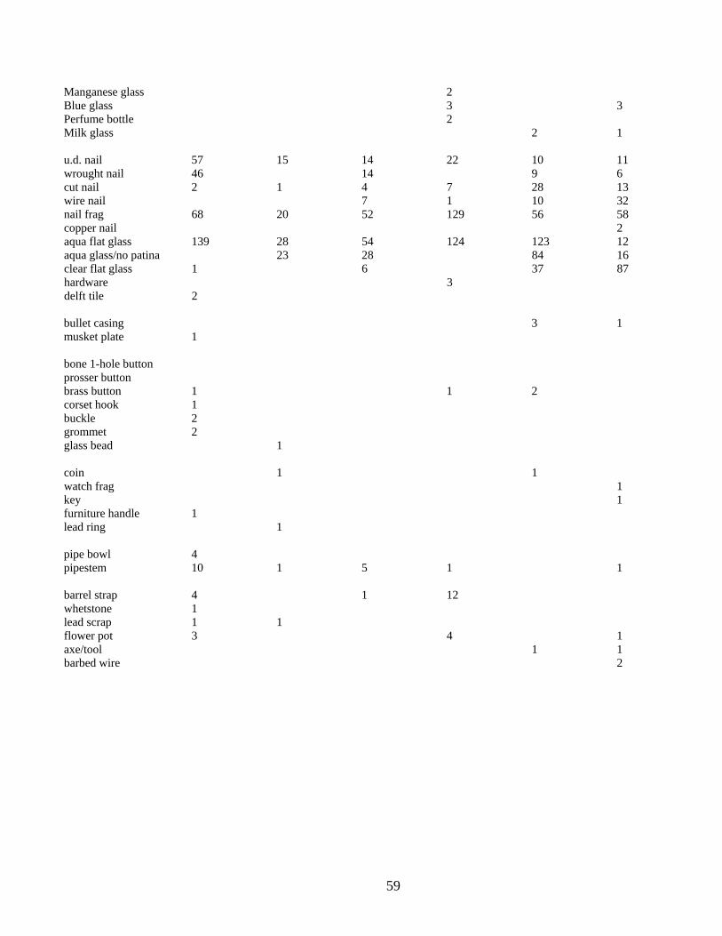
59
Manganese glass 2 Blue glass 3 3 Perfume bottle 2 Milk glass 2 1 u.d. nail 57 15 14 22 10 11 wrought nail 46 14 9 6 cut nail 2 1 4 7 28 13 wire nail 7 1 10 32 nail frag 68 20 52 129 56 58 copper nail 2 aqua flat glass 139 28 54 124 123 12 aqua glass/no patina 23 28 84 16 clear flat glass 1 6 37 87 hardware 3 delft tile 2
bullet casing 3 1 musket plate 1 bone 1-hole button prosser button brass button 1 1 2 corset hook 1 buckle 2 grommet 2 glass bead 1 coin 1 1 watch frag 1 key 1 furniture handle 1 lead ring 1 pipe bowl 4 pipestem 10 1 5 1 1 barrel strap 4 1 12 whetstone 1 lead scrap 1 1 flower pot 3 4 1 axe/tool 1 1 barbed wire 2

61
Chapter V Interpretations
Archaeological investigation of the privy area builds on three decades of research at Drayton Hall, and produced some interesting results. The excavations revealed the features described in detail by Lynn Lewis in 1980, and exposed some areas left in question at the end of her project. The excavations suggested considerable alteration to both the structure and the archaeological record during the late 19th and early 20th centuries; in fact, the material record suggests this is the period of most active use for the building. The current archaeological project provided little in the way of evidence for colonial activity in this area. The muffling of colonial activity by postbellum changes was unexpected. Particularly surprising was the paucity of artifacts around a colonial outbuilding, one traditionally used for refuse disposal after abandonment. Privies are usually considered ‘treasure troves’ of artifacts, as their vaults are often deliberately filled with cultural debris after they are abandoned, or their use has changed. Further, other areas of Drayton Hall, including the flanker buildings, the work buildings in locus 22, and the main house, have exhibited rich material assemblages. The lack of early materials around the privy requires further consideration. The 18th-19th century assemblage, though small, was dominated by colono wares. The colono ware assemblage from the privy mirrors trends noted elsewhere on Drayton Hall. The primary goal of the project was to expose features associated with the functioning of the building as a privy. Features recorded by Lewis were re-exposed, and new ones encountered. The excavations revealed several features associated with the privy function of the building, but their function and intent were less clear than expected. Interpretation of these features will be considered further. Occupational History and Material Culture Based on location, configuration, and subsurface features, the building is presumed to be a privy, one original to the main house at Drayton Hall (constructed by 1742). Excavations in 2007 revealed a construction trench on the building exterior. This was designated Feature 2 and sampled on the north and south sides of the structure. Lewis also sampled the builders trench in 1980. In all samples, Feature 2 contained few material items, and none that could be dated with accuracy; the assemblage contained fragments of window glass, brick, and mortar, all items associated with construction of the building. A lack of material items may be interpreted as evidence of construction shortly after initial occupation of a site, before the affairs of daily life resulted in the accumulation of refuse. Table 6: Artifacts from Feature 2
2 window glass 2 iron fragments 353g brick fragments, dark red 803g brick fragments, orange 1g coal 3 oyster 1 flint pebble

62
The lack of material in Feature 2 stands in contrast to the construction trench for the drain (DH 65B). Here, ceramics and other artifacts were slightly more numerous. Those present included ceramics typical of the first half of the 18th century: British delft, Combed and Trailed Slipware, and Chinese Export Porcelain. Absent from DH 65B were refined earthenwares that would date after 1760. Similar assemblages were recovered in the proveniences excavated by Lewis, and she suggested the drain was added to the privy after initial construction, in the first 20-25 years of Drayton occupation.
There is no intact archaeological evidence for use or changes to the privy during the second half of the 18th century. The earliest midden deposit around the building (Zone 3) contains a range of materials from the first quarter of the 19th century, as well as a few items from the middle of the century. A possible interpretation of the stratigraphy and material assemblage is that the building was constructed by Charles Drayton, rather than by John Drayton. Colonial artifacts were recovered around the privy, but these are in the minority. The present archaeological evidence may be interpreted either way, and should be carefully measured with the architectural and documentary evidence.
The privy is curiously absent from the drawings made by Charles Drayton in the
1790s (figure 59). The earliest image of the privy is a sketch made by Lewis Gibbes in 1846. Gibbes’ views show both the interior and exterior of the building, including features clearly associated with a privy function.
Some time after these views were
completed, the building was radically altered. The interior furniture was removed, the building received a new floor, a chimney was added to the east side, and the roof was realigned. The exact
Table 7: Artifact Assemblage, DH 65B
1 blue on white porcelain 2fr. Olive green glass 1 delft, undecorated 3 fr. Aqua flat glass 1 Historic Native American 1 lead scrap 2 whole brick
Figure 54: Lewis Gibbes’ views of the Drayton Hall privy, c. 1846;Current view, with realigned roof

63
date of these changes is unknown, but Lewis has suggested they were prompted by damage from the earthquake of 1886 or a hurricane in 1893. The changes also coincide with the period of phosphate extraction on Drayton Hall (1866-1887), and the building may have first been altered for use in this enterprise. Tradition suggests use as an office. Moreover, the building may have been altered or repaired more than once during the late 19th century, possibly during the phosphate era and later as a result of natural disaster. Likewise, its function may have changed more than once; Richmond Bowens recalls using the building as a bedroom in the early 20th century.
The artifact assemblage from Zone 2 and the large refuse-filled depression
(feature 10) accumulated between the 1880s and the first quarter of the 20th century. Materials of this period are far more numerous than those from the previous two centuries, and the present archaeological assemblage suggests this is the period of most active use of the building. Feature 10, in particular, contains numerous kitchen items and reflects domestic occupation. It may be that the majority of the materials are associated with the Bowens occupation, when the building functioned as a residence. Residential activities, particularly those associated with food, produce the majority of artifacts recovered on sites. Present research suggests the building was actively used during the last century, and that this activity informs on changing uses of the Drayton Hall landscape.
The filling of the large depression that created Feature 10, and the later
accumulation of the soils excavated as zones 1 and 2 suggest the ground surface around the privy building has been continuously altered, particularly during the last fifty years. Drainage has been a problem throughout the building’s history, and remains so. Comparison of photographs taken during Lewis’ 1980 excavation and during the present project suggest that at least a half foot of soil has been added to the west side of the building. It is possible that efforts to alleviate drainage, and to clean up around the structure resulted in the removal of archaeological soils at some point. Though there is no clear evidence of this, it remains a possible explanation for the lack of material items from the 18th and 19th centuries.
Figure 55: Soil profile above the drain in 2007. Yellow sand fill is visible in the upper portions of the profile. These soils remain unexcavated in the northeast and southwest units. The southeastern unit has been excavated to the top of the drain. The northwest unit has exposed the artifacts concentrated in Feature 10, overlying Ditch 5. North is to the left of the image.

64
Operation of the Privy The primary goal of the present project was to expose features associated with the functioning of the building as a privy for over a century, and to better understand changes to the building after this function ceased. Attribution as a privy is clear from the construction of the foundation, and suggested by the overall dimensions of the building. Lewis’s excavations on the interior revealed a vault along the rear wall of the building, measuring 2 feet in width and nearly 3 feet in depth, and part of the original construction. The vault interior featured a brick floor. The vaulted openings in the northern portions of the east and west foundations suggest access to a vault for cleaning. Recovery of whiteware in the fill inside the vault suggests the privy was cleaned for the last time sometime after 1830. The artifacts also included at least three chamber pots. Excavations on the exterior revealed the brick drain associated with the vaulted opening on the west side. Lewis recorded that the drain abutted the vault “in haphazard fashion” and was not tied to the foundation, suggesting it was a later addition. Lewis cited the recovery of numerous artifacts in the construction trench, as evidence of later construction. She notes the fact that the interior trough did not slope toward the drain as additional evidence that the drainage system was not part of the original plan. Lewis further noted that the interior trough filled with water after each rain, and that site flooding was a constant problem. She proposed that this condition could have existed in the 18th century, as well; the drain may have been constructed to help alleviate this problem. When completed, the brick drain was two feet wide, constructed of bricks six courses high surmounted by an arching brick ceiling. The drain interior was 1.0’ high, and the base of the drain was brick. The top of the brick (exterior) was 15.0’ msl, and the interior had a bottom elevation of 13.8’ msl. The silt inside the drain contained a late 19th century button, but otherwise was filled with small artifacts from the late 18th to early 19th centuries.
Figure 56: Views of interface of vault opening and drain. The opening was bricked after the 1980 excavations to stabilize the building and soils inside

65
The brick drain continued to the northwest 32 feet and terminated abruptly,
without additional architectural features. Lewis exposed the terminus in unit DH 67. She noted the end was irregular, possibly indicating disturbance or removal of remaining sections. She did observe that a large area at the terminus appeared to have been dug out and filled with slag and gravel, possibly to create a leaching field. Based on this description, it was anticipated that the drain continued beyond this point, and 2007 excavations were located to search for an extension. None was found. Instead, re-exposure of the terminus suggested a finished edge, with some slight disturbance of the upper courses. The brick terminated in a depression of dark soil, filled with artifacts from the turn of the 19th century (DH 166C). The deposits also contained quantities of slag and phosphate, possibly the materials observed by Lewis and interpreted as a leach field.
The assemblage was dominated by fragments of creamware, including chamber
pots, plus a number of pearlware fragments. DH 166C was thus deposited in the early 19th century. This rich artifact assemblage was different in content and character from others encountered during the present project. The early 20th century filling (designated Feature 10) disturbed this deposit, and artifacts from the early assemblage were re-deposited in the later fill (DH 166B and DH 166A). The early 19th century artifacts were easily distinguished from those of the early 20th century, and were quantified separately in Chapter IV. Field elevations suggest the drain slopes from the privy toward its terminus; the eastern end of Ditch 2 measuring 13.8’ msl at the interface with the privy building and 12.67 at the western end.
Figure 58: Terminus of drain; depression at end of drain
Figure 57: soil profile in Ditch 5. The deepest level (DH 166C) contains materials dating to the early 19th century. The soil layer above was deposited in the early 20th century, while the mottled fill dates to that last two decades.

66
Based on the current excavations, the brick drain appears to have terminated in a natural, or enhanced, low area. This area was filled with refuse in the early 19th century, at a time when owner Charles Drayton was making extensive changes to the property. His map of the early 19th century shows a water feature in this vicinity, running north/south from the flanker building to a large drain. It is possible that the ditch indicated on the map was an adjustment to a natural low area, adjusted to enhance drainage of the living area. Curiously, the privy building is not present on this map. The archaeological evidence indicates that the privy drain connected to this drainage feature. Evidently, the drainage ditch was eventually filled and abandoned. Feature 10 (DH 166A-B) may be part of this effort. As indicated by the present structural problems with the privy, drainage of this area remains an issue.
The vaulted opening on the east side of the privy was not fitted with an enclosed
drain. Instead, soil stains reflected a square pit adjoining the vault, measuring nearly 7’
Figure 60: Views of Feature 7 on east side of structure
Figure 59: Charles Drayton’s sketch of Drayton Hall. Note water feature extending north from the flanker. The privy building is not shown on this sketch.

67
in length and 2.5’ in width. From its point of definition at sterile subsoil, the feature was nearly 2’ deep at the face of the building, the bottom parallel with the base of the arch. The pit exhibited straight sides and a slightly rounded bottom. The feature evidenced two fill episodes. Though the lower levels exhibited no obvious lensing, it is possible that this reflects a pit that remained open for some time. Feature 7 (DH 157A) terminated in a smaller, shallower feature. The feature was clearly excavated for access to the vaulted opening, but was not used for drainage. A near absence of cultural materials suggests that it was not used for refuse disposal, either. Likely, high ground on the east side of the structure made drainage here impractical. It is possible that the pit allowed access for flushing the vault.
This was the function attributed to the breach in the rear wall by Lewis in 1980.
Excavation of DH 59 revealed an opening in the brick, three courses (.9’) height and approximately 1.5’ wide. A pit similar to Feature 4 was exposed in her narrow unit, and was fully revealed in 2007. Feature 7 (DH 162) measured 5.5’ in length and averaged 3’ in width. The feature exhibited three levels of filling, the upper level dating to the mid-19th century or later. The lowest level was a dark loam, and Lewis noted evidence of lensing in the sample adjacent to the foundation, suggesting that the pit remained open for some time. Lewis suggests an additional opening may have been required to adequately flush the privy vault.
Figure 61: Views of opening in north foundation as excavated by Lewis in 1980 (right); Expanded excavation in 2007 and associated Feature 4.
Table 8: Assemblage from Feature 7 1 slipware 12 nail frags. 1 colono, Yaughan 15 ud. nails 1 historic Native American 9 window glass 6 olive green glass 1 pipestem 1 lead frag
68
The 2007 excavations confirmed and refined the interpretations proposed by Lewis in 1980. Lewis suggested the drainage system on the west side of the privy was an addition to the early structure, but the feature may be contemporary with the building. The drain appears to have terminated in an open drainage feature that, in turn, fed a larger ditch running to the Ashley River. Whether the system ever flushed efficiently remains unknown. The access pit adjacent to the east opening, and the addition of the rear opening, suggests that direct access was required for water introduction, and possibly for periodic cleaning. The artifacts, architecture, and documents suggest the date of construction and use is open to interpretation; a paucity of colonial artifacts and presence of early 19th century ceramics in the deepest levels support construction in the early 19th century. Conversely, a lack of artifacts in the construction trench for the building and the presence of a few colonial materials in the construction trench of the drain support a colonial origin for the building. Colono Ware
The ceramic assemblage from the privy was dominated by colono wares. Though small, the colono ware assemblage was remarkably diverse. Originally referred to as Colono-Indian Ware by Virginia archaeologists and culture historians (cf. Noel Hume 1962), the pottery known today as colono ware was initially thought to have been a market ware, produced exclusively by historic period Native Americans for European Americans. In 1978, Leland Ferguson postulated that much of this pottery was actually manufactured and used by enslaved Africans and African Americans (Ferguson 1980); Ferguson urged scholars to call this pottery “colono ware”. Initial support for his contention was the sheer quantity of colono ware found in plantation contexts (Cooper and Steen 1998; Ferguson 1992), particularly those associated with slave occupation. Early evidence of on-site colono ware manufacture included the observation of spalling marks on several colono ware vessels and the recovery of several possible unfired colono ware sherds (Drucker and Anthony 1979; Wheaton et al 1983; Zierden et al 1986).
Further support for on-site manufacture of colono ware within plantation settings
was discovered at Drayton Hall plantation where Lewis (1978) recovered a basal fragment of a colono ware bowl, near the planter residence, with the initials “MHD” incised into the bowl before it had been fired. The initials may stand for Mary Henrietta Drayton who resided at Drayton Hall plantation from the 1780s to the 1840s (Lewis n.d.; Ferguson 1992). Additionally, in 2003, a very small crudely made bowl was recovered from Locus 22 at Drayton Hall plantation (Zierden and Anthony 2004). Based on its physical attributes, this vessel does not appear to be a market ware nor does it seem functionally viable. It is quite possible that this petite colono ware vessel represents a container made by a child, perhaps evidencing enculturation. This scenario further supports the on-site manufacture of colono ware within a plantation setting.

69
As a part of an accelerating interest in plantation archaeology, focused research
on colono ware began in the South Carolina lowcountry during the late 1970s. Several of the earliest studies were the result of compliance archaeology (eg. Anthony 1979, 1986; Drucker and Anthony 1979; Wheaton et al 1983; Zierden et al 1986). At several of the plantation sites investigated, it was clearly and quickly demonstrated that colono ware formed a substantial part of colonial and early antebellum artifact assemblages. At times, this hand-built earthenware was the most frequent type of pottery recovered, particularly in areas occupied by enslaved African Americans ( cf. Anthony 1979, 1986; Drucker and Anthony 1979; Lees 1980; Lewis and Haskell 1980; Wheaton et al 1983; Zierden et al 1986).
Colono ware has been investigated at varying scales of analysis. Joseph provides
an excellent summary of lowcountry colono ware research as a part of the report on archaeological investigation of the Charleston County Judicial Center site (Hamby and Joseph 2004). Those who have studied colono ware intra-regionally have for some time noted considerable morphological variability in lowcountry colono ware; in vessel form, surface treatment, paste characteristics, and method of manufacture. Importantly, Cooper and Steen (1998) have pointed out pitfalls associated with excessively broad-scaled studies, and their position acknowledges variability and diversity in the pottery. Cooper and Steen (1998:1) warn that many of the “macro scale,” or interregional studies, have “… removed colono ware from its context of manufacture and use.” This has occurred when data from large-scale studies (data not sensitive to intra-regional variability and diversity) have been used to investigate local assemblages. This decontextualizing of colono ware obscures cultural meaning, available primarily through the study of localized cultural processes reflected in this low-fired earthenware. This position should be kept in mind when studying any type of material culture from plantation contexts (cf. Anthony 1989).
One of the primary anthropological values ascribed to colono ware that it
represents one of the best examples of culture contact in the colonial South and Mid Atlantic area (Anthony 2002). As a product of syncretism, colono ware expresses the
Figure 62: small hand-modeled pot from locus 22; colono ware with incised initials

70
dynamics, complexities, diversity, and energy of cultural encounters during the colonial period in the Southeast. These cultural interactions varied substantially in scope, nature, and intensity through time and space. As with any cultural element, one should expect variability and diversity, given the dynamic nature of culture and the mosaic of cultural players in the colonial Southeast and Mid Atlantic region (cf. Joseph and Zierden 2002).
Today, several varieties of Lowcountry colono ware have been presented and
used in the research literature (cf. Anthony 1986, 2002; Ferguson 1989; Garrow and Wheaton 1989; Wheaton et al 1983). The delineation of these colono ware groupings initially facilitated the investigation of socio-economic status, including the determination of site function(s), within rural plantation contexts. Of late, they have been used to understand the fluid nature of multicultural contact in colonial and early antebellum South Carolina, particularly through new data from urban contexts (Anthony 2002; Crane 1993; Hamby and Joseph 2004; Isenbarger 2006; Steen 1999). The growing evidence that some varieties of colono ware should be considered “market” wares clearly infers that there were numerous opportunities for a variety of cultural interactions, and suggests that the origins and uses of this hand built pottery were probably more complex than originally conceived ( Anthony 1986,1989; Crane 1993; Epps 2004; Hamby and Joseph 2004; Isenbarger 2001,2006; Zierden 2001). Interestingly, the current evidence suggests that the dates of highest popularity and/or use of colono ware varied between urban and rural contexts (Anthony 1979, 1986; Crane 1993; Espenshade 1996; Ferguson 1992; Hamby and Joseph 2004; Trinkley et al 1995). This likely reflects different cultural processes in rural and urban areas - processes that colono ware should help researchers understand (Zierden et al 1986; Anthony 1986,1989, 2002; Epps 2004).
Archaeological investigations at Drayton Hall since 2003 have revealed that all of
the currently defined South Carolina varieties of colono ware are present at this Ashley River plantation, as well as a fourth category of low fired historic pottery (Zierden and Anthony 2004, 2006). These varieties include Yaughan , Lesesne, and River Burnished
colono wares (Anthony 1986,2002; Ferguson
1989; Garrow and Wheaton 1989). The fourth grouping, probably encompassing several varieties, was likely produced by Native Americans during the 18th century and/or
Figure 63: Examples of historic period Native American ceramics: shell tempered (left) and burnished (right)

71
produced and used by those interacting with Native American, as groups or individuals (Anthony 1986, 2002; Ferguson 1989; Wheaton et al 1983; Garrow and Wheaton 1989). This colono ware category includes earthenware whose surfaces have been complicated stamped and/or red filmed, as well as those whose surfaces have simply been burnished. Those vessels whose surfaces have been burnished and stamped usually exhibit a relatively coarse paste and medium to coarse sand temper (Anthony 2002). Less frequently, a crushed shell temper is observed. The red filmed vessels may or may not exhibit a medium to course paste. If not, then often they exhibit a laminar paste (Anthony 2005). This “red filming” seems to be a slip rather than a painted design like those associated with some River Burnished vessels. The burnished medium to coarse sand tempered ceramics may very well be the same pottery referred to as Colonial Burnished by Hamby and Joseph (2004) in their study of the Charleston County Judicial Center site. Table 9 depicts the frequency of colono ware by category recovered in 2003 and 2005 in locus 22, and in 2007 from the privy area.
_____________________________________________________________
Table 9
Colono Ware From Locus 22 (2003 & 2005) and Privy Area (2007) Classification Frequency % (2003) (2005) (2007) Yaughan 843 587 24 79
Lesesne 111 92 6 11 River Burnished 1 17 3 1
Historic Aboriginal 76 76 8 9 Colono Ware* TOTAL 1,031 772 41 100 *includes six red-filmed sherds and one shell tempered sherd
The 2007 investigations at Drayton Hall, around the privy (east of locus 22)
yielded only 41 colono ware sherds, including 10 rimsherds. Besides bowl and jar vessel forms, a fragment of a colono ware pipe bowl as well as a probable section of a handle

72
were collected. As with most lowcountry colono ware assemblages, bowl forms dominated the collection. Both rounded and flattened lips were observed on Yaughan, Lesesne, and Historic Aboriginal ceramics. A distinctive bulbous lip characterizes one Historic Aboriginal rimsherd from Drayton Hall, a lip form associated with the Lesesne variety in several other assemblages (eg. Anthony 1986,2002). No River Burnished rimsherds were recovered during the present effort.
As depicted in Table 9, Yaughan continues to be the
most common variety of colono ware at Drayton Hall since 2003. Yaughan has been found most frequently in slave occupation areas, particularly residential loci. In rural contexts, Lesesne lustered colono ware occurs most frequently in planter occupation areas (Anthony 1986, 2002). Additionally, Lesesne appears to be the most abundant colono ware from downtown Charleston (Hamby and Joseph 2004; Isenbarger 2006; Zierden 2001). Lesesne lustered ware quite likely represents a market ware (cf. Anthony 1986; Hamby and Joseph 2004; Isenbarger 2001, 2006). River Burnished colono ware (Ferguson 1989) likely is another, though probably a later example.
River Burnished pottery (Ferguson 1989) is thin, well made earthenware, which at
times exhibits burnished and painted surfaces that are most frequently decorated in black and/or luminescent red. Wares of this description are most common in late 18th- to early19th-century contexts. Designs observed on archaeologically recovered examples, from both rural and urban locales, include dots, lines, and floral motifs (Lewis n.d.; Zierden and Anthony 2004, 2006). River Burnished sherds recovered during the present investigation exhibited remnants of a red pigment (10R4/8). Since the 1980s, many researchers in South Carolina have suggested that River Burnished colono ware was initially produced and exchanged by Native Americans known since the late 18th century as the Catawba.
Research by Brett H. Riggs and R.P. Stephen Davis Jr., (2004, 2006) at New
Town and other areas strongly supports the belief that River Burnished pottery is Catawba pottery. Recent archaeological excavations at New Town, the “Catawba’s primary Federal-period settlement in Lancaster County, South Carolina …” (Riggs and Davis 2006:60) has clearly evidenced vessels with shapes, pastes, and surface decorations essentially matching the physical attributes that have been observed on many River Burnished examples from coastal South Carolina. Further evidence supporting the linkage between River Burnished pottery (as a market ware) and the Catawba is provided
Figure 65: River burnished sherd with red pigment
Figure 64: Lesesne lustered rim

73
by oft-cited primary documentation. For example, Simms writes (1852:127 as cited in Crane 1993:142 and Hamby and Joseph 2004:259):
[The Catawba] did not, however, bring their pots and pans from the nation, but descending to the low country empty-handed, in groups or families, they squatted down on the rich clay lands along the Edisto, raised their poles, erected their sylvan tents, and there established themselves in a temporary abiding place, until their simple potteries had yielded them a sufficient supply of wares with which to throw themselves into the market … Their camps might be found in famed loam-spots, from the Eutaws down to Parker’s Ferry, on the Edisto, and among the numerous swamps that lie at the head of the Ashley River …
Colono wares comprised over 10% of the ceramics recovered at the privy.
Further, they dominated the artifact assemblage recovered from locus 22 in 2003-2005 (63%). The overall diversity, and relative quantity, of colono ware at Drayton Hall suggests a dynamic location, with wares from a variety of sources. Wares may have been made on site, traded on site, or obtained from markets in Charleston. The presence of wares attributed to Native people, including the Catawba, suggests that Native Americans remained players in the lowcountry economy into the early 19th century. The relatively homogeneous characteristics of the colono ware from locus 22 and the privy area at Drayton Hall stands in contrast to the diversity observed in the colono ware assemblage from the immediate vicinity of Drayton Hall’s planter residence. This suggests that the social and economic dynamics of colono ware manufacture and use can be addressed at Drayton Hall and other comparable plantations.
In order to understand the formation and dynamics of the multi-faceted colonial Southeast, researchers must first pursue intra-regional investigations of both rural and urban settings. As a product of culture contact among people of widely divergent cultural backgrounds, colono ware tangibly reflects the emergence, perhaps an ethnogenesis and evolution, of new cultural systems. Colono ware promises to provide a valid avenue for reconstructing and understanding some of the processes of cultural formation and rapid change experienced by pioneering African Americans, Native Americans, and European Americans during the colonial and early antebellum periods. Many of these processes are likely undocumented and thus unknowable without focused archaeological investigation. Project Summary Excavations around the privy building in 2007 were successful in exposing the features recorded by Lynn Lewis and refining interpretations proposed as a result of her 1980 field project. Interpretation of the original function of the building as a privy was supported by the architectural evidence, specifically a deep vault along the north side of the building, accessed by arched openings on the east and west sides of the structure. The
74
brick drain aligned with the western arch. The drain extended 32 feet to the northwest, terminating in a low, refuse-filled depression that appears to be a drainage feature running north/south, illustrated by Charles Drayton in the 1790s. The arch on the east side of the building was evidently accessed by a pit approximately 7’ long and 2’ wide. There was no evidence of a brick structure on this side of the building. Artifacts contained in the ditch (feature 7) were sparse and difficult to date, but an early 19th century date is proposed, based on surrounding midden deposits. At some point, a crude opening was placed in the north foundation of the privy, accessed with ditch similar to feature 7, 5.5 feet long and approximately 2.5 feet deep. There was no evidence of brick drains at either opening. Based on cumulative documentary, architectural, and material culture evidence, construction date of the privy and the brick drain is open to interpretation. It is possible that the privy was constructed after Charles Drayton acquired the property in the 1780s. The building and drain may be constructed as a single event. Artifacts from the early 19th century dominate the material assemblage. Conversely, a lack of cultural material in the construction trench for the building foundation (feature 2) and the presence of mid-18th century materials in the construction trench for the drain (ditch 2) support an 18th century date of construction. The building was extensively altered and intensively used in the late 19th century, and this use continued through the first half of the 20th century. The roof was reoriented, the interior transformed from privy to living area, and the privy function evidently ceased. The majority of the cultural materials retrieved from the privy date to this period. The archaeological record was dominated by domestic artifacts from the early 20th century, particularly from a large filled area (feature 10). This pit may represent filling of the water feature that formed the terminus of the drain system. Ongoing efforts to alleviate drainage problems in the privy area are evident in the archaeological record. After abandonment as a privy, the building was used for a variety of purposes. Tradition suggests use as an office during the phosphate era and as a dwelling for the Bowens family in the early 20th century. The structure was evidently an important part of the Drayton Hall landscape after the Civil War. The paucity of cultural materials from the colonial period is surprising, and this absence of materials is one reason a later date of construction is proposed. Colonial sites are usually full of discarded materials, and dense midden deposits have been exposed around the main house, the flankers, and the work yard in northwest lawn. In contrast, few materials were retrieved around the privy. An alternate interpretation is that the soils around the privy were reorganized at some later point, effectively removing colonial deposits. The soil layers present contain assemblages dating to the early 19th century, but these are also relatively sparse. The only exception is DH 166C, the deep water feature at the drain terminus. The present project has provided extensive, if somewhat ambiguous, data for interpretation of the landscape and built environment at Drayton Hall. The project

75
underscores the necessity for interdisciplinary research, combining data and interpretations from documentary, architectural, environmental, and archaeological sources.
Figure 66: Drain and privy, facing southeast. Units on north, east, and south sides of building have been backfilled.

76

77
References Cited Anthony, Ronald W.
1979 Descriptive Analysis and Replication of Historic Earthenware: Colono Wares from Spiers Landing Site, Berkeley County, South Carolina. Conference on Historic Sites Archaeology Papers 13:253-268, Institute of Archaeology and Anthropology, Columbia.
1986 Colono Wares. In Home Upriver: Rural Life on Daniels Island, by Martha
Zierden, Lesley Drucker, and Jeanne Calhoun, pp. 7/22-7/51. Ms. on file, South Carolina Department of Highways and Public Transportation, Columbia.
1989 Cultural Diversity at Mid to Late 18th Century Lowcountry Plantation Slave
Settlements. M.A. Thesis, University of South Carolina, Columbia.
2002 Tangible Interaction: Evidence from Stobo Plantation. In Another’s Country, edited by J.W. Joseph and Martha Zierden, pp. 45-64, University of Alabama Press, Tuscaloosa.
2005 South Carolina Colonoware: Perplexing yet Exciting. Paper presented at the 62nd
Southeastern Archaeological Conference, Columbia, SC. Austin, John C.
1994 British Delft at Williamsburg. Colonial Williamsburg Foundation, Decorative Arts Series, Williamsburg, VA.
Barker, David
1999 The Ceramic Revolution 1650-1850. In Old and New Worlds, edited by Geoff Egan and R.L. Michael, pp. 226-234, Oxbow Books, Oxford.
Baumgarten, Linda
2002 What Clothes Reveal: The Language of Clothing in Colonial and Federal America. Yale University Press and Colonial Williamsburg Foundation, New Haven.
Beaudry, Mary
2007 Findings: The Material Culture of Needlework and Sewing. Yale University Press, New Haven, CT.
Borick, Carl
2003 A Gallant Defense: The Siege of Charleston, 1780. University of South Carolina Press, Columbia.

78
Claney, Jane Perkins 1996 Form, Fabric, and Social Factors in Nineteenth-Century Ceramics Usage: A Case
Study in Rockingham Ware. In Historical Archaeology and the Study of American Culture, edited by Lu Ann De Cunzo and Bernard L. Herman, pp. 103-150, Winterthur Publications, University of Tennessee Press, Knoxville, TN.
Clifton, Robert T.
1970 Barbs, Prongs, Points, Prickers, & Stickers. University of Oklahoma Press, Norman, OK.
Cooper, Margaret and Carl Steen
1998 Potters of the South Carolina Lowcountry: A Material Culture Study of Creolization. Ms. on file, Diachronic Research Foundation, Columbia.
Copeland, Robert
1994 Blue and White Transfer-Printed Pottery. Shire Album 97, Shire Publications, Buckinghamshire.
Crane, Brian
1993 Colono Wares and Criollo Ware Pottery from Charleston, South Carolina and San Juan, Puerto Rico in Comparative Perspective. Ph.D. Dissertation, University of Pennsylvania, University Microfilms, Ann Arbor.
Cushion, John P.
1976 Pottery and Porcelain Tablewares. William Morrow & Company, New York.
Davis, R.P. Stephen Jr. and Brett H. Riggs 2004 An Introduction to the Catawba Project. North Carolina Archaeology 53:1-41.
Deagan, Kathleen
1975 New Dates for Creamware from Closed Contexts in St. Augustine. Conference on Historic Sites Archaeology papers 9:13-29.
1987 Artifacts of the Spanish Colonies and the Caribbean, 1500-1800, volume 1.
Smithsonian Institution Press, Washington. 2002 Artifacts of the Spanish Colonies of Florida and the Caribbean, 1500-1800,
volume 2. Smithsonian Institution Press, Washington. Drucker, Lesley M. and Ronald W. Anthony
1979 The Spiers Landing Site: Archaeological Investigations in Berkeley County, South Carolina. Resource Study Series 10, Carolina Archaeological Services, Columbia.

79
Edgar, Walter
1998 South Carolina: A History. University of South Carolina Press, Columbia.
Epps, Katrina S. 2004 Intra-Regional Interaction in the Lowcountry of South Carolina. M.A. Thesis,
Department of Anthropology, University of South Carolina, Columbia, SC. Epstein, Diana
1968 Collector’s Blue Book of Buttons. Walker & Co., New York.
Espenshade, Christopher 1996 The Changing Use Contexts of Slave-Made Pottery on the South Carolina Coast.
Paper presented at the conference African Impact on the Material Culture of the Americas, Winston-Salem, NC.
Espenshade, Christopher and Marian Roberts
1991 An Archaeological and Historical Overview of the Drayton Hall Tract. Brockington & Associates, Charleston.
Ferguson, Leland
1980 Looking for the “Afro” in Colono Indian Pottery. In Archaeological Perspectives on Ethnicity in America, edited by Robert Schuyler, pp. 14-28. Baywood Press, Farmingdale, New York.
1989 Lowcountry Plantations, The Catawba Nation, and River Burnished Pottery. In
Studies in South Carolina Archaeology: Essays in Honor of Robert L. Stephenson, edited by Albert Goodyear and Glen Hanson, pp. 185-191, Anthropological Studies 9, Occasional Papers of the South Carolina Institute of Archaeology and Anthropology, University of South Carolina, Columbia.
1992 Uncommon Ground: Archaeology and Early African America, 1650-1800.
Smithsonian Institution Press, Washington.
Fontana, Bernard L. and J. Cameron Greenleaf 1962 Johnny Ward’s Ranch: A Study in Historical Archaeology. The Kiva 28(1-2):1-
115. Gaimster, David
1997 German Stoneware 1200-1900: Archaeology and Cultural History. The British Museum, London.
Galbraith, Letitia
1984 After the War. Drayton Hall Interiors, Winter 1984.

80
Garrow, Patrick H. and Thomas R. Wheaton 1989 Colonoware Ceramics: The Evidence from Yaughan and Curriboo Plantations. In
Studies in South Carolina Archaeology: Essays in Honor of Robert L. Stephenson, edited by Albert C. Goodyear and Glen T. Hanson, pp. 175-184. Anthropological Studies 9, Occasional Papers of the South Carolina Institute of Archaeology and Anthropology, University of South Carolina, Columbia, SC.
Hamby, Theresa M. and J.W. Joseph
2004 A New Look at the Old City: Archaeological Excavations of the Charleston County Judicial Center Site (38Ch1708). Report on file, County of Charleston, Charleston, SC. New South Associates Technical Report 1192, Stone Mountain, GA.
Huggins, Phillip K.
1971 The South Carolina Dispensary. Sandlapper Press, Columbia.
Isenbarger, Nicole 2001 Analysis of Colono Ware in 18th Century Deposits. In Excavations at 14 Legare
Street, Charleston, South Carolina, by Martha Zierden. Archaeological Contributions 28, The Charleston Museum, Charleston.
2006 Potters, Hucksters, and Consumers: Placing Colonoware within the Internal Slave
Economy Framework. M.A. Thesis, University of South Carolina, Columbia. Joseph, J. W. and Martha Zierden, editors
2002 Another’s Country: Archaeological and Historical Perspectives on Cultural Interactions in the Southern Colonies. University of Alabama Press, Tuscaloosa.
Kechum, William C.
1975 A Treasury of American Bottles. Bobbs Merrill, New York.
Kovacik, Charles and John Winberry 1987 South Carolina: the Making of a Landscape. University of South Carolina Press,
Columbia.
Lane, Mills B. 1996 Architecture of the Old South: Colonial and Federal. Beehive Press Books,
Savannah, GA.
Leath, Robert A. 1999 “After the Chinese Taste”: Chinese Export Porcelain and Chinoiserie Decoration
in Early Eighteenth Century Charleston. Historical Archaeology 33(3):48-61.

81
2006 “All Served Up in India China…”: Chinese Export Porcelain in Charleston, 1700-1860. Paper presented at the 2006 Charleston Art & Antiques Forum, Charleston, South Carolina.
Lees, William B.
1980 Old and in the Way: Archaeological Investigations at Limerick Plantation, Berkeley County, South Carolina. Anthropological Studies 5, Institute of Archaeology and Anthropology, University of South Carolina, Columbia.
Lewis, Kenneth E. and Helen
1980 Middleton Place: Initial Archaeological Investigations at an Ashley River Rice Plantation. Research Manuscript Series 148, Institute of Archaeology and Anthropology, University of South Carolina, Columbia, SC.
Lewis, Lynne G.
1978 Drayton Hall: Preliminary Archaeological Investigation at a Low Country Plantation. National Trust for Historic Preservation, University Press of Virginia, Charlottesville.
1985 The Planter Class: The Archaeological Record at Drayton Hall. In The
Archaeology of Slavery and Plantation Life, edited by Theresa Singleton, pp. 121-140, Academic Press, New York.
1996 Exploration of a Water Control Device at Drayton Hall, Charleston, South
Carolina. Draft report on file, Drayton Hall, Charleston, SC.
n.d. Synthesis of Archaeological Research at Drayton Hall. Draft ms. in possession of the author, Montpelier Station, Virginia.
Linder, Suzanne Cameron
1995 Historical Atlas of the Rice Plantations of the Ace River Basin 1860. South Carolina Department of Archives and History, Columbia.
2000 Anglican Churches in Colonial South Carolina: Their History and Architecture.
Wyrick & Company, Charleston. Lorrain, Dessamae
1968 An Archaeologist’s Guide to the 19th Century American Glass. Historical Archaeology 2: 35-44.
Lounsbury, Carl R.
1994 An Illustrated Glossary of Early Southern Architecture and Landscape. Oxford University Press, New York.
Luscomb, Sally C.
1954 The Collector’s Encyclopedia of Buttons. Crown Publishers, Inc., New York.

82
Martin, Anne Smart 1994a Consumption, Commodities, and Cultural Identity in Eighteenth Century
Virginia. Paper presented at the 28th annual meeting of the Society for Historical Archaeology, Washington D.C.
1994b “Fashionable Sugar Dishes, Latest Fashion Ware”: The Creamware Revolution in
the Eighteenth-Century Chesapeake. In Historical Archaeology of the Chesapeake, edited by Paul Shackel and Barbara Little, pp. 169-188, Smithsonian Institution Press, Washington, D.C.
1996 Material Things and Cultural Meanings: Notes on the Study of Early American
Material Culture. William and Mary Quarterly LIII(1):5-12.
Miller, George L. 1980 Classification and Economic Scaling of 19th Century Ceramics. Historical
Archaeology 14:1-41.
1991 A Revised List of CC Index Values for Classification and Economic Scaling of English Ceramics from 1787 to 1880. Historical Archaeology 25(1):1-25.
Miller, George L., with contributions by Patricia Samford, Ellen Shlasko, and Andrew Masden
2000 Telling Time for Archaeologists. Northeast Historical Archaeology 29:1-22. Noel Hume, Ivor
1962 An Indian Ware of the Colonial Period. Quarterly Bulletin of the Archaeological Society of Virginia. 17(1).
1969 A Guide to Artifacts of Colonial America. Alfred A. Knopf, New York.
Porcher, Richard and Sarah Fick 2005 The Story of Sea Island Cotton. The Charleston Musuem, Wyrick & Company,
Gibbs Smith, Layton, Utah.
Riggs, Brett H., R.P. Stephen Davis, and Mark R. Plane 2006 Catawba Pottery in the Post-Revolutionary Era: A View from the Source. North
Carolina Archaeology 55:60-88.
Rock, James T. 1984 Cans in the Countryside. Historical Archaeology 18(2):97-111.
Roenke, Karl G. 1978 Flat Glass: Its Use as a Dating Tool for Nineteenth Century Archaeological Sites
in the Pacific Northwest and Elsewhere. Northwest Anthropological Research Notes 12(2).
Rosengarten, Theodore
1986 Tombee: Portrait of a Cotton Planter. William Morrow & Company, New York.

83
Schick, Tom W. and Don H. Doyle
1985 The South Carolina Phosphate Boom and the Stillbirth of the New South, 1867-1920. South Carolina Historical Magazine 86(1):1-31.
Simms, William Gilmore
1852 Caloya; or Loves of the Driver. In The Wigwam and the Cabin, or Tales of the South. Walker, Richards, and Co., Charleston, SC.
South, Stanley
1964 Analysis of Buttons from Brunswick Town and Fort Fisher. Florida Anthropologist XVII(2):113-133.
1977 Method and Theory in Historical Archaeology. Academic Press, New York.
Sprague, Roderick
2002 China or Prosser Button Identification or Dating. Historical Archaeology 36(2):111-127.
Steen, Carl
1999 Pottery, Inter-Colonial Trade, and the Revolution: Domestic Earthenwares and the Development of American Social Identity. Historical Archaeology 33(3):62-71.
Stockton, Robert P.
1985 Titular Complexities and Shifting Boundaries of an Ashley River Plantation. In Volume II, Appendix C, Drayton Hall: Architectural and Documentary Research Report, by C. E. Chase and K. Murphy. National Trust for Historic Preservation, Charleston.
Stone, Lyle M.
1974 Fort Michilimackinac 1715-1781: An Archaeological Perspective on the Revolutionary Frontier. Publications of the Museum, Michigan State University, East Lansing.
Sussman, Lynn
1997 Mocha, Cat’s Eye, and Other Factory-Made Slipware. Studies in Northeast Historical Archaeology, Number 1, Council for Northeast Historical Archaeology.
Sutton, Mark Q. and Brooke S. Arkush
2006 Archaeological Laboratory Methods. Kendall-Hunt Publishing Company, Dubuque, Iowa.
Switzer, Ronald R.
1974 The Bertrand Bottles: A Study of 19th Century Glass and Ceramic Containers. National Park Service, Washington.

84
Towner, Donald
1978 Creamware. Faber & Faber, Boston. Trinkley, Michael, Debi Hacker and Natalie Adams
1995 Broom Hall Plantation: “A Good One and In a Pleasant Neighborhood.” Research Series 44, Chicora Foundation, Columbia.
Waselkov, Gregory and John A. Walthall
2002 Faience Styles in French North America: A Revised Classification. Historical Archaeology 36(1):62-78.
Wheaton, Thomas, Amy Friedlander, and Patrick Garrow
1983 Yaughan and Curriboo Plantations: Studies in Afro-American Archaeology. Soil Systems, Inc., Marietta, GA.
Zierden, Martha
2001 Archaeology at 14 Legare Street, Charleston, South Carolina. Archaeological Contributions 28, The Charleston Museum, Charleston.
2002 The Archaeological Signature of 18th Century Charleston. In Material Worlds of
the Tidewater, Lowcountry and Carribean, edited by David Shields, University of South Carolina Press, Columbia (in press).
2006a Excavations in the Front Lawn: Nathaniel Russell House 2003-2006.
Archaeological Contributions 36, The Charleston Museum, Charleston. 2006b Chinese Export Porcelain from Archaeological Contexts in Charleston, South
Carolina. Paper presented at the 2006 Charleston Art & Antiques Forum, Charleston, South Carolina.
Zierden, Martha and Ronald W. Anthony
2004 Archaeological Testing, 2003: Drayton Hall. Archaeological Contributions 33, The Charleston Museum, Charleston, SC.
2006 Unearthing the Past, Learning for the Future: Archaeology at Drayton Hall, 2005.
Archaeological Contributions 37, The Charleston Museum, Charleston, SC. Zierden, Martha and Elizabeth Reitz
2005 Archaeology at City Hall: Charleston’s Colonial Beef Market. Archaeological Contributions 35, The Charleston Museum.
Zierden, Martha, Lesley Drucker, and Jeanne Calhoun
1986 Home Upriver: Rural Life on Daniels Island, Berkeley County, South Carolina. Report on file, South Carolina Department of Highways and Public Transportation, Columbia.

85