archives.sfplanning.org€¦ · draft transit center district plan 63 04 moving about introduction...
TRANSCRIPT

DRAFT TRANSIT CENTER DISTRICT PLAN 63
MOVING ABOUT04 INTRODUCTION
The Downtown Plan has guided the substantial growth of downtown (including the Transit Center District) largely on the back of transit. Since 1985, the total built space in downtown has increased by about 25 percent, including 19 million square feet of office space. Traffic congestion and auto travel, however, has not increased commensurately. In other words, the growth in downtown jobs and residents—and the resulting growth in the City’s tax base—has been dependent on the City’s and region's commitments to enhancing local and regional transit service and getting most people to downtown San Francisco without autos. The success of the Transit Center District Plan will hinge on maintaining this “transit first” commitment.
The development of the new Transbay Transit Center—the “Grand Central Station of the West”—and development in the Transit Center District will both create and necessitate a significantly enhanced transit service beyond what downtown San Francisco enjoys today. With a focus on transit as the primary mode of moving people into and throughout the
District, the accommodation of growth (let alone current levels) in automobile traffic cannot be prioritized. Instead, a rich public realm that supports large amounts of pedestrian activity can be created. The Transit Center District Plan’s vision is to enhance the function of surface transit and manage vehicular traffic in order to transform the District’s streets into memorable, active, and world-class public spaces that support walking and bicycling, that encourage and support social activity, and that create a vibrant urban center made particularly unique by its focus around the new Transbay Transit Center.
Anticipated growth and the location of the Transit Center in this district necessitate considerable improvements to the transportation system and rights-of-way that support transit and encourage travel by non-auto modes. This future cannot be achieved based on the current design of the area’s streets and management of its circulation system. The majority of trips to and through the District must occur via non-auto modes, or proposed growth in the District will be stifled and congestion will bring the city’s core transit network to a standstill.

64 1 2 3 4 5 6 7
MOVING ABOUT04In order to transform the District’s public realm into a great place for people to get around safely and conveniently and to prepare for its new workers, residents, and visitors, this Plan recommends infrastructure improvements, transit enhancements and Transportation Demand Management (TDM) policies that will:
Create great urban streets that promote walking and •bicycling,
Support high-quality transit service (including improved •travel time performance as well as passenger amenity and comfort), and
Actively manage auto congestion.•
This chapter contains the objectives, and proposed implementing actions (policies and controls) to achieve these outcomes. Many of the proposed implementing actions build off the success of existing policies and programs that have been in place for decades, including the Downtown Plan, Transit First Policy, and recent efforts to manage parking supply and demand in order to reduce per capita vehicle trips and to help surface transit become faster and more reliable. As a result of these efforts, the greater downtown area already has substantially higher rates of transit use, carpooling, biking, and walking compared to the rest of the region and the rest of the city.1
The Downtown Plan sets performance measures to reduce the effects of downtown growth on traffic congestion, and while many of its policies have been successful, some important performance measures have not been met, including limiting the growth of the commuter parking supply and increasing the rates of carpooling (as measured by AVR, or Average Vehicle Ridership). The Downtown Plan’s goal for increasing transit mode share has been more successful in the financial district core with diminishing success outwards.
The Moving About chapter proposes several new implementing actions for improving the transportation network in the District. These new policies and controls build on previous successes, but they also go beyond existing measures to balance the role of the Transit Center District as a major multi-modal point of arrival and embarkation for the entire Bay Area, a regional employment center and recreational destination, and as an evolving San Francisco neighborhood.
What follows is a series of objectives and policies that seek to modify excessive auto traffic through the District in favor of transit, walking, and other means of circulation. Successful traffic management will make possible a new place at the core of the city, one that attracts a dense mix of commerce and people because of its bright vitality and pleasant environment. Not all of these recommendations need to be implemented or initiated immediately. Their timing will depend on the pace of the District’s development and monitoring of various factors, including public transit performance. Several policies call for further evaluation of possible improvements to circulation and the street environment. This approach is taken because the complexities of the central district and some of the recommendations need to be understood in a larger context for their effects on various systems.
1 Downtown Plan: 2007 Annual Monitoring Report. San Francisco Planning Department, September 2008. Accessed at www.sfgov.org/site/uploadedfiles/planning/Citywide/pdf/Downtown_Annual_Report_2007_FINAL.pdf in July 2009.
The Plan proposes to extend some of the exisitng bus lanes in order to improve the movement of bus transit within the District.
65DRAFT TRANSIT CENTER DISTRICT PLAN
MOV
ING
ABOU
T04
RelATeD PlAN DOCUMeNTs & exIsTING PROGRAMs
BICyCle PlAN, ADOPTeD 2009
The Bicycle Plan strives to meet these mandates with the overall primarily goal of increasing bicycle usage and the following overall objectives:
Increase the daily number of bicycle trips in San Francisco•
Develop improved methods for tracking bicycle usage•
Reduce the rate of bicycle collisions as bicycle usage increases•
The plan identifies eight goals that will assist the City in achieving its overall goal of increasing safe bicycle usage.
Refine and Expand the Existing Bicycle Route Network1.
Ensure Plentiful, High-Quality Bicycle Parking2.
Expand Bicycle Access to Transit and Bridges3.
Educate the Public about Bicycle Safety4.
Improve Bicycle Safety through Targeted Enforcement5.
Promote and Encourage Safe Bicycling6.
Adopt Bicycle-Friendly Practices and Policies7.
Prioritize and Increase Bicycle Funding8.
A wide range of targeted strategies are identified in the Bike Plan to help the City meet these eight goals.
sFMTA TRANsIT eFFeCTIVeNess PROjeCT
The Transit Effectiveness Project (TEP) is a collaboration between the SFMTA and the City of San Francisco and is the first comprehensive analysis and redesign of the San Francisco Municipal Railway (Muni) transit system in over a generation. Beginning in 2006, the TEP included compiling extensive ridership data and conducting broad public outreach to bus riders, community stakeholders, policy makers and SFMTA employees, and developing a series of recommendations designed to improve reliability, reduce travel delay, and update routes to better meet current and project travel patterns throughout the city.
In spring 2008, the TEP presented draft recommendations which were reviewed extensively following public comments and ultimately endorsed by the SFMTA Board of Directors in October 2008. The recommendations focus on service factors aimed at increasing customer convenience: improved reliability, reduced travel time, more frequent service and updated Muni bus routes and rail lines that track with current travel patterns. A number of the recommendations made will be implemented in the fall of 2009, with more to follow later. TEP is an on-going program at SFMTA.
sFPARk
SFpark is the SFMTA’s new approach to parking management. It uses innovative technologies and strategies to manage the city’s parking supply coherently and strategically as a powerful means to achieve the City’s goals for the transportation system. Via SFpark, the SFMTA strives to achieve the following parking management goals:
Manage parking toward availability targets.• By creating the right level of parking availability, parking will become easier and more convenient. Parking should be easier to find and convenient to use, especially for high-priority vehicle trips.
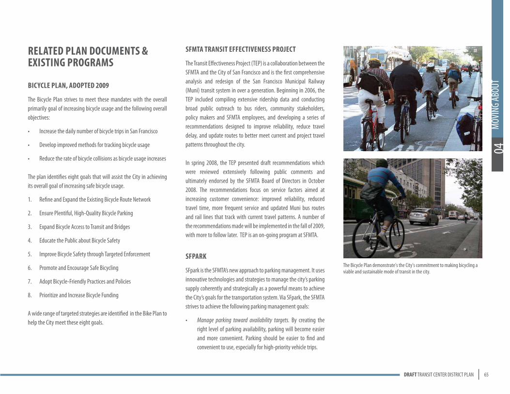
The Bicycle Plan demonstrate's the City's commitment to making bicycling a viable and sustainable mode of transit in the city.

66 1 2 3 4 5 6 7
MOVING ABOUT04
OVERALL OBJECTIVES
OBJECTIVE 4.1THE DISTRICT’S TRANSPORTATION SYSTEM WILL PRIORITIZE AND INCENTIVIZE THE USE OF TRANSIT. PUBLIC TRANSPORTATION WILL BE THE MAIN, NON-PEDESTRIAN MODE FOR MOVING INTO AND BETWEEN DESTINATIONS IN THE TRANSIT CENTER DISTRICT.
OBJECTIVE 4.2THE DISTRICT’S TRANSPORTATION SYSTEM WILL IMPLEMENT AND REQUIRE TRANSPORTATION DEMAND MANAGEMENT STRATEGIES TO MINIMIZE GROWTH IN AUTO TRIPS AND REDUCE VOLUMES AS NECESSARY. ACTIVELY MANAGE THE TRANSPORTATION SYSTEM TO OPTIMIZE PERSON-CARRYING CAPACITY. 2
OBJECTIVE 4.3THE DISTRICT’S TRANSPORTATION SYSTEM WILL MEET CHANGING TRANSIT NEEDS, PARTICULARLY TO SUPPORT THE NEW TRANSBAY TRANSIT CENTER AND ACCOMMODATE INCREASED DENSITIES. MAKE CHANGES IN THE CIRCULATION NETWORK THAT ENSURE DELIVERY OF RELIABLE AND CONVENIENT TRANSIT SERVICE TO THE TRANSBAY TRANSIT CENTER AND FOR DISTRICT RESIDENTS, EMPLOYEES, AND VISITORS.
OBJECTIVE 4.4THE DISTRICT’S TRANSPORTATION SYSTEM WILL PRIORITIZE PEDESTRIAN AMENITY AND SAFETY. INVEST IN CIRCULATION MODIFICATIONS AND URBAN DESIGN MEASURES THAT SUPPORT THE CREATION OF AN ATTRACTIVE AND MEMORABLE PUBLIC REALM.
OBJECTIVE 4.5THE DISTRICT’S TRANSPORTATION SYSTEM WILL BUILD ON SUCCESSFUL TRAFFIC AND PARKING MANAGEMENT PROGRAMS AND POLICIES THAT ARE IN PLACE. EXPAND AND STRENGTHEN EXISTING ADOPTED POLICIES (E.G. DOWNTOWN PLAN, C-3 PARKING CONTROLS) AND CURRENT PLANNING INITIATIVES (E.G. TRANSIT EFFECTIVENESS PROJECT, SFPARK).
OBJECTIVE 4.6THE DISTRICT’S TRANSPORTATION SYSTEM WILL REQUIRE MANAGEMENT OF BAY BRIDGE QUEUES TO REDUCE AND MITIGATE IMPACTS OF REGIONAL TRAFFIC ON TRANSIT CIRCULATION AND THE PUBLIC REALM IN THE DISTRICT.
OBJECTIVE 4.7THE DISTRICT’S TRANSPORTATION SYSTEM WILL FURTHER SUSTAINABILITY GOALS. ADVANCE THE GOALS OF THE CITY’S CLIMATE ACTION PLAN, BY REDUCING GREENHOUSE GAS EMISSIONS GENERATED BY VEHICULAR TRANSPORTATION.
2 The estimated mode shifts required today (without the growth of the Transit Center District Plan) to achieve the target reductions in transportation-related greenhouse gas emissions are: 9,325 solo drivers shift to walking, 9,325 shift to bicycling, 16,800 shift to carpooling/vanpooling, and 105,350 switch to transit. Climate Action Plan for San Francisco: Local Actions to Reduce Greenhouse Gas Emissions. San Francisco Department of the Environment and Public Utilities Commission, September 2004. Accessed at www.sfenvironment.org/downloads/library/climateactionplan.pdf in July 2009.
Reduce congestion and greenhouse gas emissions.• More parking availability means that drivers will spend less time circling in search of parking spaces. Less circling will reduce congestion and greenhouse gas emissions, and improve the quality of life in San Francisco’s neighborhoods. Reducing auto trip demand and congestion at peak times will help to make alternatives to driving more attractive for everyone.
Improve safety for all road users.• The right level of parking availability reduces automobile double-parking and circling, both of which present hazards for all roadway users, including pedestrians, bicyclists, and other drivers.
Reduce illegal parking. • More parking availability means that fewer drivers will be tempted to double-park or park illegally in bus zones, on sidewalks, or in front of fire hydrants and driveways.
Improve Muni’s speed and reliability.• More parking availability also reduces double-parking, which means Muni will be able to operate faster, more reliably, and more safely, especially on busy commercial corridors where many of Muni’s primary routes operate.
Increase San Francisco’s economic vitality and competitiveness.• Improving access to commercial areas, whether by foot, bicycle, transit, or car (through the right level of parking availability), will facilitate economic activity in San Francisco’s downtown and neighborhood commercial districts.

67DRAFT TRANSIT CENTER DISTRICT PLAN
MOV
ING
ABOU
T04
TRANsIT
Public transportation is fundamental to accommodating the movement of large populations of workers and residents to, within and through the city. Transit is the very backbone of the downtown’s infrastructure and enables its day-to-day function and its continued sustainable growth. Levels of density and activity, such as currently exist in the downtown and as proposed for the District, are possible only through the overwhelming majority of its workers, visitors, and residents relying on transit to move about. A circulation network that prioritizes transit will support the creation of the public spaces, walking environment and bicycle network that are envisioned for the Transit Center District. Moreover, the Transbay Transit Center is the central hub of San Francisco’s and the region’s transit network, and service delays or problems in the Plan Area can radiate throughout the network. For these reasons it is critical to facilitate transit movements in the District, as well as to and from the Transbay Transit Center.
OBjeCTIVe 4.8DesIGN THe CIRCUlATION sysTeM AND TRANsIT FACIlITIes TO ACCOMMODATe ANTICIPATeD GROWTH IN TRAVel TO AND THROUGH THe DIsTRICT IN 2030 AND BeyOND.
OBjeCTIVe 4.9PRIORITIZe TRANsIT MOVeMeNTs THROUGH AND WITHIN THe DIsTRICT OVeR All OTHeR TRANsPORTATION MODes.
OBjeCTIVe 4.10DesIGN TRANsIT FACIlITIes TO IMPROVe THe RelIABIlITy AND FUNCTION OF TRANsIT MOVeMeNTs AND TO eNHANCe THe RIDeR exPeRIeNCe.
As a fundamental component of the District's transportation system, surface transit must be able to run efficiently on city streets.
OBjeCTIVe 4.11eNsURe THAT CHANGes TO THe CIRCUlATION NeTWORk, INClUDING PeDesTRIAN AND sTReeTsCAPe IMPROVeMeNTs, ARe DesIGNeD TO sUPPORT AND eNHANCe THe OPeRATION OF TRANsIT.
The San Francisco Municipal Transportation Agency (SFMTA) has developed a set of core principles for improving and maintaining the performance and service of the transit system through the course of its Transit Effectiveness Project (TEP). All infrastructure improvements and right-of-way management should strive to:
Provide dedicated transit space (not porous to conflicting •traffic)
Create high-quality stations and passenger experiences (real •“places”)
Provide transit riders with “front-door service” to key •destinations (not 2nd-class treatment)
Provide inter-agency benefits (improvements that benefit •other transit providers, if possible)
Improve operational reliability•
Provide overall improvements to the quality of service•
Increase operating speeds (from current 6mph average to at •least 10mph)
Policy 4.1extend self-enforcing, dedicated transit lanes throughout the district.
Dedicated transit lanes expedite surface transit movement, improve transit travel time, and support more efficient operating costs by allowing for more reliable and consistent headways, especially during peak hours.

68 1 2 3 4 5 6 7
MOVING ABOUT04Existing dedicated transit lanes in the vicinity are located along Third Street (outside of the plan area); Mission Street; and on First and Fremont streets between Market Street and the existing Transbay Terminal. These transit lanes are not currently self-enforcing. As a result, automobiles can drive in the transit lane unless manual enforcement is available. As resources for manual enforcement is limited, conflicts with vehicular traffic occur often, impacting delivery of transit service in the District.
To improve transit flow and facilitate the future movement of transit through the District and to and from the Transit Center, existing transit lanes should be upgraded to be self-enforcing, and new self-enforcing transit lanes will be necessary in the following locations:
Fremont Street between Howard Street and Mission Street•
Beale Street between Market Street and the Transbay Transit •Center
SFMTA’s Transit Effectiveness Project (TEP), currently underway, is considering the need for possible service expansion of the 1-California line along Main and Beale streets. A final determination regarding this service has not been made and will be subject to ongoing evaluation of travel patterns in the emerging Transbay/Rincon Hill residential area. It is important to note that should this service be enhanced, and the engineering and design of a transit lane on Main Street must be considered. In the Transit Center District Plan, Main Street is proposed to be reconfigured as an extension of the Living Street design concept, in which case an engineering solution, such as a timed “transit-only” lane may be suitable during peak periods. SFMTA is committed to identifying balanced solutions that solve critical transit needs while achieving the desired character of the District’s streets and public realm.
To acknowledge potential service modifications based on TEP, transit lane enhancements may be necessary on:
Main Street between Market and Bryant streets•
In addition to local surface transit, inter-city buses (e.g. Amtrak, Greyhound, “airporter” type buses serving High Speed Rail), operate on city streets, many circulating from an inter-city bus plaza to be built at the east end of the Transit Center, located between Beale and Main streets. Many of these buses are destined for the Bay Bridge and need dedicated access to avoid being stuck in general auto queues.
Dedicated transit lanes on the following streets will be necessary to support inter-city buses (and will already be in place as part of the Temporary Transit Center while the new Transit Center is under construction):
Folsom Street (westbound) between First and Essex streets•
Essex Street (southbound)•Existing and Proposed Transit Lanes
Evaluate transit only zone
Propose to shorten to be only between Market and Mission streets
New eastbound transit lane
DOW PLACE
ST. FRANCIS PL.
1ST ST.1ST ST.
FREMONT ST.
FREMONT S
FREMONT ST.
FOLSOM ST. FOLSOM ST.
BEALE ST.BEALE ST.
BEALE ST
MAIN ST.
MAIN ST.
SPEAR ST.SPEAR ST.
SPEAR ST.
STEUART ST.
ZENO PLACE
GROTE PLACE
HOWARD ST.
2ND ST.
LANSING ST.
GUY PL.
ESSEX ST.
ECKER ST.
MALDEN ALLEY
ELIM AL.
ANTHONY ST.
JESSIE ST.
ECKER ST.
SHAW AL.
HUNT ST.
NATOMA ST.
NEW M
ONTGOMERY
ALDRICH AL.
JESSIE ST.
ANNIE ST.
MISSION ST.
3RD ST.3RD ST.
STEVENSON ST.
MISSION ST.MISSION ST.
MAIN ST.
HOWARD ST.
CLEMENTINA ST. CLEMENTINA ST.
KAPLAN LANE
HAWTHORNE ST.
TEHAMA ST.
STEUART ST
HAWTHORNE
MINNA ST.
NATOMA ST.
STEUART ST.
MARKET ST.
MINNA ST.
KEAR
NY STRY ST.
MONTG
MARKET ST.
S
FRONT
ST. DAV
IS
2ND ST.
TEHAMA ST.
NATOMA ST.
CLEMENTINA ST.
STEVENSON ST.
1ST ST.
Plan Boundary
Existing Transit Lanes
Proposed Transit Lanes
Transit-Only Zone
0 75 150 300 Ft

69DRAFT TRANSIT CENTER DISTRICT PLAN
MOV
ING
ABOU
T04
a special destination event in the urban landscape, the influence of the Transit Center and Mission Square plaza should expand to encompass the street in front of the Transit Center and should break the continuity of the general patterns of circulation.
OBJECTIVE 4.12PROVIDE HIGH-QUALITY FACILITIES AND EXPERIENCE FOR TRANSIT PASSENGERS.
Policy 4.4Provide sidewalk space and facilities for enhanced transit stops with passenger amenities on Mission Street and other primary transit streets.
Prioritize amenities and infrastructure to improve passenger experience and convenience and to improve the performance of the transit system. Elements such as enhanced stops with ticket machines, maps, real-time arrival information, bicycle parking and other supportive facilities, in addition to other streetscape infrastructure and amenities, can support expeditious boarding and alighting and improve operations.
Policy 4.2Design all transit lanes to be self-enforcing and to heighten awareness of transit facilities.
The design of transit lanes to make them self-enforcing is critical to their success. When transit lanes are self-enforcing, the imposition of vehicular traffic into the transit lane is less-likely, difficult or not possible at all. Without this treatment, transit lanes have limited effectiveness, as illustrated in the District today by cars regularly impeding the movement of busses by driving and parking in transit lanes.
To the extent possible, all transit lanes within the District must be designed as self-enforcing, dedicated transit lanes. Some design and engineering techniques that have been successful to these ends include textured or colored paving, raised pavement that elevates transit lanes above vehicular travel lanes (such as on Judah Street in the Sunset District), and physical elements delineating or separating transit lanes from other lanes, such as curbs, rumble strips or features that exclude low-clearance vehicles. Another technique that enhances the self-enforcing character of transit lanes is locating them in the center of the roadway (rather than curb-side), where experience has shown improvements to transit mobility and effectiveness and reduced conflicts from vehicles, such as by double parking and making right turns.
Future District streetscape projects and other construction on streets with transit lanes will implement measures to ensure the highest level possible of transit lane self-enforcement. The Plan’s proposed funding program dedicates money for this purpose.
Policy 4.3Evaluate the concept for a transit-only zone on Mission between First and Fremont streets.
Mission Street in front of the Transbay Transit Center, between First and Fremont streets, will become an exceptionally busy place, bustling with transit and pedestrian traffic. Almost all of the Transit Center-bound buses, except for AC Transit, and including Muni, Golden Gate Transit, and SamTrans converge on this block, providing service at the front door of the Transit Center. Several Muni lines coming from Market Street that terminate at the Transit Center will head south on First Street from Market and then turn left onto Mission Street, dropping all passengers in front of the Transit Center and Transit Tower. The high-frequency Mission Street Muni buses (designated as a “Rapid” line in the TEP) also use this stretch, plus many of the other regional bus carriers. In addition to all of the transit movements, there will be thousands of pedestrians moving about, particularly in peak hours, when many trains, both Caltrain and High Speed Rail, arrive and depart each hour. Added to this transit-related activity will be a substantial general increase in pedestrian traffic from development growth in the immediate area (not least of which the Transit Tower and major development near the northwest corner of First and Mission streets).
The concept of creating a transit-only zone on this block of Mission deserves additional study for a number of reasons from both a transportation and place-making standpoint. Besides simplifying the traffic on the block to allow for heavy, frequent volumes of transit and pedestrians, this concept could reduce auto volumes overall on Mission Street. This could have benefits to transit west of the Plan Area and help mitigate any diversionary effects of auto restrictions on Market Street that might otherwise impact transit on Mission Street. As important as the circulation issue, is the goal of creating a special place in front of the Transit Center to celebrate and mark its presence (and that of the Transit Tower) in the downtown public realm as a hub of activity and social interaction. In order to create
The block of Mission Street fronting the new Transit Center is recommended for further analysis as a transit-only zone.

70 1 2 3 4 5 6 7
MOVING ABOUT04OBJECTIVE 4.13SUPPORT ENHANCED FUNDING AND CAPACITY FOR REGIONAL TRANSIT SERVICE TO SUPPORT INCREASES IN POPULATION AND EMPLOYMENT GROWTH AS WELL AS SHIFTS FROM AUTO TO PUBLIC TRANSIT TRAVEL.
As downtown San Francisco is a regional job center, up to half of all workers in the city commute from homes outside of the city, making improvement and expansion of regional transit service imperative to support downtown and continued growth.
Policy 4.5Support funding and construction of the Transbay Transit Center project to further goals of the District Plan, including completion of the Downtown Extension for Caltrain and High Speed Rail.
Policy 4.6Ensure that regional transit carriers operating on city streets are prioritized along with local transit by implementing the surface transit priority improvements proposed in this plan.
Policy 4.7Work with BART to identify and fund measures to increase capacity as necessary to serve the District, particularly at the Montgomery and Embarcadero stations.
The two BART stations serving the Transit Center District area are the Montgomery and Embarcadero stations. As ridership continues to rise, capacity constraints during peak periods become a problem. For BART, the initial constraints are not expected to be with the “line haul” capacity per se, but more with the stations themselves, in terms of crowding on platforms, vertical circulation, and the “dwell time” required for trains to load and unload passengers. The Transbay Tube itself is not necessarily a constraint in the system to accommodate
growth. BART is currently in the process of designing and planning to procure new 3-door cars with higher capacity in order to accommodate expected passenger volumes, and expanding the size of the fleet to extend more trains in the peak period to 10-car trains. The use of 3-door cars would speed the boarding process and serve a higher number of passengers in existing stations without changes to service levels and without increasing dwell times that slow the system. BART is also in the process of designing improvements to the train control system to allow for more frequent peak service, which will also reduce train and station crowding. Other measures that BART can take to increase station capacity in the future include platform edge doors, better public information regarding train arrivals at concourse and street levels, and other transportation management strategies. With the measures described here, the capacity of these stations would increase by about ten percent.
OBJECTIVE 4.14SUPPORT ENHANCED FUNDING AND CAPACITY FOR LOCAL TRANSIT SERVICE TO SUPPORT INCREASES IN POPULATION AND EMPLOYMENT GROWTH AS WELL AS SHIFTS FROM AUTO TO PUBLIC TRANSIT TRAVEL.
Policy 4.8Support revenue measures and investments essential to enhancing Muni’s capacity, reliability and operational efficiency in providing service to and within the District.
The existing Transit Impact Development Fee is assessed on all commercial development and goes exclusively to San Francisco’s Muni to increase capacity and service to support this growth. These fees do not address all of the capital and operational expenses necessary to improve and expand local transit service within the city, especially if additional shifts are encouraged and expected from autos to transit.
Reliable and efficient regional transit service, such as BART, buses, and Caltrain, is key to support additional growth.
71DRAFT TRANSIT CENTER DISTRICT PLAN
MOV
ING
ABOU
T04
All projections indicate that, without significant intervention, the level of the auto traffic in the downtown and the Plan Area specifically will cause the streets in the District to reach gridlock levels over the course of the Plan’s horizon—even without any added growth in the Plan Area. Many streets in the District are already at substantially degraded and congested conditions, especially in the peak commute hours. The effects of the present and future degradation of traffic conditions would substantially impair the basic circulation of surface transit (e.g. Muni, Golden Gate Transit), and hinder the ability of necessary local circulation and commercial activity to function, in addition to causing substantially unpleasant and potentially unsafe conditions for pedestrians and cyclists.
Further analysis of the circulation and public realm system necessary and desirable to support the District will enable the determination of maximum traffic volumes that can be accommodated without compromising the system and the quality of place.
While the Downtown Plan established per-capita and per-vehicle metrics as core transportation goals, achieving these targets will likely not be sufficient to achieve the necessary vehicle reductions, as actual cumulative trips would continue to grow with continued land use growth and intensification. What are needed are actual absolute targets based on the capacity of the circulation system to handle vehicles without stifling movement.
Additionally, rather than focusing exclusively on transit mode share, the metrics should speak to all non-auto modes cumulatively, as walking and bicycling trips continue to grow as a share of overall trips into and within the District. For instance, the number of bicycle trips in the downtown has grown steadily over the past several
While the number of commuters driving to work is considerably less than other Bay Area communities, downtown San Francisco still struggles with traffic congestion, particularly in the evening peak hours and much of it bound for the Bay Bridge. This congestion negatively impacts public transit performance and diminishes the street environment for walking and bicycling. Completion of the new Transbay Transit Center, an increase in transit service in the District, continued land use growth, and the creation of an improved public realm all require traffic congestion to be managed through a series of demand management strategies. Transportation Demand Management (TDM) is critical to the success of the Transit Center District Plan and is an essential tool in shifting trips, particularly in peak hours, from auto to public transit and other means of moving about the city.
OBjeCTIVe 4.15Use DeMAND MANAGeMeNT sTRATeGIes TO ReDUCe OVeRAll leVels OF AUTO TRAFFIC IN THe PlAN AReA AND DOWNTOWN, PARTICUlARly IN THe PeAk HOURs, IN ORDeR TO ReDUCe AUTO IMPACTs ON OTHeR TRANsPORTATION MODes AND eNABle THe CReATION OF A HIGH QUAlITy PUBlIC ReAlM.
Policy 4.9Complete a detailed traffic analysis for the downtown and the District specifically to determine which TDM measures will be most effective and necessary to reduce traffic volumes and traffic impacts on the District.
Policy 4.10Update the goals of the Downtown Plan and establish specific targets for cumulative traffic volumes and non-auto travel that are necessary to achieve the conditions that enable the flow of transit, the flow of local circulation, and the creation of the public realm infrastructure as proposed by the Plan.
TRANsPORTATION DeMAND MANAGeMeNT
Transportation Demand Management (TDM) is a term for measures and regulations that reduce travelers’ use of autos and encourage a behavioral and preferential shift toward transit, carpooling, bicycling, walking, and other non-single-occupant vehicle means of getting around. The Downtown Plan contained two primary transportation targets to accommodate growth with minimal increases in traffic congestion and maximal improvement to the quality of life in the downtown (and beyond): increase vehicle occupancy on the major routes into the City from 1.48 to 1.66 persons per vehicle and increase transit mode share from 64 to 70 percent.
Evidence suggests achieving these goals has been mixed. Though somewhat dated, a focused survey of member office buildings conducted in 2000 by the Transportation Management Association of San Francisco indicated that 77 percent of commute trips to the core Financial District were made by public transit, while 17 percent were made by auto (including carpooling). But data compiled from the 2000 Census by the Metropolitan Transportation Commission (MTC) for the broader downtown, encompassing the entire C-3 zone and adjacent areas (i.e. “Superdistrict 1”), showed that 49 percent of workers took transit, 41 percent of commuters came by auto (including 29% who drove alone to work) and about 10 percent took other means (primarily walking and bicycling).3 Moreover, vehicle occupancy trends (i.e. number of people per vehicle) also appear counter to the intentions of the Downtown Plan. Evidence reviewed in the 2004 Downtown Monitoring Report indicate that vehicle occupancy on both major bridges into the City have declined since 1985. Bay Bridge peak hour occupancy declined from over 2.0 in 1985 to under 1.5 in 2000, and Golden Gate Bridge occupancy declined from 1.35 in 1985 to 1.25 in 1993. 3 Downtown Plan: 2007 Annual Monitoring Report. San Francisco Planning
Department, September 2008. Accessed at www.sfgov.org/site/uploadedfiles/planning/Citywide/pdf/Downtown_Annual_Report_2007_FINAL.pdf in July 2009.

72 1 2 3 4 5 6 7
MOVING ABOUT04years, increasing by 36 percent from 2006-2008 alone to over 3,400 cyclists in the peak hour in the downtown in 2008,4 representing a commute mode share for cycling comparable to or greater than some major public transit modes, such as ferries or even Caltrain.
Metric goals for the Transit Center District, as a sub-area of the downtown, should be established that are more ambitious than those for the downtown as a whole. A target of at least 95 percent non-auto modes for all trips into and around the District should be achieved (which is consistent with the current auto parking restrictions in the C-3 districts that allow a maximum of about one space per 20 workers). A minimum transit share of 80 percent for transit should be easily feasible (considering the evidence that approximately 75% of workers currently take transit to work in the core financial district), plus a combined walking-biking share goal of 15 percent.
Policy 4.11study the feasibility of and implement, as feasibility and necessity determines, congestion pricing of roadways as a primary tool to reduce overall traffic levels in the Plan area, particularly peak-hour bridge and freeway queues.
Without pricing intervention, it is unlikely that the necessary volume reduction targets could be met in the downtown as a whole and the District specifically. The reduction of traffic volume in the district likely cannot wholly be achieved by regulation of quantity and pricing of parking either in the District or the downtown more broadly. Much of the existing traffic originates outside of the downtown and uses the streets of the District to access the bridge and freeways. Even if traffic is re-routed around the core of the downtown, it is likely that some form of roadway pricing would also be needed to reduce volumes sufficiently to achieve the necessary improvements for transit, pedestrians, cycling, and public space required to support the growth contemplated by the Plan. 4 SFMTA “2008 State of Cycling Report”
The City and County, through the appropriate implementing agencies, such as the MTA and the County Transportation Authority, should work to complete the necessary analyses to determine the appropriate triggers, mechanisms, and scope for a congestion pricing program, and implement it. Such a program could ultimately take multiple forms that vary in physical parameters (e.g. boundaries and cordon points, such as freeway ramps or broader district edges), temporal parameters (e.g. time of day, day of week), and other factors; the program would have to be tailored over time as necessity and feasibility dictate. Further, funds raised from such a program should be directly funneled into improvements and capacity enhancements to public transit, walking, cycling, car sharing, taxi and other non-auto infrastructure. This Plan dedicates some funding to contribute to the completion of the necessary studies and the implementation of such a program.
TDM: AUTOMOBIle PARkING sUPPly AND MANAGeMeNT
OBjeCTIVe 4.16CReATe A PARkING PlAN THAT eNCOURAGes THe Use OF PUBlIC TRANsIT AND OTHeR MODes OF TRANsPORTATION THAT ARe AlTeRNATIVes TO sINGle-OCCUPANT VeHICles.
The availability and cost of automobile parking play a major role in determining whether or not people choose to drive, particularly to areas that have high levels of transit service such as the Transit Center District. When parking is readily available and inexpensive, workers and visitors are much more likely to drive to and within the city, and less likely to take transit, to bicycle, or to walk. These commuters have the greatest impact on downtown’s circulation network, particularly during peak commuting periods. These impacts are magnified within the Transit Center District, as the District’s streets are both core corridors in the entire city’s transit network and main access ways to Bay Bridge on-ramps. Back-ups
during peak commute hours can extend many blocks, resulting in significant delays to the citywide transit system. Controlling the availability and cost of parking is one of the most proven, effective, and essential TDM tools to tamper growth in auto use, and has been one of the foundations for managing the transportation system to support the continued growth of downtown since before the Downtown Plan was adopted.
A comprehensive list and discussion of objectives and policies related to auto parking is located in the Parking section of this chapter.
TDM: INCeNTIVes, BROkeRAGe AND MONITORING
OBjeCTIVe 4.17CReATe AND eNsURe COMPlIANCe WITH MeCHANIsMs THAT PROVIDe WORkeRs AND ResIDeNTs WITH INCeNTIVes TO TAke TRANsIT AND Use MODes OF TRANsPORTATION OTHeR THAN sINGle-OCCUPANT AUTOs.
Policy 4.12ensure compliance with the Commuter Benefits Ordinance.
Effective January 19, 2009, Section 421 of the San Francisco Environment Code (“Commuter Benefits Ordinance”) requires all employers in the city with 20 or more employees to provide to all employees (who work 10 or more hours a month at a work site located in San Francisco and who voluntarily opt in) one of the following transportation fringe benefits:
Provide home-to-work transportation via employer-paid •vanpools or shuttle buses.
Pay for transit or vanpool commuting costs.•

73DRAFT TRANSIT CENTER DISTRICT PLAN
MOV
ING
ABOU
T04
Policy 4.17Fund a comprehensive study to develop recommendations on the structure, operations, and authority of the existing downtown Transportation Management Association (TMA), update the goals and tools available to the TMA, and evaluate whether a district-specific TMA is needed.
Policy 4.18expand the purview and funding of the existing downtown Transportation Management Association (TMA) or create a district-specific TMA.
Policy 4.19Require that the downtown Transportation Management Association (TMA) duties, programs, and funding be reviewed and updated every 5 years and updated if necessary.
Policy 4.20Develop a transportation monitoring and enforcement plan for the district based on adopted performance measures; to be implemented by the TMA with annual reports submitted to Planning and san Francisco Municipal Transportation Agency.
Proposed Control:Amend Planning Code Section 163 based on the above policies to apply to projects in excess of 25,000 gsf and to apply to all new non-residential buildings.
Current Planning Code Section 163, adopted as part of the Downtown Plan, requires that all new developments or existing office buildings undergoing major renovations over 100,000 square feet provide on-site transportation brokerage services and produce a transportation management program. The Downtown Developer Manual, adopted in 1988, describes the components of the required transportation management program and brokerage
Offer “commuter benefits program” allowing employees to •offset transit or vanpool commuting costs (up to $115 per month) via a pre-tax automatic payroll deduction resulting in a savings of up to 40 percent.
Policy 4.13Pursue creation of requirements for transportation incentives and brokerage services for large residential properties in the District.
While the Commuter Benefits Ordinance provides incentives for employees working in San Francisco to use transit or modes of transportation other than single-occupant autos, many city residents work for employers outside of the city, work for employers smaller than are covered by the Ordinance, or are not employed. Just as large commercial developments are required to provide transportation brokerage services for on-site workers, possibly too should large residential developments as a way to encourage transit usage among its residents (whether owners or renters). A standard set of conditions or incentives should also be considered as requirements for large residential properties. Such conditions may include subsidized transit passes, car sharing memberships, or other services.
OBjeCTIVe 4.18eNCOURAGe THe Use OF NON-AUTO MODes OF TRANsPORTATION By ReQUIRING PARTICIPATION IN A TRANsPORTATION DeMAND MANAGeMeNT PROGRAM IN NeW BUIlDINGs THROUGHOUT THe DIsTRICT.
OBjeCTIVe 4.19eNsURe THAT BROkeRAGe AND TDM ReQUIReMeNTs ARe APPROPRIATe FOR CURReNT AND FUTURe TRAVel PATTeRNs FOR THe DIsTRICT AND DOWNTOWN, ARe DesIGNeD FOR GReATesT eFFeCTIVeNess WHIle MAINTAINING FlexIBIlITy, INClUDe All MODes OF TRANsPORTATION, AND PROVIDe A TOOlkIT OF FINANCIAl INCeNTIVes TO ReDUCe AUTO TRIPs.
Policy 4.14Reduce the size threshold for new and renovated buildings to trigger the requirement for transportation demand management and participation in the Transportation Management Association (TMA).
Policy 4.15expand the TMA requirement to include non-office uses, including hotels, large retail, cultural, and institutional uses.
Policy 4.16Require commercial property managers or owners to monitor and report yearly mode split or peak-hour vehicle trips of their employees and to increase or modify TDM programs if targets are not being met.

74 1 2 3 4 5 6 7
MOVING ABOUT04service. According to requirements set forth in this document, the transportation management program must include the following:
Execution of a Memorandum of Agreement for Transportation •Management between the project owner and the Director of Planning.
Designation of a permanent Transportation Management •Coordinator for each building to comply with reporting requirements, implement parking management policies and programs, and provide oversight and management of the program.
Provision of permanent transportation brokerage services to •implement the individual Transportation System Management (TSM) elements of the program.
In addition to the measures described above, individual development projects may be required to implement additional TDM measures as part of the conditions of approvals process. Buildings are then given the option of overseeing their TDM programs themselves or joining the San Francisco Transportation Management Association who then takes responsibility for providing the required TDM services.
TRANsPORTATION MANAGeMeNT AssOCIATION
The Transportation Management Association of San Francisco (TMA SF) was established in 1989 to enable developments to fulfill the requirements of Section 163. As a privately funded, non-profit organization, the TMA provides information to the general public and businesses on commute options for all modes of transportation. The TMA hosts city-wide commute festivals and produces and distributes informational materials to encourage the use of alternative modes of transportation. Membership is comprised of 56 office buildings in San Francisco, primarily downtown, but also in the broader South of Market area as well as a large office complex in the City of South San Francisco. Membership fees vary by building as they are based on square footage.
For those buildings which have opted to join, the TMA provides the TDM services required under current City policy as well as any additional requirements specified in the conditions of approval process for a particular building. The majority of buildings have opted to join the TMA rather than oversee their required TDM program themselves.
Currently, only large office developments are required to participate in the TMA. However, since the Downtown Plan was approved in 1985, hotels, large retail and institutions are increasingly becoming major downtown employers. In addition, more mixed-use buildings have been built, combining both residential, office, and commercial uses.
The goals, objectives, and requirements of the TMA were adopted in 1989. The original objectives and goals have not been updated since that time, although these may be updated every five years when the TMA provides the Planning Commission with its proposed work
scope for the next five years and reports on its past performance. The TMA also submits an Annual Report to the Planning Department staff, documenting their compliance with their goals, objectives, and the TDM requirements of member buildings.
Monitoring and enforcement
The requirements of the TMA stipulate that the organization must submit an annual report documenting their compliance with the stated goals and objectives of the TMA and that they are providing the TDM programs required of participating buildings. There are currently no enforcement mechanisms that enable the City to enact penalties for non-compliance by buildings or the TMA. Currently, the City’s only enforcement mechanism for non-compliance with the TDM requirements is to withhold future building permits for individual buildings. For the TMA to be fully effective requires City funding to be allocated annually to the appropriate agency to coordinate and monitor the activities and performance of the Association.

75DRAFT TRANSIT CENTER DISTRICT PLAN
MOV
ING
ABOU
T04
OBjeCTIVe 4.20MAke WAlkING A sAFe, PleAsANT, AND CONVeNIeNT MeANs OF MOVING TO AND THROUGHOUT THe DIsTRICT.
OBjeCTIVe 4.21CReATe A HIGH-QUAlITy PeDesTRIAN eNVIRONMeNT IN THe DIsTRICT CONsIsTeNT WITH THe VIsION FOR THe CeNTRAl DIsTRICT OF A WORlD-ClAss CeNTRAl CITy.
OBjeCTIVe 4.22GRACIOUsly ACCOMMODATe INCReAses IN PeDesTRIAN VOlUMes IN THe DIsTRICT.
OBjeCTIVe 4.23eMPHAsIZe THe IMPORTANCe OF sTReeTs AND sIDeWAlks As THe lARGesT COMPONeNT OF PUBlIC OPeN sPACe IN THe TRANsIT CeNTeR DIsTRICT.
Policy 4.21Facilitate pedestrian circulation by providing sidewalk widths that meet the needs of projected pedestrian volumes and provide a comfortable and safe walking environment.
Policy 4.22Create and implement a district streetscape plan to ensure consistent corridor-length streetscape treatments.
Policy 4.23Widen sidewalks to improve the pedestrian environment by providing space for necessary infrastructure, amenities and streetscape improvements.
WAlkING
As a major employment center and transit hub, the plan area attracts thousands of people daily, all of whom will either begin or end their trip as pedestrians. Thousands of new workers in the district joining the thousands already there, most arriving by transit and walking to or from buses, trains, and ferries, will combine with the thousands of passengers who will arrive and depart at the Transbay Transit Center. A transformation of the public realm will be required to accommodate people on foot and give them enjoyable paths to travel, linger, shop and socialize. Along with people who arrive by transit, additional daily pedestrian traffic will include workers walking to business meetings; workers walking to eat, drink or shop during the workday; residents of the burgeoning downtown neighborhoods walking to work, shop, or recreate; and visitors walking from conferences and hotels to shop, eat, and see the City. On top of those on foot who arrived by other means, thousands of people daily walk from point to point in and around downtown as the primary or only mode of transport, including workers walking to business meetings; workers walking to eat, drink or shop during the workday; residents of the burgeoning downtown neighborhoods walking to work, shop, or recreate; and visitors walking from conferences and hotels to shop, eat, and see the City. Streets are not just for movement, but for slowing down to socialize and take in the rhythms of the City. Creating a complete, high quality walking network is necessary to make all aspects of the transportation system function well.
The Public Realm chapter of this plan document contains all of the detailed policy discussion regarding pedestrian issues and design of the public realm. Below is the compiled list of objectives and policies from that chapter related to walking.
Policy 4.24Facilitate pedestrian circulation by providing sidewalk widths that meet the needs of projected pedestrian volumes and provide a comfortable and safe walking environment.
Policy 4.25Continue the living streets treatment to create linear plazas along Beale, Main, and spear streets.
Policy 4.26Create additional pedestrian capacity and shorten pedestrian crossing distances by narrowing roadways, and creating corner curb bulb-outs
Policy 4.27enhance crosswalks with special treatments (e.g. paving, lighting, raised crossings) to enhance pedestrian safety and comfort especially at potential conflict locations, such as at new mid-block crosswalks or where bulb-outs cannot be installed.
Policy 4.28Develop “quality of service” indicators and benchmarks for pedestrian travel to and through the district, and measure progress in achieving benchmarks on a regular basis.

76 1 2 3 4 5 6 7
MOVING ABOUT04
OBjeCTIVe 4.24ResTRICT CURB CUTs ON key sTReeTs TO INCReAse PeDesTRIAN COMFORT AND sAFeTy, TO PROVIDe A CONTINUOUs BUIlDING eDGe OF GROUND FlOOR Uses, TO PROVIDe A CONTINUOUs sIDeWAlk FOR sTReeTsCAPe IMPROVeMeNTs AND AMeNITIes, AND TO elIMINATe CONFlICTs WITH TRANsIT.
Policy 4.29Designate Plan Area streets where no curb cuts are allowed or are discouraged. Where curb cuts are necessary, they should be limited in number and designed to avoid maneuvering on sidewalks or in street traffic.
OBjeCTIVe 4.25eNHANCe THe PeDesTRIAN NeTWORk WITH NeW lINkAGes TO PROVIDe DIReCT AND VARIeD PATHWAys, TO sHORTeN WAlkING DIsTANCes, AND TO RelIeVe CONGesTION AT MAjOR sTReeT CORNeRs.
OBjeCTIVe 4.26eNCOURAGe PeDesTRIANs ARRIVING AT OR leAVING THe TRANsIT CeNTeR TO Use All eNTRANCes AlONG THe FUll leNGTH OF THe TRANsIT CeNTeR By MAxIMIZING ACCess VIA MID-BlOCk PAssAGeWAys AND CROssWAlks.
OBjeCTIVe 4.27eNsURe THAT NeW DeVelOPMeNT eNHANCes THe PeDesTRIAN NeTWORk AND ReDUCes THe sCAle OF lONG BlOCks By MAINTAINING AND IMPROVING PUBlIC ACCess AlONG exIsTING Alleys AND By CReATING NeW THROUGH-BlOCk PeDesTRIAN CONNeCTIONs WHeRe NONe exIsT.
OBjeCTIVe 4.28eNsURe THAT MID-BlOCk CROssWAlks AND THROUGH-BlOCk PAssAGeWAys ARe CONVeNIeNT, sAFe, AND INVITING.
Policy 4.30Create convenient pedestrian access by providing signalized mid-block crosswalks, especially on blocks longer than 300 feet
Policy 4.31Prohibit the elimination of existing alleys within the District. Consider the benefits of shifting or re-configuring alley alignments if the proposal provides an equivalent or greater degree of public circulation.
Policy 4.32Design new and improved through-block pedestrian passages to make them attractive and functional parts of the public pedestrian network.
Policy 4.33Require a new public mid-block pedestrian pathway on Block 3721, connecting Howard and Natoma streets between First and second streets.
Policy 4.34Close shaw Alley permanently to vehicles and design it as a pedestrian-only open space for thru-connection to the Transit Center.
Policy 4.35Convert the western portion of Natoma street between First and second streets on the south side of the Transit Center to a primarily pedestrian-only street.
As shown on the opposite page, a portion of Natoma will be transformed to an active, pedestrian-only alley.
Along with the Transit Center, future development within the District will attract thousands of additional pedestrians.

MOV
ING
ABOU
T04
A portion of Natoma between 1st and 2nd streets will become primarily pedestrian-only, and will be lined with shops, restaurants, and other active uses (view east from 2nd Street.)

78 1 2 3 4 5 6 7
MOVING ABOUT04
BICyCles
As a mode of transportation, bicycles have many advantages—they require no fuel, produce no emissions, and bicycle facilities are generally less expensive and space intensive than other transportation modes. The use of bicycles can be increased with the provision of a comprehensive network of bike lanes, as well as destination, infrastructure, and amenities such as secure parking and shower facilities. The introduction of a robust public bicycle sharing program, such as has been successfully implemented on a wide-scale in Paris, Barcelona, Berlin, Copenhagen, and Montreal, with rental “pods” conveniently located on streets throughout the downtown could further boost bicycle ridership. Transit passengers using both trains and buses currently have and will continue to have high bicycle demand and there needs to be good connections from the Bike Network. In addition, a need to bolster the localized bike facilities in the Plan Area is anticipated to account for higher-than-average intra-district bike travel. The Transit Center District Plan seeks to connect the Transit Center to the greater city bike network.
Existing Class 2 bike lanes are present along Howard and Folsom streets in the Plan Area (in one direction on each street), as well as along the Embarcadero in both directions. Lanes proposed under the SFMTA Bicycle Plan bolster the north-south connections by providing new lanes along Second Street, Fremont Street between Folsom and Harrison, and Beale Street south of Folsom. This Plan identifies the potential for enhanced bike facilities in the future on Fremont and Beale streets from Folsom Street to Market Street. Additional on-street bike parking will be added to the widened sidewalks in the Plan Area, and the Transbay Transit Center will have a bike station integrated into the facility.
The Transit Center itself will be a major draw for cycling, particularly to connect to transit services. Caltrain has a very high (and growing) ridership that uses bicycles (both parked at the station and passengers who bring bikes on board). High Speed Rail is also likely to have high bicycle demand, particularly for riders to leave a bicycle at the station before boarding. The current design for the Transit Center includes direct bicycle access via a bike ramp from the north side of Howard Street (between 1st and 2nd) down to the train concourse level (one level below grade), where there will also be a large bike station (accommodating about 500 bicycles).
BICyCle MOVeMeNT
OBjeCTIVe 4.29MAke CyClING A sAFe, PleAsANT, AND CONVeNIeNT MeANs OF TRANsPORTATION THROUGHOUT THe DIsTRICT.
OBjeCTIVe 4.30eNsURe HIGH-QUAlITy ON-sTReeT BICyCle CONNeCTIONs TO THe TRANsBAy TRANsIT CeNTeR.
OBjeCTIVe 4.31eNHANCe FACIlITIes FOR INTRA-DIsTRICT BICyCle TRAVel.
OBjeCTIVe 4.32eNsURe lOCAl CONNeCTIONs TO ReGIONAl BICyCle FACIlITIes.
Policy 4.36Maintain flexibility on key streets in order to expand the Bike Network in the future.
The design of the following streets should maintain flexibility to consider bicycle improvements in the future:
Fremont Street (northbound)•
Beale Street (southbound)•
Main Street (northbound)•
Policy 4.37Provide the necessary connections to the future bicycle ramp on Howard street between First and second streets, which will be the primary access point for bicycles to the Transit Center, including a bicycle station at the train concourse level.
Direct connections to the Transit Center bicycle ramp from the core Bicycle Network will be necessary to ensure that cyclists can arrive and depart from the Transit Center from all directions for convenience and safety (including ensuring that cyclists are not tempted to ride on sidewalks or against traffic to access the Transit Center). Consideration could include access from Natoma Street (including access to Natoma from southbound 2nd Street), facilities on Howard between First and Second, and facilities under the bus ramps between Folsom and Howard Street.
Policy 4.38Do not preclude future connections to a potential Bay Bridge multi-use pathway.
The new east span of the Bay Bridge between Oakland and Yerba Buena Island, scheduled to be complete by 2013, includes a 15-foot wide bicycle and pedestrian pathway. In addition, a 2001 Caltrans feasibility study proposed a 12-foot shared use (bicycle and

79DRAFT TRANSIT CENTER DISTRICT PLAN
MOV
ING
ABOU
T04
Bicycling is an important transportation mode that is key to supporting sustainable growth in downtown
Streets for Future Consideration of Bicycle Improvements
*
DOW PLACE
ST. FRANCIS PL.
1ST ST.1ST ST.
FREMONT ST.
FREMONT S
FREMONT ST.
FOLSOM ST. FOLSOM ST.
BEALE ST.BEALE ST.
BEALE ST
MAIN ST.
MAIN ST.
SPEAR ST.SPEAR ST.
SPEAR ST.
STEUART ST.
ZENO PLACE
GROTE PLACE
HOWARD ST.
2ND ST.
LANSING ST.
GUY PL.
ESSEX ST.
ECKER ST.
MALDEN ALLEY
ELIM AL.
ANTHONY ST.
JESSIE ST.
ECKER ST.
SHAW AL.
HUNT ST.
NATOMA ST.
NEW M
ONTGOMERY
ALDRICH AL.
JESSIE ST.
ANNIE ST.
MISSION ST.
3RD ST.3RD ST.
STEVENSON ST.
MISSION ST.MISSION ST.
MAIN ST.
HOWARD ST.
CLEMENTINA ST. CLEMENTINA ST.
KAPLAN LANE
HAWTHORNE ST.
TEHAMA ST.
STEUART ST
HAWTHORNE
MINNA ST.
NATOMA ST.
STEUART ST.
MARKET ST.
MINNA ST.
KEAR
NY STRY ST.
MONTG
MARKET ST.
S
FRONT
ST. DAV
IS
2ND ST.
TEHAMA ST.
NATOMA ST.
CLEMENTINA ST.
STEVENSON ST.
1ST ST.
Location of bicycle ramp into the Transbay Transit Center
Plan Boundary
Existing Bicycle Lanes
Proposed Lanes under the SFMTA Bicycle Plan
Maintain Flexibility for Consideration of Future Bicycle Improvements
0 75 150 300 Ft
pedestrian) bidirectional path on the outside of both the north and south sides of the upper deck of the bridge’s west span. Caltrans is currently undertaking a new feasibility study for the pathway and its potential touchdown options. A potential multi-use path on the Bay Bridge would become an essential regional bicycle connection linking San Francisco, Treasure Island, and Oakland. Because potential locations and configurations for such a pathway to touchdown in San Francisco are limited due to the city’s built-out nature and some fall within the Transit Center District Plan Area (due the Plan Area’s proximity, circulation and infrastructure connections to the Bridge), it is important that infrastructure changes in and around the District do not preclude identified path touchdown options. Without the ability to touchdown the path in the city, there can be no path regardless of the feasibility and willingness of the State to add it to the bridge itself.
Several potential touchdown points in the Transit Center District area ruled out by the 2001 Study may actually be feasible and desirable due to subsequent redevelopment of lots on Rincon Hill and infrastructure changes (e.g. freeway and bus ramps) in the area. Following are a subset of potential path touchdown options that fall within the Transit Center District:
Transit Center. • With a new bus ramp being constructed as part of the new Transit Center, there is the opportunity to continue and terminate a future west span Bay Bridge path at the roof-level Transit Center Park, coupled with an intermediate direct ground level touchdown between the bridge and the Transit Center, such as those described below. Besides increasing regional access to the Transit Center Park, it would provide an attractive “landmark” embarkation and arrival point in downtown for pedestrian trips and possibly bicycle trips on the Bay Bridge. With the potential for bicycle rental services at the proposed bicycle station directly in the Transit Center (utilizing the elevators) or at the park level, the potential is
*
DOW PLACE
ST. FRANCIS PL.
1ST ST.1ST ST.
FREMONT ST.
FREMONT S
FREMONT ST.
FOLSOM ST. FOLSOM ST.
BEALE ST.BEALE ST.
BEALE ST
MAIN ST.
MAIN ST.
SPEAR ST.SPEAR ST.
SPEAR ST.
STEUART ST.
ZENO PLACE
GROTE PLACE
HOWARD ST.
2ND ST.
LANSING ST.
GUY PL.
ESSEX ST.
ECKER ST.
MALDEN ALLEY
ELIM AL.
ANTHONY ST.
JESSIE ST.
ECKER ST.
SHAW AL.
HUNT ST.
NATOMA ST.
NEW M
ONTGOMERY
ALDRICH AL.
JESSIE ST.
ANNIE ST.
MISSION ST.
3RD ST.3RD ST.
STEVENSON ST.
MISSION ST.MISSION ST.
MAIN ST.
HOWARD ST.
CLEMENTINA ST. CLEMENTINA ST.
KAPLAN LANE
HAWTHORNE ST.
TEHAMA ST.
STEUART ST
HAWTHORNE
MINNA ST.
NATOMA ST.
STEUART ST.
MARKET ST.
MINNA ST.
KEAR
NY STRY ST.
MONTG
MARKET ST.
S
FRONT
ST. DAV
IS
2ND ST.
TEHAMA ST.
NATOMA ST.
CLEMENTINA ST.
STEVENSON ST.
1ST ST.
Location of bicycle ramp into the Transbay Transit Center
Plan Boundary
Existing Bicycle Lanes
Proposed Lanes under the SFMTA Bicycle Plan
Maintain Flexibility for Consideration of Future Bicycle Improvements
0 75 150 300 Ft

Connects to future Bay Bridge bike/pedestrian path
Elevated Bicycle/Pedestrian Path
Alice St Community Garden
Whole Food
Palace Hotel
SFMOMA
Moscone Center
Golden GateUniversity
Embarcadero Center
Gap Building
Rincon Park
Justin Hermann Plaza
Four Season Hotel
Metreon Yerba Buena
Ferry Building
Ferry Plaza
0’ 100’ 200’ 400’
Plan Boundary
Potential Bay Bridge Path Touchdown Points
Potential Vertical Connections
80 1 2 3 4 5 6 7
MOVING ABOUT04
Either freestanding or integrated into a structure, elevators are one option to provide vertical circulation between the Bay Bridge pathways and the street.
There is an opportunity to extend a future Bay Bridge bicycle and bike path to the Transbay Transit Center's rooftop park.
Potential vertical connections to the Bay Bridge bicycle and pedestrian path.
significant for recreational and touristic value from such an arrangement, including for activation of the park and revenue generation.
Folsom and Fremont Off-Ramp. • This option includes a pathway on the north side of the Bay Bridge, connecting to the east/south side of the Fremont/Folsom off-ramp, touching down at reconfigured “T” intersection off-ramp on Clementina Street or at Fremont Street. This option may not be feasible due to the close proximity of the Fremont ramp to an existing residential structure on the south side of Clementina Street.
Essex Street.• After crossing Harrison Street, a path could descend or switchback to grade on Essex Street, and sufficient right-of-way may exist for this touchdown in tandem with other circulation changes involving Essex Street.
Other potential touchdown options not listed include several on or around Rincon Hill, including the Harrison/Fremont off-ramp, Harrison Street, Sterling Street, Bryant Street, and Lansing Street.

81DRAFT TRANSIT CENTER DISTRICT PLAN
MOV
ING
ABOU
T04
BICyCle PARkING AND FACIlITIesThe provision of secure bike parking and the availability of shower facilities significantly facilitates bicycle commuting. There are current Planning Code requirements for bicycle parking for all new developments and renovated commercial buildings, as well as shower requirements for new large commercial buildings. However, the current Planning Code bicycle parking requirements for new and renovated commercial buildings are very low: a maximum of 12 spaces are required regardless of the size of the building. For a large office building with 500,000 gross square feet (approximately 2,000 workers), that means the Code only requires bike parking for less than one percent of workers on-site. With adopted City goals to increase bicycle mode share to 10 percent of all trips, and Plan goals to increase bike share of trips into and within the District, these bicycle parking requirements are insufficient.
OBjeCTIVe 4.33eNsURe THe PROVIsION OF ADeQUATe seCURe, ON- AND OFF-sTReeT BICyCle PARkING FACIlITIes TO ACCOMMODATe AND eNCOURAGe eMPlOyees TO CyCle FOR COMMUTING AND DAIly NeeDs.
Policy 4.39Increase the requirement for secure bicycle parking in new and renovated non-residential buildings to a minimum of five percent of peak on-site employees and visitors.
Policy 4.40Develop a plan to identify demand and locations for installation of on-street bicycle parking in the Plan Area to supplement current process of bicycle racks being installed at the request of building owners.
Proposed Control:Amend Section 155.4 to increase number of required on-site secure bicycle parking spaces for commercial buildings from maximum of 12
The Plan promotes the implementation of a District-wide bicycle sharing program. Shown: Vélib’, a highly successful public bicycle rental program in Paris.
Indoor bicycle parking provides a secure and weather-protected place for riders to store their bicycles. Shown: Bicycle parking at BART's Embarcadero stations.
spaces (for buildings larger than 50,000 gsf) to accommodate visitors and five percent of all on-site employees bicycling to work. The proposed requirement should be the equivalent of at least one bike parking space for every 6,000 gsf of office space. Spaces should be located in highly visible and well-lit locations and may not be located more than one story above or below grade.
Policy 4.41Pursue legislation to require existing commercial and industrial development to provide secure bicycle parking in conformance with current requirements or to allow employees to bring bicycles into the building if parking is not provided.
Policy 4.42support and implement a public bicycle sharing program in the District.
Implementation of a bicycle sharing program in the District should include the following actions:
Prioritize early implementation of a citywide public bike •sharing program in the District.
Locate public bicycle sharing pods on sidewalks and public •spaces throughout the District.
Encouraging or requiring development projects in the District •to offer or subsidize bicycle sharing memberships amongst employees and visitors.
Policy 4.43Update and publish an improved Bicycle Parking Design Guidelines document to establish appropriate parameters for off-street bicycle parking in new residential, commercial, and industrial development, consistent with the requirements in the Planning Code.
82 1 2 3 4 5 6 7
MOVING ABOUT04
TRAFFIC CIRCUlATION
Should proposed policies and improvements in this Plan be implemented, the Transit Center District would soon become San Francisco’s premier “transit-first” neighborhood where almost all local trips can be made without a car. But a large percentage of automobile traffic in the area—and the vast majority of peak-hour traffic congestion—will continue to be regional trips that do not originate and are not destined for the Plan Area.
Instead, these trips are passing through the Plan Area using local street network to access regional bridges and freeways. The use of the streets in the Plan Area—which is not just the heart of the city’s transit network, but a dense downtown transit- and pedestrian-oriented district—for the storage of cars that are queued for regional bridges and freeways is an inefficient and unsustainable use of the District’s street network. This conflict is heightened by the need to transform the function of streets in the District to better serve pedestrians, transit, bicycles, and local circulation for a growing population and the Transit Center.
This Plan recognizes the need to maintain appropriate traffic flow to and through the area in recognition of the District’s role as an evolving San Francisco neighborhood, a regional employment center and recreational destination, and a multi-modal point of embarkation throughout the Bay Area and beyond.
OBjeCTIVe 4.34FACIlITATe TRAFFIC FlOW TO AND THROUGH THe DIsTRICT AT leVels THAT ARe CONsIsTeNT WITH eNVIsIONeD IMPROVeMeNTs FOR TRANsIT, PeDesTRIANs AND BICyCles.
OBjeCTIVe 4.35MITIGATe THe IMPACTs OF ReGIONAl AUTO TRAFFIC WITHIN THe DIsTRICT.
OBjeCTIVe 4.36DesIGN sTReeTs TO slOW AND CAlM TRAFFIC, TO IMPROVe sAFeTy AND ATTRACTIVeNess FOR All ROAD UseRs, COMMeRCe AND FOR sOCIAl INTeRACTION.
OBjeCTIVe 4.37FACIlITATe IMPROVeD CIRCUlATION WITHIN THe DIsTRICT FOR lOCAl DesTINATIONs.
Policy 4.44Do not compromise pedestrian, bicycle, or transit amenity or service within the District to accommodate or maintain levels of service for regional auto trips.
Policy 4.45Pursue measures to actively manage traffic volumes and bridge and freeway vehicle queues in order to achieve appropriate levels of traffic necessary to allow for the creation of the public realm and circulation system envisioned and necessary for the District.
Policy 4.46Prioritize vehicle trips that increase the efficiency and person-carrying capacity of the transportation system (e.g. carpools, taxis) and that are “high- value” (e.g. goods movement, emergency response).
In order to accommodate the needs of the District, transit lanes must be created and expanded, sidewalks must be widened, and bicycle circulation must be improved. Given the finite right-of-way available, trade-offs and choices must be made as to allocation of space. As discussed earlier in the Transportation Demand Management section, sufficient TDM measures must be pursued to manage traffic volumes to appropriate levels. Such measures include demand-responsive pricing of roadways and capacity restrictions and pricing of on-and off-street parking facilities, amongst others.
Policy 4.47Consider rerouting bridge and freeway vehicle queues onto other streets outside the core of the District, avoiding primary transit, bicycle, and pedestrian streets.
Freeway queues in the District currently affect many streets, particularly in the afternoon peak hours, including First, Folsom, New Montgomery, and Howard streets. Some of these streets are important transit, bicycle, and pedestrian streets, and the extent of these queues on all streets has negative ripple effects on the function of all area streets, including substantial delays to transit, through blockage of intersections and critical movements on both the streets in question and the cross streets. In addition to pursuing ambitious TDM measures, the City should explore shifting traffic patterns to move some or all freeway queues out of the core area and off of key transit, bicycle, and retail streets. Roadway and demand-based pricing can certainly reduce these queues and enable traffic to flow. In addition to those measures, consideration should also be given to

83DRAFT TRANSIT CENTER DISTRICT PLAN
MOV
ING
ABOU
T04
Policy 4.48Consider converting some one-way streets to two-way in order to improve local circulation.
There are some benefits of a system of one-way streets, particularly regarding roadway capacity for vehicles, but there are also downsides. Particularly, a system of exclusively one-way streets can make it difficult or complex to access local buildings. Such a system may require circuitous routing around multiple blocks to reach a destination. Streets with multiple lanes of one-way traffic also often encourage speeding (due to a lack of oncoming traffic) and can feel more like freeways than do two-way streets, making them significantly less pleasant for pedestrians and local shopping districts. One-way streets are also frustrating for cyclists due to the required circuitous routing to reach a destination which tends to promote wrong-way and sidewalk riding. The following streets in the District should be considered for conversion from one-way to two-way operation:
Folsom Street (east of 2nd Street)•
Spear Street (north of Folsom Street)•
Howard Street (east of New Montgomery)•
Policy 4.49support taxi use and circulation in the District but manage their circulation to prevent conflicts with other transportation modes, particularly transit and bicycles.
Taxis are an important mode of transport that enables people to get around without private autos. While taxi use will proportionally increase with the increase in development in the area, the new Transit Center will be an especially heavy generator/attractor of taxi trips prompted by intercity rail service. High Speed Rail will generate
shifting the location of queues to streets that have lesser impacts on the transit, bicycles, and pedestrians. It is important to avoid simply shifting the burden of traffic to other important streets, and the relative benefits of different scenarios must be balanced. Some ideas to explore include:
Reducing or eliminating vehicular usage of Essex Street and •moving the general bridge queue on Folsom Street to Harrison Street. Folsom is both a transit and bicycle corridor, while Harrison is not. Essex Street could be used by intercity buses only to access the on-ramp, or could be closed entirely and used for recreational and open space amenity for the area.
Minimizing bridge queues on First Street, particularly during the •PM peak period to prevent the queue from extending north of Folsom or Howard streets. Currently the queue on First Street backs up regularly north of Market Street, as signals are adjusted to prevent queues on Harrison Street from wrapping around onto Embarcadero. While many transit movements on First Street near the Transit Center are in dedicated transit lanes, the queues nevertheless cause substantial delays and complications to movement on Mission, Market, and other core transit streets. They also cause substantial congestion around the Transit Center. The queue occupies two full lanes from the on-ramps to north of Market Street. In the future, various options should be explored, including reducing the right-of-way devoted to bridge queuing lanes to one north of Folsom (thereby freeing up right-of-way in the core Transit District for critical sidewalk widening, transit and bicycle movement, and local vehicular circulation) and modifying the signalization to favor Harrison Street to discourage drivers from using First Street. The time it takes a driver to reach the bridge should not change with such modifications, even if the queue gets longer, because the capacity of flow is constrained and metered by the on-ramps themselves, rather than the capacity of city streets.
substantial taxi demands, similar to that of an airport terminal. The Transit Center is proposed to have a dedicated taxi pick-up area at the train concourse level (i.e. one level below grade) near the west end of the Transit Center, accessed from a vehicular ramp from the north side of Howard Street between First and Second streets. The taxi center is planned for a capacity of 25 taxis at a time, meeting the projected demand. Because of potential significant conflicts with the existing bicycle lane on the north side of Howard Street (and the future bicycle ramp down into the Transit Center), it will be critical for the TJPA to manage the taxi center so that a queue of taxis does not back up onto Howard Street. Such management can be handled though an on-site cab manager as well as other enforcement personnel (e.g. SFMTA Parking Control Officers). Additionally, to the extent that taxis may be permitted in transit-only lanes and zones, the key curb transit stops on Mission Street in front of the Transit Center between First and Fremont will need to be staffed and managed by enforcement personnel to prevent taxi drop off/pick-up in this core transit location.
Additionally, a north-south road should be considered that connects Folsom and Howard streets beneath the bus ramps (between 1st and 2nd streets). Such a road could enable more direct access for taxis to the Transit Center with less circuitous routing through congested intersections, depending on the final configurations and circulation of Howard, Second, and Mission streets.

84 1 2 3 4 5 6 7
MOVING ABOUT04
PARkING
The availability and pricing of on- and off-street parking are primary determinants in the number and character of auto trips into the area. Given the high level of non-automobile transportation service in the District, parking policies and management are integral to shaping people’s decisions whether or not to drive or use other means to travel to and around the district.
The Downtown Plan, adopted in 1985, sought to limit the number of long-term parking spaces to the number that existed in 1984. Since that time, however, the supply of parking has continued to grow. Between 2002 and 2007, a total of 2,311 off-street parking spaces were approved in the C-3.5
PARkING CAPACITy
Under the existing Planning Code Section 151.1, the City does not require parking for any land use in the C-3 districts and stringently limits the amount of new parking that can be built with new development in these districts.
Existing off-street automobile parking controls for residential buildings are as follows:
No minimum off-street parking requirements.•
“As of right” maximum of 0.25 spaces per dwelling unit with •additional parking allowed as a discretionary exception by the Planning Commission.
Absolute maximum off-street parking limits of 0.75 spaces per •dwelling, or one space per dwelling for units with two or more bedrooms.
Required unbundling of parking costs from housing costs •required in projects of 10 units or more.
Stacked parking, valet parking, and tandem parking •encouraged and required for parking ratios over certain amounts in large developments.
Existing off-street automobile parking controls for non-residential buildings are as follows:
No minimum off-street parking requirements developments.•
Maximum off-street parking limit of up to seven percent of •gross floor area for new non-residential developments (e.g. for office uses this translates to approximately one parking space for every 5,000 gsf of office space, or roughly one parking space for every 20 workers.)
As parking is measured by floor area and not spaces, it •encourages stacked parking, valet parking, tandem, and other space-efficient arrangements.
PUBlIC PARkING FACIlITIes
Existing Planning Code controls prohibit new surface permanent parking lots. Temporary surface parking lots may only be permitted on a 2-year increment with Conditional Use approval from the Planning Commission. Any non-accessory parking facilities require Conditional Use from the Planning Commission.
PARkING PRICING
Planning Code Section 155(g) currently requires all new non-residential parking available for use by downtown workers be priced to favor short-term parkers and discourage long-term (8 hour or more) commuter parking. This enables occasional users and visitors
to access short-term commercial parking, while discouraging workers in the area from commuting by car.
All new residential parking is currently required to be “unbundled” from the residential units, that is parking must be sold or leased separately from the units themselves (Planning Code Section 167).
TRANsIT CeNTeR DIsTRICT PlAN CONsIDeRATIONs AND IssUes
The combination of no minimum parking requirements for all uses, in addition to parking maximums, limits the potential auto trip generation of buildings and encourages more transit-oriented development. However, given the large size of projects proposed for this area, large garage facilities could still be constructed to serve these buildings, and cumulatively could result in a net increase of over 2,000 parking spaces in the Plan Area (after taking into account that at least a couple new developments will be constructed on what are currently surface parking lots). In order to achieve the necessary reduction in auto volumes as the district grows, further curbs on the growth in parking in the District seem necessary, rather than permitting the unrestrained growth of parking supply allowed under the existing controls.
Further, there is not a simple enforcement mechanism of the pricing and unbundling policies and no clearly established penalties for non-compliance. Commercial buildings regularly offer tenants free parking, in addition to selling monthly or discounted passes to area workers, and new residential projects still regularly market and sell units as “coming with deeded parking,” despite the requirements in their conditions of approval requiring that parking be sold or leased as separate from, and in addition to, dwelling units.
5 San Francisco Planning Department, Downtown Annual Monitoring Report, 2007.

85DRAFT TRANSIT CENTER DISTRICT PLAN
MOV
ING
ABOU
T04
OBjeCTIVe 4.38CReATe A PARkING sUPPly AND DeMAND MANAGeMeNT PlAN THAT eNCOURAGes THe Use OF PUBlIC TRANsIT AND OTHeR NON-sINGle OCCUPANT VeHICle MODes OF TRANsPORTATION.
OBjeCTIVe 4.39lIMIT GROWTH IN AUTO TRIPs TO THe DIsTRICT AND CONGesTION THROUGH sTRICT lIMITs ON THe sUPPly OF PARkING.
OBjeCTIVe 4.40esTABlIsH A PARkING PRICING sTRUCTURe As A PRIMARy sTRATeGy TO MANAGe PARkING DeMAND AND ACHIeVe GOAls FOR PARkING TURNOVeR AND AVAIlABIlITy.
OBjeCTIVe 4.41IMPleMeNT PARkING MANAGeMeNT sTRATeGIes AND TeCHNOlOGIes THAT FACIlITATe THe DyNAMIC MANAGeMeNT OF PARkING sUPPly AND DeMAND.
OBjeCTIVe 4.42MINIMIZe THe IMPACTs OF PARkING FACIlITIes ON TRANsIT, PeDesTRIANs, AND BUIlDING DesIGN By ReGUlATING THe lOCATION AND DesIGN OF PARkING FACIlITIes, INClUDING eNTRANCe AND eGRess lOCATIONs.
OBjeCTIVe 4.43lIMIT THe CONTINUANCe OF sURFACe PARkING lOTs AND eNsURe THAT lOTs CONTRIBUTe TO THe PUBlIC ReAlM.
Policy 4.50establish an absolute maximum cap on number of parking spaces in the district and adjacent areas based on the established targets for traffic reduction and goals for transit usage.
In order to establish the appropriate cap on parking in the district, a comprehensive inventory of both on-street and off-street spaces in the Plan Area must be completed to establish a base. The cap should based on an amount of parking consistent with the established targets for non-auto transportation usage and for reduction of traffic levels that can be accommodated by the improved public realm and transit-priority circulation system envisioned by this Plan.
Policy 4.51scrutinize and restrict new accessory and non-accessory parking in the Plan area until a comprehensive cap on new parking is adopted.
Until a cap is adopted that can comprehensively assess, monitor, meter, and regulate parking growth in the area, new accessory parking for non-residential uses in the area should be limited to a maximum of 3.5 percent of the gross floor area of such uses (i.e. half of the current allowance). Non-accessory parking should be considered during this time only with a Conditional Use authorization from the Planning Commission and approval by the MTA Board.
Policy 4.52Increase and expand active management of on- and off-street parking, such as sFpark.
Active management of parking demand is key to managing and maintaining a transit-supportive environment in the Transit Center District and throughout the city. Contemporary strategies and technologies for managing on- and off-street parking, as
exemplified by the SFMTA’s SFpark program, should be utilized in the Transit Center District and throughout the city. As part of SFpark, the SFMTA is managing parking more coherently and strategically, using a combination of demand-responsive pricing and enhanced customer information. These tools are being used to manage parking demand and to achieve availability targets to make parking easier to find, which helps to reduce localized congestion caused by double parking and drivers circling searching for parking. SFpark also includes measures to make it easier for drivers to understand and use the parking system, such as improved information, better wayfinding signage, and parking meters that offer many forms of payment.
Policy 4.53Prohibit parking and loading curb cuts on key transit and pedestrian streets, including Mission, second, and Folsom streets.
Certain streets and street frontage are critical for transit and pedestrian movement as well as retail and other active uses. In addition, parking and loading is always preferable and encouraged to occur only from alleyways in the downtown. Core transit, pedestrian, and retail streets in the District must be protected vigorously from conflicts with parking and loading movements. Sacrifices to the quality of the ground floor interface with the sidewalk whenever garage access replaces ground floor uses must be avoided. Other streets, though important, can be considered for parking and loading access should alternative frontages not be available. However, such actions should be considered only with Conditional Use from the Planning Commission and approval by the SFMTA Board. No exceptions or variances should be granted from these rules.
Policy 3.8 in the Public Realm chapter goes into more detail on these restrictions.

86 1 2 3 4 5 6 7
MOVING ABOUT04Policy 4.54Do not permit any new surface parking lots in the district, including as temporary uses.
Policy 4.55ensure that existing surface parking lots provide landscaping and other amenities to improve the public realm and mitigate their ecological impacts.
Policy 4.56Require that temporary surface parking lots, as a condition of any re-authorization, include facilities for other non-private auto modes, including parking for car sharing vehicles and bicycles.
Proposed Control:Amend Planning Code Section 156 to prohibit new surface parking lots in the District and to require the inclusion of bicycle parking and parking spaces dedicated for car sharing vehicles, as well as landscaping and other site improvements, as a condition for the extension of approvals of a surface parking lot in the District.
Policy 4.57Develop an administrative enforcement mechanism and authority to levy administrative fines for the existing Planning Code requirement for short-term parking pricing and prohibitions on discount rates for long-term parking.
There are few resources to enforce parking pricing requirements. More importantly, there are no clearly established penalties or mechanisms to punish those who flout the law other than “cease and desist” notifications and lengthy complex legal and civil actions. Further, Section 155(g) should be clarified to state that the rental of parking spaces can only be hourly (specifically prohibiting early-bird, daily, monthly, and annual rates).
Policy 4.58Make all non-residential parking, including accessory parking, subject to the City’s Parking Tax, regardless of whether such parking is made available to the public for a fee.
Consistent with the requirement that all non-residential parking must be priced according to Section 155(g), the City should collect the Parking Tax from the owners of all non-residential spaces based on the median market prices for public parking, even if the buildings do not make the spaces available to the public. This will encourage building owners to charge market price for parking and to not provide parking for free to tenants.
Policy 4.59Develop a local enforcement mechanism for the existing state of California “parking cash-out” law for parking accessory to commercial development.
Policy 4.60Develop a local parking cash-out ordinance to apply to all parking accessory to commercial development.
Parking cash-out is a State law in California, but the State law only applies to employers with 50 employees or more who lease their parking and whose parking costs can be separated out as a line item on their lease. In addition, the California Air Resources Board (CARB) is nominally tasked with monitoring compliance, but CARB currently has no dedicated enforcement resources. For this reason, some California jurisdictions such as Santa Monica and Los Angeles have implemented local parking cash-out requirements and enforcement mechanisms. The City of Santa Monica enforces the parking cash-out law through the Emission Reduction Plan that each employer with over 50 employees is required to submit. Employers who fail to include parking cash-out in their plan will have their Emission Reduction Plan disapproved which can result in fines.
Policy 4.61support the establishment of a multimodal transportation fee for new development based on the number of parking spaces and auto trips generated, and invest the revenue in projects and programs that reduce or mitigate vehicle trips in the District.
In conjunction with an ongoing City effort to consider replacing current Level of Service (LOS) traffic analysis with a more robust multi-modal analysis that is consistent with the City’s Transit First Policy and transportation objectives, a corresponding transportation impact fee may be considered based on the number of automobile trips generated by development projects. Such a fee should levy higher fees proportionally on projects that promote and accommodate auto trips, such as by providing parking, and lower fees on projects that promote transit use, walking, cycling and other modes via measures such as restricted parking, subsidized transit passes, neighborhood and project characteristics (e.g. density, mix of uses, transit accessibility), enhanced bicycle facilities, and so forth. Such a program and fee would be consistent with the objectives of this Plan, though any new fees would have to be rectified with existing fees to avoid overlap and to maintain development feasibility. The funds should be invested in measures and capital improvements that reduce auto usage and facilitate travel by other means. Such funds could also be used to augment the activities of the TMA. A transportation impact fee based on the number of parking spaces created by development should be pursued even if LOS reform related to CEQA analysis is not fully implemented.

87DRAFT TRANSIT CENTER DISTRICT PLAN
MOV
ING
ABOU
T04
lOADING
Commercial loading activities are vital to the function of businesses and institutions. However, loading activities and the traffic they produce can substantially add to the circulation burdens of the area and compromise the public realm and pedestrian experience (particularly because larger trucks and vans have typically provided these services). The coordination and regulation of loading activities are essential to ensuring the District functions smoothly. Criteria regarding the placement and design of loading facilities in development projects are critical to ensuring that loading does not create significant conflicts with transit, bikes, and pedestrians.
For off-street loading, Section 155 of the Planning Code requires loading in the Plan Area be enclosed and accessible by a private driveway that allows for the maneuvering of trucks. The Code states that it is preferable that the access driveway for loading be located off an alley rather than the street. Use of on-street parking for commercial loading is prevalent in some parts of the Plan Area, resulting conflicts with buses, bicyclists, and pedestrians. The existing policy of providing on-street loading spaces even where loading docks are provided negates the incentive/requirement to use loading docks provided on the alleys, thus increasing the potential for conflict between loading and other modes of transportation.
There are currently no time restrictions on off-street loading, and time restrictions for on-street loading vary by area. This results in a prevalence of large delivery trucks circulating downtown throughout the day, contributing to congestion and increased traffic conflicts with other modes of transportation.
OBjeCTIVe 4.44eNsURe CONTINUeD ACCess TO FReIGHT AND BUsINess DelIVeRy seRVICes IN THe DIsTRICT.
OBjeCTIVe 4.45MINIMIZe CONFlICTs OF lOADING ACTIVITy WITH PeDesTRIANs, TRANsIT, BICyCles, AND AUTOMOBIle TRAFFIC THROUGH sITING, DesIGN, AND OPeRATIONAl ReGUlATION OF lOADING.
OBjeCTIVe 4.46IMPROVe eNFORCeMeNT OF lOADING AND TRUCk ResTRICTIONs.
Policy 4.62Maintain off-street loading facility requirements for all major new development.
Policy 4.63Require loading docks to be located only on alleys and on streets where curb cuts are not restricted.
Loading facilities are restricted on the same streets and frontages as parking garages per policies described in Policy 4.53.
Policy 4.64Restrict commercial loading and deliveries to non-peak periods .
The Planning Commission should consider adding standard conditions to project approvals that restrict planned commercial deliveries to buildings to non-peak hours. Loading docks should remain free and available during daytime and peak hours for only unscheduled, quick deliveries.
The location and timing of commercial loading is critical in avoiding conflicts with transit, bicycles, and pedestrians.
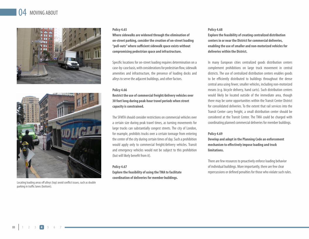
88 1 2 3 4 5 6 7
MOVING ABOUT04Policy 4.65Where sidewalks are widened through the elimination of on-street parking, consider the creation of on-street loading “pull-outs” where sufficient sidewalk space exists without compromising pedestrian space and infrastructure.
Specific locations for on-street loading requires determination on a case-by-case basis, with considerations for pedestrian flow, sidewalk amenities and infrastructure, the presence of loading docks and alleys to serve the adjacent buildings, and other factors.
Policy 4.66Restrict the use of commercial freight/delivery vehicles over 30 feet long during peak-hour travel periods when street capacity is constrained.
The SFMTA should consider restrictions on commercial vehicles over a certain size during peak travel times, as turning movements for large trucks can substantially congest streets. The city of London, for example, prohibits trucks over a certain tonnage from entering the center of the city during certain times of day. Such a prohibition would apply only to commercial freight/delivery vehicles. Transit and emergency vehicles would not be subject to this prohibition (but will likely benefit from it).
Policy 4.67explore the feasibility of using the TMA to facilitate coordination of deliveries for member buildings.
Policy 4.68explore the feasibility of creating centralized distribution centers in or near the District for commercial deliveries, enabling the use of smaller and non-motorized vehicles for deliveries within the District.
In many European cities centralized goods distribution centers complement prohibitions on large truck movement in central districts. The use of centralized distribution centers enables goods to be efficiently distributed to buildings throughout the dense central area using fewer, smaller vehicles, including non-motorized means (e.g. bicycle delivery, hand carts). Such distribution centers would likely be located outside of the immediate area, though there may be some opportunities within the Transit Center District for consolidated deliveries. To the extent that rail services into the Transit Center carry freight, a small distribution center should be considered at the Transit Center. The TMA could be charged with coordinating planned commercial deliveries for member buildings.
Policy 4.69Develop and adopt in the Planning Code an enforcement mechanism to effectively impose loading and truck limitations.
There are few resources to proactively enforce loading behavior of individual buildings. More importantly, there are few clear repercussions or defined penalties for those who violate such rules.
Locating loading areas off alleys (top) avoid conflict issues, such as double parking in traffic lanes (bottom).

89DRAFT TRANSIT CENTER DISTRICT PLAN
MOV
ING
ABOU
T04
CAR sHARING
Car sharing has become a viable alternative both for households to reduce their level of car ownership, as well as for businesses to reduce or negate the need for individual fleet services. Car sharing can help mitigate the negative impacts of new development by reducing vehicle ownership and vehicle miles traveled. Under Section 166 of the San Francisco Planning Code, new residential development or existing buildings being converted to residential uses with more than 50 units must provide car share parking spaces based on the ratios detailed in the Code. Newly constructed buildings in Neighborhood Commercial Transit (NCT) Districts or the Van Ness and Market Downtown Residential Special Use Districts with parking for non-residential uses must also provide car share parking spaces. The car share spaces must be provided at no cost to certified car share operators.
Currently, there is no requirement for car sharing parking spaces in non-residential buildings downtown. Within the District, existing parking lots used by car sharing services are being eliminated, making it essential to provide sufficient space for car sharing pods within private or public parking garages and as dedicated on-street spaces, as many California cities such as Oakland and Los Angeles already do.
OBjeCTIVe 4.47eNsURe THAT ADeQUATe sPACe Is PROVIDeD FOR CAR sHARING seRVICes THROUGHOUT THe DIsTRICT ACCessIBle TO ResIDeNTs, eMPlOyees, AND VIsITORs.
Policy 4.70Require parking spaces dedicated for car sharing vehicles in off-street parking garages in all new and renovated non-residential buildings in the Plan Area that provide parking for autos.
Proposed Control:Amend Section 166 to require car sharing spaces in all garages in the Plan Area. The existing ratios of requirements should be extended to apply to non-residential garages the Plan Area. The proposed increased ratios are as follows:
25 to 49 parking spaces: Minimum of 1 parking space dedicated •to certified car sharing organizations for their free use.
50 or more parking spaces: Minimum of 1 parking space •dedicated to certified car sharing organizations for their free use, plus 1 for every 50 parking spaces over 50.
Policy 4.71Pursue the dedication of on-street parking spaces for car sharing vehicles. Work with the MTA to identify appropriate locations for dedicated on-street parking spaces for car sharing vehicles.
Parking spaces dedicated for Zip Cars.

90 1 2 3 4 5 6 7
MOVING ABOUT04
CAsUAl CARPOOl
Casual carpooling is an informal transportation mode where drivers pick up carpoolers—without specific prior arrangement between parties—at various set locations. These ad hoc carpools then take advantage of carpool lanes on freeways and bridges, as well as reduced or waived bridge tolls. The program currently focuses on rides for commuters who live in the East Bay and work in San Francisco. Almost all drop their passengers off in the Plan Area (though a small number drop off in the Civic Center). Most morning casual carpool riders take transit (either BART or AC Transit) home in the afternoon. (This may partially be because there is less financial incentive for drivers headed back to the East Bay, since the Bay Bridge is tolled only in the westbound direction). A smaller number of commuters use casual carpool to leave San Francisco in the eastbound direction in afternoon, primarily for people headed to more distant locations such as Hercules, Vallejo and Fairfield. Current casual carpool locations in the Plan Area are as follows:
AM Drop-off:• Both sides of Howard Street between Fremont and First streets, and on the east side of Fremont Street at Howard Street. (Generally accessed from the Fremont Street off-ramp)
PM Pick-up:• On east side of Beale Street, between Howard and Folsom streets (recently moved to the west side due to construction of the Temporary Transbay Terminal). After pick-up, these carpools can continue south on Beale Street to westbound Bryant Street to access the peak hour carpool-only bridge on-ramp at Sterling Street.
OBjeCTIVe 4.48sUPPORT THe CAsUAl CARPOOl sysTeM By eNHANCING exIsTING FACIlITIes AND AMeNITIes. IF NeCessARy, THe CARPOOl FACIlITIes sHOUlD Be ReCONFIGUReD OR RelOCATeD TO eQUAlly CONVeNIeNT lOCATIONs.
Policy 4.72Create sufficient sidewalk waiting and passenger loading/unloading space at casual carpool locations in the Plan Area.
Policy 4.73Add passenger amenities at evening waiting locations, including shelters, informational signage, and other supportive services.
Most of the casual carpool drop-off and pick-up locations are within the Plan Area.
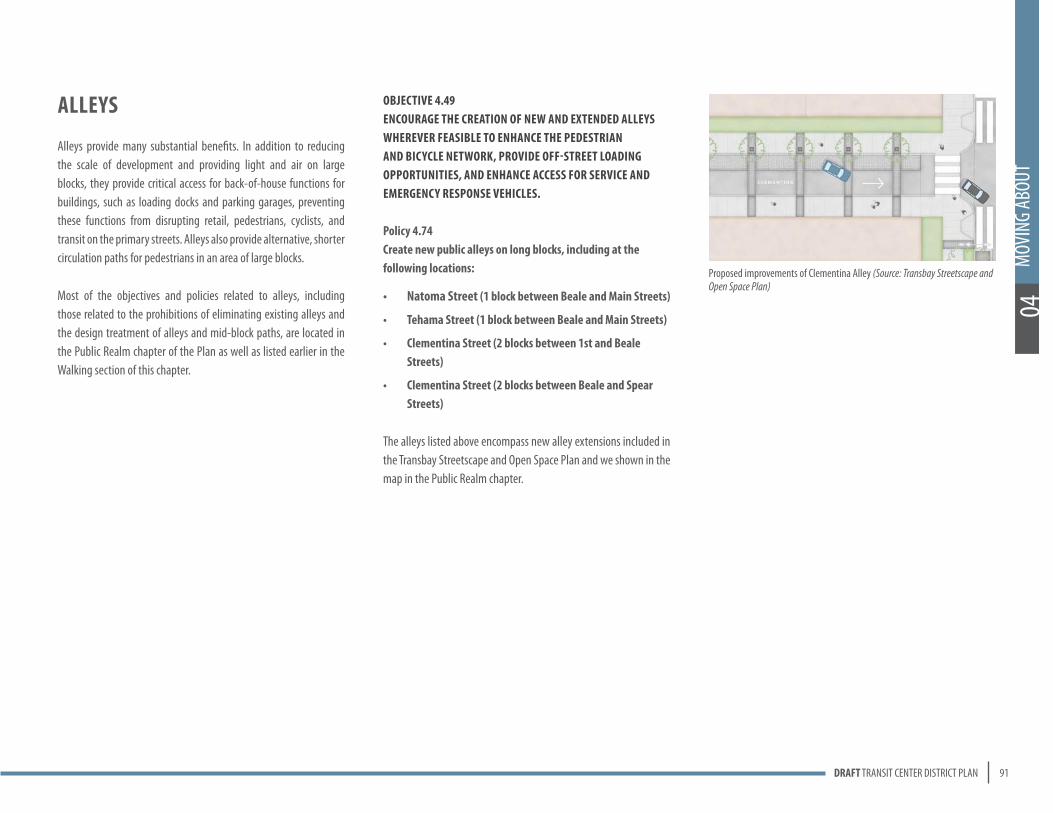
91DRAFT TRANSIT CENTER DISTRICT PLAN
MOV
ING
ABOU
T04
Alleys
Alleys provide many substantial benefits. In addition to reducing the scale of development and providing light and air on large blocks, they provide critical access for back-of-house functions for buildings, such as loading docks and parking garages, preventing these functions from disrupting retail, pedestrians, cyclists, and transit on the primary streets. Alleys also provide alternative, shorter circulation paths for pedestrians in an area of large blocks.
Most of the objectives and policies related to alleys, including those related to the prohibitions of eliminating existing alleys and the design treatment of alleys and mid-block paths, are located in the Public Realm chapter of the Plan as well as listed earlier in the Walking section of this chapter.
OBjeCTIVe 4.49eNCOURAGe THe CReATION OF NeW AND exTeNDeD Alleys WHeReVeR FeAsIBle TO eNHANCe THe PeDesTRIAN AND BICyCle NeTWORk, PROVIDe OFF-sTReeT lOADING OPPORTUNITIes, AND eNHANCe ACCess FOR seRVICe AND eMeRGeNCy ResPONse VeHICles.
Policy 4.74Create new public alleys on long blocks, including at the following locations:
Natoma street • (1 block between Beale and Main streets)
Tehama street (1 block between Beale and Main streets) •
Clementina street (2 blocks between 1st and Beale •streets)
Clementina street (2 blocks between Beale and spear •streets)
The alleys listed above encompass new alley extensions included in the Transbay Streetscape and Open Space Plan and we shown in the map in the Public Realm chapter.
Proposed improvements of Clementina Alley (Source: Transbay Streetscape and Open Space Plan)
...historic resources provide a vital contribution to the quality of life in the city... enrich our built environment... benefit residents, visitors, and businesses by creating a tangible link to our past...
“
”

DRAFT TRANSIT CENTER DISTRICT PLAN 93
HISTORIC PRESERVATION
The heritage of San Francisco is preserved in its historically significant buildings, sites, districts, and other resources. These historic resources provide a vital contribution to the quality of life in the city. As public amenities they not only enrich our built environment; they benefit residents, visitors, and businesses by creating a tangible link to our past and creating a sense of place.
The Transit Center District area embodies four important historical periods, the most important being the reconstruction of the South of Market area after the 1906 earthquake and fire, 1906–1929. Associated with this period of significance is the existing New Montgomery-Second Street Conservation District. Approved by the Board of Supervisors in 1985, the New Montgomery-Second Street Conservation District was established because the area “possesses concentrations of buildings that together create a sub-area of architectural and environmental quality and importance which contributes to the beauty and attractiveness of the city.” The Conservation District is described in depth in Section 5 of Appendix h of Article 11 of the Planning Code and is proposed for expansion under the Transit Center District
Plan in order to recognize and protect previously overlooked buildings within the area that contribute to the District.
Some of the most prominent buildings within the reconstruction period are the Palace Hotel, the Sharon, Call, Rialto, William Volker, and Pacific Telephone & Telegraph buildings. Others are less well-known, but no less significant, as unusual or rare examples of a particular style or building type, such as the Drexler Estate building at 121 Second Street or the Philips Van Orden building at 234 First Street. During the reconstruction period, the area assumed much of its physical character that is experienced today. Primarily comprised of low- and mid-rise masonry industrial loft buildings, post-disaster building trends led to the exclusion of housing, supplanting it with wholesale businesses, light industry, and support functions for offices and retail businesses north of Market Street.
Another important context comprises the Depression and World War II periods. The period of significance for this era is 1930–1945. Long home to a large maritime workforce, migrant farm laborers, and other itinerant workers, the
05

94 1 2 3 4 5 6 7
HISTORIC PRESERVATION05area became a destination for thousands looking for employment with the wartime effort. Mostly single males, these newcomers lived primarily in the residential hotels that once lined Third Street. A number of these local residents worked along the waterfront and participated in the 1934 waterfront and general strikes; however, the 1930s also saw important physical changes within the area as it became an important regional transit hub. The completion of the San Francisco-Oakland Bay Bridge in 1936 and the Transbay Terminal in 1939 greatly altered the physical fabric of the area. These massive public works projects cleared a number of buildings to make way for elevated concrete viaducts carrying both vehicular traffic and key route trains to and from the bridge.
A third important context within the area occurred as private and public capital began to finance the expansion of the financial district south of Market Street after World War II, 1946–1984. By the late 1950s, many of the traditional industries in the area had begun relocating outside the city. As local unemployment grew, social problems became more visible, serving as a pretext for urban renewal. Based on plans initially conceived in the mid-1950s by developer Ben Swig, the San Francisco Redevelopment Agency began acquiring properties on which to construct the Yerba Buena Center, demolishing buildings and displacing the remaining industries and longtime residents. As consensus broke down over what form the area should take, the City and County of San Francisco issued its 1971 Urban Design Plan. The Plan was focused on laying out the core physical elements that make San Francisco unique and livable and forging a positive relationship between the physical elements of the city and its inhabitants, including learning from recent mistakes, such as the indelicate siting, bulk, and ground-level interface of large buildings. The Urban Design Plan did not fundamentally reform the design or planning of large buildings, which it recognized have a place in the city (particularly downtown), though it did further encourage the need for improved public open space associated with large development. Existing Historic Districts
De Young (1889), Hearst/Examiner, and Spreckels/Call (1896) buildings, Market Street near Third Street (Source: KVP Consulting)
Pacific Telephone and Telegraph Building, 1925 (Source: KVP Consulting)
Howard St
Steuart St
Le idesdo rf f St
California St
Bush St
1st St
Pine St
Ofarrell St
Tenny Pl
Grant Ave
Anthony St
Bryant St
Ecker St
New M
ontgomery St
Annie St
Sutter St
Mission St
Powell St
Hunt St5th St
Ellis St
Kear ny St
Folsom
St
I-80 Eastbound
Tehama St
Main St
Ver Mehr Pl
Market St
Emma St
Chelsea P l
Eddy St
Miles
Pl
Pratt Pl
Vinton Ct
3rd St
Stockt on St
Fremont St
Harlan Pl
Chatham Pl
Anson Pl
Fella PlCentury
P l
Trea su ry P l
Mar k
Ln
Quin cy
St
Burr itt S t
Hardie Pl
I-80 Westb
ound
Sabin Pl
Geary St
4th St
2nd St
Harriso
n St
Post St
Kaplan Ln
Rincon St
Essex St
Batter y St
Shaw Aly
Cyril Magnin
St
Malden Aly
Front St
Davis
St
Sterling St
Clementina St
Grote Pl
Joice St
Stevenson St
Jessie St Nato
ma St
Minna St
Spear St
Dow Pl
Sansome
St
Tr inity St
Saint Geo rge
A ly
B elden St
Petr arch Pl
Claud e Ln
Transbay Hump
Lansing St
I-80 W O
ff Ramp
Maiden Ln
Campton Pl
Beale St
Hawthorne St
Sto ckt on Tun l
Mon tgom
ery St
I-80 E On Ramp
Guy Pl
I-80 W Off-ramp
Transbay Loop
0 100 200 300 400 500YardsThe City and County of San Francisco (CCSF) does not guarantee the accuracy, adequacy, completeness or usefulness
of any information. CCSF provides this information on an "as is" basis without warranty of any kind, including but not limited to warranties of merchantability or fitness for a particular purpose, and assumes no responsibility for anyone's use of the information.
µArticle 11 Categories
Category ICategory IICategory IIICategory IVCategory V
Existing New Montgomery and 2nd St ConservationDistrict Boundary
Market
St
Folsom
St
3rd St
Steuart St
Study Area
2nd & Howard National Register District

95DRAFT TRANSIT CENTER DISTRICT PLAN
HIST
ORIC
PRES
ERVA
TION
05
New Montgomery Street, 1885 (Source: KVP Consulting) New Montgomery Street, 1885 (Source: KVP Consulting)
Potential Historic District Expansion
Howard St
Steuart St
Le idesdo rf f St
California St
Bush St
1st St
Pine St
Ofarrell St
Tenny Pl
Grant Ave
Anthony St
Bryant St
Ecker St
New M
ontgomery St
Annie St
Sutter St
Mission St
Powell St
Hunt St
5th St
Ellis St
Kear ny St
Folsom
St
I-80 Eastbound
Tehama St
Main StVer Mehr Pl
Market St
Emma St
Chelsea P l
Eddy St
Miles
Pl
Pratt Pl
Vinton Ct
3rd St
Stockt on St
Fremont St
Harlan Pl
Chatham Pl
Anson Pl
Fella Pl
Century P l
Trea su ry P l
Mar k
Ln
Quin cy
St
Burr itt S t
Hardie Pl
I-80 Westb
ound
Sabin Pl
Geary St
4th St
2nd St
Harriso
n St
Post St
Kaplan Ln
Rincon St
Essex St
Batter y St
Shaw Aly
Cyril Magnin
St
Malden Aly
Front St
Davis
St
Sterling St
Clementina St
Grote Pl
Joice St
Stevenson St
Jessie St Nato
ma St
Minna St
Spear St
Dow Pl
Sansome
St
Tr inity St
Saint Geo rge
A ly
B elden St
Petr arch Pl
Claud e Ln
Transbay Hump
Lansing St
I-80 W O
ff Ramp
Maiden Ln
Campton Pl
Beale St
Hawthorne St
Sto ckt on Tun l
Mon tgom
ery St
I-80 E On Ramp
Guy Pl
I-80 W Off-ramp
Transbay Loop
0 100 200 300 400 500YardsThe City and County of San Francisco (CCSF) does not guarantee the accuracy, adequacy, completeness or usefulness
of any information. CCSF provides this information on an "as is" basis without warranty of any kind, including but not limited to warranties of merchantability or fitness for a particular purpose, and assumes no responsibility for anyone's use of the information.
µArticle 11 Categories
Proposed New Montgomery, 2nd St and Mission St Conservation District Boundary
Category ICategory IICategory IIICategory IVCategory V
Market
St
Folsom
St
3rd St
Steuart St
Study Area
Howard St
Steuart St
Le idesdo rf f St
California St
Bush St
1st St
Pine St
Ofarrell St
Tenny Pl
Grant Ave
Anthony St
Bryant St
Ecker St
New M
ontgomery St
Annie St
Sutter St
Mission St
Powell St
Hunt St
5th St
Ellis St
Kear ny St
Folsom
St
I-80 Eastbound
Tehama St
Main StVer Mehr Pl
Market St
Emma St
Chelsea P l
Eddy St
Miles
Pl
Pratt Pl
Vinton Ct
3rd St
Stockt on St
Fremont St
Harlan Pl
Chatham Pl
Anson Pl
Fella Pl
Century P l
Trea su ry P l
Mar k
Ln
Quin cy
St
Burr itt S t
Hardie Pl
I-80 Westb
ound
Sabin Pl
Geary St
4th St
2nd St
Harriso
n St
Post St
Kaplan Ln
Rincon St
Essex St
Batter y St
Shaw Aly
Cyril Magnin
St
Malden Aly
Front St
Davis
St
Sterling St
Clementina St
Grote Pl
Joice St
Stevenson St
Jessie St Nato
ma St
Minna St
Spear St
Dow Pl
Sansome
St
Tr inity St
Saint Geo rge
A ly
B elden St
Petr arch Pl
Claud e Ln
Transbay Hump
Lansing St
I-80 W O
ff Ramp
Maiden Ln
Campton Pl
Beale St
Hawthorne St
Sto ckt on Tun l
Mon tgom
ery St
I-80 E On Ramp
Guy Pl
I-80 W Off-ramp
Transbay Loop
0 100 200 300 400 500YardsThe City and County of San Francisco (CCSF) does not guarantee the accuracy, adequacy, completeness or usefulness
of any information. CCSF provides this information on an "as is" basis without warranty of any kind, including but not limited to warranties of merchantability or fitness for a particular purpose, and assumes no responsibility for anyone's use of the information.
µArticle 11 Categories
Category ICategory IICategory IIICategory IVCategory V
Existing New Montgomery and 2nd St ConservationDistrict Boundary
Market
St
Folsom
St
3rd St
Steuart St
Study Area
2nd & Howard National Register District
The fourth and final context is ongoing, encompassing the 1980s office construction boom countered by the rise in support for the preservation of historic downtown San Francisco and a slow-growth approach. Its period of significance is 1985 to the present, during which much of the remaining industrial, warehousing, and other commercial uses were displaced by privately financed office towers, hotels, museums, and condominium projects. Devised in response to this development boom, the Downtown Plan, an element of the General Plan adopted in 1985, responded to the concerns of preservationists that downtown was losing its historic character. Utilizing the findings of San Francisco Architectural Heritage’s Downtown Survey, the Downtown Plan created several Conservation Districts protected approximately 250 of the area’s most significant buildings while allowing new development to occur on the sites of less significant buildings. Also of major concern for the Downtown Plan was shaping the design of new development to respect the pedestrian scale, provide more interesting building forms, and moderate bulk, as recent major buildings had been criticized for degrading the character of the city.
The historic preservation objectives and policies of the Transit Center District Plan build upon the preservation principles of the Downtown Plan. They are intended to provide for the identification, retention, reuse, and sustainability of the area’s historic properties. As the area continues to change and develop, historic features and properties that define it should not be lost or their significance diminished through demolition or inappropriate alterations. As increased densities will provide a contrast to the traditional lower-scale, masonry, pre-war buildings, new construction within the historic core of the Transit Center District should respect and relate to its historic context. The District Plan regulates sound treatment of historic resources according to the Secretary of the Interior’s Standards; it encourages the rehabilitation of historic resources for new compatible uses, and it allows for incentives for qualifying historic projects.

96 1 2 3 4 5 6 7
HISTORIC PRESERVATION05OBJECTIVE 5.1PROTECT, PRESERVE, AND REUSE THOSE HISTORIC RESOURCES THAT HAVE BEEN IDENTIFIED AND EVALUATED WITHIN THE TRANSIT CENTER PLAN AREA.
Policy 5.1Protect individually significant historic and cultural resources and historic districts in the Transit Center District Plan from demolition or adverse alteration.
Policy 5.2Apply the Secretary of the Interior’s Standards for the Treatment of Historic Properties in conjunction with applicable Articles 10 and 11 of the Planning Code requirements to the Transit Center District Plan Area and objectives for all projects involving historic or cultural resources.
Policy 5.3Pursue formal recognition and designation of the Transit Center historic and cultural resources, as appropriate.
Policy 5.4Recognize and protect historic and cultural resources that are less than fifty years old that may display exceptional significance to the recent past.
The current boundaries of the existing New Montgomery-Second Street Conservation District and the Second and Howard Street National Register Historic District, are both completely contained within the Plan Area. The Planning Department completed a context statement and survey of historical resources in the Transit Center District Plan Area and the Landmarks Preservation Advisory Board adopted the survey and historic context statement at a regularly scheduled public hearing in August 2008. Supplementary survey work is currently slated for completion in November 2009.
Based on the findings of the historic context statement and these surveys, the New Montgomery-Second Street Conservation District should be expanded pursuant to Section 1107 of the Planning Code to include additional historic resources along Mission and Natoma Streets and shall be renamed the New Montgomery-Mission-Second Street (NMMS) Conservation District. The additional properties in the proposed District expansion, although previously overlooked, contain some notable buildings and relate strongly to the context of the District and strengthen its overall historic character.
In addition, there are many historic buildings within the larger Plan Area, including within the existing National Register District on the south side of Howard Street, which should be given individual recognition through Article 11 category ratings as outlined pursuant to Section 1106 of the Planning Code. These additional buildings exhibit strong architectural significance, individually or as contributors to the larger historic context identified with the Plan Area and with the Conservation District, but are separated from the proposed contiguous NMMS Conservation District by multiple lots with non-contributory or non-historic buildings. A list of the proposed Article 11 reclassifications for all buildings in the Plan Area can be found in the Appendix of this document.
The Plan recognizes that a number of existing buildings, some with historic merit, located in and near the existing conservation and historic districts along Second, Howard, Natoma and Tehama Streets, have been previously identified and reviewed in adopted environmental documents for acquisition and removal by the TJPA in order to construct the Transit Center and Downtown Rail Extension (DTX). Despite these building removals, the historic integrity of the existing and proposed overall New Montgomery-Mission-Second Street (NMMS) Conservation District remains intact, as do numerous associated adjacent groupings of buildings of merit in the immediate proximity. Moreover, while the City has no authority to restrict the TJPA’s demolition of buildings necessary to construct the Transit
Center Project (including the DTX, ramps, etc.), new replacement buildings may be proposed on these parcels-to-be-acquired once construction of the train extension and Transit Center is complete. It is important that the design of new buildings on these sites be compatible with the adjacent district context in terms of massing, size, scale, and architectural features (yet also be contemporary).
Working with the community, the Planning Department should recommend the nomination of several individually-eligible buildings for listing within Article 10 of the Planning Code as City Landmarks, including:
Planters Hotel at 606 Folsom Street (APN 3735/008);•
Phillips & Van Orden Building at 234 First Street (APN •3736/006);
Burdette Building at 90 2nd Street (APN 3707/012); and•
Marine Fireman’s and Oilers and Watertenders Union Hall at •240 Second Street (APN 3735/055).
Although less than 50 years old, the Thomas Lile Building, located at 145 Natoma Street possesses exceptional architectural significance and is eligible for listing on the California Register. The Department should list the building as a Category I building under Article 11 of the Planning Code and continue to identify and document important cultural and architectural resources from the recent past within the Transit Center District Plan Area through survey, property-specific historic resource evaluation, and context development.
Planning Department Preservation Technical Specialists, along with other governmental agencies, should apply the Secretary of the Interior’s Standards for the Treatment of Historic Properties in conjunction with the preservation policies and objectives of the Transit Center District Plan to minimize the overall impact upon historic and cultural resources.

97DRAFT TRANSIT CENTER DISTRICT PLAN
HIST
ORIC
PRES
ERVA
TION
05
Marine Fireman’s and Oilers and Watertenders Union Hall, 240 2nd Street
Planters Hotel, 606 Folsom Street (Source: KVP Consulting)
Burdette Building, 90 2nd Street
Phillips & Van Orden Building, 234 1st Street (Source: KVP Consulting)
Existing and Proposed Landmarks
1st St
Harriso
n St
2nd St
Folsom
St
Ofarrell St
Sutter St
3rd St
Grant A ve
Anthony St
Mission St
Ecker St
New M
ontgomery St
Annie St
Hunt St
Kear ny St
Tehama St
Howard St
Fremont St
Geary St
4th St
Post St
Ellis St
Kaplan Ln
Essex St
Shaw Aly
Market St
Malden Aly
Clementina St
Transbay Hump
Stevenson St
Jessi
e St Natoma St
Minna St
Ambrose Bierce St
Dow Pl
Stockton St
Campton Pl
Maiden Ln
Hawthorne St
I-80 W
Off-ram
p
Mont gom
ery St
Transbay Loop
0 40 80 120 160 200Yards
The City and County of San Francisco (CCSF) does not guarantee the accuracy, adequacy, completeness or usefulnessof any information. CCSF provides this information on an "as is" basis without warranty of any kind, including but not limited to warranties of merchantability or fitness for a particular purpose, and assumes no responsibility for anyone's use of the information.
µ
Market
St
Folsom
St
3rd St
Steuart St
Study Area
Proposed Article 10
Existing Article 10
2 New Montomery St
240 2nd St
606 Folsom St
234 1st St
111 New Montomery St
39 New Montomery St
90 2nd St

98 1 2 3 4 5 6 7
HISTORIC PRESERVATION05OBJECTIVE 5.2PROVIDE PRESERVATION INCENTIVES, GUIDANCE, AND LEADERSHIP WITHIN THE TRANSIT CENTER DISTRICT PLAN AREA
Policy 5.5Develop incentives that promote the retention and rehabilitation of significant resources within the Transit Center District Plan Area.
The Planning Department should continue to develop technical workshops, educational materials, and presentations for property owners and the public to increase the number of properties that take advantage of the Mills Act Property Tax Abatement Program.
Per the policies above, the Planning Department should evaluate and apply Article 11 classifications to all eligible buildings within the Plan Area so that property owners may leverage the sale of Transferable Development Rights (TDR) and other incentives for the maintenance and preservation of historic resources.
SUPPLy AND DEmAND OF TRANSFERABLE DEVELOPmENT RIGHTS (TDR)
In 1985 the Downtown Plan created the TDR program throughout the C-3 Districts. This program requires that, in order for the gross square footage of new development to exceed the established base Floor Area Ratio (FAR), the developer must purchase unused development rights from eligible historic properties in the downtown. The development rights for the historic property that sells TDR are forever retired and restrictions are recorded against the property. There are different C-3 sub-districts throughout downtown, with varying base FAR ranging from 5:1 to 9:1. The base FAR in the C-3-O(SD) district is 6:1 and in the C-3-O district it is 9:1. Currently, developments in both of these districts can build up to
a maximum FAR of 18:1, meaning that projects building up to the maximum densities in these districts much purchase the square footage equivalent of 9 FAR or 12 FAR. For large projects, this can total several hundred thousand square feet of TDR.
When the TDR program was created through the Downtown Plan, the Planning Department at the time estimated that, based on its inventory of likely eligible historic properties, the potential “supply” of TDR was approximately 8 million square feet. To date, based on Planning Department records, a total of approximately 5 million square feet of TDR has been certified as eligible and 2.75 million square feet has been applied and retired by development projects. This means that there is approximately 2.25 million square feet of supply already certified, and about 3 million additional square feet of “potential” supply remaining. It is estimated that a significant majority of the 2.25 million square feet of TDRs certified, but not yet used, have been acquired by developers with projects approved or filed, but not yet built (TDR rules do not require the TDR to be “applied” and retired until the project is granted its first site permit).
Analysis of the remaining potential 3 million gross square feet has revealed that very few large, single sources of potential TDR (i.e. 50,000 gsf or larger) remain in the downtown. In other words, the large historic buildings in the downtown that can potentially sell large amounts of TDR have already sold their TDR, and generally only small properties remain to sell. The median size of potential TDR is currently less than 10,000 gross square feet. Considering that large projects individually need to assemble multiple hundreds of thousands of square feet each, this could mean that for each development someone would need to track down and assemble TDR from 20 to 30 historic properties.
Wells Fargo building (1902), 85 Second Street (Source: KVP Consulting)
Crenlin Estate building (1912), 585 Howard Street (Source: KVP Consulting)

99DRAFT TRANSIT CENTER DISTRICT PLAN
HIST
ORIC
PRES
ERVA
TION
05
Sharon building (1912), New Montgomery Street (Source: KVP Consulting)
There are many reasons why owners of historic properties have not and may not sell their potential TDR. These include: (1) they do not want to dilute their property rights; (2) the financial incentive is small in comparison to total property value (e.g. the value of 10,000 square feet of TDR likely ranges from $150,000 to $300,000); (3) they do not understand the TDR program; and (4) the organization of the ownership entity is unwieldy (e.g. family trust with many owners) and cannot or will not agree on a decision to sell the TDR. While the City could provide more outreach and information to property owners, the fact is that the TDR program has been existence for over 25 years and most of the property owners likely to put their TDR up for sale have already done so, especially considering that there are brokers and developers who have somewhat systematically contacted property owners over the past 25 years soliciting the purchase of TDR. Additionally, the smaller the property, the more likely it is to be owned by a trust, a non-profit association, or other entity unlikely to come to the decision to sell off future development rights.
Another concern is not just in the potential supply of TDR, but also in the imbalance between the likely potential supply and the likely demand. In the Transit Center District alone, there is the potential demand for over 7.5 million square feet of TDR given the proposed Plan rezoning, assuming the base FAR for the entire district is 6:1 and maintenance of the current rules requiring purchase of TDR for all square footage above the base. There is clearly not even half of the potential necessary TDR for that amount of demand. If the potential supply is too low, not only will developers not be able to find the TDR at any price, but the few sellers would be able to drive TDR prices to disproportionate heights. When the TDR program was created, economic analysis determined that the supply of TDR should be approximately two times the potential demand in order to have a healthy market.
Given that there is realistically a supply of about 2 million square feet of TDR (about half of the 2.25 million square feet certified but not yet used, plus 1/3 of the remaining uncertified 3 million potential), the total demand should be in the range of 1–2 million square feet.
COSTS OF TDR AND PUBLIC BENEFITS
These TDR transactions, while recorded with the City, are private market transactions, with the developer (or other party) paying the owner of the historic property at a price and terms negotiated privately. Therefore, the price fluctuates with market demand. In active years, the price of TDR can rise to $35/square foot or more, and in times of low development activity the price of TDR has fallen to $15/square foot.
As the Plan seeks to leverage development in the District to raise revenue for the Transit Center and other necessary public infrastructure to support the District, it must be recognized that the cost to the developer of purchasing TDR is a cost that directly reduces the capacity of the development to contribute towards other public benefits.
THE USE AND EFFECT OF TDR FUNDS
The sale of TDR is, and has been, successful in reducing or eliminating development pressure to demolish the historic resource once its TDR has been sold, which was the purpose of TDR. However, other than the retirement of future development rights, there are no City-imposed conditions or criteria for the use of the revenue paid to the historic property owner for the TDR, nor are their requirements for the rehabilitation or restoration of the historic building. That is, the TDR funds are not necessarily translated directly into improvements to the historic building.
Warring-Wilkinson building (1909), 96 Jesse Street (Source: KVP Consulting)

100 1 2 3 4 5 6 7
HISTORIC PRESERVATION05There could be other avenues to leverage the basic premise of the FAR/TDR program to more directly financially support the preservation and maintenance of historic properties. Given that fact, and the reality that the potential supply of TDR is limited and diminishing, such that it could likely be difficult for developers to acquire even a reduced amount of necessary square footage, an option for developers to pay an in-lieu fee into a historic preservation fund should be considered (i.e., in-lieu of purchasing TDR). This fund would be used by the City to provide rebates to owners of historic properties in the downtown for physical improvements to their buildings, as well as for other public educational and informational programs related to the history of the District (e.g., public signage programs). However, this fee and the program should be structured and calibrated such that it does not undermine the primary avenue of purchasing TDR. In this vein, funds from such fees should be made available to owners of historic buildings who have already committed to preserving their buildings by selling any available TDR.
Policy 5.6maintain the TDR program as a critical component of the historic preservation program in the downtown and the Plan Area, but modify the program in the Plan Area based on updated information about the TDR program and on other objectives of this Plan.
Policy 5.7Balance the TDR requirement with other public benefits programs in the District by reducing the square footage requirement for the purchase of TDR by each individual development project.
Proposed Control: Based on the District Plan proposal to rezone all of the Plan Area to C-3-O(SD) with a base FAR of 6:1, modify the TDR rules in the Planning Code for the Plan area to require that development purchase TDR for all gross square footage between 6:1 and 9:1 FAR.
Proposed Control: Modify the TDR rules for the C-3-O(SD) to enable eligible historic properties to sell TDR equivalent between the existing square footage of the lot and 9:1 FAR, rather than just to base FAR 6:1.
Policy 5.8Provide flexibility for development in satisfaction of the TDR requirement by providing an in-lieu mechanism that directly benefits the preservation, rehabilitation, maintenance and public education of historic resources in the downtown.
Proposed Control: Establish a Downtown Historic Preservation and Rehabilitation Fund and a TDR In-Lieu Fee, whose proceeds would be deposited in the Fund. Give project sponsors the option to pay into this Fund in lieu of purchasing TDR. The price of the fee shall be set at such a rate that it is more than the historical average market price for TDR, such that purchasing TDR continues to be the preferred option.
In partnership with the Historic Preservation Commission, rules should be developed and established regarding the use and management of the Fund. The rules should reinforce that the Fund program should be used by the Planning Department solely for the partial reimbursement of rehabilitation or restoration work completed by qualified property owners of historic resources within the City of San Francisco.
Mission Street between New Montgomery and Third Street.
Second Street at Minna Street.

101DRAFT TRANSIT CENTER DISTRICT PLAN
HIST
ORIC
PRES
ERVA
TION
05
The Fund should allow the City to reimburse eligible property owners for preservation and rehabilitation work (windows, exterior repairs, etc.) to buildings within the C-3 Districts and that have already sold their TDR (thus encouraging historic buildings to be preserved by selling TDR, thereby removing future development rights and pressure to demolish the buildings). Eligible buildings should deemed to be (1) a designated landmark building or a contributory building within a designated historic district per Article 10 of the Planning Code, (2) a Category I-IV building identified within Article 11 of the Planning Code, or (3) a building listed on the California Register of Historical Resources by the State Office of Historic Preservation within the City of San Francisco.
The funds should be Board-appropriated in an interest earning account that carries forward its own balance. Eligible restoration or rehabilitation work should be limited only to the exterior of an historic resource, including: the reconstruction of a missing cornice; terra cotta repair and replacement, the reconstruction of missing features based on physical or documented evidence; façade cleaning, paint removal, the removal of incompatible non-historic alterations; the removal of incompatible non-historic windows with new windows that match the historic material, profile, and configuration. Additional projects eligible for use of the Fund should include public signage and similar informational programs related to historic preservation within the C-3, purchasing TDR or conservation easements from historic properties that have not yet sold TDR. Ineligible work should include new additions, new garage openings, loading docks, painting, all seismic retrofit work, roof repair or replacement. All work should comply with the Secretary of the Interior’s Standards for the Treatment of Historic Properties (36 C.F.R. § 67.7 (2001) and be subject to the review and approval requirements of Planning Code Articles 10 and 11.
OBJECTIVE 5.3FOSTER PUBLIC AWARENESS AND APPRECIATION OF HISTORIC AND CULTURAL RESOURCES WITHIN THE TRANSIT CENTER DISTRICT PLAN AREA.
Policy 5.9Foster education and appreciation of historic and cultural resources within the Transit Center District Plan Area among business leaders, neighborhood groups, and the general public through outreach efforts.
In cooperation with the Arts Commission and the Department of Public Works develop a self-guided architectural and cultural tour, and infrastructure improvements, such as permanent markers in public spaces and along the public right-of-way, within the Transit Center District Plan Area.
OBJECTIVE 5.4PROmOTE WELL-DESIGNED, CONTEmPORARy INFILL DEVELOPmENT WITHIN THE HISTORIC CORE OF THE TRANSIT CENTER DISTRICT PLAN AREA.
Policy 5.10Encourage well-designed, contemporary buildings for vacant sites, or to replace non-contributing buildings within the Conservation District that meet the Secretary of the Interior’s Standards.
Policy 5.11Provide technical assistance to government agencies and property owners for the development of buildings and amenities within the New montgomery-mission-Second Street Conservation District that strengthen its historic character and improve the public realm.
Several historic resources are proposed for demolition to construct the Transbay Transit Center. The Department should promote and encourage government agencies and other property owners to provide the City with well-designed, contemporary infill development within the New Montgomery-Mission-Second Street Conservation District, where applicable. New proposals for vacant land, whether devoted to the private or public realm, must strengthen the character-defining features of the District and contribute new opportunities for residents and visitors to experience and enjoy the District.
Infill projects must comply with Standard #9 of the Secretary of the Interior’s Standards, as well as any requirements of Articles 10 and/or 11 of the Planning Code, where applicable, and should represent the time in which they were constructed while respecting the character-defining materials, massing, size, scale, and architectural features of the District.

An overall aim for the Plan is to deliver low-impact, high-performing development that will fulfill regional growth and development requirements in an environmentally responsible and economically sound manner ...
“
”

DRAFT TRANSIT CENTER DISTRICT PLAN 103
DISTRICT SUSTAINABILITY
Sustainability is inherent to the whole of the Transit Center District Plan, not least because of its location and focus as a regional transit hub. An overall aim for the Plan is to deliver low-impact, high-performing development that will fulfill regional growth and development requirements in an environmentally responsible and economically sound manner. The Plan capitalizes on the inherent land, energy, and water resource efficiencies of high-density, transit-oriented green development, thereby reducing the City and its residents’ dependency on these increasingly scarce and costly resources and providing a protective buffer against potential volatility in energy and water prices in the future. Though many positive impacts of the Plan will be felt locally by the city and the Bay Area region, it also achieves a global impact of helping to mitigate future impacts of climate change.
The Plan has been developed with two key policy frameworks as guiding influences: California state legislation AB 32 (which mandates statewide reductions in greenhouse gas emissions) and SB 375 (which requires regions to adopt growth management land use plans that result in reduced greenhouse gas emissions and tie transportation funding to these plans),
both of which are explained in greater detail in the Introduction chapter. Both of these policies ultimately drive at achieving GHG reductions in an effort to curb California’s contributions to climate change; however, climate change mitigation is not the sole organizational principle of the sustainability strategies in the Plan. Achieving a low-carbon built environment solution not only requires a base of strategies at the regional scale, but also robust district, site, and building-level strategies. Specifically, the Plan details innovative approaches to district- scale energy and heat production, high performance buildings, and district-scale water efficiency, all of which contribute to environmental and economic performance of the Plan. For example, improved energy performance of buildings provides local running cost savings and integration of water sensitive urban design techniques can improve local air quality.
At the end of this chapter, a matrix summarizes the policies within each chapter that help achieve the sustainability goals of the Plan. Key areas of environmental, social, and regional benefit have been identified (and illustrated by an icon), and the relevant policies mapped to show where they have the most impact.
06

104 1 2 3 4 5 6 7
DISTRICT SUSTAINABILITY06
REGIONAL GROWTH AND SUSTAINABILITY
From a regional sustainability perspective, there are substantial gains to be made with respect to the environmental impact of developing a high-density regional transit hub located in the urban core of San Francisco as compared to continuing with the paradigm of lower-density suburban expansion. To gauge the magnitude of this impact, a comparative analysis1 of greenhouse gas (GHG) and air pollutant emissions was conducted to estimate the emissions reductions of accommodating urban growth with the high-density regional transit hub of the Transit Center District versus a conventional low-density suburban development with limited public transit options (the typical development model that represents the lion’s share of the region’s recent growth).
The results of this analysis tell a compelling story of the environmental benefit of investing in the high-density regional transit hub of the Transit Center District. The Emissions Comparative Analysis (Table 6-1) illustrates the dramatic reductions in air pollutant and greenhouse gas emissions that the Transit Center District would generate as opposed to a typical Bay Area suburban development alternative for equivalent square footages of development. The greenhouse gas, carbon dioxide (CO2), would be reduced by 62 percent; particulate matter (PM) would be virtually eliminated with reductions of over 90 percent for both 2.5 and 10 micron PM; smog and ground-level ozone inducing and reactive organic gases (ROG) and mono-nitrogen oxides (NOx) would be reduced by 15 and 82 percent respectively; and serious public health threats such as carbon monoxide (CO) and sulfur dioxide (SO2) would be reduced by 70 percent and 61 percent, respectively. There is an unquestionable public benefit and clear environmental argument in fortifying the Bay Area’s public transit system with a regional transit hub and
1 Analysis conducted using the Urbemis™, an emissions modeling program that estimates air emissions from land use development projects. See Technical Appendix: Emissions Modeling Methodology for further information on the assumptions and inputs used in the Urbemis™ model.
2 Climate Action Plan for San Francisco, Local actions to reduce greenhouse gas emissions, 2004.
Table 6-1: Emissions Comparative Analysis: Transit Center District vs. Suburban Development Alternatives
ROG NOx CO SO2 PM10 PM2.5 CO2
TOTAL EMISSIONS (lbs/day)
Suburban Development Alternative 9,986 2,733 9,995 6.92 5,911 2,422 861,864
Transit Center District Alternative 8,503 488 2,950 2.72 537 115 323,244
Percent Reduction 15% 82% 70% 61% 91% 95% 62%Source: Urbemis, 2007 v 9.2.4; AECOM, 2009.
developing high-density office, residential, and retail space within proximity to local and regional transit options.
There are also a number of other significant benefits that are indirectly realized by concentrating new development in the Transit Center District as opposed to the East Bay or other surrounding areas, such as no further loss of biological habitat, farmland or open green space, no requirement for new grey infrastructure, no increase in hard surfaces that could increase the heat island effect or any reduction in permeable area that could increase future flooding events.
It is the intention of the Plan to support, and where possible exceed, all existing city environmental, sustainability, and climate change objectives including the City’s ambitious greenhouse gas reduction goals of 20 percent below 1990 levels by 2012.2 There are many progressive policies in place within the City already (e.g. for green building and parking) and development in the Plan Area will be expected to build on this initial high standard.
Aside from the land use program’s intensive transit-orientation, the proposed policies and approaches to transportation management and public realm design described in the Public Realm and Moving About chapters are necessary to realize the environmental
gains represented in the model analysis. Included in these are comprehensive programs of re-allocating public right-of-way from space for autos (both parking and movement) to improve pedestrian conditions and to accommodate increased pedestrian travel, surface transit movement, and cycling, and of implementing core Transportation Demand Management policies related to congestion pricing, parking limitations, and enhancement of the function of the transportation brokerage services. All of these measures are necessary to achieve the core transit-oriented and non-auto goals of the Plan facilitate achievement of the carbon and resource reduction goals.
06
105DRAFT TRANSIT CENTER DISTRICT PLAN
DIST
RICT
SUST
AINA
BILIT
Y06
DISTRICT SYSTEMS SUSTAINABILITY
There are, however, some other significant opportunities that can be realized at a district level, particularly in terms of water usage, stormwater management, and energy efficiency, as well as green building practices. Due to the existing density of development in the Plan Area, mix of uses, and significant new development proposed, there is the opportunity for transforming the way the district uses energy. The redesign of the streets and public realm provides opportunities for a district-wide integrated water reuse management strategy that would substantially reduce use of potable water and have secondary benefits beyond minimizing flood risk. Policies described in this section addressing these issues will contribute to the City’s goal of reducing 400,000 tons of CO2 annually through energy efficiency, and displacing 3,000 tons of CO2 annually through development of renewable energy and co-generation resources by 2009.3 The focus on low energy buildings and efficient supply will ensure that properties in the Plan Area would lead the San Francisco real estate market in terms of low operating costs for both businesses and residents.
Other sustainability opportunities to reduce the urban heat island effect, improve air quality, and enrich urban ecology are dealt with through inclusion of street trees, living walls, and other green infrastructure described in the Public Realm chapter.
RELATED PLAN DOCUMENTS
SUSTAINABILITY PLAN, 1996 (ADOPTED 1997)
The Sustainability Plan establishes sustainable development as a fundamental goal of municipal public policy and sets out broad social goals, five-year objectives, and objectives that would need to be achieved in order to create a truly sustainable society. It proposes actions that City government, the private sector, and individuals should take to achieve the Plan’s goals and objectives. The document is divided into fifteen topic areas, ten that address specific environmental issues, and five that are broader in scope and cover many issues.
RECYCLED WATER ORDINANCES (ADOPTED 2001, AMENDED 2004)
The City and County of San Francisco has enacted the Reclaimed Water Use Ordinances (Ordinances 390-91, 391-91, and 393-94 found in Article 22, San Francisco Public Works Code) requiring all property owners to install dual-plumbing systems for recycled water use within the designated recycled water use areas under the following circumstances:
New or remodeled buildings and all subdivisions (except •condominium conversions) with a total cumulative area of 40,000 square feet or more
New and existing irrigated areas of 10,000 square feet or •more
The designated recycled water use areas include the Transit Center Plan area (included within the area described as the downtown/
3 Building a Bright Future, San Francisco Environmental Plan, SForward, 2008
South of Market area east of 7th Street). Once the SF Public Utilities Commission notifies subject property owners that recycled water service is commencing, all subject buildings and facilities are required to use recycled water for all applicable State of California-approved purposes. Approved uses include: landscape irrigation, toilet and urinal flushing, cooling or air conditioning involving a cooling tower, decorative fountains, industrial process water, industrial boiler feed, commercial laundries, and commercial car washing.
CLIMATE ACTION PLAN FOR SAN FRANCISCO, 2004
The Climate Action Plan provides background information on the causes of climate change and projections of its impacts on California and San Francisco from recent scientific reports. It presents estimates of San Francisco’s baseline greenhouse gas emissions inventory and reduction target. In addition, it recommends emissions reduction actions in the key target sectors of transportation, energy efficiency, renewable energy, and solid waste management to meet the City’s 2012 goal; and finally presents next steps required over the near term to implement the Plan.
URBAN FOREST PLAN, 2006
The Urban Forest Plan reviews the creation of San Francisco’s urban forest, analyzes the structure and functional benefits of the forests, and identifies the challenges that threaten its future. It is designed to provide a road map for policy-makers and implementers, and identifies five goals, critical to maximizing the value of the forest.

106 1 2 3 4 5 6 7
DISTRICT SUSTAINABILITY06
4 Building Code 2007 Edition, Chapter 13C Green Building Requirements
The Better Streets Plan contains several guidelines that promote Low Impact Design, such as infiltration trenches that can collect and treat stormwater runoff. (Source: San Francisco Better Street Plan)
RECYCLED WATER MASTER PLAN (ADOPTED MARCH 2006)
The RWMP identifies where and how San Francisco could most feasibly develop recycled water in the City and provides a strategy for implementing the recycled water projects identified. The analysis and recommendation in the RWMP focused on the west side of the City. Of these potential projects identified, the Westside Baseline Project and the Harding Park/Lake Merced Project were designated as preferred short-term projects.
BUILDING A BRIGHT FUTURE – SAN FRANCISCO’S ENvIRONMENTAL PLAN 2008
The Environmental Plan outlines how the City plans to achieve its environmental targets relating to climate protection; renewable energy and energy efficiency; zero waste; clean transportation; green building and urban forest.
2008 GREEN BUILDING ORDINANCE4
The green building practices required by this ordinance aim to further the goal of reducing the greenhouse gas emissions in the City and County of San Francisco to 20 percent below 1990 levels by the year 2012, as mandated by the City’s Climate Action Plan. For specific classes and sizes of buildings, this ordinance requires increasing levels of achievement under the USGBC LEED scheme and local GreenPoint Rated scheme (or equivalent), reaching LEED Gold or 75 GreenPoints by 2012.
DRAFT BETTER STREETS PLAN, 2008
The Better Streets Plan contains a wide range of guidelines relating to streetscape and pedestrian facilities. Those which are particularly relevant to district sustainability include details on improved street ecology and extensive greening, such as on-site stormwater management to reduce combined sewer overflows; resource-efficient elements and materials; streets as green corridors and habitat connectors; healthy, well-maintained urban forest.
DRAFT STORMWATER DESIGN GUIDELINES, 2009
The San Francisco Stormwater Design Guidelines provide guidance for new and redevelopment projects in how best to comply with City, State, and federal mandates for water quality protection—as well as providing a tool for watershed restoration, habitat creation and city greening. The Guidelines explain the regulatory requirements and the environmental context for stormwater management in San Francisco. They outline a design process for incorporating stormwater best management practices into site design and provide guidance for completing a Stormwater Control Plan (SCP). The Guidelines also include appendices which provide technical resources for designers and engineers developing stormwater controls.

06
107DRAFT TRANSIT CENTER DISTRICT PLAN
DIST
RICT
SUST
AINA
BILIT
Y06
DISTRICT HEATING AND COMBINED HEAT AND POWER
There is a great opportunity with the Transit Center Plan to establish a highly energy efficient district heating and power network, setting up the area to be an exemplar low carbon development. This will help the City to achieve its Climate Change Action Plan and carbon reduction goals. The strategy will also future-proof the Plan Area to be able to take advantage of local renewable biomass energy sources as, and when, an appropriately scaled plant(s) becomes viable. Due to the high density of the development, the use of other forms of renewable energy, such as building integrated solar power or urban-scale micro wind turbines, are unlikely to provide a significant proportion of energy demand in the near term, although use of both technologies is encouraged on a site-specific basis.
The greatest opportunity for reducing the energy use of buildings, once demand has been reduced through appropriate physical design, control systems and construction, is through the localized supply of heating, cooling (if required), and power. A district energy system (sometimes called a community energy system) is an integrated, large-scale, and flexible way to distribute heat, cooling, and power to a number of buildings. It consists of a network linking a communal energy center with one or more buildings, enabling energy consumption to be managed at the community level. The network approach leads to greater overall efficiency, as well as lower and more stable energy costs. The bulk purchase of fuel and potential fuel flexibility can help mitigate the impact of a volatile fossil fuel marketplace (though most district energy networks and combined heat and power 5 (CHP) systems will run on fossil fuels at least in the near term). A district energy center can future-proof an area for long term changes in fuel sources or technology advancements – only the energy center will need to be refurbished rather than each individual building should fuel cells or biomass gasifiers (or other
new technology) become cost effective. Operation and maintenance tasks are also streamlined for building operators.
Areas characterized by high-density development with mixed uses providing complementary heat and power requirements, such as the Transit Center District Plan Area, are good candidates for connection to a district energy system. The Plan Area and immediately adjacent areas (e.g. Transbay Redevelopment Area Zone 1, Rincon Hill) contain commercial office space, retail, hotel, and residential uses and are surrounded by further areas of proposed development with potential for future expansion of any system started within the Plan Area.
Existing sources of waste heat, either from local underutilized plant or industrial processes can also be linked into district systems, further improving efficiency and reducing cost. This heat can essentially be considered zero carbon. The heat loads of existing and proposed new buildings in the Transit District are being assessed to help the City understand the opportunity to a greater extent. A number of buildings in the local area have invested in their own CHP plants to provide long term energy efficient power supply, which may have the potential to supply adjacent buildings. Locally generated electricity supply can also help reduce peak loads on grids, and therefore, help minimize brownouts and reduce the need for investment in new more expensive, large scale plant and distribution systems.
The inclusion of these objectives is in line with a local and nationwide push for district level energy systems. In October 2008, the San Francisco Local Agency Formation Commission (LAFCO) published a “Community Choice Aggregation Program Report” produced by a consulting firm, Local Power Inc., which explicitly endorsed the pursuit of CHP systems in downtown San Francisco as the key clean energy strategy for downtown to improve local reliability and to decrease fossil fuel consumption and carbon emissions, even though the likely natural gas-based technology is not technically “renewable.” The report states:
5 A combined heat and power plant is a very efficient way of generating electricity as heat usually wasted in large scale power stations is captured and used to supply space heating and hot water, and/or cooling (through an absorption chiller). A CHP plant can be up to 80% efficient compared to 40% efficiency of standard electricity generation. A CHP plant requires certain conditions to be a financially feasible, including a minimum run time of 5000 hours a year, and a balanced heat and power load over a 24 hour period.
(40%)
waste
heat
minimal
waste
heat
the majority of domestic electric energy demand is for heating!!
Waste heat is captured from the powerstation and piped to buildings for heating
Captured heat transported underground from source in insulated pipes
electrical energy
electrical energy
Conventional Power system
Combined Heat and Power
The energy efficiency benefits of combined heat and power plants
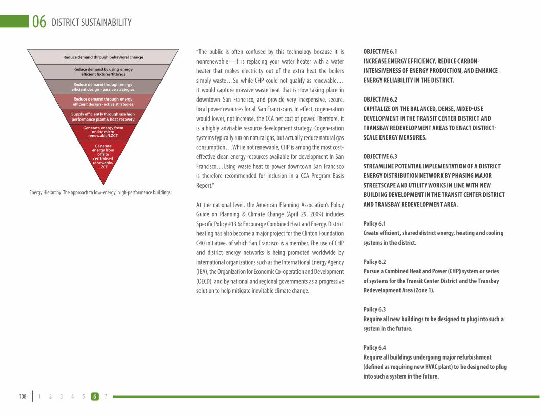
108 1 2 3 4 5 6 7
DISTRICT SUSTAINABILITY06“The public is often confused by this technology because it is nonrenewable—it is replacing your water heater with a water heater that makes electricity out of the extra heat the boilers simply waste…So while CHP could not qualify as renewable… it would capture massive waste heat that is now taking place in downtown San Francisco, and provide very inexpensive, secure, local power resources for all San Franciscans. In effect, cogeneration would lower, not increase, the CCA net cost of power. Therefore, it is a highly advisable resource development strategy. Cogeneration systems typically run on natural gas, but actually reduce natural gas consumption…While not renewable, CHP is among the most cost-effective clean energy resources available for development in San Francisco…Using waste heat to power downtown San Francisco is therefore recommended for inclusion in a CCA Program Basis Report.”
At the national level, the American Planning Association’s Policy Guide on Planning & Climate Change (April 29, 2009) includes Specific Policy #13.6: Encourage Combined Heat and Energy. District heating has also become a major project for the Clinton Foundation C40 initiative, of which San Francisco is a member. The use of CHP and district energy networks is being promoted worldwide by international organizations such as the International Energy Agency (IEA), the Organization for Economic Co-operation and Development (OECD), and by national and regional governments as a progressive solution to help mitigate inevitable climate change.
OBJECTIvE 6.1INCREASE ENERGY EFFICIENCY, REDUCE CARBON-INTENSIvENESS OF ENERGY PRODUCTION, AND ENHANCE ENERGY RELIABILITY IN THE DISTRICT.
OBJECTIvE 6.2CAPITALIZE ON THE BALANCED, DENSE, MIXED-USE DEvELOPMENT IN THE TRANSIT CENTER DISTRICT AND TRANSBAY REDEvELOPMENT AREAS TO ENACT DISTRICT-SCALE ENERGY MEASURES.
OBJECTIvE 6.3STREAMLINE POTENTIAL IMPLEMENTATION OF A DISTRICT ENERGY DISTRIBUTION NETWORK BY PHASING MAJOR STREETSCAPE AND UTILITY WORKS IN LINE WITH NEW BUILDING DEvELOPMENT IN THE TRANSIT CENTER DISTRICT AND TRANSBAY REDEvELOPMENT AREA.
Policy 6.1Create efficient, shared district energy, heating and cooling systems in the district.
Policy 6.2Pursue a Combined Heat and Power (CHP) system or series of systems for the Transit Center District and the Transbay Redevelopment Area (Zone 1).
Policy 6.3Require all new buildings to be designed to plug into such a system in the future.
Policy 6.4Require all buildings undergoing major refurbishment (defined as requiring new HvAC plant) to be designed to plug into such a system in the future.
Energy Hierarchy: The approach to low-energy, high-performance buildings
Reduce demand through behavioral change
Reduce demand by using energy e�cient �xtures/�ttings
Reduce demand through energy e�cient design - passive strategies
Reduce demand through energy e�cient design - active strategies
Supply e�ciently through use high performance plant & heat recovery
Generate energy from onsite micro
renewable/LZCT
Generate energy from
o�site centralised renewable/
LZCT

06
109DRAFT TRANSIT CENTER DISTRICT PLAN
DIST
RICT
SUST
AINA
BILIT
Y06
Policy 6.5Identify and protect either suitable public sites or major development sites within the Plan Area for locating generation facilities.
A technical study is being undertaken by the City to analyze feasibility and technical issues related to CHP in the Plan area, including scaling of future demand, options for locations of new plant facilities, options for distribution and phasing, and identifying both existing sources of waste heat (either from a CHP plant or other uses) and underutilized CHP plants which could be linked into a network. A district energy network could be located within an existing building undergoing refurbishment with plant room capacity, within a new development, or on public sites with space or without a current development program. Potential locations and phasing will be mapped along with proposed new development to identify the optimum locations with the shortest and least disruptive network connections.
Policy 6.6Require all major development to demonstrate that proposed heating and cooling systems have been designed in accordance with the following order of diminishing preference:
Connection to sources of waste heat or underutilized •boiler or CHP plant within the Transit Center District or adjacent areas
Connection to existing district heating, cooling, and/•or power plant or distribution networks with excess capacity
Site-wide CHP powered by renewable energy•
Site-wide CHP powered by natural gas•
Building level communal heating and cooling powered •by renewable energy
Building level communal heating and cooling powered •by natural gas
Policy 6.7Investigate City support for Energy Service Companies to finance, build, operate, and maintain Transit Center District energy networks; and work with PG&E to facilitate connection of new electricity supply from CHP to the grid.
Policy 6.8Require all major development in the Plan Area to produce a detailed Energy Strategy document outlining how the design of the building minimizes its use of fossil fuel driven heating, cooling and power—through energy efficiency, efficient supply, and no or low carbon generation.
In addition to the LEED checklist, each development will be expected to produce a detailed Energy Strategy document outlining how the design of the building minimizes its use of fossil fuel driven heating, cooling and power—through energy efficiency, efficient supply and no or low carbon generation. The City will develop a template strategy document outlining the information required as guidance for developers. This is to enable the City to understand the integrated design of the building related to energy and how policies 6.1–6.6 inclusive are being addressed, particularly those relating to district energy, information that is not provided within standard LEED documentation requirements. Title 24 compliance should be demonstrated.
One Market Plaza has a 1.5 MW CHP system

110 1 2 3 4 5 6 7
DISTRICT SUSTAINABILITY06
6 San Francisco Public Utilities Commission, 2005 Urban Water Management Plan for the City and County of San Francisco
7 Waste Prevention, Recycling, and Composting: Lessons from 30 U.S. Communities
8 California Integrated Waste Management Board, 2004 Statewide Waste Characterization Study
9 Leadership in Energy and Environmental Design - the US Green Building Council environmental assessment method.
carbon, and more sustainable way. Rather than require competing requirements to the City goals, this Plan builds on the existing Green Building Ordinance and expects Plan area buildings to exceed these standards wherever possible. Any updates to this ordinance published after this Plan must be complied with.
OBJECTIvE 6.4ALL NEW BUILDINGS DEvELOPED IN THE PLAN AREA WILL BE OF LEADING EDGE DESIGN IN TERMS OF SUSTAINABILITY, BOTH HIGH PERFORMANCE FOR THEIR INHABITANTS AND LOW IMPACT FOR THE ENvIRONMENT.
Policy 6.9Take maximum advantage of San Francisco’s moderate year-round climate by integrating passive solar features into building design.
Buildings will be designed in context with the local climate through appropriate orientation, fenestration area, façade design, and solar shading. Different façade treatments, including external shading devices, louvers, and/or window treatments, will be expected in order to deal with different solar aspects to minimize cooling requirements in summer months. These treatments will also provide desirable elevation and composition variety.
Table 6-2: Summary of Green Building Ordinance Requirements relating to LEED certification
2008 2009 2010 2011 2012
New Large Commercial LEED Certified LEED Silver LEED Silver LEED Silver LEED Gold
New High-Rise Residential LEED Certified LEED Certified LEED Silver LEED Silver LEED Silver
Large CTIs & Major Alterations LEED Certified LEED Silver LEED Silver LEED Silver LEED GoldNOTE: Additional minimal requirements relating to certain LEED credits relating to energy, water, waste and materials use are also required across all building types. See website (http://www.sfenvironment.org/downloads/library/sf_green_building_ordinance_2008.pdf ) for more details.
Policy 6.10Reduce the need for mechanical air conditioning through the use of natural ventilation.
Air conditioning should only be installed where natural modes of ventilation are not effective despite appropriate design. Use of operable windows, cross-ventilation, the stack effect, and displacement ventilation should all be considered in preference to comfort cooling.
Policy 6.11Use on-site renewable energy systems to reduce the use of fossil fuel generated energy.
While providing renewably generated power can be challenging in highly dense urban areas, and particularly for high-rise buildings, an assessment of the feasibility of integrating renewable energy
BUILDING PERFORMANCE
In addition to buildings making a significant contribution to climate change through energy use, they also have significant impact in terms of water (buildings consume 76 percent of potable water in the City of San Francisco6), materials, displacing habitat, and waste production. In San Francisco, building development generates approximately 27,000 tons7 of construction and demolition debris annually (1990 estimate). Statewide, California landfills are heavily impacted by over 4 million tons of construction and demolition debris each year, which comprises nearly 22 percent8 of all waste generated in California.
San Francisco is already a leader in reducing these impacts as a result of a range of leading-edge green building incentives and programs. This is demonstrated by the number of local LEED9 certified buildings, many of them concentrated downtown to the north of the Transit Center District area.
The City adopted a Green Building Ordinance in May 2008 (Ord. No. 180-08) through a revision to Building Code 2007 Edition in Chapter 13C Green Building Requirements. The green building practices required by this chapter will further the goal of reducing the greenhouse gas emissions in the City and County of San Francisco to 20 percent below 1990 levels by the year 2012, as stated in Board of Supervisors Resolution No. 158-02 and the City’s 2004 Climate Action Plan. The Ordinance lays out a map to 2012 of increasing requirements related to the LEED scheme for commercial buildings and high rise residential (see Table 6-2).
The Transit Center District will become a center for highly sustainable buildings (LEED or equivalent high performance environmental assessment scheme). The design of the buildings should be such that it is made easy for their occupants to live and/or work in a low
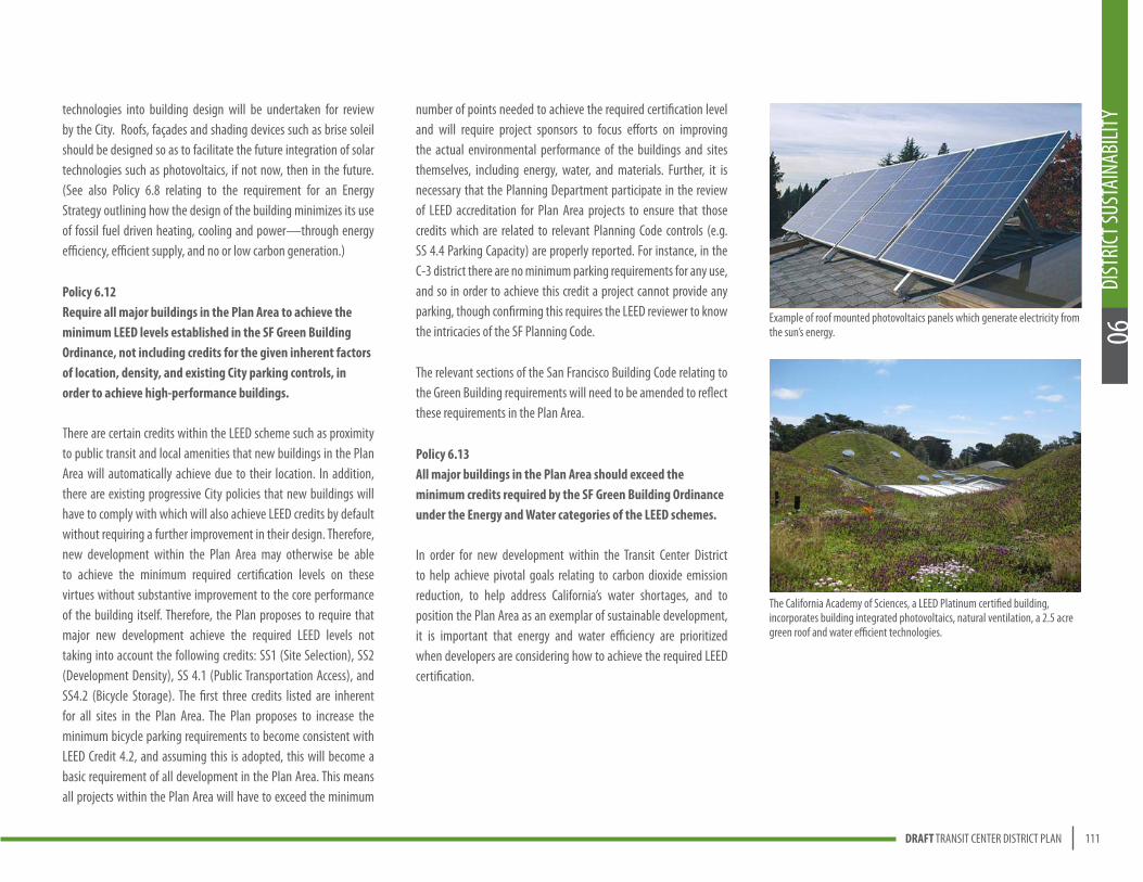
06
111DRAFT TRANSIT CENTER DISTRICT PLAN
DIST
RICT
SUST
AINA
BILIT
Y06
technologies into building design will be undertaken for review by the City. Roofs, façades and shading devices such as brise soleil should be designed so as to facilitate the future integration of solar technologies such as photovoltaics, if not now, then in the future. (See also Policy 6.8 relating to the requirement for an Energy Strategy outlining how the design of the building minimizes its use of fossil fuel driven heating, cooling and power—through energy efficiency, efficient supply, and no or low carbon generation.)
Policy 6.12Require all major buildings in the Plan Area to achieve the minimum LEED levels established in the SF Green Building Ordinance, not including credits for the given inherent factors of location, density, and existing City parking controls, in order to achieve high-performance buildings.
There are certain credits within the LEED scheme such as proximity to public transit and local amenities that new buildings in the Plan Area will automatically achieve due to their location. In addition, there are existing progressive City policies that new buildings will have to comply with which will also achieve LEED credits by default without requiring a further improvement in their design. Therefore, new development within the Plan Area may otherwise be able to achieve the minimum required certification levels on these virtues without substantive improvement to the core performance of the building itself. Therefore, the Plan proposes to require that major new development achieve the required LEED levels not taking into account the following credits: SS1 (Site Selection), SS2 (Development Density), SS 4.1 (Public Transportation Access), and SS4.2 (Bicycle Storage). The first three credits listed are inherent for all sites in the Plan Area. The Plan proposes to increase the minimum bicycle parking requirements to become consistent with LEED Credit 4.2, and assuming this is adopted, this will become a basic requirement of all development in the Plan Area. This means all projects within the Plan Area will have to exceed the minimum
number of points needed to achieve the required certification level and will require project sponsors to focus efforts on improving the actual environmental performance of the buildings and sites themselves, including energy, water, and materials. Further, it is necessary that the Planning Department participate in the review of LEED accreditation for Plan Area projects to ensure that those credits which are related to relevant Planning Code controls (e.g. SS 4.4 Parking Capacity) are properly reported. For instance, in the C-3 district there are no minimum parking requirements for any use, and so in order to achieve this credit a project cannot provide any parking, though confirming this requires the LEED reviewer to know the intricacies of the SF Planning Code.
The relevant sections of the San Francisco Building Code relating to the Green Building requirements will need to be amended to reflect these requirements in the Plan Area.
Policy 6.13All major buildings in the Plan Area should exceed the minimum credits required by the SF Green Building Ordinance under the Energy and Water categories of the LEED schemes.
In order for new development within the Transit Center District to help achieve pivotal goals relating to carbon dioxide emission reduction, to help address California’s water shortages, and to position the Plan Area as an exemplar of sustainable development, it is important that energy and water efficiency are prioritized when developers are considering how to achieve the required LEED certification.
The California Academy of Sciences, a LEED Platinum certified building, incorporates building integrated photovoltaics, natural ventilation, a 2.5 acre green roof and water efficient technologies.
Example of roof mounted photovoltaics panels which generate electricity from the sun’s energy.

S a n F r a n c i s c o S t o r m w a t e r D e s i g n G u i d e l i n e s
S a n F r a n c i s c o C o n t e x t 2 5
DR
AF
T
San Francisco’s Stormwater InfrastructureWhile the creation of these Guidelines is driven by regulatory requirements for the City’s separate sewer areas, the majority of San Francisco (90%) is served by a combined sewer system (see Figure 6). �e stormwater management goals for areas served by separate storm sewers are different from those for areas served by the combined sewer system. Despite this, many of the fundamental design concepts for stormwater management apply to both areas, and as such, the Guidelines can be used as a tool in both the separate and combined sewer areas of San Francisco. Using landscape-based stormwater infrastructure will enhance and diversify the functions of both the separate and combined systems.
Approximately 10% of the City is served by a separate storm sewer system or is lacking stormwater infrastructure; in most of these areas stormwater flows directly to receiving waters without treatment. In the separate storm sewer areas, the primary reason for implementing post-construction controls is to improve stormwater quality before it reaches a receiving water body. �ese controls are aimed at removing specific pollutants of concern and treating what is known as the “first flush”. �e first flush is the dirtiest runoff, usually generated during the beginning of a rain event; it mobilizes the majority of the pollutants and debris that have accumulated on impervious surfaces since the last rain.
�e combined sewer system conveys wastewater and stormwater in the same set of pipes. �e combined flows receive treatment at wastewater treatment plants before being discharged to the Bay and Ocean. Conventional separate storm sewer systems provide no stormwater treatment, while combined sewer systems treat most urban runoff to secondary standards, including the first flush and most additional stormwater runoff. However, when the capacity of the system is exceeded by large storm events, localized flooding and combined sewer discharges (CSDs) can occur. In the event of a CSD, the system discharges a mixture of partially treated sanitary and stormwater effluent to receiving water bodies. While these discharges are dilute (typically consisting of roughly six percent sewage and 94 percent stormwater), they can cause public health concerns and lead to beach or Bay access closures.
�e primary reason for implementing LID measures in the combined sewer system is to reduce and delay the volumes and peak flows of stormwater reaching the sewer system. Volume reductions and peak flow desynchronization can help reduce the number of CSDs, reduce flooding, and protect water quality. Post-construction controls in the combined system can also improve the capacity and efficiency of the City’s treatment facilities.
Figure 6. Combined sewer systems (top) serve 90% of San Francisco. Separate sewer systems (bottom) serve 10%. Image: modified from King County Wastewater Management Division
Using landscape based stormwater infrastructure will enhance and diversify the function of a combined sewer systems. (Source: San Francisco Stormwater Design Guidelines)
112 1 2 3 4 5 6 7
DISTRICT SUSTAINABILITY06
DISTRICT WATER
WATER SUPPLY
The city’s water is supplied by the SFPUC’s Regional Water System. The Hetch Hetchy Reservoir in Yosemite National Park delivers pristine Sierra snowmelt to provide 85 percent of San Francisco’s water, and local protected Alameda and Peninsula sources provide the remaining 15 percent. Currently, this high-quality potable water is used for almost all purposes, including those that do not require potable water, such as irrigation, toilet flushing, and industrial uses. There are many critical and ever-increasing reasons for the City to reduce the overall amount of potable water we use and increase the efficiency with which we use potable water in order to ensure continued reliable and adequate water for necessary potable uses. These reasons include frequent droughts, climate change, projected local and regional growth, impacts to fish and other wildlife, and environmental concerns for the health of the ecosystems from which the water is drawn. Developing a local supply of non-potable water for non-potable uses will help ensure that our water supply portfolio is managed to provide a reliable, high quality supply for public drinking water and ensure the state’s environment is not compromised.
WATER QUALITY
Most of San Francisco (including the Transit Center District) is served by a combined storm sewer system, where stormwater, along with residential and commercial sewage, is directed to treatment plants prior to being released to the San Francisco Bay or the Pacific Ocean. During major wet weather events, stormwater runoff can overwhelm treatments plants that treat the combined sewers, leading to untreated or partially treated discharges into the Bay and Ocean. A few areas in San Francisco are served by a separate storm sewer, where stormwater that goes into street storm drains flows directly
to receiving water bodies, such as the Bay, Ocean or local lakes. All of these polluted stormwater flows can be substantially detrimental to aquatic and other life (which directly impacts the ability of local people to consume local fish, crustaceans, and so forth), as well as detrimental to human recreation like swimming, surfing, fishing, and boating. Even in less intensive wet weather events, substantial energy and effort is expended to treat stormwater. In addition to pollution and health problems, high amounts of runoff into the sewer systems can overwhelm them and lead to localized flooding. In urbanized areas, like the Transit Center District Plan Area, a high percentage of impervious surfaces (e.g. roofs, streets) leads to very high volumes and velocities of stormwater rushing into the sewer system during wet weather, contributing substantially to these problems. These problems can be addressed by both reducing the amount of water discharged into the combined sewer system (such as by greywater re-use) and by slowing or storing stormwater when it hits the ground or structures.
RECYCLED WATER
Municipal recycled or other non-potable water use is a major avenue of future water efficiency and promises substantial reduction in potable water use. Non-potable water can be used for toilet flushing, building boilers/chillers, irrigation, and other uses. The Plan area is within the City’s Recycled Water “Ordinance Area.” The Recycled Water Ordinance, adopted in 2001, requires all buildings in the Ordinance Area to be dual-plumbed (with “purple pipes”) to use recycled water once hookup is available to a recycled water distribution system. Buildings built in this area since 2001 have been dual-plumbed to use recycled water.
Currently there are no treatment facilities planned or funded to create a recycled water supply close to the Transit Center District. At the time the RWMP was completed, the magnitude and timing of major development within the District was not adequately
Eighty-five percent of the Bay Area’s water comes from Sierra Nevada snowmelt stored in the Hetch Hetchy reservoir situated on the Tuolumne River in Yosemite National Park.

Plan Area
San Francisco’s Recycled Water Ordinance Areas
06
113DRAFT TRANSIT CENTER DISTRICT PLAN
DIST
RICT
SUST
AINA
BILIT
Y06
evaluated. Potential treatment facilities identified in the RWMP to service the east side of the city are the existing North Point and South East Wastewater treatment plants, which would have to be augmented. Both of these facilities are substantial distance from the concentrations of major development in the South of Market areas.
The dozens of major new commercial and residential buildings that are approved or proposed in this area, representing over 6 million square feet of new office space and over 5,000 new housing units provide a great opportunity to advance the objectives and infrastructure of the RWMP in a shorter time frame in this core part of the Ordinance area.
STORM AND RAINWATER HARvESTING
Harvesting of stormwater runoff and rainwater during the rainy season for use during the dry season is a time-honored tradition in arid and Mediterranean climates around the world, and is a logical way to remove large volumes of water from combined sewers. Because it does not contain sewage, if properly captured, this stormwater can receive moderate treatment and be reused for irrigation and other non-potable purposes such as toilet flushing and irrigation.
In stormwater or rainwater harvesting, runoff water is collected from impervious surfaces (typically from roofs or patios) and is collected into tanks and pipes for use in non-potable purposes. The cleaner the collecting surface, the cleaner the water. Any runoff that is diverted before reaching the combined sewer will reduce the amount of power and chemicals needed to pump and treat stormwater. San Francisco agencies have agreed to allow the collection and use of rainwater for irrigation and toilet flushing without any specialized treatment beyond first flush diversion. First flush diversion is the act of diverting the runoff generated by the first rain in a rain event. This
ensures that the dirtiest water is removed from the collection device, allowing the cleaner water to be captured.
Although stormwater is not a reliable supply source year-round, it is a resource that should be used to the maximum extent possible when it is available to augment other non-potable water options that are more consistently available, such as groundwater and recycled wastewater. Rainfall and stormwater harvesting and reuse will have a two-fold impact on the system by providing a local source of water and reduce the demands on the combined sewer system. Reuse applications such as irrigation, toilet flushing, heating and cooling and can reduce the volumes of runoff entering the system. This reduces the volumes and potentially the frequency of combined sewer overflows as well as the energy and chemicals used in the pumping and treating the stormwater.
DEWATERING SYSTEM DIvERSIONS
Another source of non-potable water includes dewatering systems. Throughout the downtown core, there are buildings and infrastructure (such as transit stations) where groundwater must be pumped from buildings and facilities year-round directly into the sewer where they contribute to pumping costs, the use of chemicals for treatment, and combined sewer overflows. The City
could require that all new buildings that dewater must develop re-use opportunities for this water for non-potable purposes, and could explore such re-use opportunities for existing buildings that are dewatering as well.
One example is the Powell Bart station where preliminary studies indicate that the dewatering system discharges approximately 130,000 to 170,000 gallons of groundwater to the sewer per day. Harvesting this water could result in approximately 44 million gallons of water annually. In this particular instance, the pollutant loads are low enough for use for irrigation. This is one example of numerous buildings within the areas of high groundwater that could serve as another source of non-potable water for the city.

9urban watershed planning charrette | summary report
water planning specialists whose insights yielded many ideas for improving management of
the drainage basins.
The second Urban Watershed Planning Charrette was held on September 27, 2007 at the
Port of San Francisco’s Pier I offi ces. Approximately 70 members of San Francisco’s greater
community with interest in stormwater management, which consisted of activists, engineers,
landscape architects, ecologists and urban designers, gathered to “play” the watershed
planning game. Participants were provided baisc information about LID and used maps of
San Francisco’s four eastern watershed basins: Channel Basin, Islais Creek Basin, Yosemite
Basin, and Sunnydale Basin to make recommendations for stormwater management projects
that reduce and detain peak fl ows and volumes of stormwater using of LID measures. Each
team was careful to work within both a capital cost budget and towards specifi ed stormwater
management goals. The groups tallied the stormwater benefi ts and costs of their proposals,
voted on their favorite ideas, and presented their recommendations to the larger group.
Volunteers were on hand to record all of the ideas that came out of each group.
This summary document contains a composite of ideas common between groups or that
were particularly unique and compelling. These proposals will undergo a more detailed
analysis to determine their impacts on the stormwater management system and their
feasibility in terms of costs, pipe alignment and opportunity to overlap with various planning
efforts already underway throughout the City. SFPUC staff will use the results of the analysis
to identify and prioritize future stormwater management efforts in San Francisco.
n a t u r a l w a t e r c o u r s e s y s t e m
e x i s t i n g u r b a n s c e n a r i o9urban watershed planning charrette | summary report
water planning specialists whose insights yielded many ideas for improving management of
the drainage basins.
The second Urban Watershed Planning Charrette was held on September 27, 2007 at the
Port of San Francisco’s Pier I offi ces. Approximately 70 members of San Francisco’s greater
community with interest in stormwater management, which consisted of activists, engineers,
landscape architects, ecologists and urban designers, gathered to “play” the watershed
planning game. Participants were provided baisc information about LID and used maps of
San Francisco’s four eastern watershed basins: Channel Basin, Islais Creek Basin, Yosemite
Basin, and Sunnydale Basin to make recommendations for stormwater management projects
that reduce and detain peak fl ows and volumes of stormwater using of LID measures. Each
team was careful to work within both a capital cost budget and towards specifi ed stormwater
management goals. The groups tallied the stormwater benefi ts and costs of their proposals,
voted on their favorite ideas, and presented their recommendations to the larger group.
Volunteers were on hand to record all of the ideas that came out of each group.
This summary document contains a composite of ideas common between groups or that
were particularly unique and compelling. These proposals will undergo a more detailed
analysis to determine their impacts on the stormwater management system and their
feasibility in terms of costs, pipe alignment and opportunity to overlap with various planning
efforts already underway throughout the City. SFPUC staff will use the results of the analysis
to identify and prioritize future stormwater management efforts in San Francisco.
n a t u r a l w a t e r c o u r s e s y s t e m
e x i s t i n g u r b a n s c e n a r i o
11urban watershed planning charrette | summary report
San Francisco’s Urban Watershed
Before San Francisco developed into the thriving, densely developed city it
is today, it consisted of a diverse range of habitats including oak woodlands,
native grasslands, riparian areas, wetlands, and sand dunes. Streams and lakes
conveyed and captured rainwater. Wetlands lined parts of the Bay, functioning
as natural fi ltration systems as well as buffers from major storms. Rainwater
infi ltrated into the soil, replenishing groundwater supplies and contributing to
stream base fl ow.
Today, impervious surfaces such as buildings, streets, and parking lots have
covered most of the City, preventing rainfall infi ltration. Over time, creeks have
been buried and diverted to the sewers and wetlands have been fi lled. Instead
of percolating into soils, runoff now travels over impervious surfaces, mobilizes
pollutants like oil and debris, and washes them into the sewer system or into the
bay, ocean, and local lakes and remnant segments of creeks. During heavy rain
events, stormwater runoff can contribute to localized fl ooding, combined sewer
discharges, and the degradation of surface water quality. Moreover, the lack of
opportunity for infi ltration caused by urbanization contributes to groundwater
depletion. Many of these adverse effectes can be mitigated by using an
innovative planning and design process called Low Impact Design (LID).u r b a n l o w i m p a c t d e s i g n o p p o r t u n i t i e s
Introduction
114 1 2 3 4 5 6 7
DISTRICT SUSTAINABILITY06
TRANSIT CENTER DISTRICT OPPORTUNITY
The total project water usage for new development in the Transit Center District, based on the proposed land use program is 1.3 million gallons per day (mgd).
The three major usages of non-potable water in the District include irrigation (0.023 mgd), toilet flushing (0.265 mgd), and building boilers/chillers (0.216 mgd), so using non-potable sources could save an annual average of up to 503,700 gallons per day in the Transit Center District Plan area (only considering new buildings). This represents an overall water savings of up to 40 percent of overall water demand for the Transit Center District. Including immediately adjacent areas that will see significant new development (Transbay Redevelopment Area Zone 1 and Rincon Hill), there is the potential to save 1.17 million gallons per day using non-potable sources.
OBJECTIvE 6.5REDUCE THE AMOUNT OF POTABLE WATER USED IN NEW DEvELOPMENT IN THE DISTRICT.
OBJECTIvE 6.6REDUCE STORMWATER RUNOFF FROM THE DISTRICT INTO THE SEWER SYSTEM TO IMPROvE BAY WATER QUALITY AND REDUCE STRAIN ON TREATMENT PLANTS DURING WET WEATHER EvENTS.
OBJECTIvE 6.7TAKE ADvANTAGE OF SIGNIFICANT CONCENTRATED DEvELOPMENT AND INFRASTRUCTURE RECONSTRUCTION IN THE DISTRICT AND ADJACENT AREAS TO CREATE DISTRICT-SCALE WATER EFFICIENCY AND REUSE MEASURES.
Policy 6.14Create a reliable supply of non-potable water that can be used throughout the plan area to reduce potable water demand.
Policy 6.15Pursue a variety of potential sources of non-potable water, including municipally-supplied recycled water and district-based greywater, stormwater, and building de-watering.
Policy 6.16Create infrastructure in the Transit Center District and immediately adjacent areas for non-potable water use, including treatment and distribution.
Policy 6.17Include distribution pipes and other necessary infrastructure for non-potable water when undertaking any major streetscape or other infrastructure work in the right-of-ways in the Transit Center District and immediately vicinity.
Policy 6.18Identify and protect suitable sites within the Plan Area or immediate vicinity for locating a treatment facility for creating a local non-potable supply.
The two options for creating a treatment and supply facility for the Transit Center District and adjacent areas are to
Add a recycled water capacity at the existing North Point or •Southeast Wastewater plants, per the suggestion of the RWMP, to serve the entire eastside Ordinance Area; or
Low impact design seeks to reduce runoff and restore hydrologic function through effective site planning, increased permeability and landscape based BMPs.

Permeable paving is an option for dealing with stormwater runoff.
06
115DRAFT TRANSIT CENTER DISTRICT PLAN
DIST
RICT
SUST
AINA
BILIT
Y06
Reduce demands by installing efficient water fixtures •and behaviors;
Design sites to reduce the total amounts of stormwater •generated on site; through the use of alternative surfaces and collection and treatment devices;
Identify all on-site sources (rainwater, cooling tower •blow down, fog, greywater, stormwater, and diverted sump water);
Install appropriate on-site collection, treatment, storage •and conveyance systems for non-potable needs;
Meet all other unmet non-potable demands using •district non-potable water or municipal recycled water; and
Meet all other unmet demands using potable water.•
Policy 6.20Ensure projects use Low Impact Design (L.I.D.) techniques in all streetscape, public space, and development projects to reduce the quantity of stormwater runoff and slow its flow into the sewer system, and to harvest this water for on-site uses.
By using the Stormwater Design Guidelines to implement low impact design, the designers and planners can address the local geologic and topographic conditions as appropriate. Design techniques include incorporating green roofs and green walls on buildings, rainwater storage facilities, and landscaping or rain gardens in public spaces. Projects must provide a narrative outlining how stormwater is being addressed through LID techniques. This narrative will not be required if the appropriate stormwater related LEED credits are sought for the project.
Create a local district-serving supply facility in the Transit •Center District. A local district-serving treatment facility could be created by diverting some amount of flow in the combined sewer system in the Transit Center District into a local plant, or by acquiring area-generated excess stormwater, greywater, and site de-watering that cannot be used on-site by individual buildings before they enter the municipal wastewater system.
Such a local facility could be located below ground or above ground. Potential sites should be identified in the area, and could include underneath the future Transbay Square park in Zone 1 of the Redevelopment Area (block bounded by Howard, Main, Folsom, and Beale), above ground underneath the bus or freeway ramps, on Parcel M, or integrated into one of the major development sites.
Because such extensive streetscape and infrastructure work will be done in coordination with the Transit Center, Downtown Extension (DTX), and development projects in the Transit Center District and Transbay Redevelopment Area, the opportunity to create the necessary non-potable water distribution system at marginal additional cost cannot be missed. The cost of implementing a district-serving non-potable water distribution system later on would be substantially more. Even if a local recycled water treatment facility is not created in the immediate area and the PUC proceeds at a later date with adding this function to the North Point, Southeast or other plant, it is essential to advance this RWMP overall program by coordinating with any and all major streetscape and infrastructure work to create the necessary future distribution system.
Policy 6.19All new and large redevelopment projects in the city should adhere to the following hierarchical approach to maximize resources and minimize use of potable water:
Bioretention planter at Mint Plaza, an example of a water sensitive urban design technique that reduces stormwater runoff, provides habitat, and improves the public realm.
Recycled water pipes are identified by their purple color.

116 1 2 3 4 5 6 7
DISTRICT SUSTAINABILITY06Table 6-1: Sustainable Benefits Matrix
REGIONAL BENEFITS LOCAL ENVIRONMENTAL BENEFITS LOCAL SOCIAL BENEFITS
POLICY NOs. THEME
REGIONAL SMART
GROWTHREDUCE WATER
USAGE
IMPROVE WATER
QUALITYIMPROVE AIR
QUALITY
REDUCE GHG EMISSIONS &
ENERGY USAGEINCREASE HABITAT
REDUCE URBAN HEAT ISLAND
EFFECTIMPROVE
PUBLIC REALM
IMPROVE PUBLIC HEALTH
01 Land Use
1.1, 1.2, 1.3 Maintain & reinforce the role of downtown as a high density employment center
1.4 Require minimum densities on major development sites
1.6 Healthy mix of uses, including “active retail”
02 Urban Form
2.1, 2.3 Allow limited number of tall buildings around Transbay tower
2.9 Maintain separation between tall buildings to permit light & air to reach the streets
2.16, 2.19, 2.21, 2.22, 2.24
Urban design to ensure an active pedestrian oriented street life
2.26 Use of reflective hardscape materials to reduce heat island effect
2.27 Encourage use of living walls to reduce solar heat gain
03 Public Realm
3.1, 3.2 Create plan for streetscape improvements, e.g. to allow for Water Sensitive Urban Design measures, bicycle racks, etc.
3.2, 3.3, 3.5–3.14 Make walking safe, pleasant & convenient
3.4 Continue living streets to create linear open space
3.15 Enhance the open space network through creating a new public plaza
04 Moving About
4.1–4.8 Improve transit efficiency and capacity; provide high quality facilities for transit passengers
4.9–4.20 Transportation demand management strategies including parking, incentives & monitoring

06
117DRAFT TRANSIT CENTER DISTRICT PLAN
DIST
RICT
SUST
AINA
BILIT
Y06
Table 6-1: Sustainable Benefits Matrix
REGIONAL BENEFITS LOCAL ENVIRONMENTAL BENEFITS LOCAL SOCIAL BENEFITS
POLICY NOs. THEME
REGIONAL SMART
GROWTHREDUCE WATER
USAGE
IMPROVE WATER
QUALITYIMPROVE AIR
QUALITY
REDUCE GHG EMISSIONS &
ENERGY USAGEINCREASE HABITAT
REDUCE URBAN HEAT ISLAND
EFFECTIMPROVE
PUBLIC REALM
IMPROVE PUBLIC HEALTH
4.36, 4.37 Augment bicycle movement and facilities
4.39, 4.40, 4.41
Bicycle storage facility requirements for residential and commercial buildings, and on-street parking
4.42 Support & implement a public bicycle share program
4.50, 4.51, 4.52, 4.54
Encourage non-auto travel by controlling quantity and pricing of parking
4.55 Ensure parking lots provide landscaping & other amenities
4.70, 4.71 New buildings parking spaces & on-street parking spaces for car sharing vehicles
4.72, 4.73 Provide & enhance facilities for casual carpool
05 Historic Preservation
5.1 - 5.10 Preserving & renovating existing buildings conserves embodied energy in materials
06 District Sustainability
6.1–6.7 Increase energy efficiency through use of CHP and district energy systems
6.8 Require a detailed energy strategy for all major developers
6.9, 6.10 Require high performance buildings
6.11 Encourage use of low carbon & renewable energy sources
6.12, 6.13 Meet or exceed citywide LEED building requirements
6.14–6.18 Create district supply of non-potable water: greywater, stormwater & building dewatering
6.19 Decrease potable water use through conservation, efficient fixtures, recycle & reuse
6.20 Use Low Impact Development techniques in streetscape, public space & development projects
Source: Urbemis, 2007 v 9.2.4; AECOM, 2009.
Additional investments in parks, streets, and community facilities and services ... is essential to meeting the needs attributable to the new development.
“
”

DRAFT TRANSIT CENTER DISTRICT PLAN 119
FUNDING pUblIc ImpRovemeNTs07 A key goal of this Plan is to create a very high-density, mixed-use urban neighborhood that capitalizes on and supports the major transportation investment and service represented by the Transbay Transit Center. Once the Plan, which proposes to allow significant density and height above the current zoning, is realized, new residents, workers, and visitors drawn to the area will create significant new demand for infrastructure and services which the area’s dated infrastructure and services cannot meet. While new development will generate a variety
of local public revenues (property taxes, sales taxes, real estate transfer taxes, etc.), additional investments in parks, streets, transportation facilities, and community facilities and services—beyond what can be provided through these local General Fund revenue sources—are essential to meet demand attributable to the new development. To address the impacts of the new development, the Plan includes mechanisms for development to contribute to the funding of public infrastructure.
120 1 2 3 4 5 6 7
FUNDING PUBLIC IMPROVEMENTS07
Plan Public infrastructure Program
To achieve the Plan’s objectives and create the district envisioned, a broad range of public improvements and related programs are needed, as described in the prior chapters. New residents, workers, and visitors drawn to new development in the Plan Area will increase demands on the existing transportation and transit network, open space and public facilities in the Plan Area and create demand for new infrastructure. In summary, four broad categories of public improvements are needed:
Streets and Pedestrian Circulation • – including district-wide streetscape and pedestrian improvements, extensive widening of sidewalks, mid-block street crossings, signalization improvements, casual carpool waiting area improvements, landscaping and enhanced pedestrian routes from the Transit Center to nearby destinations and transit services.
Transit and Other Transportation • – including improvements to enhance transit operational effectiveness, capacity, enhance safety, reduce congestion, manage transportation demand, and provide better connections to local and regional transit systems.
Open Space • – including new parks, public plazas, recreational amenities, and green infrastructure throughout the Plan Area.
Sustainable Resource District Utility • – district-wide systems for non-potable water and for combined heating and power that will serve development in the Plan Area and reduce environmental and infrastructure pressures of growth.
Table 7-1 provides a detailed list of these improvements and programs identified throughout this Plan as well as their preliminary cost estimates. The items listed in this table are in addition to infrastructure and services that existing impact fee programs would
provide, including Muni, affordable housing, and childcare. (The projected revenues for those existing fee programs are listed at the end of the chapter in Table 7-13). In addition, funds will be needed to support the long-term maintenance and operation of these facilities. Because these costs are difficult to determine without a fully-scoped out improvement program or services description, estimates of these costs are not included.
The Transit Center District Plan includes many necessary improvements to public infrastructure, services, and programs to support additional development. The focal point of the Plan area is realizing the improved multi-modal Transbay Transit Center. The existing Transbay Terminal is a blighted and outdated facility. Because alleviating blight and creating new transit facilities adds substantial value to nearby real estate and facilitates higher density development than may otherwise be achievable, the Plan incorporates zoning changes that increase overall densities in the Plan Area. This higher density development can generate various sources of revenue that can then be used to offset the costs of the public improvements that have enabled the increased densities and values. However, it is important to balance the need for development-based revenues for public improvements with the economics of private development to enable the desired development to be financially feasible.
The policies and discussion below seek to establish parameters for private development’s contributions to the costs of the public improvements, given financial feasibility.
objective 7.1ensure that Private develoPment contributes financially to building essential Public imProvements in ProPortion to the imPact that such new develoPment generates in the district.
objective 7.2generate Private develoPment funding to helP comPlete the transbay transit center Project and to establish a sustainable resource Program within the district.
objective 7.3balance the cost to be Paid by Private Projects for Public imProvements in the district with the economic feasibility of these develoPments.
Policy 7.1require new development to participate in applicable components of the funding Program as a condition of approval.
Policy 7.2require that new development continue to be subject to existing impact fee programs and inclusionary housing requirements.
Policy 7.3create a community facilities district to fund capital improvements, particularly the transit center, as well as operations and maintenance of new public spaces and facilities.

FUND
ING
PUBL
IC IM
PROV
EMEN
TS07
table 7-1: transit center district Plan Public improvements and implementation costsCategory Project Sub-project Description Est. Total Cost (2010)
streets and Pedestrian circulation
District-wide Streetscape and Pedestrian Improvements Includes sidewalk widening, transit shelters, landscaping, pedestrian amenities (e.g. benches), security bollards, kiosks, bicycle parking, road re-striping
Primary Streets (e.g. Mission, Howard, New Montgomery, 2nd, 1st, Fremont), plus striping, signage and meter upgrades
Approx. $2 million per block 90,000,000
Living Strees (Spear, Main, Beale) Approx. $2.5 million per block 15,000,000Alleys (e.g. Stevenson, Jessie, Minna, Natoma, Tehama, Anthony, ). Excludes Natoma between 1st and 2nd
Approx. $1.5 million per block 21,000,000
Mid-Block Crossings Crossings between 1st and 2nd Streets on Mission, Howard, Folsom; at Natoma on 2nd, 1st, and Fremont Streets.
6 @ Approx. $500K each 3,000,000
Signalization changes 25 intersections @ $350K per intersection 8,750,000Casual Carpool waiting area improvements Shelters, signage, seating 250,000Natoma (between 1st and 2nd) Single grade, high-quality finishes and landscaping 13,300,000Shaw plaza Ped plaza, vehicular closure. Decorative paving, landscaping, signage, curb
ramps, lighting, drainage1,700,000
Underground Pedestrian Connector from the Transit Center to Market Street BART/Muni 125,000,000Subtotal 278,000,000
transit and other transportationStation Capacity Improvements to Montgomery and Embarcadero BART Stations
Platform doors and screens; improved train arrival information for concourse level; others TBD; Approx. $5 million per station
10,000,000
Transit Center ProjectBus-related 1,010,000,000Rail-related Includes Downtown Extension and train components of Transit Center building 3,175,000,000
Update to TMA Guidelines and Procedures Full review and overhaul of Transportation Management Association guidelines and procedures, including inclusion of bicycle, car sharing, and other aspects.
250,000
Additional Studies and Trials of Traffic and Circulation Changes in Plan Including parking cap study, Metric Goal updates/Congesion analysis, Mission Street analysis, other ciruclation studies
2,500,000
Congestion Charging Studies and Pilot Implementation 1,000,000Subtotal 4,198,750,000Subtotal (excluding the Transit Center Project) 13,750,000open space
District-wide Open Space and Parks
City Park (Transit Center rooftop park) 50,000,000Transit Center Park connections (x4) Approx. $4.6 million per connection (e.g. elevator, stairs, escalators, ramps) 18,500,0002nd/Howard public space and park connection 24,000 gsf. High-quality hardscape and landscaping; small retail structure, public amenities 15,000,000Transbay Park 10,000,000
Improvements to Portsmouth, St Mary’s Squares 10,000,000Improvements to Mission Square 5,000,000Groundplane improvements Underneath Bus Ramps 8,000,000
Subtotal 116,500,000sustainable resource district utilities
District Combined Heat & PowerPlant 50,000,000Distribution 25,000,000
District Non-Potable Water SystemTreatment 63,000,000Distribution 16,000,000
Upgrades to service Transit Center 5,000,000Subtotal 159,000,000 total $4,752,250,000 total (excluding transit center Project) $567,250,000

122 1 2 3 4 5 6 7
FUNDING PUBLIC IMPROVEMENTS07
The current financial downturn is significant. The Plan, however, is a long-term plan, with a horizon of 25 years to anticipate buildout of the Plan Area. On average the total buildout represented by the Plan is modest and well supported over this time frame, taking into account historic up and down economic cycles. The Plan recognizes that almost no one is seeking to begin construction of buildings in the current economy – not at the tallest heights the Plan contemplates of 700 to 1,000 feet, but also not at lower scales of 500 feet or even at 100 feet. Significant development will not happen until the credit markets return to a more functional state and until employment rebounds and rents rise. However the long-range projections are unchanged – the City and the Bay Area will grow and the economy will turn around. The ABAG projections of substantial growth in housing and jobs for the region and for the City over the next 25 years and beyond remain little changed in light of the current economic condition. As concern grows and action is taken regarding climate change particularly, and continued actions are taken regarding farmland and open space preservation as well as air and water quality, there will be an even greater need for densification and buildings of this scale will become ever more attractive because of the land, infrastructure, and transportation efficiencies that they represent.
policy 7.4encourage the inclusion of a deed covenant in contractual development agreements for new development requiring the project sponsor to contribute to the cost of public improvements as properties are resold over time.
policy 7.5Require all new development to pay a development impact fee to fund implementation of the public improvements plan, proportional to the impact generated by new development.
policy 7.6within the limits of the established nexus for new fees, create tiers of the new impact fee to assess higher fees for more intensive projects where economically feasible.
policy 7.7provide flexibility for developers to meet the Funding program obligations through one-time charges, ongoing revenue streams, or in-kind contributions.
policy 7.8seek additional funding sources for necessary or desirable public improvements that are not funded by the Funding program and existing fees and requirements.
While Federal and State funding sources will be sought, and existing local revenue sources, such as redevelopment tax increment, will be used to help fund the proposed public improvements, a significant level of new local funding will be needed to accomplish the Plan. Because new development is the primary cause for increased demand for these new public improvements, the proposed Funding Program:
Evaluates the cost of providing new infrastructure made •necessary by new development;
Proposes a set of new local funding mechanisms that would be •applicable to new development; and
Analyzes the financial impact of these potential funding •mechanisms on new development to evaluate whether or not a range of hypothetical additional costs might potentially delay or discourage desirable new development in the Plan area.
The adoption and implementation of these funding mechanisms will occur in the future. The analysis presented in this chapter is preliminary and solely for planning purposes. Any specific impact fee amounts suggested in this draft plan were selected merely for the purpose of demonstrating the potential revenue from such fees based on hypothetical fee levels and the levels of development in the Plan Area and for assessing feasibility. The nexus studies to provide a justification for any such fees and the amounts of the fees are currently in process. Any fees proposed for adoption in the future will be fully supported by appropriate nexus studies. Such fees will not exceed the amount shown in the studies to be the maximum cost of offsetting the impact on the demand for infrastructure and services attributable to the new development in the Plan Area that is assessed the fees.

123DRAFT TRANSIT CENTER DISTRICT PLAN
FUND
ING
PUBL
IC IM
PROV
EMEN
TS07
FUNDING pRoGRAm compoNeNTs
To meet the demand for infrastructure and services created by the new development and to provide further support for the Transit Center project and other public improvements, new development should contribute additional resources consistent with the preceding objectives and policies. This Plan proposes that new development be required to participate in a funding program that includes both new impact fees as well as other revenue programs, in addition to currently applicable impact fees and development regulations. The draft Funding Program contemplates the following three components applicable to new development:
Mello-Roos Community Facilities District1. – Newly developed properties that will utilize the Plan’s proposed upzoning would be subject to a special tax to be used to fund Plan Area public infrastructure, facilities and services. This requirement would also apply in Zone 1 of the Redevelopment Area.
Benefit Covenant Fees2. – Newly developed projects on public properties would include a provision in the disposition and development agreements controlling development of the property requiring that a portion of the proceeds from the future resale of the properties would be dedicated to Plan Area facilities and services. This requirement also would apply in Zone 1 of the Redevelopment Area and could be applicable to certain other projects involving development agreements between private project sponsors and the City and County of San Francisco.
Impact Fee3. – Assuming that nexus studies now underway show that newly developed properties in the Plan Area would create a demand for infrastructure and services and the amount of money necessary to offset that impact, these developments would pay a new impact fee that would not exceed the cost to address these impacts. The Plan considers two different impact fee structure scenario. The first is a simple flat fee and the second is a three-tiered fee. In the latter scenario, the first tier would apply to all square footage of all new buildings, and the second and third tiers would cumulatively add higher fees for larger and more intensive buildings (as measured by Floor Area Ratio).
The feasibility assessments, implementation considerations, calculation methodologies, and total revenue projections of these three funding mechanisms are discussed in turn below. It should be noted that the feasibility assessment and revenue projections discussed below are based on market data gathered in 2007. While the real estate market has changed significantly since then, the purpose of this analysis and the Plan is to create a set of zoning controls and a fee structure that will remain in place for decades to come. The market data from 2007 represent stabilized market conditions, which must return before new development is feasible, regardless of the level of additional fees contemplated under this Plan.
The Funding Program has incorporated analysis by several consulting firms in addition to staff from the San Francisco Planning Department, Redevelopment Agency, Mayor’s Office, the Office of Economic Analysis, and the Transbay Joint Powers Authority. In addition, the calculations, findings, and recommendations have been reviewed with a group of developers with proposed projects in the Plan Area, as well as being presented in public workshops.

124 1 2 3 4 5 6 7
FUNDING PUBLIC IMPROVEMENTS07
mello-Roos specIAl TAx cAlcUlATIoN meThoDoloGy
To estimate the revenues that could be generated by a Mello-Roos Special Tax from the Plan area, the Funding Program assumes that each new development utilizing the upzoning would pay a Special Tax equivalent to 0.35 percent of their assessed value, which would raise the overall tax rate to roughly 1.50 percent of assessed value. In actuality, if a CFD were to be formed, the Special Tax would be established through an election that would authorize the imposition of the Special Tax, and the Special Tax structure would not be directly related to property value. Rather, it will be assessed based on a variety of factors, as determined through a detailed CFD formation study, such as the amount of development on the property.
The Funding Program assumes that each new building developed in the District and in Zone 1 of the Redevelopment Area (except for affordable housing projects) would pay the Mello-Roos Special Tax for a period of 30 years. Such payments may be made annually or as a one-time payment when the project begins construction.
Table 7-2 illustrates the Net Present Value of the Special Taxes over a 30-year period. If the developers, who are typically the property owners during the construction and occupancy phase, choose to pay the Mello-Roos Special Tax as a one-time payment, the expected payment would equal the Net Present Value of the Special Taxes over 30 years. If the developers choose to issue bonds or enter into loan agreements that are repaid over time, the Special Taxes would become the obligation of all future property owner(s).
mello-Roos cFD FeAsIbIlITy AssessmeNT
Mello-Roos special taxes can be paid by the developer or subsequent owner of a new building, or can be passed on to the end users, either as additions to their tax bills (for condominiums) or their rents (for tenants). Table 7-3 illustrates the effects that the institution of a Mello-Roos special tax would have on the costs of occupancy for residential and office tenants, if the full amount of the tax is passed on to the end user.
mello-Roos commUNITy FAcIlITIes DIsTRIcT
Mello-Roos Community Facilities Districts (CFD) are used throughout California to establish funding sources for the construction and maintenance of public infrastructure and facilities that enable new development to occur. A Mello-Roos CFD can be used to fund the Planning, design, purchase, construction, expansion, improvement, or rehabilitation of privately or publicly owned property with a useful life of five years or more. To fund these improvements up front, a CFD enables the issuance of bonds to be paid back over time by a future stream of property tax payments, referred to as Special Taxes, or it can support a loan that will be repaid by these future tax payments. Mello-Roos Special Taxes can also be used to fund services on an annual basis.
The Mello-Roos Special Taxes are levied in addition to the basic property tax rate (1.00 percent of Assessed Value, by California law) plus any additional levies approved by the voters for special purposes such as libraries, parks, or enhanced services. In the Plan Area, the current overall tax rate is about 1.15 percent of each property’s assessed value. Because the high density development on the Plan area parcels will benefit substantially—both functionally and financially—from the amenities, capacities, and services provided by the Transit Center and other public improvements, it is reasonable that those new developments would contribute toward the costs of those public facilities through a Mello-Roos Special Tax. The Plan would provide that developers would vote to opt-in to the CFD as a condition of approval by the City.
Table 7-2: mello-Roos special Tax estimates by Use
UseEstimated Value/
Net SF (1)Mello-Roos Special Tax/
SF in Year 1 (2)Total Special Taxes/SF over 30 Years (3)
Net Present Value of Special Taxes/SF over 30 Years (4)
Market-Rate Residential $1,000 $3.50 $141.99 $57.08
Office $600 $2.10 $85.19 $34.25
Hotel $800 $2.80 $113.59 $45.66
Retail $450 $1.58 $63.89 $25.68(1) Value estimates are based on market analysis conducted by the Concord Group in 2007.
(2) Mello-Roos Special Tax is estimated at 0.35% of building value per net square foot.
(3) Total Special Taxes over 30 Years assumes Special Tax/SF increases by 2% per year.
(4) Net Present Value assumes a 7.0% discount rate on revenues received after Year 1.
Sources: The Concord Group; Economic & Planning Systems
125DRAFT TRANSIT CENTER DISTRICT PLAN
FUND
ING
PUBL
IC IM
PROV
EMEN
TS07
1 Based on EPS experience, gross lease cost as a percent of total business costs can range from 5 to 15 percent. As such, an average of 10 percent is assumed.
For a market-rate condominium with an average expected value of roughly $1.0 million, the annual cost of occupying that unit would be roughly $89,900, combining mortgage payments, homeowner association dues, homeowner’s insurance, and basic property taxes. Adding $3,500 in Mello-Roos Special Taxes to these annual obligations increases the overall annual cost of occupancy by only 3.7 percent. Given the fact that the improvements to be funded by the Mello-Roos Special Tax will improve property values for condominium owners, this additional Special Tax burden is negligible in the overall cost of purchasing and occupying a condominium
in Downtown San Francisco, and thus is not expected to result in significant adjustments to the market value of such units. The Funding Program assumes that affordable housing units would not be subject to the Mello-Roos Special Tax, because the proportionate burden of the special tax would be significantly higher for lower-income households.
Table 7-3 also shows a similar Special Tax burden calculation for commercial office space. Market analysis has suggested that average office rents in the Plan Area could be expected to be $66.00 per square foot per year or more. If the office tenant pays
eNhANcemeNT oF pRopeRTy vAlUes ThRoUGh TRANsIT AND DeNsITy INcReAses
Numerous academic studies from throughout the United States have indicated that residential and commercial development adjacent to major transit stations enjoy premium values compared to their values prior to the transit improvements and compared to similar buildings located farther from the transit hubs. For example, in Dallas, office buildings near the DART system increased in value 53 percent faster than comparable buildings farther from the DART stations.a In San Diego County, commercial properties near downtown commuter transit stations realized a 91 percent value premium over parcels farther from transit.b And a study of transit stations’ impacts on office space in Washington DC and Atlanta revealed that vacancy rates were lower in transit station areas with joint development than in office complexes farther from stations.c Similarly positive effects of proximity to transit stations have been found for residential development, in terms of achievable rents, sales prices, and land values.d
These studies suggest that the Transit Center District parcels, which are closely proximate to the Transit Center and other public improvements, will be able to realize premium revenues in comparison to competitive buildings located farther from the Transit Center. While the rents will still need to be competitive within the overall market and will fluctuate over time, these studies indicate that Transit Center District parcels should be able to achieve revenues higher than similar buildings in the overall competitive market due to their proximity to the Transbay Transit Center, in addition to being new Class A buildings with premium view opportunities.
a “An assessment of the DART LRT on taxable property valuations and transit oriented development.” Bernard L. Weinstein & Terry L. Clower, September 2002.
b “Land value impacts of rail transit services in San Diego County.” Robert Cervero & Michael Duncan, June 2002.
c “Rail transit and joint development: Land market impacts in Washington, DC and Atlanta.” Robert Cervero, 1994
d Among many other examples, studies of transit impacts on residential property values include:
“The effect of CTA and Metra stations on residential property values. A report to the Regional Transportation Authority.” Gruen + Gruen Associates, June 1997
“Regional impact study commissioned by Bay Area Rapid Transit District (BART).” The Sedway Group, July 1999.
the special tax, a Mello-Roos tax at 0.35 percent of the value of office space would increase the tenant’s cost of occupancy by roughly $2.12 per square foot per year, representing a 3.2 percent additional burden. Assuming rent payments represent roughly 10 percent of a commercial tenant’s total business costs,1 the Mello-Roos special tax at 0.35 percent of assessed value represents 0.3 percent of the tenant’s total cost of doing business. Again, given the fact that the improvements funded by the Special Tax will improve the desirability of office space in the area, this level of additional cost burden for the tenants of new office space in Downtown San Francisco is not expected to require adjustments to achievable rent levels and building value assumptions.
Some may reasonably argue that tenants and homebuyers of the new buildings do not absorb the costs of the Mello-Roos Special Tax, and instead those costs are borne by the property owner or developer. If this is the case, the financial burden created by the Mello-Roos Special Tax can be more than accounted for by minor improvements in market conditions. A 2008 market study for the Plan Area found that rents for premier buildings in Downtown San Francisco were achieving rents in the $70s and $80s in 2007. The analysis of the Mello-Roos Special Tax impact on feasibility assumes office rents of only $66 per square foot. As described above, academic research indicates that commercial development near transit can generate significantly stronger performance than buildings farther from transit, in terms of lease rates, occupancy rates, and appreciation. Based on the substantial public improvements in the Transit Center district and the premium quality and amenities of new buildings in the district, it is very reasonable to assume that new buildings will attain rents comparable to or greater than the top buildings anywhere in San Francisco.
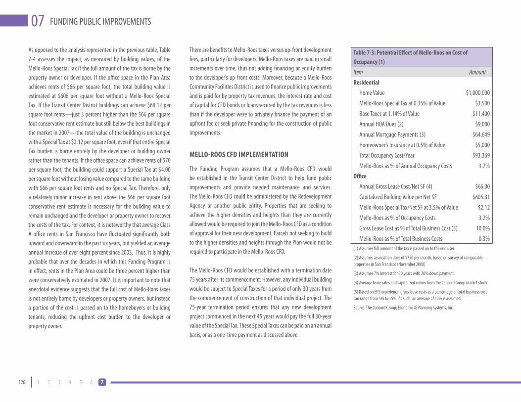
126 1 2 3 4 5 6 7
FUNDING PUBLIC IMPROVEMENTS07As opposed to the analysis represented in the previous table, Table 7-4 assesses the impact, as measured by building values, of the Mello-Roos Special Tax if the full amount of the tax is borne by the property owner or developer. If the office space in the Plan Area achieves rents of $66 per square foot, the total building value is estimated at $606 per square foot without a Mello-Roos Special Tax. If the Transit Center District buildings can achieve $68.12 per square foot rents—just 3 percent higher than the $66 per square foot conservative rent estimate but still below the best buildings in the market in 2007—the total value of the building is unchanged with a Special Tax at $2.12 per square foot, even if that entire Special Tax burden is borne entirely by the developer or building owner rather than the tenants. If the office space can achieve rents of $70 per square foot, the building could support a Special Tax at $4.00 per square foot without losing value compared to the same building with $66 per square foot rents and no Special Tax. Therefore, only a relatively minor increase in rent above the $66 per square foot conservative rent estimate is necessary for the building value to remain unchanged and the developer or property owner to recover the costs of the tax. For context, it is noteworthy that average Class A office rents in San Francisco have fluctuated significantly both upward and downward in the past six years, but yielded an average annual increase of over eight percent since 2003. Thus, it is highly probable that over the decades in which this Funding Program is in effect, rents in the Plan Area could be three percent higher than were conservatively estimated in 2007. It is important to note that anecdotal evidence suggests that the full cost of Mello-Roos taxes is not entirely borne by developers or property owners, but instead a portion of the cost is passed on to the homebuyers or building tenants, reducing the upfront cost burden to the developer or property owner.
There are benefits to Mello-Roos taxes versus up-front development fees, particularly for developers. Mello-Roos taxes are paid in small increments over time, thus not adding financing or equity burden to the developer’s up-front costs. Moreover, because a Mello-Roos Community Facilities District is used to finance public improvements and is paid for by property tax revenues, the interest rate and cost of capital for CFD bonds or loans secured by the tax revenues is less than if the developer were to privately finance the payment of an upfront fee or seek private financing for the construction of public improvements.
mello-Roos cFD ImplemeNTATIoN
The Funding Program assumes that a Mello-Roos CFD would be established in the Transit Center District to help fund public improvements and provide needed maintenance and services. The Mello-Roos CFD could be administered by the Redevelopment Agency or another public entity. Properties that are seeking to achieve the higher densities and heights than they are currently allowed would be required to join the Mello-Roos CFD as a condition of approval for their new development. Parcels not seeking to build to the higher densities and heights through the Plan would not be required to participate in the Mello-Roos CFD.
The Mello-Roos CFD would be established with a termination date 75 years after its commencement. However, any individual building would be subject to Special Taxes for a period of only 30 years from the commencement of construction of that individual project. The 75-year termination period ensures that any new development project commenced in the next 45 years would pay the full 30-year value of the Special Tax. These Special Taxes can be paid on an annual basis, or as a one-time payment as discussed above.
Table 7-3: potential effect of mello-Roos on cost of occupancy (1)
Item AmountResidential
Home Value $1,000,000
Mello-Roos Special Tax at 0.35% of Value $3,500
Base Taxes at 1.14% of Value $11,400
Annual HOA Dues (2) $9,000
Annual Mortgage Payments (3) $64,649
Homeowner’s Insurance at 0.5% of Value $5,000
Total Occupancy Cost/Year $93,369
Mello-Roos as % of Annual Occupancy Costs 3.7%office
Annual Gross Lease Cost/Net SF (4) $66.00
Capitalized Building Value per Net SF $605.81
Mello-Roos Special Tax/Net SF at 3.5% of Value $2.12
Mello-Roos as % of Occupancy Costs 3.2%
Gross Lease Cost as % of Total Business Cost (5) 10.0%
Mello-Roos as % of Total Business Costs 0.3%(1) Assumes full amount of the tax is passed on to the end user.
(2) Assumes association dues of $750 per month, based on survey of comparable properties in San Francisco (November 2008)
(3) Assumes 7% interest for 30 years with 20% down payment.
(4) Average lease rates and capitalized values from the Concord Group market study
(5) Based on EPS experience, gross lease costs as a percentage of total business cost can range from 5% to 15%. As such, an average of 10% is assumed.
Source: The Concord Group; Economic & Planning Systems, Inc.

127DRAFT TRANSIT CENTER DISTRICT PLAN
FUND
ING
PUBL
IC IM
PROV
EMEN
TS07
Table 7-5: mello-Roos special Tax Total Revenue estimates
Phasing Scenario
Assumed Year of First Building Construction
Assumed Year of Last Building Construction
Total Value of Buildings Subject to Special Tax
(2009$) (1)Total Special Taxes
Paid (2)
Net Present Value of Total Special Taxes Paid
(2009$) (3)
A 2012 2026 $8,437,490,719 $1,465,736,375 $304,848,481
B 2015 2029 $8,437,490,719 $1,555,451,167 $264,078,606(1) Value estimates are based on market analysis conducted by the Concord Group in 2008. Excludes affordable housing units and parcels not being rezoned for higher density, but includes new buildings in Zone 1.
(2) Assumes buildout occurs evenly over 15-year period, and each building pays Special Tax for 30 years starting with year of construction commencement. Figures are in nominal dollars, and include 2% annual inflation of Special Tax.
(3) Net Present Value assumes a 7.0% discount rate on revenues received.
Sources: The Concord Group; Economic & Planning Systems
mello-Roos specIAl TAx ReveNUe pRojecTIoNs
New development in the Plan Area is expected to occur over a number of years, as the market fluctuates and as owners of individual properties determine that the time is right to pursue development. Table 7-5 shows the total revenues that would be generated by a Mello-Roos CFD in the Plan Area if implemented as envisioned in the Funding Program. For purposes of comparison, the table shows the total Special Tax revenues and Net Present Value of those revenues if the Plan buildout begins in Year 2012, and if the buildout does not commence until 2015. In both cases, total buildout of the subject parcels is assumed to occur over a period of 15 years, and each building is obligated to pay the Special Taxes for 30 years from commencement of construction, so the last building constructed will have completed their Special Tax obligations 45 years after the first building was constructed. Because it is not possible to predict which properties might be developed in which years, the projections assume an even spread of the total Plan buildout over a 15-year period. For comparative purposes with historic construction and absorption, this buildout schedule represents an annual average production of approximately 400,000 gross square feet of office space. This is on par with the downtown average production over the past couple decades (and represents a little less than half of the annual citywide production).
As shown, the Net Present Value (in Year 2009 dollars) of revenues that can be generated through the Mello-Roos Special Tax is estimated to be over $200 million. Comparing Scenario A to Scenario B, it is clear that the longer the buildout of the Plan parcels takes, the lower the Net Present Value of future revenues will be, even if the nominal aggregate amount of Special Taxes paid increases.
Table 7-4: Impact of mello-Roos special Tax Under Alternative office Rent scenarios (1)
Item Conservative Scenario (2) Moderate Scenario (3) Aggressive Scenario (3)
Office Rents/SF/Year $66.00 $68.12 $70.00
Operating Expenses/SF/Year $29.65 $29.65 $29.65
Net Operating Income/SF/Year $36.35 $38.47 $40.35
Capitalization Rate (4) 6.0% 6.0% 6.0%
capitalized value/office sF with:
$0.00 Special Tax/SF/Year $605.81 $641.14 $672.48
$2.12 Special Tax/SF/Year (5) $570.48 $605.81 $637.14
$4.00 Special Tax/SF/Year $539.14 $574.48 $605.81(1) Assume the full amount of the tax is borne by the developer or building owner..
(2) Conservative scenario uses rent figures estimated by the Concord Group in 2008.
(3) Moderate and Aggressive Scenarios use slightly higher rents, but still below the rents being achieved in 2007 for top-quality, top-location San Francisco office buildings.
(4) The Concord Group tabulated cap rates for transactions of “trophy” (i.e. newest, best location) buildings in core office markets (New York City, Chicago, and Los Angeles) and found that they earned cap rates 0.5% to 2% lower than the class A overall market average at the time of each transaction. The Concord Group maintains that the new premium class A building in the Plan Area will earn trophy status and a 6% cap rate is appropriate (1% less than the overall market average for all building transactions).
(5) $2.12/SF is based on a Special Tax equivalent to 0.35% of the capitalized value/SF under the conservative scenario.
Sources: The Concord Group; Economic & Planning Systems
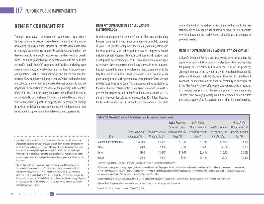
128 1 2 3 4 5 6 7
FUNDING PUBLIC IMPROVEMENTS07
beNeFIT coveNANT Fee
Through contractual development agreements (particularly through public agencies, such as redevelopment or transit agencies, developing publicly-owned properties), private developers have increasingly been willing to impose “Benefit Covenants” on their new developments to fund public improvements and services that benefit them. The funds generated by the benefit covenants are dedicated to specific “public benefit” programs and facilities, including open space maintenance, affordable housing, and transit improvements and operations. In their usual application, the benefit covenant fees function like a supplemental property transfer fee, in that the funds are collected only when the property changes ownership and are imposed as a proportion of the value of the property. In the context of this Plan area, there are many properties owned by public entities (or scheduled to be transferred from Caltrans to the TJPA and the City) who will be disposing of these properties for development through disposition and development agreements. A benefit covenant could be included as a provision in these development agreements.
beNeFIT coveNANT Fee cAlcUlATIoN meThoDoloGy
To estimate the potential revenues from the Plan area, the Funding Program assumes that each new development on public property in Zone 1 of the Redevelopment Plan Area (excluding affordable housing projects) and other publicly-owned properties would include a Benefit Covenant Fee as a condition of a disposition and development agreement equal to 1.0 percent of its sale value upon each resale. Other properties in the Plan area would be encouraged, but not required, to enter into a development agreement with the City that would include a Benefit Covenant Fee as well as other provisions typical to such agreements as recognized in State law and the City’s Administrative Code. This amount would be in addition to the current property transfer tax in San Francisco, which is now 0.75 percent for properties sold under $5 million, and as much as 1.50 percent for properties sold at a value exceeding $5 million. Because the Benefit Covenant Fee is assumed to be a percentage of the resale
Table 7-6: benefit covenant Fee Impact on Returns on Investment
UseEstimated Initial Value/Net SF (1)
Estimated Value/SF at Resale (2)
Resale Proceeds/SF with Existing
Property Transfer Taxes (3)
Gross Profit Margin without
Benefit Covenant Fee (4)
Benefit Covenant Fee/SF at 1% of
Resale Value
Gross Profit Margin with 1% Benefit Covenant
Fee (4)
Market-Rate Residential $1,000 $1,344 $1,334 33.4% $13.44 32.0%
Office $600 $806 $794 32.4% $8.06 31.0%
Hotel $800 $1,075 $1,059 32.4% $10.75 31.0%
Retail $450 $605 $596 32.4% $6.05 31.0%(1) Initial Value estimates are based on market analysis conducted by the Concord Group in 2008
(2) Assumes property re-sells every 10 years, and has increased in value at 3% per year. Based on Census data and data from realtor.com, the residential turnover rate is approximately 26% in San Francisco. EPS has also researched the turnover of several of San Francisco’s prominent office properties, and found that most had changed hands in the past ten years. As a conservative assumption, EPS has assumed the overall turnover rate is 10%.
(3) Existing Property Transfer Taxes are assumed at 0.75% for residential property (valued under $5 million) and 1.50% for other properties (values over $5 million)
(4) Gross Profit Margin calculated as the difference between initial value and net proceeds from resale.
Sources: The Concord Group; Economic & Planning Systems
value of individual properties rather than a fixed amount, the fees attributable to any individual building or land use will fluctuate over time based on the market values of buildings and the pace of property resales.
beNeFIT coveNANT Fee FeAsIbIlITy AssessmeNT
A Benefit Covenant Fee is a cost that would be incurred upon the resale of property. Like property transfer taxes, the responsibility for paying this fee officially lies with the seller of the property, although in practice the payment may be negotiated between the seller and the buyer. Table 7-6 illustrates the effect that the Benefit Covenant Fee may have on the financial feasibility of development in the Plan Area. As shown, if property values increase by an average of 3 percent per year2 and the average property sells once every 10 years,3 the average property would be expected to yield resale proceeds roughly 32 to 33 percent higher than its initial purchase
2 According to Zillow.com, the median home price in San Francisco increased by an average of 5.1 percent per year from 2000 through 2009, including periods of both rapid escalation and rapid reductions. CB Richard Ellis data shows that office rents increased by an average of 8.2 percent per year from 2003 through 2009, again including both escalating and deflating market conditions. As such, the 3 percent annual property value inflation figure is considered a conservative estimate over the long term.
3 The U.S. Census Bureau’s American Community Survey for 2006 indicated that 10 percent of homeowners in San Francisco had moved into their units within the previous year, and a survey of prominent office buildings in Downtown San Francisco – including the Bank of America Building, the Transamerica Building, the Embarcadero Center, 101 California Street, and others – found that roughly 80 percent had been resold within the previous eight years, and 100 percent had been resold within the previous 15 years.

129DRAFT TRANSIT CENTER DISTRICT PLAN
FUND
ING
PUBL
IC IM
PROV
EMEN
TS07
Table 7-7: benefit covenant Fee Total Revenue estimates
Phasing Scenario
Assumed Year of First Building Construction
Assumed Year of Last Building Construction
Total Value of Buildings Subject to Benefit
Covenant (2009$) (1)Total Benefit Covenant
Fees Paid (2)
Net Present Value of Total Fees Paid
(2009$) (3)
A 2012 2026 $8,437,490,719 $543,881,014 $99,492,541
B 2015 2029 $8,437,490,719 $592,568,899 $88,410,511(1) Value estimates are based on market analysis conducted by the Concord Group in 2008. Excludes affordable housing units and parcels not being rezoned for higher density, but includes new buildings in Zone 1.
(2) Assumes buildout occurs evenly over 15-year period, and each building is subject to Benefit Covenant Fee for 30 years starting with year of construction commencement. Assumes property values increase by 3% per year, and 10% of aggregate building value in each year is resold the following year and thus subject to the Benefit Covenant Fee at 1% of resale value. Figures are in nominal dollars.
(3) Net Present Value assumes a 7.0% discount rate on revenues received.
Sources: The Concord Group; Economic & Planning Systems
4 California Civil Code Sections 1098, 1098.5, and 1102.6e define the requirements for establishing a “transfer fee” as considered for the Plan’s proposed Benefit Covenant.
Should the City not pursue Benefit Covenant provisions through the described contractual arrangements, an alternate option would be the implementation of a Mello-Roos requirement of 0.46%, instead of 0.35%, which would yield the same long term revenue generation for public infrastructure. This would bring the overall tax rate on subject properties to approximately 1.6% instead of 1.5%. For purposes of the analysis of potential revenue projections here, it is assumed that the Benefit Covenants are implemented for the pertinent properties.
properties through a sale or development agreement with the public entity disposing of the land. For instance, the Redevelopment Agency can include this provision as a contractual condition in the RFPs and agreements for disposition of the property between themselves and the private developer. For non-public properties, this provision would be included in development agreements between the City and developer who elect to enter into such contractual agreements.4
This analysis assumes that the Benefit Covenants would be in effect for a period of 30 years following the commencement of construction on each individual building which includes the provision in its development agreements. As with the Mello-Roos Special Tax, only those Plan Area seeking to build to the higher densities and heights allowable under the Plan would have this requirement, and affordable housing units would be exempt.
beNeFIT coveNANT ReveNUe pRojecTIoNs
The revenues that might be generated through Benefit Covenants would depend on the number of properties participating, pace of construction, the pace of resales of new units and buildings, and the resale values of those properties. The Funding Program assumes that property values will increase at an average rate of 3 percent per year, and that 10 percent of the aggregate value of development will be resold each year. Table 7-7 shows the aggregate amount of Benefit Covenant Fees that would be generated under two different buildout scenarios—both lasting 15 years, but one starting in 2012 and the other starting in 2015. This analysis anticipates that the major development sites utilizing the higher zoning would participate in this program subject to development agreements with the City as well as all properties in Zone 1 (other than affordable housing projects) and two sites that the TJPA currently owns. As shown, a Benefit Covenant Fee mechanism has the potential to generate over $500 million in nominal revenues, although the Net Present Value of these funds is substantially less due to the long period of time over which the revenues would be received.
price or value. This margin factors in the existing property transfer taxes imposed in San Francisco. With a new Plan Benefit Covenant Fee in addition to the existing property transfer taxes, the gross profit margin diminishes by one percentage point, to a range of 31 to 32 percent over 10 years.
Based on this analysis, these Benefit Covenant Fees are expected to be absorbed by property buyers without decreasing the initial purchase price of the unit or building, and thus they are not anticipated to affect the feasibility of developing the properties nor the property owners’ or developers’ financial returns.
beNeFIT coveNANT ImplemeNTATIoN
If pursued, the Benefit Covenant would be imposed through contractual agreements. There are two potential scenarios for implementation. The first is the disposition of the various public

130 1 2 3 4 5 6 7
FUNDING PUBLIC IMPROVEMENTS07Some developers or property owners may elect to pay the Benefit Covenant Fee as a one-time fee rather than encumbering their property with the Benefit Covenant. Table 7-8 estimates the one-time fee that would be required for different land uses. Again assuming that properties are resold every 10 years and that they have increased in value at 3 percent per year, the table shows the Benefit Covenant Fees that would be due at each of three resales during a 30-year time period, and the Net Present Value of those fees represents the one-time, per-square-foot fee a developer may elect to pay up front in lieu of encumbering their property. These one-time fees would represent roughly 1.5 percent of the initial value of the buildings—a relatively small amount that should not substantially affect the feasibility of development.
Table 7-8: benefit covenant Fee estimates as lump sum payments
Use
Estimated Initial Value/
Net SF (1)
Estimated Value/SF at First Resale
(2)
Benefit Covenant Fee/SF at
1% of Resale Value
Estimated Value/SF at Second Resale (2)
Benefit Covenant Fee/SF at
1% of Resale Value
Estimated Value/SF at Third Resale
(2)
Benefit Covenant Fee/SF at
1% of Resale Value
Net Present Value of Fees over 30 Years
(3)
Residential $1,000 $1,344 $13.44 $1,806 $18.06 $2,427 $24.27 $15.72
Office $600 $806 $8.06 $1,804 $10.84 $1,456 $14.56 $9.43
Hotel $800 $1,075 $10.75 $1,445 $14.45 $1,942 $19.42 $12.57
Retail $450 $605 $6.05 $813 $8.13 $1,092 $10.92 $7.07(1) Initial Value estimates are based on market analysis conducted by the Concord Group in 2008(2) Assumes property re-sells every 10 years, and has increased in value at 3% per year.(3) Net Present Value assumes a 7.0% discount rate on revenues received.Sources: The Concord Group; Economic & Planning Systems
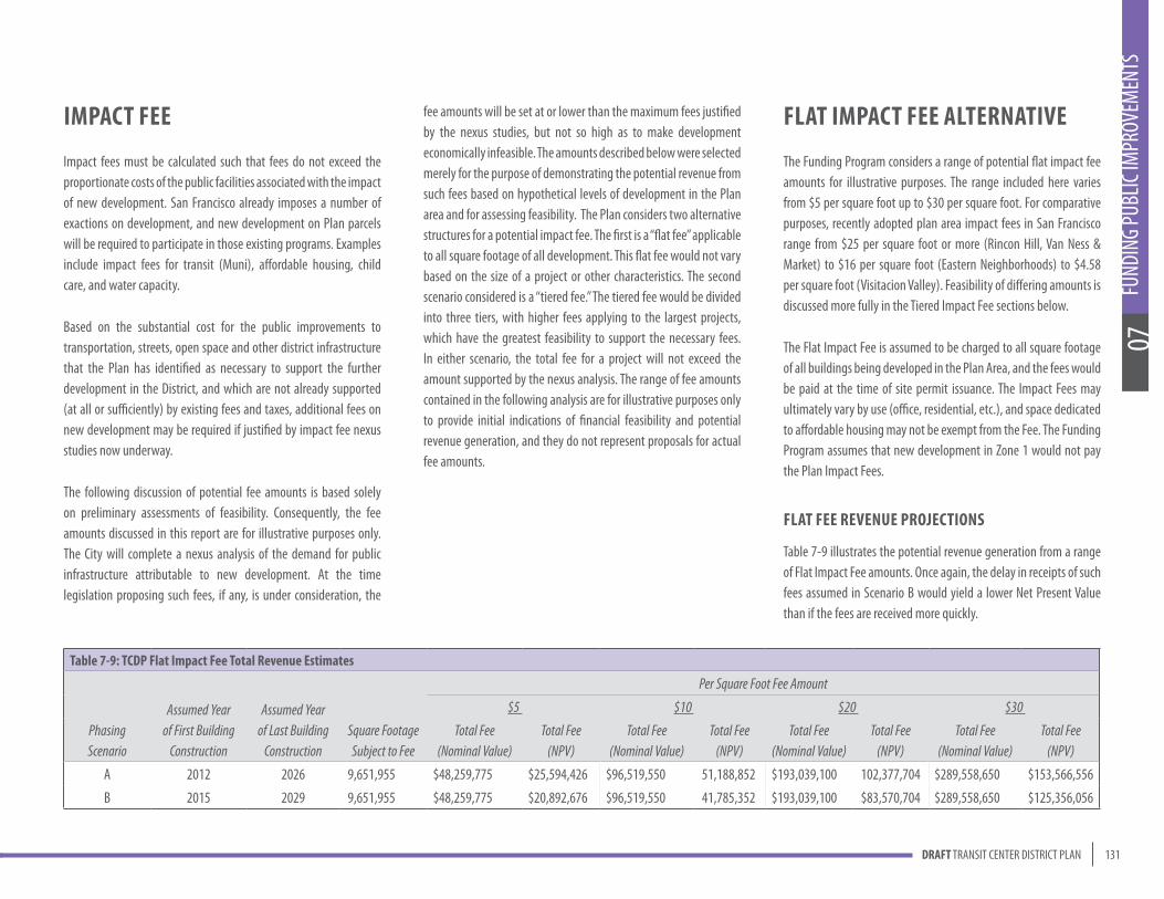
131DRAFT TRANSIT CENTER DISTRICT PLAN
FUND
ING
PUBL
IC IM
PROV
EMEN
TS07
fee amounts will be set at or lower than the maximum fees justified by the nexus studies, but not so high as to make development economically infeasible. The amounts described below were selected merely for the purpose of demonstrating the potential revenue from such fees based on hypothetical levels of development in the Plan area and for assessing feasibility. The Plan considers two alternative structures for a potential impact fee. The first is a “flat fee” applicable to all square footage of all development. This flat fee would not vary based on the size of a project or other characteristics. The second scenario considered is a “tiered fee.” The tiered fee would be divided into three tiers, with higher fees applying to the largest projects, which have the greatest feasibility to support the necessary fees. In either scenario, the total fee for a project will not exceed the amount supported by the nexus analysis. The range of fee amounts contained in the following analysis are for illustrative purposes only to provide initial indications of financial feasibility and potential revenue generation, and they do not represent proposals for actual fee amounts.
Table 7-9: TcDp Flat Impact Fee Total Revenue estimates
Phasing Scenario
Assumed Year of First Building
Construction
Assumed Year of Last Building
ConstructionSquare Footage Subject to Fee
Per Square Foot Fee Amount
$5 $10 $20 $30
Total Fee (Nominal Value)
Total Fee (NPV)
Total Fee (Nominal Value)
Total Fee (NPV)
Total Fee (Nominal Value)
Total Fee (NPV)
Total Fee (Nominal Value)
Total Fee (NPV)
A 2012 2026 9,651,955 $48,259,775 $25,594,426 $96,519,550 51,188,852 $193,039,100 102,377,704 $289,558,650 $153,566,556
B 2015 2029 9,651,955 $48,259,775 $20,892,676 $96,519,550 41,785,352 $193,039,100 $83,570,704 $289,558,650 $125,356,056
ImpAcT Fee
Impact fees must be calculated such that fees do not exceed the proportionate costs of the public facilities associated with the impact of new development. San Francisco already imposes a number of exactions on development, and new development on Plan parcels will be required to participate in those existing programs. Examples include impact fees for transit (Muni), affordable housing, child care, and water capacity.
Based on the substantial cost for the public improvements to transportation, streets, open space and other district infrastructure that the Plan has identified as necessary to support the further development in the District, and which are not already supported (at all or sufficiently) by existing fees and taxes, additional fees on new development may be required if justified by impact fee nexus studies now underway.
The following discussion of potential fee amounts is based solely on preliminary assessments of feasibility. Consequently, the fee amounts discussed in this report are for illustrative purposes only. The City will complete a nexus analysis of the demand for public infrastructure attributable to new development. At the time legislation proposing such fees, if any, is under consideration, the
FlAT ImpAcT Fee AlTeRNATIve
The Funding Program considers a range of potential flat impact fee amounts for illustrative purposes. The range included here varies from $5 per square foot up to $30 per square foot. For comparative purposes, recently adopted plan area impact fees in San Francisco range from $25 per square foot or more (Rincon Hill, Van Ness & Market) to $16 per square foot (Eastern Neighborhoods) to $4.58 per square foot (Visitacion Valley). Feasibility of differing amounts is discussed more fully in the Tiered Impact Fee sections below.
The Flat Impact Fee is assumed to be charged to all square footage of all buildings being developed in the Plan Area, and the fees would be paid at the time of site permit issuance. The Impact Fees may ultimately vary by use (office, residential, etc.), and space dedicated to affordable housing may not be exempt from the Fee. The Funding Program assumes that new development in Zone 1 would not pay the Plan Impact Fees.
FlAT Fee ReveNUe pRojecTIoNs
Table 7-9 illustrates the potential revenue generation from a range of Flat Impact Fee amounts. Once again, the delay in receipts of such fees assumed in Scenario B would yield a lower Net Present Value than if the fees are received more quickly.
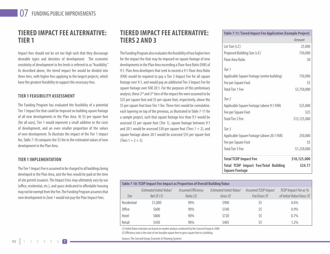
132 1 2 3 4 5 6 7
FUNDING PUBLIC IMPROVEMENTS07
TIeReD ImpAcT Fee AlTeRNATIve: TIeR 1
Impact fees should not be set too high such that they discourage desirable types and densities of development. The economic sensitivity of development to fee levels is referred to as “feasibility.” As described above, the tiered impact fee would be divided into three tiers, with higher fees applying to the largest projects, which have the greatest feasibility to support the necessary fees.
TIeR 1 FeAsIbIlITy AssessmeNT
The Funding Program has evaluated the feasibility of a potential Tier 1 impact fee that could be imposed on building square footage of all new developments in the Plan Area. At $5 per square foot (for all uses), Tier 1 would represent a small addition to the costs of development, and an even smaller proportion of the values of new development. To illustrate the impact of the Tier 1 impact fee, Table 7-10 compares the $5 fee to the estimated values of new development in the Plan Area.
TIeR 1 ImplemeNTATIoN
The Tier 1 Impact Fee is assumed to be charged to all buildings being developed in the Plan Area, and the fees would be paid at the time of site permit issuance. The Impact Fees may ultimately vary by use (office, residential, etc.), and space dedicated to affordable housing may not be exempt from the Fee. The Funding Program assumes that new development in Zone 1 would not pay the Plan Impact Fees.
TIeReD ImpAcT Fee AlTeRNATIve: TIeRs 2 AND 3
The Funding Program also evaluates the feasibility of two higher tiers for the impact fee that may be imposed on square footage of new developments in the Plan Area exceeding a Floor Area Ratio (FAR) of 9:1. Plan Area developers that seek to exceed a 9:1 Floor Area Ratio (FAR) would be required to pay a Tier 2 Impact Fee for all square footage over 9:1, and would pay an additional Tier 3 Impact Fee for square footage over FAR 20:1. For the purposes of this preliminary analysis, these 2nd and 3rd tiers of the impact fee were assumed to be $25 per square foot and $5 per square foot, respectively, above the $5 per square foot base Tier 1 fee. These tiers would be cumulative, each layering on top of the previous, as illustrated in Table 7-11 for a sample project, such that square footage less than 9:1 would be assessed $5 per square foot (Tier 1), square footage between 9:1 and 20:1 would be assessed $30 per square foot (Tiers 1 + 2), and square footage above 20:1 would be assessed $35 per square foot (Tiers 1 + 2 + 3).
Table 7-10: TcDp Impact Fee Impact as proportion of overall building value
UseEstimated Initial Value/
Net SF (1)Assumed Efficiency
Ratio (2)Estimated Initial Value/
Gross SFAssumed TCDP Impact
Fee/Gross SFTCDP Impact Fee as %
of Initial Value/Gross SF
Residential $1,000 90% $900 $5 0.6%
Office $600 90% $540 $5 0.9%
Hotel $800 90% $720 $5 0.7%
Retail $450 90% $405 $5 1.2%(1) Initial Value estimates are based on market analysis conducted by the Concord Group in 2008(2) Efficiency ratio is the ratio of net leasable square feet to gross square feet in a building.
Sources: The Concord Group; Economic & Planning Systems
Table 7-11: Tiered Impact Fee Application (example project)
Amount
Lot Size (s.f.) 25,000
Proposed Building Size (s.f.) 750,000
Floor Area Ratio 30
Tier 1
Applicable Square Footage (entire building) 750,000
Fee per Square Foot $5
Total Tier 1 Fee $3,750,000
Tier 2
Applicable Square Footage (above 9:1 FAR) 525,000
Fee per Square Foot $25
Total Tier 2 Fee $13,125,000
Tier 3
Applicable Square Footage (above 20:1 FAR) 250,000
Fee per Square Foot $5
Total Tier 3 Fee $1,250,000
Total TcDp Impact Fee $18,125,000
Total TcDp Impact Fee/Total building square Footage
$24.17

133DRAFT TRANSIT CENTER DISTRICT PLAN
FUND
ING
PUBL
IC IM
PROV
EMEN
TS07
TIeRs 2 AND 3 FeAsIbIlITy AssessmeNT
The feasibility assessment of the Impact Fee Tiers 2 and 3 (inclusive of both tiers) shown in the Tables are illustrative only. The fee amounts, if any, will be established following nexus studies. For illustrative purposes, the fees shown in the Tables are generally equivalent to current development project costs in this district, specifically the cost of acquiring TDRs. Currently, project sponsors are required to acquire TDR for square footage over 9:1. As described in the Historic Preservation chapter, the Plan proposes to reduce this requirement for a variety of reasons. Historically, the cost of acquiring TDRs has averaged between $20 and $30 per square foot.5 As such, the upper two tiers of the Tiered Impact Fee would not represent a new cost to developers of high FAR projects, and thus would not have a negative impact on the feasibility of development. Additionally, while the maximum impact fee that would apply to a given building square foot would be $35 (Tiers 1 + 2 + 3) under the tiered scenario, the average cost per square foot for the entire building (i.e. if this amount were converted to a “flat fee” equivalent) would be significantly lower. In the example illustrated in Table 7-11, which would be comparable to one the taller and larger buildings allowable in the
Table 7-12: TcDp Tiered Impact Fee Total Revenue estimates
Assumed Year of First
Building Construction
Assumed Year of Last Building
Construction
Tier 1 Tier 2 Tier 3
Phasing Scenario
Square Footage
Subject to FeeTotal Fee ($5/sf)
Square Footage
Subject to FeeTotal Fee ($25/sf)
Square Footage
Subject to FeeTotal Fee ($5/sf) Total Fees
Net Present Value of Total
Fees
A 2012 2026 9,651,955 $48,259,775 6,774,748 $169,368,698 3,484,817 $17,424,087 $235,052,560 $124,659,417
B 2015 2029 9,651,955 $48,259,775 6,774,748 $169,368,698 3,484,817 $17,424,087 $235,052,560 $101,759,218
5 The cost of acquiring TDRs fluctuates with the demand for those rights, the supply of TDRs, and the willingness of historic property owners to sell them. Recent transactions during the last economic cycle have been as high as $38 per square foot. As an average figure from known transactions, the cost of TDRs has been estimated by Planning Department staff to be roughly $25 per square foot.
district, the average cost flat fee equivalent would be less than $25. The average cost would be lower for a smaller building on the same size lot, higher for a larger and denser building.
TIeRs 2 AND 3 ImplemeNTATIoN
Tiers 2 and 3 of the Impact Fee would be paid by the developer of any building in the Plan Area at the time a building permit is issued. Ultimately, the Fee may or may not vary by use (office, residential, etc.), and space dedicated to affordable housing is not assumed to be exempt from the fee. The Funding Program assumes that new development in Zone 1 would not pay the Plan Impact Fees.
It is important to note that some property owners and developers may have already purchased TDR from historic properties in advance of this Plan draft in anticipation of a perpetuation of the existing requirements. While the Planning Department’s analysis suggests that, accounting for the proposed changes to the TDR requirements and the substantial amount of development in the Plan Area, there will continue to exist a robust market for TDR sale or re-sale, the Plan
proposes to waive the requirement that developers pay Tiers 2 and 3 of the Impact Fee. The City would accept instead TDR acquired before May 21, 2009 to exceed base FAR greater than 9:1. The date of this acquisition must have been recorded per the standard required Planning Department case process for the transfer of TDR.
TIeReD ImpAcT Fee ReveNUe pRojecTIoNs
The Tiered Impact Fee would be paid as individual properties are developed, and is assumed to be paid at time of site permit issuance. The ultimate revenues collected may vary according to the specific development proposals received for each parcel, which may include higher or lower densities than are envisioned in the Plan. Table 7-12 estimates the total Tiered Impact Fee revenues that would be generated by the rezoning as envisioned in the Plan, and calculated the Net Present Value of those revenues in current dollars. As in previous comparisons the Net Present Value of the revenues is higher under Phasing Scenario A, which assumes that parcels would begin to be redeveloped in 2012, three years before the assumed commencement date under Scenario B.

134 1 2 3 4 5 6 7
FUNDING PUBLIC IMPROVEMENTS07
sUmmARy oF FUNDING pRoGRAm
As described at the beginning of this chapter, the Plan identifies and proposes numerous public infrastructure improvements and related programs necessary to support and enhance the Transit Center District. In summary, four broad categories of public improvements are needed in order to meet the needs of new development, as well as create a sustainable, transit-oriented, livable district:
Streets and Pedestrian Circulation •
Transit and Other Transportation •
Open Space •
Sustainable Resource District Utility •
Table 7-1 at the beginning of the chapter provides a list of the improvements and programs identified throughout this Plan as well as their estimated capital costs in 2010 dollars. The total estimated cost of the proposed public improvements is $567 million in 2010 dollars; the cost of Transit Center Project the total is $4 billion. In addition, funds will be needed to support the long-term maintenance and operation of these facilities. (At this time, these annual maintenance and service costs have not been estimated because there is not yet a well-defined improvement program.)
To achieve the Plan’s vision of creating a new world-class center for the City, development must be feasible within the district and public improvements must be funded and completed. The proposed new funding mechanisms are intended to strike the balance to achieve both of these requisites. As described in this chapter, the Plan proposes three new potential sources of local revenues that could be generated as new development occurs:
Mello-Roos Community Facilities District 1.
Benefit Covenant Fees 2.
Impact Fee 3.
The financial analysis concludes that the additional value created by the new Transit Center and other Plan public improvements will outweigh the additional costs of entitlement in the district and still create an incentive to develop. Three of the proposed revenue mechanisms—the basic impact fee, the Mello-Roos tax, and the Benefit Covenant—represent net new costs. The latter two of these proposed new payments would be paid over time at the back end of development, after the entitlement and construction process.
Each of these funding sources has unique features, revenue potential, financial structure and legal requirements. Thus, the use of each funding source must be carefully evaluated before any new source is adopted by the Board of Supervisors as a funding
Table 7-13: summary of projected plan Area Revenues
Financing Mechanism
Phasing Scenario A Phasing Scenario B
Buildout 2012-2026 Buildout 2015-2029
Total Revenues (Nominal $)
Net Present Value (2009$) (1)
Total Revenues (Nominal $)
Net Present Value (2009$) (1)
existing Impact Fees
Downtown Open Space $14,275,651 $8,101,022 $14,275,651 $6,612,847
Transit (Muni) $78,521,412 $44,558,646 $78,521,412 $36,373,128
Job-Housing $117,134,014 $66,470,189 $117,134,014 $54,259,474
Child Care $7,876,768 $4,469,840 $7,876,768 $3,648,721
Water Capacity $3,006,358 $1,706,022 $3,006,358 $1,392,622
Subtotal, Existing Impact Fees $220,814,202 $125,305,717 $220,814,202 $102,286,791
New TcDp Financing mechanisms
Mello-Roos Special Tax $1,465,736,375 $304,848,481 $1,555,451,167 $264,078,606
Benefit Covenant $543,881,014 $99,492,541 $592,568,899 $88,410,511
TCDP Impact Fee $235,052,560 $124,659,417 $235,052,560 $101,759,218
Subtotal, New TCDP Mechanisms $2,244,669,948 $529,000,439 $2,383,072,625 $454,248,334(1) Net Present Value assumes fees are paid as development is built evenly over a 15-year period, that Mello-Roos Special Taxes and Benefit Covenant payments are required for 30 years from initial commencement of construction, and that a 7.0% discount rate is applied on all revenues received.
Sources: San Francisco Planning Department; Economic & Planning Systems
mechanism for the Plan. For example, an impact fee nexus analysis is currently underway to determine new development’s fair share of the proposed public improvement costs for the Plan Area.
When such analysis is complete, an appropriate “nexus-based” impact fee program, if the study shows any is warranted, will be recommended. The next step in the Plan process will be to better evaluate how each of these proposed funding sources could be used to support each of the four categories of proposed public improvement costs. For example, the Mello Roos revenues may be primarily dedicated to funding improvements associated with the Transit Center and the Sustainable Resource Utility program.

135DRAFT TRANSIT CENTER DISTRICT PLAN
FUND
ING
PUBL
IC IM
PROV
EMEN
TS07
The potential revenues (particularly their Net Present Value) from each of these three funding sources will depend on a variety of market-driven factors that cannot be controlled, including the timing of development, the value of development, and the pace of property resales. For illustration purposes only, Table 7-13 shows the potential revenues attributable to the three new proposed funding mechanisms under two development phasing scenarios (which vary by length of Plan Area buildout). (Note that this summary table uses the Tiered Impact Fee amounts for illustrative purposes). The projections assume that likely development sites build out to their maximum allowable envelopes per the Plan. To the extent that any key sites, particularly those being upzoned, are built less than the maximum allowable, the actual revenues realized will be less than these projections.
Existing impact fees applicable to downtown projects, listed in Table 7-13, will provide funding for several other key supporting aspects of the Plan, including Muni, affordable housing, and childcare. For this reason, funds from the new Plan revenue sources are not proposed for these purposes nor identified in Table 7-1 listing necessary public improvements.
In addition to the new revenues the Plan is proposing, there are other existing and proposed sources that may augment the Plan’s core revenue mechanisms to help meet the meet the public improvement funding needs described above. These potential sources include:
TRANsbAy ReDevelopmeNT AReA TAx INcRemeNT FUNDs
The Plan area boundary covers most of the Transbay Redevelopment Area, including all of Zone 2. The Redevelopment Agency funds public improvements, including streets and open spaces, for redevelopment project areas using tax increment funding. The Agency also can use tax increment funds to pay for public improvements in the areas
ImplemeNTING The plAN
This Funding chapter has described three potential new funding sources to help ensure implementation of the Plan’s policies and recommendations, particularly the physical infrastructure and further studies listed in Table 7-1. A supplementary implementation document will follow the publication of this draft Plan, which will include a more detailed evaluation of each potential funding source. In addition, an impact fee nexus analysis is currently underway to determine new development’s fair share of the proposed public improvement costs for the Plan area. The implementation document will summarize the results from the nexus analysis, describe how each of the proposed funding sources may be used to fund the proposed category of improvements, and outline the necessary actions and key parties responsible for realizing the plan’s vision and various recommendations, including its regulatory controls, physical changes, further analyses, and ongoing monitoring.
immediately outside of the Redevelopment Area to the extent that such improvements benefit the Redevelopment Project Area. Most of the tax increment funding available in Transbay has already been pledged to the TJPA to help pay the cost of building the Transit Center Project. A large portion also will be necessary to fund affordable housing projects in order to meet the 35 percent affordable housing requirement that applies specifically to the Transbay Redevelopment Plan. In addition, the Transbay Redevelopment Plan anticipates funding major street improvements in Zone 1 identified in the Transbay Streetscape & Open Space Plan. However, some funding will likely be available for street improvements in Zone 2 and the broader Transit Center District Plan area outside the boundaries of the Redevelopment Area. The San Francisco Redevelopment Commission will have to approve any allocation of tax increment funds for these purposes.
Potential Use: Street and Open Space improvements
New IN-lIeU Fees
As described in the Public Realm chapter, the Plan proposes to allow developments to pay a fee in-lieu of providing the on-site publicly-accessible open space required per Planning Code Section 138 for non-residential uses (e.g. office, hotel, retail). The fee would go into a dedicated open space fund for the Plan area to augment the funds dedicated from the Plan’s proposed Bonus and impact fees. As an optional fee in-lieu of an existing requirement, it is possible that no funds may be collected.
Potential Use: Open Space improvements
(Note: The proposed optional fee in-lieu of TDR described in the Historic Preservation chapter is not included here because those funds, if any, would be used for historic preservation purposes and programs in the area consistent with the Plan’s policies, but not to fund new physical public infrastructure called for specifically by the Plan.)
AGeNcy pRoGRAms
The two district-wide sustainable resource utility systems recommended in the Plan – non-potable water and Combined Heat & Power – are extensions of existing plans or programs or are related to the core activities of existing enterprise agencies, specially, the San Francisco Public Utilities Commission. As of the publishing of this draft Plan, the SFPUC currently does not have investments identified to undertake these programs in the Transit Center District Plan area in the time horizon of the Plan. However, to the extent that such investments may be incorporated in SF PUC plans in the future, more funding can be identified to complete them, and possibly to enable shifting of those Plan revenues to other Plan-identified public improvements, including the Transit Center.
Potential Use: Sustainable Resource District Utilities


A-1DRAFT TRANSIT CENTER DISTRICT PLAN
APPENDIX A: EmIssIoNs moDElINg mEThoDology
mEThoDology
A comparative analysis of greenhouse gas (GHG) and air pollutant emissions was conducted to estimate the emissions reductions of accommodating urban growth with high-density regional transit hub of the Transit Center District versus a “business as usual” approach with conventional suburban development and limited public transit options. Two scenarios were developed to represent these alternatives, and emissions models were generated using Urbemis 2007 9.2.4, an urban emissions modeling software developed by Environmental Management Software.
Transit Center District Alternative: This alternative was developed using the proposed development program for the Transit Center District. The development program provided the units and product type. Conservatively, an average Floor Area Ratio (FAR) of 18:1 was used, and the estimated floor area for each product type was adjusted accordingly in the Urbemis model. Additionally, a number of mitigation measures were included detailing the various ways in which this development deviates from the conventional, “business
as usual” development. Mitigation measures included, but are not exclusively, access to and diversity of transit options, building energy efficiency, proximity of residential, retail, and employment, etc. Additional information about the assumptions used for this scenario is available in the Assumptions table.
Suburban Development Alternative: This alternative was developed using the proposed development program Transit Center District as the baseline development square footage estimate. These building square footages were then equally distributed across the six counties most responsible for urban growth in the future; Alameda, Contra Costa, Marin, San Mateo, Santa Clara, and Solano. These six identical development programs were used as inputs in the Urbemis emissions modeling program. Urbemis provides default baseline assumptions (i.e. development densities, trip rate generation, average trip distance, car fleet composition, etc.) for each county, and these assumptions were used to define the “business as usual” suburban development scenario.

A-2
APPENDIX A
Identical development programs were used as inputs into the six different county-specific Urbemis models, and emissions estimates were generated. The sum of the six county-specific emissions estimates comprises the Suburban Development Alternative. Additional information about the assumptions used for this scenario is available in the Assumptions table.
Model Outputs: The Urbemis model generates estimates for seven air pollutants, including the greenhouse gas, carbon dioxide, which are listed in the table below. The emissions estimates are broken down into construction, area source, and operational related emissions (Summary Matrix section – Emissions Comparative Analysis table). The comparison was calculated as a percent reduction, using the Suburban Development Alternative as the baseline.
Table A-1: Emissions Categories
Category DefinitionROG Reactive Organic Gases
NOx Mono-Nitrogen Oxides
CO Carbon Monoxide
SO2 Sulfur Dioxide
PM10 Particulate Matter - 10 microns
PM2.5 Particulate Matter - 2.5 microns
CO2 Carbon DioxideSource: Urbemis, 2007 v 9.2.4; AECOM, 2009.
Table A-2: Emissions model Assumptions
Transit Center District Alternative Suburban Development Alternative 1
Development Program:
Residential Housing (units) 2 1,350 225Building Site (acres) 2.25 Urbemis DefaultOffice Space (square feet) 5,820,000 970,000Hotel Rooms 985 164Retail Space (square feet) 85,000 14,167Average Non-Residential FAR 18:1 2.5:1 (Urbemis Default)Parks and other Nonresidential Uses (square feet) 308,500 51,417Total Housing units within a 1/2 mile 2 19,300 355Percent of Affordable Housing (units) 15% 0% (Urbemis Default)Percent Energy Efficiency above Title 24 35% 0% (Urbemis Default)Total Study Area Employment 3 85,000 3,900
Parking:Office 1,100 Urbemis DefaultResidential 1,000 Urbemis DefaultRetail - Urbemis DefaultHotel 150 Urbemis Default
Transit:Daily Weekday Buses Stopping within ¼ mile 4 98 Urbemis DefaultDaily Rail or Rapid Transit Buses within ½ mile 5 12 Urbemis DefaultDedicated Daily Shuttles 50 Urbemis DefaultDaily Parking Charge for Nonresidential Uses $32.00 Urbemis DefaultTransit Demand Management Measures Yes Urbemis Default
Bike and Pedestrian: 6Number of intersection per square mile 261 Urbemis DefaultPercent of streets with sidewalks on one side 100% Urbemis DefaultPercent of streets with sidewalks on both sides 100% Urbemis DefaultPercent of arterials and collectors with bike lanes 25% Urbemis Default
Double Counting Correction: 5% 0% (Urbemis Default)Source: Urbemis, 2007 v 9.2.4; AECOM, 2009.
Notes:1 Uses the Transit Center Plan Alternative development program and distributes it evenly over six sites in Alameda, Contra Costa, Marin, Santa Clara, San Mateo, Solano counties.2 Housing - 1,350 Transit Center District ; 8,850 Planned; 9,100 Existing; Suburban Development - Assumed over housing density of 8 units per acre and with 1/12 of total site.3 Employment: Transit Center - 21,500 new employees; 63,500 existing employees; Suburban Development - assumed 25% of site for employment uses, FAR of 0.4, and 500 sf per employees4 98 Bus lines - 40 Muni + 31 AC Transit + 20 Golden Gate Transit + 7 Samtrans; 5,220 buses per day - 4,100 Muni + 320 Golden Gate Transit + 600 AC Transit + 200 Samtrans5 Rail lines - 7 Muni + 4 BART + Caltrain + HSR; 1,320 trains per day - 800 Muni+ 320 BART+ 100 Caltrain + 100 HSR 6 Based on estimates within a ½ mile radius of the project’s center, or entire project, whichever is larger

A-3DRAFT TRANSIT CENTER DISTRICT PLAN
APPE
NDIX
A
Table A-3: Emissions Comparative Analysis: Transit Center District vs. suburban Development Alternatives
ROG NOx CO SO2 PM10 PM2.5 CO2
CoNsTRUCTIoN EmIssIoNs (lbs/day)
Suburban Development Alternative 9,187 1,876 1,712 1.04 5,795 1,283 223,801
Transit Center District Alternative 8,150 246 852 0.76 189 49 83,990
Percent Reduction 11% 87% 50% 27% 97% 96% 62%
AREA soURCE EmIssIoNs (lbs/day)
Suburban Development Alternative 138 63 206 - 0.66 0.66 74,592
Transit Center District Alternative 117 38 47 - 0.14 0.14 45,533
Percent Reduction 15% 40% 77% N/A 79% 79% 39%
oPERATIoNAl (VEhIClE) EmIssIoNs (lbs/day)
Suburban Development Alternative 670 805 8,195 7.32 1,312 252 745,372
Transit Center District Alternative 264 242 2,431 2.32 412 78 229,571
Percent Reduction 61% 70% 70% 68% 69% 69% 69%
ToTAl EmIssIoNs (lbs/day)
Suburban Development Alternative 9,994 2,745 10,112 8.36 7,107 1,536 1,043,765
Transit Center District Alternative 8,530 526 3,330 3.08 601 127 359,094
Percent Reduction 15% 81% 67% 63% 92% 92% 66%Source: Urbemis, 2007 v 9.2.4; AECOM, 2009.

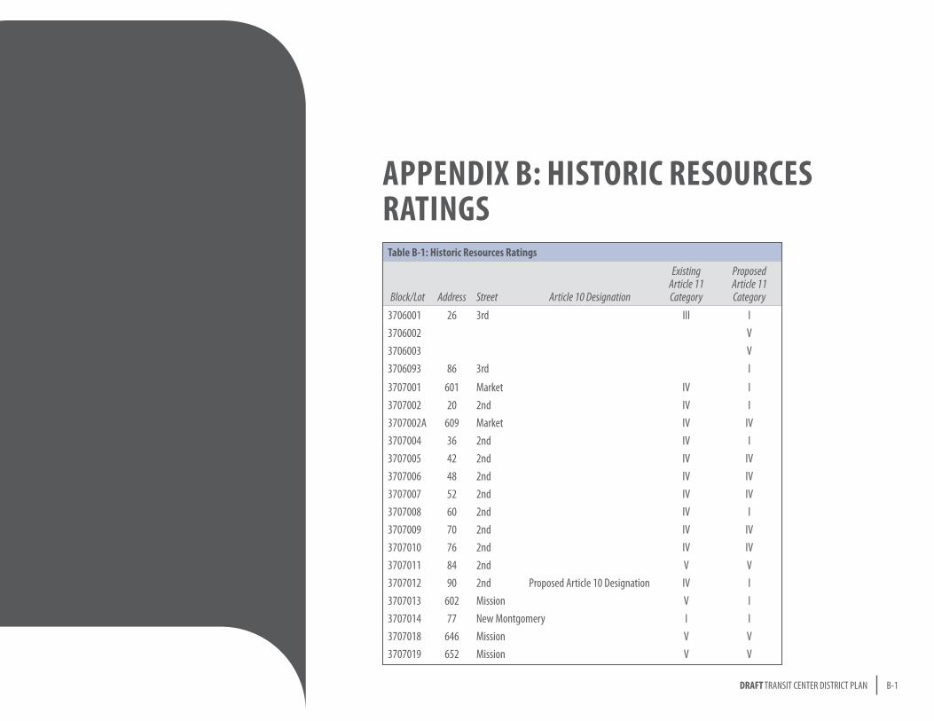
B-1DRAFT TRANSIT CENTER DISTRICT PLAN
APPENDIX B: hIsToRIC REsoURCEs RATINgs
Table B-1: historic Resources Ratings
Block/Lot Address Street Article 10 Designation
Existing Article 11 Category
Proposed Article 11 Category
3706001 26 3rd III I3706002 V3706003 V3706093 86 3rd I
3707001 601 Market IV I3707002 20 2nd IV I3707002A 609 Market IV IV3707004 36 2nd IV I3707005 42 2nd IV IV3707006 48 2nd IV IV3707007 52 2nd IV IV3707008 60 2nd IV I3707009 70 2nd IV IV3707010 76 2nd IV IV3707011 84 2nd V V3707012 90 2nd Proposed Article 10 Designation IV I3707013 602 Mission V I3707014 77 New Montgomery I I3707018 646 Mission V V3707019 652 Mission V V
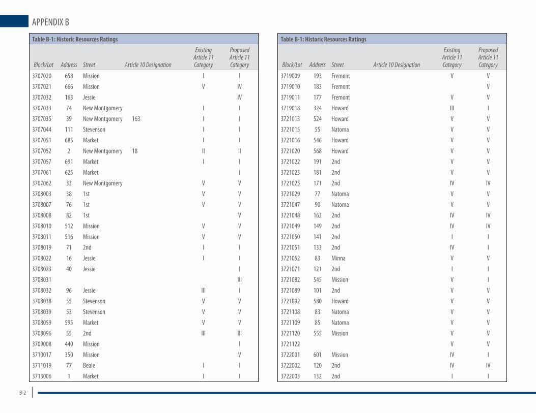
B-2
APPENDIX B
Table B-1: historic Resources Ratings
Block/Lot Address Street Article 10 Designation
Existing Article 11 Category
Proposed Article 11 Category
3707020 658 Mission I I
3707021 666 Mission V IV
3707032 163 Jessie IV
3707033 74 New Montgomery I I
3707035 39 New Montgomery 163 I I
3707044 111 Stevenson I I
3707051 685 Market I I
3707052 2 New Montgomery 18 II II
3707057 691 Market I I
3707061 625 Market I
3707062 33 New Montgomery V V
3708003 38 1st V V
3708007 76 1st V V
3708008 82 1st V
3708010 512 Mission V V
3708011 516 Mission V V
3708019 71 2nd I I
3708022 16 Jessie I I
3708023 40 Jessie I
3708031 III
3708032 96 Jessie III I
3708038 55 Stevenson V V
3708039 53 Stevenson V V
3708059 595 Market V V
3708096 55 2nd III III
3709008 440 Mission I
3710017 350 Mission V
3711019 77 Beale I I
3713006 1 Market I I
Table B-1: historic Resources Ratings
Block/Lot Address Street Article 10 Designation
Existing Article 11 Category
Proposed Article 11 Category
3719009 193 Fremont V V
3719010 183 Fremont V
3719011 177 Fremont V V
3719018 324 Howard III I
3721013 524 Howard V V
3721015 55 Natoma V V
3721016 546 Howard V V
3721020 568 Howard V V
3721022 191 2nd V V
3721023 181 2nd V V
3721025 171 2nd IV IV
3721029 77 Natoma V V
3721047 90 Natoma V V
3721048 163 2nd IV IV
3721049 149 2nd IV IV
3721050 141 2nd I I
3721051 133 2nd IV I
3721052 83 Minna V V
3721071 121 2nd I I
3721082 545 Mission V I
3721089 101 2nd V V
3721092 580 Howard V V
3721108 83 Natoma V V
3721109 85 Natoma V V
3721120 555 Mission V V
3721122 V V
3722001 601 Mission IV I
3722002 120 2nd IV IV
3722003 132 2nd I I

B-3DRAFT TRANSIT CENTER DISTRICT PLAN
APPE
NDIX
B
Table B-1: historic Resources Ratings
Block/Lot Address Street Article 10 Designation
Existing Article 11 Category
Proposed Article 11 Category
3722004 144 2nd IV IV
3722005 156 2nd IV IV
3722006 116 Natoma I I
3722007 137 New Montgomery IV I
3722011 161 Natoma V IV
3722012 658 Howard V V
3722013 147 Natoma I I
3722014 145 Natoma I
3722016 168 2nd IV IV
3722019 182 2nd IV I
3722020 606 Howard I
3722022 170 New Montgomery IV I
3722026 660 Howard V V
3722027 15 Hunt V V
3722058 142 Minna V
3722067 663 Mission V IV
3722068 657 Mission IV
3722069 647 Mission I I
3722070 641 Mission V IV
3722071 100 New Montgomery I I
3722072 111 New Montgomery 107 IV I
3722073 617 Mission IV I
3722076 611 Mission V IV
3722080 I I
3722257 125 3rd IV
3735005 625 Howard II II
3735008 606 Folsom Proposed Article 10 Designation I
3735009 608 Folsom III
3735015 690 Folsom V
Table B-1: historic Resources Ratings
Block/Lot Address Street Article 10 Designation
Existing Article 11 Category
Proposed Article 11 Category
3735017 40 Hawthorne I
3735039 667 Howard III III
3735040 663 Howard V V
3735041 657 Howard III I
3735042 651 Howard V III
3735050 633 Howard V V
3735055 240 2nd Proposed Article 10 Designation I
3736006 234 1st Proposed Article 10 Designation I I
3736023 566 Folsom V
3736025 572 Folsom I
3736079 19 Tehama V
3736083 527 Howard V I
3736086 555 Howard III
3736091 72 Tehama III I
3736093 78 Tehama V III
3736095 217 2nd V V
3736096 205 2nd V V
3736098 589 Howard V III
3736099 583 Howard III I
3736100 577 Howard V III
3736102 571 Howard III
3736107 557 Howard III
3736110 547 Howard V III
3736111 38 Tehama III
3736112 531 Howard V I
3736114 525 Howard V
3736121 509 Howard V V
3736156 V V
3740001 101 Howard I I

MAYORGavin Newsom
BOARD OF SUPERVISORSDavid Chiu, President Michela Alioto-PierJohn AvalosDavid CamposCarmen ChuChris DalyBevan DuftySean ElsberndEric MarSophie MaxwellRoss Mirkarimi
PLANNING COMMISSIONRon Miguel, PresidentChristina Olague, Vice PresidentMichael J. AntoniniGwyneth BordenWilliam L. LeeKathrin MooreHisashi Sugaya
PLANNING DEPARTMENTJohn Rahaim, Planning DirectorDavid Alumbaugh, Acting Chief of Comprehensive PlanningLarry Badiner, Assistant Director & Zoning AdministratorAlicia John-Baptisite, Assistant DirectorJoshua Switzky, Project Manager and Lead PlannerElaine ForbesTim FryeKevin GuySarah B. JonesViktoriya WiseGary Chen
SAN FRANCISCO REDEVELOPMENT AGENCYFred Blackwell, Executive DirectorMichael Grisso, Senior Project Manager
TRANSBAY JOINT POWERS AUTHORITYMaria Ayerdi, Executive DirectorRobert Beck, Transit Center Project ManagerEd SumJoyce Oishi, Program Management teamGuy Hollins, Program Management team
MAYOR’S OFFICEDean Macris
SAN FRANCISCO MUNICIPAL TRANSPORTATION AGENCYNathaniel Ford, Executive DirectorAmit K. GhoshTimothy PapandreouErin MillerSuzanne Chen-HardingJulie KirschbaumPeter StraussJack FleckDustin White
SAN FRANCISCO PUBLIC UTILITIES COMMISSIONRosey JencksMichael Martin
OFFICE OF ECONOMIC & WORKFORCE DEVELOPMENTMichael CohenMichael Yarne
SAN FRANCISCO COUNTY TRANSPORTATION AUTHORITYElizabeth Bent
BARTVal MenottiRobert Mitroff
GOLDEN GATE TRANSITMaurice Palumbo
ACKNOWLEDGEMENTS
AC TRANSITRoberto Del Rosario
TRANSBAY REDEVELOPMENT AREA CITIZENS ADVISORY COMMITTEEBruce Balshone, ChairReed BementJames HaasPeter HartmanJohn HoltzclawChristoper JaksaMichael KieslingRichard MlynarikNorm RolfeJohn Tornes
The Planning Department staff prepared this plan with contribution from the following consultants:
AECOM DESIGN + PLANNINGStephen Engblom, Principal-in-ChargeNick Haskell, Principal-in-ChargeOfelia Guner, Project ManagerClaire Bonham-Carter, Director of Sustainable DevelopmentAlexander Quinn, Director of Sustainable EconomicsChristopher Clement, Sustainable EconomistBeibei Chen, Urban DesignerTim Wong, Urban Designer
ECONOMIC & PLANNING SYSTEMS (EPS)James Musbach, Managing PrincipalDarin Smith, PrincipalEileen Tumalad, Associate
NELSON\NYGAARD, INC.Jeffrey Tumlin, PrincipalJeremy Nelson, Senior AssociateFrancesca Napolitan, Associate Planner
ROBIN CHIANG & COMPANYRobin Chiang, President
KELLEY & VERPLANCKTim KelleyChris VerPlanck
ESAKarl HeislerChuck BennettCory Barringhaus
THE CONCORD GROUPRichard Gollis, Principal Tim Cornwell
AECOM TRANSPORTATIONTim ErneyJeffrey Chan
ARUPAnthony BruzzoneRichard CoffinMike Iswalt
SEIFEL CONSULTING, INC.Libby Seifel, PresidentJessica Zenk, Managing ConsultantJackie Tsou, Senior Consultant
Special thankS to:Skidmore Owings and Merrill
For more information on the Transit Center District Plan, contact:
Joshua Switzky, Project ManagerSan Francisco Planning [email protected]
Visit our website at:http://transitcenter.sfplanning.org
The Transit Center District Plan was made possible in part by the Transbay Joint Powers Authority and the San Francisco County Transportation Authority through a grant of Proposition K local sales tax funds.

TRANSIT CENTER DISTRICT PLAN | DRAFT FOR PUBLIC REVIEW