draft perth coastal planning strategy / december 2008 ... · 41.. precincts draft perth coastal...
TRANSCRIPT

41..
PrecinctsDraft Perth Coastal Planning Strategy / December 2008
PrecinctsPrecinct descriptions and recommendations
Draft Perth Coastal Planning Strategy / December 2008
31 Mosman Beach
Precinct description:
Mosman Beach is a medium-intensity passive recreation precinct with infrastructure including pathways, change rooms, grassed areas, shade and trees. The artificial reef located offshore needs to be managed. The European and Aboriginal heritage sites need to be considered during the planning process. Further investigation will be required to determine appropriate management measures for preventing loss or damage to existing infrastructure and development due to coastal processes.
Existing environment
Land use The foreshore is reserved parks and recreation while the zone of influence is zoned urban, and reserved major regional roads and railways (MRS January 2006).
Network City comments
The passenger railway forms a primary activity corridor in Network City, which runs approximately 500 metres inland from the coast.
Bush Forever site No
Coastline/ marine habitat
The shoreline is rocky with small sandy pockets. There is an artificial reef located 250 metres offshore. The marine habitat is mapped as predominantly sandy with macro algae dominated reefs.
Cultural/ heritage sites registered or unknown
Several European and Aboriginal heritage sites have been recorded in this precinct, including artefact scatters at Macarthur Street and Victoria Street station.
Major issues and planning considerations:
• Town of Mosman Park - Mosman Beach Management Plan 2003
• one of only a few predominantly open space feel precincts along the central north coast
• pavillion buildings of McCall Centre and the Montessori school are the only built elements apart from Vlamingh Memorial
• registered Aboriginal and European heritage sites
• identified coastal processes setback encroaches on urban zoned land and further investigations will be required to determine appropriate management measures.
Land uses and features to be promoted:
• passive recreation and associated infrastructure including paths, change rooms, grassed areas, shade tree plantings
• popular dog beach
• surfing spot on artificial reef
• recreational fishing
• tourist site of Vlamingh Memorial.
Recommendations:
Precinct type: open space
Precinct character: passive recreation
• The recommended physical coastal processes setback category is medium (between 65 and 120 metres).
• Further investigate management requirements for urban reserved land that lies in the identified coastal processes setback to be addressed at first available planning opportunity.
• Develop and implement coastal management plan.
Community identified opportunities, challenges, wishes or fears
None identified.
Swanbourne Beach

42..
Draft Perth Coastal Planning Strategy / December 2008
PrecinctsPrecinct descriptions and recommendations Draft Perth Coastal Planning Strategy / December 2008
32 Leighton
Community identified opportunities, challenges, wishes or fears
Challenge – managing the dissenting views on the need for more cafes.
Wish – remain as is.
Fear – over-development.
Precinct description:
Development in this medium-intensity mixed use precinct should proceed in accordance with approved structure plans and management plans. Land use such as retail and offices as well as open space areas with trees, grass, boardwalks and change rooms are recommended. The surf club and associated facilities should be managed. The Aboriginal heritage site should be protected. Dredging and coastal engineering structures may be needed to stabilise the beach due to significant accretion and erosion trends. Further investigation is required to determine appropriate management measures to protect existing infrastructure including regional roads, port installations and urban development from coastal processes.
Existing environment
Land use The foreshore is reserved parks and recreation while the zone of influence contains urban and industrial zones and port installation, primary regional road and railway reserves (MRS January 2006).
Network City comments
Network City identifies primary activity corridor associated with the passenger rail, which is approximately 500 metres inland from the coast.
Bush Forever site No
Coastline/ marine habitat
The shoreline consists of sandy beaches with several small sections of seawall. The marine habitat is mapped as predominantly sandy with a small area of seagrass.
Cultural/ heritage sites registered or unknown
An Aboriginal heritage site has been recorded in this precinct (Mosman Park ceremonial/mythological and artefact site).
Major issues and planning considerations:
• City of Fremantle has adopted a structure plan for Leighton marshalling yards urban village and development has commenced
• the intensity of development in this precinct is determined by the Leighton Village Structure Plan and associated provisions in the local planning scheme
• access from rail to beach is a priority
• proposal for Fremantle surf club to be rebuilt
• Port and Leighton Beaches Management Plan adopted in 2005
• Leighton oceanside parklands landscape masterplan
• LandCorp developing on four hectares
• district beach
• dog beach
• presence of an Aboriginal heritage site
• significant accretion trends and erosion trends - dredging may be required and coastal engineering structures may be needed to stabilise the beach
• the identified coastal processes setback encroaches on land zoned industrial and urban, and reserved port installation and primary regional road.
Land uses and features to be promoted:
• development in accordance with approved structure plans and management plans
• some retail and office uses
• excellent access to public transport and other existing infrastructure
• significant land redevelopment opportunity adjacent to the coast
• sandy beach is used by swimmers
• surf club and associated facilities
• extensive open space areas with trees, grass, boardwalks and change rooms.
Recommendations:
Precinct type: built-up
Precinct character: mixed use
Precinct intensity: moderate
• Dredging and coastal engineering structures may be needed to stabilise the beach, due to the significant accretion trends and erosion trends.
• The recommended physical coastal processes setback category is medium (between 65 and 120 metres).
• Investigate need and extent of active coastal management required to protect infrastructure.
• The registered Aboriginal heritage site should be protected and/or recognised through the use of interpretive signage where appropriate.
• Develop and implement coastal management plan.
• Maximise opportunities for redevelopment to take full advantage of this location in terms of existing infrastructure, including public transport, access to employment base, coastal recreation facilities and transport corridors.
43..
PrecinctsDraft Perth Coastal Planning Strategy / December 2008
PrecinctsPrecinct descriptions and recommendations
Draft Perth Coastal Planning Strategy / December 2008
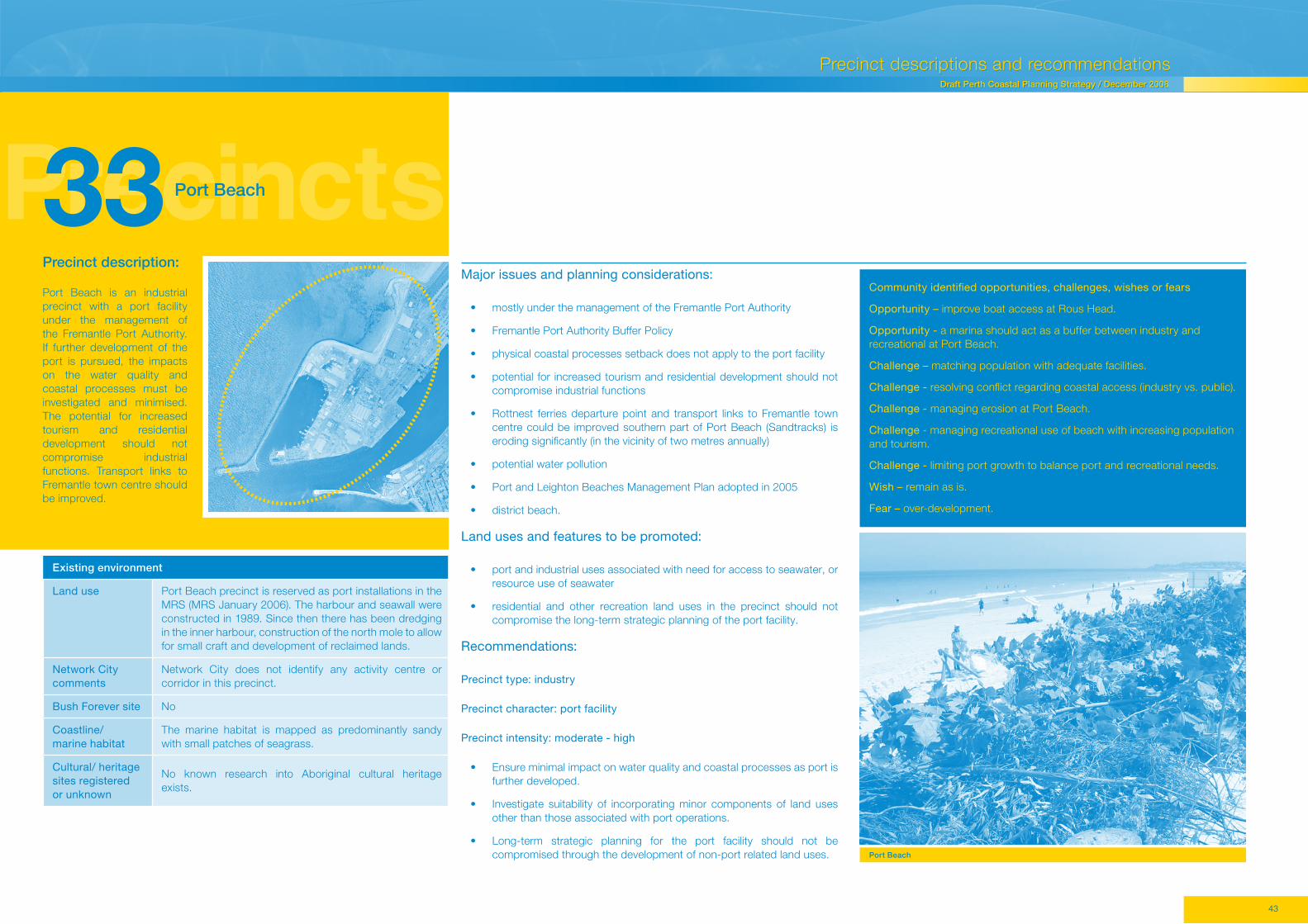
33 Port Beach
Precinct description:
Port Beach is an industrial precinct with a port facility under the management of the Fremantle Port Authority. If further development of the port is pursued, the impacts on the water quality and coastal processes must be investigated and minimised. The potential for increased tourism and residential development should not compromise industrial functions. Transport links to Fremantle town centre should be improved.
Existing environment
Land use Port Beach precinct is reserved as port installations in the MRS (MRS January 2006). The harbour and seawall were constructed in 1989. Since then there has been dredging in the inner harbour, construction of the north mole to allow for small craft and development of reclaimed lands.
Network City comments
Network City does not identify any activity centre or corridor in this precinct.
Bush Forever site No
Coastline/ marine habitat
The marine habitat is mapped as predominantly sandy with small patches of seagrass.
Cultural/ heritage sites registered or unknown
No known research into Aboriginal cultural heritage exists.
Major issues and planning considerations:
• mostly under the management of the Fremantle Port Authority
• Fremantle Port Authority Buffer Policy
• physical coastal processes setback does not apply to the port facility
• potential for increased tourism and residential development should not compromise industrial functions
• Rottnest ferries departure point and transport links to Fremantle town centre could be improved southern part of Port Beach (Sandtracks) is eroding significantly (in the vicinity of two metres annually)
• potential water pollution
• Port and Leighton Beaches Management Plan adopted in 2005
• district beach.
Land uses and features to be promoted:
• port and industrial uses associated with need for access to seawater, or resource use of seawater
• residential and other recreation land uses in the precinct should not compromise the long-term strategic planning of the port facility.
Recommendations:
Precinct type: industry
Precinct character: port facility
Precinct intensity: moderate - high
• Ensure minimal impact on water quality and coastal processes as port is further developed.
• Investigate suitability of incorporating minor components of land uses other than those associated with port operations.
• Long-term strategic planning for the port facility should not be compromised through the development of non-port related land uses.
Community identified opportunities, challenges, wishes or fears
Opportunity – improve boat access at Rous Head.
Opportunity - a marina should act as a buffer between industry and recreational at Port Beach.
Challenge – matching population with adequate facilities.
Challenge - resolving conflict regarding coastal access (industry vs. public).
Challenge - managing erosion at Port Beach.
Challenge - managing recreational use of beach with increasing population and tourism.
Challenge - limiting port growth to balance port and recreational needs.
Wish – remain as is.
Fear – over-development.
Port Beach
44..
Draft Perth Coastal Planning Strategy / December 2008
PrecinctsPrecinct descriptions and recommendations Draft Perth Coastal Planning Strategy / December 2008
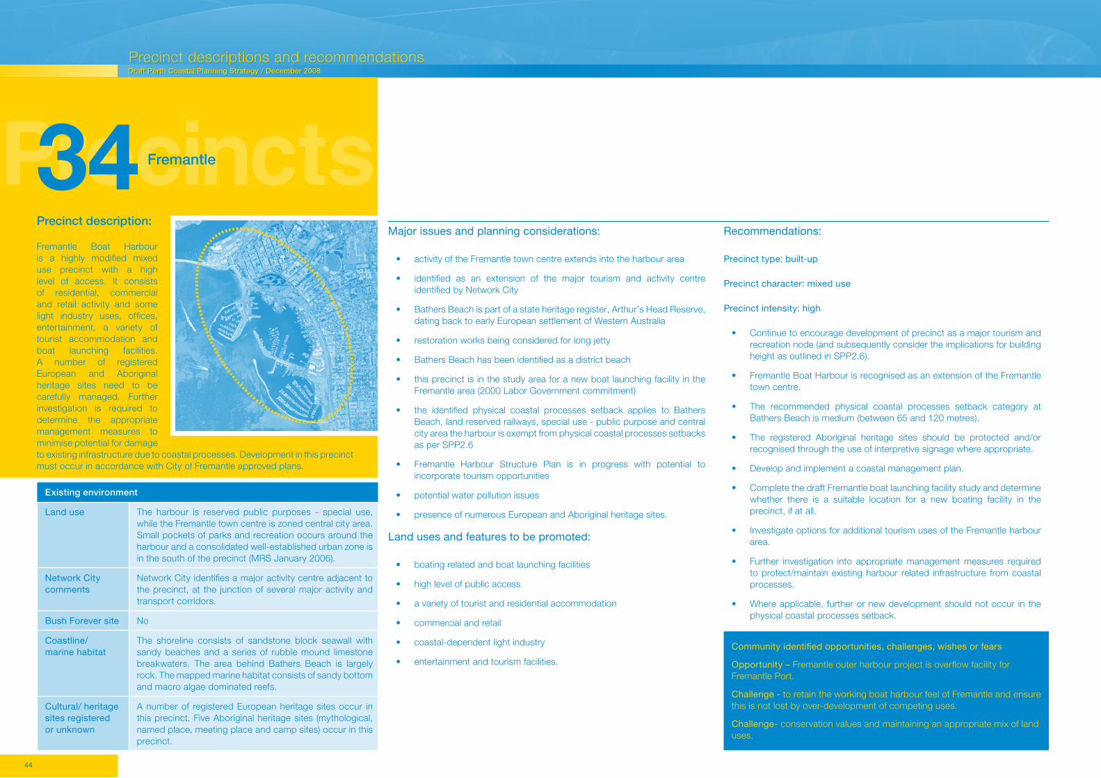
34 Fremantle
Community identified opportunities, challenges, wishes or fears
Opportunity – Fremantle outer harbour project is overflow facility for Fremantle Port.
Challenge - to retain the working boat harbour feel of Fremantle and ensure this is not lost by over-development of competing uses.
Challenge- conservation values and maintaining an appropriate mix of land uses.
Precinct description:
Fremantle Boat Harbour is a highly modified mixed use precinct with a high level of access. It consists of residential, commercial and retail activity and some light industry uses, offices, entertainment, a variety of tourist accommodation and boat launching facilities. A number of registered European and Aboriginal heritage sites need to be carefully managed. Further investigation is required to determine the appropriate management measures to minimise potential for damage to existing infrastructure due to coastal processes. Development in this precinct must occur in accordance with City of Fremantle approved plans.
Existing environment
Land use The harbour is reserved public purposes - special use, while the Fremantle town centre is zoned central city area. Small pockets of parks and recreation occurs around the harbour and a consolidated well-established urban zone is in the south of the precinct (MRS January 2006).
Network City comments
Network City identifies a major activity centre adjacent to the precinct, at the junction of several major activity and transport corridors.
Bush Forever site No
Coastline/ marine habitat
The shoreline consists of sandstone block seawall with sandy beaches and a series of rubble mound limestone breakwaters. The area behind Bathers Beach is largely rock. The mapped marine habitat consists of sandy bottom and macro algae dominated reefs.
Cultural/ heritage sites registered or unknown
A number of registered European heritage sites occur in this precinct. Five Aboriginal heritage sites (mythological, named place, meeting place and camp sites) occur in this precinct.
Major issues and planning considerations:
• activity of the Fremantle town centre extends into the harbour area
• identified as an extension of the major tourism and activity centre identified by Network City
• Bathers Beach is part of a state heritage register, Arthur’s Head Reserve, dating back to early European settlement of Western Australia
• restoration works being considered for long jetty
• Bathers Beach has been identified as a district beach
• this precinct is in the study area for a new boat launching facility in the Fremantle area (2000 Labor Government commitment)
• the identified physical coastal processes setback applies to Bathers Beach, land reserved railways, special use - public purpose and central city area the harbour is exempt from physical coastal processes setbacks as per SPP2.6
• Fremantle Harbour Structure Plan is in progress with potential to incorporate tourism opportunities
• potential water pollution issues
• presence of numerous European and Aboriginal heritage sites.
Land uses and features to be promoted:
• boating related and boat launching facilities
• high level of public access
• a variety of tourist and residential accommodation
• commercial and retail
• coastal-dependent light industry
• entertainment and tourism facilities.
Recommendations:
Precinct type: built-up
Precinct character: mixed use
Precinct intensity: high
• Continue to encourage development of precinct as a major tourism and recreation node (and subsequently consider the implications for building height as outlined in SPP2.6).
• Fremantle Boat Harbour is recognised as an extension of the Fremantle town centre.
• The recommended physical coastal processes setback category at Bathers Beach is medium (between 65 and 120 metres).
• The registered Aboriginal heritage sites should be protected and/or recognised through the use of interpretive signage where appropriate.
• Develop and implement a coastal management plan.
• Complete the draft Fremantle boat launching facility study and determine whether there is a suitable location for a new boating facility in the precinct, if at all.
• Investigate options for additional tourism uses of the Fremantle harbour area.
• Further investigation into appropriate management measures required to protect/maintain existing harbour related infrastructure from coastal processes.
• Where applicable, further or new development should not occur in the physical coastal processes setback.

45..
PrecinctsDraft Perth Coastal Planning Strategy / December 2008
PrecinctsPrecinct descriptions and recommendations
Draft Perth Coastal Planning Strategy / December 2008
35 South Beach
Community identified opportunities, challenges, wishes or fears
Opportunity – planning for future residential and/or mixed land uses.
Challenge - improving access to beaches.
Challenge - environmental consideration of encroaching industry.
Challenge - separation of residential and industry.
Fear – none identified.
Precinct description:
This high-intensity mixed use precinct with high access consists of high-density residential, mixed use and open space areas offering facilities such as cafes, change rooms, shade, BBQs, dual-use pathways and grass that encourages high intensity recreation. Provision of low cost accommodation is encouraged. Implementation of a coastal management plan is recommended to manage issues such as dune erosion and shoreline movement. Access to the foreshore via public transport could be improved. The existing groynes will require ongoing maintenance. Further investigation is required to determine the management necessary for urban and railway land that is affected by coastal processes.
Existing environment
Land use The foreshore is reserved parks and recreation and the zone of influence is urban and railway under the MRS (MRS January 2006).
Network City comments
Network City does not identify an activity centre or activity corridor in this precinct.
Bush Forever site No
Coastline/ marine habitat
The shoreline is sandy. The shoreline in this precinct has been heavily influenced by coastal; engineering works with two rock groynes constructed in the mid 1960s. The groynes were extended in 1996 as part of the South Beach redevelopment, coincident with sand nourishment that resulted in a 50 metre seaward advancement of the beach. The marine habitat consists entirely of a sandy bottom.
Cultural/ heritage sites registered or unknown
No known research into Aboriginal cultural heritage exists for this area.
Major issues and planning considerations:
• ongoing redevelopment of South Beach
• Vision for the Cockburn Coast community dialogue report 2005
• intensity of development at South Beach has primarily been determined by the South Beach Village Structure Plan and provisions in the Fremantle and Cockburn local planning schemes
• proposed Cockburn Coast District Structure Plan
• erosion in front of the ANI site is exposing dumped rubbish
• the local governments recognise the urgent need for a coastal management plan
• development pressures require coordination due to strategic location
• freight rail line isolates the foreshore
• potential risk of heavy metal from industry in this area
• public transport access to area should be improved in light of residential redevelopment of the area
• existing dog beach
• existing groynes and their associated ongoing maintenance.
• identified coastal processes setback encroaches slightly into land reserved railway and a small area of urban zoned land
• district beach
• commercial boat building industry is diminishing in this precinct, with residential uses starting to dominate
• extensive work has been done to stabilise the shoreline and improve the amenity of the beach – ongoing monitoring and maintenance is required
• Fremantle Village offers low cost accommodation.
Land uses and features to be promoted:
• residential and mixed use balanced with open space areas
• improved public transport high-density residential is to be promoted
• trees, cafes, dunes, change rooms, shade, BBQs, dual use path and grass
• high intensity recreation area
• dog beach
• high level of access.
Recommendations:
Precinct type: built-up
Precinct character: mixed use
Precinct intensity: high
• The recommended physical coastal processes setback category is small to medium.
• Where possible existing urban zoned and railway reserved land, affected by the identified coastal processes setback, should be incorporated into foreshore reserve, at the first available planning opportunity.
• Improve public transport connections with existing train and bus services, including the option of a light rail facility, where new residential communities are being developed.
• Develop and implement a coastal management plan.
• Complete the draft Fremantle boat launching facility study and determine the most appropriate location for a new boating facility, if one exists, in this precinct.
• Discourage new industrial activity west of Cockburn Road at the first available planning opportunity.

46..
Draft Perth Coastal Planning Strategy / December 2008
PrecinctsPrecinct descriptions and recommendations Draft Perth Coastal Planning Strategy / December 2008
36 Cockburn Coast
• potential groundwater pollution
• in the study area for consideration of a new boat launching facility in the Fremantle area (2000 Labor Government commitment)
• existing long-term leases and approved development plans for industry
• costs and benefits associated with relocation of existing infrastructure that is not coastal-dependent
• Improvement Plan 33 Cockburn Coast Precinct (gazetted June 2006) - enacted to ensure development in Cockburn Coast is conducive with the long-term view for the area.
Land uses and features to be promoted:
• residential, commercial/office, retail opportunities
• coastal-dependent light industry
• paths, change rooms, boardwalks and cafes on open space foreshore
• high level of beach access for active and passive recreation
• numerous public facilities supporting the area as a destination for locals and tourists
• redevelopment of the South Fremantle Power Station.
Recommendations:
Precinct type: built-up
Precinct character: mixed use
Precinct intensity: high
• The recommended physical coastal processes setback category is medium (between 65 and 120 metres).
Community identified opportunities, challenges, wishes or fears
Opportunity – high-rise and nodal development at beach and making the area more accessible while maintaining setbacks to protect the environment.
Opportunity - planning for future residential and/or mixed land uses.
Challenge - to coordinate Port Coogee, CY O’Connor and Woodman Point precincts.
Challenge - improving beach access.
Challenge - environmental consideration of encroaching industry.
Challenge - separation of residential and industry.
Wish – public transport.
Fear – no buffer to protect surrounding environmentally sensitive areas.
Fear - pollution by industry.
Precinct description:
This mixed use precinct has some minor light industrial development. Facilities such as pathways, change rooms, boardwalks and cafes on the open space foreshore are recommended. The Aboriginal and several European heritage sites registered along the foreshore need to be protected. The interface between industry and the foreshore needs to be carefully managed. The current industrial zoning should be investigated to determine opportunities for other land uses to be promoted in the area that may use the coastal location better.
Existing environment
Land use The wide foreshore is reserved parks and recreation while the area of influence is industrial and separated from the parks and recreation by a railway corridor (MRS January 2006).
Network City comments
No activity centres or corridors are identified in this precinct.
Bush Forever site No
Coastline/ marine habitat
The shoreline is sandy and has in the past experienced heavy accretion primarily due to the construction of the groynes and seawall. However, the area to the immediate south of the Catherine Point groyne is subject to erosion. The marine habitat mapping shows the near-shore marine environment to be sandy with a few small areas of seagrass.
Cultural/ heritage sites registered or unknown
An Aboriginal heritage site has been recorded along the foreshore (Robb Jetty camp). Several European heritage sites have been recorded in this precinct.
Major issues and planning considerations:
• consider the future redevelopment of the Robb Jetty area (south of Rollinson Road and east of railway) for residential purposes
• redevelopment pressure due to adjacent residential subdivision approval at South Beach and Port Coogee
• a number of industrial uses situated in the area are not coastal-dependent
• South Beach Village Structure Plan
• Port Coogee Structure Plan
• outcomes from the Vision for the Cockburn Coast community dialogue report 2005
• resulting from the vision process, a district structure plan is being prepared which may lead to a future rezoning of the land from industrial to urban in the MRS
• the identified physical coastal processes setback is contained entirely in the foreshore
• Management of the interface between industry and the foreshore to be carefully managed.
• Develop and implement foreshore management plan.
• The draft Fremantle boat launching facility study will determine the most appropriate location for a new boating facility, if one exists in this precinct.
• The existing industrial zoning to be reviewed to investigate and determine opportunities for other land uses to be promoted in the precinct that may better use the coastal location, pending existing approvals and tenure arrangements.

47..
PrecinctsDraft Perth Coastal Planning Strategy / December 2008
PrecinctsPrecinct descriptions and recommendations
Draft Perth Coastal Planning Strategy / December 2008
37 Coogee
Community identified opportunities, challenges, wishes or fears
Opportunity– developing into a regional beach with appropriate level of infrastructure and open space.
Opportunity - tourism and recreation.
Challenge - improving beach access.
Challenge - environmental consideration of encroaching industry.
Challenge - separation of residential and industry.
Wish – retain the beach reserve and conserve surrounding land.
Fear – no family areas or areas of conservation will remain.
Precinct description:
Port Coogee is a high-intensity mixed use precinct with a marina and has a moderate level of access. Residential, offices, retail, marina and tourism-based development have been supported. Change rooms, shade, paths, trees, boat ramp and cafes should be provided. Pedestrian access along the parks and recreation reserve is essential. Provision of low coast accommodation is encouraged. The European heritage site recorded in this precinct should be protected. The proposed marine development must not negatively impact the environment. The physical coastal processes setback may need to be recalculated pending the marina development.
Existing environment
Land use A foreshore reserve occurs in the north of this precinct and is reserved parks and recreation. No foreshore reserve exists in the southern section of this precinct where the land and a significant portion of marine environment is zoned urban and public purpose special uses under the MRS (MRS January 2006). A power station constructed in the late 1940s is located in this precinct. The zone of influence contains land zoned Industrial, and reserved regional roads and railway reservations.
Network City comments
Network City identifies a small activity centre on the coast at the location of the proposed Port Coogee development.
Bush Forever site No
Coastline/ marine habitat
The coastline consists of man-made seawalls, natural rock shoreline and sandy pocket beaches. The marine habitat mapping shows the near-shore marine environment to be sandy with a few small areas of seagrass.
Cultural/ heritage sites registered or unknown
A European heritage has been recorded in this precinct. No known research into Aboriginal cultural heritage exists for this area.
Major issues and planning considerations:
• Port Coogee redevelopment, marina and associated residential and mixed uses will change the area entirely
• Port Coogee redevelopment (including marina) was approved as a result of EPA assessment (statement 636)
• Port Coogee Structure Plan has been approved
• approved development works include new breakwater structures as part of the marina development
• district beach
• nature of location and surroundings may prevent precinct from developing into a regional beach
• outcomes from the Vision for the Cockburn Coast community dialogue report 2005
• proposed Cockburn Coast District Structure Plan
• the approved marina development is exempt from SPP2.6 setback requirements
• physical coastal processes setbacks apply to the non-marina parts of the precinct.
Land uses and features to be promoted:
• residential
• offices, retail
• marina
• tourism
• change rooms, shade, paths, trees, boat ramp and cafes
• pedestrian access along parks and recreation reserve essential
• moderate level of access
• public and other transport links to Fremantle.
Recommendations:
Precinct type: built-up
Precinct character: mixed use with marina
Precinct intensity: high
• The recommended physical coastal processes setback category is small (less than 65 metres).
• Develop and implement coastal management plan.
• The coastal physical processes setback may need to be recalculated once the marina development.
• Public transport links to Fremantle to be investigated and improved as part of the development.
• Ensure that the foreshore reserve is not used for the discharge of stormwater or other waste.

48..
Draft Perth Coastal Planning Strategy / December 2008
PrecinctsPrecinct descriptions and recommendations Draft Perth Coastal Planning Strategy / December 2008
38 Woodman Point
• the identified coastal processes setback is contained entirely within the foreshore reserve
• management of Bush Forever site with regards to access and use to ensure conservation values are not compromised
• existing planning mechanisms already in place addressing this area include the regional park management plan, Port Coogee proposed development, Coogee Beach Structure Plan and long term leases in the industrial zone to the south
• Fremantle-Rockingham Industrial Area Regional Strategy 2000
• public boating access to Owen Anchorage
• presence of the registered European and Aboriginal heritage sites
• part of a regionally significant contiguous bushland/wetland link
• two caravan parks (one managed by DEC and the other by the City of Cockburn) offer low cost accommodation
• Department of Sport and Recreation manages a recreation camp aimed at school groups
• the south-eastern portion of Woodman Point contains a protected boat harbour and has been identified by DPI and DEC as a site of strategic importance for the provision of improved public boating facilities
• residential development at Port Coogee may lead to higher recreational use of the reserve.
Land uses and features to be promoted:
• facilities associated with passive recreation
• swimming, snorkelling, diving
• environmental education
• recreational fishing
• public boating facility
• sailing and boating in Jervoise Bay
Precinct description:
Woodman Point is dominated by high-intensity (particularly marine-based) passive recreation. There is high access in the precinct. It also contains major conservation components with the presence of the regional park, a Bush Forever site and significant flora, fauna, mammal and reptile species. Woodman Point has been entered onto the Register for the National Estate and has a number of European and Aboriginal heritage sites, which need to be protected. It is recommended that the area remains as open space and any further activities should be subject to strict guidance and development control, consistent with the objectives of the regional park management plan. Coastal erosion requires ongoing management. Continued provision of low cost accommodation (caravan parks) and improved boating facilities is encouraged. A proposed expansion of four boat lanes near the southern boundary of the precinct may provide an opportunity to include additional facilities and services.
Existing environment
Land use The foreshore reserve and the majority of the zone of influence is reserved parks and recreation under the MRS (MRS January 2006). A small area of urban, major regional roads, railway and public purpose special uses occurs along the eastern edge of this precinct. Woodman Point Regional Park is managed by DEC, the City of Cockburn and the Department of Sport and Recreation.
Network City comments
No activity centres or corridors have been identified by Network City.
Bush Forever site Bush Forever site 341 - Woodman Point occurs in this precinct and contains vegetation from the Cottesloe (central and south) and the Quindalup dunes complexes. A vulnerable floristic community type (30a) has been recorded in this precinct (Callitris preissii and/ or Melaleuca lanceolata forests and woodlands) and a number of significant flora species are known to occur. It is a recognised location for bird species protected under JAMBA and CAMBA, and several significant mammal and reptiles species.
Coastline/ marine habitat
The marine habitat is sandy with small areas of seagrass beds. A man-made seawall built in 1918 as part of a proposed naval facility is located on the northern side of Woodman Point headland. The Cockburn cement jetty exists in this precinct as does a groyne constructed in 1918. Jervoise Bay boat harbour has changed the natural movement of sand at Woodman Point. Erosion due to long shore drift is evident in this precinct. The remainder of the precinct consists of a sandy shoreline.
Cultural/ heritage sites registered or unknown
Woodman Point has been entered onto the Register for the National Estate. A number of European heritage sites have been recorded, including the James Mathews Shipwreck, which lies offshore. Five Aboriginal heritage sites have been recorded, mostly mythological and artefact scatters.
Major issues and planning considerations:
• Woodman Point is a regional park and a Bush Forever site
• Woodman Point Regional Park management plan identifies management objectives for the park and outlines strategies to protect the conservation, recreation, cultural heritage and landscape values of the Park
• Vision for the Cockburn Coast community dialogue report 2005
• upgrade of the existing public boating facility
• erosion west of harbour requires ongoing management and extension of the seawall may be required
• highly used area
• boating and recreation facilities and clubs of regional nature exist
• presence of Cockburn Cement facility
• proposed surf life saving club
• further activities in this precinct should be subject to strict guidance and development control
• family picnic areas
• bushland and open space
• signage for public education
• trees, dunes and conservation
• dual-use pathways
• defined pathways
• high level of access
• low cost accommodation managed by DEC and/or Department of Sport and Recreation.
Recommendations:
Precinct type: open space
Precinct character: conservation with passive recreation including marina
Precinct intensity: high
• The recommended physical coastal processes setback category is small to medium.
• The registered European and Aboriginal heritage site should be protected and/or recognised through the use of interpretive signage where appropriate.
• Develop and implement a coastal management plan.
• Retain areas as an open space precinct and ensure activities are consistent with the objectives of the regional park management plan.
• Encourage the retention of low cost accommodation provided by the two caravan parks.
• Ensure that the foreshore reserve is not used for the discharge of waste or stormwater including sumps.
Community identified opportunities, challenges, wishes or fears
Opportunity – important to maintain separation between industrial and residential uses.
Challenge - managing environmental considerations of industry impacting residential areas.
Challenge - impacts of port development on environment, traffic and residents.
Wish – environmental corridor, boat ramps, fishing, remove all industrial uses.
Fear – lack of security, not enough conservation lands.

49..
PrecinctsDraft Perth Coastal Planning Strategy / December 2008
PrecinctsPrecinct descriptions and recommendations
Draft Perth Coastal Planning Strategy / December 2008
39 Henderson
Community identified opportunities, challenges, wishes or fears
Opportunity - world class opportunity of balancing industry, residential and adjacent conservation.
Challenge - managing public access, making industry sustainable.
Wish – retain old naval base dwellings, shacks, caravan park. Retain boat building activities and infrastructure.
Fear – not enough conservation area. Loosing the boat building function.
Precinct description:
Henderson consists of well-established land uses dependent on water resources and high access (although public access is restricted to well-defined areas). The Aboriginal heritage site should be protected. Drainage and water pollution needs to be carefully monitored and controlled. All development in this precinct should follow strict environmental standards to prevent pollution of adjacent waters. The community’s desire for more parks and open space on the foreshore should not be dismissed.
Existing environment
Land use The majority of the precinct is zoned industrial and no foreshore reserve exists. A small area reserved public purpose – Water Authority and other regional roads occurs in the north of this precinct (MRS January 2006). Industrial development is already well-established in this precinct.
Network City comments
Network City identifies an other activity centre at this location with a transport corridor approximately two kilometres inland running parallel to the coast.
Bush Forever site No
Coastline/ marine habitat
The marine environment is primarily sandy. Man-made breakwater and seawalls with an expected service life of 100 years dominant the shoreline and near-shore environment.
Cultural/ heritage sites registered or unknown
A mythological Aboriginal heritage site has been recorded in the public purposes reserve at Mount Brown.
Major issues and planning considerations:
• community desire to increase parks and open space on foreshore difficult to achieve but should not be ruled out as industrial practice improves and amenity of area increases desirability of uses other than industrial
• potential for water pollution from heavy industry – needs to be carefully managed and controlled
• infrastructure is located behind seawall
• drainage management
• no coastal processes setback has been identified for this precinct.
• Henderson industrial estate concept plan
• potential water pollution
• Jervoise Bay Southern Harbour Outline Development Plan
• State Environmental (Cockburn Sound) Policy 2005
• Cockburn Sound Management Plan Fremantle Rockingham Industrial Areas Regional Strategy 2000
• Aboriginal heritage site in the north of the precinct.
Land uses and features to be promoted:
• heavy industry that is dependent on water access or water resources
• public access restricted to well-defined public areas
• high activity.
Recommendations:
Precinct type: industry
Precinct character: shipbuilding
Precinct intensity: high
• All development in this precinct is to follow strict environmental standards to prevent pollution of the adjacent waters.
• Develop and implement a coastal management plan.
• Community desire to increase parks and open space on foreshore may be difficult to achieve but should not be ruled out as industrial development improves and amenity of the area increases.
• Only new proposals incorporating coastal-dependent activity should be promoted/supported in this precinct.
Ship building, Henderson.

50..
Draft Perth Coastal Planning Strategy / December 2008
PrecinctsPrecinct descriptions and recommendations Draft Perth Coastal Planning Strategy / December 2008
40 Beeliar
• provides a unique coastal to hinterland connection
• location for JAMBA and CAMBA protected migratory bird species
• habitat for the specially protected native mammal species the Quenda
• existing caravan park contains dwellings within the 50 metre setback and active management may be required to prevent loss or damage to infrastructure from coastal processes.
• existing raceway.
Precinct description:
This conservation area facilitates passive recreation. Much of the Bush Forever site and Beeliar Regional Park have been entered on the Register of the National Estate and are to be protected. Activities in this precinct should comply with the recommendations of the Beeliar Regional Park Management Plan. A caravan park exists adjacent to the coast. The existing racetrack and motocross tracks should not be expanded. Active management may be required to prevent loss or damage to infrastructure from coastal processes.
Existing environment
Land use The foreshore reserve and zone of influence is reserved parks and recreation with the tip of the Kwinana area zoned industrial and railway reserve in the southern corner of this precinct (MRS January 2006). The precinct contains a designated raceway development in the north and a low cost accommodation facility (caravan park) in the central section, with the remainder of the precinct natural bushland.
Network City comments
No activity centre or activity corridor has been identified in this precinct.
Bush Forever site The entire precinct is a Bush Forever site 346 – Brownman Swamp, Mount Brown lake and adjacent bushland. It contains vegetation from the Cottesloe (central and south) and Becher complexes. No threatened ecological communities have been recorded; however, a number of significant flora species have been recorded. The site contains a swampland and several wetlands, and is considered to be an important site for trans-equatorial wading birds protected under JAMBA and CAMBA treaties and a native mammal species.
Coastline/ marine habitat
The shoreline consists of a natural rocky coastline south of Jervoise Bay harbour with James Point consisting predominantly of a sandy beach while the marine environment is mapped as sandy.
Cultural/ heritage sites registered or unknown
No Aboriginal or European heritage sites have been recorded; however, much of the Bush Forever site and Beeliar Regional Park has been entered on the Register of the National Estate.
Major issues and planning considerations:
• part of a regionally significant contiguous bushland/wetland linkage
• Challenger Beach is a local beach
• Beeliar Regional Park
• part of this precinct is covered by the Beeliar Regional Park Management Plan 2006, which identifies management objectives for the park and outlines strategies to protect the conservation, recreation, cultural heritage and landscape values of the park
• State Environmental (Cockburn Sound) Policy 2005
• Environmental Protection (Kwinana) (Atmospheric Wastes) Policy and Regulations 1999
• Cockburn Sound Management Plan
• European heritage site listed on the Register of the National Estate
• Fremantle-Rockingham Industrial Area Regional Strategy 2000
Land uses and features to be promoted:
• conservation
• low cost accommodation in the form of a caravan park provided relevant environmental policies and regulations are satisfied
• passive recreation.
Recommendations:
Precinct type: open space
Precinct character: conservation
• The recommended physical coastal processes setback category is small (from the rocky foreshore) to medium (along the sandy shoreline).
• The existing racetrack and motocross tracks should not be expanded.
• Activities in this precinct should be consistent with the Beeliar Regional Park Management Plan.
• Coastal physical processes setback encroaches on land reserved railway and active coastal management may be required.
Community identified opportunities, challenges, wishes or fears
Opportunity – world class opportunity to balance conservation with adjacent industrial and residential activities to the north and south respectively.
Challenge – managing public access and high conservation value; retaining inland vegetation link.
Wish – retain high conservation value.