draft governor thompson state park master plan and ... · kristin kubsch communications specialist,...
TRANSCRIPT

Master Plan for Governor Thompson State Park
Wisconsin Department of Natural ResourcesBureau of Parks and Recreation
September, 2004
PR-690-2005

Approved by the Natural Resources Board in September of 2004
Wisconsin Department of Natural ResourcesBox 7921
Madison, WI 53707-7921
The Wisconsin Department of Natural Resources provides equal opportunity in itsemployment, programs, services and functions under an Affirmative Action Plan. If youhave any questions, please write to the Equal Opportunity Office, Department of Interior,Washington, D.C. 20240.
This publication is available in alternative format (large print, Braille, audio tape, etc.) upon request.Please call 608-266-2181 for more information.
You can also view this document on the Web at:http://www.dnr.wi.gov/master_planning/
(select Completed Master Plans, State Parks and Trails)
PR-690-2005
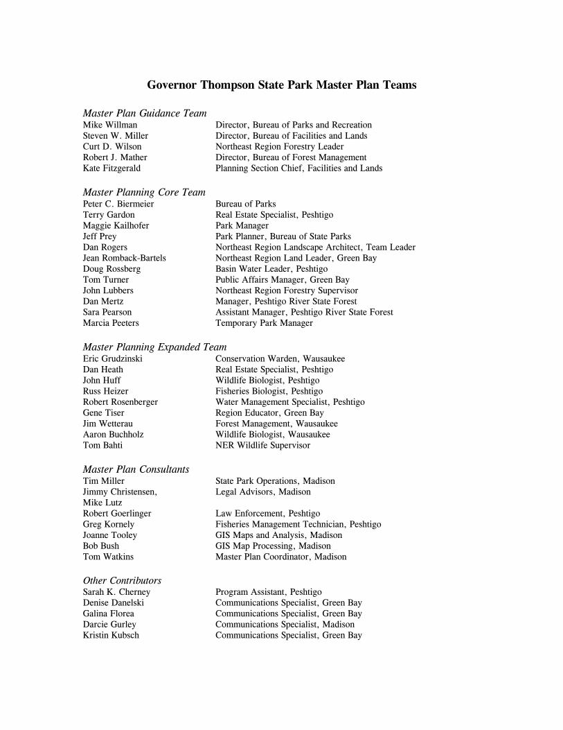
Governor Thompson State Park Master Plan Teams
Master Plan Guidance TeamMike Willman Director, Bureau of Parks and RecreationSteven W. Miller Director, Bureau of Facilities and LandsCurt D. Wilson Northeast Region Forestry LeaderRobert J. Mather Director, Bureau of Forest ManagementKate Fitzgerald Planning Section Chief, Facilities and Lands
Master Planning Core TeamPeter C. Biermeier Bureau of ParksTerry Gardon Real Estate Specialist, PeshtigoMaggie Kailhofer Park ManagerJeff Prey Park Planner, Bureau of State ParksDan Rogers Northeast Region Landscape Architect, Team LeaderJean Romback-Bartels Northeast Region Land Leader, Green BayDoug Rossberg Basin Water Leader, PeshtigoTom Turner Public Affairs Manager, Green BayJohn Lubbers Northeast Region Forestry SupervisorDan Mertz Manager, Peshtigo River State ForestSara Pearson Assistant Manager, Peshtigo River State ForestMarcia Peeters Temporary Park Manager
Master Planning Expanded TeamEric Grudzinski Conservation Warden, WausaukeeDan Heath Real Estate Specialist, PeshtigoJohn Huff Wildlife Biologist, PeshtigoRuss Heizer Fisheries Biologist, PeshtigoRobert Rosenberger Water Management Specialist, PeshtigoGene Tiser Region Educator, Green BayJim Wetterau Forest Management, WausaukeeAaron Buchholz Wildlife Biologist, WausaukeeTom Bahti NER Wildlife Supervisor
Master Plan ConsultantsTim Miller State Park Operations, MadisonJimmy Christensen, Legal Advisors, MadisonMike Lutz Robert Goerlinger Law Enforcement, PeshtigoGreg Kornely Fisheries Management Technician, PeshtigoJoanne Tooley GIS Maps and Analysis, MadisonBob Bush GIS Map Processing, MadisonTom Watkins Master Plan Coordinator, Madison
Other ContributorsSarah K. Cherney Program Assistant, PeshtigoDenise Danelski Communications Specialist, Green BayGalina Florea Communications Specialist, Green BayDarcie Gurley Communications Specialist, MadisonKristin Kubsch Communications Specialist, Green Bay

2
AcknowledgmentsThe Governor Thompson State Park Master Plan Team thanks the Upper Green Bay BasinPartners, many private citizens, local officials, and organizations who assisted in thecreation of this plan. This document reflects the work of every individual who attendedmeetings, called, e-mailed or wrote comments. It is apparent from the positive response wereceived from the very beginning of the planning process that the public values this newstate park as an enrichment of the quality of life in Northeast Wisconsin.

3
TABLE OF CONTENTS
INTRODUCTION AND EXECUTIVE SUMMARY ...........................................5CHAPTER TWO: PROPOSED MANAGEMENT, DEVELOPMENT, AND USE......9
VISION .................................................................................................9MANAGEMENT GOALS ..........................................................................9LAND MANAGEMENT CLASSIFICATIONS....................................................................... 10PROPOSED RECREATION, DEVELOPMENT, AND MANAGEMENT .............. 11OTHER PARK FACILITIES ..................................................................... 19SUMMARY OF RECREATION DEVELOPMENT AND MANAGEMENT ........... 21PROPOSED VEGETATIVE MANAGEMENT ............................................... 22PROPOSED PARK BOUNDARY EXPANSION ............................................. 27
CHAPTER THREE: SUPPORTING OR BACKGROUND INFORMATION.......... 35SUMMARY OF ECOLOGICAL RESOURCES .............................................. 35CULTURAL RESOURCES....................................................................... 41SUMMARY OF RECREATIONAL RESOURCES........................................... 41RECREATIONAL TRENDS ..................................................................... 44
CHAPTER FOUR: ASSESSMENT OF THE ENVIRONMENTAL IMPACTS OFTHE PROPOSED MASTER PLAN .............................................................. 47CHAPTER FIVE: ALTERNATIVES AND THEIRENVIRONMENTAL IMPACTS .................................................................. 65
RECREATION MANAGEMENT ALTERNATIVES........................................ 65HUNTING ALTERNATIVES.................................................................... 67VEGETATION MANAGEMENT ALTERNATIVES........................................ 68REAL ESTATE AND BOUNDARY ALTERNATIVES .................................... 69OTHER MANAGEMENT ALTERNATIVES CONSIDERED............................. 70COMPLIANCE WITH THE WISCONSIN ENVIRONMENTAL POLICY ACT ...... 72
CHAPTER SIX: SUMMARY OF PUBLIC INVOLVEMENT............................. 75CHRONOLOGY OF PUBLIC INVOLVEMENT ACTIVITIES ........................... 75BIBLIOGRAPHY / REFERENCES ............................................................. 77
DEFINITIONS AND ABBREVIATIONS ....................................................... 79
TABLESTable 2-1: NR 44 Land Management Classifications for each Management ZoneTable 2-2: Summary of Proposed Camping FacilitiesTable 2-3: Summary of Proposed Trail Mileages and Development LevelsTable 2-4: Summary of Other Recreational DevelopmentTable 3-1: Vegetative Cover Type - AcresTable 3-2: Regional Snowmobile Mileages

4
MAPSMap A: Regional Location Map B: Proposed Recreation Development and Management ZonesMap C: Proposed Vegetative Management and Use ZonesMap D: Current Vegetative CoverMap E: Existing Wetlands

5
CHAPTER ONE
INTRODUCTION AND EXECUTIVE SUMMARY
The Year 2000 was celebrated as the 100th Anniversary of the creation of Wisconsin’sState Park System. To commemorate this Centennial, the Department of Natural Resourcesacquired 1,987 acres of land comprising Paust’s Woods Lake Resort, plus about 200 acresof adjacent land fronting on Caldron Falls Reservoir from Wisconsin Public ServiceCorporation (WPS). Together, these two properties formed the core of the new GovernorThompson State Park. Woods Lake Resort was a popular family-oriented establishment thathad been operated by the Paust family for three generations. The estimated 200-acreCaldron Falls Reservoir property acquired from WPS was part of land holdings associatedwith hydroelectric power generation at the Caldron Falls Dam on the Peshtigo River. Anexisting WPS boat landing (#13) was included in this acquisition. Since the establishment ofGovernor Thompson State Park, three additional tracts of land have been purchased andadded to the park. This brings the current park acreage to 2,415 acres.
Governor Thompson State Park (GTSP) is located in central Marinette County, west of theVillage of Crivitz, Wisconsin and about 60 miles north of Green Bay. The property ispartially located on the Caldron Falls Reservoir (with about 6 miles of shoreline) and isadjacent to the Peshtigo River State Forest. They share two sections of common boundaryadjacent to Caldron Falls Reservoir—one area on the east and one on the west. See Map A- Regional Location map - for an overview.
Summary of Management, Development, and Use
The master plan sets the pattern for overall management and development of the park. It isthe product of public participation, parks program input, site resource data and BasinPartner input.
Governor Thompson State Park will be developed to provide opportunities for publicrecreation and education in a rustic, forested setting. The park and its resources will bemanaged to provide a broad range of ecological, cultural, social, and economic benefitswithin its capabilities. The generally undeveloped and scenic character of the shorelines andforested uplands will provide the state park an atmosphere of solitude, reflection, andlearning while promoting traditional state park recreational activities within the capabilitiesof the natural resources of the site. Both day-use activities and overnight camping will beprovided.

Chapter 1: Introduction and Executive Summary
6
Development includes a modern 100-site campground, rustic walk-in campsites alongCaldron Falls Reservoir, an indoor group camp, and an outdoor group camp. Over 20miles of trails will include hiking, cross-county skiing, bicycling and snowmobiling. Inaddition, the existing boat landing will be improved to provide better access to thereservoir, and the adjacent bays within the park will be designated as a slow-no-wake areato provide a quiet-water experience for non-motorized boaters and shoreline visitors.
Two day-use areas will be developed: one at Woods Lake and one at Huber Lake. Twosmall swimming areas will be provided: one at the Woods Lake Day Use Area and one onCaldron Falls Reservoir. The recreational facilities will include some modernconveniences, but the appearance of park structures and facilities will have an informal"Northwoods” style. To provide for the long-term protection of key park resources and to allow for improveddelivery of recreational opportunities, the park boundary will be expanded by about 1,720acres of fee title land and/or easements. This will bring the proposed park boundary to4,135 acres. Additionally, part of the Peshtigo River State Forest along the reservoiradjacent to the park will be included within the state park (see Map B).
The Peshtigo River State Forest shares a boundary and many management and use issueswith GTSP. A master plan will be developed for the Peshtigo River State Forest afterresource inventories and other data assessments are completed. The draft goals have beenprepared for the state forest plan. They call for closely integrated management of bothproperties—especially recreational opportunities; as a result, the recreational options forpark visitors will ultimately extend far beyond the park boundaries. For example, since thepark does not have the space necessary to provide a high-quality horse trail network, thestate forest will be the primary provider of horse riding opportunities, with some trailspotentially extending into or through the park.
The park’s vegetation will be managed to provide an appropriate balance among existingtimber types, with some areas of pine barrens/oak barrens restored for educationalpurposes. Special emphasis will be placed on maximizing the health and vigor of the redoak stands growing on sandy soils to protect against pests like the gypsy moth and foresttent caterpillar. Long-lived trees, like white pine, will be encouraged as a forest componentand, on good sites, managed for older, larger trees.
The planning of Governor Thompson State Park has generated much public interest, bothlocal and statewide. Citizen participation is a strong component of state master planning asdefined by administrative code NR 44. Numerous public meetings, open houses, newspaperarticles, and mailings have enabled the public to participate in this planning process.Newsletters, meeting announcements, and progress reports were periodically sent to thoseon the over 1,300-entry mailing list as well as posted on the DNR’s master planning website. Chapter Six contains a more detailed summary and chronology of the publicinvolvement component of the master planning effort.

Chapter 1: Introduction and Executive Summary
7
In current dollars, it is estimated that development of the park will be $4.9 million, with anadditional $3.04 million for added land acquisitions.
Park Resources
GTSP is approximately one-half uplands and one-half wetlands (See Maps D and E). Themajority of the site is forested. The single most prevalent forest type (38%) is aspen, someof which is on lowland or wet sites and some on higher ground. The other major forest typeis oak. Of the oaks, two-thirds is commonly known as scrub oak, and one third is red oak.Most of the oak occurs on sandy, dry sites. Swamp hardwoods, jack pine, swamp coniferscedar, and red pine make up the balance of the forest types. A significant amount ofyounger white pine exists on the site but as a minority component of other stands. Ageneralized vegetation map is attached to the master plan, showing the locations of thevarious timber stands.
Summary of EA
An Environmental Assessment has been prepared as a part of the draft master plan forGovernor Thompson State Park. It addresses potential impacts of actions in the masterplan, ranging from land acquisition and facility development to management and operationof the park. The Environmental Assessment concludes that the implementation of themaster plan would provide positive recreational, ecological, social, and economic benefitsto the region. It further concludes that an Environmental Impact Statement (EIS) process isnot required.

8

9
CHAPTER TWO
MANAGEMENT, DEVELOPMENT, AND USE
Designated property name: Governor Thompson State Park
Property designation: State Park
Statutory authority: Chapter 27, Wis. Stats.
Acreage goal: 4,135 acres
VISION
Governor Thompson State Park provides opportunities for public recreation and educationin a rustic, forested setting. The park and its resources are managed for present and futuregenerations to provide a broad range of ecological, cultural, social, and economic benefitswithin its capabilities. The generally undeveloped and scenic character of the shorelines andforested uplands provide the state park an atmosphere of solitude, reflection, and learningwhile promoting the continued tradition of a statewide system of parks and open spaces.The park provides the best possible service to park visitors and its partners.
MANAGEMENT GOALS
1. Provide and maintain a variety of high-quality native communities and habitats withinthe ecological capabilities of the site for public enjoyment, education, and ecologicalbenefits.
2. Identify and protect rare, threatened, and endangered species and areas of geological,archaeological, and cultural significance.
3. Manage shoreline zones for a natural appearance and the protection and enhancement ofaquatic resources.
4. Provide a variety of seasonal and year-round camping opportunities in partnership withnearby public and private campgrounds.

Chapter 2: Management, Development, and Use
10
5. Provide a range of seasonal and year-round non-motorized recreational opportunitiesthat preserve the atmosphere of solitude, reflection, and learning, in facilities rangingfrom primitive to comfortable, rustic-styled modern.
6. Establish compatible, mutually supportive programs and infrastructure with thePeshtigo River State Forest and other partners for resource protection, education, andrecreation management.
7. Provide recreational access to Caldron Falls Reservoir, Woods Lake, and Huber Lake.
8. Prevent or minimize conflict among different types of recreational uses and amongvarious types of park uses and park management activities.
9. Acquire additional land for reasons of resource protection, critical development needs,access, boundary protection, boundary continuity, or protection from non-compatibleuses.
10. Limit overall park development to no more than 15% of the total area.
11. Manage the deer herd on the property when necessary by controlled hunting methods.
LAND MANAGEMENT CLASSIFICATIONS
The park is divided into designated management zones according to the primarymanagement or use focus for the area. The management zones are shown on Maps B andC. Each zone is assigned a land management classification according to Chapter NR 44.06of the Wisconsin Administrative Code. Each zone’s classification is shown below in Table2-1. The specific management and development for each zone are detailed in the followingpages.
TABLE 2-1: NR 44 Land Management Classifications for Each Management Zone
Park Management Zone Land Management ClassRecreational UseSetting Class
Camping ZoneWoods Lake Day Use Zone
Recreation Management Area Type IV
Huber Lake Day Use ZoneActive Recreation Area Zone
Recreation Management Area Type III
Caldron Falls Reservoir Shoreland ZoneHuber Lake/Woods Lake Scenic Zone
Scenic Resources Management Area Type III
Visitor Services Zone Special Management Area - Service andAdministration
NA
Operations Services Zone Special Management Area - Service andAdministration
NA
Native Community Management Zone Native Community Management Area NA

Chapter 2: Management, Development, and Use
11
RECREATION, DEVELOPMENT, AND MANAGEMENT
Governor Thompson State Park will be developed to provide a wide variety ofopportunities for public recreation and education in a rustic, forested setting. Therecreational opportunities planned for the park include camping (primitive to modern), day-use activities like picnicking and fishing (easily accessible to remote), a variety of trails—including a network of paved bike paths—and a well-developed nature interpretation /education program. The recreation plan offers access to two small, non-motorized lakes inthe park as well as access to the Caldron Falls Reservoir. While many recreational facilitieswill include some modern conveniences, park facilities will have an informal"Northwoods” style.
The majority of the park, at least 85 percent, will be maintained in a relatively natural,undeveloped condition, with only trails and other “dispersed,” lower density types ofrecreational uses there. Campgrounds, picnic areas, playgrounds, and other intensive useareas are clustered into specific locations. The approximate future location of allrecreational facilities is shown on Map B.
The recreational opportunities to be provided and facility developments are discussed belowfor each management zone.
Camping Zone
The camping zone is a primary intensive use and development area offering a variety ofcamping and associated facilities. Recreation Management – Type IV Setting is the zone’sland management classification.
Zone Objectives 1. Provide up to 110 individual camping sites for both rustic and modern styles of family
camping, and separate rustic-style indoor and outdoor camping experiences fororganized camping groups.
2. Provide an active play area for children in a natural-appearing, safe setting inproximity to the family campground.
3. Provide a venue for interpretive programs along with regional entertainment acts forcampers and other park visitors.
The primary facilities to be constructed within the camping zone are a modern familycampground, a rustic outdoor group camp, a camp area for touring bicyclists and long-distance hikers, an indoor group camp, a playground, and an amphitheater. They aredetailed below. The main emphasis is on providing a safe, harmonious campingenvironment that ranges from year-round rustic facilities to modern facilities. See Map Bfor locations of the campgrounds/campsites.

Chapter 2: Management, Development, and Use
12
Oak View Modern Family Campground A 100-unit modern campground will be built near the northern edge of the property. TheNR 44 Development Class of this campground is Type IV-Modern.
The following developments are planned for this site: One flush toilet/shower building; Six vault toilets; RV dump station; Fish-cleaning station near the RV dump station; Thirty electrical sites would be grouped in a separate loop from non-electrified sites; Pressurized drinking water; Hand water pumps; ADA cabin for handicapped use, 1,000 GSF in size that has all doors, slopes, and
furnishings designed to comply with ADA standards. Running water, electricity, heatand air conditioning are standard features.
One open area that would provide camping opportunities for long-distance hikers andtouring bicyclists.
Playground Area One adventure playground 60' x 60' will be built next to the Oak View moderncampground.
The following facilities are planned for this site: A 60' x 60' cleared area; Artificial, but natural-appearing, rock structures up to 7 feet tall with features for
children to crawl and slide around on; Sandbox; Drinking water.
A portion of the play equipment and their base materials will accommodate children withdisabilities in accordance with ADA requirements.
Outdoor Theater/Amphitheater An outdoor theater/amphitheater will be built near the Oak View modern campground.
The following facilities are planned for this site: Wooden stages of various sizes connected to form a total platform size of 20' x 40'; Seating for up to 75 people; Vault toilets 2’x2’ design, one set; Lighting for night program entertainment; Parking lot - 30 spaces.
Chapter 2: Management, Development, and Use
13
Northern Lights Outdoor Group Campground An outdoor group camp area will be built where several separate organized camping groupscan be accommodated. It will consist of up to 5 sites (Up to 150-person total capacity) andwill be created to the south of the main road near the family modern campground. NR 44Development Class for the group campground is Type IV - Modern.
The following facilities are planned: Drinking water; Three sets of combined (2M+2W) vault toilets; Two electrical sites with one outlet at each site; Fire rings; Picnic tables; One open-sided picnic shelter.
North Woods Lake Indoor Group CampgroundTwo indoor group camp buildings will be placed on the northwest edge of Woods Lake toprovide indoor group camping. No electricity will be provided at either building.
The following facilities are planned: One building with a capacity of 12 persons; One building with a capacity of 16 persons; Drinking water; Vault toilets; Heat from a code-compliant heating device; A gravel parking area - 14 spaces; Lightly developed gravel access road; Fire rings; 12' x 20' open shelter with fireplace for cooking/group functions.
Woods Lake Day Use Zone
The Woods Lake Day Use Zone extends along the western shoreline of Woods Lake asshown in Map B. This area is classified as Recreation Management Area – Type IVSetting.
Zone Objectives 1. Within the Woods Lake Day Use Area, provide picnicking, general relaxation, non-
motorized water access for fishing, sightseeing and nature study and similar day-userecreational opportunities for all park visitors.
2. Maintain and enhance a generally natural-appearing shoreline, particularly the horizonline view of the day use area as seen from the lake.
3. Manage the fishery of Woods Lake for largemouth bass, northern pike, and panfish.Monitor fish populations to determine if any regulations are warranted.

Chapter 2: Management, Development, and Use
14
This will be a rustic day use area having a design capacity of 200 persons. The area will beADA accessible. A natural-appearing shoreline will be promoted within the area throughthe design of the facilities and use of native vegetation for screening and visualenhancement. Most development will be sited 75 feet or more away from the shoreline ofWoods Lake. A small low-key swimming beach will be reestablished in an area formerlyused for this purpose. No motors of any type will be allowed on Woods Lake.
The following facilities are planned at this site: Access road – 1/8 mile; Parking – 75 spaces, with expansion for up to 75 additional spaces; Shelter with electricity – 24’x 54’ low pitch laminated; Vault toilets 2’ x 2’ design, one set; Drinking water supply – accessible drinking fountains (3); Swimming Beach – 150’; Non-motorized watercraft drop-in site; Interpretive kiosk / displays; Accessible fishing pier – 6’x 75’.
Huber Lake Day Use Zone
Zone Objectives1. Provide opportunities for quiet, low-impact day-use recreational activities and solitude
in a somewhat remote location with simple facilities.2. Manage Huber Lake to provide a sustainable fishery. Investigate and monitor fish
populations to determine if any special regulations are warranted. Development within this area will be minimal to preserve the natural characteristics ofHuber Lake. Access to the area and lake will be by foot or bicycle via a 1/2-mile pathfrom a small trailhead parking lot. No motors of any type will be allowed on Huber Lakefrom the park. This zone is designated as a Recreation Management Area – Type IIISetting.
The following facilities are planned for this site: Remote parking at the trailhead- 30 spaces; Lightly to moderately developed internal paths and walks - 3/4 mile; Picnic sites – 3 individual, dispersed sites with picnic tables; Interpretive displays; Vault toilets 2’ x 2’ design, one set; Accessible fishing facility (not necessarily a pier); Non-motorized watercraft drop-in site; Open shelter - 12' x 20'.

Chapter 2: Management, Development, and Use
15
Caldron Falls Reservoir Shoreland Zone
The Caldron Falls Reservoir Shoreland Zone extends 200 feet inland, parallel to theshoreline of Caldron Falls as shown on Map B. The land management classification isScenic Management Area – Type III Setting.
Zone Objectives1. Provide access to Caldron Falls Reservoir for motorized and non-motorized boating,
shore fishing, and viewing of the reservoir. 2. Provide a primitive, remote camping experience to enjoy the scenic vistas and
undeveloped shorelines of Caldron Falls Reservoir.3. Provide for a quiet water experience for boaters and visitors on or near the reservoir’s
bays within the park, and protect the park shoreline from erosion from boat wakes.
Reservoir AccessImprovements will be made to the existing gravel pad boat launch on Caldron Falls. Thefollowing facilities are planned for this site: Two 12' x 30' concrete boat launch lanes; Parking for up to 50 cars and trailers; 8' x 20' long wooden floating pier; 5’ x 12' long wooden pier for accessible shore fishing and canoe/kayak launching; Vault toilets 2’ x 2’ design, one set;
A fish-cleaning station, while related to the boat landing, will be located adjacent to thetravel trailer sanitary station to take advantage of available electricity, water supply, andwastewater disposal facilities necessary to support a fish-cleaning station.
Reservoir Swimming AreaA small swimming area with up to 200 feet of sandy beach will be established on CaldronFalls Reservoir. The location likely will be to the west of the boat landing at a distance ofapproximately ¼ mile. A slight variation in location may occur to achieve optimumconditions. This site will allow the additional access to the Reservoir beyond the boataccess site. Clearing and site preparation – 2 acres maximum; Access road, about ¼ mile, lightly to moderately developed; Parking for 20 cars, plus future expansion for 20 more; Sand blanket; Swimming area markers and signage.
Vista Points Two scenic vista sites are planned upon the shoreline of Caldron Falls Reservoir. Thesevistas will offer expansive views of the reservoir.
Chapter 2: Management, Development, and Use
16
The following facilities are planned for each site: Wooden bench; Trail signage; Interpretive display.
Remote Camping Three walk-in, primitive, well-dispersed campsites will be developed proximal to thewater’s edge on Caldrons Falls Reservoir. No drinking water or electricity will beavailable at these sites. Campsites will be accessed only on foot on a primitive-to-lightly-developed trail.
The following developments will be provided for each campsite: Tent pad; Box toilet; Fire ring; Picnic table; Animal-proof food box.
It is also recommended that the Peshtigo River State Forest master plan consider placingmore walk-in camping sites along Caldron Falls Reservoir that would connect to the parkvia a network of trails.
No-Wake AreaA slow-no-wake area is planned in the park bays of Caldron Falls Reservoir (see Map B).This will enhance “quiet water” non-motor boating in the near-park bays and reduceshoreline erosion. The no-wake area will be entirely within the Governor Thompson StatePark, with NR 45 authority to manage recreational boating within the designated area.
Active Recreation Zone
The Active Recreation Zone encompasses the majority of the park. It is primarily an areafor dispersed recreation—activities such as hiking, biking, or bird watching—and does nothave high-intensity facility development and use, like the camping zone. This zone isclassified as Recreation Management Area – Type III Setting.
Zone Objectives1. Provide for a variety of trail uses within the park, including biking, hiking, cross-
country skiing, and nature interpretation/education, and provide for a connectorsnowmobile route for the Ranch Road trail.
2. Provide a rustic-style indoor camping experience for organized camping groups.

Chapter 2: Management, Development, and Use
17
3. Provide an opportunity to experience a vista or other scenic features such as theCaldron Falls Reservoir from an elevated vantage point.
TrailsWhile trails pass through most management zones within the park, they are the primaryrecreational feature of the Active Recreation Area Zone. The planned trail network isshown on Map B.
Bike TrailObjective: Provide opportunities for family biking on a non-road travel route that connectsmost developed facilities within the park.
Approximately 5 miles of fully developed bike trail will be created to act as a backbone toconnect most facilities within the park. This bike trail will have a paved or crushedlimestone surface and a minimum tread width of 8 feet. It will be separated from roadswhere possible. This bike trail will also provide entrance/exit points to Boat Landing 13Road, Caldron Falls Road, and Ranch Road.
Nature TrailObjective: Provide opportunities for nature interpretation/education programs with anADA accessible trail.
Approximately a 1/2 mile of fully developed nature trail from the nature center will becreated. This trail will go near Woods Lake in a looped fashion with interpretive displaysand signage. This trail would be ADA accessible.
Hiking and Cross-Country Ski TrailsObjective: Provide opportunities for hiking and groomed cross-country ski recreationwithin a looped trail system.
Approximately 10.75 miles of hiking and cross-country ski trails will be created. Thesewill be lightly developed trails. Winter use will consist of groomed cross-country ski trailson 8 miles of trail. Where feasible, connections will be made to the state forest that mayincrease the mileage of these trails. Two main trailheads will be established. The first willbe at the Woods Lake parking area in which trail signs, maps, and parking will beavailable. The second will be within the park at the terminus of the main road. Thistrailhead will have parking for up to 50 vehicles, drinking water, and vault-type toilets. Akiosk will be placed near the trailhead junction that will provide trails information.
Pass-Through Snowmobile TrailObjective: Provide non-road passage for snowmobiles within the park boundaries.
Chapter 2: Management, Development, and Use
18
A one-way pass-through snowmobile route will be established along the south boundary ofthe park. This trail will be a connector from Parkway Road to Caldron Falls Road. Thisconnector trail will be approximately 2.75 miles long. As lands are acquired along thesouth boundary of the park, this trail may move to the new southern boundary, if feasible.The trail will be developed and maintained as a lightly developed trail.
The specific alignment of such a trail will be determined on site by DNR staff and must belocated to prevent conflicts with other winter uses. When a pass-through route isdesignated, a land use agreement will be negotiated between the DNR and the organizationresponsible for the trail. Upon relocation of the trail from Ranch Road, it is expected thatuse of the Ranch Road right-of-way as a snowmobile route will cease.
(Definition: A pass-through snowmobile trail provides passage through a property via aroute that creates the least amount of disruption, environmental impact, and user conflict.)
No ATVs will be allowed upon this trail, and the remainder of the property will be closedto motorized trail uses.
Equestrian UseBecause of the extremely sandy soils and extensive network of wetlands covering almosthalf of the acreage (see Map E) in the park, the amount of sustainable horse trail that couldbe developed is severely limited. Depending upon the outcome of the state forest plan,there could be up to 4 miles of lightly developed trail and a horse campground (Type IVRustic development level) within GTSP.
However, there is also a need to look at a regional equestrian trail network to see how thePeshtigo River State Forest, the park, and other properties can provide an integratedequestrian trail network. During master planning for the Peshtigo River State Forest, thedepartment will examine the state park plan for possible connections to the largerequestrian trail network. Attempts will be made to integrate an equestrian connector trail inGovernor Thompson State Park with the Peshtigo River State Forest equestrian trailsystem. This connector trail would not necessarily be a pass-through trail for the state parkbut could be a trailhead where, potentially, facilities could be developed for equestrian use.Alternatively, it could be a pass-through trail depending on the configuration of the stateforest trail. Shared use of part of the snowmobile pass-through trail in the park will also beinvestigated as a partial solution.
A camping facility for horses and riders may also be a part of this system. It could belocated either in Governor Thompson State Park or in the Peshtigo River State Forest. Theexact location for these equestrian facilities would be determined at the same time as thosein the Peshtigo River State Forest.
The desired objective is to provide the public with the best possible facility for horse-ridingand camping. However, horse-riding opportunities are now, and will be, availableimmediately in the Peshtigo River State Forest.

Chapter 2: Management, Development, and Use
19
Scenic Overlook TowerOne scenic overlook tower will be built on higher ground where a significant view will bepossible. The following facilities are planned for this site: Wooden observation tower up to 80' tall; A short walking path from the trailhead parking lot; Interpretive displays/signs on top of the tower.
Interpretation and Education Program
Within the Park System, interpretation is the process of helping each park visitor find anopportunity to connect personally with a place. Each individual may connect to the place ina different way. The goal of all interpretive services is to increase each visitor's enjoymentand understanding of the parks, and to allow visitors to care about the parks on their ownterms. Because state parks belong to all of us, the Park System has a responsibility toprotect this park for future generations. Understanding the park's importance to our naturaland cultural world is the first step toward this preservation.
The following facilities/displays will be developed: Nature trail (in Active Recreation Zone); Observation tower (in Active Recreation Zone); Display kiosks and signage at selected day use areas; Interpretive/education facility (described in the Visitor Service Zone section); Integration of the existing fire tower into the interpretive display that will allow a
visitor to interact with the fire lookout "cab" in an accessible fashion.
All of these developments will be outlined further in a park interpretative plan that will bedeveloped as part of the park operations. Recommended interpretive themes should includethe social and ecological significance of the historical fires, the unique geological,topographic, and ecological features in and near the park, and the history and importance ofthe Peshtigo River dams to the park and region.
OTHER PARK FACILITIES
Visitor Service Zone
Zone Objectives1. Provide park and forest administrative headquarters services, public contact point, and
information facility.2. Provide facilities to support the park interpretive program and serve park visitors
participating in interpretive program activities.

Chapter 2: Management, Development, and Use
20
The primary development within this zone will be a building housing the Park EntranceVisitor Station (PEVS) with administrative offices, and a public interpretation/educationcenter. This zone is designated as a Special Management – Service and AdministrationArea. See Map B for locations of the planned facilities. Each is detailed below:
PEVS (Park Entrance Visitor Station) A PEVS will be integrated with the Peshtigo River State Forest Headquarters to provide aunified office space with the Governor Thompson State Park staff. The following facilitiesare planned for the PEVS portion of this site: Up to 3,500-SF office/administrative space combining both state park and state forest
staff; Visitor contact counters, displays, and exhibits; Drive-up window; Two modern public unisex restrooms; Paved parking - 12 40’ pull-through spaces; Interpretive Center – 1,200 SF, office, workshop, classroom.
Interpretation Center An interpretive/education facility will be incorporated into or attached to the PEVS buildingfor easy visitor access and use. This facility will consist of 1,200 SF of building space thatwill contain an interpreter's office, small workshop, and a room for presentations.
Operations Services Zone
Zone Objectives Provide facilities for maintenance and repair of equipment and storage of materials andequipment and office space for park and forest support staff.
The combined Park and Forest Shop/Storage Building will serve the maintenance andoperation needs of both Governor Thompson State Park and Peshtigo River State Forest.This facility will not be open to the general public. The zone is classified as a SpecialManagement – Service and Administration Area. This area will be closed to general publicuse.
The following facilities are planned for this site: 4,000 SF of indoor storage space; Office space; Break room; One set of modern restrooms.

Chapter 2: Management, Development, and Use
21
SUMMARY OF RECREATION DEVELOPMENT ANDMANAGEMENT
Listed below in Tables 2-2, 2-3 and 2-4 are summaries of the major developments plannedwithin the park. Overall, it is estimated that approximately 11% of the park will bedeveloped for recreational uses.
TABLE 2-2: Summary of Planned Camping Facilities
Camping Facility Non-electric Electric NR 44 Classification
North Woods Lake Indoor GroupCampground – Two Buildings
2 0 Type III
Northern Lights Outdoor GroupCampground
3 2 Type IV - Modern
Oak View Modern FamilyCampground
70 30 Type IV - Modern
Caldron Falls Reservoir Walk-inCampsites
3 0 Type III - Rustic
Total: 110 Sites 78 (72%) 32 (28%)
TABLE 2-3: Summary of Planned TrailMileages and Development Levels
Type Miles NR 44Classification
Snowmobile 2.75 Lightly DevelopedNature 0.5 Fully DevelopedBike 5.0 Fully DevelopedHike/Ski 10.75
Total 19.0
TABLE 2-4: Summary of OtherRecreational Development
Other Development
Woods Lake Day Use AreaHuber Lake Day Use AreaCaldron Falls Reservoir VistasCaldron Falls Reservoir Water/BoatAccessOutdoor Theater/AmphitheaterScenic Overlook TowerPark Entrance Visitor StationRoadsInterpretation Center
Chapter 2: Management, Development, and Use
22
VEGETATIVE MANAGEMENT
The vegetation on all land within the boundary of Governor Thompson State Park will bemanaged using prescriptions and techniques intended to produce specific results orconditions in fulfillment of the master plan Vision Statement and Goals. The main goalrelated to vegetative management is to “…provide and maintain a variety of high-qualitynative communities within the ecological capabilities of the site…” The key phrase“…within the ecological capabilities of the site…” is critical to understanding this proposedmanagement strategy. The number and diversity of communities or forest types will belimited to those that have a likelihood of occurring naturally on this site, given the existingconditions. All areas of the park will be managed—some actively and some passively—with a general trend toward a more mature forest.
Several areas of forest within the park will be managed with specific objectives that willrequire active management. Other areas will be managed passively, using the process ofnatural succession to influence the structure and composition of vegetative communities.Special vegetation management, including site clearing and replanting, will be required inand around public use areas and facilities.
Visitor Services Zone
Zone ObjectiveProvide an attractive public use setting using native trees and selective ornamentalplantings.
Plant materials native to the region and to local site conditions will be emphasized.However, plantings close to buildings or structures will be allowed more flexibility in theirorigins, and specialized nursery varieties of plant material may be used for specific effects.
Mature aspen exists within this zone, and some harvesting will take place with theconstruction of the new entrance ways. These harvesting zones will be defined oncedetailed site plans have been developed for this zone.
Operations Services Zone
The vegetation within the operations services zone will be managed as a utilitarianlandscape with native trees and minimal ornamental plantings. Native and specializednursery varieties of plants may be used.
Chapter 2: Management, Development, and Use
23
Camping Zone and Woods Lake Day Use Zone
Zone ObjectiveProvide an attractive, safe, and generally natural-appearing vegetative environment fordeveloped camping and day use activities.
Vegetative management in the Camping and Woods Lake day use zones will emphasizesafety and the continuous monitoring and removal of hazardous trees. In general, theexisting tree canopy in the immediate campground and day use area sites will remain as thedominant canopy type. No attempts will be made to establish or change the forest type in oraround these facilities merely for the purpose of having different trees to look at.However, the density and composition of vegetation in a designated camp area may bechanged for specific purposes, such as gaining better screening between campsites orincreasing the presence of longer-lived tree species. Harvesting, planting, herbicideapplication, and fire are techniques that may be used. The area will be monitored forhazard trees, and such trees will be removed. All tree removal will be done in ways thatminimize the visual and audible impacts to users of these areas.
An exception to the above is the area along the main park roadway. It is shown on Map C,the Mixed Forest Enhancement Area. The management of this area is described below inthe Active Recreation Zone in the section titled Park Road/Huber Lake Trail CorridorEnhancement.
Active Recreation Zone
Zone ObjectiveMaintain the majority of the forest within this management zone in a natural-appearingcondition, and in the long-term, establish a wide range of age classes and mature forestconditions.
Except for within the Aspen Maintenance Area and the Park Road/Huber Lake TrailCorridor Enhancement Area described below, natural process, including the naturalsuccession of forest types to a climax forest, will be allowed to predominate within thisarea. Black oak, northern pin oak, and red oak dominate the dry to dry-mesic uplands inthe park. The pre-settlement vegetation included oak savanna and pine-oak barrenscommunities that were maintained by frequent fire. In the absence of fire, these stands willnaturally succeed to a mixture of oak, white pine, and red maple. Passive management willpredominate here; active forest management, such as tree removal and brushing, will occurto establish and maintain roads, trails, and other facilities and, when appropriate, inresponse to major catastrophic disturbances. The decisions on how to respond aftercatastrophic events will be governed by the general policy for the park found in theOperations Policies section of this plan.
Chapter 2: Management, Development, and Use
24
Aspen Maintenance Area Within this area, the aspen timber type will be maintained in several age classes for foresthabitat diversity. The size of the proposed aspen maintenance area will be about 50 acres.Its approximate shape and location are shown on Map C; however, the exact shape andlocation of the management area will be determined in the field. Small patch cutting (viaclear-cutting multiple patches of 5 acres or fewer) will be done at intervals to regenerateand maintain aspen in several different age classes.
Maintaining an aspen component in the park will require periodic regeneration harvests at55-year intervals to establish well-stocked new stands via coppice regeneration. If standsare allowed to grow past maturity, they will slowly convert to red maple, white pine, blackcherry, and oak on these dry sites as the aspen falls out of the overstory due to old age.
Park Road/Huber Lake Trail Corridor Enhancement AreaTo meet shorter-term visual quality objectives, several areas along the main park road andthe Huber Lake trail corridor will have more active management. The primary foreststands along this corridor are oak and aspen, and the soils in these areas tend to be dry andnutrient poor.
Each of these special forest management areas is shown on Map C. Management for thesesites is described below.
Oak Management: For aesthetic reasons, red oak in two high-visibility areas flanking themain park roadway and Huber Lake trail will receive special management attention toencourage and maintain the health and vigor of these oak stands. Selective intermediatethinning of the oak will be done at about 15-to-20 year intervals to encourage andmaintain tree health and vigor. Gradually, over the long-term, these stands will be allowedto convert naturally to red maple or white pine, depending on site characteristics andunderstory tree species present. Harvesting activities will be done in ways and at times thatminimize the visual and audible impacts to park visitors
The size of the two oak management areas will total about 61 acres. Their approximateshapes and locations are shown on Map C; however, the exact shapes and locations of theoak management zones will be determined in the field.
Mixed Forest Enhancement: The two aspen-dominated sites along the corridor will bemanaged to gradually convert the aspen to more diverse, mixed forest stand having a strongcomponent of longer-lived tree species, such as white pine, red oak, or red maple. Measures to achieve this goal may include intermediate thinning by selective harvesting, aswell as supplemental plantings. Supplemental planting may be employed to encourage fasteror more thorough succession. Harvesting activities will be done in ways and at times thatminimize the visual and audible impacts to park visitors.
The size of these two management areas will be about 120 acres. Their approximate shapesand locations are shown on Map C; however, the exact shapes and locations will bedetermined in the field.

Chapter 2: Management, Development, and Use
25
Caldron Falls Reservoir Shoreland Zone and Huber Lake/Woods LakeScenic Zone
Zone Objective Maintain the forests within the Caldron Falls Reservoir Shoreland Zone and HuberLake/Woods Lake Scenic Zone in a natural-appearing condition, and, in the long-term,establish a wide range of age classes and areas with older forest habitat conditions,including den trees and dead and down coarse woody debris.
Natural process, including the natural succession of forest types to a climax forest, will beallowed to predominate within this area. Passive management will predominate here;active forest management, such as tree removal and brushing, will occur to develop andmaintain roads, trails, swimming areas, and other public use facilities or to remove hazardtrees near them and, where appropriate, in response to major catastrophic disturbances.The decisions on how to respond after catastrophic events will be governed by the generalpolicy for the park found in the Operations Policies section of this plan. Invasive exoticplants may be removed, and appropriate native trees or shrubs may be planted forlandscaping and ecosystem enhancement purposes.
Native Community Management Zones
There are two opportunities to manage for unique native communities within the park.These areas are shown on Map C. One is the fire-maintained pine-barrens community,which is now rare but historically was abundant in this area of the state. The other nativecommunity type is wild rice, which is uncommon in the area.
Barrens Management Area
Objective: Restore and maintain two sites as pine barrens communities, one of 20 acres andthe other of 16 acres, to provide biological diversity to the park landscape and to provideeducational opportunities for park visitors.
Prescribed burning is the primary means of establishing and perpetuating the barrens type.Selective cutting, herbicide application, and planting will also be permitted managementactivities. Initially, the 16-acre barrens site will be burned repeatedly— about every two-to-four years—to fully establish the desired mix of species. After the barrens isestablished, only a “maintenance” burn every seven-to-ten years will be done. The 20-acresite east of Woods Lake is already fairly typical barrens. One prescribed burn is plannednow to rejuvenate the barrens. Then, fire will be used at intervals of seven-to-ten years formaintenance. Field inspection will determine the actual fire frequency in both barrens sites.

Chapter 2: Management, Development, and Use
26
Wild Rice Management Area
Objective: Protect and maintain wild rice beds (Zizania palustris) on the eastern shore areaof Woods Lake.
The location of the wild rice bed is shown on Map C. This area will be protected fromphysical disturbance or damage, and environmental conditions that favor wild rice growthare to be preserved. Interpretive and restrictive signs may be posted in the area. Riceharvesting will not be allowed, except as part of an interpretive program.
General Vegetation Management Policies
Forest Pest and Disease ControlThe gypsy moth, forest tent caterpillar, and other forest infestations are a serious threat toforest resources in Marinette County and throughout Wisconsin. Continuous monitoringand appropriate treatment measures will take place as needed and feasible to protect theforest resources of the park. Oak wilt, two-lined chestnut borer, and gypsy moth arecommon stresses on these dry sites. The optimum strategy for controlling the spread ofthese outbreaks is to keep the forest growing in a thrifty condition through periodicimprovement thinnings, sanitation harvests, and trenching and herbicide applications.
Non-native PlantsVast expanses of bluegrass turf will be avoided. Open space grasslands, construction-disturbed sites, and road construction margins will be planted with prairie grass species orother native site-appropriate grasses and forbs. Grass mowing, if done at all, will beconfined to road margins and immediate areas around facilities. An exception to this ismowing in designated use areas where a shorter turf grass is more appropriate.
Trees and shrubs may be planted for specific reasons in the park. This will be primarily forornamental or practical reasons. Planting may be done to provide screening of an unwantedview or for increasing user privacy. Plantings may be done to provide a windbreak or forshade. This will happen primarily in designated use areas and adjacent to public facilities.Use of native plant materials endemic to the region of northeastern Wisconsin is planned.Example: black walnut and sycamore will not be planted in the park, even thoughspecimens can be found in northeast Wisconsin. Open fields will be kept in an opencondition unless specifically described otherwise in the master plan.
Pine PlantationsThree red pine plantations exist within the park, covering about 24 acres. They areembedded within several different management zones. The pine plantations will bemanaged as outlined below.

Chapter 2: Management, Development, and Use
27
Short-term objective: Manage for large-diameter pines and a more natural standappearance. Encourage or introduce other tree species as a component of the stand.
Long-term objective: Over a 50+ year period, this stand will naturally convert to moreshade-tolerant species such as red maple, white pine, oak, and ash, with each successiveharvest that allows more light to reach the forest floor.
Due to the nutrient-poor, xeric nature of the soils, supplemental planting may also be usedto enhance conversion to other species. Improvement thinnings will be made in theseplantations every seven-to-ten years, removing small-diameter and high-risk trees andpromoting the development of large-diameter trees.
PARK BOUNDARY EXPANSION
Governor Thompson State Park has a current approved acreage of about 2,415 acres. Thepark boundary will be expanded by about 1,720 acres. This will bring the park acreagegoal to about 4,135 acres. Included within this expansion are about 200 acres within thePeshtigo River State Forest boundary. The 200 acres lie to the northwest of the currentpark boundary on the Caldron Falls shoreline. This expansion will also increase theshoreline mileage from 3.5 to 6 miles
The expanded park boundary is shown on Map B. If these additional lands are acquired,they will provide permanent protection to important park resources, buffer fromincompatible uses, provide access control or clearer boundary lines, and provide space forfuture recreational facility development. All land will be acquired only from willing sellersat fair market value.
There are six areas of planned acquisition shown on the master plan map. Each is describedbelow according to its location and main features for easy reference. Each area has aspecific purpose for its inclusion in the state park boundary. These additions total 1,720acres.
1. Huber Lake AdditionSize: About 280 acresPurpose: Acquire balance of shoreline frontage on Huber Lake. Also buffer HuberLake from encroachment by development or other non-compatible use.
2. Handsaw Creek AdditionSize: About 840 acresPurpose: Protect headwater and watershed areas of Handsaw Creek, a Class I TroutStream. All land in this addition drains into Handsaw Creek. Also provide expandedtrail development opportunities.
3. Woods Lake Outlet Addition (Includes lots on Parkway Rd.)Size: About 246 acres

Chapter 2: Management, Development, and Use
28
Purpose: Acquire frontage on Woods Lake and protect the outlet stream of WoodsLake. Protect areas of native wild rice beds on Woods Lake. Provide additional uplandfor potential future trail development linked with Peshtigo River State Forest.
4. The “L” AdditionSize: About 120 acresPurpose: Acquire frontage on Woods Lake. Acquire wetland and bogs areas associatedwith Woods Lake. Protect areas of native wild rice beds on Woods Lake. Provideadditional upland for potential future trail development linked with Peshtigo River StateForest.
5. Fabian Lane AdditionSize: 33.7 acresPurpose: Protect a wetland feeder to Spring Creek, a stream that flows into WoodsLake. Acquisition will also prevent development along the borders of the wetland onthe south side of Fabian Lane. Acquisition will also provide buffering for the moderncampground planned for a nearby site.
6. Boundary Adjustment between the Park and State Forest Approximately 200 acres of land designated as Peshtigo River State Forest lying to thenorthwest of the current park boundary on the Caldron Falls shoreline are to beincluded within the park. This area is shown on Map B. This land redesignation willprovide sites for the development of walk-in camp areas and vistas as described in theRecreation Management section. This will also simplify the park boundary andeliminate potential public uncertainty about hunting regulations.
Land Acquisition Policies
All property purchases are on a willing seller basis. The Department is required by statelaw and federal laws to pay “just compensation,” which is the estimated market value basedon an appraisal by a certified licensed appraiser. At times, it is in the interest of theDepartment and the landowner for the Department to acquire partial rights to a property:an easement. The Department has a number of easement alternatives available to addressthese situations.
Landowners within the state park boundary will be contacted periodically by Departmentstaff to explain the Department’s land acquisition program and to see if they have aninterest in selling their property.
Aid in Lieu of Taxes
For all new properties purchased, the Department makes an annual payment in lieu of realestate taxes to replace property taxes that would have been paid if the property had

Chapter 2: Management, Development, and Use
29
remained in private ownership. The payment is made to the local taxing authority wherethe property is located. More detailed information on how the Department pays propertytaxes may be found in a publication titled Public Land Property Taxes, PUB-LF-001.
Operations and Administration
Existing FacilitiesAll existing facilities used for operations and administration are located in the Operationsand Visitor Services Zone.
Existing Other Non-Public BuildingsWhen these buildings are no longer needed for Department use, they will be removed bypublic sale or by contractor, and the site will be reclaimed. Reclamation will include thefollowing:
If present, the septic tank and absorption field and all related materials and equipment willbe removed. All concrete and demolition debris will be removed and the excavationbackfilled with appropriate material. The ground will be graded to a natural-appearingcontour and topsoil and seed applied. The park manager will establish a timetable for theseactivities.
Temporary Residential Rental Building (The Duplex – Nighthawk and Whippoorwill) DNR #6717: This building is temporarily being used as an employee-housing rental. Uponcompletion of the Woods Lake Day Use Area, it will be removed.
Residential Rental Building (Forest View) DNR # 6718: This building is presently unused.Upon completion of the Woods Lake Day Use Area, it will be removed.
Residential Rental Building (Ma’s House) DNR # 6705: This building is presently beingutilized as an employee-housing rental, to provide on-site presence of a park manager. Thebuilding has been used for this purpose since the park was established. The use of thisstructure for employee housing will be continued with rental and responsibility agreementsuntil the major park development is completed and the Woods Lake Day Use Area iscompleted. Then it will be removed.
Temporary Park Office – DNR # 6694J: This building—the former dining hall and WoodsLake Resort office—is presently being utilized as a temporary Governor Thompson StatePark manager’s office. It also serves as the temporary headquarters for the Peshtigo RiverState Forest management staff. The use of this building will continue until the permanentPark Entrance Visitor Station is constructed. Then it will be removed.
Temporary Workshop DNR # 6706: This 24’x 40’ steel building has been repaired andmade usable as a temporary workshop for minor carpentry projects and brush painting. It

Chapter 2: Management, Development, and Use
30
will continue to be utilized for this purpose until the permanent Shop/Storage building isconstructed. Then it will be removed.
Temporary Vehicle Storage Building DNR # 6708: This wooden frame constructionbuilding is currently utilized as a storage garage for park and forest vehicles and otherstate-owned equipment. It will continue to be utilized for this purpose until the permanentShop/Storage Building is constructed. Then it will be removed.
Miscellaneous Small Buildings DNR # 6719 – Open Storage Shed, DNR # 6723 –Woodshed, DNR # 6724 – Garden Shed, DNR # 6851 – Garden Shed: These buildings willbe retained and used for park purposes, primarily storage of materials or small equipment.Some are small enough to be moved to different locations on the property, if necessary.
Road Development and ManagementThe main public entrance road and main internal park roads will be permanent two-way,all-season roads designated as NR 44 moderately developed. Design speeds will be 25 mphor less on these three miles of road.
Other use area roads and access drives will be permanent seasonal or permanent year-round single- and occasionally two-lane roads. Examples are internal campground roadsand access drives from the main park road. These roads are classified as NR 44 lightlydeveloped with design speeds of 15 mph or less on about 3.25 miles of these road types.
See Map B for locations of the proposed roads.
Entrance Road: Governor Thompson State Park will have a single entrance from the southoff of Ranch Road. The new entrance road alignment will be changed from an existing road(Paust Lane) to avoid paralleling the nearby high-voltage line and provide more visualinterest. The entrance road will be a two-lane, all-season road.
Abandonment of Town Road (Paust Lane): When permanent park development takes place,Paust Lane will no longer be needed as a park road. The Department will petition theStephenson Town Board for abandonment of the right-of-way. Road materials will beremoved and the roadbed rehabilitated to a natural condition with topsoil and seed.
Partial Abandonment of Boat Landing 13 Road: When the boat landing along Caldron Fallsis upgraded or when development of the Oak View Family campground has started, theDepartment shall petition the Stephenson Town of Board for abandonment of the right ofway within the park boundary. Road materials will be removed and the roadbedrehabilitated to a natural condition with topsoil and seed. Access to the boat landing will beavailable only through the internal park road system.
Old Unimproved Roadways and Trails: There are many miles of old roadways and trailsthroughout the park. Some sections will be converted to new designated trails or becomepart of the new park road system. The remaining road and trail sections will be

Chapter 2: Management, Development, and Use
31
abandoned. At the discretion of the park superintendent, these old roads and trails may beactively abandoned or allowed to naturally revert to shrubs and trees.
Operations Policies
Accessibility: All developments will comply with the Americans with Disabilities Act(ADA) for programs and facilities. The Department recognizes a need to providereasonable access to Department lands for persons with disabilities, which includespermitting persons with disabilities to use vehicles on Department lands.
Protection of Historic and Archaeological Features: All new facility development sites(boat landings, parking lots, buildings) will be inspected prior to construction to locate andevaluate any evidence of significant archaeological or historic material. These culturalresource surveys will be conducted in compliance with federal laws and state guidelines onhistoric preservation. Appropriate steps will be taken to protect and preserve all significantsites found. Any existing sites that have been identified will receive special protection andmanagement.
Natural Heritage Inventory Screening: During the pre-planning and master planning phasesfor Governor Thompson State Park, Natural Heritage Inventory investigations wereconducted. Results of these investigations are given in Chapter Three of this document.Prior to specific construction or management activities, the individual sites will be screenedand the Natural Heritage Inventory again consulted to locate and evaluate any evidence ofthe presence of threatened or endangered plant or animal species. Federal and stateguidelines will be followed, and appropriate steps will be taken to protect and preserve allknown threatened or endangered species.
Facility Development Standards: All facilities, roads, and structures either providing publicrecreation or supporting public recreation activities or other administrative services must bedesigned and constructed in compliance with state building codes and DNR designstandards. All facilities and buildings, whether for use by the public or by employees, willcomply with the Americans with Disabilities Act.
Landscape Plan: All new site and facility development plans will include a landscapingplan emphasizing native plant site restoration and encouraging appropriate levels ofecological diversity.
Refuse Management: Visitors to Governor Thompson State Park may be required to carryout whatever they bring in. Refuse receptacles or collection at the campsites, day use sites,or Department-managed access points (e.g., parking lots) will not be provided. However,solid waste and recycling containers will be provided for visitors to deposit their refuse atthe entrance/exit drive to the modern campground area.
Deer Hunting: Overbrowsing by deer has a significant impact upon vegetation and can alsoseverely limit reproduction of some desirable species. If closed to deer hunting, parksbecome island refuges with significantly higher deer numbers than surrounding hunted

Chapter 2: Management, Development, and Use
32
areas. Experience with other parks shows that some type of deer hunting is an importanttool to help manage deer numbers. The size of the deer herd must be reduced to protect thediversity of vegetation in the park. Managing the size of the deer herd in GovernorThompson State Park will be done, using hunting as a tool.
The property will be open for the traditional 9-day deer gun-hunting season. The park willbe managed as an integral part of the deer management unit in which it is currently located- Unit 49A. A two-year trial period will be implemented, after which DNR staff willevaluate the effectiveness of the effort. Changes in policies on hunting within the park willbe made with guidance from the wildlife biologist and the State Parks program. Additionalcontrol measures may be used if hunting alone does not sufficiently control deer numbers.For public safety, some areas of the park will be closed to hunting. The establishment anddesign of the areas closed to hunting will be at the discretion of the park manager.
Bears in the Park: Black bear are present and plentiful on the property. The local wildlifebiologist recommends that GTSP follow policy currently used by other state parks withbear populations: educate park users and strictly enforce their responsibility to make foodinaccessible to bears (and other wildlife) and exclude bear access to garbage. Bears thatbecome a nuisance or a threat to people or property will be dealt with by USDA-WS, theagency contracted to handle all nuisance bear complaints. USDA-WS will evaluate eachbear complaint and take appropriate action such as technical advice, trapping, andeuthanizing. While no state park currently has a bear-hunting season, if the local managerand biologist feel it is necessary to mitigate the effects of the park's bear population, it is atool that is available for use.
Invasive Species Control: A program of regular monitoring and inspection for otherinvasive exotic species will be implemented in the park. There are both aquatic andterrestrial species of concern. Some common invasive exotics are purple loosestrife, garlicmustard, spotted knapweed, tatarian honeysuckle, buckthorn, black locust, zebra mussel,and Eurasian water milfoil. Control measures appropriate to the specific species will beused. These may include manual harvesting, extermination, use of herbicides or poisonousagents, fire, natural predators, and magnetic pulses.
Management of Nuisance Wildlife: Wildlife species such as skunk, raccoon, and beaverperiodically have extremely high populations, resulting in significant nuisance problemsand, in some cases, possible health hazards for park visitors. When necessary, managementof these species will include the controlled removal of these animals during high populationperiods or when excessive human exposure and/or danger exists.
Response to Catastrophic Events: Catastrophic events, such as fire, disease, insectinfestation, or timber blowdown, will be managed on a case-by-case basis. Particularmanagement options will be chosen after considering multiple factors including life/safety,improvements impacted and threatened, resources impacted and threatened, goals andobjectives of the property and the management area, and costs and benefits of managing ornot managing the event. The normal response to wildfire on the property will be to protectlife, property, and the resource by putting out the fire with immediate initial attack.

Chapter 2: Management, Development, and Use
33
Watershed protection after extinguishing the fire will be accomplished using BestManagement Practices (BMPs).
Land rehabilitation will be done where needed to prevent non-point source pollution ofWoods Lake and its tributaries and wetlands; Huber Lake and its tributaries and wetlands;and Caldron Falls Reservoir of the Peshtigo River and its tributaries and wetlands on theproperty. All forestry activities will follow the requirements prescribed in the ForestryBest Management Practices Handbook for non-point source pollution.
Public Communication Plan: The Governor Thompson State Park Superintendent is thepublic contact official for this property. Mailings, news releases, and other means may beused to notify the public of significant issues or events that occur on the property. Thesuperintendent or property manager will maintain a mailing list of persons or groupsinterested in the park or park issues. As feasible, the property manager may publish anannual newsletter or mailing.
Yearly Management Assessment: The property manager will coordinate, schedule, and leada yearly meeting to document and assess progress on the management actions accomplishedduring the previous year and plan management activities for the upcoming year. A file willbe kept with these yearly assessments in preparation for implementation of the ManualCode 9314.1(C), which calls for formal plans to determine progress on implementation andwhether the plan accomplished the intended results.

34
35
CHAPTER THREE
SUPPORTING OR BACKGROUND INFORMATION
Governor Thompson State Park (GTSP) is designated as a state park under Chapter 27,Wis. Stats. and is located in central Marinette County west of the Village of Crivitz,Wisconsin and about 60 miles north of Green Bay. The property is partially located on theCaldron Falls Reservoir and is adjacent to the Peshtigo River State Forest. The parkcurrently has 2,415 acres and approximately 3.5 miles of shoreline along Caldron FallsReservoir.
The Year 2000 was celebrated as the 100th Anniversary of the creation of Wisconsin’sState Park System. To commemorate this Centennial, the Department of Natural Resourcesacquired 1,987 acres of land comprising Paust’s Woods Lake Resort, plus about 200 acresof adjacent land fronting on Caldron Falls Reservoir from Wisconsin Public ServiceCorporation (WPS). Together, these two properties formed the 2,187-acre core of the newstate park. Woods Lake Resort was a popular family-oriented establishment that had beenoperated by the Paust family for three generations. The estimated 200-acre Caldron FallsReservoir property acquired from WPS was part of land holdings associated withhydroelectric power generation at the Caldron Falls Dam on the Peshtigo River. Anexisting WPS boat landing (#13) was included in this acquisition.
In December of 2000, the Natural Resources Board, acting on the recommendation of aDNR Feasibility Report, officially established the project as “Caldron Falls CentennialState Park” with an approved acreage goal of 2,187 acres. This acreage goal comprised thetwo properties: the former Woods Lake Resort and the 200 acres from Wisconsin PublicService Corporation. In January 2001, the Natural Resources Board changed the officialproperty name to “Governor Tommy G. Thompson Centennial State Park” to honor theGovernor’s active role in promoting Wisconsin’s natural resources and its state parksystem. The project is referred to in this master plan as “Governor Thompson State Park.”
SUMMARY OF ECOLOGICAL RESOURCES
Topography, Geology, and Soils
The site lies in the southern end of the Northeast Sands Ecological Unit of the NationalHierarchical Framework. The Northeast Sands unit is characterized by glacial topographywith sandy soils and extensive oak and pine barrens forest. Vegetation of the regionconsists predominantly of aspen and paper birch on sites that were once dominated by red pine and white pine. Jack pine remains dominant on the outwash plains with the presence ofnorthern pin oak, as well.
Chapter 3: Supporting or Background Information
36
The surface features of Marinette County and the proposed project site are the result ofglacial activity. The ice that covered the area during the most recent ice age was part of theLabrador Ice Sheet, which was located east of Hudson Bay, Ontario. The Green Bay lobeof this glacier covered what is now Marinette County. The Peshtigo River now flowsthrough glacial deposits that would be characterized as pitted outwash. A moraine traversesthe park site from southwest to northeast and comprises the highest elevations in the park.The primary soils are sands that were laid down as sediments remaining from the meltingglacier.
Bedrock underlying the area is primarily granite and sandstone. Granite bedrock is evidentat the surface in many areas of the proposed project site. This is a factor to consider whendeveloping facilities that would require digging foundations, drilling wells, laying cable orpipeline, or installing wastewater treatment systems. Granite outcrops also provide some ofthe more interesting topographic features both on land and as islands in the Peshtigo Riverreservoirs.
Development and Use Capabilities
The landscape of the park is about half wetland and half upland (see Maps D and E), withsandy soils predominating on the higher ground. The combination of abundant wetlands andsandy upland soils with moderate slopes creates some limitations for park uses anddevelopment.
More than adequate upland is available to make conventional campgrounds and otherfacilities feasible. Some of the existing trails and service roads could be adapted to use asinternal park roads and trails for recreation areas. However, sustainability of high-impacttrails, such as mountain bike or horse trails, would be reliant on careful siting, specializedconstruction techniques and materials, and an intensive maintenance and repair program. Ifthis is not feasible within the scope of the park operating budget, other alternatives shouldbe considered.
The rolling terrain of the former resort site makes it an ideal place for cross-country skiing.For several seasons, a local ski race called the “Thunder Mountain Classic” was hosted byPaust’s Woods Lake Resort, with trails provided by the resort owners.
The size and remote character of the site would accommodate primitive-style outdoorrecreation, such as hiking and backpack camping. The area around Huber Lake would beideal, as would some areas adjacent to Caldron Falls Reservoir. The convoluted shape ofthe Caldron Falls Reservoir shoreline within and near the park provides miles of waterfrontage in a relatively small area. Water depths nearby range from very shallow in someareas to 20-to-30 feet. Potential activities are trail use, walk-in camping, nature study, andsunset viewing.
Chapter 3: Supporting or Background Information
37
Natural Communities
When looking at the park forests as a natural community type, the leading upland dominantis the Northern Dry-Mesic Forest community, except in those areas that were previouslymanaged for aspen. The Dry-Mesic forest stands occur on sandy loams or sandy soilwhere organic matter has built up, or on rocky glacial river terraces. A great deal of treediversity from stand to stand is found within the study area. Some stands are dominated bywhite and red pine—others by mature scrub oak mixed with red, bur, and white oak, andred and sugar maple. Other trees present include paper birch, trembling and big-toothedaspen, and basswood, hemlock, and balsam fir. Historically, scrub oak, also callednorthern pin oak or Hill’s oak, probably occurred primarily as a shrub in jack pine barrens.This trend of an increase in mature scrub oak following fire suppression is duplicated innorthwest Wisconsin in the large former jack pine barrens in Burnett, Washburn, andDouglas counties (Radeloff et al., 1998). Young white pine, black cherry, red maple, redoak, and balsam fir are often found thriving in the stand, having moved in from an adjacentseed source. Stands located by the banks of the Peshtigo River will often include mesic orwet mesic elements within a few feet of more xeric species.
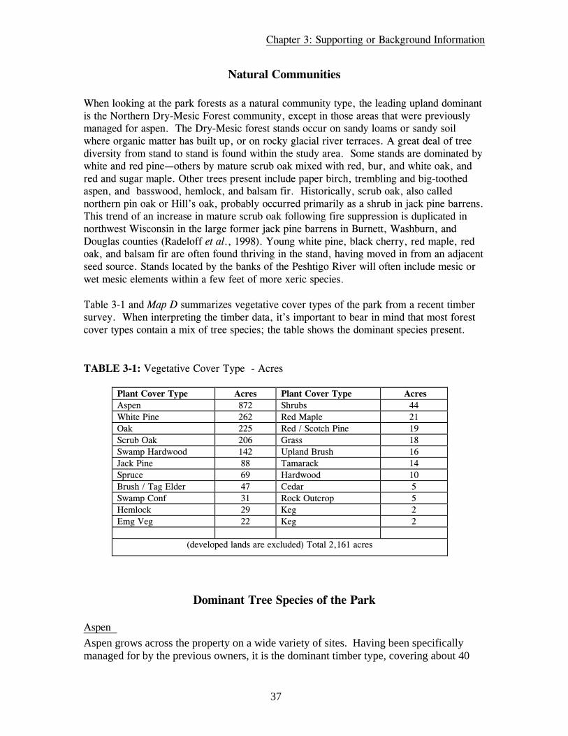
Table 3-1 and Map D summarizes vegetative cover types of the park from a recent timbersurvey. When interpreting the timber data, it’s important to bear in mind that most forestcover types contain a mix of tree species; the table shows the dominant species present.
TABLE 3-1: Vegetative Cover Type - Acres
Plant Cover Type Acres Plant Cover Type AcresAspen 872 Shrubs 44White Pine 262 Red Maple 21Oak 225 Red / Scotch Pine 19Scrub Oak 206 Grass 18Swamp Hardwood 142 Upland Brush 16Jack Pine 88 Tamarack 14Spruce 69 Hardwood 10Brush / Tag Elder 47 Cedar 5Swamp Conf 31 Rock Outcrop 5Hemlock 29 Keg 2Emg Veg 22 Keg 2
(developed lands are excluded) Total 2,161 acres
Dominant Tree Species of the Park
Aspen
Aspen grows across the property on a wide variety of sites. Having been specificallymanaged for by the previous owners, it is the dominant timber type, covering about 40
Chapter 3: Supporting or Background Information
38
percent of the property. In some cases it is in nearly pure stands; in others it is presentwith a mix of other tree species.
Pine White pine makes up the second most abundant timber type of the park at 12 percent, beinga common component of the Northern Dry-Mesic and the Northern Mesic Forestcommunity types. Red and Scotch pine are present in a few acres of plantation plantings.
Oak Oak grows throughout the park on a variety of sites. Scrub oak (Quercus ellipsoidalis) isdominant or co-dominant with jack pine on sandy soils. Timber quality in these stands isgenerally poor and limited to fuel-wood, pulpwood, or, at best, tie-logs.
Water/Fisheries Assessment
Water resources on the property consist of two inland lakes: Woods Lake (45.5 acres) andHuber Lake (29.1 acres). The park encompasses about half or more of the shoreline oneach of these lakes. Other private parties own the balance of the lake frontage.
Woods and Huber Lakes are both recommended for phosphorus monitoring due to the lackof available data. In addition, fish mercury monitoring is recommended for Woods Lakethrough the Upper Green Bay Basin Integrated Management Plan. Active and productivefisheries do exist upon the inland lakes. Large mouth bass, northern pike, and panfish areabundant.
Woods Lake is a maximum of 27 feet deep and has a fishery composed primarily ofnorthern pike, largemouth bass, and panfish. There is currently no public access to WoodsLake.
Huber Lake, also known as Deer Lake, is only a maximum of 8 feet deep, with a fisherybelieved to include bass, panfish, and forage species. There is no public access to HuberLake.
Handsaw Creek, which starts at Handsaw Lake, is a named trout stream and flows throughparts of the park. It has cold, light-brown-stained clear water with a total length of aboutsix miles and an average width of eight feet. Handsaw Creek has a population of brooktrout and is a tributary to the south fork of the Thunder River.
Two small, unnamed streams, known locally as Lost Creek and Spring Creek, flow intoWoods Lake. No inventory data is available for either of these streams. Lost Creekoriginates in what may be a spring pond or seepage known locally as “Lost Lake.” Thispond is not officially named and is located just south of Ranch Road in T33N R18E Section22. (There are three other named “Lost Lakes” in Marinette County.)

Chapter 3: Supporting or Background Information
39
Woods Lake Outlet is a 1.4-mile-long stream with an average width of six feet that flowsfrom Woods Lake to High Falls Reservoir. The fishery of Woods Lake Outlet is limitedprimarily to forage species.
Fisheries Resources
Various species of warmwater fish populate the reservoirs, rivers, and streams of theGovernor Thompson state park area, including northern pike, walleye pike, yellow perch,bluegill, crappie, pumpkinseed, largemouth bass, smallmouth bass, white sucker, andforage species. Brook, brown and rainbow trout inhabit most of the smaller streams in thearea as well as portions of the Peshtigo River. The Peshtigo River between Johnson Fallsand Sandstone Falls is managed as special regulation category 5 trout waters.
Wildlife Resources/Deer/Bear
All of the wildlife types common to northern Wisconsin can be found here: white taileddeer, red fox, gray squirrel, fox squirrel, cottontail rabbit, ruffed grouse, woodcock, ring-necked pheasant, bobwhite quail, raccoon, muskrat, mink, otter, beaver, Canada goose,and many species of puddle and diving duck. Sandhill cranes are also present. A healthypopulation of black bear is present in Marinette County and the park area, and it is notunusual to see bald eagles and osprey soaring above the reservoirs.
Since the property was acquired by the state in 2000, it has been closed to hunting. Wildlifebiologists have noted that the deer population meets or exceeds the goals for the deermanagement unit in which it is located. The park is located in Deer Management Unit 49A.As long as the park remains closed to deer hunting, it will essentially be a refuge. It is notunusual for a refuge to harbor a higher number of animals than the rest of the DeerManagement Unit. A disadvantage to this is that after the hunting season, the deer tend tostay in the refuge, browsing heavily on the understory vegetation. This can have seriouslong-term negative effects on the health and composition of forest stands.
Rare and Endangered Species
An initial, broad assessment of the park area was done to identify sites with threatened,endangered, and special concern species, or sites of potentially high-quality naturalcommunities. Based on the Department’s Wisconsin Natural Heritage Inventory database,there are no known threatened, endangered, or special concern species on the parkproperty. There are two records for animals tracked by the NHI Program immediatelyadjacent to the park. Both of these are for the Cyrano darter (Nasiaeschna pentacantha), astate special concern dragonfly. These records were not found as part of a systematicsearch; rather, they were randomly located during a visit to the area by staff biologists. A

Chapter 3: Supporting or Background Information
40
more comprehensive inventory would be needed to better assess the presence of rarespecies in the park and adjacent area. Bald eagle (state special concern and federally listed)and osprey (state threatened) are found in along the Peshtigo River corridor.
A “coarse filter” screening analysis was done on the park and the adjacent state forest toidentify potential sites that may contain threatened, endangered, and special concernspecies, or sites of potentially high-quality natural communities. This analysis revealedthree high-quality or potentially high-quality natural community sites on the park. Thesesites warrant a detailed field survey. Each is described below:
Woods Lake: Wetlands and Barrens Complex This is a 580-acre area that is mostly rolling upland. The uplands communities includeHill's oak woods, aspen thickets, good quality Hill's oak barrens, and clearings. Thewetlands include tamarack-black spruce swamp, alder thicket, the shallow, 40-acre,partially developed Woods Lake, and its outlet stream. This site has good potential to holdrare barrens and wetland species. Rare species that should be searched for here include:crinkled hairgrass, dwarf bilberry, hairy beardtongue, Richardson sedge, white floweredground cherry, dwarf milkweed, Canada yew, Hudson Bay currant, northern bog sedge,small headed sedge, small yellow lady's-slipper, showy lady's-slipper, native wild rice, andcuckoo flower.
Scrub Oak This is a 150-acre area on a low, sandy, narrow ridge with logged Hills oak woods withopenings with young aspen and some barrens. There are also small clearings dominated bybluegrass. Blueberry is common, along with hazelnut, sweet fern, and bracken fern. Otherherb plants present, varying across the site, include Penn sedge, little and big bluestem,poverty sedge, oatgrass, and rice grass. This site contains the potential habitat for the rareplants dwarf milkweed, Richardson sedge, crinkled hairgrass, white flowered groundcherry, hairy beardtongue, and dwarf bilberry.
Huber Lake: Wetlands and Uplands Complex This 513-acre site is mostly within the state park. The upland habitat is mature scrub oakand some jack pine with a modified understory, and dry mesic forest and barrens. Thereare wetlands along the shore of the nearly undeveloped Huber Lake. These open bogwetlands are rich and diverse, with leatherleaf, pitcher plants, wiregrass sedge, and avariety of willow species. Other wetlands are found in the southern part of this site and areprimarily open sedge meadows around large open pools of water.
The upland sites here are potential habitat for the rare plants crinkled hairgrass, whiteflowered ground cherry, dwarf milkweed, and Richardson sedge. The conifer swamp sitesmay hold the rare Hudson Bay currant, Northern bog sedge, small headed sedge, andCanada yew. The open wet meadows, adjacent to the lake, are potential habitat for the rareplants dragons mouth, slim stemmed reed grass, cuckoo flower, marsh willow herb, downywillow herb, and common bog arrow-grass.
Chapter 3: Supporting or Background Information
41
FindingsIn terms of vegetative/timber management, there are several small sites that may have thepotential for restoration of the regionally rare pine/scrub oak barrens natural community.Barrens are an ecological opportunity on the park. But, at this time, aspen is theprodominate forest coverage. Additional field survey work is required to assess thepotential for barrens restoration. There is an overabundant deer population, and control inthe park will be essential to avoid a long-term threat to forest reproduction and to thequality of the understory habitat.
Most lakes in the state are well developed. The undeveloped shorelines in the park are anattraction that draws visitors and are an outstanding feature worthy of continued protection.
CULTURAL RESOURCES
Available records show that no known archaeological sites have been documented withinthe former Woods Lake Resort property. This does not preclude the possibility of futurediscoveries, however. One of the remaining structures on the property, a 100-foot formerDNR Fire Tower, obtained by the property owners as surplus, is over 50 years old. It islisted on the Registry of Historic Fire Towers, a private national list created by fire towerenthusiasts. All other buildings on the property have been evaluated for historic value.
SUMMARY OF RECREATIONAL RESOURCES
The park property is located in a popular recreation area in Northeastern Wisconsin.Recreational activities that occur on or near the park include fishing, boating, canoeing,river rafting, tubing, swimming, water skiing, hiking, picnicking, camping, golf, hunting,snowmobiling, and cross-country skiing.
The area in and around the park offers a variety of scenic water feature views. Most ofthese are "wilderness-like" due to the undeveloped shoreline. The two large reservoirsprovide grand views of open water flanked in places with striking granite rockoutcroppings. The lower sections of the project area provide more intimate views of thefree flowing river.

Chapter 3: Supporting or Background Information
42
Land-based Recreation
Nonmotorized Recreation
Camping: Camping is a popular recreational activity within the region. Within a 50-mileradius of the property, over 2,400 campsites are available. The majority of these sites haveelectricity. Upon High Falls Reservoir, 62 campsites are located within the county-operated Twin Bridges Park. Wisconsin Public Service Corporation (WPS) designated 10canoe sites on Johnson Falls, Seymour Rapids, and Spring Rapids that are now maintainedby the Peshtigo River State Forest (PRSF).
Hunting: Hunting occurs near the property. The WPS allowed hunting on these forestlands.The types of hunting included deer, turkey, bear, fox, coyote, and small game. There issome waterfowl hunting on the Caldron Falls Reservoir. Limited hunting also took placewithin the park boundaries under the former owner. Regionally, hunting opportunities areabundant on federal, state, and county lands.
Hiking: Within the park property, there are over 22 miles of trails constructed by theformer owner. Most of these trails are 16 feet or wider and are usually a 1/2 mile or less inlength. Some trails intersect with geological features around the property and also offervistas of the lakes. The best way to describe this trail system would be a semi-stacked loopbisected by roads throughout the property.
Regionally, over 70 km of designated hiking trails exist in the surrounding counties. All ofthese trails are located on public lands.
On-road Biking: Locally, the roads in and around the properties are mostly paved and ingood condition for road biking. There is an established 24-mile loop from Crivitz that usesParkway, Ranch and Caldron Falls roads, and Highway W. The Wisconsin State Bicyclemap of this region shows County Highways A, C, X, and W as good roads for bicycleriding.
Off-road Biking: The GTSP property had off-road biking established under the formerowner. There was a fee charged for this activity. There appeared to be no restrictions onwhere off-road bikes could go, though the sandy soil did make for challenging conditions.Off-road biking is allowed on logging roads on the adjacent PRSF. Regionally, a numberof off-road trails exist both on federal and county forestlands along with Michigan andWisconsin State Parks.
Skiing: Cross-county ski loops exist within the PRSF. The PRSF maintains these loops.There is an approximately 5-km connector trail on private lands that connects the SeymourRapids system to the Spring Rapids system. Together, these systems account for over 24km of groomed trails. The park property was also groomed under the previous owner forboth skate and classical skiing. A series of races were held on the property over the years.Regionally, over 70 km of groomed trails exist in the surrounding counties. These trailsare all located on public lands.

Chapter 3: Supporting or Background Information
43
Horseback Riding: There are a number of horse stables located within the general area ofthe park. Regionally, there are 34 miles of trails located on the National Forest. While thepark has been closed to all uses since purchase, the PRSF logging roads are open toequestrian uses.
Motorized Recreation
Snowmobile: Table 3-2 lists the regional snowmobile trail mileage totals by county.Marinette County has the largest total mileage within the region. There is also a vastnetwork of trails within the Upper Peninsula.
TABLE 3-2: Regional Snowmobile Mileages
County MileageOconto County 431 milesFlorence County 130 milesForest County 375 milesMarinette County 446 milesTotal 1,382 miles
ATV: The former owner of the GTSP property did not promote ATV use on the property.Regionally, over 400 miles of ATV trails exist, with some of these trails on roads.
Water-based Recreation
Nonmotorized
Swimming: Clean water and numerous access points encourage swimming as a recreationalactivity on the reservoirs, lakes and rivers. Swimming is the second most popular activitywithin this setting. The sand beaches and granite rock structures allow for variedswimming experiences. However, there are very few established beaches within thesewaters. Most swimming occurs at the boat landings or the county parks.
Fishing: Excellent fishing occurs in and around the properties. Huber Lake and WoodsLakes, located on the property, support a large mouth bass, northern pike, and pan fishfishery.
Caldron Falls Reservoir supports a high-quality muskellunge fishery and is the only ClassA muskellunge waters in the Marinette County. Currently 1,000 muskellunge fingerlingsare stocked annually in the Caldron Falls Reservoir. Other fishing opportunities in theCaldron Falls Reservoir include largemouth bass, smallmouth bass, brown trout, bluegill,rock bass, yellow perch, black crappie and pumpkinseed. High Falls Reservoir alsosupports an excellent fishery of walleye, largemouth bass and smallmouth bass. Major

Chapter 3: Supporting or Background Information
44
panfish species include bluegill, rock bass, yellow perch, black crappie, and pumpkinseed.
Regionally, this area offers some of the best trout fishing within the state. There arenumerous Class I Trout Fisheries within a 50-mile radius of the project area.
Canoeing/Kayaking/Rafting: Abundant whitewater/quietwater paddling opportunities existon both the Peshtigo River and other surrounding rivers and streams. There are twowhitewater segments near the property. The Roaring Rapids section just north of theproperty offers the Midwest's longest continuous whitewater that is runnable most of thesummer. This section offers class III-IV whitewater. Commercial rafting outfitters provideeasy public access to this section with the take-out for these trips at boat landing 12--at thenorthern end of the PRSF property. The other whitewater section is located from JohnsonFalls Rd. to Kirby Lake Lane or Shaffer Rd. This section offers six miles of class I-IIIwhitewater but is seldom run compared to other segments of the Peshtigo River.
The reservoirs and the lakes offer excellent quietwater paddling opportunities. Canoetravel time from boat landing 12 (the upper reach) to the Johnson Falls dam isapproximately 11 hours. Marked portage routes exist around the dams.
Motorized
Power Boating: Power boating is a popular activity on both Caldron and High FallsReservoirs. Many larger watercraft are attracted to these large-size reservoirs andadequately large launching facilities. There are 14 rustic to semi-improved boat landingson Caldron and High Falls.
Personal Watercraft: Personal watercraft usage occurs on the reservoirs. The existinglaunch sites allow for easy access for these watercraft. While not as popular as typicalmotor boating, there has been an increase in this use.
RECREATIONAL TRENDS
Overall, recreational demand within the area is expected to increase 6.8% between 1990and 2020 (Federal Energy Regulatory Commission, Peshtigo River Multiple Project, FinalEnvironmental Impact Statement, March 1997).
Within this region, supplies of recreational resources usually outweigh the recreationaldemand. This is in part due to the low population densities and abundant public lands.Nevertheless, there are still a few areas of concern that will warrant special attention in thefuture.

Chapter 3: Supporting or Background Information
45
Statewide, and within this region, land-based motorized recreation continues to increase indemand. Due to the aging population and aggressive marketing campaigns, ATV andsnowmobile usage continues to gain in participation. In addition, nonmotorized activitiessuch as mountain biking and camping are on the increase. Regionally, because of the largetracts of public lands, most of these land-based activities can coexist, but this must belooked at from both an ecological and demand perspective.
Another area that will warrant special attention is water-based recreation. With limitedlarge bodies of water within the region, there is a pressing demand for more motorizedwater-based recreation. Since motorboat and personal watercraft sales and usage continueto increase, there will continue to be increased demands on the property and the region nowand into the future. This increasing demand will continue to pose challenges and threats tononmotorized recreation.
Other recreational activities projected to increase within the region include camping,bicycling, canoeing/kayaking, golf, wildlife viewing, and, to a lesser extent, fishing.
Findings
Two of the three largest water bodies within the watershed are Caldron and High Falls witha number of private and public recreational facilities that promote the use of these waters.WPS surveys indicate that water-based recreation is a popular activity. Since the water is anatural attraction, this result is not surprising. This becomes evident on the weekends withovercrowding at the PRSF boat landings. Swimming, while a popular activity, has limitedaccess points within the area. The County has built one beach at Twin Bridges Park, butnot all other water access points have formal beaches, though swimming does occur there.
Motorized recreation is also popular with large trail networks. There are over 1,700 milesof snowmobile and ATV trails within a four-county area, and these recreational uses areimportant to the region. But there is a lack of onroad bike trails, ATV trails, horse trails,and interpretive trails within the area.
In addition, there are a number of public and private camping facilities available within theregion. There are, however, very few year-round camping facilities along the reservoir.

46
47
CHAPTER FOUR
ASSESSMENT OF THE ENVIRONMENTAL IMPACTS OFTHE PROPOSED MASTER PLAN
The purpose of this chapter is to explain the potential environmental effects of the proposedmanagement plan. An analysis of the environmental effects or impacts is an importantelement of the Environmental Assessment (EA) for the master plan. The intent of the EAis to disclose the environmental effects of an action (the master plan) to decision-makersand the public. Chapter 2 of this document describes the proposed action or preferredmanagement alternative. The EA in the master plan has been prepared to meet therequirements of the Wisconsin Environmental Policy Act (WEPA) and Chapter NR 150 ofWisconsin Administrative Code.
IMPACTS ON AIR QUALITY
During construction periods, dust may be present in the air surrounding project areas.Application of water from tank trucks is a common dust suppression practice that is usedduring highway construction. This technique may be appropriate for projects within thepark. Impacts on air quality, whether from fugitive dust particles or from exhaust emissionsfrom construction equipment engines, would be finite and transitory in nature. Whenconstruction is complete, no residual impacts to air quality would be detectable.
The impacts to air quality from motor vehicles drawn to the park by the establishment of100 modern campsites, Day Use Facilities at Woods Lake and Huber Lake, or other parkfacilities would be negligible. The current indirect source air permit thresholds are sourceswith 1,500 or more parking spaces, or highway projects with peak vehicle traffic volumegreater than 1,800 vehicles per hour. The traffic due to projected development in this planis well below these levels.
IMPACTS ON GROUNDWATER RESOURCES
Wells, Use of Groundwater
A number of new potable water wells (about six) would be drilled to serve the proposedpark facilities. None of the wells would individually qualify as high-capacity wells;however, taken in aggregate, Governor Thompson State Park may be classified as a “high-

Chapter 4: Assessment of the Environmental Impacts of the Proposed Master Plan
48
capacity property.” Because of the dispersed nature of these wells around the 2,415-acresite, the effect on the local water table is expected to be minimal.
Abandonment of Old WellsFurther, all unused wells associated with former uses of the site have been or will beappropriately abandoned when no longer needed. Sealing the groundwater from surfacecontamination would be the effect.
Modern Septic Systems and Vault ToiletsModern septic systems developed to service proposed park facilities will be constructed toapplicable local and state Department of Commerce standards, effectively safeguarding thegroundwater from contamination. A number of vault-style toilets would also be developedto serve more remote areas of the park. These are sealed from the groundwater andpumped regularly or as needed during the use season.
Removal of Old Septic SystemsSeveral old septic systems of undetermined design have already been appropriatelyabandoned. Remaining functioning systems would also be appropriately abandoned whenno longer needed. This would take place after new state park facilities are constructed andare operational. These measures will have the effect of further safeguarding thegroundwater resource from contamination.
IMPACTS ON SURFACE WATER RESOURCES
An increase in impervious surface area from infrastructure improvements will occur.Rooftops and hard-surfaced roads would be the main sources of sheet runoff. Road andpath construction will avoid changing watercourse direction and flow, volume, andvelocity. Culverts will be sized accordingly. Pervious road and pathway surfaces would beused where impervious surfaces are not needed. Runoff from roadways and otherimpervious surfaces would be directed away from draining directly into nearby streams andlakes, thus minimizing any risks of water pollution from spilled or water-transportedmaterials.
Land acquisition for boundary expansion and management under the state park master planare measures that are anticipated to have a long-term beneficial effect on the surface waterresources of the site and those receiving waters downstream. The main effects wouldaccrue to Spring Creek within the park and Handsaw Creek, which flows out of the parkand is a tributary to Thunder River. Preservation of watershed resources would also affectWoods Lake and Huber Lake.
Chapter 4: Assessment of the Environmental Impacts of the Proposed Master Plan
49
IMPACTS ON GEOLOGICAL RESOURCES
New drilled potable water wells would penetrate the underlying granite bedrock in someplaces, but all wells would be drilled and installed according to state well drilling code,effectively minimizing any risk. Some rock excavation may be necessary for developmentof roads, parking lots, and facility foundations. Surface mining of rock is not anticipated.
IMPACTS ON VISUAL/SCENIC RESOURCES
New structures and facilities would be evident internally. The appearance of new structuressuch as buildings, roads and use areas would be a definite change from what currentlyexists. However, recreational structures were commonplace during the site’s history as aresort. New recreational structures such as shelters and buildings will be designed toharmonize with the natural surroundings of the park. Vegetative management will assure that all shoreline zones in the park would remainnatural or be restored to more natural appearance in use areas of the park. The 200’shoreline buffer zone on the Caldron Falls Reservoir will essentially be a no-cut zone, withcertain exceptions for work necessary to development and response to catastrophic events.The same would be true for the 100’ buffer zones recommended for Huber Lake andWoods Lake.
Change in the visual qualities of the active vegetative management areas would benoticeable over time as areas of oak and aspen are managed for certain objectives. Forexample, aspen regeneration areas that are clear-cut in small patches could have six or eightsmaller areas of even-aged trees in a 40-acre stand, with aspen predominating. Red oakstands that are being managed for improved health and vigor would eventually have anobvious predominance of red oak trees that are straight, tall, and relatively even-aged.Visitors using the park road system or the adjacent bicycle trail would primarily noticethese effects because the active vegetative management areas are purposely situated forvisibility.
Temporary visual and audible effects would also be a by-product of the active managementof forest vegetation. Audible effects from chainsaws and logging trucks would immediatelycease when the work is finished. Visual effects of cutting would be mitigated by measuressuch as low stump cutting and slash chipping or reduction. These measures would beincluded as conditions of any timber sale contracts used to achieve vegetative managementgoals. The temporary visual and audible effects are anticipated to be more readilynoticeable than the more subtle changes in stand age or composition.
The newly constructed park entry road and a major property identification sign would bethe only outward signs of park existence evident on Ranch Road. Directional signs placedon nearby public roads directing visitors to the park would also present a new visual

Chapter 4: Assessment of the Environmental Impacts of the Proposed Master Plan
50
element. Most other park features would be internal to the property and therefore obscuredfrom the outside view.
The removal of the lodge and cabins of the former resort complex would bring a morenatural appearance, a positive change in visual character of the western side of WoodsLake. The relocation and lowering of the existing fire tower would noticeably change theskyline viewshed of Woods Lake.
IMPACTS ON LAND USE
The land use of the original 1,987 acres of land purchased for this project would not changefrom recreational. Further, lands purchased including Boat Landing #13 were formerlydedicated to recreational lake access and would continue as such under this master plan.The main impact would be an anticipated increase in the level of active recreation on thestate park site.
Most neighboring land use in the vicinity of Governor Thompson State Park is residential,recreational, or commercial forest. Some areas of commercial business development alsoexist. It is not unlikely that some increase in service sector business could occur as spin-offof state park uses. It is anticipated that some growth in recreation-oriented businessdevelopment would take place in the vicinity the park. Local planning and zoning codeswould regulate such development.
IMPACTS ON INFRASTRUCTURE AND TRANSPORTATION
Increase in local traffic may require local road maintenance increase. Traffic throughCrivitz may increase, especially during June, July and August. Traffic counts on US 141 inthe Crivitz area will probably increase due to park visitation. It is anticipated that US 141will be the route of choice for people entering and departing Governor Thompson StatePark. From US 141 there are three principal routes of travel to the park. Each is a CountyTrunk Highway. The two that pass through Crivitz (CTH ‘W’ and CTH ‘A’) are expectedto receive the most use. The third (CTH ‘X’) passes through the unincorporated village ofMiddle Inlet and will likely receive less use by park visitors.
Local increases in traffic will be noted primarily in the months June, July and August whenthe majority of recreation takes place. Most vehicles visiting the park would be automobilesor light trucks, vans, or SUVs. Some would be vehicles towing camp trailers, small boats,or self-contained campers. It is anticipated that these vehicles may have an effect ofincreased wear and tear on roadways in the vicinity of the park, as well as increased trafficcongestion at peak times.
Governor Thompson State Park will be a generator of solid waste. Wisconsin State Parkspromote and participate in recycling programs to mitigate generation of non-recyclable

Chapter 4: Assessment of the Environmental Impacts of the Proposed Master Plan
51
material that must be disposed of in sanitary landfills. A licensed sanitary waste contractorwill be hired to pick up recyclable waste and non-recyclable materials. Campers usingremote walk-in campsites and day use areas will be required to observe a carry-in, carry-out policy.
Governor Thompson State Park will also be a customer of Wisconsin Public Service Corp.for electric service. The primary uses of electricity at the park will be for powering thebuildings and pumping water. Moderate use of electricity will occur at the 30 electrifiedcampsites in the modern campground.
IMPACTS OF NOISE
Construction noise resulting from capital improvements such as road building, vegetationmanagement, building construction, and the like could have a moderate, temporary impacton the park’s neighbors and wildlife. All of these groups could be sensitive to thisdisruption, especially during warm weather when windows may be open. This noise wouldbe peak (high level, short duration) during construction periods, rather than continuous.
The presence and activities of park visitors and campers may present a potential forreaction from neighbors or other park visitors and thus an impact. Regulations on the use ofamplified sound devices (radios, stereos, etc) and loud conduct exist for the purpose ofminimizing the imposition of unwanted noise on neighbors of the park as well as neighborsinside the park, especially in camping situations. The 30 electric service campsites in themodern campground will be grouped together to minimize potential user conflicts betweenthose who use electrically powered conveniences and those who do not.
Seasonal noise generated on the rerouted pass-through snowmobile trail may have anegative impact on neighboring properties. Where potential impacts are greatest, attemptsto mitigate the effects will be made by locating the trail alignment farther from privateproperty.
IMPACTS ON RECREATIONAL RESOURCES
The establishment of a 100-unit modern campground will increase camping opportunities inthe Marinette County area. Thirty of the campsites would be electric sites, and theremainder would be conventional. A further anticipated impact is the creation of additionaldemand for campsites at local private and public campgrounds. This effect is well known inother parts of the state. It is the policy of Wisconsin State Parks to work closely with othercampground operators to assure that when the state park campground is filled to capacity,any prospective campers seeking a campsite are referred to neighboring facilities that havevacancies.

Chapter 4: Assessment of the Environmental Impacts of the Proposed Master Plan
52
The establishment of non-road paved bicycle trails in the park will add significantly to thesupply of trails in the region. The master plan Regional Analysis information shows anoverall deficit in recreational bicycle trails.
The State Parks Program has begun providing ADA-compliant indoor camping facilities inselect parks called the “Cabin-in-the-Woods” program. The construction of a fullyhandicapped-accessible indoor camping facility at Governor Thompson State Park willprovide a new resource for handicapped campers. Opportunities for fully handicapped-accessible indoor camping experiences are currently rare to non-existent in NortheastWisconsin State Parks. Two such facilities now exist: one at Potawatomi State Park inDoor County and one at High Cliff State Park in Calumet County. Another such facility isplanned for Hartman Creek State Park near Waupaca. These existing and plannedhandicapped-accessible indoor camping facilities are all over 100 miles from GovernorThompson State Park. This new and unique recreational resource would have a positivesocial impact and be an expansion of the recreation supply in the region.
The routing of a pass-through snowmobile trail inside Governor Thompson State Park willdecrease the risk level of the trail by removing it from the roadway where it is routedparallel to Ranch Road. The new trail route will be located near the southern boundary ofthe park property to mitigate potential conflicts with other non-motorized winter park usesand impacts on biotic resources.
The swimming beach proposed for Caldron Falls Reservoir would be intended for use bystate park patrons who have paid a fee for the use of state park facilities. However, accessto the beach by watercraft on the reservoir is possible without the payment of a fee andwithout restriction. An influx of “outsiders” could occupy the use area and cause conflictor at least reduce the enjoyment of park-originated beach users. One factor that couldslightly mitigate the situation would be that the proposed beach would lie within theproposed no-wake zone.
IMPACTS ON BIOTIC RESOURCES
Forest Communities
Vegetative management prescriptions proposed for the two red oak stands and three aspenstands would have the effect of changing the structure and composition of the selectedforest stands. Two of the aspen stands would slowly be influenced to succeed to white pineor red maple types. The third aspen stand would be managed to perpetuate aspen. The useof clear-cutting in small patches of five acres or fewer would be the main managementtechnique to perpetuate aspen. The oak stands would be selectively cut or intermediately cutto encourage health and vigor of the oak type existing on poor soils. The long-termsuccession of the oak may be to white pine or red maple as a climax species.
Management of the three pine plantations would have the short-term effect of producinglarge healthy trees as well as reducing the evidence of row planting. The long-term effect
Chapter 4: Assessment of the Environmental Impacts of the Proposed Master Plan
53
would be the elimination of the plantations as a type and eventual succession to oak orwhite pine. Harvest would be the main tool used to achieve this effect. Supplementalplanting may also be used.
Management of the vegetation in the buffer zones on the shorelines of Woods Lake, HuberLake, and Caldron Falls Reservoir would be managed as a scenic management area. Theexception would be in case of a natural disaster or the need to remove a hazardous treefrom a designated use area or trail. The long-range effect of this management would be thedevelopment of an old-growth character, with coarse woody debris evident on the groundand a broad age profile of climax forest.
Vegetative management in designated use areas would include removal of trees forconstruction, supplemental planting of new vegetation for landscape purposes, and theremoval of hazardous trees when the need arises. The effect of this management would be agradual reduction in understory density and a more open appearance in designated useareas.
Vegetative management in the balance of the park, characterized as forested upland andforested lowland, would be passive. Dead and downed trees that have fallen through naturalcauses would be left for interrelated insect and mammal habitat. These will not be removedunless they are determined to be a hazard. The anticipated effect of this management wouldbe a slow succession to climax species and old growth conditions over a period of severalhundred years.
In the short –term, little, if any, change would be noticed. Some of the natural processesoccurring may be considered “unsightly,” though these will be in the more remote andinaccessible parts of the property. They would, at times, be visible from trails. The forestfloor would become littered with coarse woody debris.
In the longer term, there would be dead and downed trees in various stages ofdecomposition, serving as hosts for a multitude of creatures. The forest canopy would takeon a dense character, and gaps in the canopy from fallen trees would eventually be filled bythe growth of other trees of the same community. Trees in every stage of life, fromseedling to maturity, would be growing together.
While the passive or natural succession method of vegetative management would notnecessarily have the direct effect of exacerbating forest pest outbreaks, such as gypsy moth,oak wilt, or forest tent caterpillar, the overall impact might be greater due to relativelyweaker health of individual trees. Reactive measures, such as sanitation, root pruning, orpesticide or herbicide application could still be taken if an acute infestation werediscovered. Proactive measures, such as a wholesale conversion to less appetizing treespecies, in the passive management areas are not proposed in the master plan.
Shrub Communities

Chapter 4: Assessment of the Environmental Impacts of the Proposed Master Plan
54
The plan would restore and maintain examples of the pine barrens native community type.Two barrens restoration areas—one of about 16 acres and the other of about 40 acres—areproposed. This relatively rare ecological community was historically abundant in this partof the state. It will be used as part of the park’s nature interpretation program. Groundlayer vegetation of blueberry, wild bergamot, little bluestem grass, and bracken fern aregood barrens species representatives and were found at both sites.
Lakes
Anticipated impacts on Huber Lake and Woods Lake would be beneficial, arising fromnatural shoreline management and the buffer zones established on the perimeters.Development of day use areas would be done so as to prevent negative impacts, primarilyby limiting tree cutting and keeping structural development out of the buffer zone exceptwhere prescribed in the master plan. A small (150 linear feet) beach area would bemaintained. This area was used previously by resort patrons. Also, a small (up to 200linear feet) beach would be established on the shores of Caldron Falls Reservoir. Someclearing of vegetation and grading of the shoreline zone would be necessary.
The unique wild rice beds located on Woods Lake would be protected from disturbance byNative Community Management designation. Laws restricting the harvest of wild rice alsoprovide some protection. The overall effect would be one of preservation.
Springs and Spring Runs
State park ownership and management would have the effect of safeguarding the waterquality and biological diversity of the water systems associated with the park. Someadditional land acquisition to increase the scope of control over these systems is proposedin the master plan. Land management classifications have been chosen for these areas thatwould have the effect of preventing degradation of these resources by development orconflicting use.
Exotic Plants
A program of regular monitoring and inspection for other invasive exotic species shouldalso be implemented. Both aquatic and terrestrial species are included. Some commoninvasive exotics that would be monitored are purple loosestrife, garlic mustard, spottedknapweed, tatarian honeysuckle, buckthorn, black locust, and Eurasian water millfoil.Department policies in place that address these threats to the resource base will befollowed. Control measures appropriate to the species of invasive would be used. Thesemay include manual harvesting, plowing, use of herbicides or poisonous agents, fire,

Chapter 4: Assessment of the Environmental Impacts of the Proposed Master Plan
55
natural predators, and magnetic pulses. The effect would be a purifying of the bioticcommunity and a protection from future invasions.
IMPACTS ON ENDANGERED OR THREATENED SPECIES
At this time, no state or federally listed endangered species are recorded for GovernorThompson State Park. One state threatened species, the Blanding’s turtle, has recentlybeen sighted within the park. The Natural Heritage Inventory (NHI) record shows that onestate-listed “special concern” species of vascular plant, Malaxis brachypoda (WhiteAdder’s Mouth, a small orchid) and one species of “special concern” insect, Nasiaeschnapentacantha (Cyrano Darner, a dragonfly), have been observed on or near the specificproperty. No other species of listed plant or animal were indicated in the records. Othersmay exist in the vicinity, however. Bald eagles and osprey are commonly observed nestingand soaring over the waters of the Peshtigo River; however none are directly associatedwith the state park property. Prior to construction of facilities, the potential for negativeimpact on any of these species would be reviewed and appropriate actions taken to protectthese species and their habitat.
As a result of this plan, federal and state endangered, threatened, or special-concern speciesthat may be discovered or occur in the future will receive long-term protection andenhancement through the property's management.
IMPACTS ON HISTORICAL AND ARCHAEOLOGIC FEATURES
Available records show that no archaeological sites have been documented within theGovernor Thompson State Park property. This does not preclude the possibility of futurediscoveries, however. One of the 22 structures on the property, a 100-foot former DNRFire Tower, obtained by the property owners as surplus, is over 50 years old. The masterplan proposes to preserve this structure through adaptive reuse as an interpretive device.
ECONOMIC EFFECTS AND THEIR SIGNIFICANCE
The anticipated increase in tourist numbers will increase utilization of local businessestablishments. Economic benefits are anticipated to result from the influx of visitors toGovernor Thompson State Park. Recent data indicate that, in the Northeast Region ofWisconsin, local resident park visitors contribute an average of $19.12 per day to theeconomy, while non-local park visitors contribute an average of $57.46 per day.Anticipated annual visitation to Governor Thompson State Park when fully developedwould be from 200,000 to 250,000 people per year with a resulting economic impact ofapproximately $6.5 million a year.

Chapter 4: Assessment of the Environmental Impacts of the Proposed Master Plan
56
Benefits during construction of the park and its components would accrue to building trademembers and laborers and suppliers, some of which may be local. Competitive biddingprocedures will be followed. Total development cost for the park is expected to amount toseveral million dollars at completion, though the actual work may be spread over aconsiderable span of time. No estimate of dollar amounts to the local area is available, asextent of local contractor involvement is not yet known.
Employees working at Governor Thompson State Park would probably live in the vicinityof the park. Those employees would participate in the local economy and expend asignificant amount on their daily needs as members of the community.
FISCAL EFFECTS – STATE GOVERNMENT
Lands purchased for addition to the park would likely be acquired using State Stewardshipfunds or a similar bonding fund. Similarly, bonding programs fund the development ofmuch of Wisconsin’s State Park System. The cost to the state of bonding for landacquisition and project development occurs when the interest or dividends must be paid onthe bonds. Several methods of making these payments could be used, the main one beingGeneral Fund Support. Conversely, a benefit would accrue to the holders of the samebonds.
The Wisconsin State Park program budgets for its capital development needs on a biennialbasis, as do all state agencies. Because of the significant cost of developing GovernorThompson State Park, funding priorities within the capital budget would necessarily beadjusted to accommodate building the park. Without an increase in capital spendingauthority, construction of Governor Thompson State Park could cause temporary delay ordeferral of implementation of other state park projects.
Recurring expenses for park operation and staffing would be an unavoidable effect of parkoperation. It is anticipated that if full development were already achieved, including about100 family-style campsites, the annual operating budget would be in the range of $95,000to $150,000. This compares with similar-sized properties with similar-sized campgroundsin the DNR’s Northeast Region. Specifically, Hartman Creek State Park, High Cliff StatePark, Potawatomi State Park, and Point Beach State Forest were considered in thiscomparison.

Chapter 4: Assessment of the Environmental Impacts of the Proposed Master Plan
57
Estimated Costs of Development
Note: Costs for development of Governor Thompson State Park are based on 2004 dollar-values and assume full completion of all proposed construction. In actuality, work may bephased over several state capital biennial budget cycles.
Park Roads and Parking Lots $628,800Trail Systems $41,800Park Entrance Visitor Station $566,100Shop/Storage Building $626,100Woods Lake Day Use Area (with beach) $366,900Huber Lake Day Use Area $161,650Caldron Falls Reservoir Swimming Beach $110,000Campground, 100-Unit Class ‘A’ $1,044,100
Roads and Campsites $256,500Shelter Building $26,000Toilet/Shower Building (1) $342,800Vault Toilets, (6 sets 2x2) $189,900Utilities, well, septic, elec. $168,400Firewood Shelter $5,500Gates, signs, picnic tables, fire rings $55,000
Outdoor Group Camp $188,600
Access & Parking $33,400Campsites 30 (5 sites 6 pads) @ $750 ea $22,500Well and Hand Pump $14,700Vault Toilets (3) $95,100Picnic Shelter $22,900
Indoor Group Camp $262,700Access & Parking $33,400Bunk Houses (2) @ 800 sf ea. $160,000Well and Hand Pump $14,700Vault Toilets $31,700Picnic Shelter $22,900
Hike-in Campsites $13,200Handicap Accessible Cabin (Full Service) $150,000Travel Trailer Sanitary Station $101,300Nature Interpretive Center $150,000Amphitheater, covered $125,000Playground Equipment $52,000Bicycle Campground one acre $9,500Observation Tower $165,000Adaptation of Historic Fire Tower $55,000Boat Landing Upgrade $125,000Fish Cleaning Station $50,000Trail System PRSF Connector $50,000TOTAL ESTIMATED COST $5,042,750

Chapter 4: Assessment of the Environmental Impacts of the Proposed Master Plan
58
Estimated Costs of Land Acquisition
DNR policy is to purchase land only from willing sellers. The purchase price is set by anappraisal prepared in compliance with state and national guidelines, unless the sellerchooses to make a gift or partial donation of land.
The master plan recommends that about 1,720 acres of additional land be acquired foraddition to Governor Thompson State Park. The approximately 1,720 acres of land thatwould be added to the park boundary would be valued at an average of $3.04 million ifacquired all at once, using present day values. Individual parcel values would varydepending on whether any improvements or buildings existed on the site as well as theindividual qualities of the site. It is unlikely that all tracts within the proposed boundarywould be available for acquisition simultaneously, so expenditures would be spread over aconsiderable span of time, perhaps many years. The 200 acres of land to be added fromPeshtigo River State Forest is already owned by the state; therefore, there would be noadditional acquisition cost.
Projected Staffing Needs and Estimated Annual Operations Cost
An analysis by the Wisconsin Legislative Fiscal Bureau was done in December of 2000,prior to acquiring the Woods Lake Resort and WPS Land, for the Joint Committee onFinance. A preliminary 2001-03 operating budget projected a $540,000 budget in 2001-02and $494,000 in 2002-03 as well as 6.0 positions. These include a park superintendent,operations ranger, facility repair worker, program assistant, naturalist, and lawenforcement (park ranger). Longer-range predictions estimate that the request may increaseto eight staff members, with an annual operations budget ranging from $350,000 to$450,000. These figures project far into the future and assume complete park development.Also, there is no guarantee that the staffing level originally anticipated will beimplemented.
Revenue Projections
Park admissions sales and camper fees will be the two main revenue sources of the newstate park. Three other recreation facilities in the Northeast Region are of similar size andhave similar campgrounds as Governor Thompson State Park. They are: Hartman CreekState Park in Waupaca County, Potawatomi State Park in Door County, and Point BeachState Forest in Manitowoc County. With a campground average occupancy rate of 68.3%,2003 revenue generated by these three properties averaged $197,300. It is reasonable toanticipate that Governor Thompson State Park would perform similarly when fullyestablished and developed.
Chapter 4: Assessment of the Environmental Impacts of the Proposed Master Plan
59
Some additional revenue may accrue over time to the Parks Account as a direct result oftimber sales conducted to achieve vegetative management objectives recommended by themaster plan. Active vegetative management would take place on 204 acres of park land asspecified in the Draft Master Plan/EA. Thirty-six acres of barrens restoration area wouldbe managed using fire as a tool, therefore not providing any timber revenue. Loggingwould be the main management technique used on the remaining areas, totaling about 168acres. Periodic timber sales over the next 40-year period are estimated to total $302,000.The breakdown by timber type is aspen - $112,000, red oak and scrub oak - $102,000, redpine - $88,000.
FISCAL EFFECTS – LOCAL GOVERNMENT
Acquisition of land for Governor Thompson State Park is anticipated to result in anincrease in property tax revenues to local governments. The Department began paying localgovernment aids-in-lieu-of-taxes of $51,600 per year on the two properties first acquiredfor the park. Under a statute enacted on January 1, 1992, each time a new property isacquired, the purchase price is set as an equivalent of an assessment, and aids-in-lieu-of-taxes are paid on that basis. Therefore, one of the impacts of acquisition of additional landfor Governor Thompson State Park would be an increase in these payments. Because thepurchase price is often higher than the equalized assessed value of the property, the DNR’spayment is often greater. As additional properties are acquired for Governor ThompsonState Park, the effect would continue.
On lands purchased by the DNR since January 1992, the "property value base," used tocalculate payment in lieu of taxes (PILT), must be equal to or greater than estimated fairmarket value on a parcel for the year of purchase (s.s. 70.114). The purchase price isdetermined by an appraisal, which is completed by a certified general private or DNR staffappraiser. The year after the initial PILT payment year, and in all future tax years in whichthe DNR owns the parcel, its "property value base" is adjusted based on the change in landvalues in the municipality where the property is located. If the value in the municipalitygoes up 10%, the value of DNR land is adjusted upward 10%. For example, if the DNRpurchased 1,000 acres located in a the Town of Stephenson in January 1992 for$1,000/acre, the DNR would assume the normal tax bill for tax year 1992, and then, in1993, the 1,000 acres would be listed as tax exempt status and receive a PILT. If the 1993assessment level on land in the Town of Stephenson increased and land were now at$1,500/acre, an increase of 50% (or 1.5 multiplied times the original "property valuebase"), the Department would adjust its "property value base" and make the PILTpayments based on that figure to the taxing jurisdictions in the Town of Stephenson—thusrealizing the same assessment level adjustment as that of other private landowners in thetown. Likewise, if the assessment in the Township went up in the following year, theDepartment would adjust the PILT payment accordingly (Source: Legislative Fiscal Bureaureport).
Existing improvements on properties acquired for the park would be auctioned or sold forreuse elsewhere or salvaged for materials. Therefore, slightly fewer residences and cottages

Chapter 4: Assessment of the Environmental Impacts of the Proposed Master Plan
60
would exist within the project area; thus a reduction in demand for public services such aspolice and fire protection would occur. If the former owners relocated or built within thesame municipal jurisdiction, the net effect would be zero.
The anticipated increase in traffic on local roadways near the park may slightly increaseroad maintenance costs.
BOUNDARY EXPANSION & ACQUISITION IMPACTS
Increase Park Size
Boundary expansion would increase the size of the park by 1,720 acres to about 4,135acres. State funds would be expended to purchase these additional lands unless donations orpartial donations of land occur. No additional state funds would be expended for theredesignation of 200 acres of land from the Forestry Division to the State Parks Bureau.
Protect Resources
It is anticipated that the acquisition of the recommended additional lands would provideprotection of surface water systems feeding Woods Lake, Spring Creek, Huber Lake, andHandsaw Creek. Additionally, eventual acquisition of the remaining shoreline of HuberLake and Woods Lake would provide added resource protection by internal controls. Itwould also provide the park with full control to enforce the no-motors rule on these twolakes.
Change Boundary Configuration
The configuration of the property boundary would be impacted. It would eventually bemodified to coincide with Parkway Road on the east, Ranch Road on the south, andCaldron Falls Road on the west of the park. This is a generally desirable configuration thatwould be easily understood by the public.
SIGNIFICANCE OF CUMULATIVE EFFECTS
The cumulative effects from the preferred alternatives for Governor Thompson State Parkwould have a long-term positive effect on the quality of the human environment. Inparticular, the public has recognized the need to preserve land-and water-based public land

Chapter 4: Assessment of the Environmental Impacts of the Proposed Master Plan
61
for the benefit of future generations to benefit. They have demonstrated this supportverbally and in writing. The boundary expansion recommended by the master plan wouldfurther create opportunities for ecosystem-based vegetation management and surface watersystem and wetland protection.
While repetition of this overall action--constructing a new state park in a region where nonehas ever existed-is unlikely to occur, it should be noted that the state is also acquiring landsfrom Wisconsin Public Service Corporation on the Peshtigo River. Approximately 9,200acres of land, largely forested, are involved. While vegetative management will likely be amajor component of the Peshtigo River State Forest, there will also be recreationalcomponents.
The acquisition and management of public land on the region is not unique. Other majorpublic holdings exist nearby, including approximately 250,000 acres of Marinette CountyForest, and about 661,000 acres of Nicolet National Forest.
SIGNIFICANCE OF RISK
Management and development of Governor Thompson State Park pose a low overallpotential for risk to the environment. A land area development maximum of 15% has beenmade a part of the management prescription for the park. Current plan recommendations,even when fully implemented, fall far short of the maximum.
The presence of motor vehicles and other equipment during the construction phase maypose an increased risk from spills and erosion. These risks would be mitigated by plans andprocedures put in place in the bid documents and at the preconstruction meeting withcontractors.
Risk to the resources of the site resulting from human activity during normal operation ofGovernor Thompson State Park is mitigated by emergency action plans put in place by parkmanagement staff. These plans are reviewed annually and updated as needed or whencircumstances change.
Risk of introduction of invasive exotic species may increase due to public entry and use ofthe property. Plans and strategies, as described in the master plan Park Operation section,are in place to prevent and control outbreaks and infestations.
Fire has been identified as a possible vegetative management tool, especially for the barrensrestoration sites recommended by the master plan. Necessary precautions are alwaysfollowed during prescribed burns, including having fire-fighting equipment and personnelpresent on site. During periods of high fire danger, restrictions are put into effect. Duringexceptionally dry weather, a complete fire ban may be implemented. The Town ofStephenson Fire Department provides fire protection at a distance of about four miles.Additional protection during high fire danger periods is available from a DNR fire controlunit stationed in the vicinity.

Chapter 4: Assessment of the Environmental Impacts of the Proposed Master Plan
62
SIGNIFICANCE OF PRECEDENT
Approval of this management plan would not significantly influence future decisions onother Department property master plans. One development issue that is contingent uponthe master planning of the Peshtigo River State Forest is that of providing opportunities forhorseback riding at Governor Thompson State Park. Because the adjacent state forestcontains a number of public roads that are by law now open to horseback use, and potentialfor miles of additional designated horse trails exists, the development of such trails atGovernor Thompson State Park is being deliberately delayed. This decision is intended toprovide the optimum trail system for horseback riding and camping in the future.
SIGNIFICANCE OF CONTROVERSY OVER ENVIRONMENTALEFFECTS
Boundary Expansion from Original, Property Taxes
To date, no strong opinion either for or against boundary expansion has been registered.This does not guarantee that some opposition to the idea will not come up, since landacquisition by the state is a topic of concern to many people. One facet of opposition toexpansion could be the perception that state acquisition of more land would erode theproperty tax base, causing property taxes to increase for other property owners. Anexplanation of DNR land buying procedures and aids-in-lieu-of-tax payments can dispel thismisunderstanding.
Disagreement over Recreational Style, Uses Allowed or not Allowed
Some individuals have advocated extreme primitive management, and others haveadvocated for mechanized recreation modes. The Vision Statement and Goals suggest thepreferred alternative management measures for the property. The horse riding communityhas strongly advocated for the establishment of horse trails and horse & rider camping inthe park. DNR acknowledges this as a legitimate use of the park but has delayed theestablishment of these trails to allow a better coordination of planning with the adjacentPeshtigo River State Forest. The forest does have a number of public roads, which arelegally open to horseback riding. This fact provides immediate opportunities for horse usein Marinette County while decisions are being made about establishing more horse trails.
Late in the planning process, a number of requests for single-track mountain bike trail werereceived. Evaluation of the soil, slope, and wetland situation of the park, and standards forconstruction and maintenance of this type of trail influenced the decision not to pursue thisactivity.
Chapter 4: Assessment of the Environmental Impacts of the Proposed Master Plan
63
Local officials have raised the issue of traffic impact on local roads. This refers primarilyto physical impacts anticipated on the road surface of Township and County highways. Italso involves concern over added congestion during the tourist season. Average daily trafficcounts will increase slowly as the park development and public use increase.
Road access to the existing Boat Landing #13 (now called South Bay Landing) will bechanged. The intention is to provide boat access to Caldron Falls Reservoir primarily forpark visitors. Individuals wishing to use the boat landing from outside the park will enterthrough the park entrance and then proceed to the landing. A park admission fee is requiredto use the boat landing. This is in conformance with statewide policy. Some individualsliving near the park have expressed displeasure at this change because it affects theircustomary travel pattern and use of the landing. Mitigating factors are: In fact, Boat Landing #13 is still available for their use. Boat Landing #13 will be much improved under park development. Nearby Boat Landing #8 is also available for public use and is free of charge. Boat Landing #8 also provides ready access to virtually the same part of the reservoir
as Boat Landing #13. Individuals have raised concerns about the alignment of the proposed pass-through
snowmobile trail. Some are concerned that the snowmobile trail would be too close totheir cabin on private property in the northern part of Section 21 and would causeconflict. This anticipated impact would be mitigated by choosing a trail alignment thatwould keep a reasonable distance between the pass-through snowmobile trail and thestructure in question.
CONCLUSIONS
Implementation of master plan recommendations for management and development ofGovernor Thompson State Park would provide positive recreational, ecological, social, andeconomic benefits to the region by maintaining a predominantly undeveloped naturalproperty, but with facilities adequate to meet recreational needs expressed in the RegionalAnalysis. These facilities would provide opportunities for a variety of structured andunstructured recreation activities.
The natural shoreline management and shoreline buffer zones will preserve--and restore insome cases the “just-like-Canada” look and feel of Caldron Falls Reservoir, Huber Lake,and Woods Lake.

64

65
CHAPTER FIVE
ALTERNATIVES AND THEIR ENVIRONMENTALIMPACTS
A master plan alternative is a grouping of a number of compatible options for resourcemanagement, recreational development, and public use of a Department property. Thecontent of an alternative should be compatible with the property designation, the draftvision and goals, the property capabilities, and the regional analysis. The alternativessummarized below are the most recent set of alternatives that were considered as part of theplanning effort.
RECREATION MANAGEMENT ALTERNATIVES
Alternative One: Do not re-route any snowmobile trail through the park
This alternative would not make any accommodation for rerouting a snowmobile trail fromthe adjacent public road. The impact would be the status quo of continued operation ofsnowmobiles on a less-than-optimum trail.
Alternative Two: Route snowmobile trail aligned with southern parkboundary only where the park abuts Ranch Road
The proposal would have routed a trail on the far edge of the state park property. No trailwould be routed through the park. This alternative solution would only remove a shortsegment of trail from the Ranch Road right-of-way. The impact to the park would beminimal, but it was decided that this alternative would not provide enough effective relieffor the situation.
Alternative Three: Locate modern campground in section 16 on hill
This alternative would provide a location for the proposed 100-unit modern campground. Asignificant amount of earth moving and site grading would have been necessary to achievedevelopment of the campground and its associated facilities. During planning, an additionalparcel of land was acquired that provided a much better overall aspect as well as a moreconvenient location for other park functions.

Chapter 5: Alternatives and their Environmental Impacts
66
Alternative Four: Develop extensive horse trails and camping facilities inGovernor Thompson State Park
This alternative and the topic of horse use in the new state park have been involved invirtually every public discussion of the master plan. It was also the topic of numerousplanning team and internal administrative discussions. It is well documented that numerousrequests for horse trails and horse camping were received during master planning.
This alternative would have attempted to create a horse trail in the park that would providehorse riders with a satisfactory riding experience worth driving a couple hours both waysand spending the day in the area. Four miles of trail could probably be built in the park, butwith difficulty because of limitations of size and barriers in the form of extensive wetlandsand sandy soils on steep slopes. Four miles of trail would not provide a ride of muchduration, unfortunately. Development of a horse & rider camp would pose less of achallenge.
Several factors have caused this alternative to be considered but not chosen. During themaster planning for Governor Thompson State Park, it became known that a large amountof adjacent land with water frontage on the Peshtigo River and its hydropower reservoirswas to be acquired by the State of Wisconsin. This involved about 9,200 acres of land thathas a linear character because of its relationship to the river. The land was acquired by theDNR with the designation “Peshtigo River State Forest.” Wisconsin State law permitshorseback riding on roads within state forest boundaries; therefore, a large amount of horseriding opportunity was very quickly created. This opportunity is open to public use now,even thought the master plan for the state forest has not been completed.
Both the State Parks Bureau and the Division of Forestry recognize the need and intend toprovide the best possible system of horse trails and camping. It is obvious that the PeshtigoRiver State Forest would be in a position to provide a much more comprehensive horse trailsystem because of its size and linear quality. A combination of existing roads and newhorse trails could be the result of the forest master plan. It is also likely that the state parkcould provide some needed support to this system, especially in the camping aspect, andperhaps with some connector or short special-purpose horse trails.
The desired objective is to provide the public with the best possible facility for horse ridingand camping. The design of the system will not be known until both master plans arefinished and approved. However, horse riding opportunities are, and will be, availableimmediately in the Peshtigo River State Forest.
The anticipated impacts of developing the facilities at Governor Thompson State Parkimmediately are that the optimum system may not be developed in coordination andconnection with Peshtigo River State Forest. And it may prove difficult and expensive tomake changes necessary to make connections between the two systems.

Chapter 5: Alternatives and their Environmental Impacts
67
Alternative Five: Do not provide any opportunities for horse use inGovernor Thompson State Park
This alternative is included as the “do nothing” alternative. It is a counterpoint toalternative four. There has been little or no support for this alternative. The impact of thisalternative would be a loss of horse riding opportunity at Governor Thompson State Parkand a loss of potential for meaningful recreational connection to the Peshtigo River StateForest. A social impact would be that the many participants in the master planning processwho have worked for the good of the state park would become disenfranchised andprobably cease to support the project.
Alternative Six: Do not provide a swimming beach at the Woods Lake DayUse Area or on Caldron Falls Reservoir
Not providing a swimming beach at the Woods Lake Day Use Area would reduce the parkdevelopment cost slightly and may reduce the overall use of the Woods Lake Day Use Areaslightly. Not providing a swimming beach on Caldron Falls Reservoir would reduce parkdevelopment cost by about $150,000. Access to a state park swimming beach would not beavailable to casual boaters or personal watercraft users navigating on Caldron FallsReservoir. Overall, recreation opportunities available to park users would be reducedslightly.
A mitigating factor to the lack of swimming beaches at Governor Thompson State Parkwould be the nearby access to Twin Bridges County Park operated by Marinette County onHigh Falls Reservoir. Twin Bridges Park does have a sand beach open to the public. It isalso readily accessible by watercraft on High Falls Reservoir. Future plans for GovernorThompson State Park incorporate a bicycle trail link between the two properties.
HUNTING ALTERNATIVES
Alternative One: No Hunting Allowed
In general, hunting is not allowed in state parks by regulation. It was recognized duringearly planning stages that the size of the deer herd within the park boundary was above theover-winter goal for the deer management unit in which the park is located, Unit 49-A.Signs of overbrowsing were evident to DNR wildlife biologists. The impact of a ban ondeer hunting in the park would be an eventual elimination of understory plants, especiallyyoung red maple and white pine, and possibly permanent damage to the forest cover of thepark.

Chapter 5: Alternatives and their Environmental Impacts
68
Alternative Two: Manage deer hunt as a “special” hunt instead of regulardeer-gun season
This alternative would establish special deer hunting seasons and zones to harvest deer andthereby reduce the size of the deer herd within the park. The impact of this type of huntcould be to achieve a deer herd reduction. However, the same effect could be realizedwithout the large amount of administrative time and delay in establishing and running suchhunts. Since the object is to reduce the number of deer in the park, the most efficient andcost-effective method is the regular deer-gun hunting season. The park’s deer-gun seasonwould be managed in the same way as the rest of Unit 49-A.
Alternative Three: Allow other types of small game hunting in the park
This alternative would allow hunting for species (such as turkey) other than deer in the statepark. The potential impact of this is unknown at this time, though safety and user conflictissues may be a concern. Generally, other types of hunting are prohibited in the park bystatute. However a pilot program is being implemented in other parks in Wisconsin to testthe concept. While this alternative could not be chosen for Governor Thompson State Parknow, it may be reconsidered in the future, depending on the results in the trial program.
VEGETATION MANAGEMENT ALTERNATIVES
Alternative One: No cutting management except for safety
This alternative means that with the exception of clearing for development needs or forremoval of hazardous trees from designated use areas or trails, that no tree harvestingwould be done. This is sometimes termed to be “preserving what is there now.” Theimpact of this alternative would actually be a slow natural succession of tree species with aneventual transition to climax forest. In some cases and in some stands, this could take manygenerations. In addition, a no-management alternative may increase the impact of forestagents such as Gypsy Moth and Forest Tent Caterpillar due to the decreased health andvigor of the existing trees.
Alternative Two: More active forest management
This alternative would make forestry prescriptions to actively manage more stands oftimber on the property than the master plan recommends. Objectives would includeconverting oak stands throughout the park to other species, instead of the few areasrecommended by the master plan. The impact of this alternative could be a change in visualappearance. Various silvicultural practices including clearcutting would be used. Impactscould include reestablishment of logging roads on the property, clearing and use of landing

Chapter 5: Alternatives and their Environmental Impacts
69
sites, significantly more logging activity, and logging truck traffic in the park and on localroads. Evidence of timber harvesting could include the presence of slash on the ground,even though it may be reduced in height, and visible changes in the tree canopy. Anadditional effect would be an increase in timber harvest revenues remitted to the Parksaccount. Long-term impacts could also be a better distribution and location of oak standsin the park.
A general decrease in aspen acreage would also be a part of this alternative, instead of thefew acres of aspen conversion proposed in the master plan. The long term effect of thisalternative could also be an increase in red oak, red maple balsam fir, and white pine.Techniques and tools used to implement this alternative would include herbicides,insecticides, thinning, planting, and clear cutting.
Alternative Three: Restore forest to Finley’s model or other “original”model
This alternative was proposed, but not favored, in a master plan opinion survey duringpublic meetings. It would attempt to return the forest resources of the site to a model ofclimax forest that existing 150 to 200 years ago. The Finley model shows two generalizedplant community types to have existed over the site. They are the Swamp Conifer group ofCedar, Spruce, Tamarack and Hemlock; and the Jack Pine, Scrub Oak, Barrens, OakForest type.
The feasibility and advisability of this alternative are questionable due to cost and degree ofdifficulty, and may not be desirable for park purposes. A large amount of silviculturalmanipulation and many years would be required to achieve this effect. Selective cutting,clear cutting, thinning, herbicide application, scarifying, planting, and fire would all beused. In the meantime many perfectly good trees would be cut or removed because theydidn’t exactly fit the model for pre-settlement vegetation. The short term impact would bewidespread sensory disruption while the long term impact would be a drastic change inforest cover. Further, all of the trees in these types now exist in good numbers on theproperty but not necessarily in the same locations as shown on the Findlay map.
REAL ESTATE AND BOUNDARY ALTERNATIVES
Alternative One: No additional land acquisition
This alternative would allow no land acquisition beyond what is already owned anddesignated as Governor Thompson State Park. The impact of this alternative would be acessation of land acquisition. Lands recommended in the master plan for acquisition wouldnot be acquired. This would have the secondary impact of preventing any extra measure of

Chapter 5: Alternatives and their Environmental Impacts
70
protection of the water resources of the site. A further impact would be the inability toenforce the “no motors” prescription recommended in the master plan.
Alternative Two: Acquire more land as per Core Team submittal
This alternative included boundary expansion as shown in the master plan, plus anadditional 300 acres located on Parkway Road and Boat Landing #13 Road. The masterplan Core Team recommended that the 300 acres be deleted from the proposal asunnecessary. The impact of including this extra land would have been the extra protectionof a large non-system connected wetland and significantly higher acquisition cost to thestate.
Alternative Three: Do not redesignate any PRSF land on both sides of BoatLanding #13 for park use
This alternative would leave adjacent Peshtigo River State Forest land to the east and westof Boat Landing #13 under State Forest control. Some confusion could occur duringhunting seasons because of the proximity of a narrow strip of state forest land west of thepark boundary. The public has an expectation that deer hunting and small game hunting arepermitted on state forests. The impact of this action would be to allow no creation of statepark walk-in campsites along the Caldron Falls shoreline. Cooperative management of thisarea might still allow opportunity for such development, however.
OTHER MANAGEMENT ALTERNATIVES CONSIDERED
Alternative One: Operate the former resort cabins as a public lodgingfacility
This alternative was suggested by a number of persons during the early phases of masterplanning. Many of the former clients of Paust’s Woods Lake Resort wrote lettersencouraging the Department to offer the cabins for rent to the public. However, the DNR isprohibited from such activity by Administrative Code. NR 1.30(2) states “No overnightlodging facilities other than designated campgrounds, group camps and staff residencesmay be constructed in state parks, except: (2a) Those constructed for use exclusively bypeople with physical disabilities, with their family or attendant or both, and (2b) Overnightlodging in the Seth Peterson cottage at Mirror Lake state park.”
Because this alternative is prohibited by Code, no assessment of potential impacts isattempted.

Chapter 5: Alternatives and their Environmental Impacts
71
Alternative Two: Locate park entrance on Boat Landing # 13 Road
This alternative would have created the entrance to the park utilizing Boat Landing #13Road. This idea was tested at public meetings and in correspondence with the public. Therewas strong negative public opinion expressed against this idea. Reasons cited includedpoor road bed quality and poor road routing from the main public thoroughfare, ParkwayRoad. The impact of selecting this alternative could be the creation of a sub-standard anddifficult park entrance.
Alternative Three: Enter the park from Caldron Falls Road
Access to the park would be from Caldron Falls Road, at the extreme western edge of thepark. The majority of traffic approaching the park is anticipated to arrive from the Crivitzarea because of the proximity of US 141, the main north-south traffic artery in the region.This alternative was considered briefly and discarded because of the anticipated impacts ofdifficult accessibility and creation of a potentially dangerous intersection.
Alternative Four: Establish a single-track mountain bike course
Mountain biking is growing in popularity around the state, and the Department hasprovided a number of popular, sustainable mountain bike trails on DNR properties.Because of the extremely sandy soils of the park and the extensive system of wetlandscovering half of the site, the establishment of any significant amount of sustainable single-track mountain bike trail is infeasible. Sustainability requires that the trail not be damagingto the environment and that normal wear and tear can be managed and repaired without anunreasonable amount of time, expense, or engineering measures. Materials do exist forrepairing or reinforcing trails where they may pass through a sandy area. However,building miles of mountain bike trail using these techniques would be intrusive to theenvironment and would likely produce a sub-par riding experience. Therefore, based onthese factors, this alternative was not chosen.
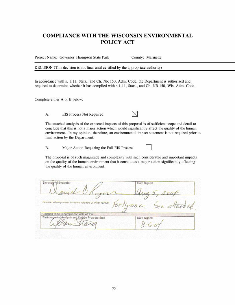
72
COMPLIANCE WITH THE WISCONSIN ENVIRONMENTALPOLICY ACT
Project Name: Governor Thompson State Park County: Marinette
DECISION (This decision is not final until certified by the appropriate authority)
In accordance with s. 1.11, Stats., and Ch. NR 150, Adm. Code, the Department is authorized andrequired to determine whether it has complied with s.1.11, Stats., and Ch. NR 150, Wis. Adm. Code.
Complete either A or B below:
A. EIS Process Not Required
The attached analysis of the expected impacts of this proposal is of sufficient scope and detail toconclude that this is not a major action which would significantly affect the quality of the humanenvironment. In my opinion, therefore, an environmental impact statement is not required prior tofinal action by the Department.
B. Major Action Requiring the Full EIS Process
The proposal is of such magnitude and complexity with such considerable and important impactson the quality of the human environment that it constitutes a major action significantly affectingthe quality of the human environment.

73
NOTICE OF APPEAL RIGHTS
If you believe that you have a right to challenge this decision, you should know that Wisconsin statutesestablish time periods within which requests to review Department decisions must be filed.
For judicial review of a decision pursuant to sections 227.52 and 227.53, Stats., you have 30 days afterthe decision is mailed, or otherwise served by the Department, to file your petition with the appropriatecircuit court and serve the petition on the Department. Such a petition for judicial review shall name theDepartment of Natural Resources as the respondent.
This notice is provided pursuant to section 227.48(2), Stats

74
75
CHAPTER SIX
SUMMARY OF PUBLIC INVOLVEMENT
Prior to the beginning of the Governor Thompson State Park master planning process, theDepartment drafted a citizen involvement plan for the planning process. When the start ofthe planning process was announced, copies of the citizen involvement plan were providedto the public and comments were solicited.
In an effort to involve all parties affected by or interested in the future of the GovernorThompson State Park, the Department incorporated a variety of public involvementtechniques. Throughout the master planning process, the Department used direct mailings,workshops, issue forums, and news releases to keep people informed and involved. Allmeeting announcements and information materials were sent to the Governor ThompsonState Park mailing list, which currently totals over 1,400 individuals.
CHRONOLOGY OF PUBLIC INVOLVEMENT ACTIVITIES
The following is a listing of public involvement activities the Department master planningteam members conducted or attended during the master planning process that was begun inAugust, 2001. Public meetings listed here were all announced in advance by a pressrelease sent to local and statewide newspapers. Press releases were also distributed at keypoints in the planning process. In addition, there has been good press coverage by the localnewspapers of events and issues throughout the planning process. An expanded mailing listwas established following the initial public open house meeting. Each public open house orinformational meeting was also announced through mailings to landowners and otherinterested citizens.
Mailings were also conducted early in the planning process to receive public input on theactual public involvement plan and the goals and objectives for the project.
August 2001. A special briefing was conducted at the Wausaukee Ranger Station formembers of the State Tourism Committee.November 2001. Invitations mailed to local government officials and initial publicparticipation database members, announcing the first public master plan meetings.November 2001. Produced and distributed the first edition of the trifold master planningbrochure. December 2001. Public meetings began the week of December 5, 2001. Three eveningmeetings were held. March 2002. Postcards were mailed to all participants of record explaining the decision tocreate the initial stages of master plans for both the Peshtigo River State Forest andGovernor Thompson State Park concurrently.

Chapter 6: Summary of Public Involvement
76
March 2002. Gave a master planning presentation, by request, to members of anequestrian club in Green Bay. Interest in horseback riding and horse camping has beenstrong since the initiation of the master plan.May 2002. Published the first edition of the Master Planning News. June 2002. Gave master planning presentation, by request, to a New London areaequestrian group. Strong interest in riding horses and horse camping in GovernorThompson State Park was expressed.August 2002. Public Meetings held (Crivitz and Green Bay) to discuss Vision Statementand Goals for Governor Thompson State Park and Peshtigo River State Forest. October 2002. Published Newsletter covering planning on Peshtigo River State Forest andGovernor Thompson State Park. Concept of “Visioning” introduced. November 2002. Newsletter published containing suggested draft vision and goalstatements for both Peshtigo River State Forest and Governor Thompson State Park. January 2003. Met with Basin Partners to discuss and compare their views of the proposedmanagement alternatives with views expressed by the DNR Core Team and GuidanceTeam.February 2003. Newsletter published giving results of the vision and goals exercise.February 2003. Master planning presentation, by request, to Green Bay Chapter ofAudubon Society.April 2003. Public Notice of meeting to discuss Management Alternatives for the masterplan. Planning for Governor Thompson State Park advances independently of PeshtigoRiver State Forest.April 2003. Newsletter announces the April public meetings and describes the managementalternatives that would be discussed at the public meetings.April 2003. Public meetings (Crivitz and Green Bay) to discuss proposed managementalternatives for Governor Thompson State Park.May 2003. Met with Basin Partners to discuss the status and content of the preferredmanagement alternatives.May 2003. Met with Marinette County Tourism Alliance. Presented a master planningupdate and discussed status and content of the preferred management alternative.May 2003. Presented a master planning update to the Marinette County Board ofSupervisors, concentrating on the status and content of the preferred managementalternatives.June 2003. Newsletter published reporting on the results of the April public meeting andpresenting the subsequent Revised Preferred Management Alternative information. February 2004. Progress report on status of the Master Plan mailed to over 1,300recipients.February 2004. Master Planning update presentation given to Marinette County TourismAlliance.March 2004. Master Planning update presentation given to Marinette County Board ofSupervisors.July 7, 2004. Newsletter published with Summary of Master Plan content, DevelopmentMap, and announcement of review period for Master Plan/Environmental Assessment. Sentto over 1,300 mailing list recipients and posted on DNR Website. July 20 & 21, 2004. Public meetings held in Crivitz and Green Bay to discuss the draftMaster Plan/EA for Governor Thompson State Park. Public comment period held openuntil July 31, 2004.

77
BIBLIOGRAPHY / REFERENCES
Andrews, Lloyd M., Carlson, Harland and Threinen, C.W. 1975. Surface Water Resourcesof Marinette County. Lake and Stream Classification Project. Wisconsin Department ofNatural Resources. 1000-3K50068-75.
Finley, R.W. 1976. Original Vegetation Cover of Wisconsin, compiled from U.S. GeneralLand Office Notes. University of Wisconsin Extension. Madison, WI. 1:500,000 map.
Marcouiller, David; Olsen, Eric; and Prey, Jeffrey. 2002. State Parks and their GatewayCommunities: Development and Recreation Planning Issues in Wisconsin. UW ExtensionPublications. Wisconsin Department of Natural Resources (G37773).
Radeloff, V.C., Mladenoff, D.J., Manies, K.L. and Boyce, M.S. 1998. Analyzing forestlandscape restoration potential: pre-settlement and current distribution of oak in thenorthwest Wisconsin Pine Barrens. Trans. Wisc. Acad. Sci. arts Letter. 86: 189-205
Wernerehl, Robert; Ungrodt, Jeffrey. 2002. Ecological Assessment and EcologicalOverview for the Governor Tommy G. Thompson Centennial State Park and Peshtigo RiverState Forest, Marinette County, Wisconsin Clark Forestry, Inc. for the Wisconsin NaturalHeritage Inventory. Wisconsin Department of Natural Resources.
Wisconsin Department of Natural Resources Staff. 2001. Forest Recon, Paust’s WoodsLake Resort. Field Work, Maps, and Text by DNR Northeast Region and Upper Green BayBasin Staff, Wisconsin Department of Natural Resources.
Wisconsin Department of Natural Resources Northeast Region Staff, Green Bay. 2000.Feasibility Report and Environmental Analysis - Land Acquisition, Proposed Caldron FallsCentennial State Park, Marinette County, Wisconsin. Wisconsin Department of NaturalResources.
Wisconsin Department of Natural Resources Northeast Region Staff, Green Bay. 2000.Feasibility Report and Environmental Analysis - Land Acquisition, Proposed GovernorTommy G. Thompson Centennial State Park, Marinette County, Wisconsin. WisconsinDepartment of Natural Resources.
Wisconsin Department of Natural Resources. 2001. The Upper Green Bay ManagementPlan. PUBL WT-663 2001.

78

79
DEFINITIONS AND ABBREVIATIONS
DEFINITIONS
Biological diversity. The variety and abundance of species, their genetic composition, andthe communities, ecosystems, and landscapes in which they occur. It also refers to thevariety of ecological structures, functions, and processes at any of these levels.
Board. The Natural Resources Board.
Climax forest. A forest stand in which the long-term species composition is relativelystable.
Campground, Modern (NR 44.07(7)(e)5b). These may be comprised of a singlecampground or a large campground complex, and typically have 75 or more campsites. Theseparation distance between campsites may vary, although 100 feet shall be used as aguideline. The facility development options are not limited; however, the followingfacilities usually are provided: electric hook-ups for recreational vehicles, hand pump orpressurized water supply, vault or flush toilets, a recreational vehicle dumping station on-site or nearby, asphalt roadways, open play areas, paved paths and trails, lighting onbuildings and public telephones. Examples of other facilities that may be present includeplayground equipment, full-service concessions, showers and laundry facilities.
Community. An assemblage of species living together in a particular area, time andhabitat.
Cultural resources. Any archeological, architectural or historical artifact, site or structurethat reflects on the human-made environment.
Department or DNR. The Wisconsin Department of Natural Resources.
Ecological capability. The potential of an area to support or develop one or morecommunities, with the potential being dependent on the area’s flora and fauna, its non-biotic attributes, its ecological processes and disturbances within and upon the area.
Facility development. The construction of infrastructure, including buildings, roads andtrails for resource management, public use or other purposes.
Forbs. Non-woody flowering plants, most likely native to the region.
Group campsite. Any campsite authorized for use by groups other than those meeting thedefinition of a camping party in a family campground as defined by ch. NR 45.

Definitions and Abbreviations
80
Invasive. Both native and exotic species (not native to WI) that have a tendency to takeover a site in the absence of period fires or other natural processes that would havehistorically kept the plant species in check; typically the overabundance of invasive speciescauses a dramatic decrease in a system’s diversity.
Master plan or plan. A Department plan that describes the authorized land management,resource protection, facility development and management of recreational use on adepartment property, but does not include a study prepared for the purpose of consideringthe feasibility of land acquisition respecting a new or existing project.
Native. Indigenous to the area or region.
Native Surface Material. Unprocessed indigenous road and trail surfacing material.
Natural Succession. The predictable tendency of certain longer-lived tree species toreplace shorter-lived ones over a period of time, if left undisturbed.
Natural-appearing. That which is visually perceived as minimally altered by humanactions.
Slow-No-Wake Zone. A designated area of a water body where operation of watercraftmust not result in a visible wake reaching the shore. This is intended to protect shorelinesfrom wave-induced erosion and to protect other water users from undue disturbance.
Sustainable Trail. A trail that can tolerate continuous moderate use without causingenvironmental damage or requiring an unreasonable amount of maintenance and repair.
Passive Management. Management where objectives are achieved without direct action.
Presettlement. The time prior to a significant presence of American/European settlers.
Property or properties. Areas of land approved for acquisition by the governor undersec.23.14, State Stats., or otherwise established by the board.
Rare Species. Endangered, threatened, or plants and animals of special concern.
Silviculture. A phase of forestry dealing with the development and care of forestcommunities.
Single Unit Campsite. A campsite designated for use by families or groups of six personsor fewer.
Trail. A way or path designated on department maps or by signs or both as open for publictravel by foot, horseback, bicycle, snowmobile, ATV or highway/off-highway vehicles.
Trail, Fully Developed. Shall be a trail with a smoothly graded base and a stable, hardsurface composed of materials such as asphalt, aggregate or frozen earth. The trail’s

Definitions and Abbreviations
81
cleared width, tread width and cuts and fills are not limited, but shall be appropriate for thetrail’s intended use. To the degree practicable and feasible, fully developed pedestrian trailsshall be fully accessible by persons with physical disabilities.
Trail, Lightly Developed. Shall be a trail with a maximum sustained, cleared widthnormally not exceeding 16 feet, a moderately wide tread width for the designated uses, arough-graded base to remove stumps and large rocks, and a surface of primitive or nativematerials, except where other materials are required due to environmental conditions orwhere the trail also serves as a lightly developed road where other types of surfacingmaterials are used.
Trail, Moderately Developed. Shall be a trail with a maximum sustained, cleared widthnormally not exceeding 8 feet, a minimal tread width for the intended use, a relativelysmooth graded base with a compacted surface composed of stable materials such asaggregate. Where practical and feasible, a moderately developed trail shall, at a minimum,meet the standards for recreational trails accessible to persons with a disability.
Trail, Primitive. A trail that shall be minimally developed as single-file with a maximumsustained, cleared width normally not exceeding 8 feet and a minimal tread width for theintended use, with a rough, ungraded bed where large rocks, stumps and downed logs maybe present. It primarily follows the natural topography, has no or few distances whereenvironmental conditions require the use of other material. Modifications to the natural trailsurface are limited to that which is minimally necessary to provide essential environmentalprotection.
ABBREVIATIONS
BMP’s Best Management Practices
CPP Citizen Participation Plan
DMU Deer Management Unit
EA Environmental Assessment
EIS Environmental Impact Statement
FERC Federal Energy Regulatory Commission
GLARC Great Lakes Area Research Center
GTSP Governor Thompson State Park
LTE Limited Term Employee
MCF Marinette County Forest
NHEU National Hierarchy of Ecological Units

Definitions and Abbreviations
82
NHI Natural Heritage Inventory
NRB Natural Resources Board
PRSF Peshtigo River State Forest
SHSW State Historical Society of Wisconsin
UGBB Upper Green Bay Basin
UWEX University of Wisconsin Extension
WDNR Wisconsin Department of Natural Resources
WPS Wisconsin Public Service Corporation