draft environmental impact report santa monica high...
TRANSCRIPT
Santa Monica High School Science and Technology Building and Site Improvements Project
April 2010
Draft Environmental Impact Report
Prepared for Santa Monica-Malibu Unified School District
1651 Sixteenth Street, Santa Monica, California 90404

Draft Environmental Impact Report Santa Monica High School Science and Technology
Building and Site Improvements Project State Clearinghouse No.: 2009061032
Prepared for:
Santa Monica-Malibu Unified School District 1651 Sixteenth Street
Santa Monica, California 90404
In association with:
Parsons/Santa Monica-Malibu Unified School District Program
12100 Wilshire Boulevard, Suite 1950 Los Angeles, California 90025
Prepared by:
515 South Flower Street, 9th Floor Los Angeles, California 90071
April 2010

Santa Monica High School Science and Technology Building and Site Improvements Project Draft EIR Page i Santa Monica-Malibu Unified School District April 2010
TABLE OF CONTENTS
CHAPTER PAGE ES EXECUTIVE SUMMARY ..................................................................................................... ES-1 1.0 INTRODUCTION ...................................................................................................................... 1-1
1.1 Summary of the Proposed Project .................................................................................... 1-1 1.2 The CEQA Environmental Process ................................................................................. 1-1 1.3 Organization of the EIR ................................................................................................... 1-4
2.0 PROJECT DESCRIPTION ....................................................................................................... 2-1
2.1 Project Location ............................................................................................................... 2-1 2.2 Physical Environmental Setting ....................................................................................... 2-1
2.2.1 Existing Land Uses ............................................................................................. 2-1 2.2.2 Surrounding Land Uses ...................................................................................... 2-1 2.2.3 General Plan Designation and Zoning ................................................................ 2-2
2.3 Project Objectives ............................................................................................................ 2-5 2.4 Proposed Project Characteristics ...................................................................................... 2-6
2.4.1 Science and Technology Buildings Reconfiguration ........................................ 2-11 2.4.2 Campus Wide Updates ...................................................................................... 2-14 2.4.3 Additional Features ........................................................................................... 2-17
2.5 Construction Scenario .................................................................................................... 2-21 2.6 Intended Uses of the EIR ............................................................................................... 2-22 2.7 Project Approvals Required ........................................................................................... 2-23
3.0 ENVIRONMENTAL SETTING, IMPACTS, AND MITIGATION ...................................... 3-1
3.1 Aesthetics ...................................................................................................................... 3.1-1 3.2 Air Quality ................................................................................................................... 3.2-1 3.3 Cultural Resources ........................................................................................................ 3.3-1 3.4 Hazards and Hazardous Materials ................................................................................ 3.4-1 3.5 Land Use and Planning ................................................................................................. 3.5-1 3.6 Noise ............................................................................................................................. 3.6-1 3.7 Recreation and Parks .................................................................................................... 3.7-1 3.8 Transportation and Traffic ............................................................................................ 3.8-1
4.0 IMPACT OVERVIEW ............................................................................................................... 4-1
4.1 Significant Unavoidable Adverse Impacts ....................................................................... 4-1 4.2 Effects Not Found to Be Significant ................................................................................ 4-2
4.2.1 Agricultural Resources ....................................................................................... 4-2 4.2.2 Biological Resources .......................................................................................... 4-2 4.2.3 Geology and Soils ............................................................................................... 4-3 4.2.4 Hydrology and Water Quality ............................................................................. 4-3 4.2.5 Mineral Resources .............................................................................................. 4-4
Table of Contents
Page ii Santa Monica High School Science and Technology Building and Site Improvements Project Draft EIR April 2010 Santa Monica-Malibu Unified School District
4.2.6 Population and Housing ...................................................................................... 4-5 4.2.7 Public Services .................................................................................................... 4-5 4.2.8 Utilities and Service Systems ............................................................................. 4-5
4.3 Cumulative Impacts ......................................................................................................... 4-5 4.4 Significant Irreversible Environmental Changes ........................................................... 4-24 4.5 Growth-Inducing Impacts .............................................................................................. 4-25
5.0 ALTERNATIVES ....................................................................................................................... 5-1
6.0 ACRONYMS AND ABBREVIATIONS ................................................................................... 6-1
7.0 REFERENCES ............................................................................................................................ 7-1 8.0 LIST OF PREPARERS .............................................................................................................. 8-1 TECHNICAL APPENDICES Appendix A Notice of Preparation, Initial Study, and Responses to Notice of Preparation Appendix B Air Quality Worksheets and HRA Appendix C Cultural Resources Technical Report Appendix D Hazardous Materials Reports Appendix E Noise Worksheets Appendix F Traffic Study

Santa Monica High School Science and Technology Building and Site Improvements Project Draft EIR Page ES-1 Santa Monica-Malibu Unified School District April 2010
EXECUTIVE SUMMARY
ES.1 INTRODUCTION AND BACKGROUND
This Environmental Impact Report (EIR) has been prepared by the Santa Monica-Malibu Unified School District (SMMUSD) to evaluate potential environmental effects that would result from development of the proposed Santa Monica High School Science and Technology and Site Improvements Project (proposed Project). This EIR has been prepared in conformance with the California Environmental Quality Act of 1970 (CEQA) statutes (Cal. Pub. Res. Code, Section 21000 et. seq., as amended) and implementing guidelines (Cal. Code Regs., Title 14, Section 15000 et. seq., 2009). The SMMUSD is the lead agency under CEQA.
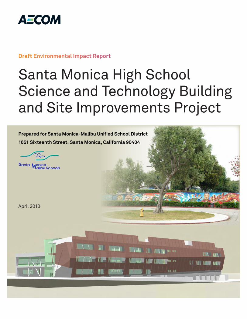
The SMMUSD proposes to reconfigure the northern portion of the existing Santa Monica High School campus, which is located at 601 Pico Boulevard. The proposed Project would consist of the demolition of the existing 88,000-square-foot two-story Science and Technology Buildings, a 253-space parking lot, and softball field and construction of a new 84,000-square-foot, three-story Science and Technology Building, replacement parking lot, and softball field in a reconfigured site layout. A formal perimeter would be created along 7th Court Alley and Olympic Boulevard. All vehicle access to the Project site would be re-routed to 6th Street, with an enhanced pedestrian and bicycle entrance along Michigan Avenue. Bicycle parking for 50 bicycles would be provided near the Michigan Avenue entrance. An Americans with Disabilities Act (ADA) accessible drop-off and pick-up lane would be provided along Olympic Boulevard. Campus-wide updates to the fire alarm and electrical systems would be included, and dependent on funding: the existing football field would be resurfaced with synthetic turf, the south gymnasium ceiling would be improved, and ventilation for the gymnasium and swimming pool locker rooms would also be improved.
ES.2 PROJECT LOCATION AND SETTING
The Santa Monica High School campus is located at 601 Pico Boulevard in the City of Santa Monica in the County of Los Angeles and is located generally south of the intersection of Olympic Boulevard and Lincoln Boulevard, approximately 100 feet south of Interstate 10 (I-10, Santa Monica Freeway), which becomes State Route 1 (SR-1, Pacific Coast Highway) approximately 800 feet southwest of the campus, and Interstate 405 (I-405, San Diego Freeway) approximately 3.5 miles to the northeast. The Pacific Ocean is located approximately one-half mile to the west of the campus.
The 26-acre campus is bordered by Olympic Boulevard and 5th Street on the north, 7th Court Alley and 7th Street on the east, Michigan Avenue and Pico Boulevard on the south, and 4th Street and hotel use on the west. The Project site specifically occupies the northeastern 5.2 acres of the campus bordered by Olympic Boulevard on the north, 6th Street on the west, the remainder of the Santa Monica High School campus on the south, and 7th Court Alley on the east. The proposed building reconfiguration would occur on this northeastern portion of the campus with additional infrastructure improvements occurring throughout the entire campus.
Executive Summary
Page ES-2 Santa Monica High School Science and Technology Building and Site Improvements Project Draft EIR April 2010 Santa Monica-Malibu Unified School District
The 5.2-acre Project site is located in the northeastern portion of the campus and is currently occupied by two, two-story buildings (Science and Technology buildings) which total approximately 88,000 square feet with the Technology Building located north of the Science Building. A basement level to the Technology Building is visible only on the southwestern façade of the building. A 253-space parking lot and a softball field also exist on the Project site. The existing Science and Technology Buildings currently occupy the southern corner of the Project site with the existing softball field located in the eastern corner and the existing parking lot on the northern and western corners.
The Santa Monica High School campus is surrounded by commercial, multi-family residential and civic uses. Commercial and multi-family residential uses are located east of the Project site, on the east side of 7th Court Alley and along Lincoln Boulevard. The commercial uses include gas stations, other automobile-related uses, small strip malls, and small commercial/industrial establishments that front Lincoln Boulevard. One multi-family residence, east of 7th Court Alley fronts Lincoln Boulevard, while the other multi-family residences are located directly adjacent to 7th Court Alley, approximately 23 feet east of the Project site. In addition, multi-family residential uses are located approximately 33 feet north of the campus, between 5th Street and Olympic Boulevard. Multi-family residences are located southeast of the Project site on the southeast side of Michigan Avenue. The DoubleTree Guest Suites Hotel is located adjacent west of the campus, and the Sheraton Delfina Hotel to the south, on the south side of Pico Boulevard. Civic uses are located west of the campus. The City of Santa Monica City Hall and the new Civic Center Parking Structure, Santa Monica Civic Auditorium (constructed in 1958) and large Civic Lot surface parking area, and related civic facilities are located on the west side of 4th Street. In addition, the Viceroy Hotel and RAND building are located west of the civic land uses.
ES.3 PROJECT OBJECTIVES
In 2006, Santa Monica and Malibu voters passed the local general obligation Measure BB Bond, a $268-million bond to construct and renovate schools within the SMMUSD. The SMMUSD requires all of its schools to improve health, safety, and class instruction. The proposed Project has been designed to adhere to these goals and requirements. The main objectives of the proposed Project are to:
• Provide modernized science and technical classrooms;
• Establish a public “front door” at the Michigan Avenue entrance to the campus;
• Develop open spaces that would unify and enhance the northern portion of the campus;
• Maximize student safety by locating buildings along the perimeter of the campus and outdoor spaces in the interior of the campus, thereby retaining students within the campus during school hours and providing separation from the general public;
• Remove asbestos, lead and other hazardous substances from the existing Science and Technology Buildings;
• Improve vehicular, bicycle and pedestrian access to campus;
• Reconfigure the existing 253-space parking lot, which currently contributes to vehicular traffic on 7th Court Alley;
Executive Summary
Santa Monica High School Science and Technology Building and Site Improvements Project Draft EIR Page ES-3 Santa Monica-Malibu Unified School District April 2010
• Develop a maintainable building consistent with SMMUSD Resolution No. 07-07 on Green Building Design and Construction; and
• Provide existing campus classrooms with limited infrastructure upgrades in preparation for future District Standard technology upgrades.
ES.4 PROPOSED PROJECT CHARACTERISTICS
SMMUSD is proposing to reconfigure the approximately 5.2-acre Project site located within the northeastern portion of the Santa Monica High School campus. The existing 88,000-square-foot Science and Technology Buildings currently occupy the southern corner of the Project site with the existing softball field located in the eastern corner and the existing 253-space parking lot on the northern and western corners. The proposed Project would consist of the demolition of the existing Science and Technology Buildings, parking lot, and softball field and construction of a new three-story 84,000-square-foot Science and Technology Building, and softball field in a reconfigured site layout and a reconfigured parking lot.
The proposed Project would place the new Science and Technology Building in the northern and eastern portion of the Project site, directly adjacent to 7th Court Alley. The new building would be constructed within the Santa Monica High School campus property line and would not encroach into 7th Court Alley. The setback would vary from the northern end to the southern end of the building. The building would be set back from the alley lot line approximately 10 feet 8 inches at the north end, and approximately 12 feet at the south end. The scrim or screen material to be installed on the eastern side of the building would extend approximately three feet four inches into this setback area. The softball field would be relocated to the southern corner of the Project site, while the proposed L-shaped parking lot would be located in between the new building and softball field, extending to the west just south of along Olympic Boulevard, and east of 6th Street. As a result of the proposed reconfiguration, approximately 20 landscape trees may be removed within the Project site. A few of the trees in the northeastern portion of the landscaped quad area would be removed with the proposed Project. However, these removed landscape trees would be replaced in excess of the number of trees removed and the existing trees are not known to be protected. A landscape plan detailing the replacement of these trees is included as part of the proposed Project.
The proposed Project would reconfigure existing land uses and would not result in an increase in student enrollment or capacity of the school. No new land uses would be introduced to the campus with the proposed Project.
Access
The new Science and Technology Building would be designed to enhance the Michigan Avenue pedestrian and bicycle entrance to the campus and create a formal perimeter along the 7th Court Alley, and Olympic Boulevard. Currently, vehicles access the campus by Michigan Avenue (primarily for drop-off/pick-up) traveling from Lincoln Boulevard, and 6th Street traveling from Olympic Boulevard. Vehicles currently enter the Project site from the 7th Court Alley that separates the Project site from the gas station located south of the intersection of Olympic Boulevard and Lincoln Boulevard. Access to the

Executive Summary
Page ES-4 Santa Monica High School Science and Technology Building and Site Improvements Project Draft EIR April 2010 Santa Monica-Malibu Unified School District
7th Court Alley currently exists from Olympic Boulevard or Michigan Avenue. Vehicles traveling along Olympic Boulevard also currently use 6th Street as a drop-off and pick-up location for the entire campus. The proposed Project would re-route all access to the Project site via a ramp off of the 6th Street access road to the proposed new parking lot. An Americans with Disabilities Act (ADA) accessible drop-off and pick-up lane would be provided along Olympic Boulevard just west of its intersection with Lincoln Boulevard. Access to 7th Court Alley would be retained and would continue to serve the commercial and residential parcels adjacent to the eastern boundary of the Project site. The 7th Court Alley would also be used for vehicle access to the school’s auto shop, which would be located in the northeastern corner of the proposed Science and Technology Building. The existing bicycle racks will be relocated elsewhere on the Project site and a new cycle parking facility for 50 bicycles would be provided near the Michigan Avenue pedestrian and bicycle entrance. The City of Santa Monica has a potential future project that would construct a pedestrian bridge that would span over the I-10 in alignment with 7th Street. This new bridge may potentially require an unknown amount of space adjacent to or within the Santa Monica High School campus. The City has stated that a detailed project description or engineering drawings for this potential future project are not yet available.1
Additional components of the proposed Project would include campus-wide updates to the fire alarm and electrical systems. Depending on funding, additional components would potentially include installation of synthetic turf at the existing football field, improvements to the South Gymnasium ceiling, and ventilation improvements to the gymnasium and swimming pool locker rooms.
The construction period for the proposed Project is anticipated to start in the third quarter of 2011 and end in the second quarter of 2014. Construction of the Project is considered in two phases, construction of the new Science and Technology buildings (Phase 1) and demolition of the old buildings (Phase 2), with each phase composed of a number of elements. The existing buildings would continue to operate during the construction of the new building. The new building construction would also remove the existing softball field and a portion of the existing parking lot. Following construction of the new building, existing buildings would be removed and replaced with the new softball field and parking lot reconfiguration.
ES.5 AREAS OF CONTROVERSY
In accordance with CEQA, an Initial Study and Notice of Preparation were prepared and circulated for public review from June 9, 2009 to July 9, 2009. An English and Spanish version of the Notice of Preparation, which included an announcement of the public scoping meeting, was mailed to all property owners and occupants within a 500-foot radius of the Project site. This included a total of 667 mailings to surrounding residential, commercial, civic and other properties. The Initial Study and Notice of Preparation were also mailed to 41 state, regional, and local agencies, organizations and stakeholders. In addition, the notice and scoping meeting announcement was circulated in a two local newspapers on June 11, 2009: the Daily Breeze and La Opinión (in Spanish).
1 Correspondence with Beth Rolandson, City of Santa Monica, Transportation Management Division. July 28, 2009.
Executive Summary
Santa Monica High School Science and Technology Building and Site Improvements Project Draft EIR Page ES-5 Santa Monica-Malibu Unified School District April 2010
A public scoping meeting was held at the Project site on June 23, 2009.2 The purpose of this meeting was to seek input from public agencies and the general public regarding the environmental issues and concerns that may potentially result from the proposed Project. At the time of the scoping meeting, a major drop-off/pick-up area (turnout) was proposed along Olympic Boulevard which has since been eliminated due to City input and the public comments below. Currently, an ADA accessible drop-off and pick-up lane would be provided along Olympic Boulevard. The following list summarizes the public comments and questions received at the scoping meeting that were related to environmental issues or the environmental process:
Aesthetics
• The building is massive and should be constructed along Olympic Boulevard, not Michigan Avenue.
• Will the building be constructed outside the school’s property line? • The building may result in shade impacts and block the view of the mountains. • The new three-story building would impact the visual quality of nearby one- to two-story
residential buildings.
Air Quality
• Air circulation would be hindered with the large building. • Concerned about air quality and dust impacting the residents, students, other children, and
sensitive receptors in the area.
Hazards and Hazardous Materials
• Asbestos, chemical contamination and dust particle emissions may be an issue. Mitigation measures are needed to minimize these issues.
Noise
• The existing alarms on the campus are constantly going off.
Transportation, Traffic, and Circulation
• Traffic may be an issue with the proposed Project, especially related to graduation (grad) night and parent drop-off/pick-up.
• The main entrance to the Project site should be along Olympic Boulevard so vehicle would not have to travel along Michigan Avenue, which is a residential street.
• Include pedestrian- and bicycle-friendly facilities.
2 A qualified Spanish translator was available at the public scoping meeting.
Executive Summary
Page ES-6 Santa Monica High School Science and Technology Building and Site Improvements Project Draft EIR April 2010 Santa Monica-Malibu Unified School District
• Consider underground parking and permeable pavement. The underground parking would be more expensive, but its benefits would outweigh the health and aesthetic impacts that could result from the current Project.
• Enhance policing for parents illegally parking or dropping-off/picking-up students. • Would the Project allow for the pedestrian bridge to occur in the future? • The transportation demand management should include students, parents and teachers to
encourage alternative modes of transportation. The Project should enhance walkability, provide safer bike routes, enhance routes to transit and include LEED elements.
• Provide details on the traffic and sidewalk/pedestrian safety on Olympic Boulevard and Michigan Avenue.
• The drop-off area on Olympic Boulevard would not be safe for the students or for vehicles due in part to the freeway on- and off-ramp traffic. Consider a turnout into the school property in the parking lot.
• Michigan Avenue is a part of a joint use Project for the proposed bicycle boulevard connecting to Ocean Boulevard.
• Construction vehicles and equipment should not park in residential or preferential parking areas. • The existing median/island at Michigan Avenue and 7th Street needs to be removed as it is
blocking traffic. • Do not block access for residents located east of the high school campus and do not exacerbate
the poor parking situation on 7th Street.
Other
• The scoping meeting has low attendance due to the scheduling.
In addition to commenting at the scoping meeting, the public and agencies were permitted to send comments to SMMUSD by mail, e-mail or fax. After the scoping meeting and during the public review period, nine comment letters were received in response to the Notice of Preparation and Initial Study for the proposed Project. Copies of the comment letters are provided in Appendix A. The primary areas of controversy identified by the public and agencies included the following potential issues:
Aesthetics
• Lighting should be provided along Olympic Boulevard in order to reduce opportunities for graffiti and deter crime.
• Shade and shadow effects from the proposed Project onto the residential uses on the east side of 7th Court Alley should be addressed.
Air Quality
• The inclusion of additional trees and a permeable parking lot surface should be considered to reduce any potential heat island effect.
• Consider baseline air quality emissions from the adjacent I-10 Freeway.
Executive Summary
Santa Monica High School Science and Technology Building and Site Improvements Project Draft EIR Page ES-7 Santa Monica-Malibu Unified School District April 2010
Transportation, Traffic, and Circulation
• Traffic and emergency response time delays may occur as a result of providing only one access point to the reconfigured parking lot along Olympic Boulevard.
• The City of Santa Monica methodology and significance criteria should be used for the Project traffic study.
• A bike workshop should be included with the auto workshop. • Transportation Demand Management (TDM) programs should be considered to reduce car trips
to include students and staff. • 7th Court Alley should not be used to accommodate high volumes of traffic and should avoid
serious conflicts with pedestrians on Michigan Avenue. • Bicycle traffic should be accommodated by the proposed Project along Michigan Avenue in a
safe manner, which enhances the role of Michigan Avenue as a bike access and bike boulevard throughout the site.
• The proposed Project should adhere to the California Collaborative for High Performance Schools (CHPS) standards, which may require up to 300 safe bicycle parking spaces.
• A turnout for student drop-off/pick-up is not recommended along Olympic Boulevard because the pedestrian area would be reduced and the efficiency of the existing drop-off/pick-up areas at that location would be reduced. Consider moving the drop-off/pick-up area further to the west along Olympic Boulevard to avoid conflicts with vehicles traveling on Olympic Boulevard towards the I-10 Freeway on-ramp.
• Baseline traffic counts in the area should include non-motorized modes of transportation, including skateboards, skating, etc. These modes of transportation are quite prevalent near the school and pose unique challenges.
• The proposed Project may result in increased traffic at the intersection of Michigan Avenue and 7th Street, particularly in the morning and afternoon.
• Project-related vehicles should not park on Michigan Avenue or 7th Street. • The drop-off/pick-up area at Michigan Avenue and 7th Street should be eliminated, as well as the
small street median at this intersection. This causes heavy traffic and queuing at this intersection. • No construction equipment should be parked on Michigan Avenue or 7th Street during the
construction of the proposed Project. • The proposed Project should be consistent with future City plans to include pedestrian and
bicycle paths along Michigan Avenue.
Noise
• The apartment building and hotel located adjacent and to the northwest of the Santa Monica High School campus should be considered sensitive receptors for the construction and operational noise analyses.

Executive Summary
Page ES-8 Santa Monica High School Science and Technology Building and Site Improvements Project Draft EIR April 2010 Santa Monica-Malibu Unified School District
Hazards and Hazardous Materials
• The removal of asbestos and other chemicals associated with the demolition of the exiting Science and Technology Buildings should be performed properly as to prevent any toxic dust from impacting sensitive receptors on campus.
• Mitigation measures should be implemented to reduce impacts related to the presence of lead-based paint, pesticides and any other contaminants on the Project site.
• Contaminants that may have migrated via groundwater and/or soil gas pathways should be investigated and mitigated.
Recreation and Parks
• The temporary relocation of Santa Monica High School softball field uses to Memorial Park during the construction phase would result in significant effects to the park as the park is already heavily utilized.
Land Use and Planning
• The proposed Project would not comply with the City’s upper-level step-back requirements. • The City of Santa Monica’s Land Use and Circulation Element Strategy Framework includes a
vision for a future bridge over the I-10 Freeway aligning with 7th Street on the north. The environmental analysis should include how the proposed Project interacts with this concept and how pedestrians and bicyclists using the bridge would enter the campus, as well as across the possible future Michigan Avenue concourse.
• The proposed Project would adversely impact the Wallpaper City and Flooring property located on the east side of 7th Court Alley, as well as the 25 residential units located on the first and second stories of these existing buildings.
Other
• Public outreach for the proposed Project should reach as many interested parties and individuals as possible. Public meetings for the Project should be scheduled when school is in session and internet files of environmental documents for the proposed Project should be easily accessible for the public.
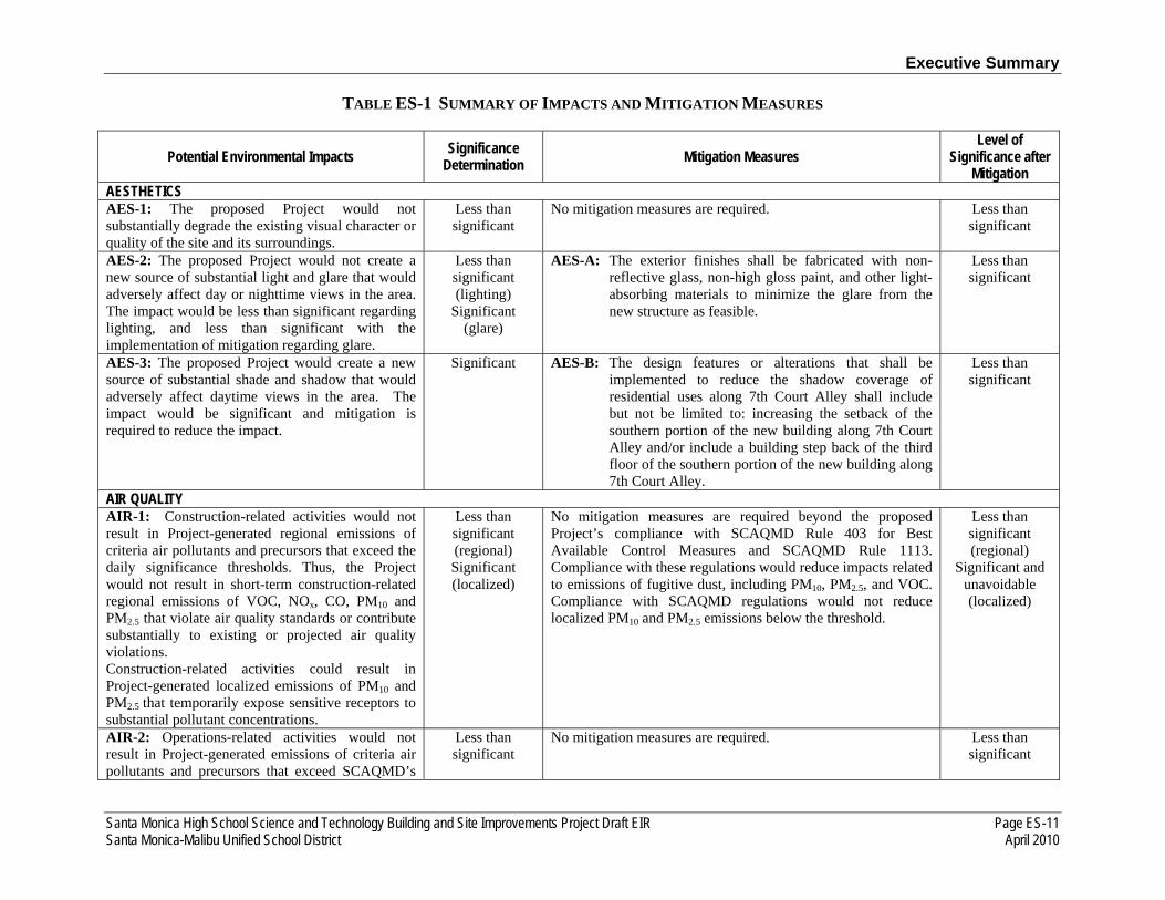
ES.6 SUMMARY OF ENVIRONMENTAL IMPACTS
An analysis of environmental impacts caused by the proposed Project has been conducted and is contained in this EIR. Eight issue areas are analyzed in detail in Chapter 3.0. Table ES-1 provides a summary of the potential significant environmental impacts that would result during construction and operation of the proposed Project, mitigation measures that would lessen potential environmental impacts, and the level of significance of the environmental impacts that would remain after implementation of mitigation. The proposed Project would create significant and unavoidable impacts related to construction air quality (Chapter 3.2) and construction parking (Chapter 3.8). The EIR identifies potentially significant impacts requiring mitigation for aesthetics – glare and shadows (Chapter 3.1),

Executive Summary
Santa Monica High School Science and Technology Building and Site Improvements Project Draft EIR Page ES-9 Santa Monica-Malibu Unified School District April 2010
hazards and hazardous materials (Chapter 3.4), construction and operational noise (Chapter 3.6), recreation and parks (Chapter 3.7), and operational and construction traffic (Chapter 3.8). The EIR identified less than significant impacts for aesthetics – visual character (Chapter 3.1), operational air quality (Chapter 3.2), and land use and planning (Chapter 3.5). The EIR identified XX impacts for cultural resources [SEE CULTURAL SECTION AND PLEASE ADVISE]. As discussed in Chapter 4.0, the proposed Project would contribute to significant cumulative impacts related to construction air quality. A detailed analysis of the environmental impacts described in Table ES-1 is presented in Chapter 3.0 of this EIR.
ES.7 ALTERNATIVES TO THE PROPOSED PROJECT
The CEQA Guidelines Section 15126.6 requires consideration and discussion of alternatives to the proposed Project in an EIR. Several alternatives and concepts, including alternate sites, were considered but rejected from consideration in this EIR. Three alternatives, including the No Project Alternative, are reviewed in Chapter 5.0 of this document. This section summarizes alternatives to the Project that were developed, as well as the No Project Alternative, as required under CEQA.
NO PROJECT ALTERNATIVE
SMMUSD prepared the Santa Monica High School Siting Study in 2008. This study developed long-term design concepts for the redevelopment of various portions of the Santa Monica High School campus. Since these design concepts included the redevelopment of buildings other than the existing Science and Technology Buildings, under the No Project Alternative, there is a potential for SMMUSD make a decision to redevelop some other portion of the Santa Monica High School Campus. In addition, the Civic Center Joint-Use Project is currently under early consideration, which would allow the City of Santa Monica to utilize the new parking facilities that may be constructed within other portions of the campus. In that case, both construction and operational impacts under the No Project Alternative would be expected to increase as compared to the proposed Project.
INCREASED SETBACK ALTERNATIVE
The Increased Setback Alternative would develop a reconfigured Project site nearly identical to the proposed Project. However, the new building would be set back an additional 10 feet from the 7th Court Alley property line in order to reduce shadow impacts on shadow-sensitive multi-family residential uses. The construction phase would be identical in duration and process to that of the proposed Project. Under this alternative, the new building would be the same size and height as with the proposed Project and no new land uses would be introduced to the Project site. Compared to the proposed Project, this alternative would have reduced impacts in the area of aesthetics. This alternative would have similar impacts in the areas of construction and operational air quality, cultural resources, hazards and hazardous materials, land use and planning, construction and operational noise and vibration, recreation and parks, and transportation and traffic. This alternative would reduce the amount of proposed open space on the Project site; however, this alternative would meet all of the Project objectives.
Executive Summary
Page ES-10 Santa Monica High School Science and Technology Building and Site Improvements Project Draft EIR April 2010 Santa Monica-Malibu Unified School District
NO RECONFIGURATION ALTERNATIVE
The No Reconfiguration Alternative would not reconfigure the Project site. The existing Science and Technology Buildings would be replaced with the proposed building of a similar design, size, and height as with the proposed Project. The existing softball field and parking lot would not be reconfigured and would be available for use during the construction phase. However, classes that currently occur in the existing Science and Technology Buildings would have to be relocated into other campus buildings and/or take place in temporary classroom trailers that could be brought onto the Project site. If temporary trailers are installed, they may be placed within the existing parking lot, which would remove some parking spaces from use during the construction phase. The construction phase would be shorter as compared to that of the proposed Project. Similar to the proposed Project, no new land uses would be introduced to the Project site. Compared to the proposed Project, this alternative would have reduced impacts in the areas of aesthetics, construction air quality, recreation and parks, and transportation and traffic. This alternative would have similar impacts in the areas of operational air quality, cultural resources, hazards and hazardous materials, land use and planning, and construction and operational noise and vibration. This alternative would reduce the amount of proposed open space on the Project site, would leave the northeastern portion of the campus open as with existing conditions, and would not reconfigure the parking lot. The No Reconfiguration Alternative would meet seven of the nine Project objectives.
Executive Summary
TABLE ES-1 SUMMARY OF IMPACTS AND MITIGATION MEASURES
Santa Monica High School Science and Technology Building and Site Improvements Project Draft EIR Page ES-11 Santa Monica-Malibu Unified School District April 2010
Potential Environmental Impacts Significance Determination Mitigation Measures
Level of Significance after
Mitigation AESTHETICS AES-1: The proposed Project would not substantially degrade the existing visual character or quality of the site and its surroundings.
Less than significant
No mitigation measures are required. Less than significant
AES-2: The proposed Project would not create a new source of substantial light and glare that would adversely affect day or nighttime views in the area. The impact would be less than significant regarding lighting, and less than significant with the implementation of mitigation regarding glare.
Less than significant (lighting)
Significant (glare)
AES-A: The exterior finishes shall be fabricated with non-reflective glass, non-high gloss paint, and other light-absorbing materials to minimize the glare from the new structure as feasible.
Less than significant
AES-3: The proposed Project would create a new source of substantial shade and shadow that would adversely affect daytime views in the area. The impact would be significant and mitigation is required to reduce the impact.
Significant AES-B: The design features or alterations that shall be implemented to reduce the shadow coverage of residential uses along 7th Court Alley shall include but not be limited to: increasing the setback of the southern portion of the new building along 7th Court Alley and/or include a building step back of the third floor of the southern portion of the new building along 7th Court Alley.
Less than significant
AIR QUALITY AIR-1: Construction-related activities would not result in Project-generated regional emissions of criteria air pollutants and precursors that exceed the daily significance thresholds. Thus, the Project would not result in short-term construction-related regional emissions of VOC, NOx, CO, PM10 and PM2.5 that violate air quality standards or contribute substantially to existing or projected air quality violations. Construction-related activities could result in Project-generated localized emissions of PM10 and PM2.5 that temporarily expose sensitive receptors to substantial pollutant concentrations.
Less than significant (regional) Significant (localized)
No mitigation measures are required beyond the proposed Project’s compliance with SCAQMD Rule 403 for Best Available Control Measures and SCAQMD Rule 1113. Compliance with these regulations would reduce impacts related to emissions of fugitive dust, including PM10, PM2.5, and VOC. Compliance with SCAQMD regulations would not reduce localized PM10 and PM2.5 emissions below the threshold.
Less than significant (regional)
Significant and unavoidable (localized)
AIR-2: Operations-related activities would not result in Project-generated emissions of criteria air pollutants and precursors that exceed SCAQMD’s
Less than significant
No mitigation measures are required. Less than significant

Executive Summary
TABLE ES-1 SUMMARY OF SIGNIFICANT IMPACTS AND MITIGATION MEASURES (CONT.)
Page ES-12 Santa Monica High School Science and Technology Building and Site Improvements Project Draft EIR April 2010 Santa Monica-Malibu Unified School District
Potential Environmental Impacts Significance Determination Mitigation Measures
Level of Significance after
Mitigation regional or localized emissions significance thresholds. Thus, the Project would not result in long-term operational (regional or local) emissions of VOC, NOx, CO, PM10 and PM2.5 that violate air quality standards or contribute substantially to existing or projected air quality violations; or expose sensitive receptors to substantial pollutant concentrations. AIR-3: Operation-related activities would not result in Project-generated emissions of CO that exceed the 20 ppm (1-hour) or 9 ppm (8-hour) standards. Thus, the Project would not result in long-term operational (local) emissions of CO that violate the air quality standard or contribute substantially to an existing or projected air quality violation; or expose sensitive receptors to substantial pollutant concentrations.
Less than significant
No mitigation measures are required. Less than significant
AIR-4: The proposed Project would not expose sensitive receptors to substantial emissions of TACs during construction because construction emissions would be temporary and would rapidly dissipate with distance from the source. Operation of the proposed laboratory facilities would not be expose sensitive receptors to substantial concentrations of TACs. The Project would not expose students and staff to carcinogenic and non-carcinogenic risks that exceed SCAQMD’s thresholds.
Less than significant
No mitigation measures are required. Less than significant
AIR-5: The proposed Project would not introduce new, permanent sources of substantial objectionable odors nor locate sensitive receptors significantly closer to existing permanent sources of odors. Odors generated during Project construction would be intermittent and would dissipate quickly. Thus, the Project would not result in short-term construction or long-term operations that create objectionable
Less than significant
No mitigation measures are required. Less than significant
Executive Summary
TABLE ES-1 SUMMARY OF SIGNIFICANT IMPACTS AND MITIGATION MEASURES (CONT.)
Santa Monica High School Science and Technology Building and Site Improvements Project Draft EIR Page ES-13 Santa Monica-Malibu Unified School District April 2010
Potential Environmental Impacts Significance Determination Mitigation Measures
Level of Significance after
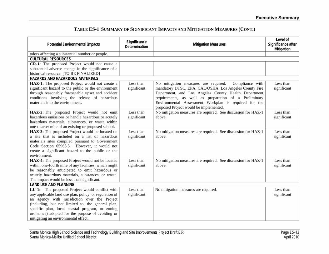
Mitigation odors affecting a substantial number or people. CULTURAL RESOURCES CR-1: The proposed Project would not cause a substantial adverse change in the significance of a historical resource. [TO BE FINALIZED]
HAZARDS AND HAZARDOUS MATERIALS HAZ-1: The proposed Project would not create a significant hazard to the public or the environment through reasonably foreseeable upset and accident conditions involving the release of hazardous materials into the environment.
Less than significant
No mitigation measures are required. Compliance with mandatory DTSC, EPA, CAL/OSHA, Los Angeles County Fire Department, and Los Angeles County Health Department requirements, as well as preparation of a Preliminary Environmental Assessment Workplan is required for the proposed Project would be implemented.
Less than significant
HAZ-2: The proposed Project would not emit hazardous emissions or handle hazardous or acutely hazardous materials, substances, or waste within one-quarter mile of an existing or proposed school.
Less than significant
No mitigation measures are required. See discussion for HAZ-1 above.
Less than significant
HAZ-3: The proposed Project would be located on a site that is included on a list of hazardous materials sites compiled pursuant to Government Code Section 65965.5. However, it would not create a significant hazard to the public or the environment.
Less than significant
No mitigation measures are required. See discussion for HAZ-1 above.
Less than significant
HAZ-4: The proposed Project would not be located within one-fourth mile of any facilities, which might be reasonably anticipated to emit hazardous or acutely hazardous materials, substances, or waste. The impact would be less than significant.
Less than significant
No mitigation measures are required. See discussion for HAZ-1 above.
Less than significant
LAND USE AND PLANNING LU-1: The proposed Project would conflict with any applicable land use plan, policy, or regulation of an agency with jurisdiction over the Project (including, but not limited to, the general plan, specific plan, local coastal program, or zoning ordinance) adopted for the purpose of avoiding or mitigating an environmental effect.
Less than significant
No mitigation measures are required. Less than significant
Executive Summary
TABLE ES-1 SUMMARY OF SIGNIFICANT IMPACTS AND MITIGATION MEASURES (CONT.)
Page ES-14 Santa Monica High School Science and Technology Building and Site Improvements Project Draft EIR April 2010 Santa Monica-Malibu Unified School District
Potential Environmental Impacts Significance Determination Mitigation Measures
Level of Significance after
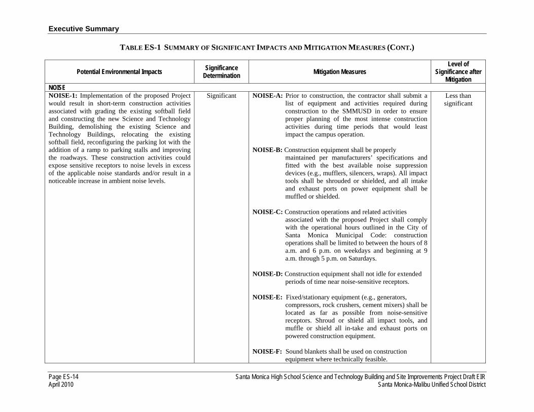
Mitigation NOISE NOISE-1: Implementation of the proposed Project would result in short-term construction activities associated with grading the existing softball field and constructing the new Science and Technology Building, demolishing the existing Science and Technology Buildings, relocating the existing softball field, reconfiguring the parking lot with the addition of a ramp to parking stalls and improving the roadways. These construction activities could expose sensitive receptors to noise levels in excess of the applicable noise standards and/or result in a noticeable increase in ambient noise levels.
Significant NOISE-A: Prior to construction, the contractor shall submit a list of equipment and activities required during construction to the SMMUSD in order to ensure proper planning of the most intense construction activities during time periods that would least impact the campus operation.
NOISE-B: Construction equipment shall be properly
maintained per manufacturers’ specifications and fitted with the best available noise suppression devices (e.g., mufflers, silencers, wraps). All impact tools shall be shrouded or shielded, and all intake and exhaust ports on power equipment shall be muffled or shielded.
NOISE-C: Construction operations and related activities
associated with the proposed Project shall comply with the operational hours outlined in the City of Santa Monica Municipal Code: construction operations shall be limited to between the hours of 8 a.m. and 6 p.m. on weekdays and beginning at 9 a.m. through 5 p.m. on Saturdays.
NOISE-D: Construction equipment shall not idle for extended
periods of time near noise-sensitive receptors. NOISE-E: Fixed/stationary equipment (e.g., generators,
compressors, rock crushers, cement mixers) shall be located as far as possible from noise-sensitive receptors. Shroud or shield all impact tools, and muffle or shield all in-take and exhaust ports on powered construction equipment.
NOISE-F: Sound blankets shall be used on construction equipment where technically feasible.
Less than significant
Executive Summary
TABLE ES-1 SUMMARY OF SIGNIFICANT IMPACTS AND MITIGATION MEASURES (CONT.)
Santa Monica High School Science and Technology Building and Site Improvements Project Draft EIR Page ES-15 Santa Monica-Malibu Unified School District April 2010
Potential Environmental Impacts Significance Determination Mitigation Measures
Level of Significance after
Mitigation
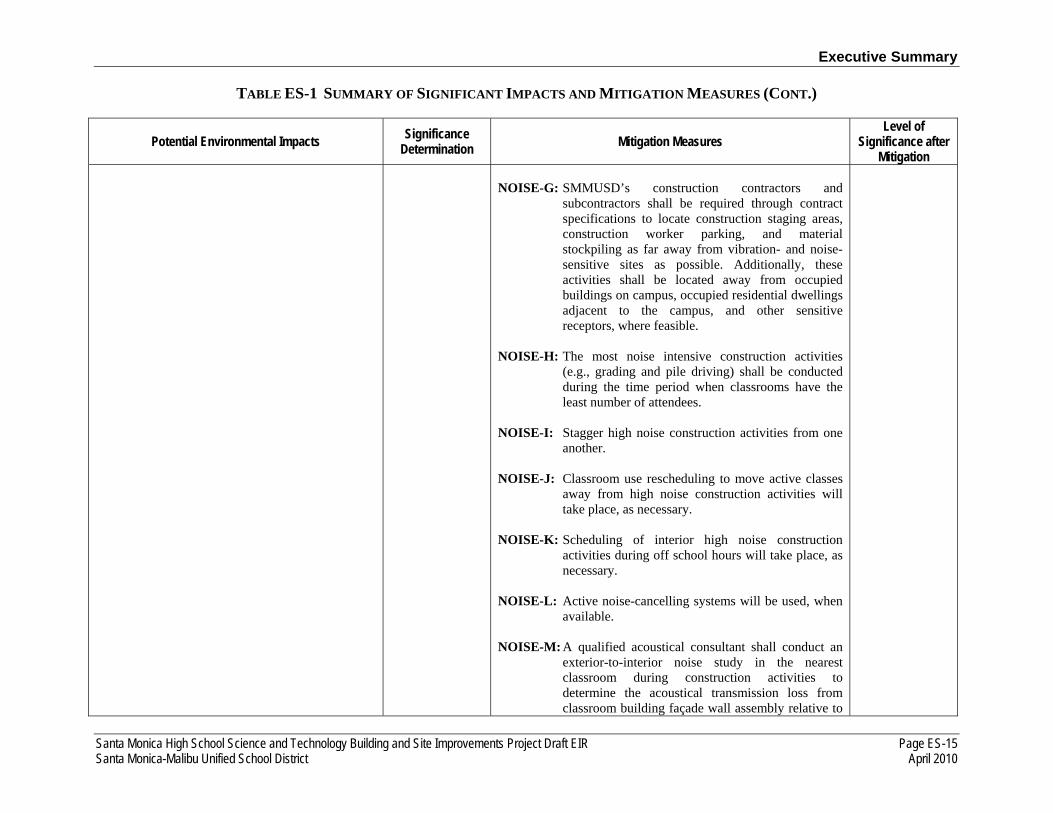
NOISE-G: SMMUSD’s construction contractors and subcontractors shall be required through contract specifications to locate construction staging areas, construction worker parking, and material stockpiling as far away from vibration- and noise-sensitive sites as possible. Additionally, these activities shall be located away from occupied buildings on campus, occupied residential dwellings adjacent to the campus, and other sensitive receptors, where feasible.
NOISE-H: The most noise intensive construction activities
(e.g., grading and pile driving) shall be conducted during the time period when classrooms have the least number of attendees.
NOISE-I: Stagger high noise construction activities from one
another. NOISE-J: Classroom use rescheduling to move active classes
away from high noise construction activities will take place, as necessary.
NOISE-K: Scheduling of interior high noise construction
activities during off school hours will take place, as necessary.
NOISE-L: Active noise-cancelling systems will be used, when
available. NOISE-M: A qualified acoustical consultant shall conduct an
exterior-to-interior noise study in the nearest classroom during construction activities to determine the acoustical transmission loss from classroom building façade wall assembly relative to

Executive Summary
TABLE ES-1 SUMMARY OF SIGNIFICANT IMPACTS AND MITIGATION MEASURES (CONT.)
Page ES-16 Santa Monica High School Science and Technology Building and Site Improvements Project Draft EIR April 2010 Santa Monica-Malibu Unified School District
Potential Environmental Impacts Significance Determination Mitigation Measures
Level of Significance after
Mitigation construction noise.
NOISE-N: Upgrade the seals of classroom windows and/or
doors. NOISE-O: A construction relations officer shall be appointed
by the SMMUSD to act as a public liaison concerning on-site construction activity. If complaints regarding exterior noise are received by the construction relations officer from either persons on campus or adjacent residential uses, SMMUSD shall enforce all mitigation measures and noise maximums that will be included in the construction contract(s). If complaints regarding interior classroom noise levels are received by the construction relations officer, additional intermittent noise monitoring will take place on site to ensure that a sustained noise level equivalent to 50 dBA is maintained within operating classrooms. If a sustained interior noise level equivalent to 50 dBA is not maintained, construction activities must be altered, rescheduled, or reduced to ensure that this noise level is attained.
NOISE-2: Implementation of the proposed Project could result in an increase of average daily vehicle trips in the proposed Project area. The increased traffic volumes would not result in a noticeable (3 dB or greater) increase in traffic noise along roadways in and within the vicinity of the proposed Project area. This impact would be less than significant.
Less than significant
No mitigation measures are required. Less than significant
NOISE-3: Implementation of the proposed Project as mitigated would not result in future traffic noise that could expose the proposed Project site to levels that exceed applicable standards.
Significant NOISE-P: SMMUSD shall ensure that, upon completion of construction of the new Science and Technology building, interior noise levels attributable to traffic noise would achieve applicable interior noise standards and Project-specific goals for interior
Less than significant

Executive Summary
TABLE ES-1 SUMMARY OF SIGNIFICANT IMPACTS AND MITIGATION MEASURES (CONT.)
Santa Monica High School Science and Technology Building and Site Improvements Project Draft EIR Page ES-17 Santa Monica-Malibu Unified School District April 2010
Potential Environmental Impacts Significance Determination Mitigation Measures
Level of Significance after
Mitigation noise levels (CHPS and acoustic goal requirements of background noise levels in unoccupied classrooms ranging from 35 dB to 45 dB Leq and a reverberation of 0.6-second maximum). The measures for achieving Project specific classroom acoustic goals include but are not limited to: Construction plans for classroom buildings shall include external wall assemblies and interior finishing materials within classrooms to comply with CHPS acoustical goal requirements as stated above; External walls to classrooms designed to achieve a minimum sound transmission class (STC) rating of 46; Post construction exterior-to-interior traffic noise levels shall be confirmed by a qualified acoustical consultant.
NOISE-4: Implementation of the proposed Project would not result in increases in stationary-source noise associated with use of the proposed school. These stationary-source noises would not potentially exceed the County’s noise standards (hourly and maximum) or result in a noticeable increase in ambient noise levels.
Less than significant
No mitigation measures are required. Less than significant
NOISE-5: Implementation of the proposed Project would result in exposing sensitive noise-receptors to groundborne noise and vibration levels that may exceed the FTA and Caltrans guidelines. These groundborne noise and vibration levels could result in annoyance or architectural/structural damage.
Less than significant
No mitigation measures are required. Less than significant
RECREATION REC-1: The proposed Project would increase the use of existing neighborhood and regional parks or other recreational facilities; however not such that substantial physical deterioration of the facility
Significant REC-A Prior to construction, the SMMUSD and Santa Monica College shall execute a Memorandum of Understanding, which coordinates the joint use of the John Adams Middle School softball field (and other
Less than significant

Executive Summary
TABLE ES-1 SUMMARY OF SIGNIFICANT IMPACTS AND MITIGATION MEASURES (CONT.)
Page ES-18 Santa Monica High School Science and Technology Building and Site Improvements Project Draft EIR April 2010 Santa Monica-Malibu Unified School District
Potential Environmental Impacts Significance Determination Mitigation Measures
Level of Significance after
Mitigation would occur or be accelerated. recreational facilities, if applicable) during the
proposed Project construction phase (approximately three years).
REC-B Prior to construction, the SMMUSD and the City of
Santa Monica shall execute a Memorandum of Understanding, which coordinates the use of the joint use of John Adams Middle School softball field (and other recreational facilities, if applicable) during the proposed Project construction phase (approximately three years).
TRANSPORTATION/TRAFFIC TRANS-1: The proposed Project would not increase traffic in relation to the existing traffic load and capacity of the street system, as established by City of Santa Monica.
Significant TRANS-A: In order to reduce intersection impacts at 4th Street and Olympic Boulevard during the AM peak
hour, the applicant shall be responsible for the following improvements:
Re-striping the northbound approach to provide an exclusive left-turn lane, constructing a shared through/right-turn lane, constructing an exclusive right-turn lane.
TRANS-B:In order to minimize pedestrian conflicts and vehicular/pedestrian delay on the north-south pedestrian crossing on the east leg of this intersection, TRANS-B recommends restricting pedestrian movement to the west side of 4th Street. As such, pedestrians traveling north-south on 4th Street would have to cross on the west side of the street.
Less than significant
TRANS-2: The proposed Project would not exceed, either individually or cumulatively, a level of service standard established by the county congestion management agency for designated roads or highways.
Less than significant
No mitigation measures are required. Less than significant
TRANS-3: The proposed Project would not substantially increase hazards due to a design
Less than significant
TRANS-C:Prior to construction, the construction contractor through SMMUSD shall prepare and submit a
Less than significant
Executive Summary
TABLE ES-1 SUMMARY OF SIGNIFICANT IMPACTS AND MITIGATION MEASURES (CONT.)
Santa Monica High School Science and Technology Building and Site Improvements Project Draft EIR Page ES-19 Santa Monica-Malibu Unified School District April 2010
Potential Environmental Impacts Significance Determination Mitigation Measures
Level of Significance after
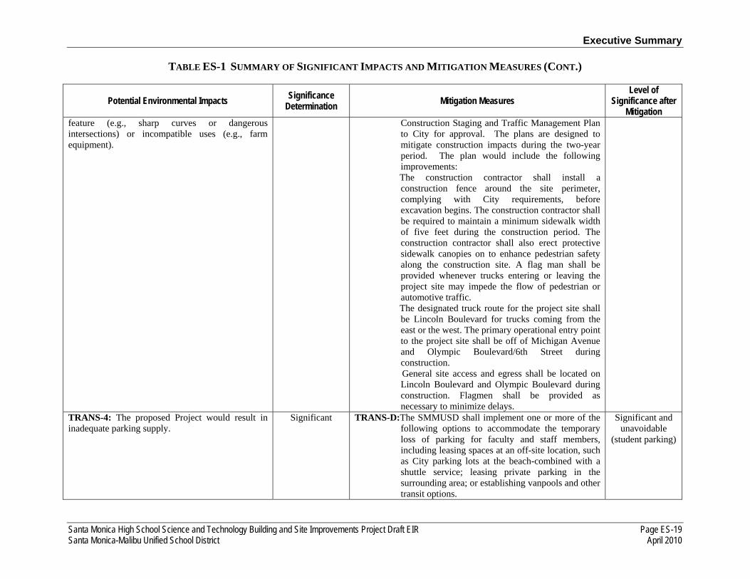
Mitigation feature (e.g., sharp curves or dangerous intersections) or incompatible uses (e.g., farm equipment).
Construction Staging and Traffic Management Plan to City for approval. The plans are designed to mitigate construction impacts during the two-year period. The plan would include the following improvements:
The construction contractor shall install a construction fence around the site perimeter, complying with City requirements, before excavation begins. The construction contractor shall be required to maintain a minimum sidewalk width of five feet during the construction period. The construction contractor shall also erect protective sidewalk canopies on to enhance pedestrian safety along the construction site. A flag man shall be provided whenever trucks entering or leaving the project site may impede the flow of pedestrian or automotive traffic.
The designated truck route for the project site shall be Lincoln Boulevard for trucks coming from the east or the west. The primary operational entry point to the project site shall be off of Michigan Avenue and Olympic Boulevard/6th Street during construction.
General site access and egress shall be located on Lincoln Boulevard and Olympic Boulevard during construction. Flagmen shall be provided as necessary to minimize delays.
TRANS-4: The proposed Project would result in inadequate parking supply.
Significant TRANS-D:The SMMUSD shall implement one or more of the following options to accommodate the temporary loss of parking for faculty and staff members, including leasing spaces at an off-site location, such as City parking lots at the beach-combined with a shuttle service; leasing private parking in the surrounding area; or establishing vanpools and other transit options.
Significant and unavoidable
(student parking)

Executive Summary
Page ES-20 Santa Monica High School Science and Technology Building and Site Improvements Project Draft EIR April 2010 Santa Monica-Malibu Unified School District
This page is intentionally left blank.
Santa Monica High School Science and Technology Building and Site Improvements Project Draft EIR Page 1-1 Santa Monica–Malibu Unified School District April 2010
1.0 INTRODUCTION
1.1 SUMMARY OF THE PROPOSED PROJECT
This Environmental Impact Report (EIR) has been prepared by the Santa Monica-Malibu Unified School District (SMMUSD) to evaluate potential environmental effects that would result from development of the proposed Santa Monica High School Science and Technology Building and Site Improvements Project (proposed Project). This EIR has been prepared in conformance with the California Environmental Quality Act of 1970 (CEQA) statutes (Cal. Pub. Res. Code, Section 21000 et. seq., as amended) and implementing guidelines (Cal. Code Regs., Title 14, Section 15000 et. seq., 2009). The SMMUSD is the lead agency under CEQA.
The SMMUSD proposes to reconfigure the northern portion of the existing Santa Monica High School campus, which is located at 601 Pico Boulevard. The proposed Project would consist of the demolition of the existing 88,000-square-foot two-story Science and Technology Buildings, a 253-space parking lot, and softball field and construction of a new 84,000-square-foot, three-story Science and Technology Building, reconfigured parking lot, and a relocated softball field. A formal perimeter would be created along 7th Court Alley and Olympic Boulevard. All vehicle access to the Project site would be off of 6th Street, with an enhanced pedestrian entrance along Michigan Avenue. A drop-off and pick-up lane would be provided along Olympic Boulevard. Campus-wide updates to the fire alarm and electrical systems would be included, and dependent on funding: the existing football field would be resurfaced with synthetic turf, the south gymnasium ceiling would be improved, and ventilation for the gymnasium and swimming pool locker rooms would also be improved.
1.2 THE CEQA ENVIRONMENTAL PROCESS
CEQA requires preparation of an EIR when there is substantial evidence supporting a fair argument that a proposed Project may have a significant effect on the environment. The purpose of an EIR is to provide decision makers, public agencies, and the general public with an objective and informational document that fully discloses the environmental effects of the proposed Project. The EIR process is intended to facilitate the objective evaluation of potentially significant direct, indirect, and cumulative impacts of the proposed Project, and to identify feasible mitigation measures and alternatives that would reduce or avoid the proposed Project’s significant effects. In addition, CEQA specifically requires that an EIR identify those adverse impacts determined to be significant after mitigation.
In accordance with CEQA, an Initial Study and Notice of Preparation were prepared and circulated for public review from June 9, 2009 to July 9, 2009. An English and Spanish version of the Notice of Preparation, which included an announcement of the public scoping meeting, was mailed to all property owners and occupants within a 500-foot radius of the Project site. This included a total of 667 mailings to surrounding residential, commercial, civic and other properties. The Initial Study and Notice of Preparation were also mailed to 41 state, regional, and local agencies, organizations and stakeholders. In addition, the notice and scoping meeting announcement was circulated in a two local newspapers on June 11, 2009: the Daily Breeze and La Opinión (in Spanish).

1.0 Introduction
Page 1-2 Santa Monica High School Science and Technology Building and Site Improvements Project Draft EIR April 2010 Santa Monica–Malibu Unified School District
A public scoping meeting was held at the Project site on June 23, 2009.1 The purpose of this meeting was to seek input from public agencies and the general public regarding the environmental issues and concerns that may potentially result from the proposed Project. At the time of the scoping meeting, a drop-off/pick-up turnout was proposed along Olympic Boulevard which has since been eliminated from the proposed Project due to City input and the public comments below. Currently, an ADA accessible drop-off and pick-up lane would be provided along Olympic Boulevard. The following list summarizes the public comments and questions received at the scoping meeting that were related to environmental issues or the environmental process:
Aesthetics
• The building is massive and should be constructed along Olympic Boulevard, not Michigan Avenue.
• Will the building be constructed outside the school’s property line? • The building may result in shade impacts and block the view of the mountains. • The new three-story building would impact the visual quality of nearby one- to two-story
residential buildings.
Air Quality
• Air circulation would be hindered with the large building. • Concerned about air quality and dust impacting the residents, students, other children, and
sensitive receptors in the area.
Hazards and Hazardous Materials
• Asbestos, chemical contamination and dust particle emissions may be an issue. Mitigation measures are needed to minimize these issues.
Noise
• The existing alarms on the campus are constantly going off.
Transportation, Traffic, and Circulation
• Traffic may be an issue with the proposed Project, especially related to graduation (grad) night and parent drop-off/pick-up.
• The main entrance to the Project site should be along Olympic Boulevard so vehicle would not have to travel along Michigan Avenue, which is a residential street.
• Include pedestrian- and bicycle-friendly facilities.
1 A qualified Spanish translator was available at the public scoping meeting.

1.0 Introduction
Santa Monica High School Science and Technology Building and Site Improvements Project Draft EIR Page 1-3 Santa Monica–Malibu Unified School District April 2010
• Consider underground parking and permeable pavement. The underground parking would be more expensive, but its benefits would outweigh the health and aesthetic impacts that could result from the current Project.
• Enhance policing for parents illegally parking or dropping-off/picking-up students. • Would the Project allow for the pedestrian bridge to occur in the future? • The transportation demand management should include students, parents and teachers to
encourage alternative modes of transportation. The Project should enhance walkability, provide safer bike routes, enhance routes to transit and include LEED elements.
• Provide details on the traffic and sidewalk/pedestrian safety on Olympic Boulevard and Michigan Avenue.
• The drop-off area on Olympic Boulevard would not be safe for the students or for vehicles due in part to the freeway on- and off-ramp traffic. Consider a turnout into the school property in the parking lot.
• Michigan Avenue is a part of a joint use project for the proposed bicycle boulevard connecting to Ocean Boulevard.
• Construction vehicles and equipment should not park in residential or preferential parking areas. • The existing median/island at Michigan Avenue and 7th Street needs to be removed as it is
blocking traffic. • Do not block access for residents located east of the high school campus and do not exacerbate
the poor parking situation on 7th Street.
Other
• The scoping meeting had low attendance due to the scheduling.
This EIR focuses on the environmental impacts identified as potentially significant during the Initial Study process, including the comments received in response to the Notice of Preparation. The issue areas analyzed in detail in this EIR include aesthetics, air quality, cultural resources, hazards and hazardous materials, land use and planning, noise, recreation and parks, and transportation and traffic. Effects not found to be significant are addressed in Section 4.0, Impact Overview of this EIR.
This Draft EIR is being circulated for 45 days for public review and comment. The timeframe of the public review period is identified in the Notice of Availability. During this period, comments from the general public, organizations, and agencies regarding environmental issues analyzed in the Draft EIR and the Draft EIR’s accuracy and completeness may be submitted to the lead agency at the following address:
Ms. Janece L. Maez, Assistant Superintendent Santa Monica-Malibu Unified School District 1651 Sixteenth Street Santa Monica, CA 90404

1.0 Introduction
Page 1-4 Santa Monica High School Science and Technology Building and Site Improvements Project Draft EIR April 2010 Santa Monica–Malibu Unified School District
Fax: (310) 581-6720 E-mail: [email protected]
The SMMUSD will prepare written responses to all comments pertaining to environmental issues raised in the Draft EIR if they are submitted in writing and postmarked by the last day of the public review period (date to be determined) identified in the Notice of Availability. No public hearing will be held for this project.
Prior to approval of the proposed Project, the SMMUSD, as the lead agency and decision-making entity, is required to certify that this EIR has been completed in accordance with CEQA, that the proposed Project has been reviewed and the information in this EIR has been considered, and that this EIR reflects the independent judgment of the SMMUSD Board of Education. CEQA also requires the SMMUSD to adopt “findings” with respect to each significant environmental effect identified in the EIR) (Pub. Res. Code Section 21081; Cal. Code Regs., Title 14, Section 15091). For each significant effect, CEQA requires the approving agency to make one or more of the following findings:
• The proposed Project has been altered to avoid or substantially lessen significant impacts identified in the Final EIR.
• The responsibility to carry out such changes or alterations is under the jurisdiction of another agency.
• Specific economic, legal, social, technological, or other considerations, which make infeasible the mitigation measures or alternatives identified in the Final EIR.
If the SMMUSD concludes that the proposed Project will result in significant effects that cannot be substantially lessened or avoided by feasible mitigation measures and alternatives, the SMMUSD will also adopt a “statement of overriding considerations” prior to approval of the proposed Project (Pub. Res. Code Section 21081 (b)). Such statements are intended under CEQA to provide a written means by which the lead agency balances in writing the benefits of the proposed Project and the significant and unavoidable environmental impacts. Where the lead agency concludes that the economic, legal, social, technological, or other benefits outweigh the unavoidable environmental impacts, the lead agency may find such impacts “acceptable” and approve the proposed Project.
In addition, public agencies, when approving a project, must also adopt a Mitigation Monitoring and Reporting Program describing the changes that were incorporated into the proposed Project or made a condition of project approval in order to mitigate or avoid significant effects on the environment (Pub. Res. Code Section 21081.6). The Mitigation Monitoring and Reporting Program is adopted at the time of project approval and is designed to ensure compliance during project implementation. Upon approval of the proposed Project, the SMMUSD will be responsible for implementation of the proposed Project’s Mitigation Monitoring and Reporting Program.
1.0 Introduction
Santa Monica High School Science and Technology Building and Site Improvements Project Draft EIR Page 1-5 Santa Monica–Malibu Unified School District April 2010
1.3 ORGANIZATION OF THE EIR
This EIR is organized as follows:
The Executive Summary provides an overview of the information provided in detail in subsequent chapters. It consists of an introduction; a description of the proposed Project and alternatives considered; a discussion of areas of controversy and issues to be resolved; and a table that summarizes the potential environmental impacts in each category, the significance determination for those impacts, mitigation measures, and significance after mitigation.
Chapter 1.0 Introduction provides a brief description of the proposed Project. It includes a brief overview of the CEQA environmental review process and a section describing the organization of the EIR.
Chapter 2.0 Project Description provides a detailed description of the proposed Project. Project objectives are identified, and information on the proposed Project characteristics and construction scenario is provided. This section also includes a description of the intended uses of the EIR and public agency actions.
Chapter 3.0 Environmental Setting, Impacts and Mitigation describes the potential environmental effects of implementing the proposed Project. The discussion in Chapter 3.0 is organized by eight environmental issue areas, as follows:
• Aesthetics • Air Quality • Cultural Resources • Hazards and Hazardous Materials
• Land Use and Planning • Noise • Recreation and Parks • Transportation and Traffic
For each environmental issue, the analysis and discussion are organized into five subsections as described below:
Environmental Setting - This subsection describes, from a local and regional perspective, the physical environmental conditions in the vicinity of the proposed Project at the time of publication of the Notice of Preparation or actually experienced in past years. The environmental setting establishes the baseline conditions by which the SMMUSD will determine whether specific Project-related impacts are significant.
Significance Criteria - This subsection identifies a set of thresholds by which the level of a significant impact is determined.
Environmental Impacts - This subsection provides detailed information on the environmental effects of the proposed Project, and whether the impacts of the proposed Project would meet or exceed the established significance criteria.
1.0 Introduction
Page 1-6 Santa Monica High School Science and Technology Building and Site Improvements Project Draft EIR April 2010 Santa Monica–Malibu Unified School District
Mitigation Measures - This subsection identifies mitigation measures that would avoid or substantially reduce significant adverse Project-related impacts and evaluates whether such are feasible.
Level of Significance after Mitigation - This subsection indicates whether Project-related impacts would be reduced to less than significant with implementation of the mitigation measures identified in the EIR. This subsection also identifies any residual significant and unavoidable adverse effects of the proposed Project that would result even after the mitigation measures have been implemented.
Chapter 4.0 Impact Overview presents the other mandatory CEQA sections, including the following:
Unavoidable Significant Impacts - This subsection identifies and summarizes the unavoidable significant impacts described in detail in Chapter 3.0.
Effects Not Found to Be Significant - This subsection identifies and summarizes the issue areas that were determined to have no adverse environmental impact or a less than significant environmental impact given the established significance criteria.
Cumulative Impacts - This subsection addresses the potentially significant cumulative impacts that may result from the proposed Project when taking into account related or cumulative impacts resulting from other past, present, and reasonably foreseeable future projects.
Irreversible Environmental Changes - This subsection addresses the extent to which the proposed Project would consume nonrenewable resources.
Growth-Inducing Impacts - This subsection describes the potential of the proposed Project to induce economic or population growth or the construction of additional housing, either directly or indirectly, in the surrounding environment.
Chapter 5.0 Alternatives describes and evaluates the comparative merits of a reasonable range of alternatives to the proposed Project that would feasibly attain most of the basic objectives of the proposed Project and avoid or substantially lessen potentially significant Project-related impacts. Chapter 5.0 also describes the preliminary site constraints analysis and rationale for selecting the range of alternatives discussed in the EIR and identifies the alternatives considered by SMMUSD that were rejected from further discussion as infeasible during the scoping process. Chapter 5.0 also includes a discussion of the environmental effects of the No Project Alternative.
Chapter 6.0 Acronyms and Abbreviations provides a list of acronyms and abbreviations used in this EIR.
Chapter 7.0 References provides a bibliography of reference materials used in preparation of this EIR.
Chapter 8.0 List of Preparers identifies those persons responsible for the preparation of this EIR.
Santa Monica High School Science and Technology Building and Site Improvements Project Draft EIR Page 2-1 Santa Monica-Malibu Unified School District April 2010
2.0 PROJECT DESCRIPTION
This EIR is being prepared to evaluate the potential environmental impacts that may result from the proposed Santa Monica High School Science and Technology Building and Site Improvements Project, known as the proposed Project. This chapter provides a detailed description of the proposed Project evaluated in Chapter 3.0 of this EIR. This chapter also provides the objectives, location, and environmental setting of the proposed Project, followed by a description of the proposed Project’s characteristics and construction phasing, and a summary of proposed Project approvals that would be required. This information is provided pursuant to the CEQA Guidelines Section 15124.
2.1 PROJECT LOCATION
The Santa Monica High School campus is located at 601 Pico Boulevard in the City of Santa Monica in the County of Los Angeles and is located generally south of the intersection of Olympic Boulevard and Lincoln Boulevard, approximately 100 feet south of Interstate 10 (I-10, Santa Monica Freeway), which becomes State Route 1 (SR-1, Pacific Coast Highway) approximately 800 feet southwest of the campus, and Interstate 405 (I-405, San Diego Freeway) approximately 3.5 miles to the northeast. The Pacific Ocean is located approximately one-half mile to the west of the campus. Figure 2-1 shows the location of the campus in a regional context.
The 26-acre campus is bordered by Olympic Boulevard and 5th Street on the north, 7th Court Alley and 7th Street on the east, Michigan Avenue and Pico Boulevard on the south, and 4th Street and a hotel on the west. The Project site encompassing the new facilities specifically occupies the northern 5.2 acres of the campus bordered by Olympic Boulevard on the northwest side, 6th Street on the southwest side, the remainder of the Santa Monica High School campus on the south side, and 7th Court Alley on the northeast side. Additional improvements to existing facilities would throughout the entire campus. Figure 2-2 shows the local vicinity map of the existing campus.
2.2 PHYSICAL ENVIRONMENTAL SETTING
2.2.1 EXISTING LAND USES
Santa Monica High School has an enrollment of approximately 3,100 students, the largest school population in the SMMUSD. The 5.2-acre portion of the Project site is located in the northern portion of the campus and is currently occupied by two, two-story buildings (Science and Technology buildings) which total approximately 88,000 square feet with the Technology Building located north of the Science Building. A basement level to the Technology Building is visible only on the southwestern façade of the building. A 253-space parking lot and a softball field also exist on this portion of the Project site. The existing Science and Technology Buildings currently occupy the southern corner of the Project site with the existing softball field located in the eastern corner and the existing parking lot on the northern and western corners. The remainder of the campus includes the following facilities:
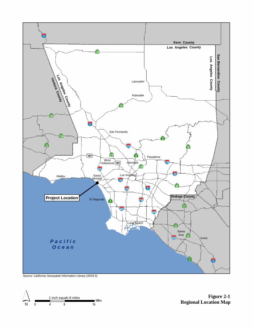
Al
Los Angeles
Orange County
Figure 2-1
Source: California Geospatial Information Library (2003-5)
P a c i f i cO c e a n
Project LocationLos Angeles County
Long Beach
Glendale
Pasadena
Irvine
SantaAna
Malibu
San Fernando
Lancaster
Palmdale
0 8 164Miles
WestHollywood
SantaMonica
El SegundoVentura County
Kern County
ytnu
oC
onid
ranr
eB
naS
Los Angeles Countyyt
nuo
C se
legn
A so
L
10
60
101
110
710
605
405
5
210
210
2170
110
39
14
2
5
10
405
22
55
57
5
118
23
138
5
126
405
1
1
101
N1 inch equals 8 miles
Regional Location Map
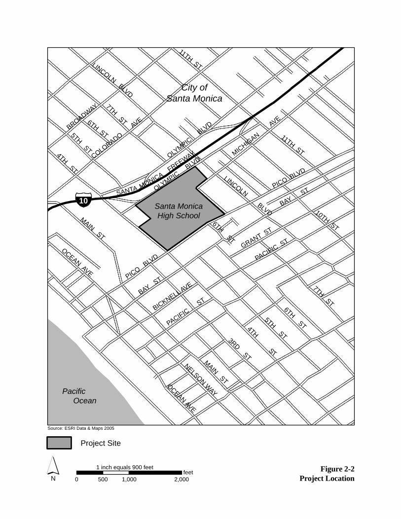
0 1,000 2,000500feet
1 inch equals 900 feet
N
Source: ESRI Data & Maps 2005
Figure 2-2Project Location
Project Site
Pacific Ocean
City of Santa Monica
Santa MonicaHigh School
P
ICO BLVD
MAIN ST
OCEAN AVE
COLORADO A
VEBROADWAY
LINCOLN BLVD
11TH ST 4TH ST
BAY ST
OLYMPIC
BLVD
OLYMPIC BLVD
MICHIGAN A
VE
4TH ST
6TH ST
6TH ST
5TH ST
BICKNELL AVE
PACIFIC ST
GRANT ST
PACIFIC ST
7TH ST 5TH ST
6TH ST
MAIN STOCEAN AVE
NELSON WAY
3RD ST
7TH ST
10TH ST
11TH ST
PICO BLVD
BAY ST
LINCOLN BLVD
SANTA MONICA FREEWAY
10
2.0 Project Description
Page 2-4 Santa Monica High School Science and Technology Building and Site Improvements Project Draft EIR April 2010 Santa Monica-Malibu Unified School District
• Cultural facilities: Barnum Hall
• Indoor athletic facilities: North Gymnasium (main), Natatorium (pool) and South Gymnasium (practice)
• Outdoor athletic facilities: football field/track, baseball/soccer field, seven tennis courts, and three basketball courts
• Academic facilities: Business, Art, History, Language, English, and Music Buildings
• Support facilities: Administration and Cafeteria Buildings, outdoor gathering space and quadrangles, landscaped areas with trees and additional campus parking areas1
Figure 2-3 shows the existing facilities on the Santa Monica High School campus, which includes the Science and Technology Buildings, parking lot and softball field on the Project site.
2.2.2 SURROUNDING LAND USES
The Santa Monica High School campus is surrounded by commercial, multi-family residential and civic uses. Commercial and multi-family residential uses are located northeast side of the Project site, along 7th Court Alley and along the paralleling Lincoln Boulevard. The commercial uses include gas stations, other automobile-related uses, small strip malls, and small commercial/industrial establishments that front Lincoln Boulevard. Wallpaper City and Flooring is located northeast of the Project site, on 7th Court Alley (1754, 1756, and 1758 Lincoln Boulevard). This property includes two, two-story buildings with the business on the ground floor and 25 multi-family residential units above. Some of these multi-family residential units front 7th Court Alley, approximately 25 feet northeast of the Project site. One multi-family residential building, located northeast of 7th Court Alley, fronts Lincoln Boulevard. In addition, multi-family residential uses are located approximately 33 feet northwest of the campus, between 5th Street and Olympic Boulevard. Multi-family residences are also located southeast of the Project site along Michigan Avenue. The DoubleTree Guest Suites Hotel is located adjacent west of the campus, and the Sheraton Delfina Hotel to the south, on the south side of Pico Boulevard. Civic uses are located west of the campus. The City of Santa Monica City Hall and the new Civic Center Parking Structure, Santa Monica Civic Auditorium (constructed in 1958) and large Civic Lot surface parking area, and related civic facilities are located on the southwest side of 4th Street. The Viceroy Hotel and RAND building are located west of the civic land uses. In addition, City designated bike routes are located along Olympic Boulevard, Michigan Avenue, 7th Street and a small section of Pico Boulevard adjacent to the campus.2
1 R.L. Binder, FAIA Architecture & Planning. SMMUSD Santa Monica High School Siting Study (document dated June 2008).
Revised January 2009. website http://www.smmusd.org/measureBB/SMHS/011209SitingStudy.pdf, accessed June 18, 2009. 2 City of Santa Monica. Sustainable City Progress Report – Santa Monica Bike Map. 2007. website http://www01.smgov.net/
epd/scpr/Transportation/T4_BikeLanes.htm, accessed July 6, 2009. Bike Route: Refers to a street identified as a bicycle facility by “Bike Route” guide signing only. Bike routes differ from bike lanes in that they have no special street markings.
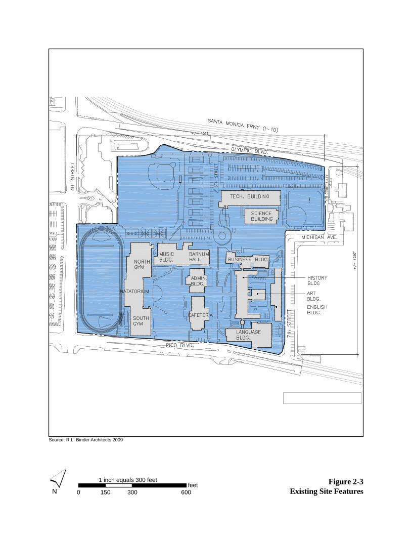
0 300 600150feet
1 inch equals 300 feet
N
Source: R.L. Binder Architects 2009
Figure 2-3Existing Site Features
7TH COURT ALLEY
6TH STREET

2.0 Project Description
Page 2-6 Santa Monica High School Science and Technology Building and Site Improvements Project Draft EIR April 2010 Santa Monica-Malibu Unified School District
2.2.3 GENERAL PLAN DESIGNATION AND ZONING
The entire Santa Monica High School campus has a City of Santa Monica General Plan and zoning designation of Medium Density Multiple Family Residential (R3) and is also within the Public Lands Overlay District.3 The R3 zoning district is intended to provide a broad range of housing within medium density multiple family residential neighborhoods (0 to 35 dwelling units per net residential acre) and schools are only permitted in this zone with a conditional use permit. The R3 zoning district seeks to protect residential neighborhoods from environmental effects and serves to maintain and protect the existing character of residential neighborhoods.4 Uses permitted within the R3 zoning district include multi-family dwelling units, senior housing and small family day care homes. With a conditional use permit, schools, places of worship, neighborhood grocery stores, libraries and other uses are allowed. With a performance standards permit, large family day care homes, accessory living quarters, private tennis courts and other uses are allowed.5
The Project site is also within the Public Lands Overlay District. This district is intended to provide adequate long-term public institutional and open space opportunities for the community and to provide for the most efficient use and conservation of all public lands. In addition, this overlay district is intended to assure the protection and preservation of natural open space, parks, beaches, and recreation areas, to retain school sites required to meet future educational needs and to provide land for public parking. This overlay district will allow for the future re-use of public lands as long as the City’s and neighborhoods’ need for parks and public open space, the neighborhood’s recommendations for re-use, and the need for additional public revenue are considered, consistent with the goals, objectives, and policies of the General Plan.6 Land uses permitted in the Public Lands Overlay District include public schools, beach concessions, cemeteries, open space, public beaches, parks, playgrounds, recreation facilities and public parking.7 Proposed development on parcels within the Public Lands Overlay District must comply with the property development standards of the underlying zoning.8 In July of 2009, SMMUSD adopted a resolution that exempted this Project from the requirements of the City of Santa Monica General Plan and Zoning Code.9
The Project site is located within the City of Santa Monica Earthquake Recovery Redevelopment Project. Established in 1994, this project area includes the area of Santa Monica predominately damaged in the January 1994 Northridge earthquake. The Project area is bounded on the east by Cloverfield Boulevard
3 City of Santa Monica. Districting Map. 2009. website http://www01.smgov.net/isd/gis/map_catalog/index.html, accessed
June 18, 2009. 4 City of Santa Monica. Municipal Code Section 9.04.08.06.010 Purpose. website http://www.qcode.us/codes/santamonica/,
accessed June 18, 2009. 5 City of Santa Monica. Municipal Code Section 9.04.08.06.020 Allowed Land Uses. website http://www.qcode.us/codes/santa
monica/ index.php?topic=9-9_04-9_04_08-9_04_08_10-9_04_08_10_010, accessed July 2, 2009. 6 City of Santa Monica. Municipal Code Section 9.04.08.36.010 Purpose. website http://www.qcode.us/codes/santamonica/,
accessed June 18, 2009. 7 City of Santa Monica. Municipal Code 9.04.08.36.020 Permitted Uses. website http://www.qcode.us/codes/santamonica/,
accessed June 18, 2009. 8 City of Santa Monica. Municipal Code Section 9.04.08.36.060 Property Development Standards. website http://www.qcode.
us/codes/santamonica/, accessed June 18, 2009. 9 Santa Monica-Malibu Unified School District. Resolution 09-03. July 16, 2009.

2.0 Project Description
Santa Monica High School Science and Technology Building and Site Improvements Project Draft EIR Page 2-7 Santa Monica-Malibu Unified School District April 2010
and 26th Street, on the west by the Pacific Coast Highway/Beach Promenade, on the south by approximately Pico Boulevard and on the north by Montana Avenue. The implementation goals within the Redevelopment Plan include addressing the revitalization needs of the commercial, residential and institutional structures damaged or impacted by the Northridge earthquake.10
2.3 PROJECT OBJECTIVES
In 2006, Santa Monica and Malibu voters passed the local general obligation Measure BB Bond, a $268-million bond to construct and renovate schools within the SMMUSD. The SMMUSD requires all of its schools to improve health, safety, and class instruction. The proposed Project has been designed to adhere to these goals and requirements. The main objectives of the proposed Project are to:
• Provide modernized science and technical classrooms;
• Establish a public “front door” at the Michigan Avenue entrance to the campus;
• Develop open spaces that would unify and enhance the northern portion of the campus;
• Maximize student safety by locating buildings along the perimeter of the campus and outdoor spaces in the interior of the campus, thereby retaining students within the campus during school hours and providing separation from the general public;
• Remove asbestos, lead and other hazardous substances from the existing Science and Technology Buildings;
• Improve vehicular, bicycle and pedestrian access to campus;
• Reconfigure the existing 253-space parking lot, which currently contributes to vehicular traffic on 7th Court Alley;
• Develop a maintainable building consistent with SMMUSD Resolution No. 07-07 on Green Building Design and Construction; and
• Provide existing campus classrooms with limited infrastructure upgrades in preparation for future District Standard technology upgrades.
2.4 PROPOSED PROJECT CHARACTERISTICS
2.4.1 SCIENCE AND TECHNOLOGY BUILDINGS RECONFIGURATION
SMMUSD is proposing to reconfigure the approximately 5.2-acre Project site located within the northeastern portion of the Santa Monica High School campus. The existing 88,000-square-foot Science and Technology Buildings currently occupy the southern corner of the Project site with the existing softball field located in the eastern corner and the existing 253-space parking lot on the northern and western corners. The proposed Project would consist of the demolition of the existing Science and 10 City of Santa Monica Redevelopment Agency. 2008. website http://www01.smgov.net/housing/RDA.htm, accessed July 11,
2009.

2.0 Project Description
Page 2-8 Santa Monica High School Science and Technology Building and Site Improvements Project Draft EIR April 2010 Santa Monica-Malibu Unified School District
Technology Buildings, parking lot, and softball field and construction of a new three-story 84,000-square-foot Science and Technology Building, and softball field in a reconfigured site layout and a reconfigured parking lot. Figure 2-4 and Figure 2-5 show the proposed Project site plan and a rendering of the new building, respectively.
The proposed Project would place the new Science and Technology Building in the northern and eastern portion of the Project site, directly adjacent to 7th Court Alley. The new building would be constructed within the Santa Monica High School campus property line and would not encroach into 7th Court Alley. The setback would vary from the northern end to the southern end of the building. The building would be set back from the alley lot line approximately 10 feet 8 inches at the north end, and approximately 12 feet at the south end. The scrim or screen material to be installed on the eastern side of the building would extend approximately three feet four inches into this setback area. The softball field would be relocated to the southern corner of the Project site, while the proposed L-shaped parking lot would be located in between the new building and softball field, extending to the west just south of along Olympic Boulevard, and east of 6th Street. As a result of the proposed reconfiguration, approximately 20 landscape trees may be removed within the Project site. A few of the trees in the northeastern portion of the landscaped quad area would be removed with the proposed Project. However, these removed landscape trees would be replaced in excess of the number of trees removed and the existing trees are not known to be protected. A landscape plan detailing the replacement of these trees is included as part of the proposed Project.
The proposed Project would reconfigure existing land uses and would not result in an increase in student enrollment or capacity of the school. No new land uses would be introduced to the campus with the proposed Project.
ACCESS
The new Science and Technology Building would be designed to enhance the Michigan Avenue pedestrian and bicycle entrance to the campus and create a formal perimeter along the 7th Court Alley, and Olympic Boulevard. Currently, vehicles access the campus by Michigan Avenue (primarily for drop-off/pick-up) traveling from Lincoln Boulevard, and 6th Street traveling from Olympic Boulevard. Vehicles currently enter the Project site from the 7th Court Alley that separates the Project site from the gas station located south of the intersection of Olympic Boulevard and Lincoln Boulevard. Access to the 7th Court Alley currently exists from Olympic Boulevard or Michigan Avenue. Vehicles traveling along Olympic Boulevard also currently use 6th Street as a drop-off and pick-up location for the entire campus. The proposed Project would re-route all access to the Project site via a ramp off of the 6th Street access road to the proposed new parking lot. An Americans with Disabilities Act (ADA) accessible drop-off and pick-up lane would be provided along Olympic Boulevard just west of its intersection with Lincoln Boulevard. Access to 7th Court Alley would be retained and would continue to serve the commercial and residential parcels adjacent to the eastern boundary of the Project site. The 7th Court Alley would also be used for vehicle access to the school’s auto shop, which would be located in the northeastern corner of the proposed Science and Technology Building. The existing bicycle racks will be relocated elsewhere on the Project site and a new cycle parking facility for 50 bicycles would be provided near the Michigan
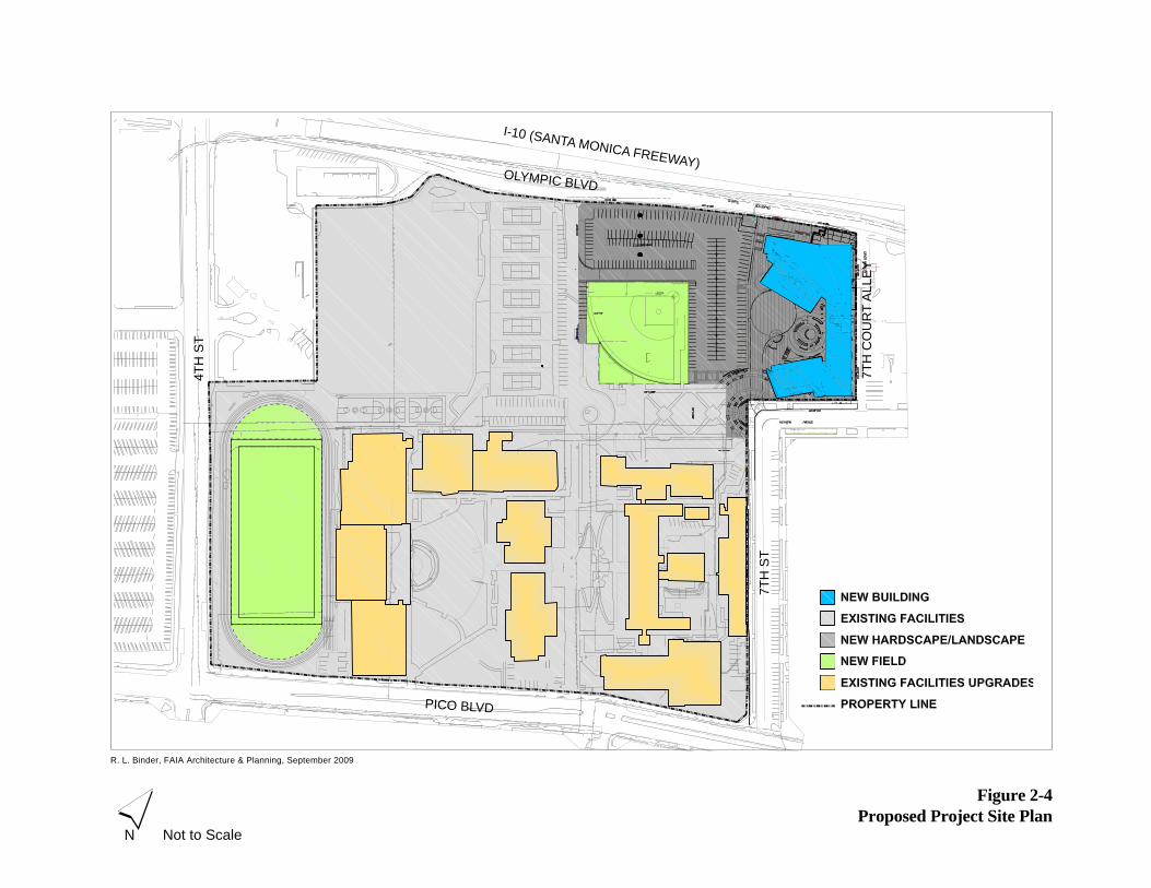
R. L. Binder, FAIA Architecture & Planning, September 2009
Figure 2-4Proposed Project Site Plan
Not to ScaleN
OLYMPIC BLVD4T
H S
T
7TH
ST
PICO BLVD
7TH
CO
UR
T A
LLE
Y
I-10 (SANTA MONICA FREEWAY)
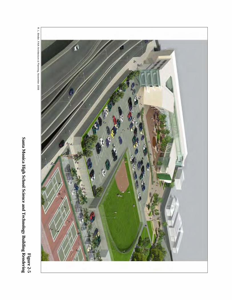
R. L. B
inder, FAIA
Architecture &
Planning, N
ovember 2008
Figure 2-5Santa M
onica High School Science and T
echnology Building R
endering
2.0 Project Description
Santa Monica High School Science and Technology Building and Site Improvements Project Draft EIR Page 2-11 Santa Monica-Malibu Unified School District April 2010
Avenue pedestrian and bicycle entrance. The City of Santa Monica has a potential future project that would construct a pedestrian bridge that would span over the I-10 in alignment with 7th Street. This new bridge may potentially require an unknown amount of space adjacent to or within the Santa Monica High School campus. The City has stated that a detailed project description or engineering drawings for this potential future project are not yet available.11
2.4.2 CAMPUS-WIDE UPDATES
Additional components of the proposed Project would include campus-wide updates to the fire alarm and electrical systems. Depending on funding, additional components would potentially include installation of synthetic turf at the existing football field, improvements to the South Gymnasium ceiling, and ventilation improvements to the gymnasium and swimming pool locker rooms.
2.4.3 ADDITIONAL FEATURES
A major design component of the proposed Project is sustainability and maintainability. The SMMUSD has adopted a District-wide Resolution No. 07-07 on Green Building Design and Construction that establishes the following sustainable design approach:
• Student performance and staff health and well being, through measures such as daylighting, the use of non-toxic materials, and the utilization of strategies to enhance the acoustical quality of each classroom;
• Operating cost minimization through: (a) energy efficiency in buildings and equipment beyond that required by the California Energy Performance Standards (Title 24); (b) the purchase of Energy Star rated equipment; (c) the use of renewable energy resources such as solar and wind power; and (d) water efficiency through the utilization of native and other drought tolerant (“California friendly”) plants, efficient irrigation systems and water conserving interior fixtures beyond those required by code; and
• Ensuring that Bond Measure BB Projects minimize the SMMUSD’s long-term impact on the environment through reducing carbon emissions, ensuring the cleanliness of stormwater runoff, storing and reusing stormwater where feasible, and recycling demolition and construction waste.
Accordingly, the design of the proposed Project has been tailored to meet the SMMUSD’s sustainability goals including:
• Collection of stormwater runoff in infiltration devices for groundwater recharge;
• Development of a landscape plan to minimize water use and urban heat island effect through shade and reflective landscape materials;
11 Correspondence with Beth Rolandson, City of Santa Monica, Transportation Management Division. July 28, 2009.
2.0 Project Description
Page 2-12 Santa Monica High School Science and Technology Building and Site Improvements Project Draft EIR April 2010 Santa Monica-Malibu Unified School District
• Inclusion of permeable surfaces, including porous asphalt, paver blocks or large aggregate concrete, and trees with a high, dense canopy;
• Configuration of buildings to reduce footprint and take advantage of natural ventilation; and
• Use of reflective roofs, shading devices, renewable recycled building materials, and drip irrigation and low flow water features.
PROJECT COMPLIANCE WITH REGULATIONS AND POLICIES
The proposed Project would be required to adhere to applicable regulations and guidelines regarding construction and operation. In addition to compliance with the California Department of Education’s requirements for site design and function, these regulations and guidelines include the following:
• Laboratories within the new Science and Technology Building shall be equipped with proper venting equipment and operation of the proposed Project shall comply with South Coast Air Quality Management District (SCAQMD) Rule 402.
• The proposed Project shall implement the following measures in compliance with SCAQMD Rule 403 for Best Available Control Measures:
o Land disturbance shall be minimized to the extent feasible.
o Haul trucks shall be covered when loaded with fill.
o Paved streets shall be swept at least once per day where there is evidence of dirt that has been carried on to the roadway.
o Watering trucks shall be used to minimize dust. Watering should be sufficient to confine dust plumes to the project work areas.
o Active disturbed areas shall have water applied to them three times daily.
o Inactive disturbed areas shall be revegetated as soon as feasible to prevent soil erosion.
o For disturbed surfaces to be left inactive for four or more days and that will not be revegetated, a chemical stabilizer shall be applied per manufacturer’s instruction.
o For unpaved roads, chemical stabilizers shall be applied or the roads shall be watered once per hour during active operation.
o Vehicle speed on unpaved roads shall be limited to 15 miles per hour (mph).
2.0 Project Description
Santa Monica High School Science and Technology Building and Site Improvements Project Draft EIR Page 2-13 Santa Monica-Malibu Unified School District April 2010
o For open storage piles that will remain on-site for two or more days, water shall be applied once per hour, or coverings shall be installed.
o For paved road track-out, all haul vehicles shall be covered, or shall comply with vehicle freeboard requirements of Section 23114 of the California Vehicle Code for both public and private roads.
o During high wind conditions (wind speeds in excess of 25 mph), all earthmoving activities shall cease or water shall be applied to soil not more than 15 minutes prior to disturbing such soil.
• Architectural coatings for nonresidential uses shall be selected so that the average volatile organic compound (VOC) content of the coatings does not exceed 125 grams per liter. Where Rule 1113 requires VOC content less than 125 grams per liter, the Rule shall take precedence over this measure.
• Construction shall comply with the Migratory Bird Treaty Act to ensure that nesting bird surveys are conducted prior to the start of construction activities which would occur during nesting bird season (February 1 through August 31). According to the Migratory Bird Treaty Act requirements, a qualified biologist shall conduct a nest survey within one week of the start of construction to ensure that no active nests are present. If an active nest is located, then the nest shall be flagged and construction within 250 feet (500 feet for raptors) of the nest shall be postponed until the biologist has confirmed that the nest is no longer active.
• The proposed Project shall comply with the City of Santa Monica tree protection ordinance, which requires that any tree, shrub or plant in any street, park, boulevard, or public place in the City must be protected against damage during the repair, alteration, or construction of a building. Accordingly, no trees in public places, including adjacent sidewalks, shall be removed or damaged as a result of the proposed Project. However, approximately 20 landscape trees may be removed within the Project site, which is not considered to be a public place.12
• During all earth-moving activities associated with construction of the proposed Project, a qualified archaeologist shall be on call to respond and evaluate any archaeological artifacts discovered. In accordance with the provisions of CEQA Guidelines Section 15064.5, should artifacts be uncovered, construction activities shall be halted until such time as the archaeologist has cleared the site. Unidentified artifacts shall be preserved and identified in consultation with an appropriate jurisdictional agency.
• Should construction activities uncover human remains during earth moving activities, the SMMUSD would be required to implement the process specified by Section 7050.5 of the
12 Cy Carlberg, Registered Consulting Arborist. Santa Monica High School – Tree Report. April 9, 2009.

2.0 Project Description
Page 2-14 Santa Monica High School Science and Technology Building and Site Improvements Project Draft EIR April 2010 Santa Monica-Malibu Unified School District
California Health and Safety Code, and all construction activities shall be halted until such time as the Los Angeles County Coroner has been able to clear the site.
• All new structures shall be subject to State building and safety guidelines, restrictions, and permit regulations, including the Uniform Building Code and the California Department of Conservation, Divisions of Mines and Geology requirements, which are designed to address the risks associated with seismic groundshaking. The design of the proposed Science and Technology Building would comply with the Field Act, which requires high standards of safety
for school buildings through adherence to strict standards based on the California Building Code. As part of the proposed Project’s compliance with the Field Act, the design of the building would be reviewed and approved by the Division of the State Architect.
• Since the proposed Project is greater than one acre in size, the SMMUSD’s construction contractor shall prepare and comply with a Stormwater Pollution Prevention Plan (SWPPP), which would feature erosion control measures. In addition, the SMMUSD’s construction contractor shall obtain the necessary permit for storm water and wastewater discharges.
• The proposed Project shall be designed and constructed to exceed the standards of Title 24 of the California Building Standards Code and to meet Collaborative for High Performance Schools (CHPS) standards, and other design guidelines established by the site-specific Geotechnical Investigation Report.
• Due to the age of on-site structures, asbestos-containing material (ACM) and lead-based paint (LBP) are expected. A preconstruction survey will be conducted to locate ACM and LBP. All ACM and LBP would be removed prior to the start of demolition in accordance with SCAQMD’s regulations for ACM (Rule 1403) and California Division of Occupational Safety and Health (OSHA) requirements.13
2.5 CONSTRUCTION PHASING
The construction period for the proposed Project is anticipated to start in the third quarter of 2011 and end in the second quarter of 2014. Construction of the Project is considered in two phases, construction of the new Science and Technology buildings (Phase 1) and demolition of the old buildings (Phase 2), with each phase composed of a number of elements. The existing buildings would continue to operate during the construction of the new building. The new building construction would also remove the existing softball field and a portion of the existing parking lot. Following construction of the new building, existing buildings would be removed and replaced with the new softball field and parking lot reconfiguration.
13 South Coast Air Quality Management District. Rule 1403 - Asbestos Emissions From Demolition/Renovation Activities. website http://www.arb.ca. gov/DRDB/SC/CURHTML/R1403.HTM.

2.0 Project Description
Santa Monica High School Science and Technology Building and Site Improvements Project Draft EIR Page 2-15 Santa Monica-Malibu Unified School District April 2010
As shown in Figure 2-6, Phase 1 would include construction of the new Science and Technology Building, Michigan Avenue Entrance, and campus technology upgrades. As shown in Figure 2-8, Phase 2 would include construction of the parking lot and softball field. Since the existing buildings will remain functional while the new one is being constructed, no overlap was assumed between Phases 1 and 2. Construction of the parking ramp (Phase 1.5) is anticipated to overlap with both phases of construction (Figure 2-7).
During construction, approximately 3,000 cubic yards of dirt would be required to be exported. Approximately 20 landscape trees may be removed; however, the proposed Project includes a landscape plan which would include the planting of additional trees and shrubs throughout the Project site. The replacement trees would exceed the number of trees removed. The Project site would be fenced and screened in order to prevent visual intrusion during the temporary construction phase. During construction of the new building, softball activities would be temporarily relocated to Memorial Park, located approximately 0.6-mile to the northeast across the I-10 Freeway and to John Adams Middle School located approximately 0.9-mile to the east of the Project site.
The existing parking lot provides approximately 253 parking spaces: 183 assigned to faculty and staff, 40 spaces assigned to students during a twice-yearly lottery, and 2 spaces for ADA accessible handicapped parking. The reconfigured parking lot would accommodate the same number of 253 parking spaces. The existing parking lot would be closed during construction of the new building. The SMMUSD is exploring a number of options to accommodate the temporary loss faculty and staff parking including leasing spaces at an off-site location including City parking lots at the beach, combined with a shuttle service, leasing private parking in the surrounding area, establishing vanpools and other transit options. However, all student spaces would be temporarily lost during construction. . Following construction of the new building, the existing buildings would be removed and replaced with the new softball field and parking lot reconfiguration.
2.6 INTENDED USES OF THE EIR
An EIR is a public document that discloses the significant environmental effects of a project, to identify alternatives, and to disclose possible ways to minimize the significant effects (CEQA Guidelines, Section 15121). The main purpose of an EIR is to inform governmental decision makers and the public about potential environmental impacts of the proposed Project.
This EIR will be used by the SMMUSD, as the lead agency under CEQA, in making decisions with regard to the proposed Project, the subsequent construction and development of the Proposed Project described above, and the related approvals described herein.

Figure 2-6Proposed Project Construction Phase 1
6TH
STR
EET
150 15075 teeF0
R. L. Binder, FAIA Architecture & Planning, December 2009
N

Figure 2-7Proposed Project Construction Phase 1.5150 15075 teeF0
R. L. Binder, FAIA Architecture & Planning, December 2009
N
6TH
STR
EET
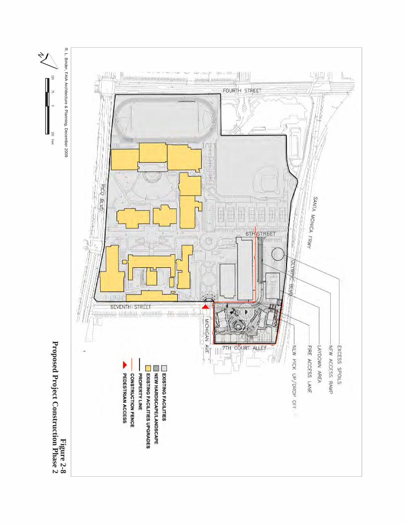
150150
75te
eF0
Figure 2-8Proposed Project C
onstruction Phase 2R
. L. Binder, FA
IA A
rchitecture & P
lanning, Decem
ber 2009
N
6TH STREET
2.0 Project Description
Santa Monica High School Science and Technology Building and Site Improvements Project Draft EIR Page 2-19 Santa Monica-Malibu Unified School District April 2010
2.7 PROJECT APPROVALS REQUIRED
The SMMUSD is the lead agency pursuant to CEQA Guidelines Section 15367. This EIR will be used by the SMMUSD as a decision-making tool for approval of the Santa Monica High School Science and Technology Building and Site Improvements Project and related permits and approvals. Various permits and discretionary approvals would be required in order to approve and implement the proposed Project as follows:
• Santa Monica-Malibu Unified School District (certification of the EIR and Project approval)
• State Fire Marshall (approval of code analysis)
• Division of the State Architect (approval of construction drawings and accessibility)
• California Department of Toxic Substances Control (Letter of No Further Action)
• Los Angeles Regional Water Quality Control Board, Region 4 (National Pollutant Discharge Elimination System permit, issuance of waste discharge requirement, construction stormwater runoff permits)
• Utility providers (i.e. utility connection permits)
• City of Santa Monica (Infrastructure and Santa Monica Fire Department Review)
• City of Santa Monica (Grading Permit)
Santa Monica High School Science and Technology Building and Site Reconfiguration Project Draft EIR Page 3-1 Santa Monica-Malibu Unified School District April 2010
3.0 ENVIRONMENTAL SETTING, IMPACTS AND MITIGATION
The following sections include an analysis, by issue area, of the proposed Project’s potential effects on the environment. Each environmental issue area includes the following subsections:
• Environmental Setting • Regulatory Setting • Environmental Impacts • Mitigation Measures • Level of Significance after Mitigation
The mitigation measures provided in Chapter 3.0 are proposed by the SMMUSD, unless otherwise noted. The environmental issue areas analyzed in this section are as follows:
• Aesthetics (Chapter 3.1) • Air Quality (Chapter 3.2) • Cultural Resources (Chapter 3.3) • Hazards and Hazardous Materials (Chapter 3.4) • Land Use and Planning (Chapter 3.5) • Noise (Chapter 3.6) • Recreation and Parks (Chapter 3.7) • Transportation and Traffic (Chapter 3.8)
As identified in the Initial Study (see Appendix A) prepared in June 2009, the following are the environmental issue areas that were not found to be significantly impacted or potentially impacted by the proposed project:
• Agriculture Resources • Biological Resources • Geology and Soils • Hydrology and Water Quality • Mineral Resources • Population and Housing • Public Services • Utilities and Services Systems
Therefore, no further evaluation of these environmental issue areas is necessary in this chapter. Chapter 4.0 includes a brief discussion of impacts that were not found to be significant.
3.0 Environmental Setting, Impacts and Mitigation
Page 3-2 Santa Monica High School Science and Technology Building and Site Reconfiguration Project Draft EIR April 2010 Santa Monica-Malibu Unified School District
This page is intentionally left blank.
Santa Monica High School Science and Technology Building and Site Improvements Project Draft EIR Page 3.1-1 Santa Monica-Malibu Unified School District April 2010
3.1 AESTHETICS
The purpose of this section is to identify and evaluate key visual and aesthetic resources in the vicinity of the Project site and to determine the degree of visual and aesthetic impacts that would be attributable to the proposed Project. The analysis describes the potential aesthetic effects of the proposed Project on the existing landscape and built environment, focusing on the compatibility of the proposed Project with existing conditions and its potential effects on visual resources. Visual simulations were prepared, and a shade and shadow analysis was conducted for the proposed Project.
3.1.1 ENVIRONMENTAL SETTING
VISUAL CHARACTER
Visual character can be defined in terms of the overall visual impression formed by the relationship or contrast between perceived visual elements of the built urban environment existing in the potentially impacted area. Elements contributing to this visual impression may include the following:
• The nature and quality of buildings
• The cohesion of the area’s collective architecture
• The compatibility between uses and activities with the built environment
• The quality of streetscape, including roadways, sidewalks, plazas, parks and street furniture
• The nature and quality of private property landscaping that is visible to the general public
Visual character functions as a point of reference in assessing whether the proposed Project’s features would appear to be compatible with the existing built environment. In general, evaluation of visual character is determined by the degree of contrast that could potentially result between the proposed Project and the existing built environment. Contrast is assessed by considering the consistency of the following features of the proposed Project with those of the existing built environment:
• Scale or the general intensity of development comprised of the height and set back of buildings
• Massing or the volume and arrangement of buildings
• Open space or the set back of buildings and amount of pedestrian spaces
Project Site
The Santa Monica High School campus as it is currently arranged was constructed in 1912 with additions completed until 1960. Various types of architecture are evident on the campus including Northern Italian Renaissance Revival-style and Art Deco/Moderne. The Open-Air Greek Theater located on the southern portion of the campus was constructed in 1921 and Barnum Hall on the central portion of the campus was
3.1 Aesthetics
Page 3.1-2 Santa Monica High School Science and Technology Building and Site Improvements Project Draft EIR April 2010 Santa Monica-Malibu Unified School District
constructed in 1938. Barnum Hall is considered to be an aesthetic resource in the Project area due to its previous use as the main community cultural center in the area and its Art Deco architecture.
The 5.2-acre Project site is located in the northeastern portion of the 26-acre Santa Monica High School campus, within a highly urbanized area of Santa Monica directly south of Interstate 10 (I-10, Santa Monica Freeway). The Project site includes the existing Science and Technology Buildings, a 253-space parking lot, and a softball field. The existing Science and Technology Buildings are currently in need of exterior building maintenance and painting, and these buildings do not possess any unique architectural features or memorable visual character. Figures 3.1-1 through 3.1-4 show the existing buildings, softball field, parking lot, and landscaping currently on the Project site.
The existing Science and Technology Buildings include two, two-story buildings which total approximately 88,000 square feet in area and are bordered by 6th Street on the southwest. Sixth Street is an approximately 40-foot-wide street that is exclusively used to access the Santa Monica High School campus and includes a small traffic circle. The Technology Building is located directly adjacent and approximately 12 feet northwest of the Science Building. The Technology Building is larger than the Science Building and includes a basement level in addition to the two above-grade levels. The basement is only visible along the southwestern façade of the building. The Science and Technology Buildings are connected by two enclosed, elevated pedestrian walkways. One of the walkways connects the second story of the northeastern side of the two buildings, while the other connects the second story of the southwestern sides of the two buildings. The Science and Technology Buildings were constructed in 1954 and do not appear to have any unique aesthetic features. There are areas of the both buildings where graffiti exists or was painted over. The Science and Technology Buildings are medium- to large-scale buildings compared to the surrounding buildings in the Project area. However, the scale of the Science and Technology Buildings is consistent with the other medium- to large-scale buildings on the Santa Monica High School campus. Many of the other buildings on the campus are larger in scale and mass in relation to the existing Science and Technology Buildings.
A small open plaza area is located directly south of the Science and Technology Buildings and includes tables, benches, two small school gardens, a small greenhouse, and approximately five small trees. A landscaped quadrangle (quad) with gathering areas and diagonal walkways is located directly southeast of the Science and Technology Buildings. This landscaping includes grass and several mature trees.
The existing softball field on the Project site is located directly adjacent and northeast of the Science and Technology Buildings. The softball field is bordered on the southeast by a landscaped parkway and Michigan Avenue and on the northeast by 7th Court Alley. The softball field is set back nominally along Michigan Avenue and there is no setback along 7th Court Alley. The softball field is surrounded by an approximately 20-foot-tall chain-linked fence, which separates the field from the other uses on the Project site and prevents softballs from being hit outside of the Project site, towards the commercial and multi-family residential uses on opposite side or northeastern side of 7th Court Alley. Several approximately 30-foot-tall power poles and associated transmission lines are located along the northeastern border of the softball field, just outside of the chain-linked fence, along the southwestern side of 7th Court Alley. The

3.1 Aesthetics
Santa Monica High School Science and Technology Building and Site Improvements Project Draft EIR Page 3.1-3 Santa Monica-Malibu Unified School District April 2010
Figure 3.1-1: Existing Project Site Looking South from 7th Court Alley
Figure 3.1-2: Existing Project Site Looking West from Michigan Avenue

3.1 Aesthetics
Page 3.1-4 Santa Monica High School Science and Technology Building and Site Improvements Project Draft EIR April 2010 Santa Monica-Malibu Unified School District
Figure 3.1-3: Existing Science and Technology Buildings Looking Northwest
Figure 3.1-4: Existing Science Building and Landscaped Quad Looking North
3.1 Aesthetics
Santa Monica High School Science and Technology Building and Site Improvements Project Draft EIR Page 3.1-5 Santa Monica-Malibu Unified School District April 2010
existing 253-space parking lot is located directly adjacent and northwest of the existing Science and Technology Buildings and softball field. The parking lot is bound by 6th Street on the southwest, Olympic Boulevard on the northwest, and 7th Court Alley on the northeast. Along 6th Street, Olympic Boulevard, and 7th Court Alley the parking lot is surrounded by a chain-linked fence which varies in height from approximately 10 to 15 feet. In addition, along 6th Street and Olympic Boulevard, this chain-linked fence is located atop a concrete wall. The concrete wall varies in height from approximately 2 to 15 feet due to variations in the elevation of the Project site. The tallest portion of the combined chain-linked fence/concrete wall is located at the western corner of the parking lot at the intersection of 6th Street and Olympic Boulevard. The parking lot has no setback along 6th Street, Olympic Boulevard, or 7th Court Alley and includes a small grassy area and few landscape trees.
The Santa Monica Mountains are located approximately 3.15 miles north of the Project site. North-facing views of the Santa Monica Mountains are available on the major north-south oriented streets in the Project area, such as Lincoln Boulevard. North-facing views of the Santa Monica Mountains from the Project site are currently disrupted by the existing multi-level buildings and tall trees located on the north side of I-10.
Surrounding Setting
The Santa Monica High School campus is surrounded by major commercial and civic thoroughfares including Olympic Boulevard, Lincoln Boulevard, Pico Boulevard, and 4th Street. In addition, the campus is surrounded by an alley and smaller residential streets including 7th Court Alley, Michigan Avenue, and 7th Street. The existing visual character of the roadways and development surrounding the campus is described below.
Olympic Boulevard. The Project site is located adjacent to and on the southeast side of Olympic Boulevard. Olympic Boulevard is a major commercial and industrial corridor in the City of Santa Monica, which situated parallel to I-10 in a southwest to northeast direction in the Project area. The depressed I-10 is located approximately 100 feet northwest of the Project site. In the Project area, Olympic Boulevard straddles I-10 with two to three southwest bound lanes located adjacent and northeast of I-10 and the two northeast bound lanes located adjacent and southeast of I-10, directly adjacent to the Project site.
The northeast bound side of Olympic Boulevard includes the three- to nine-story DoubleTree Guest Suites Hotel, the three-story Santa Monica City Hall building, other two- to five-story civic buildings (including the Santa Monica Public Safety building), and a two-story multi-family apartment building, located southwest of the Project site. The DoubleTree Guest Suites Hotel and apartment building are located directly adjacent to the Santa Monica High School campus. In addition, a portion of the large-scale five-story Civic Center Parking Structure is visible along the northeast bound side of Olympic Boulevard. A majority of the buildings located along this side of Olympic Boulevard have setbacks and have a minimal amount of landscaping, with the exception of the Santa Monica City Hall building and other civic building which have at least a 29-foot manicured landscaped setback. Northwest of the Project site, Olympic Boulevard includes small-scale automobile-related commercial buildings with large
3.1 Aesthetics
Page 3.1-6 Santa Monica High School Science and Technology Building and Site Improvements Project Draft EIR April 2010 Santa Monica-Malibu Unified School District
surface parking facilities. In addition, medium-scale one- to two-story multi-family residential buildings are located along Olympic Boulevard, northeast of the Project site. A majority of the existing buildings along this portion of Olympic Boulevard do not front Olympic Boulevard, and rather front the north-south oriented streets.
The southwest bound side of Olympic Boulevard, located on the northwest side of I-10, includes medium- to large-scale two- to four-story commercial/industrial buildings. A large area of landscaping including mature trees, bushes, and shrubs provide a buffer between the depressed freeway and these commercial/industrial buildings. The trees within this landscaped buffer reach up to 50 feet in height. These trees along with the adjacent up to four-story commercial/industrial buildings contribute to the current disruption of views of the Santa Monica Mountains from the Project area. A smaller and less dense landscaped buffer is provided between I-10 and the Project site. In addition, the public sidewalks located on both sides of Olympic Boulevard in the Project area are approximately six to seven feet in width and, due to the higher vehicle speeds and relatively heavy traffic conditions on this street; Olympic Boulevard does not provide an aesthetically-pleasing pedestrian visual character in the Project area. Figure 3.1-5 shows the existing visual character of Olympic Boulevard adjacent to the Project site.
Lincoln Boulevard. The Project site is located approximately 168 feet south of Lincoln Boulevard. Lincoln Boulevard is a major commercial corridor in the City and is situated in a northwest to southeast direction. In addition, Lincoln Boulevard includes an overpass above the depressed I-10 in the Project area. Large-scale commercial buildings front Lincoln Boulevard northwest of I-10. However, primarily small-scale commercial and automobile-related businesses front Lincoln Boulevard in the Project area, southeast of I-10. These include a U-Haul truck rental yard, Wallpaper City and Flooring, gas stations, strip malls, and commercial/industrial establishments of one to two stories in height. Northeast of the Project site, Wallpaper City and Flooring includes two two-story buildings with the commercial business on the ground floor and a total of 25 multi-family residential units above. One of these buildings is painted brick red and front Lincoln Boulevard, while the other building is located within the back of the lot (adjacent to 7th Court Alley). In addition, a one-story cottage-style building (1748 Lincoln Boulevard) fronts Lincoln Boulevard, adjacent and north of Wall paper City and Flooring. This building appears to be residential in nature; however, it houses a personal loan business. A majority of the buildings on the southwest side of Lincoln Boulevard are not set back from the Lincoln Boulevard property line, while many of the buildings on the northeast side of the street include a setback for surface parking areas. Small trees are located within the approximately 12-foot public sidewalk along Lincoln Boulevard. Some of the existing buildings located along Lincoln Boulevard in the Project area are dilapidated and in need of exterior building maintenance. Figure 3.1-6 shows the existing visual character of Lincoln Boulevard.
Pico Boulevard. The Santa Monica High School campus, including the Project site, fronts Pico Boulevard (601 Pico Boulevard). Pico Boulevard is a commercial and residential corridor within the City and is situated in a southwest to northeast direction in the Project area. Primarily two- to four-story commercial and multi-family apartment buildings front Pico Boulevard in the Project area. These buildings are primarily medium- to large-scale, and encompass a majority of the area of their respective lots with minimal area dedicated to surface parking lots. The 10- to 11-story Sheraton Delfina Hotel is located south of the Project Site along Pico Boulevard and includes two large-scale adjoined buildings
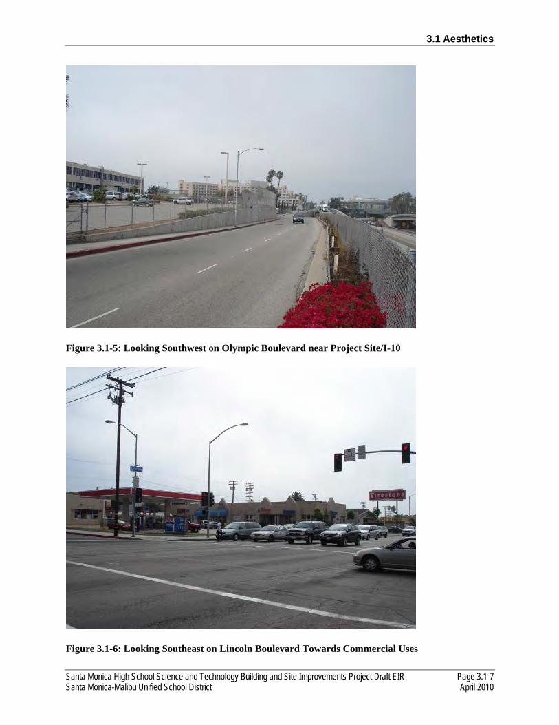
3.1 Aesthetics
Santa Monica High School Science and Technology Building and Site Improvements Project Draft EIR Page 3.1-7 Santa Monica-Malibu Unified School District April 2010
Figure 3.1-5: Looking Southwest on Olympic Boulevard near Project Site/I-10
Figure 3.1-6: Looking Southeast on Lincoln Boulevard Towards Commercial Uses
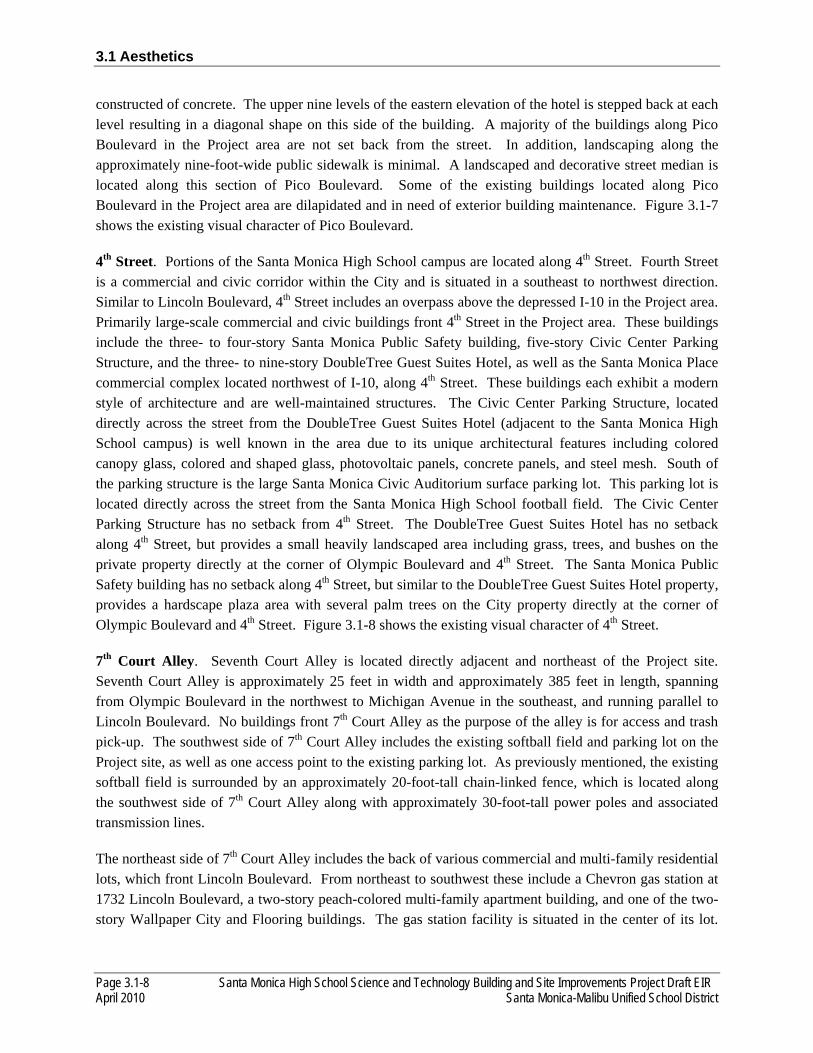
3.1 Aesthetics
Page 3.1-8 Santa Monica High School Science and Technology Building and Site Improvements Project Draft EIR April 2010 Santa Monica-Malibu Unified School District
constructed of concrete. The upper nine levels of the eastern elevation of the hotel is stepped back at each level resulting in a diagonal shape on this side of the building. A majority of the buildings along Pico Boulevard in the Project area are not set back from the street. In addition, landscaping along the approximately nine-foot-wide public sidewalk is minimal. A landscaped and decorative street median is located along this section of Pico Boulevard. Some of the existing buildings located along Pico Boulevard in the Project area are dilapidated and in need of exterior building maintenance. Figure 3.1-7 shows the existing visual character of Pico Boulevard.
4th Street. Portions of the Santa Monica High School campus are located along 4th Street. Fourth Street is a commercial and civic corridor within the City and is situated in a southeast to northwest direction. Similar to Lincoln Boulevard, 4th Street includes an overpass above the depressed I-10 in the Project area. Primarily large-scale commercial and civic buildings front 4th Street in the Project area. These buildings include the three- to four-story Santa Monica Public Safety building, five-story Civic Center Parking Structure, and the three- to nine-story DoubleTree Guest Suites Hotel, as well as the Santa Monica Place commercial complex located northwest of I-10, along 4th Street. These buildings each exhibit a modern style of architecture and are well-maintained structures. The Civic Center Parking Structure, located directly across the street from the DoubleTree Guest Suites Hotel (adjacent to the Santa Monica High School campus) is well known in the area due to its unique architectural features including colored canopy glass, colored and shaped glass, photovoltaic panels, concrete panels, and steel mesh. South of the parking structure is the large Santa Monica Civic Auditorium surface parking lot. This parking lot is located directly across the street from the Santa Monica High School football field. The Civic Center Parking Structure has no setback from 4th Street. The DoubleTree Guest Suites Hotel has no setback along 4th Street, but provides a small heavily landscaped area including grass, trees, and bushes on the private property directly at the corner of Olympic Boulevard and 4th Street. The Santa Monica Public Safety building has no setback along 4th Street, but similar to the DoubleTree Guest Suites Hotel property, provides a hardscape plaza area with several palm trees on the City property directly at the corner of Olympic Boulevard and 4th Street. Figure 3.1-8 shows the existing visual character of 4th Street.
7th Court Alley. Seventh Court Alley is located directly adjacent and northeast of the Project site. Seventh Court Alley is approximately 25 feet in width and approximately 385 feet in length, spanning from Olympic Boulevard in the northwest to Michigan Avenue in the southeast, and running parallel to Lincoln Boulevard. No buildings front 7th Court Alley as the purpose of the alley is for access and trash pick-up. The southwest side of 7th Court Alley includes the existing softball field and parking lot on the Project site, as well as one access point to the existing parking lot. As previously mentioned, the existing softball field is surrounded by an approximately 20-foot-tall chain-linked fence, which is located along the southwest side of 7th Court Alley along with approximately 30-foot-tall power poles and associated transmission lines.
The northeast side of 7th Court Alley includes the back of various commercial and multi-family residential lots, which front Lincoln Boulevard. From northeast to southwest these include a Chevron gas station at 1732 Lincoln Boulevard, a two-story peach-colored multi-family apartment building, and one of the two-story Wallpaper City and Flooring buildings. The gas station facility is situated in the center of its lot.
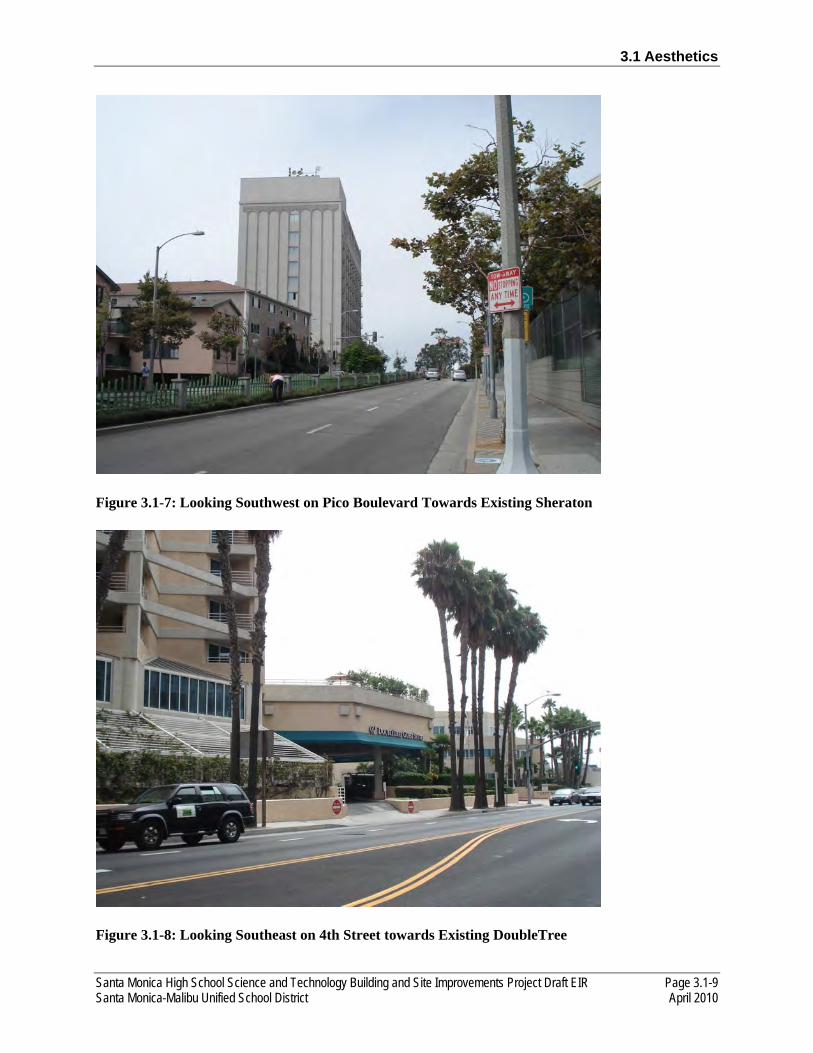
3.1 Aesthetics
Santa Monica High School Science and Technology Building and Site Improvements Project Draft EIR Page 3.1-9 Santa Monica-Malibu Unified School District April 2010
Figure 3.1-7: Looking Southwest on Pico Boulevard Towards Existing Sheraton
Figure 3.1-8: Looking Southeast on 4th Street towards Existing DoubleTree

3.1 Aesthetics
Page 3.1-10 Santa Monica High School Science and Technology Building and Site Improvements Project Draft EIR April 2010 Santa Monica-Malibu Unified School District
The two-story peach-colored apartment building is small in scale and is located in the back portion of the lot at 1748 Lincoln Boulevard, where the cottage-style personal loan business fronts and is directly adjacent to Lincoln Boulevard. From 7th Court Alley, the windows of the apartments are visible on the upper level, with four individual garages located on the ground floor. The two-story Wallpaper City and Flooring building (1754 Lincoln Boulevard) is located within the back portion of the lot which also includes a second two-story building (painted red), fronting Lincoln Boulevard as previously mentioned. The 1754 Lincoln Boulevard Wallpaper City and Flooring building is small in scale and includes commercial uses on the ground floor with apartment units on the upper floor. Both the 1748 Lincoln Boulevard and the 1754 Lincoln Boulevard Wallpaper City and Flooring buildings are located directly adjacent to 7th Court Alley with no setback. Landscaping and small trees are located along the perimeter of the gas station property. A colorful, but weathered mural is located on the southwest side of the five- to six-foot-tall wall, which is along the 7th Court Alley property line of the gas station. This mural faces the Project site. Figure 3.1-9 shows the existing visual character of 7th Alley Court.
Michigan Avenue and 7th Street. Michigan Avenue is situated in a southwest to northeast direction (parallel to Olympic and Pico Boulevards) and is the southeastern border of the Project site and the Wallpaper City and Flooring property. No buildings front this portion of Michigan Avenue. On the southeastern side of Michigan Avenue (opposite the Project site), a medium-scale multi-family residential apartment building (painted light blue-green) of two stories in height at 1805 7th Street, along with a three-story apartment building at 1809 7th Street are visible, both fronting 7th Street. The three-story apartment building includes covered parking areas on the ground floor with the apartment units on the upper floors. Although these apartment buildings do not front Michigan Avenue, several of the front doors and windows to individual apartment units face the direction of the Project site. However, several small-and medium-sized trees located within the public parkway on both sides of Michigan Avenue disrupt the line-of-sight to the Project site. On the southeastern side of Michigan Avenue, opposite the Wallpaper City and Flooring property, medium-scale one-story commercial businesses are visible, which front Lincoln Boulevard. Seventh Court Alley separates the commercial uses from the residential uses, and provides access for residents and trash pick-up. Similar to 7th Court Alley adjacent to the Project site, this portion of 7th Court Alley includes numerous power poles and associated transmission lines. Setback lengths are minimal along Michigan Avenue and landscaping includes grass and small- to medium-sized trees in the large public parkway. Figure 3.1-10 shows the existing visual character of Michigan Avenue.
Seventh Street is perpendicular to Michigan Avenue and serves as a continuation of Michigan Avenue in a northwest-southeast direction, forming a right angle. Seventh Street is the northeastern border of the Santa Monica High School campus. Numerous medium-scale two- to three-story multi-family residential apartment buildings front 7th Street, directly across the street from the existing two- to three-story English Building on the Santa Monica High School campus. These apartment buildings are older and do not include unique visual characteristics. Several of the apartment buildings include covered parking areas on the ground floor with the apartment units on the upper floors. However, some of the apartment buildings have limited on-site surface parking areas. The on-street parking spaces provided for apartment residents are situated perpendicular to the curb, instead of parallel as is typical. Setbacks are approximately 10 to 20 feet in length and include grass and some bushes. Small- to mature-sized trees are primarily located within the public parkway, with fewer trees located within the private apartment building properties.

3.1 Aesthetics
Santa Monica High School Science and Technology Building and Site Improvements Project Draft EIR Page 3.1-11 Santa Monica-Malibu Unified School District April 2010
Figure 3.1-9: Looking Northwest on 7th Court Alley Towards Mixed Uses
Figure 3.1-10: Looking Northeast on Michigan Avenue from 7th Street
3.1 Aesthetics
Page 3.1-12 Santa Monica High School Science and Technology Building and Site Improvements Project Draft EIR April 2010 Santa Monica-Malibu Unified School District
LIGHT AND GLARE
The Project site is within a highly urbanized area of Santa Monica nearby residential, commercial, and civic uses, as well as I-10, a regional transportation facility. A high level of ambient light exists in the Project area due to required building security, freeway, vehicular, and pedestrian lighting standards. Approximately 25-foot-tall standard parking lot lighting and 20-foot tall lighting for the softball field is present on the Project site. Several of the light fixtures installed to illuminate the softball field are attached to the existing power poles along 7th Court Alley, approximately 25 feet from multi-family residential unit windows. Approximately 70-foot tall athletic field lighting is provided for the football field at the southwestern corner of the Santa Monica High School campus. In addition, there is currently a high level of ambient lighting on the Project site due to the security lighting provided at strategic locations on the campus including at the main pedestrian entrance at Michigan Avenue and 7th Street, adjacent to the existing softball field on the Project site. It is likely that this and other lighting may be spilling over onto the apartment building properties at the corner of Michigan and 7th Street, as well as the residences along 7th Court Alley. Approximately 30-foot-tall vehicular street lighting is provided on a majority of streets in the Project area. However, along Michigan Avenue and 7th Street, shorter approximately 20-foot-tall vehicular street lighting is provided.
The majority of existing structures within the project area are comprised of non-reflective materials, such as concrete, wood, and plaster. Glare can result from sunlight reflecting off the plastic awnings or other structural fixtures of commercial buildings located on Lincoln Boulevard or other streets near the Project site. As previously mentioned, the Civic Center Parking Structure located directly across 4th Street from the DoubleTree Guest Suites Hotel (adjacent southwest of the Santa Monica High School campus) has unique architectural features including colored canopy glass, colored and shaped glass, photovoltaic panels, concrete panels, and steel mesh. This parking structure may potentially currently result in nighttime or daytime glare effects. During the daytime, parked vehicles can produce a large source of glare from sunlight being reflected off windshields and other surfaces. This phenomenon is noticeable primarily along 4th Street in the large Santa Monica Civic Auditorium surface parking lot.
SHADE AND SHADOWS
Shadows are cast in a clockwise direction from west/northwest to east/northeast during the various solar periods of the year: Spring Equinox (March 20), Summer Solstice (June 21), Autumn Equinox (September 22), and Winter Solstice (December 21). Generally, the shortest shadows are cast during the Summer Solstice and grow increasingly longer until the Winter Solstice. During the Winter Solstice, the sun is lower in the sky and shadows are at their maximum coverage lengths. Shadow-sensitive uses generally include routinely useable outdoor spaces associated with residential, recreational, or institutional land uses; commercial uses, such as pedestrian-oriented outdoor spaces or restaurants with outdoor eating areas; nurseries; and existing solar collectors/panels. Due to the relatively dense arrangement of existing buildings within the campus and surrounding Project area, shadow effects on shadow-sensitive uses may currently exist. However, the multi-family residential uses located on the northeast side of 7th Court Alley and on the southeast side of Michigan Avenue do not currently receive a
3.1 Aesthetics
Santa Monica High School Science and Technology Building and Site Improvements Project Draft EIR Page 3.1-13 Santa Monica-Malibu Unified School District April 2010
high amount of shadow coverage in the afternoon due to the lack of buildings located adjacent to the west.
3.1.2 REGULATORY SETTING
CITY OF SANTA MONICA GENERAL PLAN
The City of Santa Monica General Plan was adopted in 1984. As required by state law, the General Plan is a set of policies and programs that form a blueprint for physical development throughout the City. The General Plan is a long-term, comprehensive document that defines how the City should develop and is a key planning tool for land use decision making. General plans are required to address seven areas or elements including land use, circulation, housing, conservation, open space, noise and safety.
The City of Santa Monica General Plan does not contain an element that specifically addresses aesthetics or visual quality. However, the currently adopted Land Use Element provides several polices that relate to the development of the visual and architectural quality of the City. The City of Santa Monica General Plan Land Use Element was revised and adopted in 2002.1 Land Use Element provides objectives and policies related to the development of commercial corridors, residential neighborhoods, special districts, and public lands, as well as guidance in the areas of urban design and neighborhood participation. An EIR is currently being prepared in support of the update to the Land Use Element, which is estimated to be certified in Spring 2010.2
The construction and operation of the proposed Project would not be subject to the policies outlined within the City of Santa Monica General Plan. In July of 2009, the SMMUSD Board of Education adopted a resolution that exempts SMMUSD’s facilities projects at Santa Monica High School, Edison Language Academy, John Adams Middle School, and Lincoln Middle School from the requirements of the General Plan, as well as Article 9 of the Municipal Code.3 As such, the discussion of the General Plan is provided below as background information.
Policies identified in the Land Use Element that are applicable to projects in the City of Santa Monica are listed below:
• Policy 3.1.2: Encourage the maintenance of high aesthetic standards and architectural innovation consistent with the surrounding community and encourage large buildings to be of predominately light color and materials that fit in with the existing context. Prohibit large expanses of highly reflective materials such as black glass or mirrored metal.
• Policy 3.1.3: Encourage retention of historic and architecturally significant resources. Design of new buildings should respect the character of nearby historic resources.
1 City of Santa Monica. Santa Monica Land Use and Circulation Element. 2009. Website http://www.shapethefuture
2025.net/links.html, accessed July 2, 2009. 2 City of Santa Monica Planning and Community Development. Integrated Planning Process. May 5, 2009. website
http://www01.smgov.net/cityclerk/council/agendas/2009/20090512/s2009051204-A-1.pdf, accessed July 2, 2009. 3 Santa Monica-Malibu Unified School District. Resolution 09-03. July 16, 2009.

3.1 Aesthetics
Page 3.1-14 Santa Monica High School Science and Technology Building and Site Improvements Project Draft EIR April 2010 Santa Monica-Malibu Unified School District
• Policy 3.3.4: Encourage design articulation of building facades.
• Policy 3.4.3: Require new development to provide streetscape and/or open space improvements which contribute to the overall open space system. Open space requirements shall not exceed the project mitigation measures for projects subject to these mitigation measures.
• Policy 3.4.4: Require landscaping of new surface parking lots both at the perimeter and in the interior of the lots.
• Policy 3.4.5: Consistent with legitimate safety concerns, all exterior lighting shall be unobtrusive and constructed or located so that only the intended area is illuminated, long-range visibility is reduced, and off-site glare is minimized.
3.1.3 ENVIRONMENTAL IMPACTS
THRESHOLDS OF SIGNIFICANCE
As part of the Initial Study (see Appendix A), it was determined that the proposed Project would not have a substantial adverse effect on a scenic vista and would not substantially damage scenic resources within a state scenic highway. Accordingly, these issues are not further analyzed in the EIR.
Pursuant to the CEQA Guidelines, the proposed Project would have a significant effect on aesthetic resources if it would:
• Substantially degrade the existing visual character or quality of the site and its surroundings;
• Create a new source of substantial light or glare that would adversely affect day or nighttime views in the area; and/or
• Create a new source of substantial shade or shadow that would adversely affect daytime views in the area.
METHODOLOGY FOR ASSESSING VISUAL IMPACT
The extent of the potential impact from a particular visual change is subjective and depends upon the degree of alteration, the scenic quality of the area disturbed, and the sensitivity of the viewers. The degree of alteration refers to the extent of change, including changes to the building height, landscaping, and setback. Scenic quality is often indicated by special zoning and planning overlay zones, but can also be assessed based on the vividness or memorability of the view, and intactness and unity of the elements within the view. These terms are defined as follows:4
Vividness the memorability of the visual impression received from contrasting landscape elements as they combine to form a striking distinctive visual pattern.
4 U.S. Department of Transportation, 1988.
3.1 Aesthetics
Santa Monica High School Science and Technology Building and Site Improvements Project Draft EIR Page 3.1-15 Santa Monica-Malibu Unified School District April 2010
Intactness the integrity of visual order in the natural and man-built landscape, and the extent to which the landscape is free from visual encroachment.
Unity the degree to which the visual resources of the landscape join together to form a coherent, harmonious visual pattern. Unity refers to the compositional harmony or inter-compatibility between landscape elements.
Because of the location of the Project site, the proposed Project would be visible to several different groups of people. To assess their potential response to the proposed Project, it is important to identify and categorize different types of viewers depending on their sensitivity to change in the landscape. Viewer groups who currently experience the Project site include Santa Monica High School students and faculty/staff, local residents, patrons and employees of local commercial businesses, and motorists passing the Project Site. Viewer sensitivity varies depending on the location of the viewer at the time the view is experienced, the duration of that view, the typical activities being undertaken while the view is experienced, and the number of viewers in the sensitive viewer group. A description of each viewer group follows, in order from the most to least sensitive viewer groups.
• Multi-family residential uses located along 7th Court Alley, Michigan Avenue, and 7th Street currently have views of the Project site. Private direct views of the Project Site are experienced from the second floor windows of the apartment units located at 1748 and 1754 Lincoln Boulevard, on the northeast side of 7th Court Alley. In addition, private views of the Project site are experienced from the front doors and windows of first, second, and third story units within two apartment buildings located on the south side of Michigan Avenue. Some of these views are interrupted by trees located within the public parkway on both sides of Michigan Avenue, which front 7th Street. Views of the Project site can be seen from the street looking northwest on 7th Street over intervening development and tall trees. The sensitivity of these residential viewers is considered to be moderate to high.
• The students and faculty/staff of Santa Monica High School experience views of the Project site as they approach and leave school/work, and as they walk throughout the campus daily. Although these students and faculty/staff may potentially be interested in the external visual quality or aesthetics of the facility in which they learn and work, they are considered to have less personal investment in the visual appearance of the site and its vicinity. This is primarily because they would typically continue to attend and work at the school despite the aesthetics of the buildings. However, it is acknowledged that some of these viewers, who may have attended school or worked in the Project area for several years, may have an interest in the visual character of the campus. The students and faculty/staff at Santa Monica High School would have a moderate to low sensitivity to the changes at the Project site.
• Patrons and employees of the commercial businesses that front Lincoln Boulevard east and northeast of the Project site are considered less sensitive viewers because they would typically continue to patronize and work at the commercial businesses despite the aesthetics of the buildings on the Project site. In addition, these viewers have less personal investment

3.1 Aesthetics
Page 3.1-16 Santa Monica High School Science and Technology Building and Site Improvements Project Draft EIR April 2010 Santa Monica-Malibu Unified School District
in the visual appearance of the surrounding buildings. However, it is acknowledged that some of these viewers, who may have patronized or worked in the Project area for several years, may have an interest in the visual character of the campus. Patrons and employees at these locations would have a low sensitivity to changes at the Project Site.
• Motorists pass the Project Site along Olympic Boulevard, Michigan Avenue, 7th Street, as well as 7th Court Alley. Motorists are generally considered to be the least sensitive of the viewers identified here as views are fleeting and temporary as they pass the Project Site. This is particularly the case for Olympic Boulevard where the highest volume of traffic travels at higher speeds. There are no traffic signals that would result in a longer duration of views from any of these streets located adjacent to the Project site. Motorists are considered the least sensitive of the viewer groups considered in this analysis. However, it is acknowledged that some of these viewers, who may have driven through the Project area for several years, may have an interest in the visual character of the campus.
It is possible to acknowledge a visual change as potentially adverse, but not significant, because either viewers are not sensitive or the scenic quality of the surrounding area is not high.
IMPACT ANALYSIS
AES-1 The proposed Project would not substantially degrade the existing visual character or quality of the site and its surroundings. The impact would be less than significant.
Construction
The construction phase would involve the demolition and construction of the existing buildings and other facilities on the Project site. The existing Science and Technology buildings would continue to operate during the construction of the new building. The new building construction would also remove the existing softball field and a portion of the existing parking lot, which would be reconfigured. Following construction of the new building, the existing buildings would be removed and replaced with the new softball field and parking lot reconfiguration. In addition, a new parking ramp would also be constructed, as well as campus and technology upgrades installed throughout other buildings and areas of the campus.
During the construction phase, the visual character of the Project site would change substantially from existing conditions. Construction areas would be busier than at present, with truck movements carrying materials on- and off-site, and work crews and construction equipment moving around the Project site. Demolition and construction activities would be visible from nearby roadways and surrounding properties. This short-term condition would create a temporary visual distraction typically associated with construction activities. The construction would be temporary in nature and is anticipated to last for approximately 36 months.
The visual character of the Project site during the proposed construction and demolition activities would primarily be visible to apartment building residents located along 7th Court Alley, Michigan Avenue, and 7th Street; the students and faculty/staff at Santa Monica High School; patrons and employees of the

3.1 Aesthetics
Santa Monica High School Science and Technology Building and Site Improvements Project Draft EIR Page 3.1-17 Santa Monica-Malibu Unified School District April 2010
commercial businesses located in the Project area; and motorists traveling along Olympic Boulevard, Michigan Avenue, 7th Street, as well as 7th Court Alley.
The residents located within the second floor apartment units along the northeastern side of 7th Court Alley at 1748 and 1754 Lincoln Boulevard would have direct views of the construction and demolition activities on the Project site. These residential viewers are considered to be moderate to highly sensitive to changes in visual character because they are located only 25 feet from the Project site and would have direct views of the construction and demolition activities from their second story windows. The residents located within the apartment buildings located along Michigan Avenue and 7th Street would have an indirect view of the Project site during the construction and demolition activities. This view would be interrupted due to the presence of trees along the public parkway on both sides of Michigan Avenue, and due to intervening development (the apartment buildings themselves), which block some of the residential views of the Project site viewing from 7th Street. The existing trees within the public parkway are located within the public right-of-way and would not be removed with the proposed Project. These multi-family residences located along 7th Court Alley, Michigan Avenue, and 7th Street are considered to be moderate to highly sensitive to changes in visual character. However, the proposed Project would include fencing and screening at the perimeter of the Project site that would help to limit the residential views of the construction site. As such, less than significant impacts would be anticipated related to the temporary changes in the visual character of the Project site during the proposed construction and demolition, from the perspective of the apartment units located along 7th Court Alley.
The students and faculty/staff at Santa Monica High School, particularly those who work or attend classes on a regular basis at the existing Science and Technology Buildings, are considered to have a low to moderate sensitivity to changes in visual character. Students and faculty/staff that populate the northeastern section of the campus would have both direct and indirect views of the construction of the new Science and Technology Building, and subsequently in the proposed construction phase, would also have direct views of the demolition of the existing Science and Technology Buildings. The existing Science and Technology Buildings would be in use while the new Science and Technology Building is being constructed directly to the northeast. As such, students and faculty/staff would have indirect views of the new construction from inside the existing Science and Technology Buildings and from the landscaped quad area located directly southeast of the existing buildings. Direct views of the new construction would be available from the walkway at the northeastern side of the existing Science and Technology Buildings. However, during the construction phase, this walkway would not be heavily used due to the presence of construction activities and equipment. In addition, direct views of demolition of the existing Science and Technology Buildings would be available from the new Science and Technology Building as the demolition of the existing buildings would occur after the construction of the new building. The students and faculty/staff on the campus would experience a substantial change in visual character during proposed Project construction. As such, temporary significant impacts are anticipated related to the temporary changes in the visual character of the Project site during the proposed construction and demolition, from the perspective of the students, faculty, and staff.
The patrons and employees of commercial and other land uses in the Project area would primarily experience views of the construction activities on the Project site as they approach and leave their
3.1 Aesthetics
Page 3.1-18 Santa Monica High School Science and Technology Building and Site Improvements Project Draft EIR April 2010 Santa Monica-Malibu Unified School District
commercial destination or place of work. Therefore, their views of the construction activities would primarily take place while en route to and from these locations in the Project area. The employees of Project area land uses would not be highly sensitive to visual changes occurring on the Project site during the construction phase. In addition, patrons of Project area land uses may be more sensitive than the employees, but nevertheless would not likely change their patronage due to visual changes taking place on the Project site during the construction phase. A temporary impact to visual character would result for Project area patrons and employees. However, because this viewer group would have a low sensitivity to visual changes and have less personal investment in the visual appearance of the Project site, the impact would be less than significant.
Passing motorists would primarily experience the visual character of the proposed construction activities while driving along the roadways adjacent to the Project site, as well as the various residential side streets. A majority of the passing motorists who would have a line-of-sight to the Project site would be traveling along Olympic Boulevard, as this street consistently has a higher volume of traffic as compared to the residential side streets adjacent to the campus. In addition, motorists viewing the Project site from Olympic Boulevard would likely be traveling at moderate speeds as there are no traffic signals within the segment of Olympic Boulevard which is adjacent to the Project site. As a result, motorists would not have prolonged periods of time to experience the temporary change in the visual character of the Project site during the construction phase. The passing motorists experiencing the change in visual character while traveling on the residential side streets (i.e., Michigan Avenue and 7th Street) would be driving at slower speeds and, therefore, would experience more prolonged views of the altered visual character of the Project site during the construction phase of the proposed Project. However, passing motorists are considered to have a low sensitivity to any visual changes on the Project site as they are likely passing through the Project area to reach their destination and do not necessarily have a personal investment in the visual character of the Project site. In addition, the construction phase of the proposed Project would be temporary in nature. Therefore, visual character impacts for passing motorists would be less than significant.
The residents located along 7th Court Alley and Michigan Avenue, as well as the students and faculty/staff that attend school or work on the Project site are considered to have a higher level of sensitivity to the temporary changes in visual character during the construction phase of the proposed Project than the Project area patrons, employees, and passing motorists. The Project Site would be fenced and screened on all sides to reduce the visual intrusion on the surrounding uses. During the proposed Project construction, the Project site would stand out as a memorable or remarkable feature in the landscape from the perspective of the residents and campus students and faculty/staff. The construction impact on visual character for these groups would be temporary and less than significant.
Operations
In order to assess the potential visual changes that would result from operation of the proposed Project, three Key Views, representative of those experienced by viewers of the Project site, were selected for analysis. Simulations from these key views were completed to provide a comparison of the visual effect that would result under the proposed Project. A guide to the location from which the key views can be

3.1 Aesthetics
Santa Monica High School Science and Technology Building and Site Improvements Project Draft EIR Page 3.1-19 Santa Monica-Malibu Unified School District April 2010
seen is shown on Figure 3.1-11, while the key view before and after simulations are shown in Figures 3.1-12 through 3.1-14.
The key views are representative of direct views of the Project site; simulations from the same locations show how these views would change as a result of the proposed Project. The simulated building and landscaping is based on architectural facades and details provided by the Project architect and are not intended to represent the final building design or finishes.
The proposed Project would reconfigure the existing Project site located within the northeastern portion of the Santa Monica High School campus. The two, two-story Science and Technology Buildings currently occupy the southern corner of the Project site with the existing softball field located in the eastern corner and the existing 253-space parking lot on the northern and western corners. The existing Science and Technology Buildings total approximately 88,000 square feet in area. The proposed Project would consist of the demolition of the existing Science and Technology Buildings, parking lot, and softball field and construction of a new three-story 84,000-square-foot Science and Technology Building, and softball field in a reconfigured site layout and a reconfigured parking lot.
The proposed Project would place the new three-story Science and Technology Building in the northern and eastern portion of the Project site, directly adjacent to 7th Court Alley. The new building would be constructed within the Santa Monica High School campus property line and would not encroach into 7th Court Alley. The setback of the building would vary from the northern end to the southern end of the building. The building would be set back from the alley lot line approximately 10 feet 8 inches at the north end, and approximately 12 feet at the south end. The scrim or screen material to be installed on the eastern side of the building would extend approximately three feet four inches into this setback area. The softball field would be relocated to the southern corner of the Project site, while the proposed L-shaped parking lot would be located in between the new building and softball field, extending to the west just south of along Olympic Boulevard, and east of 6th Street. As a result of the proposed reconfiguration, approximately 20 landscape trees may be removed within the Project site. However, these removed landscape trees would be replaced in excess of the number of trees removed. A landscape plan detailing the replacement of these trees is included as part of the proposed Project.
The new Science and Technology Building would integrate overhangs and other external elements into the overall modern building design. The varying heights, rooflines, color, materials, and textures of the proposed building would provide visual variety to soften the bulk and mass of the Project site. A majority of the southeastern portion of the new building, adjacent to Michigan Avenue, would be two stories in height in order to reduce the building height contrast with the two-story multi-family residential building on the southeast side of Michigan Avenue. In addition, the new building would include a large landscaped plaza, which would face the proposed reconfigured parking lot.
The primary visual change that would result from the proposed Project would be the placement and height of the new Science and Technology Building as compared to the existing Science and Technology Buildings. The new building would be located adjacent to 7th Court Alley and the campus’ northeastern property line, a location on the Project site where no buildings or structures currently exist. This location
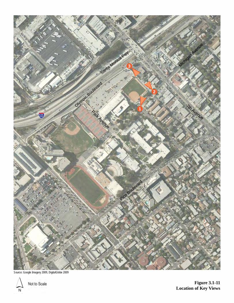
Figure 3.1-11Location of Key Views
Source: Google Imagery 2009, DigitalGlobe 2009
1
3
2
Park Avenue
Park Avenue
7th Avenue
7th Avenue
Olympic
Boulev
ard
Olympic
Boulev
ard
Pico Bouleva
rd
Pico Bouleva
rd
Santa Monica
Fwy
Santa Monica
Fwy
Michiga
n Ave
nue
Michiga
n Ave
nue
N
10

3.1 Aesthetics
Santa Monica High School Science and Technology Building and Site Improvements Project Draft EIR Page 3.1-21 Santa Monica-Malibu Unified School District April 2010
Figure 3.1-12a: Key View 1 Before - View Looking North Towards the Project Site from 7th Street
Figure 3.1-12b: Key View 1 After - View Looking North Towards the Project Site from 7th Street

3.1 Aesthetics
Page 3.1-22 Santa Monica High School Science and Technology Building and Site Improvements Project Draft EIR April 2010 Santa Monica-Malibu Unified School District
Figure 3.1-13a: Key View 2 Before - View Looking Northwest along 7th Court Alley from Michigan Avenue
Figure 3.1-13b: Key View 2 After - View Looking Northwest along 7th Court Alley from Michigan Avenue
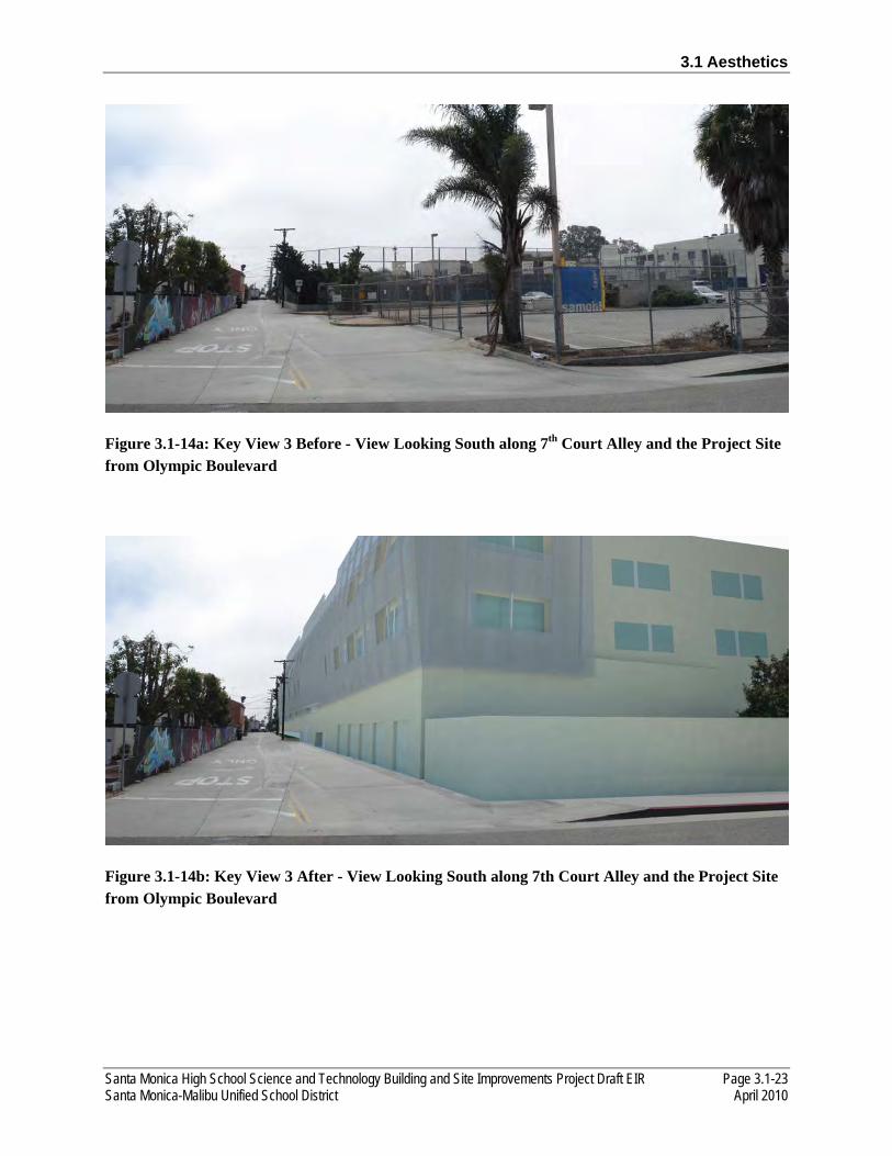
3.1 Aesthetics
Santa Monica High School Science and Technology Building and Site Improvements Project Draft EIR Page 3.1-23 Santa Monica-Malibu Unified School District April 2010
Figure 3.1-14a: Key View 3 Before - View Looking South along 7th Court Alley and the Project Site from Olympic Boulevard
Figure 3.1-14b: Key View 3 After - View Looking South along 7th Court Alley and the Project Site from Olympic Boulevard

3.1 Aesthetics
Page 3.1-24 Santa Monica High School Science and Technology Building and Site Improvements Project Draft EIR April 2010 Santa Monica-Malibu Unified School District
places the new building adjacent to multi-family residential uses, which are located across the 25-foot-wide alley. Whereas, the existing Science and Technology Buildings, located adjacent to 6th Street, are relatively centrally located on the campus and are approximately 164 feet from the nearest residential property. In addition, the new building would include one three-story 84,000-square-foot structure as compared the existing Science and Technology Buildings, which include two two-story structures totaling 88,000 square feet. Although the new building would have a lower square footage than the collective square footage of the existing Science and Technology Buildings, due to the increased height of the new building, the new building would represent an increase in mass and bulk on the Project site.
Key View 1 shows the existing softball field located on the northeastern side of the Project site looking north from 7th Street (see Figure 3.1-12a). In addition, this view shows the visual character of Michigan Avenue and the existing medium-scale, two-story, multi-family residential apartment building (painted light blue-green) at 1805 7th Street. The existing commercial and residential uses located along 7th Court Alley are visible through the chain-linked fences surrounding the existing softball field. This is a view that would typically be seen by residents, students, faculty/staff walking or driving north on 7th Street. The Project site is visible in the middle ground of this view represented by the existing softball field, surrounding fencing, and landscape bushes located along the Michigan Avenue property line. Because of the existing use of the Project site and the presence of the fencing, the Project site in this view does not stand out as a memorable or remarkable feature in the landscape and does not possess a unique visual character or visual interest. Under the proposed Project, this portion of the Project site would become the major visual element in Key View 1 because of the introduction of a three-story building in place of the existing softball field. A portion of the new building along Michigan Avenue would be two stories in height. As shown in Figure 3.1-12b, the proposed building would represent a greater bulk and mass as compared to the existing medium-scale, two-story, multi-family residential apartment building located opposite and southeast of the new building at the corner of Michigan Avenue and 7th Street. However, the two-story portion of the new building along Michigan Avenue is consistent in terms of height, bulk and mass with the existing two-story residential building across Michigan Avenue. Also, the proposed landscaping shown along Michigan Avenue, in addition to the public parkway trees that would remain with the Project, would soften the visual contrast between the new building and the existing residential building across Michigan Avenue. From Key View 1, the proposed Project would not represent a substantial change in the visual character of the area.
Key View 2 shows the existing softball field located on the northeastern side of the Project site looking northwest from Michigan Avenue (see Figure 3.1-13a). In addition, this view shows the visual character of 7th Court Alley and the existing small-scale, two-story, commercial/multi-family residential buildings located on the northeast side of 7th Court Alley, approximately 25 feet from the Project site’s northeastern property line. The existing Science and Technology Buildings are visible looking to the west through the existing landscaping within the public parkway along Michigan Avenue and through the chain-linked fences surrounding the existing softball field. This is a view that would typically be seen by the multi-family residents living opposite the Project site on the southeast side of Michigan Avenue, as well as students, faculty/staff, and motorists traveling along Michigan Avenue. The Project site is visible in the middle ground of this view represented by the existing softball field, surrounding fencing, and landscape bushes located along the Michigan Avenue and 7th Court Alley property line. Because of the existing use

3.1 Aesthetics
Santa Monica High School Science and Technology Building and Site Improvements Project Draft EIR Page 3.1-25 Santa Monica-Malibu Unified School District April 2010
of the Project site, the presence of the fencing, and the several power poles and transmission lines located along the northeastern property line, the Project site in this view does not stand out as a memorable or remarkable feature in the landscape and does not possess a unique visual character or visual interest. Under the proposed Project, this portion of the Project site would become the major visual element in Key View 2 because of the introduction of a three-story building in place of the existing softball field. As shown in Figure 3.1-13b, a portion of the new building along Michigan Avenue (left side of the view) would be two stories in height. The proposed building would represent a greater bulk and mass as compared to the existing small-scale, two-story, commercial/multi-family residential buildings located opposite the new building on the northeast side of 7th Court Alley. As shown, the new building would be setback from the 7th Court Alley property line to provide a buffer between the new building and the commercial/multi-family residential buildings. The new building would result in a visual contrast with the existing small-scale commercial/multi-family residential buildings in terms of height, bulk, and mass. However, the existing commercial/multi-family residential buildings front onto Lincoln Boulevard and the portions of these buildings that are located adjacent to 7th Court Alley do not currently possess a unique visual character. In general, the visual character of 7th Court Alley is not valued as the alley is used for access and trash pick-up. From Key View 2, the proposed Project would not represent a substantial change in the visual character of the area.
Key View 3 shows the existing parking lot located on the northeastern side of the Project site looking southeast from Olympic Boulevard (see Figure 3.1-14a). In addition, this view shows the visual character of 7th Court Alley and the existing small-scale, two-story, commercial/multi-family residential buildings located on the northeast side of 7th Court Alley. The existing softball field and Science and Technology Buildings are visible looking south-southeast through the existing chain-linked fences that surround the existing parking lot and softball field. This is a view that would typically be seen by motorists traveling along Olympic Boulevard and motorists who may by turning right from Olympic Boulevard onto 7th Court Alley in order to access the existing parking lot. In addition, these motorists may include Project area residents, students, or faculty/staff. The Project site is visible in the foreground and middle ground of this view represented by the existing parking lot, surrounding fencing, and landscape trees located along the perimeter of the existing parking lot. Because of the existing use of the Project site and the presence of a substantial amount of fencing, the Project site in this view does not stand out as a memorable or remarkable feature in the landscape and does not possess a unique visual character or visual interest. Under the proposed Project, this portion of the Project site would become the major visual element in Key View 3 because of the introduction of a three-story building in place of the existing parking lot and softball field. As shown in Figure 3.1-14b, the proposed building would represent a greater height, bulk, and mass as compared to the existing small-scale, two-story, commercial/multi-family residential buildings located opposite the new building on the northeast side of 7th Court Alley. However, the existing commercial/multi-family residential buildings front onto Lincoln Boulevard and the portions of these buildings that are located adjacent to 7th Court Alley do not currently possess a unique visual character. In general, the visual character of 7th Court Alley is not valued as the alley is used for access and trash pick-up. Also, Olympic Boulevard is a one-way (northeast) thoroughfare in the section adjacent to the Project site, and motorists traveling along this section of Olympic Boulevard would not have prolonged views of the new building’s visual character as there are no traffic signals

3.1 Aesthetics
Page 3.1-26 Santa Monica High School Science and Technology Building and Site Improvements Project Draft EIR April 2010 Santa Monica-Malibu Unified School District
within this section of the street. From Key View 3, the proposed Project would not represent a substantial change in the visual character of the area.
The proposed Project would construct a new, modern-looking structure that would be one-story taller than the existing surrounding development. However, there is no unifying theme or character to the existing development that surrounds the Project site and the proposed Project would not substantially degrade the existing visual character or quality of the site and its surroundings. In addition, approximately 20 landscape trees on the Project site would be removed with the proposed Project, which would temporarily impact the visual character of the Project site. However, the removed trees are not known to be protected and would be replaced with trees of similar species and maturity with the implementation of the proposed Project. The impact would be less than significant.
AES-2 The proposed Project would not create a new source of substantial light and glare that would adversely affect day or nighttime views in the area. The impact would be less than significant regarding lighting, and less than significant with the implementation of mitigation regarding glare.
The Project site is located in an urban area adjacent to Olympic Boulevard and I-10, an area that currently has a high level of ambient lighting. The existing uses on the Project site include nighttime building lighting, security lighting, parking lot lighting, and minor softball field lighting. The proposed Project would use nighttime building lighting, security lighting, and building entrance lighting similar to the existing Project site. No new sports field lighting is proposed with the Project. Lighting would also be installed in the proposed plaza area and along the Olympic Boulevard, 7th Court Alley, and Michigan Avenue facades for security and decorative purposes. All lighting, including security lighting, would be installed in accordance with applicable specifications and with the appropriate lighting levels to prevent light from spilling over onto the adjacent multi-family residential uses along 7th Court Alley and Michigan Avenue. All lighting fixtures, including those installed on the Project site adjacent to 7th Court Alley, would be installed in accordance with the applicable specifications and City standards, and would be aimed downward as appropriate to ensure that the light does not spillover onto adjacent residential uses. With the implementation of applicable lighting specifications and City standards, the proposed Project would result in less than significant impacts related to lighting.
Glare is produced when any visible light source is brighter than the surroundings in the line of vision. Reflections from smooth, polished reflective surfaces can also be a cause of glare. The proposed Project would not include any new major sources of glare, such as softball field lighting. It is anticipated that the proposed new building would be constructed of concrete, various scrim or screen material, and nonreflective glass windows. The exterior of the proposed Project would not include any metal or other reflective materials that could result in glare effects on the multi-family residences along Michigan Avenue and 7th Court Alley, or on the drivers traveling along the various streets surrounding the Project site. However, because the characteristics of the exterior building materials used with the proposed Project are not yet finalized, mitigation measure AES-A is provided to require the use of low-reflective building materials in Project construction. With the implementation of mitigation measure AES-A, the proposed Project would result in less than significant impacts related to glare.
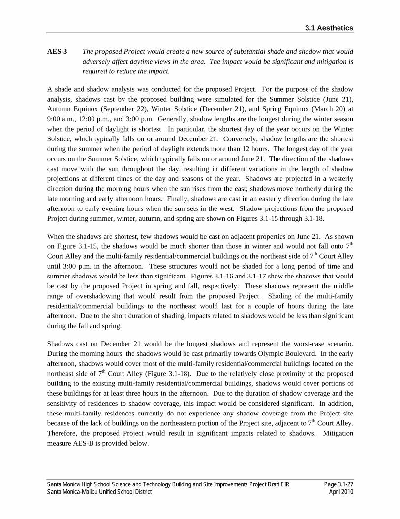
3.1 Aesthetics
Santa Monica High School Science and Technology Building and Site Improvements Project Draft EIR Page 3.1-27 Santa Monica-Malibu Unified School District April 2010
AES-3 The proposed Project would create a new source of substantial shade and shadow that would adversely affect daytime views in the area. The impact would be significant and mitigation is required to reduce the impact.
A shade and shadow analysis was conducted for the proposed Project. For the purpose of the shadow analysis, shadows cast by the proposed building were simulated for the Summer Solstice (June 21), Autumn Equinox (September 22), Winter Solstice (December 21), and Spring Equinox (March 20) at 9:00 a.m., 12:00 p.m., and 3:00 p.m. Generally, shadow lengths are the longest during the winter season when the period of daylight is shortest. In particular, the shortest day of the year occurs on the Winter Solstice, which typically falls on or around December 21. Conversely, shadow lengths are the shortest during the summer when the period of daylight extends more than 12 hours. The longest day of the year occurs on the Summer Solstice, which typically falls on or around June 21. The direction of the shadows cast move with the sun throughout the day, resulting in different variations in the length of shadow projections at different times of the day and seasons of the year. Shadows are projected in a westerly direction during the morning hours when the sun rises from the east; shadows move northerly during the late morning and early afternoon hours. Finally, shadows are cast in an easterly direction during the late afternoon to early evening hours when the sun sets in the west. Shadow projections from the proposed Project during summer, winter, autumn, and spring are shown on Figures 3.1-15 through 3.1-18.
When the shadows are shortest, few shadows would be cast on adjacent properties on June 21. As shown on Figure 3.1-15, the shadows would be much shorter than those in winter and would not fall onto 7th Court Alley and the multi-family residential/commercial buildings on the northeast side of 7th Court Alley until 3:00 p.m. in the afternoon. These structures would not be shaded for a long period of time and summer shadows would be less than significant. Figures 3.1-16 and 3.1-17 show the shadows that would be cast by the proposed Project in spring and fall, respectively. These shadows represent the middle range of overshadowing that would result from the proposed Project. Shading of the multi-family residential/commercial buildings to the northeast would last for a couple of hours during the late afternoon. Due to the short duration of shading, impacts related to shadows would be less than significant during the fall and spring.
Shadows cast on December 21 would be the longest shadows and represent the worst-case scenario. During the morning hours, the shadows would be cast primarily towards Olympic Boulevard. In the early afternoon, shadows would cover most of the multi-family residential/commercial buildings located on the northeast side of 7th Court Alley (Figure 3.1-18). Due to the relatively close proximity of the proposed building to the existing multi-family residential/commercial buildings, shadows would cover portions of these buildings for at least three hours in the afternoon. Due to the duration of shadow coverage and the sensitivity of residences to shadow coverage, this impact would be considered significant. In addition, these multi-family residences currently do not experience any shadow coverage from the Project site because of the lack of buildings on the northeastern portion of the Project site, adjacent to 7th Court Alley. Therefore, the proposed Project would result in significant impacts related to shadows. Mitigation measure AES-B is provided below.
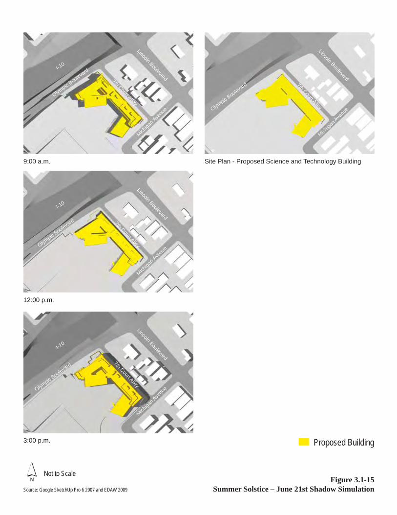
Not to ScaleFigure 3.1-15
Summer Solstice – June 21st Shadow Simulation
Proposed Building
9:00 a.m.
12:00 p.m.
3:00 p.m.
Site Plan - Proposed Science and Technology Building
Source: Google SketchUp Pro 6 2007 and EDAW 2009
Michiga
n Ave
nue
Michiga
n Ave
nue
Lincoln Boulevard
Lincoln Boulevard
Michiga
n Ave
nue
Lincoln Boulevard
Michiga
n Ave
nue
Lincoln Boulevard
I-10
I-10
I-10
7th Court Alley
7th Court Alley
7th Court Alley
Olympic B
oulevard
7th Court Alley
Olympic B
oulevard
Olympic B
oulevard
Olympic B
oulevard
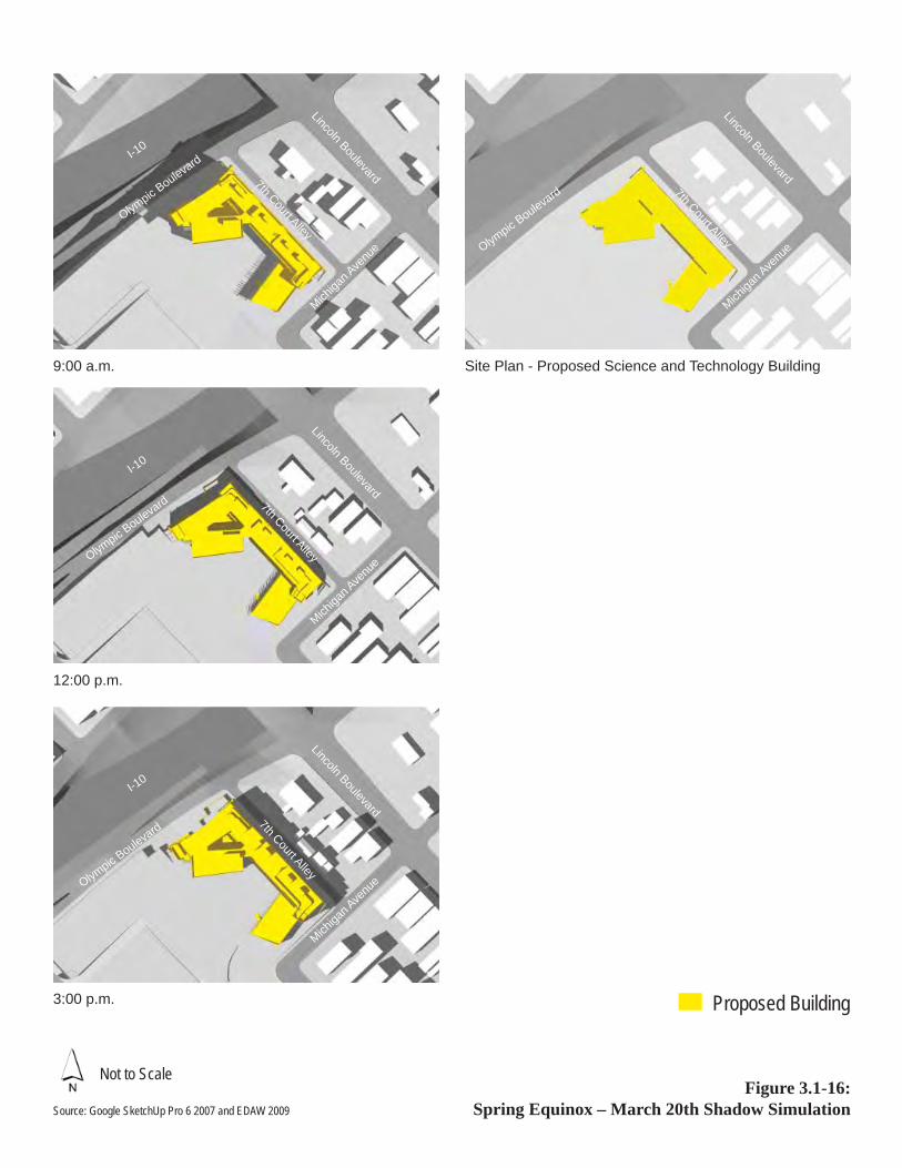
Figure 3.1-16: Spring Equinox – March 20th Shadow Simulation
9:00 a.m.
12:00 p.m.
3:00 p.m.
Site Plan - Proposed Science and Technology Building
Michiga
n Ave
nue
Michiga
n Ave
nue
Lincoln Boulevard
Lincoln Boulevard
Michiga
n Ave
nue
Michiga
n Ave
nue
Lincoln Boulevard
Lincoln Boulevard
Not to Scale
Source: Google SketchUp Pro 6 2007 and EDAW 2009
Proposed Building
I-10
I-10
I-10
7th Court Alley
7th Court Alley
7th Court Alley
Olympic B
oulevard
7th Court Alley
Olympic B
oulevard
Olympic B
oulevard
Olympic B
oulevard

Figure 3.1-17 Autumn Equinox – September 22nd Shadow Simulation
9:00 a.m.
12:00 p.m.
3:00 p.m.
Site Plan - Proposed Science and Technology Building
Michiga
n Ave
nue
Michiga
n Ave
nue
Lincoln Boulevard
Lincoln Boulevard
I-10
I-10
Michiga
n Ave
nue
Michiga
n Ave
nue
Lincoln Boulevard
Lincoln Boulevard
I-10
I-10
Not to Scale
Source: Google SketchUp Pro 6 2007 and EDAW 2009
Proposed Building
7th Court Alley
7th Court Alley
7th Court Alley
Olympic B
oulevard
7th Court Alley
Olympic B
oulevard
Olympic B
oulevard
Olympic B
oulevard

Figure 3.1-18 Winter Solstice – December 21st Shadow Simulation
9:00 a.m.
12:00 p.m.
3:00 p.m.
Michiga
n Ave
nue
Michiga
n Ave
nue
Michiga
n Ave
nue
Michiga
n Ave
nue
Lincoln Boulevard
Lincoln Boulevard
Lincoln Boulevard
Lincoln Boulevard
Site Plan - Proposed Science and Technology Building
Not to Scale
Source: Google SketchUp Pro 6 2007 and EDAW 2009
Proposed Building
I-10
I-10
I-10
7th Court Alley
7th Court Alley
7th Court Alley
Olympic B
oulevard
7th Court Alley
Olympic B
oulevard
Olympic B
oulevard
Olympic B
oulevard

3.1 Aesthetics
Page 3.1-32 Santa Monica High School Science and Technology Building and Site Improvements Project Draft EIR April 2010 Santa Monica-Malibu Unified School District
3.1.4 MITIGATION MEASURES
AES-A The exterior finishes shall be fabricated with non-reflective glass, non-high gloss paint, and other light-absorbing materials to minimize the glare from the new structure as feasible.
AES-B The design features or alterations that shall be implemented to reduce the shadow coverage of residential uses along 7th Court Alley shall include but not be limited to: increasing the setback of the southern portion of the new building along 7th Court Alley and/or include a building step back of the third floor of the southern portion of the new building along 7th Court Alley.
3.1.5 SIGNIFICANCE AFTER MITIGATION
The proposed Project may potentially introduce a new source glare, and would result in substantial shadow coverage. The implementation of mitigation measures AES-A and AES-B would reduce glare and shadow impacts to less than significant levels, respectively. Impacts related to construction and operational visual character, as well as lighting from the proposed Project would be less than significant.

Santa Monica High School Science and Technology Building and Site Improvements Project Draft EIR Page 3.2-1 Santa Monica-Malibu Unified School District April 2010
3.2 AIR QUALITY
This section includes a description of existing air quality conditions in the Project area, a summary of applicable regulations, and analyses of potential short-term, and long-term air quality impacts of the proposed Project. The methods of analysis for short-term construction, long-term regional (operational), local mobile source, odor, and toxic air contaminant (TAC) emissions are consistent with the guidelines of the South Coast Air Quality Management District (SCAQMD). Mitigation measures are recommended, as necessary, to reduce significant air quality impacts.
3.2.1 ENVIRONMENTAL SETTING
The Project site is located in Los Angeles County which lies within the South Coast Air Basin (Basin), a 6,600 square mile coastal plain bounded by the Pacific Ocean to the southwest and the San Gabriel, San Bernardino, and San Jacinto mountains to the north and east. The Basin includes all of Orange County and the non-desert portions of Los Angeles, Riverside, and San Bernardino Counties. The ambient concentrations of air pollutant emissions are determined by the amount of emissions released by sources and the atmosphere’s ability to transport and dilute such emissions. Natural factors that affect transport and dilution include terrain, wind, atmospheric stability, and sunlight. Therefore, existing air quality conditions in the area are determined by such natural factors as topography, meteorology, and climate, in addition to the amount of emissions released by existing air pollutant sources, as discussed separately below.
TOPOGRAPHY, METEOROLOGY, AND CLIMATE
The distinctive climate of the Basin is determined by its terrain and geographic location. The Basin is a coastal plain with connecting broad valleys and low hills, bounded by the Pacific Ocean to the southwest and high mountains around the rest of its perimeter. The general region lies in the semipermanent high-pressure zone of the eastern Pacific, resulting in a mild climate tempered by cool sea breezes with light average wind speeds. The usually mild climatological pattern is interrupted occasionally by periods of extremely hot weather, winter storms, or Santa Ana winds.
Winds in the Project area are usually driven by the dominant land/sea breeze circulation system. Regional wind patterns are dominated by the daytime onshore sea breezes. At night, the wind generally slows and reverses direction traveling toward the sea. Local canyons can also alter wind direction, with wind tending to flow parallel to the canyons.
The vertical dispersion of air pollutants in the Basin is hampered by the presence of persistent temperature inversions. High-pressure systems, such as the semipermanent high-pressure zone in which the Basin is located, are characterized by an upper layer of dry air that warms as it descends, restricting the mobility of cooler, marine-influenced air near the ground surface, and resulting in the formation of subsidence inversions. Such inversions restrict the vertical dispersion of air pollutants released into the marine layer and, together with strong sunlight, can produce worst-case conditions for the formation of photochemical
3.2 Air Quality
Page 3.2-2 Santa Monica High School Science and Technology Building and Site Improvements Project Draft EIR April 2010 Santa Monica-Malibu Unified School District
smog. The Basinwide occurrence of inversions at 3,500 feet above mean sea level or less averages 191 days per year.1
The atmospheric pollution potential of an area is largely dependent on winds, atmospheric stability, solar radiation, and terrain. The combination of low wind speeds and low inversions produces the greatest concentration of air pollutants. On days without inversions, or on days of winds averaging over 15 miles per hour, smog potential is greatly reduced.
Local Climate
The mountains and hills within the South Coast Air Basin contribute to the variation of rainfall, temperature, and winds throughout the region. The predominant wind direction within the Project site and its vicinity is from the southwest, as observed at the Downtown Los Angeles Wind Monitoring Station.2 The wind direction is representative of coastal Los Angeles County and the Project area.
The annual average temperature in the vicinity of the Project site is 57 degrees Fahrenheit (°F). The Project site experiences an average winter temperature of approximately 53°F and an average summer temperature of approximately 62°F. Total precipitation in the vicinity of the Project site averages approximately 15 inches annually. Precipitation occurs mostly during the winter and relatively infrequently during the summer. Precipitation averages approximately nine inches during the winter, approximately four inches during the spring, approximately two inches during the fall, and less than one inch during the summer.3
EXISTING AMBIENT AIR QUALITY – CRITERIA AIR POLLUTANTS
Concentrations of the following air pollutants: ozone, carbon monoxide (CO), nitrogen dioxide (NO2), sulfur dioxide (SO2), respirable particulate matter with an aerodynamic resistance diameter of 10 micrometers or less (PM10), and fine particulate matter with an aerodynamic resistance diameter of 2.5 micrometers or less (PM2.5), and lead are used as indicators of ambient air quality conditions. These air pollutants are commonly referred to as “criteria air pollutants” because the United States Environmental Protection Agency (EPA) regulates them by developing human health-based and/or environmentally-based criteria (science-based guidelines) for setting permissible levels. These air pollutants are the most prevalent air pollutants known to be deleterious to human health, and there is extensive documentation available on health effects of these pollutants.
1 South Coast Air Quality Management District (SCAQMD) CEQA Air Quality Handbook. April 1993. 2 SCAQMD Quality Assurance Site Survey Report for Los Angeles-VA Hospital. website http://www.aqmd.gov/tao/AQ-Reports/AQMonitoringNetworkPlan/WestLosAngeles.pdf. March 2009.
3 Western Region Climate Center (WRCC). Santa Monica City, California (047950) Climate Summary. website http://www.wrcc.dri.edu/cgi-bin/cliMAIN.pl?ca7950. September 2009.

3.2 Air Quality
Santa Monica High School Science and Technology Building and Site Improvements Project Draft EIR Page 3.2-3 Santa Monica-Malibu Unified School District April 2010
A brief description of each criteria air pollutant, including source types, health effects, and future trends, is provided below along with the most current attainment area designations and monitoring data for the Project area and vicinity.
Ozone
Ozone is a photochemical oxidant, a substance whose oxygen combines chemically with another substance in the presence of sunlight, and the primary component of smog. Ozone is not emitted directly into the air, but is formed through complex chemical reactions between precursor emissions of reactive organic gases (ROG) and oxides of nitrogen (NOX) in the presence of sunlight. ROG are volatile organic compounds (VOCs) that are photochemically reactive. It should be noted that the ROG designation includes more chemical compounds than the VOC designation. For purposes of this analysis ROG and VOC are equivalent and are used interchangeably. ROG emissions result primarily from incomplete combustion and the evaporation of chemical solvents and fuels. NOX are a group of gaseous compounds of nitrogen and oxygen that result from the combustion of fuels.
Ozone located in the upper atmosphere (stratosphere) acts in a beneficial manner by shielding the earth from harmful ultraviolet radiation that is emitted by the sun. However, ozone located in the lower atmosphere (troposphere) is a major health and environmental concern. Meteorology and terrain play a major role in ozone formation. Generally, low wind speeds or stagnant air coupled with warm temperatures and clear skies provide the optimum conditions for ozone formation. As a result, observed ozone concentrations are highest during the summer season. Because of the reaction time involved, peak ozone concentrations often occur far downwind of the precursor emissions. Therefore, ozone is a regional pollutant that often affects large areas. In general, ozone concentrations over or near urban and rural areas reflect an interplay of emissions of ozone precursors, transport, meteorology, and atmospheric chemistry.4
The adverse health effects associated with exposure to ozone pertain primarily to the respiratory system. Scientific evidence indicates that ambient levels of ozone affect not only sensitive receptors, such as asthmatics and children, but healthy adults as well. Exposure to ambient levels of ozone ranging from 0.10 to 0.40 part per million (ppm) for 1 or 2 hours has been found to significantly alter lung functions by increasing respiratory rates and pulmonary resistance, decreasing tidal volumes, and impairing respiratory mechanics. Ambient levels of ozone above 0.12 ppm are linked to symptomatic responses that include such symptoms as throat dryness, chest tightness, headache, and nausea. In addition to the above adverse health effects, evidence also exists relating ozone exposure to an increase in the permeability of respiratory epithelia; such increased permeability leads to an increase in the respiratory system’s responsiveness to challenges and the interference or inhibition of the immune system’s ability to defend against infection.5
4 Godish, T. Air Quality. Lewis Publishers. Boca Raton, Florida. 2004. 5 Ibid.

3.2 Air Quality
Page 3.2-4 Santa Monica High School Science and Technology Building and Site Improvements Project Draft EIR April 2010 Santa Monica-Malibu Unified School District
Ozone air quality in the Basin has improved substantially over the last 30 years. During the 1960s, maximum 1-hour concentrations were above 0.60 ppm. Today, the maximum measured concentrations are less than one-third of that. The 2007 peak 8-hour indicator value was 42 percent lower than the 1988 value. The 2008 three-year average of the maximum 8-hour concentration was over 41 percent lower than 1990. The number of days above the standards has also declined dramatically, and the trend for 1-hour ozone is similar to that for 8-hour.6
Although ozone has improved substantially over time, progress has leveled off during the last several years. This may be attributable to changes in the mix and reactivity of precursor emissions in the Basin. While the basin-wide trends show a slower rate of improvement during recent years, progress in some sub-regions of the Basin (for example, the coastal area and some of the inland valley areas) is still occurring. Continuing implementation of the aggressive emissions control measures will ensure continued progress throughout the Basin.7
Carbon Monoxide
CO is a colorless, odorless gas that is formed when carbon in fuel is not burned completely. It is a component of motor vehicle exhaust, which contributes about 77 percent of all CO emissions nationwide. The other 23 percent consist of CO emissions from wood-burning stoves, incinerators, and industrial sources. Higher levels of CO generally occur in areas with heavy traffic congestion. In cities, 85 to 95 percent of all CO emissions may come from motor vehicle exhaust. Other sources of CO emissions include industrial processes (such as metals processing and chemical manufacturing), residential wood burning, and natural sources such as forest fires. Woodstoves, gas stoves, cigarette smoke, and unvented gas and kerosene space heaters are sources of CO indoors. The highest levels of CO in the outside air typically occur during the colder months of the year when inversion conditions are more frequent. The air pollution becomes trapped near the ground beneath a layer of warm air.8
CO enters the bloodstream through the lungs by combining with hemoglobin, which normally supplies oxygen to the cells. However, CO combines with hemoglobin much more readily than oxygen does, resulting in a drastic reduction in the amount of oxygen available to the cells. Adverse health effects associated with exposure to CO concentrations include such symptoms as dizziness, headaches, and fatigue. CO exposure is especially harmful to individuals who suffer from cardiovascular and respiratory diseases.9
6 California Air Resources Board (ARB)The California Almanac of Emissions and Air Quality - 2009 Edition Sacramento, CA. website http://www.arb.ca.gov/aqd/almanac/almanac09/almanac2009all.pdf. Accessed August 2009.
7 Ibid. 8 U.S. Environmental Protection Agency (EPA). Criteria Air Pollutant Information. website http://www.epa.gov/air/urbanair.html. Accessed August 2009.
9 Ibid.

3.2 Air Quality
Santa Monica High School Science and Technology Building and Site Improvements Project Draft EIR Page 3.2-5 Santa Monica-Malibu Unified School District April 2010
The highest CO concentrations are generally associated with cold, stagnant weather conditions that occur during the winter. In contrast to ozone, which tends to be a regional pollutant, CO tends to cause localized problems.
Nitrogen Dioxide
NO2 is a brownish, highly reactive gas that is present in all urban environments. The major human-made sources of NO2 are combustion devices, such as boilers, gas turbines, and mobile, and stationary reciprocating internal-combustion engines. Combustion devices emit primarily nitric oxide (NO), which reacts through oxidation in the atmosphere to form NO2.10 The combined emissions of NO and NO2 are referred to as NOX, which are reported as equivalent NO2. Because NO2 is formed and depleted by reactions associated with photochemical smog (ozone), the NO2 concentration in a particular geographical area may not be representative of the local NOX emission sources.
Inhalation is the most common route of exposure to NO2. Because NO2 has relatively low solubility in water, the principal site of toxicity is in the lower respiratory tract. The severity of the adverse health effects depends primarily on the concentration inhaled rather than the duration of exposure. An individual may experience a variety of acute symptoms, including coughing, difficulty with breathing, vomiting, headache, and eye irritation, during or shortly after exposure. After a period of approximately 4 to 12 hours, an exposed individual may experience chemical pneumonitis or pulmonary edema with breathing abnormalities, cough, cyanosis, chest pain, and rapid heartbeat. Severe, symptomatic NO2
intoxication after acute exposure has been linked on occasion with prolonged respiratory impairment, with such symptoms as chronic bronchitis and decreased lung functions.
Sulfur Dioxide
SO2 is produced by such stationary sources as coal and oil combustion, steel mills, refineries, and pulp and paper mills. The major adverse health effects associated with SO2 exposure pertain to the upper respiratory tract. SO2 is a respiratory irritant with constriction of the bronchioles occurring with inhalation of SO2 at 5 ppm or more. On contact with the moist mucous membranes, SO2 produces sulfurous acid, which is a direct irritant. Concentration rather than duration of the exposure is an important determinant of respiratory effects. Exposure to high SO2 concentrations may result in edema of the lungs or glottis and respiratory paralysis.
Particulate Matter
Respirable particulate matter with an aerodynamic diameter of 10 microns or less is referred to as PM10. PM10 consists of particulate matter emitted directly into the air, such as fugitive dust, soot, and smoke from mobile and stationary sources, construction operations, fires, and natural windblown dust; and
10 Ibid.
3.2 Air Quality
Page 3.2-6 Santa Monica High School Science and Technology Building and Site Improvements Project Draft EIR April 2010 Santa Monica-Malibu Unified School District
particulate matter formed in the atmosphere by condensation and/or transformation of SO2 and ROG.11 PM2.5 includes a subgroup of finer particles that have an aerodynamic diameter of 2.5 microns or less.12
The adverse health effects associated with PM10 depend on the specific composition of the particulate matter. For example, health effects may be associated with adsorption of metals, polycyclic aromatic hydrocarbons, and other toxic substances onto fine particulate matter (which is referred to as the “piggybacking effect”), or with fine dust particles of silica or asbestos. Generally, adverse health effects associated with PM10 may result from both short-term and long-term exposure to elevated concentrations and may include breathing and respiratory symptoms, aggravation of existing respiratory and cardiovascular diseases, alterations to the immune system, carcinogenesis, and premature death.13 PM2.5 poses an increased health risk because the particles can deposit deep in the lungs and contain substances that are particularly harmful to human health.
Direct emissions of PM10 have been increasing in the Basin since 1975. A decrease in emissions would have been observed, if not for growth in emissions from areawide sources, primarily fugitive dust from paved and unpaved roads, dust from construction and demolition operations, and other sources. The increase in activity of these areawide sources reflects the increased growth and vehicle miles traveled (VMT) in the Basin.14
PM10 concentrations in the Basin have shown an improvement during the years for which reliable data are available. The three-year average of the annual average decreased about 35 percent from 1989 to 2007. Despite the overall decrease, ambient concentrations still exceed the state annual and 24-hour PM10 standards. Similar to the ambient concentrations, the calculated number of days above the 24-hour PM10 standards has also shown an overall drop. During 1989, there were 305 calculated days above the state standard and 34 calculated days above the national standard. By 2007, there were 273 calculated State standard exceedance days and 13 national standard exceedance days. The high 24-hour concentration in 2007 was due to a national windblown dust event. Despite these decreases, PM10 continues to pose an issue in the Basin. While emission controls implemented for ozone will also benefit PM10, more controls aimed specifically at reducing PM10 will be needed to reach attainment.15
Direct emissions of PM2.5 have decreased slightly in the Basin since 1975. Stationary source emissions have been decreasing, while area-wide emissions have been increasing. Annual average PM2.5 concentrations have decreased over 37 percent from 1999 to 2007. The 98th percentile of 24-hour PM2.5
concentrations has also declined during this time period.16
11 Ibid. 12 ARB. The California Almanac of Emissions and Air Quality - 2009 Edition Sacramento, CA. website http://www.arb.ca.gov/aqd/almanac/almanac09/almanac2009all.pdf. Accessed August 2009. 13 EPA. Criteria Air Pollutant Information. website http://www.epa.gov/air/urbanair.html. Accessed August 2009. 14 ARB. The California Almanac of Emissions and Air Quality - 2009 Edition Sacramento, CA. website http://www.arb.ca.gov/aqd/almanac/almanac09/almanac2009all.pdf. Accessed August 2009. 15 Ibid. 16 Ibid.
3.2 Air Quality
Santa Monica High School Science and Technology Building and Site Improvements Project Draft EIR Page 3.2-7 Santa Monica-Malibu Unified School District April 2010
Lead
Lead is a metal found naturally in the environment as well as in manufactured products. The major sources of lead emissions have historically been mobile and industrial sources. As a result of the phase-out of leaded gasoline, as discussed in detail below, metal processing is currently the primary source of lead emissions. The highest levels of lead in air are generally found near lead smelters. Other stationary sources are waste incinerators, utilities, and lead-acid battery manufacturers.
Twenty years ago, mobile sources were the main contributor to ambient lead concentrations in the air. In the early 1970s, EPA set national regulations to gradually reduce the lead content in gasoline. In 1975, unleaded gasoline was introduced for motor vehicles equipped with catalytic converters. EPA banned the use of leaded gasoline in highway vehicles in December 1995.17
As a result of EPA’s regulatory efforts to remove lead from gasoline, emissions of lead from the transportation sector declined by 95 percent between 1980 and 1999, and levels of lead in the air decreased by 94 percent between 1980 and 1999. Transportation sources, primarily airplanes, now contribute only 13 percent of lead emissions. A recent National Health and Nutrition Examination Survey reported a 78 percent decrease in the levels of lead in people’s blood between 1976 and 1991. This substantial decline can be attributed to the move from leaded to unleaded gasoline.18
Lead emissions and ambient lead concentrations have decreased dramatically in California over the past 25 years. The rapid decrease in lead concentrations can be attributed primarily to phasing out the lead in gasoline. This phase-out began during the 1970s, and subsequent California Air Resources Board (ARB) regulations have eliminated virtually all lead from gasoline now sold in California. All areas of the state are currently designated as attainment for the state lead standard (EPA does not designate areas for the national lead standard). Although the ambient lead standards are no longer violated, lead emissions from stationary sources still pose “hot spot” problems in some areas. As a result, ARB has identified lead as a TAC.
Monitoring Station Data and Attainment Area Designations
Criteria air pollutant concentrations are measured at 36 monitoring stations in the Basin. The Project site is located in Source Receptor Area (SRA) 2 – Northwest Coastal Los Angeles County. The most representative monitoring station in this area is the Los Angeles – Westchester Parkway monitoring station, located approximately seven miles south of the Project site. This monitoring station was chosen due to its proximity to the Project site and location relative to the Santa Monica Bay.19 The station reports data for ozone, CO, NO2, SO2, and PM10. Air quality data for PM2.5 is available from the North Long
17 EPA. Criteria Air Pollutant Information. website http://www.epa.gov/air/urbanair.html. Accessed August 2009. 18 Ibid. 19 PCR Services Corporation. Health Risk Assessment Santa Monica-Malibu Unified School District (SMMUSD) Santa Monica High School Science/Technology Building. September 2009.
3.2 Air Quality
Page 3.2-8 Santa Monica High School Science and Technology Building and Site Improvements Project Draft EIR April 2010 Santa Monica-Malibu Unified School District
Beach monitoring station, located approximately 27 miles south of the Project site. Table 3.2-1 summarizes the air quality data for the most recent three years.
Both ARB and EPA use this type of monitoring data to designate areas according to their attainment status for criteria air pollutants. The purpose of these designations is to identify the areas with air quality problems and thereby initiate planning efforts for improvement. The three basic designation categories are nonattainment, attainment, and unclassified. Unclassified is used in an area that cannot be classified on the basis of available information as meeting or not meeting the standards. In addition, the California designations include a subcategory of nonattainment-transitional, which is given to nonattainment areas that are progressing and nearing attainment.
The Basin is currently classified as a federal and state nonattainment area for ozone (severe-17 [federal]), PM10 (serious [federal]), and PM2.5 and a federal attainment/maintenance area for CO.20 The Basin is classified as a state attainment area for CO; the Basin currently meets the federal and state standards for NO2, SO2, and lead and is classified as an attainment area for these pollutants.21
20 EPA. The Greenbook Nonattainment Areas for Criteria Pollutants. website http://www.epa.gov/air/oaqps/greenbk/index.html. Accessed August 2009. 21 ARB. Area Designation Maps / State and National. website www.arb.ca.gov/desig/adm/adm.htm/. Accessed August 2009.

3.2 Air Quality
Santa Monica High School Science and Technology Building and Site Improvements Project Draft EIR Page 3.2-9 Santa Monica-Malibu Unified School District April 2010
TABLE 3.2-1 AMBIENT AIR QUALITY AT THE LOS ANGELES COUNTY MONITORING STATIONS22 23
Pollutant Pollutant Concentration & Standards
Number of Days Above State Standard
2006 2007 2008
Ozone
Maximum 1-hr Concentration (ppm) 0.084 0.087 0.086 Days > 0.09 ppm (State 1-hr standard) 0 0 0 Maximum 8-hr Concentration (ppm) 0.066 0.075 0.075
Days > 0.070 ppm (State 8-hr standard) 0 1 1
Carbon Monoxide
Maximum 1-hr concentration (ppm) 3 3 -- Days > 20 ppm (State1-hr standard) 0 0 0 Maximum 8-hr concentration (ppm) 2.27 2.39 2.53 Days > 9.0 ppm (State 8-hr standard) 0 0 0
Nitrogen Dioxide Maximum 1-hr Concentration (ppm) 0.099 0.084 0.094 Days > 0.18 ppm (State 1-hr standard) 0 0 0
PM101 Maximum 24-hr concentration (μg/m3) 45.0 128.0 50.0
Measured Days > 50 μg/m3 (State 24-hr standard) 0 3 0
PM2.5 Maximum 24-hr concentration (μg/m3) 58.5 82.8 39.4
Measured Days > 15 μg/m3 (Federal 24-hr standard) 5 12 2
Sulfur Dioxide Maximum 24-hr Concentration (ppm) 0.010 0.009 0.004 Days > 0.04 ppm (State 24-hr standard) 0 0 0
“-” = data not available or applicable. 1 PM10 data are recorded separately for federal and state purposes because EPA and California methods are slightly different.
Federal values are shown. PM10 is measured every 6 days; the number of days exceeding standards is projected to a 365-day base from the measurements.
EXISTING AIR QUALITY ― TOXIC AIR CONTAMINANTS TACs are air pollutants that may cause or contribute to an increase in mortality or in serious illness, or that may pose a hazard to human health. TACs are usually present in minute quantities in the ambient air. However, their high toxicity or health risk may pose a threat to public health even at low concentrations. According to The California Almanac of Emissions and Air Quality24, the majority of the estimated health risk from TACs can be attributed to relatively few compounds, the most important being particulate matter from diesel-fueled engines (diesel PM). Diesel PM differs from other TACs in that it is not a single substance, but rather a complex mixture of hundreds of substances. Although diesel PM is emitted by diesel-fueled internal-combustion engines, the composition of the emissions varies depending on engine type, operating conditions, fuel composition, lubricating oil, and whether an emission control system is present. Unlike the other TACs, no ambient monitoring data are available for diesel PM because no routine measurement method currently exists. However, ARB has made preliminary concentration estimates based on a PM exposure method. This method uses the ARB emissions
22 ARB. Air Quality Data Statistics. website www.arb.ca.gov/adam/welcome.html. Accessed August 2009. 23 SCAQMD. Historical Data by Year. website http://www.aqmd.gov/smog/historicaldata.htm. Accessed August 2009. 24 ARB. The California Almanac of Emissions and Air Quality - 2009 Edition Sacramento, CA. website http://www.arb.ca.gov/aqd/almanac/almanac09/almanac2009all.pdf. Accessed August 2009.
3.2 Air Quality
Page 3.2-10 Santa Monica High School Science and Technology Building and Site Improvements Project Draft EIR April 2010 Santa Monica-Malibu Unified School District
inventory’s PM10 database, ambient PM10 monitoring data, and the results from several studies on chemical speciation to estimate concentrations of diesel PM. Of the TACs for which data are available in California, diesel PM, benzene, 1,3-butadiene, acetaldehyde, carbon tetrachloride, hexavalent chromium, para-dichlorobenzene, formaldehyde, methylene chloride, and perchloroethylene pose the greatest existing ambient risks.
Diesel PM poses the greatest health risk among these 10 TACs. Based on receptor modeling techniques, ARB estimated the diesel PM health risk in the Basin in 2000 to be 720 excess cancer cases per million people. Although the health risk is higher than the statewide average, it represents a 33 percent drop between 1990 and 2000.25
The Health Risk Assessment (HRA) performed for the proposed Project identified 54 stationary TAC emitting sources within 0.25 mile of the school site. A complete list of sources is included in Appendix B. Vehicles on Interstate 10 (I-10) and associated ramps and access roads are sources of diesel PM and other TACs associated with vehicle exhaust.
Sensitive Receptors
Some members of the population are especially sensitive to air pollutant emissions and should be given special consideration when evaluating air quality impacts from projects. These people include children, the elderly, persons with preexisting respiratory or cardiovascular illness, and athletes and others who engage in frequent exercise. Structures that house these persons or places where they gather are defined as sensitive receptors by SCAQMD. According to SCAQMD, sensitive receptors include residences, schools, playgrounds, child care centers, athletic facilities, long-term health care facilities, rehabilitation centers, convalescent centers, and retirement homes. Thus, the Santa Monica High School, which includes the proposed Project site, is considered a sensitive receptor to surrounding emissions sources.
Residential areas are considered sensitive to air pollution because residents (including children and the elderly) tend to be at home for extended periods of time, resulting in sustained exposure to any pollutants present. Recreational land uses are considered moderately sensitive to air pollution. Exercise places a high demand on respiratory functions, which can be impaired by air pollution even though exposure periods during exercise are generally short. In addition, noticeable air pollution can detract from the enjoyment of recreation. Industrial and commercial areas are considered the least sensitive to air pollution. Exposure periods are relatively short and intermittent as the majority of the workers tend to stay indoors most of the time. In addition, the working population is generally the healthiest segment of the public.
The Project site is surrounded by commercial, multi-family residential and civic uses. Commercial and multi-family residential uses are located east of the Project site, on the east side of 7th Court Alley and along Lincoln Boulevard. The commercial uses include gas stations, other automobile-related uses, small
25 Ibid.
3.2 Air Quality
Santa Monica High School Science and Technology Building and Site Improvements Project Draft EIR Page 3.2-11 Santa Monica-Malibu Unified School District April 2010
strip malls, and small commercial/industrial establishments that front Lincoln Boulevard. One multi-family residence east of 7th Court Alley fronts Lincoln Boulevard, while the other multi-family residences are located directly adjacent to 7th Court Alley, approximately 23 feet east of the Project site. In addition, multi-family residential uses are located approximately 33 feet north of the campus, between 5th Street and Olympic Boulevard. Civic uses are located west of the campus. The DoubleTree Guest Suites Hotel is located adjacent west of the campus, and the Sheraton Delfina Hotel to the south, on the south side of Pico Boulevard. The City of Santa Monica City Hall and the new Civic Center Parking Structure, Santa Monica Civic Auditorium (constructed in 1958) and large Civic Lot surface parking area, and related civic facilities are located on the west side of 4th Street. The Viceroy Hotel and RAND building are located west of the civic land uses.
EXISTING AIR QUALITY — ODORS
Odors are generally regarded as an annoyance rather than a health hazard. However, manifestations of a person’s reaction to foul odors can range from psychological (e.g., irritation, anger, or anxiety) to physiological (e.g., circulatory and respiratory effects, nausea, vomiting, and headache).
With respect to odors, the human nose is the sole sensing device. The ability to detect odors varies considerably among the population and overall is quite subjective. Some individuals have the ability to smell very minute quantities of specific substances; others may not have the same sensitivity but may have sensitivities to odors of other substances. In addition, people may have different reactions to the same odor; an odor that is offensive to one person may be perfectly acceptable to another (e.g., fast food restaurant). It is important to also note that an unfamiliar odor is more easily detected and is more likely to cause complaints than a familiar one. This is because of the phenomenon known as odor fatigue, in which a person can become desensitized to almost any odor and recognition only occurs with an alteration in the intensity.
Quality and intensity are two properties present in any odor. The quality of an odor indicates the nature of the smell experience. For instance, if a person describes an odor as flowery or sweet, then the person is describing the quality of the odor. Intensity refers to the strength of the odor. For example, a person may use the word strong to describe the intensity of an odor. Odor intensity depends on the odorant concentration in the air. When an odorous sample is progressively diluted, the odorant concentration decreases. As this occurs, the odor intensity weakens and eventually becomes so low that the detection or recognition of the odor is quite difficult. At some point during dilution, the concentration of the odorant reaches a detection threshold. An odorant concentration below the detection threshold means that the concentration in the air is not detectable by the average human.
There are no existing concentrated sources of objectionable odors within one mile of the Project site. Minor sources of odor include gas stations, restaurant char-broilers, auto body shops, and dry cleaners.

3.2 Air Quality
Page 3.2-12 Santa Monica High School Science and Technology Building and Site Improvements Project Draft EIR April 2010 Santa Monica-Malibu Unified School District
These sources do not represent major concentrated sources of odors. No major agriculture-related odor sources (e.g., livestock or dairy operations) are located within two miles.
EXISTING AIR QUALITY — GREENHOUSE GASES
In addition to criteria air pollutants and TACs, greenhouse gases (GHGs) are also considered pollutants of air quality concern. From the standpoint of CEQA, GHG impacts to global climate change are inherently cumulative. Therefore, background information on global climate change and the proposed Project’s contribution of GHGs are discussed subsequently in the EIR in Chapter 4.0 Impact Overview; subsection 4.3 Cumulative Impacts.
3.2.2 REGULATORY SETTING
Air quality in the City is regulated by EPA, ARB, and SCAQMD. Each of these agencies develops rules, regulations, policies, and/or goals to comply with applicable legislation. Although EPA regulations may not be superseded, both state and local regulations may be more stringent.
CRITERIA AIR POLLUTANTS
Air quality regulations focus on ozone, CO, NO2, SO2, PM10, PM2.5, and lead. Because these are the most prevalent air pollutants known to be deleterious to human health, and extensive health-effects criteria documents are available, these pollutants are commonly referred to as “criteria air pollutants.”
Federal Plans, Policies, Regulations, and Laws
At the federal level, EPA has been charged with implementing national air quality programs. EPA’s air quality mandates are drawn primarily from the federal Clean Air Act (CAA), which was enacted in 1970. The most recent major amendments to the CAA were made by Congress in 1990.
The CAA required EPA to establish national ambient air quality standards (NAAQS). As shown in Table 3.2-2, EPA has established primary and secondary NAAQS for ozone, CO, NO2, SO2, PM10, PM2.5, and lead. The primary standards protect the public health, while the secondary standards protect the public welfare. The CAA also required each state to prepare an air quality control plan, referred to as a state implementation plan (SIP). The federal Clean Air Act Amendments of 1990 (CAAA) added requirements for states with nonattainment areas to revise their SIPs to incorporate additional control measures to reduce air pollution. The SIP is modified periodically to reflect the latest emissions inventories, planning documents, and rules and regulations of the air basins, as reported by their jurisdictional agencies. EPA is responsible for reviewing all SIPs to determine whether they conform to the mandates of the CAA and its amendments, and to determine whether implementing the SIPs will achieve air quality goals.

3.2 Air Quality
Santa Monica High School Science and Technology Building and Site Improvements Project Draft EIR Page 3.2-13 Santa Monica-Malibu Unified School District April 2010
TABLE 3.2-2 FEDERAL AND STATE AMBIENT AIR QUALITY STANDARDS26
Pollutant Averaging Time NAAQS1 CAAQS2
Primary3 Secondary4 Concentration5
Ozone (O3)6 1-Hour - Same as Primary Standard
0.09 ppm (180 μg/m3) 8-Hour 0.075 ppm (147 μg/m3) 0.070 ppm (137 μg/m3) 7
Carbon Monoxide (CO)
8-Hour 9 ppm (10 mg/m3) None 9.0 ppm (10 mg/m3) 1-Hour 35 ppm (40 mg/m3) 20 ppm (23 mg/m3)
8-Hour (Lake Tahoe) - - 6 ppm (7 mg/m3) Nitrogen Dioxide
(NO2) Annual Average 0.053 ppm (100 μg/m3) Same as
Primary Standard 0.030 ppm (57 μg/m3)8
1-Hour - 0.18 ppm (339 μg/m3)8
Sulfur Dioxide (SO2)
Annual Average 0.030 ppm (80 μg/m3) - - 24-Hour 0.14 ppm (365 μg/m3) - 0.04 ppm (105 μg/m3) 3-Hour - 0.5 ppm (1,300 μg/m3) - 1-Hour - - 0.25 ppm (655 μg/m3)
Respirable Particulate Matter (PM10)9
24-Hour 150 μg/m3 Same as Primary Standard
50 μg/m3 Annual Arithmetic
Mean Revoked 20 μg/m3 note 9
Fine Particulate Matter (PM2.5)10
24-Hour 35 μg/m3 Same as Primary Standard
- Annual Arithmetic
Mean 15 μg/m3 12 μg/m3
Lead (Pb)
30-Day Average - - 1.5 μg/m3
Calendar Quarter 1.5 μg/m3 Same as Primary Standard -
Rolling 3-Month Average10 0.15 μg/m3 Same as
Primary Standard -
Hydrogen Sulfide (H2S) 1-Hour
No Federal Standards
0.03 ppm (42 μg/m3)
Sulfates (SO4) 24-Hour 25 μg/m3
Visibility Reducing Particles
8-Hour (10 a.m. to 6 p.m., Pacific Standard
Time)
Extinction coefficient of 0.23 per km-visibility of 10 miles or more (0.07/30 miles for Lake Tahoe) due to particles when the relative humidity is less than 70 percent.
Vinyl Chloride7 24-Hour 0.01 ppm (26 μg/m3) 1 NAAQS (other than O3, particulate matter, and those based on annual
averages or annual arithmetic mean) are not to be exceeded more than once a year. The O3 standard is attained when the fourth highest 8-hour concentration in a year, averaged over 3 years, is equal to or less than the standard. For PM10, the 24-hour standard is attained when the expected number of days per calendar year with a 24-hour average concentration above 150 µg/m3 is equal to or less than one. For PM2.5, the 24-hour standard is attained when 98 percent of the daily concentrations, averaged over 3 years, are equal to or less than the standard. Contact EPA for further clarification and current federal policies.
2 California Ambient Air Quality Standards for O3, CO (except Lake Tahoe), SO2 (1- and 24-hour), NO2, PM10, PM2.5 and visibility reducing particles are values that are not to be exceeded. All others are not to be equaled or exceeded.
3 National Primary Standards: The levels of air quality necessary, with an adequate margin of safety, to protect the public health.
4 National Secondary Standards: The levels of air quality necessary to protect the public welfare from any known or anticipated adverse effects of a pollutant.
5 Concentration expressed first in units in which it was promulgated. Ppm in this table refers to ppm by volume or micromoles of pollutant per mole of gas.
6 On June 15, 2005, the 1-hour ozone standard was revoked for all areas except the 8-hour ozone nonattainment Early Action Compact Areas (those areas do not yet have an effective date for their 8-hour designations). Additional information on federal ozone standards is available at http://www.epa.gov/oar/oaqps/greenbk/index.html.
7 ARB has identified lead and vinyl chloride as “toxic air contaminants” with no threshold level of exposure for adverse health effects determined. These actions allow for the implementation of control measures at levels below the ambient concentrations specified for these pollutants.
8 The nitrogen dioxide ambient air quality standard was amended to lower the 1-hr standard to 0.18 ppm and establish a new annual standard of 0.030 ppm. These changes became effective March 20, 2008.
9 Due to a lack of evidence linking health problems to long-term exposure to coarse particle pollution, EPA revoked the annual PM10 standard on December 17, 2006.
10 Effective December 17, 2006, EPA lowered the PM2.5 24-hour standard from 65 µg/m3 to 35 µg/m3.
ppm = parts per million; µg/m3 = micrograms per cubic meter; mg/m3 = milligrams per cubic meter; km = kilometers
26 ARB. Ambient Air Quality Standards. website http://www.arb.ca.gov/research/ aaqs/aaqs2.pdf. Accessed August 2009.

3.2 Air Quality
Page 3.2-14 Santa Monica High School Science and Technology Building and Site Improvements Project Draft EIR April 2010 Santa Monica-Malibu Unified School District
If EPA determines a SIP to be inadequate, a federal implementation plan that imposes additional control measures may be prepared for the nonattainment area. If an approvable SIP is not submitted or implemented within the mandated time frame, sanctions may be applied to transportation funding and stationary sources of air pollution in the air basin.
State Plans, Policies, Regulations, and Laws
ARB is responsible for coordination and oversight of state and local air pollution control programs in California and for implementation of the California Clean Air Act (CCAA). The CCAA, which was adopted in 1988, required ARB to establish California Ambient Air Quality Standards (CAAQS) (Table 3.2-2). ARB has established CAAQS for sulfates, hydrogen sulfide, vinyl chloride, visibility-reducing particulate matter, and the above-mentioned criteria air pollutants. In most cases, the CAAQS are more stringent than the NAAQS. Differences in the standards are generally explained through interpretation of the health-effects studies considered during the standard-setting process. In addition, the CAAQS incorporate a margin of safety to protect sensitive individuals.
The CCAA requires all local air districts in the state to endeavor to achieve and maintain the CAAQS by the earliest practical date. The act specifies that local air districts shall focus particular attention on reducing the emissions from transportation and areawide emission sources, and provides districts with the authority to regulate indirect sources.
Among ARB’s other responsibilities are overseeing compliance by local air districts with California and federal laws; approving local air quality plans, submitting SIPs to EPA; monitoring air quality; determining and updating area designations and maps; and setting emissions standards for new mobile sources, consumer products, small utility engines, off-road vehicles, and fuels.
Local Plans, Policies, Regulations, and Laws
South Coast Air Quality Management District
SCAQMD attains and maintains air quality conditions in the Basin through a comprehensive program of planning, regulation, enforcement, technical innovation, and promotion of the understanding of air quality issues. The clean air strategy of SCAQMD includes the preparation of plans for the attainment of ambient air quality standards, adoption and enforcement of rules and regulations concerning sources of air pollution, and issuance of permits for stationary sources of air pollution. SCAQMD also inspects stationary sources of air pollution and responds to citizen complaints; monitors ambient air quality and meteorological conditions; and implements programs and regulations required by the CAA, CAAA, and the CCAA. Air quality plans applicable to the proposed Project are discussed below.
3.2 Air Quality
Santa Monica High School Science and Technology Building and Site Improvements Project Draft EIR Page 3.2-15 Santa Monica-Malibu Unified School District April 2010
Air Quality Management Plan
SCAQMD and the Southern California Association of Governments (SCAG) are responsible for preparing the air quality management plan (AQMP), which addresses federal and state CAA requirements. The AQMP details goals, policies, and programs for improving air quality in the Basin. Two versions (2003 and 2007) of the AQMP are in different stages of approval. The 2003 AQMP is an update to the 1997 AQMP. The 2003 AQMP employs up-to-date science and analytical tools and incorporates a comprehensive strategy aimed at controlling pollution from all sources, including stationary sources, on-road and off-road mobile sources, and area sources. The 2003 AQMP proposes policies and measures to achieve federal and state standards for healthy air quality in the Basin. The 2003 AQMP updates the demonstration of attainment for the federal O3 and PM10; replaces the 1997 attainment demonstration for the federal CO standard and provides a basis for a maintenance plan for CO for the future; and updates the maintenance plan for the federal NO2 standard that the Basin has met since 1992. The 2003 AQMP was adopted by SCAQMD in August 2003 and approved, with modifications, by ARB in October 2003.27 ARB submitted the South Coast SIP to the EPA on January 9, 2004; however, this SIP has not been approved, and the 1997 AQMP with 1999 amendments remains the federally approved AQMP.
A draft version of the 2007 AQMP was released to the public, and public workshops were held in October, November, and December 2006.28 The 2007 AQMP was adopted by the SCAQMD Governing Board on June 1, 2007. The purpose of the 2007 AQMP for the Basin is to set forth a comprehensive program that will lead the region into compliance with federal 8-hour O3 and PM2.5 air quality standards. ARB adopted the State Strategy for the 2007 SIP, and the 2007 AQMP as part of the SIP on September 27, 2007. On November 28, 2007, ARB submitted a SIP revision to EPA for O3, PM2.5, CO, and NO2 in the Basin; this revision is identified as the 2007 South Coast SIP. The 2007 AQMP/2007 South Coast SIP demonstrates attainment of the federal PM2.5 standard in the Basin by 2014, and attainment of the federal 8-hour O3 standard by 2023. The SIP also includes a request of reclassification of the O3 attainment designation from “severe” to “extreme”.29 On February 1, 2008, ARB submitted additional technical information relative to the 2007 South Coast SIP to EPA.30
The PM2.5 strategy outlined in the AQMP is of interest. Since PM2.5 in the Basin is overwhelmingly formed secondarily, the overall draft control strategy focuses on reducing precursor emission of sulfur oxides (SOX), directly emitted PM2.5, NOX, and VOC instead of fugitive dust.31 Based on SCAQMD’s
27 SCAQMD. 2003 Air Quality Management Plan. website http://www.aqmd.gov/aqmp/AQMD03AQMP.htm. August 2003. 28 SCAQMD. Draft 2007 Air Quality Management Plan. website http://www.aqmd.gov/ aqmp/07aqmp/draft/07aqmp.pdf. June 2007.
29 ARB. Letter to Mr. Wayne Nastri, USEPA, submitting revisions to the California State Implementation Plan, including revisions identified as the 2007 South Coast SIP. November 28, 2007. 30 ARB. Letter to Mr. Wayne Nastri, USEPA, submitting additional technical information supporting reasonable further progress demonstration for the South Coast SIP. February 1, 2008. 31 SCAQMD. Draft 2007 Air Quality Management Plan. website http://www.aqmd.gov/ aqmp/07aqmp/draft/07aqmp.pdf. June 2007.
3.2 Air Quality
Page 3.2-16 Santa Monica High School Science and Technology Building and Site Improvements Project Draft EIR April 2010 Santa Monica-Malibu Unified School District
modeling sensitivity analysis, SOX reductions, followed by directly emitted PM2.5 and NOX reductions, provide the greatest benefits in terms of reducing the ambient PM2.5 concentrations.
As a result of state and local control strategies, the Basin has not exceeded the federal CO standard since 2002. In March 2005, SCAQMD adopted a CO Redesignation Request and Maintenance Plan that provides for maintenance of the federal CO air quality standard until at least 2015 and commits to revising the Redesignation Request and Maintenance Plan in 2013 to ensure maintenance through 2025.32 SCAQMD also adopted a CO emissions budget that covers 2005 through 2015. On February 24, 2006, ARB transmitted the Redesignation Request and Maintenance Plan (including the CO budgets) to EPA for approval. On June 11, 2007, EPA redesignated the Basin as attainment for the federal CO standard and approved the maintenance plan amendment to the SIP for the Basin.33
SCAQMD Rules and Regulations
All projects are subject to SCAQMD rules and regulations in effect at the time of construction. Specific Rules applicable to the construction of the proposed Project may include, but are not limited to:
Rule 401 – Visible Emissions. A person shall not discharge into the atmosphere from any single source of emission whatsoever any air contaminant for a period or periods aggregating more than three minutes in any one hour which is as dark or darker in shade as that designated No. 1 on the Ringelmann Chart, as published by the United States Bureau of Mines.
Rule 402 – Nuisance. A person shall not discharge from any source whatsoever such quantities of air contaminants or other material which cause injury, detriment, nuisance, or annoyance to any considerable number of persons or to the public, or which endanger the comfort, repose, health or safety of any such persons or the public, or which cause, or have a natural tendency to cause injury or damage to business or property. The provisions of this rule do not apply to odors emanating from agricultural operations necessary for the growing of crops or the raising of fowl or animals.
Rule 403 – Fugitive Dust. This rule is intended to reduce the amount of particulate matter entrained in the ambient air as a result of anthropogenic (man-made) fugitive dust sources by requiring actions to prevent, reduce or mitigate fugitive dust emissions. Rule 403 applies to any activity or man-made condition capable of generating fugitive dust.
Rule 1113 – Architectural Coatings. No person shall apply or solicit the application of any architectural coating within the SCAQMD, with VOC content in excess of the values specified in a table incorporated in the Rule.
32 SCAQMD. Carbon Monoxide Redesignation Request and Maintenance Plan. February 2005. 33 Federal Register. Vol. 72, No. 91 Rules and Regulations, Pages 26718-26721. May 11, 2007.

3.2 Air Quality
Santa Monica High School Science and Technology Building and Site Improvements Project Draft EIR Page 3.2-17 Santa Monica-Malibu Unified School District April 2010
TOXIC AIR CONTAMINANTS
Air quality regulations also focus on TACs, or in federal parlance hazardous air pollutants (HAPs). Examples of TACs are discussed in detail in Section 3.2-1, “Environmental Setting,” under “Existing Air Quality—Toxic Air Contaminants.” In general, for those TACs that may cause cancer, there is no concentration that does not present some risk. In other words, there is no safe level of exposure. This contrasts with the criteria air pollutants, for which acceptable levels of exposure can be determined and for which the ambient standards have been established (Table 3.2-2). Instead, EPA and ARB regulate HAPs and TACs, respectively, through statutes and regulations that generally require the use of the maximum or best available control technology for toxics (MACT and BACT) to limit emissions. These statutes and regulations, in conjunction with additional rules set forth by the districts, establish the regulatory framework for TACs.
Federal Programs for Hazardous Air Pollutants
EPA has programs for identifying and regulating HAPs. Title III of the CAAA directed EPA to promulgate national emissions standards for HAPs (NESHAP). The NESHAP may differ for major sources than for area sources of HAPs. Major sources are defined as stationary sources with potential to emit more than 10 tons per year (TPY) of any HAP or more than 25 TPY of any combination of HAPs; all other sources are considered area sources. The emissions standards are to be promulgated in two phases. In the first phase (1992–2000), EPA developed technology-based emission standards designed to produce the maximum emission reduction achievable. These standards are generally referred to as requiring MACT. For area sources, the standards may be different, based on generally available control technology. In the second phase (2001–2008), EPA is required to promulgate health risk–based emissions standards, where deemed necessary, to address risks remaining after implementation of the technology-based NESHAP standards.
The CAAA also required EPA to promulgate vehicle or fuel standards containing reasonable requirements that control toxic emissions of, at a minimum, benzene and formaldehyde. Performance criteria were established to limit mobile-source emissions of toxics, including benzene, formaldehyde, and 1,3-butadiene. In addition, Section 219 required the use of reformulated gasoline in selected areas with the most severe ozone nonattainment conditions to further reduce mobile-source emissions.
State and Local Programs for Toxic Air Contaminants
TACs in California are regulated primarily through the Tanner Air Toxics Act (Assembly Bill [AB] 1807 [Chapter 1047, Statutes of 1983]) and the Air Toxics Hot Spots Information and Assessment Act (Hot Spots Act) (AB 2588 [Chapter 1252, Statutes of 1987]). AB 1807 sets forth a formal procedure for ARB to designate substances as TACs. This includes research, public participation, and scientific peer review before ARB can designate a substance as a TAC. To date, ARB has identified more than 21 TACs and adopted EPA’s list of HAPs as TACs. Most recently, diesel PM was added to the ARB list of TACs.
3.2 Air Quality
Page 3.2-18 Santa Monica High School Science and Technology Building and Site Improvements Project Draft EIR April 2010 Santa Monica-Malibu Unified School District
Once a TAC is identified, ARB then adopts an Airborne Toxics Control Measure (ATCM) for sources that emit that particular TAC. If there is a safe threshold for a substance at which there is no toxic effect, the control measure must reduce exposure below that threshold. If there is no safe threshold, the measure must incorporate BACT to minimize emissions.
The Air Toxics Hot Spots Information and Assessment Act requires existing facilities emitting toxic substances above a specified level to prepare a toxic-emission inventory, prepare a risk assessment if emissions are significant, notify the public of significant risk levels, and prepare and implement risk reduction measures.
ARB has adopted diesel-exhaust control measures and more stringent emission standards for various on-road mobile sources of emissions, including transit buses, and off-road diesel equipment (e.g., tractors, generators). In February 2000, ARB adopted a new public-transit bus fleet rule and emissions standards for new urban buses. These new rules and standards provide (1) more stringent emission standards for some new urban bus engines beginning with 2002 model year engines, (2) zero-emission bus demonstration and purchase requirements applicable to transit agencies, and (3) reporting requirements under which transit agencies must demonstrate compliance with the public-transit bus fleet rule. New milestones include the low-sulfur diesel fuel requirement, and tighter emission standards for heavy-duty diesel trucks (2007) and off-road diesel equipment (2011) nationwide. Over time, the replacement of older vehicles will result in a vehicle fleet that produces substantially lower levels of TACs than current vehicles. Mobile-source emissions of TACs (e.g., benzene, 1-3-butadiene, diesel PM) have been reduced significantly over the last decade, and they will be reduced further in California through a progression of regulatory measures (e.g., Low Emission Vehicle/Clean Fuels and Phase II reformulated gasoline regulations) and control technologies. With implementation of ARB’s risk reduction plan, it is expected that diesel PM concentrations will be reduced by 75 percent in 2010 and 85 percent in 2020 from the estimated year 2000 level. Adopted regulations are also expected to continue to reduce formaldehyde emissions from cars and light-duty trucks. As emissions are reduced, it is expected that risks associated with exposure to the emissions will also be reduced.
ARB published the Air Quality and Land Use Handbook: A Community Health Perspective, which provides guidance concerning land use compatibility with TAC sources.34 Although it is not a law or adopted policy, the handbook offers advisory recommendations for the siting of sensitive receptors near uses associated with TACs, such as freeways and high-traffic roads, commercial distribution centers, rail yards, ports, refineries, dry cleaners, gasoline stations, and industrial facilities, to help keep children and other sensitive populations out of harm’s way. A number of comments on the handbook were provided to ARB by air districts, other agencies, real estate representatives, and others. The comments included concern about whether ARB was playing a role in local land use planning, the validity of relying on static
34 ARB. Air Quality and Land Use Handbook: A Community Health Perspective. Available at http://www.arb.ca.gov/ch/handbook.pdf. April 2005.
3.2 Air Quality
Santa Monica High School Science and Technology Building and Site Improvements Project Draft EIR Page 3.2-19 Santa Monica-Malibu Unified School District April 2010
air quality conditions over the next several decades in light of technological improvements, and support for providing information that can be used in local decision making.
California Public Resources Code (PRC) Section 21151.8 and Education Code (EC) Section 17213 prohibit the approval of an environmental impact report (EIR) or negative declaration (or mitigated negative declaration [MND]) for a project involving the construction of a new elementary or secondary school without conducting a formal HRA. Under both the State PRC and EC, approval of an EIR or negative declaration for a project involving the purchase of new land is prohibited unless an HRA is conducted that includes all stationary sources within 0.25 mile (1,320 feet) of the proposed Project boundary. In addition, Senate Bill (SB) 352, passed in 2003, amended these sections of law to include the criteria about freeways and busy traffic corridors within 500 feet of a proposed school site. SB 352 defined facility as “any source with a potential to use, generate, emit or discharge hazardous air pollutants, including, but not limited to, pollutants that meet the definition of a hazardous substance, and whose process or operation is identified as an emission source pursuant to the most recent list of source categories published by the California Air Resources Board.” Prior to this legislation, facility was not defined, but widely accepted as Air District permitted facilities (e.g., power plants, refineries, gasoline stations, etc.). However, the SB 352 definition also includes non-permitted sources (e.g., warehouse distribution centers).
At the local level, air pollution control or management districts may adopt and enforce ARB control measures. Under SCAQMD Regulation XIV (Toxics and Other Non-Criteria Pollutants), and in particular Rule 1401 (New Source Review), all sources that possess the potential to emit TACs are required to obtain permits from the district. Permits may be granted to these operations if they are constructed and operated in accordance with applicable regulations, including new source review standards and air toxics control measures. SCAQMD limits emissions and public exposure to TACs through a number of programs. SCAQMD prioritizes TAC-emitting stationary sources based on the quantity and toxicity of the TAC emissions and the proximity of the facilities to sensitive receptors.
ODORS
SCAQMD has identified some common types of facilities that have been known to produce odors: agriculture (farming and livestock), wastewater treatment plants, food processing plants, chemical plants, composting operations, refineries, landfills, rendering plants, dairies, rail yards, and fiberglass molding operations. This list is not meant to be entirely inclusive, but to act as general guidance. Because offensive odors rarely cause any physical harm and no requirements for their control are included in federal or state air quality regulations, SCAQMD does not have rules or standards related to odor emissions other than Rule 402 (Nuisance) and Rule 410 (Odors from Transfer Stations and Material Recovery Facilities). Any actions related to odors are based on citizen complaints to local governments and SCAQMD.

3.2 Air Quality
Page 3.2-20 Santa Monica High School Science and Technology Building and Site Improvements Project Draft EIR April 2010 Santa Monica-Malibu Unified School District
Two situations increase the potential for odor problems. The first occurs when a new odor source is located near existing sensitive receptors. The second occurs when new sensitive receptors are developed near existing sources of odor. In the first situation, SCAQMD recommends operational changes, add-on controls, process changes, equipment relocation, or changes in stack heights where feasible to address odor complaints. In the second situation, the potential conflict is considered significant if the Project site is at least as close as any other site that has already experienced significant odor problems related to the odor source. For projects locating near a source of odors, and for odor sources locating near existing sensitive receptors, SCAQMD recommends that the determination of potential conflict be based on variables such as wind speed, wind direction, and the distance and frequency at which odor complaints from the public have occurred in the vicinity of the facility.35
3.2.3 ENVIRONMENTAL IMPACTS
THRESHOLDS OF SIGNIFICANCE
Based on Appendix G of the CEQA Guidelines, a significant impact related to air quality would occur if implementation of the proposed Project would do any of the following:
• Conflict with or obstruct implementation of the applicable air quality plan;
• Violate any air quality standard or contribute substantially to an existing or projected air quality violation;
• Result in a cumulatively considerable net increase of any criteria pollutant for which the project region is non-attainment under an applicable federal or state ambient air quality standard (including releasing emissions which exceed quantitative thresholds for ozone precursors);
• Expose sensitive receptors to substantial pollutant concentrations; or
• Create objectionable odors affecting a substantial number of people.
As stated in Appendix G of the CEQA Guidelines, the significance criteria established by the applicable air quality management or air pollution control district may be relied upon to make the above determinations. SCAQMD has established thresholds, as shown in Table 3.2-3.
As shown in Table 3.2-3, SCAQMD has established quantitative thresholds for analyzing the significance of direct impacts from a project that introduces new sources of TAC emissions to sensitive populations. While it was not originally intended to evaluate projects that introduce new sensitive receptors to an area with existing offsite TAC sources, in the absence of a more applicable threshold for exposure, SCAQMD has recommended that this threshold be used as a conservative measure of the potential risk to new receptors. This is consistent with EC 17213 for sites which involve land acquisition. Although the 35 SCAQMD. CEQA Air Quality Handbook. April 1993.

3.2 Air Quality
Santa Monica High School Science and Technology Building and Site Improvements Project Draft EIR Page 3.2-21 Santa Monica-Malibu Unified School District April 2010
proposed Project does not directly increase TAC emissions or involve acquisition of new land, the SMMUSD has adopted the recommended significance thresholds as follows.
The Project would have a significant impact from TAC exposure if:
• The change in carcinogenic risk equals or exceeds 10 in one million (10 E-06) at any receptor location.
• The change in any chronic or acute hazard index equals or exceeds a value of one.
TABLE 3.2-3 SCAQMD AIR QUALITY SIGNIFICANCE THRESHOLDS36
Mass Daily Thresholds
Pollutant Construction a Operation b NOX 100 lb/day 55 lb/day VOC 75 lb/day 55 lb/day PM10 150 lb/day 150 lb/day PM2.5 55 lb/day 55 lb/day SOX 150 lb/day 150 lb/day CO 550 lb/day 550 lb/day
Lead 3 lb/day 3 lb/day Toxic Air Contaminants (TACs) and Odor Thresholds TACs
(including carcinogens and noncarcinogens)
Maximum Incremental Cancer Risk ≥ 10 in 1 million
Cancer Burden > 0.5 excess cancer cases (in areas ≥ 1 in 1 million)
Hazard Index ≥ 1.0 (project increment) Odor Project creates an odor nuisance
pursuant to SCAQMD Rule 402 Ambient Air Quality for Criteria Pollutants c
NO2
1-hour average annual average
SCAQMD is in attainment; project is significant if it causes or contributes
to an exceedance of the following attainment standards:
0.18 ppm (state) 0.03 ppm (state)
PM10 24-hour average
annual average
10.4 μg/m3 (construction)d & 2.5 μg/m3 (operation)
1.0 μg/m3 PM2.5
24-hour average
10.4 μg/m3 (construction)d & 2.5 μg/m3 (operation)
36 SCAQMD. SCAQMD Air Quality Significance Thresholds. website http://www.aqmd.gov/CEQA/ handbook/signthres.pdf. March 2009.

3.2 Air Quality
Page 3.2-22 Santa Monica High School Science and Technology Building and Site Improvements Project Draft EIR April 2010 Santa Monica-Malibu Unified School District
Sulfate 24-hour average
1 μg/m3
CO
1-hour average 8-hour average
SCAQMD is in attainment; project is significant if it causes or contributes
to an exceedance of the following attainment standards:
20 ppm (state) 9.0 ppm (state/federal)
a Construction thresholds apply to both the South Coast Air Basin and Coachella Valley (Salton Sea Air Basin and Mojave Desert Air Basin).
b For Coachella Valley, the mass daily thresholds for operation are the same as the construction thresholds. c Ambient air quality thresholds for criteria pollutants based on SCAQMD Rule 1303, Table A-2 unless otherwise stated. d Ambient air quality threshold based on SCAQMD Rule 403. KEY: lb/day = pounds per day; μg/m3 = micrograms per cubic meter; ppm = parts per million; ≥ greater than or equal to
The SCAQMD has developed methodology to assess the potential for localized emissions to cause an exceedance of applicable ambient air quality standards. Impacts would be considered significant if the following would occur:
• The predicted localized contribution to a pollutant concentration at the proposed sensitive land use when added to the representative background concentration would exceed the applicable ambient air quality standards (applies only to those pollutants for which the Basin is classified as attainment), or
• The predicted localized sources of PM10 and PM2.5 would contribute more than 2.5 µg/m3 at the proposed sensitive land use. Since the Basin does not meet the ambient air quality standards for PM10 and PM2.5, SCAQMD instead recommends using this allowable increase as a significance threshold, consistent with SCAQMD Rule 1303.
As part of the Initial Study (see Appendix A), it was determined that the proposed Project would not conflict with the applicable Air Quality Attainment or Congestion Management Plan. Accordingly, this issue is not further analyzed in the EIR.
The proposed Project would place the new Science and Technology Building in the northeastern portion of the Project site, directly adjacent to 7th Court Alley. The proposed Project would change the orientation of the Building and could change the air circulation patterns for the adjacent buildings in comparison to existing conditions. The predominant wind direction in the Project vicinity is from the southwest. The new Science and Technology Building would be located northwest of the residential development on 7th Street and would not interfere with the air movement around these buildings. The new Building could act as an obstacle to wind flow around the buildings on 7th Court Alley east of the Project site. In general, high buildings generally have an adverse effect on the wind conditions in their immediate vicinity,
3.2 Air Quality
Santa Monica High School Science and Technology Building and Site Improvements Project Draft EIR Page 3.2-23 Santa Monica-Malibu Unified School District April 2010
sometimes giving rise to dangerous wind conditions.37 Groups of buildings tend to slow winds near ground level. Buildings that are much taller than the surrounding buildings intercept and redirect winds that might otherwise flow overhead. The new Science and Technology Building would be three stories. Thus, it would not be significantly higher than the surrounding development on 7th Court Alley. Air flow would be rerouted around the Building, but would not be changed substantially due to the similar size of buildings in the neighborhood. Accordingly, this issue is not further analyzed in the EIR.
METHODOLOGY
Regional and local emissions of criteria air pollutants and precursors, and TACs during Project construction and operations were assessed in accordance with the methodologies described below.
Air quality impacts from the proposed Project can be divided into two types, short-term impacts and long-term impacts. Short-term impacts are associated with construction activities, and long-term impacts are associated with the continued operation of the buildings and the associated increase in vehicular trips.
Short-term construction-related and long-term operation-related (regional and local) impacts, as well as impacts from TACs, were assessed in accordance with SCAQMD-recommended methodologies. Where quantification was required, Project-generated construction-related emissions were modeled using the ARB-approved URBEMIS 2007 Version 9.2.4 (URBEMIS) computer program as recommended by SCAQMD.38 URBEMIS incorporates ARB’s EMFAC2007 model for on-road vehicle emissions and the OFFROAD2007 model for off-road vehicle emissions. URBEMIS is designed to model construction emissions for land development projects and allows for the input of project-specific information. Project-generated emissions were modeled based on general information provided in the Project description and default URBEMIS settings in order to estimate reasonable worst-case conditions.
Project-generated, long-term regional area- and mobile-source emissions of criteria air pollutants and O3 precursors were assessed qualitatively since the Project involves the replacement of the Science and Technology buildings and would not create new land uses.
Determinations of significance for construction- and operation-related emissions were based on the comparison of Project-generated emissions to applicable SCAQMD thresholds.
Other air quality impacts (i.e., local emissions of CO, construction- and operation-related TACs, and odors) were assessed in accordance with methodologies recommended by ARB and SCAQMD. Localized
37 G. Th. Visser, C. J. Folkers and A. Weenk. KnoWind: a database-oriented approach to determine the pedestrian level wind environment around buildings. Journal of Wind Engineering and Industrial Aerodynamics. Volume 87, Issues 2-3, 13 October 2000, Pages 287-299
38 Rimpo and Associates. URBEMIS 2007 for Windows, Version 9.2.4. website http://www.urbemis. com/software/download.html. 2008.
3.2 Air Quality
Page 3.2-24 Santa Monica High School Science and Technology Building and Site Improvements Project Draft EIR April 2010 Santa Monica-Malibu Unified School District
emissions of criteria air pollutants, both onsite and offsite, were analyzed based on SCAQMD’s localized significance threshold (LST) methodology.39
Dispersion Modeling Methodology
Although not required by CEQA, an HRA was performed to evaluate potential carcinogenic and non-carcinogenic risks to students and staff resulting from the change in exposure to localized sources of TACs. Since the Project site is located in close proximity to the I-10 freeway, a criteria air pollutant analysis was also conducted. The assessment and dispersion modeling methodologies used in the preparation of the analysis were based on procedures presented by U.S. EPA and California EPA, including guidelines from OEHHA.
A total of 54 permitted and unpermitted facilities were identified within ¼ mile of the Project site. A list of permitted facilities is available from SCAQMD through their Facility Information Database (FIND). Unpermitted sources were identified through an extensive site reconnaissance.40 The HRA also considered the impact of potential long-term (i.e., chronic) exposures to hazardous emissions generated from mobile-source activity associated with vehicles traversing I-10 and associated ramps and access roads. Contaminant release information and associated chemical species were identified through a review of available documentation for each source facility. A list of pollutants included in the analysis is provided in Appendix B.
Permitted sources are required to report annual emissions of criteria air pollutants and some TACs to the SCAQMD. However, only a few of the permitted sources within ¼ mile of the proposed Project meet the requirements to report all TAC emissions. Therefore, TAC emissions were calculated based on permit limits (i.e. maximum permissible throughput or usage rates) combined with conservative engineering estimates (i.e. published values regarding content of specific TACs in products used by industry) for most sources. Emission factors for the unpermitted sources were based on information provided by the facility manager or representative during an onsite interview. All emission factors were calculated using conservative methodologies promulgated by OEHHA, ARB, and SCAQMD. Data regarding the number of vehicles and ratio of heavy duty diesel trucks was gathered from California Department of Transportation (Caltrans) traffic data to model the freeway. Emission factors were derived from ARB’s EMFAC2007 model to reflect county-wide conditions. Further detail on sources and emission factors is included in Appendix B.
Potential TAC and criteria air pollutant impacts were evaluated by conducting a detailed analysis (i.e. dispersion modeling) based on mobile and stationary sources identified in the 0.25 mile radius. Dispersion modeling was conducted using the EPA Industrial Source Complex-Short Term (ISCST3)
39 SCAQMD. Final Localized Significance Threshold Methodology. website http://www. aqmd.gov/CEQA/handbook/LST/Method_final.pdf 2003. June 2003.
40 PCR Services Corporation. Health Risk Assessment Santa Monica-Malibu Unified School District (SMMUSD) Santa Monica High School Science/Technology Building. September 2009.

3.2 Air Quality
Santa Monica High School Science and Technology Building and Site Improvements Project Draft EIR Page 3.2-25 Santa Monica-Malibu Unified School District April 2010
model which is designed to provide conservative estimates of air pollutant concentrations. The model is recommended by SCAQMD for dispersion modeling and ISCST3-ready meteorological data are available from their website. Modeling was performed using meteorological data collected at Los Angeles International Airport (LAX). The most recent set of complete meteorological data (surface and upper air) collected at LAX consists of hourly surface and upper air data from the LAX meteorological observation station operated by the National Weather Service (NWS) for the 12-month period beginning March 1, 1996 and ending February 28, 1997. Meteorological data were rearranged to create a full calendar year (January 1 to December 31) compatible with the ISC meteorological data input formats. Detailed modeling parameters are shown in Appendix B.
IMPACT ANALYSIS
AIR-1:
Construction-related activities would not result in Project-generated regional emissions of criteria air pollutants and precursors that exceed the daily significance thresholds. Thus, the Project would not result in short-term construction-related regional emissions of VOC, NOx, CO, PM10 and PM2.5 that violate air quality standards or contribute substantially to existing or projected air quality violations. (Less than Significant).
Construction-related activities could result in Project-generated localized emissions of PM10 and PM2.5 that temporarily expose sensitive receptors to substantial pollutant concentrations. (Significant and unavoidable).
REGIONAL EMISSIONS
Construction-related emissions are described as “short term” or temporary in duration and have the potential to represent a significant impact with respect to air quality. Construction-related activities would result in Project-generated emissions of criteria air pollutants (e.g., PM10) and precursors (e.g., ROG and NOX). Project-generated, construction-related emissions of VOC and NOX were modeled using the ARB-approved URBEMIS 2007 Version 9.2.4 computer program. URBEMIS is designed to model construction emissions for land use development projects and allows for the input of project-specific information.
Project construction is anticipated to begin in the third quarter of 2011 and end in the second quarter of 2014. Construction of the Project is considered in two phases, construction of the new Science and Technology buildings (Phase 1) and demolition of the old buildings (Phase 2), with each phase composed of a number of elements. Construction of the parking ramp (Phase 1.5) is anticipated to overlap with both phases of construction. The existing buildings would continue to operate during the construction of the new building.

3.2 Air Quality
Page 3.2-26 Santa Monica High School Science and Technology Building and Site Improvements Project Draft EIR April 2010 Santa Monica-Malibu Unified School District
The new building construction will also remove the existing softball field and a portion of the existing parking lot. Following construction of the new building, existing buildings would be removed and replaced with the new softball field and parking lot reconfiguration.
Phase 1, which includes construction of the new Science and Technology Building, Michigan Avenue Entrance, and Campus Technology power upgrade, is anticipated to occur from the third quarter of 2011 to the end of 2013. Phase 2, which includes construction of the parking lot and softball field, is anticipated to occur from the third quarter of 2013 to the second quarter of 2014. Since the existing building will remain functional while the new one is being constructed, no overlap was assumed between Phases 1 and 2. Construction of the parking ramp (Phase 1.5) is anticipated to overlap with both phases of construction. This analysis focuses on the earliest possible timeline that Project construction could occur and examines the worst-case scenario for daily emissions. Since SCAQMD’s thresholds for construction are based on daily emissions, the analysis identifies the scenarios where maximum daily emissions could occur due to concurrent construction activities onsite.
Project-generated emissions were modeled based on information provided in the Project description and by the SMMUSD. Where specific information was not known, engineering judgment and default URBEMIS settings and parameters were used. Compliance with SCAQMD Rules is required; specifically, it is assumed that the construction would be performed in accordance with Rule 403, Fugitive Dust, and Rule 1113, Architectural Coatings. Therefore, emissions reductions consistent with those rules have been included in the estimate of construction emissions. The required actions of Rules 403 and 1113 are discussed in Section 7.0 of this report as Standard Conditions AIR-A and AIR-B.
Table 3.2-4 summarizes the modeled emissions for the construction phases. Construction-related air quality effects were determined by comparing these modeling results with applicable SCAQMD significance thresholds. Refer to Appendix B of this EIR for detailed modeling input parameters and results.
Based on the modeling conducted, construction-related activities would not result in criteria air pollutant or precursor emissions that would exceed SCAQMD’s significance thresholds. Thus, Project-generated construction-related emissions would not violate or contribute substantially to an existing or projected air quality violation. As a result, construction-generated emissions would be less than significant.

3.2 Air Quality
Santa Monica High School Science and Technology Building and Site Improvements Project Draft EIR Page 3.2-27 Santa Monica-Malibu Unified School District April 2010
TABLE 3.2-4 ESTIMATED CONSTRUCTION-RELATED DAILY EMISSIONS OF CRITERIA
AIR POLLUTANTS AND PRECURSORS (UNMITIGATED)41
Phase (Year) Emissions
Pounds Per Day (lb/day)
VOC NOX CO PM10 PM2.5
Phase 1
2011 9.3 70.1 40.1 40.3 11.2
2012 3.4 15.9 16.3 1.1 1.0
2013 28.1 14.9 15.8 1.0 0.9
Phase 1.5
2013 7.2 45.1 28.9 32.2 8.7
Phase 2
2013 4.0 33.6 19.1 48.6 11.3
Worst-Case Total Daily Emissions (Unmitigated)
2011 9.3 70.1 40.1 40.3 11.2
2012 3.4 15.9 16.3 1.1 1.0
2013(Phases 1 and 1.5) 35.3 60.0 44.7 33.2 9.6
2013 (Phases 1.5 and 2) 11.2 78.7 48.0 80.8 20.0
SCAQMD Significance Threshold; see Table 4 75 100 550 150 55
Exceeds Thresholds? No No No No No
Worst-case totals may not appear as the sum of applicable phases due to rounding. Calculations assume compliance with SCAQMD Rules 403 and 1113; see Standard Conditions AIR-1 and AIR-2. Refer to Appendix B for detailed assumptions and modeling output files.
LOCALIZED EMISSIONS
SCAQMD has promulgated standards and methodology for calculation of impacts based on LST.42 Calculation of LST is a voluntary procedure but has more importance when sensitive receptors are close to sources of emissions. As existing multi-family residential development is located next to the Project site, the LST calculations are included in this air quality analysis.
41 Data modeled by EDAW 2009. 42 SCAQMD. Final Localized Significance Threshold Methodology. website http://www. aqmd.gov/CEQA/handbook/LST/Method_final.pdf 2003. June 2003.
3.2 Air Quality
Page 3.2-28 Santa Monica High School Science and Technology Building and Site Improvements Project Draft EIR April 2010 Santa Monica-Malibu Unified School District
An LST analysis is a localized air dispersion modeling analysis. Air dispersion modeling is a function of multivariables, including local meteorological conditions, site-specific air pollutant emission levels, and sensitive receptor distances to the modeling site. LST analyses utilize air dispersion modeling methodologies to predict maximum concentration levels of air pollutant emissions generated from a project site that could reach nearby sensitive receptors based on mathematic simulation of meteorological dispersion processes. The pollutants of concern are NO2, CO, PM10, and PM2.5.
To minimize efforts for detailed dispersion modeling, SCAQMD developed screening (lookup) tables to assist lead agencies with a simple tool for evaluating impacts from small, typical projects. The use of LST lookup tables is limited to projects that are five acres or smaller in size, limited to eight hours of operations during the day, and with emissions distributed evenly across the proposed site.
Since the Project would be constructed in phases, the LST analysis was performed for the worst-case scenario, i.e., highest daily onsite emissions and closest proximity to receptors. Construction activities during Phase 1 represent both these criteria. The area of disturbance during Phase 1 is approximately two acres. Thus, the site meets the LST criteria, and the lookup tables were used for analysis. The screening tables require the following information:
The area of the Project site. The lookup tables provide data for one-, two-, and five-acre sites. The thresholds for a two-acre site were used.
Maximum daily emissions of CO, NOX, PM10, and PM2.5, in pounds per day. These data were calculated with the URBEMIS 2007, version 9.2.4 model, as described above. In the LST analysis, only on-site emissions are considered; thus, off-site emissions such as haul trucks and worker commuting are not included. The maximum daily emissions for the site were used. The URBEMIS data sheets are included in Appendix B.
Distance from the boundary of the Project to the nearest off-site receptor. The lookup tables analyze distances of 25, 50, 100, 200, and 500 meters (82, 164, 328, 656, and 1,640 feet) from the boundary of the Project to the nearest off-site receptor. Since the closest residence is located next to the proposed building site, the closest receptor locations at 25 meters (82 feet) were used.
Geographic location of the construction site in terms of district SRA. These data are required because emissions thresholds are based on local pollutant measurements and meteorology. The proposed Project is located in SRA 2 – Northwest Coastal Los Angeles County.
Construction emissions for the LST analysis were calculated in accordance with the methodology described above. Results are shown in Table 3.2-5. Detailed LST calculations are shown in Appendix B.
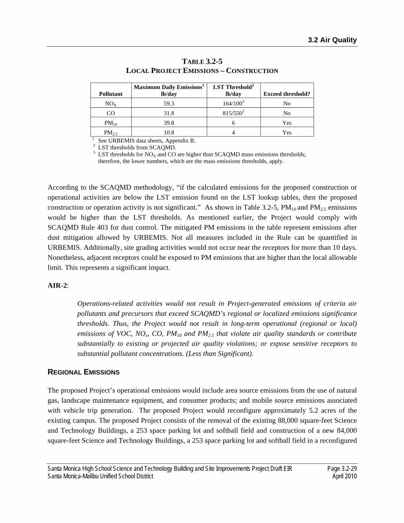
3.2 Air Quality
Santa Monica High School Science and Technology Building and Site Improvements Project Draft EIR Page 3.2-29 Santa Monica-Malibu Unified School District April 2010
TABLE 3.2-5 LOCAL PROJECT EMISSIONS – CONSTRUCTION
Pollutant Maximum Daily Emissions1
lb/day LST Threshold2
lb/day Exceed threshold? NOX 59.3 164/1003 No CO 31.8 815/5503 No
PM10 39.8 6 Yes PM2.5 10.8 4 Yes
1 See URBEMIS data sheets, Appendix B. 2 LST thresholds from SCAQMD. 3 LST thresholds for NOX and CO are higher than SCAQMD mass emissions thresholds;
therefore, the lower numbers, which are the mass emissions thresholds, apply.
According to the SCAQMD methodology, “if the calculated emissions for the proposed construction or operational activities are below the LST emission found on the LST lookup tables, then the proposed construction or operation activity is not significant.” As shown in Table 3.2-5, PM10 and PM2.5 emissions would be higher than the LST thresholds. As mentioned earlier, the Project would comply with SCAQMD Rule 403 for dust control. The mitigated PM emissions in the table represent emissions after dust mitigation allowed by URBEMIS. Not all measures included in the Rule can be quantified in URBEMIS. Additionally, site grading activities would not occur near the receptors for more than 10 days. Nonetheless, adjacent receptors could be exposed to PM emissions that are higher than the local allowable limit. This represents a significant impact.
AIR-2:
Operations-related activities would not result in Project-generated emissions of criteria air pollutants and precursors that exceed SCAQMD’s regional or localized emissions significance thresholds. Thus, the Project would not result in long-term operational (regional or local) emissions of VOC, NOx, CO, PM10 and PM2.5 that violate air quality standards or contribute substantially to existing or projected air quality violations; or expose sensitive receptors to substantial pollutant concentrations. (Less than Significant).
REGIONAL EMISSIONS
The proposed Project’s operational emissions would include area source emissions from the use of natural gas, landscape maintenance equipment, and consumer products; and mobile source emissions associated with vehicle trip generation. The proposed Project would reconfigure approximately 5.2 acres of the existing campus. The proposed Project consists of the removal of the existing 88,000 square-feet Science and Technology Buildings, a 253 space parking lot and softball field and construction of a new 84,000 square-feet Science and Technology Buildings, a 253 space parking lot and softball field in a reconfigured
3.2 Air Quality
Page 3.2-30 Santa Monica High School Science and Technology Building and Site Improvements Project Draft EIR April 2010 Santa Monica-Malibu Unified School District
site layout. As such, the proposed Project would not generate new trips onto the roadway system as there would be no additional student enrollment as part of the proposed Project.43
In general, the number of laboratories would be the same for the existing buildings and new building. Thus, building operations are anticipated to remain the same and would not represent a net increase in area source emissions.
If a proposed Project involves the removal of existing emission sources on the same site as the proposed land use, State CEQA guidelines allow for subtracting the existing emissions levels from the emissions levels estimated for the new proposed land use. This net credit is permissible if the existing emission sources were operational at the time that the NOP for the CEQA project was circulated and would continue if the proposed redevelopment project is not approved. Since the Science and Technology buildings operations would be identical before and after the redevelopment there would be no net increase in area- or mobile-source emissions. Therefore, the Project’s operational activities would not result in Project-generated emissions of criteria air pollutants and precursors that violate air quality standards or contribute substantially to existing or projected air quality violations. This impact is less than significant.
LOCALIZED EMISSIONS
Impacts of the Project
The Project would not introduce new building operations since it involves redevelopment of the Science and Technology buildings. However, the new Science and Technology building would be located closer to the surrounding multi-family residences as compared to existing conditions. Therefore, operational emissions are analyzed for a localized impact.
The LST analysis for operational emissions was performed using the same methodology as the construction emissions LST analysis. In the LST analysis, only on-site emissions are considered; thus, off-site emissions such as vehicular emissions due to the operation of the Project are not included. Only area source emissions, such as emissions from the use of natural gas, landscape maintenance equipment, and consumer products are included in the analysis. The URBEMIS data sheets are included in Appendix B. Detailed LST calculations are shown in Appendix B.
Results of the LST analysis for operational emissions are shown in Table 3.2-6.
43 KOA Corporation Traffic Impact Study for Santa Monica High School Science and Technology Building and Site Improvement Project. March 2010.
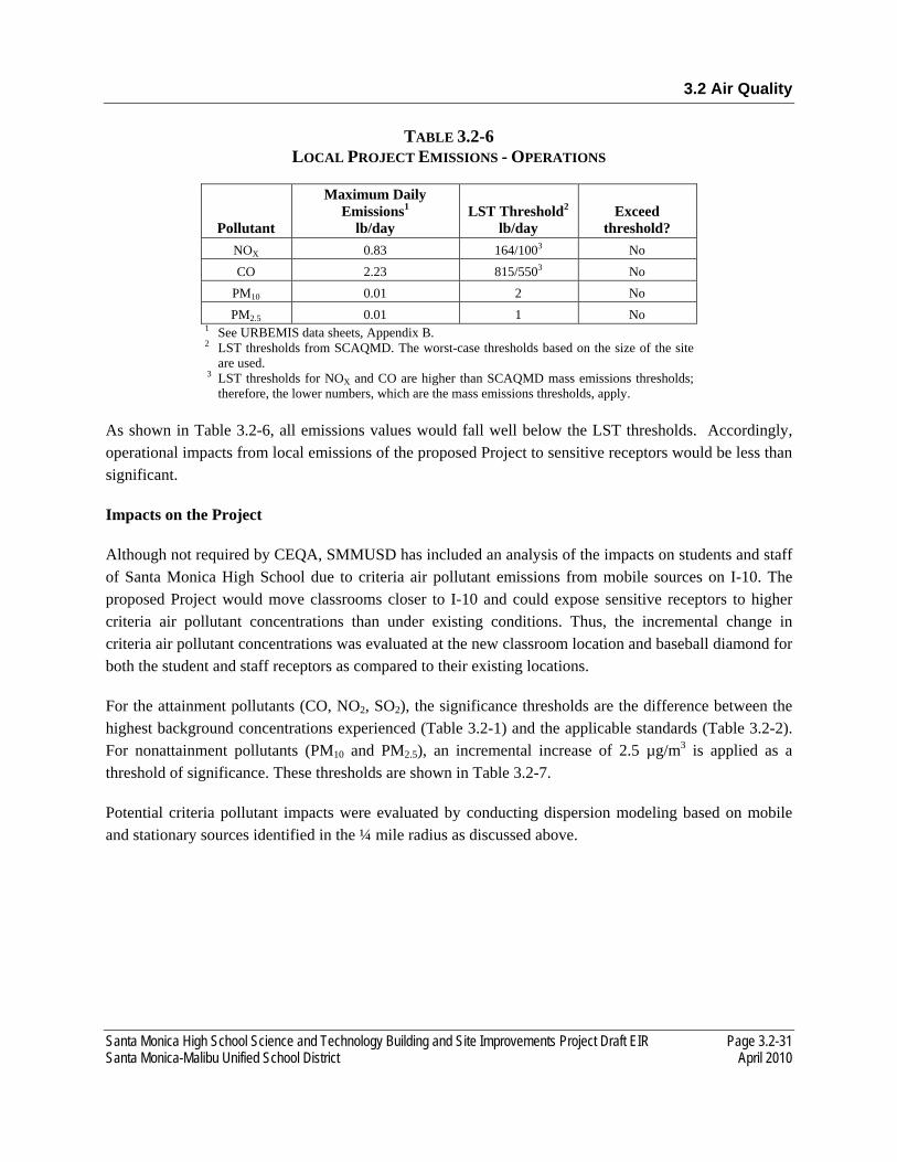
3.2 Air Quality
Santa Monica High School Science and Technology Building and Site Improvements Project Draft EIR Page 3.2-31 Santa Monica-Malibu Unified School District April 2010
TABLE 3.2-6 LOCAL PROJECT EMISSIONS - OPERATIONS
Pollutant
Maximum Daily Emissions1
lb/day LST Threshold2
lb/day Exceed
threshold? NOX 0.83 164/1003 No CO 2.23 815/5503 No
PM10 0.01 2 No PM2.5 0.01 1 No
1 See URBEMIS data sheets, Appendix B. 2 LST thresholds from SCAQMD. The worst-case thresholds based on the size of the site
are used. 3 LST thresholds for NOX and CO are higher than SCAQMD mass emissions thresholds;
therefore, the lower numbers, which are the mass emissions thresholds, apply. As shown in Table 3.2-6, all emissions values would fall well below the LST thresholds. Accordingly, operational impacts from local emissions of the proposed Project to sensitive receptors would be less than significant.
Impacts on the Project
Although not required by CEQA, SMMUSD has included an analysis of the impacts on students and staff of Santa Monica High School due to criteria air pollutant emissions from mobile sources on I-10. The proposed Project would move classrooms closer to I-10 and could expose sensitive receptors to higher criteria air pollutant concentrations than under existing conditions. Thus, the incremental change in criteria air pollutant concentrations was evaluated at the new classroom location and baseball diamond for both the student and staff receptors as compared to their existing locations.
For the attainment pollutants (CO, NO2, SO2), the significance thresholds are the difference between the highest background concentrations experienced (Table 3.2-1) and the applicable standards (Table 3.2-2). For nonattainment pollutants (PM10 and PM2.5), an incremental increase of 2.5 µg/m3 is applied as a threshold of significance. These thresholds are shown in Table 3.2-7.
Potential criteria pollutant impacts were evaluated by conducting dispersion modeling based on mobile and stationary sources identified in the ¼ mile radius as discussed above.
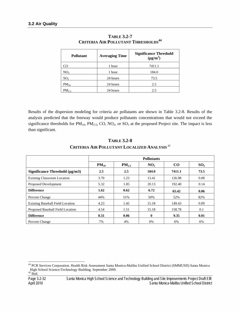
3.2 Air Quality
Page 3.2-32 Santa Monica High School Science and Technology Building and Site Improvements Project Draft EIR April 2010 Santa Monica-Malibu Unified School District
TABLE 3.2-7 CRITERIA AIR POLLUTANT THRESHOLDS44
Pollutant Averaging Time Significance Threshold (µg/m3)
CO 1 hour 7411.1
NO2 1 hour 184.0
SO2 24 hours 73.5
PM10 24 hours 2.5
PM2.5 24 hours 2.5
Results of the dispersion modeling for criteria air pollutants are shown in Table 3.2-8. Results of the analysis predicted that the freeway would produce pollutants concentrations that would not exceed the significance thresholds for PM10, PM2.5, CO, NO2, or SO2 at the proposed Project site. The impact is less than significant.
TABLE 3.2-8 CRITERIA AIR POLLUTANT LOCALIZED ANALYSIS 45
Pollutants
PM10 PM2.5 NO2 CO SO2
Significance Threshold (µg/m3) 2.5 2.5 184.0 7411.1 73.5
Existing Classroom Location 3.70 1.23 13.41 126.98 0.08
Proposed Development 5.32 1.85 20.13 192.40 0.14
Difference 1.62 0.62 6.72 65.42 0.06
Percent Change 44% 51% 50% 52% 82%
Existing Baseball Field Location 4.23 1.45 15.18 149.43 0.09
Proposed Baseball Field Location 4.54 1.51 15.18 158.78 0.1
Difference 0.31 0.06 0 9.35 0.01
Percent Change 7% 4% 0% 6% 6%
44 PCR Services Corporation. Health Risk Assessment Santa Monica-Malibu Unified School District (SMMUSD) Santa Monica High School Science/Technology Building. September 2009.
45 Ibid.
3.2 Air Quality
Santa Monica High School Science and Technology Building and Site Improvements Project Draft EIR Page 3.2-33 Santa Monica-Malibu Unified School District April 2010
AIR-3:
Operation-related activities would not result in Project-generated emissions of CO that exceed the 20 ppm (1-hour) or 9 ppm (8-hour) standards. Thus, the Project would not result in long-term operational (local) emissions of CO that violate the air quality standard or contribute substantially to an existing or projected air quality violation; or expose sensitive receptors to substantial pollutant concentrations. (Less than Significant).
CO concentration is a direct function of motor vehicle activity (e.g., idling time and traffic flow conditions), particularly during peak commute hours, and meteorological conditions. Under specific meteorological conditions (e.g., stable conditions that result in poor dispersion), CO concentrations may reach unhealthy levels with respect to local sensitive land uses such as residential areas, schools, and hospitals. As a result, SCAQMD recommends analysis of CO emissions at a local as well regional level.
An appropriate qualitative screening procedure is provided in the procedures and guidelines contained in Transportation Project-Level Carbon Monoxide Protocol (the Protocol) to determine whether a project poses the potential for a CO hotspot.46 A CO hotspot is an area of localized CO pollution that is caused by severe vehicle congestion on major roadways, typically near intersections. According to the Protocol, projects may worsen air quality if they increase the percentage of vehicles in cold start modes by 2 percent or more; significantly increase traffic volumes (by 5 percent or more) over existing volumes; or worsen traffic flow, defined for signalized intersections as increasing average delay at intersections operating at Level of Service (LOS) E or F or causing an intersection that would operate at LOS D or better without the Project, to operate at LOS E or F.
The proposed Project would not generate new trips onto the roadway system as there would be no additional student enrollment as part of the proposed Project. However, the proposed reconfiguration of the SAMOHI campus would alter traffic circulation with regard to access to the parking lot. The Project’s traffic analysis (see Appendix F) indicates that the Project would worsen the delay time at the following signalized intersection operating at LOS E under 2014 cumulative conditions with the Project47:
• 4th Street and Olympic Boulevard/I-10 On Ramp (AM peak hour)
Therefore, further investigation of potential CO impacts is warranted. The Protocol prescribes a quantitative screening analysis to determine a project’s CO impacts. However, the screening analysis has become obsolete since it uses emission factors from an older version of ARB’s EMFAC model. As a substitute, various air quality agencies in California have developed conservative screening methods. SCAQMD has not developed quantitative CO screening criteria; therefore, the
46 U.C. Davis Institute of Transportation Studies (UCD ITS). Transportation Project-level Carbon Monoxide Protocol. Davis, California. December 1997.
47 KOA Corporation Traffic Impact Study for Santa Monica High School Science and Technology Building and Site Improvement Project. March 2010.
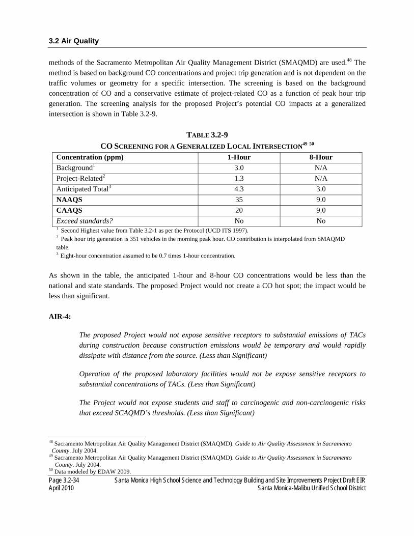
3.2 Air Quality
Page 3.2-34 Santa Monica High School Science and Technology Building and Site Improvements Project Draft EIR April 2010 Santa Monica-Malibu Unified School District
methods of the Sacramento Metropolitan Air Quality Management District (SMAQMD) are used.48 The method is based on background CO concentrations and project trip generation and is not dependent on the traffic volumes or geometry for a specific intersection. The screening is based on the background concentration of CO and a conservative estimate of project-related CO as a function of peak hour trip generation. The screening analysis for the proposed Project’s potential CO impacts at a generalized intersection is shown in Table 3.2-9.
TABLE 3.2-9 CO SCREENING FOR A GENERALIZED LOCAL INTERSECTION49 50
Concentration (ppm) 1-Hour 8-Hour Background1 3.0 N/A Project-Related2 1.3 N/A Anticipated Total3 4.3 3.0 NAAQS 35 9.0 CAAQS 20 9.0 Exceed standards? No No 1 Second Highest value from Table 3.2-1 as per the Protocol (UCD ITS 1997). 2 Peak hour trip generation is 351 vehicles in the morning peak hour. CO contribution is interpolated from SMAQMD table. 3 Eight-hour concentration assumed to be 0.7 times 1-hour concentration.
As shown in the table, the anticipated 1-hour and 8-hour CO concentrations would be less than the national and state standards. The proposed Project would not create a CO hot spot; the impact would be less than significant. AIR-4:
The proposed Project would not expose sensitive receptors to substantial emissions of TACs during construction because construction emissions would be temporary and would rapidly dissipate with distance from the source. (Less than Significant)
Operation of the proposed laboratory facilities would not be expose sensitive receptors to substantial concentrations of TACs. (Less than Significant)
The Project would not expose students and staff to carcinogenic and non-carcinogenic risks that exceed SCAQMD’s thresholds. (Less than Significant)
48 Sacramento Metropolitan Air Quality Management District (SMAQMD). Guide to Air Quality Assessment in Sacramento County. July 2004.
49 Sacramento Metropolitan Air Quality Management District (SMAQMD). Guide to Air Quality Assessment in Sacramento County. July 2004. 50 Data modeled by EDAW 2009.

3.2 Air Quality
Santa Monica High School Science and Technology Building and Site Improvements Project Draft EIR Page 3.2-35 Santa Monica-Malibu Unified School District April 2010
The exposure of sensitive receptors to emissions of TACs from on-site Project-generated construction-related and operation-related sources is discussed separately below.
ON-SITE CONSTRUCTION-RELATED EQUIPMENT EMISSIONS Diesel PM is a TAC. Construction-related activities would result in short-term Project-generated emissions of diesel PM from the exhaust of off-road heavy-duty diesel equipment for demolition, site preparation (e.g., excavation, grading, and clearing); paving; installation of utilities, materials transport and handling, erection of structures; and other miscellaneous activities. The potential cancer risk from the inhalation of diesel PM, as discussed below, outweighs the potential non-cancer health impacts. At this time, SCAQMD has not adopted a methodology for analyzing such impacts, and does not recommend the completion of HRAs for construction-related emissions of TACs.
The dose to which receptors are exposed is the primary factor used to determine health risk (i.e., potential exposure to TAC to be compared to applicable standards). Dose is a function of the concentration of a substance or substances in the environment and the duration of exposure to the substance. Dose is positively correlated with time, meaning that a longer exposure period would result in a higher exposure level for the maximally exposed individual (MEI). Thus, the risks estimated for a MEI are higher if a fixed exposure occurs over a longer period of time. According to the Office of Environmental Health Hazard Assessment (OEHHA), health risk assessments, which determine the exposure of sensitive receptors to TAC emissions, should be based on a 70-year exposure period; however, such assessments should be limited to the period/duration of activities associated with the proposed Project.51
The Project construction period of four years would be much less than the 70 years period used for risk determination, and the equipment would often be located at considerable distance from the sensitive receptors. Because the use of off-road heavy-duty diesel equipment would be temporary in combination with the highly dispersive properties of diesel PM52 and further reductions in exhaust emissions, Project-generated, construction-related emissions of TACs would not expose sensitive receptors to substantial emissions of TACs. Therefore, there would be a less than significant air impact by diesel PM.
ON-SITE AREA- AND STATIONARY-SOURCE EMISSIONS
Sources of TAC emissions include diesel-fueled engines and possible facility operations. Delivery truck travel, truck idling, and operation of emergency back-up power generators are emission sources of particulate matter from diesel-fueled engines. Trucks entering and leaving the proposed Project would include deliveries associated with the Science and Technology building. Truck idling would occur in the shipping and receiving delivery areas. Trucks will be limited to an idle time not to exceed 5 minutes for entering or exiting the truck delivery well, in accordance with California State Legislation. The loading
51 Salinas, Julio. Staff Toxicologist. Office of Health Hazard Assessment, Sacramento, California. Telephone conversation with Kurt Legleiter of EDAW regarding exposure period for determining heath risk. August 3, 2004.
52 Zhu, Yifang, W. C. Hinds, S. Kim, and S. Shen. Study of Ultrafine Particles Near a Major Highway with Heavy-duty Diesel Traffic. Atmospheric Environment 36:4323–4335. 2002.
3.2 Air Quality
Page 3.2-36 Santa Monica High School Science and Technology Building and Site Improvements Project Draft EIR April 2010 Santa Monica-Malibu Unified School District
delivery docks are the only locations where routine truck idling associated with operation of the Project would be expected. It is not anticipated that the proposed Project would experience high truck volumes (i.e., greater than 100 commercial trucks per day) delivering materials on a frequent basis. Thus, on- or off-site sensitive receptors would not be exposed to substantial TAC concentrations from these sources.
In addition, the proposed Project would include laboratory facilities, which would be equipped with chemical fume hoods. Title 8 of the California Code of Regulations contains California Occupational Safety and Health Administration requirements for these emission sources such as a minimum flow speed, face velocity, and certain design features to protect laboratory personnel in their work. In addition, the code establishes specific requirements for the use and storage of carcinogens, including a requirement to scrub or filter air emissions from areas where carcinogens are used. These emissions capture and control devices, assuming that they would be properly installed and operable, would ensure that TAC emissions from the proposed facility are within acceptable limits. Further, the fume hood exhausts would be located higher (one story more) than the existing Science Building allowing rapid dispersion of emissions away from sensitive receptors. Thus, the operation of the proposed laboratory facilities would not be expected to expose sensitive receptors to substantial concentrations of TACs. Moreover, the proposed Project would not introduce new laboratory operations but would rather replace the existing operations with laboratory operations in the new building.
OFF-SITE STATIONARY, AREA, AND MOBILE SOURCES
Although SMMUSD is neither purchasing new land nor moving locations as a result of the proposed Project and such is not required under CEQA, an HRA was performed to evaluate potential carcinogenic and non-carcinogenic risks to students and staff resulting from the change in exposure to localized sources of TACs. The HRA was performed based on the methodology described above.
The HRA evaluated increased cancer risk and chronic non-cancer health hazards to both students and staff. The incremental change in estimated risk was evaluated for the new classroom location and baseball diamond for both student and staff receptors as compared to their existing locations. Students were evaluated with accelerated breathing rates to account for exercise on the baseball diamond. A worst-case staff receptor or physical education (PE) teacher was also evaluated for the entire nine-hour day teaching outside at the baseball field. To represent the unique characteristics of the school-based population, the HRA employed EPA’s guidance to develop viable dose estimates based on reasonable maximum exposures (RME). RMEs are defined as the “highest exposure that is reasonably expected to occur” for a given receptor population. Lifetime risk values for the student population were adjusted to account for an exposure duration of 180 days per year for 13 years since the school includes grades K through eight. To assess staff exposure related risk, school-based exposures were adjusted to account for an employment-duration of 240 days per year for 40 years. This timeline is considered appropriate for potential long term exposures for both certificated and classified personnel and consistent with workplace exposures established under California Proposition 65.

3.2 Air Quality
Santa Monica High School Science and Technology Building and Site Improvements Project Draft EIR Page 3.2-37 Santa Monica-Malibu Unified School District April 2010
The Unit Risk Factors (URFs) and corresponding cancer potency factors were obtained principally from OEHHA guidance.53 The URF is a measure of the carcinogenic potential of a chemical when a dose is received through the inhalation pathway. For compounds not listed in the OEHHA database, toxicity values from EPA, Integrated Risk Information System (IRIS) were utilized.
An evaluation of the potential non-cancer effects of acute and chronic chemical exposures was also conducted. Adverse health effects were evaluated by comparing the annual ground level concentration of each chemical compound with the appropriate Reference Exposure Level (REL). Available RELs promulgated by OEHHA were used in the assessment. For compounds not listed in the OEHHA database, RELs from the Consolidated Table of OEHHA/ARB Approved Risk Assessment Health Values or EPA IRIS database were utilized. To quantify non-carcinogenic impacts, the hazard index approach was used. Detailed information on the calculation methodology is included in Appendix B.
The incremental carcinogenic risks resulting from TAC emissions attributable to the adjacent freeway and nearby stationary sources are shown in Table 3.2-10. As shown therein, the incremental risk presented below is the difference between the risks at the existing classroom locations and baseball diamond location and the proposed development. A maximum cancer risk increase of 5.23 in one million was predicted for the staff member who could spend nine continuous hours in and around the proposed new Science and Technology building. Student cancer risk was estimated to increase 2.13 in one million. Although the carcinogenic risk would increase slightly due to the Science and Technology building being located closer to the primary source of TAC emissions, the incremental increases are within the acceptable thresholds under CEQA and impacts would be less than significant. Staff exposure at the sports facility is expected to decrease.
TABLE 3.2-10 RISK CALCULATIONS 54
Cancer Risk (# in one million)
Configuration
Typical Classroom
Setting Adult Risk
Typical Classroom
Setting Student Risk
PE Teacher
Significance Threshold
10E-06 10E-06 10E-06
Existing Development 4.24E-06 1.71E-06 5.44E-06
Proposed Development 9.47E-06 3.84E-06 5.33E-06
Incremental Change 5.23E-06 2.13E-06 -1.10E-07
53 Office of Environmental Health Hazard Assessment (OEHHA). Air Toxic hot Spots Program Risk Assessment Guidelines. Part IV: Technical Support Document for Exposure Assessment and Stochastic Analysis. 2000.
54 PCR Services Corporation. Health Risk Assessment Santa Monica-Malibu Unified School District (SMMUSD) Santa Monica High School Science/Technology Building. September 2009.
3.2 Air Quality
Page 3.2-38 Santa Monica High School Science and Technology Building and Site Improvements Project Draft EIR April 2010 Santa Monica-Malibu Unified School District
For chronic, non-carcinogenic effects, the incremental increase in hazard index identified for each toxicological endpoint totaled less than one for both students and staff (Appendix B). Therefore, chronic non-carcinogenic hazards were predicted to be within acceptable limits. Additionally, for acute, non-carcinogenic effects, incremental increase in the hazard index identified for each toxicological endpoint totaled less than one for both students and staff (Appendix B). Therefore, acute non-carcinogenic hazards were predicted to be within acceptable limits. The impact is less than significant.
AIR-5:
The proposed Project would not introduce new, permanent sources of substantial objectionable odors nor locate sensitive receptors significantly closer to existing permanent sources of odors. Odors generated during Project construction would be intermittent and would dissipate quickly. Thus, the Project would not result in short-term construction or long-term operations that create objectionable odors affecting a substantial number or people. (Less than Significant).
The occurrence and severity of odor impacts depend on numerous factors, including the nature, frequency, and intensity of the source; wind speed and direction; and the presence of sensitive receptors. While offensive odors rarely cause any physical harm, they still can be very unpleasant, leading to considerable distress and often generating citizen complaints to local governments and regulatory agencies.
SHORT-TERM USE OF CONSTRUCTION EQUIPMENT
Project construction activities could result in odorous emissions from diesel exhaust associated with construction equipment. However, because of the temporary nature of these emissions and the highly diffusive properties of diesel exhaust (as discussed under Impact AIR-4), nearby receptors would not likely be affected by diesel exhaust odors associated with Project construction. As a result, this impact would be considered less than significant.
LONG-TERM OPERATION
There are no existing concentrated sources of objectionable odors within one mile of the Project site. Minor sources of odor include gas stations, restaurant char-broilers, auto body shops, and dry cleaners. These sources do not represent major concentrated sources of odors and any noticeable odors would likely disperse and dilute before reaching the site boundary. No major agriculture-related odor sources (e.g, livestock or dairy operations) are located within two miles. The proposed Project involves the replacement of the existing Science and Technology buildings. The proposed Project would include laboratory facilities that would be equipped with chemical fume hoods. However, the proposed Project would not introduce new laboratory operations but would replace existing operations with laboratory operations in the new building. Since buildings operations would be identical before and after the
3.2 Air Quality
Santa Monica High School Science and Technology Building and Site Improvements Project Draft EIR Page 3.2-39 Santa Monica-Malibu Unified School District April 2010
redevelopment there would be no net increase in odors from building vents. The proposed Project would place the new buildings slightly closer to adjacent sensitive receptors, but would not expose them to new or intensified odor emissions. The chemical fume hoods in the laboratories would comply with the California Occupational Safety and Health Administration requirements contained in Title 8 of the California Code of Regulations, as explained earlier. The requirement to scrub or filter air emissions in the hoods would also serve to dilute odorous emissions. As discussed above, the fume hood exhausts would be three stories high as opposed to the current two stories. Thus, the proposed Project would not introduce new, permanent odor-generating facilities, nor would it expose receptors to odors in excess of existing conditions. Long-term odor impacts would be less than significant.
The construction of the proposed Project would not result in the frequent exposure of on- or off-site receptors to substantial objectionable odor emissions. Operation of the proposed Project would not result in the exposure of on- or off-site receptors to frequent exposure to excessive odors. Additionally, proposed on-site receptors would not be exposed to excessive odors from surrounding existing land uses on a recurring basis. As a result, this impact would be considered less than significant.
3.2.4 MITIGATION MEASURES
No mitigation measures are required beyond the proposed Project’s compliance with SCAQMD Rule 403 for Best Available Control Measures and SCAQMD Rule 1113, as described in Section 2.0 Project Description. Compliance with these regulations would reduce impacts related to emissions of fugitive dust, including PM10, PM2.5, and VOC.
3.2.5 SIGNIFICANCE AFTER MITIGATION
Localized construction emissions of PM10 and PM2.5 would remain above the applicable significance thresholds even with incorporation of SCAQMD-recommended dust control measures. The impact is significant and unavoidable.

3.2 Air Quality
Page 3.2-40 Santa Monica High School Science and Technology Building and Site Improvements Project Draft EIR April 2010 Santa Monica-Malibu Unified School District
This page is intentionally left blank.
Santa Monica High School Science and Technology Building and Site Improvements Project Draft EIR Page 3.3-1 Santa Monica-Malibu Unified School District April 2010
3.3 CULTURAL RESOURCES
An Archaeological Resources Assessment was prepared for the proposed Project in September 2009. A complete copy of this report is included in Appendix C of this EIR. In addition, this section was prepared in consultation with City of Santa Monica historic resources staff.
3.3.1 ENVIRONMENTAL SETTING
HISTORY OF THE PROJECT AREA
Human occupation of the Santa Monica and Malibu region may date back to at least 10,000 years ago, possibly earlier. Ethnographically recorded Native American groups include the Gabrielino and Chumash. In 1769 following the discovery of the California coast by Spanish explorers, a party of missionaries began to colonize California, creating missions one day’s journey apart throughout the state. Some soldiers of these early exploration parties were the recipients of large land grants which they received in payment from the Spanish crown for their services. These land grants were the beginning of the rancho system in California. In 1822, when California became Mexican territory, the area around Santa Monica was still unclaimed. The nearest rancho was at Malibu, a piece of which had been granted to Jose Tapia in 1804. In 1828, a place called “Santa Monica” in the area now known as Santa Monica Canyon, was granted to Xavier Alvarado and Antonio Machado. The land later passed into the hands of Ysidro Reyes and Franciso Marquez. In 1828, Don Francisco Sepulveda took possession of a place called “San Vicente,” which included the area of the future town site of Santa Monica and stretched from Santa Monica Canyon on the north to Pico Boulevard on the south, extending east to present-day Westwood.1
The first building in what is now Santa Monica was an adobe built by Ysidro Reyes in 1839, located near Seventh Street and Adelaide Drive (demolished in 1906). Throughout the 1840s, the Reyez and Marquez families disputed the Sepulveda claim. The dispute was settled in 1851, a year after California became part of the United States, with Sepulveda receiving deed to 30,000 acres known as “Rancho San Vicente y Santa Monica.” The Reyez-Marquez families were deeded the 6,000 acres known as “Boca de Santa Monica.” By the 1860s, parts of Boca de Santa Monica, particularly Santa Monica Canyon, had become a popular summer campground. The flat expanse on the mesa, however, received little attention until Colonel R. S. Baker purchased the Sepulveda Ranch in 1872 for a sheep ranch, later also acquiring some of the Reyes-Marquez property to the northwest. In 1874, Colonel Baker acquired a partner, Senator John Percival Jones, who came to be known as the founder of Santa Monica. Jones and Baker organized the Los Angeles and Independence Railroad to link the mines of Colorado and Nevada to the ocean, and secured the right-of-way and began construction of a wharf.2
SANTA MONICA-MALIBU UNIFIED SCHOOL DISTRICT
The SMMUSD, which was established in 1875, currently includes 17 school sites that serve the two distinct non-contiguous cities of Santa Monica and Malibu. The SMMUSD encompasses approximately
1 Johnson Heumann Research Associates. “Santa Monica Historical Resources Inventory, 1985-1986.”
3.3 Cultural Resources
Page 3.3-2 Santa Monica High School Science and Technology Building and Site Improvements Project Draft EIR April 2010 Santa Monica-Malibu Unified School District
25 square miles extending from the northern city limits of Malibu at the Ventura County line to the southern city limits of Santa Monica. The cities of Santa Monica and Malibu are separated by the City of Los Angeles community of Pacific Palisades, which is served by the Los Angeles Unified School District. The City of Santa Monica is a dense, compact urban community of over 10,000 people per square mile, while the City of Malibu is more rural and has a density of just 632 people per square mile. Today, the SMMUSD serves approximately 12,200 students on sixteen sites ranging from large campuses like Santa Monica High School, with over 3,200 students, to compact elementary school sites like Point Dume Marine Science School, with a current enrollment of approximately 290 students.
Santa Monica High School has been located on its present Project area since 1912. The cornerstone of Santa Monica’s first high school, located on scenic Prospect Hill between Fourth and Sixth Streets and between Michigan and Fremont avenues, was laid in a public ceremony on April 11, 1912. The three buildings comprising the main section of the high school were constructed of tapestry brick with red tile roofs. These buildings housed the academic and administrative departments, manual arts and commerce, and the science, household, and fine arts departments. Two memorial gateways adorned the high school grounds. Dedication ceremonies for the new high school were held on February 23, 1913.
Subsequent additions included a gymnasium and a health unit (soon after the dedication), a printing plant (1918), a large outdoor theater (1921), and a fourteen-room addition (1924). Following the earthquake of 1933 there was a reconstruction period where five main buildings were reconstructed to meet earthquake standards for school buildings at the time. Also during this period three new buildings were added including an auditorium, a gymnasium, and a wing for the art department. This period of reconstruction and addition was truly the completion of the high school campus.
The auditorium which was opened in 1938 was used for high school functions as well as all large civic events until the construction of the Santa Monica Civic Auditorium. The auditorium, named Barnum Hall, contains a mosaic and a mural which were part of a Federal Art Project under the Works Progress Administration.
Between 1951 and 1960, new International-style Modern buildings were added to the campus as well as modernized landscape design and the enlargement of existing facilities.
EXISTING CONDITIONS
Archival records research for the Project Site was conducted on March 10, 2009 at the South Central Coastal Information Center housed at California State University, Fullerton. The archival research focused on the identification of previously recorded cultural resources within the Project area, as well as within a 0.5-mile radius of the Project Site. The archival research involved a review of historic maps, previously recorded archaeological site records and reports, and historic site and building inventories.
2 Ibid.
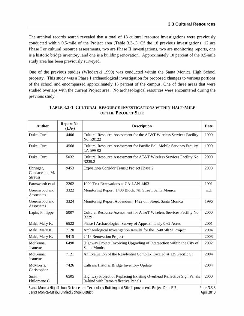
3.3 Cultural Resources
Santa Monica High School Science and Technology Building and Site Improvements Project Draft EIR Page 3.3-3 Santa Monica-Malibu Unified School District April 2010
The archival records search revealed that a total of 18 cultural resource investigations were previously conducted within 0.5-mile of the Project area (Table 3.3-1). Of the 18 previous investigations, 12 are Phase I or cultural resource assessments, two are Phase II investigations, two are monitoring reports, one is a historic bridge inventory, and one is a building renovation. Approximately 10 percent of the 0.5-mile study area has been previously surveyed.
One of the previous studies (Wlodarski 1999) was conducted within the Santa Monica High School property. This study was a Phase I archaeological investigation for proposed changes to various portions of the school and encompassed approximately 15 percent of the campus. One of three areas that were studied overlaps with the current Project area. No archaeological resources were encountered during the previous study.
TABLE 3.3-1 CULTURAL RESOURCE INVESTIGATIONS WITHIN HALF-MILE OF THE PROJECT SITE
Author Report No. (LA-) Description Date
Duke, Curt 4406 Cultural Resource Assessment for the AT&T Wireless Services Facility No. R0122
1999
Duke, Curt 4568 Cultural Resource Assessment for Pacific Bell Mobile Services Facility LA 599-02
1999
Duke, Curt 5032 Cultural Resource Assessment for AT&T Wireless Services Facility No. R239.2
2000
Ehringer, Candace and M. Strauss
9453 Exposition Corridor Transit Project Phase 2 2008
Farnsworth et al 2262 1990 Test Excavations at CA-LAN-1403 1991 Greenwood and Associates
3322 Monitoring Report: 1400 Block, 7th Street, Santa Monica n.d.
Greenwood and Associates
3324 Monitoring Report Addendum: 1422 6th Street, Santa Monica 1996
Lapin, Philippe 5007 Cultural Resource Assessment for AT&T Wireless Services Facility No. R329
2000
Maki, Mary K. 6522 Phase I Archaeological Survey of Approximately 0.62 Acres 2001 Maki, Mary K. 7120 Archaeological Investigation Results for the 1548 5th St Project 2004 Maki, Mary K. 9415 2418 Renovation Project 2008 McKenna, Jeanette
6498 Highway Project Involving Upgrading of Intersection within the City of Santa Monica
2002
McKenna, Jeanette
7121 An Evaluation of the Residential Complex Located at 125 Pacific St 2004
McMorris, Christopher
7426 Caltrans Historic Bridge Inventory Update 2004
Smith, Philomene C.
6505 Highway Project of Replacing Existing Overhead Reflective Sign Panels In-kind with Retro-reflective Panels
2000

3.3 Cultural Resources
Page 3.3-4 Santa Monica High School Science and Technology Building and Site Improvements Project Draft EIR April 2010 Santa Monica-Malibu Unified School District
Author Report No. (LA-) Description Date
Sylvia, Barbara 7841 Project Proposes to Construct Curb Ramps at Various Locations on PCH 2001 Wlodarski, Robert J.
4665 A Phase I Archaeological Study for Proposed Improvements to Santa Monica High School
1999
Wlodarski, Robert J.
8257 A Phase I Archaeological Study for the 1427 4th St EIR 2007
Source: EDAW September 2009.
According to the California Historic Resources Inventory System (CHRIS) there are six previously recorded cultural resources within 0.5-mile of the Project area (Table 3.3-2). None of these occur within the Project area itself.
TABLE 3.3-2 CULTURAL RESOURCES RECORDED WITHIN HALF-MILE OF THE PROJECT SITE
Permanent Trinomial (CA-
LAN-)
P-Number (P-19-) Description Date
Recorded
1403H - Spencer House Site 4/9/88
2392 002392 Historic trash/debris 3/29/96
- 003803 Santa Monica Air Line Segment 1/2008
- 177904 Palisades Park (Linda Vista Park) 1986 & 5/1998
- 187744 Robert E. McClure Tunnel 1/21/96
- 188014 Santa Monica Pier Bridge 1/14/96 Source: EDAW September 2009.
The Native American Heritage Commission (NAHC) conducted a check of its Sacred Lands File for the affected Project area on March 27, 2009. The search did not identify any Native American cultural resources in the Project area. However, the absence of specific site information in the Sacred Lands File does not preclude the possibility of cultural resources within the Project area.
3.3.2 REGULATORY SETTING
NATIONAL REGISTER OF HISTORIC PLACES
The National Register of Historic Places (National Register) is the nation’s official list of cultural resources worthy of preservation. Authorized under the National Historic Preservation Act of 1966, as amended, the National Register is part of a national program to coordinate and support public and private efforts to identify, evaluate, and protect the country’s historic and archaeological resources. Properties listed in the National Register include districts, sites, buildings, structures, and objects that are significant in American history, architecture, archaeology, engineering, and culture. The National Register is administered by the National Park Service (NPS), which is part of the Department of Interior (DOI).

3.3 Cultural Resources
Santa Monica High School Science and Technology Building and Site Improvements Project Draft EIR Page 3.3-5 Santa Monica-Malibu Unified School District April 2010
Currently there are more than 76,000 listings that make up the National Register, including all historic areas in the National Park System, over 2,300 National Historic Landmarks, and properties that have been listed because they are significant to the nation, a state, or a community.3
Properties are nominated to the National Register by the State Historic Preservation Officer (SHPO) of the state in which the property is located, by the Federal Preservation Officer (FPO) for properties under federal ownership or control, or by the Tribal Historic Preservation Officer (THPO) if a property is on tribal lands.
Any individual or group may prepare a National Register nomination. Thorough documentation of physical appearance and historic significance of the property is required. In California, completed nominations are submitted to Office of Historic Preservation. After an application has been reviewed by Office of Historic Preservation staff, it is submitted to the State Historical Resources Commission (SHRC) to determine whether or not the property meets criteria for evaluation and the SHRC then makes a recommendation to the SHPO to approve or disapprove the designation. Nominations recommended by the SHRC and approved by the SHPO are forwarded for consideration to the Keeper of the National Register at the NPS in Washington, D.C.4
During the time the proposed nomination is reviewed by the SHPO, property owners and local officials are notified of the intent to nominate. Local officials and property owners are given the opportunity to comment on the nomination and owners of private property are given an opportunity to object to or concur with the nomination. If the owner of a private property, or the majority of owners for a property or district with multiple owners, objects to the nomination, the SHPO may forward the nomination to NPS only for a determination of eligibility. Without formally listing the property in the National Register, the NPS then determines whether the property is eligible for listing.5
Properties may qualify for the National Register when they meet any of four basic criteria:
A. Are associated with events that have made a significant contribution to the broad patterns of history;
B. Are associated with the lives of persons significant in our past;
C. Embody the distinctive characteristics of a type, period, or method of construction; represent the work of a master; possess high artistic values; or represent a significant and distinguishable entity whose components may lack individual distinction; or
D. Have yielded, or may be likely to yield, information important in prehistory or history.
3 National Park Service. National Register of Historic Places. Listing a Property. Website http://www.cr.nps.gov/nr/listing.htm., Accessed December 3, 2009. 4 California Office of Historic Preservation. California Environmental Quality Act. website http://ohp.parks.ca.gov/., accessed December 3, 2009.

3.3 Cultural Resources
Page 3.3-6 Santa Monica High School Science and Technology Building and Site Improvements Project Draft EIR April 2010 Santa Monica-Malibu Unified School District
A final critical component of eligibility is integrity. “Integrity” refers to the ability of a property to convey its significance, and the degree to which the property retains the identity, including physical and visual attributes, for which it is significant under the four basic criteria. The National Register criteria recognize seven aspects or qualities of integrity: location, design, setting, materials, workmanship, feeling, and association.
CALIFORNIA REGISTER OF HISTORIC RESOURCES
A cultural resource is considered “historically significant” under CEQA if the resource meets one or more of the criteria for listing on the California Register of Historic Resources (California Register). The California Register was designed to be used by state and local agencies, private groups, and citizens to identify existing cultural resources within the state and to indicate which of those resources should be protected, to the extent prudent and feasible, from substantial adverse change. The following criteria have been established for the California Register.6 A resource is considered significant if it:
1. is associated with events that have made a significant contribution to the broad patterns of California’s history and cultural heritage;
2. is associated with the lives of persons important in our past;
3. embodies the distinctive characteristics of a type, period, region, or method of construction, or represents the work of an important creative individual, or possesses high artistic values; or
4. has yielded, or may be likely to yield, information important in prehistory or history.
In addition to meeting one or more of the above criteria, historical resources eligible for listing in the California Register must retain enough of their historic character or appearance to be able to convey the reasons for their significance. Such integrity is evaluated with regard to the retention of location, design, setting, materials, workmanship, feeling, and association.
CITY OF SANTA MONICA
The City of Santa Monica formally initiated a historic preservation program with its 1976 adoption of the Landmark and Historic Preservation Ordinance. This ordinance established the Landmarks Commission whose powers include designation of Structures of Merit and Landmarks, and recommendation to the City Council for the designation of historic districts. Furthermore, it identified both obligations required of historic property ownership and a broad range of incentives available to owners of historic properties.
5 National Park Service. National Register of Historic Places. Listing a Property. Website http://www.cr.nps.gov/nr/listing.htm., accessed December 3, 2009. 6 Pub. Res. Code Section 5024.1, Title 14 CCR Section 4852.
3.3 Cultural Resources
Santa Monica High School Science and Technology Building and Site Improvements Project Draft EIR Page 3.3-7 Santa Monica-Malibu Unified School District April 2010
Section 9.36.100 of the City of Santa Monica Landmark and Historic Preservation Ordinance authorizes the Landmarks Commission to designate Landmarks or Historic Districts. A geographic area or a noncontiguous grouping of thematically related properties may be designated a Historic District by the City Council. An individually significant property may be designated a Landmark. Such designations may be made provided that the subject property (or properties) meet one or more of the following criteria:
• 9.36.100(a)(1) It exemplifies, symbolizes, or manifests elements of the cultural, social, economic, political or architectural history of the City.
• 9.36.100(a)(2) It has aesthetic or artistic interest or value, or other noteworthy interest or value. • 9.36.100(a)(3) It is identified with historic personages or with important events in local, state or
national history. • 9.36.100(a)(4) It embodies distinguishing architectural characteristics valuable to a study of a
period, style, method of construction, or the use of indigenous materials or craftsmanship, or is a unique or rare example of an architectural design, detail or historical type valuable to such a study.
• 9.36.100(a)(5) It is a significant or a representative example of the work or product of a notable builder, designer or architect.
• 9.36.100(a)(6) It has a unique location, a singular physical characteristic, or is an established and familiar visual feature of a neighborhood, community or the City.
SANTA MONICA-MALIBU UNIFIED SCHOOL DISTRICT
The SMMUSD defines a historical resource as: (1) a resource listed in the California Register of Historical Resources; (2) a resource determined by the State Historical Resources Commission to be eligible for listing in the California Register of Historical Resources; (3) a resource designated in a local register of historical resources pursuant to a local government ordinance or resolution; (4) a resource recognized as historically significant by local government ordinance or resolution; or (5) a resource identified as significant in a local government historical resource survey that meets the requirements of Public Resources Code section 5024.1(g). [STAN-PLEASE PROVIDE THE REFERENCE FOR THIS LANGUAGE, WHICH WAS ALSO USED IN INITIAL STUDY]
3.3.3 ENVIRONMENTAL IMPACTS
THRESHOLDS OF SIGNIFICANCE
As part of the Initial Study (see Appendix A), it was determined that the proposed Project would not cause a substantial adverse change in the significance of an archaeological resource (Cal. Code Regs., Title 14, Section 15064.5), directly or indirectly destroy a unique paleontological resource or site or
3.3 Cultural Resources
Page 3.3-8 Santa Monica High School Science and Technology Building and Site Improvements Project Draft EIR April 2010 Santa Monica-Malibu Unified School District
unique geologic feature, or directly or indirectly disturb human remains, including those interred outside of a formal cemetery.7
Pursuant to the CEQA Guidelines, the proposed Project would have a significant effect on cultural resources if it would cause a substantial adverse change in the significance of a historical resource (Cal. Code Regs., Title 14, Section 15064.5).
IMPACT ANALYSIS
CR-1: The proposed Project would not cause a substantial adverse change in the significance of a historical resource.
The proposed Project site is within the existing Santa Monica High School campus, which was constructed in 1912 with additions completed in 1960. Currently, no buildings or structures on the Santa Monica High School campus are listed or have been determined to be eligible for listing in the California Register of Historical Resources. Barnum Hall, constructed in 1938 and located in the central portion of the campus, was designated as City Landmark No. 47 in 2002.8 In 1993, the City of Santa Monica identified the amphitheater on the southern portion of the campus, which was constructed in 1921, as potentially contributing to the potential Santa Monica Public Schools Thematic District in the City’s Historic Resources Inventory.9 Further, the potential Santa Monica Public Schools Thematic District does not appear on the City’s list of Designated Historic Districts.10 In addition, no City Structures of Merit are located on the campus.11 The City is currently in the process of updating its Historic Resources Inventory.12 The proposed Project would consist of the demolition of the existing Science and Technology Buildings, parking lot, and softball field and construction of a new three-story 84,000-square-foot Science and Technology Building, and softball field in a reconfigured site layout and a reconfigured parking lot. The proposed Project would not directly impact or alter Barnum Hall or the amphitheater. While the current Science and Technology Buildings are of historic age, the Science and Homemaking Building (present Science Building) was built in 1954 and underwent some alterations in 1958, the SMMUSD has determined that the buildings are not historic resources, pursuant to CEQA Section 15064.5. [STAN—PLEASE ADVISE THE CITY HAS NOT FINISHED UPDATING THEIR HISTORIC SURVEY]
7 A paleontological resources assessment was conducted by Dr. Samuel McLeod, Vertebrate Paleontology Division of the Natural History Museum of Los Angeles County on May 27, 2009. While no fossil vertebrate localities have been recorded within the boundaries of the Project area, there are known fossil resources nearby from the same sedimentary deposits that occur in the Project area. In the event any paleontological resources are encountered during earthmoving activities, the construction contractor would be required to cease activity in the affected area until the discovery can be evaluated by a qualified paleontological resource specialist in accordance with the provisions of CEQA Guidelines Section 15064.5. 8 City of Santa Monica. Designated City Landmarks. June 2008. Website http://www01.smgov.net/planning/ planningcomm/designatedlandmarks.html. Accessed May 27, 2009. 9 City of Santa Monica. Historic Resources Inventory, California Department of Parks and Recreation (DPR) 523 Form for Potential Thematic District (Santa Monica Public Schools).1993. 10 City of Santa Monica. Designated Historic Districts. December 2006. Website http://www01.smgov.net/planning/ planningcomm/designatedlandmarks.html. Accessed May 27, 2009. 11 City of Santa Monica. Designated Landmarks, Historic Districts, and Structures of Merit Map. October 2006. Website http://www01.smgov.net/planning/planningcomm/designatedlandmarks.html. Accessed May 27, 2009. 12 City of Santa Monica. Roxanne Tanemori, Senior Planner. Email correspondence May 2009.
3.3 Cultural Resources
Santa Monica High School Science and Technology Building and Site Improvements Project Draft EIR Page 3.3-9 Santa Monica-Malibu Unified School District April 2010
Based on the results of the archival research and the Sacred Lands File search, it is possible that prehistoric and/or historic archaeological resources may be present within the Project area. Such resources may lie beneath the surface obscured by pavement, vegetation, buildings, or other school features. The proposed Project involves building construction, including grading, trenching, or other ground disturbing activities that could expose potentially historic archaeological resources. Destruction or damage to these resources during construction would constitute a significant impact. Mitigation measure CUL-A is required to reduce the level of impact to less than significant by recovering significant historic archaeological resources from the Project site prior to the start of construction activities.
3.3.4 MITIGATION MEASURES
CUL-A All ground-disturbing activities associated with the proposed Project shall be monitored by a qualified archaeological monitor. Prior to the issuance of a demolition permit, an Archaeological Monitoring and Discovery Plan shall be prepared outlining archaeological monitoring procedures and appropriate treatment of discoveries, should any be made. Archaeological monitors shall be under the direct supervision of a Principal Investigator or Project Manager certified by the Register of Professional Archaeologists (qualifications derived from 36 CFR Part 61). Ground-disturbing activities to be monitored include, but are not limited to, the demolition of buildings and structures, grading, trenching, utilities relocations and installations, and landscaping removal. The archaeological monitor shall have the authority to redirect construction equipment in the event potential archaeological resources are encountered. In the event archaeological resources are encountered, work in the vicinity of the discovery shall halt until appropriate treatment of the resource is determined by a qualified archaeologist in accordance with the provisions of CEQA Section 15064.5.
3.3.5 SIGNIFICANCE AFTER MITIGATION
Implementation of CUL-A would reduce potential historic archaeological resources impacts from the project’s construction to less than significant.

3.3 Cultural Resources
Page 3.3-10 Santa Monica High School Science and Technology Building and Site Improvements Project Draft EIR April 2010 Santa Monica-Malibu Unified School District
This page is intentionally left blank.
Santa Monica High School Science and Technology Building and Site Improvements Project Draft EIR Page 3.4-1 Santa Monica-Malibu Unified School District April 2010
3.4 HAZARDS AND HAZARDOUS MATERIALS
Hazardous substances are defined by state and federal regulations as substances that must be regulated in order to protect the public health and the environment. Hazardous materials have certain chemical, physical, or infectious properties that cause them to be hazardous. The California Code of Regulations Title 22, Chapter 11, Article 2, Section 66261 provides the following definition:
A hazardous material is a substance or combination of substances which, because of its quantity, concentration, or physical, chemical, or infectious characteristics, may either (1) cause, or significantly contribute to, an increase in mortality or an increase in serious irreversible, or incapacitating reversible illness; or (2) pose a substantial present or potential hazard to human health or environment when improperly treated, stored, transported, or disposed of or otherwise managed.
According to Title 22 (California Code of Regulations Chapter 11, Article 3), substances having a characteristic of toxicity, ignitability, corrosively, or reactivity are considered hazardous. Hazardous wastes are hazardous substances that no longer have a practical use, such as material that has been abandoned, discarded, spilled, contaminated, or which is being stored prior to disposal. Toxic substances may cause short-term or long-term health effects, ranging from temporary effects to permanent disability or death. Examples of toxic substances include most heavy metals, pesticides, benzene, gasoline, hexane, natural gas, sulfuric acid, lye, explosives, pressurized canisters, and radioactive and biohazardous materials. Soils may also be toxic due to accidental spilling of toxic substances.
This section discusses the potential for the proposed Project to expose people to hazards and hazardous materials. The past, present, and future uses of the Project site and the surrounding area are discussed. For the purposes of this analysis, the following reports prepared and incorporated by reference for the Project site were reviewed (also see Appendix D):
• California Environmental Geologists & Engineers, Inc. Report • Phase I Preliminary Environmental Site Assessment (January 2009)1 • Limited Phase I Addendum (April 2009)2 • Limited Soil Gas Survey Report (April 2009)3 • Pipelines, Water Tanks, and Aboveground Fuel Storage Tanks California Department of
Education Checklist Item (January 2009)4 • Stage 2 Pipeline Risk Analysis of a High-Volume Water Pipeline (March 2009)5
1 LFR, Inc. Phase I Environmental Site Assessment: Santa Monica Science and Technology Building and Site Improvements Project. January 20, 2009.
2 Kroner Environmental Services, Inc. Limited Phase I Addendum Environmental Site Assessment – Onsite Sources. April 2009. 3 Kroner Environmental Services, Inc. Limited Soil Gas Survey Report for the Proposed New Science and Technology Building.
April 2009. 4 LFR, Inc. Pipelines, Water Tanks, and Aboveground Fuel Storage Tanks California Department of Education Checklist Item.
January 29, 2009 5 LFR, Inc. Stage 2 Pipeline Risk Analysis of a High-Volume Water Pipeline Located within 1,500 Feet of the Santa Monica High
School. March 25, 2009.
3.4 Hazards and Hazardous Materials
Page 3.4-2 Santa Monica High School Science and Technology Building and Site Improvements Project Draft EIR April 2010 Santa Monica-Malibu Unified School District
3.4.1 ENVIRONMENTAL SETTING
PROJECT SITE CONDITIONS
The Santa Monica High School campus is located at 601 Pico Boulevard in the City of Santa Monica in the County of Los Angeles and is located generally south of the intersection of Olympic Boulevard and Lincoln Boulevard, approximately 100 feet south of Interstate 10 (I-10, Santa Monica Freeway), which becomes State Route 1 (SR-1, Pacific Coast Highway) approximately 800 feet southwest of the campus, and Interstate 405 (I-405, San Diego Freeway) approximately 3.5 miles to the northeast. The Project site encompassing the new facilities specifically occupies the northern 5.2 acres of the campus bordered by Olympic Boulevard on the northwest side, 6th Street on the southwest side, the remainder of the Santa Monica High School campus on the south side, and 7th Court Alley on the northeast side. The proposed building reconfiguration would occur on this northeastern portion of the campus with additional infrastructure improvements occurring throughout the entire campus.
Based on a review of historical topographic maps, Sanborn Fire Insurance Maps (Sanborn maps), and aerial photographs of the site vicinity, the Project site consisted primarily of vacant lots from approximately 1900. From 1918 to the mid-1960s, a portion of the Project site was used as Garfield Public School and later as Santa Monica City College; the remainder of the Project site was improved with residences. The Project site has been used as a portion of the Santa Monica High School campus since the mid-1960s.
The Santa Monica High School campus is surrounded by commercial, multi-family residential and civic uses. Commercial and multi-family residential uses are located northeast side of the Project site, along 7th Court Alley and along the paralleling Lincoln Boulevard. The commercial uses include gas stations, other automobile-related uses, small strip malls, and small commercial/industrial establishments that front Lincoln Boulevard. Wallpaper City and Flooring is located northeast of the Project site, on 7th Court Alley (1754, 1756, and 1758 Lincoln Boulevard). This property includes two, two-story buildings with the business on the ground floor and 25 multi-family residential units above. Some of these multi-family residential units front 7th Court Alley, approximately 23 feet northeast of the Project site. One multi-family residential building, located northeast of 7th Court Alley, fronts Lincoln Boulevard. In addition, multi-family residential uses are located approximately 33 feet northwest of the campus, between 5th Street and Olympic Boulevard. Multi-family residences are also located southeast of the Project site along Michigan Avenue. The DoubleTree Guest Suites Hotel is located adjacent west of the campus, and the Sheraton Delfina Hotel to the south, on the south side of Pico Boulevard. Civic uses are located west of the campus. The City of Santa Monica City Hall and the new Civic Center Parking Structure, Santa Monica Civic Auditorium (constructed in 1958) and large Civic Lot surface parking area, and related civic facilities are located on the southwest side of 4th Street. The Viceroy Hotel and RAND building are located west of the civic land uses.
3.4 Hazards and Hazardous Materials
Santa Monica High School Science and Technology Building and Site Improvements Project Draft EIR Page 3.4-3 Santa Monica-Malibu Unified School District April 2010
PHASE I AND LIMITED PHASE I ENVIRONMENTAL SITE ASSESSMENTS
On November 14, 2007, a Phase I Environmental Site Assessment (Phase I ESA) was conducted for the Project site was by LFR Inc. The purpose was to observe general site conditions and indications of the possible uses and releases of hazardous materials and/or petroleum products. On September 15, 2008, a Phase I ESA update was conducted in order to assess changes to the location of areas proposed construction and modification at the school campus. This Phase I ESA was conducted in accordance with the current version of the American Society for Testing and Materials (ASTM) Standard Practice for Environmental Site Assessments, Phase I Environmental Site Assessment Process (E 1527-05). The objective of the Phase I ESA is to identify recognized environmental conditions in connection with the Site pursuant to the processes prescribed in the ASTM E 1527-05 guidelines and the AAI Rule.
State and federal hazardous material databases were searched to determine if the Project site is known to have had hazardous materials present currently or in the past. An environmental database records report was prepared for the proposed Project as part of the Phase I ESA update and includes a search of the following databases:
• Federal National Priorities List - “Superfund” • Federal Comprehensive Environmental Response, Compensation, and Liability Information
System and No Further Remedial Action Planned • Federal Resource Conservation and Recovery Act – Treatment, Storage, and Disposal Facilities • State lists of hazardous waste sites identified for investigation or remediation, including ASTM
Standard: Annual Work Plan and CALSITES • National Priorities List or Comprehensive Environmental Response, Compensation, and Liability
Information System equivalents: Annual Work Plan, Bond Expenditure Plan and CALSITES • State Solid Waste Facilities and/or Landfill Facilities site lists • State Leaking Underground Storage Tanks lists • Resource Conservation and Recovery Act Administrative Action Tracking System • HAZNET - Hazardous Waste Information System • United States Environmental Protection Agency Regional Offices Superfund Consent Decrees • Records of Decision • Hazardous Materials Information Reporting Systems • Material Licensing Tracking Systems • Mines Master Index Files • Polychlorinated biphenyl Activity Database System • Department of Defense Site • Toxic Chemical Release Inventory System • Toxic Substances Control Act • Section 7 Tracking Systems • Federal Insecticide, Fungicide and Rodenticide Act/ Toxic Substances Control Act Tracking
System • Aboveground Petroleum Storage Tank Facilities • California Department of Toxic Substances Control Drycleaners • Waste Discharge System • List of Deed Restrictions • School Property Evaluation Program
3.4 Hazards and Hazardous Materials
Page 3.4-4 Santa Monica High School Science and Technology Building and Site Improvements Project Draft EIR April 2010 Santa Monica-Malibu Unified School District
• Emissions Inventory Data • Spills, Leaks, Investigation & Cleanup Cost Recovery Listing • Manufactured Gas Plants • California Department of Toxic Substances Control Site Mitigation and Brownfields Reuse
Program • Los Angeles County Site Mitigation List • Voluntary Cleanup Program Properties
In addition, LFR Inc. reviewed information from the following agencies:
• Los Angeles Regional Water Quality Control Board • Department of Toxic Substance Control (DTSC) • City of Santa Monica Planning and Building Departments • California Division of Oil, Gas, and Geothermal Resources • City of Santa Monica, Environmental Programs Division • Los Angeles County Department of Environmental Health, Public Health
Investigations • Santa Monica Malibu Unified School District Files
Based on an additional Phase I ESA prepared in January 2009, Santa Monica High School is listed on the FINDS database. The FINDS database is a pointer to other databases with more complete information. SMMUSD is listed at the Project site on the Resource Conservation and Recovery Act-Small Quantity Generators (RCRA-SQG) and FINDS databases. The RCRA-SQG database indicates that a form was received on November 4, 1986 and no violations were found. Santa Monica High School is listed on the HAZNET database for disposal of unspecified hazardous substances. Santa Monica High School was not listed on any databases indicating that a release to the soil or groundwater from on-site materials had occurred.
The Phase I ESA identified eight recognized environmental conditions (RECs) or other conditions that would appear to require additional investigation prior to the Project site being approved for school use:
• REC #1: Based on a review of historical topographic maps, Sanborn maps, and aerial photographs of the vicinity, the Project site primarily consisted of vacant lots in approximately 1900. From at least 1918 until the mid-1960s, a portion of the Project site was used as Garfield Public School, then as Santa Monica City College; the remainder of the Project site was improved with residences. The Project site has been used as a portion of the Santa Monica High School campus since the mid-1960s. Based on the original date of construction for the former and current buildings, the potential exists for lead-based paint (LBP) (as they were present prior to the ban of LBP in the late 1970s) and termiticides (as they were present prior to the ban of chlorinated pesticides in the late 1980s) to be present at the Project site. Due to the presence of structures constructed prior to the ban of LBP in the late 1970s/early 1980s and structures constructed prior to the ban of organochlorine pesticides in the late 1970s/early 1980s, soil sampling for lead and termiticides (i.e., organochlorine pesticides) was recommended in the Phase I ESA.

3.4 Hazards and Hazardous Materials
Santa Monica High School Science and Technology Building and Site Improvements Project Draft EIR Page 3.4-5 Santa Monica-Malibu Unified School District April 2010
• REC #2: A pad-mounted electric transformer is located near the southwestern Project site border. No leaks or stains were observed near the transformer. Soil sampling for Polychlorinated biphenyl (PCBs) adjacent to transformer is recommended and soil sampling in the vicinity of the pad-mounted electric transformer to identify the potential for a PCB release was recommended in the Phase I ESA.
• REC #3: Since 1998, a three-stage clarifier or sump pit has been located along 6th Street, between the pad-mounted electrical transformer and the auto shop. Water from the sump pit is reportedly pumped to the street and storm drains when it reaches a certain level. Rain runoff from drains near the auto shop reportedly flows into the underground area. It is possible that chemicals or waste oils from the auto shop were washed into the sump pit and are present in soil. Soil and soil vapor sampling and analysis adjacent to three-stage clarifier (interceptor) and along drain line were recommended in the Phase I ESA. Soil sampling to evaluate the potential presence of metals, total petroleum hydrocarbons (TPH) or volatile organic compounds (VOCs) in the soil or soil vapor in the vicinity of the three-stage clarifier/sump pit located near the southwestern border of the Project site was also recommended in the Phase I ESA.
• REC #4: An auto shop is located below the courtyard and the existing Technology Building along 6th Street. The auto shop has been located along 6th Street since at least the late 1970s. The presence of several parts cleaning areas, waste oil and used oil filter storage, used batteries, and automotive fluid storage within the auto shop, in addition to documented improper disposal of automotive-related wastes down drains in the 1980s, may have allowed contaminants to impact soil in the vicinity of the auto shop if the lines had ever cracked or leaked. Based on the long-term use of the auto shop, the documented improper disposal methods observed by a regulatory agency in the 1980s, and the storage of waste oil, used oil filters, batteries, and other automotive fluids, soil and soil vapor in the vicinity of the auto shop may have been impacted. Soil and soil vapor sampling for metals, TPH, PCBs, and/or VOCs to determine if soil and soil vapor in the vicinity of the auto shop have been impacted was recommended in the Phase I ESA.
• REC #5: A former auto shop, machine shop, and foundry were historically located in the existing Business Building adjacent to the eastern extension of the Project site. Based on the presence of these land uses, soil and soil vapor along the perimeter of the property may have been impacted. Soil and/or soil vapor sampling in along the perimeter of the property in order to evaluate the potential presence of metals, cyanide, and/or VOCs was recommended in the Phase I ESA.
• REC #6: Chemistry classrooms are located on-site and laboratory-grade chemical storage areas are maintained on-site. Although no evidence of chemical releases was observed during site reconnaissance activities, sampling is required in order to address potential releases from chemistry classrooms (i.e., in the vicinity of wastewater lines) when a chemistry laboratory is located on or adjacent to a site. Sampling for metals, pH, and/or VOCs in the vicinity of the drain lines in order to address potential releases from activities related to on-site chemistry classrooms was recommended in the Phase I ESA.

3.4 Hazards and Hazardous Materials
Page 3.4-6 Santa Monica High School Science and Technology Building and Site Improvements Project Draft EIR April 2010 Santa Monica-Malibu Unified School District
• REC #7: An abandoned in-place underground storage tank (UST), which formerly contained drain oil mixed with sludge from solvents, is located near the entrance of the auto shop along 6th Street. Two soil borings were advanced near the UST and soil samples were collected. Significant release of toxics was determined to be unlikely. Soil sampling in the vicinity of the abandoned in-place UST located near the auto shop along the southwestern site boundary did not identify the presence of TPH or VOCs. The Phase I ESA recommended UST removal and closure in accordance with local agency regulations. As part of UST removal and closure activities, additional soil sampling was recommended to further confirm that soil in the vicinity of the abandoned UST was not impacted.
• REC #8: Four potential off-site sources were identified as having impacted soil and groundwater in the vicinity; however, the impact on the site, though suggested, has not been evaluated. The DTSC would typically require an evaluation of the Project site for potential impacts from these potential off-site sources. The potential off-site sources include:
REC #8a: Chevron service station (located approximately 0.01 mile east-northeast of the Project site)
REC #8b: World Oil service station (located approximately 0.05 mile northeast of the Project site)
REC #8c: Former Shell service station (currently known as Arco Realty Property located approximately 0.08 mile north-northwest of the Project site)
REC #8d: Former Mobil service station (located approximately 0.06 mile northwest of the Project site).
In addition, a Limited Phase I ESA Addendum prepared by Kroner Environmental Services, Inc. was prepared in April 2009. This additional information is intended to supplement the findings of the Phase I ESA prepared by LFR, Inc. dated September 24, 2008. The scope of the work was based on the findings of the Phase I ESA prepared by LFR, Inc. dated September 24, 2008, which identified seven on-site RECs associated with sources on the school property. The purpose of the limited sampling was to gather soil and soil vapor data from locations identified by LFR as RECs. These locations are within an area of the campus in which future construction consisting of demolition of existing classroom buildings and construction of a new Science and Technology classroom building in the present softball field and parking areas. REC #8 was not evaluated in the Limited Phase I ESA Addendum because these were off-site sources. The following summarizes the results of the sampling and analysis findings:
• REC #1: Elevated concentrations of the pesticides chlordane and dieldrinds detected in shallow planter soils adjacent to the existing Science and Technology Buildings were detected.
• REC #s 2, 3, 5, and 6: Sampling and analyses completed for the other LFR, Inc. RECs did not indicate the presence of soil contamination associated with these RECs.
• REC #4: Access for sampling was too limited due to physical constraints imposed by the current building configuration, lack of information on buried drain line locations, and use of the facility
3.4 Hazards and Hazardous Materials
Santa Monica High School Science and Technology Building and Site Improvements Project Draft EIR Page 3.4-7 Santa Monica-Malibu Unified School District April 2010
as an active classroom and shop area. Soil sampling was recommended when the building is demolished.
• REC #7: Because the abandoned UST is still present, access for sampling soils beneath the tank, access for sampling was infeasible. The Limited Phase I ESA Addendum recommended that no sampling at this time be conducted due to previous samples having non-detectable results. It was recommended that UST removal and sampling be conducted during school vacation periods.
3.4.2 REGULATORY SETTING
FEDERAL
Comprehensive Environmental Response, Compensation, and Liability Act
The Comprehensive Environmental Response, Compensation, and Liability Act, commonly known as Superfund, provides broad federal authority to respond directly to releases or threatened releases of hazardous substances that may endanger public health or the environment. The Comprehensive Environmental Response, Compensation, and Liability Act established prohibitions and requirements concerning closed and abandoned hazardous waste at these sites, provided for liability of persons responsible for releases of hazardous waste at these sites, and established a trust fund to provide for cleanup when no responsible party could be identified.
Resource Conservation and Recovery Act
The Resource Conservation and Recovery Act provide the United States Environmental Protection Agency (EPA) the authority to control hazardous waste from the “cradle-to-grave.” This includes the generation, transportation, treatment, storage, and disposal of hazardous waste. The Resource Conservation and Recovery Act also set forth a framework for the management of non-hazardous wastes.
STATE
Title 22 of the California Code of Regulations
Title 22 of the California Code of Regulations includes state hazardous waste regulations enforced by the DTSC and local Certified Unified Program Agencies. Authority from the state was delegated to local the Certified Unified Program Agencies to establish a unified hazardous waste and hazardous materials management program for hazardous waste generators, treatment of hazardous waste subject to tiered permitting, facilities with underground storage tanks and aboveground storage tanks, risk management and prevention plans, and hazardous materials management plans and inventory statements required by the Uniform Fire Code.

3.4 Hazards and Hazardous Materials
Page 3.4-8 Santa Monica High School Science and Technology Building and Site Improvements Project Draft EIR April 2010 Santa Monica-Malibu Unified School District
California Health and Safety Code
State hazardous waste control laws enforced by DTSC are included in the California Health and Safety Code. These regulations identify standards for the classification, management, and disposal of hazardous waste in California.
Occupational Safety and Health Act
Federal and state occupational safety and health regulations also contain provisions on hazardous materials management as it relates to worker safety, worker training, and worker right-to-know. The applicable federal law is the Occupational Safety and Health Act. Under the Occupational Safety and Health Act, authority to administer the Act is delegated to states that have developed a plan with provisions that are at least as stringent as those provided by the Occupational Safety and Health Act. California is a delegated state for federal Occupational Safety and Health Act purposes. The California Occupational Safety and Health Act and regulations and programs authorized are commonly referred to as Cal/OSHA.
3.4.3 ENVIRONMENTAL IMPACTS
THRESHOLDS OF SIGNIFICANCE
The Initial Study (see Appendix A) issued for the proposed Project in June 2009 determined that several potential hazards and hazardous materials impacts were less than significant and were not required to be further analyzed in the EIR. Specifically, the Initial Study determined that the proposed Project would not:
• Create a significant hazard to the public or the environment through the routine transport, use, or disposal of hazardous materials;
• Be located on a site which is included on a list of hazardous materials sites compiled pursuant to Government Code Section 65962.5 and, as a result, would not create a significant hazard to the public or the environment;
• Be located on a site within 2 nautical miles (12,152 feet) of a runway or planned runway of a public airport or private airport;
• Impair implementation of or physically interfere with an adopted emergency response plan or emergency evacuation plan;
• Expose people or structures to significant risk of loss, injury or death involving wildland fires;
• Be located on a site where the property line is less than the following distance from the edge of a respective power line easement;
• Be located on a site that is within 1,500 feet of a railroad track easement;

3.4 Hazards and Hazardous Materials
Santa Monica High School Science and Technology Building and Site Improvements Project Draft EIR Page 3.4-9 Santa Monica-Malibu Unified School District April 2010
• Be located on a site that is adjacent or near to a major arterial roadway or freeway that may pose a safety hazard;
• Be located on a site that is near a reservoir, water storage tanks or high-pressure water lines;
• Be located within 1,500 feet of a pipeline that may pose a safety hazard;
• Be located on a site that contains, or is near, propane tanks that can pose a safety hazard;
• Be located on a site that does not have a proportionate length to width ratio to accommodate the building layout, parking and play fields that can be safely supervised; or
• Be located on a site that is within 2,000 feet of a significant disposal of hazardous waste.
The CEQA Guidelines establish that a proposed Project would have a significant effect on hazards and hazardous materials if it would:
• Create a significant hazard to the public or the environment through reasonably foreseeable upset and accident conditions involving the release of hazardous materials into the environment;
• Emit hazardous emissions or handle hazardous or acutely hazardous materials, substances, or waste within one-quarter mile of an existing or proposed school;
• Be located on a site that is, (a) a current or former hazardous waste disposal site or solid waste disposal site and, if so, has the waste been removed; (b) a hazardous substance release site identified by the State Department of Health Services in a current list adopted pursuant to Section 25356 of Division 20 of the Health and Safety Code; or (c) a site that contains one or more pipelines, situated underground or above ground, which carries materials or hazardous wastes, unless the pipeline is a natural gas line which is used only to supply natural gas to that school or neighborhood; or
• Be located within one-fourth mile of any facilities, which might be reasonably anticipated to emit hazardous or acutely hazardous materials, substances, or waste.
3.4 Hazards and Hazardous Materials
Page 3.4-10 Santa Monica High School Science and Technology Building and Site Improvements Project Draft EIR April 2010 Santa Monica-Malibu Unified School District
IMPACT ANALYSIS
HAZ-1: The proposed Project would not create a significant hazard to the public or the environment through reasonably foreseeable upset and accident conditions involving the release of hazardous materials into the environment. The impact would be less than significant.
Construction
The proposed Project would consist of the removal of the existing Science and Technology Buildings, parking lot, and softball field and construction of a new three-story 84,000-square-foot Science and Technology Building, 253-space parking lot, and softball field in a reconfigured site layout. The existing 88,000-square-foot Science and Technology Buildings currently occupy the southern corner of the Project site. The 5.2-acre Project site was vacant land in 1900. By 1918, portions of the Project site appear to have been occupied by a school and residences, according to a Sanborn fire insurance map dating from that time. An aerial photograph shows that the school had been expanded by 1928, and a small area was still occupied by residences. By 1938, another aerial photograph shows the entire Project site was a school. The Project site has been used as a portion of the Santa Monica High School campus since the mid-1960s. The school facilities have been renovated and expanded over the years, resulting in the current facility configuration.
Construction activities for the proposed Project would be short-term and would involve the limited transport, storage, use, or disposal of hazardous materials. The construction period for the proposed Project is anticipated to start in the third quarter of 2011 and end in the second quarter of 2014. Some examples of hazardous materials handling include fueling and servicing construction equipment on site and the transport of fuels, lubricating fluids, and solvents. Although construction of the proposed Project may involve the transport, storage, and use of some hazardous materials, such construction-related activities would be temporary in nature and would not be expected to create a significant hazard to workers or the community either from routine use of the materials or a reasonably foreseeable accident. These types of materials, however, are not acutely hazardous, and all storage, handling, and disposal of these materials are regulated by the DTSC, EPA, CAL/OSHA, the Los Angeles County Fire Department, and the Los Angeles County Health Department.
Due to the age of the existing Science and Technology Buildings, these buildings may include asbestos-containing material (ACM) and lead-based paint (LBP). As a result, prior to the demolition of any existing structures at the Project site, the buildings would be required to be assessed and abated for ACMs and LBP. All soil would be assessed for potential LBP residue per the DTSC Interim Guidance for Evaluating Lead-Based Paint and Asbestos Containing Materials at Proposed School Sites.6 Demolition of the existing buildings and proposed improvements could result in exposure and mobilization of ACMs and LBP contaminants, which could potentially create a significant health hazard to construction workers
6 LFR, Inc. Phase I Environmental Site Assessment: Santa Monica Science and Technology Building and Site Improvements Project. January 20, 2009.
3.4 Hazards and Hazardous Materials
Santa Monica High School Science and Technology Building and Site Improvements Project Draft EIR Page 3.4-11 Santa Monica-Malibu Unified School District April 2010
and the public. Compliance with existing regulations for the control and abatement of ACMs and LBP would be required prior to construction to reduce the potential impacts from ACMs or LBP to a less than significant level. Applicable mandatory compliance measures include the following:
• ACMs and LBP. Prior to demolition activities, all structures within the Project site would be surveyed for ACMs and LBP by a licensed professional. All tests would be performed in accordance with generally accepted testing laboratory methods. Based on lab test results, appropriate measures for handling, removal, and disposal of these materials would be developed as part of the survey investigation. Any demolition activities that would remove or disturb these materials would implement the developed measures in accordance with applicable regulations. As required by law, the abatement contractor would be a licensed professional.
The Limited Phase I Addendum, prepared by Kroner Environmental Services, Inc., conducted the soil samples for RECs 1 through 7, as recommended by the Phase I ESA. Investigations have indicated that elevated levels of certain pesticides were detected in the soil directly adjacent to the existing Science and Technology Buildings (REC #1). These concentrations exceed the residential California Human Health Screening Levels. In addition, elevated lead (a Title 22 metal) concentrations were detected in the soil from the planter areas around the existing Science and Technology Buildings (REC #1). Ann abandoned UST was also identified directly northwest of the existing Science and Technology Buildings. The UST is reportedly filled with sand, and the surface above the UST is paved with concrete. However, laboratory analysis of soil samples collected at various depths from two recent soil borings advanced to 15 feet below ground surface (bgs) near the UST did not identify detectable concentrations of TPH or VOCs.7 However, it is also possible that previously unidentified pockets of soil contamination may be discovered during construction.
As recommended in the Phase I ESA, a Preliminary Environmental Assessment Workplan (Assessment) would be prepared when potential contamination is identified on the Project site. The Assessment would be prepared following the guidelines set forth by DTSC's School Property Evaluation and Cleanup Division, which is responsible for assessing, investigating, and cleaning up proposed school sites. The Division ensures that selected properties are free of contamination or, if the properties were previously contaminated, that they have been cleaned up to a level that protects the students and staff who will occupy the new school.8 Following the preparation of the Assessment and the removal of the impacted soil in accordance with state and federal standards for residential occupancy, construction impacts related to hazardous conditions at the site would be less than significant. Because preparation of an Assessment is required by state law, no mitigation measures are required. Removal of site contaminants would be required to be undertaken prior to project construction. Such contamination would be remediated according to DTSC standards prior to start of proposed Project construction. As such, compliance with applicable rules and regulations regarding handling and disposal of hazardous materials contamination
7 Kroner Environmental Services, Inc. Limited Phase I Addendum Environmental Site Assessment – Onsite Sources. April 2009.
8 California Department of Toxic Substances Control. Evaluating and Cleaning Up School Site: Three-Step Process. Last Revised May 4, 2006. Available at http://www.dtsc.ca.gov/Schools/three_step.cfm. Accessed October 2009.

3.4 Hazards and Hazardous Materials
Page 3.4-12 Santa Monica High School Science and Technology Building and Site Improvements Project Draft EIR April 2010 Santa Monica-Malibu Unified School District
would be required to reduce the impacts associated with contact with contaminated soil to a less than significant level. Mandatory compliance measures include the following:
• Preparation of Preliminary Environmental Assessment Workplan. The Assessment includes collection of environmental samples and evaluation of potential health risks. School districts enter into an environmental oversight agreement with DTSC, then contract with a qualified environmental consultant to prepare an assessment according to DTSC guidelines. The Assessment includes preparation of a work plan, collection, and analysis of environmental samples, and preparation of a Preliminary Environmental Assessment Workplan, which would include results of environmental sampling and a health risk assessment conducted according to DTSC guidelines. If the Assessment identifies no significant health or environmental risks, the school district will receive a “no further action” determination letter from DTSC and the process is complete. However, if the Assessment identifies potential contamination, further action would be required.
• Soil Contamination. The construction contractor would provide training for construction employees during grading and earthwork activities to identify potentially contaminated soils (i.e. visible staining or odors). If potentially contaminated soils are observed, the soils would first be tested in the field by the contractor or qualified environmental subcontractor with an organic vapor analyzer (OVA) or other field equipment for volatile components. Soil with OVA readings exceeding levels established in the site-specific health and safety plan developed for the proposed Project or that has a detectable petrochemical odor would be stockpiled by the contractor separately from non-contaminated soils. The stockpiles would be barricaded near the excavation area, away from drainage areas or catch basins, on an impermeable plastic liner. Caution would be taken to separate any contaminated soil from the remainder of the excavated material. If only a small amount of contaminated soil is encountered, it may be drummed in 55-gallon steel drums with sealing lids.
Potentially contaminated stockpiles would be sampled in a random and representative manner by the construction contractor or qualified environmental subcontractor. Samples would be taken to a State-certified environmental laboratory or tested in the field with a mobile lab and technician using infrared spectrometry in accordance with appropriate testing methods. To establish waste classification, samples would be analyzed for total recoverable petroleum hydrocarbons (TRPH), VOCs, total petroleum hydrocarbons (TPH) as gasoline or diesel if these fuels are found in the area, Title 22 heavy metals, reactivity (pH), corrosivity, and toxicity. The number of samples would depend upon the volume of material removed, one sample for approximately every ton of soil. Storage space available at the site and neighborhood sensitivity would determine the amount of soil that can be stockpiled.
If VOCs are detected at concentrations exceeding 50 parts per million (ppm), a permit from the South Coast Air Quality Management District (SCAQMD) would be required, which most likely will require control of vapor, such as covering the stockpiles with plastic sheeting or wetting with water or a soap solution. The construction contractor would obtain all necessary permits.

3.4 Hazards and Hazardous Materials
Santa Monica High School Science and Technology Building and Site Improvements Project Draft EIR Page 3.4-13 Santa Monica-Malibu Unified School District April 2010
Materials with elevated levels of TRPH, metals, or other regulated contaminants would require handling by workers who have been adequately trained for health and safety aspects of hazardous material handling.
Any contaminated material (soil, asphalt, railroad ballast, concrete, or debris) that is to be hauled off-site and is considered a "waste product" would be classified as hazardous or nonhazardous waste under all criteria by both State and Federal Codes prior to disposal. If the waste soil or other material is determined hazardous, a hazardous waste manifest would be prepared by the construction contractor or its qualified representative and the material transported to an appropriate class of facility for recycling or landfill disposal by a registered hazardous material transporter. If the soil is nonhazardous but still exceeds the maximum concentration levels, a less costly nonhazardous transporter and soil recycling facility would be used if no hazardous constituents are present above their respective action levels.
Compliance with the mandatory DTSC standards, regulations, and procedures would ensure that the construction of the proposed Project would result in less than significant impacts related to the create a hazard to the public or the environment through reasonably foreseeable upset and accident conditions involving the release of hazardous materials into the environment. No mitigation measures are required.
Operation
As discussed above, soil investigations have indicated that elevated levels of certain pesticides and lead were detected in the soil directly adjacent to the existing Science and Technology Buildings (REC #1), which exceed the residential California Human Health Screening Levels. Following the implementation of the Preliminary Environmental Assessment Workplan (Assessment) as required by DTSC, the potential existing sources of the identified pesticides and lead are expected to be minimized. If the Assessment identifies that no significant health or environmental risks exist, the SMMUSD will receive a “No Further Action” determination letter from DTSC. However, if the Assessment identifies potential contamination, further action will be required. Compliance with existing state and federal regulations, including compliance with DTSC regulations and preparation of the Assessment would be expected to provide substantial environmental benefits to the Project site. Compliance with the mandatory DTSC standards, regulations, and procedures would ensure that the operation of the proposed Project would result in less than significant impacts related to the creation of a hazard to the public or the environment through reasonably foreseeable upset and accident conditions involving the release of hazardous materials into the environment. No mitigation measures are required.
3.4 Hazards and Hazardous Materials
Page 3.4-14 Santa Monica High School Science and Technology Building and Site Improvements Project Draft EIR April 2010 Santa Monica-Malibu Unified School District
HAZ-2: The proposed Project would not emit hazardous emissions or handle hazardous or acutely hazardous materials, substances, or waste within one-quarter mile of an existing or proposed school. The impact would be less than significant.
The Project site is located within Santa Monica High School, which is the only school located within one-quarter mile of the Project site.9 The proposed Project would involve improvements to the existing Science and Technology Buildings on the campus. Due to the age of the buildings, the existing Science and Technology Buildings may contain ACM and LBP. Investigations have indicated that elevated levels of certain pesticides and lead (a Title 22 metal) concentrations exist in the soil adjacent to the existing Science and Technology Buildings (REC #1). Additionally, an abandoned UST located northwest of the existing Science and Technology Buildings presents the potential for the existence of unknown areas of soil contamination.
Construction activities for the proposed Project would be short-term in nature and may involve the limited handling of hazardous materials, substances, or waste. The handling of hazardous materials, substances, or waste during the proposed Project construction phase would be regulated by the DTSC, EPA, CAL/OSHA, the Los Angeles County Fire Department, and the Los Angeles County Health Department. Several compliance measures would be implemented and the Assessment would be prepared prior to the construction phase as described above under HAZ-1. Compliance with existing regulations for the control and abatement of ACMs and LBP and the regarding handling and disposal of hazardous materials contamination (i.e. contaminated soil) would reduce the potential impacts related to the release of hazardous materials into the environment. As such, the temporary construction phase associated with the proposed Project would not be expected to create a hazard to the students, faculty, and staff present on the Santa Monica High School campus. Compliance with the mandatory DTSC standards, regulations, and procedures would ensure that the construction of the proposed Project would result in less than significant impacts related to the emission of hazardous emissions or handling of hazardous or acutely hazardous materials, substances, or waste within one-quarter mile of an existing or proposed school. No mitigation measures are required.
Proposed Project operations would involve the limited use of hazardous materials and is not anticipated to emit hazardous emissions. No new uses beyond those which currently exist within the classrooms, laboratories, and auto shop of the existing Science and Technology Building would occur. The proposed Project would be required to comply with existing regulations for the control and abatement of ACMs and LBP and regulations regarding handling and disposal of hazardous materials contamination as described above under HAZ-1. Compliance with DTSC standards, regulations, and procedures would ensure that the operation of the proposed Project would result in less than significant impacts related to the emission of hazardous emissions or handling of hazardous or acutely hazardous materials, substances, or waste within one-quarter mile of an existing or proposed school. No mitigation measures are required.
9 The Thomas Guide, Los Angeles, and Orange Counties. Thomas Brothers Maps. 2006.
3.4 Hazards and Hazardous Materials
Santa Monica High School Science and Technology Building and Site Improvements Project Draft EIR Page 3.4-15 Santa Monica-Malibu Unified School District April 2010
HAZ-3: The proposed Project would be located on a site that is included on a list of hazardous materials sites compiled pursuant to Government Code Section 65965.5. However, it would not create a significant hazard to the public or the environment. The impact would be less than significant.
The Phase I ESA identified three listings that included the Project site, which are summarized below:
• Resource Conservation and Recovery Act-Small Quantity Generator (RCRA-SQG) and FINDS Databases: SMMUSD is listed on the Resource RCRA-SQG and FINDS databases. The FINDS database is a pointer to other databases with more complete information, and does not include any information. The RCRA-SQG database indicates that a form was received on November 4, 1986. A small quantity generator indicates that a handler generates more than 100 kilograms (kg) and less than 1,000 kg of hazardous waste during any calendar month, and accumulates less than 6,000 kg of hazardous waste at any time; or generates 100 kg or less of hazardous waste during any calendar month, and accumulates more than 1,000 kg of hazardous waste at any time. No violations were found.
• HAZNET: Santa Monica High School is listed on the HAZNET database for aqueous solution with 10 percent or more total organic residue, contaminated soil from site cleanups, PCBs and materials containing PCBs, asbestos-containing waste, unreported materials, other organic solids, oil/water separation sludge, other inorganic solid waste, waste oil and mixed oil, off-specification, aged or surplus organics, laboratory waste chemicals, and liquids with PCBs of less than 50 milligrams per liter (mg/l) disposed of by recyclers, transfer stations, disposal in landfill, treatment-tank, treatment-incinerator or unreported disposal methods.
Santa Monica High School was not listed on any databases indicating a release to the soil or groundwater from on-site materials had occurred. No violations are associated with any of the listings and none of the records indicate that the Project site is: (a) a current or former hazardous waste disposal site or solid waste disposal site; (b) a hazardous substance release site identified by the State Department of Health Services (DHS); or (c) a site that contains one or more pipelines, situated underground or above-ground, which carry materials or hazardous wastes.10,11 The California Department of Education Checklist Study prepared for the Project site determined that no hazardous materials pipelines or high-pressured natural gas pipelines are located within 1,500 feet of the Project site (see Appendix D).12 Eight medium-pressured natural gas pipelines are located within 1,500 feet of the Project site. However, the Checklist Study determined that all eight pipelines are below 80 pounds per square inch of pressure and accordingly, these pipelines do not pose a significant safety risk to the proposed Project occupants.13
10 Ibid. 11 LFR, Inc. Pipelines, Water Tanks, and Aboveground Fuel Storage Tanks California Department of Education Checklist Item.
January 29, 2009 12 Ibid. 13 Ibid.
3.4 Hazards and Hazardous Materials
Page 3.4-16 Santa Monica High School Science and Technology Building and Site Improvements Project Draft EIR April 2010 Santa Monica-Malibu Unified School District
The Phase I ESA conducted for the proposed Project identified unresolved records of potential releases associated with past activities at the Project site which may pose a hazard to the soil and groundwater beneath the Project site. The following list provides a summary of the results of the records review in the Phase I ESA (see Appendix D).
• National Priorities List (NPL): The National Priorities List (NPL) is a subset of the Comprehensive Environmental Response, Compensation, and Liability Information System (CERCLIS) and identifies over 1,200 sites for priority cleanup under the Superfund program. There are no NPL properties within 1.0 mile of the Project site.
• Delisted NPL Site List: The Delisted NPL Site List includes properties that have been removed from the NPL. There are no Delisted NPL properties within 1.0 mile of the Project site.
• Comprehensive Environmental Response, Compensation, and Liability Act: This contains data on potentially hazardous waste sites that have been reported to the EPA by states, municipalities, private companies, and private persons pursuant to the Comprehensive Environmental Response, Compensation, and Liability Act (CERCLA). There are no CERCLIS properties within 0.5 mile of the Project site.
• CERCLIS-No Further Remedial Action Planned (CERCLIS-NFRAP): This contains data on sites where, following an initial investigation, no contamination was found, contamination was removed quickly without the need for the site to be place on the NPL, or the contamination was not serious enough to require Federal Superfund action or NPL consideration. One property listed on the CERCLIS-NFRAP database is located within 0.5 mile of Project site (America’s Finest Products Corporation on 1639 9th Street). Based on the status of the facility and the hydraulically crossgradient location, this listing is not anticipated to pose an environmental concern to the Project site.
• Corrective Action Report (CORRACTS): This identifies hazardous waste handlers with RCRA corrective action activity. No properties listed on the CORRACTS database are located within 1.0 mile of the Project site.
• RCRA Treatment, Storage, and Disposal Facilities: The RCRA Treatment, Storage, and Disposal (TSD) Facilities database includes selected information on facilities that generate, transport, store, treat, and/or dispose of hazardous waste, as defined by RCRA. No properties listed on the RCRA TSD database are located within 0.5 mile of the Project site.
• RCRA Generators Lists: RCRA-Large Quantity Generators (LQG) are those facilities that generate at least 1,000 kilograms per month (kg/month) of non-acutely hazardous waste or meet other applicable RCRA requirements. One RCRA-LQG facility is located within 0.25 mile of the Site. This listing is not anticipated to pose an environmental concern to the Project site.
A RCRIS-SQG facility generates less than 1,000 kg/month of non-acutely hazardous waste or meets other applicable RCRA requirements. Nineteen RCRA-SQG facilities are located within
3.4 Hazards and Hazardous Materials
Santa Monica High School Science and Technology Building and Site Improvements Project Draft EIR Page 3.4-17 Santa Monica-Malibu Unified School District April 2010
0.25 mile of the Project site. These listings are not anticipated to pose an environmental concern to the Project site.
• Federal Institutional Control/Engineering Control Registries: Federal institutional control and engineering control registries were requested in the database search. No properties listed on these registries are located within 0.5 mile of the Project site.
• Emergency Response Notification System: The Emergency Response Notification System (ERNS) is a national database that records and stores information on reported releases of oil and hazardous substances. The Project site is not listed on the ERNS database.
• State and Tribal-Equivalent SWF/LF, State Landfill: The State and Tribal-Equivalent Solid Waste Facility/Landfill, State Landfill (Solid Waste Information System [SWIS]) database is an inventory of solid waste disposal facilities or landfills. No properties listed on the SWIS database are located within 0.5 mile of the Project site.
• State and Tribal Registered Underground Storage Tank Facilities: No listed state or tribal registered UST facilities are located on the Project site or on adjoining properties.
• State Water Resources Control Board Waste Management Unit Database: The State Water Resources Control Board Waste Management Unit Database (WMUDS/SWAT) is used for tracking and inventory of waste management units. No properties listed on the WMUDS/SWAT database are located within 0.5 mile of the Site.
• State and Tribal Leaking Underground Storage Tank Database: The State and Tribal Leaking Underground Storage Tank (LUST) database is a list of reported leaking UST incidents. Thirty-two properties listed on the LUST database are located within a 0.5-mile radius of the Project site. Of these listed properties, four could potentially impact the Project site:
Chevron #9-9266 (1732 Lincoln Boulevard): This site is located approximately 0.01 mile east-northeast of and in a hydraulically upgradient direction from the Project site. Two LUST cases are listed for this facility: the first case is listed with a closed status as of 1993, with groundwater affected; the second case is listed as having a gasoline leak that affected a non-potable groundwater source. The facility is currently undergoing remediation. This facility is also listed on the Cortese database. Due to its upgradient location and close proximity to the Project site, this property could potentially impact the Project site.
World Oil #16 (1801 Lincoln Boulevard). This site is located approximately 0.05 mile northeast of and in a hydraulically upgradient to cross-gradient direction from the Project site. The facility is listed as having a gasoline leak that affected a non-potable groundwater source. The facility is currently undergoing remediation by removing free product from the water table and vapor extraction. This facility is also listed on the

3.4 Hazards and Hazardous Materials
Page 3.4-18 Santa Monica High School Science and Technology Building and Site Improvements Project Draft EIR April 2010 Santa Monica-Malibu Unified School District
Cortese database. Due to its upgradient to cross-gradient location and close proximity to the Project site, this property could potentially impact the Project site.
Arco Realty Property (Former Shell Service Station; 1661 Lincoln Boulevard). This site is located approximately 0.08 mile north-northwest of and in a hydraulically upgradient direction from the Project site. This facility is listed as having a gasoline leak that affected a non-potable groundwater source. The facility is currently undergoing pollution characterization. The facility is also listed on the Cortese database. Due to its upgradient location and close proximity to the Project site, this property could potentially impact the Project site, depending on the extent of the release and direction of groundwater flow.
Former Mobil Service Station: This site is located approximately 0.06 mile northwest of and in a hydraulically upgradient direction from the Project site. Based on the maps, it is possible that the former Mobil Service Station contributed to groundwater contamination in the vicinity of the former Shell and Mobil service stations. Due to its upgradient location and close proximity to the Project site, this property could potentially impact the Project site.
As discussed above, the four State and Tribal Leaking Underground Storage Tank Database sites (Chevron #9 9266, World Oil #16, Arco Realty Property, and the Former Mobil Service Station) may have potentially contributed to the possible contamination of groundwater and soil beneath the Project site. The Project site is listed on two hazardous materials databases. However, no violations have occurred related to any existing hazardous materials used or stored on the Project site. The proposed Project would be located on a site that is included on a list of hazardous materials sites compiled pursuant to Government Code Section 65965.5. However, the proposed Project would be required to comply with existing regulations regarding handling and disposal of hazardous materials contamination as described above under HAZ-1. Compliance with DTSC standards, regulations, and procedures would ensure that the operation of the proposed Project would result in less than significant impacts related to the creation of a significant hazard to the public or the environment. No mitigation measures are required.
HAZ-4: The proposed Project would not be located within one-fourth mile of any facilities, which might be reasonably anticipated to emit hazardous or acutely hazardous materials, substances, or waste. The impact would be less than significant.
The Phase I ESA prepared for the proposed Project determined that the Project site is located within one-quarter mile of five facilities that have the potential to represent a potential environmental concern to the Project site.14 These include the following: Chevron #9-9266 at 1732 Lincoln Boulevard; World Oil #16 at 1801 Lincoln Boulevard; Arco Realty Property (formerly a Shell Service Station) at 1661 Lincoln Boulevard; the former Mobil Service Station, adjacent to the Former Shell Service Station, southwest corner of Lincoln Boulevard and Olympic Boulevard; and the former auto shop, machine shop, and
14 Ibid.
3.4 Hazards and Hazardous Materials
Santa Monica High School Science and Technology Building and Site Improvements Project Draft EIR Page 3.4-19 Santa Monica-Malibu Unified School District April 2010
foundry within the existing campus Business Building, historically located adjacent to eastern portion of the Santa Monica High School campus.
It has been determined that the former auto shop, machine shop, and foundry within the Business Building are not within the boundaries of the Project site and would not be disturbed with the construction and operation of the proposed Project. As such, only the remaining four sites will be evaluated in this analysis.
A soil gas survey report (see Appendix D) was prepared for the proposed Project under the protocols suggested in the joint California Department of Toxic Substances Control/Los Angeles Regional Water Quality Control Board (DTSC/LARWQCB).15 The soil gas survey report indicated that the gas station sites Chevron #9-9266 and World Oil #16 have had gasoline releases that have impacted non-potable groundwater that flows towards and beneath the Project site. However, both facilities are undergoing remediation and quarterly groundwater monitoring. Chevron #9-9266, which is nearest to the Project site, also has a vapor extraction system in place.
The soil samples from the Project site were analyzed in accordance with applicable EPA methods. Soil vapor samples were analyzed for the full range of VOCs including TPHs as gasoline, typical gasoline constituents including benzene, toluene, ethylbenzene and xylenes (BTEX), fuel oxygenates such as methyl tert butyl ether (MTBE), and others. None of these contaminants were detected in the soil vapor samples. A No Further action determination by the DTSC would be supported for the Chevron #9-9266 and World Oil #16 sites specifically related to soil gas.16 In addition, the proposed Project would be required to comply with existing regulations regarding handling and disposal of hazardous materials contamination as described above under HAZ-1. Compliance with DTSC standards, regulations, and procedures would ensure that the operation of the proposed Project would result in less than significant impacts related to the emission of hazardous or acutely hazardous materials, substances, or waste. No mitigation measures are required.
3.4.4 MITIGATION MEASURES
As discussed above, the proposed Project would be required to comply with applicable state and federal regulations in regards to hazards and hazardous materials during both the construction and operational phases. The proposed Project would be required to implement applicable measures in accordance with the DTSC, EPA, CAL/OSHA, Los Angeles County Fire Department, and Los Angeles County Health Department. In addition, the preparation of a Preliminary Environmental Assessment Workplan is required for the proposed Project. With implementation of all required regulations and measures, impacts related to hazards and hazardous materials would be less than significant; therefore, no mitigation measures are required.
15 Kroner Environmental Services, Inc. Limited Soil Gas Survey Report for the Proposed New Science and Technology Building. April 2009.
16 Kroner Environmental Services, Inc. Limited Phase I Addendum Environmental Site Assessment – Onsite Sources. April 2009.

3.4 Hazards and Hazardous Materials
Page 3.4-20 Santa Monica High School Science and Technology Building and Site Improvements Project Draft EIR April 2010 Santa Monica-Malibu Unified School District
3.4.5 SIGNIFICANCE AFTER MITIGATION
The impacts to hazards and hazardous materials would be less than significant with the implementation or required state and federal compliance measures and regulations.

Santa Monica High School Science and Technology Building and Site Improvements Project Draft EIR Page 3.5-1 Santa Monica-Malibu Unified School District April 2010
3.5 LAND USE AND PLANNING
This section evaluates land use and planning impacts associated with the implementation of the proposed Project. A description of the existing land uses on and surrounding the Project site is provided. The analysis in this section assesses whether the proposed Project would comply with the City of Santa Monica General Plan, Santa Monica Municipal Code, and other land use plans and policies.
3.5.1 ENVIRONMENTAL SETTING
EXISTING LAND USES
The Project site is located within the northeastern portion of the Santa Monica High School campus and is currently occupied by two, two-story buildings (Science and Technology buildings) that total approximately 88,000 square feet, with the Technology Building located north of the Science Building. A basement level to the Technology Building is visible only on the southwestern façade of the building. A 253-space parking lot and a softball field also exist on the Project site. The existing Science and Technology buildings currently occupy the southern corner of the Project site, with the existing softball field located in the eastern corner and the existing parking lot on the northern and western corners. The Project site is fully developed and there are no residential uses on the site. The remainder of the campus includes two-story cultural, academic, and support facilities, as well as indoor and outdoor athletic facilities. The entire Santa Monica High School campus has a zoning designation of Medium Density Multiple Family Residential and is also within the Public Lands Overlay District.1
SURROUNDING LAND USES
The Santa Monica High School campus is surrounded by commercial, multi-family residential and civic uses. Commercial and multi-family residential uses are located east of the Project site, on the east side of 7th Court Alley and along Lincoln Boulevard. The commercial uses include gas stations, other automobile-related uses, small strip malls, and small commercial/industrial establishments that front Lincoln Boulevard. Wallpaper City and Flooring is located east of the Project site, on the east side of 7th Court Alley. This property includes two, two-story buildings, with the business on the ground floor and 25 multi-family residential units above. Some of these multi-family residential units front 7th Court Alley, approximately 23 feet east of the Project site. One multi-family residential building, east of 7th Court Alley, fronts Lincoln Boulevard. In addition, multi-family residential uses are located approximately 33 feet north of the campus, between 5th Street and Olympic Boulevard. Multi-family residences are also located southeast of the Project site on the southeast side of Michigan Avenue. The DoubleTree Guest Suites Hotel is located adjacent to and west of the campus, with the Sheraton Delfina Hotel to the south, on the south side of Pico Boulevard. Civic uses are located west of the campus. The City of Santa Monica City Hall, the new Civic Center parking structure, Santa Monica Civic Auditorium, a large Civic Lot surface parking area, and related civic facilities are located on the west side of 4th
1 City of Santa Monica. Districting Map. 2009. Available at http://www01.smgov.net/isd/gis/map_catalog/index.html. Accessed
June 18, 2009.

3.5 Land Use and Planning
Page 3.5-2 Santa Monica High School Science and Technology Building and Site Improvements Project Draft EIR April 2010 Santa Monica-Malibu Unified School District
Street. The Viceroy Hotel and RAND building are located west of the civic land uses. In addition, City designated bike routes are located along Olympic Boulevard, Michigan Avenue, 7th Street, a small section of Pico Boulevard adjacent to the campus.
3.5.2 REGULATORY SETTING
The construction and operation of the proposed Project would not be subject to the policies outlined within the City of Santa Monica General Plan and Article 9, Planning and Zoning, of the City’s Municipal Code. In July 2009, the SMMUSD Board of Education adopted a resolution that exempted the proposed Project from the requirements of the General Plan and Article 9 of the Municipal Code.2 As such, the discussion of the General Plan and Article 9 of the Municipal Code is provided below as background information only. Since neither the General Plan nor Article 9, Planning and Zoning, of the City’s Municipal Code apply to this Project, no significant impact to land use and planning could occur.
CITY OF SANTA MONICA GENERAL PLAN
The City of Santa Monica General Plan was adopted in 1984. As required by state law, the General Plan is a set of policies and programs that form a blueprint for physical development throughout the City. The General Plan is a long-term, comprehensive document that defines how the City should develop and is a key planning tool for land use decision making. General plans are required to address seven areas or elements: land use, circulation, housing, conservation, open space, noise, and safety.
The City of Santa Monica General Plan Land Use and Circulation Elements were revised and adopted in 2002.3 The Land Use Element provides objectives and policies related to the development of commercial corridors, residential neighborhoods, special districts, and public lands, as well as guidance in the areas of urban design and neighborhood participation. The Circulation Element outlines objectives and policies related to local streets and roadways, traffic circulation, public transit, and parking. The City is currently in the process of obtaining community input and updating the Land Use and Circulation Elements.4 An EIR is currently being prepared to environmentally clear the update to the Land Use and Circulation Elements, which is estimated to be certified in summer 2010.5
Objectives and policies identified in the Land Use Element that relate to the proposed Project are listed below:
• Objective 1.2: Ensure compatibility of adjacent land uses, with particular concern for protecting residential neighborhoods.
2 Santa Monica-Malibu Unified School District. Resolution 09-03. July 16, 2009. 3 City of Santa Monica. Santa Monica Land Use and Circulation Element. 2009. Available at http://www.shapethefuture
2025.net/links.html. Accessed July 2, 2009. 4 City of Santa Monica. Santa Monica Land Use and Circulation Element. 2009. Available at http://www.shape
thefuture2025.net/index.html. Accessed July 2, 2009. 5 City of Santa Monica Planning and Community Development. Integrated Planning Process. May 5, 2009. Available at
http://www01.smgov.net/cityclerk/council/agendas/2009/20090512/s2009051204-A-1.pdf. Accessed July 2, 2009.
3.5 Land Use and Planning
Santa Monica High School Science and Technology Building and Site Improvements Project Draft EIR Page 3.5-3 Santa Monica-Malibu Unified School District April 2010
• Policy 1.11.5: Retain all school sites that are needed to meet future educational facility needs. Any re-use of public school property not needed for educational facility needs shall: (1) consider the City’s and neighborhood’s need for parks and public open space, (2) consider neighborhood residents’ recommendations for appropriate re-use of the site, and (3) consider the School District’s need for additional sources of revenue. If the site is redeveloped, a proposed project shall: (1) reflect the existing land use pattern in the adjacent area; (2) be compatible with the scale of development in the neighborhood; (3) retain, as determined by community needs, the same or a greater amount of usable public open space as is provided by the existing playground or athletic field; and (4) consider retaining important architectural structures that can be adapted to new uses or incorporating important architectural features of facades in new development on the site. Determining the appropriate re-use of public school sites shall be a cooperative effort among the School District, the City, neighborhood residents, and the proposed redeveloper.
• Policy 3.1.2: Encourage the maintenance of high aesthetic standards and architectural innovation consistent with the surrounding community and encourage large buildings to be of predominately light color and materials that fit in with the existing context. Prohibit large expanses of highly reflective materials such as black glass or mirrored metal.
• Policy 3.1.3: Encourage retention of historic and architecturally significant resources. Design of new buildings should respect the character of nearby historic resources.
• Policy 3.3.4: Encourage design articulation of building facades.
• Policy 3.4.3: Require new development to provide streetscape and/or open space improvements that contribute to the overall open space system. Open space requirements shall not exceed the project mitigation measures for projects subject to these mitigation measures.
• Policy 3.4.4: Require landscaping of new surface parking lots both at the perimeter and in the interior of the lots.
• Policy 3.4.5: Consistent with legitimate safety concerns, all exterior lighting shall be unobtrusive and constructed or located so that only the intended area is illuminated, long-range visibility is reduced, and off-site glare is minimized.
Objectives and policies identified in the Circulation Element that relate to the proposed Project are listed below:
• Policy 4.2.3: Locate new development and their access points in such a way that traffic is not encouraged to utilize local residential streets and alleys for access to the development and its parking.

3.5 Land Use and Planning
Page 3.5-4 Santa Monica High School Science and Technology Building and Site Improvements Project Draft EIR April 2010 Santa Monica-Malibu Unified School District
• Policy 4.6.1: Ensure that all recreation areas, including schools and public services, are safely accessible by bicycle. Bike route should be located within two blocks of such facilities wherever possible and shall be designed according to State or other accepted safety standards.
• Policy 4.7.9: Encourage parking and service access from existing and future alleys that do not abut residential neighborhoods. Where existing or future alleys abut residential neighborhoods, encourage parking and service from the alley only when the potential traffic intrusion into the residential neighborhood is minimized.
A discussion of the Noise Element of the General Plan is included in Section 3.6 Noise of this EIR.
CITY OF SANTA MONICA MUNICIPAL CODE
The Santa Monica Municipal Code includes various provisions, regulations, and ordinances that specifically define the physical development of the City. The Municipal Code includes the City’s planning and zoning regulations within Article 9. The entire Santa Monica High School campus has a zoning designation of Medium Density Multiple Family Residential (R3) and is also within the Public Lands Overlay District.6 The R3 zoning district is intended to provide a broad range of housing within medium density multiple family residential neighborhoods (0 to 35 dwelling units per net residential acre), and schools are only permitted in this zone with a conditional use permit. The R3 zoning district seeks to protect residential neighborhoods from environmental effects and serves to maintain and protect the existing character of residential neighborhoods.7 Uses permitted within the R3 zoning district include multi-family dwelling units, senior housing, and small family day care homes. With a conditional use permit, schools, places of worship, neighborhood grocery stores, libraries, and other uses are allowed. With a performance standards permit, large family day care homes, accessory living quarters, private tennis courts, and other uses are allowed.8
The R3 zoning district allows the development of up to two-story (23-foot-tall) buildings; however, three stories (35 feet) are permitted for “Preferred Permitted Projects” constructed within the R3 zoning district. Schools are not listed as a Preferred Permitted Project.9 Therefore, the height limit in the R3 zoning district with regard to the Project site is two stories (23 feet).
The Project site is also within the Public Lands Overlay District. This district is intended to provide adequate long-term public institutional and open space opportunities for the community and to provide for the most efficient use and conservation of all public lands. In addition, this overlay district is intended to ensure the protection and preservation of natural open space, parks, beaches, and recreation areas; to 6 City of Santa Monica. Districting Map. 2009. Available at http://www01.smgov.net/isd/gis/map_catalog/index.html. Accessed
June 18, 2009. 7 City of Santa Monica. Municipal Code Section 9.04.08.06.010 Purpose. Available at http://www.qcode.us/codes/santamonica/.
Accessed June 18, 2009. 8 City of Santa Monica. Municipal Code Section 9.04.08.06.020 Allowed Land Uses. Available at
http://www.qcode.us/codes/santa monica/ index.php?topic=9-9_04-9_04_08-9_04_08_10-9_04_08_10_010. Accessed July 2, 2009.
9 City of Santa Monica. Municipal Code Section 9.04.08.06.060 Property Development Standards. Available at http://www.qcode.us /codes/santamonica/. Accessed July 2, 2009.
3.5 Land Use and Planning
Santa Monica High School Science and Technology Building and Site Improvements Project Draft EIR Page 3.5-5 Santa Monica-Malibu Unified School District April 2010
retain school sites required to meet future educational needs; and to provide land for public parking. This overlay district will allow for the future re-use of public lands as long as the City’s and neighborhoods’ need for parks and public open space, the neighborhood’s recommendations for re-use, and the need for additional public revenue are considered, consistent with the goals, objectives, and policies of the General Plan.10 Land uses permitted in the Public Lands Overlay District include public schools, beach concessions, cemeteries, open space, public beaches, parks, playgrounds, recreation facilities, and public parking.11 Proposed development on parcels within the Public Lands Overlay District must comply with the property development standards of the underlying zoning.12
Although the SMMUSD is exempt from the requirements of the municipal Code, a discussion of the other Municipal Code regulations related to the proposed Project is included in Section 3.6 Noise of this EIR for background information purposes only. As a result, the Project cannot create a significant land use and planning impact.
EARTHQUAKE RECOVERY REDEVELOPMENT PLAN
The Project site is located within the City of Santa Monica Earthquake Recovery Redevelopment Project. Established in 1994, this project area includes the area of Santa Monica predominately damaged in the January 1994 Northridge earthquake. The project area is bounded on the east by Cloverfield Boulevard and 26th Street, on the west by the Pacific Coast Highway/Beach Promenade, on the south by approximately Pico Boulevard, and on the north by Montana Avenue. The implementation goals within the Redevelopment Plan include addressing the revitalization needs of the commercial, residential, and institutional structures damaged or impacted by the Northridge earthquake.13
SANTA MONICA HIGH SCHOOL SITING STUDY
In June 2008, the SMMUSD prepared the Santa Monica High School Siting Study. The purpose of this study was to develop long-term design concepts to redevelopment the Santa Monica High School campus. The focus of the design concepts for the campus presented in the study were:
• To reorganize the campus to meet its functional and programmatic needs;
• To expand the shared public use of its facilities;
• To link the campus with the Civic Auditorium Campus development located to the southwest; and
10 City of Santa Monica. Municipal Code Section 9.04.08.36.010 Purpose. Available at
http://www.qcode.us/codes/santamonica/. Accessed June 18, 2009. 11 City of Santa Monica. Municipal Code 9.04.08.36.020 Permitted Uses. Available at http://www.qcode.us/codes/santamonica/.
Accessed June 18, 2009. 12 City of Santa Monica. Municipal Code Section 9.04.08.36.060 Property Development Standards. Available at
http://www.qcode. us/codes/santamonica/. Accessed June 18, 2009.
13 City of Santa Monica Redevelopment Agency. 2008. Available at http://www01.smgov.net/housing/RDA.htm. Accessed July 11, 2009.

3.5 Land Use and Planning
Page 3.5-6 Santa Monica High School Science and Technology Building and Site Improvements Project Draft EIR April 2010 Santa Monica-Malibu Unified School District
• To confirm the defined Measure BB Fund project scope.
3.5.3 ENVIRONMENTAL IMPACTS
THRESHOLDS OF SIGNIFICANCE
As part of the Initial Study (see Appendix A), it was determined that the proposed Project would not physically divide an established community or conflict with any applicable habitat conservation plan or natural community conservation plan. Accordingly, these issues are not further analyzed in the EIR.
Pursuant to the CEQA Guidelines, the proposed Project would have a significant effect on land use and planning if it would conflict with any applicable land use plan, policy, or regulation of an agency with jurisdiction over the Project (including, but not limited to, the general plan, specific plan, local coastal program, or zoning ordinance) adopted for the purpose of avoiding or mitigating an environmental effect. However, the exemption of this Project from the requirement of the General Plan and Article 9, Planning and Zoning, of the City’s Municipal Code render any land use and planning significant threshold in applicable.
IMPACT ANALYSIS
CITY OF SANTA MONICA GENERAL PLAN AND MUNICIPAL CODE
As part of the proposed Project, the existing Science and Technology buildings, 253-space parking lot, and the softball field located on the northeastern portion of the Santa Monica High School campus would be reconfigured. A new 84,000-square-foot Science and Technology Building would be constructed, along with the replaced 253-space parking lot and a softball field. Campus-wide updates to the fire alarm and electrical systems would be included, and, dependent on funding, various other campus-wide updates would occur, including the installation of synthetic turf on the existing football field. Overall, the type and intensity of users within the campus would not change; rather, current school uses would be reconfigured within the boundaries of the existing site.
As previously mentioned, the construction and operation of the proposed Project would not be subject to the policies outlined within the City of Santa Monica General Plan and Article 9, Planning and Zoning, of the Municipal Code. The proposed Project is, however, required to comply with SMMUSD’s Santa Monica High School Siting Study. The proposed Project is consistent with this study and was designed with using the study’s design concepts. Impacts related to conflicts with the City of Santa Monica General Plan and Article 9, Planning and Zoning, would be less than significant.
EARTHQUAKE RECOVERY REDEVELOPMENT PLAN
Construction and operation of the proposed Project would be required to comply with the goals of the City of Santa Monica Earthquake Recovery Development Plan, which seeks to address the revitalization needs of the commercial, residential, and institutional structures damaged or impacted by the January

3.5 Land Use and Planning
Santa Monica High School Science and Technology Building and Site Improvements Project Draft EIR Page 3.5-7 Santa Monica-Malibu Unified School District April 2010
1994 Northridge earthquake. The proposed Project involves the redevelopment of the northeastern portion of the Santa Monica High School campus to include a new three-story Science and Technology Building, 253-space parking lot, and a softball field. The proposed Project would be subject to state building and safety guidelines, restrictions, and permit regulations, including the Uniform Building Code, California Department of Conservation and California Geological Survey requirements, which are designed to address the risks associated with seismic groundshaking. The design of the proposed Project would comply with the Field Act, which requires high standards of safety for school buildings through adherence to strict standards based on the California Building Code. As part of the proposed Project’s compliance with the Field Act, the design of the building would be reviewed and approved by the Division of the State Architect. The proposed Project would not conflict with the general goals of the Earthquake Recovery Development Plan. Therefore, impacts related to conflicts with local plans would be less than significant.
3.5.4 MITIGATION MEASURES
No mitigation measures are required.
3.5.5 SIGNIFICANCE AFTER MITIGATION
The impacts to land use and planning would be less than significant.
3.5 Land Use and Planning
Page 3.5-8 Santa Monica High School Science and Technology Building and Site Improvements Project Draft EIR April 2010 Santa Monica-Malibu Unified School District
This page is intentionally left blank.

Santa Monica High School Science and Technology Building and Site Improvements Project Draft EIR Page 3.6-1 Santa Monica-Malibu Unified School District April 2010
3.6 NOISE
This section evaluates noise and vibration impacts associated with the implementation of the proposed Project. A description of existing ambient noise and vibration conditions at the Project site and its vicinity and a summary of applicable regulations. The noise analysis in this section assesses noise and vibration conditions of short-term construction, demolition, traffic noise increases along area roadways and long-term operational noise and vibration impacts, compatibility of on-site and surrounding land uses with on-site noise levels, and land use compatibility relative to applicable noise criteria associated with the Project. Mitigation measures are recommended where necessary to reduce Project-related noise impacts. Implementation of the proposed Project would not require blasting or pile driving; however, other construction activities would cause vibrations and vibration-sensitive receptors are located on the Project site.
3.6.1 ENVIRONMENTAL SETTING
ACOUSTIC FUNDAMENTALS
Acoustics is the scientific study that evaluates perception, propagation, absorption, and reflection of sound waves. Sound is a mechanical form of radiant energy, transmitted by a pressure wave through a solid, liquid or gaseous medium. Sound that is loud, disagreeable, unexpected, or unwanted is generally defined as noise; consequently, the perception of sound is subjective in nature, and can vary substantially from person to person. Common environmental noise sources and noise levels are presented in Figure 3.6-1.
A sound wave is initiated in a medium by a vibrating object (e.g., vocal chords, the string of a guitar or the diaphragm of a radio speaker). The wave is comprised of minute variations in pressure, oscillating above and below the ambient atmospheric pressure. The number of pressure variations occurring per second is referred to as the frequency of the sound wave and is expressed in hertz (Hz), which is equivalent to one complete cycle per second.
Directly measuring sound pressure fluctuations would require the use of a very large and cumbersome range of numbers. To avoid this and have a more useable numbering system the decibel scale was introduced. A sound level expressed in decibels is the logarithmic ratio of two like pressure quantities, with one pressure quantity being a reference sound pressure. For sound pressure in air the standard reference quantity is generally considered to be 20 micropascals (µPa), which directly corresponds to the threshold of human hearing. The use of the decibel is a convenient way to handle the million-fold range of sound pressures to which the human ear is sensitive too. A decibel is logarithmic; as such it does not follow normal algebraic methods and cannot be directly added. For example, a 65 decibel (dB) source of sound, such as a truck, when joined by another 65 dB source results in a sound amplitude of 68 dB, not 130 dB (i.e., doubling the source strength increases the sound pressure by 3 dB). A sound level increase of 10 dB corresponds to 10 times the acoustical energy, and an increase of 20 dB equates to a 100-fold increase in acoustical energy.
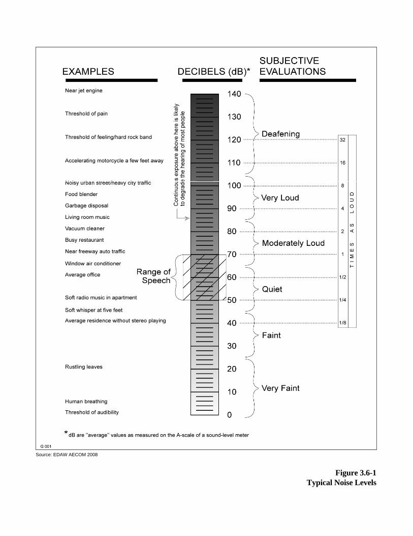
Figure 3.6-1Typical Noise Levels
Source: EDAW AECOM 2008

3.6 Noise
Santa Monica High School Science and Technology Building and Site Improvements Project Draft EIR Page 3.6-3 Santa Monica-Malibu Unified School District April 2010
The loudness of sound preserved by the human ear depends primarily on the overall sound pressure level and frequency content of the sound source. The human ear is not equally sensitive to loudness at all frequencies in the audible spectrum. To better relate overall sound levels and loudness to human perception frequency-dependent weighting networks were developed. The standard weighting networks are identified as A through E. There is a strong correlation between the way humans perceive sound and A-weighted sound levels (dBA). For this reason the dBA can be used to predict community response to environmental and transportation noise. Sound levels expressed as dB in this section are A-weighted sound levels, unless noted otherwise.
Noise can be generated by a number of sources, including mobile sources (transportation) such as automobiles, trucks, and airplanes; and stationary sources (nontransportation) such as construction sites, machinery, commercial and industrial operations. As acoustic energy spreads through the atmosphere from the source to the receptor, noise levels attenuate (reduce) dependent on ground absorption characteristics, atmospheric conditions, and the presence of physical barriers (walls, building facades, berms). Noise generated from mobile sources generally attenuate at a rate of 4.5 dB per doubling of distance (dB/DD). Stationary noise sources spread with more spherical dispersion patterns, which attenuate at a rate of 6 dB to 7.5 dB/DD.
Atmospheric conditions such as wind speed, turbulence, temperature gradients, and humidity may additionally alter the propagation of noise and affect levels at a receptor. Furthermore, the presence of a large object (barrier) between the source and the receptor can provide significant attenuation of noise levels at the receptor. The amount of noise level reduction or “shielding” provided by a barrier primarily depends on the size of the barrier, the location of the barrier in relation to the source and receptors, and the frequency spectra of the noise. Natural barriers such as berms or hills, and human-made features such as buildings and walls may be used as noise barriers.
Noise Descriptors
The intensity of environmental noise changes over time. This section uses several different descriptors of time-averaged noise levels. The selection of a proper noise descriptor for a specific source depends on the spatial and temporal distribution, duration, and fluctuation of both the noise source and the environment. The noise descriptors most often used to describe environmental noise are defined below:
Lmax (Maximum Noise Level): The highest A/B/C-weighted, integrated noise level occurring during a specific period of time.
Lmin (Minimum Noise Level): The lowest A/B/C-weighted, integrated noise level during a specific period of time.
Ln (Statistical Descriptor): The noise level exceeded n% of a specific period of time, generally accepted as an hourly statistic. An L10 would be the noise level exceeded 10% of the measurement period.

3.6 Noise
Page 3.6-4 Santa Monica High School Science and Technology Building and Site Improvements Project Draft EIR April 2010 Santa Monica-Malibu Unified School District
Leq (Equivalent Noise Level): The energy mean (average) noise level, the steady state sound level in a specified period of time that contains the same acoustical energy as a varying sound level over the same time period.
Ldn (Day-Night Noise Level): The 24-hour Leq with a 10 dB “penalty” applied during nighttime noise-sensitive hours, 10:00 p.m. through 7:00 a.m. The Ldn attempts to account for the fact that noise during this specific period of time is a potential source of disturbance with respect to normal sleeping hours.
CNEL (Community Noise Equivalent Level): The CNEL is similar to the Ldn described above, but with an additional 5 dB “penalty” for the noise-sensitive hours between 7:00 p.m. to 10:00 p.m., which are typically reserved for relaxation, conversation, reading, and television. If using the same 24-hour noise data, the CNEL is typically 0.5 dB higher than the Ldn.
SEL (Sound Exposure Level): The SEL describes the cumulative exposure to sound energy over a stated period of time.
SENEL (Single Event Noise Exposure Level): An SEL where, the measurement period is defined by the start and end times of a single noise event, such as an automobile passby, aircraft flyover, or individual industrial operations.
Effects of Noise on Humans
Excessive and chronic exposure to elevated noise levels can result in auditory and nonauditory effects in humans. Auditory effects of noise on people are those relating to temporary or permanent noise-induced hearing loss. Nonauditory effects of exposure to elevated noise levels are those relating to behavioral and physiological effects. The nonauditory behavioral effects of noise on humans is primarily associated with the subjective effects of annoyance, nuisance, and dissatisfaction; which lead to interference with activities such as communications, sleep, and learning. The nonauditory physiological health effects of noise on humans has been the subject of considerable research efforts attempting to discover correlations between exposure to elevated noise levels and health problems, such as hypertension and cardiovascular disease. The mass of research infers that noise-related health issues are predominantly the result of behavioral stressors (physiological) and not a direct noise-induced response. The degree to which noise contributes to nonauditory health effects remains a subject of considerable research, with no definitive conclusions.
The degree to which noise results in annoyance and interference is highly subjective and may be influenced by a number of nonacoustic factors. The number and effect of these nonacoustic environmental and physical factors varies depending on individual characteristics of the noise environment, including sensitivity, level of activity, location, time of day, and length of exposure. One key aspect in the prediction of human response to new noise environments is the individual level of adaptation to an existing noise environment. The greater change in noise levels that are attributed to a new noise source, relative to the environment an individual has become accustom too, the less tolerable the individual will be to the new noise source.

3.6 Noise
Santa Monica High School Science and Technology Building and Site Improvements Project Draft EIR Page 3.6-5 Santa Monica-Malibu Unified School District April 2010
With regard to human perception of increases in sound levels expressed in dB, a change of 1 dB is generally not perceivable, excluding controlled conditions and pure tones. Outside of controlled laboratory conditions, the average human ear barely perceives a change of 3 dB. A change of 5 dB generally fosters a noticeable change in human response, and an increase of 10 dB is subjectively heard as a doubling of loudness.
VIBRATION CHARACTERISTICS AND EFFECTS
Vibration is the periodic oscillation of a medium or object with respect to a given reference point. Sources of vibration include natural phenomena (e.g., earthquakes, volcanic eruptions, sea waves, landslides) and those introduced by human activity (e.g., explosions, machinery, traffic, trains, construction equipment). Vibration sources may be continuous, such as operating factory machinery, or transient in nature, such as explosions. Vibration levels can be depicted in terms of amplitude and frequency, relative to displacement, velocity, and acceleration.
Vibration amplitudes are commonly expressed in peak-particle-velocity (PPV) or root-mean-square (RMS) vibration velocity. PPV is defined as the maximum instantaneous positive or negative peak of a vibration signal. PPV is typically used in the monitoring of transient and impact vibration and has been found to correlate well to the stresses experienced by buildings.1,2 PPV and RMS vibration velocity are normally described in inches per second (in/sec).
Although PPV is appropriate for evaluating the potential for building damage, it is not always suitable for evaluating human response. The response of the human body to vibration relates well to average vibration amplitude; therefore, vibration impacts on humans are evaluated in terms of RMS vibration velocity. Similar to airborne sound, vibration velocity can be expressed in decibel notation as vibration decibels (VdB). The logarithmic nature of the decibel serves to compress the broad range of numbers required to describe vibration.
Typical outdoor sources of perceptible groundborne vibration include construction equipment, steel-wheeled trains, and traffic on rough roads. Although the effects of vibration may be imperceptible at low levels, effects may result in detectable vibrations and slight damage to nearby structures at moderate and high levels, respectively. At the highest levels of vibration, damage to structures is primarily architectural (e.g., loosening and cracking of plaster or stucco coatings) and rarely damages structural components. The range of vibration important to the proposed Project occurs from approximately 50 VdB, which is the typical background vibration-velocity level, to 100 VdB, which is the general threshold where vibrations cause minor damage in fragile buildings.3
1 Federal Transit Administration (FTA). 2006 (May). Transit Noise and Vibration Impact Assessment. Washington, D.C. 2 California Department of Transportation (Caltrans). 2004 (June). Transportation and Construction Induced Vibration Guidance
Manual. Sacramento, CA. 3 Federal Transit Administration (FTA). 2006 (May). Transit Noise and Vibration Impact Assessment. Washington, D.C.
3.6 Noise
Page 3.6-6 Santa Monica High School Science and Technology Building and Site Improvements Project Draft EIR April 2010 Santa Monica-Malibu Unified School District
EXISTING ENVIRONMENTAL SETTING
The existing noise environment within the Project area is typical of an urban community. The existing noise environment is primarily influenced by traffic noise emanating from Interstate 10 (I-10), school activities, 4th Street, and Olympic Boulevard. Noise from outdoor activities (e.g., people talking, dogs barking) and commercial aircraft over-flights contribute to the existing noise environment in a lesser extent.
Ambient Noise Survey
An ambient noise survey was conducted July 28, 2009 through July 29, 2009 to document the existing noise environment at noise-sensitive receptors within the immediate Project area and noise sources emanating from school property. The dominant noise source identified during the ambient noise survey was traffic noise on I-10. Short-term (7 locations) 15 minutes and continuous 24-hour long-term (1 location) monitoring of noise levels were taken in accordance with American National Standards Institute (ANSI) standards at using a Larson Davis Laboratories (LDL) Model 820 precision integrating sound level meter (SLM). The SLMs were calibrated before and after use with an LDL Model CAL200 acoustical calibrator to ensure that the measurements would be accurate. The equipment used meets all pertinent specifications of the ANSI for Type 1 SLMs (ANSI S1.4-1983[R2006]).
Ambient noise survey locations are shown in Figure 3.6-2. The Ldn, Leq, Lmax, and L50 values taken at each ambient noise measurement location are presented in Table 3.6-1. During the survey, average daytime hourly noise levels within the Project area ranged approximately from 55 dB to 65 dB Leq, with maximum noise levels that ranged from 62 dB to 74 dB Lmax. Ambient noise levels were dependent on the relative distance from nearby roadways and shielding provided by nearby existing structures.
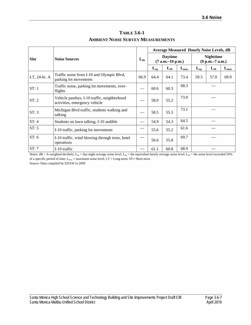
3.6 Noise
Santa Monica High School Science and Technology Building and Site Improvements Project Draft EIR Page 3.6-7 Santa Monica-Malibu Unified School District April 2010
TABLE 3.6-1 AMBIENT NOISE SURVEY MEASUREMENTS
Site Noise Sources Ldn
Average Measured Hourly Noise Levels, dB Daytime
(7 a.m.–10 p.m.) Nighttime
(9 p.m.–7 a.m.) Leq L50 Lmax Leq L50 Lmax
LT, 24-hr. A Traffic noise from I-10 and Olympic Blvd, parking lot movements 66.9 64.4 64.1 73.4 59.3 57.0 69.9
ST: 1 Traffic noise, parking lot movements, over-flights — 60.6 60.3
68.3 —
ST: 2 Vehicle passbys, I-10 traffic, neighborhood activities, emergency vehicle — 58.9 55.2
73.9 —
ST: 3 Michigan Blvd traffic, students walking and talking — 58.5 55.3
73.1 —
ST: 4 Students on lawn talking, I-10 audible — 54.9 54.3 64.5 —
ST: 5 I-10 traffic, parking lot movements — 55.6 55.2 61.6 —
ST: 6 I-10 traffic, wind blowing through trees, hotel operations
— 56.6 55.8
69.7 —
ST: 7 I-10 traffic — 61.1 60.8 68.9 — Notes: dB = A-weighted decibels; Ldn = day-night average noise level; Leq = the equivalent hourly average noise level; L50 = the noise level exceeded 50% of a specific period of time; Lmax = maximum noise level; LT = Long-term; ST= Short-term. Source: Data compiled by EDAW in 2009

0 300 600150feet
1 inch equals 300 feet
N
Source: R.L. Binder Architects 2009
Figure 3.6-2Ambient Noise Monitoring Locations
6
54
1
2
3
7A
56.6 dB Leq
60.6 dB Leq
58.9 dB Leq
61.1 dB Leq66.9 dB Ldn
54.9 dB Leq
58.5 dB Leq55.6 dB Leq
= Long Term Noise Measurement
= Short Term Noise Measurement#
#
3.6 Noise
Santa Monica High School Science and Technology Building and Site Improvements Project Draft EIR Page 3.6-9 Santa Monica-Malibu Unified School District April 2010
Vehicular Traffic
The dominant noise source in the Project area is vehicle traffic emanating from I-10. Existing vehicle traffic noise levels near the Project site were modeled using the Federal Highway Administration (FHWA) Highway Traffic Noise Prediction Model (FHWA-RD-77-108) and traffic data provided by the Project traffic consultant (KOA Corporation). The FHWA model is based on CALVENO reference noise factors for automobiles, medium trucks, and heavy trucks, with consideration given to vehicle volume, speed, roadway configuration, distance to the receptor, and ground attenuation factors. Truck usage and vehicle speeds on roadways near the Project site were estimated from field observations and Caltrans data where available.4
Table 3.6-2 summarizes the modeled traffic noise levels, provides noise levels at 100 feet from the centerline of each major roadway in the immediate area of the Project site, and lists distances from the roadway centerlines to the 60 dB, 65 dB, and 70 dB Ldn traffic noise contours. These traffic noise modeling results are based on existing average daily traffic (ADT) volumes. As shown in Table 3.6-2, the location of the 60 dB Ldn contour ranges from 7 to 1,391 feet from the centerline of the modeled roadways. The extent to which existing land uses in the Project area are affected by existing traffic noise depends on their respective proximity to the roadways and their individual sensitivity to noise. Refer to Appendix E of this EIR for complete modeling inputs and results.
Based on the comparison of modeled traffic noise levels (78.4 dB Ldn) and measured traffic noise levels (66.9 dB Ldn) for I-10, a minus 10 dB offset has been applied to the FHWA traffic noise prediction model. The offset reflects the shielding provided by the retaining wall of the depressed I-10 roadway that eliminates line of sight to the roadway from school grounds. The 10 dB reduction in traffic noise levels would be expected due to the size of the wall based on the Technical Noise Supplement published by Caltrans.5 The minus 10 dB offset will be applied to future traffic noise level modeling for I-10.
Existing Vibration Environment
Similar to the environmental setting for noise, the vibration environment is dominated by traffic from nearby roadways. Heavy trucks can generate ground-borne vibration that varies depending on vehicle type, weight, and pavement conditions. Field observations indicated that heavy-duty truck travel is minimal along Michigan Boulevard, 6th Street, 7th Street and 7th Court Alley. Vibration levels from adjacent roadways are not perceptible at the Project site.
4 California Department of Transportation (Caltrans). 2007 (December). 2006 Average Annual Daily Truck Traffic on the California State Highway System. Sacramento, CA.
5 California Department of Transportation (Caltrans). 1998 (October). Technical Noise Supplement. Sacramento, CA.

3.6 Noise
Page 3.6-10 Santa Monica High School Science and Technology Building and Site Improvements Project Draft EIR April 2010 Santa Monica-Malibu Unified School District
TABLE 3.6-2 SUMMARY OF MODELED EXISTING TRAFFIC NOISE LEVELS
Roadway Segment Ldn (dB)
100 Feet Distance (feet) from Roadway
From To 70 dB 65 dB 60 dB
Interstate 10 Highway 1 Lincoln Boulevard 71 139 440 1,391
Olympic Blvd 4th Street To West 53 2 7 22
Olympic Blvd 4th Street 6th Street 58 7 21 67
Olympic Blvd 6th Street 7th Court 50 1 3 11
Olympic Blvd 7th Court Lincoln Boulevard 55 3 11 34
Olympic Blvd Lincoln Boulevard To East 61 12 37 116
Michigan Ave 7th Court 7th Street 49 1 2 7
Michigan Ave Lincoln Boulevard 7th Court 50 1 3 9
Michigan Ave Lincoln Boulevard To East 52 2 5 16
Pico Blvd 4th Street Main Street 62 14 45 143
Pico Blvd 4th Street 7th Street 60 10 33 104
Pico Blvd Lincoln Boulevard 7th Street 60 10 32 101
Pico Blvd Lincoln Boulevard To East 60 11 34 106
4th Street Olympic Boulevard Pico Boulevard 61 14 43 136
4th Street Pico Boulevard Bay Street 57 6 17 55
6th Street Olympic Boulevard School Center 45 0 1 3
7th Street Pico Boulevard Michigan Avenue 47 1 2 5
7th Court Olympic Boulevard Michigan Avenue 44 0 1 2
7th Court Michigan Avenue Pico Boulevard 43 0 1 2
Lincoln Blvd Olympic Boulevard Michigan Avenue 64 23 74 233
Lincoln Blvd Michigan Avenue Pico Boulevard 63 22 71 223
Lincoln Blvd Pico Boulevard Pico Place 64 25 80 254
Notes: dB = A-weighted decibels; Ldn = day-night average noise level. Source: Data modeled by EDAW in 2009
3.6 Noise
Santa Monica High School Science and Technology Building and Site Improvements Project Draft EIR Page 3.6-11 Santa Monica-Malibu Unified School District April 2010
3.6.2 REGULATORY SETTING
Various private and public agencies have established noise guidelines and standards to protect citizens from potential hearing damage and various other adverse physiological and social effects associated with noise. The following federal, state, and local regulations discussed below are applicable to the proposed Project regarding noise and vibration standards.
FEDERAL PLANS, POLICIES, REGULATIONS, AND LAWS
The U.S. Environmental Protection Agency (EPA), Office of Noise Abatement and Control was originally established to coordinate federal noise control activities. After inception, EPA’s Office of Noise Abatement and Control issued the federal Noise Control Act of 1972, establishing programs and guidelines to identify and address the effects of noise on public health and welfare and the environment. Administrators of EPA determined in 1981 that subjective issues such as noise would be better addressed at lower levels of government. Consequently, in 1982 responsibilities for regulating noise control policies were transferred to state and local governments. However, noise control guidelines and regulations contained in the rulings by EPA in prior years remain upheld by designated federal agencies, allowing more individualized control for specific issues by designated federal, state, and local government agencies.
The Acoustical Society of America (ASA) develops, maintains, and revises its American National Standards on Acoustics in accordance with procedure approved by ANSI. The use of American National Standards is considered completely voluntary and does not apply to noise generated within the classroom.6 The analysis presented below evaluates the interior noise level standard within classrooms from transportation noise. Table 1 of ANSI S12.60-2002 establishes an interior noise level standard of 35 dB for core learning spaces. Core learning spaces are defined by ASA as spaces for educational activities where the primary functions are teaching and learning and where good speech communication is critical to a student’s academic achievement.7
To address the human response to groundborne vibration, the Federal Transit Administration (FTA) has guidelines for maximum-acceptable vibration criteria for different types of land uses. These guidelines recommend 65 VdB referenced to 1 μin/sec and based on the RMS velocity amplitude for land uses where low ambient vibration is essential for interior operations (e.g., hospitals, high-tech manufacturing, laboratory facilities); 80 VdB for residential uses and buildings where people normally sleep; and 83 VdB for institutional land uses with primarily daytime operations (e.g., schools, churches, clinics, offices).8
6 American National Standard Institute (ANSI). 2002 (June). Acoustical Performance Criteria, Design Requirements, and Guidelines for Schools, ANSI S12.60-2002. Melville, NY.
7 American National Standard Institute (ANSI). 2002 (June). Acoustical Performance Criteria, Design Requirements, and Guidelines for Schools, ANSI S12.60-2002. Melville, NY.
8 Federal Transit Administration (FTA). 2006 (May). Transit Noise and Vibration Impact Assessment. Washington, DC. Prepared by: Harris Miller Miller & Hanson Inc., Burlington, MA.

3.6 Noise
Page 3.6-12 Santa Monica High School Science and Technology Building and Site Improvements Project Draft EIR April 2010 Santa Monica-Malibu Unified School District
STATE PLANS, POLICIES, REGULATIONS, AND LAWS
The State of California has adopted noise standards in areas of regulation not preempted by the federal government. State standards regulate noise levels of motor vehicles, sound transmission through buildings, occupational noise control, and noise insulation.
Title 5 of the California Code of Regulations
The California Department of Education siting requirements for school projects establishes noise standards in Title 5 of the California Code of Regulations Division 1, Chapter 13, Subchapter 1, “School Facilities Construction.” The following articles are applicable to the proposed Project:
The State of California General Plan Guidelines 2003, published by the California Governor’s Office of Planning and Research (OPR), provides guidance for the acceptability of projects within areas of specific noise exposure. Table 3.6-3 presents acceptable and unacceptable community noise exposure limits for various land use categories.9 The guidelines also present adjustment factors that may be used to arrive at noise acceptability standards that reflect the noise control goals of the community, the particular community’s sensitivity to noise, and the community’s assessment of the relative importance of noise pollution.
Title 24 of the California Code of Regulations
Title 24 of the California Code of Regulations establishes standards governing interior noise levels that apply to all new multifamily residential units in California. These standards require that acoustical studies be performed before construction begins at locations where the existing Ldn exceeds 60 dBA. Such acoustical studies are required to establish mitigation measures that limit maximum Ldn levels to 45 dBA in any habitable room. Although no generally applicable interior noise standards are pertinent to all uses, many communities in California have adopted an Ldn of 45 dBA as an upper limit on interior noise in all residential units.
CITY OF SANTA MONICA GENERAL PLAN
The City of Santa Monica’s General Plan Noise Element contains goals, policies and actions to address noise within the City. The City’s has established acceptable exterior and interior noise level standards for assessing land use compatibility of proposed land uses with the noise environment within the City’s General Plan Noise Element. The following tables are the primary tools which allow the City to ensure integrated planning for compatibility between land uses and outdoor noise. The Land Use/Noise Compatibility Matrix shown in Table 3.6-4 (Table 1 of the Santa Monica General Plan Noise Element) is used in the land planning stage of the development process to identify project opportunities and constraints. Table 3.6-5 (Table 2 of the Santa Monica General Plan Noise Element) shows design standards to be used in the project design stage.

3.6 Noise
Santa Monica High School Science and Technology Building and Site Improvements Project Draft EIR Page 3.6-13 Santa Monica-Malibu Unified School District April 2010
TABLE 3.6-3 LAND USE NOISE COMPATIBILITY GUIDELINES
Land Use Category Community Noise Exposure (Ldn or CNEL, dB)
Normally Acceptable1
Conditionally Acceptable2
Normally Unacceptable3
Clearly Unacceptable4
Residential-Low Density Single Family, Duplex, Mobile Home <60 55–70 70–75 75+
Residential-Multiple Family <65 60–70 70–75 75+
Transient Lodging, Motel, Hotel <65 60–70 70–80 80+
School, Library, Church, Hospital, Nursing Home <70 60–70 70–80 80+
Auditorium, Concert Hall, Amphitheater <70 65+
Sports Arenas, Outdoor Spectator Sports <75 70+
Playground, Neighborhood Park <70 67.5–75 72.5+
Golf Courses, Stable, Water Recreation, Cemetery <75 70–80 80+
Office Building, Business Commercial and Professional <70 67.5–77.5 75+
Industrial, Manufacturing, Utilities, Agriculture <75 70–80 75+ 1 Specified land use is satisfactory, based on the assumption that any buildings involved are of normal conventional
construction, without any special noise insulation requirements. 2 New construction or development should be undertaken only after a detailed analysis of the noise reduction requirements is
made and needed noise insulation features are included in the design. Conventional construction, but with closed windows and fresh air supply systems or air conditioning will normally suffice.
3 New construction or development should generally be discouraged. If new construction or development does proceed, a detailed analysis of the noise reduction requirements must be made and needed noise insulation features included in the design. Outdoor areas must be shielded.
4 New construction or development should generally not be undertaken. Notes: CNEL = Community Noise Equivalent Level; dB = A-weighted decibels; Ldn = day-night average noise level. Source: OPR 2003
TABLE 3.6-4 LAND USE/NOISE COMPATIBILITY MATRIX
Proposed Land Use Categories Compatible Land Use Zones
Categories Uses CNEL
55-60
60-65
65-70
70-75
75-80
CNEL
Residential Single Family, Duplex, Multiple Family
A A B B C D D
Residential Mobile Home A A B C C D D
9 Governor’s Office of Planning and Research (OPR). 2003. General Plan Guidelines. Pages 250-251. Sacramento, CA.

3.6 Noise
Page 3.6-14 Santa Monica High School Science and Technology Building and Site Improvements Project Draft EIR April 2010 Santa Monica-Malibu Unified School District
Proposed Land Use Categories Compatible Land Use Zones
Categories Uses CNEL
55-60
60-65
65-70
70-75
75-80
CNEL
Commercial Regional, District
Hotel, Motel, Transient Lodging A A B B C C D
Commercial Regional, Village
Commercial Retail, Bank, Restaurant, Movie Theater
A A A A B B C
Commercial , Industrial Institutional
Office Building, Research and Development, Professional Offices, City Office Building
A A A B B C D
Commercial, Recreation, Institutional, Civic Center
Amphitheatre, Concert Hall, Auditorium, Meeting Hall
B B C C D D D
Commercial, Recreation Childrens Amusement Park, Miniature Golf Course, Go-cart Track, Equestrian Center, Sports Club
A A A B B D D
Commercial, General, Special, Industrial, Institutional
Automobile Service Station, Auto Dealership, Manufacturing, Warehousing, Wholesale, Utilities
A A A A B B B
Institutional, General Hospital, Church, Library, Schools’ Classroom, Day Care
A A B C C D D
Open Space Parks A A A B C D D
Open Space Golf Course, Cemeteries, Nature Centers/Wildlife Reserves, Wildlife Habitat
A A A A B C C
Agriculture Agriculture A A A A A A A
TABLE 3.6-4 INTERPRETATION ZONE A CLEARLY COMPATIBLE
Specified land use is satisfactory, based upon the assumption that any buildings involved are of normal conventional construction without any special noise insulation requirements.
ZONE B COMPATIBLE WITH MITIGATION
New construction or development should be undertaken only after detailed analysis of the noise reduction requirements are made and needed noise insulation features in the design are determined. Conventional construction, with closed windows and fresh air supply systems or air conditioning, will normally suffice. Note that residential uses are prohibited with Airport CNEL greater than 65.
ZONE C New construction or development should generally be discouraged. If new
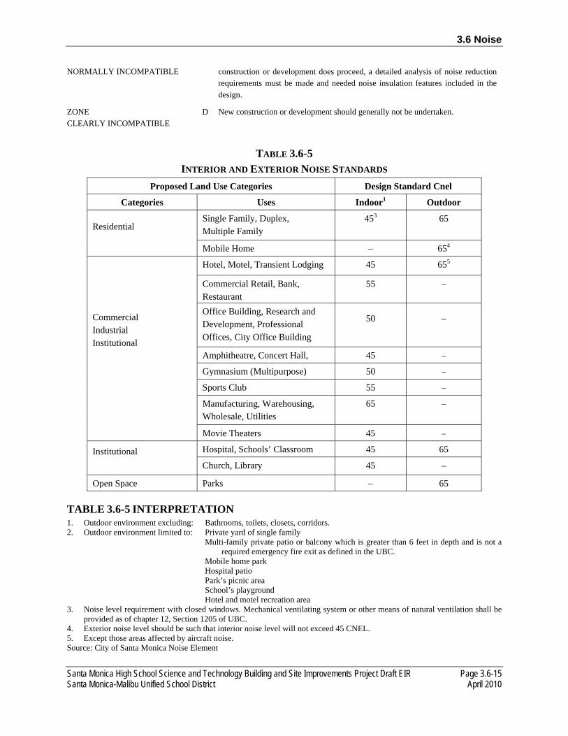
3.6 Noise
Santa Monica High School Science and Technology Building and Site Improvements Project Draft EIR Page 3.6-15 Santa Monica-Malibu Unified School District April 2010
NORMALLY INCOMPATIBLE construction or development does proceed, a detailed analysis of noise reduction requirements must be made and needed noise insulation features included in the design.
ZONE D CLEARLY INCOMPATIBLE
New construction or development should generally not be undertaken.
TABLE 3.6-5 INTERIOR AND EXTERIOR NOISE STANDARDS
Proposed Land Use Categories Design Standard Cnel
Categories Uses Indoor1 Outdoor
Residential Single Family, Duplex, Multiple Family
453 65
Mobile Home – 654
Commercial Industrial Institutional
Hotel, Motel, Transient Lodging 45 655
Commercial Retail, Bank, Restaurant
55 –
Office Building, Research and Development, Professional Offices, City Office Building
50 –
Amphitheatre, Concert Hall, 45 –
Gymnasium (Multipurpose) 50 –
Sports Club 55 –
Manufacturing, Warehousing, Wholesale, Utilities
65 –
Movie Theaters 45 –
Institutional Hospital, Schools’ Classroom 45 65
Church, Library 45 –
Open Space Parks – 65
TABLE 3.6-5 INTERPRETATION 1. Outdoor environment excluding: Bathrooms, toilets, closets, corridors. 2. Outdoor environment limited to: Private yard of single family
Multi-family private patio or balcony which is greater than 6 feet in depth and is not a required emergency fire exit as defined in the UBC.
Mobile home park Hospital patio Park’s picnic area School’s playground Hotel and motel recreation area
3. Noise level requirement with closed windows. Mechanical ventilating system or other means of natural ventilation shall be provided as of chapter 12, Section 1205 of UBC.
4. Exterior noise level should be such that interior noise level will not exceed 45 CNEL. 5. Except those areas affected by aircraft noise. Source: City of Santa Monica Noise Element
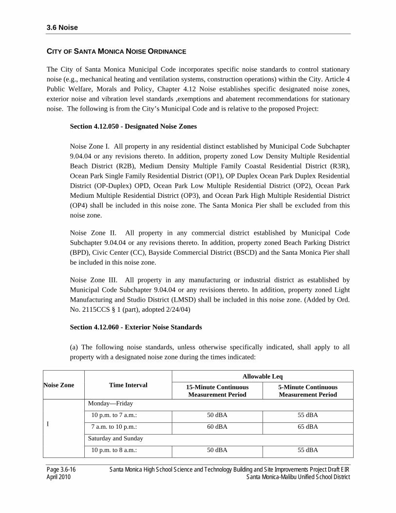
3.6 Noise
Page 3.6-16 Santa Monica High School Science and Technology Building and Site Improvements Project Draft EIR April 2010 Santa Monica-Malibu Unified School District
CITY OF SANTA MONICA NOISE ORDINANCE
The City of Santa Monica Municipal Code incorporates specific noise standards to control stationary noise (e.g., mechanical heating and ventilation systems, construction operations) within the City. Article 4 Public Welfare, Morals and Policy, Chapter 4.12 Noise establishes specific designated noise zones, exterior noise and vibration level standards ,exemptions and abatement recommendations for stationary noise. The following is from the City’s Municipal Code and is relative to the proposed Project:
Section 4.12.050 - Designated Noise Zones
Noise Zone I. All property in any residential distinct established by Municipal Code Subchapter 9.04.04 or any revisions thereto. In addition, property zoned Low Density Multiple Residential Beach District (R2B), Medium Density Multiple Family Coastal Residential District (R3R), Ocean Park Single Family Residential District (OP1), OP Duplex Ocean Park Duplex Residential District (OP-Duplex) OPD, Ocean Park Low Multiple Residential District (OP2), Ocean Park Medium Multiple Residential District (OP3), and Ocean Park High Multiple Residential District (OP4) shall be included in this noise zone. The Santa Monica Pier shall be excluded from this noise zone.
Noise Zone II. All property in any commercial district established by Municipal Code Subchapter 9.04.04 or any revisions thereto. In addition, property zoned Beach Parking District (BPD), Civic Center (CC), Bayside Commercial District (BSCD) and the Santa Monica Pier shall be included in this noise zone.
Noise Zone III. All property in any manufacturing or industrial district as established by Municipal Code Subchapter 9.04.04 or any revisions thereto. In addition, property zoned Light Manufacturing and Studio District (LMSD) shall be included in this noise zone. (Added by Ord. No. 2115CCS § 1 (part), adopted 2/24/04)
Section 4.12.060 - Exterior Noise Standards
(a) The following noise standards, unless otherwise specifically indicated, shall apply to all property with a designated noise zone during the times indicated:
Noise Zone Time Interval Allowable Leq
15-Minute Continuous Measurement Period
5-Minute Continuous Measurement Period
I
Monday—Friday
10 p.m. to 7 a.m.: 50 dBA 55 dBA
7 a.m. to 10 p.m.: 60 dBA 65 dBA
Saturday and Sunday
10 p.m. to 8 a.m.: 50 dBA 55 dBA

3.6 Noise
Santa Monica High School Science and Technology Building and Site Improvements Project Draft EIR Page 3.6-17 Santa Monica-Malibu Unified School District April 2010
Noise Zone Time Interval Allowable Leq
15-Minute Continuous Measurement Period
5-Minute Continuous Measurement Period
8 a.m. to 10 p.m.: 60 dBA 65 dBA
II All Days of Week
10 p.m. to 7 a.m.: 60 dBA 65 dBA
7 a.m. to 10 p.m. 65 dBA 70 dBA
III Anytime 70 dBA 75 dBA
(b) For each Noise Zone, the allowable exterior equivalent noise level shall be reduced by five dBA for impulsive or simple tone noise, or for noises consisting of speech or music. If the ambient noise level exceeds the allowable exterior noise level standard, the ambient noise level shall be the standard.
(c) Except as provided for in this Chapter, no person shall at any location within the City create any noise or allow the creation of any noise on property owned, leased, occupied or otherwise controlled by such person, which causes:
(1) The equivalent noise level to exceed the noise standards established in subsection (a) of this Section for the noise zone where the measurement is taken; or
(2) A maximum instantaneous A-weighted, slow sound pressure level to exceed the decibel limits established in subsection (a) of this Section for the noise zone where the measurement is taken plus twenty dBA for any period of time.
(d) If any portion of a parcel is located within one hundred feet of a noise zone with higher noise standards as compared to the noise standards for the noise zone in which the parcel is located, then the maximum allowable exterior equivalent noise level for the entire parcel shall be the average of the noise standards of the two noise zones. However, any noise level measurement must be taken at least twenty-five feet from the parcel line of the source of the noise.
(e) Construction activity shall be subject to the noise standards set forth in Section 4.12.110.
Section 4.12.070 - Vibration
Notwithstanding other Sections of this Chapter, it shall be unlawful for any person to create, maintain or cause any ground vibration that is perceptible without instruments at any point on any property. For the purpose of this Chapter, the perception threshold shall be presumed to be more than 0.05 inches per second RMS velocity. The vibration caused by construction activity, moving vehicles, trains, and aircraft shall be exempt from this Section. (Added by Ord. No. 2115CCS § 1 (part), adopted 2/24/04)

3.6 Noise
Page 3.6-18 Santa Monica High School Science and Technology Building and Site Improvements Project Draft EIR April 2010 Santa Monica-Malibu Unified School District
Section 4.12.110 - Restrictions on Demolition, Excavation, Grading, Spray Painting, Construction, Maintenance or Repair of Buildings
(a) No person shall engage in any construction activity during the following times anywhere in the City:
(1) Before eight a.m. or after six p.m. on Monday through Friday, except that construction activities conducted by employees of the City of Santa Monica or public utilities while conducting duties associated with their employment shall not occur before seven a.m. or after six p.m. on Monday through Friday;
(2) Before nine a.m. or after five p.m. on Saturday;
(3) All day on Sunday;
(4) All day on New Year’ s Day, Martin Luther King’ s Birthday, President’ s Day, Memorial Day, Independence Day, Labor Day, Thanksgiving Day and Christmas Day, as those days have been established by the United States of America.
(b) Except as set forth in subsection (d) of this Section, the noise created by construction activity shall not cause:
(1) The equivalent noise level to exceed the noise standards specified in Section 4.12.060 of this Chapter, for the noise zone where the measurement is taken, plus twenty dBA, or
(2) A maximum instantaneous A-weighted, slow sound pressure level to exceed the decibel limits specified in Section 4.12.060 of this Chapter for the noise zone where the measurement is taken plus forty dBA, for any period of time.
(c) Prior to the issuance of a building permit, all development projects located within five hundred feet of any residential development or other noise sensitive land uses must submit a list of equipment and activities required during construction. In particular, this list shall include the following:
(1) Construction equipment to be used, such as pile drivers, jackhammers, pavement breakers or similar equipment;
(2) Construction activities such as twenty-four hour pumping, excavation or demolition;
(3) A list of measures that will be implemented to minimize noise impacts on nearby residential uses;
(d) Any construction that exceeds the noise levels established in subsection (b) of this Section shall occur between the hours of ten a.m. and three p.m., Monday through Friday.
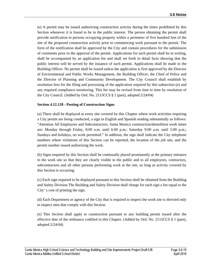
3.6 Noise
Santa Monica High School Science and Technology Building and Site Improvements Project Draft EIR Page 3.6-19 Santa Monica-Malibu Unified School District April 2010
(e) A permit may be issued authorizing construction activity during the times prohibited by this Section whenever it is found to be in the public interest. The person obtaining the permit shall provide notification to persons occupying property within a perimeter of five hundred feet of the site of the proposed construction activity prior to commencing work pursuant to the permit. The form of the notification shall be approved by the City and contain procedures for the submission of comments prior to the approval of the permit. Applications for such permit shall be in writing, shall be accompanied by an application fee and shall set forth in detail facts showing that the public interest will be served by the issuance of such permit. Applications shall be made to the Building Officer. No permit shall be issued unless the application is first approved by the Director of Environmental and Public Works Management, the Building Officer, the Chief of Police and the Director of Planning and Community Development. The City Council shall establish by resolution fees for the filing and processing of the application required by this subsection (e) and any required compliance monitoring. This fee may be revised from time to time by resolution of the City Council. (Added by Ord. No. 2115CCS § 1 (part), adopted 2/24/04)
Section 4.12.120 - Posting of Construction Signs
(a) There shall be displayed at every site covered by this Chapter where work activities requiring a City permit are being conducted, a sign in English and Spanish reading substantially as follows: “Attention All Employees and Subcontractors. Santa Monica construction/demolition work times are: Monday through Friday, 8:00 a.m. until 6:00 p.m.; Saturday 9:00 a.m. until 5:00 p.m.; Sundays and holidays, no work permitted.” In addition, the sign shall indicate the City telephone numbers where violations of this Section can be reported, the location of the job site, and the permit number issued authorizing the work.
(b) Signs required by this Section shall be continually placed prominently at the primary entrance to the work site so that they are clearly visible to the public and to all employees, contractors, subcontractors and all other persons performing work at the site, so long as activity covered by this Section is occurring.
(c) Each sign required to be displayed pursuant to this Section shall be obtained from the Building and Safety Division The Building and Safety Division shall charge for each sign a fee equal to the City’ s cost of printing the sign.
(d) Each Department or agency of the City that is required to inspect the work site is directed only to inspect sites that comply with this Section.
(e) This Section shall apply to construction pursuant to any building permit issued after the effective date of the ordinance codified in this Chapter. (Added by Ord. No. 2115CCS § 1 (part), adopted 2/24/04)

3.6 Noise
Page 3.6-20 Santa Monica High School Science and Technology Building and Site Improvements Project Draft EIR April 2010 Santa Monica-Malibu Unified School District
Section 4.12.130 - Location, Screening and Noise Measurements of Mechanical Equipment
All development project applications must demonstrate compliance with or contain the following information:
(a) A list of all permanent mechanical equipment to be placed outdoors and all permanent mechanical equipment to be placed indoors which may be heard outdoors. All such equipment shall require a noise analysis to demonstrate compliance with Section 4.12.060 prior to the issuance of a building permit for the development project.
(b) Mechanical equipment shall not be located on the side of any building which is adjacent to a residential building on the adjoining lot unless it can be shown that the noise will comply with the requirements of Section 4.12.060. Roof locations may be used when the mechanical equipment is installed within a noise attenuating structure.
(c) Final approval of the location of any mechanical equipment will require a noise test to demonstrate compliance with Section 4.12.060. Equipment for the test shall be provided by the owner or contractor and the test shall be conducted by the owner or contractor. A copy of noise test results on mechanical equipment shall be submitted to the Community Noise Officer for review to ensure that noise levels do not exceed maximum allowable levels for the applicable noise zone. (Added by Ord. No. 2115CCS § 1 (part), adopted 2/24/04)
Section 4.12.170 - Noise Reduction in Project Siting and Design
New development may only be permitted if noise mitigation measures are taken in project siting and design such that exterior noise levels meet equivalent noise level requirements of Section 4.12.060 and the standards contained in the Interior and Exterior Noise Standards Matrix as contained in the Noise Element of the General Plan for any existing noise sources near the project or contained within the project. (Added by Ord. No. 2115CCS § 1 (part), adopted 2/24/04)
Section 4.12.180 - Restrictions on Gardening or Landscaping Activities
(a) No person shall engage in any gardening or landscaping activity by use of any internal combustion, motorized or electromechanical means during the following times anywhere in the City:
(1) Before eight a.m. or after eight p.m. on Monday through Friday, except that gardening or landscaping activities conducted by employees of the City of Santa Monica or public utilities shall not occur before seven a.m. or after eight p.m. on Monday through Friday;
(2) Before nine a.m. or after eight p.m. on Saturday and Sunday, or on New Years Day, Martin Luther King’s Birthday, President’s Day, Memorial Day, Independence Day, Labor Day, Thanksgiving Day and Christmas Day, as those days have been established by the United States of America.
3.6 Noise
Santa Monica High School Science and Technology Building and Site Improvements Project Draft EIR Page 3.6-21 Santa Monica-Malibu Unified School District April 2010
3.6.3 ENVIRONMENTAL IMPACTS
THRESHOLDS OF SIGNIFICANCE
As part of the Initial Study (see Appendix A), it was determined that the proposed Project would not expose persons to excessive noise from public or private airports. Accordingly, these issues are not further analyzed in the EIR.
Pursuant to the CEQA Guidelines, the proposed Project would have a significant effect on noise if it would:
► expose persons to or generate noise levels in excess of applicable standards (e.g., City of Santa
Monica General Plan and City of Santa Monica Municipal Code exterior and interior noise levels as
shown in Tables 3.6-4 and 3.6-5 and Municipal Code 4.12.060);
► result in a substantial permanent increase in ambient noise levels in the Project vicinity above levels
existing without the Project, as outlined in Table 3.6-5;
► result in a substantial temporary or periodic increase in ambient noise levels in the Project vicinity
above levels existing without the proposed Project, as outlined in Municipal Code 4.12.110;
► expose students to interior classroom noise levels exceeding 50 dB Leq for 15 minutes during any
instructional hour while classes are in attendance;
► expose people residing or working in the area to excessive noise levels, for a project located within an
airport land use plan or, where such a plan has not been adopted, within 2 miles of a public airport or
public use airport;
► expose people residing or working in the Project area to excessive noise levels, for a project within
the vicinity of a private airstrip; or
► expose persons to or generate excessive groundborne vibration or groundborne noise levels.
Specifically, vibration impacts would be significant if levels exceed the Caltrans-recommended
standard of 0.2 in/sec PPV regarding the prevention of structural damage for normal buildings or
FTA’s maximum acceptable vibration standard of 78 VdB regarding human response (i.e.,
annoyance) at nearby vibration-sensitive land uses (i.e., school).
Generally, a project may have a significant effect on the environment if it would substantially increase the ambient noise levels for adjoining areas or expose people to severe noise levels. In practice, more specific
3.6 Noise
Page 3.6-22 Santa Monica High School Science and Technology Building and Site Improvements Project Draft EIR April 2010 Santa Monica-Malibu Unified School District
professional standards have been implemented. These standards state that a noise impact may be considered significant if it would generate noise that would conflict with local planning criteria or ordinances or substantially increase noise levels at noise-sensitive land uses.
For the proposed Project, the significance of anticipated noise effects is based on a comparison between predicted noise levels and noise criteria defined by the City of Santa Monica. For this Project, noise impacts are considered significant if existing or proposed noise-sensitive land uses would be exposed to noise levels in excess of the City of Santa Monica General Plan and the City of Santa Monica Municipal Code standards as described above (see Section 3.6-2, “Regulatory Context”) or if implementation of the proposed Project would result in an increase in ambient noise levels in excess of Table 3.7-7. The Project site is located within two miles of a public or private airstrip (Santa Monica Municipal); however, the 70 dB CNEL airport noise contour does not extend beyond airport property, therefore, airport-related noise impacts are not discussed further in this EIR.10
Vibration Criteria
CEQA states that the potential for any excessive groundborne noise and vibration levels must be analyzed; however, it does not define the term “excessive” vibration. Numerous public and private organizations and governing bodies have provided guidelines to assist in the analysis of groundborne noise and vibration; however, the federal, state, and local governments have yet to establish specific groundborne noise and vibration requirements. Publications of the FTA and Caltrans are two of the seminal works for the analysis of groundborne noise and vibration relating to transportation- and construction-induced vibration. Caltrans guidelines recommend a standard of 0.2 in/sec PPV not be exceeded for the protection of normal residential buildings and 0.08 in/sec PPV not be exceeded for the protection of old or historically significant structures.11 With respect to human response within residential uses (i.e., annoyance), the FTA recommends a maximum acceptable vibration standard of 78 VdB for school uses.12
Ambient Community Noise Environment Degradation
In addition to the criteria discussed above, the degradation of the existing ambient noise environment must be considered. In community noise assessments, it is “generally not significant” if no noise-sensitive sites are located within the plan area, or if increases in community noise levels associated with implementation of the proposed Project would not exceed +3 dB at noise-sensitive locations in the Project vicinity.13 Using a single value to evaluate an impact relating to a noise level increase does not account for the pre-existing ambient noise environment a person has become accustom to. Studies assessing the percentage of people who are highly annoyed by changes in ambient noise levels indicate that when
10 Los Angeles County Airport Land Use Commission, 2003. Santa Monica Airport noise contours. Available: <http://planning.lacounty.gov/assets/upl/project/aluc_airport-santa-monica.pdf. Accessed October, 2009.
11 California Department of Transportation (Caltrans). 2004 (June). Transportation and Construction Induced Vibration Guidance Manual. Sacramento, CA.
12 Federal Transit Administration (FTA). 2006 (May). Transit Noise and Vibration Impact Assessment. Washington, DC. 13 California Department of Transportation (Caltrans). 1998 (October). Technical Noise Supplement. Sacramento, CA.

3.6 Noise
Santa Monica High School Science and Technology Building and Site Improvements Project Draft EIR Page 3.6-23 Santa Monica-Malibu Unified School District April 2010
ambient noise levels are low, a greater change is needed to cause a response. As ambient noise levels increase, less change in noise levels is required to elicit significant annoyance. The significance criteria outlined in Table 3.6-6 correlate well with human response to changes in ambient noise levels and assess degradation of the ambient community noise environment.
TABLE 3.6-6 SIGNIFICANT CHANGE IN AMBIENT NOISE LEVELS
Existing Ambient Noise Level, Ldn/CNEL Significant Increase
<60 dB + 5 dB or greater
>60 dB + 3 dB or greater
Notes: CNEL = Community Noise Equivalent Level; dB = A-weighted decibels; Ldn = day-night average noise level. Source: Adapted from FICON 1992 and Caltrans 1998
ANALYSIS METHODOLOGY
Data included in Chapter 2, “Project Description,” and obtained during on-site noise monitoring have been used to determine potential locations of noise-sensitive receptors and potential noise-generating land uses on the Project site. Noise-sensitive land uses and major noise sources near the Project site have been identified based on existing documentation (e.g., equipment noise levels and attenuation rates) and site reconnaissance data.
To assess the potential short-term noise impacts from construction, sensitive receptors and their relative exposure (considering intervening building façades and distance) have been identified. Construction noise generated by the proposed Project is predicted using the Federal Transit Noise and Vibration Impact Assessment methodology for construction noise prediction.14 Reference emission noise levels and usage factors are based on the Federal Highway Administration Roadway Construction Noise Model.15 Noise levels of specific construction equipment operated and resultant noise levels at sensitive receptor locations have been calculated.
Regarding traffic noise, AECOM conducted traffic noise modeling based on ADT volumes obtained from the traffic analysis prepared by the KOA Corporation for this Project, as discussed in Section 3.8, “Transportation and Circulation.” The FHWA Highway Traffic Noise Prediction Model is used to calculate the change in traffic noise levels along affected roadways, based on the trip distribution estimates and modeling condition. 16 The proposed Project’s contribution to the existing traffic noise levels along area roadways is determined by comparing the predicted noise levels at a reference distance
14 Federal Transit Administration (FTA). 2006 (May). Transit Noise and Vibration Impact Assessment. Washington, DC. Prepared by: Harris Miller Miller & Hanson Inc., Burlington, MA.
15 Federal Highway Administration (FHWA). 2006 (January). Roadway Construction Noise Model Version 1.0 (FHWA RCNM V. 1.0). Washington DC.
16 Federal Highway Administration (FHWA). 1978 (December). Federal Highway Traffic Noise Prediction Model FHWA RD 77-108. Washington DC.
3.6 Noise
Page 3.6-24 Santa Monica High School Science and Technology Building and Site Improvements Project Draft EIR April 2010 Santa Monica-Malibu Unified School District
of 100 feet from the roadway centerline, with and without Project-generated traffic for existing and cumulative conditions.
Potential long-term (operation-related) noise impacts from a stationary source are assessed based on existing documentation (e.g., equipment noise levels) and site reconnaissance data. This analysis also included an evaluation of the proposed noise-generating uses that could affect noise-sensitive receptors near the proposed Project.
Predicted noise levels have been compared with applicable standards for determination of significance. Mitigation measures have been developed to reduce significant and potentially significant noise impacts.
Groundborne vibration impacts have been qualitatively assessed based on existing documentation (e.g., vibration levels produced by specific construction equipment operations) and the distance of sensitive receptors from the given source.
IMPACT ANALYSIS
NOISE-1 Implementation of the proposed Project would result in short-term construction activities associated with grading the existing softball field and constructing the new Science and Technology Building, demolishing the existing Science and Technology Buildings, relocating the existing softball field, reconfiguring the parking lot with the addition of a ramp to parking stalls and improving the roadways. These construction activities could expose sensitive receptors to noise levels in excess of the applicable noise standards and/or result in a noticeable increase in ambient noise levels. This impact would be significant.
Construction noise levels in the Project vicinity would fluctuate depending on the particular type, number, and duration of usage for the varying equipment. The effects of construction noise largely depends on the type of construction activities occurring on any given day, noise levels generated by those activities, distances to noise sensitive receptors, and the existing ambient noise environment in the receptor’s vicinity. Construction generally occurs in several discrete stages, with each stage requiring different equipment, which has varied noise characteristics. These stages alter the characteristics of the noise environment generated on the Project site and in the surrounding community for the duration of the construction process. The construction period for the proposed Project would occur in two phase and is anticipated to start in the third quarter of 2011 and end in the second quarter of 2014. The proposed Project would be operational in 2014.
The site preparation phase typically generates the most substantial noise levels. Site preparation involves demolishing, grading, compacting, and excavating, which uses the noisiest construction equipment. Site preparation equipment includes backhoes, bulldozers, loaders, excavation equipment such as graders and scrapers, and compaction equipment. Erection of large structural elements and mechanical systems could require using a crane, which may also generate a substantial noise levels. Although a detailed list of construction equipment is not currently available, the primary sources of noise would likely include
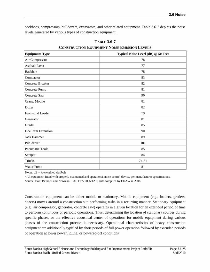
3.6 Noise
Santa Monica High School Science and Technology Building and Site Improvements Project Draft EIR Page 3.6-25 Santa Monica-Malibu Unified School District April 2010
backhoes, compressors, bulldozers, excavators, and other related equipment. Table 3.6-7 depicts the noise levels generated by various types of construction equipment.
TABLE 3.6-7 CONSTRUCTION EQUIPMENT NOISE EMISSION LEVELS
Equipment Type Typical Noise Level (dB) @ 50 Feet
Air Compressor 78
Asphalt Paver 77
Backhoe 78
Compactor 83
Concrete Breaker 82
Concrete Pump 81
Concrete Saw 90
Crane, Mobile 81
Dozer 82
Front-End Loader 79
Generator 81
Grader 85
Hoe Ram Extension 90
Jack Hammer 89
Pile-driver 101
Pneumatic Tools 85
Scraper 84
Trucks 74-81
Water Pump 81Notes: dB = A-weighted decibels *All equipment fitted with properly maintained and operational noise control device, per manufacturer specifications. Source: Bolt, Beranek and Newman 1981, FTA 2006:12-6; data compiled by EDAW in 2008
Construction equipment can be either mobile or stationary. Mobile equipment (e.g., loaders, graders, dozers) moves around a construction site performing tasks in a recurring manner. Stationary equipment (e.g., air compressor, generator, concrete saw) operates in a given location for an extended period of time to perform continuous or periodic operations. Thus, determining the location of stationary sources during specific phases, or the effective acoustical center of operations for mobile equipment during various phases of the construction process is necessary. Operational characteristics of heavy construction equipment are additionally typified by short periods of full power operation followed by extended periods of operation at lower power, idling, or powered-off conditions.

3.6 Noise
Page 3.6-26 Santa Monica High School Science and Technology Building and Site Improvements Project Draft EIR April 2010 Santa Monica-Malibu Unified School District
As indicated in Table 3.6-7, operational noise levels for typical construction activities would generate noise levels ranging from 74 to 101 dB at a distance of 50 feet. Continuous combined noise levels generated by the simultaneous operation of the loudest pieces of equipment would result in noise levels of 97 dB at 50 feet. Accounting for the usage factor of individual pieces of equipment, topographical shielding and absorption effects, construction activities on the Project site are expected to result in hourly average noise levels of 90 dB Leq, at a distance of 50 feet. Maximum noise levels generated by construction activities are not predicted to exceed 101 dB Lmax at 50 feet.
The nearest off-site noise-sensitive land uses in the Project vicinity are multi-family residences located approximately 25 feet northeast of the proposed Project boundary, or approximately 100 feet northeast of the acoustical center of the site. Noise from localized point sources (such as construction sites) typically decreases by 6 dB to 7.5 dB with each dB/DD from source to receptor. Conservatively assuming an attenuation rate of 6 dB per dB/DD, construction operations and related activities are predicted to generate exterior hourly noise levels of 81 dB Leq at the nearest off-site sensitive receptor, when propagated from the acoustical center of construction operations. The nearest noise sensitive receptors to proposed pile driving activities are multi-family residences and hotel 500 feet and 650 feet southwest, respectively. Predicted noise levels at the multi-family residences and the hotel due to pile driving activities, are 70 dB Leq and 67 dB Leq, respectively.
On-site noise-sensitive receptors include students in classrooms located 130 feet from the acoustical center of the Project site. It is predicted that construction noise would be 80 dB Leq at the Science and Technology building façade during the site preparation phase. Assuming an average exterior-to-interior noise reduction of 25 dB (with windows and doors closed), interior noise levels would exceed the 45 dB Ldn standard required for classrooms by 10 dB. It is predicted that pile driving construction noise would be 86 dB Leq at the Science and Technology building façade, resulting in classroom interior noise levels being exceeded by 16 dB.
Existing ambient noise levels in the close proximity to off-site noise sensitive receptors exceeds (See Table 3.6-1) the standards set forth in Section 4.12.060 Exterior Noise Standards of the City’s Municipal Code. Therefore, the ambient noise level is considered the noise standard during Project construction. The City’s Municipal Code (Section 4.12.110) permits construction noise to exceed the equivalent noise level (ambient Leq) by 20 dB and instantaneous maximum noise level (Lmax) by 40 dB. Based on the ambient noise survey (See Table 3.6-1) and the predicted construction noise levels due to the proposed Project, an exceedance still exists for Leq standards but not Lmax standards at the nearest noise sensitive receptors to the northeast of the Project site.
Construction activities would result in a substantial (i.e., exceeding 3 dB to 5 dB) temporary increase in ambient noise levels at nearby noise-sensitive land uses. Furthermore, if construction activities occur before 8 a.m. or after 6 p.m., Project-generated noise levels would exceed the City of Santa Monica noise standards. Mitigation measures NOISE-A through NOISE-O are required to reduce significant short-term impacts related to construction-generated noise.

3.6 Noise
Santa Monica High School Science and Technology Building and Site Improvements Project Draft EIR Page 3.6-27 Santa Monica-Malibu Unified School District April 2010
NOISE-2 Implementation of the proposed Project could result in an increase of average daily vehicle trips in the proposed Project area. The increased traffic volumes would not result in a noticeable (3 dB or greater) increase in traffic noise along roadways in and within the vicinity of the proposed Project area. This impact would be less than significant.
Long-term operation of the proposed Project would result in an increase in ADT volumes on the local roadway network and, consequently, an increase in noise levels from traffic sources along affected segments. To examine the affect of Project-generated traffic increases, traffic noise levels associated with the proposed Project were calculated for roadway segments in the Project area using the FHWA Highway Noise Prediction Model (FHWA-RD-77-108). Traffic noise levels were modeled under future 2014 conditions, with and without the implementation of the proposed Project. ADT volumes and the distribution thereof were obtained from the Project traffic consultant, as discussed in Section 3.8, Transportation and Circulation. Vehicle speeds and truck volumes on local area roadways were determined based on field observations and data provided in the traffic report prepared for this Project (KOA Corporation). Table 3.6-6 summarizes the modeled traffic noise levels at 100 feet from the centerline of affected roadway segments in the Project area. Additional input data included day/night percentages of autos, medium and heavy trucks, vehicle speeds, ground attenuation factors, and roadway widths. Refer to Appendix E of this EIR for complete modeling inputs and results.
TABLE 3.6-6 PREDICTED TRAFFIC NOISE LEVELS, FUTURE 2014
Roadway Segment Ldn at 100 Feet, dB
From To No Project Plus Project Net Significant
Interstate 10 Highway 1 Lincoln Boulevard 72 72 0 No
Olympic Boulevard 4th Street To West 59 59 0 No
Olympic Boulevard 4th Street 6th Street 63 63 0 No
Olympic Boulevard 6th Street 7th Court 51 52 +1 No
Olympic Boulevard 7th Court Lincoln Boulevard 56 56 0 No
Olympic Boulevard Lincoln Boulevard To East 62 61 -1 No
Michigan Avenue 7th Court 7th Street 49 48 -1 No
Michigan Avenue Lincoln Boulevard 7th Court 49 49 -1 No
Michigan Avenue Lincoln Boulevard To East 52 52 0 No
Pico Boulevard 4th Street Main Street 63 63 0 No
Pico Boulevard 4th Street 7th Street 61 62 0 No
Pico Boulevard Lincoln Boulevard 7th Street 61 61 0 No
Pico Boulevard Lincoln Boulevard To East 61 61 0 No
4th Street Olympic Boulevard Pico Boulevard 62 62 0 No
4th Street Pico Boulevard Bay Street 60 60 0 No
6th Street Olympic Boulevard School Center 45 49 +5 Yes1
7th Street Pico Boulevard Michigan Avenue 47 46 -1 No
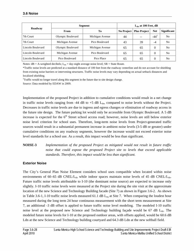
3.6 Noise
Page 3.6-28 Santa Monica High School Science and Technology Building and Site Improvements Project Draft EIR April 2010 Santa Monica-Malibu Unified School District
Roadway Segment Ldn at 100 Feet, dB
From To No Project Plus Project Net Significant
7th Court Olympic Boulevard Michigan Avenue 44 -- -441 No
7th Court Michigan Avenue Pico Boulevard 43 39 -4 No
Lincoln Boulevard Olympic Boulevard Michigan Avenue 65 65 0 No
Lincoln Boulevard Michigan Avenue Pico Boulevard 65 65 0 No
Lincoln Boulevard Pico Boulevard Pico Place 65 65 0 No
Notes: dB = A-weighted decibels; Ldn = day-night average noise level; SR = State Route. *Traffic noise levels are predicted at a standard distance of 100 feet from the roadway centerline and do not account for shielding from existing noise barriers or intervening structures. Traffic noise levels may vary depending on actual setback distances and localized shielding. 1Traffic would no longer travel along this segment in the future due to site design change. Source: Data modeled by EDAW in 2009.
Implementation of the proposed Project in addition to cumulative conditions would result in a net change in traffic noise levels ranging from -44 dB to +5 dB Ldn, compared to noise levels without the Project. Decreases in traffic noise levels are due to ingress and egress changes or elimination of roadway access in the future site design. The future parking lot would only be accessible from Olympic Boulevard. A 5 dB increase is expected for the 6th Street school access road; however, noise levels are still below exterior noise level criterion for school uses. Therefore, long-term noise levels from Project-generated traffic sources would result in a substantial permanent increase in ambient noise levels (3-5 dB or greater) under cumulative conditions on any roadway segments, however the increase would not exceed exterior noise level standards for a school use. As a result, this impact would be less than significant.
NOISE-3 Implementation of the proposed Project as mitigated would not result in future traffic noise that could expose the proposed Project site to levels that exceed applicable standards. Therefore, this impact would be less than significant.
Exterior Noise
The City’s General Plan Noise Element considers school uses compatible when located within noise environments of 60–65 dB CNEL/Ldn while indoor spaces maintain noise levels of 45 dB CNEL/Ldn. Future traffic noise levels attributable to I-10 (the dominant noise source) are expected to increase only slightly. I-10 traffic noise levels were measured at the Project site during the site visit at the approximate location of the new Science and Technology Building facade (Site 7) as shown in Figure 3.6-2. As shown in Table 3.6-1, I-10 traffic noise levels measured 61.1 dB Leq at Site 7. When comparing the loudest hour measured during the long term 24 hour continuous measurement with the short term measurement at Site 7, an additional -3 dB offset is applied to future traffic noise level modeling. The modeled I-10 traffic noise level at the proposed new Science and Technology building façade would be 67 dB Ldn. The modeled future noise levels for I-10 at the proposed outdoor areas, with offsets applied, would be 60.6 dB Ldn at the new Science and Technology building courtyard and 64.3 dB Ldn at the new softball field.

3.6 Noise
Santa Monica High School Science and Technology Building and Site Improvements Project Draft EIR Page 3.6-29 Santa Monica-Malibu Unified School District April 2010
As a result, the proposed school improvement Project site would be compatible with the City’s Land Use/Noise Compatibility Matrix, Table 3.6-4, for exterior noise.
Interior Noise
The City has established interior noise standards for school uses or for uses where speech intelligibility is essential and where communication may be affected by transportation source noise. The interior noise standards are 45 dB CNEL/Ldn in the City’s General Plan, Table 3.6-5. The proposed Project is also subject to CHPS acoustic goal requirements of background noise levels in unoccupied classrooms ranging from 35 dB to 45 dB Leq and a reverberation of 0.6-second maximum. Detailed construction designs for the proposed school buildings are not available at this time; however, this analysis assumes standard construction practices are employed and the assumed noise reduction (15 dB to 20 dB with windows open and 25 dB to 30 dB with windows closed) from common building construction.
As discussed above, modeled traffic noise levels at the proposed new Science and Technology building would be 67 dB Ldn at first floor receptors. Second floor receptors would be exposed to higher traffic noise levels emanating from I-10 due to increased line of site and accepted noise modeling practices of an additional 2-3 dB noise level increase for second and third floor receptors. This analysis shall assume a 3 dB increase in traffic noise levels for second and third floor receptors. Applying the noise reductions for common building construction discussed above, classrooms would be exposed to interior noise levels of 37 to 42 dB CNEL/Ldn at first floor receptors and 40 to 45 dB CNEL/Ldn at second and third floor receptors with windows closed (assumed noise reduction of 25 to 30 dB) and 47 to 52 dB CNEL/Ldn at first floor receptors and 50 to 55 dB CNEL/Ldn at second and third floor receptors with windows open (assumed noise reduction of 15 to 20 dB).
As a result, the proposed Project would be compatible with the City’s interior noise level standard of 45 dB Ldn for first, second, and third floor receptors with windows closed. The proposed Project would not be compatible with the City’s interior noise level standard of 45 dB Ldn for first, second, and third floor receptors with windows open.
Overall, traffic noise levels affecting the proposed Project would not exceed applicable exterior and interior (with windows closed) noise standards. Mitigation measure NOISE-P is provided to ensure that traffic noise levels would not exceed applicable exterior and interior noise standards.

3.6 Noise
Page 3.6-30 Santa Monica High School Science and Technology Building and Site Improvements Project Draft EIR April 2010 Santa Monica-Malibu Unified School District
NOISE-4 Implementation of the proposed Project would not result in increases in stationary-source noise associated with use of the proposed school. These stationary-source noises would not potentially exceed the County’s noise standards (hourly and maximum) or result in a noticeable increase in ambient noise levels. Therefore, this impact is would be less than significant.
Mechanical HVAC Equipment
HVAC equipment could be a primary noise source for sensitive receptors near individual HVAC units. HVAC equipment is often mounted on rooftops, located on the ground, or located within mechanical rooms. The noise sources could take the form of fans, pumps, air compressors, chillers, or cooling towers. Packaged rooftop units contain all necessary mechanical equipment such as fans, pumps, condenser, and compressors within a single enclosure. Noise levels generated by packaged HVAC systems can be modeled in relation to the required cooling capacity for the unit, measured in tons of refrigeration 17. However, it is assumed that a mechanical HVAC room would be part of the building design in order to reduce HVAC noise levels to acceptable levels. As a result, HVAC equipment would not exceed the City’s noise level performance standard of 50 dB Leq for noise-sensitive uses affected by nontransportation noise during the daytime period (Section 4.12.060 Exterior Noise Standards of the City’s Municipal Code), and would not result in a substantial permanent increase in ambient noise levels in the Project vicinity above levels existing without the Project.
Parking Lot Activities
The proposed Project would accommodate 253 parking stalls. Parking would be located directly adjacent to the proposed Science and Technology building and softball field, bounded by 6th Street access road to the southwest and Olympic Boulevard to the northeast. Previously conducted reference noise level measurements of parking lot activities indicate that average sound exposure levels (SEL) associated with a single parking event is 71 dB SEL at distance of 50 feet. Activities making up a single parking event included vehicle arrival, limited idling, occupants exiting the vehicle, door closures, conversations among passengers, occupants entering the vehicle, startup, and departure of the vehicle. Assuming peak hour parking operations, one vehicle arriving and departing each available parking stall, 506 events may occur. Assuming a standard attenuation rate of 6 dB/DD the combined noise level from parking lot activities would be 38.6 dB Leq at the nearest noise-sensitive receptor, located approximately 775 feet west of the center of the parking lot. As a result, parking lot operations would not exceed the City’s noise level performance standard of 50 dB Leq for residential uses affected by nontransportation noise during the daytime period (Section 4.12.060 Exterior Noise Standards of the City’s Municipal Code), nor result in a substantial permanent increase in ambient noise levels in the Project vicinity above levels existing without the Project.
17 Bolt, Beranek and Newman Inc. 1981. Noise Control for Buildings and Manufacturing Plants. Cambridge MA.
3.6 Noise
Santa Monica High School Science and Technology Building and Site Improvements Project Draft EIR Page 3.6-31 Santa Monica-Malibu Unified School District April 2010
Softball Field Activities
The proposed softball field would be located to the north of existing tennis courts on the Project site. Softball fields are intended for day use only by students. Previously conducted softball field noise measurements at an existing school site measured 63.2 dB Leq at a distance of 75 feet. The nearest noise-sensitive receptor to the softball field is located 540 feet to the southwest. The resulting noise level at the nearest noise-sensitive receptor would be 46.1 dB Leq. The City’s noise level performance standard of 50 dB Leq for noise-sensitive uses affected by nontransportation noise during the daytime period shall be adjusted by -5 dB for noise sources consisting of speech. The predicted noise levels from softball field activities would exceed the noise level performance standards. However, the dominant noise source at the nearest noise-sensitive receptor is I-10 traffic noise as described during on-site field observations. Section 4.12.030 of the City’s Municipal Code exempts activities conducted on public parks, public playgrounds, and public or private school grounds including, but not limited to, school athletic and school entertainment events. In addition, softball field activities are not expected to increase ambient noise levels in the Project vicinity above levels existing without the proposed Project due to the existing dominant traffic noise. As a result, softball field activities would not exceed the City’s noise level performance standard of 50 dB Leq for noise-sensitive uses affected by nontransportation noise during the daytime period (Section 4.12.060 Exterior Noise Standards of the City’s Municipal Code), nor would it result in a substantial permanent increase in ambient noise levels in the Project vicinity above levels existing without the Project.
In summary, increases in stationary source noise attributable to the proposed Project would result in a negligible and imperceptible increase in noise for all operational noise sources. As a result, this impact would be less than significant.
NOISE-5 Implementation of the proposed Project would result in exposing sensitive noise-receptors to groundborne noise and vibration levels that may exceed the FTA and Caltrans guidelines. These groundborne noise and vibration levels could result in annoyance or architectural/structural damage. This impact would be considered less than significant.
Construction-Induced Vibration
Construction activities have the potential to result in varying degrees of temporary ground vibration depending on the specific construction equipment used and operations involved. Ground vibration levels associated with various types of construction equipment are summarized in Table 3.6-7. Based on the representative vibration levels identified for various construction equipment types, sensitive receptors located near construction activities could be exposed to groundborne vibration levels exceeding the recommended FTA and Caltrans guidelines of 80 VdB and 0.2 in/sec PPV, respectively.
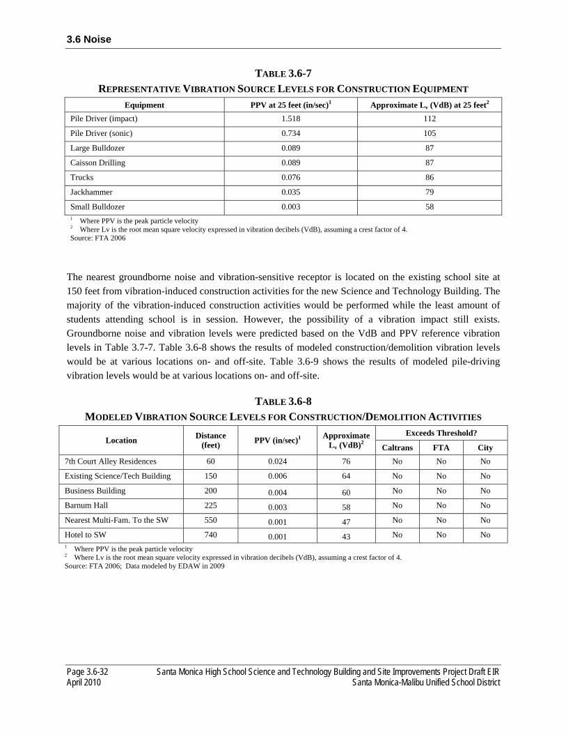
3.6 Noise
Page 3.6-32 Santa Monica High School Science and Technology Building and Site Improvements Project Draft EIR April 2010 Santa Monica-Malibu Unified School District
TABLE 3.6-7 REPRESENTATIVE VIBRATION SOURCE LEVELS FOR CONSTRUCTION EQUIPMENT
Equipment PPV at 25 feet (in/sec)1 Approximate Lv (VdB) at 25 feet2 Pile Driver (impact) 1.518 112
Pile Driver (sonic) 0.734 105
Large Bulldozer 0.089 87
Caisson Drilling 0.089 87
Trucks 0.076 86
Jackhammer 0.035 79
Small Bulldozer 0.003 58 1 Where PPV is the peak particle velocity 2 Where Lv is the root mean square velocity expressed in vibration decibels (VdB), assuming a crest factor of 4. Source: FTA 2006
The nearest groundborne noise and vibration-sensitive receptor is located on the existing school site at 150 feet from vibration-induced construction activities for the new Science and Technology Building. The majority of the vibration-induced construction activities would be performed while the least amount of students attending school is in session. However, the possibility of a vibration impact still exists. Groundborne noise and vibration levels were predicted based on the VdB and PPV reference vibration levels in Table 3.7-7. Table 3.6-8 shows the results of modeled construction/demolition vibration levels would be at various locations on- and off-site. Table 3.6-9 shows the results of modeled pile-driving vibration levels would be at various locations on- and off-site.
TABLE 3.6-8 MODELED VIBRATION SOURCE LEVELS FOR CONSTRUCTION/DEMOLITION ACTIVITIES
Location Distance (feet) PPV (in/sec)1 Approximate
Lv (VdB)2 Exceeds Threshold?
Caltrans FTA City 7th Court Alley Residences 60 0.024 76 No No No
Existing Science/Tech Building 150 0.006 64 No No No
Business Building 200 0.004 60 No No No
Barnum Hall 225 0.003 58 No No No
Nearest Multi-Fam. To the SW 550 0.001 47 No No No
Hotel to SW 740 0.001 43 No No No 1 Where PPV is the peak particle velocity 2 Where Lv is the root mean square velocity expressed in vibration decibels (VdB), assuming a crest factor of 4. Source: FTA 2006; Data modeled by EDAW in 2009

3.6 Noise
Santa Monica High School Science and Technology Building and Site Improvements Project Draft EIR Page 3.6-33 Santa Monica-Malibu Unified School District April 2010
TABLE 3.6-9 MODELED VIBRATION SOURCE LEVELS FOR PILE-DRIVING ACTIVITIES
Location Distance (feet)
PPV (in/sec)1 Approximate Lv (VdB)2
Exceeds Threshold?
Caltrans FTA City
Impact Sonic Impact Sonic Impact Sonic Existing Science/Tech 320 0.033 0.016 78 72 No No
Barnum Hall 400 0.024 0.011 76 70 No No
Business Building 415 0.022 0.011 75 69 No No
Nearest Multi-Fam. To the SW 505 0.017 0.008 72 66 No No
7th Court Alley Residences 525 0.016 0.008 72 66 No No
Hotel to SW 585 0.013 0.006 71 64 No No 1 Where PPV is the peak particle velocity 2 Where Lv is the root mean square velocity expressed in vibration decibels (VdB), assuming a crest factor of 4. Source: FTA 2006; Data modeled by EDAW in 2009
Predicted groundborne noise and vibration levels would range from 43 and 78 VdB and .0001 and 0.024 in/sec PPV. As a result, vibration-induced construction activities would not exceed recommended Caltrans standard of 0.2 in/sec PPV regarding the prevention of structural damage for normal buildings, FTA’s maximum acceptable vibration standard of 78 VdB regarding human response (i.e., annoyance) at nearby vibration-sensitive land uses (i.e., school), or the City of Santa Monica Municipal Code vibration standard, nor expose persons to or generate excessive groundborne vibration or groundborne noise levels. As a result, this impact would be less than significant.
3.6.4 MITIGATION MEASURES
No single feasible mitigation measure can reduce all potential construction noise impacts to less than significant. However, a mitigation measure or combination of measures can reduce a specific significant construction noise event. The following list of mitigation measures used singularly or jointly will ensure that construction-related noise levels are reduced to less-than-significant levels.
NOISE-A Prior to construction, the contractor shall submit a list of equipment and activities required during construction to the SMMUSD in order to ensure proper planning of the most intense construction activities during time periods that would least impact the campus operation.
NOISE-B Construction equipment shall be properly maintained per manufacturers’ specifications and fitted with the best available noise suppression devices (e.g., mufflers, silencers, wraps). All impact tools shall be shrouded or shielded, and all intake and exhaust ports on power equipment shall be muffled or shielded.
NOISE-C Construction operations and related activities associated with the proposed Project shall comply with the operational hours outlined in the City of Santa Monica Municipal Code:
3.6 Noise
Page 3.6-34 Santa Monica High School Science and Technology Building and Site Improvements Project Draft EIR April 2010 Santa Monica-Malibu Unified School District
construction operations shall be limited to between the hours of 8 a.m. and 6 p.m. on weekdays and beginning at 9 a.m. through 5 p.m. on Saturdays.
NOISE-D Construction equipment shall not idle for extended periods of time near noise-sensitive receptors.
NOISE-E Fixed/stationary equipment (e.g., generators, compressors, rock crushers, cement mixers) shall be located as far as possible from noise-sensitive receptors. Shroud or shield all impact tools, and muffle or shield all in-take and exhaust ports on powered construction equipment.
NOISE-F Sound blankets shall be used on construction equipment where technically feasible.
NOISE-G SMMUSD’s construction contractors and subcontractors shall be required through contract specifications to locate construction staging areas, construction worker parking, and material stockpiling as far away from vibration- and noise-sensitive sites as possible. Additionally, these activities shall be located away from occupied buildings on campus, occupied residential dwellings adjacent to the campus, and other sensitive receptors, where feasible.
NOISE-H The most noise intensive construction activities (e.g., grading and pile driving) shall be conducted during the time period when classrooms have the least number of attendees.
NOISE-I Stagger high noise construction activities from one another.
NOISE-J Classroom use rescheduling to move active classes away from high noise construction activities will take place, as necessary.
NOISE-K Scheduling of interior high noise construction activities during off school hours will take place, as necessary.
NOISE-L Active noise-cancelling systems will be used, when available.
NOISE-M A qualified acoustical consultant shall conduct an exterior-to-interior noise study in the nearest classroom during construction activities to determine the acoustical transmission loss from classroom building façade wall assembly relative to construction noise.
NOISE-N Upgrade the seals of classroom windows and/or doors.
NOISE-O A construction relations officer shall be appointed by the SMMUSD to act as a public liaison concerning on-site construction activity. If complaints regarding exterior noise are received by the construction relations officer from either persons on campus or adjacent residential uses, SMMUSD shall enforce all mitigation measures and noise maximums that will be included in the construction contract(s). If complaints regarding interior classroom noise levels are received by the construction relations officer, additional
3.6 Noise
Santa Monica High School Science and Technology Building and Site Improvements Project Draft EIR Page 3.6-35 Santa Monica-Malibu Unified School District April 2010
intermittent noise monitoring will take place on site to ensure that a sustained noise level equivalent to 50 dBA is maintained within operating classrooms. If a sustained interior noise level equivalent to 50 dBA is not maintained, construction activities must be altered, rescheduled, or reduced to ensure that this noise level is attained.
NOISE-P SMMUSD shall ensure that, upon completion of construction of the new Science and Technology building, interior noise levels attributable to traffic noise would achieve applicable interior noise standards and Project-specific goals for interior noise levels (CHPS and acoustic goal requirements of background noise levels in unoccupied classrooms ranging from 35 dB to 45 dB Leq and a reverberation of 0.6-second maximum). The measures for achieving Project specific classroom acoustic goals include but are not limited to:
• Construction plans for classroom buildings shall include external wall assemblies and interior finishing materials within classrooms to comply with CHPS acoustical goal requirements as stated above;
• External walls to classrooms designed to achieve a minimum sound transmission class (STC) rating of 46;
• Post construction exterior-to-interior traffic noise levels shall be confirmed by a qualified acoustical consultant.
3.6.5 SIGNIFICANCE AFTER MITIGATION
Construction operations are exempt when limited to daytime hours and recommended mitigation measures are provided above to reduce noise levels; however, it should be noted that construction operations are expected to result in a temporary or periodic increase in ambient noise levels in the Project vicinity above levels existing without the proposed Project. Mitigation measures NOISE-A through NOISE-O are required to reduce significant short-term impacts related to construction-generated noise. Therefore, short-term construction-generated noise levels would be a less than significant impact.
Implementation of mitigation measure Noise-P would reduce traffic noise to acceptable interior noise levels by identifying specific construction measures to meet Project-specific interior noise level goals. Therefore, traffic noise levels would be a less than significant impact.
3.6 Noise
Page 3.6-36 Santa Monica High School Science and Technology Building and Site Improvements Project Draft EIR April 2010 Santa Monica-Malibu Unified School District
This page is intentionally left blank.
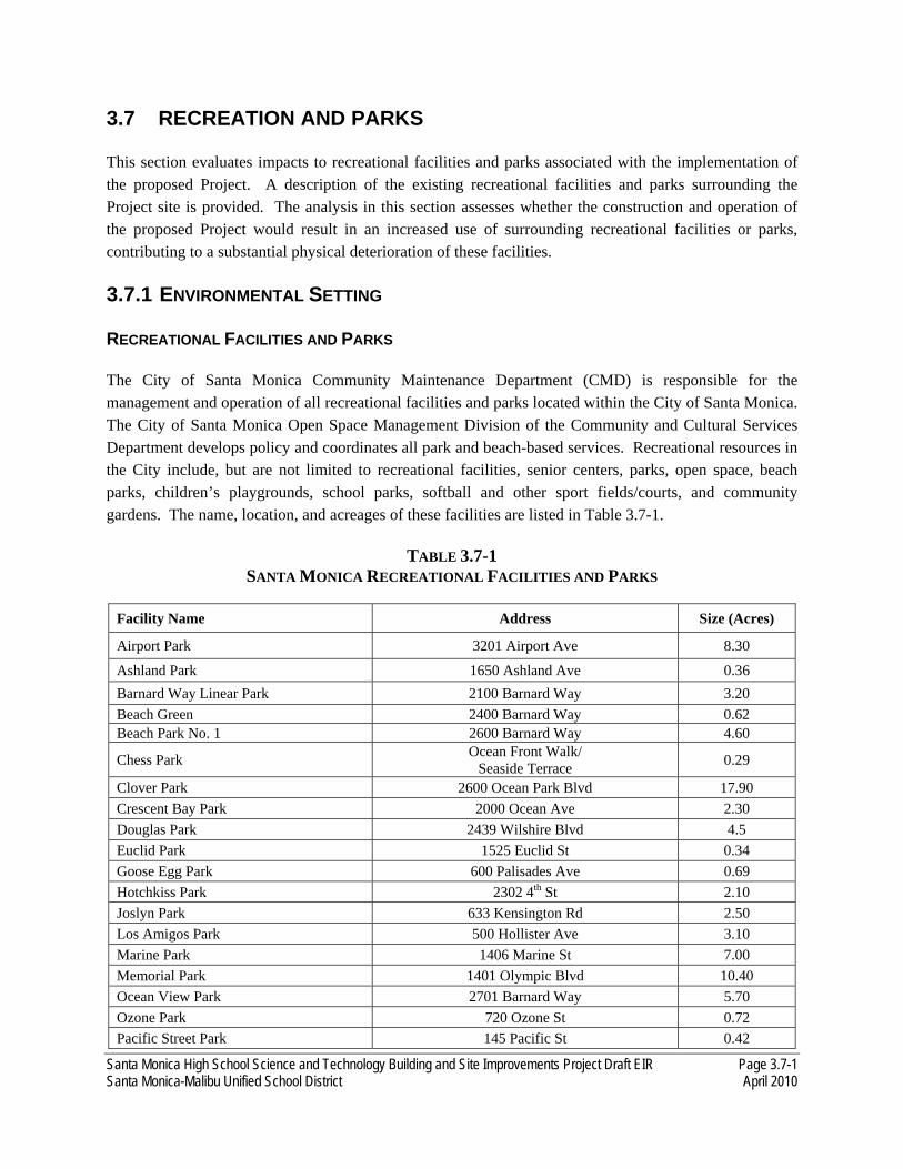
Santa Monica High School Science and Technology Building and Site Improvements Project Draft EIR Page 3.7-1 Santa Monica-Malibu Unified School District April 2010
3.7 RECREATION AND PARKS
This section evaluates impacts to recreational facilities and parks associated with the implementation of the proposed Project. A description of the existing recreational facilities and parks surrounding the Project site is provided. The analysis in this section assesses whether the construction and operation of the proposed Project would result in an increased use of surrounding recreational facilities or parks, contributing to a substantial physical deterioration of these facilities.
3.7.1 ENVIRONMENTAL SETTING
RECREATIONAL FACILITIES AND PARKS
The City of Santa Monica Community Maintenance Department (CMD) is responsible for the management and operation of all recreational facilities and parks located within the City of Santa Monica. The City of Santa Monica Open Space Management Division of the Community and Cultural Services Department develops policy and coordinates all park and beach-based services. Recreational resources in the City include, but are not limited to recreational facilities, senior centers, parks, open space, beach parks, children’s playgrounds, school parks, softball and other sport fields/courts, and community gardens. The name, location, and acreages of these facilities are listed in Table 3.7-1.
TABLE 3.7-1 SANTA MONICA RECREATIONAL FACILITIES AND PARKS
Facility Name Address Size (Acres)
Airport Park 3201 Airport Ave 8.30
Ashland Park 1650 Ashland Ave 0.36 Barnard Way Linear Park 2100 Barnard Way 3.20 Beach Green 2400 Barnard Way 0.62 Beach Park No. 1 2600 Barnard Way 4.60
Chess Park Ocean Front Walk/ Seaside Terrace 0.29
Clover Park 2600 Ocean Park Blvd 17.90 Crescent Bay Park 2000 Ocean Ave 2.30 Douglas Park 2439 Wilshire Blvd 4.5 Euclid Park 1525 Euclid St 0.34 Goose Egg Park 600 Palisades Ave 0.69 Hotchkiss Park 2302 4th St 2.10 Joslyn Park 633 Kensington Rd 2.50 Los Amigos Park 500 Hollister Ave 3.10 Marine Park 1406 Marine St 7.00 Memorial Park 1401 Olympic Blvd 10.40 Ocean View Park 2701 Barnard Way 5.70 Ozone Park 720 Ozone St 0.72 Pacific Street Park 145 Pacific St 0.42
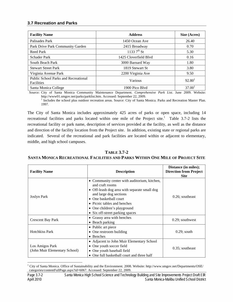
3.7 Recreation and Parks
Page 3.7-2 Santa Monica High School Science and Technology Building and Site Improvements Project Draft EIR April 2010 Santa Monica-Malibu Unified School District
Facility Name Address Size (Acres)
Palisades Park 1450 Ocean Ave 26.40 Park Drive Park Community Garden 2415 Broadway 0.70 Reed Park 1133 7th St 5.30 Schader Park 1425 Cloverfield Blvd 0.16 South Beach Park 3000 Barnard Way 1.80 Stewart Street Park 1819 Stewart St 3.80 Virginia Avenue Park 2200 Virginia Ave 9.50 Public School Parks and Recreational Facilities Various 92.801
Santa Monica College 1900 Pico Blvd 37.001 Source: City of Santa Monica Community Maintenance Department. Comprehensive Park List. June 2009. Website:
http://www01.smgov.net/parks/parklist.htm. Accessed: September 22, 2009. 1 Includes the school plus outdoor recreation areas. Source: City of Santa Monica. Parks and Recreation Master Plan.
1997.
The City of Santa Monica includes approximately 425 acres of parks or open space, including 14 recreational facilities and parks located within one mile of the Project site.1 Table 3.7-2 lists the recreational facility or park name, description of services provided at the facility, as well as the distance and direction of the facility location from the Project site. In addition, existing state or regional parks are indicated. Several of the recreational and park facilities are located within or adjacent to elementary, middle, and high school campuses.
TABLE 3.7-2 SANTA MONICA RECREATIONAL FACILITIES AND PARKS WITHIN ONE MILE OF PROJECT SITE
Facility Name Description Distance (in miles);
Direction from Project Site
Joslyn Park
• Community center with auditorium, kitchen, and craft rooms
• Off-leash dog area with separate small dog and large dog sections
• One basketball court • Picnic tables and benches • One children’s playground • Six off-street parking spaces
0.26; southeast
Crescent Bay Park • Grassy area with benches • Beach parking 0.29; southwest
Hotchkiss Park • Public art piece • One restroom building • Benches
0.29; south
Los Amigos Park (John Muir Elementary School)
• Adjacent to John Muir Elementary School • One youth soccer field • One youth baseball field • One full basketball court and three half
0.35; southeast
1 City of Santa Monica. Office of Sustainability and the Environment. 2008. Website: http://www.smgov.net/Departments/OSE/ categories/contentFullPage.aspx?id=6067. Accessed: September 22, 2009.

3.7 Recreation and Parks
Santa Monica High School Science and Technology Building and Site Improvements Project Draft EIR Page 3.7-3 Santa Monica-Malibu Unified School District April 2010
Facility Name Description Distance (in miles);
Direction from Project Site
courts, with lighting • Two tennis courts (one with lighting) • Four handball courts with lighting • One children’s playground • One restroom building
Santa Monica State Beach
• Picnic area • Shops • Pier • Volleyball courts • Basketball courts
0.35; west
Will Rogers Elementary School • One playing field • Basketball courts 0.36; west
Olympic High School (Continuation) • Two basketball courts 0.44; southeast
Palisades Park
• Senior Center • Shuffleboard courts • Visitors Center kiosk • Camera Obscura • Picnic areas and benches • Rose garden • Beacon overlook • Three restroom buildings
0.44; west
Memorial Park
• Memorial Park Gym • Police Activities League • Community meeting rooms • Two youth baseball fields with concession
stand • One adult baseball field • Three softball infields • One soccer field • One children’s playground • Four tennis courts with lighting • One off-leash dog run • The Cove skatepark • 63 off-street parking spaces • One restroom building
0.60; northeast
Ocean View Park • Two junior paddle tennis courts • One basketball court with lighting • Six tennis courts
0.67; south
Santa Monica College • Basketball courts • One gym
0.69; northeast
Reed Park
• CREST program/youth offices • Miles Memorial Playhouse • Two basketball courts • Croquet and horseshoe court • One children’s playground • Six tennis courts with lighting • Public restrooms
0.73; northwest
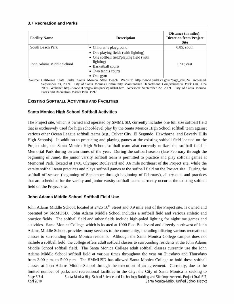
3.7 Recreation and Parks
Page 3.7-4 Santa Monica High School Science and Technology Building and Site Improvements Project Draft EIR April 2010 Santa Monica-Malibu Unified School District
Facility Name Description Distance (in miles);
Direction from Project Site
South Beach Park • Children’s playground 0.85; south
John Adams Middle School
• One playing fields (with lighting) • One softball field/playing field (with
lighting) • Basketball courts • Two tennis courts • One gym
0.90; east
Source: California State Parks. Santa Monica State Beach. Website: http://www.parks.ca.gov/?page_id=624. Accessed: September 23, 2009. City of Santa Monica Community Maintenance Department. Comprehensive Park List. June 2009. Website: http://www01.smgov.net/parks/parklist.htm. Accessed: September 22, 2009. City of Santa Monica. Parks and Recreation Master Plan. 1997.
EXISTING SOFTBALL ACTIVITIES AND FACILITIES
Santa Monica High School Softball Activities
The Project site, which is owned and operated by SMMUSD, currently includes one full size softball field that is exclusively used for high school-level play by the Santa Monica High School softball team against various other Ocean League softball teams (e.g., Culver City, El Segundo, Hawthorne, and Beverly Hills High Schools). In addition to practicing and playing games at the existing softball field located on the Project site, the Santa Monica High School softball team also currently utilizes the softball field at Memorial Park during certain times of the year. During the softball season (late February through the beginning of June), the junior varsity softball team is permitted to practice and play softball games at Memorial Park, located at 1401 Olympic Boulevard and 0.6 mile northeast of the Project site, while the varsity softball team practices and plays softball games at the softball field on the Project site. During the softball off-season (beginning of September through beginning of February), all try-outs and practices that are scheduled for the varsity and junior varsity softball teams currently occur at the existing softball field on the Project site.
John Adams Middle School Softball Field Use
John Adams Middle School, located at 2425 16th Street and 0.9 mile east of the Project site, is owned and operated by SMMUSD. John Adams Middle School includes a softball field and various athletic and practice fields. The softball field and other fields include high-poled lighting for nighttime games and activities. Santa Monica College, which is located at 1900 Pico Boulevard and directly northwest of John Adams Middle School, provides many services to the community, including offering various recreational classes to surrounding Santa Monica residents. Although the Santa Monica College campus does not include a softball field, the college offers adult softball classes to surrounding residents at the John Adams Middle School softball field. The Santa Monica College adult softball classes currently use the John Adams Middle School softball field at various times throughout the year on Tuesdays and Thursdays from 3:00 p.m. to 5:00 p.m. The SMMUSD has allowed Santa Monica College to hold these softball classes at John Adams Middle School through the execution of an agreement. Currently, due to the limited number of parks and recreational facilities in the City, the City of Santa Monica is seeking to

3.7 Recreation and Parks
Santa Monica High School Science and Technology Building and Site Improvements Project Draft EIR Page 3.7-5 Santa Monica-Malibu Unified School District April 2010
utilize John Adams Middle School recreational facilities to assist in implementing their Middle School Programs (i.e., youth sports leagues, enrichment classes, and camps).2
Memorial Park Softball Field Use
The City of Santa Monica owns and operates Memorial Park. This park includes three softball fields with high-poled lighting for nighttime activities. The City of Santa Monica currently offers men’s, women’s, and a coed softball leagues at Memorial Park to the adult residents in the area three times per year; spring, summer, and fall/winter. The men’s leagues include a 12-game season which typically plays games Tuesday through Friday evenings (6:45 p.m. through 10:00 p.m.).3 The women’s leagues include a 12-game season which typically plays games on Monday evenings. The coed leagues include a 12-game season which typically plays on Sunday mornings, afternoons, and early evenings.4 As previously mentioned, the Santa Monica High School junior varsity softball team utilizes Memorial Park for practice and games during the softball season.
3.7.2 REGULATORY SETTING
The construction and operation of the proposed Project would not be subject to the policies outlined within the City of Santa Monica General Plan. In July 2009, the SMMUSD Board of Education adopted a resolution that exempted the proposed Project from the requirements of the General Plan.5 As such, the discussion of the General Plan is provided below as background information only.
CITY OF SANTA MONICA GENERAL PLAN
The City of Santa Monica General Plan was adopted in 1984. As required by state law, the General Plan is a set of policies and programs that form a blueprint for physical development throughout the City. The General Plan is a long-term, comprehensive document that defines how the City should develop and is a key planning tool for land use decision making. General plans are required to address seven areas or elements: land use, circulation, housing, conservation, open space, noise, and safety.
The Open Space Element was updated in 1997 and provides objectives and policies for the purpose of establishing a long-range vision for the future development of parks and open space within the City. The Open Space Element outlines objectives and policies related to the preservation of open space, development of new areas of open space, and open space connectivity.6
2 Correspondence with Carey Upton, Director of Theater Operations and Facility Permits, Santa Monica-Malibu Unified School District. September 29, 2009.
3 City of Santa Monica. Recscape Fall 2009. Website: http://www.smgov.net/uploadedFiles/Departments/CMO/ CommGovRel/RecScapeFall2009.pdf. Accessed: September 25, 2009.
4 City of Santa Monica. Adult Sports-Softball. Website: http://www01.smgov.net/comm_progs/community_sports/Softball.htm. Accessed: September 24, 2009.
5 Santa Monica-Malibu Unified School District. Resolution 09-03. July 16, 2009. 6 City if Santa Monica. Open Space Element. Roma Design Group, March 1997. Available at http://www01.smgov.net/parks/. Accessed April 9, 2010.

3.7 Recreation and Parks
Page 3.7-6 Santa Monica High School Science and Technology Building and Site Improvements Project Draft EIR April 2010 Santa Monica-Malibu Unified School District
CITY OF SANTA MONICA PARKS AND RECREATION MASTER PLAN
The City of Santa Monica Parks and Recreation Master Plan (Master Plan) was adopted in 1997. The Master Plan is intended to guide the improvement of the City’s parks and recreational facilities for 20 years from its adoption. The preparation of the Master Plan was based on the City of Santa Monica General Plan Open Space Element and it sets forth specific actions to assist in implementing the Open Space Element. The Master Plan describes the existing recreational themes and challenges in the City, discusses the role of schools as possible neighborhood park sites, recreational trends and preferences, master plan strategies, and methods of Master Plan implementation.7
3.7.3 ENVIRONMENTAL IMPACTS
THRESHOLDS OF SIGNIFICANCE
As part of the Initial Study (see Appendix A), it was determined that the proposed Project would not require the construction or expansion of recreational facilities that might have an adverse effect on the environment. Accordingly, this issue is not further analyzed in the EIR.
Pursuant to the CEQA Guidelines, the proposed Project would have a significant effect on recreation and parks if the proposed Project would increase the use of existing neighborhood and regional parks or other recreational facilities such that substantial physical deterioration of the facility would occur or be accelerated.
IMPACT ANALYSIS
REC-1: The proposed Project would increase the use of existing neighborhood and regional parks or other recreational facilities; however not such that substantial physical deterioration of the facility would occur or be accelerated. The impact would be significant.
Construction
During the demolition of the existing Science and Technology Buildings, and the construction of the new Science and Technology Building, softball field, and reconfigured parking lot, the existing softball field on the Project site would be removed and no softball field facilities would be available for use on the Project site from the third quarter of 2011 to the end in the second quarter of 2014 (approximately three years). During the proposed Project construction phase, the existing softball activities on the Project site would be temporarily relocated to Memorial Park and John Adams Middle School.
During the construction phase, the Santa Monica High School varsity softball team would practice and play softball games at the John Adams Middle School softball field for the entire school-year, from the beginning of September through the beginning of June. As such, all varsity softball team practices and
7 City of Santa Monica. Parks and Recreation Master Plan. 1997. Available at http://www01.smgov.net/parks/. Accessed April 2010.

3.7 Recreation and Parks
Santa Monica High School Science and Technology Building and Site Improvements Project Draft EIR Page 3.7-7 Santa Monica-Malibu Unified School District April 2010
games in both the season and off-season take place at John Adams Middle School. During the off-season, the varsity softball team’s practices would occur at John Adams Middle School from 2:45 p.m. to 5:00 p.m., each school day. During the season, the varsity softball team would practice and play softball games from 2:45 p.m. to 5:00 p.m. on Monday through Friday, and from 9:00 a.m. to 12:00 p.m. on Saturdays at the softball field at John Adams Middle School. However, the varsity softball team may require additional time during the season, resulting in the use of the facility up until 5:30 p.m. on weekdays and up until 12:30 p.m. on Saturdays, or occasionally, later.
Similar to the varsity softball team, the junior varsity softball team would also practice at the John Adams Middle School softball field during the off-season. During the off-season, junior varsity softball team’s practices would occur at the softball field at John Adams Middle School from 2:45 p.m. to 5:00 p.m., each school day. However, during the softball season, the junior varsity softball team would continue to be permitted to play games and practice at the softball field at Memorial Park, the same as existing conditions. As such, the construction of the proposed Project would not result in an increase in the use of Memorial Park such that substantial physical deterioration of the facility would occur or be accelerated.
The temporary use of the John Adams Middle School softball field by the Santa Monica High School softball teams during the construction phase would impact the existing Santa Monica College adult softball classes that currently use the John Adams Middle School softball field. The Santa Monica College adult softball classes currently use this softball field at various times throughout the year on Tuesdays and Thursdays from 3:00 p.m. to 5:00 p.m. This current use would conflict with the proposed use of the softball field by Santa Monica High School softball teams during the school-year from 2:45 p.m. to 5:30 p.m. each school day, which would include Tuesdays and Thursdays. In addition, the primary softball field at John Adams Middle School, there is also an additional practice softball field. This additional practice softball field does not have the amenities that the primary softball field has, including full-size backstop fencing for safety purposes. It is assumed that the Santa Monica High School softball teams would use the primary softball field because the school is owned by SMMUSD. It is unknown at this time if the additional practice softball field would be appropriate for use by the Santa Monica College adult softball classes. In addition, the construction phase would impact any City of Santa Monica Middle School Programs that may be utilizing the John Adams Middle School softball field at the time of the start of construction. As such, the proposed Project would result in a temporary increase in the use of the John Adams Middle School softball field during the construction phase; however substantial physical deterioration of the facility would not be expected due to the short-term nature and relative infrequency of use at this site by Santa Monica High School students. A significant impact is anticipated related to the temporary increase in demand and use of the John Adams Middle School softball field facilities. Mitigation measure REC-A and REC-B are provided to ensure that temporary impacts are reduced to less than significant levels.
3.7 Recreation and Parks
Page 3.7-8 Santa Monica High School Science and Technology Building and Site Improvements Project Draft EIR April 2010 Santa Monica-Malibu Unified School District
Operations
After the completion of the construction phase, the Project site would operate similar to existing conditions. The Santa Monica High School softball teams would use the new softball field on the Project site, as well as Memorial Park, the same as existing conditions. Therefore, the operations of the proposed Project would not result in an increase in the use of existing neighborhood and regional parks or other recreational facilities such that substantial physical deterioration of the facility would occur or be accelerated. No mitigation measures are necessary.
3.7.4 MITIGATION MEASURES
REC-A Prior to construction, the SMMUSD and Santa Monica College shall execute a Memorandum of Understanding, which coordinates the joint use of the John Adams Middle School softball field (and other recreational facilities, if applicable) during the proposed Project construction phase (approximately three years).
REC-B Prior to construction, the SMMUSD and the City of Santa Monica shall execute a Memorandum of Understanding, which coordinates the use of the joint use of John Adams Middle School softball field (and other recreational facilities, if applicable) during the proposed Project construction phase (approximately three years).
3.7.5 SIGNIFICANCE AFTER MITIGATION
The proposed Project would significantly increase the use of John Adams Middle School recreational facilities during the construction phase, but substantial physical deterioration of the facility would not be expected. The implementation of mitigation measures REC-A and REC-B would reduce construction impacts to John Adams Middle School recreational facilities to less than significant levels. Impacts during the operational phase would be less than significant.

Santa Monica High School Science and Technology Building and Site Improvements Project Draft EIR Page 3.8-1 Santa Monica-Malibu Unified School District April 2010
3.8 TRANSPORTATION AND TRAFFIC
This section summarizes the traffic study prepared by KOA Corporation. A complete copy of the traffic study is included in Appendix F of this EIR. The scope and methodology for the traffic study was developed in conjunction with the City of Santa Monica Transportation Department staff. The base assumptions, technical methodologies, and geographic coverage of the study were all identified as part of the study approach. The study, which analyzes the potential project-generated traffic impacts on the street system, assumes completion of the proposed project in 2014. The potential impacts of the proposed Project are therefore determined for 2014 conditions and include an analysis of the following traffic scenarios:
• Existing Conditions: The analysis of existing traffic conditions provides a basis for the remainder of the study. The existing conditions analysis includes an assessment of present streets, traffic volumes, and operating conditions.
• Existing Conditions with project: This is an analysis of existing traffic conditions with the traffic generated by the proposed Project, considering the present streets, traffic volumes, and operating conditions.
• Future Without project Conditions: Future traffic conditions are projected for 2014 without the proposed Project. The objective of this phase of analysis is to estimate future traffic growth and operating conditions that could be expected to result from growth in the vicinity of the project site by 2014, absent the proposed Project.
• Future With project Conditions: This is an analysis of future traffic conditions with the traffic generated by the proposed Project added to the future without the proposed Project traffic forecasts. The impacts of the proposed Project on future traffic operating conditions can then be identified.
3.8.1 ENVIRONMENTAL SETTING
Data was collected to develop a detailed description of existing conditions within the study area. The assessment of conditions relevant to this study includes an inventory of the street system, traffic volumes on these facilities, and operating conditions at the study intersections.
In conjunction with City of Santa Monica staff, a total of nine intersections were identified and are analyzed in the EIR for weekday morning and afternoon peak hour conditions. Four of the nine study intersections are stop-sign controlled, while the remaining five intersections are signalized. All of the study intersections are located within the City of Santa Monica. The locations of the study intersections are shown on Figure 3.8-1 and the study intersection geometry are shown on Figure 3.8-2. The study intersections are listed in Table 3.8-1.
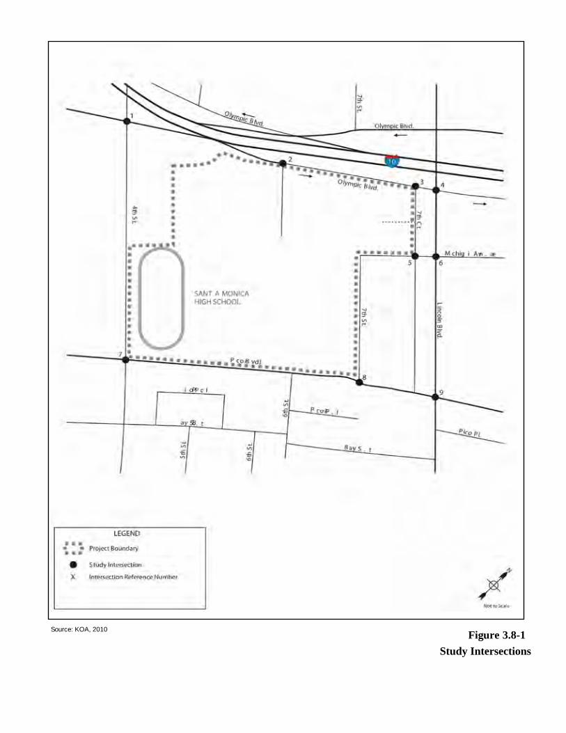
Study IntersectionsFigure 3.8-1Source: KOA, 2010
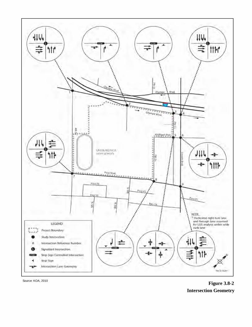
Intersection GeometryFigure 3.8-2Source: KOA, 2010
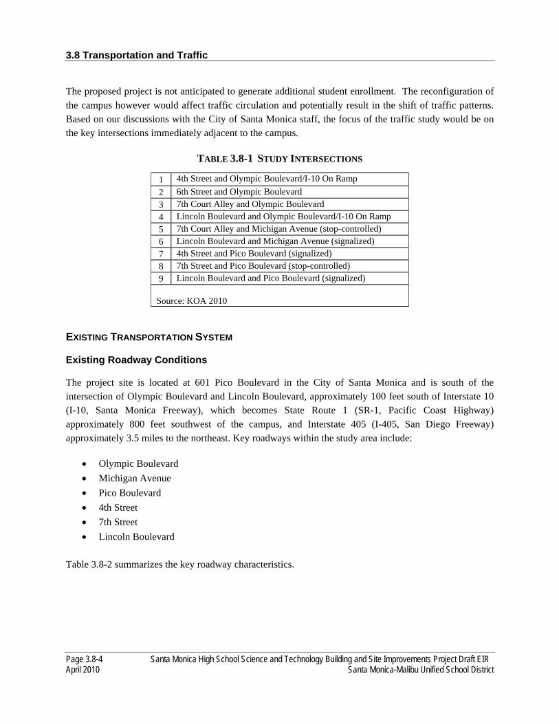
3.8 Transportation and Traffic
Page 3.8-4 Santa Monica High School Science and Technology Building and Site Improvements Project Draft EIR April 2010 Santa Monica-Malibu Unified School District
The proposed project is not anticipated to generate additional student enrollment. The reconfiguration of the campus however would affect traffic circulation and potentially result in the shift of traffic patterns. Based on our discussions with the City of Santa Monica staff, the focus of the traffic study would be on the key intersections immediately adjacent to the campus.
TABLE 3.8-1 STUDY INTERSECTIONS
1 4th Street and Olympic Boulevard/I-10 On Ramp 2 6th Street and Olympic Boulevard 3 7th Court Alley and Olympic Boulevard 4 Lincoln Boulevard and Olympic Boulevard/I-10 On Ramp 5 7th Court Alley and Michigan Avenue (stop-controlled) 6 Lincoln Boulevard and Michigan Avenue (signalized) 7 4th Street and Pico Boulevard (signalized) 8 7th Street and Pico Boulevard (stop-controlled) 9 Lincoln Boulevard and Pico Boulevard (signalized)
Source: KOA 2010
EXISTING TRANSPORTATION SYSTEM
Existing Roadway Conditions
The project site is located at 601 Pico Boulevard in the City of Santa Monica and is south of the intersection of Olympic Boulevard and Lincoln Boulevard, approximately 100 feet south of Interstate 10 (I-10, Santa Monica Freeway), which becomes State Route 1 (SR-1, Pacific Coast Highway) approximately 800 feet southwest of the campus, and Interstate 405 (I-405, San Diego Freeway) approximately 3.5 miles to the northeast. Key roadways within the study area include:
• Olympic Boulevard • Michigan Avenue • Pico Boulevard • 4th Street • 7th Street • Lincoln Boulevard
Table 3.8-2 summarizes the key roadway characteristics.

3.8 Transportation and Traffic
Santa Monica High School Science and Technology Building and Site Improvements Project Draft EIR Page 3.8-5 Santa Monica-Malibu Unified School District April 2010
TABLE 3.8-2 KEY ROADWAY DESCRIPTIONS
Segment
# Lanes
Median Type
Parking Restrictions
General Land Use
Posted Speed Limit (mph)
NB/EB SB/WB North Side /
East Side
South Side / West Side
Olympic Boulevard
West of 4th St 3 0 Striped
NPAT exp Fire & Police
vehicles
NP, red curb Commercial 35
Between 4th St & 6th St 1 0 Striped NSAT
NSAT; NPAT 7-
9AM & 2-4PM exp Passenger loading Mon-Fri
School 35
Between 6th St & Lincoln Blvd 2 0 Striped NSAT
NPAT 7-9AM & 2-4PM exp Passenger loading Mon-Fri
School 35
East of Lincoln Blvd 2 0 Striped NSAT NP Commercial/Residential 35
Michigan Avenue
West of Lincoln Blvd 1 1 Not
Striped
2 Hour Parking 9AM-6PM;
NP3-5AM Thur
2 Hour Parking
9AM-6PM; NP3-5AM
Tue
Residential 25
East of Lincoln Blvd 1 1 Not
Striped
NP 6PM-9AM; 2
Hour Parking 9AM-
6PM; NP 2-4PM Mon
NP 6PM-9AM; 2
Hour Parking
9AM-6PM; NP 1-3PM
Tue
Residential 25
Pico Boulevard
West of 4th St 2 2 Striped NSAT NSAT Commercial 35
Between 4th St & 7th St 2 2 Striped/
Raised NSAT NSAT School/ Commercial 35
Between 7th St & Lincoln Blvd 2 2 Striped/
Raised NP, red
curb NSAT Commercial 35
East of Lincoln Blvd 2 2 Striped NP, red
curb
NP 3-5AM; 2 Hour Parking
9AM-6PM
Commercial 35

3.8 Transportation and Traffic
Page 3.8-6 Santa Monica High School Science and Technology Building and Site Improvements Project Draft EIR April 2010 Santa Monica-Malibu Unified School District
4th Street North of Olympic Blvd 2 2 Striped NSAT NSAT Commercial 30
Between Olympic Blvd & Pico Blvd 2 2 Striped NSAT NSAT Commercial 30
South of Pico Blvd 2 2 Striped NSAT NP 3-5PM Tue Commercial 30
7th Street
Between Michigan Ave & Pico Blvd 1 1 Striped
NPAT exp with
permit; NP
11AM-1PM Tue
NP 7-9AM & 2-4PM
exp passenger loading
Mon-Fri; 1 Hour
Parking 9AM-2PM; NP 10AM-12PM Wed
School/ Residential 25
Lincoln Boulevard Between Olympic Blvd & Michigan Ave
3 2 Striped NP NP Commercial 35
Between Michigan Ave & Pico Blvd 2 2 Striped
NP 3-5AM; 2
Hour Parking 9AM-6PM
NS 3-9AM & 4-6PM; 2
Hour Parking
9AM-4PM exp Sun
Commercial 35
South of Pico Blvd 2 2 Striped
NP 3-5AM; 2
Hour Parking 9AM-6PM
NS 3-9AM & 4-6PM; 2
Hour Parking
9AM-4PM exp Sun
Commercial 35
Source: KOA 2010 Notes: NS - No Stopping NP - No Parking NSAT - No Stopping Any Time NPAT - No Parking Any Time
3.8 Transportation and Traffic
Santa Monica High School Science and Technology Building and Site Improvements Project Draft EIR Page 3.8-7 Santa Monica-Malibu Unified School District April 2010
Existing Transit Conditions
The City of Santa Monica and Los Angeles County Metropolitan Transportation Authority (Metro) and the operate bus lines in the vicinity of the project Site. A brief description of the routes is provided below. Figure 3.8-3 illustrates the transit lines within the study area.
Big Blue Bus Line 2 is a route between UCLA and Venice. Within the study area it travels north and south along 4th Street. Service is provided on weekdays, weekends, and holidays.
Big Blue Bus Line 3 is a route between the Green Line Station and the UCLA Hilgard Terminal. Within the study area it travels east and west along Pico Boulevard. Service is provided on weekdays, weekends, and holidays.
Big Blue Bus Line 4 is a route between Westside Pavilion and the Santa Monica Civic Center. Within the study area it travels north and south along 4th Street. Service is provided on weekdays, weekends, and holidays.
Big Blue Bus Line 7 is a route between Rimpau Transit Center and Santa Monica. Within the study area it travels east and west along Pico Boulevard. Service is provided on weekdays, weekends, and holidays.
Big Blue Bus Line 9 is a route between Pacific Palisades and Santa Monica. Within the study area it travels north and south along 4th Street. Service is provided on weekdays, weekends, and holidays.
Metro Line Rapid 3 is a rapid bus route that operates between the Green Line Station and Santa Monica. Within the study area it travels north and south along Lincoln Boulevard and east and west along Pico Boulevard. Service is provided only on weekdays.
Metro Line Rapid 7 is a rapid bus route that operates between the Rimpau Transit Center and Santa Monica. Within the study area it travels north and south along Lincoln Boulevard and east and west along Pico Boulevard. Service is provided only on weekdays.

Existing Transit Services
Figure 3.8-3Source: KOA, 2010
3.8 Transportation and Traffic
Santa Monica High School Science and Technology Building and Site Improvements Project Draft EIR Page 3.8-9 Santa Monica-Malibu Unified School District April 2010
EXISTING TRAFFIC VOLUMES AND LEVELS OF SERVICE
The following discussion presents the existing peak hour turning movement traffic volumes for each of the intersections analyzed in the traffic study, describes the methodology used to assess the traffic conditions at each intersection, and analyzes the resulting operating conditions at each intersection studied, indicating volume-to-capacity ratios (V/C), or delay, and level of service (LOS).
Level of Service Methodology
For analysis of LOS at signalized intersections and stop-controlled intersections, the City of Santa Monica has designated the operational analysis method from Highway Capacity Manual (HCM) published by the Transportation Research Board (TRB). The HCM 2000 expresses LOS in terms of "delay" and in terms of "average seconds per vehicle" for the study intersections. This delay value is based upon volumes by lane, signal phasing, and approach lane configuration.
The efficiency of traffic operations at a given intersection is measured in terms of LOS. The LOS concept is a measure of average operating conditions at the designated intersection during a peak hour. It is based on delay (in seconds) for signalized and stop-controlled intersections. LOS values range from LOS A to LOS F. LOS A indicates excellent operating conditions with little delay to motorists, whereas LOS F represents congested conditions with excessive vehicle delay. LOS E is typically defined as the operating “capacity” of a roadway. Table 3.8-3 describes the level of service concept and the operating conditions expected under each LOS.
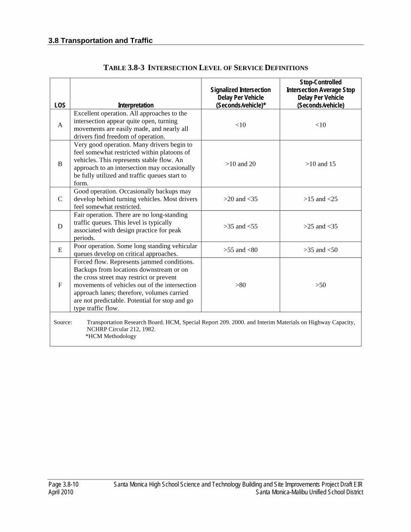
3.8 Transportation and Traffic
Page 3.8-10 Santa Monica High School Science and Technology Building and Site Improvements Project Draft EIR April 2010 Santa Monica-Malibu Unified School District
TABLE 3.8-3 INTERSECTION LEVEL OF SERVICE DEFINITIONS
LOS Interpretation
Signalized Intersection Delay Per Vehicle (Seconds/vehicle)*
Stop-Controlled Intersection Average Stop
Delay Per Vehicle (Seconds/vehicle)
A
Excellent operation. All approaches to the intersection appear quite open, turning movements are easily made, and nearly all drivers find freedom of operation.
<10 <10
B
Very good operation. Many drivers begin to feel somewhat restricted within platoons of vehicles. This represents stable flow. An approach to an intersection may occasionally be fully utilized and traffic queues start to form.
>10 and 20 >10 and 15
C Good operation. Occasionally backups may develop behind turning vehicles. Most drivers feel somewhat restricted.
>20 and <35 >15 and <25
D
Fair operation. There are no long-standing traffic queues. This level is typically associated with design practice for peak periods.
>35 and <55 >25 and <35
E Poor operation. Some long standing vehicular queues develop on critical approaches. >55 and <80 >35 and <50
F
Forced flow. Represents jammed conditions. Backups from locations downstream or on the cross street may restrict or prevent movements of vehicles out of the intersection approach lanes; therefore, volumes carried are not predictable. Potential for stop and go type traffic flow.
>80 >50
Source: Transportation Research Board. HCM, Special Report 209. 2000. and Interim Materials on Highway Capacity, NCHRP Circular 212, 1982. *HCM Methodology
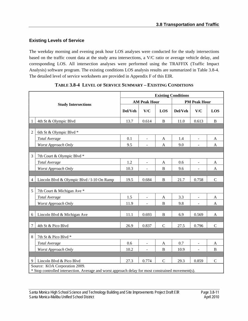
3.8 Transportation and Traffic
Santa Monica High School Science and Technology Building and Site Improvements Project Draft EIR Page 3.8-11 Santa Monica-Malibu Unified School District April 2010
Existing Levels of Service
The weekday morning and evening peak hour LOS analyses were conducted for the study intersections based on the traffic count data at the study area intersections, a V/C ratio or average vehicle delay, and corresponding LOS. All intersection analyses were performed using the TRAFFIX (Traffic Impact Analysis) software program. The existing conditions LOS analysis results are summarized in Table 3.8-4. The detailed level of service worksheets are provided in Appendix F of this EIR.
TABLE 3.8-4 LEVEL OF SERVICE SUMMARY – EXISTING CONDITIONS
Study Intersections
Existing Conditions AM Peak Hour PM Peak Hour
Del/Veh V/C LOS Del/Veh V/C LOS
1 4th St & Olympic Blvd 13.7 0.614 B 11.0 0.613 B
2 6th St & Olympic Blvd * Total Average 0.1 - A 1.4 - A Worst Approach Only 9.5 - A 9.0 - A
3 7th Court & Olympic Blvd * Total Average 1.2 - A 0.6 - A Worst Approach Only 10.3 - B 9.6 - A
4 Lincoln Blvd & Olympic Blvd / I-10 On Ramp 19.5 0.684 B 21.7 0.758 C
5 7th Court & Michigan Ave * Total Average 1.5 - A 3.3 - A Worst Approach Only 11.9 - B 9.8 - A
6 Lincoln Blvd & Michigan Ave 11.1 0.693 B 6.9 0.569 A
7 4th St & Pico Blvd 26.9 0.837 C 27.5 0.796 C
8 7th St & Pico Blvd * Total Average 0.6 - A 0.7 - A Worst Approach Only 10.2 - B 10.9 - B
9 Lincoln Blvd & Pico Blvd 27.3 0.774 C 29.3 0.859 C Source: KOA Corporation 2009. * Stop controlled intersection. Average and worst approach delay for most constrained movement(s).
3.8 Transportation and Traffic
Page 3.8-12 Santa Monica High School Science and Technology Building and Site Improvements Project Draft EIR April 2010 Santa Monica-Malibu Unified School District
As shown in Table 3.8-4, the City of Santa Monica provided the latest traffic volumes for the following five study intersections:
• 4th Street and Olympic Boulevard • Lincoln Boulevard and Olympic Boulevard/I-10 On Ramp • Lincoln Boulevard and Michigan Avenue • 4th Street and Pico Boulevard • Lincoln Boulevard and Pico Boulevard
For the remaining four study intersections, KOA conducted new 2009 traffic counts at the following:
• 6th Street and Olympic Boulevard • 7th Court Alley and Olympic Boulevard • 7th Court Alley and Michigan Avenue • 7th Street and Pico Boulevard
Table 3.8-4 indicates that under existing conditions, all the study intersections are operating at LOS C or better during both the peak hours.
LOS ANGELES COUNTY CONGESTION MANAGEMENT PROGRAM
The Congestion Management Program (CMP) was created statewide because of Proposition 111 and has been implemented locally by Metro. The CMP for Los Angeles County requires that the traffic impact of individual development projects of potentially regional significance be analyzed. A specific system of arterial roadways and all freeways comprises the CMP system. A total of 164 intersections are identified for monitoring on the system in Los Angeles County. In addition, all freeway segments in Los Angeles County, including on- and off-ramps, are mainline freeway segment monitoring locations. The nearest CMP arterial monitoring intersections to the project Site is the intersection of 6th Street from Olympic Boulevard.
3.8.2 ENVIRONMENTAL IMPACTS
THRESHOLDS OF SIGNIFICANCE
As part of the Initial Study (see Appendix A), it was determined that the proposed project would not result in a change in air traffic patterns, including either an increase in traffic levels or a change in location that results in substantial safety risks; result in inadequate emergency access; result in inadequate parking capacity; or conflict with adopted policies, plans, or programs supporting alternative transportation (e.g., bus turnouts, bicycle racks). Accordingly, a majority of these issues are not further analyzed in the EIR. Parking capacity impacts are addressed in the EIR due to changes in the proposed project parking conditions since the completion of the Initial Study.

3.8 Transportation and Traffic
Santa Monica High School Science and Technology Building and Site Improvements Project Draft EIR Page 3.8-13 Santa Monica-Malibu Unified School District April 2010
The CEQA Guidelines establish that a proposed project would have a significant effect on transportation and traffic if it would:
• Cause an increase in traffic that is substantial in relation to the existing traffic load and capacity of the street system (i.e., result in a substantial increase in either the number of vehicle trips, the volume to capacity ratio on roads, or congestion at intersections);
• Exceed, either individually or cumulatively, a level of service standard established by the county congestion management agency for designated roads or highways; or
• Result in inadequate parking capacity.
Traffic impacts are identified if the proposed project would result in a significant change in traffic conditions at a study intersection. A significant impact is typically identified if project-related traffic would cause LOS to deteriorate beyond a threshold limit specified by the overseeing agency. Impacts can also be significant if an intersection is already operating below the poorest acceptable LOS and proposed project traffic would cause a further decline below a certain threshold.
Significant Impact Criteria
The City of Santa Monica has established specific thresholds for project related increases in the delay and volume to capacity (V/C) ratio of study intersections. The following increases in peak hour V/C ratios are considered “significant” impacts. Table 3.8-5 summarizes the City of Santa Monica’s significant impact criteria.

3.8 Transportation and Traffic
Page 3.8-14 Santa Monica High School Science and Technology Building and Site Improvements Project Draft EIR April 2010 Santa Monica-Malibu Unified School District
TABLE 3.8-5 CITY OF SANTA MONICA SIGNIFICANT IMPACT CRITERIA
Future Base Scenario Future Plus project Scenario
If LOS=A, B, or C Significant Impact If:
Collector Street Intersection
Average Vehicle Delay Increase is >= 15 Seconds
OR LOS becomes D, E, or F
Arterial Intersection
Average Vehicle Delay Increase is >= 15 Seconds
OR
LOS becomes E or F If LOS=D Significant Impact If:
Collector Street Intersection Any net increase in average seconds of delay per vehicle
Arterial Intersection
Average Vehicle Delay Increase is >= 15 Seconds
OR
LOS becomes E or F If LOS=E Significant Impact If:
Collector or Arterial Intersection
Any net increase in average seconds of delay per vehicle
If LOS=F Significant Impact If: Collector or Arterial
Intersection HCM V/C ratio net increase is
>=0.005
Source: City of Santa Monica 2010
For analysis of LOS at signalized intersections and stop-controlled intersections, the City of Santa Monica designated the operational analysis method from Highway Capacity Manual (HCM) published by the Transportation Research Board (TRB). The HCM 2000 expresses levels of service in terms of "delay" and in terms of "average seconds per vehicle" for the study intersections. This delay value is based upon volumes by lane, signal phasing, and approach lane configuration.

3.8 Transportation and Traffic
Santa Monica High School Science and Technology Building and Site Improvements Project Draft EIR Page 3.8-15 Santa Monica-Malibu Unified School District April 2010
IMPACT ANALYSIS
TRANS-1 The proposed Project would not increase traffic in relation to the existing traffic load and capacity of the street system, as established by City of Santa Monica.
The City of Santa Monica does not require analysis of this scenario and, therefore, does not have specific significant impact criteria to measure project impacts under the “Existing Conditions with project” scenario. For the purpose of this study, the City’s official criteria outlined in Table 3.8-5 will be used. Table 3.8-6 summarizes the project’s impact under existing conditions and provides a comparison of “Existing” and “Existing with-project” under weekday AM and PM, peak hours, respectively. Traffic impacts created by the project are calculated by comparing “existing conditions” to “existing with project” conditions. The overall traffic impacts created by the proposed project, and determinations of significant impact, are provided in the right column of each table.
As shown in Table 3.8-6, Existing Conditions with project, all the study intersections are projected to be operating at LOS C or better during both the peak hours. Based on the adopted criteria outlined in Table 3.8-5, the proposed project is not expected to generate significant traffic impacts at any of the study intersections under this scenario.

3.8 Transportation and Traffic
Page 3.8-16 Santa Monica High School Science and Technology Building and Site Improvements Project Draft EIR April 2010 Santa Monica-Malibu Unified School District
TABLE 3.8-6 EXISTING CONDITIONS WITH PROJECT
Study Intersections
Existing Conditions Existing Conditions with project Change in V/C or Delay Sig
Impact ? AM Peak Hour PM Peak Hour AM Peak Hour PM Peak Hour
Del/Veh V/C LOS Del/Veh V/C LOS Del/Veh V/C LOS Del/Veh V/C LOS AM Peak Hour PM Peak Hour
Delay V/C Delay V/C
1 4th St & Olympic Blvd 13.7 0.614 B 11.0 0.613 B 15.2 0.697 B 11.1 0.613 B 1.5 0.083 0.1 0.000 NO
2 6th St & Olympic Blvd *
Total Average 0.1 - A 1.4 - A 2.2 - A 3.6 - A 2.1 - 2.2 - NO
Worst Approach Only 9.5 - A 9.0 - A 10.7 - B 9.4 - A 1.2 - 0.4 - NO
3 7th Court & Olympic Blvd *
Total Average 1.2 - A 0.6 - A 0.0 - A 0.0 - A -1.2 - -0.6 - NO
Worst Approach Only 10.3 - B 9.6 - A 0.0 - A 0.0 - A -10.3 - -9.6 - NO
4
Lincoln Blvd & Olympic Blvd / I-10 On Ramp 19.5 0.684 B 21.7 0.758 C 20.4 0.704 C 23.0 0.788 C 0.9 -0.054 1.3 0.030 NO
5 7th Court & Michigan Ave *
Total Average 1.5 - A 3.3 - A 0.8 - A 1.7 - A -0.7 - -1.6 - NO
Worst Approach Only 11.9 - B 9.8 - A 9.4 - A 8.9 - A -2.5 - -0.9 - NO
6 Lincoln Blvd & Michigan Ave 11.1 0.693 B 6.9 0.569 A 11.0 0.702 B 6.7 0.602 A -0.1 0.009 -0.2 0.033 NO
7 4th St & Pico Blvd 26.9 0.837 C 27.5 0.796 C 28.6 0.867 C 27.7 0.802 C 1.7 0.030 0.2 0.006 NO
8 7th St & Pico Blvd *
Total Average 0.6 - A 0.7 - A 0.4 - A 0.5 - A -0.2 - -0.2 - NO
Worst Approach Only 10.2 - B 10.9 - B 10.4 - B 10.8 - B 0.2 - -0.1 - NO
9 Lincoln Blvd & Pico Blvd 27.3 0.774 C 29.3 0.859 C 27.6 0.765 C 29.3 0.861 C 0.3 0.0 0.0 0.002 NO
Source: KOA 2010

3.8 Transportation and Traffic
Santa Monica High School Science and Technology Building and Site Improvements Project Draft EIR Page 3.8-17 Santa Monica-Malibu Unified School District April 2010
FUTURE (2014) WITHOUT PROPOSED PROJECT CONDITIONS
To evaluate the potential impact of the proposed Project on local traffic conditions, it is necessary to develop a forecast of future traffic volumes in the study area under conditions without the proposed Project. The proposed project is anticipated to being construction in the third quarter of 2011 and expected to be completed in the second quarter of 2014. For the purpose of impact analysis, the year 2014 was selected.
Ambient Traffic Growth. Based on the City’s guidelines the ambient growth rate is used for estimating future traffic growth is 0.8% per year. For those locations where 2007 counts were utilized, a growth factor of 1.056 was applied to estimate 2014 traffic conditions. For those locations were 2009 counts were utilized, a growth factor of 1.040 was applied to estimate 2014 traffic conditions.
Cumulative Project Growth. Cumulative project traffic growth is due to specific, known development projects in the vicinity that may affect traffic circulation in the study area. A list of related projects is included to capture specific known developments which may contribute significant amount of traffic under future conditions. The City’s Traffix Model includes a list of cumulative development projects identified by the City of Santa Monica Planning Division. In addition to those projects already programmed into the City’s Traffix Model, a list of updated projects was obtained from the City’s Planning Division to be added to the traffic forecasts. Between the Traffix Model and the list of additional projects, a total of 80 projects were considered. The trips generated by the related projects were estimated based on the Institute of Transportation Engineers (ITE) Trip Generation Rates. The related projects list as displayed in Table 3.8-7 consists of all projects currently approved, under construction, or pending approval in order to provide the most conservative analysis of future traffic conditions within the vicinity of the project Site.
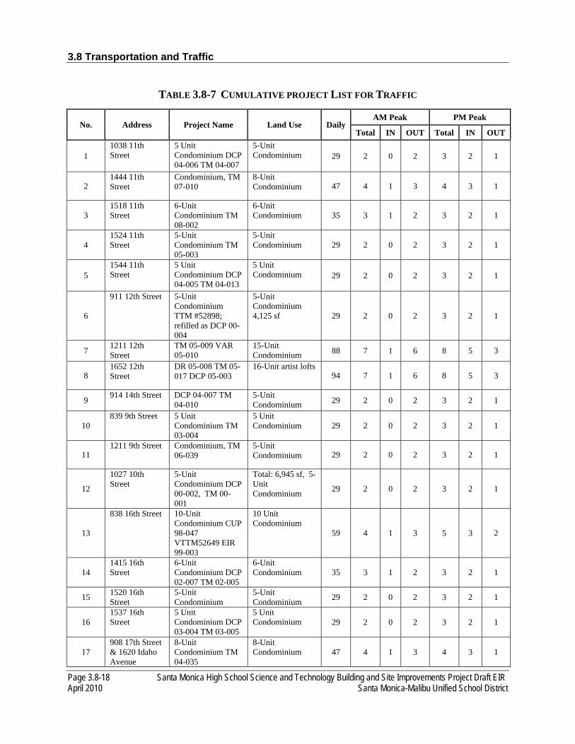
3.8 Transportation and Traffic
Page 3.8-18 Santa Monica High School Science and Technology Building and Site Improvements Project Draft EIR April 2010 Santa Monica-Malibu Unified School District
TABLE 3.8-7 CUMULATIVE PROJECT LIST FOR TRAFFIC
No. Address Project Name Land Use Daily AM Peak PM Peak
Total IN OUT Total IN OUT
1 1038 11th Street
5 Unit Condominium DCP 04-006 TM 04-007
5-Unit Condominium 29 2 0 2 3 2 1
2 1444 11th Street
Condominium, TM 07-010
8-Unit Condominium 47 4 1 3 4 3 1
3 1518 11th Street
6-Unit Condominium TM 08-002
6-Unit Condominium 35 3 1 2 3 2 1
4 1524 11th Street
5-Unit Condominium TM 05-003
5-Unit Condominium 29 2 0 2 3 2 1
5 1544 11th Street
5 Unit Condominium DCP 04-005 TM 04-013
5 Unit Condominium 29 2 0 2 3 2 1
6
911 12th Street 5-Unit Condominium TTM #52898; refilled as DCP 00-004
5-Unit Condominium 4,125 sf 29 2 0 2 3 2 1
7 1211 12th Street
TM 05-009 VAR 05-010
15-Unit Condominium 88 7 1 6 8 5 3
8 1652 12th Street
DR 05-008 TM 05-017 DCP 05-003
16-Unit artist lofts 94 7 1 6 8 5 3
9 914 14th Street DCP 04-007 TM 04-010
5-Unit Condominium 29 2 0 2 3 2 1
10 839 9th Street 5 Unit
Condominium TM 03-004
5 Unit Condominium 29 2 0 2 3 2 1
11 1211 9th Street Condominium, TM
06-039 5-Unit Condominium 29 2 0 2 3 2 1
12
1027 10th Street
5-Unit Condominium DCP 00-002, TM 00-001
Total: 6,945 sf, 5-Unit Condominium 29 2 0 2 3 2 1
13
838 16th Street 10-Unit Condominium CUP 98-047 VTTM52649 EIR 99-003
10 Unit Condominium
59 4 1 3 5 3 2
14 1415 16th Street
6-Unit Condominium DCP 02-007 TM 02-005
6-Unit Condominium 35 3 1 2 3 2 1
15 1520 16th Street
5-Unit Condominium
5-Unit Condominium 29 2 0 2 3 2 1
16 1537 16th Street
5 Unit Condominium DCP 03-004 TM 03-005
5 Unit Condominium 29 2 0 2 3 2 1
17 908 17th Street & 1620 Idaho Avenue
8-Unit Condominium TM 04-035
8-Unit Condominium 47 4 1 3 4 3 1

3.8 Transportation and Traffic
Santa Monica High School Science and Technology Building and Site Improvements Project Draft EIR Page 3.8-19 Santa Monica-Malibu Unified School District April 2010
No. Address Project Name Land Use Daily AM Peak PM Peak
Total IN OUT Total IN OUT
18 919 17th Street 5-Unit
Condominium TM 05-019
5-Unit Condominium 29 2 0 2 3 2 1
19 1807 17th Street
Condominium, TM 07-007 (W/D) TM 07-014
7-Unit Condominium 41 3 1 2 4 3 1
20
1927 18th Street
6-Unit Condominium TM 05-013 (W/D) TM 05-025
6-unit Condominium
35 3 1 2 3 2 1
21 1035 19th Street
5-Unit Condominium TM04-034
5-Unit Condominium 29 2 0 2 3 2 1
22 1119 20th Street
5-Unit Condominium TM 05-021
5 Unit Condominium 29 2 0 2 3 2 1
23 1671 20th Street
AA 05-016 101-unit Apartment 679 52 10 42 63 41 22
24 1818 20th Street
5-Unit Condominium TM06-001
5 Unit Condominium 29 2 0 2 3 2 1
25
1120 21st Street
5-Unit Condominium DCP03-009 TM03-003
5 Unit Condominium 29 2 0 2 3 2 1
26 1131 Arizona Avenue
DR 06-019 CUP 06-020 Alzheimer’s Facility
3-story 38,632 sq.ft. 65 beds 768 73 51 22 85 31 54
27 829 Broadway Mixed-Use, AA 06-
015 129-Unit Residential 867 66 13 53 80 52 28
28 1424 Broadway Affordable Housing
AA 03-016 41 Apartment Units 276 21 4 17 25 16 9
29
1502 Broadway 32-Unit Condominium DR 04-004 DCP 04-013 TM 04-026
32-Unit Condominium
188 14 2 12 17 11 6
30 1902 California Avenue
5-Unit Condominium TM 05-007
5-Unit Condominium 29 2 0 2 3 2 1
31 1707 Cloverfield Boulevard
Storage Facility DR 05-003
31,400 sq.ft. self-storage 79 5 3 2 8 4 4
32 1940 Cloverfield Boulevard
DR 04-007, TM 04-028
16- Unit Condominium 94 7 1 6 8 5 3
33 1327 Euclid Street
ARB 06-106 5 Unit Condominium 29 2 0 2 3 2 1
34 Near 1525 Euclid
Euclid Park 15,000 sf park 1.0 0.0 0.0 0.0 0.0 0.0 0.0
35 2222 Pico Blvd.
Mixed-Use AA06-003
2 units residential & 2,399 sf of retail
12 1 0 1 1 1 0
106 3 2 1 7 3 4
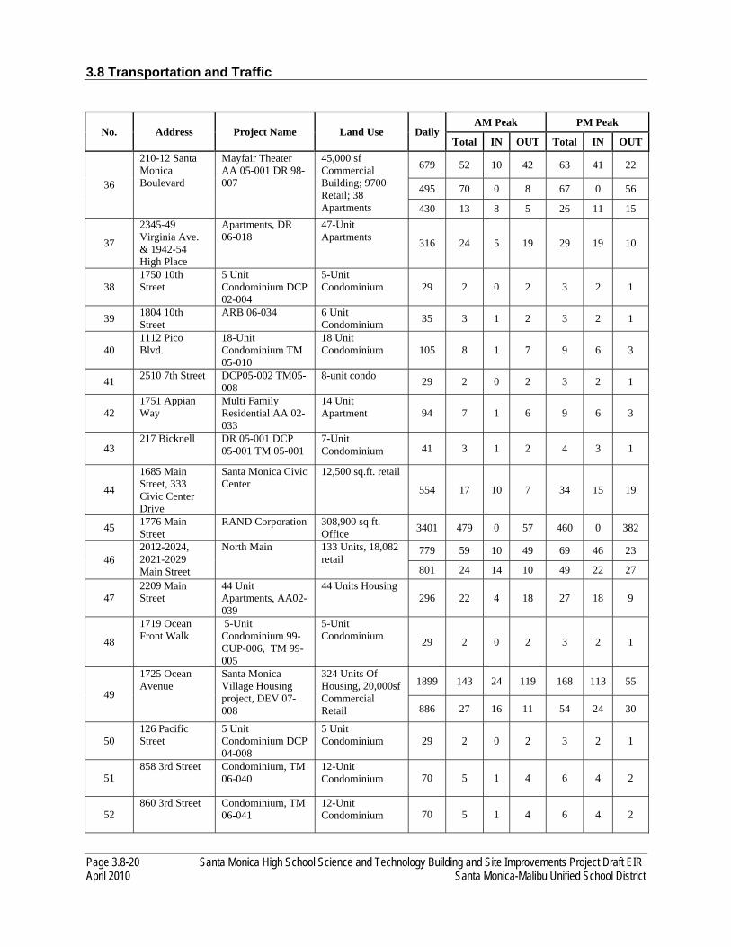
3.8 Transportation and Traffic
Page 3.8-20 Santa Monica High School Science and Technology Building and Site Improvements Project Draft EIR April 2010 Santa Monica-Malibu Unified School District
No. Address Project Name Land Use Daily AM Peak PM Peak
Total IN OUT Total IN OUT
36
210-12 Santa Monica Boulevard
Mayfair Theater AA 05-001 DR 98-007
45,000 sf Commercial Building; 9700 Retail; 38 Apartments
679 52 10 42 63 41 22
495 70 0 8 67 0 56
430 13 8 5 26 11 15
37
2345-49 Virginia Ave. & 1942-54 High Place
Apartments, DR 06-018
47-Unit Apartments 316 24 5 19 29 19 10
38 1750 10th Street
5 Unit Condominium DCP 02-004
5-Unit Condominium 29 2 0 2 3 2 1
39 1804 10th Street
ARB 06-034 6 Unit Condominium 35 3 1 2 3 2 1
40 1112 Pico Blvd.
18-Unit Condominium TM 05-010
18 Unit Condominium 105 8 1 7 9 6 3
41 2510 7th Street DCP05-002 TM05-008
8-unit condo 29 2 0 2 3 2 1
42 1751 Appian Way
Multi Family Residential AA 02-033
14 Unit Apartment 94 7 1 6 9 6 3
43 217 Bicknell DR 05-001 DCP
05-001 TM 05-001 7-Unit Condominium 41 3 1 2 4 3 1
44
1685 Main Street, 333 Civic Center Drive
Santa Monica Civic Center
12,500 sq.ft. retail
554 17 10 7 34 15 19
45 1776 Main Street
RAND Corporation 308,900 sq ft. Office 3401 479 0 57 460 0 382
46 2012-2024, 2021-2029 Main Street
North Main 133 Units, 18,082 retail
779 59 10 49 69 46 23
801 24 14 10 49 22 27
47 2209 Main Street
44 Unit Apartments, AA02-039
44 Units Housing 296 22 4 18 27 18 9
48
1719 Ocean Front Walk
5-Unit Condominium 99-CUP-006, TM 99-005
5-Unit Condominium 29 2 0 2 3 2 1
49
1725 Ocean Avenue
Santa Monica Village Housing project, DEV 07-008
324 Units Of Housing, 20,000sf Commercial Retail
1899 143 24 119 168 113 55
886 27 16 11 54 24 30
50 126 Pacific Street
5 Unit Condominium DCP 04-008
5 Unit Condominium 29 2 0 2 3 2 1
51 858 3rd Street Condominium, TM
06-040 12-Unit Condominium 70 5 1 4 6 4 2
52 860 3rd Street Condominium, TM
06-041 12-Unit Condominium 70 5 1 4 6 4 2
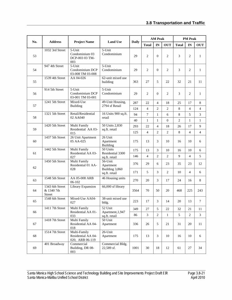
3.8 Transportation and Traffic
Santa Monica High School Science and Technology Building and Site Improvements Project Draft EIR Page 3.8-21 Santa Monica-Malibu Unified School District April 2010
No. Address Project Name Land Use Daily AM Peak PM Peak
Total IN OUT Total IN OUT
53
1032 3rd Street 5-Unit Condominium 03 DCP-003 03 TM-003
5-Unit Condominium 29 2 0 2 3 2 1
54 947 4th Street 5-Unit
Condominium DCP 03-008 TM 03-008
5-Unit Condominium 29 2 0 2 3 2 1
55 1539 4th Street AA 04-026 62-unit mixed use
building 363 27 5 22 32 21 11
56 914 5th Street 5-Unit
Condominium DCP 03-001 TM 03-001
5-Unit Condominium 29 2 0 2 3 2 1
57 1241 5th Street Mixed-Use
Building 49-Unit Housing, 2794 sf Retail
287 22 4 18 25 17 8
124 4 2 2 8 4 4
58 1321 5th Street Retail/Residential
02 AA040 16 Units 900 sq.ft. retail
94 7 1 6 8 5 3
40 1 1 0 2 1 1
59 1420 5th Street Multi Family
Residential AA 03-015
50 Units 2,830 sq.ft. retail
293 22 4 18 26 17 9
125 4 2 2 8 4 4
60 1437 5th Street 26 Unit Apartment
05 AA-025 26 Unit Apartment Building
175 13 3 10 16 10 6
61 1442 5th Street Multi Family
Residential AA 03-027
50 Units Residential 3300 sq.ft. retail
175 13 3 10 16 10 6
146 4 2 2 9 4 5
62
1450 5th Street Multi Family Residential 01 AA-028
56-Unit Apartment Building 3,860 sq.ft. retail
376 29 6 23 35 23 12
171 5 3 2 10 4 6
63 1548 5th Street AA 05-008 ARB 06-102
46 Housing units 270 20 3 17 24 16 8
64 1343 6th Street & 1340 7th Street
Library Expansion 66,000 sf library 3564 70 50 20 468 225 243
65 1548 6th Street Mixed-Use AA04-
027 38-unit mixed use bldg. 223 17 3 14 20 13 7
66 1411 7th Street Multi Family
Residential AA 01-033
52 Unit Apartment,1,947 sq.ft. retail
349 27 5 22 32 21 11
86 3 2 1 5 2 3
67 1418 7th Street Multi Family
Residential AA 04-018
50 Unit Apartment 336 26 5 21 31 20 11
68 1514 7th Street Multi-Family
Residential AA 04-020, ARB 06-119
26-Unit Apartment 175 13 3 10 16 10 6
69 401 Broadway Commercial
Building, DR 08-003
Commercial Bldg. 22,589 sf. 1001 30 18 12 61 27 34

3.8 Transportation and Traffic
Page 3.8-22 Santa Monica High School Science and Technology Building and Site Improvements Project Draft EIR April 2010 Santa Monica-Malibu Unified School District
No. Address Project Name Land Use Daily AM Peak PM Peak
Total IN OUT Total IN OUT
70
525 Broadway 125 Condominiums DCP 06-002 DR 06-003 TM 06-005
125 Condos
733 55 9 46 65 44 21
71 606 Broadway Multi-Family
Residential AA 03-001
50-Units Apartment 336 26 5 21 31 20 11
72 626 Broadway Mixed-Use
Building AA 05-004
48-Unit Housing, 4,090 ground floor retail
323 24 5 19 30 20 11
181 5 3 2 11 5 6
73 1333-1337 Ocean Avenue
Hill Street Partners Development Agreement
77 rooms, café, and a full service restaurant
629 43 26 17 45 24 21
74 1301 Ocean Avenue
Hotel Addition. CUP05-006
20 hotel rooms 163 11 7 4 12 6 6
75 1515-25 Ocean Avenue
Hotel CUP 05-009, DR 05-007
4-story hotel; 173 rooms 1413 97 59 38 102 54 48
76 507 Wilshire Multi Family
Residential AA03-022
50 residential units 336 26 5 21 31 20 11
77 1540 2nd Street Fast Food/
Retail/Office 64,485 sf. Commercial office space
710 100 88 12 96 16 80
78 1318 10th Street
Condominium, TM 06-038
6-Unit Condominium 35 3 1 2 3 2 1
79 1434 14th Street
Condominium TM 06-037
6-Unit Condominium 35 3 1 2 3 2 1
80 1447 Lincoln Boulevard
Mixed-Use DR 07-005
97-Units Apartment 652 49 10 39 60 39 21
Source: KOA 2010
The Future (2014) Without the Proposed Project Conditions were developed and operating conditions were analyzed at the nine study intersections for the AM and PM peak hours, as shown in Table 3.8-8. Under Future (2014) without the proposed Project Conditions, all the nine study intersections are projected to operate at LOS D or better during the AM and PM peak hours with the following exceptions:
• 4th Street and Olympic Boulevard (LOS E – AM peak hour) • Lincoln Boulevard and Pico Boulevard (LOS E – PM peak hour)
The traffic analysis worksheets for this scenario are provided in Appendix F of this EIR.
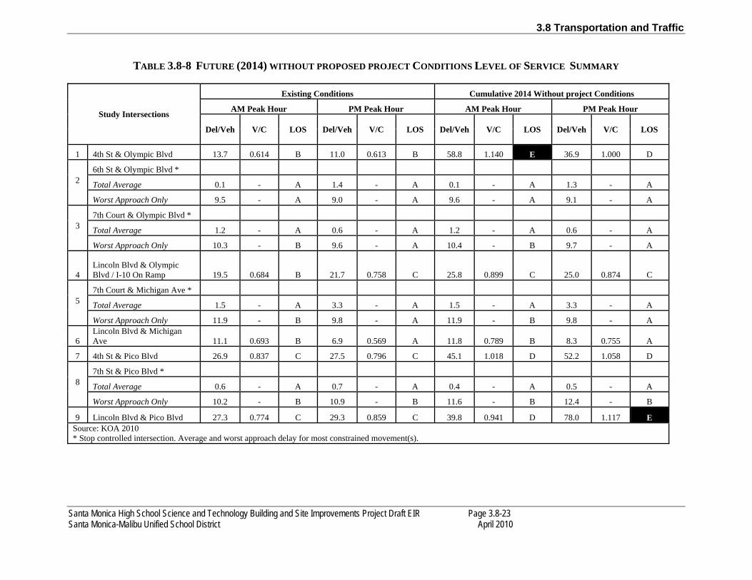
3.8 Transportation and Traffic
Santa Monica High School Science and Technology Building and Site Improvements Project Draft EIR Page 3.8-23 Santa Monica-Malibu Unified School District April 2010
TABLE 3.8-8 FUTURE (2014) WITHOUT PROPOSED PROJECT CONDITIONS LEVEL OF SERVICE SUMMARY
Study Intersections
Existing Conditions Cumulative 2014 Without project Conditions
AM Peak Hour PM Peak Hour AM Peak Hour PM Peak Hour
Del/Veh V/C LOS Del/Veh V/C LOS Del/Veh V/C LOS Del/Veh V/C LOS
1 4th St & Olympic Blvd 13.7 0.614 B 11.0 0.613 B 58.8 1.140 E 36.9 1.000 D
2
6th St & Olympic Blvd *
Total Average 0.1 - A 1.4 - A 0.1 - A 1.3 - A
Worst Approach Only 9.5 - A 9.0 - A 9.6 - A 9.1 - A
3
7th Court & Olympic Blvd *
Total Average 1.2 - A 0.6 - A 1.2 - A 0.6 - A
Worst Approach Only 10.3 - B 9.6 - A 10.4 - B 9.7 - A
4 Lincoln Blvd & Olympic Blvd / I-10 On Ramp 19.5 0.684 B 21.7 0.758 C 25.8 0.899 C 25.0 0.874 C
5
7th Court & Michigan Ave *
Total Average 1.5 - A 3.3 - A 1.5 - A 3.3 - A
Worst Approach Only 11.9 - B 9.8 - A 11.9 - B 9.8 - A
6 Lincoln Blvd & Michigan Ave 11.1 0.693 B 6.9 0.569 A 11.8 0.789 B 8.3 0.755 A
7 4th St & Pico Blvd 26.9 0.837 C 27.5 0.796 C 45.1 1.018 D 52.2 1.058 D
8
7th St & Pico Blvd *
Total Average 0.6 - A 0.7 - A 0.4 - A 0.5 - A
Worst Approach Only 10.2 - B 10.9 - B 11.6 - B 12.4 - B
9 Lincoln Blvd & Pico Blvd 27.3 0.774 C 29.3 0.859 C 39.8 0.941 D 78.0 1.117 E Source: KOA 2010 * Stop controlled intersection. Average and worst approach delay for most constrained movement(s).

3.8 Transportation and Traffic
Page 3.8-24 Santa Monica High School Science and Technology Building and Site Improvements Project Draft EIR April 2010 Santa Monica-Malibu Unified School District
FUTURE (2014) WITH PROPOSED PROJECT CONDITIONS
Proposed Project Trip Generation. To evaluate the potential impact of the proposed Project on local traffic conditions, it is necessary to estimate the number of new trips expected to be generated by the proposed Project. Using the trip generation rates contained in the Institute of Transportation Engineer’s Trip Generation (7th Edition) (2003) the gross estimated trips for the proposed Project were calculated.
The proposed project would reconfigure approximately 5.2 acres of the existing campus. The proposed project consists of the removal of the existing 88,000 square-foot Science and Technology Buildings, parking lot and softball field and construction of a new 84,000 square-foot Science and Technology Buildings, a 253-space parking lot and softball field in a reconfigured site layout. As such, the proposed Project would not generate new trips onto the roadway system as there would be no additional student enrollment as part of the proposed project.
Proposed Project Trip Distribution. Trip distribution is the process of assigning the amount of traffic to and from a project Site. Trip distribution is dependent upon the land use characteristics of the proposed Project and the general locations of land uses to which proposed Project trips would originate or terminate. Proposed project trip distribution was based on the geographic distribution of population from which the proposed Project trips would originate or terminate, as well as knowledge of development trends in the area, local and sub-regional traffic routes, and regional traffic flows. Based on the current traffic volumes/patterns at key intersections that include Lincoln Boulevard/Michigan Avenue, the estimated current traffic distribution pattern and re-routed school traffic is shown in Figures 3.8-4 and 3.8-5.
Proposed Project Trip Assignment. The final product of the trip assignment process is a full accounting of re-routed project trips, by direction and turning movement at each of the study intersections. The project trips were assigned based on the assumptions discussed previously. Figures 3.8-6 and 3.8-7 illustrate the resultant project trip assignment to the study intersections for the weekday AM, and PM peak hours, respectively. It is important to note that the negative trips shown denote existing trips that have been diverted to new paths due to the relocated parking lot access.

Net Inbound Project Traffic Assignment - AM and PM Peak Hours
Figure 3.8-4Source: KOA, 2010

Net Outbound Project Traffic Assignment - AM and PM Peak Hours
Figure 3.8-5Source: KOA, 2010
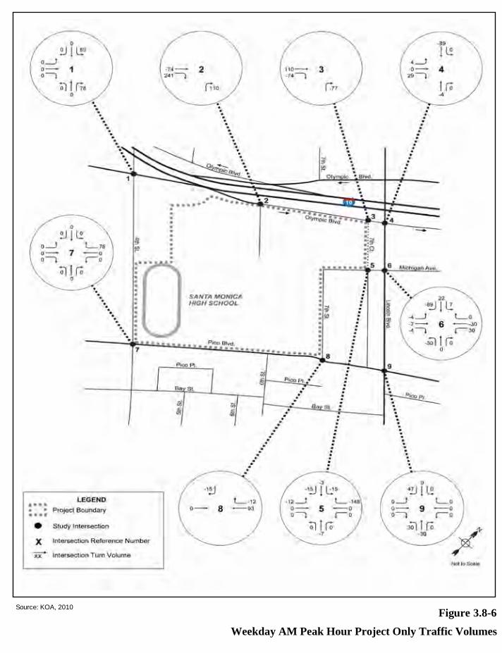
Weekday AM Peak Hour Project Only Traffic Volumes
Figure 3.8-6Source: KOA, 2010

Weekday PM Peak Hour Project Only Traffic Volumes
Figure 3.8-7Source: KOA, 2010

3.8 Transportation and Traffic
Santa Monica High School Science and Technology Building and Site Improvements Project Draft EIR Page 3.8-29 Santa Monica-Malibu Unified School District April 2010
Intersection Analysis. For analysis of level of service (LOS) at signalized intersections and stop-controlled intersections, the City of Santa Monica has designated the operational analysis method from Highway Capacity Manual (HCM) published by the Transportation Research Board (TRB). The HCM 2000 expresses levels of service in terms of "delay" and in terms of "average seconds per vehicle" for the study intersections. This delay value is based upon volumes by lane, signal phasing, and approach lane configuration. Future traffic conditions at the study intersections with the addition of project-generated traffic were also analyzed. Traffic volumes for these scenarios were derived by superimposing the project’s diverted trips onto the Future (2014) without project Conditions. Table 3.8-9 summarizes the resulting LOS values at the study intersections with the diverted trips as a result of the proposed project.
TABLE 3.8-9 FUTURE (2014) WITH PROPOSED PROJECT CONDITIONS
LEVEL OF SERVICE SUMMARY
Study Intersections
Cumulative 2014 With project Conditions
AM Peak Hour PM Peak Hour
Del/Veh V/C LOS Del/Veh V/C LOS
1 4th St & Olympic Blvd 78.2 1.223 E 38.8 1.015 D
2
6th St & Olympic Blvd *
Total Average 2.2 - A 3.4 - A
Worst Approach Only 10.8 - B 9.5 - A
3
7th Court & Olympic Blvd *
Total Average 0.0 - A 0.0 - A
Worst Approach Only 0.0 - A 0.0 - A
4 Lincoln Blvd & Olympic Blvd / I-10 On Ramp 27.5 0.918 C 27.4 0.904 C
5
7th Court & Michigan Ave *
Total Average 0.8 - A 1.7 - A
Worst Approach Only 9.4 - A 8.9 - A
6 Lincoln Blvd & Michigan Ave 12.7 0.853 B 8.5 0.770 A
7 4th St & Pico Blvd 50.5 1.036 D 53.3 1.062 D
8
7th St & Pico Blvd *
Total Average 0.3 - A 0.4 - A
Worst Approach Only 11.8 - B 12.3 - B

3.8 Transportation and Traffic
Page 3.8-30 Santa Monica High School Science and Technology Building and Site Improvements Project Draft EIR April 2010 Santa Monica-Malibu Unified School District
Study Intersections Cumulative 2014 With project Conditions
AM Peak Hour PM Peak Hour Del/Veh V/C LOS Del/Veh V/C LOS
9 Lincoln Blvd & Pico Blvd 40.5 0.932 D 77.8 1.118 E Source: KOA 2010 * Stop controlled intersection. Average and worst approach delay for most constrained movement(s).
Under Future (2014) with the proposed Project conditions, all the nine study intersections are projected to operate at LOS D or better during the AM and PM peak hours with the following exceptions:
• 4th Street and Olympic Boulevard (LOS E – AM peak hour) • Lincoln Boulevard and Pico Boulevard (LOS E – PM peak hour)
The traffic analysis worksheets for this scenario are included in Appendix F of this EIR.
Table 3.8-10 provides a summary comparison of “Future (2014) Without the Proposed Conditions” and “Future (2014) With the Proposed Project Conditions” under weekday AM and PM, peak hours, respectively.
Based on the traffic forecasts, LOS analysis and significant impact thresholds set forth by the City of Santa Monica, the following study intersection is anticipated to be significantly impacted from additional traffic generated by the proposed Project:
• 4th Street and Olympic Boulevard (LOS E – AM peak hour)
In order to reduce intersection impacts at 4th Street and Olympic Boulevard during the AM peak hour, implementation of mitigation measure TRANS-A would be required. The recommended improvement includes re-striping the northbound approach to provide an exclusive left-turn lane, a shared through/right-turn lane, and an exclusive right-turn lane.
In order to minimize pedestrian conflicts and vehicular/pedestrian delay on the north-south pedestrian crossing on the east leg of this intersection, TRANS-B recommends restricting pedestrian movement to the west side of 4th Street. As such, pedestrians traveling north-south on 4th Street would have to cross on the west side of the street. From discussions with City staff, this pedestrian circulation change would be considered an enhancement to pedestrian mobility in general along 4th Street in this area.
Table 3.8-11 provides the V/C and LOS results with implementation of the recommended improvement. Figure 3.8-8 shows the proposed mitigation measure on a conceptual level.

3.8 Transportation and Traffic
Santa Monica High School Science and Technology Building and Site Improvements Project Draft EIR Page 3.8-31 Santa Monica-Malibu Unified School District April 2010
TABLE 3.8-10 PEAK HOUR PROJECT IMPACT SUMMARY
Study Intersections
Cumulative 2014 Without Project Conditions Cumulative 2014 With Project Conditions Change in V/C or Delay Sig Impact
?
AM Peak Hour PM Peak Hour AM Peak Hour PM Peak Hour
Del/Veh V/C LOS Del/Veh V/C LOS Del/Veh V/C LOS Del/Veh V/C LOS AM Peak Hour PM Peak Hour
Delay V/C Delay V/C
1 4th St & Olympic Blvd 58.8 1.140 E 36.9 1.000 D 78.2 1.223 E 38.8 1.015 D 19.4 0.083 1.9 0.015 AM
2 6th St & Olympic Blvd *
Total Average 0.1 - A 1.3 - A 2.2 - A 3.4 - A 2.1 - 2.1 - NO
Worst Approach Only 9.6 - A 9.1 - A 10.8 - B 9.5 - A 1.2 - 0.4 - NO
3 7th Court & Olympic Blvd *
Total Average 1.2 - A 0.6 - A 0.0 - A 0.0 - A -1.2 - -0.6 - NO
Worst Approach Only 10.4 - B 9.7 - A 0.0 - A 0.0 - A -10.4 - -9.7 - NO
4
Lincoln Blvd & Olympic Blvd / I-10 On Ramp 25.8 0.899 C 25.0 0.874 C 27.0 0.912 C 27.0 0.898 C 1.2 0.038 2.0 0.024 NO
5 7th Court & Michigan Ave *
Total Average 1.5 - A 3.3 - A 0.8 - A 1.7 - A -0.7 - -1.6 - NO
Worst Approach Only 11.9 - B 9.8 - A 9.4 - A 8.9 - A -2.5 - -0.9 - NO
6 Lincoln Blvd & Michigan Ave 11.8 0.789 B 8.3 0.755 A 12.7 0.853 B 8.5 0.770 A 0.9 0.064 0.2 0.015 NO
7 4th St & Pico Blvd 45.1 1.018 D 52.2 1.058 D 50.5 1.036 D 53.3 1.062 D 5.4 0.018 1.1 0.004 NO
8 7th St & Pico Blvd *
Total Average 0.4 - A 0.5 - A 0.3 - A 0.4 - A -0.1 - -0.1 - NO
Worst Approach Only 11.6 - B 12.4 - B 11.8 - B 12.3 - B 0.2 - -0.1 - NO
9 Lincoln Blvd & Pico Blvd 39.8 0.941 D 78.0 1.117 E 40.5 0.932 D 77.8 1.118 E 0.7 0.0 -0.2 0.001 PM
Source: KOA Corporation, 2010

Santa Monica High School Science and Technology Building and Site Improvements Project Draft EIR Page 3.8-32 Santa Monica-Malibu Unified School District April 2010
Based on KOA’s research, there are no planned roadway improvements that would affect traffic operations at the nine study intersections. As such, no impact would result on residential roadways.
TRANS-2: The proposed Project would not exceed, either individually or cumulatively, a level of service standard established by the county congestion management agency for designated roads or highways.
The proposed Project has the potential to exceed a level of service standard established by the county congestion management agency for designated roads or highways. The statewide Congestion Management Program (CMP), implemented locally by the Los Angeles County Metropolitan Transportation Authority (Metro), requires that the traffic impacts of development projects with regional significance must be analyzed for the CMP system of selected arterials and all freeways.1 The thresholds for conducting a CMP analysis are 50 directional trips at a CMP intersection and 150 directional trips on a CMP freeway segment. A significant impact is identified per CMP guidelines if project-related traffic would cause service levels to deteriorate to LOS F and increase demand caused by the proposed Project in V/C ratio by 0.02 or more. The proposed Project is not expected to affect traffic on a regional basis. In addition, the proposed Project would not on increase demand at nearby CMP-designated facilities through the redistribution of vehicle trips to the new access via 6th Street from Olympic Boulevard. Based on the incremental V/C ratio shown in Tables 3.8-10 above, the proposed Project would not increase demand at this location such that the V/C ratio increases by 0.02 or more under any of the peak periods. The impact would be less than significant, and no mitigation measures are required.
TRANS-3: The proposed Project would not substantially increase hazards due to a design feature (e.g., sharp curves or dangerous intersections) or incompatible uses (e.g., farm equipment).
Construction
There is the potential for short-term adverse traffic impacts in the project vicinity during construction of the project. The additional trips generated by the truck deliveries and construction workers could affect traffic flow within the study area, as well as pedestrian traffic flow near the project site. The construction period is anticipated to start in the third quarter of 2011 and end in the second quarter of 2014. As such, TRANS-C requires the construction contractor through SMMUSD is required to prepare and submit a Construction Staging and Traffic Management Plan to City for approval. The Construction Staging and Traffic Management Plan would require the construction contractor to install a construction fence around the site perimeter, complying with City requirements, before excavation begins. The construction contractor would be required to maintain a minimum sidewalk width of five feet during the construction period. The construction contractor would also erect protective sidewalk canopies on to enhance pedestrian safety along the construction site. A flagman would be provided whenever trucks entering or leaving the project site may impede the flow of pedestrian or automotive traffic.
1 Los Angeles County Metropolitan Transportation Authority. Congestion Management Program. December 1992.
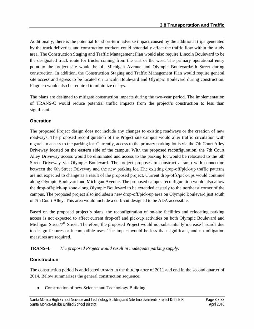
3.8 Transportation and Traffic
Santa Monica High School Science and Technology Building and Site Improvements Project Draft EIR Page 3.8-33 Santa Monica-Malibu Unified School District April 2010
Additionally, there is the potential for short-term adverse impact caused by the additional trips generated by the truck deliveries and construction workers could potentially affect the traffic flow within the study area. The Construction Staging and Traffic Management Plan would also require Lincoln Boulevard to be the designated truck route for trucks coming from the east or the west. The primary operational entry point to the project site would be off Michigan Avenue and Olympic Boulevard/6th Street during construction. In addition, the Construction Staging and Traffic Management Plan would require general site access and egress to be located on Lincoln Boulevard and Olympic Boulevard during construction. Flagmen would also be required to minimize delays.
The plans are designed to mitigate construction impacts during the two-year period. The implementation of TRANS-C would reduce potential traffic impacts from the project’s construction to less than significant.
Operation
The proposed Project design does not include any changes to existing roadways or the creation of new roadways. The proposed reconfiguration of the Project site campus would alter traffic circulation with regards to access to the parking lot. Currently, access to the primary parking lot is via the 7th Court Alley Driveway located on the eastern side of the campus. With the proposed reconfiguration, the 7th Court Alley Driveway access would be eliminated and access to the parking lot would be relocated to the 6th Street Driveway via Olympic Boulevard. The project proposes to construct a ramp with connection between the 6th Street Driveway and the new parking lot. The existing drop-off/pick-up traffic patterns are not expected to change as a result of the proposed project. Current drop-offs/pick-ups would continue along Olympic Boulevard and Michigan Avenue. The proposed campus reconfiguration would also allow the drop-off/pick-up zone along Olympic Boulevard to be extended easterly to the northeast corner of the campus. The proposed project also includes a new drop-off/pick-up area on Olympic Boulevard just south of 7th Court Alley. This area would include a curb-cut designed to be ADA accessible.
Based on the proposed project’s plans, the reconfiguration of on-site facilities and relocating parking access is not expected to affect current drop-off and pick-up activities on both Olympic Boulevard and Michigan Street/7th Street. Therefore, the proposed Project would not substantially increase hazards due to design features or incompatible uses. The impact would be less than significant, and no mitigation measures are required.
TRANS-4: The proposed Project would result in inadequate parking supply.
Construction
The construction period is anticipated to start in the third quarter of 2011 and end in the second quarter of 2014. Below summarizes the general construction sequence:
• Construction of new Science and Technology Building
3.8 Transportation and Traffic
Page 3.8-34 Santa Monica High School Science and Technology Building and Site Improvements Project Draft EIR April 2010 Santa Monica-Malibu Unified School District
• Construction of 6th Street ramp • Demolition of existing buildings • Construction of new parking lot • Construction of new softball field
Parking on the high school campus is provided in five surface parking areas. The existing (February/March 2008) inventory of the on-campus parking spaces provides a total of 397 parking spaces, including 303 staff spaces (both assigned spaces and currently vacant spaces), 48 student spaces, 34 visitor spaces and 12 handicapped spaces. Staff and student spaces are assigned to specific individuals. Each staff or faculty member who desires an on-campus parking space is accommodated and the remaining spaces are offered to students twice a year on a lottery basis.2
The existing parking lot located adjacent to the Science and Technology Buildings would be reconfigured and result in the loss of parking during construction. The existing parking lot provides approximately 253 parking spaces: 183 assigned to faculty and staff, 40 spaces assigned to students during a twice-yearly lottery, and 2 spaces for ADA accessible handicapped parking. The reconfigured parking lot would accommodate the same number of 253 parking spaces. The existing parking lot would be closed during construction of the new building. During the construction phase of the project, on-campus parking would be unavailable to faculty/staff and students. Student parking would not be provided by the SMMUSD during the construction period.
In addition to faculty/staff parking needs, it is estimated that as many as 200 construction workers could be working on the construction project. The number of workers on the site at any one time will during the course of the construction effort. As such, it is estimated that as many as 411 parking spaces could be required off-site. The general contractor would be required to provide a parking management plan to the City of Santa Monica that identifies where construction workers will park.
It is expected that some faculty/staff and students would carpool or ride transit. Faculty/staff, students, and visitors may also park on city streets and in public and private parking facilities near the campus. The on-street supply in the study area accounted for approximately 1,798 total spaces.3 The majority of the parking in the surrounding residential areas to the south and to the east (approximately 1,314 spaces) is free and unrestricted. Metered parking is mostly on the two major arterial streets near the campus, Lincoln Boulevard and Pico Boulevard, and totals 112 spaces.
The loss of parking during construction and the temporary displacement of faculty/staff parking would be significant. Mitigation measure TRANS-D is provided to reduce these impacts. However, the temporary loss of 40 student parking spaces would be significant and unavoidable.
2 Fehr and Peers. Draft Technical Memorandum: Assessment of Existing Parking Conditions at Santa Monica High School. May 8, 2008. 3 Ibid.

3.8 Transportation and Traffic
Santa Monica High School Science and Technology Building and Site Improvements Project Draft EIR Page 3.8-35 Santa Monica-Malibu Unified School District April 2010
Operation
Operation of the proposed Project would not result in the loss of parking spaces. Following construction of the new building, the existing buildings would be removed and replaced with the new reconfigured parking lot.
As previously discussed, the proposed reconfiguration of the Project site would alter traffic circulation with regards to access to the parking lot. The proposed Project would re-route all access to the project site via a ramp off of the 6th Street access road to the proposed new parking lot. An Americans with Disabilities Act (ADA) accessible drop-off and pick-up lane would be provided along Olympic Boulevard just west of its intersection with Lincoln Boulevard. Access to 7th Court Alley would be retained and would continue to serve the commercial and residential parcels adjacent to the eastern boundary of the project site. The 7th Court Alley would also be used for vehicle access to the school’s auto shop, which would be located in the northeastern corner of the proposed Science and Technology Building.
Based on the proposed project’s plans, the reconfiguration of on-site facilities and the relocation of parking access is not expected to impact current drop-off and pick-up activities on both Olympic Boulevard and Michigan Street/7th Street. As such, operational impacts to parking would be less than significant.
3.8.3 MITIGATION MEASURES
TRANS-A In order to reduce intersection impacts at 4th Street and Olympic Boulevard during the AM peak hour, the applicant shall be responsible for the following improvements:
Re-striping the northbound approach to provide an exclusive left-turn lane, Constructing a shared through/right-turn lane, Constructing an exclusive right-turn lane.
TRANS-B In order to minimize pedestrian conflicts and vehicular/pedestrian delay on the north-
south pedestrian crossing on the east leg of this intersection, TRANS-B recommends restricting pedestrian movement to the west side of 4th Street. As such, pedestrians traveling north-south on 4th Street would have to cross on the west side of the street.
TRANS-C Prior to construction, the construction contractor through SMMUSD shall prepare and submit a Construction Staging and Traffic Management Plan to City for approval. The plans are designed to mitigate construction impacts during the two-year period. The plan would include the following improvements:
The construction contractor shall install a construction fence around the site perimeter, complying with City requirements, before excavation begins. The construction contractor shall be required to maintain a minimum sidewalk width of five feet during the construction period. The construction contractor shall also

3.8 Transportation and Traffic
Page 3.8-36 Santa Monica High School Science and Technology Building and Site Improvements Project Draft EIR April 2010 Santa Monica-Malibu Unified School District
erect protective sidewalk canopies on to enhance pedestrian safety along the construction site. A flag man shall be provided whenever trucks entering or leaving the project site may impede the flow of pedestrian or automotive traffic.
The designated truck route for the project site shall be Lincoln Boulevard for trucks coming from the east or the west. The primary operational entry point to the project site shall be off of Michigan Avenue and Olympic Boulevard/6th Street during construction.
General site access and egress shall be located on Lincoln Boulevard and Olympic Boulevard during construction. Flagmen shall be provided as necessary to minimize delays.
TRANS-D The SMMUSD shall implement one or more of the following options to accommodate the temporary loss of parking for faculty and staff members, including leasing spaces at an off-site location, such as City parking lots at the beach-combined with a shuttle service; leasing private parking in the surrounding area; or establishing vanpools and other transit options.
3.9.4 SIGNIFICANCE AFTER MITIGATION
Implementation of TRANS-A and TRANS-B would reduce impacts on 4th Street and Olympic Boulevard during the AM peak hour to a less than significant level. The proposed improvement would fully mitigate AM project impacts from a 78.2 seconds delay (LOS E) to 33.5 seconds delay (LOS C). Table 3.8-11 provides the V/C and LOS results with implementation of the recommended improvement. Figure 3.8-8 shows the proposed mitigation measure on a conceptual level. TRANS-C would reduce traffic impacts during the construction phase.
Implementation of TRANS-D would reduce potential traffic and parking impacts from the project’s construction to less than significant. However, the temporary loss of 40 student parking spaces during the construction phase would be significant and unavoidable.

3.8 Transportation and Traffic
Page 3.8-37 Santa Monica High School Science and Technology Building and Site Improvements Project Draft EIR April 2010 Santa Monica-Malibu Unified School District
TABLE 3.8-11 PROJECT MITIGATION LEVEL OF SERVICE SUMMARY
Study Intersections
Cumulative 2014 With project Conditions Cumulative 2014 With project With Mitigation Conditions Change in V/C or Delay Sig
Impact ? AM Peak Hour PM Peak Hour AM Peak Hour PM Peak Hour
Del/Veh V/C LOS Del/Veh V/C LOS Del/Veh V/C LOS Del/Veh V/C LOS AM Peak Hour PM Peak Hour
Delay V/C Delay V/C
1
4th St & Olympic Blvd / I-10 On Ramp 78.2 1.223 E 38.8 1.015 D 33.5 0.980 C 29.7 0.930 C -44.7 -0.243 -9.1 -0.085 NO
Source: KOA 2010
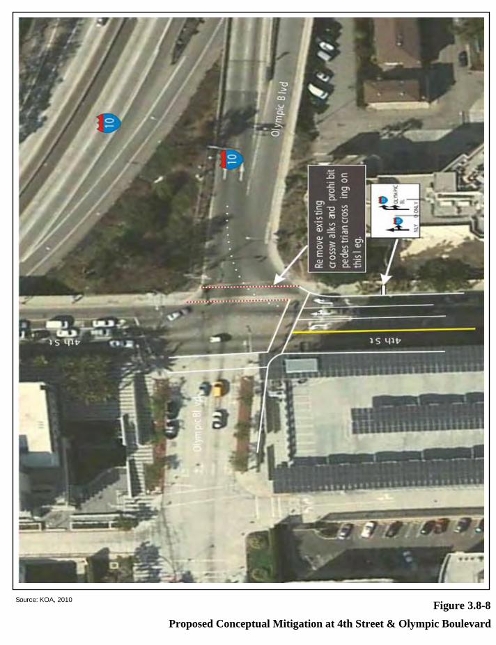
Proposed Conceptual Mitigation at 4th Street & Olympic Boulevard
Figure 3.8-8Source: KOA, 2010

Santa Monica High School Science and Technology Building and Site Improvements Project Draft EIR Page 4-1 Santa Monica-Malibu Unified School District April 2010
4.0 IMPACT OVERVIEW
This chapter provides an overview of the environmental effects of the proposed Project, including significant unavoidable adverse impacts, impacts not found to be significant, cumulative impacts, significant irreversible environmental changes, and growth-inducing impacts. Cross-references are made throughout this chapter to other sections of the EIR where more detailed discussions of the impacts of the proposed Project can be found.
4.1 SIGNIFICANT UNAVOIDABLE ADVERSE IMPACTS
This section is prepared in accordance with Section 15126.2(b) of the CEQA Guidelines, which requires the discussion of any significant environmental effects that cannot be avoided if a project is implemented. These include impacts that can be mitigated, but cannot be reduced to a less than significant level. An analysis of environmental impacts caused by the proposed Project has been conducted and is contained in this EIR. Nine issue areas were analyzed in detail in Chapter 3.0. According to the environmental impact analysis presented in Chapter 3.0, the proposed Project would result in significant unavoidable adverse impacts connected to construction-related air quality (Chapter 3.2) and construction parking (Chapter 3.8).
As discussed in Chapter 3.2, PM10 and PM2.5 emissions during construction would be higher than the LST thresholds. The proposed Project would comply with SCAQMD Rule 403 for dust control. However, a significant impact would remain even after the implementation of SCAQMD Rule 403. Adjacent receptors may be exposed to PM emissions that are higher than the local allowable limit and the impact would be significant and unavoidable.
As discussed in Chapter 3.8, the existing 253 parking spaces on the Project site would not be available during construction. The SMMUSD will provide a temporary parking location for faculty and staff vehicles during construction. However, 40 student parking spaces would be lost and a temporary significant and unavoidable impact would result related to these student parking spaces.
4.2 EFFECTS NOT FOUND TO BE SIGNIFICANT
Section 15128 of the CEQA Guidelines requires the identification of impacts of a project that were determined not to be significant and that were not discussed in detail in an impact section of the EIR. These issues were eliminated from further review during the Initial Study process (see Appendix A). Therefore, the following section presents a brief discussion of environmental issues that were not found to be significant for the proposed Project, including agriculture resources, biological resources, geology and soils, hydrology and water quality, mineral resources, population and housing, public services and utilities and service systems.
4.0 Impact Overview
Page 4-2 Santa Monica High School Science and Technology Building and Site Improvements Project Draft EIR April 2010 Santa Monica-Malibu Unified School District
4.2.1 AGRICULTURE RESOURCES
The proposed Project would not convert farmland to non-agricultural uses, conflict with agricultural zoning or a Williamson Act contract. The Project site is located within an area designated as Urban and Built-Up Land by the California Division of Land Resource Protection Farmland Mapping and Monitoring Program, with the nearest farmland located several miles from the Project site. The Project site is currently zoned Medium Density Multiple Family Residential (R3) with the Public Lands Overlay District and developed with school facilities. Therefore, the proposed Project would not result in significant impacts on Prime Farmland, Unique Farmland, Farmland of Statewide Importance or other agriculture resources.
4.2.2 BIOLOGICAL RESOURCES
The proposed Project would not impact, either directly or indirectly or through habitat modifications, any endangered threatened or rare species as listed in Title 14 of the California Code of Regulations. The Project site is currently developed and located in an urban setting that does not contain any habitat of candidate, sensitive or special status species, or riparian habitat or other sensitive natural community as listed in local or regional plans, policies, or regulations, or by the California Department of Fish and Game (CDFG) or U.S. Fish and Wildlife Service (USFWS). Based on the California Natural Diversity Database (CNDDB) search conducted for the Project site and site visit, there is no potential for the presence of special-status species at the Project site. In addition, the Project site is currently developed and located in an urban setting and the proposed Project would not have an effect on federally protected wetlands as defined by Section 404 of the Clean Water Act (including, but not limited to, marsh, vernal pool, coastal, etc.) through direct removal, filling, hydrological interruption or other means. No Habitat Conservation Plan, Natural Community Conservation Plan, or other approved habitat conservation plan has been adopted to include the Project site.
Implementation of the proposed Project would not interfere with the movement of any native resident or migratory fish or wildlife species, or with established native resident or migratory wildlife corridors, or impede the use of native wildlife nursery sites. The Project site is an existing school, located in an urban residential environment. The Project site does not contain any watercourse, greenbelt, or open space for wildlife movement, as it is an existing school, which does not provide appropriate habitat for plants or wildlife. The proposed Project may remove approximately 20 landscape trees from the Project site. However, no sensitive tree species would be removed as part of the proposed Project and construction would comply with the Migratory Bird Treaty Act to ensure that nesting bird surveys would be conducted prior to the start of construction activities which would occur during nesting bird season (February 1 through August 31). Per the Migratory Bird Treaty Act requirements, a qualified biologist would conduct a nest survey within one week of the start of construction to ensure that no active nests would be lost. If an active nest is located, then the nest should be flagged and construction within 300 feet (500 feet for raptors) of the nest should be postponed until the biologist has confirmed that the nest is no longer active. The proposed Project would also comply with the City of Santa Monica tree protection ordinance, which requires that any tree, shrub or plant in any street, park, boulevard, or public place in the City must be protected against damage during the repair, alteration, or construction of a building. Although
4.0 Impact Overview
Santa Monica High School Science and Technology Building and Site Improvements Project Draft EIR Page 4-3 Santa Monica-Malibu Unified School District April 2010
approximately 20 trees may be removed from the Project site, the Project site is not considered to be a public place. Accordingly, no trees in public places, including adjacent sidewalks, would be removed or damaged as a result of the proposed Project. Compliance with the Migratory Bird Treaty Act and City Municipal Code requirements would ensure no significant impact to migratory wildlife species. Therefore, the proposed Project would not result in significant impacts related to biological resources.
4.2.3 GEOLOGY AND SOILS
The proposed Project would not expose people or structures to potential adverse effects, including the risk of loss, injury, or death involving the rupture of a known earthquake fault or strong seismic groundshaking. The Project site is not located within an Alquist-Priolo Fault Zone and no known faults cross the Project site. The nearest known fault is the Santa Monica Fault, located approximately 1.93 miles north of the Project site. The Santa Monica Fault is considered to be active, and the Project site would be subject to strong seismic groundshaking in the event of an earthquake. Seismic hazards from groundshaking are typical for many areas of Southern California and the potential for seismic activity would not be greater than for much of the Los Angeles area. The design of the proposed building would be reviewed and approved by the Division of the State Architect, in accordance with the policies of the Field Act. Additionally, all new structures would be subject to State building and safety guidelines, restrictions, and permit regulations, including the Uniform Building Code and the California Department of Conservation, Divisions of Mines and Geology requirements, which are designed to address the risks associated with fault rupture and seismic groundshaking.
The proposed Project would not expose people or structures to potential substantial adverse effects, including the risk of loss, injury, or death involving landslides or seismic-related ground failure, including liquefaction. The Project site is not within a landslide hazard zone, and no known landslides are located near the Project site, nor is the Project site in the path of any known potential landslides. The proposed Project area is not located within an area determined to be susceptible to seismic slope instability, including liquefaction. A Geotechnical Investigation concluded that the relatively level ground surface precludes the Project site from susceptibility to seismically-induced soil instability, including lurching and settlement. In addition, the Project site is not located on a geologic unit or soil that is unstable, or that would become unstable as a result of the proposed Project, and potentially result in on- or off-site landslide, lateral spreading, subsidence, liquefaction, or collapse. The proposed Project would be designed and constructed pursuant to Title 24 of the California Building Standards Code, and other design guidelines established by the site-specific Geotechnical Investigation Report, which would ensure no significant impacts.
Implementation of the proposed Project would not result in substantial soil erosion or the loss of topsoil. The relatively flat nature of the Project site precludes it from being readily susceptible to erosion. However, construction of the proposed Project would result in ground surface disruption during excavation and grading that could create the potential for erosion to occur. Since the proposed Project is greater than one acre, the SMMUSD’s construction contractor would prepare and comply with a Stormwater Pollution Prevention Plan (SWPPP), which would feature erosion control measures. In addition, the SMMUSD’s construction contractor would comply with the Stormwater Construction

4.0 Impact Overview
Page 4-4 Santa Monica High School Science and Technology Building and Site Improvements Project Draft EIR April 2010 Santa Monica-Malibu Unified School District
Activities General Permit and obtain a National Pollution Discharge Elimination System (NPDES) permit. Compliance with the requirements of the NPDES permit and SWPPP and implementation of the required construction best management practices would ensure no significant impacts related to soil erosion.
The fine grained, clayey soils underlying the Project site are considered to be expansive. However, in accordance with the recommendations of the Geotechnical Investigation Report, existing soils would be over-excavated and replaced with engineered fill or where appropriate, reused and re-compacted as part of the proposed Project. The proposed Project would be designed and constructed pursuant to Title 24 of the California Building Standards Code. In addition, the Project site is connected to City sewer and storm drains and septic tanks or alternative wastewater systems would not be used. Therefore, the proposed Project would not result in significant impacts related to geology and soils.
4.2.4 HYDROLOGY AND WATER QUALITY
The proposed Project includes the demolition of the existing Science and Technology Buildings, parking lot, and softball field and construction of a new Science and Technology Building, parking lot, and softball field. During construction, water used to control dust during grading and construction, as well as storm water, could carry construction debris, spilled fluids (including petroleum products from construction vehicles), and disturbed soils into local and regional waterways. Water quality in Santa Monica is regulated by the State of California Water Quality Control Board (WQCB), Los Angeles Region (Region 4, LARWQCB). The County of Los Angeles issues permits to cities to discharge storm water runoff under NPDES. The LARWQCB requires all discretionary projects, such as the proposed Project, to incorporate features to filter or retain the first ¾ inch of storm water onsite. Since most pollutants are carried away in the first ¾ inch of rainfall, this requirement would address the primary source of pollution onsite. The proposed Project would be designed to direct and retain stormwater from the building and parking lot in infiltration swales. Only excessive overflow would flow directly to the municipal storm drain network. During construction, adherence to all applicable water quality requirements would be required. Implementation of these requirements, including preparation of a SWPPP, would ensure that impacts to water quality, during construction and operation, are not significant.
Implementation of the proposed Project would not deplete groundwater supplies or interfere with groundwater recharge such that there would be a net deficit in aquifer volume or a lowering of the local groundwater table level. Groundwater would not be extracted during construction or operation of the proposed Project.
The proposed Project would not substantially alter the existing drainage pattern of the Project site or area, including through the alteration of the course of a stream or river, in a manner which would result in substantial erosion, siltation or flooding on-or off-site. Drainage patterns within the Project area are well established resulting in low potential for drainage alteration in most areas. The SMMUSD would comply with all applicable requirements regulating drainage improvements and grading plans as they relate to construction of on-site improvements that affect off-site drainage. In addition, the SMMUSD shall
4.0 Impact Overview
Santa Monica High School Science and Technology Building and Site Improvements Project Draft EIR Page 4-5 Santa Monica-Malibu Unified School District April 2010
incorporate standards developed by the Collaborative for High Performance Schools (CHPS) to the extent feasible. Compliance with existing regulations would ensure that that the proposed Project would not adversely affect the local drainage system in a manner that would result in substantial flooding on- or off-site.
The proposed Project would not create or contribute runoff water that would exceed the capacity of existing or planned stormwater drainage systems, provide substantial additional sources of polluted runoff, or degrade water quality. Impervious surfaces such as buildings and parking lots can increase runoff rates through impeding infiltration of rainfall and increasing overland flow velocities. Ultimately, the proposed Project would not increase the coverage of impervious surfaces as the Project site is an existing school. Furthermore, the proposed Project would be designed to direct stormwater runoff to onsite infiltration areas, which would reduce the amount of runoff currently leaving the Project site. Construction of the proposed Project would include grading and other construction activities that could cause deterioration of water quality. SMMUSD’s construction contractor would comply with NPDES regulations, prepare a SWPPP, incorporate construction best management practices (BMPs) into the proposed Project, and include in the design of the proposed Project BMPs to reduce post-construction runoff and regulated stormwater quality.
The proposed Project would not expose people or structures to a significant risk of loss, injury or death involving flooding, including flooding as a result of the failure of a levee or dam. In addition, the proposed Project would not expose people or structures to the risk of inundation by seethe, tsunami, or mudflow. The proposed Project site is not located within an area that is down slope of any large bodies of water which would have potential to impact the Project site through levee or dam failure, seethe or mudflow. In addition, the Project site is not located in a designated flood zone and would not place housing within a 100-year flood hazard area as mapped on a federal Flood Hazard Boundary or Flood Insurance Rate Map or other flood hazard delineation map. The Project site is also not within a tsunami run up zone as determined by the City of Santa Monica or the County of Los Angeles. Therefore, the proposed Project would not result in significant impacts related to hydrology and water quality.
4.2.5 MINERAL RESOURCES
The proposed Project would not result in the loss of availability of a known mineral resource that would be of value to the region and the residents of the state. In addition, no locally important mineral resource recovery sites delineated on a local general plan, specific plan or other land use plan would be impacted. Mineral and energy resources are generally located on industrial lands that are not suitable for school facilities and that would be eliminated from consideration during the initial site screening process. The Santa Monica General Zoning Plan does not indicate an important mineral resource on or near the Project site. The Project site is an existing school in a currently developed area, and the land use would not change as a result of the proposed Project. In addition, proposed Project construction would not displace large quantities of sand or gravel. Therefore, the proposed Project would not result in significant impacts related to mineral resources.
4.0 Impact Overview
Page 4-6 Santa Monica High School Science and Technology Building and Site Improvements Project Draft EIR April 2010 Santa Monica-Malibu Unified School District
4.2.6 POPULATION AND HOUSING
The proposed Project would not increase the capacity of Santa Monica High School and would not induce population growth or create the need for additional housing in the Project area. The proposed Project is intended to accommodate projected population growth in the local community. The occupants of the existing Science and Technology Buildings would remain in the building until the new Science and Technology Building is completed. Additionally, the proposed Project would not require the extension or increase the capacity of existing off-site infrastructure. The proposed Project is intended to serve existing and future students within the SMMUSD and would not result in the creation of housing or infrastructure that would induce or accelerate population or household growth that would exceed Southern California Association of Governments (SCAG) Year 2020 Projections. The number of students attending the school would not be affected by the proposed Project. As such, the Project would not stimulate population growth beyond that already projected to occur.
The proposed Project would reconfigure the Science and Technology Buildings, parking lot and softball field within the existing school’s property line. Only school uses and buildings are currently located within the school’s property line; no housing or businesses are located on the school site. Therefore, the proposed Project would not displace any existing housing or businesses, necessitating the construction of replacement housing or businesses elsewhere. In addition, the proposed Project would not displace any jobs necessitating the replacement of businesses of jobs elsewhere. New temporary jobs would be created during construction of the proposed Project. Therefore, the proposed Project would not result in significant impacts related to population and housing.
4.2.7 PUBLIC SERVICES
Fire protection service needs are generally related to the size of the population and geographic area served, the number and types of calls for service, and other community and physical characteristics. No change in enrollment would occur as a result of the Project and no additional faculty or staff would be required. Fire protection services would continue to be provided to the Project site by the City of Santa Monica Fire Department. Fire Station 121, located at 7th Street, approximately 0.4-mile from the Project site, would be the primary responder. The secondary responder would be Fire Station 122, located at 222 Hollister Avenue, approximately 0.6-mile from the Project site. Based on the distance of the nearby fire stations to the Project site, fire protection at the Project site would be considered adequate. In addition, the Santa Monica Fire Department has confirmed that fire protection services would not be immediately impacted by the proposed Project.1 No new uses would be introduced on-site and the number of students on campus would not change; however, the number of students attending the school may increase over time, but would not be a direct result of the proposed Project. As such, the proposed Project would not result in adverse physical impacts associated with the provision of new or physically altered fire protection facilities, in order to maintain acceptable service ratios, response times or other performance objectives for fire protection.
1 Written comment letter from Jim Glew, Fire Marshal (See Appendix A). Santa Monica Fire Department. July 8, 2009.

4.0 Impact Overview
Santa Monica High School Science and Technology Building and Site Improvements Project Draft EIR Page 4-7 Santa Monica-Malibu Unified School District April 2010
Police protection services would continue to be provided to the Project site by the City of Santa Monica Police Department. Santa Monica High School is located within the service area of Beat A2 of the Santa Monica Police Department Patrol Area. Redevelopment of the Project site with comparable new school facilities would not change the student enrollment or create new demands on police services such that significant impacts to service ratios, response times and other performance objectives would occur.
The proposed Project would physically alter existing school facilities by reconfiguring the northeastern portion of the Santa Monica High School campus. However, the proposed Project would not create a need for new or expanded public school facilities; rather, it would reconfigure the existing Science and Technology Buildings, parking lot, and softball field and conduct upgrades to campus-wide electrical and fire alarm systems. As a result, the Project would benefit the existing campus by providing an updated Science and Technology Building, softball field, parking lot and modernized campus’ utilities. In addition, the proposed Project would not result in adverse physical impacts associated with the provision of new or physically altered public facilities or services. The proposed Project would not result in an increase in enrollment or faculty/staff. No additional new government facilities would be required and the proposed Project would not contribute to increased demand for additional public services and facilities. Therefore, the proposed Project would not result in significant impacts related to public services.
4.2.8 UTILITIES AND SERVICE SYSTEMS
Implementation of the proposed Project would not exceed wastewater treatment requirements of the applicable Regional Water Quality Control Board, require the construction of new water or wastewater treatment facilities or expansion of existing facilities, or result in inadequate capacity at the wastewater treatment facility. During the construction of the proposed Project, the SMMUSD would become a permitted under the City’s MS4 NPDES permit or obtain its own NPDES permit from the LARWQCB, including requirements for wastewater discharge, BMPs, and a SWPPP. Within the applicable permit, the effluent quality criteria are specified by the LARWQCB, based on receiving water guidelines and waste load allocations. Additionally, the operation of the proposed Project would not result in an increase in enrollment or faculty/staff which would result in an increase in wastewater from the proposed Project and wastewater would continue to flow to the existing eight-inch sewer line in 7th Street currently serving the existing Science and Technology Buildings. There would be nor increase in demand for water or wastewater treatment facilities. Additionally, the new Science and Technology Building would include energy conservation features and low-flow plumbing fixtures which would decrease water and wastewater demand.
The proposed Project would not require the construction of new stormwater drainage facilities. The proposed project would reconfigure the northeastern portion of the Santa Monica High School campus. The proposed Project would not increase the amount of impervious surfaces on the Project site and the Project would be designed to retain all stormwater runoff onsite. Only overflow would be directed to the municipal storm drain network in Olympic Boulevard. As such, the proposed Project would not require the construction of new or expansion of existing stormwater drainage facilities, the construction of which could result in adverse environmental effects.

4.0 Impact Overview
Page 4-8 Santa Monica High School Science and Technology Building and Site Improvements Project Draft EIR April 2010 Santa Monica-Malibu Unified School District
With regard to water supplies, distribution infrastructure is already in place on and around the proposed Project site and the existing eight-inch water supply line in Michigan Avenue would adequately supply the new Science and Technology Building. The City of Santa Monica is responsible for supplying water within the City limits and for ensuring that the delivered water quality meets applicable California Department of Health Services (DHS) standards for drinking water. Because the proposed Project would not result in a change in the number of students or faculty/staff, no substantial increase in water supply requirements would occur. SMMUSD would comply with local, regional, and state water conservation policies and would follow standard BMPs to reduce water consumption. Additionally, to conserve water to the maximum extent possible, the City of Santa Monica recommends water conservation measures in landscape, installation, and maintenance (e.g., use drip irrigation and soak hoses in lieu of sprinklers to lower the amount of water lost to evaporation and overspray, set automatic sprinkler systems to irrigate during the early morning or evening hours to minimize water loss due to evaporation, and water less in the cooler months and during the rainy season). The proposed Project would in include a landscape plan that would feature many drought tolerant plants to minimize water usage. In addition, the proposed Project would be required to be constructed in accordance with Title 24 measures and CHPS standards that would lessen a development’s water demand.
Solid waste generated in the City of Santa Monica is currently taken to the Santa Monica Community Recycling Center and Transfer Station. From there, the waste can be sorted and recycled where possible. The remaining solid waste is then disposed of at one of many landfill locations within the region. Currently, it is anticipated that solid waste generated by the proposed Project would be taken to Puente Hills Landfill, which has a remaining capacity of approximately 26.6 million tons. In addition, the City could potentially seek additional capacity from landfills in Orange, Riverside, and Ventura Counties. The SMMUSD would implement BMPs during construction and operation of the proposed Project, such as source reduction, recycling and other diversion measures to reduce solid waste generation impacts to landfills. In addition, the proposed Project would be required to comply with the Countywide Integrated Waste Management Plan (CIWMP) and the Santa Monica Municipal Code (if applicable). Furthermore, the proposed Project would be located in a highly developed area that has previously contributed solid waste to regional landfills. The proposed Project would not result in significant impacts related to utilities and service systems.
4.3 CUMULATIVE IMPACTS
According to Section 15355 of the CEQA Guidelines, cumulative impacts refer to:
“Two or more individual effects which, when considered together are considerable or which compound or increase other environmental effects. The individual effects may be changes resulting from a single project or a number of separate projects. The cumulative impact from several projects is the change in the environment that results from the incremental impact of the project when added to other closely related past, present, and reasonably foreseeable future projects. Cumulative impacts can result from individually minor but collectively significant projects taking place over a period of time.”

4.0 Impact Overview
Santa Monica High School Science and Technology Building and Site Improvements Project Draft EIR Page 4-9 Santa Monica-Malibu Unified School District April 2010
Section 15130(a) of the CEQA Guidelines states that:
“An EIR shall discuss cumulative impacts of a project when the project’s incremental effect is cumulatively considerable.... When the combined cumulative impact associated with the project’s incremental effect and the effects of other projects is not significant, the EIR shall briefly indicate why the cumulative impact is not significant and is not discussed in further detail in the EIR.... An EIR may determine that a project’s contribution to a significant cumulative impact will be rendered less than cumulatively considerable and thus is not significant. A project’s contribution is less than cumulatively considerable if the project is required to implement or fund its fair share of a mitigation measure or measures designed to alleviate the cumulative impact.”
According to Section 15130 (b)(1)(A) of the CEQA Guidelines, a list of past, present, and probable future projects producing related or cumulative impacts may be used as the basis of the cumulative impacts analysis. The “list” approach was used for the cumulative impacts discussion in this EIR. The scale or geographic scope of related projects varies for each impact category. For instance, cumulative geology and soils or aesthetics impacts are considered localized, while cumulative traffic and transportation and air quality impacts are considered regionally. Table 4-1 includes all of the approved, under construction, or proposed development projects within in the vicinity of the Project Site. Figure 4-1 shows the location of the related projects. The list of development projects is derived from lists compiled by KOA Corporation and provided by the City of Santa Monica.
TABLE 4-1 RELATED PROJECTS
No. Address Project Name Land Use Daily AM Peak PM Peak
Total IN OUT Total IN OUT
1 1038 11th Street
5 Unit Condominium DCP 04-006 TM 04-007
5-Unit Condominium 29 2 0 2 3 2 1
2 1444 11th Street
Condominium, TM 07-010
8-Unit Condominium 47 4 1 3 4 3 1
3 1518 11th Street
6-Unit Condominium TM 08-002
6-Unit Condominium 35 3 1 2 3 2 1
4 1524 11th Street
5-Unit Condominium TM 05-003
5-Unit Condominium 29 2 0 2 3 2 1
5 1544 11th Street
5 Unit Condominium DCP 04-005 TM 04-013
5 Unit Condominium 29 2 0 2 3 2 1
6
911 12th Street 5-Unit Condominium TTM #52898; refilled as DCP 00-004
5-Unit Condominium 4,125 so 29 2 0 2 3 2 1
7 1211 12th Street
TM 05-009 VAR 05-010
15-Unit Condominium 88 7 1 6 8 5 3
8 1652 12th Street
DR 05-008 TM 05-017 DCP 05-003
16-Unit artist lofts 94 7 1 6 8 5 3

4.0 Impact Overview
Page 4-10 Santa Monica High School Science and Technology Building and Site Improvements Project Draft EIR April 2010 Santa Monica-Malibu Unified School District
No. Address Project Name Land Use Daily AM Peak PM Peak
Total IN OUT Total IN OUT
9 914 14th Street DCP 04-007 TM 04-010
5-Unit Condominium 29 2 0 2 3 2 1
10 839 9th Street 5 Unit
Condominium TM 03-004
5 Unit Condominium 29 2 0 2 3 2 1
11 1211 9th Street Condominium, TM
06-039 5-Unit Condominium 29 2 0 2 3 2 1
12
1027 10th Street
5-Unit Condominium DCP 00-002, TM 00-001
Total: 6,945 so, 5-Unit Condominium 29 2 0 2 3 2 1
13
838 16th Street 10-Unit Condominium CUP 98-047 VTTM52649 EIR 99-003
10 Unit Condominium
59 4 1 3 5 3 2
14 1415 16th Street
6-Unit Condominium DCP 02-007 TM 02-005
6-Unit Condominium 35 3 1 2 3 2 1
15 1520 16th Street
5-Unit Condominium
5-Unit Condominium 29 2 0 2 3 2 1
16 1537 16th Street
5 Unit Condominium DCP 03-004 TM 03-005
5 Unit Condominium 29 2 0 2 3 2 1
17 908 17th Street & 1620 Idaho Avenue
8-Unit Condominium TM 04-035
8-Unit Condominium 47 4 1 3 4 3 1
18 919 17th Street 5-Unit
Condominium TM 05-019
5-Unit Condominium 29 2 0 2 3 2 1
19 1807 17th Street
Condominium, TM 07-007 (W/D) TM 07-014
7-Unit Condominium 41 3 1 2 4 3 1
20
1927 18th Street
6-Unit Condominium TM 05-013 (W/D) TM 05-025
6-unit Condominium
35 3 1 2 3 2 1
21 1035 19th Street
5-Unit Condominium TM04-034
5-Unit Condominium 29 2 0 2 3 2 1
22 1119 20th Street
5-Unit Condominium TM 05-021
5 Unit Condominium 29 2 0 2 3 2 1
23 1671 20th Street
AA 05-016 101-unit Apartment 679 52 10 42 63 41 22
24 1818 20th Street
5-Unit Condominium TM06-001
5 Unit Condominium 29 2 0 2 3 2 1
25
1120 21st Street
5-Unit Condominium DCP03-009 TM03-003
5 Unit Condominium 29 2 0 2 3 2 1
26 1131 Arizona Avenue
DR 06-019 CUP 06-020 Alzheimer’s Facility
3-story 38,632 sq.ft. 65 beds 768 73 51 22 85 31 54

4.0 Impact Overview
Santa Monica High School Science and Technology Building and Site Improvements Project Draft EIR Page 4-11 Santa Monica-Malibu Unified School District April 2010
No. Address Project Name Land Use Daily AM Peak PM Peak
Total IN OUT Total IN OUT
27 829 Broadway Mixed-Use, AA 06-
015 129-Unit Residential 867 66 13 53 80 52 28
28 1424 Broadway Affordable Housing
AA 03-016 41 Apartment Units 276 21 4 17 25 16 9
29
1502 Broadway 32-Unit Condominium DR 04-004 DCP 04-013 TM 04-026
32-Unit Condominium
188 14 2 12 17 11 6
30 1902 California Avenue
5-Unit Condominium TM 05-007
5-Unit Condominium 29 2 0 2 3 2 1
31 1707 Cloverfield Boulevard
Storage Facility DR 05-003
31,400 sq.ft. self-storage 79 5 3 2 8 4 4
32 1940 Cloverfield Boulevard
DR 04-007, TM 04-028
16- Unit Condominium 94 7 1 6 8 5 3
33 1327 Euclid Street
ARB 06-106 5 Unit Condominium 29 2 0 2 3 2 1
34 Near 1525 Euclid
Euclid Park 15,000 sf park 1.0 0.0 0.0 0.0 0.0 0.0 0.0
35 2222 Pico Blvd.
Mixed-Use AA06-003
2 units residential & 2,399 sf of retail
12 1 0 1 1 1 0
106 3 2 1 7 3 4
36
210-12 Santa Monica Boulevard
Mayfair Theater AA 05-001 DR 98-007
45,000 sf Commercial Building; 9700 Retail; 38 Apartments
679 52 10 42 63 41 22
495 70 0 8 67 0 56
430 13 8 5 26 11 15
37
2345-49 Virginia Ave. & 1942-54 High Place
Apartments, DR 06-018
47-Unit Apartments 316 24 5 19 29 19 10
38 1750 10th Street
5 Unit Condominium DCP 02-004
5-Unit Condominium 29 2 0 2 3 2 1
39 1804 10th Street
ARB 06-034 6 Unit Condominium 35 3 1 2 3 2 1
40 1112 Pico Blvd.
18-Unit Condominium TM 05-010
18 Unit Condominium 105 8 1 7 9 6 3
41 2510 7th Street DCP05-002 TM05-008
8-unit condo 29 2 0 2 3 2 1
42 1751 Appian Way
Multi Family Residential AA 02-033
14 Unit Apartment 94 7 1 6 9 6 3
43 217 Bicknell DR 05-001 DCP
05-001 TM 05-001 7-Unit Condominium 41 3 1 2 4 3 1
44
1685 Main Street, 333 Civic Center Drive
Santa Monica Civic Center
12,500 sq.ft. retail
554 17 10 7 34 15 19
45 1776 Main Street
RAND Corporation 308,900 sq ft. Office 3401 479 0 57 460 0 382
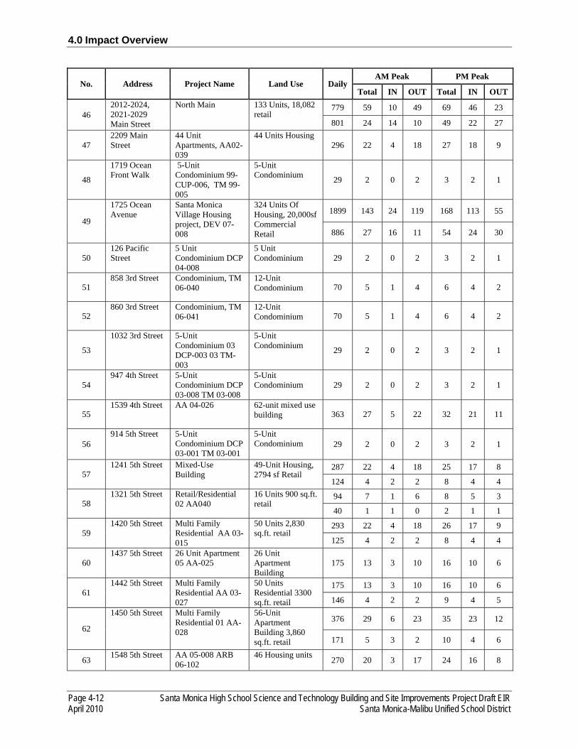
4.0 Impact Overview
Page 4-12 Santa Monica High School Science and Technology Building and Site Improvements Project Draft EIR April 2010 Santa Monica-Malibu Unified School District
No. Address Project Name Land Use Daily AM Peak PM Peak
Total IN OUT Total IN OUT
46 2012-2024, 2021-2029 Main Street
North Main 133 Units, 18,082 retail
779 59 10 49 69 46 23
801 24 14 10 49 22 27
47 2209 Main Street
44 Unit Apartments, AA02-039
44 Units Housing 296 22 4 18 27 18 9
48
1719 Ocean Front Walk
5-Unit Condominium 99-CUP-006, TM 99-005
5-Unit Condominium 29 2 0 2 3 2 1
49
1725 Ocean Avenue
Santa Monica Village Housing project, DEV 07-008
324 Units Of Housing, 20,000sf Commercial Retail
1899 143 24 119 168 113 55
886 27 16 11 54 24 30
50 126 Pacific Street
5 Unit Condominium DCP 04-008
5 Unit Condominium 29 2 0 2 3 2 1
51 858 3rd Street Condominium, TM
06-040 12-Unit Condominium 70 5 1 4 6 4 2
52 860 3rd Street Condominium, TM
06-041 12-Unit Condominium 70 5 1 4 6 4 2
53
1032 3rd Street 5-Unit Condominium 03 DCP-003 03 TM-003
5-Unit Condominium 29 2 0 2 3 2 1
54 947 4th Street 5-Unit
Condominium DCP 03-008 TM 03-008
5-Unit Condominium 29 2 0 2 3 2 1
55 1539 4th Street AA 04-026 62-unit mixed use
building 363 27 5 22 32 21 11
56 914 5th Street 5-Unit
Condominium DCP 03-001 TM 03-001
5-Unit Condominium 29 2 0 2 3 2 1
57 1241 5th Street Mixed-Use
Building 49-Unit Housing, 2794 sf Retail
287 22 4 18 25 17 8
124 4 2 2 8 4 4
58 1321 5th Street Retail/Residential
02 AA040 16 Units 900 sq.ft. retail
94 7 1 6 8 5 3
40 1 1 0 2 1 1
59 1420 5th Street Multi Family
Residential AA 03-015
50 Units 2,830 sq.ft. retail
293 22 4 18 26 17 9
125 4 2 2 8 4 4
60 1437 5th Street 26 Unit Apartment
05 AA-025 26 Unit Apartment Building
175 13 3 10 16 10 6
61 1442 5th Street Multi Family
Residential AA 03-027
50 Units Residential 3300 sq.ft. retail
175 13 3 10 16 10 6
146 4 2 2 9 4 5
62
1450 5th Street Multi Family Residential 01 AA-028
56-Unit Apartment Building 3,860 sq.ft. retail
376 29 6 23 35 23 12
171 5 3 2 10 4 6
63 1548 5th Street AA 05-008 ARB 06-102
46 Housing units 270 20 3 17 24 16 8
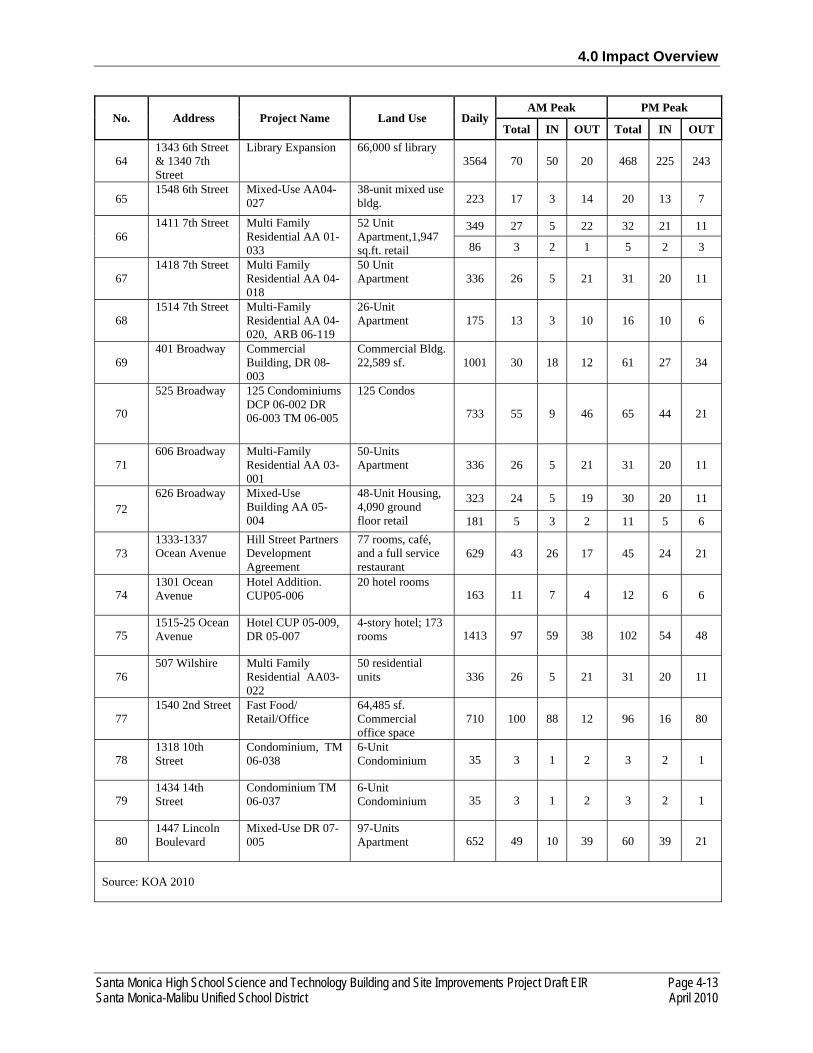
4.0 Impact Overview
Santa Monica High School Science and Technology Building and Site Improvements Project Draft EIR Page 4-13 Santa Monica-Malibu Unified School District April 2010
No. Address Project Name Land Use Daily AM Peak PM Peak
Total IN OUT Total IN OUT
64 1343 6th Street & 1340 7th Street
Library Expansion 66,000 sf library 3564 70 50 20 468 225 243
65 1548 6th Street Mixed-Use AA04-
027 38-unit mixed use bldg. 223 17 3 14 20 13 7
66 1411 7th Street Multi Family
Residential AA 01-033
52 Unit Apartment,1,947 sq.ft. retail
349 27 5 22 32 21 11
86 3 2 1 5 2 3
67 1418 7th Street Multi Family
Residential AA 04-018
50 Unit Apartment 336 26 5 21 31 20 11
68 1514 7th Street Multi-Family
Residential AA 04-020, ARB 06-119
26-Unit Apartment 175 13 3 10 16 10 6
69 401 Broadway Commercial
Building, DR 08-003
Commercial Bldg. 22,589 sf. 1001 30 18 12 61 27 34
70
525 Broadway 125 Condominiums DCP 06-002 DR 06-003 TM 06-005
125 Condos
733 55 9 46 65 44 21
71 606 Broadway Multi-Family
Residential AA 03-001
50-Units Apartment 336 26 5 21 31 20 11
72 626 Broadway Mixed-Use
Building AA 05-004
48-Unit Housing, 4,090 ground floor retail
323 24 5 19 30 20 11
181 5 3 2 11 5 6
73 1333-1337 Ocean Avenue
Hill Street Partners Development Agreement
77 rooms, café, and a full service restaurant
629 43 26 17 45 24 21
74 1301 Ocean Avenue
Hotel Addition. CUP05-006
20 hotel rooms 163 11 7 4 12 6 6
75 1515-25 Ocean Avenue
Hotel CUP 05-009, DR 05-007
4-story hotel; 173 rooms 1413 97 59 38 102 54 48
76 507 Wilshire Multi Family
Residential AA03-022
50 residential units 336 26 5 21 31 20 11
77 1540 2nd Street Fast Food/
Retail/Office 64,485 sf. Commercial office space
710 100 88 12 96 16 80
78 1318 10th Street
Condominium, TM 06-038
6-Unit Condominium 35 3 1 2 3 2 1
79 1434 14th Street
Condominium TM 06-037
6-Unit Condominium 35 3 1 2 3 2 1
80 1447 Lincoln Boulevard
Mixed-Use DR 07-005
97-Units Apartment 652 49 10 39 60 39 21
Source: KOA 2010
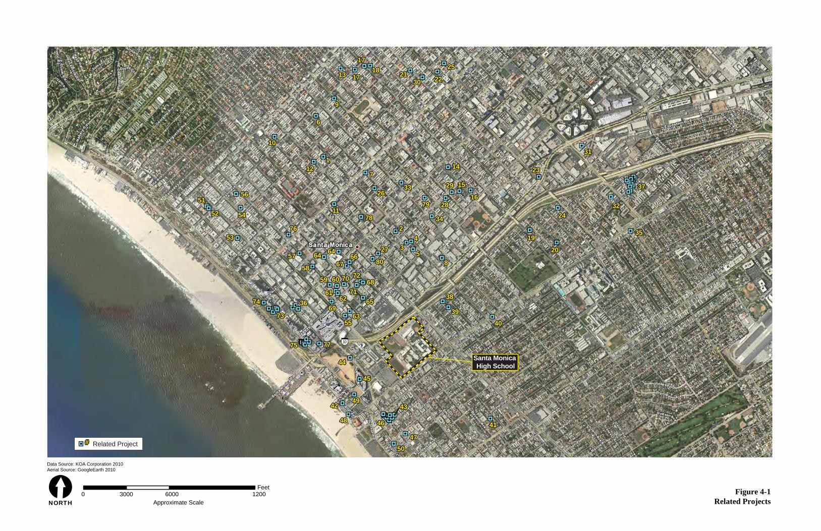
Figure 4-1Related Projects
Data Source: KOA Corporation 2010Aerial Source: GoogleEarth 2010
[NORTH
3000Feet
0 6000Approximate Scale
1200
5151
5353
3636
7373
7474
5050
4848
4949
4545
4444
7777
5555
69696363
62626161
5959 6060 7070
7171
72726868
65653838
8
3434
3333 3737
3535
3232
3131
2323
2424
1919
2020
2626
7
1111
7676
5757
5858
6464 64646666
2727
80806767
7979 2828
2929 1515
1616
53
42
7878
3939
4040
7575
4242
4747
4646
4343
4141
5454
5656
1010
12121
6
9
1313 1717
17171818 2121
3030 2222
2525
1414
5252
51
53
36
73
74
50
48
49
45
44
77
55
6963
6261
59 60 70
71
7268
6538
8
34
33 37
35
32
31
23
24
19
20
26
7
11
76
57
58
64 6466
27
8067
79 28
29 15
16
53
42
78
39
40
75
42
47
46
43
41
54
56
10
121
6
9
13 17
1718 21
30 22
25
14
52
10
Santa Monica High School
Related Project##
Santa Monica High School Science and Technology Building and Site Improvements Project Draft EIR Page 4-15 Santa Monica-Malibu Unified School District April 2010
Based on the environmental evaluation contained in the previous sections of this Draft EIR, the proposed Project would result in “no impact” to the following resource areas: agricultural resources, mineral resources, public services, population and housing, and utilities. Additionally, the proposed Project is not subject to the policies outlined within the City of Santa Monica General Plan and Article 9, Planning and Zoning, of the Municipal Code. As such, the proposed project would not contribute to any potential cumulative impact for land use and planning. Thus, these resource topics are not considered further in this analysis.
AESTHETICS
Construction
Construction activities with the proposed Project in conjunction with related projects may present a potential visual impact. The residents located along 7th Court Alley and Michigan Avenue, as well as the students and faculty/staff that attend school or work on the Project site are considered to have a higher sensitivity to the temporary changes in visual character during the construction phase of the proposed Project than the Project area patrons, employees, and passing motorists. The Project Site would be fenced on all sides to reduce the visual intrusion on the surrounding uses. During the proposed Project construction, the Project site would stand out as a memorable or remarkable feature in the landscape from the perspective of the residents and campus students and faculty/staff. However, this impact would be temporary and the Project site would be fenced and screened during construction. The proposed Project, like the related projects, would be subject to design review by the City to ensure that project design is consistent with City standards. The related projects would be required to comply with the same standards and similar mitigation measures, as applicable. As such, the cumulative construction impact on visual character would be less than significant.
Operation
The related projects located within a one-mile radius include various retail/mixed-use, office, commercial, and residential projects that are currently under construction, approved but not built, or proposed for development. The proposed Project would place the new three-story Science and Technology Building in the northern and eastern portion of the Project site, directly adjacent to 7th Court Alley. The new building would be constructed within the Santa Monica High School campus property line and would not encroach into 7th Court Alley. The building would be set back from the alley lot line approximately 10 feet 8 inches at the north end, and approximately 12 feet at the south end. The scrim or screen material to be installed on the eastern side of the building would extend approximately three feet four inches into this setback area. There is no unifying theme or character to the existing development that surrounds the Project site and the proposed Project would not substantially degrade the existing visual character or quality of the site and its surroundings. In addition, approximately 20 landscape trees on the Project site would be removed with the proposed Project, which would temporarily affect the visual character of the Project site. However, the removed trees are not known to be protected and would be replaced with trees of similar species and maturity with the implementation of the proposed Project. The proposed Project, like the related projects, would be subject to design review by the City to ensure that project design is

4.0 Impact Overview
Page 4-16 Santa Monica High School Science and Technology Building and Site Improvements Project Draft EIR April 2010 Santa Monica-Malibu Unified School District
consistent with City standards. Therefore, the proposed Project, in conjunction with the listed projects, would not have a cumulative aesthetic impact.
The Project site is located in an urban area adjacent to Olympic Boulevard and I-10, an area that currently has a high level of ambient lighting. The existing uses on the Project site include nighttime building lighting, security lighting, parking lot lighting, and minor softball field lighting. The proposed Project would use nighttime building lighting, security lighting, and building entrance lighting similar to the existing Project site. No major softball field lighting is proposed with the Project. Lighting would also be installed in the proposed plaza area and along the Olympic Boulevard, 7th Court Alley, and Michigan Avenue facades for security and decorative purposes. Similar to the related projects, all lighting fixtures proposed for the Project, including those installed on the Project site adjacent to 7th Court Alley, would be installed in accordance with the applicable specifications and standards, and would be aimed downward as appropriate to ensure that the light does not spillover onto adjacent residential uses. With the implementation of applicable lighting specifications and standards, the proposed Project in conjunction with the related projects would result in less than significant impacts related to lighting.
The proposed Project would not include any new major sources of glare, such as softball field lighting. It is anticipated that the proposed Project would be constructed of concrete, various scrim or screen material, and non-reflective glass windows. The exterior of the proposed Project would not include any metal or other reflective materials that could result in glare effects on the multi-family residences along Michigan Avenue and 7th Court Alley, or on the drivers traveling along the various streets surrounding the Project site. However, because the characteristics of the exterior building materials used with the proposed Project are not yet finalized, mitigation measure AES-A is provided to require the use of low-reflective building materials in Project construction. Additionally, as with the related projects, the proposed Project, would be required to comply with the same standards and similar mitigation measures, as applicable. Mitigation measure AES-A would be subject to design review by the City to ensure that project design is consistent with City standards and required to implement similar mitigation measures, as applicable. Therefore, the proposed Project’s incremental contribution to cumulative glare impacts would be less than significant.
The primary visual change that would result from the proposed Project would be the placement and height of the new Science and Technology Building as compared to the existing Science and Technology Buildings. The new building would be located adjacent to 7th Court Alley and the campus’ northeastern property line, a location on the Project site where no buildings or structures currently exist. This building places the new building adjacent to multi-family residential uses, which are located across the 23-foot-wide alley. The proposed Project would construct a new, modern-looking structure that would be one-story taller than the existing surrounding development. Due to the relatively close proximity of the proposed building to the existing multi-family residential/commercial buildings, shadows would cover portions of these buildings for at least three hours in the afternoon. Due to the duration of shadow coverage and the sensitivity of residences to shadow coverage, this impact would be considered significant. In addition, these multi-family residences currently do not experience any shadow coverage from the Project site because of the lack of buildings on the northeastern portion of the Project site, adjacent to 7th Court Alley. Therefore, the proposed Project in would result in significant impacts related

4.0 Impact Overview
Santa Monica High School Science and Technology Building and Site Improvements Project Draft EIR Page 4-17 Santa Monica-Malibu Unified School District April 2010
to shadows. Mitigation measure AES-B is required to reduce the impact to less than significant. The related projects would be subject to design review by the City to ensure that project design is consistent with City standards and required to implement similar mitigation measures. Therefore, the proposed Project’s incremental contribution to cumulative shade and shadow impacts would be less than significant.
AIR QUALITY
Construction
The related projects include the development of hundreds of thousands of square feet of commercial and residential uses, a number that is many times greater than the proposed Project. Based on the modeling conducted, construction-related activities would not result in criteria air pollutant or precursor emissions that would exceed SCAQMD’s significance thresholds. Thus, the proposed Project would not result in regionally significant impacts during the excavation phase relative to NOX, PM10, and PM2.5. Project-generated construction-related emissions would not violate or contribute substantially to an existing or projected air quality violation. As a result, cumulative regional construction-generated emissions would be less than significant.
Localized construction emissions of PM10 and PM2.5 would remain above the applicable significance thresholds even with incorporation of SCAQMD-recommended dust control measures. Adjacent receptors would be exposed to PM emissions that are higher than the local allowable limit. The Project would be required to comply with SCAQMD Rule 403 for dust control. However, not all measures included in the Rule can be quantified in URBEMIS. Additionally, site grading activities would not occur near the receptors for more than 10 days. Construction activities associated with related projects occurring within 1,500 feet of the Project Site during the brief excavation phase of construction activity may expose adjacent receptors to PM emissions that are higher than the local allowable limit. The impact is significant and unavoidable. As such, the proposed Project in conjunction with related projects would have a significant cumulative localized emissions impact.
Operation
The SCAQMD’s approach for assessing cumulative operational impacts is based on the Quality Management Plan forecasts of attainment of ambient air quality standards in accordance with the requirements of the federal and state Clean Air Act. The SCAQMD has set forth regional significance thresholds designed to assist in the attainment of ambient air quality thresholds per the State Implementation Plan. The proposed Project would not result in a significant VOC, PM2.5, PM10, NOX, or CO impact during operations. Therefore, the proposed Project would result in a less than significant regional cumulative operations impact.
GLOBAL CLIMATE CHANGE
Various gases in the Earth’s atmosphere, classified as atmospheric greenhouse gases (GHGs), play a critical role in determining the Earth’s surface temperature. Solar radiation enters the Earth’s atmosphere
4.0 Impact Overview
Page 4-18 Santa Monica High School Science and Technology Building and Site Improvements Project Draft EIR April 2010 Santa Monica-Malibu Unified School District
from space, and a portion of the radiation is absorbed by the Earth's surface. The Earth emits this radiation back to space, but the properties of the radiation have changed from high-frequency solar radiation, to lower-frequency infrared radiation. GHGs, which are transparent to solar radiation, are effective in absorbing infrared radiation. This radiation that would have otherwise escaped back to space is now “trapped,” resulting in a warming of the atmosphere. This phenomenon, known as the Greenhouse Effect, is responsible for maintaining a habitable climate. Without the Greenhouse Effect, Earth would not be able to support life.
Prominent GHGs contributing to the Greenhouse Effect include carbon dioxide (CO2), methane (CH4), ozone (O3), water vapor, nitrous oxide (N2O), and chlorofluorocarbons (CFCs). Human-caused emissions of these GHGs in excess of natural ambient concentrations are considered to be responsible for an enhancement of the Greenhouse Effect, which have led to a trend of unnatural warming of the Earth’s climate, known as global warming or global climate change. Emissions of GHGs contributing to global climate change have been attributed in large part to human activities associated with industrial/manufacturing, utility, transportation, residential, and agricultural sectors. Emissions of CO2 are byproducts of fossil fuel combustion. Methane, a highly potent GHG, results from off-gassing associated with agricultural practices and landfills. Processes that absorb CO2, often referred to as sinks, include uptake by vegetation and dissolution into the ocean.
Carbon dioxide-equivalent (CO2e) is a value used to account for different GHGs having different potential to retain infrared radiation in the atmosphere and contribute to the Greenhouse Effect. This is known as the Global Warming Potential of a GHG, and is dependent on the lifetime, or persistence, of the gas molecule in the atmosphere. For example, as described in Appendix C, “Calculation Referenced,” of the General Reporting Protocol of the California Climate Action Registry, one ton of CH4 has the same contribution to the Greenhouse Effect as approximately 21 tons of CO2. Therefore, CH4 is a much more potent GHG than CO2. Expressing emissions in carbon-dioxide equivalents takes the Greenhouse Effect contribution of all GHG emissions and converts them to a single unit equivalent to the effect if all emissions were CO2.
As discussed in Chapter 3.2, Air Quality, an increase in the generation and emission of GHGs is not itself an adverse environmental effect. Climate change is a global problem, and GHGs are global pollutants, unlike criteria air pollutants and TACs, which are pollutants of regional and local concern, respectively. The scientific community generally agrees that global warming will lead to adverse climate change effects around the globe and that the phenomenon is anthropogenic, i.e., caused by humans. Thus, it is the increased accumulation of GHGs in the atmosphere that may result in global climate change that causes adverse environmental effects.
In 2004, California produced 492 million gross metric tons of CO2 gases. In California, the transportation sector is the largest emitter of GHGs, followed by electricity generation. Fossil fuel consumption in the transportation sector was the single largest source of California’s GHG emissions in 2004, accounting for 40.7 percent of total GHG emissions in the state. This category was followed by the electric power sector (including both in-state and out-of-state sources) (22.2 percent) and the industrial sector (20.5 percent).
4.0 Impact Overview
Santa Monica High School Science and Technology Building and Site Improvements Project Draft EIR Page 4-19 Santa Monica-Malibu Unified School District April 2010
Various local and statewide initiatives to reduce the state’s contribution to GHG emissions have raised awareness that, even though the various contributors to and consequences of global climate change are not yet fully understood, global climate change is under way and there is a real potential for severe adverse environmental, social, and economic effects over the long term. Because every nation is an emitter of GHGs, and therefore makes an incremental cumulative contribution to global climate change, cooperation on a global scale will be required to reduce the rate of GHG emissions to a level that can help slow or stop human-caused increase in average global temperatures and associated changes in climatic conditions.
On September 27 2006, Governor Arnold Schwarzenegger signed Assembly Bill 32, which requires the CARB to monitor and reduce greenhouse gas emissions. Specifically, Assembly Bill 32 requires CARB to:
• Establish a statewide greenhouse gas emissions cap for 2020, based on 1990 emissions by January 1, 2008.
• Adopt mandatory reporting rules for significant sources of greenhouse gases by January 1, 2008.
• Adopt a plan by January 1, 2009 indicating how emission reductions will be achieved from significant greenhouse gas sources via regulations, market mechanisms and other actions.
• Adopt regulations by January 1, 2011 to achieve the maximum technologically feasible and cost-effective reductions in greenhouse gases, including provisions for using both market mechanisms, and alternative compliance mechanisms.
• Convene an Environmental Justice Advisory Committee and an Economic and Technology Advancement Advisory Committee to advise CARB.
• Ensure public notice and opportunity for comment for all CARB actions.
• Prior to imposing any mandates or authorizing market mechanisms, requires CARB to evaluate several factors, including but not limited to: impacts on California’s economy, the environment, and public health; equity between regulated entities; electricity reliability, conformance with other environmental laws, and to ensure that the rules do not disproportionately impact low-income communities.
• Adopt a list of discrete, early action measures by July 1, 2007 that can be implemented before January 1, 2010 and adopt such measures.
Senate Bill 97, enacted in 2007, amends CEQA to provide that GHG emissions and the effects of GHG emissions are appropriate subjects for CEQA analysis. It directs the Office of Planning and Research to develop draft CEQA Guidelines “for the mitigation of greenhouse gas emissions or the effects of greenhouse gas emissions by July 1, 2009, and directs the Resources Agency to certify and adopt the
4.0 Impact Overview
Page 4-20 Santa Monica High School Science and Technology Building and Site Improvements Project Draft EIR April 2010 Santa Monica-Malibu Unified School District
CEQA Guidelines by January 1, 2010. As of this writing, the Office of Planning and Research has not adopted CEQA Guidelines.
However, in June 2008, the Governor’s Office of Planning and Research (OPR) issued the Technical Advisory CEQA and Climate Change: Addressing Climate Change Through California Environmental Quality Act (CEQA) Review to provide interim advice to lead agencies regarding the analysis of greenhouse gas emissions in environmental documents. The Technical Advisory encourages lead agencies to follow three basic steps: (1) identify and quantify the greenhouse gas emissions that could result from a proposed project; (2) analyze the effects of those emissions and determine whether the effect is significant; and (3) if the impact is significant, identify feasible mitigation measures or alternatives that will reduce the impact below a level of significance. This DEIR follows this general approach. Therefore, GHG emissions generated by the proposed Project were calculated and are provided below.
Construction
Short-term sources of proposed Project-generated GHG emissions would be the off-road construction equipment and on-road vehicles used for site preparation, grading, and construction of the site facilities. The combustion of gasoline and diesel fuel results in the generation of CO2, CH4, and N2O.
Construction of the proposed Project would generate finite quantities of approximately 88, 291, and 304 metric tons of CO2 in 2011, 2012, and 2013 respectively over the duration of construction activities (refer to Table 4-1). Construction would contribute GHG emissions to a much lesser extent than operation of the proposed Project for which emissions occur annually over the lifetime of the proposed Project.
In terms of generating an inventory of the proposed Project’s long-term GHG emissions, the California Climate Action Registry published version 2.2 of its General Reporting Protocol in March 2007 as a means for businesses, government agencies, and non-profit organizations to calculate GHG emissions from a number of general and industry-specific activities and participate in the California Climate Action Registry. Although this General Reporting Protocol was not developed for CEQA purposes, it does provide methods that can be used to quantify the GHG emissions of CO2, CH4, and N2O associated with a project’s increase in on-road mobile vehicle operations, electricity consumption, and natural gas consumption.
The consumption of fossil fuels to generate electricity and to provide heating and hot water for the proposed Project, as well as the consumption of fuel by on-road mobile vehicles associated with the proposed Project, has the potential to create GHG emissions. The future fuel consumption rates for the proposed Project by these sources are estimated based on the number of proposed residential units. Natural gas and electricity demand factors derived from the SCAQMD’s CEQA Air Quality Handbook are used to project fuel consumption rates. The GHG emission factors from the California Climate Action Registry Protocol for natural gas and electricity are then applied to the respective consumption rates to calculate annual GHG emissions in metric tons. Regarding GHG emissions associated with energy used in the transport and consumption of water, the California Energy Commission has reported that the energy intensity of the water cycle in Southern California is 12,700 kilowatt-hours per million gallons.
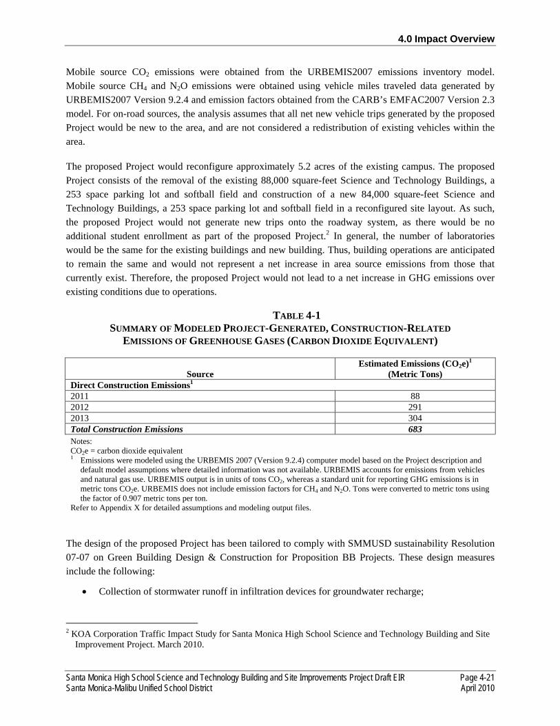
4.0 Impact Overview
Santa Monica High School Science and Technology Building and Site Improvements Project Draft EIR Page 4-21 Santa Monica-Malibu Unified School District April 2010
Mobile source CO2 emissions were obtained from the URBEMIS2007 emissions inventory model. Mobile source CH4 and N2O emissions were obtained using vehicle miles traveled data generated by URBEMIS2007 Version 9.2.4 and emission factors obtained from the CARB’s EMFAC2007 Version 2.3 model. For on-road sources, the analysis assumes that all net new vehicle trips generated by the proposed Project would be new to the area, and are not considered a redistribution of existing vehicles within the area.
The proposed Project would reconfigure approximately 5.2 acres of the existing campus. The proposed Project consists of the removal of the existing 88,000 square-feet Science and Technology Buildings, a 253 space parking lot and softball field and construction of a new 84,000 square-feet Science and Technology Buildings, a 253 space parking lot and softball field in a reconfigured site layout. As such, the proposed Project would not generate new trips onto the roadway system, as there would be no additional student enrollment as part of the proposed Project.2 In general, the number of laboratories would be the same for the existing buildings and new building. Thus, building operations are anticipated to remain the same and would not represent a net increase in area source emissions from those that currently exist. Therefore, the proposed Project would not lead to a net increase in GHG emissions over existing conditions due to operations.
TABLE 4-1 SUMMARY OF MODELED PROJECT-GENERATED, CONSTRUCTION-RELATED
EMISSIONS OF GREENHOUSE GASES (CARBON DIOXIDE EQUIVALENT)
Source Estimated Emissions (CO2e)1
(Metric Tons) Direct Construction Emissions1
2011 88 2012 291 2013 304 Total Construction Emissions 683 Notes: CO2e = carbon dioxide equivalent 1 Emissions were modeled using the URBEMIS 2007 (Version 9.2.4) computer model based on the Project description and
default model assumptions where detailed information was not available. URBEMIS accounts for emissions from vehicles and natural gas use. URBEMIS output is in units of tons CO2, whereas a standard unit for reporting GHG emissions is in metric tons CO2e. URBEMIS does not include emission factors for CH4 and N2O. Tons were converted to metric tons using the factor of 0.907 metric tons per ton.
Refer to Appendix X for detailed assumptions and modeling output files.
The design of the proposed Project has been tailored to comply with SMMUSD sustainability Resolution 07-07 on Green Building Design & Construction for Proposition BB Projects. These design measures include the following:
• Collection of stormwater runoff in infiltration devices for groundwater recharge;
2 KOA Corporation Traffic Impact Study for Santa Monica High School Science and Technology Building and Site Improvement Project. March 2010.

4.0 Impact Overview
Page 4-22 Santa Monica High School Science and Technology Building and Site Improvements Project Draft EIR April 2010 Santa Monica-Malibu Unified School District
• Development of a landscape plan to minimize water use and urban heat island effect through shade and reflective landscape materials;
• Inclusion of permeable surfaces, including porous asphalt, paver blocks or large aggregate concrete, and trees with a high, dense canopy;
• Configuration of buildings to reduce footprint and take advantage of natural ventilation; and
• Use of reflective roofs, shading devices, renewable recycled building materials, and drip irrigation and low flow water features.
Additionally, the SMMUSD shall incorporate standards developed by the Collaborative for High Performance Schools (CHPS) into Project design. CHPS is a green building rating program especially designed for K-12 schools. The 50 percent construction report for the proposed Project includes a sustainability analysis that identifies the CHPS sustainable design components that the Project will attempt to achieve. The report includes a CHPS scorecard that indicates that the Project would achieve 29 points for modernization projects. Through each phase of the design process, the sustainable design components will be reassessed to confirm that the Project will achieve 29 CHPS points, exceeding the minimum required 24 CHPS points for Modernization projects by 15 percent. The proposed Project shall:
• Use a roof material with an initial reflectance of 0.71 and initial emissivity of 0.87 for 88 percent of the roof surface to reduce buildings cooling loads and urban heat island effects by reflecting the sun’s energy, instead of absorbing, retaining, and radiating it into the occupied spaces below.
• Have a permanent educational display located at the Central Stairwell on the first floor to increase the school community’s knowledge about the basics of high performance design.
• Specify and install recycled content products in order to reduce the environmental impacts associated with extraction and processing of virgin materials
• Provide high quality daylighting in classrooms to achieve enhanced occupant productivity, improved connection to the outdoors, improved health, energy savings, and quality of light.
• Place deciduous trees on south/southwest side of buildings to provide shade. • Minimize lawn area – use more drought tolerant groundcover where feasible. • Maximize drought tolerant low-maintenance plantings, both native and "California friendly." • Maximize permeable surfaces where feasible. • Configure the building to reduce the building footprint and to use the existing wind patterns to
assist in ventilating the interior spaces. • Achieve a 14 percent reduction in total net energy use compared to Title 24-2005 baseline.
Provide 15 percent of the building’s annual source energy use through the use of on-site renewable energy systems.
• Verify that the buildings energy systems are installed, calibrated and performing as intended through a commissioning service provider.
• Provide an easily accessible area serving the entire school that is dedicated to the collection and storage of materials for recycling including (at a minimum) paper, cardboard, glass, plastics, metals and landscaping waste.
4.0 Impact Overview
Santa Monica High School Science and Technology Building and Site Improvements Project Draft EIR Page 4-23 Santa Monica-Malibu Unified School District April 2010
• Recycle, compost, and/or salvage at least 75 percent (by weight) of the non-hazardous construction and demolition debris.
These measures would reduce the GHG emissions of the proposed Project by reducing energy consumption and water consumption, and waste generation. Even though Building operations would be unchanged as compared to under existing conditions, the Building would be more energy efficient than the existing one due to incorporation of the above mentioned measures. Thus, GHG emissions attributable to the new Science and Technology Building would likely be lower than the GHG emissions of the existing building. Therefore, the Project would not lead to a net increase in GHG emissions and would not hinder the State’s ability to attain the goals identified in AB 32. Additionally, the amount of construction emissions would be minimal and the Project includes a measure to recycle, compost, and/or salvage at least 75 percent of the construction waste. Therefore, the GHG emissions associated with the proposed Project would not cause a cumulatively considerable incremental contribution to climate change.
CULTURAL RESOURCES
[TO BE COMPLETED WITH COMMENTS ON CULTURAL SECTION]
HAZARDS AND HAZARDOUS MATERIALS
Construction
The related projects captured within the one-mile cumulative project radius adequately captures the past, present, and probable future projects that would potentially contribute to cumulative hazardous materials impacts. The proposed Project has the potential for exposure to hazardous materials during construction activities. Construction activities for the proposed Project would be short-term and would involve the limited transport, storage, use, or disposal of hazardous materials. The construction period for the proposed Project is anticipated to start in the third quarter of 2011 and end in the second quarter of 2014. Some examples of hazardous materials handling include fueling and servicing construction equipment on site and the transport of fuels, lubricating fluids, and solvents. Although construction of the proposed Project may involve the transport, storage, and use of some hazardous materials, such construction-related activities would be temporary in nature and would not be expected to create a significant hazard to workers or the community either from routine use of the materials or a reasonably foreseeable accident. These types of materials, however, are not acutely hazardous, and all storage, handling, and disposal of these materials are regulated by the DTSC, EPA, CAL/OSHA, the Los Angeles County Fire Department, and the Los Angeles County Health Department. Due to the age of the existing Science and Technology Buildings, these buildings may include asbestos-containing material (ACM) and lead-based paint (LBP). As a result, prior to the demolition of any existing structures at the Project site, the buildings would be required to be assessed and abated for ACMs and LBP. All soil would be assessed for potential LBP residue per the DTSC Interim Guidance for Evaluating Lead-Based Paint and Asbestos Containing Materials at Proposed School Sites.3 Demolition of the existing buildings and proposed 3 LFR, Inc. Phase I Environmental Site Assessment: Santa Monica Science and Technology Building and Site Improvements Project. January 20, 2009.

4.0 Impact Overview
Page 4-24 Santa Monica High School Science and Technology Building and Site Improvements Project Draft EIR April 2010 Santa Monica-Malibu Unified School District
improvements could result in exposure and mobilization of ACMs and LBP contaminants, which could potentially create a significant health hazard to construction workers and the public. The related projects would be subject to existing regulations for the control and abatement of ACMs and LBP, as well as regulations set forth by DTSC, EPA, CAL/OSHA, the Los Angeles County Fire Department, and the Los Angeles County Health Department. Therefore, the proposed Project, in conjunction with the listed projects, would not have a cumulative hazardous materials impact.
Operation
As discussed in Section 3.4, the Project Site soil investigations have indicated that elevated levels of certain pesticides and lead were detected in the soil directly adjacent to the existing Science and Technology Buildings (REC #1), which exceed the residential California Human Health Screening Levels. Following the implementation of the Preliminary Environmental Assessment Workplan (Assessment) as required by DTSC, the potential existing sources of the identified pesticides and lead are expected to be minimized. If the Assessment identifies that no significant health or environmental risks exist, the SMMUSD will receive a “No Further Action” determination letter from DTSC. However, if the Assessment identifies potential contamination, further action will be required. Compliance with existing state and federal regulations, including compliance with DTSC regulations and preparation of the Assessment would be expected to provide substantial environmental benefits to the Project site. Compliance DTSC standards, regulations, and procedures would ensure that the operation of the proposed Project, in conjunction with related projects, would result in less than significant cumulative impacts related to the creation of a hazard to the public or the environment through reasonably foreseeable upset and accident conditions involving the release of hazardous materials into the environment.
The proposed Project would not emit hazardous emissions or handle hazardous or acutely hazardous materials, substances, or waste within one-quarter mile of an existing or proposed school. The proposed Project operations would involve the limited use of hazardous materials and is not anticipated to emit hazardous emissions. No new uses beyond those which currently exist within the classrooms, laboratories, and auto shop of the existing Science and Technology Building would occur. The proposed Project would be required to comply with existing regulations for the control and abatement of ACMs and LBP and regulations regarding handling and disposal of hazardous materials contamination. Operation of the proposed Project, in conjunction with related projects, would result in less than significant impacts related to emitting hazardous emissions within one-quarter mile of an existing or proposed school.
The proposed Project would be located on a site that is included on a list of hazardous materials sites compiled pursuant to Government Code Section 65965.5. The gas station sites Chevron #9-9266 and World Oil #16 have had gasoline releases that have impacted non-potable groundwater that flows towards and beneath the Project site. However, both facilities are undergoing remediation and quarterly groundwater monitoring. Chevron #9-9266, which is nearest to the Project site, also has a vapor extraction system in place. The soil samples from the Project site indicated that no toxic contaminants were detected in the soil vapor samples. A No Further action determination by the DTSC would be supported for the Chevron #9-9266 and World Oil #16 sites specifically related to soil gas.4 In addition, 4 Kroner Environmental Services, Inc. Limited Phase I Addendum Environmental Site Assessment – Onsite Sources. April 2009.
4.0 Impact Overview
Santa Monica High School Science and Technology Building and Site Improvements Project Draft EIR Page 4-25 Santa Monica-Malibu Unified School District April 2010
the proposed Project would be required to comply with existing regulations regarding handling and disposal of hazardous materials contamination. The related projects, as with the proposed Project, would be required to assess the potential for hazardous materials onsite and comply with DTSC standards for the cleanup of any hazards. Therefore, the proposed Project, in conjunction with the listed projects, would not have a cumulative hazardous materials impact.
NOISE
Construction
The potential for cumulative noise effects is limited to temporary construction operations. Construction noise levels in the Project vicinity would fluctuate depending on the particular type, number, and duration of usage for the varying equipment. The nearest off-site noise-sensitive land uses in the Project vicinity are multi-family residences located approximately 25 feet northeast of the proposed Project boundary, or approximately 100 feet northeast of the acoustical center of the site. On-site noise-sensitive receptors include students in classrooms located 130 feet from the acoustical center of the Project site. Typical construction activities would generate noise levels ranging from 74 to 101 dB at a distance of 50 feet. Continuous combined noise levels generated by the simultaneous operation of the loudest pieces of equipment would result in noise levels of 97 dB at 50 feet. Construction activities would result in a substantial (i.e., exceeding 3 dB to 5 dB) temporary increase in ambient noise levels at nearby noise-sensitive land uses.
Due to the localized nature of noise impacts, the analysis of cumulative noise impacts focuses on the related projects located within a quarter-mile radius of the Project Site. There are approximately four related projects located less than a quarter-mile from the Project Site. Given the distance of the related projects from the Project Site, the presence of physical barriers (buildings, etc.) between the site, and the decrease in noise levels with distance, construction activities associated with the related projects when considered together with the proposed Project would not be cumulatively significant. Simultaneous construction noise from related projects would not be discernable to sensitive receptors. The proposed Project and related projects would include attenuation measures to reduce noise levels generated during construction. As described in Section 3.6, mitigation measures NOISE-A through NOISE-O would be required to reduce significant short-term impacts related to construction-generated noise. Further, the proposed Project and related projects would be required to comply with the City of Santa Monica noise standards. Based upon this assessment a combined cumulative noise effect would not occur.
Vibration impacts associated with construction activities are extremely localized because they are groundborne. Ground vibration generated by construction equipment spreads through the ground and diminishes greatly in magnitude with increases in distance. Predicted groundborne noise and vibration levels would range from 43 and 78 VdB and .0001 and 0.024 in/sec PPV. As a result, vibration-induced construction activities would not exceed recommended Caltrans standard of 0.2 in/sec PPV regarding the prevention of structural damage for normal buildings, FTA’s maximum acceptable vibration standard of 78 VdB regarding human response (i.e., annoyance) at nearby vibration-sensitive land uses (i.e., school), or the City of Santa Monica Municipal Code vibration standard, nor expose persons to or generate
4.0 Impact Overview
Page 4-26 Santa Monica High School Science and Technology Building and Site Improvements Project Draft EIR April 2010 Santa Monica-Malibu Unified School District
excessive groundborne vibration or groundborne noise levels. As such, the proposed Project and related projects would not have cumulative impacts from vibration would result.
Operations
Long-term operation of the proposed Project would result in an increase in ADT volumes on the local roadway network and, consequently, an increase in noise levels from traffic sources along affected segments. When calculating future traffic impacts, the traffic consultant considered 80 additional projects (see Chapter 3.8). Thus, the future traffic results without and with the proposed Project already account for the cumulative affects from these other projects. Since the noise impacts are generated directly from the traffic analysis results, the Future Without Project and Future With proposed Project noise impacts described in this report already reflect cumulative impacts. Table 4-2 summarizes the modeled traffic noise levels at 100 feet from the centerline of affected roadway segments in the Project area.
Implementation of the proposed Project in addition to cumulative conditions would result in a net change in traffic noise levels ranging from -44 dB to +5 dB Ldn, compared to noise levels without the Project. Traffic noise levels at the proposed new Science and Technology building would be 67 dB Ldn at first floor receptors. Second floor receptors would be exposed to higher traffic noise levels emanating from I-10 due to increased line of site and accepted noise-modeling practices of an additional 2-3 dB noise level increase for second and third floor receptors. Decreases in traffic noise levels are due to ingress and egress changes or elimination of roadway access in the future site design. The future parking lot would only be accessible from Olympic Boulevard. A 5 dB increase is expected for the 6th Street school access road; however, noise levels are still below exterior noise level criterion for school uses. Therefore, long-term noise levels from Project-generated traffic sources would result in a substantial permanent increase in ambient noise levels (3-5 dB or greater) under cumulative conditions on any roadway segments, however the increase would not exceed exterior noise level standards for a school use. Therefore, operational activities would result in a less than significant cumulative mobile noise impact.

4.0 Impact Overview
Santa Monica High School Science and Technology Building and Site Improvements Project Draft EIR Page 4-27 Santa Monica-Malibu Unified School District April 2010
TABLE 4-2 PREDICTED TRAFFIC NOISE LEVELS, FUTURE 2014
Roadway Segment Ldn at 100 Feet, dB
From To No Project Plus Project Net Significant
Interstate 10 Highway 1 Lincoln Boulevard 72 72 0 No
Olympic Boulevard 4th Street To West 59 59 0 No
Olympic Boulevard 4th Street 6th Street 63 63 0 No
Olympic Boulevard 6th Street 7th Court 51 52 +1 No
Olympic Boulevard 7th Court Lincoln Boulevard 56 56 0 No
Olympic Boulevard Lincoln Boulevard To East 62 61 -1 No
Michigan Avenue 7th Court 7th Street 49 48 -1 No
Michigan Avenue Lincoln Boulevard 7th Court 49 49 -1 No
Michigan Avenue Lincoln Boulevard To East 52 52 0 No
Pico Boulevard 4th Street Main Street 63 63 0 No
Pico Boulevard 4th Street 7th Street 61 62 0 No
Pico Boulevard Lincoln Boulevard 7th Street 61 61 0 No
Pico Boulevard Lincoln Boulevard To East 61 61 0 No
4th Street Olympic Boulevard Pico Boulevard 62 62 0 No
4th Street Pico Boulevard Bay Street 60 60 0 No
6th Street Olympic Boulevard School Center 45 49 +5 Yes1
7th Street Pico Boulevard Michigan Avenue 47 46 -1 No
7th Court Olympic Boulevard Michigan Avenue 44 -- -441 No
7th Court Michigan Avenue Pico Boulevard 43 39 -4 No
Lincoln Boulevard Olympic Boulevard Michigan Avenue 65 65 0 No
Lincoln Boulevard Michigan Avenue Pico Boulevard 65 65 0 No
Lincoln Boulevard Pico Boulevard Pico Place 65 65 0 No
Source: Data modeled by EDAW in 2009. Notes: dB = A-weighted decibels; Ldn = day-night average noise level; SR = State Route. *Traffic noise levels are predicted at a standard distance of 100 feet from the roadway centerline and do not account for shielding from existing noise barriers or intervening structures. Traffic noise levels may vary depending on actual setback distances and localized shielding. 1Traffic would no longer travel along this segment in the future due to site design change.
4.0 Impact Overview
Page 4-28 Santa Monica High School Science and Technology Building and Site Improvements Project Draft EIR April 2010 Santa Monica-Malibu Unified School District
RECREATION AND PARKS
Construction
The proposed Project would increase the use of existing neighborhood and regional parks or other recreational facilities such that substantial physical deterioration of the facility would occur or be accelerated. During the demolition of the existing Science and Technology Buildings, and the construction of the new Science and Technology Building, softball field, and reconfigured parking lot, the existing softball field on the Project site would be removed and no softball field facilities would be available for use on the Project site from the third quarter of 2011 to the end in the second quarter of 2014 (approximately three years). During the proposed Project construction phase, the existing softball activities on the Project site would be temporarily relocated to Memorial Park and John Adams Middle School. As such, the proposed Project would result in a temporary increase in the use of the John Adams Middle School softball field during the construction phase; however substantial physical deterioration of the facility would not be expected. A significant impact is anticipated related to the temporary increase in demand and use of the John Adams Middle School softball field facilities. Mitigation measure REC-A and REC-B are provided to ensure that temporary impacts are reduced to less than significant levels. Related projects would also include similar mitigation measures that would reduce the impact to less than significant levels. Based upon this assessment a combined cumulative effect related to recreation and parks would not occur.
Operation
After the completion of the construction phase, the Project site would operate similar to existing conditions. The Santa Monica High School softball teams would use the new softball field on the Project site, as well as Memorial Park, the same as existing conditions. Therefore, the operations of the proposed Project would not result in an increase in the use of existing neighborhood and regional parks or other recreational facilities such that substantial physical deterioration of the facility would occur or be accelerated. No cumulative impacts to recreation and parks would occur.
TRANSPORTATION AND TRAFFIC
Construction
There is the potential for short-term adverse traffic impacts in the project vicinity during construction of the project. The additional trips generated by the truck deliveries and construction workers could affect traffic flow within the study area, as well as pedestrian traffic flow near the project site. The construction period is anticipated to start in the third quarter of 2011 and end in the second quarter of 2014. As such, TRANS-C requires the construction contractor through SMMUSD is required to prepare and submit a Construction Staging and Traffic Management Plan to City for approval. The plans are designed to mitigate construction impacts during the two-year period. Related projects would also include similar mitigation measures that would reduce the impact to less than significant levels. Based upon this assessment a combined cumulative effect related to recreation and parks would not occur.
4.0 Impact Overview
Santa Monica High School Science and Technology Building and Site Improvements Project Draft EIR Page 4-29 Santa Monica-Malibu Unified School District April 2010
The proposed project would result in inadequate parking supply. The existing parking lot located adjacent to the Science and Technology Buildings would be reconfigured and result in the loss of parking during construction. During the construction phase of the project, on-campus parking would be unavailable to faculty/staff and students. Student parking would be provided by the SMMUSD or SAMOHI during the construction period. The School District is exploring a number of options to accommodate the temporary loss of parking for faculty and staff members, including leasing spaces at an off-site location, such as City parking lots at the beach-combined with a shuttle service; leasing private parking in the surrounding area; or establishing vanpools and other transit options. However, the loss of parking during construction and the temporary displacement of faculty/staff and student parking would be a significant and unavoidable impact. Therefore, the potential for a cumulative impact associated with parking would occur.
Operation
As discussed in Chapter 3.9, Transportation and Traffic, the future traffic conditions take into account a total of 80 related projects in Santa Monica (see Table 4-1) as potentially affecting traffic circulation through the study area. The related projects list takes into account all projects currently approved, under construction, or pending approval. The proposed Project would potentially result in individual and cumulative traffic impacts to vicinity intersections in the long-term. Under Future (2014) With and Without the proposed Project Conditions, all the nine study intersections are projected to operate at LOS D or better during the AM and PM peak hours except for: 1) 4th Street and Olympic Boulevard (LOS E – AM peak hour); and 2) Lincoln Boulevard and Pico Boulevard (LOS E – PM peak hour). However, based on the traffic forecasts, LOS analysis and significant impact thresholds set forth by the City of Santa Monica, it was determined that the proposed Project would create a significant traffic impact at the intersection of 4th Street and Olympic Boulevard during the AM peak hour. In order to reduce intersection impacts at 4th Street and Olympic Boulevard during the AM peak hour, implementation of mitigation measures TRANS-A and TRANS-B would be required. Further, the related projects would be required to include similar mitigation measures, which would reduce the impacts to less than significant. As such, the proposed Project in conjunction with related projects would not contribute to a significant cumulative impact on transportation and traffic during operation.
4.4 SIGNIFICANT IRREVERSIBLE ENVIRONMENTAL CHANGES
Public Resources Code section 21100(b)(2)(B) and Section 15126.2(c) of the CEQA Guidelines require that an EIR analyze the extent to which the proposed Project’s primary and secondary effects would impact the environment and commit nonrenewable resources to uses that future generations will not be able to reverse.
Construction and operation of the proposed Project would result in the use of nonrenewable resources during construction, including fossil fuels, natural gas, and water and building materials, such as concrete and steel. In addition, the proposed Project would be designed to incorporate energy and water efficiency features in accordance with Title 24 standards and CHPS requirements. The proposed Project is not anticipated to consume substantial amounts of energy in a wasteful manner, and it would not result in
4.0 Impact Overview
Page 4-30 Santa Monica High School Science and Technology Building and Site Improvements Project Draft EIR April 2010 Santa Monica-Malibu Unified School District
significant impacts from consumption of utilities. Although irreversible environmental changes would result from the proposed Project, such changes would not be considered significant.
4.5 GROWTH-INDUCING IMPACTS
According to Section 15126.2 (d) of the CEQA Guidelines, growth-inducing impacts of the proposed Project shall be discussed in the EIR. Growth-inducing impacts are those effects of the proposed Project that might foster economic or population growth or the construction of new housing, either directly or indirectly, in the surrounding environment. According to CEQA, increases in the population may tax existing community service facilities, requiring construction of new facilities that could cause significant environmental effects.
Induced growth is any growth that exceeds planned growth and results from new development that would not have taken place without the implementation of the proposed Project. Typically, the growth-inducing potential of a project would be considered significant if it results in growth or population concentration that exceeds those assumptions included in pertinent master plans, land use plans, or projections made by regional planning authorities. However, the creation of growth-inducing potential does not automatically lead to growth, whether it would be below or in exceedance of a projected level.
The goal of the proposed Project is to provide an upgraded and modern Science and Technology Building and the Project would not include additional students. Other existing buildings on the campus would be upgraded as well; however no additional classrooms would be constructed. The square footage of the new building would be approximately 4,000 square feet less than the existing buildings combined. The number of classrooms provided with the proposed Project would be similar to the amount currently provided. Therefore, the proposed Project would not be expected to induce growth in the Project area.
Santa Monica High School Science and Technology Building and Site Improvements Project Draft EIR Page 5-1 Santa Monica-Malibu Unified School District April 2010
5.0 ALTERNATIVES
CEQA requires that an EIR objectively evaluate a “reasonable” range of alternatives. According to the CEQA Guidelines Section 15126.6(a), “an EIR shall describe a range of reasonable alternatives to the proposed Project, or to the location of the proposed Project, which would feasibly attain most of the basic objectives of the proposed Project, but would avoid or substantially lessen any of the significant effects of the proposed Project, and evaluate the comparative merits of the alternatives.” The CEQA Guidelines also state that an EIR need not consider every conceivable alternative nor consider alternatives that are infeasible. Under CEQA, the factors that can determine feasibility are site suitability, economic limitations, availability of infrastructure, General Plan consistency, other plan or regulatory limitations, and jurisdictional boundaries. An EIR need not consider an alternative whose effects cannot be reasonably ascertained and whose implementation is remote and speculative.
The alternatives analysis must also include a comparative evaluation of the No Project Alternative per Section 15126.6(e) of the CEQA Guidelines. Through comparison of the alternatives, the advantages and disadvantages of each alternative compared with the proposed Project can be weighed and analyzed. Consequently, the No Project Alternative is described below.
5.1 PROJECT OBJECTIVES
In 2006, Santa Monica and Malibu voters passed the local general obligation Measure BB Bond, a $268-million bond to construct and renovate schools within the SMMUSD. The SMMUSD requires all of its schools to improve health, safety, and class instruction. The proposed Project has been designed to adhere to these goals and requirements. The main objectives of the proposed Project are to:
• Provide modernized science and technical classrooms;
• Establish a public “front door” at the Michigan Avenue entrance to the campus;
• Develop open spaces that would unify and enhance the northern portion of the campus;
• Maximize student safety by locating buildings along the perimeter of the campus and outdoor spaces in the interior of the campus, thereby retaining students within the campus during school hours and providing separation from the general public;
• Remove asbestos, lead and other hazardous substances from the existing Science and Technology Buildings;
• Improve vehicular, bicycle and pedestrian access to campus;
• Reconfigure the existing 253-space parking lot, which currently contributes to vehicular traffic on 7th Court Alley;
• Develop a maintainable building consistent with SMMUSD Resolution No. 07-07 on Green Building Design and Construction; and
• Provide existing campus classrooms with limited infrastructure upgrades in preparation for future District Standard technology upgrades.
5.0 Alternatives
Page 5-2 Santa Monica High School Science and Technology Building and Site Improvements Project Draft EIR April 2010 Santa Monica-Malibu Unified School District
5.2 ALTERNATIVES CONSIDERED BUT ELIMINATED
Section 15126.6(c) of the CEQA Guidelines requires that an EIR identify any alternatives that were considered by the lead agency, but were rejected as infeasible during the scoping process and briefly explain the reasons underlying the lead agency’s determination. Among factors that may be used to eliminate alternatives from detailed consideration in the EIR are: (1) failure to meet most of the basic project objectives, (2) infeasibility, and (3) inability to avoid significant environmental impacts.
5.2.1 ALTERNATIVE SITES
Section 15126.6(f)(2) of the CEQA Guidelines requires that an EIR consider alternative locations to the Project site. In accordance with the provisions of the Measure BB Bond, one of the purposes of the proposed Project is to improve the existing 26-acre Santa Monica High School campus by providing a new Science and Technology Building, and updating existing buildings and facilities on the campus. The City of Santa Monica is almost entirely built out and there are few remaining vacant parcels left in the City. In addition, none of the existing vacant parcels are of a comparable size to the Project site and none are located near the existing campus. If a vacant parcel of adequate size was available to the SMMUSD for the location of the new Science and Technology Building, several of the objectives of the proposed Project would not be accomplished. Student safety would not be maximized by locating buildings along the perimeter of the campus and outdoor spaces in the interior of the campus, and modern science and technology classrooms would be provided, but at an alternative site at distance from the existing campus and students who would utilize the new classrooms. In addition, a public “front door” to the campus would not be provided at Michigan Avenue, open spaces would not be developed, asbestos and other hazardous substances would not be removed from the existing Science and Technology Buildings, access to and traffic surrounding the campus would not be improved, and existing campus classrooms would not be upgraded. As such, this alternative would achieve only one of the nine objectives of the proposed Project.
5.2.2 CONCEPTUAL ALTERNATIVES
Following the passing of the Measure BB Bond in 2006, the SMMUSD considered several different concepts for the redevelopment and reorganization of the Santa Monica High School campus. The concepts were considered and eliminated based on the attainment of the various goals associated with the implementation of the Measure BB Bond. These various conceptual alternatives were formulated and eliminated during the process of preparing the Santa Monica High School Siting Study from approximately 2006 to 2008. As previously discussed in Chapter 3.5 Land Use and Planning, the Santa Monica High School Siting Study included design concepts for the campus that were focused on reorganizing the campus to meet its functional and programmatic needs; to expand the shared public use of its facilities; to link the campus with the Civic Auditorium Campus development located to the southwest; and to confirm the defined Measure BB Bond project scope. The design concepts also considered the need for the redevelopment or reorganization of the campus to accommodate multiple facilities, to achieve and adhere to the numerous facility requirements, and to include natural and

5.0 Alternatives
Santa Monica High School Science and Technology Building and Site Improvements Project Draft EIR Page 5-3 Santa Monica-Malibu Unified School District April 2010
mechanical ventilation systems in new buildings, particularly within those that would include laboratories.
Originally, the existing Business Building on the campus was considered for demolition and replacement, instead of the existing Science and Technology Buildings. The one- to three-story Business Building is located directly southeast of the landscaped quad and the existing Science and Technology Buildings. However, the Santa Monica High School Siting Study determined that the existing Science and Technology Buildings should be demolished and replaced, instead of the Business Building, so that a more comprehensive high school program could be implemented.
Another concept that was previously considered would reorganize the existing campus by placing taller buildings near the center of the campus. This concept would involve the demolition of several existing campus buildings, including the Science and Technology Buildings. One or several multilevel buildings would be constructed to house the science, technology, and other classroom and laboratory spaces that were originally within the demolished buildings. This concept was eventually determined to be infeasible primarily because the multilevel buildings would require the use of several elevators. Due to the large number of students that would attend classes in these buildings and would require use of the elevators, this concept would require major changes to typical class durations and schedules to accommodate the increased passing periods between classes needed as a result of many students waiting for elevators.
An additional concept that was considered included reorganizing the campus by constructing the athletic facilities above surface parking areas, or stacking various uses on the campus to provide additional campus space for future development or expansion of uses. This concept was eliminated because there would be a major disruption of classes and the functioning of the campus. One of SMMUSD’s goals was to create a project that could be constructed without an extensive disruption of classes or the functioning of the campus. In addition, constructing athletic facilities, such as the football field/track, above surface parking may have impacted the ability for a California Interscholastic Federation (CIF) conforming football field/track to be constructed. Also, it was determined that the athletic facilities on the campus should be placed in one distinct zone of the campus. Constructing athletic facilities above surface parking areas would not achieve this goal.
Previously, a concept was considered that would demolish the existing Science and Technology Buildings and construct the new buildings on the northeastern portion of the campus, adjacent to the Olympic Boulevard property line. Similar to existing conditions, this concept would leave much of the northeastern portion of the campus open including the existing softball field, adjacent to 7th Court Alley. One of the objectives of the Project is to place buildings on the edge of the campus property, so that the buildings would become similar to a fence, increasing safety for students and decreasing the likelihood of students congregating off-campus and near the alley. In addition, increased open space was needed internally within the campus. This concept would result in a large area of open space (i.e., parking lot and softball field) adjacent to 7th Court Alley, resulting in similar safety issues as currently exists on the campus. Also, under this concept, the new building would be placed directly adjacent to Olympic Boulevard, a major thoroughfare in the City, as well as I-10 directly north of Olympic Boulevard, which
5.0 Alternatives
Page 5-4 Santa Monica High School Science and Technology Building and Site Improvements Project Draft EIR April 2010 Santa Monica-Malibu Unified School District
would likely increase noise, air quality, and health risk effects on students attending classes in the new building. For these reasons, this concept was eliminated from further consideration.
In addition, a concept was considered that would demolish the existing Science and Technology Buildings and place the new building at the same general location as with the proposed Project, adjacent to 7th Court Alley. Also, similar to the proposed Project, this concept would include a new building with both two-story and three-story sections. However, the two-story portion would include a majority of the building at the southeastern portion of the Project site, near the intersection of Michigan Avenue and 7th Court Alley. Because this concept would include a larger two-story portion, the building footprint had to be larger to accommodate the number of classrooms and laboratories that were required to be constructed. However, one of the goals of the Project was to decrease the building footprint, achieving sustainability requirements under Collaborative for High Performance Schools (CHPS). For these reasons, this concept was eliminated from further consideration. In addition, subterranean parking was considered as an alternative to surface parking. However, due to the extensive construction phase disruption to students, classes, and residences along 7th Court Alley and Michigan Avenue that would be attributed to the excavation needed, this concept was also eliminated for the proposed Project.
During the initial stages of the CEQA process for the proposed Project, a vehicle turnout was under consideration to be located along Olympic Boulevard, just west of 7th Court Alley. With the turnout, vehicles traveling along Olympic Boulevard would be able to drop-off and pick-up students at the turnout, which would be adjacent to the new building. Also, the turnout would be useful as a drop-off and pick-up area for disabled students as it would be designed to be Americans with Disabilities Act (ADA) accessible. However, the City’s Transportation Management Division stated that the proposed turnout would likely reduce the effectiveness of the drop-off and pick-up activity.1 It was determined that the turnout would encourage longer vehicle queuing times and possibly enable double parking along Olympic Boulevard, a major thoroughfare in the City. For these reasons, this concept was eliminated from further consideration.
5.3 ALTERNATIVES CARRIED FORWARD FOR DETAILED ANALYSIS
Three alternatives have been carried forward for detailed analysis in this EIR, including the “No Project” alternative as required by CEQA. Based on the environmental analysis conducted for the proposed Project, significant impacts requiring mitigation have been identified regarding Aesthetics, Noise, Recreation and Parks, and Transportation and Traffic. The EIR identifies less than significant impacts for Cultural Resources, Hazards and Hazardous Materials, and Land Use and Planning. A significant and unavoidable impact was identified for Air Quality.
The alternatives carried forward for detailed analysis in this section include:
• No Project Alternative
1 Correspondence from Beth Rolandson, City of Santa Monica, Transportation Management Division. May 28, 2009.
5.0 Alternatives
Santa Monica High School Science and Technology Building and Site Improvements Project Draft EIR Page 5-5 Santa Monica-Malibu Unified School District April 2010
• Increased Setback Alternative
• No Reconfiguration Alternative
5.3.1 OVERVIEW OF ALTERNATIVES AND IMPACTS
The table at the end of this chapter provides a comparison of the impacts of the alternatives to the proposed Project. In accordance with the CEQA Guidelines Section 15126.6(d), each alternative was evaluated in sufficient detail to determine whether the overall environmental impacts would be less, similar, or greater than the corresponding impacts of the proposed Project. A discussion of each alternative is provided below.
5.3.2 NO PROJECT ALTERNATIVE
According to the CEQA Guidelines Section 15126.6(e)(3)(b), the No Project Alternative is defined as the “circumstance under which the proposed Project does not proceed.” The impacts of the No Project Alternative shall be analyzed “by projecting what would reasonably be expected to occur in the foreseeable future if the proposed Project were not approved, based on current plans and consistent with available infrastructure and community services.” The purpose of describing and analyzing the No Project Alternative is “to allow decision makers to compare the impacts of approving the proposed Project with the impacts of not approving the proposed Project.” Under the No Project Alternative, the proposed new Science and Technology Building, softball field, and reconfigured parking lot would not be constructed. In addition, the proposed campus-wide building updates would not be completed. The existing Science and Technology Buildings, softball field, and parking lot would remain onsite and continue to operate as under existing conditions. No new structures would be constructed. The environmental characteristics would be the same as those described in the environmental setting sections of Chapter 3.
Construction phase impacts associated with the proposed Project would be avoided because no development would occur on the Project site under the No Project Alternative. The existing Science and Technology Buildings would not be demolished, the new Science and Technology Building would not be constructed adjacent to 7th Court Alley, and the proposed ramp would not be constructed. In addition, the existing softball field would not be demolished and campus softball activities would not be required to temporarily use the softball field at John Adams Middle School. No buildings would be constructed adjacent to the northeastern property line of the campus (7th Court Alley) and, therefore, no temporary aesthetic impacts would result for the nearby multi-family residences. The existing Project site uses would continue to operate in their current capacity and function. Maintenance activities would occur as needed to maintain the existing facilities. There would be no change to cultural resources and the potential for uncovering previously unknown archaeological or paleontological resources would be avoided because excavation would not take place.
Similar to the proposed Project, a majority of the operational impacts would be avoided because no changes to the operation of the Project site would occur. The number of vehicles trips to/from the Project site would not be expected to change because the same uses would be operating at the Project site. Thus,

5.0 Alternatives
Page 5-6 Santa Monica High School Science and Technology Building and Site Improvements Project Draft EIR April 2010 Santa Monica-Malibu Unified School District
no increase in mobile emissions or vehicular noise would be expected to occur. No land use changes would occur because the site would continue to operate as a high school, as under existing conditions. Under the No Project Alternative, the visual setting of the Project site would continue to be two, two-story institutional buildings that are not remarkable in style, color, or bulk, and the Project site would not stand out as particularly memorable or remarkable feature in the landscape. As such, the visual improvements associated with redevelopment of the Project site would not occur under this alternative. Further, this alternative would not achieve any of the objectives of the proposed Project.
However, as previously mentioned in Chapter 3.5 Land Use and Planning, SMMUSD prepared the Santa Monica High School Siting Study in 2008. This study developed long-term design concepts for the redevelopment of various portions of the Santa Monica High School campus. Since these design concepts included the redevelopment of buildings other than the existing Science and Technology Buildings, under the No Project Alternative, there is a potential for SMMUSD make a decision to redevelop some other portion of the Santa Monica High School Campus. In addition, the Civic Center Joint-Use Project is currently under early consideration, which would allow the City of Santa Monica to utilize the new parking facilities that may be constructed within other portions of the campus. In that case, both construction and operational impacts under the No Project Alternative would be expected to increase as compared to the proposed Project.
5.3.3 INCREASED SETBACK ALTERNATIVE
Similar to the proposed Project, the Increased Setback Alternative would reconfigure the approximately 5.2-acre Project site within the northeastern portion of the Santa Monica High School campus. This alternative would consist of the demolition of the existing 88,000-square-foot Science and Technology Buildings, parking lot, and softball field and the construction of a new three-story, 84,000-square-foot Science and Technology Building, and softball field in a reconfigured site layout and a reconfigured parking lot. Similar to the proposed Project, this alternative would place the new Science and Technology Building in the northern and eastern portion of the Project site, directly adjacent to 7th Court Alley.
The new building would be constructed within the Santa Monica High School campus property line and would not encroach into 7th Court Alley. The building setback from the 7th Court alley property line would be 22 feet, an approximately 10-foot increase over the proposed Project in order to reduce shadow impacts on the multi-family residences on the northeastern side of 7th Court Alley. As a result of the increased building setback length, the proposed landscaped plaza area on the southwestern side of the new building would be reduced, limiting the amount and size of landscape features that would be installed within the plaza. The scrim or screen material included with the proposed Project that would extend approximately three feet four inches into this setback area, would be eliminated with this alternative. The softball field would be relocated to the southern corner of the Project site, while the proposed L-shaped parking lot would be located in between the new building and softball field, extending to the west just south of along Olympic Boulevard, and east of 6th Street. As a result of the increased setback of the proposed building, the configuration of the parking lot may require adjustments, but a reduction in parking spaces as compared to the proposed Project is not expected. As a result of the proposed reconfiguration, approximately 20 landscape trees may be removed within the Project site. A few of the
5.0 Alternatives
Santa Monica High School Science and Technology Building and Site Improvements Project Draft EIR Page 5-7 Santa Monica-Malibu Unified School District April 2010
trees in the northeastern portion of the landscaped quad area would be removed with the proposed Project. However, these removed landscape trees would be replaced in excess of the number of trees removed and the existing trees are not known to be protected. In addition, the construction phase would be identical to the proposed Project.
Similar to the proposed Project, this alternative would reconfigure existing land uses and would not result in an increase in student enrollment or capacity of the school. In addition, no new land uses would be introduced to the campus.
AESTHETICS
Under the Increased Setback Alternative, visual character impacts during the construction phase would be reduced as the new building construction would occur an additional 10 feet southwest from the nearest visually sensitive land use. As with the proposed Project, this alternative would not substantially conflict with the existing visual character of the Project site or the surrounding area during the operational phase. Shadows cast onto adjacent shadow-sensitive uses as a result of the Increased Setback Alternative would be shorter in duration than with the proposed Project because the building would be set back an additional 10 feet from the 7th Court Alley property line. Thus, the shadows cast onto the adjacent commercial/residential buildings, on the northeastern side of 7th Court Alley, would be shorter than the proposed Project during the Winter Solstice. As with the proposed Project, this alternative would not create substantial lighting impacts with the implementation of applicable City lighting standards and specifications. Similar to the proposed Project, glare impacts would be reduced with the implementation of the mitigation measures, which require the use of non-reflective building materials. The Increased Setback Alternative would result in reduced impacts on aesthetics, due to the reduced shadow coverage of shadow-sensitive uses as compared to the proposed Project.
AIR QUALITY
The Increased Setback Alternative would require similar construction activity as was assumed for the proposed Project because there would be approximately the same amount of total development. Pollutant emissions during the entire Increased Setback Alternative construction phase would be similar to the amount of pollutants emitted during the entire proposed Project construction phase. In addition, the daily construction intensity (e.g., construction equipment hours) for the Increased Setback Alternative would be similar to the daily construction intensity assumed for the proposed Project. Accordingly, the Increased Setback Alternative daily regional construction emissions of VOC, NOX, CO, PM2.5, and PM10 would be similar to the emissions presented for the proposed Project and would not violate or contribute substantially to an existing or projected air quality violation. Similar to the proposed Project, the Increased Setback Alternative would result in a less than significant impact related to daily regional construction emissions.
Localized PM2.5 and PM10 construction emissions were calculated based on the amount of acres to be disturbed per day. The size of the Project site would not change under the Increased Setback Alternative and the acres of land graded per day would be similar to that analyzed for the proposed Project. This
5.0 Alternatives
Page 5-8 Santa Monica High School Science and Technology Building and Site Improvements Project Draft EIR April 2010 Santa Monica-Malibu Unified School District
would result in fugitive dust emissions similar to the proposed Project, which would exceed the SCAQMD localized significance thresholds for PM10 and PM2.5 with implementation of SCAQMD’s Rule 403 for dust control. Similar to the proposed Project, the Increased Setback Alternative would result in a significant and unavoidable impact related to localized PM2.5 and PM10 construction emissions.
The Increased Setback Alternative would not alter the existing land uses on the Project site and would not result in increased student enrollment. As such, similar to the proposed Project, this alternative would not generate any additional traffic trips in addition to existing conditions. Therefore, regional emissions associated with this alternative would not exceed the SCAQMD operational significance thresholds for VOC, NOx, CO, PM10 or PM2.5. Similar to the proposed Project, the Increased Setback Alternative would result in a less than significant impact related to daily regional operational emissions.
Mobile source emissions associated with the Increased Setback Alternative would not increase localized VOC, NOx, CO, PM10 or PM2.5 emissions as no additional traffic trips would occur in addition to existing conditions. Similar to the proposed Project, the daily emissions of these pollutants would not exceed SCAQMD’s LST thresholds. Also similar, vehicles traveling on I-10 would not produce pollutant concentrations that would exceed the significance thresholds for PM10, PM2.5, CO, NO2, or SO2 and, therefore, would not impact students, faculty, or staff on the Project site.
Maximum proposed Project-related one- and eight-hour CO concentrations were estimated to be 4.3 and 3.0 ppm, respectively. These concentrations are well below the state one- and eight-hour standards of 9.0 and 20 ppm, respectively. Traffic associated with the Increased Setback Alternative would not change the CO concentrations estimated for the proposed Project as no new traffic trips would be generated. Similar to the proposed Project, the Increased Setback Alternative would result in a less than significant localized CO impact.
Similar to the proposed Project, the Increased Setback Alternative would not expose sensitive receptors to substantial emissions of TACs during the construction phase because construction emissions would be temporary and would rapidly dissipate with distance from the source. Operation of the proposed laboratory facilities would not expose sensitive receptors to substantial concentrations of TACs, as the number of laboratory facilities would be similar to existing conditions. In addition, this alternative would not expose students, faculty, or staff to carcinogenic and non-carcinogenic risks that exceed SCAQMD’s thresholds. Similar to the proposed Project, the Increased Setback Alternative would result in a less than significant impact related to TAC emissions, and carcinogenic and non-carcinogenic risks.
Similar to the proposed Project, this alternative would not introduce new, permanent sources of substantial objectionable odors or locate sensitive receptors significantly closer to existing permanent sources of odors. Odors generated during construction would be intermittent and would dissipate quickly. Similar to the proposed Project, the Increased Setback Alternative would have a less than significant impact related to odors.
The Increased Setback Alternative would generate a similar amount of GHG emissions as estimated for the proposed Project as this alternative would not alter the operations of the Project site and would not generate additional traffic trips. Similar to the proposed Project, the Increased Setback Alternative would

5.0 Alternatives
Santa Monica High School Science and Technology Building and Site Improvements Project Draft EIR Page 5-9 Santa Monica-Malibu Unified School District April 2010
not lead to a net increase in GHG emissions over existing conditions due to operations. Similar to the proposed Project, the Increased Setback Alternative would have a less than significant impact related to global climate change.
CULTURAL RESOURCES
Under the Increased Setback Alternative, impacts to cultural resources would be similar to the proposed Project. [TO BE FINALIZED WITH COMMENTS ON CULTURAL RESOURCES SECTION]
HAZARDS AND HAZARDOUS MATERIALS
As discussed in Chapter 3.4 Hazards and Hazardous Materials, due to the age of the existing Science and Technology Buildings, these buildings may include ACMs and LBP. In addition, soil investigations conducted on the Project site have indicated that elevated levels of certain pesticides were detected in the soil directly adjacent to the existing buildings. Elevated lead (a Title 22 metal) concentrations were detected in the soil from the planter areas around the existing Science and Technology Buildings. Additionally, an abandoned UST was identified directly northwest of the existing buildings. Four State and Tribal Leaking Underground Storage Tank Database sites (Chevron #9 9266, World Oil #16, Arco Realty Property, and the Former Mobil Service Station) may have potentially contributed to the possible contamination of groundwater and soil beneath the Project site. The Project site is also listed on two hazardous materials databases.
Similar to the proposed Project, under the Increased Setback Alternative, a No Further Action determination by the DTSC would be supported for the Chevron #9-9266 and World Oil #16 sites specifically related to soil gas. In addition, this alternative would be required to comply with DTSC regulations and requirements regarding handling, transport, and disposal of hazardous materials and any contaminated soils. Similar to the proposed Project, this alternative would be required to implement applicable measures in accordance with the DTSC, EPA, CAL/OSHA, Los Angeles County Fire Department, and Los Angeles County Health Department. In addition, the preparation of a Preliminary Environmental Assessment Workplan would be required under this alternative. Similar to the proposed Project, the Increased Setback Alternative would have a less than significant impact related to hazards and hazardous materials.
LAND USE AND PLANNING
Similar to the proposed Project, the construction and operation of the Increased Setback Alternative would not be subject to the policies outlined within the City of Santa Monica General Plan and Article 9, Planning and Zoning, of the City’s Municipal Code. In July 2009, the SMMUSD Board of Education adopted a resolution that exempted the Project site from being subject to the requirements of the General Plan and Article 9 of the Municipal Code. Since neither of these land use and planning regulations apply to the Project site, no significant impact to land use and planning could occur. Similar to the proposed Project, the Increased Setback Alternative would have a less than significant impact related to land use and planning.

5.0 Alternatives
Page 5-10 Santa Monica High School Science and Technology Building and Site Improvements Project Draft EIR April 2010 Santa Monica-Malibu Unified School District
NOISE
Construction activity associated with the Increased Setback Alternative would generally result in reduced noise levels as compared to the proposed Project, since the building construction would take place an additional 10 feet to the southwest of the residences located along 7th Court Alley. However, construction noise impacts to on-site sensitive receptors (i.e., students and faculty within the existing Science and Technology Buildings) may increase because the new building construction would occur 10 feet nearer to the existing buildings where classes would continue during new building construction. Similar to the proposed Project, construction vibration impacts would be less than significant under this alternative as vibration levels would not exceed Caltrans standards. Daily noise and vibration levels would be similar to the noise levels presented for the proposed Project because this alternative would not alter the operation of the Project site from existing conditions. Therefore, the Increased Setback Alternative would not expose persons to noise levels in excess of City standards and the impact would be less than significant. Stationary noise sources associated with the Increased Setback Alternative would be similar to those sources identified for the proposed Project. Stationary noise under the Increased Setback Alternative would result in a less than significant impact. Overall, the Increased Setback Alternative would result in similar noise and vibration impacts as the proposed Project.
RECREATION AND PARKS
Similar to the proposed Project, the Increased Setback Alternative would require the use of the existing softball facility at John Adams Middle School and Memorial Park during the construction phase. The use of Memorial Park by the Santa Monica High School softball teams, during the construction phase, would not increase from existing conditions. However, similar to the proposed Project, this alternative would significantly increase the use of John Adams Middle School recreational facilities during the construction phase. The implementation of mitigation measures REC-A and REC-B would reduce construction impacts to John Adams Middle School recreational facilities. Similar to the proposed Project, the Increased Setback Alternative would result in less than significant impacts related to recreation and parks.
TRANSPORTATION AND TRAFFIC
Similar to the proposed Project, the Increased Setback Alternative would not alter the existing land uses on the Project site and would not generate additional student enrollment. However, the reconfiguration of the Project site would affect traffic circulation and potentially result in the shift of traffic patterns. Since this alternative would include the same land uses and building space as the proposed Project, all the study intersections would be projected to be operating at LOS C or better during both the morning and evening peak hours. Based on the traffic forecasts, LOS analysis and significant impact thresholds set forth by the City of Santa Monica, the intersection of 4th Street and Olympic Boulevard would be significantly impacted from traffic generated by the shift of traffic patterns resulting in LOS E during the AM peak hour. Similar to the proposed Project, in order to reduce intersection impacts at 4th Street and Olympic Boulevard during the AM peak hour, implementation of mitigation measures would be required. The recommended improvement includes re-striping the northbound approach to provide an exclusive left-turn lane, a shared through/right-turn lane, and an exclusive right-turn lane.

5.0 Alternatives
Santa Monica High School Science and Technology Building and Site Improvements Project Draft EIR Page 5-11 Santa Monica-Malibu Unified School District April 2010
Similar to the proposed Project, the Increased Setback Alternative would not be expected to affect traffic on a regional basis. In addition, this alternative would not on increase demand at nearby CMP-designated facilities through the redistribution of vehicle trips to the new access via 6th Street from Olympic Boulevard.
Similar to the proposed Project, with the Increased Setback Alternative there is the potential for short-term adverse traffic impacts in the Project site vicinity during construction. The additional trips generated by the truck deliveries and construction workers may affect traffic flow within the vicinity, as well as pedestrian traffic flow near the Project site. As such, mitigation requires the construction contractor through SMMUSD be required to prepare and submit a Construction Staging and Traffic Management Plan to the City of Santa Monica for approval. The reconfiguration of on-site facilities and relocating parking access is not expected to affect current drop-off and pick-up activities on both Olympic Boulevard and Michigan Street/7th Street. Therefore, this alternative would not substantially increase hazards due to design features or incompatible uses.
Similar to the proposed Project, the temporary loss of student parking would be a significant and unavoidable impact under the Increased Setback Alternative. The SMMUSD is exploring a number of options to accommodate the temporary loss of faculty and staff parking including leasing spaces at an off-site location including City parking lots at the beach, combined with a shuttle service, leasing private parking in the surrounding area, establishing vanpools and other transit options. Similar to the proposed Project, the loss of faculty and staff parking during the construction phase would be addressed by one of these options to reduce the impact to less than significant. Also similar, the temporary loss of student parking on the Project site during construction would remain significant and unavoidable. During the operation of this alternative, it is expected that all 253 parking spaces would be accommodated in the reconfigured parking lot. Under the Increased Setback Alternative, impacts to parking would be similar to the proposed Project.
CONCLUSION
The Increased Setback Alternative would develop a reconfigured Project site nearly identical to the proposed Project. However, the new building would be set back an additional 10 feet from the 7th Court Alley property line in order to reduce shadow impacts on shadow-sensitive multi-family residential uses. The construction phase would be identical in duration and process to that of the proposed Project. Under this alternative, the new building would be the same size and height as with the proposed Project and no new land uses would be introduced to the Project site. Compared to the proposed Project, this alternative would have reduced impacts in the area of aesthetics. This alternative would have similar impacts in the areas of construction and operational air quality, cultural resources, hazards and hazardous materials, land use and planning, construction and operational noise and vibration, recreation and parks, and transportation and traffic. This alternative would reduce the amount of proposed open space on the Project site; however, this alternative would meet all of the Project objectives.

5.0 Alternatives
Page 5-12 Santa Monica High School Science and Technology Building and Site Improvements Project Draft EIR April 2010 Santa Monica-Malibu Unified School District
5.3.4 NO RECONFIGURATION ALTERNATIVE
The No Reconfiguration Alternative would not reconfigure the approximately 5.2-acre Project site within the northeastern portion of the Santa Monica High School campus. This alternative would consist of the demolition of the existing 88,000-square-foot Science and Technology Buildings, and the construction of a new three-story, 84,000-square-foot Science and Technology Building. The softball field and parking lot would remain in place. This alternative would place the new Science and Technology Building in the location of the existing Science and Technology Buildings to be demolished.
Due to the placement of the new building, the size of the proposed landscaped plaza area may be reduced as compared to the proposed Project. The scrim or screen material included with the proposed Project would be included with this alternative. This alternative may result in the removal of trees, but it is expected to be less than with the proposed Project. These removed landscape trees would be replaced in excess of the number of trees removed and the existing trees are not known to be protected. Similar to the proposed Project, this alternative would replace an existing land use and would not result in an increase in student enrollment or capacity of the school. In addition, no new land uses would be introduced to the campus.
The construction phase associated with the No Reconfiguration Alternative would be shorter in duration as compared to the proposed Project. The existing buildings would be demolished and replaced with the new building, and no changes to the existing softball field and parking lot are expected. As a result, the building could not be used for classes at any time during construction. Temporary classrooms would have to be brought on-site (i.e., trailers, portables, or other type of temporary structures), and/or these classes would temporarily take place in other existing buildings on the campus. Any temporary structures brought on-site during construction would be placed within the existing parking lot on the Project site. Therefore, parking would be limited during the construction phase, but not completely eliminated as with the proposed Project.
AESTHETICS
Under the No Reconfiguration Alternative, visual character impacts during the construction phase would be reduced as the new building construction would not occur adjacent to visually sensitive off-site uses. Visual character impacts to students, faculty, and staff during the construction phase would be similar to the proposed Project. As with the proposed Project, this alternative would not substantially conflict with the existing visual character of the Project site or the surrounding area during the operational phase. No shadows would be cast onto adjacent shadow-sensitive uses as a result of the No Reconfiguration Alternative. As with the proposed Project, this alternative would not create substantial lighting impacts with the implementation of applicable City lighting standards and specifications. Similar to the proposed Project, glare impacts would be reduced with the implementation of the mitigation measures, which require the use of non-reflective building materials. Because this alternative would not cast shadows on shadow-sensitive uses, the No Reconfiguration Alternative would result in reduced impacts related to aesthetics.
5.0 Alternatives
Santa Monica High School Science and Technology Building and Site Improvements Project Draft EIR Page 5-13 Santa Monica-Malibu Unified School District April 2010
AIR QUALITY
The No Reconfiguration Alternative would require reduced construction activity as compared to the proposed Project because there would be no reconfiguration of the existing softball field and parking lot. Pollutant emissions during the entire No Reconfiguration Alternative construction phase would be similar to the amount of pollutants emitted during the entire proposed Project construction phase. However, these pollutants would be emitted for a shorter duration. In addition, the daily construction intensity (e.g., construction equipment hours) for the No Reconfiguration Alternative would be similar to the daily construction intensity assumed for the proposed Project, assuming that construction trucks would be required to deliver temporary classroom trailers on-site. Accordingly, the No Reconfiguration Alternative daily regional construction emissions of VOC, NOX, CO, PM2.5, and PM10 would be similar to the emissions presented for the proposed Project and would not violate or contribute substantially to an existing or projected air quality violation. The No Reconfiguration Alternative would result in similar impacts related to regional construction air quality emissions.
Localized PM2.5 and PM10 construction emissions were calculated based on the amount of acres to be disturbed per day. The size of the Project site would not change under the No Reconfiguration Alternative; however, the acres of land graded per day would be less than that analyzed for the proposed Project. This would result in reduced fugitive dust emissions as compared to the proposed Project, which would exceed the SCAQMD localized significance thresholds for PM10 and PM2.5 with implementation of SCAQMD’s Rule 403 for dust control. The No Reconfiguration Alternative would result in reduced impacts related to localized PM2.5 and PM10 construction emissions.
The No Reconfiguration Alternative would not alter the existing land uses on the Project site and would not result in increased student enrollment. As such, similar to the proposed Project, this alternative would not generate any additional traffic trips in addition to existing conditions. Therefore, regional emissions associated with this alternative would not exceed the SCAQMD operational significance thresholds for VOC, NOx, CO, PM10 or PM2.5. Similar to the proposed Project, the No Reconfiguration Alternative would result in a less than significant impact related to daily regional operational emissions.
Mobile source emissions associated with the No Reconfiguration Alternative would not increase localized VOC, NOx, CO, PM10 or PM2.5 emissions as no additional traffic trips would occur in addition to existing conditions. Similar to the proposed Project, the daily emissions of these pollutants would not exceed SCAQMD’s LST thresholds. Also similar, vehicles traveling on I-10 would not produce pollutant concentrations that would exceed the significance thresholds for PM10, PM2.5, CO, NO2, or SO2 and, therefore, would not impact students, faculty, or staff on the Project site.
Maximum proposed Project-related one- and eight-hour CO concentrations were estimated to be 4.3 and 3.0 ppm, respectively. These concentrations are well below the state one- and eight-hour standards of 9.0 and 20 ppm, respectively. Traffic associated with the No Reconfiguration Alternative would not change the CO concentrations estimated for the proposed Project as no new traffic trips would be generated. Similar to the proposed Project, the No Reconfiguration Alternative would result in a less than significant localized CO impact.
5.0 Alternatives
Page 5-14 Santa Monica High School Science and Technology Building and Site Improvements Project Draft EIR April 2010 Santa Monica-Malibu Unified School District
Similar to the proposed Project, the No Reconfiguration Alternative would not expose sensitive receptors to substantial emissions of TACs during the construction phase because construction emissions would be temporary and would rapidly dissipate with distance from the source. Operation of the proposed laboratory facilities would not expose sensitive receptors to substantial concentrations of TACs, as the number of laboratory facilities would be similar to existing conditions. In addition, this alternative would not expose students, faculty, or staff to carcinogenic and non-carcinogenic risks that exceed SCAQMD’s thresholds. Similar to the proposed Project, the No Reconfiguration Alternative would result in a less than significant impact related to TAC emissions, and carcinogenic and non-carcinogenic risks.
Similar to the proposed Project, this alternative would not introduce new, permanent sources of substantial objectionable odors or locate sensitive receptors significantly closer to existing permanent sources of odors. Odors generated during construction would be intermittent and would dissipate quickly. Similar to the proposed Project, the No Reconfiguration Alternative would have a less than significant impact related to odors.
The No Reconfiguration Alternative would generate a similar amount of GHG emissions as estimated for the proposed Project as this alternative would not alter the operations of the Project site and would not generate additional traffic trips. Similar to the proposed Project, the No Reconfiguration Alternative would not lead to a net increase in GHG emissions over existing conditions due to operations. Similar to the proposed Project, the No Reconfiguration Alternative would have a less than significant impact related to global climate change.
CULTURAL RESOURCES
Under the No Reconfiguration Alternative, impacts to cultural resources would be similar to the proposed Project. [TO BE FINALIZED WITH COMMENTS ON CULTURAL RESOURCES SECTION]
HAZARDS AND HAZARDOUS MATERIALS
As discussed in Chapter 3.4 Hazards and Hazardous Materials, due to the age of the existing Science and Technology Buildings, these buildings may include ACMs and LBP. In addition, soil investigations conducted on the Project site have indicated that elevated levels of certain pesticides were detected in the soil directly adjacent to the existing buildings. Elevated lead (a Title 22 metal) concentrations were detected in the soil from the planter areas around the existing Science and Technology Buildings. Additionally, an abandoned UST was identified directly northwest of the existing buildings. Four State and Tribal Leaking Underground Storage Tank Database sites (Chevron #9 9266, World Oil #16, Arco Realty Property, and the Former Mobil Service Station) may have potentially contributed to the possible contamination of groundwater and soil beneath the Project site. The Project site is also listed on two hazardous materials databases.
Similar to the proposed Project, under the No Reconfiguration Alternative, a No Further Action determination by the DTSC would be supported for the Chevron #9-9266 and World Oil #16 sites specifically related to soil gas. In addition, this alternative would be required to comply with DTSC regulations and requirements regarding handling, transport, and disposal of hazardous materials and any
5.0 Alternatives
Santa Monica High School Science and Technology Building and Site Improvements Project Draft EIR Page 5-15 Santa Monica-Malibu Unified School District April 2010
contaminated soils. Similar to the proposed Project, this alternative would be required to implement applicable measures in accordance with the DTSC, EPA, CAL/OSHA, Los Angeles County Fire Department, and Los Angeles County Health Department. In addition, the preparation of a Preliminary Environmental Assessment Workplan would be required under this alternative. Similar to the proposed Project, the No Reconfiguration Alternative would have a less than significant impact related to hazards and hazardous materials.
LAND USE AND PLANNING
Similar to the proposed Project, the construction and operation of the No Reconfiguration Alternative would not be subject to the policies outlined within the City of Santa Monica General Plan and Article 9, Planning and Zoning, of the City’s Municipal Code. In July 2009, the SMMUSD Board of Education adopted a resolution that exempted the Project site from being subject to the requirements of the General Plan and Article 9 of the Municipal Code. Since neither of these land use and planning regulations apply to the Project site, no significant impact to land use and planning could occur. Similar to the proposed Project, the No Reconfiguration Alternative would have a less than significant impact related to land use and planning.
NOISE
Construction activity associated with the No Reconfiguration Alternative would generally result in reduced noise impacts as compared to the proposed Project, since the building construction would not take place directly adjacent to sensitive receptors along 7th Court Alley. However, construction noise impacts to on-site sensitive receptors (i.e., students and faculty within the surrounding campus buildings) may increase because the new building construction would occur at a central location on the campus. Similar to the proposed Project, construction vibration impacts would be less than significant under this alternative as vibration levels would not likely exceed Caltrans standards. Daily noise and vibration levels would be similar to the noise levels presented for the proposed Project because this alternative would not alter the operation of the Project site from existing conditions. Therefore, the No Reconfiguration Alternative would not expose persons to noise levels in excess of City standards and the impact would be less than significant. Stationary noise sources associated with the No Reconfiguration Alternative would be similar to those sources identified for the proposed Project. Stationary noise under the No Reconfiguration Alternative would result in a less than significant impact. Overall, the No Reconfiguration Alternative would result in similar noise and vibration impacts as the proposed Project.
RECREATION AND PARKS
The No Reconfiguration Alternative would not require the use of the existing softball facility at John Adams Middle School during the construction phase, as the existing on-site softball field would be available. The use of Memorial Park by the Santa Monica High School softball teams, during the construction and operational phase, would not change from existing conditions. This alternative would not significantly increase the use of John Adams Middle School recreational facilities during the construction phase and implementation of mitigation measures would not be required. The No
5.0 Alternatives
Page 5-16 Santa Monica High School Science and Technology Building and Site Improvements Project Draft EIR April 2010 Santa Monica-Malibu Unified School District
Reconfiguration Alternative would result reduced recreation and parks impacts as compared to the proposed Project.
TRANSPORTATION AND TRAFFIC
Similar to the proposed Project, the No Reconfiguration Alternative would not alter the existing land uses on the Project site and would not generate additional student enrollment. However, under this alternative, the Project site would not be reconfigured, and the potential shift of traffic patterns assumed with the proposed Project would not occur. Since this alternative would include the same land uses and building space as the proposed Project, all the study intersections would be projected to be operating at LOS C or better during both the morning and evening peak hours. However, because this alternative would not result in shifts in traffic patterns, the impact to the intersection of 4th Street and Olympic Boulevard would be reduced as compared to the proposed Project.
Similar to the proposed Project, the No Reconfiguration Alternative would not be expected to affect traffic on a regional basis. In addition, this alternative would not on increase demand at nearby CMP-designated facilities through the redistribution of vehicle trips to the new access via 6th Street from Olympic Boulevard.
Similar to the proposed Project, with the No Reconfiguration Alternative there is the potential for short-term adverse traffic impacts in the Project site vicinity during construction. The additional trips generated by the truck deliveries and construction workers may affect traffic flow within the vicinity, as well as pedestrian traffic flow near the Project site. As such, mitigation requires the construction contractor through SMMUSD be required to prepare and submit a Construction Staging and Traffic Management Plan to the City of Santa Monica for approval. This alternative is not expected to affect current drop-off and pick-up activities on both Olympic Boulevard and Michigan Street/7th Street. Therefore, this alternative would not substantially increase hazards due to design features or incompatible uses.
Under the No Reconfiguration Alternative, the temporary loss of some parking due to the placement of temporary classroom trailers within the existing parking lot would be reduced as compared to the proposed Project. The SMMUSD is exploring a number of options to accommodate the temporary loss of faculty and staff parking including leasing spaces at an off-site location including City parking lots at the beach, combined with a shuttle service, leasing private parking in the surrounding area, establishing vanpools and other transit options. Similar to the proposed Project, the loss of any faculty and staff parking during the construction phase would be addressed by one of these options to reduce the impact to less than significant. Also, the loss of student parking under this alternative would be less than with the proposed Project because some of the 253 parking spaces on-site would be unavailable for use during construction. During the operation of this alternative, it is expected that all 253 parking spaces would be accommodated in the existing parking lot to remain. Parking impacts under the No Reconfiguration Alternative would be reduced as compared to the proposed Project.

5.0 Alternatives
Santa Monica High School Science and Technology Building and Site Improvements Project Draft EIR Page 5-17 Santa Monica-Malibu Unified School District April 2010
CONCLUSION
The No Reconfiguration Alternative would not reconfigure the Project site. The existing Science and Technology Buildings would be replaced with the proposed building of a similar design, size, and height as with the proposed Project. The existing softball field and parking lot would not be reconfigured and would be available for use during the construction phase. However, classes that currently occur in the existing Science and Technology Buildings would have to be relocated into other campus buildings and/or take place in temporary classroom trailers that could be brought onto the Project site. If temporary trailers are installed, they may be placed within the existing parking lot, which would remove some parking spaces from use during the construction phase. The construction phase would be shorter as compared to that of the proposed Project. Similar to the proposed Project, no new land uses would be introduced to the Project site. Compared to the proposed Project, this alternative would have reduced impacts in the areas of aesthetics, construction air quality, recreation and parks, and transportation and traffic. This alternative would have similar impacts in the areas of operational air quality, cultural resources, hazards and hazardous materials, land use and planning, and construction and operational noise and vibration. This alternative would reduce the amount of proposed open space on the Project site, would leave the northeastern portion of the campus open as with existing conditions, and would not reconfigure the parking lot. The No Reconfiguration Alternative would meet seven of the nine Project objectives.
5.4 ENVIRONMENTALLY SUPERIOR ALTERNATIVE
The “No Project” alternative would be the environmentally superior alternative if it is assumed that the Civic Center Joint-Use Project would not occur. This would not be the case if the Civic Center Joint-Use Project does occur. It is reasonably foreseeable that this project would occur due to the fact that preliminary descriptions of this effort are available to the public and the SMMUSD Board of Education has had hearings and meetings on this potential project. In accordance with Section 15126.6(e) (2) of the CEQA Guidelines, if the environmentally superior alternative is the No Project Alternative, then the EIR shall also identify an environmentally superior alternative among the other alternatives. Table 5-1 provides a comparison of the impacts of the alternatives to the proposed Project. Due to the reduction of shadow impacts on shade-sensitive uses, the elimination of the use of the John Adams Middle School softball field during construction, and the availability of parking spaces on-site during construction, the No Reconfiguration Alternative would be the environmentally superior alternative.

5.0 Alternatives
Page 5-18 Santa Monica High School Science and Technology Building and Site Improvements Project Draft EIR April 2010 Santa Monica-Malibu Unified School District
TABLE 5-1 COMPARISON OF IMPACTS FOR THE PROPOSED PROJECT AND THE ALTERNATIVES
Impact Area Proposed Project No Project Alternative Increased Setback Alternative
No Reconfiguration Alternative
Aesthetics II II (Mixed) III (Less) II (Less) Air Quality: Construction I I (Similar) I (Similar) II (Less) Operation III II (Greater) III (Similar) III (Similar) Cultural Resources XX XX XX XX Hazards and Hazardous Materials III II (Greater) III (Similar) III (Less) Land Use and Planning III III (Similar) III (Similar) III (Similar) Noise/Vibration: Construction II I (Greater) II (Similar) II (Similar) Operation III II (Greater) III (Similar) III (Similar) Recreation and Parks II II (Similar) II (Similar) III (Less) Transportation and Traffic I I (Mixed) I (Similar) II (Less)
Notes: I: Significant Unavoidable Impact Less: Impact is lower in magnitude than impacts of the proposed Project II: Potentially Significant Impact Unless Mitigated Similar: Impact is similar in magnitude to impacts of the proposed Project III: Less Than Significant Impact Greater: Impact is greater in magnitude than impacts of the proposed Project IV: No Impact Mixed: Some impacts are less than, similar to, and/or greater in magnitude
than impacts of the proposed Project

Santa Monica High School Science and Technology Building and Site Improvements Project Draft EIR Page 6-1 Santa Monica-Malibu Unified School District April 2010
6.0 ACRONYMS AND ABBREVIATIONS
ACM asbestos-containing material
ADA Americans with Disabilities Act
Caltrans California Department of Transportation
CARB California Air Resources Board
California Register California Register of Historic Resources
CEQA California Environmental Quality Act
CFCs chlorofluorocarbons
CH4 methane
City City of Santa Monica
CMP Congestion Management Program
CNEL community noise equivalent level
CO carbon monoxide
CO2 carbon dioxide
CO2e carbon dioxide-equivalent
dB decibel
dBA A-weighted decibel
diesel PM diesel particulate emissions
DTSC Department of Toxic Substance Control
EIR Environmental Impact Report
EPA U.S. Environmental Protection Agency
°F degrees Fahrenheit
GHGs greenhouse gases

6.0 Acronyms and Abbreviations
Page 6-2 Santa Monica High School Science and Technology Building and Site Improvements Project Draft EIR April 2010 Santa Monica-Malibu Unified School District
I-10 Interstate 10, Santa Monica Freeway
I-405 Interstate 405, San Diego Freeway
LBP lead-based paint
Ldn day-night average sound level
LEED Leadership in Energy and Environmental Design
Leq equivalent noise level
LOS level of service
LST Localized Significance Threshold
Metro Los Angeles County Metropolitan Transportation Authority
µg/m3 micrograms per cubic meter
NPDES National Pollution Discharge Elimination System
N2O nitrous oxide
NO nitric oxide
NO2 nitrogen dioxide
NOx nitrogen oxides
O3 ozone
OPR Office of Planning and Research
Pb lead
PCE perchloroethylene
PM2.5 fine particulate matter
PM10 inhalable particulate matter
ppm parts per million
proposed Project Santa Monica High School Science and Technology Building and Site Improvements Project
6.0 Acronyms and Abbreviations
Santa Monica High School Science and Technology Building and Site Improvements Project Draft EIR Page 6-3 Santa Monica Malibu-Unified School District April 2010
R3 Medium Density Multiple Family Residential
Sanitation Districts Los Angeles County Sanitation Districts
SMMUSD Santa Monica-Malibu Unified School District
SCAQMD South Coast Air Quality Management District
SO2 sulfur dioxide
SOX sulfur oxides
SR-1 State Route 1, Pacific Coast Highway
SWPPP Stormwater Pollution Prevention Plan
TAC toxic air contaminants
TCE trichloroethylene
V/C volume-to-capacity
Vdb vibration decibels
VOCs volatile organic compounds

6.0 Acronyms and Abbreviations
Page 6-4 Santa Monica High School Science and Technology Building and Site Improvements Project Draft EIR April 2010 Santa Monica-Malibu Unified School District
This page is intentionally left blank.

Santa Monica High School Science and Technology Building and Site Improvements Project Draft EIR Page 7-1 Santa Monica-Malibu Unified School District April 2010
7.0 LIST OF PREPARERS
EIR OVERSIGHT
o Janece L. Maez, Assistant Superintendent-Business and Fiscal Services, Santa Monica-Malibu Unified School District (SMMUSD)
o Tom Tomeoni, Program Manager, Parsons/SMMUSD Program
o Mitra Nehorai-Tome, Senior Project Manager, Parsons/SMMUSD Program
EIR PREPARATION
o Eric Wilson, Principal, AECOM
o Shannon Daniels, Project Manager, AECOM
o Pete Choi, Senior Environmental Analyst, AECOM
o Sheryll DelRosario, Senior Environmental Analyst, AECOM
o Kathalyn Tung, Environmental Analyst, AECOM
o Brian Boecking, Graphic Artist, AECOM
o Shawn Godkin, Urban Designer, AECOM
TRAFFIC IMPACT ANALYSIS
o Joel Falter, Vice President, KOA Corporation
o Bob Cheung, Traffic Engineer, KOA Corporation
o Rajeev Seetharam, Traffic Engineer, KOA Corporation
CULTURAL RESOURCES ASSESSMENT
o Monica Strauss, Senior Archaeologist, AECOM
o Angel Tomes, Project Architectural Historian, AECOM
o Candace Ehringer, Staff Archaeologist, AECOM
o Sara Dietler, Project Archaeologist, AECOM

7.0 List of Preparers
Page 7-2 Santa Monica High School Science and Technology Building and Site Improvements Project Draft EIR April 2010 Santa Monica-Malibu Unified School District
AIR QUALITY AND NOISE ANALYSES
o Honey Walters, Associate Principal - Air Quality, Climate Change and Noise, AECOM
o Heather Phillips, Air Quality & Climate Change Specialist, AECOM
o Poonam Boparai, Environmental Engineer - Acoustics and Air Quality, AECOM
o Chris Shields, Noise Specialist, AECOM