draft eia p capacity 2,50,000 mtpa 14.2045 b t narmada ... · narmada cement jafrabad works draft...
TRANSCRIPT

NARMADA CEMENT JAFRABAD WORKS
DRAFT EIA FOR PRODUCTION
CAPACITY 2,50,000 MTPA OF
LIMESTONE IN LEASE ARE 14.2045 HA
IN VILLAGE BABARKOT, TAL-JAFRABAD, DISTRICT AMRELI ANNEXURES
KADAM ENVIRONMENTAL CONSULTANTS | JUNE 2017 217
Annexure 13: Mining Questionnair
448

Q- 1
PROFORMA FOR ENVIRONMENTAL APPRAISAL OF MINING PROJECTS
(MINING SECTOR PROJECTS)
Note 1 : All information to be given in the form of Annex/s should be properly numbered and
form part of reply to this proforma
Note 2 : Please enter √ in appropriate box where answer is Yes / No
Note 3 : No abbreviations to be used – Not available or Not applicable should be clearly
mentioned.
Note 4 : Core Zone is the mining lease area.
Buffer Zone in case of ML area upto 25 ha. is to be considered as 5 km all around
the periphery of the core zone and for ML area above 25 ha. an area 10 km all
around the periphery of the core zone.
Note 5 : Adopt Scoping process in carrying out EIA study.
Note 6 : Please indicate source of data.
1. General Information
(a) Name of the project : Fully-mechanized open cast mining of 2,50,000 TPA
capacity for Limestone mineral, Babarkot Village, Jafarabad
Taluka, District Amreli, Gujarat
(i) Name of the proponent : UltraTech Cement Ltd.,
Unit:Narmada Cement-Jafarabad Works
(ii) Mailing Address : Narmada Cement-Jafarabad Works, UltraTech Cement Ltd.
Village Babarkot
Taluka-Jafarabad,Dist-Amreli,Gujarat-365540
(iii) E-mail : [email protected]
(iv) Telephone : 02794 245121
(v) Fax No. : 02794 245110
(b) Objective of the project :
The mining lease is captive to the Cement Plant of
UltraTech Cement Ltd.,Unit-Narmada Cement-Jafarabad
Works at village Babarkot, DistAmreli,Gujarat.
(c) Location of mine (s)
Village(s) Tehsil District State
Babarkot Taluka-Jafarabad Amreli Gujarat
449
Q- 2
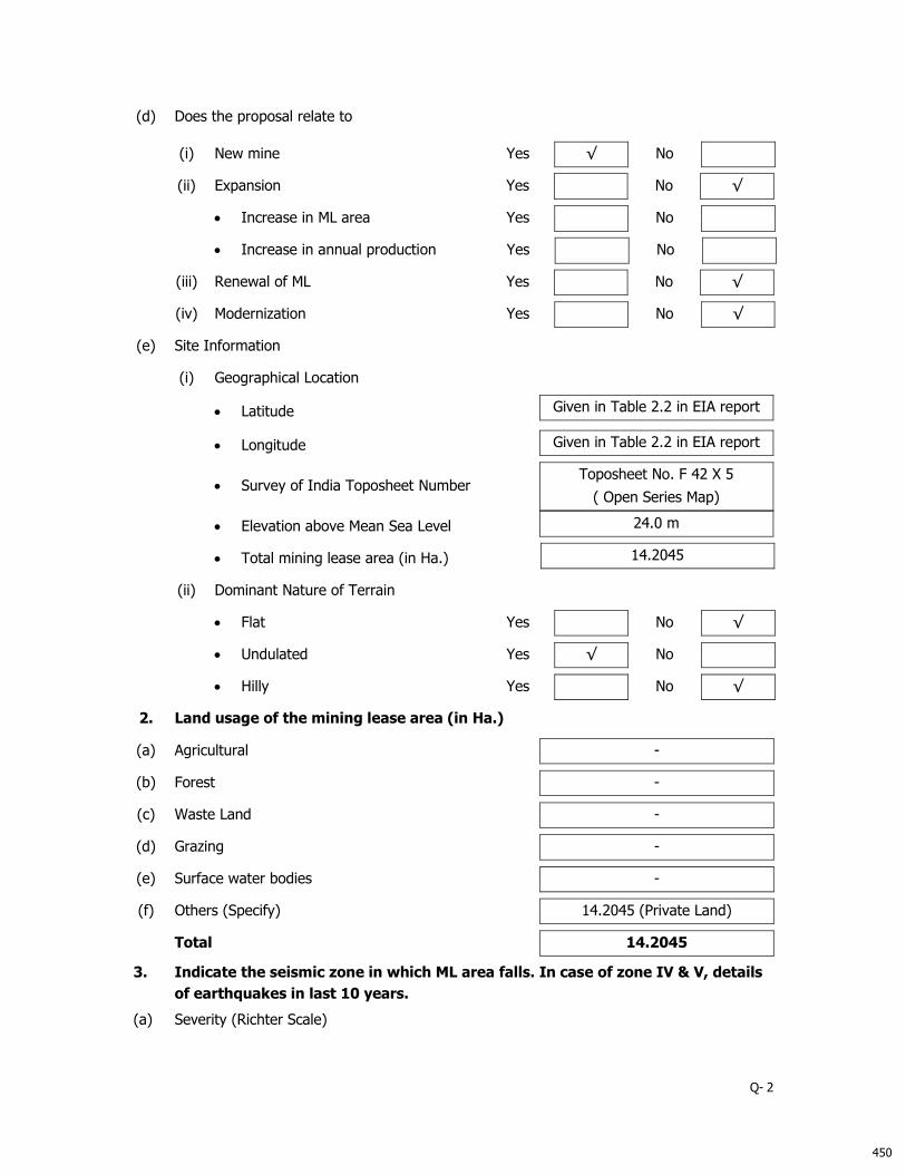
(d) Does the proposal relate to
(i) New mine Yes √ No
(ii) Expansion Yes No √
Increase in ML area Yes No
Increase in annual production Yes No
(iii) Renewal of ML Yes No √
(iv) Modernization Yes No √
(e) Site Information
(i) Geographical Location
Latitude
Given in Table 2.2 in EIA report
Longitude
Given in Table 2.2 in EIA report
Survey of India Toposheet Number
Toposheet No. F 42 X 5
( Open Series Map)
Elevation above Mean Sea Level
24.0 m
Total mining lease area (in Ha.)
14.2045
(ii) Dominant Nature of Terrain
Flat Yes No √
Undulated Yes √ No
Hilly Yes No √
2. Land usage of the mining lease area (in Ha.)
(a) Agricultural -
(b) Forest -
(c) Waste Land -
(d) Grazing -
(e) Surface water bodies -
(f) Others (Specify) 14.2045 (Private Land)
Total 14.2045
3. Indicate the seismic zone in which ML area falls. In case of zone IV & V, details
of earthquakes in last 10 years.
(a) Severity (Richter Scale)
450

Q- 3
The mining lease falls in Seismic Zone III. There have been no earthquakes with epicenter
in the Jafarabad Taluka or Amreli District.
(b) Impact i.e. Damage to
Life Yes No √
Property Yes No √
Existing Mine Yes No √
451

Q- 4
4. Break-up of mining lease area (in Ha.) as per approved conceptual plan:
Purpose
Mining Lease Area
Total
Area Acquired Area to be Acquired
Government Private Government Private Government Private
Forest Others Agri. Others Forest Others Agri. Others Forest Others Agri. Others
1. Area to be excavated 12.015 12.015
2. Storage for top soil - -
3. Overburden / Dumps - -
4. Mineral Storage - -
5. Infrastructure (Workshop,
Administrative Building) - -
6. Roads 0.26 0.26
7. Railways - -
8. Green Belt*
Backfilled area
Statutory Barrier
1.50
2.00
1.50
2.00
9. Tailings pond - -
10. Effluent Treatment Plant - -
11. Coal Handling plant /
mineral separation plant - -
12. Township area - -
13. Other (Specify)** 1.9295 1.9295
Total 14.2045 14.2045
* Greenbelt includes backfilled area and area covered under statutory barrierwhich is included in the excavated pits and un disturbed areas.
**This area will be remain un disturbed
452

Q- 5
5. Township (outside mining lease) – Not Applicable
(a) Total area (in Ha.) -
(b) No. of dwelling units -
(c) Distance from mine site -
6. Distance of water bodies (in km)
Distance from River Bank*
Other water bodies*
Sea / Creek / Lake / Nalla etc.
(specify)
Mining lease boundary Dhatarwadi
~ 8.2 Km
Sea
~ 1.20km
Ancillary facilities - -
[* From highest flood line / high tide line]
7. For projects falling within the Coastal Regulation Zone (CRZ)
Whether the mineral to be mined
is of rare nature and not available
outside CRZ
Yes - No -
If yes, annex a scaled location map showing low tide line (LTL), high tide line (HTL) duly
demarcated by one of the authorized agencies* [*Director, Space Application Centre,
Ahmedabad: Centre for Earth Science Studies, Thiruvananthapuram: Institute of Remote
Sensing, Anna University, Chennai: Institute of Wetland Management & Ecological Designs,
Kolkata: Naval Hydrographers Office, Dehradun: National Institute of Oceanography,
Panjim, Goa: and National Institute of Ocean Technology, Chennai], boundary of mining
lease area, distance of ML area from LTL and HTL CRZ boundary and CRZ classification of
the project area as per the approved Coastal Zone Management Plan, and settlements,
sand dunes, mangroves, forest land/patches, turtles breeding and nesting sites etc., if any,
in the project area.
8. Indicate aerial distance from the periphery of core zone/ area from the
periphery of the buffer zone to the boundary of following (upto 10 km):
S.
No. Areas Name
Aerial distance from (in km)
Core
Zone* Buffer Zone*
1. National park /
Sanctuary None - -
2.
Biosphere Reserve /
tiger Reserve/ Elephant
Reserve/ any other
Reserve
None - -
3. Forest (RF/ PF /
unclassified)
Reserve Forest -1
Reserve Forest – 2
Reserve Forest -3
0.40
2.00
6.00
Within buffer zone
453

Q- 6
4. Habitat for migratory
birds No No No
5.
Corridor for animals of
schedule I & II of the
Wildlife (Protection) Act,
1972
None
6.
Archaeological Sites
* Notified
* Others
None - -
7. Defence Installation None - -
8. Industries / Thermal
Power Plants
Narmada Cement –Jafarabad
Works, UltraTech Cement Ltd
Gujarat Cement Works,
UltraTech Cement Ltd
CPP, Gujarat Cement Works,
UltraTech Cement Ltd
Sintex Yarns Ltd
1.2 Km
5.93 Km
6.13 Km
5.68 Km
9. Other Mines
Narmada Cement-Jafarbad
Works (UltraTech Cement Ltd.)
Babarkot Limestone Mine
(565.94 Ha)
The mines mentioned to the left are
known to be within 10 kms of the
mine lease boundary
Narmada Cement-Jafarbad
Works, (UltraTech Cement Ltd.)
Babarkot Limestone Mine
(49.8454 Ha)
Narmada Cement-Jafarbad
Works (UltraTech Cement Ltd.)
Vadhera-Rohisa Limestone Mine
(160.24 Ha)
Narmada Cement-Jafarbad
Works (UltraTech Cement Ltd.)
Jafarabad Limestone Mine
(100.61 Ha)
Narmada Cement-Jafarbad
Works (UltraTech Cement Ltd.)
Kagwadar Natural Clay Mines
(88.54 Ha)
Gujarat Cement Works,
(UltraTech Cement Ltd.)
Kovaya Limestone Mine
(953.33)
10. Airport Diu Airport Diu 50km in
SW 40 km in SW
454

Q- 7
11. Railway Lines Rajula Railway Station
30 km in
Eastern
Direction
Outside Buffer Zone
12. National / State
Highways
State Highway -34
2.27 km in
NW
Direction
Within Buffer Zone
National Highway 8E
9.1 km in
Northern
Direction
Inside Buffer Zone
[* Buffer zone in case of ML area upto 25 ha is to be considered as 5 km all around the
periphery of the core zone and for ML area above 25 ha. an area 10 km all around the
periphery of the core zone]
9. Description of flora & fauna separately in the core and buffer zones*
[*Consult the Wildlife (Protection) Act, 1972 as amended subsequently and list species with
(1) Common Name (2) Scientific Name and (3) under which schedule of the Wildlife
(Protection ) Act the identified species fall. Get the list authenticated by an expert in the
field/ credible scientific institute / University / Chief Wildlife Warden office. Information
to be based on field survey.]
A. Flora Core Zone Buffer Zone
1. Agricultural crops
Details of flora present in the core and buffer zone is given in
Chapter 3 under Section 3.5.11 of the EIA report.
2. Commercial crops
3. Plantation
4. Natural vegetation / forest type
5. Grass lands
6. Endangered species
7. Endemic species
8. Others (Specify)
B. Fauna Core Zone Buffer Zone
1. Total listing of faunal elements
Details of flora present in the core and buffer zone is given in
Chapter 3 under Section 3.5.11 of the EIA report.
2. Endangered species
3. Endemic species
4. Migratory species
5. Details of aquatic fauna, if
applicable
455

Q- 8
10.
Details of mineral reserves (as per approved Mining Plan) (Details Given in
section 2.6 in EIA report)
Quantity (in million tonnes)
(a) Proved /Probable
(b) Indicated -
(c) Inferred
(d) Mineable reserves
11. Major geological formation / disturbances in the mining lease area
(a) Geological maps submitted Yes √ No
(b) Geological sections submitted Yes √ No
(c) Contour map submitted Yes √ No
(d) Whether the presence, if any, noted of
(i) Faults Yes No √
(ii) Dykes Yes No √
(iii) Shear Zone Yes No √
(iv) Folds Yes No √
(v) Other weak zones Yes No √
(e) Source of data (Indicate) On the basis of site visits and the Approved
Mining Plan
12. Production of mineral(s) and life of mine
(a) Rated capacity of mine mineral wise
(Tonnes/annum) 2,50,000
(b) Life of mine at proposed capacity (Years) 5
(c) Lease period (Years) 50
(d) Date of expiry of lease (D/M/Y) 11.01.2067
(e) Indicate in case of existing mines (Fresh
Granted lease)
(i) Date of opening of mine
(ii)
Production in the last 5 years from
year 2007-2008 to year 2011-2012 in
1st year 5th year
456

Q- 9
million tonnes.
(iii)
Projected production for the next 5
years from year2016-17 to 2020-21
in million tonnes.
(iv) Whether mining was suspended
after opening of the mine? Yes No
If yes, details thereof including last
production figure and reason for the
same
(f) Whether plans & sections provided? Yes √ No
13. Type and method of mining operations
TYPE METHOD
Opencast √
Manual
Underground
Semi – mechanized
Both
Mechanized √
14. Details of ancillary operations for mineral processing
(a) Existing Not Applicable
(b) Additional Not Applicable
15. Mine details
(a) Opencast Mine
(i) Stripping ratio (Mineral in tonnes to over
burden in m3) 1:0.10
(ii) Ultimate working depth (in m bgl) Up to 0 msl
(iii) Indicate present working depth in case of
existing mine (in m bgl) Not Applicable
(iv) Thickness of top soil (in m)
Minimum -
Maximum -
Average -
(vi) Mining Plan
Height and width of the bench in
overburden / waste
Height of the Bench: 1.00 m
Width of the Bench: 4.5 m
457

Q- 10
Height and width of the bench in ore body
/ coal seam
Height of the Bench: 6.00 m
Width of the Bench: 4.50 m
Proposed inclination / slope of the sides of
the opencast mine (Separately for
overburden, coal / ore and overall a\slope
of the pit sides) both while operating the
mine as well as at the time of closure of
the mine.
The slope of the face will be
maintained 80˚ from vertical during
mining operation
Whether transverse sections across the
opencast mine at the end of fifth year and
at the end of the life of the mine have
been submitted?
Yes* √ No
* Transverse section across the opencast mine at
the end of fifth year has been submitted
(vii) Type of blasting, if any, to be adopted No Blasting.
Surface Miner will be deployed
(b) Underground mine Not applicable
(i) Seam / Ore body
Min. Depth (m) Max. Depth
(m)
Avg. Thickness
(m)
Rate of dip in
degree Direction of dip
(ii) Mode of entry into the mine
Shaft
Adit
incline
(iii) Details of machinery
On surface
At Face
For transportation
Others
(iv) Method of stoping (metalliferrous mines)
Open
Filled
Shrinkage
Caving
Combination of above
458

Q- 11
Others (Specify)
(v) Extraction method
Caving
Stowing
Partial extraction
(vi) Subsidence
Predicted max. subsidence (in m)
Max. value of tensile strain (in mm/m)
Max. slope change (in mm/m)
Whether identified possible subsidence
area(s) superimposed on surface plan has
been submitted?
Major impacts on surface features like
natural drainage pattern, houses, buildings,
water bodies, roads, forest, etc.
Salient features of subsidence management
(monitoring and control)
16. Surface drainage pattern at mine site
(a) Whether the pre-mining surface drainage plan
submitted? Yes No √
(b)
Do you propose any modification / diversion in
the existing natural drainage pattern at any
stage? If yes, when. Provide location map
indicating contours, dimensions of water body
to be diverted, direction of flow of water and
proposed route / changes, if any i.e.
realignment of river / nallah / any other water
body falling within core zone and its impact.
Yes No √
17. Embankment and / or weir construction
(a) Do you propose, at any stage, construction of
(i) Embankment for protection against
flood? Yes No √
(ii) Weir for water storage for the mine? Yes No √
(b) If so, details thereof. Not Applicable
(c) Impact of embankment of HFL and settlement
around Not Applicable
459
Q- 12
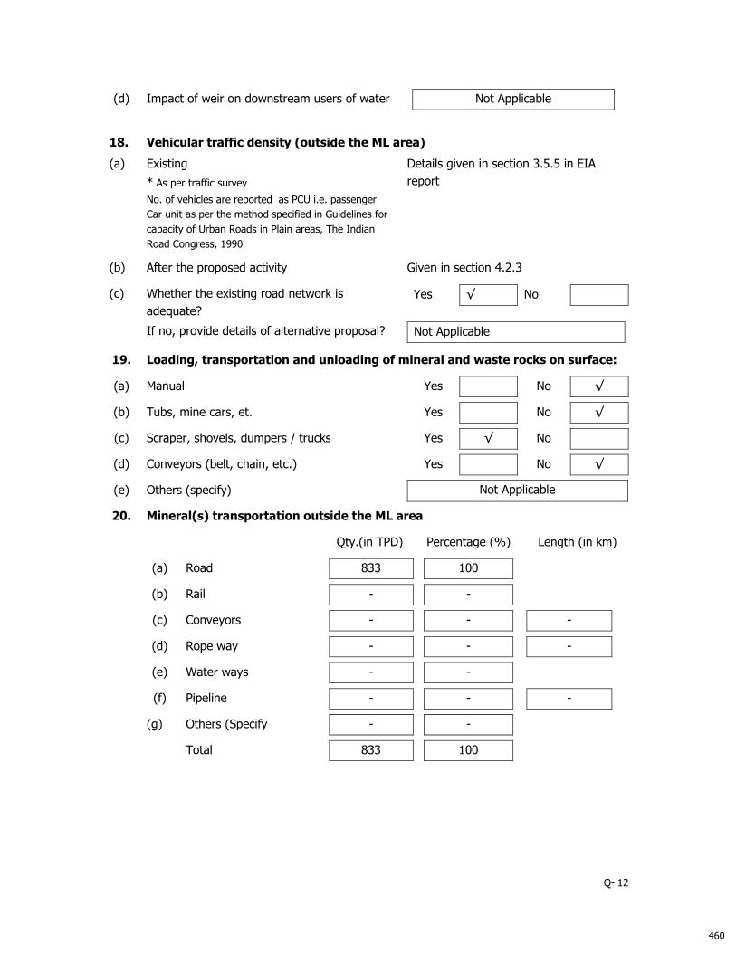
(d) Impact of weir on downstream users of water Not Applicable
18.
Vehicular traffic density (outside the ML area)
(a) Existing
* As per traffic survey
No. of vehicles are reported as PCU i.e. passenger
Car unit as per the method specified in Guidelines for
capacity of Urban Roads in Plain areas, The Indian
Road Congress, 1990
Details given in section 3.5.5 in EIA
report
(b) After the proposed activity Given in section 4.2.3
(c) Whether the existing road network is
adequate?
Yes √ No
If no, provide details of alternative proposal? Not Applicable
19. Loading, transportation and unloading of mineral and waste rocks on surface:
(a) Manual Yes No √
(b) Tubs, mine cars, et. Yes No √
(c) Scraper, shovels, dumpers / trucks Yes √ No
(d) Conveyors (belt, chain, etc.) Yes No √
(e) Others (specify) Not Applicable
20. Mineral(s) transportation outside the ML area
Qty.(in TPD) Percentage (%) Length (in km)
(a) Road 833
100
(b) Rail -
-
(c) Conveyors -
-
-
(d) Rope way -
-
-
(e) Water ways -
-
(f) Pipeline -
-
-
(g) Others (Specify -
-
Total 833
100
460

Q- 13
21. Baseline Meteorological and Air Quality data
(a) Micro-meteorological data
[Continuous monitoring through autographic instrument for one full season other than monsoon]
(i) Wind rose pattern for one full season (16 points of compass i.e. N, NNE, and NE …) based on 24-hourly data. For coastal area also
furnish day-time and night time data.
Day time
Night time
24-hours period
Wind rose pattern is given as Figure 3.1 in Chapter 3 of the EIA report
(ii) Site specific monitored data
Month
Wind Speed (kmph) Temperature (˚C) Relative Humidity (%) Rainfall* (mm) Cloud Cover **
(Octas of Sky)
Mean Max. % of
calm
Mean
(Dry Bulb) Highest Lowest Mean Highest Lowest Total
24-
Hours
Highest
No. of
rainy
days
Mean
Oct-Dec 2016 3.4 7.1 0.0 28.6 35.7 19.8 52.6 93.5 28.0 - - - 0
* 24-hours rainfall should be reported from 08:30 hrs IST of previous day to 08:30 hrs IST of the day.
* Rainy day is considered when 24 hrs rainfall is > 2.5 mm.
** Visual observations of cloud cover should be recorded four times a day at regular intervals.
(iii) Indicate name and distance of the nearest IMD meteorological station form which climatologically data have been obtained for
reporting in the EIA report, if any.
Site specific Met data collected using online weather logger installed near site
Long term weather quoted in EIA report is from IMD station at Diu (~ 50 km [aerial] in SW direction)
461
Q- 14
(b) Ambient air quality data* (RPM, SPM, SO2, and NOX)
[* Monitoring should be carried of covering one full season except monsoon – same season as in 21 (a) (i)]
[* Frequency of sampling: Sampling to be done twice a week for the entire season 24 hourly for SPM & RPM. For gaseous pollutants 24-
hourly data be given irrespective of the sampling period]
(i) Season and period for which monitoring has been carried out.
Season of Monitoring –Post monsoon 2016
Period of Monitoring – Oct to Dec 2016
(ii) No. of samples collected at each monitoring station.
S.No. AAQM Station No. of Samples Location Distance (km) &Direction from mining lease area
1. AA1 18 At Project Site 0.00, Core
2. AA2 18 Babarkot 1.6 km in S direction
3. AA3 21 Jafrabad 3.3 km in SW direction
4. AA4 21 Vandh 0.9 km in N direction
5. AA5 16 Mitiyala 0.9 km in NW direction
6. AA6 18 Varahsvarup 3.7 km in SE direction
7. AA7 16 Narmada Cement 1.8 km SW direction
462
Q- 15
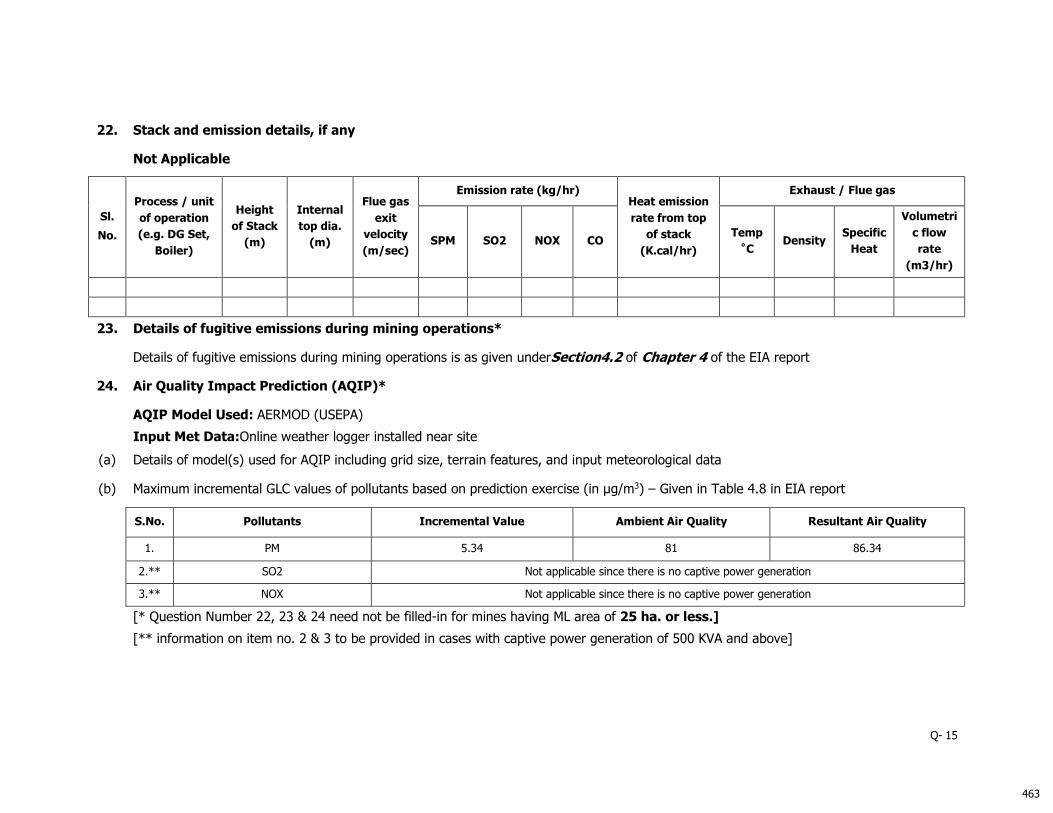
22. Stack and emission details, if any
Not Applicable
Sl.
No.
Process / unit
of operation
(e.g. DG Set,
Boiler)
Height
of Stack
(m)
Internal
top dia.
(m)
Flue gas
exit
velocity
(m/sec)
Emission rate (kg/hr) Heat emission
rate from top
of stack
(K.cal/hr)
Exhaust / Flue gas
SPM SO2 NOX CO Temp
˚C Density
Specific
Heat
Volumetri
c flow
rate
(m3/hr)
23. Details of fugitive emissions during mining operations*
Details of fugitive emissions during mining operations is as given underSection4.2 of Chapter 4 of the EIA report
24. Air Quality Impact Prediction (AQIP)*
AQIP Model Used: AERMOD (USEPA)
Input Met Data:Online weather logger installed near site
(a) Details of model(s) used for AQIP including grid size, terrain features, and input meteorological data
(b) Maximum incremental GLC values of pollutants based on prediction exercise (in µg/m3) – Given in Table 4.8 in EIA report
S.No. Pollutants Incremental Value Ambient Air Quality Resultant Air Quality
1. PM 5.34 81 86.34
2.** SO2 Not applicable since there is no captive power generation
3.** NOX Not applicable since there is no captive power generation
[* Question Number 22, 23 & 24 need not be filled-in for mines having ML area of 25 ha. or less.]
[** information on item no. 2 & 3 to be provided in cases with captive power generation of 500 KVA and above]
463

25. Water requirement (m3/day)
Purpose Avg. Demand Peak Demand
A
. Mine Site
1. Mine operation - -
2. Land reclamation - -
3. Dust suppression - 5.00
4. Drinking - 0.50
5. Green Belt - 3.00
6. Beneficiation - -
7. Washeries - -
8. Fire Service - -
9. Others (specify) - -
B
. Township
1. Green Belt NA NA
2. Domestic NA NA
3. Other (specify) NA NA
Total 8.50
26. Source of water supply*
S.No. Source m3/day
1. River (name) -
2. Ground water** -
3. Mine water (sump / pit) 8.00
4. Other surface water bodies (specify) 0.5 (Nearby Drinking Water facility)
[*Annex a copy of sanction letter / permission from the concerned authority (Central
Ground Water Authority in case of ground water abstraction is from notified area / State
Ground Water Board in case of non-notified area / State Irrigation Department for surface
water pumping) for drawing water.]
464

27. Lean season flow in case of pumping from river / nalla
(cumecs)
Not Applicable
28. Ground water potential of the study area
Ground water potential of the study area is as given under Table 4-20 of Chapter 4 of
the draft EIA report
28.1 Ground water availability
(a) Range of water table (m AMSL)
(i) Pre-monsoon (April/May)
Core Zone Below msl
Buffer Zone Range: (-2m msl to
+4m msl)
(ii) Post-monsoon (November)
Core Zone Below msl
Buffer Zone Range: (0m msl to +6m
msl)
(b) Total annual replenishable recharge (million m3/year)3471.24
(c) Annual draft excluding estimated draft through mine
discharge (million m3/year) 1962
(d) Estimated draft through mine drainage (million m3/year) NIL
(e) Net annual ground water availability (million m3/year) 3297.68
(f) Stage of ground water development in % 59.50
28.2 Water demand – Competing users of the water source
S.
No. Usage
Present Consumption
(m3/day)
Additional proposed
as per local plan
(m3/day)
Total
(m3/day)
Surface Ground Surface Ground Surface Ground
1. Irrigation - 1704 MCM/Day
Data Not Available
- 1704 MCM/Day
2. Domestic -
258 MCM/Day
-
258 MCM/Day 3. Industry - -
4. Mining - -
5. Others (Specify) - 0.0 MCM/Day - 0.0 MCM/Day
Total - 1962 MCM/Day - 1962 MCM/Day
Source- CGWB report for Jafarabad Taluka, Amreali District
465
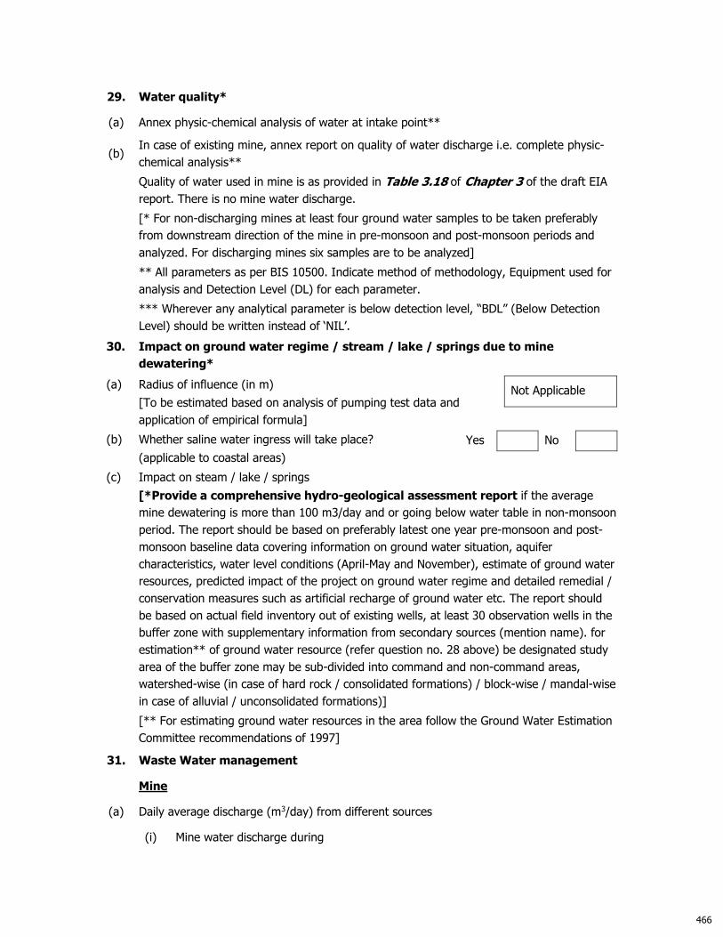
29. Water quality*
(a) Annex physic-chemical analysis of water at intake point**
(b) In case of existing mine, annex report on quality of water discharge i.e. complete physic-
chemical analysis**
Quality of water used in mine is as provided in Table 3.18 of Chapter 3 of the draft EIA
report. There is no mine water discharge.
[* For non-discharging mines at least four ground water samples to be taken preferably
from downstream direction of the mine in pre-monsoon and post-monsoon periods and
analyzed. For discharging mines six samples are to be analyzed]
** All parameters as per BIS 10500. Indicate method of methodology, Equipment used for
analysis and Detection Level (DL) for each parameter.
*** Wherever any analytical parameter is below detection level, “BDL” (Below Detection
Level) should be written instead of ‘NIL’.
30. Impact on ground water regime / stream / lake / springs due to mine
dewatering*
(a) Radius of influence (in m)
[To be estimated based on analysis of pumping test data and
application of empirical formula]
Not Applicable
(b) Whether saline water ingress will take place?
(applicable to coastal areas)
Yes No
(c) Impact on steam / lake / springs
[*Provide a comprehensive hydro-geological assessment report if the average
mine dewatering is more than 100 m3/day and or going below water table in non-monsoon
period. The report should be based on preferably latest one year pre-monsoon and post-
monsoon baseline data covering information on ground water situation, aquifer
characteristics, water level conditions (April-May and November), estimate of ground water
resources, predicted impact of the project on ground water regime and detailed remedial /
conservation measures such as artificial recharge of ground water etc. The report should
be based on actual field inventory out of existing wells, at least 30 observation wells in the
buffer zone with supplementary information from secondary sources (mention name). for
estimation** of ground water resource (refer question no. 28 above) be designated study
area of the buffer zone may be sub-divided into command and non-command areas,
watershed-wise (in case of hard rock / consolidated formations) / block-wise / mandal-wise
in case of alluvial / unconsolidated formations)]
[** For estimating ground water resources in the area follow the Ground Water Estimation
Committee recommendations of 1997]
31. Waste Water management
Mine
(a) Daily average discharge (m3/day) from different sources
(i) Mine water discharge during
466

Lean period Not Applicable
Monsoon period Not Applicable
(ii) Workshop Not Applicable
(iii) Domestic (mine site) Not Applicable
(iv) Beneficiation / Washeries Not Applicable
(v) Coal Handling Plant Not Applicable
(vi) Tailings Pond Not Applicable
(vii) Others (Specify) Not Applicable
Total
(b) Waste water treatment plant; flow sheet for treatment
process attachedNot Applicable
Yes No
(c) Quantity of water recycled / reused / to be recycled in
(i) Percentage Not Applicable
(ii) m3/day
(d) Point of final discharge
Final Point Quantity discharged (in m3/day)
1. Surface Not Applicable
(i) Agricultural Land
(ii) Waste Land
(iii) Forest Land
(iv) Greenbelt
2. River / nallah Not Applicable
3. Lakes Not Applicable
4. Sea Not Applicable
5. Others (specify) Not Applicable
Total Not Applicable
(e) Users of discharge water
(i) Human Yes No √
(ii) Livestock Yes No √
(iii) Irrigation Yes No √
(iv) Industry Yes No √
(v) Others (Specify) None, since waste water will be
discharged through soak pits
467

(f) Details of the river / nalla, if final effluent is / will be discharged (cumecs) Not Applicable
(i) Average flow rate
(ii) Lean season flow rate
(iii) Aquatic life
(iv) Analysis of river water 100 meters upstream and
100 meters downstream of discharge point
submitted.
Yes No
Township Not Applicable
(a) Waste water generation from township (m3/day)
(b) Are you planning to provide sewage treatment plant? Yes No
(c) Usage of treated water
32. Attach water balance statement in the form of a flow diagram indicating source
(s), consumption (section-wise) and output.
Water balance diagram is as given in Figure 3-1 under Section 3.10.3 of Chapter 3 of
the EIA report
33. Ambient noise level leq dB(A) Given in Table 3.16 in EIA report
34. Solid Waste
(a) Top soil and solid waste quantity and quality
Name
(Lump / fines / slurry /
sludge / others)
Composition Quantity
(m3/month) Method of disposal
Mining activity*
a. Top Soil Soil - No topsoil is available
b
. Over burden Windblown sand 1055
Temporary stacking and use
for back filling in conceptual
stage
c. Others (specify) - - -
Effluent Treatment Plant
(sludge) - - -
Total - 1055 -
[*Annex layout plan indicating the dump sites.]
(b) (i) Does waste(s) contain any hazardous / toxic
substance / radioactive materials or heavy metals? Yes No √
(ii) If yes, whether details and precautionary measures
provided? Yes No
(c) Recovery and recycling possibilities Not applicable since backfilling is proposed
at conceptual stage
468

(d) Possible user(s) of the solid waste Not applicable since backfilling is proposed
(e) (i) Is the solid waste suitable for backfilling?
Not applicable
Yes No
(ii) If yes, when do you propose to start backfilling
(in million m3)
Solid Waste (s)
Already
accumulated
(A)
To be generated
(B)
% of A & B to be backfilled
A B
Over burden NIL NIL NIL 100
Others (Specify) Not Applicable Not Applicable Not Applicable Not Applicable
Land reclamation Plan
(f) In case waste is to be dumped on the ground, indicate:
(i) Associated environmental problems
(ii)
Number & type of waste dumps (Temporary dump
within site which will used for backfilling
conceptually)
No. of external dumps NOT APPLICABLE
Max. projected height of dumps (in m)
No. of terraces and height of each stage
Overall slope of the dump (degree)
Proposed reclamation measures
(iii) Section of the waste dump in relation to the adjacent
ground profile attached Yes No
35. Fuel / Energy requirements*
[* To be furnished for mines having ML area more than 25 Ha. or captive power
generation of 500 KVA and above]
(a) Total power requirement (in MW): Not applicable since power will not be required
for mining activities
S.No. Mine Site Township Others
(Specify) Total
1. Present
2. Proposed /
additional
Total
(b) Source of power (in MW)
469

S.No SEB/Grid* Captive Power Plant DG Sets
1. Present
2. Proposed / additional
Total
[* Annex a copy of sanction letter from the concerned authority]
(c) Details of fuels (for vehicles and mining equipments)
S.
No. Fuel
Daily Consumption (TPD) Calorific Value
(kcals/kg) % Ash % Sulphur
Existing Proposed
1. HSD _ 0.15 10,000 <0.01 <0.005
2. LSHS - - - - -
3. Others
(Specify) - - - - -
36. Storage of inflammable / explosive materials-Not Applicable
S.
No. Name Number of Storages
Consumption
(in TPD)
Maximum Quantity at
any point of time
1. Fuels
2. Explosives
37. Human Settlement (Details given in 3.5.12 of the EIA Repot )
Core Zone Buffer Zone
Population* -
No. of villages -
Number of households
village-wise -
[* As per 2011 census record or actual survey]
38. Rehabilitation & Resettlement (R&R) Plan*
Not Applicable, since neither rehabilitation nor resettlement is envisaged
[* Provide a comprehensive rehabilitation plan, if more than 1000 people are likely to be
displaced, other-wise a summary plan]
(a) Villages falling within the study area
Villages
Number Name
Core Zone
500 m from the blasting site
(s)
Buffer Zone
Township site
470
(b) Details of village(s) in the core zone
S.
No. Village Name
Population* Average Annual
Income Tribal Others
[* As per 2001 census/actual survey]
(c) Population to be displaced and / or Land oustees
Name of village(s) falling within
Number of oustees
Land (Only) Homestead
(only)
Land and Homestead
(Both)
Mining Lease
1.
2.
Township Site
1.
2.
(d)
Whether R&R package has been finalized?
If yes, salient features of R&R plan for oustees.
(i) Site details where the people are proposed to be
resettled & facilities existing / to be created
(ii) Funds earmarked for compensation package.
(iii) Agency / Authority responsible for their
resettlement.
(iv) Time of commencement of resettlement of
Project Affected People (PAP)
(v) Period by which resettlement of PAP will be over.
39. Lease-wise plantation details
(a) Lease area (in ha.) Existing Mine New Mine
(i) Area broken up -
√
(ii) To be broken up -
√
(iii) Area not to be broken-up -
√
(b) Township area (in ha.) Not applicable
-
471

(c) Area afforested and proposed (in ha.)
Peripheral Dumps Roads Township Others
(i) Existing Nil Nil Nil Nil
(ii) Proposed 2.00 Nil Nil Nil 1.5
(d) No. and type of trees planted and proposed
(i) Existing(Not Applicable)
When plantation was started? Month / Year
No. of plant species planted Number saplings (per ha.)
- -
Survival rate %
- Avg. height
-
(ii) Proposed
No. of plant species to be planted Number of sapling (per ha.)
2000 2000
40. Environmental health and safety
Details of Environment Health and Safety is as given in Chapter 7 of the draft EIA report
(a) What major health and safety hazards are anticipated? As given in Chapter 7 of
the draft EIA report
(b) What provisions have been made / proposed to be made
to conform to health and safety requirements?
As given in Chapter 7 of
the draft EIA report
(c) In case of an existing mine :
(i) Comprehensive report on health status of the workers
as under the Mines Act annexed. – Being prepared Yes - No -
(ii)
Mineralogical composition of RPM (dust)
Free silica
Chromium* (Total as well as Hexavalent)
Lead**
[* Only for Chromite mines]
[** Only for Base Metal mines]
(d) Information on radiation protection measures, if applicable. : Not Applicable
472

41. Environmental Management Plan
Salient features of environmental protection measures
S.No. Environmental Issues* Already practiced, if
applicable Proposed
1. Air Pollution
As given in Chapter
10of the EIA report
2. Water Pollution
3. Water Conservation
4. Noise Pollution
5. Solid Waste / Tailings
6. Land degradation
7. Erosion & Sediment
8. Top Soil
9. Ground Vibration
10. Wildlife Conservation
11. Forest Protection
12. Others (specify)
[*As applicable]
42. Compliance with environmental safeguards (For existing units)
(a) Status of the compliance of conditions of environmental
clearance issued by MoEF, if any, enclosed. Yes - No -
(b) Status of the compliance of ‘Consent to Operate’ issued
by SPCB, if any, enclosed. Yes No -
(c) Latest ‘environmental statement’ enclosed. Yes - No -
43. Scoping of EIA
Whether environmental impact assessment of the
project has been carried out by following scoping
process?
Yes √ No
If yes, a copy of scoping of EIA annexed. Yes √ No
ToR received from SEIAA is attached in the EIA report
44. Mine Closure (Progressive Mine closure Plan)
(a) Have you planned mine closure? Yes √ No
(b) Submitted a conceptual mine closure plan Yes √ No
(c) If yes, indicate estimated amount for implementing the
same (in Rs. Lakhs) 36.39 lacs
473

45. Capital cost of the project (in Rs. Lakh)
(Based on latest estimate)
Given in Table 1.2 of EIA
report
46. Cost of environmental protection measures(in Rs. Lakhs) is Given in Table 6.2 of EIA
report
47. Amount earmarked for socio-economic welfare measures for the nearby villages
other than R&R plans.
Amount earmarked for socio-economic welfare measures is Rs. 2.00 lacs/year
48. Public Hearing : To be held post submission of the draft EIA report
(a) Date of Advertisement
(b) Newspapers in which the advertisement appeared
(c) Date of public hearing (DD/MM/YYYY)
(d) Public Hearing Panel chaired by & members present
(e) No. of people attended the public hearing meeting and
number of people from the lease area.
(f) Summary / details of public hearing in tabular form
49. Whether the following approvals* (wherever applicable) have been obtained?
(i) Site clearance from MoEF Yes No √
(ii) ‘Consent for Establishment’ from the State
Pollution Control Board- Yes No √
(iii) NOC from Atomic Mineral Division Yes No √
(iv) Mining plan approval from IBM/Ministry of Coal Yes √ No
(v) In case of existing mines, mining scheme
approval from IBM Yes No √
(vi) Forestry clearance under FCA, 1980 Yes No √
(vii) NOC from Chief Controller of Explosives Yes No √
(viii) Commitment regarding availability / pumping of
water from the concerned Authorities Yes No √
(ix) In case of ML area falling I notified areas of the
Central Ground Water Authority, NOC from them. Yes - No -
[* Annex copies of approvals and number them]
50. Was / is there any court case relating to the project or related activities? If so,
provide details present status.
No
474

475

CONTACT DETAILS
Vadodara (Head Office)
871/B/3, GIDC Makarpura, Vadodara, India – 390 010.
E: [email protected]; T:+91-265-6131000; F: +91-265-3001069
Delhi / NCR
SPAZE IT Park, Unit No. 1124, Sector 49, Near Omax City Center Mall Sohna Road, Gurgaon – 122 022
E: [email protected]; T: +91-124-4242430
Kadam Environmental Consultants w w w . ka d am en v i r o . c o m
E nv ironmentfor Deve lopm ent
476