draft basic assessment report for the proposed ...rhdhv.co.za/media/feedlot/draft bar .pdf · draft...
TRANSCRIPT
DRAFT BASIC ASSESSMENT REPORT FOR THE PROPOSED
CONSTRUCTION OF A CATTLE FEEDLOT AT THE NKOMAZI
ABATTOIR NEAR MALELANE: MPUMALANGA PROVINCE.
A R E P O R T F O R : D E PA R T M E N T O F R U R A L D E V E L O P M E N T
A N D L A N D R E F O R M
D A T E : O C T O B E R 2 0 1 5

BASIC ASSESSMENT REPORT
1
(For official use only)
File Reference Number:
Application Number:
Date Received:
Basic assessment report in terms of the Environmental Impact Assessment Regulations, 2014, promulgated in terms of the National Environmental Management Act, 1998 (Act No. 107 of 1998), as amended.
Kindly note that:
1. This basic assessment report is a standard report that may be required by a competent authority in terms of the EIA Regulations, 2014 and is meant to streamline applications. Please make sure that it is the report used by the particular competent authority for the activity that is being applied for.
2. This report format is current as of 08 December 2014. It is the responsibility of the applicant to ascertain whether subsequent versions of the form have been published or produced by the competent authority
3. The report must be typed within the spaces provided in the form. The size of the spaces provided is not necessarily indicative of the amount of information to be provided. The report is in the form of a table that can extend itself as each space is filled with typing.
4. Where applicable tick the boxes that are applicable in the report. 5. An incomplete report may be returned to the applicant for revision. 6. The use of “not applicable” in the report must be done with circumspection because if it is used in
respect of material information that is required by the competent authority for assessing the application, it may result in the rejection of the application as provided for in the regulations.
7. This report must be handed in at offices of the relevant competent authority as determined by each authority.
8. No faxed or e-mailed reports will be accepted. 9. The signature of the EAP on the report must be an original signature. 10. The report must be compiled by an independent environmental assessment practitioner. 11. Unless protected by law, all information in the report will become public information on receipt by the
competent authority. Any interested and affected party should be provided with the information contained in this report on request, during any stage of the application process.
12. A competent authority may require that for specified types of activities in defined situations only parts of this report need to be completed.
13. Should a specialist report or report on a specialised process be submitted at any stage for any part of this application, the terms of reference for such report must also be submitted.
14. Two (2) colour hard copies and one (1) electronic copy of the report must be submitted to the competent authority.
Shape files (.shp) for maps must be included in the electronic copy of the report submitted to the competent authority.

BASIC ASSESSMENT REPORT
2
SECTION A: ACTIVITY INFORMATION
Has a specialist been consulted to assist with the completion of this section? YES
If YES, please complete the form entitled “Details of specialist and declaration of interest” for the specialist appointed and attach in Appendix I. 1. PROJECT DESCRIPTION a) Describe the project associated with the listed activities applied for
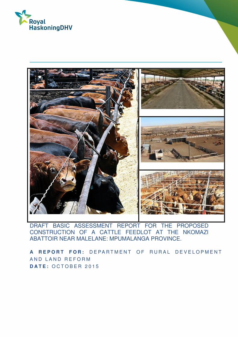
1 PROJECT DESCRIPTION
The Department of Rural Development and Land Reform (DRDLR) is proposing to develop a Cattle Feedlot located
adjacent to the Nkomazi red meat abattoir in the Mzinti village in the Nkomazi Local Municipality (refer to Figure 1). The
proposed development will be located on the farm Vlakbult 450 JU, which is approximately 530 hectares in size (refer to
Figure 2). The study area is bordered by Kamhlushwa village in the north westerly direction, Vlakbut and Phiva villages in
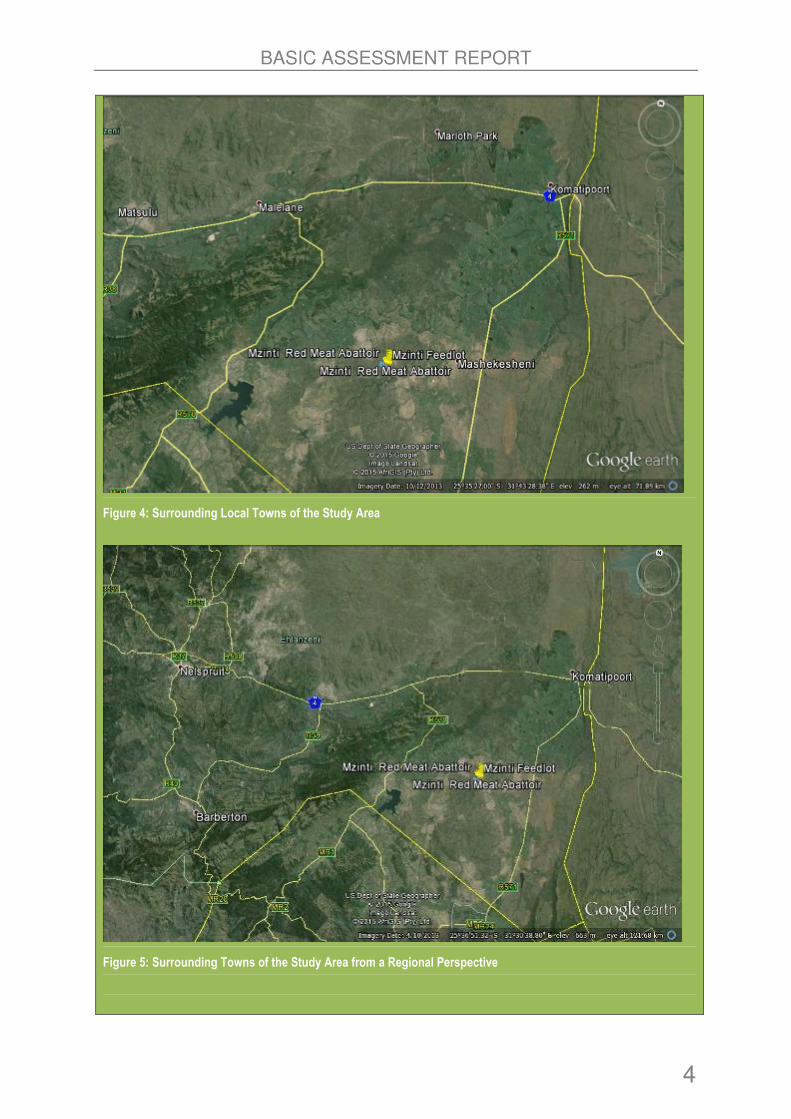
the north easterly direction and Mzinti and Tonga villages towards the southerly direction (refer to Figure 3). The nearest
town is Malelane, which is located approximately 50km away in a north westerly direction (refer to Figure 4). From a
regional perspective, located approximately 120km away in the north westerly direction is the Mbombela town (formerly
known as Nelspruit) which is the Capital City of the Mpumalanga Province (Refer to Figure 5).
Figure 1: Aerial Photograph of Locality (source: Google Earth)

BASIC ASSESSMENT REPORT
3
Figure 2: Boundary of the Study Area in Blue (530ha).
Figure 3: Surrounding Villages of the Study Area
BASIC ASSESSMENT REPORT
4
Figure 4: Surrounding Local Towns of the Study Area
Figure 5: Surrounding Towns of the Study Area from a Regional Perspective

BASIC ASSESSMENT REPORT
5
The proposed feedlot facility will be secured via a perimeter fence and be accessed via the access road to the abattoir. It
will comprise of the following associated infrastructure (as also illustrated in alternative layout drawings in Figures 17and
18).
• Feedlot Pens to accommodate 500 cattle at 9-15m² per animal;
• Hospital and Acclimatization Pens for 100 cattle at 9-15m² per animal;
• Handling Facility with offload , on-load , handling, receiving, and sorting areas at 2m²/animal;
• Manure Lagoons and Stockpile Area;
• Carcass Disposal Trench ;
• Diversion Banks, Spray Race and Silage Bunkers;
• Water Network, including 1.5km of 200mm diameter Pipes, Elevated Tanks of 75 000 litres and reservoirs that can
be used for dust suppression;
• Feed Trough and Aprons and Water Trough and Shades;
• Feed Storage Area and Processing Unit ;
• Administration Block and Weighbridge, Veterinary Facility, Equipment Sheds and Standby Generator; and
• External Ablution Facility and Canteen for Staff.
According to the feasibility studies conducted by Perozz Consulting Engineers, 2015, the proposed project will be
developed on an area that will be 5-10 hectares in extent. The feedlot will have a capacity to carry up to 500 cattle and a
production capacity of approximately 1000 cattle per annum. The following aspects have been considered in the design of
the project in order to minimise the environmental impacts:
1.1.1 Slope
• Alternative 1 has a slope that is 2.5%; and
• Alternative 2 has a slope that is 2.1%.
1.1.2 Attenuation Capacity
• 500 cattle carrying capacity feedlot;
• Manure area of 0.5 Ha;
• Canals, sedimentation pits and lagoon included (lined lagoon with no seepage); and
• Dam to trap run-off with a capacity of 1900m3.
1.1.3 Feedlot Pad
• Grading and Earthworks: Interface layer to protect subterranean soils from intrusion by hazardous substances,
pothole formation and run-off enhancement; and
• Earthworks and importation of gravel fill, spread and compacted to a slope maximum 2.5 -3%. Scraper to be
regularly used to scrape excess dung.
1.1.4 Manure Stockpile
• 0.5 Ha for stockpile located in the a separate section has been included in the design; and
• On slope >2.5-3% to channel, sedimentation pit and lagoon.
1.1.5 Lagoons (2 Tier Lined Lagoons)
• Design includes (2 tier system) settlement and spill-over area (sedimentation and secondary unit as holding ponds).
BASIC ASSESSMENT REPORT
6
• Lined to prevent seepage.
• Sludge to be annually removed.
• Design size 1900m3.
1.1.6 Animal Carcasses
• Design includes carcass disposal for any cattle deaths in a trench which will be fenced off; and
• Trench will be 1m above the water table as a minimum.
1.1.7 Water Sources
• Water will be sourced from on-site boreholes.
2 DESCRIPTION OF THE RECEIVING ENVIRONMENT
2.1 Climate
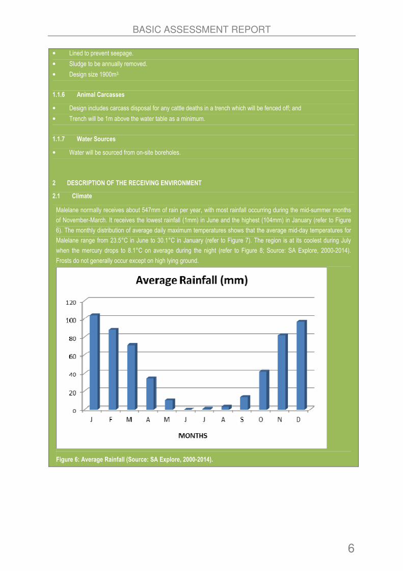
Malelane normally receives about 547mm of rain per year, with most rainfall occurring during the mid-summer months
of November-March. It receives the lowest rainfall (1mm) in June and the highest (104mm) in January (refer to Figure
6). The monthly distribution of average daily maximum temperatures shows that the average mid-day temperatures for
Malelane range from 23.5°C in June to 30.1°C in January (refer to Figure 7). The region is at its coolest during July
when the mercury drops to 8.1°C on average during the night (refer to Figure 8; Source: SA Explore, 2000-2014).
Frosts do not generally occur except on high lying ground.
Figure 6: Average Rainfall (Source: SA Explore, 2000-2014).

BASIC ASSESSMENT REPORT
7
Figure 7: Average Mid-day Temperatures (Source: SA Explore, 2000-2014).
Figure 8: Average Night Time Temperatures (Source: SA Explore, 2000-2014).
2.2 Ecology
2.2.1 Vegetation
The vegetation unit of the area and farm site is Granite Lowveld (SVI 3; Mucina & Rutherford, 2006), previously classified
as Arid Lowveld (VT 11) and Lowveld (VT 10; Acocks, 1953) and Mixed Lowveld Bushveld (Low & Rebelo, 1996). The
vegetation of the site consists mainly of mixed Terminalia sericea, Combretum zeyheri and Combretum apiculatum
woodlands in various stages of transformation and degradation. Sections of bush have been cleared including the existing
residential erven, the abattoir site, access roads, Eskom servitudes as well as more open grazing areas. Bush
encroachment by Terminalia serricea, Dichrostachys cinerea and various small Vachelia species; occurs in disturbed

BASIC ASSESSMENT REPORT
8
areas (refer to Figure 9).
Granite Lowveld (SVI 3) occurs in both the Limpopo and Mpumalanga Provinces, Swaziland and marginally into Kwazulu-
Natal. A north-south belt on the plains east of the escarpment from Thohoyandou in the north, interrupted in the Bolobedu
area, continues into the Bivati area, with an eastward extension onto the plains around the Murchison Range and
southwards to the Abel Erasmus Pass, Mica and Hoedspruit areas to the east of Bushbuckridge. Substantial coverage is
also found in the Kruger National Park spanning areas to the east of Orpen Camp southwards through Skukuza and
Mkuhlu, including undulating terrain west of Skukuza to the basin of the Mbyamiti River. It continues further southward to
the Hectorspruit area with a narrow westward extension up the Crocodile River Valley past Malelane, Kaapmuiden and the
Kaap River Valley, entering Swaziland between Jeppe’s Reef in the west and the Komati River in the east, through the
area between Manzini and Siphofaneni; including the Grand Valley, narrowing irregularly and marginally entering Kwazulu-
Natal near Pongola (Mucina et al. 2006).
The farm site is currently utilised for limited livestock grazing activities. Historic and current vegetation clearance for
increased grazing areas and access for livestock throughout the site was observed. Dense closed woodland occurs along
the Mnywane River and the southern portions of the site. Bush encroachment occurs in the overgrazed and disturbed
areas with dense thickets of Terminalia serircea, Dichrostrachys cinerea, as well as Vachelia erubescens.
Most of the natural vegetation has been completely transformed except for a few large Marula Sclerocarya birrea subsp.
caffra around existing buildings. The mixed bushveld vegetation has been historically cleared in the northern and central
portions of the site, as well as surrounding the farm site. Existing homesteads occur across the river outside the southern
boundary of the site. Evidence of bush clearing activities as well as previous wood harvesting activities is apparent on site.
2.2.1.1 Protected Species
The protected tree Apple-leaf (Philenoptera violacea) was observed along the Mnywane River. The wood is attractive, hard
and dense, and used for ornament carving. Leaves are browsed by the livestock and game. Roots and leaves are used
medicinally. Water excretions by the sap sucking nymphs of Ptyleus grossus (Hemiptera) cause the trees to ‘rain’ during
certain times of the year. The butterflies Charaxes bohemani and Coeliades forestan forestan breed on the tree (Van Wyk
& Van Wyk 2013).
Several (50) protected Marula Sclerocarya. birrea ssp. caffra were observed in the open and closed woodland vegetation
unit on the development area, as well as scattered individuals around the Mzinti abattoir. Bark of S. birrea ssp. caffra is
used to treat a variety of ailments, notably fever, boils and diarrhoea. Together with butter, it is applied as an ointment for
headaches and pains in the eyes. It is claimed that blood circulation is aided by a steam bath of extracts of S. birrea ssp.
caffra mixed with extracts from other plants and roots. Steam from the bark is also used to treat eye disorders.
Bark decoctions, when mixed with other medicinal plants, treats various infections such as malaria, syphilis, leprosy,
hydropsy, dysentery, hepatitis and rheumatism, and is a laxative. It is also used internally and externally as a prophylactic
against gangrenous rectitis. Leaves, bark and roots are used externally (as a rub) for snakebite, and internally (as a
beverage) for toothache. It has occasionally been used in veterinary medicine. The tree is also a host to the edible mopane
caterpillar as well as the large sturnid or emperor moth caterpillars (Van Wyk & Van Wyk 2013). The protected tree
Leadwood (Combretum imberbe) was observed within the closed woodland and adjacent to the Mnywane River. A list of
protected tree species for the area is provided in Table 1.

BASIC ASSESSMENT REPORT
9
Figure 9: Vegetation of the Study Area.

BASIC ASSESSMENT REPORT
10
Table 1: List of Protected Species
SCIENTIFIC NAME FAMILY COMMON NAME RECORDED SPECIES
Breonadia salicina Rubiaceae Matumi No specimens observed; it’s a facultative
riparian (riverine) species.
Elaeodendron
transvaalensis
Celastraceae Bushveld saffron No specimens observed.
Combretum
Imberbe
Combretaceae Leadwood Approximately 2 specimens observed.
Philenoptera violacea Caesalpiniaceae Apple-Leaf Approximately 5 specimens observed.
Pittosporum
viridiflorum
Pittosporaceae Cheesewood No specimens observed.
Pterocarpus
angolensis
Ceasalpiniaceae Wild teak No specimens observed.
Sclerocarya
birrea subsp. caffra
Anacardiaceae Marula Confirmed on the site (∼50).
2.2.2 Fauna
An adult male Bushbuck and Common Duiker were observed in the denser Acacia woodland vegetation unit on the
property. Evidence of Marsh Mongoose (Atilax paludinosus), Cape Genet (Genetta tigrina) in the form of faeces or
spraints, as well as the quills of Cape Porcupine (Hystrix africaeustralis) were observed within the closed woodlands and
riparian zone of the non-perennial Mnywane tributary. The non-perennial tributary provides suitable habitat in the form of
dense grassland and reed beds for the Angoni Vlei Rat (Otomys angogiensis). Tree Squirrels (Paraxerus cepapi) were
observed foraging adjacent to Cluster Figs. Evidence (spoor) of several antelope species were observed including Greater
Kudu (Tragelaphus strepsiceros), Bushbuck (Tragelaphus scriptus) and Common Duiker (Sylvicarpa scrptus). Slender
Mongoose and Banded Mongoose were observed within the open grasslands within the woodland areas. Several rodent
burrows (most likely Bushveld Gerbils) were observed on the site. No major rocky outcrops were observed on the site
hence the lack of rupicolous mammal species such as Eastern Elephant Shrew, Namaqua Rock Mouse and Rock Hyrax.
The 1 139 ha Mahushe Shongwe Provincial Nature Reserve to the south of the area, along the Mziniti River provides
important habitat for several larger and smaller mammal species.
2.2.2.1 Protected Mammal Species
Mammal species of conservation importance possibly occurring on the site, using habitat availability and current
distribution records according to Skinner and Chimimba (2005) as an indicator of presence, are shown in Table 2.
Table 2: List of Mammals Recorded in the Study Area
FAMILY GENUS SPECIES COMMON NAME RED LIST CATEGORY
(FRIEDMAN & DALY 2004)
Mustelidae Mellivora capensis Honey Badger Near Threatened
Rhinolophidae Rhinolophus clivosus Geoffroy's Horseshoe Bat Near-Threatened
Rhinolophidae Rhinolophus darlingi Darling's Horseshoe Bat Near-Threatened

BASIC ASSESSMENT REPORT
11
2.2.2.2 Avifauna Species
The Savannah biome is particularly rich in large raptors, and forms the stronghold of Red Data species such as the
Whitebacked Vulture, Cape Vulture, Martial Eagle and Tawny Eagle. These large raptors may occasionally utilise the
Tonga-Mzinti study area for foraging arrays. Apart from Red Data species, the area provides habitat for several non-Red
Data raptor species, such as the Brown Snake Eagle, Blackbreasted Snake Eagle and a multitude of medium-sized raptors
for example the migratory Steppe Buzzard, African Harrier Hawk (Gymnogene), Wahlberg’s Eagle and African Hawk
Eagle. The Red Data listed near-threatened smaller raptors including the Lanner Falcon and Peregrine Falcon have been
recorded from the Mbombela and White River pentads. The crepuscular Bat Hawk has been recorded from the White River
as well as Mbombela pentads. These birds occur in low densities and have extremely large home ranges. They are known
to breed in plantations where it selects large pale barked Eucalyptus trees for nests (A.C.Kemp in litt.).
The Mzinti River, as well as the non-perennial Mnywane River on the site, provide habitats for birds. The larger rivers are
particularly important for stork species such as Black Stork and Yellowbilled Stork and a variety of other water-birds. The
riparian habitat along the Mnywane River and Crocodile River could provide refuge for shy and skulking species such as
the Whitebacked Night Heron. The eroded macro-channel banks of the Mnywane River could provide favourable nesting,
foraging and dispersal habitat for Kingfishers.
2.2.2.3 Avifauna Species of Conservation Importance
Two threatened bird species were recorded during the brief survey, namely an adult Martial Eagle and a White-backed
Vulture. Both of these birds were observed flying above the site which probably forms part of their foraging areas or
territories. Several of the threatened larger raptors such as Tawny Eagle, Bateleur and smaller Peregrine and Lanner
Falcon may utilize the site occasionally for foraging and exploratory purposes. The open and closed woodland areas on
the site offer suitable foraging habitat for the migratory European Roller.
Table 3: List of Avifaunal Species of Conservation Importance Recorded in the Study Area
Full Name Scientific Name Regional Red List
Status_2000
Global Red List
Status_2013
Regional Red List
Status_2014
White-backed Vulture Gyps africanus VU EN EN
Martial Eagle Polemaetus bellicosus VU VU EN
European Roller Coracias garrulus LC NT NT
2.2.2.4 Reptiles Species
Nine reptile species were recorded during the survey: Striped Skinks (Trachylepis punctatissima) and Rainbow Skinks
(Trachylepis margatiger) were observed around the Mzinti abattoir sheds and buildings, as well as on the rough-barked
trees. Spotted Sand Lizard (Pedioplanis lineoocellata), Flap-necked Chameleon (Chamaeleo dilepis), Black-lined Plated
Lizard (Gerrhosaurus intermedius) and Southern Tree Agama Acanthocercus atricollis were observed within the open and
closed woodlands adjacent to the Mnywane River. A Nile Monitor (Varanus niloticus) was flushed from the rank vegetation
along the Mnywane River. A shedding of a Mozambique Cobra (Naja mossambica) was observed adjacent to the
stormwater pipes under the R570.
2.2.2.5 Amphibian Species
The results obtained from short-term sampling are highly dependent on collecting and environmental variables. Some of
these variables include weather (both prior and during sampling), collector’s experience, and level of sampling effort in
each habitat, diversity of collecting techniques used, and phenology of the amphibian species. This is especially important

BASIC ASSESSMENT REPORT
12
when results from similar habitats are compared. Any effects of these variables must be recognised and controlled. Time
constrained searches must standardise collecting efforts within the selected habitat types. The current survey was
undertaken towards the end of the summer months. Precipitation occurred during the field survey, as well as providing
sufficient surface water within the Mnywane River.
As the survey was undertaken mainly during the day and a single night/nocturnal survey, only a small proportion of species
were recorded. Comprehensive herpetological surveys can only be undertaken throughout the duration of the wet season
(November-March). It is only during this period that accurate frog species lists can be compiled. The majority of amphibian
species recorded on the site were along the non-perennial Mnywane River or drainage line and in seasonal pools and
included Drakensberg River Frog (Amietia (Afrana) queckensis); Snoring Puddle Frog (Phrynobatrchus natalensis),
Southern Foam Nest Frog (Chiromantis xerampelina) and Painted Reed Frog (Hyperolius marmoratus taeniatus). Several
Dwarf Puddle Frogs (Phrynobatrachus mababiensis) were calling from the grassy banks and shallow edges of the
drainage line during the day. Several recently metamorphosed or juvenile Guttural Toads (Amietophrynus gutturalis) were
observed migrating within the riparian zone as well as adjacent access roads. During this survey; fieldwork was augmented
with species lists compiled from personal records (1999-2010); data from the site collected for the South African Frog Atlas
Project (SAFAP) (1999-2003) and published data.
2.3 Geology and Soils
The study area is underlain by the Swazian Goudplaats Gneiss, Makhutswi Gneiss and Nelspruit Suite (granite gneiss
and migmatite) from the north to south. Further south still, the younger Mpuluzi Granite (Randian) forms the major
basement geology of the area. Archaen granite and gneiss weather into sandy soils in the uplands and clayey soils with
high sodium content in the lowlands. The underlying geology around Hectorspruit is poorly exposed and consists of the
lowermost greenstone formations of the Barberton Supergroup, known as the Onverwacht Group with the mountains to
the south being the eastern end of the Barberton Mountain Land. There are few outcrops close to the road but some road
cuttings reveal dark ultramafic schists and greenstones. Near Hectorspruit are the bare granite boulders of the Salisbury
Kop pluton (Norman and Whitfield 2006). Erosion is very low to moderate (Mucina et al. 2006). Cleared areas on the site
showed evidence of sheet or surface erosion, especially around livestock pathways and drinking points, indicating the
permeability of the underlying soils and susceptibility to erosion. The embankments of the Mnywane River are eroded due
to alteration in the hydrological regimes as well as livestock drinking, grazing and trampling activities. Rill eroded channels
were observed along the informal access roads in the area.
2.4 Heritage
2.4.1 Regional Overview
The cultural landscape qualities of the region essentially consist of traditional rural features. Within this, the human
occupation is made up of a pre-colonial element consisting of limited Stone Age and Iron Age occupation, as well as a
much later colonial (farming) component. A much smaller but growing component is urban.
2.4.1.1 Land Uses of the Study Area
The main activity occurring on the farm site is the grazing of cattle. There were old farming structures (concrete dams,
water troughs, loading platforms and pump-houses) which were found on site dating to older than 20 years and these
structures, after being built, were soon abandoned. Some of these structures are depicted in Figure 10.

BASIC ASSESSMENT REPORT
13
Feed trough Loading Platform
Figure 10: Farming Structures found in the Study Area.
2.4.2 Identified Sites
2.4.2.1 Stone Age
There were no sites, features and objects dating to Stone Age found in the study area.
2.4.2.2 Iron Age
There were no sites, features and objects dating to Iron Age found in the study area.
2.4.2.3 Historical Age
There are no sites, features and objects dating to Historical Age found in the study area.
There are no impacts which will result from the proposed development as there were no heritage sites, features and
objects identified.
2.5 Wetland Assessment
2.5.1 Surface Water Typology (including Wetland Hydrogeomorphic Forms)
Wetlands and surface water features can be found all across a landscape. The landscape can be divided up into a number
of units, each of which can contain wetlands. Wetlands occurring on these different terrain units typically differ in terms of
their formative processes and hydrological inputs, and thus differ in terms of their functionality. In the context of the study
area, it is important to note that surface water features do not only occur in valley bottoms where depositional processes
typically lead to valley bottom wetland formation. Wetlands are also encountered on foot-slopes and mid-slopes
surrounding the valley bottoms. While wetlands in these terrain settings would typically be predominated by colluvial
processes, the flatness of the terrain results in depositional processes occurring in the wetland / drainage feature that,
whilst not immediately apparent, occurs across part of the development site and drains the foot-slopes and mid-slopes.
The classification of wetland forms has been based upon the most updated wetland classification system for South Africa –
the Classification System for Wetlands and other Aquatic Ecosystems in South Africa (Ollis et al, 2013). The system uses
a six-tiered approach for classifying inland aquatic systems, including wetlands. Levels 4 and 5 (hydrogeomorphic (HGM)
unit and hydrological regime respectively) are the focal points of the classification system – i.e. these describe the
functional unit (Ollis et al, 2013). Figures 11 and 12, and Table 4 below, indicates the tiered classification for the surface
water features on the development site.

BASIC ASSESSMENT REPORT
14
Figure 11: Quaternary Catchments in the Study Area.
Figure 12: Surface Water Occurrence in the Vicinity of the Development Site.

BASIC ASSESSMENT REPORT
15
Table 4: Tiered Wetland / Aquatic Ecosystem Descriptors for the Surface Water Features on the Development Site.
Seep Wetlands Rivers
Level 1 – System Inland
Level 2 – Regional
Setting (NFEPA
WetVeg Group)
Lowveld – Group 3
Level 3 – Landscape
Unit
Slope Valley Floor
Level 4 – HGM Unit Seep River
Level 4B – Seep
outflow
characteristic / River
Longitudinal Zone
Class
Without channelled outflow Lower Foothills Stream
Level 5 –
Hydrological Regime
/ Period of
inundation
Intermittently inundated Non-perennial
(Seasonal / Ephemeral)
Level 5B – Period of
Saturation
Seasonally Saturated
Level 6 – Other
descriptors
Natural vs. Artificial - Natural
Salinity - Fresh (non-saline)
Substratum Type – Sandy Soil Substratum Type - Gravel (alluvially
deposited sand) with some bedrock
outcropping
Geology – Mpuluzi Granite (Nelspruit Suite)
Vegetation Cover – Vegetated –
Herbaceous = dominant (Grasses and herbs
and forms dominant with geophytes present),
with a shrub/thicket component
Vegetation Cover – Vegetated (Riparian
Zone) – Shrubs / Thicket = dominant, with
herbaceous component (Grasses, rushes
/reeds) & Un-vegetated (Active channel)
2.5.1.1 Rivers
Two river systems are found on the wider development site. These rivers are tributaries of the Mzinti River which is located
to the south and east of the development area. The larger tributary (Mnywane) is located on the southern boundary of the
development site, lying to the north of the (expanding) settlement of Mzinti. A smaller watercourse, not immediately
apparent from low resolution Google images, drains through part of the eastern part of the development site before joining
the larger Mnywane River. Both of the rivers on the site are typified by a narrow central channel and a riparian zone with a
vegetation structure and species composition that are typical of rivers in the Lowveld – i.e. dominated by woody vegetation
that consists of trees and shrubs that take the form of a thicket-like structure.
The central channel of both of these watercourses is characterised by relatively steep (macro-channel) banks. The channel
bed in both systems has eroded down to bedrock in certain places, with the channel bed otherwise consisting of fine to
coarse gravel that is alluvially transported down the drainage line during spate events. At the time of the site visit, only the
smaller watercourse displayed flow, although the larger watercourse on the site’s southern boundary was characterised by

BASIC ASSESSMENT REPORT
16
a series of longitudinal pools, with hydrological connection between the surface pools and the gravels likely. In places, the
channel bed of the Mnywane River was vegetated by beds of hydrophytic grasses (Leersia hexandra). These river
watercourses drain small catchments and are likely to be non-perennial in nature. The smaller tributary is likely to be
ephemeral, although it is possible that the Mnywane River on the southern boundary of the site is seasonal in nature. Both
watercourses are classified predominantly as rivers; however, they also display some characteristics of a channelled valley
bottom wetland, in particular the presence of hydromorphic soils on the channel banks. There is not sufficient wetland
habitat within the channel and riparian zone to characterise it as a channelled valley bottom wetland.
2.5.1.2 Seeps
Two Seep wetlands were encountered on the development site. Seep wetlands are within the terrain setting of sloping
ground. In seep wetlands, water inputs are primarily via subsurface flows from the upslope catchment of the wetland.
Water movement through the seep is mainly in the form of interflow, with diffuse overland flow (known as sheetwash) often
being significant during and after rainfall events (Ollis et al, 2013). A small seep wetland of limited spatial area is located to
the north of the boundary of the Mnywane River, and a much larger drainage system that drains from the north-east and
which enters the development site adjacent to its boundary with the Elangeni Lodge. Seeps are often associated with
lithologies that cause groundwater to discharge to the surface, or are located in topographic positions that either cause
groundwater to discharge to the land surface or rain-derived water to ‘seep’ down-slope as subsurface interflow (Ollis et al,
2013). In the case of the seep wetlands on the development site, soils within the area are largely sandy in nature, thus
being highly permeable and well-drained. The largest portion of the water movement in the landscape that is derived from
precipitation enters the soil strata and moves with the slope as very shallow sub-surface flow (interflow). In the case of the
larger seep wetland on the site, much of this interflow appears to be directed into the seep area to form localised areas of
seasonally saturated soils.
The smaller seep wetland located in the southern part of the site is typical of seep wetlands that are typically associated
with riparian corridors in Lowveld Rivers. In the landscape setting of the lowlands within granite topography that occur in
the Mpumalanga Lowveld, the terrain cross-sectional profile (from bottomland to crest) is often characterised by the
presence of a seasonally inundated wetland area or ‘seep-line’ at the lower portion of the foot-slopes adjacent to the edge
of the riparian zone - Alard (2009) indicates that ephemeral wetlands are one of the typical landscape settings that occur at
the interface between the riparian zone and the foot-slopes (sodic (soil) patch) on granite catenas in the Lowveld (refer to
Figure 13 below). These wetlands are characterised by open grassy vegetation and limited woody vegetation of certain
species, as compared to the surrounding thickets that occur in these bottomlands. The smaller seep wetland was noted in
the south-eastern part of the site, occurring from the edge of the riparian area of the Mnywane River and extending a short
distance up the foot-slopes. It was noted to take the form of an open area with visibly gleyed soils, extending upslope in a
poorly defined series of depressions or seasonally saturated areas.
Figure 13: Lowveld granitic catena indicating different landscape positions.
BASIC ASSESSMENT REPORT
17
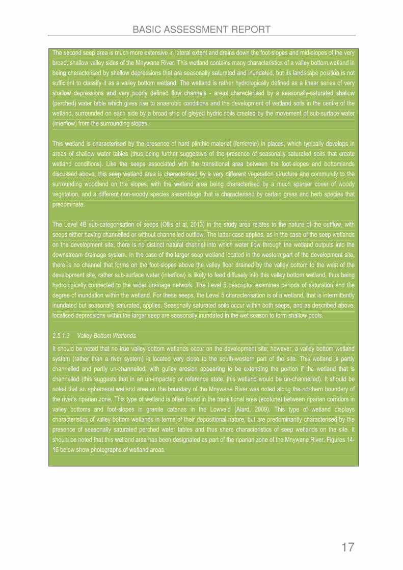
The second seep area is much more extensive in lateral extent and drains down the foot-slopes and mid-slopes of the very
broad, shallow valley sides of the Mnywane River. This wetland contains many characteristics of a valley bottom wetland in
being characterised by shallow depressions that are seasonally saturated and inundated, but its landscape position is not
sufficient to classify it as a valley bottom wetland. The wetland is rather hydrologically defined as a linear series of very
shallow depressions and very poorly defined flow channels - areas characterised by a seasonally-saturated shallow
(perched) water table which gives rise to anaerobic conditions and the development of wetland soils in the centre of the
wetland, surrounded on each side by a broad strip of gleyed hydric soils created by the movement of sub-surface water
(interflow) from the surrounding slopes.
This wetland is characterised by the presence of hard plinthic material (ferricrete) in places, which typically develops in
areas of shallow water tables (thus being further suggestive of the presence of seasonally saturated soils that create
wetland conditions). Like the seeps associated with the transitional area between the foot-slopes and bottomlands
discussed above, this seep wetland area is characterised by a very different vegetation structure and community to the
surrounding woodland on the slopes, with the wetland area being characterised by a much sparser cover of woody
vegetation, and a different non-woody species assemblage that is characterised by certain grass and herb species that
predominate.
The Level 4B sub-categorisation of seeps (Ollis et al, 2013) in the study area relates to the nature of the outflow, with
seeps either having channelled or without channelled outflow. The latter case applies, as in the case of the seep wetlands
on the development site, there is no distinct natural channel into which water flow through the wetland outputs into the
downstream drainage system. In the case of the larger seep wetland located in the western part of the development site,
there is no channel that forms on the foot-slopes above the valley floor drained by the valley bottom to the west of the
development site, rather sub-surface water (interflow) is likely to feed diffusely into this valley bottom wetland, thus being
hydrologically connected to the wider drainage network. The Level 5 descriptor examines periods of saturation and the
degree of inundation within the wetland. For these seeps, the Level 5 characterisation is of a wetland, that is intermittently
inundated but seasonally saturated, applies. Seasonally saturated soils occur within both seeps, and as described above,
localised depressions within the larger seep are seasonally inundated in the wet season to form shallow pools.
2.5.1.3 Valley Bottom Wetlands
It should be noted that no true valley bottom wetlands occur on the development site; however, a valley bottom wetland
system (rather than a river system) is located very close to the south-western part of the site. This wetland is partly
channelled and partly un-channelled, with gulley erosion appearing to be extending the portion if the wetland that is
channelled (this suggests that in an un-impacted or reference state, this wetland would be un-channelled). It should be
noted that an ephemeral wetland area on the boundary of the Mnywane River was noted along the northern boundary of
the river’s riparian zone. This type of wetland is often found in the transitional area (ecotone) between riparian corridors in
valley bottoms and foot-slopes in granite catenas in the Lowveld (Alard, 2009). This type of wetland displays
characteristics of valley bottom wetlands in terms of their depositional nature, but are predominantly characterised by the
presence of seasonally saturated perched water tables and thus share characteristics of seep wetlands on the site. It
should be noted that this wetland area has been designated as part of the riparian zone of the Mnywane River. Figures 14-
16 below show photographs of wetland areas.

BASIC ASSESSMENT REPORT
18
Figure 14: Shallow pool within the centre of the larger
seep wetland in the western part of the site.
Figure 15: Periphery of the seep wetland with the
transition to woody vegetation on the wetland
boundary.
Figure 16: Ephemeral wetland on the boundary of the riparian zone of the Mnywane River on the development site.

BASIC ASSESSMENT REPORT
19
b) Provide a detailed description of the listed activities associated with the project as applied for
Detailed description of listed activities associated with the project
Listed activity as described in GN R982, 983, 984 Description of project activity that triggers listed activity.
GNR.983 Item 8 : The development and related operation of hatcheries or agri-industrial facility outside industrial complexes where the development footprint covers an area of 2000 square meters of more.
The proposed project entails the construction of a cattle feedlot for the red meat abattoir. The feedlot will contain 500 cattle and produce 1000 cattle per annum. This development will take place in an area that is 50 000 square meters.
GNR 983 Item 9: The development of infrastructure exceeding 1000 meters in length for the bulk transportation of water or storm water (i) With internal diameter of 0.36m or more
Construction of the water main pipeline that has a 400mm diameter with a length of 1500m.
GNR 983 Item 27 The clearance of an area of 1 hectare or more but less than 20 hectares of indigenous vegetation.
The proposed project will be developed in an area that is approximately 5 hectares where approximately 2 hectares of indigenous vegetation will be cleared.
2. REASONABLE ALTERNATIVES “alternatives”, in relation to a proposed activity, means different means of meeting the general purpose and requirements of the activity, which may include alternatives to— (a) the property on which or location where it is proposed to undertake the activity; (b) the type of activity to be undertaken; (c) the design or layout of the activity; (d) the technology to be used in the activity; (e) the operational aspects of the activity; and (f) the option of not implementing the activity. Describe alternatives that are considered in this application as required by Regulation 22(2)(h) of GN R.543. Alternatives should include a consideration of all possible means by which the purpose and need of the proposed activity (NOT PROJECT) could be accomplished in the specific instance taking account of the interest of the applicant in the activity. The no-go alternative must in all cases be included in the assessment phase as the baseline against which the impacts of the other alternatives are assessed. The determination of whether site or activity (including different processes, etc.) or both is appropriate needs to be informed by the specific circumstances of the activity and its environment. After receipt of this report the, competent authority may also request the applicant to assess additional alternatives that could possibly accomplish the purpose and need of the proposed activity if it is clear that realistic alternatives have not been considered to a reasonable extent. The identification of alternatives should be in line with the Integrated Environmental Assessment Guideline Series 11, published by the DEA in 2004. Should the alternatives include different locations and lay-outs, the co-ordinates of the different alternatives must be provided. The co-ordinates should be in degrees, minutes and seconds. The projection that must be used in all cases is the WGS84 spheroid in a national or local projection.

BASIC ASSESSMENT REPORT
20
a) DESCRIPTION OF ALTERNATIVES Three alternatives were considered for the proposed project and they are Alternative 1 and Alternative 2 and Alternative 3.
Alternative 1: This site is located in a south-westerly direction from the abattoir (refer to Figure 17).
Alternative 2: This site is located in a south-easterly direction from the abattoir (refer to Figure 18).
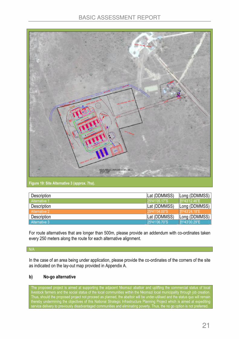
Alternative 3: This site is located in a north westerly direction from the abattoir (refer to Figure 19).
Figure 17: Site Alternative 1 (approx. 5ha).
Figure 18: Site Alternative 2 (approx. 10ha).
BASIC ASSESSMENT REPORT
21
Figure 19: Site Alternative 3 (approx. 7ha).
Description Lat (DDMMSS) Long (DDMMSS) Alternative 1 25041’05.17”S 31043’12.46”E
Description Lat (DDMMSS) Long (DDMMSS) Alternative 2 25041’04.00”S 31043’24.18”E
Description Lat (DDMMSS) Long (DDMMSS) Alternative 3 25041’06.70”S 31043’00.29”E
For route alternatives that are longer than 500m, please provide an addendum with co-ordinates taken every 250 meters along the route for each alternative alignment. N/A
In the case of an area being under application, please provide the co-ordinates of the corners of the site as indicated on the lay-out map provided in Appendix A. b) No-go alternative The proposed project is aimed at supporting the adjacent Nkomazi abattoir and uplifting the commercial status of local livestock farmers and the social status of the local communities within the Nkomazi local municipality through job creation. Thus, should the proposed project not proceed as planned, the abattoir will be under-utilised and the status quo will remain thereby undermining the objectives of this National Strategic Infrastructure Planning Project which is aimed at expediting service delivery to previously disadvantaged communities and eliminating poverty. Thus, the no go option is not preferred.
2

BASIC ASSESSMENT REPORT
22
Paragraphs 3 – 13 below should be completed for each alternative. 3. PHYSICAL SIZE OF THE ACTIVITY a) Indicate the physical size of the preferred activity/technology as well as alternative
activities/technologies (footprints): Alternative: Size of the activity:
Alternative 1 5ha
Alternative 2 10ha
Alternative 3 7ha
b) Indicate the size of the alternative sites or servitudes (within which the above footprints
will occur): Alternative: Size of the site/servitude:
Alternative 1 1334m2
Alternative 2 2660m2
Alternative 3 1995m2
4. SITE ACCESS
Does ready access to the site exist? YES
If NO, what is the distance over which a new access road will be built m
The site can be accessed using the R570 Road and access road to the Nkomazi abattoir.
Describe the type of access road planned: N/A
Include the position of the access road on the site plan and required map, as well as an indication of the road in relation to the site. 5. LOCALITY MAP
An A3 locality map must be attached to the back of this document, as Appendix A. The scale of the locality map must be relevant to the size of the development (at least 1:50 000. For linear activities of more than 25 kilometres, a smaller scale e.g. 1:250 000 can be used. The scale must be indicated on the map.). The map must indicate the following:
• an accurate indication of the project site position as well as the positions of the alternative sites, if any;
• indication of all the alternatives identified;
• closest town(s;)
• road access from all major roads in the area;
• road names or numbers of all major roads as well as the roads that provide access to the site(s);
• all roads within a 1km radius of the site or alternative sites; and

BASIC ASSESSMENT REPORT
23
• a north arrow;
• a legend; and
• locality GPS co-ordinates (Indicate the position of the activity using the latitude and longitude of the centre point of the site for each alternative site. The co-ordinates should be in degrees and decimal minutes. The minutes should have at least three decimals to ensure adequate accuracy. The projection that must be used in all cases is the WGS84 spheroid in a national or local projection).
6. LAYOUT/ROUTE PLAN A detailed site or route plan(s) must be prepared for each alternative site or alternative activity. It must be attached as Appendix A to this document. The site or route plans must indicate the following:
• the property boundaries and numbers of all the properties within 50 metres of the site;
• the current land use as well as the land use zoning of the site;
• the current land use as well as the land use zoning each of the properties adjoining the site or sites;
• the exact position of each listed activity applied for (including alternatives);
• servitude(s) indicating the purpose of the servitude;
• a legend; and
• a north arrow. 7. SENSITIVITY MAP The layout/route plan as indicated above must be overlain with a sensitivity map that indicates all the sensitive areas associated with the site, including, but not limited to:
• watercourses;
• the 1:100 year flood line (where available or where it is required by DWA);
• ridges;
• cultural and historical features;
• areas with indigenous vegetation (even if it is degraded or infested with alien species); and
• critical biodiversity areas. The sensitivity map must also cover areas within 100m of the site and must be attached in Appendix A. 8. SITE PHOTOGRAPHS Colour photographs from the centre of the site must be taken in at least the eight major compass directions with a description of each photograph. Photographs must be attached under Appendix B to this report. It must be supplemented with additional photographs of relevant features on the site, if applicable. 9. FACILITY ILLUSTRATION A detailed illustration of the activity must be provided at a scale of at least 1:200 as Appendix C for activities that include structures. The illustrations must be to scale and must represent a realistic image of the planned activity. The illustration must give a representative view of the activity.

BASIC ASSESSMENT REPORT
24
10. ACTIVITY MOTIVATION Motivate and explain the need and desirability of the activity (including demand for the activity):
1. Is the activity permitted in terms of the property’s existing land use rights?
YES
The Nkomazi Local Municipality has secured the land on which the proposed project will be built. In fact, there is an abattoir already in existence.
2. Will the activity be in line with the following?
(a) Provincial Spatial Development Framework (PSDF) YES
(b) Urban edge / Edge of Built environment for the area YES
I Integrated Development Plan (IDP) and Spatial Development Framework (SDF) of the Local Municipality (e.g. would the approval of this application compromise the integrity of the existing approved and credible municipal IDP and SDF?).
YES
The Department of Rural Development and Land Reform have formed a partnership with the local municipality in order to develop the proposed project which will help address the commercial status of local livestock farmers and the high unemployment rate within Nkomazi area.
(d) Approved Structure Plan of the Municipality YES
I An Environmental Management Framework (EMF) adopted by the Department (e.g. Would the approval of this application compromise the integrity of the existing environmental management priorities for the area and if so, can it be justified in terms of sustainability considerations?)
YES
(f) Any other Plans (e.g. Guide Plan) YES
3. Is the land use (associated with the activity being applied for) considered within the timeframe intended by the existing approved SDF agreed to by the relevant environmental authority (i.e. is the proposed development in line with the projects and programmes identified as priorities within the credible IDP)?
YES
4. Does the community/area need the activity and the associated land use concerned (is it a societal priority)? (This refers to the strategic as well as local level (e.g. development is a national priority, but within a specific local context it could be inappropriate.)
YES
The proposed development will be managed by the local community/municipality and thus promote livestock farming and alleviate the high rate of unemployment within the Nkomazi area.
5. Are the necessary services with adequate capacity currently available (at the time of application), or must additional capacity be created to cater for the development? (Confirmation by the relevant Municipality in this regard must be attached to the final Basic Assessment Report as Appendix I.)
YES
There are adequate municipal services to cater for the project.
BASIC ASSESSMENT REPORT
25
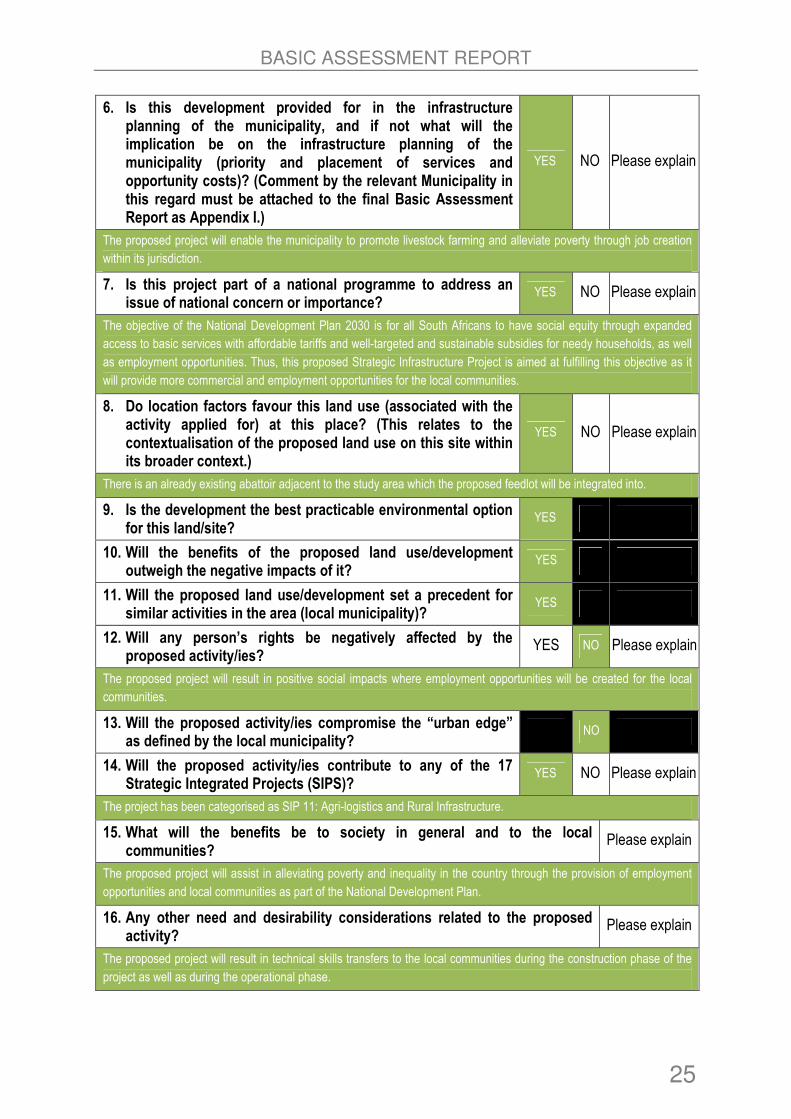
6. Is this development provided for in the infrastructure planning of the municipality, and if not what will the implication be on the infrastructure planning of the municipality (priority and placement of services and opportunity costs)? (Comment by the relevant Municipality in this regard must be attached to the final Basic Assessment Report as Appendix I.)
YES NO Please explain
The proposed project will enable the municipality to promote livestock farming and alleviate poverty through job creation
within its jurisdiction.
7. Is this project part of a national programme to address an issue of national concern or importance?
YES NO Please explain
The objective of the National Development Plan 2030 is for all South Africans to have social equity through expanded
access to basic services with affordable tariffs and well-targeted and sustainable subsidies for needy households, as well
as employment opportunities. Thus, this proposed Strategic Infrastructure Project is aimed at fulfilling this objective as it
will provide more commercial and employment opportunities for the local communities.
8. Do location factors favour this land use (associated with the activity applied for) at this place? (This relates to the contextualisation of the proposed land use on this site within its broader context.)
YES NO Please explain
There is an already existing abattoir adjacent to the study area which the proposed feedlot will be integrated into.
9. Is the development the best practicable environmental option for this land/site?
YES
10. Will the benefits of the proposed land use/development outweigh the negative impacts of it?
YES
11. Will the proposed land use/development set a precedent for similar activities in the area (local municipality)?
YES
12. Will any person’s rights be negatively affected by the proposed activity/ies?
YES NO Please explain
The proposed project will result in positive social impacts where employment opportunities will be created for the local
communities.
13. Will the proposed activity/ies compromise the “urban edge” as defined by the local municipality?
NO
14. Will the proposed activity/ies contribute to any of the 17 Strategic Integrated Projects (SIPS)?
YES NO Please explain
The project has been categorised as SIP 11: Agri-logistics and Rural Infrastructure.
15. What will the benefits be to society in general and to the local communities?
Please explain
The proposed project will assist in alleviating poverty and inequality in the country through the provision of employment
opportunities and local communities as part of the National Development Plan.
16. Any other need and desirability considerations related to the proposed activity?
Please explain
The proposed project will result in technical skills transfers to the local communities during the construction phase of the
project as well as during the operational phase.
BASIC ASSESSMENT REPORT
26
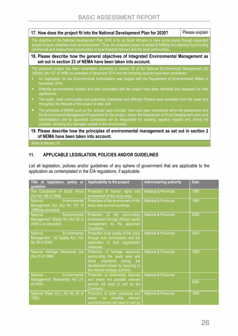
17. How does the project fit into the National Development Plan for 2030? Please explain
The objective of the National Development Plan 2030 is for all South Africans to have social equity through expanded access to basic amenities such as employment. Thus, the proposed project is aimed at fulfilling this objective by providing commercial and employment opportunities to local livestock farmers and the local communities.
18. Please describe how the general objectives of Integrated Environmental Management as set out in section 23 of NEMA have been taken into account.
The proposed project has been undertaken according to section 24 of the National Environmental Management Act (NEMA) (No 107 of 1998) as amended in December 2014 and the following aspects have been considered:
• An Application for the Environmental Authorisation was lodged with the Department of Environmental Affairs in November 2014;
• Potential environmental impacts and risks associated with the project have been identified and assessed for their significance;
• The public, local communities and authorities (Interested and Affected Parties) were consulted from the onset and throughout the lifecycle of the project to date; and
• The principles of NEMA such as the “polluter pays principle” have also been considered within the assessment and the Environmental Management Programme for the project, where the Department of Rural Development and Land Administration and its appointed Contractors will be responsible for avoiding negative impacts and, where not possible, rectifying any damages caused to the environment.
19. Please describe how the principles of environmental management as set out in section 2 of NEMA have been taken into account.
Refer to Section 18.
11. APPLICABLE LEGISLATION, POLICIES AND/OR GUIDELINES List all legislation, policies and/or guidelines of any sphere of government that are applicable to the application as contemplated in the EIA regulations, if applicable: Title of legislation, policy or guideline
Applicability to the project Administering authority Date
The Constitution of South Africa (Act No 108 of 1996)
Protection of human rights and environment of the study area.
National & Provincial 1996
National Environmental Management Act (Act No 107 0f 1998)(as amended)
Protection of the environment of the study area and surroundings.
National & Provincial 1998
National Environmental Management: Waste Act (Act 59 of 2008) ( as amended)
Protection of the surrounding environment through efficient waste management by the appointed Contractor.
National & Provincial 2008
National Environmental Management : Air Quality Act ( Act No 39 of 2004)
Protection of air quality of the study through dust minimisation and the application of dust suppression measures.
National & Provincial 2004
National Heritage Resources Act (No 25 of 1999)
Protection of heritage resources surrounding the study area and those uncovered during the development phase by reporting to the nearest heritage authority.
National & Provincial 1999
National Environmental Management: Biodiversity Act (10 of 2004)
Protection of biodiversity features and where not possible relevant permits will need to sort by the Contractor.
National & Provincial
2004
National Water Act ( Act No 36 of 1998)
Protection of water resources and where not possible relevant permits/licences will need to sort by
National & Provincial 1998
BASIC ASSESSMENT REPORT
27
Title of legislation, policy or guideline
Applicability to the project Administering authority Date
the Contractor.
National Road Traffic Act (No 93 of 1996)
The Contractor will obey traffic laws by driving at minimal speed approved by local authorities.
National & Provincial 1996
Occupational Health and Safety Act (No 85 of 1993)
Protection of workers on site through provision of Personal Protective Equipment’s; Training and other health and safety amenities.
National & Provincial 1993
All relevant Provincial regulations, Municipal bylaws
The Contractor will obey and abide by provincial and municipal bylaws which are related to the proposed project.
Provincial and Local
Good Practices for the Meat Industry Manual
The Developer will need to adhere to international practices in order to protect the environment.
International Guideline 2004
***Gauteng Guideline Manual for the Management of Abattoirs and other Waste of Animal Origin
The Developer will need to adhere to these guidelines in order to protect the environment.
Provincial and Local 2009
***The guidelines relevant for the Mpumalanga Province could not be accessed.
12. WASTE, EFFLUENT, EMISSION AND NOISE MANAGEMENT a) Solid waste management
Will the activity produce solid construction waste during the construction/initiation phase?
YES NO
If YES, what estimated quantity will be produced per month?
The quantities are not known at this stage.
How will the construction solid waste be disposed of (describe)? The construction waste will be collected by the appointed Contractor and disposed at the TSB and Steenbok Municipal Landfill Sites within the Malelane area.
Where will the construction solid waste be disposed of (describe)? At TSB and Steenbok Landfill Sites.
Will the activity produce solid waste during its operational phase? YES
If YES, what estimated quantity will be produced per month? m3
The types of waste which will be produced during the operational phase of the feedlot include carcasses of dead animals, manure, feeding silage, sludge and domestic waste generated by employees.
How will the solid waste be disposed of (describe)?

BASIC ASSESSMENT REPORT
28
� Domestic waste will be disposed at TSB and Steenbok Municipal Landfill Facilities. Operational Phase
� Domestic waste will be disposed at TSB and Steenbok Municipal Landfill Facilities. � The manure, feeding silage and sludge will be recycled and re-used for agricultural purposes. � Dead animal carcasses were proposed to be buried on site. It is, however, recommended that these rather be
disposed of off-site at a permitted facility unless a Waste Management License is applied for which will require that geotechnical/hydrological studies be conducted prior to establishing a carcass burial area on site that precludes potential damage to the local groundwater resource from which the feedlot intends sourcing its water.
If the solid waste will be disposed of into a municipal waste stream, indicate which registered landfill site will be used. TSB and Steenbok Landfill Sites.
Where will the solid waste be disposed of if it does not feed into a municipal waste stream (describe)? N/A
If the solid waste (construction or operational phases) will not be disposed of in a registered landfill site or be taken up in a municipal waste stream, then the applicant should consult with the competent authority to determine whether it is necessary to change to an application for scoping and EIA.
• Can any part of the solid waste be classified as hazardous in terms of the NEM:WA?
NO
• If YES, inform the competent authority and request a change to an application for scoping and EIA. An application for a waste permit in terms of the NEM: WA must also be submitted with this application.
• Is the activity that is being applied for a solid waste handling or treatment facility?
NO
• If YES, then the applicant should consult with the competent authority to determine whether it is necessary to change to an application for scoping and EIA. An application for a waste permit in terms of the NEM: WA must also be submitted with this application. b) Liquid effluent
Will the activity produce effluent, other than normal sewage, that will be disposed of in a municipal sewage system?
YES
If YES, what estimated quantity will be produced per month? The volume is not known as yet.
Will the activity produce any effluent that will be treated and/or disposed of on site? YES
If YES, the applicant should consult with the competent authority to determine whether it is necessary to change to an application for scoping and EIA. Typical liquid effluent produced by feedlots includes run-off from feedlot pens, silage bunkers, manure storage areas and sedimentation and sludge collection zones. The by-products from effluent produced will be evaporated or re-used on site or local farms. Currently, the exact volume of effluent treated is not known. However, it is anticipated that the daily throughput capacity will be less than 2000 cubic meters thus not triggering an additional environmental authorisation.
Will the activity produce effluent that will be treated and/or disposed of at another facility?
NO
If YES, provide the particulars of the facility:
Facility name: N/A
Contact person:

BASIC ASSESSMENT REPORT
29
Postal address:
Postal code:
Telephone: Cell:
E-mail: Fax:
Describe the measures that will be taken to ensure the optimal reuse or recycling of waste water, if any: As alluded to above, waste water from the operations of the feedlot will be collected using drainage channels, treated and either evaporated or re-used.
c) Emissions into the atmosphere
Will the activity release emissions into the atmosphere other than exhaust emissions and dust associated with construction phase activities?
NO
If YES, is it controlled by any legislation of any sphere of government? NO
If YES, the applicant must consult with the competent authority to determine whether it is necessary to change to an application for scoping and EIA. If NO, describe the emissions in terms of type and concentration: During the construction phase, dust and vehicular emissions will be released as a result of earth moving machinery and trucks transporting construction material. The emissions will however, have short term impacts on the immediate surrounding areas which can be easily mitigated and thus the authorisation of such emissions will not be required. A buffer zone should be maintained around the feedlot to prevent manure and associated concentrated farming smells from affecting the nearest communities.
d) Waste permit
Will any aspect of the activity produce waste that will require a waste permit in terms of the NEM:WA?
NO
If YES, please submit evidence that an application for a waste permit has been submitted to the competent authority e) Generation of noise
Will the activity generate noise? YES
If YES, is it controlled by any legislation of any sphere of government? NO
If YES, the applicant should consult with the competent authority to determine whether it is necessary to change to an application for scoping and EIA. If NO, describe the noise in terms of type and level: The movements of construction trucks, machinery and other construction activities will generate noise on site and surrounding communities. However, the noise will be of short term, localised and will last during the construction activities/phase of the project. The noise level is anticipated to be less than 50dBA as required by SANS 10103 and thus authorisation will not be required for the noise. It must be mentioned that during the operation of the feedlot, there might noise generated but it will be a residual noise which will not result in significant impacts. A buffer zone around the feedlot will help prevent impacts.

BASIC ASSESSMENT REPORT
30
13. WATER USE Please indicate the source(s) of water that will be used for the activity by ticking the appropriate box(es):
Municipal Water board Groundwater River, stream, dam or lake
Other The activity will not use water
If water is to be extracted from groundwater, river, stream, dam, lake or any other natural feature, please indicate the volume that will be extracted per month:
750 000 litres
Does the activity require a water use authorisation (general authorisation or water use license) from the Department of Water Affairs?
NO
If YES, please provide proof that the application has been submitted to the Department of Water Affairs. The abattoir which is located adjacent to the planned feedlot area currently uses a borehole as a source of water. Thus it has been assumed that the existing borehole has been permitted accordingly as per the requirements of the National Water Act. The feedlot will be sourcing water from the same borehole, but the Licence may have to be amended if additional water is abstracted or if further boreholes are drilled..
14. ENERGY EFFICIENCY Describe the design measures, if any that have been taken to ensure that the activity is energy efficient: N/A
Describe how alternative energy sources have been taken into account or been built into the design of the activity, if any: N/A
BASIC ASSESSMENT REPORT
31
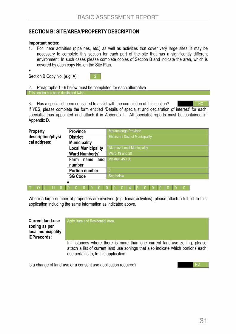
SECTION B: SITE/AREA/PROPERTY DESCRIPTION Important notes: 1. For linear activities (pipelines, etc.) as well as activities that cover very large sites, it may be
necessary to complete this section for each part of the site that has a significantly different environment. In such cases please complete copies of Section B and indicate the area, which is covered by each copy No. on the Site Plan.
•
Section B Copy No. (e.g. A): 2
2. Paragraphs 1 - 6 below must be completed for each alternative. This section has been duplicated twice.
3. Has a specialist been consulted to assist with the completion of this section? NO
If YES, please complete the form entitled “Details of specialist and declaration of interest” for each specialist thus appointed and attach it in Appendix I. All specialist reports must be contained in Appendix D. Property description/physical address:
Province Mpumalanga Province
District Municipality
Ehlanzeni District Municipality
Local Municipality Nkomazi Local Municipality
Ward Number(s) Ward 19 and 20
Farm name and number
Vlakbult 450 JU
Portion number 0
SG Code See below
• T O J U 0 0 0 0 0 0 0 0 0 4 5 0 0 0 0 0 0
Where a large number of properties are involved (e.g. linear activities), please attach a full list to this application including the same information as indicated above.
Current land-use zoning as per local municipality IDP/records:
Agriculture and Residential Area.
In instances where there is more than one current land-use zoning, please attach a list of current land use zonings that also indicate which portions each use pertains to, to this application.
Is a change of land-use or a consent use application required? NO

BASIC ASSESSMENT REPORT
32
1. GRADIENT OF THE SITE Indicate the general gradient of the site. Alternative 1
Shallower than 3%
Alternative 2
Shallower than 3%
Alternative 3
Shallower than 3.5%
2. LOCATION IN LANDSCAPE Indicate the landform(s) that best describes the site: Alternative 1
2.1 Ridgeline 2.4 Closed valley 2.7 Undulating plain / low hills X
2.2 Plateau 2.5 Open valley X 2.8 Dune
2.3 Side slope of hill/mountain 2.6 Plain 2.9 Seafront
Alternative 2
2.1 Ridgeline 2.4 Closed valley 2.7 Undulating plain / low hills X
2.2 Plateau 2.5 Open valley X 2.8 Dune
2.3 Side slope of hill/mountain 2.6 Plain 2.9 Seafront
Alternative 3
2.1 Ridgeline 2.4 Closed valley 2.7 Undulating plain / low hills X
2.2 Plateau 2.5 Open valley X 2.8 Dune
2.3 Side slope of hill/mountain 2.6 Plain 2.9 Seafront
3. GROUNDWATER, SOIL AND GEOLOGICAL STABILITY OF THE SITE Is the site(s) located on any of the following? Alternative 1 Alternative 2 Alternative 3
Shallow water table (less than 1.5m deep) YES YES NO
Dolomite, sinkhole or doline areas NO NO NO
Seasonally wet soils (often close to water bodies)
YES YES NO
Unstable rocky slopes or steep slopes with loose soil
NO NO NO
Dispersive soils (soils that dissolve in water) NO NO NO
Soils with high clay content (clay fraction more than 40%)
NO NO NO
Any other unstable soil or geological feature NO NO NO
An area sensitive to erosion YES YES YES

BASIC ASSESSMENT REPORT
33
If you are unsure about any of the above or if you are concerned that any of the above aspects may be an issue of concern in the application, an appropriate specialist should be appointed to assist in the completion of this section. Information in respect of the above will often be available as part of the project information or at the planning sections of local authorities. Where it exists, the 1:50 000 scale Regional Geotechnical Maps prepared by the Council for Geo Science may also be consulted. 4. GROUNDCOVER Indicate the types of groundcover present on the site. The location of all identified rare or endangered species or other elements should be accurately indicated on the site plan(s). Alternative 1
Natural veld - good conditionE
Natural veld with scattered aliensE
Natural veld with heavy alien infestationE
Veld dominated by alien speciesE
Gardens
Sport field Cultivated land Paved surface Building or other structure.
Bare soil
Alternative 2
Natural veld - good conditionE
Natural veld with scattered aliensE
Natural veld with heavy alien infestationE
Veld dominated by alien speciesE
Gardens
Sport field Cultivated land Paved surface Building or other structure.
Bare soil
Alternative 3
Natural veld - good conditionE
Natural veld with scattered aliensE
Natural veld with heavy alien infestationE
Veld dominated by alien speciesE
Gardens
Sport field Cultivated land Paved surface Building or other structure.
Bare soil
If any of the boxes marked with an “E “is ticked, please consult an appropriate specialist to assist in the completion of this section if the environmental assessment practitioner doesn’t have the necessary expertise. 5. SURFACE WATER Indicate the surface water present on and or adjacent to the site and alternative sites? Alternative 1
Perennial River NO
Non-Perennial River YES
Permanent Wetland NO
Seasonal Wetland YES
Artificial Wetland NO
Estuarine / Lagoonal wetland NO

BASIC ASSESSMENT REPORT
34
Alternative 2
Perennial River NO
Non-Perennial River YES
Permanent Wetland NO
Seasonal Wetland YES
Artificial Wetland NO
Estuarine / Lagoonal wetland NO
Alternative 3
Perennial River NO
Non-Perennial River YES
Permanent Wetland NO
Seasonal Wetland NO
Artificial Wetland NO
Estuarine / Lagoonal wetland NO

BASIC ASSESSMENT REPORT
35
If any of the boxes marked YES or UNSURE is ticked, please provide a description of the relevant watercourse. According to the surface water report, two river systems are found on the wider development site. These rivers are tributaries of the Mzinti River which is located to the south and east of the development site. The larger tributary (Mnywane) is located on the southern boundary of the development site, lying to the north of the (expanding) settlement of Mzinti. A smaller watercourse drains through part of the eastern part of the development site before joining the larger Mnywane River. These river watercourses drain small catchments and are likely to be non-perennial in nature. The smaller tributary is likely to be ephemeral, although it is possible that the Mnywane River on the southern boundary of the site is seasonal in nature. Both watercourses are classified predominantly as rivers, however they also display some characteristics of a channelled valley bottom wetland, in particular the presence of hydromorphic soils on the channel banks. There is not sufficient wetland habitat within the channel and riparian zone to characterise it as a channelled valley bottom wetland. There are two seep wetlands which are located in the south easterly direction and north easterly direction of the study area. Seeps are often associated with lithologies that cause groundwater to discharge to the surface, or are located in topographic positions that either causes groundwater to discharge to the land surface or rain-derived water to ‘seep’ down-slope as subsurface interflow. In addition, an ephemeral wetland area on the boundary of the Mnywane River was noted along the northern boundary of the river’s riparian zone. This type of wetland is often found in the transitional area (ecotone) between riparian corridors in valley bottoms and footslopes in granite catenas in the Lowveld (Alard, 2009). This type of wetland displays characteristics of valley bottom wetlands in terms of their depositional nature, but are predominantly characterised by the presence of seasonally saturated perched water tables and thus share characteristics of seep wetlands. Figure 19 depicts all the surface water features occurring on site.
Figure 20: Surface Water Occurrence in the vicinity of the development site (2)

BASIC ASSESSMENT REPORT
36
6. LAND USE CHARACTER OF SURROUNDING AREA Indicate land uses and/or prominent features that currently occur within a 500m radius of the site and give description of how this influences the application or may be impacted upon by the application: Alternative 1
Natural area Dam or reservoir Polo fields
Low density residential Hospital/medical centre Filling station H Medium density residential School Landfill or waste treatment site
High density residential Tertiary education facility Plantation
Informal residentialA Church Agriculture
Retail commercial & warehousing Old age home River, stream or wetland
Light industrial Sewage treatment plantA Nature conservation area
Medium industrial AN Train station or shunting yard N Mountain, koppie or ridge
Heavy industrial AN Railway line N Museum
Power station Major road (4 lanes or more) N Historical building
Office/consulting room Airport N Protected Area
Military or police base/station/compound
Harbour Graveyard
Spoil heap or slimes damA Sport facilities Archaeological site
Quarry, sand or borrow pit Golf course Other land uses (describe)
If any of the boxes marked with an “N “are ticked, how will this impact / be impacted upon by the proposed activity? N/A
If any of the boxes marked with an "An" are ticked, how will this impact / be impacted upon by the proposed activity? Specify and explain: N/A
If any of the boxes marked with an "H" are ticked, how will this impact / be impacted upon by the proposed activity? Specify and explain: N/A
Does the proposed site (including any alternative sites) fall within any of the following :
Critical Biodiversity Area (as per provincial conservation plan) NO
Core area of a protected area? NO
Buffer area of a protected area? NO
Planned expansion area of an existing protected area? NO
Existing offset area associated with a previous Environmental Authorisation? NO
Buffer area of the SKA? NO
The Ecology report states that the study area has Degraded and Transformed Bushveld or Granite Lowveld areas on the Mzinti site which are influenced by various factors namely the existing Mzinti abattoir, residential development and extensive vegetation transformation or clearance. These effects has led the area to become totally degraded with pioneer weedy grass and forb species and declared invasive weeds dominating the vegetation. There is no resemblance to natural vegetation and the area is transformed. Low faunal diversity is expected from these heavily degraded areas on the site. From vegetation and faunal perspective the degraded and transformed areas of Granite Lowveld have a low

BASIC ASSESSMENT REPORT
37
sensitivity and conservation potential/value as well as ecosystem functioning.
Figure 21: Mpumalanga Conservation Plan in Relation to the Study Area
If the answer to any of these questions was YES, a map indicating the affected area must be included in Appendix A. Alternative 2
Natural area Dam or reservoir Polo fields
Low density residential Hospital/medical centre Filling station H Medium density residential School Landfill or waste treatment site
High density residential Tertiary education facility Plantation
Informal residentialA Church Agriculture
Retail commercial & warehousing Old age home River, stream or wetland
Light industrial Sewage treatment plantA Nature conservation area
Medium industrial AN Train station or shunting yard N Mountain, koppie or ridge
Heavy industrial AN Railway line N Museum
Power station Major road (4 lanes or more) N Historical building
Office/consulting room Airport N Protected Area
Military or police base/station/compound
Harbour Graveyard
Spoil heap or slimes damA Sport facilities Archaeological site
Quarry, sand or borrow pit Golf course Other land uses (describe)

BASIC ASSESSMENT REPORT
38
If any of the boxes marked with an “N “are ticked, how will this impact / be impacted upon by the proposed activity? N/A
If any of the boxes marked with an "An" are ticked, how will this impact / be impacted upon by the proposed activity? Specify and explain: N/A
If any of the boxes marked with an "H" are ticked, how will this impact / be impacted upon by the proposed activity? Specify and explain: N/A
Does the proposed site (including any alternative sites) fall within any of the following :
Critical Biodiversity Area (as per provincial conservation plan) NO
Core area of a protected area? NO
Buffer area of a protected area? NO
Planned expansion area of an existing protected area? NO
Existing offset area associated with a previous Environmental Authorisation? NO
Buffer area of the SKA? NO
The Ecology report states that the study area has Degraded and Transformed Bushveld or Granite Lowveld areas on the Mzinti site which are influenced by various factors namely the existing Mzinti abattoir, residential development and extensive vegetation transformation or clearance. These effects has led the area to become totally degraded with pioneer weedy grass and forb species and declared invasive weeds dominating the vegetation. There is no resemblance to natural vegetation and the area is transformed. Low faunal diversity is expected from these heavily degraded areas on the site. From vegetation and faunal perspective the degraded and transformed areas of Granite Lowveld have a low sensitivity and conservation potential/value as well as ecosystem functioning.

BASIC ASSESSMENT REPORT
39
Figure 22: Mpumalanga Conservation Plan in Relation to the Study Area
If the answer to any of these questions was YES, a map indicating the affected area must be included in Appendix A. Alternative 3
Natural area Dam or reservoir Polo fields
Low density residential Hospital/medical centre Filling station H Medium density residential School Landfill or waste treatment site
High density residential Tertiary education facility Plantation
Informal residentialA Church Agriculture
Retail commercial & warehousing Old age home River, stream or wetland
Light industrial Sewage treatment plantA Nature conservation area
Medium industrial AN Train station or shunting yard N Mountain, koppie or ridge
Heavy industrial AN Railway line N Museum
Power station Major road (4 lanes or more) N Historical building
Office/consulting room Airport N Protected Area
Military or police base/station/compound
Harbour Graveyard
Spoil heap or slimes damA Sport facilities Archaeological site
Quarry, sand or borrow pit Golf course Other land uses (describe)

BASIC ASSESSMENT REPORT
40
If any of the boxes marked with an “N “are ticked, how will this impact / be impacted upon by the proposed activity? N/A
If any of the boxes marked with an "An" are ticked, how will this impact / be impacted upon by the proposed activity? Specify and explain: N/A
If any of the boxes marked with an "H" are ticked, how will this impact / be impacted upon by the proposed activity? Specify and explain: N/A
Does the proposed site (including any alternative sites) fall within any of the following:
Critical Biodiversity Area (as per provincial conservation plan) NO
Core area of a protected area? NO
Buffer area of a protected area? NO
Planned expansion area of an existing protected area? NO
Existing offset area associated with a previous Environmental Authorisation? NO
Buffer area of the SKA? NO
The Ecology report states that the study area has Degraded and Transformed Bushveld or Granite Lowveld areas on the Mzinti site which are influenced by various factors namely the existing Mzinti abattoir, residential development and extensive vegetation transformation or clearance. These effects has led the area to become totally degraded with pioneer weedy grass and forb species and declared invasive weeds dominating the vegetation. There is no resemblance to natural vegetation and the area is transformed. Low faunal diversity is expected from these heavily degraded areas on the site. From vegetation and faunal perspective the degraded and transformed areas of Granite Lowveld have a low sensitivity and conservation potential/value as well as ecosystem functioning.

BASIC ASSESSMENT REPORT
41
Figure 23: Mpumalanga Conservation Plan in Relation to the Study Area
If the answer to any of these questions was YES, a map indicating the affected area must be included in Appendix A. 7. CULTURAL/HISTORICAL FEATURES
Are there any signs of culturally or historically significant elements, as defined in section 2 of the National Heritage Resources Act, 1999, (Act No. 25 of 1999), including Archaeological or paleontological sites, on or close (within 20m) to the site? If YES, explain:
NO
According to the Heritage study conducted by Dr van Schalkwyk for the proposed project, there were no heritage sites, features and objects found in the study area.
If uncertain, conduct a specialist investigation by a recognised specialist in the field (archaeology or palaeontology) to establish whether there is such a feature(s) present on or close to the site. Briefly explain the findings of the specialist: N/A
Will any building or structure older than 60 years be affected in any way? NO
Is it necessary to apply for a permit in terms of the National Heritage Resources Act, 1999 (Act 25 of 1999)?
NO
If YES, please provide proof that this permit application has been submitted to SAHRA or the relevant provincial authority.

BASIC ASSESSMENT REPORT
42
8. SOCIO-ECONOMIC CHARACTER a) Local Municipality Please provide details on the socio-economic character of the local municipality in which the proposed site(s) are situated. Level of unemployment: According to the Nkomazi Local Municipality draft Integrated Development Plan, 2014-2015, approximately 24% of the households has had no formal income in 2001 while 60% of the household earned an annual household income of less than R20 000. In 2007, the number of households with no income decreased to 13% while a number of household earning an income of less than R20 000 remained at 60%. The year 2011 had a similar trend which is indicative of persistent high poverty level within the municipality which affects the municipality’s financial ability to provide and maintain services.
Economic profile of local municipality: The municipality experiences a high rate of unemployment and struggling to attract investments due to it being a rural municipality. In addition, illiteracy and shortage of skills are other contributing factors of unemployment. In 2007 the unemployment rate of the municipality was approximately 34.2% which translates to 26% of males and 43% of females respectively. In 2011, approximately 27% of people were involved in the community services which range from self employment to elementary work. Short skills and low level of education has prohibited people from entering to formal sectors that require technical expertise (Nkomazi draft IDP, 2014-2015).
Level of education: According to the Nkomazi Local Municipality draft Integrated Development Plan, 2014-2015, there were major improvements in educational attainment within the municipality between 2001 and 2011. There is about 17.6% of males and 26.7% of females over 20 years which had no schooling in 2001. These figures were reduced to 8.6% for males and 17.6% for females by 2007 which indicate favourable improvements in educational attainment over a period of six years. This group represents people who completed matric and post matric qualification.
b) Socio-economic value of the activity
What is the expected capital value of the activity on completion? It is not known at this stage.
What is the expected yearly income that will be generated by or as a result of the activity?
It is not known at this stage.
Will the activity contribute to service infrastructure? YES
Is the activity a public amenity? YES
How many new employment opportunities will be created in the development and construction phase of the activity/ies?
It is not known at this stage.
What is the expected value of the employment opportunities during the development and construction phase?
It is not known at this stage.
What percentage of this will accrue to previously disadvantaged individuals?
It is not known at this stage.
How many permanent new employment opportunities will be created during the operational phase of the activity?

BASIC ASSESSMENT REPORT
43
A total number of employment opportunities which will be created by the feedlot are not known at this stage. However, a typical feedlot consists of the following employees: � Manager and Assistant Manager � Yard Forman � Mill Forman � Mill Operator � Feed Truck Driver � Head Cowboy � Cowboys � Maintenance Forman � Maintenance Personnel � General Labour � Office Manager � Office Personnel
What is the expected current value of the employment opportunities during the first 10 years?
It is not known at this stage.
What percentage of this will accrue to previously disadvantaged individuals? It is not known at this stage.
9. BIODIVERSITY Please note: The Department may request specialist input/studies depending on the nature of the biodiversity occurring on the site and potential impact(s) of the proposed activity/ies. To assist with the identification of the biodiversity occurring on site and the ecosystem status consult http://bgis.sanbi.org or [email protected]. Information is also available on compact disc (cd) from the Biodiversity-GIS Unit, Ph (021) 799 8698. This information may be updated from time to time and it is the applicant/ EAP’s responsibility to ensure that the latest version is used. A map of the relevant biodiversity information (including an indication of the habitat conditions as per (b) below) and must be provided as an overlay map to the property/site plan as Appendix D to this report. a) Indicate the applicable biodiversity planning categories of all areas on site and indicate
the reason(s) provided in the biodiversity plan for the selection of the specific area as part of the specific category)
Systematic Biodiversity Planning Category If CBA or ESA, indicate the reason(s) for its selection in biodiversity plan
Critical Biodiversity Area (CBA)
Ecological Support Area (ESA)
Other Natural
Area (ONA)
No Natural Area
Remaining (NNR)
According to Mpumalanga Sector Plan handbook 2014, the study area falls with area which has been classified as Other Natural Areas moderately modified-old land lands heavily modified.
b) Indicate and describe the habitat condition on site
Habitat Condition
Percentage of habitat condition class (adding up
to 100%)
Description and additional Comments and Observations (including additional insight into condition, e.g. poor land
management practises, presence of quarries, grazing, harvesting regimes etc).
Natural 10%
Near Natural (includes areas with
30%

BASIC ASSESSMENT REPORT
44
low to moderate level of alien invasive
plants)
Degraded (includes areas
heavily invaded by alien plants)
30%
Transformed (includes cultivation,
dams, urban, plantation, roads, etc)
30%
c) Complete the table to indicate:
(i) the type of vegetation, including its ecosystem status, present on the site; and (ii) whether an aquatic ecosystem is present on site.
Terrestrial Ecosystems Aquatic Ecosystems
Ecosystem threat status as per the
National Environmental Management:
Biodiversity Act (Act No. 10 of 2004)
Critical Wetland (including rivers, depressions, channelled and unchanneled wetlands, flats, seeps pans, and artificial
wetlands)
Estuary Coastline Endangered
Vulnerable
Least Threatened YES NO NO
d) Please provide a description of the vegetation type and/or aquatic ecosystem present on
site, including any important biodiversity features/information identified on site (e.g. threatened species and special habitats)
The vegetation unit of the site is Granite Lowveld (SVI 3) (Mucina & Rutherford 2006) previously classified as Arid
Lowveld (VT 11) and Lowveld (VT 10) (Acocks 1953) and Mixed Lowveld Bushveld (Low & Rebelo 1996). The vegetation
of the site consists mainly of mixed Terminalia sericea, Combretum zeyheri and Combretum apiculatum woodlands in
various stages of transformation and degradation. Sections have been cleared including the exiting residential erven,
abattoir, access roads, Eskom servitudes as well as open grazing areas. Bush encroachment by Terminalia serricea,
Dichrostachys cinerea and various small Vachelia species; occurs in disturbed areas.
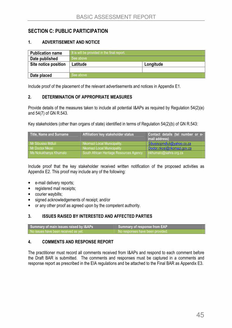
BASIC ASSESSMENT REPORT
45
SECTION C: PUBLIC PARTICIPATION 1. ADVERTISEMENT AND NOTICE
Publication name It is will be provided in the final report.
Date published See above
Site notice position Latitude Longitude
Date placed See above
Include proof of the placement of the relevant advertisements and notices in Appendix E1. 2. DETERMINATION OF APPROPRIATE MEASURES Provide details of the measures taken to include all potential I&APs as required by Regulation 54(2)(e) and 54(7) of GN R.543. Key stakeholders (other than organs of state) identified in terms of Regulation 54(2)(b) of GN R.543: Title, Name and Surname Affiliation/ key stakeholder status Contact details (tel number or e-
mail address)
Mr Sibusiso Mdluli Nkomazi Local Municipality. [email protected]
Mr Doctor Nkosi Nkomazi Local Municipality [email protected]
Ms Nokukhanya Khumalo South African Heritage Resources Agency [email protected]
Include proof that the key stakeholder received written notification of the proposed activities as Appendix E2. This proof may include any of the following:
• e-mail delivery reports;
• registered mail receipts;
• courier waybills;
• signed acknowledgements of receipt; and/or
• or any other proof as agreed upon by the competent authority. 3. ISSUES RAISED BY INTERESTED AND AFFECTED PARTIES Summary of main issues raised by I&APs Summary of response from EAP
No issues have been received as yet. No responses have been provided.
4. COMMENTS AND RESPONSE REPORT The practitioner must record all comments received from I&APs and respond to each comment before the Draft BAR is submitted. The comments and responses must be captured in a comments and response report as prescribed in the EIA regulations and be attached to the Final BAR as Appendix E3.

BASIC ASSESSMENT REPORT
46
5. AUTHORITY PARTICIPATION Authorities and organs of state identified as key stakeholders: Authority/Organ of State
Contact person (Title, Name and Surname)
Tel No Fax No e-mail Postal address
Mpumalanga Department of Agriculture, Rural Development, Land and Environmental Affairs
Selape Letswana
013 766
6067/8
[email protected] Building No. 6, 1 & 2nd Floor Riverside Park Extension 2. Mbomela 1200
Department of Water and Sanitation
Mr S Shabangu 013 759 7300
Inkomati-Usuthu Catchment Agency.
Mr Mduduzi Nkuna
083 634 8769
[email protected] Private Bag X 11214 Mobombela 1200
Include proof that the Authorities and Organs of State received written notification of the proposed activities as appendix E4. In the case of renewable energy projects, Eskom and the SKA Project Office must be included in the list of Organs of State. 6. CONSULTATION WITH OTHER STAKEHOLDERS Note that, for any activities (linear or other) where deviation from the public participation requirements may be appropriate, the person conducting the public participation process may deviate from the requirements of that sub-regulation to the extent and in the manner as may be agreed to by the competent authority. Proof of any such agreement must be provided, where applicable. Application for any deviation from the regulations relating to the public participation process must be submitted prior to the commencement of the public participation process. A list of registered I&APs must be included as appendix E5. Copies of any correspondence and minutes of any meetings held must be included in Appendix E6.

BASIC ASSESSMENT REPORT
47
SECTION D: IMPACT ASSESSMENT The assessment of impacts must adhere to the minimum requirements in the EIA Regulations, 2014 and should take applicable official guidelines into account. The issues raised by interested and affected parties should also be addressed in the assessment of impacts. 1. IMPACTS THAT MAY RESULT FROM THE PLANNING AND DESIGN, CONSTRUCTION,
OPERATIONAL, DECOMMISSIONING AND CLOSURE PHASES AS WELL AS PROPOSED MANAGEMENT OF IDENTIFIED IMPACTS AND PROPOSED MITIGATION MEASURES.
Provide a summary and anticipated significance of the potential direct, indirect and cumulative impacts that are likely to occur as a result of the planning and design phase, construction phase, operational phase, decommissioning and closure phase, including impacts relating to the choice of site/activity/technology alternatives as well as the mitigation measures that may eliminate or reduce the potential impacts listed. This impact assessment must be applied to all the identified alternatives to the activities identified in Section A (2) of this report. IMPACT ASSESSMENT DESCRIPTIVE CRITERIA
Nature Include a descriptive sentence
Probability Categories 1 – 5
1 Improbable (less than 24% chance of occurring)
2 Probable (25 – 49%)
3 Likely (50 – 69%)
4 Very likely (70 – 89%)
5 Definite (90 – 100%)
Frequency Categories 1 – 5
1 Very rare to remote (once or twice a decade)
2 Unusual to occasional (once or twice every 5 years)
3 Frequent (a few times a month)
4 Very frequent (a few times a week, to daily)
5 Continuous (daily to a significant percentage of every day)
Extent Categories 1 – 5
1 Footprint / site
2 Local
3 Regional
4 National
5 International (trans-boundary)
Duration Categories 1 – 5
1 Short (few days to a few months, less than a phase)
2 Short (few months, or less than a phase in total)
3 Medium (a few years, significant part of a phase)
4 Long (lifespan of development (i.e. all of operation))
5 Permanent
Intensity Categories 1 – 5
1 Very low – natural processes not affected
2 Low – natural processes slightly affected
3 Medium – natural processes continue but in a modified manner
4 Medium-high – natural processes are modified significantly
5 High – natural processes disturbed significantly so that they cease to occur (temporarily / permanently)
Significance Significance = P + F + E + D + I Minimum value of 5, maximum of 25 Status determines if positive / negative

BASIC ASSESSMENT REPORT
48
IMPACT ASSESSMENT DESCRIPTIVE CRITERIA
Any positive value
No impact
1. High to low consequence, probability not an issue as positive, no mitigation required
1– 5 Low
2. Low consequence, probably, minimal mitigation may be required
6 to 10 Medium
3. Medium consequence, probably, mitigation is advised / preferred
11 to 15 Medium–high
4. Medium to high consequence, probably to very probable, mitigation is necessary
16 to 20 High
5. High consequence, probably / definite, mitigation is essential
21 to 25 Extreme
6. Very high consequence, definite, fatal flaw!

BASIC ASSESSMENT REPORT
49
1 (A). IMPACTS THAT MAY RESULT FROM THE PLANNING AND DESIGN
Alternative 1
DIRECT IMPACTS
Potential Impacts Significance Rating Mitigation Measure (Also Refer to EMPr) Significant of Impact After Mitigation
1. Topography and Project Costs:
• Selection of the incorrect site for the feedlot will result in significant design and construction costs as well as significant impacts on the water resources.
Duration: Medium Term (3)
Extent: Localised (2)
Frequency: Frequent (3)
Probability: Likely (3)
Intensity: Medium (3)
Significance Rating: (14)
Medium–High
� It is thus strongly recommended that the layout alternatives be redesigned to be situated outside of the 100m buffer of surface water features on the site, as a key mitigation measure.
� It is recommended that the transformed area to the west of the current Option 1 layout and to the south-west of the existing abattoir be considered for the siting of the feedlot. This area is environmentally transformed (the natural woodland vegetation has historically been removed) and most of it is located outside of the 100m surface water buffers on the site
Duration: Short Term (1)
Extent: Localised (2)
Frequency: Un-usual (2)
Probability: Probable (2)
Intensity: Low (2)
Significance Rating: (9)
Medium
2. Municipal Services Supply:
• Shortage of municipal services supply
Duration: Medium Term (3)
Extent: Localised (2)
Frequency: Frequent (3)
Probability: Very Likely (4)
Intensity: Medium-High (4)
Significant Rating: (16)
High
� The project developer need to secure sufficient basic municipal services (portable water, electricity, sewer) prior construction activities to ensure that there are no shortages.
Duration: Short Term (1)
Extent: Localised (2)
Frequency: Un-usual (2)
Probability: Probable (2)
Intensity: Very Low (1)
Significant Rating: (8)
Medium
INDIRECT IMPACTS
None
CUMULATIVE IMPACTS
None

BASIC ASSESSMENT REPORT
50
Alternative 2
DIRECT IMPACTS
Potential Impacts Significance Rating Mitigation Measure (Also Refer to EMPr) Significant of Impact After Mitigation
1. Topography and Project Costs:
• Selection of the incorrect site for the feedlot will result in significant design and construction costs as well as significant impacts on the water resources.
Duration: Short Term (1)
Extent: Localised (2)
Frequency: Frequent (3)
Probability: Unusual (3)
Intensity: Low (2)
Significance Rating: (11)
Medium–High
� It is thus strongly recommended that the layout alternatives be redesigned to be situated outside of the 100m buffer of surface water features on the site, as a key mitigation measure.
� It is recommended that the transformed area to the west of the current Option 1 layout and to the south-west of the existing abattoir be considered for the siting of the feedlot. This area is environmentally transformed (the natural woodland vegetation has historically been removed) and most of it is located outside of the 100m surface water buffers on the site.
Duration: Short Term (1)
Extent: Localised (2)
Frequency: Un-usual (2)
Probability: Unlikely (1)
Intensity: Very Low (1)
Significance Rating: (7)
Medium
2. Municipal Services Supply:
• Shortage of municipal services supply.
Duration: Medium Term (3)
Extent: Localised (2)
Frequency: Frequent (3)
Probability: Very Likely (4)
Intensity: Medium-High (4)
Significance Rating: (16)
High
� The project developer need to secure sufficient basic municipal services (portable water, electricity, sewer) prior construction activities to ensure that there are no shortages.
Duration: Short Term (1)
Extent: Localised (2)
Frequency: Un-usual (2)
Probability: Probable (2)
Intensity: Very Low (1)
Significance Rating: (8)
Medium
INDIRECT IMPACTS
None
CUMULATIVE IMPACTS
None

BASIC ASSESSMENT REPORT
51
Alternative 3
DIRECT IMPACTS
Potential Impacts Significance Rating Mitigation Measure (Also Refer to EMPr) Significant of Impact After Mitigation
1. Topography and Project Costs:
• Selection of the incorrect site for the feedlot will result in significant design and construction costs as well as significant impacts on the water resources.
Duration: Short Term (1)
Extent: Localised (2)
Frequency: Frequent (3)
Probability: Unusual (2)
Intensity: Very Low (1)
Significance Rating: (9)
Medium
� It is recommended that this site be selected for the project as it located away from water resources. This area is also environmentally transformed (the natural woodland vegetation has historically been removed) and most of it is located outside of the 100m surface water buffers on the site.
Duration: Short Term (1)
Extent: Localised (2)
Frequency: Un-usual (2)
Probability: Unlikely (1)
Intensity: Very Low (1)
Significance Rating: (7)
Medium
2. Municipal Services Supply:
• Shortage of municipal services supply.
Duration: Medium Term (3)
Extent: Localised (2)
Frequency: Frequent (3)
Probability: Very Likely (4)
Intensity: Medium-High (4)
Significance Rating: (16)
High
� The project developer need to secure sufficient basic municipal services (portable water, electricity, sewer) prior construction activities to ensure that there are no shortages.
Duration: Short Term (1)
Extent: Localised (2)
Frequency: Un-usual (2)
Probability: Probable (2)
Intensity: Very Low (1)
Significance Rating: (8)
Medium
INDIRECT IMPACTS
None
CUMULATIVE IMPACTS
None
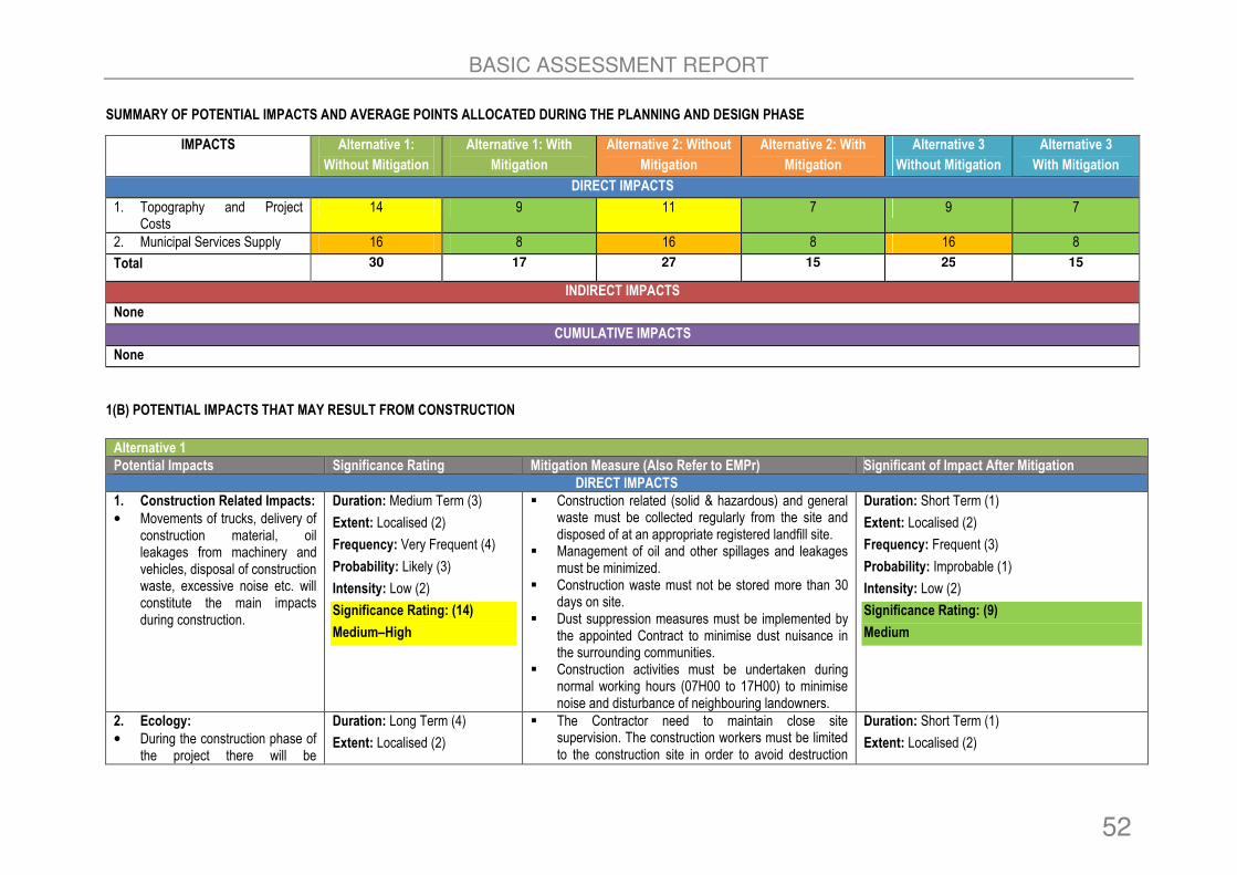
BASIC ASSESSMENT REPORT
52
SUMMARY OF POTENTIAL IMPACTS AND AVERAGE POINTS ALLOCATED DURING THE PLANNING AND DESIGN PHASE
IMPACTS Alternative 1:
Without Mitigation
Alternative 1: With
Mitigation
Alternative 2: Without
Mitigation
Alternative 2: With
Mitigation
Alternative 3
Without Mitigation
Alternative 3
With Mitigation
DIRECT IMPACTS
1. Topography and Project Costs
14 9 11 7 9 7
2. Municipal Services Supply 16 8 16 8 16 8
Total 30 17 27 15 25 15
INDIRECT IMPACTS
None
CUMULATIVE IMPACTS
None
1(B) POTENTIAL IMPACTS THAT MAY RESULT FROM CONSTRUCTION
Alternative 1
Potential Impacts Significance Rating Mitigation Measure (Also Refer to EMPr) Significant of Impact After Mitigation
DIRECT IMPACTS
1. Construction Related Impacts:
• Movements of trucks, delivery of construction material, oil leakages from machinery and vehicles, disposal of construction waste, excessive noise etc. will constitute the main impacts during construction.
Duration: Medium Term (3)
Extent: Localised (2)
Frequency: Very Frequent (4)
Probability: Likely (3)
Intensity: Low (2)
Significance Rating: (14)
Medium–High
� Construction related (solid & hazardous) and general waste must be collected regularly from the site and disposed of at an appropriate registered landfill site.
� Management of oil and other spillages and leakages must be minimized.
� Construction waste must not be stored more than 30 days on site.
� Dust suppression measures must be implemented by the appointed Contract to minimise dust nuisance in the surrounding communities.
� Construction activities must be undertaken during normal working hours (07H00 to 17H00) to minimise noise and disturbance of neighbouring landowners.
Duration: Short Term (1)
Extent: Localised (2)
Frequency: Frequent (3)
Probability: Improbable (1)
Intensity: Low (2)
Significance Rating: (9)
Medium
2. Ecology:
• During the construction phase of the project there will be
Duration: Long Term (4)
Extent: Localised (2)
� The Contractor need to maintain close site supervision. The construction workers must be limited to the construction site in order to avoid destruction
Duration: Short Term (1)
Extent: Localised (2)
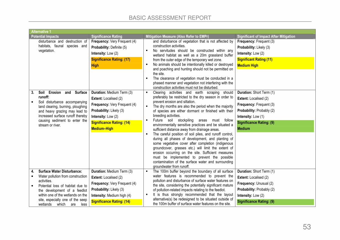
BASIC ASSESSMENT REPORT
53
Alternative 1
Potential Impacts Significance Rating Mitigation Measure (Also Refer to EMPr) Significant of Impact After Mitigation
disturbance and destruction of habitats, faunal species and vegetation.
Frequency: Very Frequent (4)
Probability: Definite (5)
Intensity: Low (2)
Significance Rating: (17)
High
and disturbance of vegetation that is not affected by construction activities.
� No servitudes should be constructed within any wetland habitat as well as a 20m grassland buffer from the outer edge of the temporary wet zone.
� No animals should be intentionally killed or destroyed and poaching and hunting should not be permitted on the site.
� The clearance of vegetation must be conducted in a phased manner and vegetation not interfering with the construction activities must not be disturbed.
Frequency: Frequent (3)
Probability: Likely (3)
Intensity: Low (2)
Significant Rating (11)
Medium High
3. Soil Erosion and Surface runoff:
• Soil disturbance accompanying land clearing, burning, ploughing and heavy grazing may lead to increased surface runoff thereby causing sediment to enter the stream or river.
Duration: Medium Term (3)
Extent: Localised (2)
Frequency: Very Frequent (4)
Probability: Likely (3)
Intensity: Low (2)
Significance Rating: (14)
Medium–High
� Clearing activities and earth scraping should preferably be restricted to the dry season in order to prevent erosion and siltation.
� The dry months are also the period when the majority of species are either dormant or finished with their breeding activities.
� Future soil stockpiling areas must follow environmentally sensitive practices and be situated a sufficient distance away from drainage areas.
� The careful position of soil piles, and runoff control, during all phases of development, and planting of some vegetative cover after completion (indigenous groundcover, grasses etc.) will limit the extent of erosion occurring on the site. Sufficient measures must be implemented to prevent the possible contamination of the surface water and surrounding groundwater from runoff.
Duration: Short Term (1)
Extent: Localised (2)
Frequency: Frequent (3)
Probability: Probably (2)
Intensity: Low (1)
Significance Rating: (9)
Medium
4. Surface Water Disturbance:
• Water pollution from construction activities.
• Potential loss of habitat due to the development of a feedlot within one of the wetlands on the site, especially one of the seep wetlands which are less
Duration: Medium Term (3)
Extent: Localised (2)
Frequency: Very Frequent (4)
Probability: Likely (3)
Intensity: Medium high (4)
Significance Rating: (14)
� The 100m buffer beyond the boundary of all surface water features is recommended to prevent the pollution and disturbance of surface water features on the site, considering the potentially significant mature of pollution-related impacts relating to the feedlot.
� It is thus strongly recommended that the layout alternative(s) be redesigned to be situated outside of the 100m buffer of surface water features on the site.
Duration: Short Term (1)
Extent: Localised (2)
Frequency: Unusual (2)
Probability: Probably (2)
Intensity: Low (2)
Significance Rating: (9)

BASIC ASSESSMENT REPORT
54
Alternative 1
Potential Impacts Significance Rating Mitigation Measure (Also Refer to EMPr) Significant of Impact After Mitigation
distinctive than the riverine watercourses.
• Pollution related and human health related impacts. o Incorrect design or
mismanagement of feedlot infrastructure can lead to pollution as inadequately sized and poorly-lined detention ponds or other storage structures allow can allow manure and waste to escape into the surrounding environment.
o Poorly maintained and unlined holding areas let contaminated wastewater containing pollutants to seep into ground water.
o Contamination of drinking water with animal waste can cause a number of human health issues.
Medium–High Medium
5. Heritage :
• There were no heritage artefacts identified during the survey of the study area. However, during the construction phase there might be disturbance of heritage artefacts uncovered which were not previously identified.
Duration: Medium Term (3)
Extent: Localised (2)
Frequency: Very Frequent (4)
Probability: Likely (3)
Intensity: Low (2)
Significance Rating: (14)
Medium–High
� Should heritage objects and artefacts be uncovered during the construction process, construction work need to stop and the uncovered objects be reported to the nearest museum for further assessment.
Duration: Short Term (1)
Extent: Localised (2)
Frequency: Very Rare (1)
Probability: Probably (2)
Intensity: Low (2)
Significance Rating: (8)
Medium
INDIRECT IMPACTS
1. Stormwater related Impacts:
• The development could be associated with discharge of
Duration: Medium Term (3) Extent: Localised (2) Frequency: Very Frequent (4)
� Stormwater control measures on a construction site (i.e. a dynamic situation) is difficult, measures must be taken to ensure that stormwater is controlled as far as
Duration: Short Term (1)
Extent: Localised (2)

BASIC ASSESSMENT REPORT
55
Alternative 1
Potential Impacts Significance Rating Mitigation Measure (Also Refer to EMPr) Significant of Impact After Mitigation
stormwater off hard (impermeable) surfaces that would be developed on the site, such as roofs and paved parking areas.
• Stormwater off access roads constructed as part of the proposed feedlot facility may also pose a risk to wetlands.
Probability: Definite (4) Intensity: Medium (3) Significance Rating: (16) High
possible and that all silt and other foreign materials are prevented from entering any surface water feature located adjacent to the construction area during the construction phase.
Frequency: Frequent (3)
Probability: Likely (3)
Intensity: Low (2)
Significance rating: 11
Medium-High
CUMULATIVE IMPACTS
None
Alternative 2
Potential Impacts Significance Rating Mitigation Measure (Also Refer to EMPr) Significant of Impact After Mitigation
DIRECT IMPACTS
1. Construction Related Impacts:
• Movements of trucks, delivery of construction material, oil leakages from machinery and vehicles, disposal of construction waste, excessive noise etc. will constitute the main impacts during construction.
Duration: Medium Term (3)
Extent: Localised (2)
Frequency: Very Frequent (4)
Probability: Likely (3)
Intensity: Low (2)
Significance Rating: (14)
Medium–High
� Construction related (solid & hazardous) and general waste must be collected regularly from the site and disposed of at an appropriate registered landfill site.
� Management of oil and other spillages and leakages must be minimized.
� Construction waste must not be stored more than 30 days on site.
� Dust suppression measures must be implemented by the appointed Contract to minimise dust nuisance in the surrounding communities.
� Construction activities must be undertaken during normal working hours (07H00 to 17H00) to minimise noise and disturbance of neighbouring landowners.
Duration: Short Term (1)
Extent: Localised (2)
Frequency: Frequent (3)
Probability: Improbable (1)
Intensity: Low (2)
Significance Rating: (9)
Medium
2. Ecology:
• During the construction phase of the project there will be disturbance and destruction of habitats, faunal species and vegetation.
Duration: Long Term (4)
Extent: Localised (2)
Frequency: Very Frequent (4)
Probability: Definite (5)
Intensity: Low (2)
� The Contractor need to maintain close site supervision. The construction workers must be limited to the construction site in order to avoid destruction and disturbance of vegetation that is not affected by construction activities.
� No servitudes should be constructed within any wetland habitat as well as a 20m grassland buffer
Duration: Short Term (1)
Extent: Localised (2)
Frequency: Frequent (3)
Probability: Likely (3)
Intensity: Low (2)
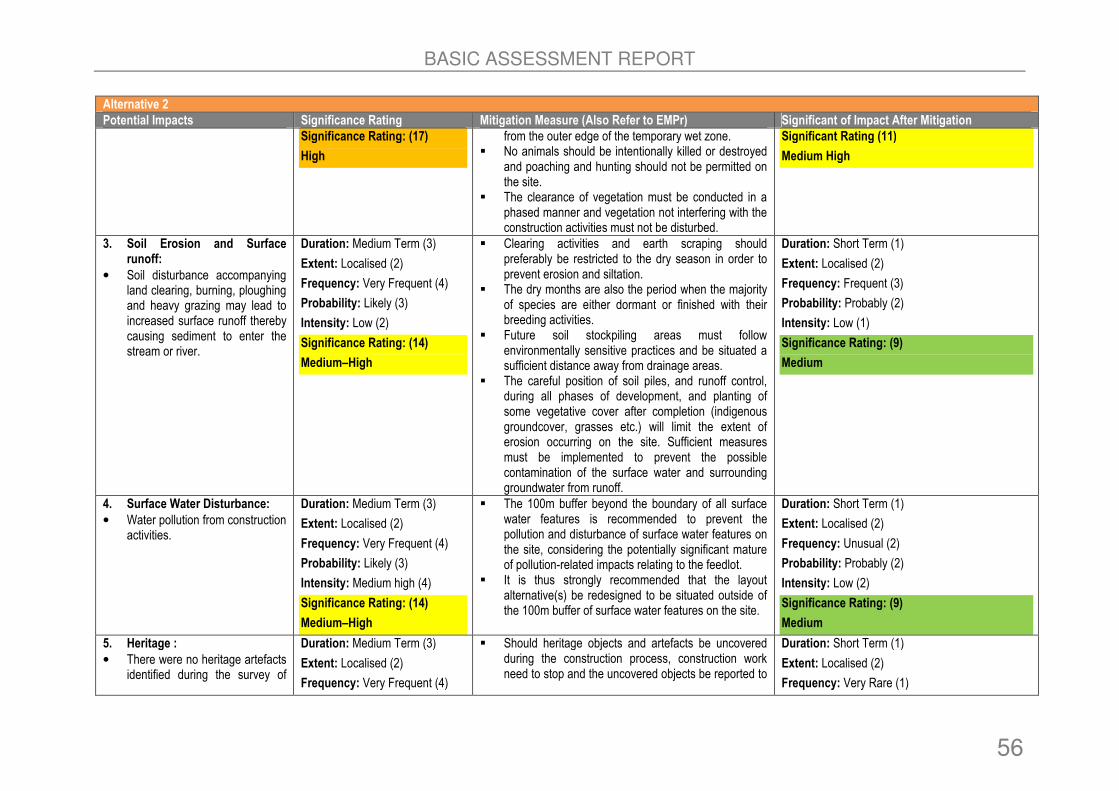
BASIC ASSESSMENT REPORT
56
Alternative 2
Potential Impacts Significance Rating Mitigation Measure (Also Refer to EMPr) Significant of Impact After Mitigation
Significance Rating: (17)
High
from the outer edge of the temporary wet zone. � No animals should be intentionally killed or destroyed
and poaching and hunting should not be permitted on the site.
� The clearance of vegetation must be conducted in a phased manner and vegetation not interfering with the construction activities must not be disturbed.
Significant Rating (11)
Medium High
3. Soil Erosion and Surface runoff:
• Soil disturbance accompanying land clearing, burning, ploughing and heavy grazing may lead to increased surface runoff thereby causing sediment to enter the stream or river.
Duration: Medium Term (3)
Extent: Localised (2)
Frequency: Very Frequent (4)
Probability: Likely (3)
Intensity: Low (2)
Significance Rating: (14)
Medium–High
� Clearing activities and earth scraping should preferably be restricted to the dry season in order to prevent erosion and siltation.
� The dry months are also the period when the majority of species are either dormant or finished with their breeding activities.
� Future soil stockpiling areas must follow environmentally sensitive practices and be situated a sufficient distance away from drainage areas.
� The careful position of soil piles, and runoff control, during all phases of development, and planting of some vegetative cover after completion (indigenous groundcover, grasses etc.) will limit the extent of erosion occurring on the site. Sufficient measures must be implemented to prevent the possible contamination of the surface water and surrounding groundwater from runoff.
Duration: Short Term (1)
Extent: Localised (2)
Frequency: Frequent (3)
Probability: Probably (2)
Intensity: Low (1)
Significance Rating: (9)
Medium
4. Surface Water Disturbance:
• Water pollution from construction activities.
Duration: Medium Term (3)
Extent: Localised (2)
Frequency: Very Frequent (4)
Probability: Likely (3)
Intensity: Medium high (4)
Significance Rating: (14)
Medium–High
� The 100m buffer beyond the boundary of all surface water features is recommended to prevent the pollution and disturbance of surface water features on the site, considering the potentially significant mature of pollution-related impacts relating to the feedlot.
� It is thus strongly recommended that the layout alternative(s) be redesigned to be situated outside of the 100m buffer of surface water features on the site.
Duration: Short Term (1)
Extent: Localised (2)
Frequency: Unusual (2)
Probability: Probably (2)
Intensity: Low (2)
Significance Rating: (9)
Medium
5. Heritage :
• There were no heritage artefacts identified during the survey of
Duration: Medium Term (3)
Extent: Localised (2)
Frequency: Very Frequent (4)
� Should heritage objects and artefacts be uncovered during the construction process, construction work need to stop and the uncovered objects be reported to
Duration: Short Term (1)
Extent: Localised (2)
Frequency: Very Rare (1)
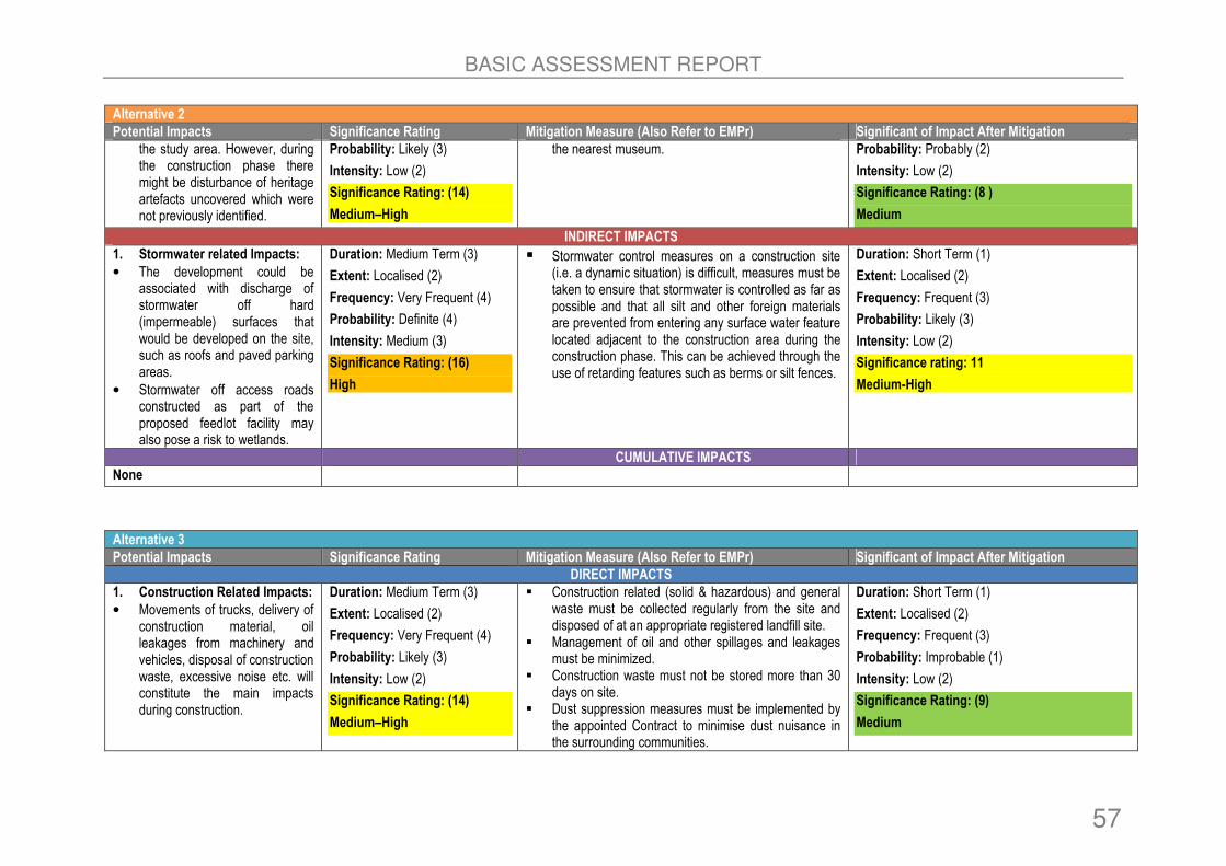
BASIC ASSESSMENT REPORT
57
Alternative 2
Potential Impacts Significance Rating Mitigation Measure (Also Refer to EMPr) Significant of Impact After Mitigation
the study area. However, during the construction phase there might be disturbance of heritage artefacts uncovered which were not previously identified.
Probability: Likely (3)
Intensity: Low (2)
Significance Rating: (14)
Medium–High
the nearest museum. Probability: Probably (2)
Intensity: Low (2)
Significance Rating: (8 )
Medium
INDIRECT IMPACTS
1. Stormwater related Impacts:
• The development could be associated with discharge of stormwater off hard (impermeable) surfaces that would be developed on the site, such as roofs and paved parking areas.
• Stormwater off access roads constructed as part of the proposed feedlot facility may also pose a risk to wetlands.
Duration: Medium Term (3)
Extent: Localised (2)
Frequency: Very Frequent (4)
Probability: Definite (4)
Intensity: Medium (3)
Significance Rating: (16)
High
� Stormwater control measures on a construction site (i.e. a dynamic situation) is difficult, measures must be taken to ensure that stormwater is controlled as far as possible and that all silt and other foreign materials are prevented from entering any surface water feature located adjacent to the construction area during the construction phase. This can be achieved through the use of retarding features such as berms or silt fences.
Duration: Short Term (1)
Extent: Localised (2)
Frequency: Frequent (3)
Probability: Likely (3)
Intensity: Low (2)
Significance rating: 11
Medium-High
CUMULATIVE IMPACTS
None
Alternative 3
Potential Impacts Significance Rating Mitigation Measure (Also Refer to EMPr) Significant of Impact After Mitigation
DIRECT IMPACTS
1. Construction Related Impacts:
• Movements of trucks, delivery of construction material, oil leakages from machinery and vehicles, disposal of construction waste, excessive noise etc. will constitute the main impacts during construction.
Duration: Medium Term (3)
Extent: Localised (2)
Frequency: Very Frequent (4)
Probability: Likely (3)
Intensity: Low (2)
Significance Rating: (14)
Medium–High
� Construction related (solid & hazardous) and general waste must be collected regularly from the site and disposed of at an appropriate registered landfill site.
� Management of oil and other spillages and leakages must be minimized.
� Construction waste must not be stored more than 30 days on site.
� Dust suppression measures must be implemented by the appointed Contract to minimise dust nuisance in the surrounding communities.
Duration: Short Term (1)
Extent: Localised (2)
Frequency: Frequent (3)
Probability: Improbable (1)
Intensity: Low (2)
Significance Rating: (9)
Medium

BASIC ASSESSMENT REPORT
58
Alternative 3
Potential Impacts Significance Rating Mitigation Measure (Also Refer to EMPr) Significant of Impact After Mitigation
� Construction activities must be undertaken during normal working hours (07H00 to 17H00) to minimise noise and disturbance of neighbouring landowners.
2. Ecology:
• During the construction phase of the project there will be disturbance and destruction of habitats, faunal species and vegetation.
Duration: Short Term (2)
Extent: Localised (2)
Frequency: Unusual (2)
Probability: Probably (2)
Intensity: Low (2)
Significance Rating: (10)
Medium
� The Contractor need to maintain close site supervision. The construction workers must be limited to the construction site in order to avoid destruction and disturbance of vegetation that is not affected by construction activities.
� No servitudes should be constructed within any wetland habitat as well as a 20m grassland buffer from the outer edge of the temporary wet zone.
� No animals should be intentionally killed or destroyed and poaching and hunting should not be permitted on the site.
� The clearance of vegetation must be conducted in a phased manner and vegetation not interfering with the construction activities must not be disturbed.
Duration: Short Term (1)
Extent: Localised (2)
Frequency: Unusual (2)
Probability: Probably (2)
Intensity: Low (1)
Significant Rating (8)
Medium
3. Soil Erosion and Surface runoff:
• Soil disturbance accompanying land clearing, burning, ploughing and heavy grazing may lead to increased surface runoff thereby causing sediment to enter the stream or river.
Duration: Short Term (2)
Extent: Localised (2)
Frequency: Unusual (2)
Probability: Likely (3)
Intensity: Low (2)
Significance Rating: (11)
Medium-High
� Clearing activities and earth scraping should preferably be restricted to the dry season in order to prevent erosion and siltation.
� The dry months are also the period when the majority of species are either dormant or finished with their breeding activities.
� Future soil stockpiling areas must follow environmentally sensitive practices and be situated a sufficient distance away from drainage areas.
� The careful position of soil piles, and runoff control, during all phases of development, and planting of some vegetative cover after completion (indigenous groundcover, grasses etc.) will limit the extent of erosion occurring on the site. Sufficient measures must be implemented to prevent the possible contamination of the surface water and surrounding groundwater from runoff.
Duration: Short Term (1)
Extent: Localised (2)
Frequency: Frequent (3)
Probability: Probably (2)
Intensity: Low (1)
Significance Rating: (9)
Medium
4. Surface Water Disturbance: 5. Water pollution from construction
Duration: Short Term (1)
Extent: Localised (2)
� A 32m buffer strips for the maintenance riparian zone located near the feedlot is recommended in order to reduce the risk of surface water contamination via
Duration: Short Term (1)
Extent: Localised (2)
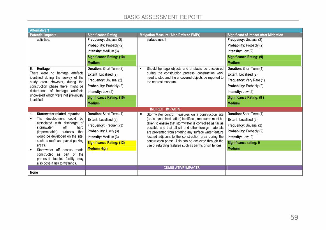
BASIC ASSESSMENT REPORT
59
Alternative 3
Potential Impacts Significance Rating Mitigation Measure (Also Refer to EMPr) Significant of Impact After Mitigation
activities. Frequency: Unusual (2)
Probability: Probably (2)
Intensity: Medium (3)
Significance Rating: (10)
Medium
surface runoff Frequency: Unusual (2)
Probability: Probably (2)
Intensity: Low (2)
Significance Rating: (9)
Medium
6. Heritage : There were no heritage artefacts identified during the survey of the study area. However, during the construction phase there might be disturbance of heritage artefacts uncovered which were not previously identified.
Duration: Short Term (2)
Extent: Localised (2)
Frequency: Unusual (2)
Probability: Probably (2)
Intensity: Low (2)
Significance Rating: (10)
Medium
� Should heritage objects and artefacts be uncovered during the construction process, construction work need to stop and the uncovered objects be reported to the nearest museum.
Duration: Short Term (1)
Extent: Localised (2)
Frequency: Very Rare (1)
Probability: Probably (2)
Intensity: Low (2)
Significance Rating: (8 )
Medium
INDIRECT IMPACTS
1. Stormwater related Impacts:
• The development could be associated with discharge of stormwater off hard (impermeable) surfaces that would be developed on the site, such as roofs and paved parking areas.
• Stormwater off access roads constructed as part of the proposed feedlot facility may also pose a risk to wetlands.
Duration: Short Term (1)
Extent: Localised (2)
Frequency: Frequent (3)
Probability: Likely (3)
Intensity: Medium (3)
Significance Rating: (12)
Medium High
� Stormwater control measures on a construction site (i.e. a dynamic situation) is difficult, measures must be taken to ensure that stormwater is controlled as far as possible and that all silt and other foreign materials are prevented from entering any surface water feature located adjacent to the construction area during the construction phase. This can be achieved through the use of retarding features such as berms or silt fences.
Duration: Short Term (1)
Extent: Localised (2)
Frequency: Unusual (2)
Probability: Probably (2)
Intensity: Low (2)
Significance rating: 9
Medium
CUMULATIVE IMPACTS
None

BASIC ASSESSMENT REPORT
60
SUMMARY OF POTENTIAL IMPACTS AND AVERAGE POINTS ALLOCATED TO ALTERNATIVES DURING THE CONSTRUCTION PHASE
IMPACTS Alternative 1 Without
Mitigation
Alternative 1: With
Mitigation
Alternative 2: With
Mitigation
Alternative 2: Without
Mitigation
Alternative 3:
Without Mitigation
Alternative 3
With Mitigation
DIRECT IMPACTS
1. Construction Related Impacts
14 9 14 9 14 9
2. Ecology 17 11 17 11 10 8
3. Soil Erosion and Surface runoff
14 9 14 9 11 9
4. Surface water disturbance 14 9 14 9 10 9
5. Heritage 14 7 14 7 10 8
Total 73 45 73 45 55 43
INDIRECT IMPACTS
1. Stormwater related Impacts
16 11 16 11 12 9
Total 16 11 16 11 12 9
CUMULATIVE IMPACTS
None
1 (c) IMPACT THAT MAY RESULT FROM OPERATION
Alternative 1
Potential Impacts Significance Rating Mitigation Measure (Also Refer to EMPr) Significant of Impact After Mitigation
DIRECT IMPACTS
1. Residual impacts Residual impacts that arose during the construction phase and incorrect rehabilitation of construction-related access.
Duration: Long Term (4)
Extent: Localised (2)
Frequency: Very Frequent (4)
Probability: Likely (3)
Intensity: Low (2)
Significance Rating: (15)
Medium–High
� Care should be taken at all times to prevent any potential impacts that might result from operation activities.
� The feedlot and associated infrastructure must be maintained accordingly at least twice a year.
� Should there be any oil spills it should be cleaned immediately and disposed of at the appropriate hazardous landfill site. The surrounding communities should be encouraged to report any incidence that occurs.
Duration: Short Term (1)
Extent: Localised (2)
Frequency: Unusual (2)
Probability: Likely (3)
Intensity: Very Low (1)
Significance Rating: (9)
Medium
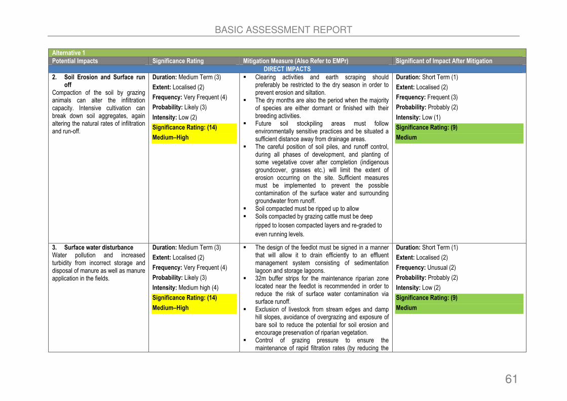
BASIC ASSESSMENT REPORT
61
Alternative 1
Potential Impacts Significance Rating Mitigation Measure (Also Refer to EMPr) Significant of Impact After Mitigation
DIRECT IMPACTS
2. Soil Erosion and Surface run off
Compaction of the soil by grazing animals can alter the infiltration capacity. Intensive cultivation can break down soil aggregates, again altering the natural rates of infiltration and run-off.
Duration: Medium Term (3)
Extent: Localised (2)
Frequency: Very Frequent (4)
Probability: Likely (3)
Intensity: Low (2)
Significance Rating: (14)
Medium–High
� Clearing activities and earth scraping should preferably be restricted to the dry season in order to prevent erosion and siltation.
� The dry months are also the period when the majority of species are either dormant or finished with their breeding activities.
� Future soil stockpiling areas must follow environmentally sensitive practices and be situated a sufficient distance away from drainage areas.
� The careful position of soil piles, and runoff control, during all phases of development, and planting of some vegetative cover after completion (indigenous groundcover, grasses etc.) will limit the extent of erosion occurring on the site. Sufficient measures must be implemented to prevent the possible contamination of the surface water and surrounding groundwater from runoff.
� Soil compacted must be ripped up to allow � Soils compacted by grazing cattle must be deep
ripped to loosen compacted layers and re-graded to
even running levels.
Duration: Short Term (1)
Extent: Localised (2)
Frequency: Frequent (3)
Probability: Probably (2)
Intensity: Low (1)
Significance Rating: (9)
Medium
3. Surface water disturbance Water pollution and increased turbidity from incorrect storage and disposal of manure as well as manure application in the fields.
Duration: Medium Term (3)
Extent: Localised (2)
Frequency: Very Frequent (4)
Probability: Likely (3)
Intensity: Medium high (4)
Significance Rating: (14)
Medium–High
� The design of the feedlot must be signed in a manner that will allow it to drain efficiently to an effluent management system consisting of sedimentation lagoon and storage lagoons.
� 32m buffer strips for the maintenance riparian zone located near the feedlot is recommended in order to reduce the risk of surface water contamination via surface runoff.
� Exclusion of livestock from stream edges and damp hill slopes, avoidance of overgrazing and exposure of bare soil to reduce the potential for soil erosion and encourage preservation of riparian vegetation.
� Control of grazing pressure to ensure the maintenance of rapid filtration rates (by reducing the
Duration: Short Term (1)
Extent: Localised (2)
Frequency: Unusual (2)
Probability: Probably (2)
Intensity: Low (2)
Significance Rating: (9)
Medium

BASIC ASSESSMENT REPORT
62
Alternative 1
Potential Impacts Significance Rating Mitigation Measure (Also Refer to EMPr) Significant of Impact After Mitigation
DIRECT IMPACTS
amount of trampling), good pasture or grass recovery rates and preservation of the grass and litter layer.
� Controlled runoff from feedlots and proper storage (with impervious linings) and disposal of manure (manure is suited for application to cropland).
4. Noise and Odour Excessive noise and offensive odour impacts from the operations of the feedlot.
Duration: Medium Term (3)
Extent: Localised (2)
Frequency: Very Frequent (4)
Probability: Definite (4)
Intensity: Medium (3)
Significance Rating: (16)
High
� Necessary berms need to be erected at the feedlot site to minimise the disturbance of the neighbouring landowners.
� The operations of the feedlot need to be maintained regularly to minimise odour impacts and this can be achieved by having a good design and keeping the feed pens as dry as possible.
� Where necessary the feedlot must be operated during normal working hours 07H00 to 17H00.
Duration: Short Term (1)
Extent: Localised (2)
Frequency: Frequent (3)
Probability: Likely (3)
Intensity: Low (2)
Significance rating: 11
Medium-High
5. Air Emissions Emissions generated from feed silage, feed pans and other operations of the feedlot.
Duration: Medium Term (3)
Extent: Localised (2)
Frequency: Very Frequent (4)
Probability: Definite (4)
Intensity: Medium (3)
Significance Rating: (16)
High
� Dust suppression measures must be implemented constantly to reduce the impacts.
� Feeding pans and silage storage areas must be cleaned regularly.
Duration: Short Term (1)
Extent: Localised (2)
Frequency: Frequent (3)
Probability: Likely (3)
Intensity: Low (2)
Significance rating: 11
Medium-High
6. Waste Generation
• Generation of domestic waste
• Generation of solid waste from feeding pans and silage storage areas as well as dead carcases.
• Generation of wastewater from drainage system and storage ponds.
• Generation of cattle waste dung.
Duration: Medium Term (3)
Extent: Localised (2)
Frequency: Very Frequent (4)
Probability: Definite (4)
Intensity: Medium (3)
Significance Rating: (16)
High
� Domestic and hazardous solid waste generated on site must be disposed at a registered landfill facility.
� Dead carcases must be buried in an area that has low water table. Thus geotechnical studies need to be undertaken in order to locate such area. In addition the trench which will be used to bury the carcass must be line.
� Wastewater must be linked to a municipal drainage system.
� Waste dung generated by cattle must be managed appropriately where necessary be reused as fertilising manure for crops.
Duration: Short Term (1)
Extent: Localised (2)
Frequency: Frequent (3)
Probability: Likely (3)
Intensity: Low (2)
Significance rating: 11
Medium-High

BASIC ASSESSMENT REPORT
63
Alternative 1
Potential Impacts Significance Rating Mitigation Measure (Also Refer to EMPr) Significant of Impact After Mitigation
DIRECT IMPACTS
INDIRECT IMPACTS
None
CUMULATIVE IMPACTS
None
Alternative 2
Potential Impacts Significance Rating Mitigation Measure (Also Refer to EMPr) Significant of Impact After Mitigation
DIRECT IMPACTS
1. Residual impacts Residual impacts that arose during the construction phase and incorrect rehabilitation of construction-related access.
Duration: Long Term (4)
Extent: Localised (2)
Frequency: Very Frequent (4)
Probability: Likely (3)
Intensity: Low (2)
Significance Rating: (15)
Medium–High
� Care should be taken at all times to prevent any potential impacts that might result from operation activities.
� The feedlot and associated infrastructure must be maintained accordingly at least twice a year.
� Should there be any oil spills it should be cleaned immediately and disposed of at the appropriate hazardous landfill site. The surrounding communities should be encouraged to report any incidence that occurs.
Duration: Short Term (1)
Extent: Localised (2)
Frequency: Unusual (2)
Probability: Likely (3)
Intensity: Very Low (1)
Significance Rating: (9)
Medium
2. Soil Erosion and Surface run off
Compaction of the soil by grazing animals can alter the infiltration capacity. Intensive cultivation can break down soil aggregates, again altering the natural rates of infiltration and run-off.
Duration: Medium Term (3)
Extent: Localised (2)
Frequency: Very Frequent (4)
Probability: Likely (3)
Intensity: Low (2)
Significance Rating: (14)
Medium–High
� Clearing activities and earth scraping should preferably be restricted to the dry season in order to prevent erosion and siltation.
� The dry months are also the period when the majority of species are either dormant or finished with their breeding activities.
� Future soil stockpiling areas must follow environmentally sensitive practices and be situated a sufficient distance away from drainage areas.
� The careful position of soil piles, and runoff control, during all phases of development, and planting of some vegetative cover after completion (indigenous groundcover, grasses etc.) will limit the extent of erosion occurring on the site. Sufficient measures must be implemented to prevent the possible
Duration: Short Term (1)
Extent: Localised (2)
Frequency: Frequent (3)
Probability: Probably (2)
Intensity: Low (1)
Significance Rating: (9)
Medium

BASIC ASSESSMENT REPORT
64
Alternative 2
Potential Impacts Significance Rating Mitigation Measure (Also Refer to EMPr) Significant of Impact After Mitigation
DIRECT IMPACTS
contamination of the surface water and surrounding groundwater from runoff.
� Soil compacted must be ripped up to allow � Soils compacted by grazing cattle must be deep
ripped to loosen compacted layers and re-graded to
even running levels.
3. Surface water disturbance Water pollution and increased turbidity from incorrect storage and disposal of manure as well as manure application in the fields.
Duration: Medium Term (3)
Extent: Localised (2)
Frequency: Very Frequent (4)
Probability: Likely (3)
Intensity: Medium high (4)
Significance Rating: (14)
Medium–High
� The design of the feedlot must be signed in a manner that will allow it to drain efficiently to an effluent management system consisting of sedimentation lagoon and storage lagoons.
� 32m buffer strips for the maintenance riparian zone located near the feedlot is recommended in order to reduce the risk of surface water contamination via surface runoff.
� Exclusion of livestock from stream edges and damp hill slopes, avoidance of overgrazing and exposure of bare soil to reduce the potential for soil erosion and encourage preservation of riparian vegetation.
� Control of grazing pressure to ensure the maintenance of rapid filtration rates (by reducing the amount of trampling), good pasture or grass recovery rates and preservation of the grass and litter layer.
• Controlled runoff from feedlots and proper storage (with impervious linings) and disposal of manure (manure is suited for application to cropland).
Duration: Short Term (1)
Extent: Localised (2)
Frequency: Unusual (2)
Probability: Probably (2)
Intensity: Low (2)
Significance Rating: (9)
Medium
4. Noise and Odour Excessive noise and offensive odour impacts from the operations of the feedlot.
Duration: Medium Term (3)
Extent: Localised (2)
Frequency: Very Frequent (4)
Probability: Definite (4)
Intensity: Medium (3)
Significance Rating: (16)
High
� Necessary berms need to be erected at the feedlot site to minimise the disturbance of the neighbouring landowners.
� The operations of the feedlot need to be maintained regularly to minimise odour impacts and this can be achieved by having a good design and keeping the feed pens as dry as possible.
� Where necessary the feedlot must be operated during normal working hours 07H00 to 17H00.
Duration: Short Term (1)
Extent: Localised (2)
Frequency: Frequent (3)
Probability: Likely (3)
Intensity: Low (2)
Significance rating: 11
Medium-High

BASIC ASSESSMENT REPORT
65
Alternative 2
Potential Impacts Significance Rating Mitigation Measure (Also Refer to EMPr) Significant of Impact After Mitigation
DIRECT IMPACTS
5. Air Emissions Emissions generated from feed silage, feed pans and other operations of the feedlot.
Duration: Medium Term (3)
Extent: Localised (2)
Frequency: Very Frequent (4)
Probability: Definite (4)
Intensity: Medium (3)
Significance Rating: (16)
High
� Dust suppression measures must be implemented constantly to reduce the impacts.
� Feeding pans and silage storage areas must be cleaned regularly.
Duration: Short Term (1)
Extent: Localised (2)
Frequency: Frequent (3)
Probability: Likely (3)
Intensity: Low (2)
Significance rating: 11
Medium-High
6. Waste Generation
• Generation of domestic waste
• Generation of solid waste from feeding pans and silage storage areas as well as dead carcases.
• Generation of wastewater from drainage system and storage ponds.
• Generation of cattle waste dung.
Duration: Medium Term (3)
Extent: Localised (2)
Frequency: Very Frequent (4)
Probability: Definite (4)
Intensity: Medium (3)
Significance Rating: (16)
High
� Domestic and hazardous solid waste generated on site must be disposed at a registered landfill facility.
� Dead carcases must be buried in an area that has low water table. Thus geotechnical studies need to be undertaken in order to locate such area. In addition the trench which will be used to bury the carcass must be line.
� Wastewater must be linked to a municipal drainage system.
� Waste dung generated by cattle must be managed appropriately where necessary be reused as fertilising manure for crops.
Duration: Short Term (1)
Extent: Localised (2)
Frequency: Frequent (3)
Probability: Likely (3)
Intensity: Low (2)
Significance rating: 11
Medium-High
INDIRECT IMPACTS
None
CUMULATIVE IMPACTS
None
Alternative 3
Potential Impacts Significance Rating Mitigation Measure (Also Refer to EMPr) Significant of Impact After Mitigation
DIRECT IMPACTS
1. Residual impacts Residual impacts that arose during the construction phase and incorrect rehabilitation of construction-related
Duration: Long Term (4)
Extent: Localised (2)
Frequency: Very Frequent (4)
� Care should be taken at all times to prevent any potential impacts that might result from operation activities.
� The feedlot and associated infrastructure must be
Duration: Short Term (1)
Extent: Localised (2)
Frequency: Unusual (2)

BASIC ASSESSMENT REPORT
66
Alternative 3
Potential Impacts Significance Rating Mitigation Measure (Also Refer to EMPr) Significant of Impact After Mitigation
DIRECT IMPACTS
access.
Probability: Likely (3)
Intensity: Low (2)
Significance Rating: (15)
Medium–High
maintained accordingly at least twice a year. � Should there be any oil spills it should be cleaned
immediately and disposed of at the appropriate hazardous landfill site. The surrounding communities should be encouraged to report any incidence that occurs.
Probability: Likely (3)
Intensity: Very Low (1)
Significance Rating: (9)
Medium
2. Soil Erosion and Surface run off
Compaction of the soil by grazing animals can alter the infiltration capacity. Intensive cultivation can break down soil aggregates, again altering the natural rates of infiltration and run-off.
Duration: Medium Term (3)
Extent: Localised (2)
Frequency: Very Frequent (4)
Probability: Likely (3)
Intensity: Low (2)
Significance Rating: (14)
Medium–High
� Clearing activities and earth scraping should preferably be restricted to the dry season in order to prevent erosion and siltation.
� The dry months are also the period when the majority of species are either dormant or finished with their breeding activities.
� Future soil stockpiling areas must follow environmentally sensitive practices and be situated a sufficient distance away from drainage areas.
� The careful position of soil piles, and runoff control, during all phases of development, and planting of some vegetative cover after completion (indigenous groundcover, grasses etc.) will limit the extent of erosion occurring on the site. Sufficient measures must be implemented to prevent the possible contamination of the surface water and surrounding groundwater from runoff.
� Soil compacted must be ripped up to allow � Soils compacted by grazing cattle must be deep
ripped to loosen compacted layers and re-graded to
even running levels.
Duration: Short Term (1)
Extent: Localised (2)
Frequency: Frequent (3)
Probability: Probably (2)
Intensity: Low (1)
Significance Rating: (9)
Medium
3. Surface water disturbance Water pollution and increased turbidity from incorrect storage and disposal of manure as well as manure application in the fields.
Duration: Medium Term (3)
Extent: Localised (2)
Frequency: Very Frequent (4)
Probability: Likely (3)
Intensity: Medium high (4)
Significance Rating: (14)
� The design of the feedlot must be signed in a manner that will allow it to drain efficiently to an effluent management system consisting of sedimentation lagoon and storage lagoons.
� 32m buffer strips for the maintenance riparian zone located near the feedlot is recommended in order to reduce the risk of surface water contamination via surface runoff.
Duration: Short Term (1)
Extent: Localised (2)
Frequency: Unusual (2)
Probability: Probably (2)
Intensity: Low (2)
Significance Rating: (9)

BASIC ASSESSMENT REPORT
67
Alternative 3
Potential Impacts Significance Rating Mitigation Measure (Also Refer to EMPr) Significant of Impact After Mitigation
DIRECT IMPACTS
Medium–High � Exclusion of livestock from stream edges and damp hill slopes, avoidance of overgrazing and exposure of bare soil to reduce the potential for soil erosion and encourage preservation of riparian vegetation.
� Control of grazing pressure to ensure the maintenance of rapid filtration rates (by reducing the amount of trampling), good pasture or grass recovery rates and preservation of the grass and litter layer.
• Controlled runoff from feedlots and proper storage (with impervious linings) and disposal of manure (manure is suited for application to cropland).
Medium
4. Noise and Odour Excessive noise and offensive odour impacts from the operations of the feedlot.
Duration: Medium Term (3)
Extent: Localised (2)
Frequency: Very Frequent (4)
Probability: Definite (4)
Intensity: Medium (3)
Significance Rating: (16)
High
� Necessary berms need to be erected at the feedlot site to minimise the disturbance of the neighbouring landowners.
� The operations of the feedlot need to be maintained regularly to minimise odour impacts and this can be achieved by having a good design and keeping the feed pens as dry as possible.
� Where necessary the feedlot must be operated during normal working hours 07H00 to 17H00.
Duration: Short Term (1)
Extent: Localised (2)
Frequency: Frequent (3)
Probability: Likely (3)
Intensity: Low (2)
Significance rating: 11
Medium-High
5. Air Emissions Emissions generated from feed silage, feed pans and other operations of the feedlot.
Duration: Medium Term (3)
Extent: Localised (2)
Frequency: Very Frequent (4)
Probability: Definite (4)
Intensity: Medium (3)
Significance Rating: (16)
High
� Dust suppression measures must be implemented constantly to reduce the impacts.
� Feeding pans and silage storage areas must be cleaned regularly.
Duration: Short Term (1)
Extent: Localised (2)
Frequency: Frequent (3)
Probability: Likely (3)
Intensity: Low (2)
Significance rating: 11
Medium-High
6. Waste Generation
• Generation of domestic waste
• Generation of solid waste from feeding pans and silage storage areas as well as dead carcases.
• Generation of wastewater from
Duration: Medium Term (3)
Extent: Localised (2)
Frequency: Very Frequent (4)
Probability: Definite (4)
Intensity: Medium (3)
� Domestic and hazardous solid waste generated on site must be disposed at a registered landfill facility.
� Dead carcases must be buried in an area that has low water table. Thus geotechnical studies need to be undertaken in order to locate such area. In addition the trench which will be used to bury the carcass must
Duration: Short Term (1)
Extent: Localised (2)
Frequency: Frequent (3)
Probability: Likely (3)
Intensity: Low (2)

BASIC ASSESSMENT REPORT
68
Alternative 3
Potential Impacts Significance Rating Mitigation Measure (Also Refer to EMPr) Significant of Impact After Mitigation
DIRECT IMPACTS
drainage system and storage ponds.
• Generation of cattle waste dung.
Significance Rating: (16)
High
be line. � Wastewater must be linked to a municipal drainage
system. � Waste dung generated by cattle must be managed
appropriately where necessary be reused as fertilising manure for crops.
Significance rating: 11
Medium-High
INDIRECT IMPACTS
None
CUMULATIVE IMPACTS
None
SUMMARY OF POTENTIAL IMPACTS AND AVERAGE POINTS ALLOCATED TO ALTERNATIVES DURING THE OPERATION PHASE
IMPACTS Alternative 1:
Without Mitigation
Alternative 2: With
Mitigation
Alternative 2:
Without Mitigation
Alternative 2: With
Mitigation
Alternative 3
Without Mitigation
Alternative 3 With
Migration
DIRECT IMPACTS
1. Residual impacts 15 9 15 9 15 9
2. Soil Erosion and Surface run off 14 9 14 9 14 9
3. Surface water disturbance 14 9 14 9 14 9
4. Noise and Odour 16 11 16 11 16 11
5. Air Emissions 16 11 16 11 16 11
6. Waste Generation 16 11 16 11 16 11
Total 91 60 91 60 91 60
INDIRECT IMPACTS
None
CUMULATIVE IMPACTS
None

BASIC ASSESSMENT REPORT
69
1(d) POTENTIAL IMPACTS THAT MAY RESULT FROM DECOMMISSIONING
Potential Impacts
The closure and decommissioning of the feedlot is unknown at this stage. However, when closure and decommissioning does take place a separate EIA process will have to be conducted to
address impacts that arises as a result of closure.
No Go Option
The proposed project is aimed at supporting the adjacent Nkomazi abattoir and uplifting the commercial status of local livestock farmers and the social status of the local communities within the Nkomazi local municipality through job creation. Thus, should the proposed project not proceed as planned, the abattoir will be under-utilised and the status quo will remain thereby undermining the objectives of this National Strategic Infrastructure Planning Project which is aimed at expediting service delivery to previously disadvantaged communities and eliminating poverty. Thus, the no go option is not preferred.

BASIC ASSESSMENT REPORT
70
A complete impact assessment in terms of Regulation 22(2)(i) of GN R.543 must be included as Appendix F. 1. ENVIRONMENTAL IMPACT STATEMENT Taking the assessment of potential impacts into account, please provide an environmental impact statement that summarises the impact that the proposed activity and its alternatives may have on the environment after the management and mitigation of impacts have been taken into account, with specific reference to types of impact, duration of impacts, likelihood of potential impacts actually occurring and the significance of impacts. Alternative 1
Feedlot tends to generate significant impacts as outlined above. However, when the construction and operations activities managed accordingly the impacts are minimal to the environment. The concluding statements from specialist studies are provide below: Ecology: There are no significant ecological impacts identified and those impacts which were identified can be easily mitigated. Heritage: There were no heritage artefacts identified during the survey of the study area and thus there will be no heritage impacts. Surface Water: Alternatives 1 is located in immediate proximity to the seep wetland located to the north of the river that forms the southern boundary of the site, and both are located close to the boundary of the riparian zone of that watercourse. It is thus strongly recommended that the layout alternative(s) be redesigned to be situated outside of the 100m buffer of surface water features on the site, as a key mitigation measure. This alternative is the least preferred from the surface water perspective.
Alternative 2
Feedlot tends to generate significant impacts as outlined above. However, when the construction and operations activities managed accordingly the impacts are minimal to the environment. The concluding statements from specialist studies are provided below: Ecology: There are no significant ecological impacts identified and those impacts which were identified can be easily mitigated. Heritage: There were no heritage artefacts identified during the survey of the study area and thus there will be no heritage impacts. Surface Water: Alternatives 2 is located in immediate proximity to the seep wetland located to the north of the river that forms the southern boundary of the site, and both are located close to the boundary of the riparian zone of that watercourse. It is thus strongly recommended that the layout alternative(s) be redesigned to be situated outside of the 100m buffer of surface water features on the site, as a key mitigation measure. This alternative is the least preferred from the surface water perspective.
BASIC ASSESSMENT REPORT
71
Alternative 3
Feedlot tends to generate significant impacts as outlined above. However, when the construction and operations activities managed accordingly the impacts are minimal to the environment. The concluding statements from specialist studies are provide below: Ecology: There are no significant ecological impacts identified and those impacts which were identified can be easily mitigated. Heritage: There were no heritage artefacts identified during the survey of the study area and thus there will be no heritage impacts. Surface Water: Alternatives 3 is located outside of the 100m buffer zone of surface water features in the southern part of the site would lessen the risk of the feedlot impacting on these surface water features, and this alternative is recommended for development. In addition Alternative 3 is located within a transformed part of the site from which the natural woodland has been historically removed. The transformation of this area would lessen the transformative impact of the feedlot facility.
No go Option The proposed project is aimed at supporting the adjacent Nkomazi abattoir and uplifting the commercial status of local livestock farmers and the social status of the local communities within the Nkomazi local municipality through job creation. Thus, should the proposed project not proceed as planned, the abattoir will be under-utilised and the status quo will remain thereby undermining the objectives of this National Strategic Infrastructure Planning Project which is aimed at expediting service delivery to previously disadvantaged communities and eliminating poverty. Thus, the no go option is not preferred.

BASIC ASSESSMENT REPORT
72
SECTION E. RECOMMENDATION OF PRACTITIONER
Is the information contained in this report and the documentation attached hereto sufficient to make a decision in respect of the activity applied for (in the view of the environmental assessment practitioner)?
YES
If “NO”, indicate the aspects that should be assessed further as part of a Scoping and EIA process before a decision can be made (list the aspects that require further assessment). N/A
If “YES”, please list any recommended conditions, including mitigation measures that should be considered for inclusion in any authorisation that may be granted by the competent authority in respect of the application. The findings of the specialist studies undertaken within the Basic Assessment provided an assessment of both benefits and potential negative impacts anticipated as a result of the proposed project. The findings conclude that there are no environmental fatal flaws that should prevent the proposed project from proceeding, provided that the recommended mitigation and management measures are implemented. Alternatives 1 and 2 are located within the 100m buffer of surface water features on the site and thus, neither are considered preferable from a surface water perspective. It is therefore, strongly recommended that the layout alternatives be redesigned to be situated outside of the 100m buffer of surface water features on the site. In addition, the transformed area to the west of the current Alternative 1 layout and to the south-west of the existing abattoir is considered instead for the siting of the feedlot (Refer to Figure 22). This area is environmentally transformed (the natural woodland vegetation has historically been removed) and most of it is located outside of the 100m surface water buffers on the site (Refer to Figure 23).
Figure 24: Location of Alternatives in Relation to surface water and buffers on the development site.

BASIC ASSESSMENT REPORT
73
Figure 25: Proposed Alternative 3 The below recommendation must be considered for this project.
• Should the developer require addition water resources from new boreholes and the stream closer to the study area, a Water Use Licence Application will have to conducted and approved by the Department of Water and Sanitation prior sourcing of the water.
• The developer need to maintain the waste carcass trench accordingly to ensure that there is no contamination of groundwater.
• The developer need to ensure that adverse environmental impacts are minimal.
• It is recommended that site option 3 be implemented for the project.
• During the rehabilitation process trees will need to be planted which will minimise the odour, visual and noise impacts which might emanate from the Abattoir facility.
• The stream below the abattoir facility is an important environmental feature as it provides a migration corridor for animals. Thus, it is imperative that the stream be protected.
Is an EMPr attached? YES NO
The EMPr must be attached as Appendix G. The details of the EAP who compiled the BAR and the expertise of the EAP to perform the Basic Assessment process must be included as Appendix H. If any specialist reports were used during the compilation of this BAR, please attach the declaration of interest for each specialist in Appendix I. Any other information relevant to this application and not previously included must be attached in Appendix J.

BASIC ASSESSMENT REPORT
74
Sibongile Gumbi ________________________________________ NAME OF EAP ________________________________________ _________________ SIGNATURE OF EAP DATE
BASIC ASSESSMENT REPORT
75
SECTION F: APPENDIXES The following appendixes must be attached: Appendix A: Maps Appendix B: Photographs Appendix C: Facility illustration(s) Appendix D: Specialist reports Appendix D1: Ecological Report Appendix D2: Heritage Report Appendix D3: Wetland Report
Appendix E: Public Participation Appendix F: Impact Assessment Appendix G: Environmental Management Programme (EMPr) Appendix H: Details of EAP and expertise Appendix I: Specialist’s declaration of interest Appendix J: Additional Information