downscaling configuraon of wrf weather …wakes.uma.pt/workshop/tutorial_wrf.pdfdownscaling...
TRANSCRIPT

DownscalingConfigura0onofWRFWeatherResearch&Forecas0ngModel
CCM,MadeiraUniversity,Funchal,MadeiraIsland,Portugal 21‐31July2008
Interna0onalWorkshopGeophysicalFluidDynamics:IslandWakeStudies
RicardoToméCCMMG,AzoresUniversity,PortugalCGUL/IDL,LisbonUniversity,Portugal

Layout1. Overview2. So2wareInstalla7on3. WRFPreprocessingSystem4. WRFModel5. Post‐ProcessingPrograms6. CaseStudy
DownscalingConfigura0onofWRF–WeatherResearch&Forecas0ngModel
July2008 00/00
Overview
DownscalingConfigura0onofWRF–WeatherResearch&Forecas0ngModel
July2008 00/00

DownscalingConfigura0onofWRF–WeatherResearch&Forecas0ngModel
July2008 00/00
Overview
WhatisWRF?• WRF:WeatherResearchandForecas0ngModel
• Usedforbothresearchandopera0onalforecas0ng
• It is a supported “community model”, i.e. a free and sharedresourcewithdistributeddevelopmentandcentralizedsupport
• Its development is led by NCAR, NOAA/GSD and NOAA/NCEP/EMCwithpartnershipsatAFWA,FAA,NRL,andcollabora0onswithUniversi0esandothergovernmentagenciesintheUS

DownscalingConfigura0onofWRF–WeatherResearch&Forecas0ngModel
July2008 00/00
Overview
WhatareARWandNMM?• Advanced ResearchWRF (ARW) andNonhydrosta0cMesoscaleModel(NMM)aredynamicalcores
• Dynamical cores includesmostly advec0on, pressure‐gradients, Coriolis,buoyancy,filters,diffusion,and0me‐stepping
• ARWsupportanddevelopmentarecenteredatNCAR/MMM• NMMdevelopmentiscenteredatNCEP/EMC(NCAR/DTC)
• BotharedownloadableinthesameWRFtarballfile
• Physics, pre‐ and post‐processing soaware are shared betweenthedynamicalcores

DownscalingConfigura0onofWRF–WeatherResearch&Forecas0ngModel
July2008 00/00
Overview
WhatcanWRFbeusedfor?• ARWandNMM
• Atmosphericphysics/parameteriza0onresearch• Casestudyresearch• Real0meNWPandresearchsystemresearch• TeachingdynamicsandNWP
• ARWonly• Regionalclimateandseasonal0mescaleresearch• Coupled‐model(e.g.ocean,chemistry)applica0ons• Idealized simula0ons at many scales (e.g. convec0on, baroclinic waves,largeeddysimula0on)• Dataassimila0onresearch

DownscalingConfigura0onofWRF–WeatherResearch&Forecas0ngModel
July2008 00/00
Overview
WRFModelingSystemFlowChart(WRFV2)
DownscalingConfigura0onofWRF–WeatherResearch&Forecas0ngModel
July2008 00/00
Overview
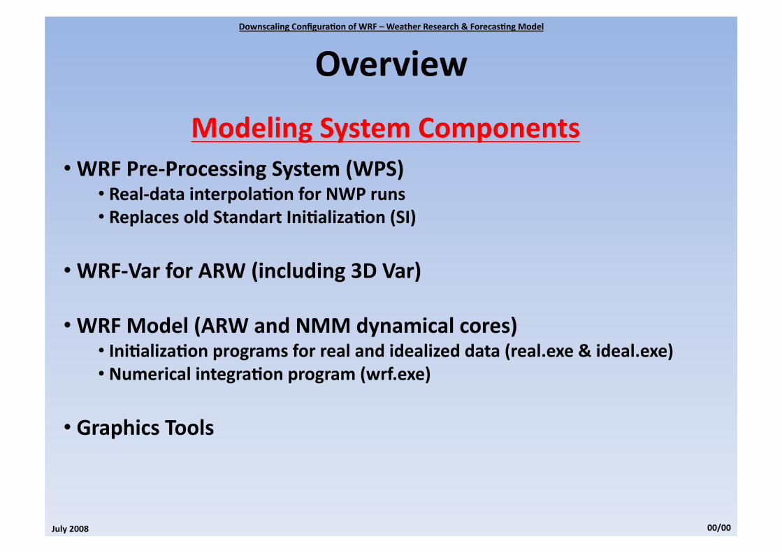
ModelingSystemComponents• WRFPre‐ProcessingSystem(WPS)
• Real‐datainterpola0onforNWPruns• ReplacesoldStandartIni0aliza0on(SI)
• WRF‐VarforARW(including3DVar)
• WRFModel(ARWandNMMdynamicalcores)• Ini0aliza0onprogramsforrealandidealizeddata(real.exe&ideal.exe)• Numericalintegra0onprogram(wrf.exe)
• GraphicsTools

DownscalingConfigura0onofWRF–WeatherResearch&Forecas0ngModel
July2008 00/00
Overview
ARWDetails• Keyfeatures:
• Fullycompressibleandnon‐hydrosta0c(hydrosta0cop0onincluded)• Mass‐basedterrainfollowingcoordinate• ArakawaC‐GridStaggering
• 3rdOrderRunge‐Kuea0meintegra0onsheme• CompleteCoriolis,curvatureandmappingterms• Two‐wayinterac0ngnests(movingnests)
• Choicesoflateralboundarycondi0onssuitableforrealdataandidealizedsimula0ons• Fullphysics• Gridnudgingandobs‐nudging(FDDA)
DownscalingConfigura0onofWRF–WeatherResearch&Forecas0ngModel
July2008 00/00
Overview
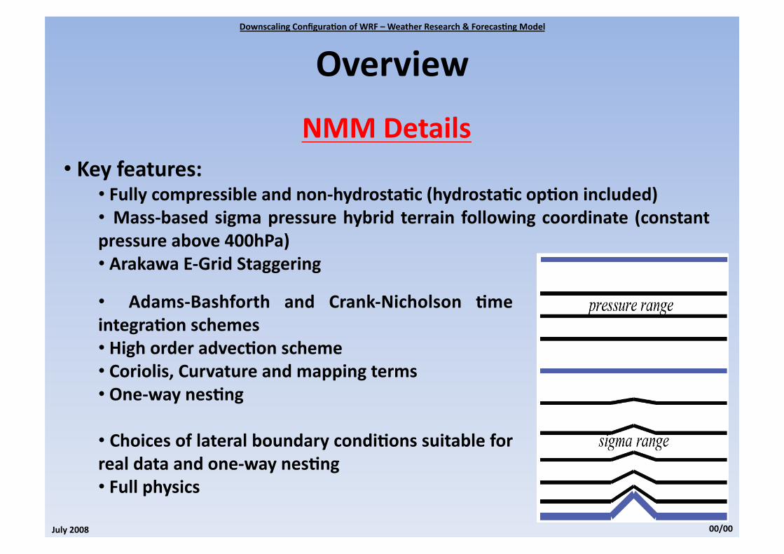
NMMDetails• Keyfeatures:
• Fullycompressibleandnon‐hydrosta0c(hydrosta0cop0onincluded)• Mass‐basedsigmapressurehybridterrain followingcoordinate (constantpressureabove400hPa)• ArakawaE‐GridStaggering
• Adams‐Bashforth and Crank‐Nicholson 0meintegra0onschemes• Highorderadvec0onscheme• Coriolis,Curvatureandmappingterms• One‐waynes0ng
• Choicesoflateralboundarycondi0onssuitableforrealdataandone‐waynes0ng• Fullphysics

DownscalingConfigura0onofWRF–WeatherResearch&Forecas0ngModel
July2008 00/00
Overview
UserSupport• EMAIL:[email protected]
• UserWebPages:• ARW:hep://www.mmm.ucar.edu/wrf/users/• NMM:hep://www.dtcenter.org/wrf‐nmm/users/
• Latestupdateforthemodelingsystem• WRFsoawaredownload• Variousdocuma0on(UserGuide,Technicalnotes,…)
• WRFUsersForum:hep://forum.wrfforum.com/

DownscalingConfigura0onofWRF–WeatherResearch&Forecas0ngModel
July2008 00/00
Overview
WRFVersion3• Nes0ng&movingnests• GlobalWRF• Variable0mestepcapability• NewPhysicsOp0ons• Chemistry• GridandObs.Nudging• WPS(SIreplacement)• WRFDomainWizard• New/Enhancedsupport
• OceanMixedLayer?!?

So2wareInstalla7on
DownscalingConfigura0onofWRF–WeatherResearch&Forecas0ngModel
July2008 00/00

DownscalingConfigura0onofWRF–WeatherResearch&Forecas0ngModel
July2008 00/00
SoawareInstalla0on
RequiredCompilersandScrip0ngLanguages• Fortran90/95Compiler• CCompiler• Perl
Required/Op0onalLibrariestoDownload• netCDF(hep://www.unidata.ucar.edu/)almostalwaysrequired• MPI(hep://www‐unix.mcs.anl.gov/mpi/mpich1/)• JasPer(hep://www.ece.uvic.ca/~mdadams/jasper/)• PNG(hep://www.libpng.org/pub/png/libpng.html)• zlib(hep://www.zlib.net/)

DownscalingConfigura0onofWRF–WeatherResearch&Forecas0ngModel
July2008 00/00
SoawareInstalla0on
UNIXEnvironmentSerngs• WRF_EM_CORE1(ARWCore–Definesthecoretobuild)• WRF_NMM_CORE0(NMMCore–DefinesthecoreNOTtobuild)• WRF_DA_CORE0(Definesnodataassimila0on)• NETCDF<netcdfpath>(Definesthenetcdfloca0on)
• OMP_NUM_THREADSn(Specifythenumberofthreads)• MP_STACK_SIZE64000000(Setitlargetopreventblowups)
DownscalingConfigura0onofWRF–WeatherResearch&Forecas0ngModel
July2008 00/00
SoawareInstalla0on
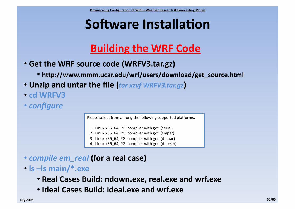
BuildingtheWRFCode• GettheWRFsourcecode(WRFV3.tar.gz)
• hep://www.mmm.ucar.edu/wrf/users/download/get_source.html
• Unzipanduntarthefile(tarxzvfWRFV3.tar.gz)• cdWRFV3• configure
• compileem_real(forarealcase)• ls–lsmain/*.exe
• RealCasesBuild:ndown.exe,real.exeandwrf.exe• IdealCasesBuild:ideal.exeandwrf.exe
PleaseselectfromamongthefollowingsupportedplaJorms.
1.Linuxx86_64,PGIcompilerwithgcc(serial)2.Linuxx86_64,PGIcompilerwithgcc(smpar)3.Linuxx86_64,PGIcompilerwithgcc(dmpar)4.Linuxx86_64,PGIcompilerwithgcc(dm+sm)

DownscalingConfigura0onofWRF–WeatherResearch&Forecas0ngModel
July2008 00/00
SoawareInstalla0on
BuildingtheWPSCode• GettheWPSsourcecode(WPSV3.TAR.gz)
• hep://www.mmm.ucar.edu/wrf/users/download/get_source.html
• Unzipanduntarthefile(tarxzvfWPSV3.tar.gz)• cdWPS• configure
• compile• ls–ls*.exe
• geogrid.exe,ungrib.exeandmetgrid.exe
PleaseselectfromamongthefollowingsupportedplaJorms.
1.PCLinuxx86_64,Intelcompilerserial,NOGRIB22.PCLinuxx86_64,Intelcompilerserial3.PCLinuxx86_64,IntelcompilerDMparallel,NOGRIB24.PCLinuxx86_64,IntelcompilerDMparallel5.PCLinuxx86_64(IA64andOpteron),PGIcompiler5.2or

WRFPreprocessingSystem
DownscalingConfigura0onofWRF–WeatherResearch&Forecas0ngModel
July2008 00/00

DownscalingConfigura0onofWRF–WeatherResearch&Forecas0ngModel
July2008 00/00
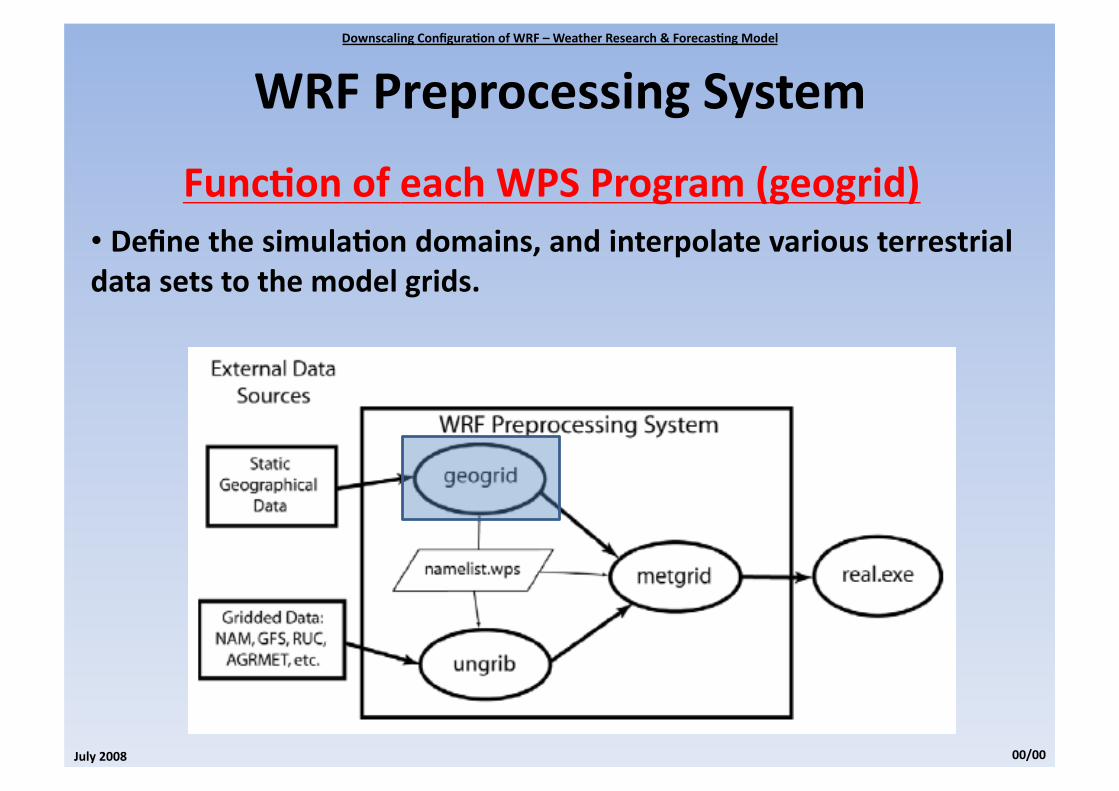
WRFPreprocessingSystem
Introduc0on• TheWRFPreprocessingSystemisasetofthreewhosecollec0veroleistoprepareinputtotheWRFmodelforrealdatasimula0on.
DownscalingConfigura0onofWRF–WeatherResearch&Forecas0ngModel
July2008 00/00
WRFPreprocessingSystem
Func0onofeachWPSProgram(geogrid)• Definethesimula0ondomains,andinterpolatevariousterrestrialdatasetstothemodelgrids.

DownscalingConfigura0onofWRF–WeatherResearch&Forecas0ngModel
July2008 00/00
WRFPreprocessingSystem
Func0onofeachWPSProgram(ungrib)• Reads GRIB files, “degribs” the data, and writes the data in asimple format, called the intermediate format. This files contains0me‐varying meteorological fields. Reads both GRIB1 and GRIB2files.

DownscalingConfigura0onofWRF–WeatherResearch&Forecas0ngModel
July2008 00/00
WRFPreprocessingSystem
Func0onofeachWPSProgram(metgrid)• Horizontallyinterpolatestheintermediateformatmeteorologicaldataintothesimula0ondomainsdefinedbythegeogridprogram.MetgridoutputcanthenbeingestedbytheWRFrealprogram.

DownscalingConfigura0onofWRF–WeatherResearch&Forecas0ngModel
July2008 00/00
WRFPreprocessingSystem
RunningWPS(geogrid)• Step1:Definemodeldomains
Thecoarsedomainandanynesteddomainaredefinedinthe“geogrid”and“share”recordofthenamelist.wpsfile.
&sharewrf_core='ARW',max_dom=2,start_date='2008‐03‐24_12:00:00','2008‐03‐24_12:00:00',end_date='2008‐03‐24_18:00:00','2008‐03‐24_12:00:00',interval_seconds=21600,io_form_geogrid=2/
&geogridparent_id=1,1,parent_grid_ra0o=1,3,i_parent_start=1,31,j_parent_start=1,17,s_we=1,1,e_we=74,112,s_sn=1,1,e_sn=61,97,geog_data_res='10m','2m',dx=30000,dy=30000,map_proj='lambert',ref_lat=34.83,ref_lon=‐81.03,truelat1=30.0,truelat2=60.0,stand_lon=‐98.,geog_data_path='/mmm/users/wrhelp/WPS_GEOG/'/
geogrid.exe
Output:geo_em.dXX.nc

DownscalingConfigura0onofWRF–WeatherResearch&Forecas0ngModel
July2008 00/00
WRFPreprocessingSystem
RunningWPS(ungrib)• Step2:Extrac0ngmeteorologicalfieldsfromGRIBfiles
The first step in extrac0ng fields to the intermediate format involves edi0ng the“share”and“ungrib”namelistrecordsofthenamelist.wpsfile.
&sharewrf_core='ARW',max_dom=2,start_date='2008‐03‐24_12:00:00','2008‐03‐24_12:00:00',end_date='2008‐03‐24_18:00:00','2008‐03‐24_12:00:00',interval_seconds=21600,io_form_geogrid=2/
&ungribout_format='WPS',prefix='FILE'/
ln‐sungrib/Variable_Tables/Vtable.GFSVtablelink_grib.csh<fullpathtogribfiles>/gfs*ungrib.exe
Output:FILE:YYYY‐MM‐DD_HH

DownscalingConfigura0onofWRF–WeatherResearch&Forecas0ngModel
July2008 00/00
WRFPreprocessingSystem
RunningWPS(metgrid)• Step3:Horizontallyinterpola0ngmeteorologicaldata
In the final step ofWPS,meteorological data extracted by ungrib are horizontallyinterpolated to the simula0on grids defined by geogrid. In order to run metgrid, thenamelist.wps file must be edited. In par0cular, the “share” and “metgrid” namelistrecords.
&sharewrf_core='ARW',max_dom=2,start_date='2008‐03‐24_12:00:00','2008‐03‐24_12:00:00',end_date='2008‐03‐24_18:00:00','2008‐03‐24_12:00:00',interval_seconds=21600,io_form_geogrid=2/
&metgridfg_name='FILE',io_form_metgrid=2,/
metgrid.exe
Output:met_em.dXX.YYYY‐MM‐DD_HH:mm:ss.nc(ARW)

WRFModel
DownscalingConfigura0onofWRF–WeatherResearch&Forecas0ngModel
July2008 00/00

DownscalingConfigura0onofWRF–WeatherResearch&Forecas0ngModel
July2008 00/00
WRFModel
Introduc0onTheWRFmodelhastwolargeclassesofsimula0ons:
• IdealIni0aliza0on• RealCases
Ini0al/BoundaryCondi0ons:• 1Dor2Dsounding(Simplifiedorography)• Realcasesrequirepreprocessing(WPSpackage)
• TheWRFmodelexecutable itself isnotalteredbychossingoneini0aliza0on op0on over another, but the WRF model pre‐processorsprograms,arespecificallybuilduponuser’sselec0on.
DownscalingConfigura0onofWRF–WeatherResearch&Forecas0ngModel
July2008 00/00
WRFModel
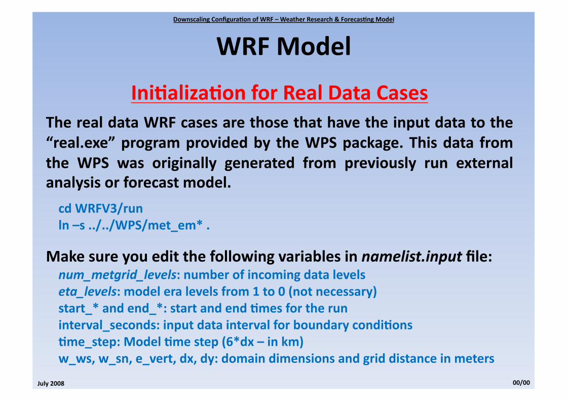
Ini0aliza0onforRealDataCasesTherealdataWRFcasesarethosethathavetheinputdatatothe“real.exe”programprovidedby theWPSpackage.Thisdata fromthe WPS was originally generated from previously run externalanalysisorforecastmodel.
cdWRFV3/runln–s../../WPS/met_em*.
Makesureyoueditthefollowingvariablesinnamelist.inputfile:num_metgrid_levels:numberofincomingdatalevelseta_levels:modeleralevelsfrom1to0(notnecessary)start_*andend_*:startandend0mesfortheruninterval_seconds:inputdataintervalforboundarycondi0ons0me_step:Model0mestep(6*dx–inkm)w_ws,w_sn,e_vert,dx,dy:domaindimensionsandgriddistanceinmeters

DownscalingConfigura0onofWRF–WeatherResearch&Forecas0ngModel
July2008 00/00
WRFModel
Ini0aliza0onforRealDataCasesreal.exe
Output:wrfinput_dXXandwr]dy_dXX
wrf.exe
Output:wrfout_dXX‐YYYY‐MM‐DD_HH_MM_SS

DownscalingConfigura0onofWRF–WeatherResearch&Forecas0ngModel
July2008 00/00
WRFModel
ModelPhysicsMicrophysics(namelistop0on:mp_physics):
1.Kesslerscheme(WarmRain,i.e.noice–Idealizedcases)
2.Linetal.Scheme(Sophis0catedschemethathasice,snowandgraupel)
3.WRFSM3Scheme(Simpleefficientschemewithiceandsnow)
4.WRFSM5Scheme(Allowsmixed‐phaseprocessesandsuper‐cooledwater)
5.ETAMicrophysics(Efficientschemewithmixed‐phaseprocesses)
6.WRFSM6Scheme(Updatedversionofscheme4)
7.GoddardMicrophysicsScheme(Includesice,snowandgraupel)8.Thompsonetal.Scheme(Newschemewithice,snowandgraupel)
10.MorrisonDMScheme(Doublemomentice,snow,rainandgraupel)

DownscalingConfigura0onofWRF–WeatherResearch&Forecas0ngModel
July2008 00/00
WRFModel
ModelPhysicsLongwaveRadia0on(namelistop0on:ra_lw_physics):
1.RRTMScheme(Accountsformul0plebands,tracegases,andmicrophysics)
3.CAMSheme(Allowsforaerosolsandtracegases–CAM3ClimateModel)
99.GFDLScheme(Mul0bandschemewithCO2,ozoneandmicrophysics)
ShortwaveRadia0on(namelistop0on:ra_sw_physics):1.DudhiaScheme(Simpledownwardintegra0on)
2.GoddardShotwave(Two‐streammul0‐bandscheme)
3.CAMScheme(Allowsforaerosolsandtracegases–CAM3ClimateModel)
99.GFDLScheme(ETAOpera0onalScheme)

DownscalingConfigura0onofWRF–WeatherResearch&Forecas0ngModel
July2008 00/00
WRFModel
ModelPhysicsSurfaceLayer(namelistop0on:sf_sfclay_physics):
1.MM5Similarity(Monin‐ObukhovwithCarslon‐Bolandviscoussub‐layer)
2.ETASimilarity(Monin‐ObukhovwithZili0nkevichthermalroughnesslength)
7.Pleim‐XiuSurfaceLayer(?!?NEW?!?)
LandSurface(namelistop0on:sf_surface_physics):1.FiveLayerThermalDiffusion(Onlytemperature)
2.NOAHLandSurfaceModel(Temperature,moistureandsnow/frozensoilphysics)
3.RUCLandSurfaceModel(Temperature,moistureandsnow/frozensoilphysics)
7.Pleim‐XiuLandSurfaceModel(Twolayerwithvegeta0onandsub‐grid0ling)

DownscalingConfigura0onofWRF–WeatherResearch&Forecas0ngModel
July2008 00/00
WRFModel
ModelPhysicsPlanetaryBoundaryLayer(namelistop0on:bl_pbl_physics):
1.YonseiUniversityScheme(Non‐localKprofilewithexplicitentrainment)
2.MYJScheme(1DTKEPrognos0cschemewithlocalver0calmixing)
7.ACMPBL(Nonlocalupwardmixingandlocaldownwardmixing)
99.MRFScheme(Non‐localKmixxedlayerwithimplicitentrainment)
Cumulus(namelistop0on:cu_physics): 1.Kain‐FritschScheme(Deepandshallowconvec0onsub‐gridscheme) 2.Bees‐Miller‐Janjic(Adjustmentschemerelaxingtowardsawellmixedprofile)
3.Grell‐Devenyiensemble(Mul0‐closure,mul0‐parameter,ensemblemethod)
5.Grell3DensembleScheme(Allowssubsidenceinneighboringcolumns) 99.Kain‐Fritsch(Sameas1butwithnoshallowconvec0on)

Post‐ProcessingPrograms
DownscalingConfigura0onofWRF–WeatherResearch&Forecas0ngModel
July2008 00/00


CaseStudy
DownscalingConfigura0onofWRF–WeatherResearch&Forecas0ngModel
July2008 00/00

DownscalingConfigura0onofWRF–WeatherResearch&Forecas0ngModel
July2008 00/00
WRFModel
ModelSetup4NestedDomainSetup(4:1ra0o) 1.120x120pts(64km) 2.161x161pts(16km) 3.241x241pts(4km) 4.281x281pts(1km)
ETOPO2/10mindatabaseECMWFAnalysis
04to09/March/200704to09/August/2003

DownscalingConfigura0onofWRF–WeatherResearch&Forecas0ngModel
July2008 00/00
WRFModel
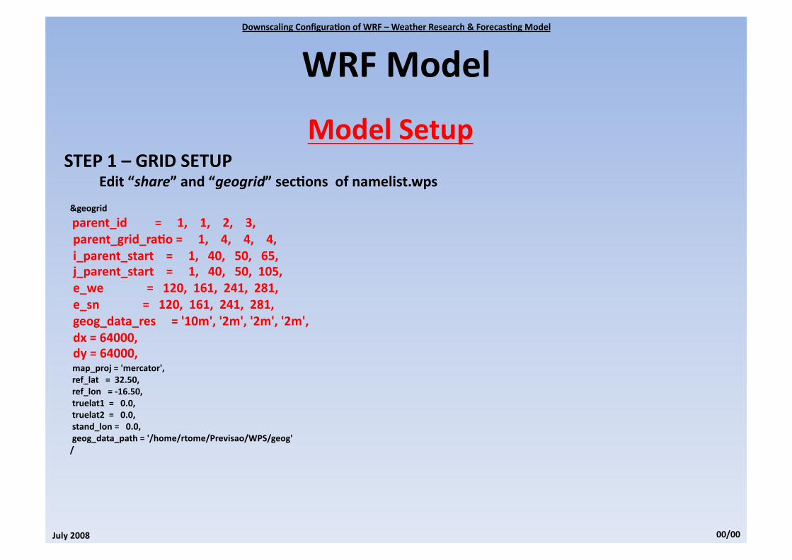
ModelSetupSTEP1–GRIDSETUP
Edit“share”and“geogrid”sec0onsofnamelist.wps
&sharewrf_core='ARW',max_dom=4,start_date='2006‐03‐01_00:00:00','2008‐03‐04_00:00:00','2008‐03‐04_00:00:00','2008‐03‐04_00:00:00',end_date='2006‐03‐01_18:00:00','2008‐03‐09_00:00:00','2008‐03‐09_00:00:00','2008‐03‐09_00:00:00',interval_seconds=21600io_form_geogrid=2,/
&geogridparent_id=1,1,2,3,parent_grid_ra0o=1,4,4,4,i_parent_start=1,40,50,65,j_parent_start=1,40,50,105,e_we=120,161,241,281,e_sn=120,161,241,281,geog_data_res='10m','2m','2m','2m',dx=64000,dy=64000,map_proj='mercator',ref_lat=32.50,ref_lon=‐16.50,truelat1=0.0,truelat2=0.0,stand_lon=0.0,geog_data_path='/home/rtome/Previsao/WPS/geog'/

DownscalingConfigura0onofWRF–WeatherResearch&Forecas0ngModel
July2008 00/00
WRFModel
ModelSetupSTEP1–GRIDSETUP
Edit“share”and“geogrid”sec0onsofnamelist.wps
&share
wrf_core='ARW',max_dom=4,start_date='2006‐03‐01_00:00:00','2008‐03‐04_00:00:00','2008‐03‐04_00:00:00','2008‐03‐04_00:00:00',end_date='2006‐03‐01_18:00:00','2008‐03‐09_00:00:00','2008‐03‐09_00:00:00','2008‐03‐09_00:00:00',interval_seconds=21600io_form_geogrid=2,/

DownscalingConfigura0onofWRF–WeatherResearch&Forecas0ngModel
July2008 00/00
WRFModel
ModelSetupSTEP1–GRIDSETUP
Edit“share”and“geogrid”sec0onsofnamelist.wps
&geogridparent_id=1,1,2,3,parent_grid_ra0o=1,4,4,4,i_parent_start=1,40,50,65,j_parent_start=1,40,50,105,e_we=120,161,241,281,e_sn=120,161,241,281,geog_data_res='10m','2m','2m','2m',dx=64000,dy=64000,
map_proj='mercator',ref_lat=32.50,ref_lon=‐16.50,truelat1=0.0,truelat2=0.0,stand_lon=0.0,geog_data_path='/home/rtome/Previsao/WPS/geog'/
DownscalingConfigura0onofWRF–WeatherResearch&Forecas0ngModel
July2008 00/00
WRFModel
ModelSetupSTEP1–GRIDSETUP
Edit“share”and“geogrid”sec0onsofnamelist.wps
&geogrid
parent_id=1,1,2,3,parent_grid_ra0o=1,4,4,4,i_parent_start=1,40,50,65,j_parent_start=1,40,50,105,e_we=120,161,241,281,e_sn=120,161,241,281,geog_data_res='10m','2m','2m','2m',dx=64000,dy=64000,map_proj='mercator',ref_lat=32.50,ref_lon=‐16.50,truelat1=0.0,truelat2=0.0,stand_lon=0.0,geog_data_path='/home/rtome/Previsao/WPS/geog'/


DownscalingConfigura0onofWRF–WeatherResearch&Forecas0ngModel
July2008 00/00
WRFModel
ModelSetupSTEP1–GRIDSETUP
Edit“share”and“geogrid”sec0onsofnamelist.wps
&geogridparent_id=1,1,2,3,parent_grid_ra0o=1,4,4,4,i_parent_start=1,40,50,65,j_parent_start=1,40,50,105,e_we=120,161,241,281,e_sn=120,161,241,281,geog_data_res='10m','2m','2m','2m',dx=64000,dy=64000,map_proj='mercator',ref_lat=32.50,ref_lon=‐16.50,truelat1=0.0,truelat2=0.0,stand_lon=0.0,
geog_data_path='/home/rtome/Previsao/WPS/geog'/
geogrid.exe

DownscalingConfigura0onofWRF–WeatherResearch&Forecas0ngModel
July2008 00/00
WRFModel
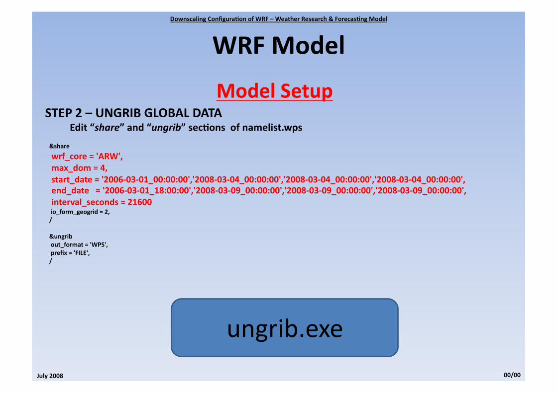
ModelSetupSTEP2–UNGRIBGLOBALDATA
Edit“share”and“ungrib”sec0onsofnamelist.wps
&sharewrf_core='ARW',max_dom=4,start_date='2006‐03‐01_00:00:00','2008‐03‐04_00:00:00','2008‐03‐04_00:00:00','2008‐03‐04_00:00:00',end_date='2006‐03‐01_18:00:00','2008‐03‐09_00:00:00','2008‐03‐09_00:00:00','2008‐03‐09_00:00:00',interval_seconds=21600io_form_geogrid=2,/
&ungribout_format='WPS',prefix='FILE',/

DownscalingConfigura0onofWRF–WeatherResearch&Forecas0ngModel
July2008 00/00
WRFModel
ModelSetupSTEP2–UNGRIBGLOBALDATA
Edit“share”and“ungrib”sec0onsofnamelist.wps
&share
wrf_core='ARW',max_dom=4,start_date='2006‐03‐01_00:00:00','2008‐03‐04_00:00:00','2008‐03‐04_00:00:00','2008‐03‐04_00:00:00',end_date='2006‐03‐01_18:00:00','2008‐03‐09_00:00:00','2008‐03‐09_00:00:00','2008‐03‐09_00:00:00',interval_seconds=21600io_form_geogrid=2,/
&ungribout_format='WPS',prefix='FILE',/
ungrib.exe

DownscalingConfigura0onofWRF–WeatherResearch&Forecas0ngModel
July2008 00/00
WRFModel
ModelSetupSTEP3–HORIZONTALINTERPOLATIONTOOURGRID
Edit“share”and“metgrid”sec0onsofnamelist.wps
&sharewrf_core='ARW',max_dom=4,start_date='2006‐03‐01_00:00:00','2008‐03‐04_00:00:00','2008‐03‐04_00:00:00','2008‐03‐04_00:00:00',end_date='2006‐03‐01_18:00:00','2008‐03‐09_00:00:00','2008‐03‐09_00:00:00','2008‐03‐09_00:00:00',interval_seconds=21600io_form_geogrid=2,/
&metgridfg_name='FILE'io_form_metgrid=2,/

DownscalingConfigura0onofWRF–WeatherResearch&Forecas0ngModel
July2008 00/00
WRFModel
ModelSetupSTEP3–HORIZONTALINTERPOLATIONTOOURGRID
Edit“share”and“metgrid”sec0onsofnamelist.wps
&share
wrf_core='ARW',max_dom=4,start_date='2006‐03‐01_00:00:00','2008‐03‐04_00:00:00','2008‐03‐04_00:00:00','2008‐03‐04_00:00:00',end_date='2006‐03‐01_18:00:00','2008‐03‐09_00:00:00','2008‐03‐09_00:00:00','2008‐03‐09_00:00:00',interval_seconds=21600io_form_geogrid=2,/
&metgridfg_name='FILE'io_form_metgrid=2,/
metgrid.exe

DownscalingConfigura0onofWRF–WeatherResearch&Forecas0ngModel
July2008 00/00
WRFModel
ModelRunVERTICALINTERPOLATIONANDMODELRUN
&0me_controlrun_days=7,run_hours=0,run_minutes=0,run_seconds=0,start_year=2008,2008,2008,2008,start_month=03,03,03,03,start_day=04,04,04,04,start_hour=00,00,00,00,start_minute=00,00,00,00,start_second=00,00,00,00,end_year=2008,2008,2008,2008,end_month=03,03,03,03,end_day=09,09,09,09,end_hour=00,00,00,00,end_minute=00,00,00,00,end_second=00,00,00,00,history_interval=60,60,60,60,input_from_file=.true.,.true.,.true.,.true.,frames_per_ou�ile=21600,21600,21600,21600,restart=.false.,restart_interval_h=36,io_form_history=2io_form_restart=2io_form_input=2io_form_boundary=2debug_level=0auxinput1_inname="met_em.d<domain>.<date>"/
&domains0me_step=1800me_step_fract_num=00me_step_fract_den=1max_dom=4,s_we=1,1,1,1,e_we=120,161,241,281,s_sn=1,1,1,1,e_sn=120,161,241,281,s_vert=1,1,1,1,e_vert=30,30,30,30,num_metgrid_levels=22dx=64000,16000,4000,1000,dy=64000,16000,4000,1000,p_top_requested=5000grid_id=1,2,3,4,parent_id=0,1,2,3,i_parent_start=1,40,50,65,j_parent_start=1,40,50,105,parent_grid_ra0o=1,4,4,4,parent_0me_step_ra0o=1,4,4,4,feedback=1,smooth_op0on=00/

DownscalingConfigura0onofWRF–WeatherResearch&Forecas0ngModel
July2008 00/00
WRFModel
ModelRunVERTICALINTERPOLATIONANDMODELRUN
&physicsmp_physics=1,1,1,1,ra_lw_physics=1,1,1,1,ra_sw_physics=1,1,1,1,radt=30,30,30,30,sf_sfclay_physics=1,1,1,1,sf_surface_physics=1,1,1,1,bl_pbl_physics=1,1,1,1,bldt=0,0,0,0,cu_physics=2,2,2,2,cudt=5,5,5,5,isfflx=1,ifsnow=0,icloud=1,surface_input_source=1,num_soil_layers=5,mp_zero_out=0,maxiens=1,maxens=3,maxens2=3,maxens3=16,ensdim=144,/
real.exe
1.Ver0calInterpola0on
wrf.exe
2.WRFModel

DownscalingConfigura0onofWRF–WeatherResearch&Forecas0ngModel
July2008 00/00
WRFModel