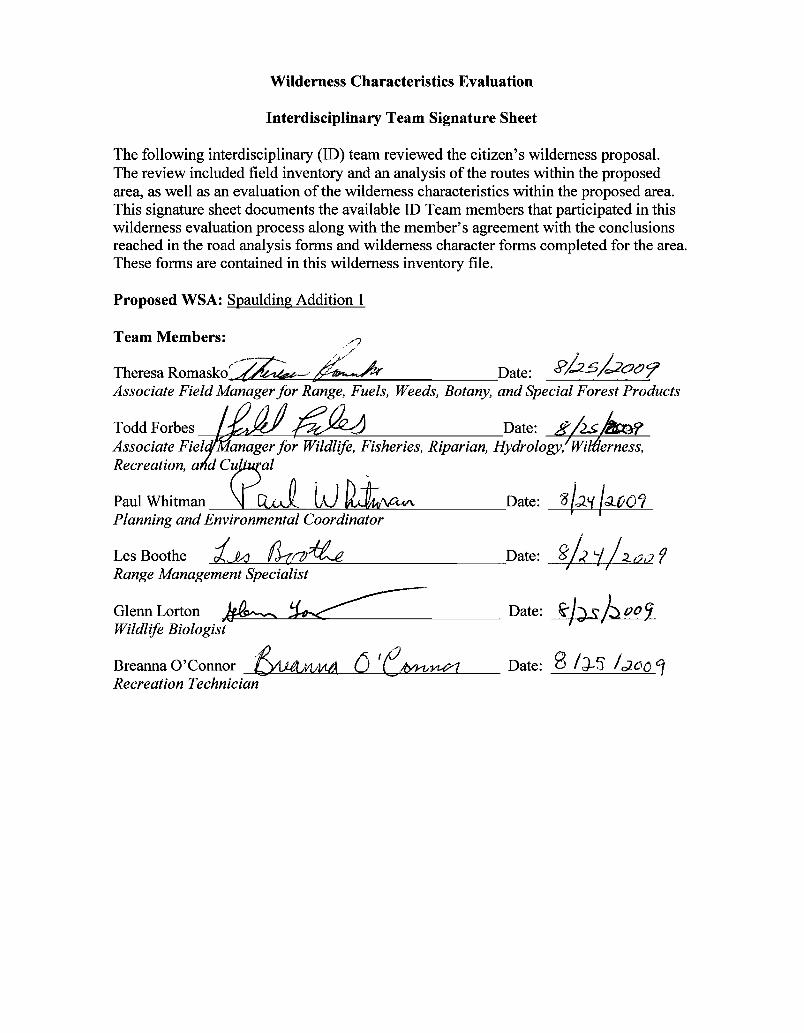
Wilderness Characteristics Evaluation
Interdisciplinary Team Signature Sheet
The following interdisciplinary (ID) team reviewed the citizen's wilderness proposal. The review included field inventory and an analysis of the routes within the proposed area, as well as an evaluation of the wilderness characteristics within the proposed area. This signature sheet documents the available ID Team members that participated in this wilderness evaluation process along with the member's agreement with the conclusions reached in the road analysis forms and wilderness character forms completed for the area. These forms are contained in this wilderness inventory file.
Proposed WSA: Spaulding Addition 1
Team Members: /'? " //
TheresaRomasko('~~ Date: s>J:z--s,L:20cJ'7 Associate Field Manager for Range, Fuels, Weeds, Botany, and Special Forest Products
Recreation, a,{~al
Paul Whitman~ LJ ~'\ctf/\. "8/:1!.( /~tJ01Date: Planning and Environmental Coordinator
Les Boothe tko flno~ Date: goh i /2-U(} f Range Management Specialist
~ I
Glenn Lorton ~~ Date: ~J) ~.btJoi Wildlife Biologist
Breanna 0'ConnorA1AMt!lYJ.-vyy?1 Date: 8 /J-'5 !c;oo'1'& (j 'e Recreation Technician
Todd Forbes
,'l /1 .--. /1
_~ Date: ij2$~ Associate Field/Manager for Wildlife, Fisheries, Riparian, Hydrology~Willierness,

1
Ownership Size
(historic
acres)
Natural
Condition?
Y/N
Outstanding
Solitude?
Y/N
Outstanding
Primitive &
Unconfined
Recreation?
Y/N
Supplemental
Values?
Y/N
BLM 4,640 NA NA NA NA
Year: 2009 Inventory Unit Number/Name: OR-015-139A/Spaulding Reservoir East
FORM 1
DOCUMENTATION OF BLM WILDERNESS INVENTORY
FINDINGS ON RECORD
1. Is there existing BLM wilderness inventory information on all or part of this area?
No __Yes _X_
a) Inventory Source: Wilderness Inventory: Oregon and Washington Final Intensive
Inventory Decisions, November 1980
b) Inventory Unit Name(s)/Number(s):_1-139A/Spaulding Reservoir
c) Map Name(s)/Number(s): U.S. Department of the Interior: Bureau of Land
Management Oregon: Intensive Wilderness Inventory Final Decisions November,
1980
d) BLM District(s)/Field Office(s):_Lakeview District, Lakeview Resource Area.
2. BLM Inventory Findings on Record:
Existing inventory information regarding wilderness characteristics (if more than one BLM
inventory unit is associated with the area, list each unit and answer each question individually for
each inventory unit):
2
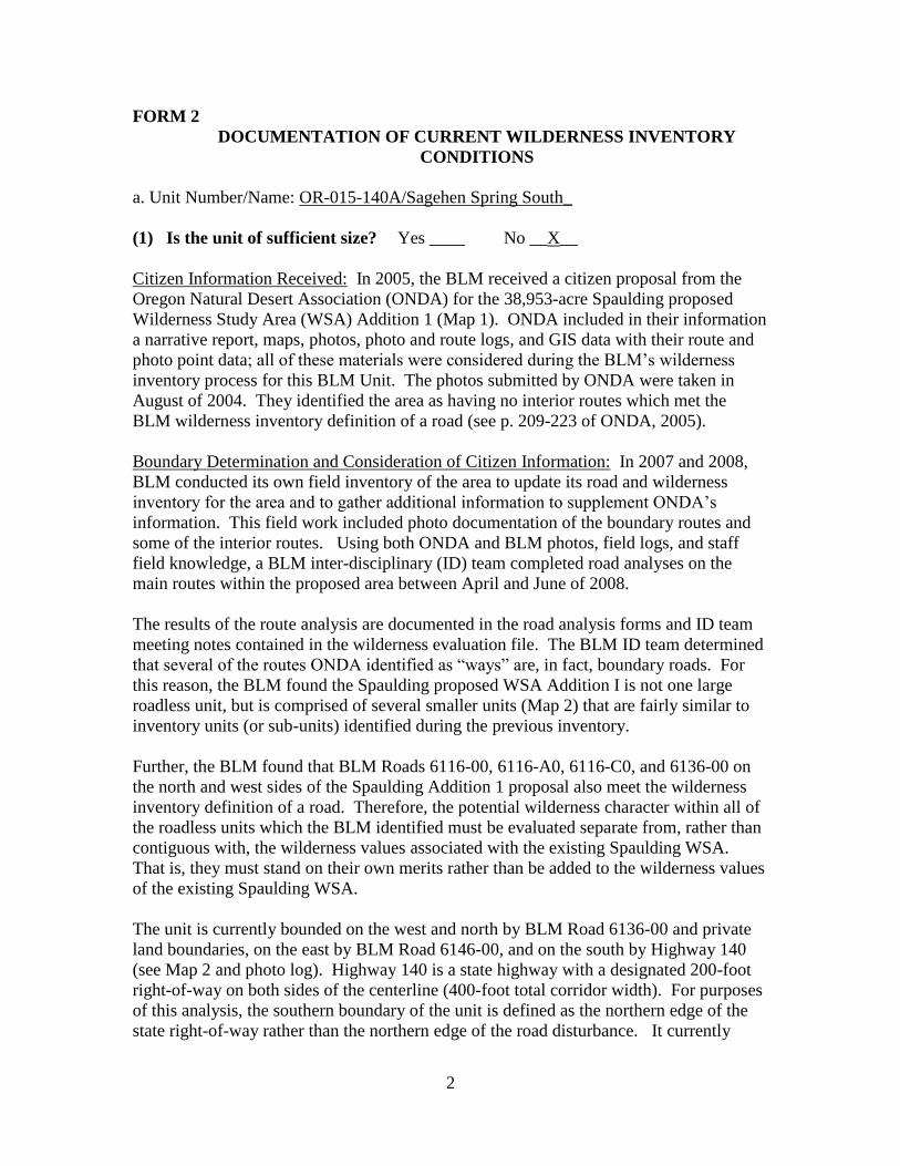
FORM 2
DOCUMENTATION OF CURRENT WILDERNESS INVENTORY
CONDITIONS
a. Unit Number/Name: OR-015-139A/Spaulding Reservoir East
(1) Is the unit of sufficient size? Yes __X__ No _____
Citizen Information Received: In 2005, the BLM received a citizen proposal from the
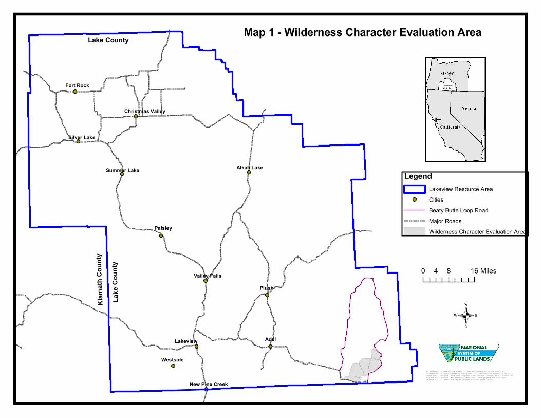
Oregon Natural Desert Association (ONDA) for the 38,953-acre Spaulding proposed
Wilderness Study Area (WSA) Addition 1 (Map 1). ONDA included in their information
a narrative report, maps, photos, photo and route logs, and GIS data with their route and
photo point data; all of these materials were considered during the BLM’s wilderness
inventory process for this BLM Unit. The photos submitted by ONDA were taken in
August of 2004. They identified the area as having no interior routes which met the
BLM wilderness inventory definition of a road (see p. 209-223 of ONDA, 2005).
Boundary Determination and Consideration of Citizen Information: In 2007 and 2008,
BLM conducted its own field inventory of the area to update its road and wilderness
inventory for the area and to gather additional information to supplement ONDA’s
information. This field work included photo documentation of the boundary routes and
some of the interior routes. Using both ONDA and BLM photos, field logs, and staff
field knowledge, a BLM inter-disciplinary (ID) team completed road analyses on the
main routes within the proposed area between April and June of 2008.
The results of the route analysis are documented in the road analysis forms and ID team
meeting notes contained in the wilderness evaluation file. The BLM ID team determined
that several of the routes ONDA identified as “ways” are, in fact, boundary roads. For
this reason, the BLM found the Spaulding proposed WSA Addition I is not one large
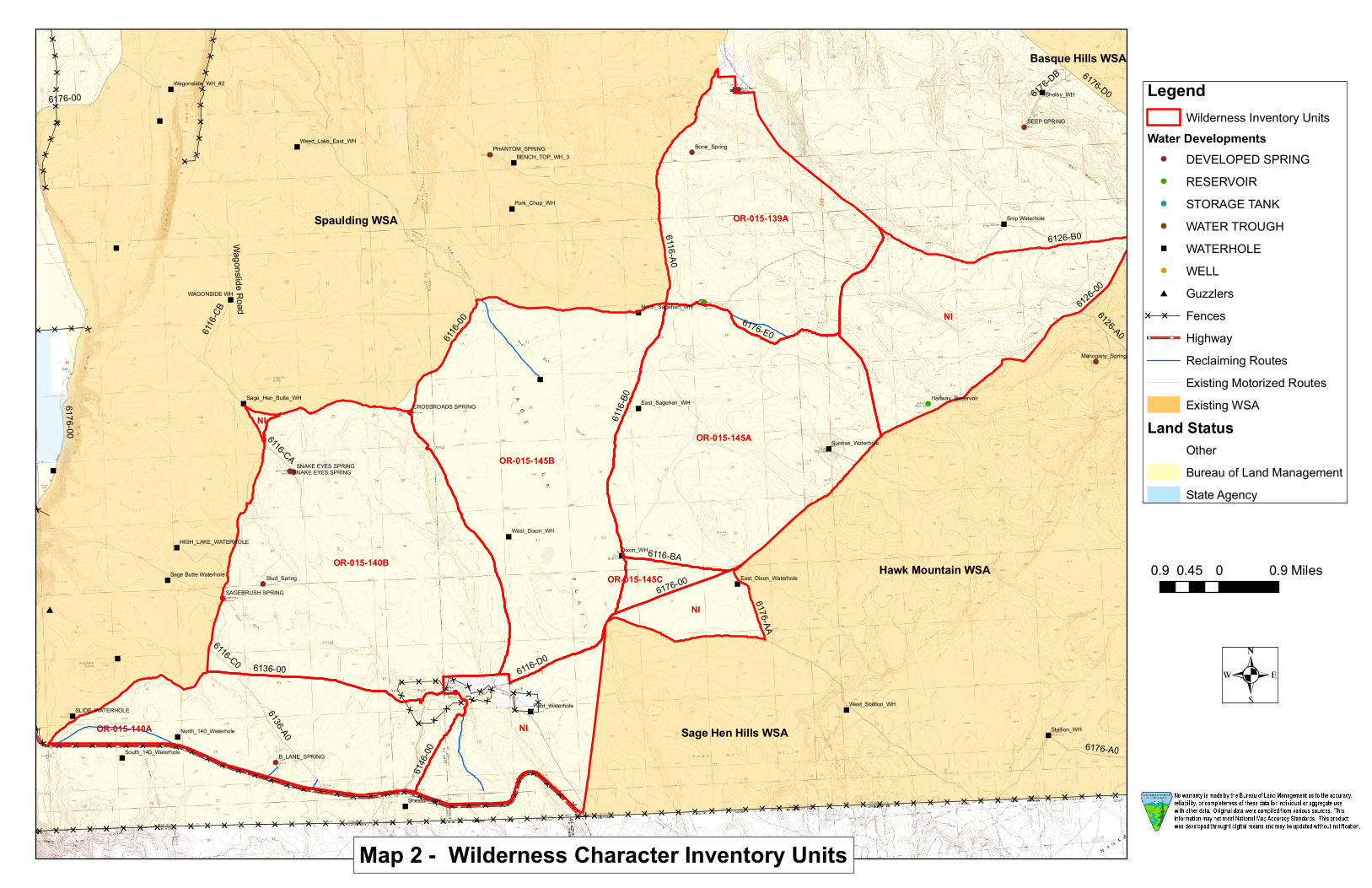
roadless unit, but is comprised of several smaller units (Map 2) that are fairly similar to
inventory units (or sub-units) identified during the previous inventory.
Further, the BLM found that BLM Roads 6116-00, 6116-A0, 6116-C0, and 6136-00 on
the north and west sides of the Spaulding Addition 1 proposal also meet the wilderness
inventory definition of a road. Therefore, the potential wilderness character within all of
the roadless units which the BLM identified must be evaluated separate from, rather than
contiguous with, the wilderness values associated with the existing Spaulding WSA.
That is, they must stand on their own merits rather than be added to the wilderness values
of the existing Spaulding WSA.
It is bounded on the west by BLM Road 6116-A0 and private lands, on the east by BLM
Road 6176-00 and private lands, and on the south by 6116-00 and an unnumbered road
(referred to as 6176 C in 1980 inventory) (Map 2). (Refer to the road analysis forms,
photos, photo logs, and BLM ID team minutes in the wilderness inventory file for
additional supporting information regarding these boundary determinations).
3
In the 1980 inventory, this subunit was split out from subunit 1-139B (Spaulding WSA)
based on the presence of BLM Road 6116-A0-A (referred to formerly as BLM Road
6176 B) dividing unit 1-139 into two subunits. The earlier inventory estimated this area
as encompassing approximately 4,640 acres of BLM-administered lands (BLM 1980b).
The unit was eliminated from further study in 1980 due to the size estimate being less
than 5,000 acres. However, the current size estimate for this unit is 5,410 acres.
Following this boundary determination, the BLM ID team subsequently evaluated the
wilderness characteristics within this unit. The results are contained in the following
section. Additional background on the process that the BLM ID team followed during
this evaluation is contained in the document, Wilderness Inventory Maintenance Process
for the Lakeview Resource Area, BLM, and the ID team meeting notes contained in the
wilderness inventory file.
DESCRIPTION OF CURRENT CONDITIONS:
The unit is located approximately 32 miles east of Adel, Oregon, and north of the
Sheldon National Antelope Refuge (Maps 1 and 2).
(2) Is the unit in a natural condition? Yes _X_ No __ __ N/A _____
1980 Unit Description: The 1980 inventory did not describe this sub-unit in detail due to
the initial finding of small size.
Current Condition Description: Elevation across the unit ranges from about 5,700 feet
to 6,200 feet and includes several small buttes and ridges. Based on a review of recent
ecological site inventory data, the vegetation within the sub-unit is dominated by a
mixture of low and big sagebrush and associated native grasses.
About 3 miles of BLM Road 6116-00 cuts across the southeast portion of the unit (Map
2). This route was found not to meet the wilderness definition of a road in 1980 or during
the current evaluation. In addition, a naturally reclaiming route about a mile in length is
located along the southern boundary.
One man-made reservoir, Rock Reservoir, exists along the southwestern boundary. One
undeveloped spring occurs near the northeast corner of the unit. One developed spring
exists in the northwestern portion of the unit (Map 2). Developed springs typically
include a small, fenced exclosure surrounding the spring site and a short piece of pipe
extending to one or more water troughs located outside of the exclosure. Reservoirs
typically involve construction of a small earthen dam across a drainage using heavy
machinery, and are designed to capture seasonal runoff. Reservoirs typically cover 0.5 to
2 surface acres. Most of these man-made developments are substantially noticeable
within close distances (up to a quarter mile) and less noticeable from farther distances.
4
The entire sub-unit falls within the Beatty Butte wild horse herd management area
(HMA) (see Map SMA-4, BLM 2003b). Wild horses were introduced into the west by
man starting in the 1500’s and are protected under the Wild Horse and Burro Act of
1971.
Despite the presence of human disturbances described above, the BLM ID team
concluded that overall, the majority of this unit is in a natural condition where the imprint
of man is substantially unnoticeable.
(3) Does the unit have outstanding opportunities for solitude?
Yes_____ No __X__ N/A _____
1980 Unit Description: The 1980 inventory did not evaluate the opportunities for
solitude within this sub-unit due to its failure to meet the minimum size criteria.
Current Condition Description: The unit has some rolling topography, including a
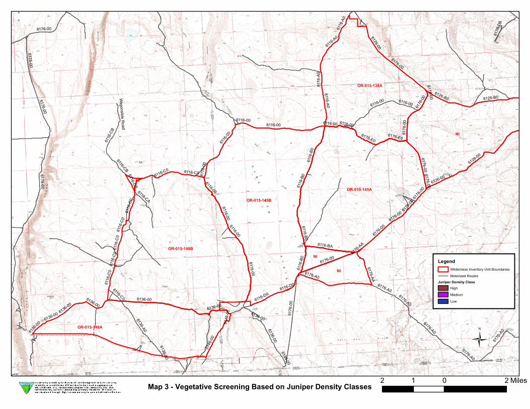
ridgeline running parallel to the northeast boundary, and some taller sagebrush that
provides some limited screening that would allow some opportunity to avoid the presence
of others within the northeastern half of the unit (Map 3). However, due to the relatively
small size of the unit, it is still not possible to avoid others within the flatter southwestern
half of the unit.
The most common visitors to the unit include livestock permittees, BLM staff,
researchers, and hunters. The continued presence of boundary roads and internal
motorized routes (BLM Road 6116-00; Map 2) provides motorized access to the entire
perimeter of the unit, as well as a substantial portion of the southeastern interior of the
unit. This motorized access increases the actual likelihood of encountering other people
visiting the unit. The noise level associated with motorized activity diminishes solitude
and the overall quality of the recreational experience for those visitors attempting to get
away from others.
For these reasons, the BLM ID team found that the opportunities for solitude within this
unit are not outstanding, nor is the area being managed specifically to provide an
outstanding opportunity for solitude.
(4) Does the unit have outstanding opportunities for primitive and unconfined
recreation? Yes _____ No __X___ N/A _____
1980 Unit Description: The 1980 inventory did not evaluate the opportunities for
primitive recreation within this sub-unit due to its failure to meet the minimum size
criteria.
Current Condition Description: ONDA’s inventory report (2005) identified the
surrounding area as having outstanding opportunities for hiking, horseback riding,
photography, wildlife viewing, hunting, and camping (page 213) based on the premise
5
that their proposed Spaulding WSA addition is one, large roadless area. As noted above,
this proposal is not one large, roadless area, but is in fact comprised of several smaller
roadless inventory units which must be evaluated individually.
The Lakeview RMP/ROD (Map R-7; BLM 2003b) shows that the entire unit is open to
off-highway vehicle (OHV) use, demonstrating that the area is being managed primarily
for motorized recreation opportunities. In 2008, the BLM ID Team considered the
primitive recreation opportunities identified by ONDA, and found that while this unit has
some limited potential for hunting, hiking, or horse-back riding, they are similar to those
opportunities available throughout much of the Lakeview Resource Area, and are not
unique or outstanding.
Currently, there are about 3 miles of existing internal primitive motorized routes (Map 2)
that provide access to portions of the interior of the unit. This further limits the ability to
have a primitive (non-motorized) recreational experience. Field observations by BLM
staff have confirmed that people are, in fact, using motorized vehicles on and off of
existing roads to access the surrounding public lands for a variety of reasons including
recreation.
The unit does not provide a single, unique primitive recreational opportunity, nor does it
provide a unique diversity of primitive recreation opportunities. For these reasons, the
BLM ID team determined that primitive and unconfined recreation opportunities within
this unit are not outstanding.
(5) Does the unit have supplemental values? Yes _____ No ____ NA _X_
Description: Supplemental values were not evaluated as the unit does not meet the
minimum wilderness criteria.
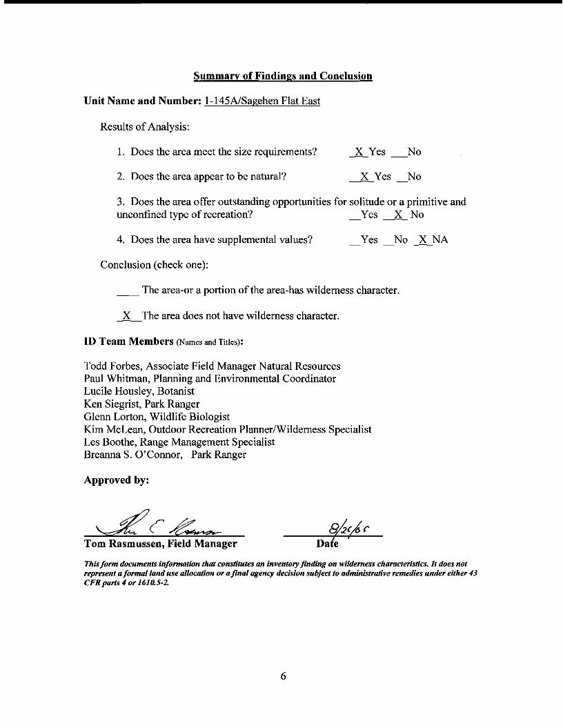
Summary of Findings and Conclusion
Unit Name and Number: Spaulding Reservoir East/OR-OI5-139A
Results of Analysis:
1. Does the area meet the size requirements? X Yes No
2. Does the area appear to be natural? X Yes No
3. Does the area offer outstanding opportunities for solitude or a primitive and unconfined type of recreation? _Yes ~ No
4. Does the area have supplemental values? Yes No lNA
Conclusion (check one):
__ The area-or a portion of the area-has wilderness character.
~~The area does not have wilderness character.
ID Team Members (Names and Titles):
Todd Forbes, Associate Field Manager Natural Resources Paul Whitman, Planning and Environmental Coordinator Lucile Housley, Botanist Ken Siegrist, Park Ranger Glenn Lorton, Wildlife Biologist Kim McLean, Outdoor Recreation Planner/Wilderness Specialist Les Boothe, Range Management Specialist Breanna S. O'Connor, Park Ranger
Approved by:
~~~ ~Cd7 Tom Rasmussen, Field Manager 7 Date
This form documents information that constitutes an inventory finding on wilderness characteristics. It does not represent a formal land use allocation or a final agency decision subject to administrative remedies under either 43 CFRpans 4 or 1610.5-2.
6
1
Ownership Size
(historic
acres)
Natural
Condition?
Y/N
Outstanding
Solitude?
Y/N
Outstanding
Primitive &
Unconfined
Recreation?
Y/N
Supplemental
Values?
Y/N
BLM 4,040 NA NA NA NA
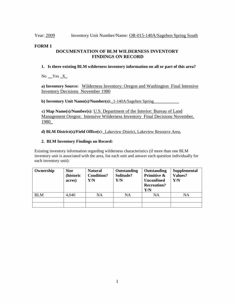
Year: 2009 Inventory Unit Number/Name: OR-015-140A/Sagehen Spring South
FORM 1
DOCUMENTATION OF BLM WILDERNESS INVENTORY
FINDINGS ON RECORD
1. Is there existing BLM wilderness inventory information on all or part of this area?
No __Yes _X_
a) Inventory Source: Wilderness Inventory: Oregon and Washington Final Intensive
Inventory Decisions November 1980
b) Inventory Unit Name(s)/Number(s):_1-140A/Sagehen Spring____________
c) Map Name(s)/Number(s): U.S. Department of the Interior: Bureau of Land
Management Oregon: Intensive Wilderness Inventory Final Decisions November,
1980_
d) BLM District(s)/Field Office(s):_Lakeview District, Lakeview Resource Area.
2. BLM Inventory Findings on Record:
Existing inventory information regarding wilderness characteristics (if more than one BLM
inventory unit is associated with the area, list each unit and answer each question individually for
each inventory unit):
2
FORM 2
DOCUMENTATION OF CURRENT WILDERNESS INVENTORY
CONDITIONS
a. Unit Number/Name: OR-015-140A/Sagehen Spring South_
(1) Is the unit of sufficient size? Yes ____ No __X__
Citizen Information Received: In 2005, the BLM received a citizen proposal from the
Oregon Natural Desert Association (ONDA) for the 38,953-acre Spaulding proposed
Wilderness Study Area (WSA) Addition 1 (Map 1). ONDA included in their information
a narrative report, maps, photos, photo and route logs, and GIS data with their route and
photo point data; all of these materials were considered during the BLM’s wilderness
inventory process for this BLM Unit. The photos submitted by ONDA were taken in
August of 2004. They identified the area as having no interior routes which met the
BLM wilderness inventory definition of a road (see p. 209-223 of ONDA, 2005).
Boundary Determination and Consideration of Citizen Information: In 2007 and 2008,
BLM conducted its own field inventory of the area to update its road and wilderness
inventory for the area and to gather additional information to supplement ONDA’s
information. This field work included photo documentation of the boundary routes and
some of the interior routes. Using both ONDA and BLM photos, field logs, and staff
field knowledge, a BLM inter-disciplinary (ID) team completed road analyses on the
main routes within the proposed area between April and June of 2008.
The results of the route analysis are documented in the road analysis forms and ID team
meeting notes contained in the wilderness evaluation file. The BLM ID team determined
that several of the routes ONDA identified as “ways” are, in fact, boundary roads. For
this reason, the BLM found the Spaulding proposed WSA Addition I is not one large
roadless unit, but is comprised of several smaller units (Map 2) that are fairly similar to
inventory units (or sub-units) identified during the previous inventory.
Further, the BLM found that BLM Roads 6116-00, 6116-A0, 6116-C0, and 6136-00 on
the north and west sides of the Spaulding Addition 1 proposal also meet the wilderness
inventory definition of a road. Therefore, the potential wilderness character within all of
the roadless units which the BLM identified must be evaluated separate from, rather than
contiguous with, the wilderness values associated with the existing Spaulding WSA.
That is, they must stand on their own merits rather than be added to the wilderness values
of the existing Spaulding WSA.
The unit is currently bounded on the west and north by BLM Road 6136-00 and private
land boundaries, on the east by BLM Road 6146-00, and on the south by Highway 140
(see Map 2 and photo log). Highway 140 is a state highway with a designated 200-foot
right-of-way on both sides of the centerline (400-foot total corridor width). For purposes
of this analysis, the southern boundary of the unit is defined as the northern edge of the
state right-of-way rather than the northern edge of the road disturbance. It currently
3
encompasses approximately 4,601 acres of BLM-administered lands. Due to the unit’s
small size (less than 5,000 acres) it was not evaluated further in 1980. The unit is still
less than 5,000 acres in size and does not meet the minimum size criteria or any
exceptions to the size criteria.
(Refer to the road analysis forms, photos, photo logs, and BLM ID team minutes in the
wilderness inventory file for additional supporting information regarding these boundary
determinations). Additional background on the process that the BLM ID team followed
during this evaluation is contained in the document, Wilderness Inventory Maintenance
Process for the Lakeview Resource Area, BLM, and the ID team meeting notes contained
in the wilderness inventory file.
DESCRIPTION OF CURRENT CONDITIONS:
This small, narrow unit and is located approximately 25 miles southeast of Adel, Oregon
(Maps 1 and 2).
(2) Is the unit in a natural condition? Yes ___ No __ __ N/A __X__
Description: Since the unit did not meet the minimum size criteria or any of the
exceptions to the size criteria, the natural quality was not evaluated.
(3) Does the unit have outstanding opportunities for solitude?
Yes_____ No _____ N/A __X___
Description: Since the unit did not meet the minimum size criteria or any of the
exceptions to the size criteria, the opportunities for solitude were not evaluated.
(4) Does the unit have outstanding opportunities for primitive and unconfined
recreation? Yes _____ No _____ N/A __X___
Description: Since the unit did not meet the minimum size criteria or any of the
exceptions to the size criteria, the recreation opportunities were not evaluated.
(5) Does the unit have supplemental values? Yes _____ No ____ NA _X_
Description: Since the unit did not meet the minimum size criteria or any of the
exceptions to the size criteria, the supplemental values were not evaluated.
Summary of Findings and Conclusion
Unit Name and Number: OR-015-140A/ Sagehen Spring South
Results ofAnalysis:
1. Does the area meet any of the size requirements? Yes -----.2LNo
2. Does the area appear to be natural? Yes No ~NA
3. Does the area offer outstanding opportunities for solitude or a primitive and unconfined type of recreation? __Yes _No ~NA
4. Does the area have supplemental values? Yes No ~NA
Conclusion (check one):
__ The area-or a portion of the area-has wilderness character.
~The area does not have wilderness character.
ID Team Members (Names and Titles):
Todd Forbes, Associate Field Manager Natural Resources Paul Whitman, Planning and Environmental Coordinator Lucile Housley, Botanist Ken Siegrist, Park Ranger Glenn Lorton, Wildlife Biologist Kim McLean, Outdoor Recreation Planner/Wilderness Specialist Les Boothe, Range Management Specialist Breanna S. O'Connor, Park Ranger
Approved by:
Lc~ 5xfc(61' Tom Rasmussen, Field Manager 7Date
This form documents information that constitutes an inventory finding on wilderness characteristics. It does not represent a formal land use allocation or a final agency decision subject to administrative remedies under either 43 CFRparts 4 or 1610.5-2.
4

1
Ownership Size
(historic
acres)
Natural
Condition?
Y/N
Outstanding
Solitude?
Y/N
Outstanding
Primitive &
Unconfined
Recreation?
Y/N
Supplemental
Values?
Y/N
BLM 9,400 Y N N NA
Year: 2009 Inventory Unit Number/Name: OR-015-140B/Sagehen Spring North
FORM 1
DOCUMENTATION OF BLM WILDERNESS INVENTORY
FINDINGS ON RECORD
1. Is there existing BLM wilderness inventory information on all or part of this area?
No __Yes _X_
a) Inventory Source: Wilderness Inventory: Oregon and Washington Final Intensive
Inventory Decisions, November 1980
b) Inventory Unit Name(s)/Number(s):_1-140B/Sagehen Spring___________
c) Map Name(s)/Number(s): U.S. Department of the Interior: Bureau of Land
Management Oregon: Intensive Wilderness Inventory Final Decisions November,
1980_
d) BLM District(s)/Field Office(s):_Lakeview District, Lakeview Resource Area.
2. BLM Inventory Findings on Record:
Existing inventory information regarding wilderness characteristics (if more than one BLM
inventory unit is associated with the area, list each unit and answer each question individually for
each inventory unit):
2
FORM 2
DOCUMENTATION OF CURRENT WILDERNESS INVENTORY
CONDITIONS
a. Unit Number/Name: OR-015-140B/Sagehen Spring North
(1) Is the unit of sufficient size? Yes __X__ No _____
Citizen Information Received: In 2005, the BLM received a citizen proposal from the
Oregon Natural Desert Association (ONDA) for the 38,953-acre Spaulding proposed
Wilderness Study Area (WSA) Addition 1 (Map 1). ONDA included in their information
a narrative report, maps, photos, photo and route logs, and GIS data with their route and
photo point data; all of these materials were considered during the BLM’s wilderness
inventory process for this BLM Unit. The photos submitted by ONDA were taken in
August of 2004. They identified the area as having no interior routes which met the
BLM wilderness inventory definition of a road (see p. 209-223 of ONDA, 2005).
Boundary Determination and Consideration of Citizen Information: In 2007 and 2008,
BLM conducted its own field inventory of the area to update its road and wilderness
inventory for the area and to gather additional information to supplement ONDA’s
information. This field work included photo documentation of the boundary routes and
some of the interior routes. Using both ONDA and BLM photos, field logs, and staff
field knowledge, a BLM inter-disciplinary (ID) team completed road analyses on the
main routes within the proposed area between April and June of 2008.
The results of the route analysis are documented in the road analysis forms and ID team
meeting notes contained in the wilderness evaluation file. The BLM ID team determined
that several of the routes ONDA identified as “ways” are, in fact, boundary roads. For
this reason, the BLM found the Spaulding proposed WSA Addition I is not one large
roadless unit, but is comprised of several smaller units (Map 2) that are fairly similar to
inventory units (or sub-units) identified during the previous inventory.
Further, the BLM found that BLM Roads 6116-00, 6116-A0, 6116-C0, and 6136-00 on
the north and west sides of the Spaulding Addition 1 proposal also meet the wilderness
inventory definition of a road. Therefore, the potential wilderness character within all of
the roadless units which the BLM identified must be evaluated separate from, rather than
contiguous with, the wilderness values associated with the existing Spaulding WSA.
That is, they must stand on their own merits rather than be added to the wilderness values
of the existing Spaulding WSA.
Currently the unit is bounded on the west and north by BLM Road 6116-C0, on the east
by BLM Road 6116-00, and on the south by BLM Road 6136-00 and private lands (Map
2). It encompasses approximately 9,593 acres of BLM-administered lands. (Refer to the
road analysis forms, photos, photo logs, and BLM ID team minutes in the wilderness
inventory file for additional supporting information regarding these boundary
determinations).
3
Following this boundary determination, the BLM ID team subsequently evaluated the
wilderness characteristics within this unit. The results are contained in the following
section. Additional background on the process that the BLM ID team followed during
this evaluation is contained in the document, Wilderness Inventory Maintenance Process
for the Lakeview Resource Area, BLM, and the ID team meeting notes contained in the
wilderness inventory file.
DESCRIPTION OF CURRENT CONDITIONS:
The unit is located approximately 24 miles southeast of Adel, Oregon, and north of the
Sheldon National Antelope Refuge (Maps 1 and 2).
(2) Is the unit in a natural condition? Yes _X_ No __ __ N/A _____
1980 Unit Description: The previous inventory (BLM 1980b) described this unit as
containing sagebrush flats and low, rolling terrain with minor drainages. On the (south)
east side of the unit a small canyon exists east of Sagehen Spring on private land.
Elevation ranges from about 5,900 feet to 6,200 feet.
In 1980, the unit contained two developed springs and one short way in the northwest
corner of the unit which were found to be substantially unnoticeable. The unit as a whole
was found to retain a generally natural condition where the imprints of man were
substantially unnoticeable (BLM 1980b).
Current Condition Description: The vegetation has not changed substantially since the
previous inventory.
The unit currently contains one undeveloped spring and five developed springs: Snake
Eyes Springs in the northwest, Crossroads Spring in the northeast, and Stud and
Sagebrush Springs in the southwest (Map 2 and photo log). Developed springs typically
include fenced exclosures surrounding the spring site and a short pipeline extending to
one or more water troughs located outside of the exclosure.
In addition, the interior of the unit currently contains about 6.8 miles of primitive,
motorized routes, and 1.3 miles of fence surrounding Sagehen Creek (Map 2). These
man-made disturbances are substantially noticeable within close distances (up to a
quarter mile) and less noticeable from farther distances.
The entire unit falls within the Beatty Butte wild horse herd management area (HMA)
(see Map SMA-4, BLM 2003b). Wild horses were introduced into the west by man
starting in the 1500’s and are protected under the Wild Horse and Burro Act of 1971.
Despite the increase in human disturbances since 1980, the BLM ID team concluded that
overall, the majority of this unit is in a natural condition where the imprint of man is
substantially unnoticeable.

4
(3) Does the unit have outstanding opportunities for solitude?
Yes_____ No __X__ N/A _____
1980 Unit Description: The 1980 inventory found the unit had only gently rolling
contours in limited areas of the unit that were capable of providing screening from the
sights and sounds of others in the unit. There is one extended (side) slope paralleling
BLM Road 6116-00 along the east side of the unit that drops off onto Sage Hen Flats to
the east. The topography and small unit size prevented the area from providing an
outstanding opportunity for solitude. In addition, the existing short sagebrush cover did
not provide significant screening.
Current Condition Description: The terrain and vegetation characteristics within the
unit have not changed since 1980. The topography and short vegetation continues to fail
to provide adequate screening from others within the unit (Map 3).
The most common visitors to the unit include livestock permittees, private land owners,
BLM staff, researchers, and hunters. The continued presence of boundary roads and
internal motorized routes (Map 2) provides motorized access to the entire perimeter of
the unit, as well as portions of the interior of the unit. This motorized access increases
the actual likelihood of encountering other people visiting the unit. The noise level
associated with motorized activity diminishes solitude and the overall quality of the
recreational experience for those visitors attempting to get away from others.
For these reasons, the BLM ID team found that the opportunities for solitude within this
unit have not changed since 1980 and are not outstanding, nor is the area being managed
specifically to provide an outstanding opportunity for solitude.
(4) Does the unit have outstanding opportunities for primitive and unconfined
recreation? Yes _____ No __X___ N/A _____
1980 Unit Description: The 1980 inventory noted this unit had the potential for hunting
and trapping, along with limited hiking and horseback riding opportunities. However,
these opportunities were not found to be outstanding due to the unit’s size.
Current Condition Description: ONDA’s inventory report (2005) identified the
surrounding area as having outstanding opportunities for hiking, horseback riding,
photography, wildlife viewing, hunting, and camping (page 213) based on the premise
that their proposed Spaulding WSA addition is one, large roadless area. As noted above,
this proposal is not one large, roadless area, but is in fact comprised of several smaller
roadless inventory units which must be evaluated individually.
The Lakeview RMP/ROD (Map R-7; BLM 2003b) shows that the entire unit is open to
off-highway vehicle (OHV) use, demonstrating that the area is being managed primarily
for motorized recreation opportunities. In 2008, the BLM ID Team considered primitive
5
recreation opportunities identified in 1980 and those identified by ONDA, but did not
find these opportunities to be unique or outstanding.
Currently, there are about 6.8 miles of existing internal primitive motorized routes (Map
2) that provide access to portions of the interior of the unit. This further limits the ability
to have a primitive (non-motorized) recreational experience. Field observations by BLM
staff have confirmed that people are, in fact, using motorized vehicles on and off of
existing roads to access the surrounding public lands for a variety of reasons including
recreation.
The recreation opportunities are similar other BLM lands within the Lakeview Resource
Area. The unit does not provide a single, unique primitive recreational opportunity, nor
does it provide a unique diversity of primitive recreation opportunities. For these
reasons, the BLM ID team determined that primitive and unconfined recreation
opportunities within this unit have not changed since 1980. The unit continues to lack an
outstanding opportunity for primitive and unconfined recreation.
(5) Does the unit have supplemental values? Yes _____ No ____ NA _X_
Description: Supplemental values were not evaluated as the unit does not meet the
minimum wilderness criteria.
JJ~ ~0r Tom Rasmussen, Field Manager te
This form documents information that constitutes an inventory finding on wilderness characteristics. It does not represent a formal land use allocation or a final agency decision subject to administrative remedies under either 43 CFRparts 4 or 1610.5-2.
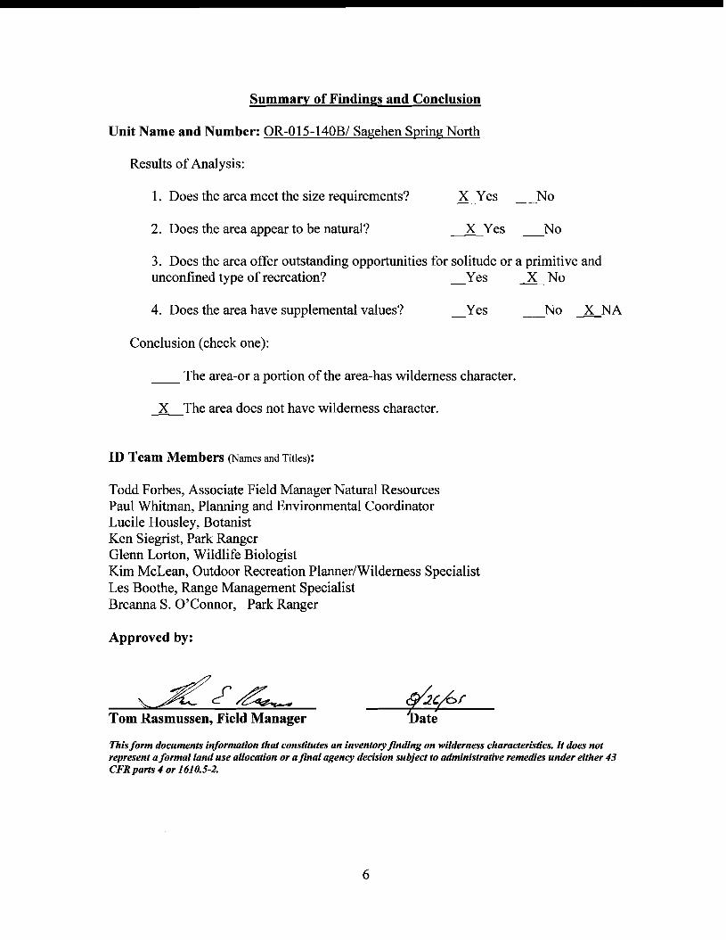
Summary of Findings and Conclusion
Unit Name and Number: OR-OI5-140B/ Sagehen Spring North
Results of Analysis:
1. Does the area meet the size requirements? X Yes No
2. Does the area appear to be natural? X Yes No
3. Does the area offer outstanding opportunities for solitude or a primitive and unconfined type of recreation? _Yes l No
4. Does the area have supplemental values? Yes No X NA
Conclusion (check one):
__ The area-or a portion of the area-has wilderness character.
.-K..-The area does not have wilderness character.
ID Team Members (Names and Titles):
Todd Forbes, Associate Field Manager Natural Resources Paul Whitman, Planning and Environmental Coordinator Lucile Housley, Botanist Ken Siegrist, Park Ranger Glenn Lorton, Wildlife Biologist Kim McLean, Outdoor Recreation Planner/Wilderness Specialist Les Boothe, Range Management Specialist Breanna S. O'Connor, Park Ranger
Approved by:
6
1
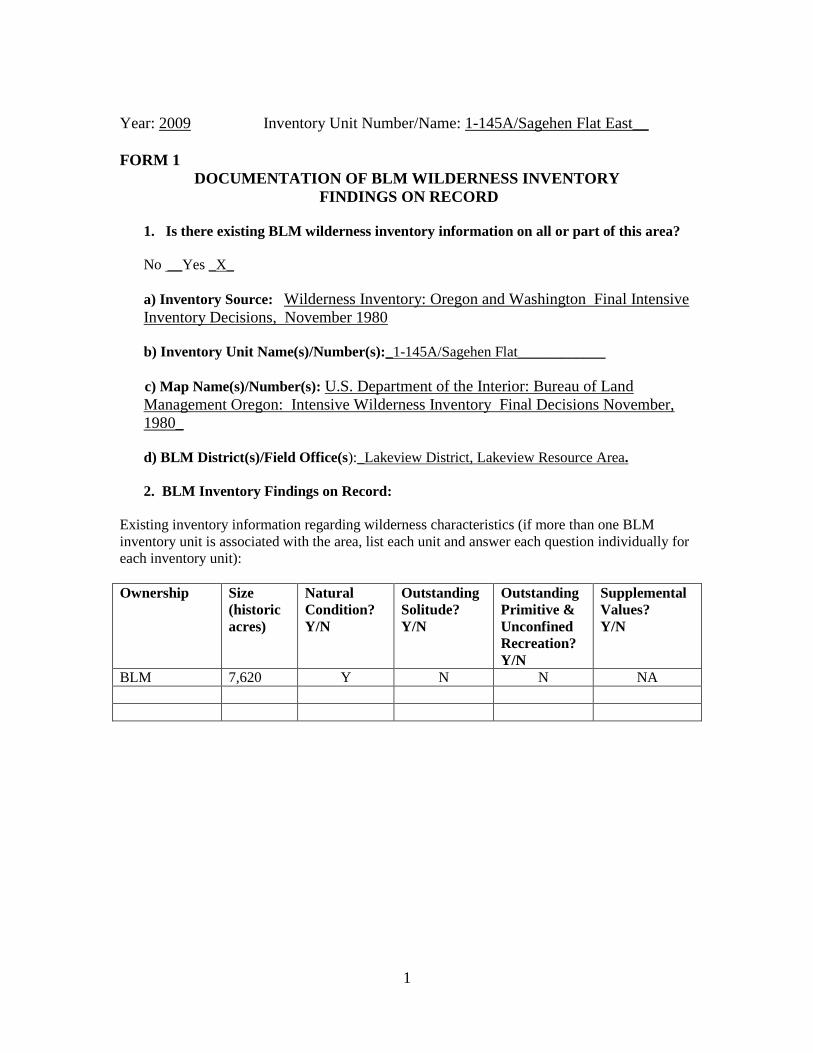
Year: 2009 Inventory Unit Number/Name: 1-145A/Sagehen Flat East__
FORM 1
DOCUMENTATION OF BLM WILDERNESS INVENTORY
FINDINGS ON RECORD
1. Is there existing BLM wilderness inventory information on all or part of this area?
No __Yes _X_
a) Inventory Source: Wilderness Inventory: Oregon and Washington Final Intensive
Inventory Decisions, November 1980
b) Inventory Unit Name(s)/Number(s):_1-145A/Sagehen Flat____________
c) Map Name(s)/Number(s): U.S. Department of the Interior: Bureau of Land
Management Oregon: Intensive Wilderness Inventory Final Decisions November,
1980_
d) BLM District(s)/Field Office(s):_Lakeview District, Lakeview Resource Area.
2. BLM Inventory Findings on Record:
Existing inventory information regarding wilderness characteristics (if more than one BLM
inventory unit is associated with the area, list each unit and answer each question individually for
each inventory unit):
Ownership Size
(historic
acres)
Natural
Condition?
Y/N
Outstanding
Solitude?
Y/N
Outstanding
Primitive &
Unconfined
Recreation?
Y/N
Supplemental
Values?
Y/N
BLM 7,620 Y N N NA
2
FORM 2
DOCUMENTATION OF CURRENT WILDERNESS INVENTORY
CONDITIONS
a. Unit Number/Name: 1-145A/Sagehen Flat East_
(1) Is the unit of sufficient size? Yes __X__ No _____
Citizen Information Received: In 2005, the BLM received a citizen proposal from the
Oregon Natural Desert Association (ONDA) for the 38,953-acre Spaulding proposed
Wilderness Study Area (WSA) Addition 1 (Map 1). ONDA included in their information
a narrative report, maps, photos, photo and route logs, and GIS data with their route and
photo point data; all of these materials were considered during the BLM’s wilderness
inventory process for this BLM Unit. The photos submitted by ONDA were taken in
August of 2004. They identified the area as having no interior routes which met the
BLM wilderness inventory definition of a road (see p. 209-223 of ONDA, 2005).
Boundary Determination and Consideration of Citizen Information: In 2007 and 2008,
BLM conducted its own field inventory of the area to update its road and wilderness
inventory for the area and to gather additional information to supplement ONDA’s
information. This field work included photo documentation of the boundary routes and
some of the interior routes. Using both ONDA and BLM photos, field logs, and staff
field knowledge, a BLM inter-disciplinary (ID) team completed road analyses on the
main routes within the proposed area between April and June of 2008.
The results of the route analysis are documented in the road analysis forms and ID team
meeting notes contained in the wilderness evaluation file. The BLM ID team determined
that several of the routes ONDA identified as “ways” are, in fact, boundary roads. For
this reason, the BLM found the Spaulding proposed WSA Addition I is not one large
roadless unit, but is comprised of several smaller units (Map 2) that are fairly similar to
inventory units (or sub-units) identified during the previous inventory.
Further, the BLM found that BLM Roads 6116-00, 6116-A0, 6116-C0, and 6136-00 on
the north and west sides of the Spaulding Addition 1 proposal also meet the wilderness
inventory definition of a road. Therefore, the potential wilderness character within all of
the roadless units which the BLM identified must be evaluated separate from, rather than
contiguous with, the wilderness values associated with the existing Spaulding WSA.
That is, they must stand on their own merits rather than be added to the wilderness values
of the existing Spaulding WSA.
Currently the unit is bounded on the west by BLM Roads 6116-B0, on the north by BLM
Road 6116-00 and an unnumbered road (formerly referred to as 6176 C), and on the east
and south by BLM Roads 6176-00 and 6116-BA (formerly referred to as 6176 B) (Map
2). This unit currently encompasses approximately 7,605 acres of BLM-administered
lands. (Refer to the road analysis forms, photos, photo logs, and BLM ID team minutes
3
in the wilderness inventory file for additional supporting information regarding these
boundary determinations).
Following this boundary determination, the BLM ID team subsequently evaluated the
wilderness characteristics within this unit. The results are contained in the following
section. Additional background on the process that the BLM ID team followed during
this evaluation is contained in the document, Wilderness Inventory Maintenance Process
for the Lakeview Resource Area, BLM, and the ID team meeting notes contained in the
wilderness inventory file.
DESCRIPTION OF CURRENT CONDITIONS:
The unit is located approximately 32 miles east of Adel, Oregon, and north of the
Sheldon National Antelope Refuge (Maps 1 and 2).
(2) Is the unit in a natural condition? Yes _X_ No __ __ N/A _____
1980 Unit Description: The original inventory described the two sub-units as being
similar in character and described the unit as a whole, despite the presence of a road
dividing the unit into two sub-units. The area was described as a low, sagebrush flat
containing two large lakebed pits (waterholes) (BLM 1980b). The unit also contained
two shallow, ephermal lakebeds. The elevation ranged from about 5,850 feet to 6,135
feet.
One of the two waterholes (Dixon) was located along the road dividing the two sub-units.
The other waterhole (Dutch) was located in Section25 on the northeast portion of the sub-
unit. Because of the extremely flat nature of the unit, the large mound of material
resulting from digging Dixon waterhole is visible for a considerable distance. Dutch
waterhole was also very noticeable over a large area. The sub-unit as a whole was judged
to be primarily affected by the forces of nature where the imprints of man were
substantially unnoticeable (BLM 1980b).
Current Condition Description: The vegetation characteristics within the unit have not
changed substantially since the 1980 inventory was completed.
The unit currently contains two waterholes, not counting Dixon waterhole (see Map 2 and
photo log). Waterholes typically involve digging out a 5-10 foot deep hole covering a
small area (0.5 to 2.0 acres) in a playa flat and side-casting the material into a pile
adjacent to the hole. In addition, the interior of the unit currently contains about 4.8
miles of primitive motorized routes (Map 2). These man-made developments are
substantially noticeable within close distances (up to a quarter mile) and less noticeable
from farther distances.
The entire unit falls within the Beatty Butte wild horse herd management area (HMA)
(see Map SMA-4 BLM 2003b). Wild horses were introduced into the west by man
starting in the 1500’s and are protected under the Wild Horse and Burro Act of 1971.
4
Despite the increase in human disturbances since 1980, the BLM ID team concluded that
overall, the majority of this unit is in a natural condition where the imprint of man is
substantially unnoticeable.
(3) Does the unit have outstanding opportunities for solitude?
Yes_____ No __X__ N/A _____
1980 Unit Description: The previous inventory found that the extremely flat terrain and
low sagebrush cover made it difficult to avoid the sights and sounds of others in the area.
The unit size was also deemed insufficient, in combination with the flat terrain, to
provide opportunities to escape the presence of others. The sub-unit did not offer an
outstanding opportunity for solitude (BLM 1980b).
Current Condition Description: The terrain and vegetation characteristics within the
unit have not changed since 1980. The unit continues to lack either topographic or
vegetative screening (Map 3) which makes it difficult to avoid the presence of others
within the unit.
The most common visitors to the unit include livestock permitees, BLM staff,
researchers, and hunters. The continued presence of boundary roads and internal
motorized routes (Map 2) provides motorized access to the perimeter and large portions
of the interior of the unit. This motorized access increases the actual likelihood of
encountering other people visiting the unit. The noise level associated with motorized
activity diminishes solitude and the overall quality of the recreational experience for
those visitors attempting to get away from others.
For these reasons, the BLM ID team found that the opportunities for solitude within this
unit have not changed since 1980 and are not outstanding, nor is the area being managed
specifically to provide an outstanding opportunity for solitude.
(4) Does the unit have outstanding opportunities for primitive and unconfined
recreation? Yes _____ No __X___ N/A _____
1980 Unit Description: The previous inventory found that the unit as a whole did not
offer any outstanding opportunity for hiking, hunting, or other primitive or unconfined
forms of recreation (BLM 1980b).
Current Condition Description: ONDA’s inventory report (2005) identified the
surrounding area as having outstanding opportunities for hiking, horseback riding,
photography, wildlife viewing, hunting, and camping (page 213) based on the premise
that their proposed Spaulding WSA addition is one, large roadless area. As noted above,
this proposal is not one large, roadless area, but is in fact comprised of several smaller
roadless inventory units which must be evaluated individually.
5
The Lakeview RMP/ROD (Map R-7; BLM 2003b) shows that the entire unit is open to
off-highway vehicle (OHV) use, demonstrating that the area is being managed primarily
for motorized recreation opportunities. Currently, there are about 4.8 miles of existing
internal primitive motorized routes (Map 2) that provide access to substantial portions of
the interior of the unit. This further limits the ability to have a primitive (non-motorized)
recreational experience. Field observations by BLM staff have confirmed that people are,
in fact, using motorized vehicles on and off of existing roads to access the surrounding
public lands for a variety of reasons including recreation.
In 2008, the BLM ID Team considered primitive recreation opportunities identified in
1980 and those identified by ONDA, but did not find these opportunities to be unique or
outstanding. The recreation opportunities are similar other BLM lands within the
Lakeview Resource Area. The unit does not provide a single, unique primitive
recreational opportunity, nor does it provide a unique diversity of primitive recreation
opportunities. For these reasons, the BLM ID team determined that primitive and
unconfined recreation opportunities within this unit have not changed since 1980. The
unit continues to lack an outstanding opportunity for primitive and unconfined recreation.
(5) Does the unit have supplemental values? Yes _____ No ____ NA _X_
Description: Supplemental values were not evaluated as the unit does not meet the
minimum wilderness criteria.
~(~.~. 8A~r Tom Rasmussen, Field Manager
This form documents informatton that constitutes an inventory finding on wilderness characteristics. It does not represent a formal land use allocation or a final agency decision subject to administrative remedies under either 43 CFRpans 4 or 1610.5-2.
Summary of Findings and Conclusion
Unit Name and Number: 1-145A/Sagehen Flat East
Results ofAnalysis:
1. Does the area meet the size requirements? lYes No
2. Does the area appear to be natural? ~Yes No
3. Does the area offer outstanding opportunities for solitude or a primitive and unconfined type of recreation? Yes ~ No
4. Does the area have supplemental values? Yes No lNA
Conclusion (check one):
__ The area-or a portion of the area-has wilderness character.
l-The area does not have wilderness character.
ID Team Members (Names and Titles):
Todd Forbes, Associate Field Manager Natural Resources Paul Whitman, Planning and Environmental Coordinator Lucile Housley, Botanist Ken Siegrist, Park Ranger Glenn Lorton, Wildlife Biologist Kim McLean, Outdoor Recreation Planner/Wilderness Specialist Les Boothe, Range Management Specialist Breanna S. O'Connor, Park Ranger
Approved by:
6

1
Year: 2009 Inventory Unit Number/Name: OR-015-145B/Sagehen Flat West
FORM 1
DOCUMENTATION OF BLM WILDERNESS INVENTORY
FINDINGS ON RECORD
1. Is there existing BLM wilderness inventory information on all or part of this area?
No __Yes _X_
a) Inventory Source: Wilderness Inventory: Oregon and Washington Final Intensive
Inventory Decisions, November 1980
b) Inventory Unit Name(s)/Number(s):_1-145B/Sagehen Flat___________
c) Map Name(s)/Number(s): U.S. Department of the Interior: Bureau of Land
Management Oregon: Intensive Wilderness Inventory Final Decisions November,
1980_
d) BLM District(s)/Field Office(s):_Lakeview District, Lakeview Resource Area.
2. BLM Inventory Findings on Record:
Existing inventory information regarding wilderness characteristics (if more than one BLM
inventory unit is associated with the area, list each unit and answer each question individually for
each inventory unit):
Ownership Size
(historic
acres)
Natural
Condition?
Y/N
Outstanding
Solitude?
Y/N
Outstanding
Primitive &
Unconfined
Recreation?
Y/N
Supplemental
Values?
Y/N
BLM 8,095 Y N N NA
2
FORM 2
DOCUMENTATION OF CURRENT WILDERNESS INVENTORY
CONDITIONS
a. Unit Number/Name: OR-015-145B/Sagehen Flat West_
(1) Is the unit of sufficient size? Yes __X__ No _____
Citizen Information Received: In 2005, the BLM received a citizen proposal from the
Oregon Natural Desert Association (ONDA) for the 38,953-acre Spaulding proposed
Wilderness Study Area (WSA) Addition 1 (Map 1). ONDA included in their information
a narrative report, maps, photos, photo and route logs, and GIS data with their route and
photo point data; all of these materials were considered during the BLM’s wilderness
inventory process for this BLM Unit. The photos submitted by ONDA were taken in
August of 2004. They identified the area as having no interior routes which met the
BLM wilderness inventory definition of a road (see p. 209-223 of ONDA, 2005).
Boundary Determination and Consideration of Citizen Information: In 2007 and 2008,
BLM conducted its own field inventory of the area to update its road and wilderness
inventory for the area and to gather additional information to supplement ONDA’s
information. This field work included photo documentation of the boundary routes and
some of the interior routes. Using both ONDA and BLM photos, field logs, and staff
field knowledge, a BLM inter-disciplinary (ID) team completed road analyses on the
main routes within the proposed area between April and June of 2008.
The results of the route analysis are documented in the road analysis forms and ID team
meeting notes contained in the wilderness evaluation file. The BLM ID team determined
that several of the routes ONDA identified as “ways” are, in fact, boundary roads. For
this reason, the BLM found the Spaulding proposed WSA Addition I is not one large
roadless unit, but is comprised of several smaller units (Map 2) that are fairly similar to
inventory units (or sub-units) identified during the previous inventory.
Further, the BLM found that BLM Roads 6116-00, 6116-A0, 6116-C0, and 6136-00 on
the north and west sides of the Spaulding Addition 1 proposal also meet the wilderness
inventory definition of a road. Therefore, the potential wilderness character within all of
the roadless units which the BLM identified must be evaluated separate from, rather than
contiguous with, the wilderness values associated with the existing Spaulding WSA.
That is, they must stand on their own merits rather than be added to the wilderness values
of the existing Spaulding WSA.
The unit is currently bounded on the west by BLM Roads 6116-00 and 6116-00, on the
north by BLM Road 6116-00 (formerly referred to as Road 6176 C), on the east by BLM
Roads 6116-B0 and 6116-BA (formerly referred to as 6176 B) and on the south by BLM
Roads 6176-00 and 6116-D0. This unit currently encompasses approximately 8,510
acres of BLM-administered lands. (Refer to the road analysis forms, photos, photo logs,
3
and BLM ID team minutes in the wilderness inventory file for additional supporting
information regarding these boundary determinations).
Following this boundary determination, the BLM ID team subsequently evaluated the
wilderness characteristics within this unit. The results are contained in the following
section. Additional background on the process that the BLM ID team followed during
this evaluation is contained in the document, Wilderness Inventory Maintenance Process
for the Lakeview Resource Area, BLM, and the ID team meeting notes contained in the
wilderness inventory file.
DESCRIPTION OF CURRENT CONDITIONS:
The unit is located approximately 30 miles east of Adel, Oregon, and north of the
Sheldon National Antelope Refuge (Maps 1 and 2).
(2) Is the unit in a natural condition? Yes _X_ No __ __ N/A _____
1980 Unit Description: The 1980 inventory described the two sub-units as being similar
in character and described the unit as a whole despite the presence of a road (6116-B0)
dividing the area into two sub-units. The area was described as a low sagebrush flat
containing two large lakebed pits (waterholes) (BLM 1980b). Elevation ranged from
about 5,820 feet to 5,975 feet.
Only one of the two waterholes (Dixon) was located along the road dividing the two
subunits. Because of the extremely flat nature of the sub-unit, the large mound of
material resulting from digging Dixon waterhole is visible for a considerable distance.
The sub-unit as a whole was judged to be primarily affected by the forces of nature where
the imprints of man were substantially unnoticeable (BLM 1980b).
Current Condition Description: The vegetation characteristics within the unit have not
changed substantially since the 1980 inventory was completed.
The unit currently contains one undeveloped spring and four waterholes (Map 2 and
photo log. Waterholes typically involve digging out a 5-10 foot deep hole covering a
small surface area (0.5 to 2.0 acres) in a playa flat and side-casting the material into a pile
adjacent to the hole. In addition, the interior of the unit currently contains about 0.2
miles of primitive motorized routes and about 2.8 miles of primitive reclaiming routes.
Most of these man-made disturbances are substantially noticeable within close distances
(up to a quarter mile) and less noticeable from farther distances.
The entire unit falls within the Beatty Butte wild horse herd management area (HMA)
(see Map SMA-4, BLM 2003b). Wild horses were introduced into the west by man
starting in the 1500’s and are protected under the Wild Horse and Burro Act of 1971.
4
Despite the continued presence of human disturbances, the BLM ID team concluded that
overall, the majority of this unit is in a natural condition where the imprint of man is
substantially unnoticeable (Map 2).
(3) Does the unit have outstanding opportunities for solitude?
Yes_____ No __X__ N/A _____
1980 Unit Description: The 1980 inventory found that the extremely flat terrain and low
sagebrush cover in the entire unit made it difficult to avoid the sights and sounds of
others in the area. The entire unit size was also deemed insufficient, in combination with
the flat terrain, to provide opportunities to escape the presence of others. The sub-unit
did not offer an outstanding opportunity for solitude (BLM 1980b).
Current Condition Description: The terrain and vegetation characteristics within the
unit have not changed since the 1980 inventory was completed. The unit continues to
lack adequate topographic or vegetative screening (Map 3) which makes it difficult to
avoid the presence of others within the unit.
The most common visitors to the unit include livestock permitees, BLM staff,
researchers, and hunters. The continued presence of boundary roads (Map 2) provides
motorized access to the perimeter of the unit. This motorized access increases the actual
likelihood of encountering other people visiting the unit. The noise level associated with
motorized activity diminishes solitude and the overall quality of the recreational
experience for those visitors attempting to get away from others.
For these reasons, the BLM ID team found that the opportunities for solitude within this
unit have not changed since 1980 and are not outstanding, nor is the area being managed
specifically to provide an outstanding opportunity for solitude.
(4) Does the unit have outstanding opportunities for primitive and unconfined
recreation? Yes _____ No __X___ N/A _____
1980 Unit Description: The 1980 inventory found that the unit as a whole did not offer
any outstanding opportunity for hiking, hunting, or other primitive or unconfined forms
of recreation (BLM 1980b).
Current Condition Description: ONDA’s inventory report (2005) identified the
surrounding area as having outstanding opportunities for hiking, horseback riding,
photography, wildlife viewing, hunting, and camping (page 213) based on the premise
that their proposed Spaulding WSA addition is one, large roadless area. As noted above,
this proposal is not one large, roadless area, but is in fact comprised of several smaller
roadless inventory units which must be evaluated individually.
The Lakeview RMP/ROD (Map R-7; BLM 2003b) shows that the entire unit is open to
off-highway vehicle (OHV) use, demonstrating that the area is being managed primarily
5
for motorized recreation opportunities. Field observations by BLM staff have confirmed
that people are, in fact, using motorized vehicles on and off of existing roads to access the
surrounding public lands for a variety of reasons including recreation.
In 2008, the BLM ID Team considered primitive recreation opportunities identified in
1980 and those identified by ONDA, but did not find these opportunities to be unique or
outstanding. The recreation opportunities are similar other BLM lands within the
Lakeview Resource Area. The unit does not provide a single, unique primitive
recreational opportunity, nor does it provide a unique diversity of primitive recreation
opportunities. For these reasons, the BLM ID team determined that primitive and
unconfined recreation opportunities within this unit have not changed since 1980. The
unit continues to lack an outstanding opportunity for primitive and unconfined recreation.
(5) Does the unit have supplemental values? Yes _____ No ____ NA _X_
Description: Supplemental values were not evaluated as the unit does not meet the
minimum wilderness criteria.
~~? Uate
This form documents information that constitutes an inventory finding on wilderness characteristics. It does not represent a formal land use allocation or a final agency decision subject to administrative remedies under either 43 CFRparls 4 or 1610.5-2.
Summary of Findings and Conclusion
Unit Name and Number: OR-015-145B/Sagehen Flat West
Results ofAnalysis:
1. Does the area meet the size requirements? lYes No
2. Does the area appear to be natural? ----.1LYes No
3. Does the area offer outstanding opportunities for solitude or a primitive and unconfined type of recreation? _Yes ----.1L No
4. Does the area have supplemental values? Yes No lNA
Conclusion (check one):
__ The area-or a portion of the area-has wilderness character.
--.X-The area does not have wilderness character.
ID Team Members (Names and Titles):
Todd Forbes, Associate Field Manager Natural Resources Paul Whitman, Planning and Environmental Coordinator Lucile Housley, Botanist Ken Siegrist, Park Ranger Glenn Lorton, Wildlife Biologist Kim McLean, Outdoor Recreation Planner/Wilderness Specialist Les Boothe, Range Management Specialist Breanna S. O'Connor, Park Ranger
Approved by:
6
1
Year: 2009 Inventory Unit Number/Name: OR-015-145C/Sagehen Flat South
FORM 1
DOCUMENTATION OF BLM WILDERNESS INVENTORY
FINDINGS ON RECORD
1. Is there existing BLM wilderness inventory information on all or part of this area?
No __ Yes _X__
a) Inventory Source: Wilderness Inventory: Oregon and Washington Final Intensive
Inventory Decisions, November 1980
b) Inventory Unit Name(s)/Number(s):_This area was part of Sagehen Flat, unit 1-145B
during the 1980 inventory_
c) Map Name(s)/Number(s): U.S. Department of the Interior: Bureau of Land
Management Oregon: Intensive Wilderness Inventory Final Decisions November,
1980_
d) BLM District(s)/Field Office(s):_Lakeview District, Lakeview Resource Area.
2. BLM Inventory Findings on Record:
Existing inventory information regarding wilderness characteristics (if more than one BLM
inventory unit is associated with the area, list each unit and answer each question individually for
each inventory unit):
Ownership Size
(historic
acres)
Natural
Condition?
Y/N
Outstanding
Solitude?
Y/N
Outstanding
Primitive &
Unconfined
Recreation?
Y/N
Supplemental
Values?
Y/N
BLM 8,095 Y N N NA

2
FORM 2
DOCUMENTATION OF CURRENT WILDERNESS INVENTORY
CONDITIONS
a. Unit Number/Name: OR-015-145C/Sagehen Flat South
(1) Is the unit of sufficient size? Yes ____ No __X__
Citizen Information Received: In 2005, the BLM received a citizen proposal from the
Oregon Natural Desert Association (ONDA) for the 38,953-acre Spaulding proposed
Wilderness Study Area (WSA) Addition 1 (Map 1). ONDA included in their information
a narrative report, maps, photos, photo and route logs, and GIS data with their route and
photo point data; all of these materials were considered during the BLM’s wilderness
inventory process for this BLM Unit. The photos submitted by ONDA were taken in
August of 2004. They identified the area as having no interior routes which met the
BLM wilderness inventory definition of a road (see p. 209-223 of ONDA, 2005).
Boundary Determination and Consideration of Citizen Information: In 2008, BLM
conducted its own field inventory of the area to update its road and wilderness inventory
and to gather additional information to supplement the information provided by ONDA.
This field work included photo documentation of the boundary routes and some of the
interior routes. Using both ONDA and BLM photos, field logs, and staff field
knowledge, a BLM inter-disciplinary (ID) team completed road analyses on the main
routes within the proposed area between April and June of 2008.
The results of the road analysis are documented in the road analysis forms and the ID
team meeting notes contained in the wilderness evaluation file. The BLM ID team
determined that several of the routes ONDA identified as “ways” are still, in fact,
boundary roads. For this reason, the BLM found the Spaulding Proposed WSA Addition
I is not one large roadless unit, but is comprised of several smaller units (Map 2).
The ID team found that the boundary for this unit has changed since the previous
inventory was completed in 1980. This area was previously evaluated as part of unit 1-
145B during the 1980 inventory. However, the south end of BLM Road 6116-B0 has
been maintained within the recent past and now qualifies as a boundary road. The unit is
currently bounded on the west by BLM Road 6116-B0, on the north by BLM Road 6116-
BA, on the southeast by BLM Road 6176-00.
Currently the unit is bounded on the west by BLM Roads 6116-B0, on the north by BLM
Road 6116-BA, and on the southeast by BLM Road 6176-00 (Map 2). The unit currently
encompasses approximately 425 acres of BLM-administered lands and does not meet the
size criteria or any of the exceptions to the size criteria. (Refer to the road analysis
forms, photos, photo logs, and BLM ID team minutes in the wilderness inventory file for
additional supporting information regarding these boundary determinations). Additional
background on the process that the BLM ID team followed during this evaluation is
contained in the document, Wilderness Inventory Maintenance Process for the Lakeview
3
Resource Area, BLM, and the ID team meeting notes contained in the wilderness
inventory file.
DESCRIPTION OF CURRENT CONDITIONS:
This small, triangular shaped unit is located approximately 30 miles east of Adel, Oregon
(Maps 1 and 2).
(2) Is the unit in a natural condition? Yes ___ No __ __ N/A __X__
Description: Since the unit did not meet the minimum size criteria or any of the
exceptions to the size criteria, the natural quality was not evaluated.
(3) Does the unit have outstanding opportunities for solitude?
Yes_____ No _____ N/A __X___
Description: Since the unit did not meet the minimum size criteria or any of the
exceptions to the size criteria, the opportunities for solitude were not evaluated.
(4) Does the unit have outstanding opportunities for primitive and unconfined
recreation? Yes _____ No _____ N/A __X___
Description: Since the unit did not meet the minimum size criteria or any of the
exceptions to the size criteria, the recreation opportunities were not evaluated.
(5) Does the unit have supplemental values? Yes _____ No ____ NA _X_
Description: Since the unit did not meet the minimum size criteria or any of the
exceptions to the size criteria, the supplemental values were not evaluated.
~(~ ~ Tom Rasmussen, Field Manager Date
This form documents information that constitutes an inventory finding on wilderness characteristics. It does not represent a formal land use allocation or a final agency decision subject to administrative remedies under either 43 CFRparls 4 or 1610.5-2.
Summary of Findings and Conclusion
Unit Name and Number: Sagehen Flat South/OR-OI5-145C
Results of Analysis:
1. Does the area meet the size requirements? Yes~No
2. Does the area appear to be natural? Yes No X NA
3. Does the area offer outstanding opportunities for solitude or a primitive and unconfined type of recreation? Yes _ No ~NA
4. Does the area have supplemental values? Yes No ~NA
Conclusion (check one):
__ The area-or a portion of the area-has wilderness character.
~The area does not have wilderness character.
ID Team Members (Names and Titles):
Todd Forbes, Associate Field Manager Natural Resources Paul Whitman, Planning and Environmental Coordinator Lucile Housley, Botanist Ken Siegrist, Park Ranger Glenn Lorton, Wildlife Biologist Kim McLean, Outdoor Recreation Planner/Wilderness Specialist Les Boothe, Range Management Specialist Breanna S. O'Connor, Park Ranger
Approved by:
4
1
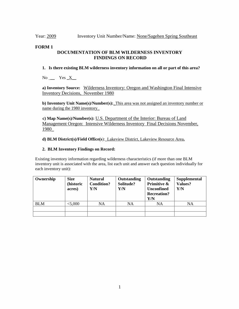
Year: 2009 Inventory Unit Number/Name: None/Sagehen Spring Southeast
FORM 1
DOCUMENTATION OF BLM WILDERNESS INVENTORY
FINDINGS ON RECORD
1. Is there existing BLM wilderness inventory information on all or part of this area?
No __ Yes _X__
a) Inventory Source: Wilderness Inventory: Oregon and Washington Final Intensive
Inventory Decisions, November 1980
b) Inventory Unit Name(s)/Number(s):_This area was not assigned an inventory number or
name during the 1980 inventory_
c) Map Name(s)/Number(s): U.S. Department of the Interior: Bureau of Land
Management Oregon: Intensive Wilderness Inventory Final Decisions November,
1980_
d) BLM District(s)/Field Office(s):_Lakeview District, Lakeview Resource Area.
2. BLM Inventory Findings on Record:
Existing inventory information regarding wilderness characteristics (if more than one BLM
inventory unit is associated with the area, list each unit and answer each question individually for
each inventory unit):
Ownership Size
(historic
acres)
Natural
Condition?
Y/N
Outstanding
Solitude?
Y/N
Outstanding
Primitive &
Unconfined
Recreation?
Y/N
Supplemental
Values?
Y/N
BLM <5,000 NA NA NA NA
2
FORM 2
DOCUMENTATION OF CURRENT WILDERNESS INVENTORY
CONDITIONS
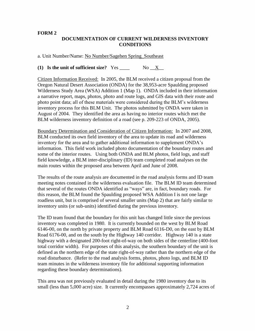
a. Unit Number/Name: No Number/Sagehen Spring_Southeast
(1) Is the unit of sufficient size? Yes ____ No __X__
Citizen Information Received: In 2005, the BLM received a citizen proposal from the
Oregon Natural Desert Association (ONDA) for the 38,953-acre Spaulding proposed
Wilderness Study Area (WSA) Addition 1 (Map 1). ONDA included in their information
a narrative report, maps, photos, photo and route logs, and GIS data with their route and
photo point data; all of these materials were considered during the BLM’s wilderness
inventory process for this BLM Unit. The photos submitted by ONDA were taken in
August of 2004. They identified the area as having no interior routes which met the
BLM wilderness inventory definition of a road (see p. 209-223 of ONDA, 2005).
Boundary Determination and Consideration of Citizen Information: In 2007 and 2008,
BLM conducted its own field inventory of the area to update its road and wilderness
inventory for the area and to gather additional information to supplement ONDA’s
information. This field work included photo documentation of the boundary routes and
some of the interior routes. Using both ONDA and BLM photos, field logs, and staff
field knowledge, a BLM inter-disciplinary (ID) team completed road analyses on the
main routes within the proposed area between April and June of 2008.
The results of the route analysis are documented in the road analysis forms and ID team
meeting notes contained in the wilderness evaluation file. The BLM ID team determined
that several of the routes ONDA identified as “ways” are, in fact, boundary roads. For
this reason, the BLM found the Spaulding proposed WSA Addition I is not one large
roadless unit, but is comprised of several smaller units (Map 2) that are fairly similar to
inventory units (or sub-units) identified during the previous inventory.
The ID team found that the boundary for this unit has changed little since the previous
inventory was completed in 1980. It is currently bounded on the west by BLM Road
6146-00, on the north by private property and BLM Road 6116-D0, on the east by BLM
Road 6176-00, and on the south by the Highway 140 corridor. Highway 140 is a state
highway with a designated 200-foot right-of-way on both sides of the centerline (400-foot
total corridor width). For purposes of this analysis, the southern boundary of the unit is
defined as the northern edge of the state right-of-way rather than the northern edge of the
road disturbance. (Refer to the road analysis forms, photos, photo logs, and BLM ID
team minutes in the wilderness inventory file for additional supporting information
regarding these boundary determinations).
This area was not previously evaluated in detail during the 1980 inventory due to its
small (less than 5,000 acre) size. It currently encompasses approximately 2,724 acres of
3
BLM-administered lands and 280 acres of developed private lands and does not meet the
size criteria or any of the exceptions to the size criteria.
Additional background on the process that the BLM ID team followed during this
evaluation is contained in the document, Wilderness Inventory Maintenance Process for
the Lakeview Resource Area, BLM, and the ID team meeting notes contained in the
wilderness inventory file.
DESCRIPTION OF CURRENT CONDITIONS:
This unit is located approximately 30 miles southeast of Adel, Oregon, north of Highway
140, near the Oregon/Nevada State line (Maps 1 and 2).
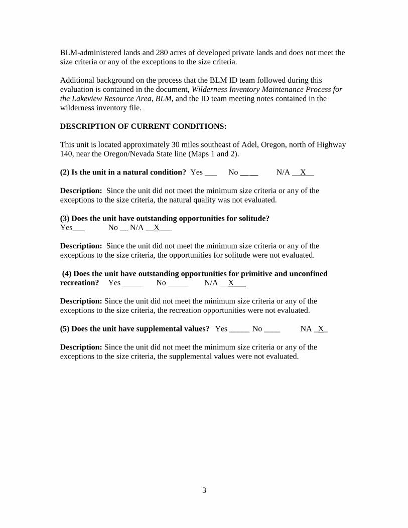
(2) Is the unit in a natural condition? Yes ___ No __ __ N/A __X__
Description: Since the unit did not meet the minimum size criteria or any of the
exceptions to the size criteria, the natural quality was not evaluated.
(3) Does the unit have outstanding opportunities for solitude?
Yes___ No __ N/A __X___
Description: Since the unit did not meet the minimum size criteria or any of the
exceptions to the size criteria, the opportunities for solitude were not evaluated.
(4) Does the unit have outstanding opportunities for primitive and unconfined
recreation? Yes _____ No _____ N/A __X___
Description: Since the unit did not meet the minimum size criteria or any of the
exceptions to the size criteria, the recreation opportunities were not evaluated.
(5) Does the unit have supplemental values? Yes _____ No ____ NA _X_
Description: Since the unit did not meet the minimum size criteria or any of the
exceptions to the size criteria, the supplemental values were not evaluated.
~~ ~., Tom Rasmussen, Field Manager
Thisform documentsinformation that constitutesan inventoryfinding on wilderness characteristics. It does not representaformal land use allocation or afinal agencydecision subject to administrative remediesunder either43 CFRparts 4 or 1610.5-2.
Summary of Findings and Conclusion
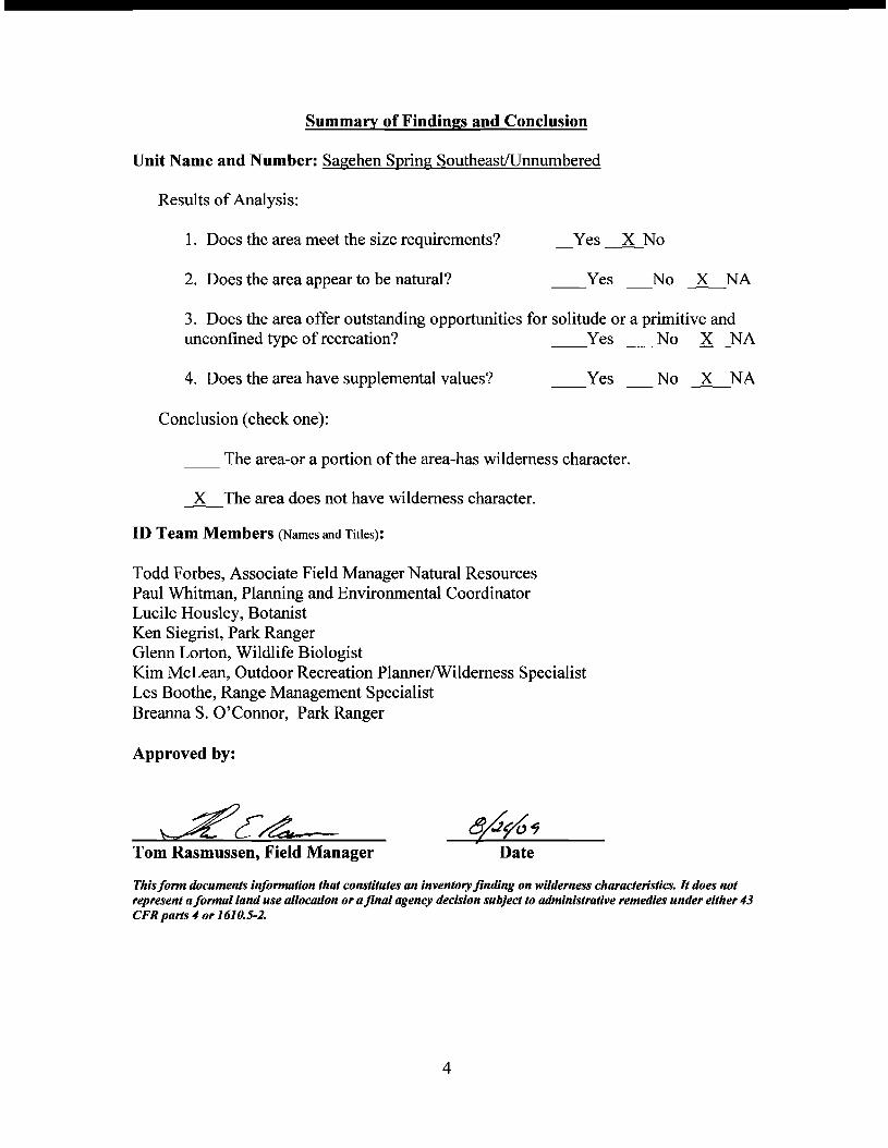
Unit Name and Number: Sagehen Spring SoutheastlUnnumbered
Results of Analysis:
1. Does the area meet the size requirements? Yes~No
2. Does the area appear to be natural? Yes No ~NA
3. Does the area offer outstanding opportunities for solitude or a primitive and unconfined type of recreation? Yes _No ~NA
4. Does the area have supplemental values? Yes No ~NA
Conclusion (check one):
__ The area-or a portion of the area-has wilderness character.
~The area does not have wilderness character.
ID Team Members (Names and Titles):
Todd Forbes, Associate Field Manager Natural Resources Paul Whitman, Planning and Environmental Coordinator Lucile Housley, Botanist Ken Siegrist, Park Ranger Glenn Lorton, Wildlife Biologist Kim McLean, Outdoor Recreation Planner/Wilderness Specialist Les Boothe, Range Management Specialist Breanna S. O'Connor, Park Ranger
Approved by:
4
Adel
Plush
Paisley
Lakeview
Westside
Fort Rock
Silver Lake
Alkali LakeSummer Lake
Valley Falls
New Pine Creek
Christmas Valley
LegendLakeview Resource AreaCities Beaty Butte Loop RoadMajor RoadsWilderness Character Evaluation Area
Map 1 - Wilderness Character Evaluation Area
No warranty is made by the Bureau of Land Management as to the accuracy, reliability, or completeness of these data for individual or aggregate use with other data. Original data were compiled from various sources. This information may not meet National Map Accuracy Standards. This product was developed through digital means and may be updated without notification.
0 8 164 Miles
Lake
Cou
nty
Klam
ath C
ounty
Lake County
Spaulding WSA
Hawk Mountain WSA
Sage Hen Hills WSA
Basque Hills WSA
6136-00
6176-A0
6116-0
0
6176-00
6116-C0
6116-B
0
6126-0
0
6116-A0
6126-B0
6136-A0
6116-C
B
6176-D0
6146
-00
6176-E0
6116-BA
6116-D0
6116-CA
6176-AA
6126-A0
6176-D
B
Wagonslide Road
6176-00
6176-00
Dixon_WH
Shelby_WH
Sheldon_WH
SEEP SPRING
Bone_Spring
Stallion_WH
Stud_Spring
Pork_Chop_WH
WAGONSIDE WH
B_LANE_SPRING
West_Dixon_WH
BENCH_TOP_WH_3PHANTOM_SPRING
Snip Waterhole
Field_Waterhole
East_Sagehen_WH
Mahogany_Spring
SLIDE_WATERHOLE
SAGEBRUSH SPRING
West_Stallion_WH
Wagonslide_WH_#2
North_Sagehen_WH
SNAKE EYES SPRINGSNAKE EYES SPRING
CROSSROADS SPRING
Sunrise_Waterhole
Sage_Hen_Butte_WH
Weed_Lake_East_WH
Halfway_Reservoir
North_140_Waterhole
South_140_Waterhole
HIGH_LAKE_WATERHOLE
East_Dixon_WaterholeSage Butte Waterhole
NI
NI
OR-015-140B
OR-015-145B
OR-015-145A
NI
OR-015-139A
OR-015-140A
NI
OR-015-145C
Map 2 - Wilderness Character Inventory Units
0.9 0 0.90.45 Miles
LegendWilderness Inventory Units
Water DevelopmentsDEVELOPED SPRINGRESERVOIRSTORAGE TANKWATER TROUGHWATERHOLEWELLGuzzlersFencesHighwayReclaiming RoutesExisting Motorized RoutesExisting WSA
Land StatusOtherBureau of Land ManagementState Agency
6176-00
6176-A0
6136-A0
6126-B06116-00
6136-00
6176-AA
6116-CB
6116
-A0
6116-C0
Wagonslide Road
6176
-DB
6116-D0
6116-CA
6116
-B0
6126-00
6146
-00
6116-BA
6176-E0
6176-A0
6176-00
6176-00
6146-0
0
6116-C0
6116-A0
6176-0
0
6176-A0
6116-00
6176-0
0
6116-A
0
6176-00
6136-00
6176-A
0
6136-00
6176-00
6116
-C0
6116-C
0
6136-00
6136-00
6116-B
06116-00
6126-B0
6176-00
6176-0
0
6116-00 6116-00
6116-00
6116-00
6116
-00
6176-0
0
6116-C0
6176-00
6176-E0
6176-A0
6176-00
6136-00
6176-AA
6176
-00
6116-C
06176-00
6176-00
6116-A0
6176-00
6116-00
6116-C
0
6126-00
6116-CB
6116-B0
6116-00
6116-C
0
6116
-B0
6116-0
0
6176
-00
6116-00
6136-00
6116-D0
6136-00
6176-A0
6136-A0
6116-C
B
6136-0
0
NI
OR-015-140B
OR-015-145B
OR-015-145A
NI
OR-015-139A
OR-015-140A
NI
NI
Map 3 - Vegetative Screening Based on Juniper Density Classes
LegendWilderness Inventory Unit BoundariesMotorized Routes
Juniper Density ClassHighMediumLow
2 0 21 Miles


