
VIIRS Level-1 Data Product User’s Guide
July 2017
1.0 Introduction
This document describes the specifications of the NASA-developed Visible and Infrared Imaging Radiometer Suite (VIIRS) Level-1 data products. These products are produced and distributed by the NASA VIIRS Science Investigator-led Processing Systems (SIPSs) for the Atmosphere, Land and Ocean disciplines. VIIRS is a multidisciplinary instrument being flown on the Joint Polar Satellite System (JPSS) satellites, including the Suomi National Polar-orbiting Partnership (SNPP), which launched in October 2011, and JPSS-1, launching in October 2017.
The products are implemented in the Network Common Data Format Version 4 (NetCDF4), and NetCDF terminology is used in this document. These specifications are given in terms of the logical implementation of the products in NetCDF and are not a physical description of file contents. The format is also compatible with the Hierarchical Data Format Version 5 (HDF5). Therefore, NetCDF4 or HDF5 software can be used to read these products.
User support for the NASA VIIRS Level-1 products is available at the following sites.
Level-1 and Atmosphere Archive and Distribution System (LAADS):
https://ladsweb.nascom.nasa.gov/help/
Ocean Color Forum:
http://oceancolor.gsfc.nasa.gov/forum/oceancolor/forum_show.pl
2.0 References
1. EOS Data Products Handbook, ed. M.D. King, et al, NASA/GSFC, 2003.
2. Mission Data Format Control Book National Polar-Orbiting Operational Environmental Satellite System (NPOESS) Preparatory Project (NPP) (MDFCB), Revision G, 429-05-02-42, June 2014.
3. ICD between Earth Observing System (EOS) Data and Operations System (EDOS) and Science Investigator-led Processing Systems for the Suomi National Polar-Orbiting Partnership (SNPP) Science Data Segment (SDS), 423-ICD-010, May 2015.
4. ICD between Suomi National Polar-Orbiting Partnership (SNPP) Science Data Segment (SDS) Processing and Distribution Elements, 423-ICD-XXX, Draft, September 2015.

3.0 Overview
In November 2013, when NASA issued the Research Opportunities in Space and Earth Sciences (ROSES) solicitation for the VIIRS Science Team, it specified that Level-0 to 1B software would be developed to replace the current IDPS RDR-to-SDR software, and that the Level-0 data would be provided to the SIPSs by the EOS Data and Operations System (EDOS). Following the release of the solicitation, the SNPP Project Scientist, Dr. James Gleason, chartered the formation of the VIIRS Level-1 Algorithm/Software Working Group (L1ASWG), a confederation of personnel from the VIIRS SIPSs and the VIIRS Characterization Support Team (VCST), to perform this software development for VIIRS. The first version of the VIIRS Level-1 software was completed in October 2015.
The VIIRS Level-1 software and data products largely follow the model previously developed for MODIS:
The software includes separate executable modules for Level-1A, Geolocation, Onboard
Calibrator (OBC) and Level-1B processing.
The interfaces between the software modules are the data products. Specifically, the
Level-1A product is the input to the Geolocation, Level-1B and OBC software.
The nominal granule size is longer than the NOAA VIIRS granules (85.35 seconds). The
standard granule period is 6 minutes, but the software will be capable of processing any
reasonable granule period.
The VIIRS Level-1 processing flow is illustrated in Figure 1, which shows the processing
software modules, input data types (raw, dynamic ancillary, static ancillary), look-up tables
(LUTs) and data products.
Figure 1 – VIIRS Level-1 Processing Flow
The VIIRS Level-0 and SNPP spacecraft data are delivered by EDOS in the form of Project Data Sets (PDSs). A session-based PDS (S-PDS) contain instrument or spacecraft packet data for a single downlink (approximately 1 orbit), while a time-based PDS (T-PDS) contains data for a specified time period. For the VIIRS and spacecraft T-PDSs, the period is 2 hours. The format of the PDSs is specified in Reference 3, and the format of the VIIRS packets in Reference 2.
The VIIRS Level-1 data products follow the standard NASA Earth Observing System (EOS) definitions for product levels, as specified in Reference 1. They are also designed to be archived in EOSDIS DAACs, and as such, they all include granule metadata as well as processed data. The granule metadata scheme is described in Section 4.1.
As stated above, the VIIRS granule period has been specified to be exactly 6 minutes, synchronized with the UTC day. This was chosen at the request of the VIIRS Atmosphere team for compatibility with the Cross-track Infrared Sounder (CrIS) data products; CrIS is also flown on SNPP. The granulation of the VIIRS data is performed during the Level-1A processing, with each granule containing all of the VIIRS scans that start within the granule period.
The Level-1 software is installed, and the data products are generated, archived and distributed, at all three VIIRS discipline SIPSs. The archive and distribution facility of record is the Level-1 and Atmosphere Archive and Distribution Systems (LAADS), which is co-located both physically and organizationally with the Land SIPS.
4.0 Data Product Formats
The following sections describe the product granule-level and object-level metadata for all VIIRS Level-1 data products, the data object dimensions, and the specific structure and content of each data product. All data product field names are shown in bold type. Note that many of the data objects in a product have similar names that differ in only a few characters; for brevity, a single object description is included, with the distinguishing characters indicated as “[X], X = {list or range of values}”.
4.1 Metadata
The metadata for the VIIRS Level-1 data products are stored as NetCDF4/HDF5 attributes. The granule-level metadata are stored as attributes at the file level, while the object-level metadata are stored using attributes attached to the individual data objects.
Table 1 lists all of the granule-level metadata for the VIIRS Level-1 data products. Not all metadata are stored in all data objects, and the table indicates for which of the data objects each attribute is stored. In a few cases, metadata are duplicated in multiple attributes to meet specific system needs or maintain data continuity with heritage sensors.
Table 2 lists the object-level metadata. Note that only the “long_name” attribute is mandatory for all data objects; the other attributes are stored as appropriate. For example, the “units” attribute is only used for data objects which have defined units; the “scale_factor” and “add_offset” attributes are used for data which are computed as floating point values but stored as scaled integers; and the “flag_values”, “flag_masks” and “flag_meanings” attributes are used for integer data objects to specify meanings for a limited number of defined values.
The fill values specified using the “_FillValue” attribute is, as much as possible, set to standard values according to the data object type. The standard fill values for each data type are listed in Table 3. Exceptions are noted for individual data fields. If the entire range of the data type is valid for a data object, no fill value is defined.

Table 1 – VIIRS Level-1 Product Granule-level Metadata
Attribute Name Example Usage
L1A GEO L1B OBC
title “VIIRS Level-1A” X X X X
platform “Suomi NPP” X X X X
project “VIIRS L1 Project” X X X X
product_name “V2013081085000.L1A_SNPP.nc” X X X X
LocalGranuleID “V2013081085000.L1A_SNPP.nc” X X
LongName “VIIRS/NPP Moderate Resolution Terrain
Corrected Geolocation 6-Min L1 Swath 750m”
X X
ShortName “VNP03MOD” X X
instrument “VIIRS” X X X X
format_version 2 X X X X
instrument_number 2 X X X X
Conventions "CF-1.6" X X X X
institution "NASA Goddard Space Flight Center” X X X X
license "http://science.nasa.gov/earth-science/earth-
science-data/data-information-policy/"
X X X X
naming_authority "gov.nasa.gsfc.sci.oceandata" X X X X
keywords_vocabulary "NASA Global Change Master Directory (GCMD)
Science Keywords"
X X X X
stdname_vocabulary "NetCDF Climate and Forecast (CF) Metadata
Convention"
X X X X
creator_name “NASA/GSFC” X X X X
creator_email "[email protected]" X X X X
creator_url "http://laadsweb.nascom.nasa.gov" X X X X
date_created "2013-12-03T21:17:31Z" X X X X
ProductionTime "2013-12-03T21:17:31Z" X X
publisher_name “NASA/GSFC” X X X X
publisher_email "[email protected]" X X X X
publisher_url "http://laadsweb.nascom.nasa.gov" X X X X
cdm_data_type “swath” X X X X
processing_level “L1A” X X X X
processing_version “v2.0.0” X X
history "l1agen_viirs --outlist l1agen_viirs_outlist.txt" X X X X
source “V2013081085000.L1A_SNPP.nc,…” X
time_coverage_start "2013-03-21T08:48:00Z" X X X X
time_coverage_end "2013-03-21T08:54:00Z" X X X X
PGE_StartTime "2013-03-21T08:48:00Z" X X
PGE_EndTime "2013-03-21T08:54:00Z" X X
StartTime "2013-03-21T08:48:00Z" X X
EndTime "2013-03-21T08:54:00Z" X X
geospatial_lat_units “Degrees North” X X
geospatial_lon_units “Degrees East” X X
geospatial_lat_max 44.077 X X
geospatial_lat_min 19.686 X X
geospatial_lon_max 50.698 X X
geospatial_lon_min 12.174 X X
NorthBoundingCoordinate 44.077 X X
SouthBoundingCoordinate 19.686 X X
EastBoundingCoordinate 50.698 X X
WestBoundingCoordinate 12.174 X X
GringPointLatitude (24.187, 19.686, 35.0, 44.077) X X

GringPointLongitude (12.174, 41.459, 50.569, 13.747) X X
GringPointSequenceNo (1,2,3,4) X X
orbit_number 12345 X X X
OrbitNumber 12345 X
startDirection “Ascending” X X X X
endDirection “Ascending” X X X X
day_night_flag “Day” X X X
DayNightFlag “Day” X
number_of_filled_scans 202 X X
pixel_offset 500 X
Table 2 – VIIRS Level-1 Product Object-level Metadata
Attribute Name Data Type Example
long_name Character “Scan start time”
units Character “seconds”
_FillValue Object1 -999.9
valid_min Object1 0.d0
valid_max Object1 “VIIRS”
scale_factor2 Object1 1.d0
add_offset2 Object1 0.d0
flag_values3 Object1 (1, 2, 3, 4)
flag_masks4 Object1 (1, 2, 4, 8)
flag_meanings5 Character "Substitute_Cal Out_of_Range Saturation Temp_not_Nominal"
1Same type as the associated data object 2Used for real data stored as scaled integers 3The flag_values are mutually exclusive. 4The flag_masks describe a number of independent Boolean conditions using bit fields. Any number of bits can be set. 5Indicates flag meanings for each value of flag_values or flag_masks
Table 3 – Standard Fill Values for Data Object Types
Data Type Fill Value
Byte -1
Unsigned Byte 255
16-bit Integer -999
Unsigned 16-bit Integer 65535
32-bit Integer -999
32-bit Float -999.9
64-bit Float -999.9

4.2 Object Dimensions
NetCDF supports the use of named dimensions to provide dimensions with meanings that are common across data objects. The dimension names and descriptions used in the VIIRS Level-1 data products are presented in Table 4. Several of these dimensions are shared by multiple data products.
Table 4 – Data Object Dimension Names, Descriptions and Sizes
Dimension Name Description Size
number_of_scans1
number_of_scans = 203;
SC_records = 381;
Mband_detectors = 16;
Iband_detectors = 32;
Mband_pixels = 3200;
Iband_pixels = 6400;
DNB_pixels = 4064;
Mband_samples = 6304;
Mband_cal_samples = 48;
Iband_cal_samples = 96;
DNB_cal_samples = 64;
number_of_Mbands_OBC = 17;
number_of_Ibands = 5;
quaternion_elements = 4;
vector_elements = 3;
EV_APIDs = 24;
HR_metadata = 146;
cal_metadata = 134;
eng_status = 8;
eng_block = 128;
ASP_offsets = 3072;
SDSM_data = 256;
encoder_reading = 1290;
ADCS_block = 341;
bus_crit_block = 193;
number_of_scans = 203;
SC_records = 381;
Mband_detectors = 16;
Iband_detectors = 32;
Mband_pixels = 3200;
Iband_pixels = 6400;
DNB_pixels = 4064;
Mband_samples = 6304;
Mband_cal_samples = 48;
Iband_cal_samples = 96;
DNB_cal_samples = 64;
number_of_Mbands_OBC = 17;
number_of_Ibands = 5;
VIIRS scans in product1 2031
number_of_lines2 VIIRS scan lines in product2 varies2
SC_records1 S/C diary, ADCS and bus-critical telemetry records1 3811
Mband_detectors Number of detectors for M-bands and the DNB 16
Iband_detectors Number of detectors for I-bands 32
Mband_pixels Aggregated pixels for single-gain M-bands 3200
Iband_pixels Aggregated pixels for I-bands 6400
DNB_pixels Aggregated pixels for the DNB 4064
Mband_samples Unaggregated pixels for dual-gain M-bands 6304
number_of_pixels2 Pixels in each scan line2 varies2
Mband_cal_samples Calibrator view samples for M-bands 48
Iband_cal_samples Calibrator view samples for I-bands 96
DNB_cal_samples Calibrator view samples for the DNB 64
number_of_Mbands_OBC Number of M-band onboard calibrator sets (2 for M16) 17
number_of_Ibands Number of I-bands 5
number_of_DG_bands Number of dual-gain bands 7
quaternion_elements Elements in a quaternion 4
vector_elements Cartesian vector elements 3
EV_APIDs Number of Earth view APIDs 24
HR_metadata Bytes of metadata in Earth view header packets 146
cal_metadata Bytes of metadata in calibration header packet 134
eng_status Bytes of engineering status data 8
eng_block Bytes of data in multiple engineering packet data blocks 128
ASP_offsets Bytes of ASP offset data in engineering packet 3072
SDSM_data Bytes of SDSM data in engineering packet 256
encoder_reading Number of telescope and HAM encoder readings 1290
ADCS_block Bytes of data in ADCS packet 3413
bus_crit_block Bytes of data in bus-critical telemetry packet 1933
number_of_LUT_values Size of TEB band brightness temperature LUTS 65536
mirror_sides Number of HAM sides 2
number_of_BB_temps Number of blackbody temperatures 6
SDSM_samples SDSM measurements per detector and scan 5
SDSM_detectors Number of SDSM detectors 8 1These dimensions can vary according to the product period and the actual number of scans in a product.
2These dimensions can vary according to the product type. The M-bands, I-bands, and DNB have 3200, 6400 and 4064 pixels per scan line, respectively. The number of lines in an L1B or Geolocation file will be equal to the product of the number of scans and the number of detectors for that resolution.
3These dimensions are platform-specific (SNPP, JPSS-1, etc.)

4.3 Common Scan-level Metadata
All VIIRS Level-1 products store scan-level information in a group named scan_line_attributes. The following data objects are common to all of the data products.
scan_start_time (64-bit float, dimension number_of_scans); long_name = "Scan start time (TAI93)"; start time of VIIRS scans in seconds since 1/1/1993.
scan_end_time (64-bit float, dimension number_of_scans); long_name = "Scan end time (TAI93)"; end time of VIIRS scans in seconds since 1/1/1993.
HAM_side (unsigned byte, dimension number_of_scans); long_name = "Half-angle mirror side”; index of HAM side (0 or 1) from HR metadata.
sensor_mode (unsigned byte, dimension number_of_scans); long_name = "VIIRS sensor mode”; flag variable storing VIIRS sensor mode from HR metadata.
4.4 Level-1A Data Product
The VIIRS Level-1A data product contains the unpacked, raw VIIRS science, calibration and engineering data; the extracted ephemeris and attitude data from the spacecraft diary packets; and the raw ADCS and bus-critical spacecraft telemetry data from those packets, with a few critical fields extracted. These data are stored in the following groups: scan_line_attributes, engineering_data, navigation_data, onboard_calibration_data, and earth_view_data. The data objects in each group are described below.
4.4.1 scan_line_attributes
In addition to the data objects described in 4.3, the Level-1A product scan_line_attributes group contains the following scan-level data objects.
scan_[X]_CCSDS_day, X = {start, end} (16-bit integer, dimension number_of_scans); long_name = "Scan [X] time day (CCSDS segmented time)"; scan , [X] time days since 1/1/1958 from the CCSDS segmented time code.
scan_[X]_CCSDS_msec , X = {start, end} (32-bit integer, dimension number_of_scans); long_name = "Scan [X] time milliseconds of day (CCSDS segmented time)"; scan [X] time milliseconds of day from the CCSDS segmented time code.
scan_[X]_CCSDS_usec , X = {start, end} (16-bit integer, dimension number_of_scans); long_name = "Scan [X] time microseconds (CCSDS segmented time)"; scan [X] time microseconds from the CCSDS segmented time code.
VIIRS_scan_number (32-bit integer, dimension number_of_scans); long_name = "VIIRS scan number"; counter of VIIRS scans since last VIIRS power cycle or counter rollover.
HR_metadata (unsigned byte, dimensions number_of_scans, EV_APIDs, HR_metadata); long_name = "High-rate first packet metadata"; science packet metadata from the first packet of each VIIRS science packet group.
cal_metadata (unsigned byte, dimensions number_of_scans, cal_metadata); long_name = "Calibration first packet metadata"; calibration packet metadata from the first packet of each VIIRS calibration packet group.
4.4.2 engineering_data
The VIIRS engineering data packets contain the non-science data for each scan (e.g. telemetry, instrument settings, HAM and telescope data, SDSM data). Each type of engineering data is stored in a separate data object, but is otherwise unconverted. Selected fields are also unpacked to facilitate downstream processing. The complete description of the engineering data fields is given in Reference 2.
engineering_status (unsigned byte, dimensions number_of_scans, eng_status); long_name = "Engineering status telemetry".
DPP_config (unsigned byte, dimensions number_of_scans, eng_block); long_name = "DPP configuration"; digital preprocessor (DPP) commanded settings.
ASP_config (unsigned byte, dimensions number_of_scans, eng_block); long_name = "Analog signal processor configuration".
DNB_config (unsigned byte, dimensions number_of_scans, eng_block); long_name = "DNB configuration"; DNB commandable settings.
ASP_offsets (unsigned byte, dimensions number_of_scans, ASP_offsets); long_name = "Analog signal processor offsets"; ASP offsets for each band and detector.
ASP_analog (unsigned byte, dimensions number_of_scans, eng_block); long_name = "Analog signal processor analog telemetry".
analog_temperature (unsigned byte, dimensions number_of_scans, eng_block); long_name = "Analog temperature sensor measurements"; VIIRS temperature telemetry.
SDSM_data (unsigned byte, dimensions number_of_scans, SDSM_data); long_name = "Solar diffuser stability monitor data"; raw SDSM state and measurement data.
HAM_encoder (unsigned 16-bit integer, dimensions number_of_scans, encoder_reading); long_name = "HAM encoder readings".
tel_encoder (unsigned 16-bit integer, dimensions number_of_scans, encoder_reading); long_name = "Telescope encoder readings".
eng_reserved (unsigned byte, dimensions number_of_scans, eng_block); long_name = "Reserved engineering block data"; unused fields in the engineering packets.
tel_start_enc (16-bit integer, dimension number_of_scans); long_name = "Telescope encoder count at start of Earth view".
HAM_start_enc (16-bit integer, dimension number_of_scans); long_name = "HAM encoder count at start of Earth view".
scan_encoder_delta (16-bit integer, dimension number_of_scans); long_name = "Scan encoder delta shift"; shift applied to start of scan, e.g., for a sector rotation.
se_[X]_teleHAM_scansyn, X = {a,b} (unsigned byte, dimension number_of_scans); long_name = "[X]-side telescope and HAM synch".
se_[X]_anlg_pwr_on, X = {a,b} (unsigned byte, dimension number_of_scans); long_name = "Analog Power on SE [X]".
servo_in_use (unsigned byte, dimension number_of_scans); long_name = "Servo In Use (A or B)"; telescope servo in use.
se_[X]_tele_pos_known, X = {a,b} (unsigned byte, dimension number_of_scans); long_name = "Telescope Position Known SE [X]".

se_[X]_mtrs_stopped, X = {a,b} (unsigned byte, dimension number_of_scans); long_name = "Motor State SE [X]".
4.4.3 navigation_data
The navigation_data group contains spacecraft data and associated time tags spanning the granule period. The data are stored at the original sample rate (1 second). Additional samples are included at the start and end of the period to support geolocation processing. This includes: unpacked ephemeris and attitude data from the S/C diary packets; raw attitude determination and control system (ADCS) and bus-critical telemetry data; and selected fields extracted from the ADCS and bus-critical telemetry.
att_time (64-bit float, dimension SC_records); long_name = "Attitude sample time (TAI93)"; time of attitude samples in seconds since 1/1/1993.
att_quat (32-bit float, dimensions SC_records, quaternion_elements); long_name = "Attitude quaternions (J2000 to spacecraft)"; attitude quaternions from S/C diary in the J2000 frame.
orb_time (64-bit float, dimension SC_records); long_name = "Orbit vector time (TAI93)"; time of ephemeris samples in seconds since 1/1/1993.
orb_pos (32-bit float, dimensions SC_records, vector_elements); long_name = "Orbit position vectors (ECR)"; _FillValue = -9999999.; orbit position vectors from S/C diary ephemeris data, in the Earth-centered rotating reference frame.
orb_vel (32-bit float, dimensions SC_records, vector_elements); long_name = "Orbit velocity vectors (ECR)"; _FillValue = -9999999.; orbit velocity vectors from S/C diary ephemeris data, in the Earth-centered rotating reference frame.
bus_time (64-bit float, dimension SC_records); long_name = "Bus critical telemetry time (TAI93)"; bus-critical packet time tags in seconds since 1/1/1993.
adstate (unsigned byte, dimension SC_records); long_name = "Current ADCS State".
adsolution (unsigned byte, dimension SC_records); long_name = "ADCS Attitude Solution Source"; source of S/C diary attitude (two star trackers, one star tracker, or gyros only).
adcs_time (64-bit float, dimension SC_records); long_name = "ADCS telemetry time (TAI93)"; ADCS packet time tags in seconds since 1/1/1993.
adfftid (16-bit integer, dimension SC_records); long_name = "Fixed Frame Table Target ID".
admandone (unsigned byte, dimension SC_records); long_name = "Maneuver Done flag"; maneuver state flag.
bus_critical_tlm (unsigned byte, dimensions SC_records, bus_crit_block); long_name = "Bus Critical Telemetry"; raw data from bus-critical telemetry packet.
ADCS_tlm (unsigned byte, dimensions SC_records, ADCS_block); long_name = "ADCS Telemetry"; raw data from ADCS telemetry packet.
4.4.4 onboard_calibration_data
The onboard_calibration_data group contains the measurements from the onboard calibrator views ‒ solar diffuser (SD), space view (SV) and blackbody (BB) ‒ for each band and scan: The calibration data in the packets are compressed onboard, and are uncompressed as part of the Level-1A processing before being stored in the data products.
[X]_M, X = {SD, SV, BB} (16-bit integer, dimensions number_of_Mbands_OBC, number_of_scans, band_detectors, Mband_cal_samples); long_name = "[X] data for
M-bands"; calibrator view data for all of the M-bands. Note that Band M16 has two sets of calibrator view data (16A and 16B).
[X]_I, X = {SD, SV, BB} (16-bit integer, dimensions number_of_Ibands, number_of_scans, Iband_detectors, Iband_cal_samples); long_name = "[X] data for I-bands"; calibrator view data for all of the I-bands.
[X]_DNB, X = {SD, SV, BB} (16-bit integer, dimensions number_of_scans, Mband_detectors, DNB_cal_samples); long_name = "[X] data for DNB"; calibrator view data for the DNB.
DNB_sequence (unsigned byte, dimension number_of_scans); long_name = "DNB aggregation mode"; DNB aggregation mode from calibration metadata.
4.4.5 earth_view_data
The earth_view_data group contains the Earth view science data measurements for each band and scan. The science data in the packets are compressed onboard, and are uncompressed as part of the Level-1A processing before being stored in the data products. The science data for each band are stored in a separate data object.
EV_[X], X = {M01 through M16} (16-bit integer, dimensions number_of_scans, Mband_detectors, Mband_samples); long_name = "Earth view data for band [X]”; uncompressed, reconstructed Earth view counts for each M-band.
EV_[X], X = {I01 through I05} (16-bit integer, dimensions number_of_scans, Iband_detectors, Iband_pixels); long_name = "Earth view data for band [X]”; uncompressed, reconstructed Earth view counts for each I-band.
EV_DNB_[X], X = {HGS, MGS, LGS} (16-bit integer, dimensions number_of_scans, Mband_detectors, DNB_pixels); long_name = "Earth view data for DNB [X]"; uncompressed, reconstructed Earth view counts for each DNB; note that the MGS and LGS data are only collected when commanded.
4.5 Geolocation Data Product
The VIIRS Geolocation data product contains the viewed locations for the VIIRS science data, and related data including sensor and solar angles, height, range, and the land/water mask. There are separate products for each resolution (M-band, I-band, DNB). These data are stored in the following groups: scan_line_attributes, navigation_data, and geolocation_data. The data objects in each group are described below.
4.5.1 scan_line_attributes
In addition to the data objects described in 4.3, the Geolocation product scan_line_attributes group contains the following scan-level data objects.
ev_mid_time (64-bit float, dimension number_of_scans); long_name = "Earth view mid time (TAI93)"; mid-time of VIIRS scans in seconds since 1/1/1993.
scan_quality (16-bit integer, dimension number_of_scans); long_name = "Geolocation scan quality flags"; bit-mapped flag indicating geolocation quality at the scan level; see Table 5 for explanations of each flag meaning.

Table 5 – Geolocation Scan Quality Flags
Bit Flag Meaning Description
0 (LSB) SCE_side_A_B Scan control electronics (SCE) side (1 = B)
1 SCE_side_invalid Invalid SCE side telemetry
2 Sector_rotation1 Invalid HAM or telescope encoder data
3 Encoder_degraded Earth view sector rotation (i.e., non-nominal EV start)
4 SAA Spacecraft in the South Atlantic Anomaly
5 Solar_eclipse Spacecraft in a solar eclipse
6 Lunar_eclipse Lunar eclipse
7 HAM_side HAM side indicator
1Both bits are set to indicate missing encoder data.
4.5.2 navigation_data
The navigation_data group contains the ephemeris and attitude data for each scan, along with input values for additional information used in geolocation (Sun and Moon vectors).
att_quat_ev (32-bit float, dimensions number_of_scans, quaternion_elements); long_name = "Attitude quaternions at EV mid-times (J2000 to spacecraft)"; attitude quaternions interpolated to ev_mid_time, in J2000 frame.
att_ang[X], X = {start, mid, end} (32-bit float, dimensions number_of_scans, vector_elements); long_name = "Attitude angles (roll, pitch, yaw) at EV [X]-times"; attitude angles at EV start, mid and end times.
orb_pos_ev[X], X = {start, mid, end} (32-bit float, dimensions SC_records, vector_elements); long_name = "Orbit position vectors at EV [X]-times (ECR)"; orbit position vectors interpolated to EV start, mid and end times, in Earth-centered rotating reference frame.
orb_vel_ev[X], X = {start, mid, end} (32-bit float, dimensions SC_records, vector_elements); long_name = "Orbit velocity vectors at EV [X]-times (ECR)"; orbit velocity vectors interpolated to EV start, mid and end times, in Earth-centered rotating reference frame.
solar_j2000 (32-bit float, dimensions number_of_scans, vector_elements); long_name = "Solar unit vectors in J2000 frame"; solar unit vector at ev_mid_time in the J2000 frame.
solar_inst (32-bit float, dimensions number_of_scans, vector_elements); long_name = "Solar unit vectors in VIIRS frame"; solar unit vector at ev_mid_time in instrument frame.
earth_sun_distance (32-bit float, dimension number_of_scans); long_name = "Earth-Sun distance"; Earth-to-Sun distance at ev_mid_time in AU.
lunar_j2000 (32-bit float, dimensions number_of_scans, vector_elements); long_name = "Lunar unit vectors in J2000 frame"; lunar unit vector at ev_mid_time in the J2000 frame.
lunar_inst (32-bit float, dimensions number_of_scans, vector_elements); long_name = "Lunar unit vectors in VIIRS frame"; lunar unit vector at ev_mid_time in instrument frame.
earth_moon_distance (32-bit float, dimension number_of_scans); long_name = "Earth-Moon distance"; Earth-to-Moon distance at ev_mid_time in meters.

4.5.3 geolocation_data
The geolocation_data group contains the viewed locations and related data for each pixel at the product resolution. All angles are in degrees.
latitude (32-bit float, dimensions number_of_lines, number_of_pixels); long_name = "Latitudes of pixel locations".
longitude (32-bit float, dimensions number_of_lines, number_of_pixels); long_name = "Longitudes of pixel locations".
height (16-bit integer, dimensions number_of_lines, number_of_pixels); long_name = "Terrain height at pixel locations". Note that this will be set to zero if the terrain correction is not performed during geolocation processing.
range (16-bit integer, dimensions number_of_lines, number_of_pixels); long_name = "Satellite-to-pixel range".
sensor_azimuth (16-bit integer, dimensions number_of_lines, number_of_pixels); long_name = "Sensor azimuth angle at pixel locations"; azimuth of the viewed location-to-instrument vector.
sensor_zenith (16-bit integer, dimensions number_of_lines, number_of_pixels); long_name = "Sensor zenith angle at pixel locations"; zenith of the viewed location-to-instrument vector.
solar_azimuth (16-bit integer, dimensions number_of_lines, number_of_pixels); long_name = "Solar azimuth angle at pixel locations"; azimuth of the viewed location-to-Sun vector.
solar_zenith (16-bit integer, dimensions number_of_lines, number_of_pixels); long_name = "Solar zenith angle at pixel locations"; zenith of the viewed location-to-Sun vector.
lunar_azimuth (16-bit integer, dimensions number_of_lines, number_of_pixels); long_name = "Lunar azimuth angle at pixel locations"; azimuth of the viewed location-to-Moon vector; DNB only.
lunar_zenith (16-bit integer, dimensions number_of_lines, number_of_pixels); long_name = "Lunar zenith angle at pixel locations"; zenith of the viewed location-to-Moon vector; DNB only.
moon_illumination_fraction (16-bit integer, dimensions number_of_lines, number_of_pixels); long_name = "Lunar illumination fraction viewed at pixel locations"; fraction of Sun-illuminated Moon surface facing the Earth at viewed locations; DNB only.
moon_phase_angle (16-bit integer, dimensions number_of_lines, number_of_pixels); long_name = "Lunar phase angle viewed at pixel locations"; lunar phase angle between pixel-Moon_Sun; DNB only.
land_water_mask (unsigned byte, dimensions number_of_lines, number_of_pixels); long_name = "Land/Water mask at pixel locations".
quality_flag (unsigned byte, dimensions number_of_lines, number_of_pixels); long_name = "Geolocation pixel quality flags"; bit-mapped flag indicating geolocation quality at the pixel level; see Table 6 for explanations of each flag meaning.
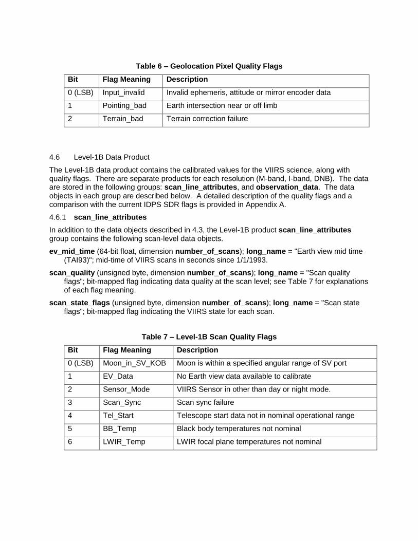
Table 6 – Geolocation Pixel Quality Flags
Bit Flag Meaning Description
0 (LSB) Input_invalid Invalid ephemeris, attitude or mirror encoder data
1 Pointing_bad Earth intersection near or off limb
2 Terrain_bad Terrain correction failure
4.6 Level-1B Data Product
The Level-1B data product contains the calibrated values for the VIIRS science, along with quality flags. There are separate products for each resolution (M-band, I-band, DNB). The data are stored in the following groups: scan_line_attributes, and observation_data. The data objects in each group are described below. A detailed description of the quality flags and a comparison with the current IDPS SDR flags is provided in Appendix A.
4.6.1 scan_line_attributes
In addition to the data objects described in 4.3, the Level-1B product scan_line_attributes group contains the following scan-level data objects.
ev_mid_time (64-bit float, dimension number_of_scans); long_name = "Earth view mid time (TAI93)"; mid-time of VIIRS scans in seconds since 1/1/1993.
scan_quality (unsigned byte, dimension number_of_scans); long_name = "Scan quality flags"; bit-mapped flag indicating data quality at the scan level; see Table 7 for explanations of each flag meaning.
scan_state_flags (unsigned byte, dimension number_of_scans); long_name = "Scan state flags"; bit-mapped flag indicating the VIIRS state for each scan.
Table 7 – Level-1B Scan Quality Flags
Bit Flag Meaning Description
0 (LSB) Moon_in_SV_KOB Moon is within a specified angular range of SV port
1 EV_Data No Earth view data available to calibrate
2 Sensor_Mode VIIRS Sensor in other than day or night mode.
3 Scan_Sync Scan sync failure
4 Tel_Start Telescope start data not in nominal operational range
5 BB_Temp Black body temperatures not nominal
6 LWIR_Temp LWIR focal plane temperatures not nominal

4.6.2 observation_data
The observation_data group contains the calibrated science data and the pixel-level quality flags. As stated above, the data for each resolution are stored in a separate data product. The M and I-band data are stored as scaled integers, while the DNB data are stored as floating point values because of their dynamic range.
For the reflective solar bands (RSBs), scale factor, offset and units attributes are provided for both reflectance and radiance values. The standard attributes shown in Table 2 are used for reflectance, and the radiance scaling is performed using the attributes radiance_scale_factor and radiance_add_offset. Note: the stored reflectance is actually the product of the true reflectance and the cosine of the solar zenith angle at the pixel location; in order to obtain the reflectance, the reconstituted reflectance must be divided by the cosine of solar zenith.
For the thermal emissive bands (TEBs), LUTs for the radiance-to-brightness temperature conversion are also included. To determine the brightness temperature corresponding to each radiance, the scaled integer values are used as indices into the brightness temperature LUTs.
Each calibrated data object also includes the flag_values and flag_meanings attributes, to specify individual fill values for each missing data state.
M[X], X = {01 – 11} (unsigned 16-bit integer, dimensions number_of_lines, number_of_pixels); long_name = "M-band [X] earth view reflectance"; calibrated RSB M-band science data.
M[X], X = {12 – 16} (unsigned 16-bit integer, dimensions number_of_lines, number_of_pixels); long_name = "M-band [X] earth view radiance"; calibrated TEB M-band science data.
M[X]_quality_flags, X = {01 – 16)} (unsigned 16-bit integer, dimensions number_of_lines, number_of_pixels); long_name = "M-band [X] quality flags"; bit-mapped quality flags for the M-bands; see Table 8 for explanations of each flag meaning.
M[X]_uncert_index, X = {01 – 16)} (byte, dimensions number_of_lines, number_of_pixels); long_name = "M-band [X] uncertainty index"; computed uncertainty index for each M-band.
M[X]_brightness_temperature_lut, X = {12 – 16} (32-bit float, dimension number_of_LUT_values); long_name = "M-band [X] brightness temperature lookup table"; LUT for radiance to brightness temperature conversion.
I[X], X = {01 – 03} (unsigned 16-bit integer, dimensions number_of_lines, number_of_pixels); long_name = "I-band [X] earth view reflectance"; calibrated RSB I-band science data.
I[X], X = {04 – 05} (unsigned 16-bit integer, dimensions number_of_lines, number_of_pixels); long_name = "I-band [X] earth view radiance"; calibrated TEB I-band science data.
I[X]_quality_flags, X = {01 – 05} (unsigned 16-bit integer, dimensions number_of_lines, number_of_pixels); long_name = "I-band [X] quality flags"; bit-mapped quality flags for the I-bands; see Table 8 for explanations of each flag meaning.
I[X]_uncert_index, X = {01 – 05)} (byte, dimensions number_of_lines, number_of_pixels); long_name = "I-band [X] uncertainty index"; computed uncertainty index for each I-band.
I[X]_brightness_temperature_lut, X = {04, 05} (32-bit float, dimension number_of_LUT_values); long_name = "I-band [X] brightness temperature lookup table"; LUT for radiance to brightness temperature conversion.
DNB_observations (32-bit float, dimensions number_of_lines, number_of_pixels); long_name = " DNB observations at pixel locations"; calibrated DNB science data.
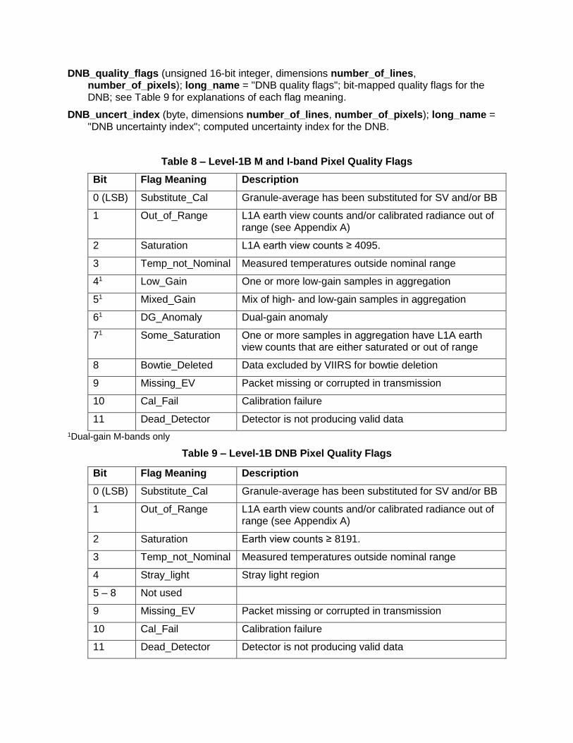
DNB_quality_flags (unsigned 16-bit integer, dimensions number_of_lines, number_of_pixels); long_name = "DNB quality flags"; bit-mapped quality flags for the DNB; see Table 9 for explanations of each flag meaning.
DNB_uncert_index (byte, dimensions number_of_lines, number_of_pixels); long_name = "DNB uncertainty index"; computed uncertainty index for the DNB.
Table 8 – Level-1B M and I-band Pixel Quality Flags
Bit Flag Meaning Description
0 (LSB) Substitute_Cal Granule-average has been substituted for SV and/or BB
1 Out_of_Range L1A earth view counts and/or calibrated radiance out of range (see Appendix A)
2 Saturation L1A earth view counts ≥ 4095.
3 Temp_not_Nominal Measured temperatures outside nominal range
41 Low_Gain One or more low-gain samples in aggregation
51 Mixed_Gain Mix of high- and low-gain samples in aggregation
61 DG_Anomaly Dual-gain anomaly
71 Some_Saturation One or more samples in aggregation have L1A earth view counts that are either saturated or out of range
8 Bowtie_Deleted Data excluded by VIIRS for bowtie deletion
9 Missing_EV Packet missing or corrupted in transmission
10 Cal_Fail Calibration failure
11 Dead_Detector Detector is not producing valid data
1Dual-gain M-bands only
Table 9 – Level-1B DNB Pixel Quality Flags
Bit Flag Meaning Description
0 (LSB) Substitute_Cal Granule-average has been substituted for SV and/or BB
1 Out_of_Range L1A earth view counts and/or calibrated radiance out of range (see Appendix A)
2 Saturation Earth view counts ≥ 8191.
3 Temp_not_Nominal Measured temperatures outside nominal range
4 Stray_light Stray light region
5 – 8 Not used
9 Missing_EV Packet missing or corrupted in transmission
10 Cal_Fail Calibration failure
11 Dead_Detector Detector is not producing valid data
4.7 OBC Data Product
The OBC data product contains the onboard calibrator measurements, selected engineering fields that have been extracted from the raw engineering data, and navigation data. These data are stored in the following groups: scan_line_attributes, engineering_data, navigation_data, and onboard_calibration_data. The data objects in each group are described below.
4.7.1 scan_line_attributes
In addition to the data objects described in 4.3, the OBC product scan_line_attributes group contains the following scan-level data objects.
sv_mid_time (64-bit float, dimension number_of_scans); long_name = Space view mid time (TAI93)"; mid-time of VIIRS space vew in seconds since 1/1/1993.
sd_mid_time (64-bit float, dimension number_of_scans); long_name = "Solar diffuser mid time (TAI93)"; mid-time of VIIRS solar diffuser vew in seconds since 1/1/1993.
bb_mid_time (64-bit float, dimension number_of_scans); long_name = "Blackbody mid time (TAI93)"; mid-time of VIIRS blackbody view in seconds since 1/1/1993.
VIIRS_scan_number (32-bit integer, dimension number_of_scans); long_name = "VIIRS scan number"; counter of VIIRS scans since last VIIRS power cycle or counter rollover.
4.7.2 engineering_data
The engineering_data group contains selected VIIRS engineering data fields that have been extracted from the raw engineering packet data. The data objects are summarized in Table 10.
4.7.3 navigation_data
The navigation_data group contains the ephemeris and attitude data at the SD view times, along with input values for additional information used in calibration (Sun and Moon vectors).
att_quat_sd (32-bit float, dimensions number_of_scans, quaternion_elements); long_name = "Attitude quaternions at SD mid-times (J2000 to spacecraft)"; attitude quaternions interpolated to sd_mid_time, in the J2000 frame.
orb_pos_sd (32-bit float, dimensions SC_records, vector_elements); long_name = "Orbit position vectors at SD mid-times (ECR)"; _FillValue = -9999999.; orbit position vectors interpolated to sd_mid_time, in the Earth-centered rotating reference frame.
orb_vel_sd (32-bit float, dimensions SC_records, vector_elements); long_name = "Orbit velocity vectors at SD mid-times (ECR)"; _FillValue = -9999999.; orbit velocity vectors interpolated to sd_mid_time, in the Earth-centered rotating reference frame.
solar_j2000 (32-bit float, dimensions number_of_scans, vector_elements); long_name = "Solar unit vectors in J2000 frame"; solar unit vector at sd_mid_time in the J2000 frame.
solar_inst (32-bit float, dimensions number_of_scans, vector_elements); long_name = "Solar unit vectors in VIIRS frame"; solar unit vector at sd_mid_time in instrument frame.
earth_sun_distance (32-bit float, dimension number_of_scans); long_name = "Earth-Sun distance"; Earth-to-Sun distance at sd_mid_time in AU.
lunar_j2000 (32-bit float, dimensions number_of_scans, vector_elements); long_name = "Lunar unit vectors in J2000 frame"; lunar unit vector at sd_mid_time in the J2000 frame.
lunar_inst (32-bit float, dimensions number_of_scans, vector_elements); long_name = "Lunar unit vectors in VIIRS frame"; lunar unit vector at sd_mid_time in instrument frame.
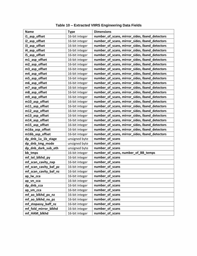
Table 10 – Extracted VIIRS Engineering Data Fields
Name Type Dimensions
i1_asp_offset 16-bit integer number_of_scans, mirror_sides, Iband_detectors
i2_asp_offset 16-bit integer number_of_scans, mirror_sides, Iband_detectors
i3_asp_offset 16-bit integer number_of_scans, mirror_sides, Iband_detectors
i4_asp_offset 16-bit integer number_of_scans, mirror_sides, Iband_detectors
i5_asp_offset 16-bit integer number_of_scans, mirror_sides, Iband_detectors
m1_asp_offset 16-bit integer number_of_scans, mirror_sides, Iband_detectors
m2_asp_offset 16-bit integer number_of_scans, mirror_sides, Iband_detectors
m3_asp_offset 16-bit integer number_of_scans, mirror_sides, Iband_detectors
m4_asp_offset 16-bit integer number_of_scans, mirror_sides, Iband_detectors
m5_asp_offset 16-bit integer number_of_scans, mirror_sides, Iband_detectors
m6_asp_offset 16-bit integer number_of_scans, mirror_sides, Iband_detectors
m7_asp_offset 16-bit integer number_of_scans, mirror_sides, Iband_detectors
m8_asp_offset 16-bit integer number_of_scans, mirror_sides, Iband_detectors
m9_asp_offset 16-bit integer number_of_scans, mirror_sides, Iband_detectors
m10_asp_offset 16-bit integer number_of_scans, mirror_sides, Iband_detectors
m11_asp_offset 16-bit integer number_of_scans, mirror_sides, Iband_detectors
m12_asp_offset 16-bit integer number_of_scans, mirror_sides, Iband_detectors
m13_asp_offset 16-bit integer number_of_scans, mirror_sides, Iband_detectors
m14_asp_offset 16-bit integer number_of_scans, mirror_sides, Iband_detectors
m15_asp_offset 16-bit integer number_of_scans, mirror_sides, Iband_detectors
m16a_asp_offset 16-bit integer number_of_scans, mirror_sides, Iband_detectors
m16b_asp_offset 16-bit integer number_of_scans, mirror_sides, Iband_detectors
dp_dnb_1a_1b_stage unsigned byte number_of_scans
dp_dnb_tmg_mode unsigned byte number_of_scans
dp_dnb_dark_sub_eth unsigned byte number_of_scans
bb_tmps 16-bit integer number_of_scans, number_of_BB_temps
mf_tel_blkhd_py 16-bit integer number_of_scans
mf_scan_cavity_nxp 16-bit integer number_of_scans
mf_scan_cavity_baf_pz 16-bit integer number_of_scans
mf_scan_cavity_baf_nz 16-bit integer number_of_scans
ap_lw_cca 16-bit integer number_of_scans
ap_vn_cca 16-bit integer number_of_scans
dp_dnb_cca 16-bit integer number_of_scans
ap_sm_cca 16-bit integer number_of_scans
mf_ao_blkhd_px_nz 16-bit integer number_of_scans
mf_ao_blkhd_nx_pz 16-bit integer number_of_scans
mf_stopassy_baff_nz 16-bit integer number_of_scans
mf_fold_mirror_blkhd 16-bit integer number_of_scans
mf_HAM_blkhd 16-bit integer number_of_scans
4.7.4 onboard_calibration_data
The onboard_calibration_data group contains the measurements from the onboard calibrator views ‒ solar diffuser (SD), space view (SV) and blackbody (BB) ‒ for each band and scan: The calibration data in the packets are compressed onboard, and are uncompressed as part of the Level-1A processing before being stored in the data products. The gain states for the dual-gain bands and the SDSM data are also stored in this group.
[X]_M, X = {SD, SV, BB} (16-bit integer, dimensions number_of_Mbands_OBC, number_of_scans, band_detectors, Mband_cal_samples); long_name = "[X] data for M-bands"; calibrator view data for all of the M-bands. Note that Band M16 has two sets of calibrator view data (16A and 16B).
[X]_I, X = {SD, SV, BB} (16-bit integer, dimensions number_of_Ibands, number_of_scans, Iband_detectors, Iband_cal_samples); long_name = "[X] data for I-bands"; calibrator view data for all of the I-bands.
[X]_DNB, X = {SD, SV, BB} (16-bit integer, dimensions number_of_scans, Mband_detectors, DNB_cal_samples); long_name = "[X] data for DNB"; calibrator view data for the DNB.
OBC_gain_states (unsigned byte, dimensions number_of_DG_bands, number_of_scans, Mband_detectors); long_name = "Calibrator view gains for dual-gain M-bands".
SDSM_position (unsigned byte, dimension number_of_scans); long_name = "SDSM position"; SDSM position during operation (SD, Sun, instrument).
SDSM_sample (32-bit float, dimensions number_of_scans, SDSM_detectors, SDSM_samples); long_name = "SDSM sample"; converted SDSM measurements.
APPENDIX A – VIIRS Level-1B QUALITY FLAGS
A.1 INTRODUCTION
The VIIRS Level-1B scan and pixel quality flagging scheme is derived from the corresponding IDPS SDR pixel quality flagging scheme. It conveys as much useful information as those in the IDPS SDR format while using fewer bits. This leaves several bits available for reporting of conditions specific to particular band categories, such as the reporting of gain state information for the dual-gain bands. This section provides a description of both the VIIRS Level-1B quality flags and the IDPS SDR quality flags to support the understanding of how they differ.
A.2 PIXEL QUALITY FLAG
A.2.1 VIIRS L1B Pixel Quality Flag Approach
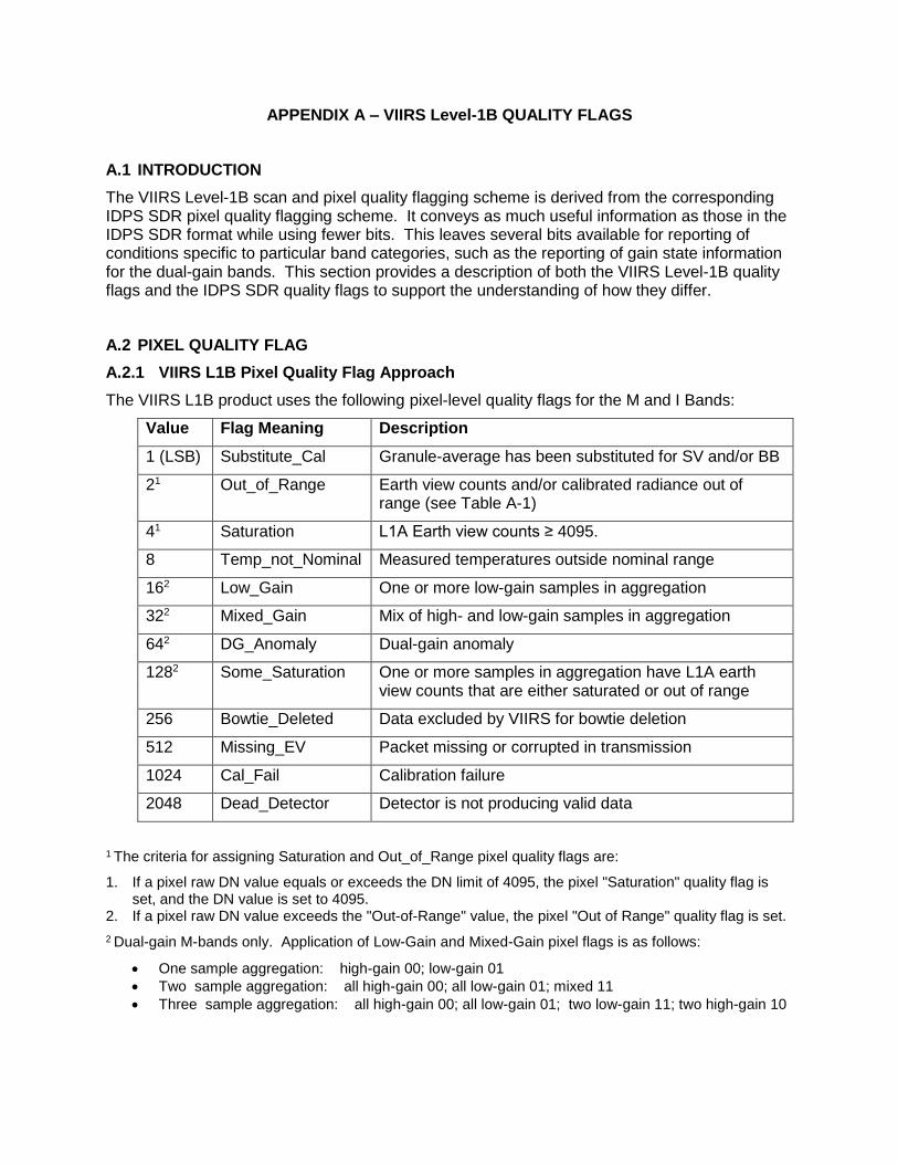
The VIIRS L1B product uses the following pixel-level quality flags for the M and I Bands:
Value Flag Meaning Description
1 (LSB) Substitute_Cal Granule-average has been substituted for SV and/or BB
21 Out_of_Range Earth view counts and/or calibrated radiance out of range (see Table A-1)
41 Saturation L1A Earth view counts ≥ 4095.
8 Temp_not_Nominal Measured temperatures outside nominal range
162 Low_Gain One or more low-gain samples in aggregation
322 Mixed_Gain Mix of high- and low-gain samples in aggregation
642 DG_Anomaly Dual-gain anomaly
1282 Some_Saturation One or more samples in aggregation have L1A earth view counts that are either saturated or out of range
256 Bowtie_Deleted Data excluded by VIIRS for bowtie deletion
512 Missing_EV Packet missing or corrupted in transmission
1024 Cal_Fail Calibration failure
2048 Dead_Detector Detector is not producing valid data
1 The criteria for assigning Saturation and Out_of_Range pixel quality flags are:
1. If a pixel raw DN value equals or exceeds the DN limit of 4095, the pixel "Saturation" quality flag is set, and the DN value is set to 4095.
2. If a pixel raw DN value exceeds the "Out-of-Range" value, the pixel "Out of Range" quality flag is set.
2 Dual-gain M-bands only. Application of Low-Gain and Mixed-Gain pixel flags is as follows:
One sample aggregation: high-gain 00; low-gain 01
Two sample aggregation: all high-gain 00; all low-gain 01; mixed 11
Three sample aggregation: all high-gain 00; all low-gain 01; two low-gain 11; two high-gain 10

The VIIRS L1B uses the following pixel-level quality flags for DNB Band:
Value Meaning Description
1 Substitute_Cal Granule-average substitution has been made for SV and/or BB (e.g., moon-in-SV).
21 Out_of_Range Earth view counts and/or calibrated radiance out of range (see Table A-1)
41 Saturation L1A Earth view counts ≥ 8191
8 Temp_not_Nominal Measured temperatures (black body, focal plane) outside nominal range
16 Straylight Stray light region
512 Missing_EV Packet missing or corrupted in transmission
1024 Cal_Fail Calibration failure
2048 Dead_Detector Detector is not producing valid data
1 The criteria for assigning Saturation and Out_of_Range pixel quality flags are:
1. If a pixel raw DN value equals or exceeds the DN limit of 8191, the pixel "Saturation" quality flag is set, and the DN value is set to 8191.
2. If a pixel raw DN value exceeds the "Out-of-Range" value, the pixel "Out of Range" quality flag is set.
For the TEB, the brightness temperature LUT covers the Radiance Range exactly. That is, the maximum allowable radiance integers (65227) should correspond to the Radiance Range values. So the maximum brightness temperature should also correspond to the Radiance Range value.
Note that the IDPS SDR pixel quality “poor” bit has been excluded from the VIIRS L1B. It is excluded because there are now an adequate number of bits to explicitly identify all the conditions that have been regarded as the basis for characterizing a pixel as having "poor" quality.
Table A-1 – Out-of-range thresholds
Band DN Saturation
DN Out of Range
Reflectance Range
Radiance Range2
I1 4095 3400 1.31 N/A
I2 4095 3400 1.31 N/A
I3 4095 3400 1.31 N/A
I4 4095 4095 N/A 4.0
I5 4095 4095 N/A 24.0
M1 4095 3700 1.31 N/A
M2 4095 3700 1.31 N/A
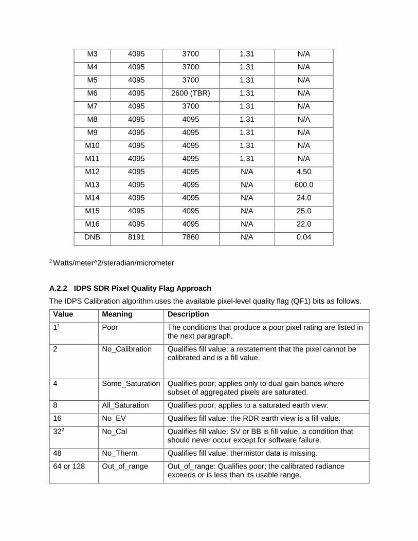
M3 4095 3700 1.31 N/A
M4 4095 3700 1.31 N/A
M5 4095 3700 1.31 N/A
M6 4095 2600 (TBR) 1.31 N/A
M7 4095 3700 1.31 N/A
M8 4095 4095 1.31 N/A
M9 4095 4095 1.31 N/A
M10 4095 4095 1.31 N/A
M11 4095 4095 1.31 N/A
M12 4095 4095 N/A 4.50
M13 4095 4095 N/A 600.0
M14 4095 4095 N/A 24.0
M15 4095 4095 N/A 25.0
M16 4095 4095 N/A 22.0
DNB 8191 7860 N/A 0.04
2 Watts/meter^2/steradian/micrometer
A.2.2 IDPS SDR Pixel Quality Flag Approach
The IDPS Calibration algorithm uses the available pixel-level quality flag (QF1) bits as follows.
Value Meaning Description
11 Poor The conditions that produce a poor pixel rating are listed in the next paragraph.
2 No_Calibration Qualifies fill value; a restatement that the pixel cannot be calibrated and is a fill value.
4 Some_Saturation Qualifies poor; applies only to dual gain bands where subset of aggregated pixels are saturated.
8 All_Saturation Qualifies poor; applies to a saturated earth view.
16 No_EV Qualifies fill value; the RDR earth view is a fill value.
322 No_Cal Qualifies fill value; SV or BB is fill value, a condition that should never occur except for software failure.
48 No_Therm Qualifies fill value; thermistor data is missing.
64 or 128 Out_of_range Out_of_range: Qualifies poor; the calibrated radiance exceeds or is less than its usable range.

1 In the IDPS Calibration algorithm, a pixel is designated as poor for any of the following reasons:
Radiance out of range, high or low ‒ Very common for some bands (e.g., M6)
All saturation ‒ Earth view DN exceeds or is equal to 4095.
Some saturation ‒ Applies only to DG bands where a subset of aggregated samples are saturated.
Dual-gain anomaly ‒ Applies only to DG bands, and is very common.
Moon in SV KOB ‒
Scans near by a sync loss scan ‒ Applies only to DG bands.
SV gain state is fill ‒ Applies only to DG bands, but is useless because it can never happen unless SV is fill.
LWIR focal plane temperature not nominal ‒ Applies only to LWIR TEB bands.
Stray light region ‒ Applies only to DNB band
2 In the IDPS Calibration algorithm, a pixel is assigned as no-calibrate (fill value) for any of the following reasons:
Bowtie region
RDR scan data is fill
Telescope start not nominal
Synchronization loss
Any calibration software failure of unspecified nature
Night scan ‒ Applies only to most RSB bands
Dead detector
RDR earth view fill value
SV/BB fill value ‒ Should never occur except in the case of software failure.
Bad coefficients ‒ Should never occur except in the case of software failure.
Bad thermal value ‒ Applies only to TEB bands; should never occur except in the case of software failure.
Bad interpolation value ‒ Applies only to TEB bands; should never occur except in the case of software failure.
A.3 SCAN QUALITY FLAG
A.3.1 VIIRS L1B Scan Quality Flagging
In the VIIRS L1B, we have consolidated the scan-level quality flags from being across three QF data sets, as they are in the IDPS SDR, to two.
The scan_state_flags object in the VIIRS L1B, provides information on the HAM side, Electronics side, and Night Mode.
The scan_quality_flags object in the VIIRS L1B, is the scan-level quality flag. This provides information pertaining to the condition of an entire scan, which in some cases results in the entire scan being uncalibrated. Note that flag names are provided without their associated perjorative, e.g., EV_Data rather than No_EV_Data, and Sensor_Mode rather than Sensor_Mode_not_Operational.

Value Meaning Description
1 Moon_in_SV_KOB Moon position relative to space view port is within a specified angular range
2 EV_Data No earth view data available to calibrate
4 Sensor_Mode VIIRS Sensor in mode other than day or night mode
8 Scan_Sync Scan sync failure
16 Tel_Start Telescope start data not in nominal operational range
32 BB_Temp Black body temperatures not nominal
64 LWIR_Temp LWIR focal plane temperatures not nominal
A3.2 IDPS SDR Scan Quality Flags
The IDPS SDRs contain the following scan-level quality flags:
QF2 – uses two bits to indicate the HAM side and Moon in the SV.
QF3 – indicates checksum failures in the VIIRS packet data, an extremely rare occurrence.
QF4 – indicates reduced data quality for a scan, specifically the “combined number of steps required to find a replacement for missing thermistor or calibration source data.”


