
UUSS CCiittiieess XX
IInnddiiaannaappoolliiss

US Cities X: Indianapolis 1.00
Page 2 of 10
Index Index ........................................................................................................................................................ 2 Introduction .............................................................................................................................................. 3 Copyrights ................................................................................................................................................ 3 Credits ...................................................................................................................................................... 4 System requirements ................................................................................................................................ 4 Contact support ........................................................................................................................................ 4 Area covered ............................................................................................................................................ 5 Helipads included ...................................................................................................................................... 6 Advised settings ........................................................................................................................................ 7
Graphics menu:................................................................................................................................ 7 Scenery menu: ................................................................................................................................. 7 Traffic menu: ................................................................................................................................... 7
Road traffic ............................................................................................................................................... 7 System overload ....................................................................................................................................... 8 Compatibility with “Dreamscenery’s Indianapolis X” .................................................................................. 9 Compatibility with BluePrint Simulation’s KIND2009 .................................................................................. 9 FAQs ......................................................................................................................................................... 9

US Cities X: Indianapolis 1.00
Page 3 of 10
Introduction US Cities X is a series of city scenery that should be positioned between the high end city scenery like Manhattan X and the default scenery. It is intended to give the user who likes to explore the world new destinations. Fully aimed at daytime VFR flights it does not include seasons and night textures (this would make the product too large for comfort as well).
Indianapolis was chosen as the first city because it is a very typical US city. A high rise centre surrounded by a huge extended suburban area. Of course the fact is has one of the most famous race tracks does help!
Copyrights The manual, documentation, video images, software, and all the related materials are copyrighted and cannot be copied, photocopied, translated or reduced to any electronic medium or machine legible form, neither completely nor in part, without the previous written consent of AEROSOFT. THE SOFTWARE IS FURNISHED «AS IS» AND IT DOES NOT COME FURNISHED WITH ANY GUARANTEE IMPLICIT OR EXPRESS. THE AUTHOR DECLINES EVERY RESPONSIBILITY FOR CONTINGENT MALFUNCTIONS, DECELERATION, AND ANY DRAWBACK THAT SHOULD ARISE, USING THIS SOFTWARE. Copyright © 2009 AEROSOFT & LimeSim. All rights reserved. Microsoft Windows, and Flight Simulator are registered trademarks or trademarks of Microsoft Corporation in the United States and/or other Countries. All trademarks and brand names are trademarks or registered trademarks of the respective owners.
Copyrights are serious stuff. If you find any pirated copies of this software please notify us at [email protected]. We will make sure reports of copyrights violation are rewarded. Aerosoft GmbH Lindberghring 12 D-33142 Büren, Germany www.aerosoft.com www.aerosoft-shop.com

US Cities X: Indianapolis 1.00
Page 4 of 10
Credits Concept: LimeSim Programming: LimeSim Project Management: Lime Sim, Mathijs Kok Manual, documentation: Mathijs Kok, Lime Sim Installer: Andreas Mügge Testing: Several good folks who will all be getting a free copy.
System requirements Intel Core 2 Duo E6850 CPU (Core 2 Quad advised) 1 GB RAM (2 GB advised) Direct X 9 compatible Graphics Card with minimal 512 MB Microsoft FSX (with SP2 or Acceleration) Windows XP, Windows VISTA, Windows 7 (fully updated) Adobe Acrobat® Reader 8 minimal to read and print the manual (1)
(1) Available for free, download at: http://www.adobe.com/prodindex/acrobat/readstep.html
Contact support Support for this product is done by Aerosoft. We prefer to do support on the support forum for one simple reason, it is fast and efficient because customers help customers when we are sleeping. Aerosoft forums: http://www.forum.aerosoft.com/
We feel strong about support. Buying one of our products gives you the right to waste out time with questions you feel might be silly. They are not.
US Cities X: Indianapolis 1.00
Page 5 of 10
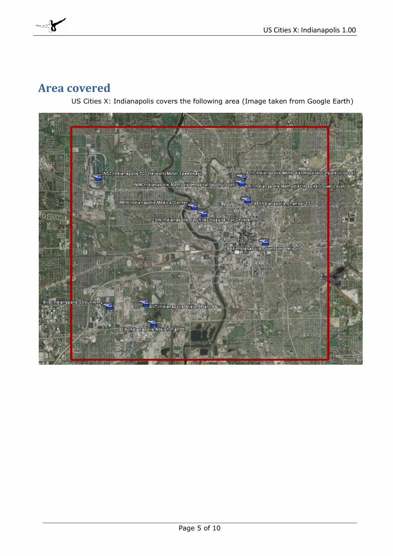
Area covered US Cities X: Indianapolis covers the following area (Image taken from Google Earth)

US Cities X: Indianapolis 1.00
Page 6 of 10
Helipads included There are 9 usable helipads in this scenery where you can take off and land. Check your windows start menu (Start->Programs\Aerosoft\USCitiesX_Indianapolis\Google Earth Map) for a map of all helipads. This map requires that you have Google Earth installed, which you can find here: http://earth.google.com/. To choose one of the helipads go to the airport menu and either type in its name “by airport name” or its ID “by ID”. More details on each heliport can be found by clicking on the links.
8A4 – Indianapolis Downtown Heliport o This heliport is one of the few US downtown heliports in service. It has 6 parking
positions and its own terminal. The touchdown location right over a road tunnel with the skyscrapers nearby is a real eye-catcher! There are two published procedures for this airport that are included at the end of this manual. http://www.airnav.com/airport/8A4
II48 – Indianapolis Channel 13 o Local TV News station from where you can take off for all kinds of news reports.
Traffic reports, sport events… it’s all up to you! But take care when returning to the base. Landing between all the trees, cars, station building and satellite antennas isn’t easy! http://www.airnav.com/airport/II48
Indianapolis Methodist Hospital o This is the base of the LifeLine helicopters in Indy. Check the crew’s new
homepage here: http://www.lifelinehelicopter.com/ It is divided into 3 landing pads at various levels, of which 2 are active:
IN06 – Indianapolis Methodist Hospital Upper Level http://www.airnav.com/airport/in06
81II – Indianapolis Methodist Hospital Lower Level http://www.airnav.com/airport/81II
81II – Indianapolis Methodist Hospital Carpark (closed) 23IN – Indianapolis JW Riley Hospital of Children
o Another rooftop helipad. http://www.airnav.com/airport/23in
96IN – Indianapolis Medical Center o http://www.airnav.com/airport/96in
IN52 – Indianapolis 500 Heliport (Motor Speedway) o This is where the annual Indy 500 motor races take place!
http://www.airnav.com/airport/in52
8II8 – Indianapolis Strout Army o A former airbase that was closed between 1960 and 1961. The helipad is still
military and you can still see the former runways used for storehouses and car parks for military vehicles. http://www.airnav.com/airport/8II8
8II7 – Allsion Plant 8 o Commercial helipad.
http://www.airnav.com/airport/8II7
8II6 – Allsion Plant 5 o Commercial helipad.
http://www.airnav.com/airport/8II6

US Cities X: Indianapolis 1.00
Page 7 of 10
Advised settings To change your scenery settings, go to Settings -> Display Note: All other settings not mentioned here are up to you. They don’t actually affect the scenery very much. Keep in mind to do your settings with care otherwise you may overload your system.
Graphics menu: o Global Texture resolution should be at Very High to get the full detail in textures (aerial
image, building walls etc.)
Scenery menu: o All unique 3D buildings (most downtown buildings, factories, speedway, churches etc.)
become visible at a Scenery Complexity of Normal or higher. o For best results in displaying the suburbs and vegetation in between we recommend to
set Autogen Density to Extremely Dense. But keep in mind not all systems can handle this much detail!
o Texture resolution should be at 1m/pix or higher to get the best resolution of the aerial image beneath the 3D objects.
Traffic menu: o To get some life in the scenery set the traffic of Road Vehicles to 20% or higher. This
will bring you animated car and truck traffic along the major roads and freeways. For more information see the traffic chapter.
Road traffic Some major roads within the city boundaries were equipped with additional road traffic. This will bring you a better real-world feeling when flying over the scenery, but: FSX only knows freeway traffic, meaning that the traffic doesn’t stop at intersections and other obstructions. If you don’t like this but still would like to keep the default traffic on the Interstates, do the following: Go to folder FSX\Aerosoft\USCitiesX_Indianapolis\Scenery and remove the file Indianapolis_Traffic.bgl from this folder.

US Cities X: Indianapolis 1.00
Page 8 of 10
System overload Because of the extremely high complexity of this scenery it can happen that weaker systems have to struggle with system overloads resulting in blurry textures and a non-readable FSX menu bar and ATC. This usually happens with 256MB video cards, which is the reason why we recommend a minimum of 512MB memory on your video card (see system requirements). Although we haven’t had any reports of problems with 512MB video cards some people may still encounter problems with budget video cards or the like.
For users encountering this problem we have added a set with downsizes textures that will solve this problem. You find them in the following folder: FSX\Aerosoft\USCitiesX_Indianapolis\\Low-Res\ Make a backup of your texture folder and then move or copy all the files from Low-Res to the Texture folder replacing all existing files.

US Cities X: Indianapolis 1.00
Page 9 of 10
Compatibility with “Dreamscenery’s Indianapolis X” Some users may still have this scenery installed. We are sure that our scenery looks way better and offers more value for your money but there still may be reasons why you want to merge both sceneries. Dreamscenery’s version of Indianapolis is less detailed as you can see on the screenshots but it has the cities’ international airport included. To merge both sceneries you need to remove all files containing downtown, the speedway and river bridges from Dreamscenery’s Indianapolis. To do so, first locate the folder where you installed it, which is usually FSX Main Folder\Indianapolis X\ Go to the scenery subdirectory and remove (by either renaming BGL to OFF or moving them to a backup folder) all files beginning with:
Downtownterr*.bgl race1fsx.bgl rivbrd*.bgl speed*.bgl twnbldgfsx*.bgl
Note: Although we tested this on our systems we do not guarantee that this will also work for your system. Keep in mind that both loaded together, US Cities’ Indianapolis and Dreamsceneries’ Indianapolis may have an extreme impact on your system performance. Also make sure that US Cities’ Indianapolis is above Dreamsceneries’ Indianapolis in your Scenery library.
Compatibility with BluePrint Simulation’s KIND2009 This scenery might be the better option if you don’t have another Indianapolis scenery as yet and want to add the International airport to our scenery. Unfortunately we didn’t get a test copy of KIND 2009 before releasing this manual so we couldn’t do any tests on it. But referring to forum voices this one might be better on frames, which is very important if you want to use the airport together with a dense scenery like ours.
FAQs Q: Why are there no night and seasonal textures? A: We wanted to keep the price of this whole series as low as possible and the development process as simple as possible so that we can cover as many cities as possible. The VFR flights over these cities is mostly a daytime affair anyway. Still all autogen buildings and airports in the series will have night illumination and autogen vegetation will change with the season. Q: Even after the loading process has reached 100% there are still some objects not loaded! A: Due to the extreme scenery density some computers (mainly those with only 256MB video memory, slower hard disks etc.) take a little longer to load everything. This can last up to 2-3

US Cities X: Indianapolis 1.00
Page 10 of 10
additional minutes. Still the frames per second should be pretty good after everything becomes visible. Q: When selecting Downtown or one of the rooftop helipads I'm beneath the terrain! A: Unfortunately this is a very bad FSX simulation which doesn't support starting a flight on a 3D object. You can circumvent this by selecting the same helipad a second time or using the slew mode of FSX to move the aircraft at the desired level (Y to activate and deactivate slew mode, F1-F4 keys to go up and down). Q: I just started FSX but after selecting one of the cities helipads/airports everything stands still for a long while! A: This can happen on slower systems because FSX actually starts loading the scenery after the airport has been selected - before you even started the flight. If you have one of those systems, do it as follows: First select the desired aircraft, time and weather and last select the airport/helipad in the city and start the flight. Q: Are there any extensions for this city planned? I'm missing a certain 3D object, newly constructed building or more coverage! A: There might be updates for possible bugs or additional missions, but extensions are not planned once a city is finished and released. Q: Some of the 3D buildings or autogen's positions are slightly shifted on the aerial image A: This can happen on the corners of the covered scenery and is due to different coordinate system used. Although in a very limited scale. Q: Why are there no trees and/or autogen buildings in downtown? A: Technical reasons. Due to its high complexity we had to cover a merge a small part of downtown (about the area from RCA Dome up north to Channel 13 helipad) in one single 3D object. This brings a better performance, but also suppresses all autogen buildings in the area covered by this 3D object. Q: Some 3D buildings seem to have misplaced textures! A: Please note that to create a dense scenery like this for a low price was only possible with some automatic processes and images couldn’t be taken from every angle of a cities building (for this scenery alone there are about 1000 unique buildings!) Q: The roofs of some autogen storage buildings show residential buildings! A: An – unfortunately – well known bug in the FSX object library we can’t do much about because FSX chooses the buildings and textures it wants to display on autogen buildings. Q: The fences on helipads are disappearing in certain view angles! A: Unfortunately another FSX bug. The only way to display a proper fence without x-ray effects and flickering is to add it to the airport’s AFCAD file. Bug the smaller the airport (in this case small helipads), the higher the risk that the fence disappears in certain view angles.

ELEV
CATEGORY
APP CRS
Rwy Idg
TDZE
Apt Elev
INDIANAPOLIS, INDIANA
INDIANAPOLIS, INDIANA
(8A4)
(8A4)
INDIANAPOLIS DOWNTOWN HELIPORT
INDIANAPOLIS DOWNTOWN HELIPORT
AL-6835 (FAA)
39^46’N - 86^09’W
732
291^
A
1056045Knots
Min:Sec
75 90 COPTER
H-291^ 1340- 516 (600- )3 4 3 4
26002600
ProcedureTurn NA2400
OPNIC
BOULD
LEEBR VORTAC
291^291^
2 .8 NM 3 NM 8 NM
VHP1500 3000
336^
4.2 NM
336^ 4.2 NMfrom MAP
NA
UNICOM
123.05
INDIANAPOLIS APP CON
(CTAF) L
AWOS-3
118.250 125.275 317.8
N/AN/A
732
COPTER RNAV (GPS) 291^
MISSED APPROACH: Cl imb to 1500 then
cl imbing r ight turn to 3000 d i rect VHP
VORTAC and hold.
COPTER RNAV (GPS) 291^
H
I -65
I -70
I-52/74
336^ 4.2 NM
I-65/70
291^
131^
311^
336^4.2 NM
(MAP)
OPNIC
(FAF)
BOULD
BRICKYARD
VHP
Proceed VFR f rom OPNIC or conduct
the speci f ied missed approach procedure.
Surface e levat ion 824 feet at MAP.
( IF)
LEEBR
(IAF)
SHELBYVILLE
SHB
HProcedure NA for arr iva ls
on SHB VORTAC ai rway
radia ls 231 CW 312.
4 NM
MS A O P N I C 2 5 N
M
3100
1074
1866
1864
1546
1542
13541348
1342
1264
12491140
1000
1000
963
918
902
1068
SEE INSET
2600
(8)
Hel ipor t located in area
of numerous l ighted and
unl ighted obstruct ions.
CAUTION:
Or ig 08045
950
1875
(MAP)
OPNIC
When local a l t imeter set t ing not received, use Indianapol is In t l
a l t imeter set t ing and increase MDA 40 feet . L imi t f ina l and missed
approach a i rspeed to 70 KIAS. DME/DME RNP-0.3 NA.
ACTIVATE High Intensi ty Pad L ights-CTAF.
2400
(3)
H
60 x 60HANGARS
872
1004
859
840
US40
I-65/70
ARENA
V 2
EC
-2, 12 MA
R 2009 to 09 A
PR
2009E
C-2
, 12
MA
R 2
009
to 0
9 A
PR
200
9

H
60 x 60HANGARS
872
1004
859
840
US40
I-65/70
ARENA
V 2
ELEV
1056045Knots
Min:Sec
CATEGORY
UNICOM
123.05
Rwy Idg
TDZE
Apt Elev
INDIANAPOLIS APP CON
(CTAF) L
A
MS A S H B 2 5 N M
3100
COPTER
H-287
2600
2400
2600
VORTAC
287^
2 .8 NM 3 NM 8 NM
2600
1 0 N M
SEEINSET
R-287
H
I -65
I -70
I-52/74
COPTER VOR/DME 287^
COPTER VOR/DME 287^
INDIANAPOLIS, INDIANA
INDIANAPOLIS, INDIANA
(8A4)
(8A4)
INDIANAPOLIS DOWNTOWN HELIPORT
INDIANAPOLIS DOWNTOWN HELIPORT
AL-6835 (FAA)
732
4.2 NM
VORTAC SHB
287^13.8 DME
332^ 4.2 NMfrom MAP
AWOS-3
118.250
NA
125.275 317.8
IAFSHELBYVILLE
Chan 57
N39^37.95’ -W85^49.46’
112.0 SHB SHB
39^46’N - 86^09’W
112.0
57287^
Chan
APP CRSN/AN/A
732
MISSED APPROACH: Cl imbing le f t turn to 2600
via SHB R-287 to LEEBR/8 DME and hold.
Proceed VFR f rom OPNIC or conduct the
speci f ied missed approach procedure.
Surface e levat ion 824 feet at MAP.
Procedure NA for arr iva l
on SHB VORTAC ai rway
radia ls 231 CW 312.
H332^4.2 NM
287^
107^
2600
(8)
OPNIC
SHB 13.8
CAUTION: Hel ipor t located in area
o f numerous l ighted and
un l ighted obstruct ions.
BOULD
SHB 11
LEEBR
SHB 8
Procedure
Turn NA
332^
SHB R-287
112.0
LEEBR
SHB 8
OPNIC
SHB 13.8
1340- 516 (600- )34
34
BOULD
SHB 11
( IF)
LEEBR
SHB 8
1866
1864
1342
1348 1354
1000
1264
963
1546
1000
902
918
11401249
1068
1074
1542
When local a l t imeter set t ing not received, use Indianapol is
Int l a l t imeter set t ing and increase MDA 40 feet .
ACTIVATE High Intensi ty Pad L ights-CTAF.
1020
10282400
(3)
287^
Amdt 2 08045
1875
332^ 4.2 NM
75 90
EC
-2, 12 MA
R 2009 to 09 A
PR
2009E
C-2
, 12
MA
R 2
009
to 0
9 A
PR
200
9


