
The Basketmaker Communities Project
Annual Report, 2011 Field Season
by
Shanna R. Diederichs
and
Steven R. Copeland
© Copyright 2012 by Crow Canyon Archaeological Center
All rights reserved
How to cite this publication.
REMINDER: Archaeological resources are protected by federal laws, and archaeological
research is guided by a set of professional ethics. See Archaeological Ethics and Laws.
1
Introduction In 2011, the Crow Canyon Archaeological Center conducted its first year of field research as part
of the Basketmaker Communities Project, a multiyear study of early Pueblo community
development in the central Mesa Verde region. The study examines an important but
underinvestigated time in Pueblo history: the Basketmaker III period, which dates from A.D. 500
to 750. The focus of Crow Canyon’s field research is a settlement cluster consisting of more than
100 Basketmaker sites located within a 4.9-km2 area in southwestern Colorado. In 2011, Crow
Canyon conducted remote-sensing survey, subsurface probing, and excavations at one of these
sites, the Dillard site (5MT10647), which dates from the seventh century A.D. and includes a
great kiva, the only confirmed Basketmaker III great kiva in the central Mesa Verde region. In
addition, Crow Canyon conducted remote-sensing surveys and subsurface probing at seven other
sites with evidence of Basketmaker III occupation. Understanding the relationship between the
Dillard site and the many surrounding Basketmaker III sites in the study area is essential to our
understanding of how early Pueblo communities formed and were organized.
This annual fieldwork report summarizes progress made on the Basketmaker Communities
Project during the 2011 field season, which ran from April through mid-November. Fieldwork
and related Crow Canyon education programs were conducted by members of the research and
education staff, with assistance from seasonal interns. Remote-sensing work was donated by Bill
Volf and Wes Tuttle of the National Resource Conservation Service and by Colorado School of
Mines geophysical undergraduate students Kendra Johnson, Patricia Littman, and Travis Pitcher,
under the direction of Dr. Richard Krahenbuhl. (See the 2011 personnel list at the end of the
report.)
Upon completion of all fieldwork (scheduled to last through 2013), laboratory analyses, and
synthetic studies related to the Basketmaker Communities Project, Crow Canyon will publish
detailed results of its research on its Web site (www.crowcanyon.org).
Project Area Location and Ownership
The Basketmaker Communities Project study area is located in the eastern portion of the central
Mesa Verde region (Figure 1)―more specifically, in the McElmo drainage unit, which is defined
as the lands in southwestern Colorado that are drained by McElmo Creek. The settlement cluster
that is the focus of Crow Canyon’s research lies north of the creek, on a dissected upland
between Alkali Canyon to the west and the less-substantial Crow Canyon to the east (not shown
on map), just over 6 km (about 4 mi) northwest of Cortez, Colorado.
The project area is defined by the property boundaries of Indian Camp Ranch, a 1,200-acre, 31-
lot private residential community developed in the late 1980s and early 1990s. There are 208
known archaeological sites in the Ranch (Ortman et al. 2011); evidence visible on the modern
ground surface indicates that 107 date from the Basketmaker III period. Figure 2 shows the
boundaries of Indian Camp Ranch and individual lots, as well as the locations of the known or
suspected Basketmaker III sites. Lots outlined in bold are those for which Crow Canyon has
obtained permission from the individual landowners to conduct field investigations (see
following section).

2
Permits and Permissions
Fieldwork in 2011 was conducted under State of Colorado Survey and Testing Permit 2011-84
and Excavation Permit 2011-86.
Crow Canyon’s investigations are also being conducted with the permission of the Indian Camp
Ranch Homeowners Association and individual landowners. Both the bylaws and covenants of
Indian Camp Ranch were crafted to promote the preservation and research of archaeological sites
(Indian Camp Ranch Homeowners Association 2007). In 2010, the homeowners association
granted Crow Canyon permission to conduct field research at Basketmaker III sites located
within the Ranch, subject only to restrictions imposed by the individual landowners and provided
that the work complied with the professional and ethical standards established by the Society for
American Archaeology and the Register of Professional Archaeologists.
To date, five individual contracts between Indian Camp Ranch landowners and the Crow Canyon
Archaeological Center have been signed. Several contracts limit Crow Canyon activities on
particular properties: two prohibit excavation but permit surface mapping and remote sensing; a
third permits less than 10 m2
of excavation at two separate sites, which will limit our work to test
excavations. The other two contracts give permission for both test and intensive excavations at
Basketmaker III sites on the landowners’ lots.
Public Involvement
A diverse segment of the public benefitted from Crow Canyon’s research during the 2011 field
season. Through Crow Canyon’s research and education programs, 430 people―ranging in age
from middle school students through adults―assisted in excavations at the Dillard site. At least
600 additional individuals participated in numerous formal tours offered as part of single-day
field trips, multiday non-excavation school group programs, or other Crow Canyon–sponsored
activities. The total number of people served reflects not only Crow Canyon’s commitment to
involving the public in its research but also the level of public interest in the ancient past of the
Mesa Verde region.
American Indian Involvement
American Indians were involved in the Basketmaker Communities Project in several ways
during 2011. Teachers from Santa Ana Pueblo attended a week-long Archaeology Research
Program, excavating alongside other participants at the Dillard site. Some of these teachers
returned with Santa Ana elementary and high school students later in the summer for multiday
sessions. Southern Ute and Ute Mountain Ute school groups also attended education programs,
and one member of Zia Pueblo participated in High School Field School. (The American Indian
participants are included in the participant totals in the preceding paragraph.)
As part of Crow Canyon’s ongoing Pueblo Farming Project, Hopi farmers visited campus to
consult on the 2011 experimental gardens. During their stay, these advisors visited the Dillard
site and blessed the great kiva before excavation began. Finally, during Crow Canyon’s annual
board meeting, the Crow Canyon Native American Advisory Group visited the Dillard site and
heard updates on the progress made during the field season. Their visit also prompted discussion
of the possible functions of great kivas and the potential for dryland farming in the vicinity of the
site.
3
Throughout these activities, the insights and perspectives shared by American Indians informed
Crow Canyon’s research and enriched the experience of participants enrolled in the Center’s
education programs. We intend to build on our relationships with American Indians through
continued consultation with the Native American Advisory Group and other interested parties as
the Basketmaker Communities Project progresses.
Environmental Setting The Basketmaker Communities Project study area consists of gently rolling uplands where
varying thicknesses of eolian silt loam overlie the Dakota Sandstone. The elevation at the center
of the project area is about 1890 m (6200 ft). Approximately 100 million years of geologic
history dating from the late Triassic/Jurassic through the middle Cretaceous are exposed to the
west, in Alkali Canyon. The various geologic strata provided Pueblo people with construction
stone and raw material for tools, and the permeable layers form a high-quality aquifer that gives
rise to numerous springs at the interfaces between fine sandstone beds and less-permeable
mudstones.
Indian Camp Ranch was probably once completely covered by a pinyon-juniper woodland
dominated by pinyon pine and Utah juniper, with an understory of bunch grasses, yucca, and
prickly pear cactus. Today, remnants of this woodland can be found in the northwest and south-
central portions of the Ranch, but elsewhere the native vegetation has been replaced (in the last
100 years) by ranchland and farm fields. Properties in the western third of the Ranch have been
cultivated and are planted in winter wheat. Ranchlands, including a portion of the tract on which
the Dillard site is located, are dominated by big sagebrush, rabbitbrush, and bunch grasses.
History of Archaeological Investigations In 1984 and 1985, the Crow Canyon Archaeological Center recorded 11 sites on property that is
now part of Indian Camp Ranch. The recorded sites are 5MT2032, 5MT3875, 5MT3873,
5MT3906, 5MT3907, 5MT3915, 5MT3919, 5MT3887, 5MT3890, 5MT3893, and 5MT3911.
This documentation was part of the Center’s early public education initiative, and no formal
report was generated (Mark Varien, personnel communication 2012).
In the fall of 1989, Woods Canyon Archaeological Consultants, Inc., conducted a reconnaissance
of the newly created Indian Camp Ranch. The goal of this survey was to identify and briefly
describe sites within the 1,200-acre development and plot them on an aerial photograph
(Honeycutt and Fetterman 1991). From 1991 through 1993, Woods Canyon archaeologists
formally recorded sites located during the reconnaissance, eventually documenting all 208 sites
within Indian Camp Ranch, including the 11 sites recorded by Crow Canyon in the mid-1980s
(Fetterman and Honeycutt 1994).
One of the most compelling features recorded during the Woods Canyon survey was a 10-m-
wide depression on a tract located in the far western portion of the development. The depression
and immediately surrounding area were designated Site 5MT10647; Crow Canyon later named it
the Dillard site, after the landowner who in the meantime had purchased the tract. In 1991,
Woods Canyon archaeologists excavated a 12-m-long dog-leg trench through this prominent
feature, revealing a large, circular―but fairly shallow―structure (Fetterman 1991). Multiple,

4
layered adobe floor surfaces were found about 1 m below the modern ground surface, and a low
bench was defined around the perimeter of the exposed portion of the building. All the visible
characteristics indicated that the structure was a great kiva. One large, partly burned upright post
was located in the southwest quadrant, suggesting that the structure had a four-post roof-support
system. The presence of this burned post and the discovery of charred and fragmentary wood in
the fill above the floor suggests that the structure may have burned after it was abandoned.
Though the post was not tree-ring dated, a scatter of Chapin Gray sherds on the floor indicated
that the structure was, indeed, a Basketmaker III great kiva.
A Basketmaker III presence has also been documented on adjacent lands south and east of Indian
Camp Ranch. Approximately 300 hectares south of the Ranch were surveyed for a fuel-reduction
project for Canyons of the Ancients National Monument (Fetterman 2004). Thirty-seven sites
with Basketmaker III components were recorded, including single- and multiple-habitation sites,
field houses, and activity areas. The nearby Crow Canyon Archaeological Center, located south
and east of Indian Camp Ranch, recently surveyed its campus of approximately 70 hectares
(Kuckelman and Powell 2009) and documented six Basketmaker III sites. Of these, three are
single-habitation sites and three are limited-activity (probably resource-procurement) sites. The
results of the Indian Camp Ranch, fuel-reduction, and Crow Canyon surveys indicate that there
was once a very large Basketmaker III community that occupied more than 800 hectares
stretching between Crow and Alkali canyons. However, because there has been no
comprehensive study of this settlement to date, the momentary population and exact nature of the
community, as well as its relationship to neighboring communities, are mostly unknown.
Research Objectives The Basketmaker Communities Project is a study of seventh-century population growth and
social organization in the central Mesa Verde region. Data generated as a result of Crow
Canyon’s field and laboratory research will lead to a better understanding of settlement changes
that occurred as hunter-gatherer societies transitioned to agricultural economies across the
northern Southwest (Varien and Diederichs 2011). In addition to being a time of marked
population growth, the Basketmaker III period was also witness to great technological and social
change, including the expansion of dry farming, the addition of cultivated beans and new
varieties of corn to the diet, the replacement of the spear and atlatl with the bow and arrow, and
the first appearance of pottery and public architecture. Taken together, these characteristics form
what Kohler and Varien (2010:44) call ―the full Neolithic package,‖ and the appearance of this
package kicks off the ancestral Pueblo ―Neolithic Revolution‖ in the Four Corners area,
including the Mesa Verde region.
The cluster of Basketmaker III sites in the study area is unique in its potential to shed light on the
Pueblo Neolithic transition. First, the density of Basketmaker III sites across Indian Camp Ranch
is fairly high (about 1 site per every 4 hectares), indicating that the settlement was substantial.
Second, the great kiva at the Dillard site is the only confirmed Basketmaker III great kiva in the
central Mesa Verde region. The presence of this structure indicates that the site was a focal point
for a burgeoning population and may constitute some of the earliest evidence of non-kin social
organization in the region. Finally, at least 77 of the Basketmaker III sites in Indian Camp Ranch
are single component, including the Dillard site. These sites are especially suitable for the study
5
of Basketmaker III settlement patterns because architectural and other material remains are not
obscured by later Pueblo sites with substantial masonry construction.
The research goals of the Basketmaker Communities Project are fourfold: (1) to date
Basketmaker III households and public architecture across Indian Camp Ranch to determine the
contemporaneity of sites in the settlement and calculate momentary-population estimates; (2) to
determine the relationships among different households in the settlement and between sites with
public architecture and those without; (3) to assemble data on imported cultural material and
traditions; (4) and to identify the subsistence technologies and strategies employed by the
Basketmaker III inhabitants. The results of our research will be used to examine three important
questions: First, what was the source population for the Basketmaker III immigrants to the study
area? Second, is there an identifiable community represented by the Indian Camp Ranch
Basketmaker III settlement, and, if so, how was it organized? Third, what was the nature of the
Neolithic transition during the Basketmaker III period, and what technological changes made the
transition possible?
Research at the Dillard site and surrounding Basketmaker III sites will address these important
questions as well as issues of general anthropological interest, including the nature of leadership;
the development of, and/or resistance to, social inequality; and the role of public architecture in
social complexity. The Basketmaker Communities Project research design is presented in A
Proposal to Conduct Archaeological Testing at Indian Camp Ranch, Montezuma County, CO
(Ortman et al. 2011).
Field Methods The ephemeral nature of Basketmaker III surface remains at open sites presents a special
challenge to field archaeologists. As a result, Crow Canyon employed several tactics to locate,
delineate, and test structures, activity areas, and middens in the project area. Field methods used
during the 2011 field season included (1) site mapping, (2) remote-sensing survey combined with
soil probing, (3) trowel- and shovel-stripping block areas in 2-x-2-m units, (4) excavating
structures and structure chambers in quadrants (up to one-half the area of an individual
structure), and (5) random testing of midden areas with 1-x-1-m units.
A detailed description of Crow Canyon’s field methods and provenience system can be found in
the online field manual (www.crowcanyon.org); in addition, project-specific methods are
outlined in the project research proposal (Ortman et al. 2011).
Test vs. Intensive Excavations
The research design for the Basketmaker Communities Project calls for both test and intensive
excavations. Test excavation, as defined by the Colorado State Historic Preservation Office, is
limited excavation of noncontiguous units totaling less than 10 m2 at any given site; intensive
excavation is excavation that exceeds 10 m2 (Office of Archaeology and Historic Preservation
2011). Our work at the Dillard site constitutes intensive excavation. Beginning in 2012, however,
we will conduct test excavations at small sites where targeted excavation is expected to provide
the information needed to answer our research questions.

6
Structure-Numbering Convention
Crow Canyon’s field-recording system requires the detailed documentation of all architecture
uncovered in the course of excavation. For structures, that documentation includes the recording
of structure stratigraphy, length, width, height/depth, and diameter; specific characteristics of
individual walls and surfaces; and detailed information about features. Basketmaker III pithouses
pose a particular challenge for recording because the typical structure consists of two
chambers—a main chamber and an antechamber—and the architectural characteristics of the two
are often quite different. For example, the floor of the main chamber is often deeper than the
floor of the antechamber, a bench may be present in one chamber but not the other, and the
construction of the walls and floors can differ markedly between the two parts of the pithouse.
Therefore, although the main chamber and antechamber constitute a single structure, the
requirements of our recording system dictate that we treat them as two separate structures for the
purposes of field documentation. Throughout this report, and in all related field records and
databases, we have assigned two structure numbers to each pithouse that has an antechamber:
one number is assigned to the main chamber, and the other number is assigned to the
antechamber. Both numbers are provided on maps and the first time a given structure is
introduced in text—for example, Structure 205 (main chamber) and Structure 226
(antechamber). Thereafter, the structure is referred to in the singular as ―the pithouse,‖ ―the
structure,‖ or as a hyphenated compound (in this example, Structure 205-226), to make clear that
the discussion refers to just one pithouse.
Non-Excavation Fieldwork in 2011 Temperature Monitoring
In 2011, two monitors were installed to record temperature data in the western portion of the
project area. These electronic monitors are very precise and can operate unattended for months at
a time. The monitors were placed at two geographically distinct sites. The first was installed at a
small habitation site, 5MT2032, which sits on a ridgetop at an elevation of 1932 m (6340 ft). The
second monitor was installed in the center of the Dillard site, at 1925 m (6315 ft). Five other
comparable monitors are recording data on experimental farm plots across Crow Canyon’s
campus, 3 km to the east, to determine corn productivity of particular environmental settings.
With the data from these various monitors, we hope to determine if temperatures and growing
season length are adequate for maize farming at particular locales in and near the Basketmaker
Communities Project study area.
Mapping
During the 2011 field season, sites selected for excavation were mapped using a Topcon GT-203
electronic total station surveying instrument in combination with AutoCad Light and Adobe
Acrobat software. In addition to mapping site boundaries, we also mapped structures, middens,
and rock concentrations discernible on the modern ground surface. The resulting maps were then
used to delineate architectural blocks. An architectural block consists of spatially related
buildings, middens, and extramural spaces. Because most Basketmaker III structures are
undetectable on the ground surface, we defined architectural blocks primarily on the basis of
other evidence visible on the surface, such as concentrations of artifacts and possible
construction stone. As we discovered in Block 2 at the Dillard site, a single block may
encompass many structures and features. Using numerous instrument-established datums, we
also mapped the marker pole that had been placed at each site during the development of Indian
7
Camp Ranch and relocated and mapped the limits of the Woods Canyon excavations at the
Dillard site. In addition, we used the total station to set in excavation units.
Remote-Sensing Survey and Subsurface Probing
A combination of remote-sensing survey and subsurface probing was conducted at eight sites
with the potential to yield information on Basketmaker III settlement patterns. This work had
two primary objectives: (1) to locate subsurface structures and activity areas and (2) to help
develop plans for future targeted excavations. The sites surveyed in 2011 include the multiple-
habitation Dillard site and two small hamlets on the west side of the project area and five hamlets
clustered on the east side (Figure 3). In all, an area of 12,880 m2
was surveyed using remote-
sensing technology during 2011 (Table 1). In addition, we conducted subsurface probing in
several locations not subjected to remote sensing. The net result of both efforts was the
identification of 13 probable pithouses and several other possible cultural anomalies.
Remote-sensing survey was conducted in cooperation with both the Natural Resources
Conservation Service (NRCS) and the Colorado School of Mines geophysical department.
William Volf of the NRCS, Cortez office, volunteered his time, equipment, and expertise to
conduct large-scale remote-sensing survey on six sites. This work will help the NRCS develop
models for cultural remains signatures on cultivated landscapes, especially for sites in similar
deep-loess settings across southwestern Colorado.
Kendra Johnson, Patricia Littman, and Travis Pitcher are undergraduate geophysical students at
the Colorado School of Mines. Under the direction of Dr. Richard Krahenbuhl, these students
conducted remote-sensing surveys at two sites as part of a senior project designed to prepare
them for using this technology on cultural resource mitigation projects. Additional remote
sensing conducted during the 2011 field season included conductivity survey and a small test run
of ground-penetrating radar. This work was performed by Wes Tuttle and William Volf of the
NRCS on top of previously detected structures to test the reliability of the equipment.
To generate comparable data across the Basketmaker Communities Project study area, remote-
sensing survey was conducted in a standard grid measuring 20 x 20 m wherever possible. These
remote-sensing blocks were laid out on a north–south axis, south of any probable storage
features, in an effort to detect pit structures and extramural activity areas. William Volf surveyed
primarily with an electrical-resistance meter, the RM-15 Resistance Meter; at the Dillard site he
used both the RM-15 and a magnetometer, the FM-256 Fluxgate Gradiometer. The Colorado
School of Mines students conducted a variety of remote-sensing surveys using ground-
penetrating radar, magnetometer, and electrical-resistivity technology. Only preliminary results
are available from this year’s remote-sensing surveys. Final reports, including detailed
descriptions of equipment, methodology, and results, are expected to be submitted to Crow
Canyon in 2012. Anomalies that on the basis of preliminary data seemed most likely to indicate
the presence of pit structures were probed with 1-inch-diameter soil augers by Crow Canyon
staff, who described the characteristics of any cultural deposits and recorded the depth of the
reddish-brown loess that marks the prehistoric ground surface.
8
Remote-Sensing Survey and Subsurface Probing, West
Remote-sensing survey was conducted at three sites in the western portion of the study area in
2011: the Dillard site (5MT10647) and two smaller sites (5MT10721 and 5MT10730) located
northeast of Dillard.
The Dillard site encompasses slightly more than 3 hectares of a gently sloping, north–south
ridge. The modern ground surface has been disturbed by historic chaining and recent burning of
all downed material across the property. The site is now covered with sagebrush and grasses.
Electrical-resistivity and magnetometer surveys were conducted by William Volf during the
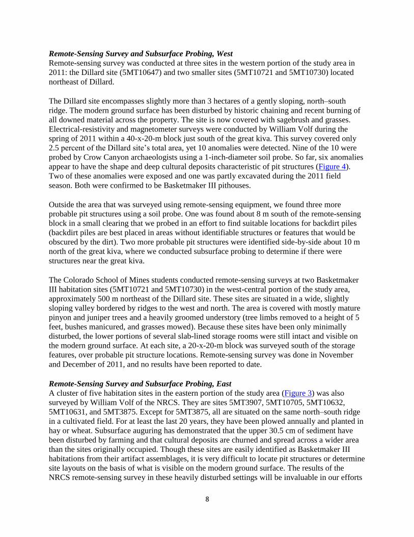
spring of 2011 within a 40-x-20-m block just south of the great kiva. This survey covered only
2.5 percent of the Dillard site’s total area, yet 10 anomalies were detected. Nine of the 10 were
probed by Crow Canyon archaeologists using a 1-inch-diameter soil probe. So far, six anomalies
appear to have the shape and deep cultural deposits characteristic of pit structures (Figure 4).
Two of these anomalies were exposed and one was partly excavated during the 2011 field
season. Both were confirmed to be Basketmaker III pithouses.
Outside the area that was surveyed using remote-sensing equipment, we found three more
probable pit structures using a soil probe. One was found about 8 m south of the remote-sensing
block in a small clearing that we probed in an effort to find suitable locations for backdirt piles
(backdirt piles are best placed in areas without identifiable structures or features that would be
obscured by the dirt). Two more probable pit structures were identified side-by-side about 10 m
north of the great kiva, where we conducted subsurface probing to determine if there were
structures near the great kiva.
The Colorado School of Mines students conducted remote-sensing surveys at two Basketmaker
III habitation sites (5MT10721 and 5MT10730) in the west-central portion of the study area,
approximately 500 m northeast of the Dillard site. These sites are situated in a wide, slightly
sloping valley bordered by ridges to the west and north. The area is covered with mostly mature
pinyon and juniper trees and a heavily groomed understory (tree limbs removed to a height of 5
feet, bushes manicured, and grasses mowed). Because these sites have been only minimally
disturbed, the lower portions of several slab-lined storage rooms were still intact and visible on
the modern ground surface. At each site, a 20-x-20-m block was surveyed south of the storage
features, over probable pit structure locations. Remote-sensing survey was done in November
and December of 2011, and no results have been reported to date.
Remote-Sensing Survey and Subsurface Probing, East
A cluster of five habitation sites in the eastern portion of the study area (Figure 3) was also
surveyed by William Volf of the NRCS. They are sites 5MT3907, 5MT10705, 5MT10632,
5MT10631, and 5MT3875. Except for 5MT3875, all are situated on the same north–south ridge
in a cultivated field. For at least the last 20 years, they have been plowed annually and planted in
hay or wheat. Subsurface auguring has demonstrated that the upper 30.5 cm of sediment have
been disturbed by farming and that cultural deposits are churned and spread across a wider area
than the sites originally occupied. Though these sites are easily identified as Basketmaker III
habitations from their artifact assemblages, it is very difficult to locate pit structures or determine
site layouts on the basis of what is visible on the modern ground surface. The results of the
NRCS remote-sensing survey in these heavily disturbed settings will be invaluable in our efforts
9
to identify subsurface structures, plan for future testing, and reconstruct the Basketmaker III
settlement pattern in the study area.
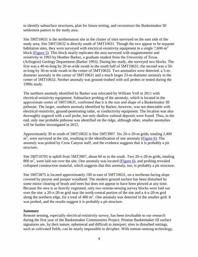
Site 5MT10631 is the northernmost site in the cluster of sites surveyed on the east side of the
study area; Site 5MT10632 is directly south of 5MT10631. Though the two appear to be separate
habitation sites, they were surveyed with electrical-resistivity equipment in a single 7,600-m2
block (Figure 5). This block nearly replicates the area surveyed with magnetometer and
resistivity in 1993 by Heather Barker, a graduate student from the University of Texas
(Arlington) Geology Department (Barker 1993). During her study, she surveyed two blocks. The
first was a 40-m-long by 20-m-wide swath in the south half of 5MT10631; the second was a 50-
m-long by 30-m-wide swath in the center of 5MT10632. Two anomalies were detected: a 5-m-
diameter anomaly in the center of 5MT10631 and a much larger 23-m-diameter anomaly in the
center of 5MT10632. Neither anomaly was ground-truthed with soil probes or tested during the
1990s study.
The northern anomaly identified by Barker was relocated by William Volf in 2011 with
electrical-resistivity equipment. Subsurface probing of the anomaly, which is located in the
approximate center of 5MT10631, confirmed that it is the size and shape of a Basketmaker III
pithouse. The larger, southern anomaly identified by Barker, however, was not detectable with
electrical-resistivity, ground-penetrating radar, or conductivity equipment. The location was also
thoroughly augured with a soil probe, but only shallow cultural deposits were found. Thus, in the
end, only one probable pithouse was identified on the ridge, although other, smaller anomalies
will be further investigated in 2012.
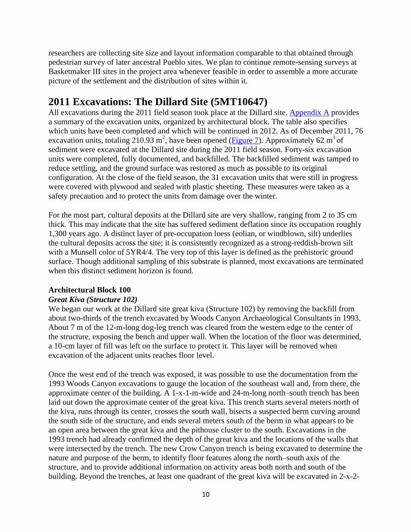
Approximately 30 m south of 5MT10632 is Site 5MT3907. Six 20-x-20-m grids, totaling 2,400
m2, were surveyed at the site, resulting in the identification of one anomaly (Figure 6). The
anomaly was probed by Crow Canyon staff, and the evidence suggests that it is probably a pit
structure.
Site 5MT10705 is uphill from 5MT3907, about 60 m to the south. Two 20-x-20-m grids, totaling
800 m2, were laid out over the site. One anomaly was located (Figure 6), and probing revealed
collapsed construction material, which suggests that this anomaly, too, is probably a pit structure.
Site 5MT3875 is located approximately 100 m east of 5MT10631, on a northeast-facing slope
covered by pinyon and juniper woodland. The modern ground surface has been disturbed by
some minor clearing of brush and trees but does not appear to have been plowed at any time.
Because the area is so heavily vegetated, only two remote-sensing survey blocks were laid out
over the site: a 20-x-20-m grid near the north-central portion of the site and a 4-x-20-m grid
along the northern edge, for a total of 480 m2. One anomaly was detected in the smaller grid. It
was probed, and the results suggest it is probably a pit structure.
Summary
Remote sensing, especially electrical-resistivity survey, has been invaluable to our research
during the first year of the Basketmaker Communities Project. Pristine Basketmaker III surface
signatures are, by their nature, ephemeral and difficult to interpret; sites in disturbed settings,
such as cultivated fields, can be nearly impossible to decipher. With remote-sensing technology,
10
researchers are collecting site size and layout information comparable to that obtained through
pedestrian survey of later ancestral Pueblo sites. We plan to continue remote-sensing surveys at
Basketmaker III sites in the project area whenever feasible in order to assemble a more accurate
picture of the settlement and the distribution of sites within it.
2011 Excavations: The Dillard Site (5MT10647) All excavations during the 2011 field season took place at the Dillard site. Appendix A provides
a summary of the excavation units, organized by architectural block. The table also specifies
which units have been completed and which will be continued in 2012. As of December 2011, 76
excavation units, totaling 210.93 m2, have been opened (Figure 7). Approximately 62 m
3 of
sediment were excavated at the Dillard site during the 2011 field season. Forty-six excavation
units were completed, fully documented, and backfilled. The backfilled sediment was tamped to
reduce settling, and the ground surface was restored as much as possible to its original
configuration. At the close of the field season, the 31 excavation units that were still in progress
were covered with plywood and sealed with plastic sheeting. These measures were taken as a
safety precaution and to protect the units from damage over the winter.
For the most part, cultural deposits at the Dillard site are very shallow, ranging from 2 to 35 cm
thick. This may indicate that the site has suffered sediment deflation since its occupation roughly
1,300 years ago. A distinct layer of pre-occupation loess (eolian, or windblown, silt) underlies
the cultural deposits across the site; it is consistently recognized as a strong-reddish-brown silt
with a Munsell color of 5YR4/4. The very top of this layer is defined as the prehistoric ground
surface. Though additional sampling of this substrate is planned, most excavations are terminated
when this distinct sediment horizon is found.
Architectural Block 100
Great Kiva (Structure 102)
We began our work at the Dillard site great kiva (Structure 102) by removing the backfill from
about two-thirds of the trench excavated by Woods Canyon Archaeological Consultants in 1993.
About 7 m of the 12-m-long dog-leg trench was cleared from the western edge to the center of
the structure, exposing the bench and upper wall. When the location of the floor was determined,
a 10-cm layer of fill was left on the surface to protect it. This layer will be removed when
excavation of the adjacent units reaches floor level.
Once the west end of the trench was exposed, it was possible to use the documentation from the
1993 Woods Canyon excavations to gauge the location of the southeast wall and, from there, the
approximate center of the building. A 1-x-1-m-wide and 24-m-long north–south trench has been
laid out down the approximate center of the great kiva. This trench starts several meters north of
the kiva, runs through its center, crosses the south wall, bisects a suspected berm curving around
the south side of the structure, and ends several meters south of the berm in what appears to be
an open area between the great kiva and the pithouse cluster to the south. Excavations in the
1993 trench had already confirmed the depth of the great kiva and the locations of the walls that
were intersected by the trench. The new Crow Canyon trench is being excavated to determine the
nature and purpose of the berm, to identify floor features along the north–south axis of the
structure, and to provide additional information on activity areas both north and south of the
building. Beyond the trenches, at least one quadrant of the great kiva will be excavated in 2-x-2-
11
m units. Seven of these units have been opened in and adjacent to the northwest quadrant of the
building and are being excavated at the same pace as the north–south trench.
A layer of disturbed fill up to 20 cm thick was found throughout the great kiva depression.
Within it are large pockets of ash and charcoal, the remains of vegetation that apparently was
piled and burned. This material probably dates from the 1990s, when windrows of chained trees
were pushed into the depression of the great kiva and burned during the development of Indian
Camp Ranch.
Below the disturbed material in the great kiva is postoccupational fill that either washed or blew
into the depression created by the collapse of the structure. This material is mostly dark gray
clayey silt with flecks of both burned stone and adobe. Interestingly, the artifact density is
moderately high and includes pottery dating from the Pueblo II and III periods, including black-
on-white and black-on-red sherds. We also found two drills, an obsidian projectile point, a chert
biface, a polished pebble, and several cores in this fill.
High in this postoccupational fill was a rectangular cluster of 13 sandstone slabs. Designated
Feature 1, this rock cluster measured about 90 x 60 cm; about half the slabs were ground on at
least one face and several were found in an upright position. It is difficult to determine the
feature’s purpose, but the symmetry of the rock cluster and its location in the postoccupational
fill suggests that it was purposefully constructed in the great kiva long after the structure
collapsed.
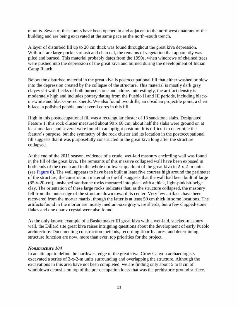
At the end of the 2011 season, evidence of a crude, wet-laid masonry encircling wall was found
in the fill of the great kiva. The remnants of this massive collapsed wall have been exposed in
both ends of the trench and in the whole northwest quadrant of the great kiva in 2-x-2-m units
(see Figure 8). The wall appears to have been built at least five courses high around the perimeter
of the structure; the construction material in the fill suggests that the wall had been built of large
(85-x-20-cm), unshaped sandstone rocks mortared into place with a thick, light-pinkish-beige
clay. The orientation of these large rocks indicates that, as the structure collapsed, the masonry
fell from the outer edge of the structure down toward its center. Very few artifacts have been
recovered from the mortar matrix, though the latter is at least 50 cm thick in some locations. The
artifacts found in the mortar are mostly medium-size gray ware sherds, but a few chipped-stone
flakes and one quartz crystal were also found.
As the only known example of a Basketmaker III great kiva with a wet-laid, stacked-masonry
wall, the Dillard site great kiva raises intriguing questions about the development of early Pueblo
architecture. Documenting construction methods, recording floor features, and determining
structure function are now, more than ever, top priorities for the project.
Nonstructure 104
In an attempt to define the northwest edge of the great kiva, Crow Canyon archaeologists
excavated a series of 2-x-2-m units surrounding and overlapping the structure. Although the
excavations in this area have not been completed, we are finding only about 5 to 8 cm of
windblown deposits on top of the pre-occupation loess that was the prehistoric ground surface.
12
The artifact density in the windblown stratum is low, and, so far, no artifacts have been found
directly on the prehistoric ground surface.
Architectural Block 200
Pithouses and Immediately Surrounding Areas
Many Basketmaker III pithouses have been fully excavated in the Mesa Verde region, but
previous investigations have not emphasized the recovery of comparable data across sites in the
same settlement cluster. The Basketmaker Communities Project is an opportunity to remedy this
situation. First, we are examining multiple sites within a single large cluster; second, we are
using a ―layered‖ sampling strategy at all sites, which will ensure a high degree of comparability.
That strategy includes (1) exposing the shape and size of selected pithouses by stripping away
the postoccupational deposits above and around them; (2) excavating a trench across selected
pithouses to better define structure boundaries, expose stratigraphy, and locate floor features; and
(3) excavating an additional one-quarter to one-half of the trenched structures to expose the
hearth, ritual features, and intramural storage features.
Structure 205 and Structure 226:
Structure 205 and Structure 226 refer to the main chamber and antechamber, respectively, of one
of the pithouses identified with electrical resistivity at the Dillard site. This pithouse is located
about 25 m south of the great kiva, along the western edge of the ridge. Despite the slightly west-
facing slope in this location, the structure is oriented northwest–southeast (Figure 9), with the
antechamber to the southeast.
The pithouse was exposed by stripping sediments above and around it in a series of test units.
These excavations are described below, in the discussion of Arbitrary Unit 202 and Nonstructure
216.
Once the boundaries of the pithouse were defined, we excavated a 50-cm-wide trench along the
front, or southeast, wall of the main chamber to more precisely locate the division between the
main chamber and antechamber. Next, we bisected the structure northwest to southeast and
began excavating the northeast halves of both the antechamber and main chamber. In 2011, we
excavated down to 25 cm above the floor in the main chamber; in the antechamber, we fully
exposed the floor in the northwest quadrant but left 10 cm of fill in the northeast quadrant.
Both chambers of the pithouse are filled with collapsed construction material consisting of light-
reddish-brown silty clay with small caliche inclusions. This clayey matrix is very compacted,
and its texture and color are very uniform, suggesting that the sediment used to cover the roof
and walls of the pithouse was specially selected and possibly even mined for this purpose.
Burned wood was found in the collapsed construction material in both the main chamber and the
antechamber, but these materials are fairly sparse, suggesting that the pithouse was only partly
burned. The antechamber may have burned more completely than the main chamber. At this
time, about 25 tree-ring samples have been collected from the roofing material for submission to
the Laboratory of Tree-Ring Research at the University of Arizona, Tucson.
The main chamber of the pithouse is large, measuring about 4.8 m long and 5.5 m wide. This
chamber is D-shaped, with a straight front wall and more-rounded rear wall. Though excavation

13
is still about 25 cm above the floor, it appears that the chamber is about 85 cm deep, or 20 cm
deeper than the antechamber. At this time, neither a bench nor a wing wall has been detected.
Quite a few artifacts were found in the collapsed construction material in the main chamber,
including more than 400 gray ware sherds, a bone pendant, a bone bead, three awls, a couple of
pieces of unmodified nonhuman bone, one gizzard stone, a mano, an obsidian flake, two drills,
several cores, and several pieces of malachite, azurite, and gypsum. Though most of this material
is probably refuse that was incidentally mixed into the sediment before it was collected for
construction, some of the items may have been stashed in the rafters of the structure before its
collapse.
The antechamber is an elongated oval in plan, measuring 5 m long, 4.3 m wide, and 65 cm deep;
there is no bench in the excavated portion. As was the case in the main chamber, numerous
artifacts were found in the collapsed construction material, including several hundred gray ware
sherds, one modified nonhuman rib bone, a quartz crystal, a fossilized shell, a mortar stone, an
artiodactyl tooth, four eggshell fragments, an obsidian flake, several small cores, and several
shaped, grooved, and ground sandstone slabs. The portion of the floor exposed in the northwest
quadrant of the antechamber is use-compacted and covered with de facto refuse, including
several clumps of raw clay, a mano, more than 40 gray ware sherds, a gizzard stone, and several
large cores. Two probable features have been detected on the floor―what appears to be a bin in
the northwest corner and an ephemeral hearth near the center of the structure (not yet mapped).
Both features will be excavated in 2012.
Arbitrary Unit 202 and Nonstructure 216:
The sediment above and surrounding Structure 205-226 that was stripped to better delineate the
boundaries of the pithouse was designated Arbitrary Unit 202. Nineteen 2-x-2-m units and one 1-
x-2-m unit, for a total area of 78 m2, were excavated. These excavations sampled mixed
postoccupational and cultural fill above and surrounding the pithouse and exposed the prehistoric
ground surface surrounding the structure. The surface is designated Nonstructure 216; it consists
of a reddish-brown loess with almost no inclusions.
Arbitrary Unit 202 ranges from 4 to 10 cm thick and consists of a light brown silty loam with
light charcoal flecking. The artifact density is moderately dense. The discovery of a few sherds
dating to the Pueblo II and/or Pueblo III periods, as well as several small, corner-notched
projectile points, indicates that the site continued to be lightly used after the Basketmaker III
period. Numerous gray ware sherds and stone flakes were found in the cultural fill surrounding
and above the structure, in addition to some unfired clay, possible turquoise and malachite, a
fossilized shell, some gizzard stones, and one piece of galena. The highest density and greatest
variety of artifacts were found north of the pithouse. A dense concentration of more than 200
gray ware sherds (some of them only lightly fired), a quartz crystal, and several pieces of
hematite pigment and animal bone were collected, suggesting that this may have been an outdoor
work area.
Four meters south of the antechamber is an extramural pit feature, designated Feature 1 of
Nonstructure 216. This ovoid feature is about 95 cm long and 30 cm deep. Large slabs, several of
which are metate fragments, line the walls of the feature but not the base; some of these slabs

14
protrude above the prehistoric ground surface. The base of the feature was oxidized, indicating
that at least one fire had been built in the pit, but the final use was for refuse disposal.
Structure 220:
Structure 220 is located on the same ridge as, and directly east of, Structure 205-226. It was first
identified during the remote-sensing survey. Before remote sensing, the only evidence of a
pithouse in this location was a light scatter of eroded adobe, pottery sherds, and a few stone
flakes.
In 2011, we began stripping the sediments above and immediately surrounding this pithouse to
fully expose its shape and size in plan view. These excavations are described below, in the
discussion of Nonstructure 215.
So far we have delineated approximately half of Structure 220; the entire southwestern edge of
the main chamber is now visible. This pithouse appears to be smaller than Structure 205-226, but
we do not yet know if it has an antechamber. The main chamber is approximately 4.3 m long and
fairly rectangular in plan. Several burned posts have been identified along the periphery of the
building, outside the main chamber. The structure fill is dense with charcoal of all sizes and
flecks of burned adobe; it is clear that Structure 220 burned. This structure will be important for
dating the Dillard site because of its potential to provide tree-ring samples.
In 2012, we will continue stripping sediments to expose the remainder of the pithouse. Once the
boundaries have been fully delineated, we will excavate one-quarter to one-half of the structure.
Arbitrary Unit 214, Nonstructure 215, and Nonstructure 227:
In 2011, we excavated 10 2-x-2-m units over and around the southwest half of Structure 220 in
an effort to define the horizontal limits of the pithouse; approximately seven more 2-x-2-m units
will be excavated in 2012 to expose the northeast boundary.
Our 2011 excavations sampled the postoccupational overburden (designated Arbitrary Unit 214),
a layer of refuse (Nonstructure 215), and the prehistoric ground surface surrounding Structure
220 (Nonstructure 227). Arbitrary Unit 214 is a windblown deposit; in it we found gray ware
pottery sherds, stone flakes, a pendant fragment, and a few Pueblo II and/or Pueblo III sherds.
Below this stratum, a 15- to 20-cm-thick layer of very dark brown, culturally stained loam
blankets the pithouse and surrounding area. This deposit, designated Nonstructure 215, has an
extremely high artifact density, which suggests that this location was used for refuse disposal
after the structure was abandoned. In addition to hundreds of gray ware sherds and stone flakes,
artifacts recovered include chipped-stone tools, small fragments of nonhuman bone, red ochre, a
turquoise or malachite fragment, a fossilized shell, burned corn, and ground-stone tools and tool
fragments. Two very interesting pottery items were also found. The first is an incised sherd that
may have been used as a gaming piece. The second is probably a fragment of a figurine with
parallel puncture marks (Figure 10). At this time, it is unclear whether the midden deposit
extends down into the pithouse depression or was deposited across the surface only after the
depression completely filled in.
15
Structure 228:
In a random 1-x-1-m unit excavated in the west midden (Nonstructure 203; see discussion under
―Midden Testing,‖ below), we unexpectedly exposed the north side of a previously unknown
pithouse, designated Structure 228. On the modern ground surface, this excavation unit looked
like the surrounding midden―the sediment consisted of a light brown eolian loess, and a few
stone flakes and gray ware sherds were visible. There was no evidence, such as a depression or
construction material, to suggest that a pithouse would be found in this location. But below the
eolian loess, the sediment was found to be much more characteristic of structure fill. The upper
fill of the structure ranges from 6 to 28 cm thick and consists of a reddish-gray silty clay with
clumped caliche inclusions. The presence of burned adobe, charcoal flecks, and numerous small
sandstone rocks suggests that this deposit is the remains of a collapsed roof. We recovered a few
gray ware sherds, stone flakes, ground-stone tools, raw clay, and one piece of burnt corn from
the structure fill.
Within the 1-x-1-m test unit, excavators exposed a low earthen bench and a section of floor on
the north side of the structure. The bench is only 23 cm high and was shaped from the underlying
sterile substrate. The upper wall of the pithouse was not exposed in the test unit and is probably
just to the north of the unit. The floor of the pithouse seems to have been more formally
constructed than the bench. It consists of a thin layer of dark, charcoal-stained and caliche-veined
clay. Two large sandstone slabs were found directly on the surface and may have been used as
floor ―furniture.‖ Only one flake, a few gray ware sherds, and a misfired buff-colored sherd were
found on or near the floor.
Because only the northern part of the Structure 228 was exposed during excavation, we do not
know if it has an antechamber.
Midden Testing
The sampling strategy for the Basketmaker Communities Project calls for the excavation of
randomly selected 1-x-1-m units in concentrated midden (refuse) deposits located outside of
structures. The artifact assemblage data for the middens will be used to (1) establish a basic site
chronology, (2) identify the types of activities that occurred in different architectural blocks, (3)
make inferences about ancient subsistence practices and import networks, and (4) reconstruct the
past environment. The data will also be used in a variety of intrasite and intersite comparative
studies.
Two large middens were tested during the 2011 field season: one is located on the west slope of
the north–south ridge; the other is on the east slope. Together, they flank the southern half of the
Dillard site (Figure 7). Two percent of each midden is slated for excavation in randomly selected
units. Once this goal is reached, Crow Canyon archaeologists will assess the artifact collection to
determine if it contains enough diagnostic pottery for comparative dating. If not, we will
continue sampling, excavating up to a total of 4 percent of each midden. The midden test units
are being excavated in 10-cm levels within identifiable strata.
Eight-meter-wide swaths through the centers of both middens have been disturbed by modern
heavy equipment. These areas were probably the locations of windrows formed when vegetation
was cleared by chaining in the 1960s. Burn piles and small ―push piles‖ are evident at intervals
16
in the disturbed swaths. The disturbed areas were not included in our random sample of the
middens.
Nonstructure 203:
Nonstructure 203 is the larger of the two middens flanking the southern half of the site (Figure
7). It is located on the west slope of the ridge and measures roughly 56 m long by an average of
16 m wide. This 1,100-m2 midden probably served as a discard area for at least four, and
possibly up to six, pithouses, including Structure 205-226 and Structure 228. During the 2011
field season, 20 1-x-1-m units were excavated to test Nonstructure 203. Fourteen of these were
completed, documented, and backfilled.
The artifact density on the modern ground surface in Nonstructure 203 is low. Artifacts consist
mostly of sherds and stone flakes. One gizzard stone was also recovered. For the most part, a 3-
to 6-cm-thick layer of eolian silt mixed with recent duff (designated Arbitrary Unit 201) covered
the actual midden deposits. Below this, the true midden deposit is fairly shallow, measuring 8 to
25 cm thick. It is composed of dark-grayish-brown, highly compacted silt with notable amounts
of charcoal and some caliche. The artifact density is moderate, and chipped-stone artifacts and
gray ware pottery sherds were the most common items recovered. Other notable artifacts include
a piece of red ochre, one possible gaming piece, two drill fragments, one biface, one projectile
point, a large piece of ground stone, and some unfired clay. The deposits are thickest on the
south end of the midden and gradually taper to their shallowest at the north end. No features
were found within Nonstructure 203; however, one pithouse (Structure 228), was discovered (see
discussion above).
Nonstructure 213:
Nonstructure 213 is the midden located on the east slope of the ridge; it is approximately 53 m
long and 13 m wide, for a total area of about 690 m2
(Figure 7). This midden probably served as
the refuse-disposal area for at least two, but as many as four, pithouses, including Structure 220.
In 2011, eight 1-x-1-m units in Nonstructure 213 were excavated, documented, and backfilled.
Another 12 units are slated for testing in 2012.
The density of artifacts on the modern ground surface in Nonstructure 213 is light except in a
few pockets of sediment deflation. Pottery sherds and stone flakes were collected from the
modern ground surface. A 5- to 16-cm-thick postoccupational deposit of eolian loess (designated
Arbitrary Unit 209) covers the actual midden deposits. A few post–Basketmaker III sherds were
found in this upper stratum, including one corrugated gray sherd and one red ware sherd. These
items were probably deposited by later occupants of the area. The midden itself consists of a 6-
to 16-cm-thick deposit of dark brown silty clay loam. Artifacts recovered include gray ware
pottery sherds, one piece of unfired pottery, many stone flakes, two gizzard stones, and a human
molar. No features were found in any of the midden test units in 2011, but clusters of rock on the
modern ground surface in Nonstructure 213 indicate that there may be thermal or storage
features nearby.
17
Other Extramural Testing
In 2011, Crow Canyon researchers began excavation in a 2-m-wide swath between Structure
205-226 and Structure 220. This swath is 10 m long and oriented east–west across the ridgetop;
it is being excavated in a series of 2-x-2-m units. The remote-sensing data indicate that there are
several small, but dense, anomalies in this area. When these anomalies were tested with a soil
probe, at least two were found to have cultural deposits up to 70 cm deep. This suggests that
there may be at least two features along the center of the ridge, between the two pithouses. In
2011, only the uppermost overburden (Arbitrary Unit 206) was removed from one of the 2-x-2-m
units (1370N 499E) in the swath. A large number of gray ware sherds, one misfired black-on-
white sherd, pieces of burned adobe, stone flakes, and lightly used ground-stone artifacts were
recovered. Excavation in this area will be a priority in 2012.
Analysis and Curation Crow Canyon researchers have begun processing and analyzing artifacts and samples recovered
during the 2011 field season and are in negotiations with the Anasazi Heritage Center to provide
for the long-term curation of the Basketmaker Communities Project collection.
In 2012, all the pottery and chipped-stone flakes collected in 2011 will be analyzed at Crow
Canyon, and tree-ring samples will be sent to the Laboratory of Tree-Ring Research in Tucson,
Arizona. Specialized analyses of animal bone, human bone, obsidian, and botanical remains are
scheduled for 2013.
The analysis of Basketmaker III pottery from the Dillard site will require some modifications to
Crow Canyon’s current analysis system, which was designed for later Pueblo I, II, and III
materials. Some of our current criteria will be expanded to accommodate the more nuanced
technological and stylistic variability in Basketmaker III pottery. During preliminary analysis,
we have found that a significant amount of the pottery recovered to date from the Dillard site is
gray or brown ware; there are very few painted sherds. Because of this dominance of
undecorated pottery, we will incorporate additional technological and compositional attributes to
the list of attributes we already record. The resulting data will provide us with valuable
information about early pottery technology, materials, and vessel forms, which in turn may help
us evaluate (1) where Basketmaker III immigrants to the study area originated, (2) the
technological innovations that mark the emergence of the Pueblo Neolithic, and (3) the
relationship between domestic areas and public spaces in the project area.
Several discussions between the Anasazi Heritage Center and the Crow Canyon Archaeological
Center have taken place regarding the final curation of the Basketmaker Communities Project
collections. Details of the agreement are being negotiated, and a final curation agreement is
expected to be signed in 2012.
National Register District Nomination
The 2010 agreement between Crow Canyon and the Indian Camp Ranch Homeowners
Association stated that Crow Canyon would consider the viability of nominating the Ranch as a
state or national historic district. Finding that the Basketmaker settlement was unique and
substantial across the Ranch and that the sites were protected by covenants, bylaws, and the
18
goodwill of individual landowners, Crow Canyon submitted a National Register District
Nomination (Varien and Diederichs 2011) in September 2011. The nomination is scheduled for
final review by the National Register of Historic Places, Department of the Interior, National
Park Service, in 2012.
Summary and Conclusions The research conducted in the first year of the Basketmaker Communities Project has already
contributed to our understanding of Basketmaker III social organization in the Mesa Verde
region. Prior to this work, our understanding of the Dillard site was based on the initial 1989
survey (Fetterman and Honeycutt 1994) and subsequent testing (Fetterman 1991) by Woods
Canyon Archaeological Consultants. The great kiva, of course, had been confirmed as a
community-size structure, and archaeologists at Woods Canyon Archaeological Consultants and
at Crow Canyon had speculated that there might be a smaller pithouse north of the great kiva.
But no one had predicted the number of structures that Crow Canyon discovered during the 2011
field season. Using remote sensing, subsurface probing, and excavation, researchers located 10
additional pithouses at the Dillard site. Because remote-sensing survey was conducted on only
2.5 percent of the site, there is a distinct possibility that the number of pithouses may actually be
much greater.
For more than 20 years, Crow Canyon has focused much of its research on ancestral Pueblo
community centers (Varien 1999). It has become clear that these centers were key nodes of
interaction that played instrumental roles in structuring the social life of Pueblo people across the
Mesa Verde region from A.D. 600 to 1300 (Brown et al. 2008; Cattanach 1980; Glowacki 2010;
Glowacki and Bocinsky 2011; Hurst and Till 2009; Lipe and Ortman 2000; Varien 1999). The
Dillard site fits the criteria used to identify early Pueblo community centers in that it appears to
have at least 10 pithouses and includes public architecture (see Lipe and Varien [1999] and
Varien [1999] for definitions of community center). These two factors make the Dillard site the
first confirmed Basketmaker III community center in the central Mesa Verde region.
The Dillard site great kiva is the only known Basketmaker III great kiva in the central Mesa
Verde region. But Basketmaker III great kivas have been documented elsewhere. The best-
known example is the excavated great kiva at Shabik’eshchee Village, which dates from the mid-
sixth century and is located in Chaco Canyon in northwestern New Mexico. Excavations by
Roberts (Roberts 1929) and by Hayes (Hayes 1964) make Shabik’eshchee the most completely
excavated example of a Basketmaker III pithouse village. Excavations and surface mapping
revealed up to 15 pithouses and 45 storage cists radiating out from a central great kiva. Though
there is debate about how intensively Shabik’eshchee was inhabited at any given time (Roberts
1929; Wills et al. 2011; Wills and Windes 1989), the site is nevertheless an example of early
Pueblo aggregation and village organization. The Dillard site is almost certainly smaller in scale
than Shabik’eshchee Village, but the aggregation of at least 10 pithouses around a great kiva
could qualify the site as a small village. Studying the relationship of the Dillard site to other sites
in the settlement will help us understand the development of community institutions during the
Pueblo Neolithic transition―institutions that are part of the anthropogenic legacy of the Pueblo
people.

19
Plans for 2012 Crow Canyon researchers will continue to focus on testing and remote-sensing survey in 2012.
At the Dillard site, excavation will continue in the great kiva, Structure 205-206, and Structure
220. The focus will then shift to the north half of the site, where a possible oversize pit structure
has been located with soil probes. Testing is scheduled at three small hamlets just north
(5MT10718 and 5MT10719) and northeast (5MT2032) of the Dillard site. We will map the sites
and auger probable pit structures before beginning test excavations.
Remote-sensing survey will continue across the project area in 2012. The top priorities will be
the north half of the Dillard site, a large Basketmaker III complex just east of the Dillard site
(Site 5MT3890), and small hamlets in the wheat fields along the eastern edge of Indian Camp
Ranch.
In 2012, the Basketmaker Communities Project will be partly funded by a Colorado State
Historic Fund grant (work in 2011 was supported entirely by Crow Canyon). In addition, Crow
Canyon, in cooperation with the University of Colorado, has received a grant from the National
Science Foundation that will help support surface survey and specialized analyses.
20
Personnel, 2011 Field Season Unless otherwise noted, personnel are or were employees of the Crow Canyon Archaeological
Center
Crow Canyon Research Staff Shanna Diederichs, supervisory archaeologist and project director
Steve Copeland, research archaeologist
Grant Coffey, research archaeologist
Caitlin Sommer, seasonal archaeologist
Tuesday Critz, intern
Sean Dolan, intern
Allison Hill, intern
Tamara Luce, intern
Crow Canyon Education Staff
April Baisan
Jill Blumenthal
Josephina Chang-Order
Paul Ermigiotti
Rebecca Hammond
Deloria Lomawaima
Remote-Sensing Consultants
William Volf (National Resources Conservation Service)
Wes Tuttle (National Resources Conservation Service)
Richard Krahenbuhl (Colorado School of Mines)
Kendra Johnson (Colorado School of Mines)
Patricia Littman (Colorado School of Mines)
Travis Pitcher (Colorado School of Mines)

21
References Cited
Barker, Heather
1993 Geophysical Survey of Anasazi Ruins, Indian Camp Ranch, Cortez, Colorado.
Unpublished Master’s thesis, Department of Geology, University of Texas at Arlington.
Brown, Gary, Thomas C. Windes, and Peter J. McKenna
2008 Animas Anamnesis: Aztec Ruins or Anasazi Capital? In Chaco’s Northern
Prodigies: Salmon, Aztec, and the Ascendancy of the Middle San Juan Region after
A.D. 1100, edited by Paul F. Reed, pp. 231–250. University of Utah Press, Salt Lake
City.
Cattanach, George S.
1980 Long House, Mesa Verde National Park, Colorado. Publications in Archeology,
no. 7H. National Park Service, Washington, D.C.
Fetterman, Jerry E.
1991 Field notes regarding the great kiva at the Dillard site, 5MT10647. Documentation
completed by Woods Canyon Archaeological Consultants, Inc., Yellow Jacket, Colorado.
Original notes on file at Crow Canyon Archaeological Center, Cortez, Colorado.
2004 Report on the Cultural Resource Survey for the Indian Camp Northeast Hazardous Fuel
Reduction Project, Canyons of the Ancients National Monument, Montezuma County,
Colorado. Report submitted to the Bureau of Land Management, Colorado State Office,
Lakewood, Colorado.
Fetterman, Jerry, and Linda Honeycutt
1994 Interim Report on the Archaeological Survey of Indian Camp Ranch, Southwestern
Colorado. Indian Camp Ranch Report, no. 3. Woods Canyon Archaeological
Consultants, Yellow Jacket, Colorado.
Glowacki, Donna M.
2010 The Social and Cultural Contexts of the Central Mesa Verde Region During the
Thirteenth-Century Migrations. In Leaving Mesa Verde: Peril and Change in the
Thirteenth-Century Southwest, edited by Timothy A. Kohler, Mark D. Varien, and Aaron
M. Wright, pp. 200–221. Amerind Foundation Seminar Series. University of Arizona
Press, Tucson.
Glowacki Donna M., and R. Kyle Bocinsky
2011 The Mesa Verde 2011 Progress Report: Community Center Survey—Documenting Large
Pueblo Villages in Mesa Verde National Park. Available:
http://village.anth.wsu.edu/sites/village.anth.wsu.edu/files/publications/MVCCS2011_rep
ort_no_UTMs.pdf. Date of use: December 19, 2010.
22
Hayes, Alden C.
1964 The Archeological Survey of Wetherill Mesa, Mesa Verde National Park, Colorado.
Archeological Research Series, no. 7-A. National Park Service, Washington, D.C.
[Honeycutt, Linda, and Jerry Fetterman]
1991 Indian Camp Ranch at Cortez: Archaeology at Work, Preserving the Anasazi Legacy for
the Future. Indian Camp Ranch Report, no. 1. Archie and Mary Hanson, Templeton,
California.
Hurst, Winston, and Jonathan D. Till
2009 A Brief Survey of Great Houses and Related Features in Southeastern Utah. In
Chaco and Post-Chaco in the Northern San Juan Region: Excavations at the Bluff
Great House, edited by Catherine M. Cameron, pp. 44–80. University of Arizona Press,
Tucson.
Indian Camp Ranch Homeowners Association
2007 Bylaws of Indian Camp Ranch Homeowners Association, Inc. Cortez, Colorado.
Kohler, Timothy A., and Mark D. Varien
2010 A Scale Model of Seven Hundred Years of Farming Settlements in Southwestern
Colorado. In Becoming Villagers: Comparing Early Village Societies, edited by Matthew
S. Bandy and Jake R. Fox, pp. 37–61. University of Arizona Press, Tucson.
Kuckelman, Kristin A., and Shirley Powell
2009 A Class III Survey of the Crow Canyon Archaeological Center Campus, Montezuma
County, Southwestern Colorado. Crow Canyon Archaeological Center, Cortez, Colorado.
Report submitted to the Colorado Historical Society, Denver.
Lipe, William D., and Scott G. Ortman
2000 Spatial Patterning in Northern San Juan Villages, A.D. 1050–1300. Kiva,
66:91–122.
Lipe, William D., and Mark D. Varien
1999 Pueblo III (A.D. 1150–1300). In Colorado Prehistory: A Context for the
Southern Colorado River Basin, edited by William D. Lipe, Mark D. Varien, and Richard
H. Wilshusen, pp. 290–352. Colorado Council of Professional Archaeologists, Denver,
Colorado.
Office of Archaeology and Historic Preservation
2011 Rules and Procedures: Historical, Prehistorical, and Archaeological Resources Act.
Office of Archaeology and Historic Preservation, History Colorado Publication 8CCR
1504-7: Available:
http://www.historycolorado.org/sites/default/files/files/OAHP/crforms_edumat/pdfs/
1308b.pdf. Date of use: December 12, 2011.
23
Ortman, Scott G., Shanna R. Diederichs, and Kristin A. Kuckelman
2011 A Proposal to Conduct Archaeological Testing at Indian Camp Ranch, Montezuma
County, Colorado. Proposal submitted to the Colorado State Historic Preservation Office,
Denver, Colorado. Manuscript on file, Crow Canyon Archaeological Center, Cortez,
Colorado.
Roberts, F. H. H., Jr.
1929 Shabik'eshchee Village: A Late Basket Maker Site in the Chaco Canyon, New Mexico.
Smithsonian Institution, Washington, D.C.
Varien, Mark D.
1999 Sedentism and Mobility in a Social Landscape: Mesa Verde and Beyond. University of
Arizona Press, Tucson.
Varien, Mark D., and Shanna R. Diederichs
2011 Nomination of the Indian Camp Ranch Archaeological District, Site 5MT19927, to the
National Register of Historic Places. Nomination submitted to the U.S. Department of the
Interior, National Park Service, National Register of Historic Places, Washington, D.C.
Manuscript on file, Crow Canyon Archaeological Center, Cortez, Colorado.
Wills, W. H., and T. C. Windes
1989 Evidence for Population Aggregation and Dispersal During the Basketmaker III Period in
Chaco Canyon, New Mexico. American Antiquity 54:347–369.
Wills, W. H., F. S. Worman, and H. Richards
2011 Shabik’eshchee Village in Chaco Canyon: Time to Move Beyond the Archetype.
American Antiquity, in press.


