
Earth and Planetary Science Letters 353-354 (2012) 163–172
Contents lists available at SciVerse ScienceDirect
Earth and Planetary Science Letters
0012-82
http://d
n Corr
E-m
journal homepage: www.elsevier.com/locate/epsl
Structural evolution of an inner accretionary wedge and forearc basininitiation, Nankai margin, Japan
Nicholas W. Hayman a,n, Timothy B. Byrneb, Lisa C. McNeillc, Kyuichi Kanagawad, Toshiya Kanamatsue,Cassandra M. Brownea, Anja M. Schleicherf, Gary J. Huftileg
a Institute for Geophysics, University of Texas, 10100 Burnet Rd., ROC 196, Austin, TX 78758-4445, USAb Center for Integrative Geoscience, University of Connecticut, Storrs, CT, USAc National Oceanography Centre Southampton, University of Southampton, Southampton, UKd Department of Earth Sciences, Chiba University, Chiba, Japane IFREE/Subduction Geodynamics Research Team, Japan Agency for Marine-Earth Science and Technology (JAMSTEC), Yokosuka, Japanf Department of Earth and Environmental Sciences, University of Michigan, Ann Arbor, MI, USAg Queensland University of Technology, Brisbane, Australia
a r t i c l e i n f o
Article history:
Received 28 March 2012
Received in revised form
27 July 2012
Accepted 28 July 2012
Editor: P. Shearerdip with depth, and are cut by (i) soft-sediment deformation bands (‘‘vein structures’’), (ii) �1-cm thick
Available online 11 September 2012
Keywords:
accretionary prisms
fault mechanics
Integrated Ocean Drilling Program
D/V Chikyu
Expedition 319
Site C0009
1X/$ - see front matter & 2012 Elsevier B.V.
x.doi.org/10.1016/j.epsl.2012.07.040
esponding author.
ail address: [email protected] (N.W
a b s t r a c t
Core recovered during Integrated Ocean Drilling Program (IODP) Expedition 319 from below the
Kumano forearc basin of Japan’s Nankai margin provides some of the only in situ samples from an inner
accretionary wedge, and sheds light on the tectonic history of a seismically hazardous region. The 84 m
of core comprises Miocene-age well-bedded muds, silts, and volcaniclastic sediments. Beds increase in
shear zones within �10-cm thick regions of high shear strain, and (iii) o1-mm thick slickensided
faults which are the youngest structures in the core and highly localized. Microstructural analyses of
the shear zones suggest that they formed via multiple increments of shear localization and a mixed
granular and cataclastic flow. Kinematic analysis of slip indicators in shear zones further reveals that
they formed via north–south shortening. In contrast, the faults cut the shear zones with mixed slip
kinematics, and accommodated northwest–southeast shortening, roughly parallel to the modern
shortening direction. The entire section was also rotated �151 counterclockwise about a roughly
vertical axis. Therefore the principle strain axes and stratigraphic section rotated during or postdating
development of the major sub-basin (�5.6–3.8 Ma) unconformity, a time that generally coincides
with a change in the Philippine Sea plate convergence direction. Forearc basin development therefore
postdates a protracted geologic evolution of shear-zone development, tectonic rotations, and inner-
wedge development, the last of which coincides with a rheological evolution toward localized frictional
faulting.
& 2012 Elsevier B.V. All rights reserved.
1. Introduction
Accretionary wedges develop as marine sediment is scrapedoff a subducting oceanic plate along an outer wedge, in manyplaces accompanied by forearc basin development over an innerwedge. Though in many places covered by only a thin veneer ofsediment on the surface slope, some accretionary wedges alsodevelop a slope apron and/or local piggy-back basins betweenthrust ridges. The mechanics of prism, slope, and forearc basindevelopment are linked, and can correlate with the distribution ofseismogenic slip over space and time (Wells et al., 2003; Song andSimons, 2003; Wang and Hu, 2006; Simpson, 2010). However, the
All rights reserved.
. Hayman).
geological evolution of inner accretionary wedges along modernmargins has not been documented in detail largely due to the lackof coring, which provides valuable information on the nature andrelative timing of structures otherwise inferred from seismicimaging.
The Nankai margin of southwestern Japan is an excellenttesting ground for linkages between inner wedge deformation,forearc basin development, and seismicity. The margin has ahistory of large earthquakes, and a rich and growing database ofseismic imaging, earthquake and geodetic monitoring, and scien-tific ocean drilling, including the current NanTroSEIZE complexdrilling program of the IODP (Tobin and Kinoshita, 2006). As aninitial step to access the inner wedge, IODP Expedition 319recovered core from beneath the Kumano basin (at Site C0009)using the D/V Chikyu riser technology (Saffer et al., 2009;Expedition 319 Scientists, 2009). During Expedition 319, we were

N.W. Hayman et al. / Earth and Planetary Science Letters 353-354 (2012) 163–172164
able to document a range of sedimentary and deformationalstructures in core recovered from below the forearc basin,and supplement these geologic data with inferences fromX-ray computerized tomography (CT) scans of core, Formation
km
33°
34°
35°N
135°E 136° 137° 138° 139°
Kii Peninsula
0 50
SiteC0002
SiteC0009
1944
1946
~4.1-6.5 cm/y
KumanoBasin
accretionary prism
Iz uIz uIz u
30°
140° 150°
40°N
130°E
PhilippineSea Plate
EurasianPlate
Fig. 1. After Saffer et al. (2009). Location of the NanTroSEIZE complex drilling
program, and Site C0009. Stars indicate the epicenters of the 1944 and 1946 M48
earthquakes, black line and box represent the 2D and 3D seismic surveys of Park
et al. (2002) and Moore et al. (2007). Green diamonds are two NanTroSEIZE sites.
(For interpretation of the references to color in this figure legend, the reader is
referred to the web version of this article.)
Hole C 0009A 2000
2500
3000
3500
4000
Dep
th (m
bsl)
NW
S1
S2
UC1
UC2
S-A
S-B
cored interval
I
II
IIIA
IIIB
IV
20 40 60 801520
1540
1560
1580
1600
0 20 40 60 80
Dip
Dep
th (m
bsf)
3650 mbsl
Bedding(From Core)
Bedding(From FMI) Shear Zones
Fig. 2. Seismic profile across the Kumano basin (see Fig. 1 for location of Sites C0009 an
2007; Expedition 315 Scientists, 2009). The unconformities and associated ages were de
core and cuttings (Saffer et al., 2009). The cored interval is indicated in red, and down-h
(and in the case of bedding, FMI) observations in Supplementary materials 1. On the
cuttings; cuttings were sampled every 5 m during drilling and unconformities 1 and 2 (U
to color in this figure legend, the reader is referred to the web version of this article.)
Micro-Imager (FMI) logging of the borehole, and paleomagneticand microstructural data. We present these results below fol-lowed by a discussion of how they constrain the geologicalevolution of the uppermost inner wedge.
2. Background and methods
Results presented here come from Site C0009, located within theKumano forearc basin, in 2054 m water depth (Figs. 1 and 2).Expedition 319 employed the D/V Chikyu to drill 1600 m belowseafloor (mbsf) at C0009, using riser-drilling technology from 700 to1600 mbsf. Coring operations are the central focus of this study butExpedition 319 had several objectives, partly surrounding the initialuse of riser drilling that is anticipated to access deeper parts of thesubduction zone in the future (Tobin and Kinoshita, 2006). Addi-tional operations included the use of cuttings to determine thebiostratigraphy of the Kumano basin (Saffer et al., 2009), thedocumentation of in situ stress conditions (e.g., Lin et al., 2010)and variations in permeability (e.g., Boutt et al., in press).
During riser operations, the section below the forearc basinwas studied in cuttings from 1287.7 to 1603.7 mbsf and core wasacquired from 1509.7 to 1593.9 mbsf. Overall core recoverywas 69% (Saffer et al., 2009), though this was largely due topoor recovery during initiation of coring; recovery was in general76–100%.
Hole C 0002A SEI
II
IIIIV
Unit I & II: Upper Kumano Basin, < 0.9 MaUnit III: Lower Kumano Basin, 3.8-1.34 MaUnit IV: Sub-Basin, >5.6 Ma
Units
20 40 60 80 1100
1200
1300
1400
1500
0 5 10 15 20 25
Number
Faults Vein Structures
UC1
UC2
d C0002 in map view), extracted from the Kuman3D seismic volume (Moore et al.,
termined with biostratigraphy and sedimentological characterization of recovered
ole plots of bedding, shear-zone, and fault dips are plotted against depth from core
right is a down-hole plot of vein structures observed per 20 randomly selected
C1 and UC2) are plotted for a depth reference. (For interpretation of the references
N.W. Hayman et al. / Earth and Planetary Science Letters 353-354 (2012) 163–172 165
Once recovered, core was scanned with a CT-scanner. Theintensity of any pixel within a CT image is a function of the X-rayattenuation of the material, and therefore, in any 2D or 3Drendering of multiple images, brighter regions reflect generallydenser material and can highlight key structural and sedimento-logical features (Expedition 315 Scientists, 2009). We used the CTimages to guide our subsampling of the core for bulk-rockdestructive analyses (�10 cm of core-length for every �1.5 mof core), and then split the core down the long (z) axis. One half ofthe core was then used to document the depositional anddeformational structures in the core.
Because the core is only oriented vertically, structures weremeasured in an arbitrary core reference frame, including theirorientation and interpretation of their kinematic history. Many ofthe structures are difficult to observe, and we routinely usedbinocular microscopes for inspection, and compared notesbetween three observers, eliminating any ambiguous kinematicinterpretations from our compilation. The reference frame waslater reoriented into geographic coordinates using additionalinformation from FMI logs and paleomagnetic results. FMI logs– generated by resistivity contrast in the borehole walls – wereparticularly useful for providing clear visualization of beddingorientations. Paleomagnetic samples were collected from at leasteach core section, depending on the coherency of the coredsection. Measurements of magnetization were made using ahorizontal 2-G Enterprises cryogenic magnetometer. Naturalremanent magnetization (NRM) and demagnetization were rou-tinely measured at several alternating field levels. Characteristicremanent directions were determined using the principal-com-ponent analysis for demagnetization diagrams.
Reorientations of remanent magnetic directions were achievedby fitting CT images of the core to the FMI borehole images by themethod described in MacLeod et al., (1994). Bedding dip direc-tions observed in the CT images, in which paleomagnetic sampleswere taken, were fitted to a mean dip direction from boreholeimages. Then, remanent magnetic directions were tilt-correctedfrom in situ directions. Corrected bedding orientations werecalculated on the assumption that magnetization was lockedwhen bedding planes were horizontal. Mean directions withconcentration parameters in each attitude were then calculated.Using the paleomagnetic and FMI constraints, we were able toreorient sufficient numbers of structures to generate a straininversion using software FaultKin (Allmendinger et al., 2012).
The data used in the reorientation and strain analysis areindicated in the data table in Supplementary materials 1, and theerror associated with these values is within the normal range ofstructural geology measurements (e.g., individual measurementsshould be treated as 751). The geological measurements carrythe largest analytical uncertainty, though there is clearly a spreadof the paleomagnetic and strain-analysis values as presented inSupplementary materials 2 and the following sections.
Thin sections from selected samples were prepared for opticaland scanning electron microscopy (SEM) for detailed microstruc-tural analysis. One of the thin sections was chosen for quantita-tive microstructural analysis using the digital image analysisfreeware, Jmicrovision (Roduit, 2008). A graphical example ofthe method is provided by Milliken and Reed (2010) and ispresented below (in Section 3). The analysis method requiresthe observer to manually trace a population of (many hundredsof) grains, in this case 42 mm, which are then subject tostatistical analyses of, in this case, grain size and orientation.Both microstructural measurements approximate each grain as anellipse and extract the long axis for calculations of grain diameterand orientation. Though this dataset is limited to several areas inone thin section for this effort, the results are from a shear zonesimilar to the 166 shear zones we documented and are consistent
with results from other, more extensive microstructural studiesfrom convergent margins (e.g., Byrne et al., 1993b; Vannucchi andLeoni, 2007; Milliken and Reed, 2010).
3. Results
3.1. Stratigraphic and structural overview
Hole C0009A, like Hole C0002A further seaward within theforearc basin (Araki et al., 2009; Kinoshita et al., 2009), penetratedfour major lithostratigraphic units defined by core and cuttingscharacterization, biostratigraphy, and properties resolved inlogging data (Saffer et al., 2009). Units 1 through 3 make up thebasin-fill deposited during Plio-Pleistocene Kumano forearc basinsubsidence. Units 1 and 2 are younger than �0.9 Ma based on thepresence of R. Asanoi, and Unit 3 was deposited between �3.8 and�1.34 Ma based upon the presence of R. pseudoumbilicus andH. Sellii, respectively (Fig. 2) (see Figure F46 in Expedition 319Scientists (2010)). At least 4 major unconformities span the entireforearc basin throughout these units (Fig. 2). Lateral thicknessvariations and changes in stratal orientation illustrate the variablesubsidence pattern across the basin over time, much of whichis likely linked to activity on the megasplay fault since�1.3–1.95 Ma (Strasser et al., 2009; Gulick et al., 2010).
Our focus here is Unit 4, for which biostratigraphic ages rangefrom 5.6 to 7.9 Ma. The unconformity between Units 3 and 4 there-fore reflects �1.8 myr of missing section, and is here referred to asthe sub-basin unconformity. Similarly, because of the age gap andresults presented below, one cannot consider Unit 4 part of theKumano basin, but rather as the uppermost inner wedge or slopebasin immediately below the forearc basin. Unit 4 comprises well-bedded silty mudstones with minor silt interbeds and volcanics,but is generally finer grained, more devoid of organics, and morelithified than the overlying units. Unit 4 is also highly deformedwith respect to overlying units, which resulted in a drop inborehole conditions, and an increase in bedding dips from o201to as much as 4701 with depth (Fig. 2). As discussed in thefollowing sections, the depositional and deformational environ-ment of Unit 4 could have been the frontally accreted region of thetrench, or the slope overlying the prism.
We measured the orientations of 523 structures in the 84 m ofcore, including 157 bedding measurements, 166 shear zones, and200 faults (structures are defined more fully below). We alsofound kinematic indicators on 100 faults and shear zones. Thekinematic indicators are similar to those extensively reported inprevious, similar programs (Maltman et al., 1993; Lallemant et al.,1993; Byrne et al., 1993a), and include offset or stretched primary(e.g., bedding, worm tubules) and secondary structures (e.g.,offset earlier-formed faults and shear zones) as well as subsidiarystructures such as Riedel shears, small-scale folds, and S–C-likeasymmetric fabrics.
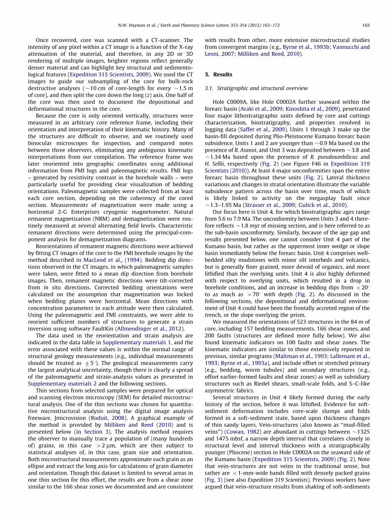
Several structures in Unit 4 likely formed during the earlyhistory of the section, before it was lithified. Evidence for soft-sediment deformation includes core-scale slumps and foldsformed in a soft-sediment state, based upon thickness changesof thin sandy layers. Vein-structures (also known as ‘‘mud-filledveins’’) (Cowan, 1982) are abundant in cuttings between �1325and 1475 mbsf, a narrow depth interval that correlates closely instructural level and interval thickness with a stratigraphicallyyounger (Pliocene) section in Hole C0002A on the seaward side ofthe Kumano basin (Expedition 315 Scientists, 2009) (Fig. 2). Notethat vein-structures are not veins in the traditional sense, butrather are o1-mm-wide bands filled with densely packed grains(Fig. 3) (see also Expedition 319 Scientists). Previous workers haveargued that vein-structure results from shaking of soft-sediments

N.W. Hayman et al. / Earth and Planetary Science Letters 353-354 (2012) 163–172166
in an earthquake or a similar high-frequency shaking event(Ohsumi and Ogawa, 2008). These early structures are either
Vein Structure
Shear Zone
Stretched Trace Fossils
increasing strain
stretchedsilt & carbonatelenses
worm tubules(perpen-dicular to bedding)
Shear Zone
10 cm
increasing strain
Fig. 3. CT scan of Core 5R6 illustrates the character of a shear zone. The steeply
dipping bright lines in the lower and uppermost part of the image are worm
tubules and similar trace fossils that are oriented perpendicular to bedding in the
undeformed state. The adjacent photograph depicts approximately 20 cm of core
from below the label ‘‘shear zone’’ in the CT scan, with a strain gradient
qualitatively defined by subsidiary shear bands, vein structure, and stretched
trace fossils and sedimentary lenses (from Core 5R6-70-87). An undecorated
image of the core is provided in Supplementary materials 3.
Sediment = high porosity (blue dye)
Shear Zone = low porosity (no blue dye)
shear-zone boundary
250 m
Fig. 4. (A) Optical photo taken in plane polarized light. The thin section was stained w
low-porosity structures. (B) SEM image (taken in backscatter mode) of a shear zone (fro
by a mixture of clay minerals) surrounding clasts of quartz- and feldspar-rich clasts. W
associated with, or cut by, shear zones, which are in turn cut byfaults, as described below.
3.2. Shear zones
Shear zones are the most prominent structures observed in thecore and are typically o1-cm wide dark bands (Fig. 3). The shearzones have a wide range in dip, but are locally bedding-paralleland generally increase in dip with depth in a similar manner tobedding (Fig. 2). The shear zones everywhere exhibit reversesense of shear based upon kinematic indicators such as hanging-wall fold vergence, stretched lenses of sediment and trace fossils,or Riedel shears. Offsets across shear zones are generally greaterthan the �10-cm width of the core. Best observed in CT images,the shear zones in most cases reside within broader, 410-cmwide, zones of increased shear strain. These zones cut acrossworm tubules and other trace fossils that were initially orientedperpendicular to bedding. Within the strain gradient of the shearzones, the trace fossils and other lenses of sedimentary materialare disrupted, rotated and stretched, forming a deformationalfabric. As mentioned above, in some instances vein structures areassociated with the shear zones, in the case of the strain gradientin Fig. 3 having formed late in the strain history (i.e., the veinstructures are relatively undeformed).
The higher x-ray intensity of the shear zones in the CT imagesindicates that they are more densely packed than the surroundingmaterial, as also reflected at the grain scale by the abruptdiscontinuity in pore-filling blue dye against shear zone bound-aries in thin sections (Fig. 4A). Therefore, we infer that the shearzones formed partly via porosity closure, as suggested for accre-tionary prism deformation in other locations (Maltman et al.,1992; Morgan and Ask, 2004), and consistent with the associationwith ‘‘soft-sediment’’ vein structures. However, in SEM imagesthere is evidence that shear-zone deformation was also accom-modated by cataclastic flow, which involves the additionalprocess of grain-size reduction via fracture and pulverization(Fig. 4B).
Two quantitative measures of shear-zone microstructure offeradditional insight into their development. In upper crustal shearzones, the Shape Preferred Orientation (SPO) and Particle SizeDistribution (PSD) are indicators of the deformation mechanismand amount of shear strain (Cladouhos, 1999; Rawling andGoodwin, 2003; Billi and Storti, 2004; Hayman et al., 2004;Hayman, 2006; Sammis and King, 2007; Vannucchi and Leoni,2007). We conducted an analysis of SPO and PSD in a thin-section
25 m
pulverized grain
strainedfossil
ith a blue dye that penetrates open porosity, illustrating that the shear zones are
m Core 6R1-88), illustrating the fine-grained granular matrix (typically dominated
e also interpret pulverized clasts and strained fossil fragments.

0
20
40
60
80
100
120
140
160
180
2 3 4 5 6 7 8 9 10 11 12 13 14 15 16 17 18 19 20 21 22 23 24 25 26 27 28 29 30 31 32 33 34
Num
ber o
f Gra
ins
Size ( m)
25 m
Fig. 5. An example of the method for determining particle size distributions and shape preferred orientations (PSDs and SPOs) of the shear-zone microstructure. Using
Jmicrovision (Roduit, 2008), an SEM image (left image) was digitized and the long axes of the resulting shapes (right image) were used to generate the microstructural
data. An unscaled plot of the PSD of the SEM is presented adjacent to the images, and SPOs and power-law PSD plots are presented in the following figure.
N.W. Hayman et al. / Earth and Planetary Science Letters 353-354 (2012) 163–172 167
cut approximately parallel to the dip-direction (and estimatedslip direction) in a representative shear zone. The shear zone iscomposed of several closely spaced o1�mm wide shear bands.We determined SPO and PSD in five ‘domains’ of the shear zone(See Section 2 and Figs. 5 and 6). Each domain has relatively poor,but observable SPO; vector strengths are o0.25 and generallyo0.16, whereas other high-strain upper crustal shear zones canhave vector strengths ranging from �0.2 to 40.6 (Cladouhos,1999; Hayman et al., 2004). Additionally, there is no pattern ofstrengthening of SPO toward the central domains; we offer aninterpretation of the SPO in Section 4.
The shear-zone PSDs are dominated by fine grain sizes, asshown in an example in Fig. 5. Most studies have found thatshear-zone PSDs have a power-law distribution, as graphicallypresented in log–log plots of cumulative number vs. diameter(e.g., Sammis et al., 1987). The power-law exponent is thought tobe proportional to the number and mechanism of particle inter-actions, and hence roughly proportional to shear strain, asexplored further in the discussion. The shear zone PSDs docu-mented here deviate from a power-law at high and low grainsizes (Fig. 6). This deviation is not a result of technique-resolutionbecause (a) the finer grain size PSD has the highest precision andaccuracy (unlike other techniques where the deviation from thepower-law may reflect the technique-resolution), and (b) thedeviation from a power law occurs for both the finest andcoarsest grain sizes, and occurs for PSDs compiled across theshear zone as well as the PSD determined for individual micro-structural domains within the shear zone (and is therefore not aresult of counting statistics). Nonetheless, the PSDs can be fitwith a crude power law (r240.9) and the resulting exponentsrange from �1.55 to �2.19, and �1.83 for the entire population.Like the SPO, there was no obvious pattern of increasing power-law exponent with position in the shear zone. The highestpower-law exponent was from ‘‘domain 1’’, which also has thestrongest SPO suggesting the highest strain zone, though it is notthe central zone as predicted by most models for symmetricshear localization (e.g., Chester and Chester, 1998). Other thanthis relationship, there is no other obvious correlation betweenthe two measures. We present our interpretation of the PSD andSPO data in the following Discussion, and remark on their
implication for the mechanical history of the Nankai innerwedge and forearc.
3.3. Faults
In contrast with the shear zones, faults are highly localized andare generally o1-mm in thickness (Fig. 7). Faults are the young-est deformational structure, crosscutting all sedimentary andother deformational features, and everywhere have polished,slickensided surfaces. The slickensides contain kinematic indica-tors such as scoop-shaped grooves and steps. Faults have a widerange in dip, though they tend to dip more steeply than the shearzones (Fig. 2). In contrast with shear zones which all displayreverse sense-of-shear indicators, of the 60 faults exhibiting clearkinematic indicators, 23 had reverse-sense and 12 had strike-slipindicators, the latter with a mix of left-lateral (4 faults) and right-lateral (8 faults) indicators (Supplementary Data 1). Additionally15 had normal-sense indicators, and crosscutting relationshipssuggest that these faults were the youngest in the core. Theslickensides comprise microcrystalline material, which we inter-pret as having formed via stick-slip wear of competent materialsat high strain rates. Therefore, the mechanics of faulting werequite different than the mechanics of the older, wider, granular-cataclastic shear zones.
3.4. Kinematics of faults and shear zones
We successfully reoriented 28 shear zones and 29 faults intothe paleomagnetic reference frame for further strain analysis (seeSection 2, and the following subsection). Along with the kine-matic indicators from the core-scale structures, we determinedthat the shear zones developed via shortening with a roughlynorth–south maximum principle-strain orientation, whereas thefaults developed via more northwest–southeasterly shortening.We present these data in our concluding schematic Fig. 8, whichwe describe in further detail in Section 4.

0.1
1
10
100
1000
Diameter [µm]10
Cum
ulat
ive
#
100
1: D-2.19
2: D-1.73
3: D-1.834: D-2.01
5: D-1.55
D-2
1
100 µm
2 3 4 5
1
1
2 3
4 5
D=-1.84
1
10
100
1000
10000
1 10 100
v=0.15N=2994
v=0.25N=375
v=0.12N=374
v=0.14N=324
v=0.14N=257
v=0.16N=251
Diameter [µm]
Cum
ulat
ive
#
x
z
x
z
x
z
Fig. 6. Microstructural analysis of a shear zone (from Core 5R1-11-21). The shear zone can optically (with a gypsum plate and cross-polarized light) be differentiated into
5 microstructural domains. PSD and SPO data are presented for both a compilation of 5 SEM images taken in each domain (top right) and for each of the domains (bottom).
For each PSD plot, D is the slope of the best-fit power law exponent (slope). For each rose diagram, N is the number of grains, and v is the vector strength.
slickenlines
1 µm
slickensidewith kinematicindicators
shear
shear
20µm
Fig. 7. (A) Example of a fault in core (Core 5R1-11-21) with striated slickenside containing kinematic indicators (e.g., steps and cuspate grooves). (B) optical photograph of
slickenlines and steps used as kinematic indicators (from Core 9R1-65-68). (C) SEM image of material that comprises the slickensides and are interpreted to result from
high-strain rate wear of competent material.
N.W. Hayman et al. / Earth and Planetary Science Letters 353-354 (2012) 163–172168
3.5. Block rotation
Analysis of paleomagnetic data was also undertaken to test formore regional-scale tectonic rotations (Supplementary materials 2).The first direction parameter in our paleomagnetic analysis is a meanmagnetic inclination in the in situ core coordinate system and eachdirection is scattered around the pole not unexpectedly suggestingartificial rotations of cores during coring operations. However, con-centration of magnetic directions in this in situ coordinate system ishigh, as steep as 86.01, and with a mean of 75.01, significantly
different from the expected inclination value of 52.91 given thegeocentric axial dipole model at the drilling site. In contrast,the tilt-corrected mean inclination is 43.41, which is slightlyshallower than expected (a95¼5.31 cone of confidence around theobserved mean).
The reason for the difference between the expected andobtained mean inclinations is currently unclear. One of thereasons may be that our samples do not cover a sufficientlylong time interval to obtain a mean geomagnetic direction.Another is due to an effect of sediment deformation during the

ShearZones
Faults
FaultKin Solution
FrontallyAccretedMaterial
Inner Wedge
~15 km
~30 km
modern toe + ~20 km
>5.6 Ma: Northward-directed subduction & shortening accommodated by (slope-cutting?) thrust-sense shear zones
< 3.8 Ma: Northwestward-directed subduction & shortening accommodated by faults & block rotation
hyp. s
plate motion
plate motion
modern toe + ~35 km
hyp. t
hyp. s
hyp. t
NW
FaultKin Solution
N
Slope
Trench
N=39Dm=345.1Im=43.4a95=3.7k=36.1
N
Fig. 8. Conceptual model of the evolution of the inner wedge and sub-Kumano basin section from 45.6 to o3.8 Ma, including kinematic solution from shear zones (top)
and faults (middle). A summary of the paleomagnetic analysis is also included illustrating the 151 counterclockwise rotation. ‘‘hyp.s’’ and ‘‘hyp.t’’ refer to the alternative
hypotheses that Site C0009 was located on the slope (‘‘hyp.s’’) vs. the frontal thrust region (‘‘hyp.t’’) o5.6 Ma. The figure was drawn to qualitatively restore to the seismic
section of Park et al. (2002).
N.W. Hayman et al. / Earth and Planetary Science Letters 353-354 (2012) 163–172 169
syn-sedimentary phase (compaction and/or slumping). Our inter-pretation is that the magnetization was acquired when thesequence was horizontal.
The second parameter in the paleomagnetic analysis is thedeclination, which also deviates from the expected pole. Thepaleomagnetic data for the cores show a declination of 345.11whereas the expected pole is roughly 0001. In this case the meandeclination showing 151 anticlockwise from the north indicatestectonic block rotation post deposition (Fig. 8 and Supplementarymaterials 2).
4. Discussion
We begin our discussion with two alternative hypotheses forthe original depositional environment of the cored sub-Kumanosection, Unit 4 at Site C0009. On the one hand, this part of Unit4 could have been deposited in the trench and frontally accretedinto the Miocene-age outer wedge, as historically interpretedfor most accretionary systems. On the other hand, it may have
deposited in a slope apron or within a slope basin that developedbetween thrust ridges.
In favor of a slope depositional setting are the followingobservations. Firstly, at the seismic scale, the stratigraphic sectionbeneath the Kumano basin comprises relatively continuousreflectors with local disruptions by folds and faults (e.g., Fig. 2),and at the core-scale comprises well-bedded mudstones andvolcaniclastics. Secondly, vein structures in the core are thoughtto develop via the shaking of the poorly consolidated slopesections during earthquakes or debris flows, potentially in slopeenvironments (Ohsumi and Ogawa, 2008). Lastly, bedding orien-tation in the core and logging data increases in dip with depth;most models for, and observations of, frontal accretion findthat beds are either unchanged or decrease in dip with depth asthe frontal thrusts propagate and imbricate the section (e.g.,Suppe, 1983). Even more complex fault-propagation models(e.g., Allmendinger, 1998) only predict increasing dips with depthin specific hinge zones of very tight fold-thrust systems.In contrast, slope (piggy-back) basin stratigraphy will commonlyhave growth strata, which increase in dip with depth, a naturalconsequence of their local structurally position.

N.W. Hayman et al. / Earth and Planetary Science Letters 353-354 (2012) 163–172170
Though we favor the hypothesis that Unit 4 was deposited in aslope basin, we note several reasons why the alternative (frontalaccretion) hypothesis cannot be ruled out completely. The basicmud, silt, and volcaniclastic lithology of the cored section couldequally have been deposited in the trench and incorporated byfrontal thrusts. Though the well-bedded character of the coredsection contrasts with the relatively seismically characterless andpoorly bedded materials commonly associated with highlydeformed parts of frontally accreted materials, frontally accretedaccretionary prism material can, in fact, have a range of structuralproperties, in many places preserving relatively undeformedsedimentary sections. We suspect that vein structures may notnecessarily be diagnostic of a slope environment. Lastly, bedding-dip increases with depth are indeed unusual in frontally accretedmaterial, but may be observed in the limbs of anticlines near thefrontally accreting thrusts. The difference between the twosettings is presented in Fig. 8.
The consideration of a slope vs. trench environment for thesection equally applies to the deformational environment andmechanics of the early shear zones. The shear-zone microstructureis characterized by tightly packed grains and lower porosity than thesurrounding material. The porosity closure does not seem to beassociated with extensive diagenetic or metamorphic processesother than minor growth of poorly oriented, low-temperatureswelling clays in the finer grained matrix (Schleicher and van derPluijm, 2011). Therefore, to a first-order, the microstructure of theshear zones is consistent with their development through a granulardeformation such as suggested for decollement zones and accre-tionary-prism thrusts (e.g., Maltman et al., 1992; Morgan and Ask,2004).
The PSD from a representative shear zone (Figs. 5 and 6)provides further insight into the deformation mechanism. Asdescribed in Section 3, most studies of fault-zone deformationfind that shear strain imparts a power-law PSD (in diameter vs.cumulative number), with the exponent approximately propor-tional to finite shear strain, because higher power law exponentsrequire more numerous finer grains, which require more inter-particle collisions to generate (Sammis and King, 2007). Changesin deformation mechanism over time and space can result inexponents greater than �1.6 or even �2 (in 2D) (e.g., Billi andStorti, 2004). For example as deformation becomes more granularas opposed to cataclastic (the latter wherein deformationproceeds through transgranular fracture), grain boundary abra-sion becomes more predominant, leading to an increased propor-tion of fine grains (Rawlings and Goodwin, 2003). Vannucchi andLeoni (2007) reported on data from the Costa Rica decollementthat show that these fault-rock PSD concepts can be appliedto convergent margins as well, and emphasized an interpretationthat the deformation was linked with fluctuation in fluidpressure.
The PSDs in the shear zone we studied from the core onlycrudely follow a power-law. Historically, the deviation from apower-law fault-rock PSD was interpreted as reflecting limita-tions in resolution (e.g., Hayman, 2006). However, our techniquedoes not suffer from such a resolution limitation because it relieson the direct mapping of all grain boundaries in an SEM image ofup to several hundred grains, though we note that to date therehas been no effort to provide a rigorous statistical evaluation ofcounting errors across scale and the dependence on dimension-ality (i.e., associated with the 2D view and scales of observation).Milliken and Reed, 2010 offered a convincing explanation for theweakly defined power-law PSD slopes in a microstructural studyof samples from NanTroSEIZE sites near the megasplay and on theprism slope and toe. Namely, that the less well-defined thepower-law distribution, and the lower the exponent of theapproximate power-law fit, the more the microstructure was
dominated by compaction fabrics. In recognition of these recentinsights, we interpret the power-law PSD of our samples to reflectthe combined effects of sedimentation, compaction, granulardeformation, and cataclastic flow.
The SPO and patterns of localization in our representativeshear zone also provide insight into the deformation mechanisms.The shear zone does not have a well-developed fabric as quanti-fied by the SPO, nor does it exhibit highly localized (at themillimeter to sub-millimeter scale) shear. In contrast, granularand cataclastic deformation in general tends to produce a well-developed SPO with increasing shear strain, both in the finerelongate clay-sized grains and also in the larger clasts that rotatewithin a deforming finer-grained matrix (Cladouhos, 1999;Hayman et al., 2004), and favors localization to the sub-milli-meter scale (Chester and Chester, 1998). We therefore suggestthat the shear zones are part of an anastomosing network wherelocalization progressed heterogeneously over space and time, assuggested for mesoscale shear-zone structures in on-shore expo-sures of accretionary complexes (Fagereng and Sibson, 2009).
Some workers suggest that accretionary-complex shear zonesslip both aseismically and seismically (e.g., Fagereng and Sibson,2009), in keeping with monitored seismic and aseismic deforma-tion of active accretionary prism systems (e.g., Davis et al., 2006).We therefore hypothesize that the granular deformation thatcauses porosity reduction may occur via aseismic creep. Incontrast, a coseismic cataclastic deformation may have impartedthe power-law character of the PSDs, the poor SPOs, pulverizedand fractured grains, and generated multiple domains in shearzones at the centimeter scale, similar to other megathrustsystems (e.g., Rowe et al., 2011; Meneghini et al., 2012). Seismicrupture propagation from great earthquakes of Nankai is inferredto have occurred on the current slope-breaking megasplay fault(Moore et al., 2007; Yamaguchi et al., 2011), but may also haveoccurred along the decollement and frontal thrusts (e.g.,Sakaguchi et al., 2011). Given the additional data on the deposi-tional environment and possible reconstructions of the section(Fig. 8), we hypothesize that the shear zones formed in anenvironment similar to the modern slope-breaking megasplaysystem, or perhaps more likely in out-of-sequence thrusts such asobserved in the Muroto area to the southwest (Gulick et al., 2004;Bangs et al., 2006).
In contrast with the shear zones, the faults are clearly theproduct of highly localized, stick-slip deformation. Though thefaults in the core are relatively small in comparison to the mega-splay and record small total displacements, they likely reflect themechanical result of more widespread faulting in the region giventhat faults in general follow length-scale distributions (e.g.,Cladouhos and Marrett, 1996) (Fig. 2). We suggest that thesefaults formed after the development of the 5.6–3.8 myr uncon-formity and the rotation of the principal strain directions (seebelow). The youngest age of faulting is less well constrained, butin general the section is less deformed stratigraphically upward(Fig. 2). Pleistocene normal faulting that cuts the upper Kumanobasin section to the southeast is not widespread at the seismicscale in the area of Site C0009 (e.g., Gulick et al., 2010).Additionally, the interpreted maximum stress direction at SiteC0009 is trench-perpendicular (Lin et al., 2010), likely favoringthrusting over normal faulting. Therefore, the faults are likelyolder than mid-Pleistocene age, and potentially older than latePliocene age.
Given that there is a structural contrast between the shear zonesand the younger (crosscutting) faults, it is worth considering themore regional-scale tectonic evolution of the Nankai margin leadingup to the development of the current Kumano forearc basin. Thesub-Kumano basin unconformity reflects �1.8 myr of missingstratigraphic section. There is good reason to believe that the shear

N.W. Hayman et al. / Earth and Planetary Science Letters 353-354 (2012) 163–172 171
zones predate this unconformity, and that the faults postdate theunconformity. Again, the relative timing constraints come from theobservation that the faults cut the shear zones and have contrastingmechanical histories. Using this constraint and the estimated 5.6-Maage of the unconformity we can also loosely establish the absolutetiming of these two deformational phases as pre-5.6 Ma (shearzones) and syn-to-post 3.8 Ma (faults). These relative timing con-straints and the kinematic analyses further suggest that the princi-ple shortening direction rotated counterclockwise from �0101 (forthe shear zones) to �3301 (for the faults) sometime between orafter 5.6 and 3.8 Ma, the time of the sub-basin unconformity. Inaddition, our favored interpretation of the paleomagnetic data isthat the cored section rotated 151 counterclockwise about a verticalaxis although the timing of this rotation can only be constrained topost-date the age of the cored sediments (i.e., post �5.6 Ma).
Although the rocks likely rotated �151 counterclockwise some-time after 5.6 Ma, the different shortening directions recorded in therocks can be interpreted as either (1) a 451 clockwise rotation of therocks in a fixed strain field, or (2) a 451 counterclockwise rotation ofthe strain field as the rocks remained fixed. We prefer the secondinterpretation, that there was a counterclockwise rotation of thestrain field, for two reasons. Firstly, the rotation in the strain fieldcould have induced the 151 rotation of the rocks due to the obliquesuperposition of the strain fields and secondly, the rotation of thestrain field is consistent with recent plate reconstructions. Thesereconstructions show significant counterclockwise rotation of theplate convergence direction (up to 801) at about 5 Ma (Seno andMaruyama, 1984; Mahoney et al., 2011; Kanamatsu et al., 2012).
In summary, forearc basin nucleation over the inner Nankaiaccretionary wedge followed a change in plate-convergencewhich reoriented the principal strain directions and caused someblock rotation. The reorientation accompanied a rheologicalchange in the material that favored highly localized faulting asthe inner wedge developed prior to the major phase of Kumanobasin subsidence. This Late Miocene through Pliocene history ofthe Nankai margin at Site C0009 is therefore broadly consistentwith models for accretionary wedge development (e.g., Wang andHu, 2006), including those that emphasize the role of variablehinterland-sourced sedimentation (e.g., Simpson, 2010). How-ever, the exact temporal relationship between sedimentationvariations and major mechanical changes in wedge behavior isunclear, and major plate-boundary tectonic reorganizationsappear to play an important role in inner wedge evolution.
5. Conclusion
Core recovered from IODP Site C0009 provides insight into thegeological and mechanical development of the inner wedge of theNankai accretionary margin and nucleation of the Kumano forearcbasin. By 5.6 Ma a system of shear zones had developed poten-tially in an out-of-sequence thrust system that cut across a thinslope apron and/or developing slope basins, though a frontalaccretionary thrust origin cannot be ruled out. Microstructuraldata from a type shear zone lead us to infer that thrust-associatedcore-scale shear zones developed via primarily aseismic granulardeformation, but also channeled coseismic rupture that caused acataclastic deformation. The combined cataclastic-granular defor-mation accommodated shortening associated with north-directedsubduction. Then, the mechanics at this structural level changedand sometime after 3.8 Ma highly brittle faults associated withmixed slip kinematics and northwest–southeast shortening cutthe shear zones and early sub-Kumano basin section. The changein shortening direction was likely caused by a change in plateconvergence direction that occurred in late Miocene time.This late-stage, northwestward-directed deformation rotated the
sediments and older shear zones 151 counterclockwise, and in ageological sense has persisted since as early as �3.8 Ma and setthe stage for inner wedge development and Kumano forearc basinsubsidence.
Acknowledgments
This research used samples and data provided by theIntegrated Ocean Drilling Program (IODP). Funding for thisresearch was provided by Ocean Leadership (US Science SupportProgram) and NSF OCE-1130078 (to Hayman) and NSF GEO-1171000 (to Byrne). We particularly thank the other membersof the shipboard party of Expedition 319, the captain(s) and crewof the D/V Chikyu, and the JAMSTEC organizers for the expedition,especially Sean Toczko, Kyoma Takahashi, and Nobuhisa Eguchi.We thank Michi Strasser and an anonymous reviewer for valuablecomments.
Appendix A. Supporting information
Supplementary data associated with this article can be found inthe online version at http://dx.doi.org/10.1016/j.epsl.2012.07.040.
References
Allmendinger, R.W., 1998. Inverse and forward numerical modeling of trishearfault-propagation folds. Tectonics 17, 640–656.
Allmendinger, R.W., Cardozo, N.C., Fisher, D., 2012. Structural Geology Algorithms:Vectors & Tensors. Cambridge University Press, Cambridge, England (289 pp.).
Araki, E., Byrne, T., McNeill, L., Saffer, D., Eguchi, N., Takahashi, K., Toczko, S., 2009.NanTroSEIZE Stage 2: NanTroSEIZE Riser/Riserless Observatory. IODP ScientificProspectus 319.
Bangs, N.L.B., Gulick, S.P.S., Shipley, T.H., 2006. Seamount subduction erosion inthe Nankai Trough and its potential impact on the seismogenic zone. Geology34, 701–704.
Billi, A., Storti, F., 2004. Fractal distribution of particle size in carbonate cataclasticrocks from the core of a regional strike-slip fault zone. Tectonophysics 384,115–128.
Boutt, D., et al. Scale dependence of in situ permeability measurements in theNankai Accretionary Prism: the role of fractures. Geophys. Res. Lett., http://dx.doi.org/10.1029/2012GL051216, in press.
Byrne, T., Bruckmann, W., Owens, W., Lallemant, S., Maltman, A., 1993a. Correla-tion of structural fabrics, velocity anisotropy and magnetic susceptibility data.In Hill, I., Taira, A., Firth, J., (Eds.). Scientific Results of the Ocean DrillingProgram, vol. 131.
Byrne, T., Maltman, A., Stevenson, E., Soh, W., R., K., 1993b. Deformation structuresand fluid flow in the toe region of the Nankai accretionary prism. In: Hill, I.,Taira, A., Firth, J. (Eds.), Scientific Results of the Ocean Drilling Program, vol.131; 1993b.
Cladouhos, T.T., 1999. A kinematic model for deformation within brittle shearzones. J. Struct. Geol. 21, 437–448.
Chester, F.M., Chester, J.S, 1998. Ultracataclasite structure and friction processes ofthe Punchbowl fault, San Andreas System, California. Tectonophysics 295,199–221.
Cladouhos, T., Marrett, R., 1996. Are fault growth and linkage models consistentwith power-law distributions of fault lengths? J. Struct. Geol. 18, 281–293.
Cowan, D.S., 1982. Origin of ‘vein structure’ in slope sediments on the inner slopeof the Middle America Trench off Guatemala. In: Von Huene, R., Aubouin, J.,et al. (Eds.), Initial Report of DSDP, vol. 57; 1982, pp. 645–650.
Davis, E.E., Becker, K., Wang, K., Obara, K., Ito, Y., Kinoshita, M., 2006. A discreteepisode of seismic and aseismic deformation of the Nankai trough subductionzone accretionary prism and incoming Philippine Sea plate. Earth Planet. Sci.Lett. 242, 73–84.
Expedition 315 Scientists, 2009. In: Kinoshita, M., Tobin, H., Ashi, J., Kimura, G.,Lallemant, S., Screaton, E.J., Curewitz, D., Masago, H., Moe, K.T., the Expedition314/315/316 Scientists (Eds.), Proceedings of the IODP, vol. 314/315/316.Integrated Ocean Drilling Program Management International, Inc., Washington,DC. http://dx.doi.org/10.2204/iodp.proc.314315316.122.2009.
Expedition 319 Scientists, 2010. Site C0009. In: Saffer, D., McNeill, L., Byrne, T., Araki, E.,Toczko, S., Eguchi, N., Takahashi, K., the Expedition 319 Scientists (Eds.), Proceed-ings of the IODP, vol. 319. Integrated Ocean Drilling Program ManagementInternational, Inc., Tokyohttp://dx.doi.org/10.2204/iodp.proc.319.103.2010.
Fagereng, A, Sibson, R.H., 2009. Melange rheology and seismic style. Geology 38,751–754.

N.W. Hayman et al. / Earth and Planetary Science Letters 353-354 (2012) 163–172172
Gulick, S.P.S., Bangs, N.L., Shipley, T.H., Nakamura, Y., Moore, G.F., Kuramoto, S.,2004. Three-dimensional architecture of the Nankai accretionary prism’simbricate thrust zone off Cape Muroto, Japan: prism reconstruction via enechelon thrust propagation. J. Geophys. Res. 109 (B02105), http://dx.doi.org/10.1029/2003JB002654.
Gulick, S., Bangs, N., Martin, K., Moore, G., Sawyer, D., Nakamura, Y., 2010. Uplifthistory of the outer Kumano forearc basin: implications for splay faultdevelopment. Earth Planet. Sci. Lett. 300, 55–62.
Hayman, N.W., Housen, B.A., Cladouhos, T.T., Livi, K., 2004. Magnetic and clastfabrics as measurements of grain-scale processes within the Death Valleyshallow crustal detachment faults. J. Geophys. Res. 109, B05409, http://dx.doi.org/10.1029/2203JB02902.
Hayman, N.W., 2006. Shallow crustal fault rocks from the Black Mountaindetachments, Death Valley, CA. J. Struct. Geol. 10, 1767–1784.
Kanamatsu, T, Pares, J.M., Kitamura, Y., 2012. Pliocene shortening direction inNankai Trough off Kumano, southwest Japan, Sites IODP C0001 and C0002,Expedition 315: anisotropy of magnetic susceptibility analysis for paleost-ress. Geochem. Geophys. Geosyst. 13, Q0AD22, http://dx.doi.org/10.1029/2011GC003782.
Kinoshita, M., Tobin, H., Ashi, J., Kimura, G., Lallemant, S., Screaton, E.J.,Curewitz, D., Masago, H., Moe, K.T., 2009. Proceedings of the IODP, vol.314/315/316. Integrated Ocean Drilling Program Management Interna-tional, Inc., Washington, DChttp://dx.doi.org/10.2204/iodp.proc.319.103.2010.
Lallemant, S., Byrne, T., Maltman, A., Karig, D., 1993. Stress tensors at the toe of theNankai accretionary prism: an application of inverse methods to slickensidedbearing faults. In: Hill, I., Taira, A., Firth, J., (Eds.). Scientific Results of the OceanDrilling Program, vol 131.
Lin, W., et al., 2010. Present-day principal horizontal stress orientations in theKumano forearc basin of the southwest Japan subduction zone determinedfrom IODP NanTroSEIZE drilling Site C0009. Geophys. Res. Lett. 37, L13303,http://dx.doi.org/10.1029/2010GL043158.
MacLeod, C.J., Parson, L.M., Sager, W.W., 1994. Reorientation of core using theFormation MicroScanner and Borehole Televiewer: application to structuraland palaeomagnetic studies with the Ocean Drilling Program. In: Hawkins, J.,Parson, L., Allan, J., et al. Proc. ODP, Scientific Results. 135: College Station, TX(Ocean Drilling Program), pp. 301–311.
Mahoney, S.H., Wallace, L.M., Miyoshi, M., Villamor, P., Sparks, R.S.J., Hasenaka, T.,2011. Volcano-tectonic interactions during rapid plate-boundary evolution inthe Kyushu region, SW Japan. GSA Bull. 123, 2201–2223.
Maltman, A.J., Byrne, T., Karig, D., Lallement, S., 1993. Deformation at the toe of anactive accretionary prism: synopsis of results from ODP Leg 131, Nankai, SWJapan. J. Struct. Geol. 15 (8), 949–964.
Maltman, A., Byrne, T., Karig, D., Lallemant, S., Party, t.L.S., 1992. Leg 131 ShipboardParty, structural geological evidence from ODP 131 regarding fluid flow in theNankai Prism, Japan. Earth Planet. Sci. Lett. 109, 463–468.
Meneghini, F., Di Toro, G., Rowe, C.D., Moore, J.C., Tsutsumi, A., Yamaguchi, A.,2012. Record of mega-thrust earthquakes in subductions thrusts: the blackfault rocks of Pasagshak Point (Kodiak Island, Alaska). GSA Bull. 122,1280–1297.
Milliken, K.L, Reed, R.M., 2010. Multiple causes of diagenetic fabric anisotropy inweakly consolidated mud, Nankai accretionary prism, IODP Expedition 316.J. Struct. Geol. 32, 1887–1898.
Moore, G.F., Bangs, N.L., Taira, A., Kuramoto, S., Pangborn, E., Tobin, H.J., 2007.Three-dimensional splay fault geometry and implications for tsunami genera-tion. Science 318 (5853), 1128–1131.
Morgan, J.K., Ask, M.V.S., 2004. Consolidation state and strength of underthrustsediments and evolution of the decollement at the Nankai accretionarymargin: results of uniaxial reconsolidation experiments. J. Geophys. Res.109, B03102, http://dx.doi.org/10.1029/2002JB002335.
Ohsumi, T., Ogawa, Y., 2008. Vein structures, like ripple marks, are formed byshort-wavelength shear waves. J. Struct. Geol. 6, 719–724.
Park, J.O., Tsuru, T., Kodaira, S., Cummins, P.R., Kaneda, Y., 2002. Splay faultbranching along the Nankai subduction zone. Science 297, 1157–1160.
Rawling, G.C., Goodwin, L.B., 2003. Cataclasis and particulate flow in faulted,poorly lithified sediments. J. Struct. Geol. 25, 317–331.
Roduit, N., 2008. JMICROVISION: Image Analysis Toolbox for Measuring andQuantifying Components of High-definition Images.
Rowe, et al., 2011. Textural Record of the Seismic Cycle: Strain-rate Variation in anAncient Subduction Thrust, vol. 359. Geological Society Special Publications,London (pp. 77–95).
Saffer, D., McNeill, L., Araki, E., Byrne, T., Eguchi, N., Toczko, S., Takahashi, K., a. t. E.Scientists, 2009. NanTroSEIZE Stage 2: NanTroSEIZE Riser/Riserless Observa-tory. IODP Preliminary Report 319. http://dx.doi.org/10.2204/iodp.pr.319.2009/.
Sakaguchi, A., Chester, F., Curewitz, D., Fabbri, O., Goldsby, D., Kimura, G., Li, C-F,Masaki, Y., Screaton, E.J., Tsutsumi, A., Ujiie, K., Yamaguchi, A., 2011. Seismicslip propagation to the updip end of plate boundary subduction interfacefaults: vitrinite reflectance geothermometry on Integrated Ocean DrillingProgram NanTro SEIZE cores. Geology 39, 395–398, http://dx.doi.org/10.1130/G31642.1.
Sammis, C.G., King, G., Biegel, R., 1987. The kinematics of gouge deformation. PureAppl. Geophys. 125, 777–812.
Sammis, C.G., King, G.C.P., 2007. Mechanical origin of power law scaling in faultzone rock. Geophys. Res. Lett. 34, L04312, http://dx.doi.org/10.1029/2006GL028548.
Schleicher, A.M., van der Pluijm, B.A., 2011. Properties of smectite in the Kumanobasin, Japan: new results from NanTroSEIZE Expedition 319. T21B-2363presented at the 2011 Fall Meeting, AGU, San Francisco, California, 5–9December 2011.
Seno, T., Maruyama, S., 1984. Paleogeographic reconstruction and origin of thePhilippine Sea. Tectonophysics 102, 53–84, http://dx.doi.org/10.1016/0040-1951 (84)90008-8.
Simpson, G.D.H., 2010. Formation of accretionary prisms influenced by sedimentsubduction and supplied by sediments from adjacent continents. Geology 38,131–134.
Song, T.R.A., Simons, M., 2003. Large trench-parallel gravity variations predictseismogenic behavior in subduction zones. Science 301 (5633), 630–633.
Strasser, M., Moore, G.F., Kimura, G., Kitamura, Y., Kopf, A.J., Lallemant, S., Park,J.-O., Screaton, E.J., Su, X., Underwood, M.B., Zhao, X., 2009. Origin andevolution of a splay fault in the Nankai accretionary wedge. Nat. Geosci. 2,648–652.
Suppe, J., 1983. Geometry and kinematics of fault-bend folding. Am. J. Sci. 283,684–721.
Tobin, H.J., Kinoshita, M., 2006. NanTroSEIZE: the IODP Nankai Trough seismogeniczone experiment. Sci. Drill. 2, 23–27.
Vannucchi, P., Leoni, L., 2007. Structural characterization of the Costa Ricadecollement: Evidence for seismically-induced fluid pulsing. Earth and Plane-tary Science Letters 262, 413–428.
Wang, K.L., Hu, Y., 2006. Accretionary prisms in subduction earthquake cycles: thetheory of dynamic Coulomb wedge. J. Geophys. Res. 111, 16.
Wells, R.E., Blakely, R.J., Sugiyama, Y., Scholl, D.W., Dinterman, P.A., 2003. Basin-centered asperities in great subduction zone earthquakes: a link between slip,subsidence, and subduction erosion? J. Geophys. Res. 108, 30.
Yamaguchi, A., Sakaguchi, A., Sakamoto, T., Iijima, K., Kameda, J., Kimura, G.,Ujiie, K., Chester, F.M., Fabbri, O., Goldsby, D., Tsutsumi, A., Li, C.-F.,Curewitz, D., 2011. Progressive illitization in fault gouge caused by seismicslip propagation along a megasplay fault in Nankai Trough. Geology 39,995–998.


