
Stirling Strategic Park and Ride Study 03/02/2020
Reference number 107755
STIRLING STRATEGIC PARK AND RIDE STUDY – CASEFOR CHANGE

STIRLING STRATEGIC PARK AND RIDE STUDYSTIRLING STRATEGIC PARK AND RIDE STUDY – CASE FOR CHANGE
IDENTIFICATION TABLE
Client/Project owner Tactran
Project Stirling Strategic Park and Ride Study
Study Stirling Strategic Park and Ride Study – Case for Change
Type of document Final Report
Date 03/02/2020
Reference number 107755
Number of pages 103
APPROVAL
Version Name Position Date Modifications
1
Author Claire MackayPrincipalConsultant
08/01/20191st Draft (POIConly)Approved
byIain Clement
AssociateDirector
08/01/2019
2
Author Claire MackayPrincipalConsultant
04/03/2019
2nd DraftApprovedby
Iain ClementAssociateDirector
04/03/2019
3
Author Claire MackayPrincipalConsultant
29/03/2019
3rd DraftApprovedby
Iain ClementAssociateDirector
29/03/2019
4
Author Claire MackayPrincipalConsultant
09/04/2019Final – minoramendmentsApproved
byIain Clement
AssociateDirector
09/04/2019
5
Author Claire MackayPrincipalConsultant
03/12/2019
Minoramendments24/1/2020 and03/02/2020
Approvedby
Iain ClementAssociateDirector
04/12/2019
6
Author Claire MackayPrincipalConsultant
03/02/2020
Approvedby
Iain ClementAssociateDirector
03/02/2020

Stirling Strategic Park and Ride Study
Stirling Strategic Park and Ride Study – Case for Change 107755
Final Report 03/02/2020 Page 3/103
TABLE OF CONTENTS
EXECUTIVE SUMMARY 7
1. INTRODUCTION 13
1.1 OVERVIEW 13
1.2 BACKGROUND TO STUDY: 2016 DPMTAG APPRAISAL 14
2. METHODOLOGY 19
2.1 SCOTTISH TRANSPORT APPRAISAL GUIDANCE (STAG) 19
2.2 STAKEHOLDER ENGAGEMENT 19
2.3 COLLATION OF BASELINE DATA 20
2.4 PROJECT STEERING GROUP 20
3. POLICY 21
3.1 OVERVIEW 21
3.2 NATIONAL POLICY 21
3.3 LOCAL AND REGIONAL POLICY 27
3.4 SUMMARY 35
4. SOCIO-ECONOMIC CONTEXT 37
4.1 OVERVIEW 37
4.2 SOCIO-ECONOMIC DATA 38
4.3 POPULATION 39
4.4 SCOTTISH INDEX OF MULTIPLE DEPRIVATION 41
4.5 CAR AVAILABILITY 42
4.6 ECONOMIC ACTIVITY 43
4.7 SOCIO-ECONOMIC SUMMARY 44
5. TRANSPORT NETWORK AND DEMAND 47
5.1 OVERVIEW 47
5.2 EMPLOYMENT AND TRAVEL TO WORK 47
5.3 ACCESS TO EMPLOYMENT 49
5.4 PUBLIC TRANSPORT: BUS 51
5.5 SCOTTISH HOUSEHOLD SURVEY 54
5.6 PUBLIC TRANSPORT: RAIL 56

Stirling Strategic Park and Ride Study
Stirling Strategic Park and Ride Study – Case for Change 107755
Final Report 03/02/2020 Page 4/103
5.7 RAIL USER SURVEYS – BRIDGE OF ALLAN AND STIRLING 58
5.8 CYCLE HIRE SCHEME AT STIRLING AND BRIDGE OF ALLAN STATIONS 61
5.9 RECENT PUBLIC TRANSPORT STUDIES 61
5.10 ROAD NETWORK 63
5.11 JOURNEY TIMES COMPARISON 65
5.12 PARKING 67
5.13 PARK & RIDE 67
5.14 SUMMARY OF TRANSPORT NETWORK 69
6. CONSULTATION 71
6.1 WORKSHOP CONSULTATION 71
6.2 STIRLING COUNCIL LOCAL TRANSPORT STRATEGY CONSULTATION 72
7. PROBLEMS, OPPORTUNITIES, ISSUES AND CONSTRAINTS 75
7.1 OVERVIEW 75
7.2 PROBLEMS 75
7.3 OPPORTUNITIES 79
7.4 ISSUES 81
7.5 CONSTRAINTS 82
7.6 SUMMARY 83
8. TRANSPORT PLANNING OBJECTIVES 85
8.1 OVERVIEW 85
8.2 STUDY OBJECTIVES 85
9. OPTION GENERATION 89
9.1 OVERVIEW 89
9.2 OPTION GENERATION PROCESS 89
9.3 OPTION GENERATION 89
10. REFERENCE CASE AND DO-MINIMUM 99
11. SUMMARY 101

Stirling Strategic Park and Ride Study
Stirling Strategic Park and Ride Study – Case for Change 107755
Final Report 03/02/2020 Page 5/103
LIST OF FIGURES
Figure 1. Stirling Study Area (Open Street Map) 13Figure 2. Passenger Numbers in 2023/24 into Glasgow QS (08:00 – 09:00) 25Figure 3. Stirling Study Area Intermediate Zones 2011 (Open Street Map) 38Figure 4. Local Development Plan Sites 40Figure 5. SIMD Quintiles 41Figure 6. Geographic Access, SIMD Quintiles 42Figure 7. Census 2011 Households Economically Active: Unemployed (%) 44Figure 8. Distance Travelled to Work for Stirling City area residents 49Figure 9. Accessibility to Key Employment Centres (TRACC, SYSTRA) 50Figure 10. Stirling Area Bus Service Network Map 51Figure 11. Office of Rail and Road Station Estimates Time Series 56Figure 12. 2027 Do-Nothing 64Figure 13. PM Peak Hour Change in Journey Times (2017 to 2037) 66Figure 14. Park and Ride Use 68Figure 15. Stakeholders Consulted 71Figure 16. Stirling Trip Attractors 80Figure 17. TPO Mapping to Problems, Issues, Opportunities and Constraints 87Figure 18. Option generation 90
LIST OF TABLES
Options recommended for Initial Appraisal 11Network Wide Average Journey Times, PM Peak Hour 15Population Growth and Projections in Stirling 39Households with No Access to a Car – Intermediate Zone Level 43Travel to Work Origins for Stirling City Area Employees and Mode of Travel * 47Census Travel to Work destinations for Stirling residents and mode of travel 48Bus Services 52Use of local Bus services in Stirling Council and Scotland from 2014– 2017 (%) 54Adults (16+) views on the convenience of public transport in their area (%) 54Use of Local Train Services in Stirling Council and Scotland from 2014 – 2017 (%) 57Dec 2019 Rail Provision (ScotRail) 58Bridge of Allan Key Statistics 59Stirling Key Statistics 60PM Peak Hour Journey Times (2017, 2027 and 2037) 65Options generated 91

Stirling Strategic Park and Ride Study
Stirling Strategic Park and Ride Study – Case for Change 107755
Final Report 03/02/2020 Page 6/103
LIST OF APPENDICES
Appendix A – Steering Group WorkshopAppendix B - Stakeholder WorkshopAppendix C – Steering Group Workshop PresentationAppendix D – Parking informationAppendix E – Option SiftingAppendix F – Environment Baseline

Stirling Strategic Park and Ride Study
Stirling Strategic Park and Ride Study – Case for Change 107755
Final Report 03/02/2020 Page 7/103
EXECUTIVE SUMMARY
Overview
SYSTRA was commissioned by regional transport partnership Tactran to consider how best to increasethe modal share of public transport for those trips entering, leaving and passing through the StirlingCity Area. Funding was allocated to the study as part of Transport Scotland’s Local Rail DevelopmentFund.
The work builds on the recommendations of Stirling Council’s DPMTAG Transport Appraisal,undertaken to inform Stirling’s Local Development Plan (LDP) and Local Transport Strategy (LTS), whichconcluded that:
The impacts of the travel demands generated by build out of the LDP to 2027 (74% ofthe proposed housing) could be accommodated by measures that the Council couldimplement in its LTS. These packages of measures included everything the Council couldreasonably implement in relation to:
modal shift; local road capacity improvements; and new local roads.
However, to enable full build out of the LDP to 2037 (or 100% of proposed housing),additional modal shift and road capacity improvements would be required over andabove what the Council could achieve via local modal shift and local road capacityimprovements if significant increases in journey times across the network were to beavoided e.g.:
Improvements to existing motorway junctions; and Additional motorway junction and strategic park and ride sites on the rail corridor to
the north and south of the city.
Context of study and identification of problems, opportunities, issues and constraints
This report has drawn on the outputs of the DPMTAG and further investigated the current transportconditions and impacts associated with the LDP highlighting. The identification of problems,opportunities, issues and constraints was also informed by the stakeholder engagement programmewhich involved workshop sessions with local representatives including elected members, communitycouncils, public transport operators and council officers. This was supported by a comprehensivepublic survey which informed the Local Transport Strategy and gave recent views on transport in andaround the study area.
The process highlighted the following:
Socio-economic factors and travel demand:
Stirling is an importer of workers coming from surrounding council areas includingFalkirk and Clackmannanshire primarily all arriving by car.

Stirling Strategic Park and Ride Study
Stirling Strategic Park and Ride Study – Case for Change 107755
Final Report 03/02/2020 Page 8/103
There are significant flow of workers into (63% of workforce) and out of (51% ofresidents) the Stirling City area which puts pressure on the transport network and isfurther exacerbated by workers travelling through the study area to the Central Beltfrom Clackmannanshire.
Planned developments are largely on the outskirts of the city where significantincreases in journey times and queuing is forecast in 2027 and 2037 on motorwayjunctions and core routes in the study area.
Areas with below average access to employment and services, especially to locationsbeyond Stirling and Falkirk, and with low car ownership, have been identified in theEastern Villages.
Almost 20% of the study area’s datazones are considered to be within Scotland’s 20%most deprived datazones (using the overall index of deprivation). These factorsinclude access to services, education and employment. Some of the areas (Cowie andareas in Bannockburn, Cornton and Cultenhove) are also within the lowest 40% ofnational datazones in terms of access to facilities.
Rail:
Frequent services to/from Glasgow/Edinburgh and Stirling/Bridge of Allan. Services are well used with steady growth and a good proportion of commuter trips
to these destinations using rail. Rail journey times between Glasgow/Edinburgh and Stirling City are competitive with
car. EGIP and Revolution in Rail have improved journey times and capacity of rail services
in the study area. Two thirds of passengers access bridge of Allan and Stirling stations by car, adding
traffic to the surrounding road network. Ten per cent of passengers using Stirling station travel from Clackmannanshire.
Road:
Due to the limited number of routes through Stirling City Area, there are a number ofpinch points within, and at the gateways to, the Stirling city area through which alltraffic passes. Traffic modelling indicates that development proposed within the LDPwill significantly increase the journey times and queuing at these locations withconsequential adverse impacts likely.
Future year traffic modelling has also indicated that the generated traffic associatedwith the LDP development sites will place added pressure on the local and strategictransport networks, particularly in the south and east of Stirling.
Between 38%-44% of all car trips within the study area have either their origin ordestination outwith the study area and therefore require some form of strategicintervention.
National strategy seeks to encourage a modal shift, including for strategic trips, toreduce carbon emissions and the adverse economic impacts of congestion. This wasreflected in Transport Scotland’s first Strategic Transport Projects Review whichproposed a strategic park and ride site to the south of Stirling to help increase thepublic transport mode share of trips into Stirling, Glasgow and Edinburgh.
Bus:

Stirling Strategic Park and Ride Study
Stirling Strategic Park and Ride Study – Case for Change 107755
Final Report 03/02/2020 Page 9/103
Stirling has a reasonable commercial bus network, in particular, between Stirling City,Alloa, Stirling University and Falkirk via Larbert, however in recent years there hasbeen a decline in bus use and reduction in service provision across some communitiesas services have been combined.
Park and Ride: Two local park and ride sites currently exist enabling a transfer fromcar to bus for trips into the city. Whilst usage has declined in recent years StirlingCouncil has adopted a new parking strategy, and consequential charging regime, tosupport park and ride usage.
Opportunities to address the social, economic and environmental consequences arising from theinability of the current and proposed transport network to accommodate future demands exist withinthe area. These opportunities include the existing strategic road and rail networks which are served bylong-distance bus and coach services which pass in close proximity to both the pinch points on thetransport network as well as locations where there are existing and proposed major trip generators.These opportunities also present options to assist in improving access to jobs, services andopportunities for some of the more deprived locations in the study area (as defined by the SIMD).
Constraints were also identified and considered at this stage including the physical constraintsassociated with the road infrastructure and River Forth and constraints associated with rail includingtimetabling constraints and impacts on existing passengers.
A review of national, regional and local policy highlighted a commitment to:
Improve journey times and connectivity; Reduce emissions and the impact of transport on the environment; and Improve quality, accessibility and affordability of transport
In addition, Transport Scotland’s Strategic Transport Projects Review 1 identified a series ofstrategic park and ride sites including a site at Bannockburn serving Edinburgh, Glasgow, andStirling. STPR stated that the site would be served by either rail services or express bus links toand from the city centre and areas of economic activity (STPR Project 8).
Transport Planning Objectives
Based on the problems, opportunities, issues and constraints identified through this process threeTransport Planning Objectives were identified:
TPO1: Improve transport access to healthcare, employment, education and training forresidents of Plean, Cowie, Fallin, Bannockburn and Cornton.
TPO2: Support LDP and CRD growth aspirations by reducing the modal share of carsentering, leaving or passing through the Stirling City Area.
TPO3: Improve the competitiveness of sustainable modes compared to the private carfor strategic trips between Stirling City Area and key origins/destinations in the CentralBelt.

Stirling Strategic Park and Ride Study
Stirling Strategic Park and Ride Study – Case for Change 107755
Final Report 03/02/2020 Page 10/103
TPO Mapping to Problems, Issues, Opportunities and Constraints

Stirling Strategic Park and Ride Study
Stirling Strategic Park and Ride Study – Case for Change 107755
Final Report 03/02/2020 Page 11/103
Option generation
Following the development of the Transport Planning Objectives a wide range of options which couldmeet the Transport Planning Objectives were generated which could alleviate the identified problemsand address the potential opportunities across the study area.
99 options were generated at this stage. Options were generated across all modes of transports andgeographically across the study area, and beyond. Following the development of an initial long list theoptions were developed and cleaned. This involved clarifying the options to provide further detail andto remove duplicates. Where appropriate, options were also grouped by mode. At this stage 25options remained.
The final stage of the Option Generation involved a high-level appraisal to determine suitability forfurther assessment. This appraisal was a qualitative assessment against the TPOs and determined ifthe option would have a positive, negative or neutral impact against the TPO. Options which wouldcontribute to meeting the TPOs in conjunction with other options were identified as complementaryoptions. Nine options have been recommended for initial appraisal, 14 have been identified ascomplementary options and 2 have been recommended for rejection.
Options recommended for Initial Appraisal
MODE OPTION RATIONALE
Bus Improve coach connectivity - increase infrequency and destinations
Option would support all threeTPOs by improving access toservices, encouraging modalshift and improving thecompetitiveness of publictransport over car.
Bus/Coach Bus/coach Park and Ride opportunities atthe following sites:- Pirnhall/South Stirling- Relocated Springkerse site
Option would support all threeTPOs by improving access toservices, encouraging modalshift and improving thecompetitiveness of publictransport over car.
Other Light rail from Pirnhall/ Durieshill (intoStirling)
Option would support all threeTPOs by improving access toservices, encouraging modalshift and improving thecompetitiveness of publictransport over car.
Park and Ride/Choose Potential for other trip attractors to usePrudential bus services (from city centreand around Central Scotland, e.g. ForthValley College)
Option would support all threeTPOs by improving access toservices, encouraging modalshift and improving thecompetitiveness of publictransport over car.

Stirling Strategic Park and Ride Study
Stirling Strategic Park and Ride Study – Case for Change 107755
Final Report 03/02/2020 Page 12/103
MODE OPTION RATIONALE
Park and Ride/Choose Improvements to existing P&R including- strategic coach/bus services;- improved frequency;- improved walking and cyclingconnections/facilities (including Nextbike);- tourism bus;- connections to employment andeducation destinations;- active travel hub with good connections;- shuttle buses connecting P&R sites- low carbon transport- mix P&R sites with other uses
Option would support all threeTPOs by improving access toservices, encouraging modalshift and improving thecompetitiveness of publictransport over car.
Parking Increased parking at stations:- Stirling;- Dunblane;- Bridge of Allan;- Alloa;- Larbert
Increased parking at stationsincreases the car accessibility tointerchanges and journey timecompetitiveness of park andride journeys (TPO1 and 3)however increased parking mayresult in an increase in drivingtrips to stations which mayhave previously beensustainable trips (neutralTPO2).
Rail Relocated Bridge of Allan station (closureand reopening)
The relocation of Bridge ofAllan station may result in anincreased walk-in catchmentand improved journey timecompetitiveness which wouldreduce the cars accessing thestation supporting all threeTPOs.
Rail Improve journey times, frequencies of railservices (frequency of Alloa to Edinburghfor example)
Option would support all threeTPOs by improving access toservices, encouraging modalshift and improving thecompetitiveness of publictransport over car.
Rail New rail stations:- Cornton (retaining Bridge of Allan);- Manor Powis;- Cambus;- Causewayhead (Alloa line);- South Stirling/ Cowie/ Bannockburn;- Blackford or Greenloaning;- Clackmannanan.
Option would support all threeTPOs by improving access toservices, encouraging modalshift and improving thecompetitiveness of publictransport over car.

Stirling Strategic Park and Ride Study
Stirling Strategic Park and Ride Study – Case for Change 107755
Final Report 03/02/2020 Page 13/103
1. INTRODUCTION
1.1 Overview
SYSTRA Limited (SYSTRA) was commissioned by Regional Transport Partnership Tactran inNovember 2018 to undertake a multi-modal transport appraisal of transport movementsgoing into and out of Stirling City as part of the Local Rail Development Fund.
The appraisal will investigate a range of potential transport options which could contribute toreducing the volume of traffic entering, leaving or passing through the Stirling City area. Asthese trips are for distances beyond most people’s ability to walk or cycle, the appraisal willpredominantly, but not be limited to, strategic rail and/or coach park and ride services. Theappraisal will consider options that could improve door to door journey times by publictransport between the study area and key employment destinations/employee originsoutside the study area (Figure 1). For the purpose of this study, the area will be referred toas the Stirling City Area.
This Case for Change Report provides the shape and proposed direction of the study, in settingthe scene in terms of the evidence base, collation of the problems and opportunities andsetting the transport planning objectives.
Figure 1. Stirling Study Area (Open Street Map)

Stirling Strategic Park and Ride Study
Stirling Strategic Park and Ride Study – Case for Change 107755
Final Report 03/02/2020 Page 14/103
1.2 Background to Study: 2016 DPMTAG Appraisal
Overview
In 2015/16, Stirling Council undertook a transport appraisal to inform its emerging LocalDevelopment Plan (LDP) and Local Transport Strategy (LTS). The appraisal was carried out inline with Transport Scotland’s Development Planning and Management: Transport AppraisalGuidance (DPMTAG) and covered the period 2017-2027, while also looking ahead to 2037.
The appraisal considered the transport impacts of the development proposals proposed forthe LDP, and proposed relevant responses in both the LTS and the LDP Action Plan.
Approach
The process started from a position of a preferred spatial strategy, and sought to identify thepotential impact of the various development proposals identified in the LDP, and whether theimpacts could be mitigated and what transport interventions will be required to deliver thestrategy.
The appraisal followed the traditional evidence-led approach of identifying problems, issues,opportunities and constraints, developing Transport Planning Objectives, collating, sifting andpackaging of potential transport interventions before conducting a qualitative appraisalagainst TPOs and STAG criteria, and quantitative evaluation using microsimulation modelling.
The appraisal tested a series of transport options that are aligned with national and localplanning, transport and economic policies in reducing journey times and improving thequality, accessibility and affordability of transport.
Transport Assessment
The appraisal tested five delivery packages, based on increasing levels of intervention in thetransport system:
DP1: Encourage sustainable travel choices (e.g. integrating the bus and rail station andimprove city cycle network)
DP2: Improve network efficiency (e.g. Upgrade improvements at junctions includingMuirton, Millhall and Manor Powis roundabouts)
DP3: Local network interventions (e.g. Completion of outer Ring Road with the Kildeanto Airthrey Road link across the River Forth and phased dualling of A91)
DP4: Strategic network interventions (e.g. M9 Junction 10 Craigforth Improvement) DP5: Additional strategic interventions (e.g. New M9 junction at A811, new rail station)
In addition, the study considered future year scenarios with different levels of modal shifttowards sustainable modes; 0%, 2.5%, 5% and 10% mode shift.
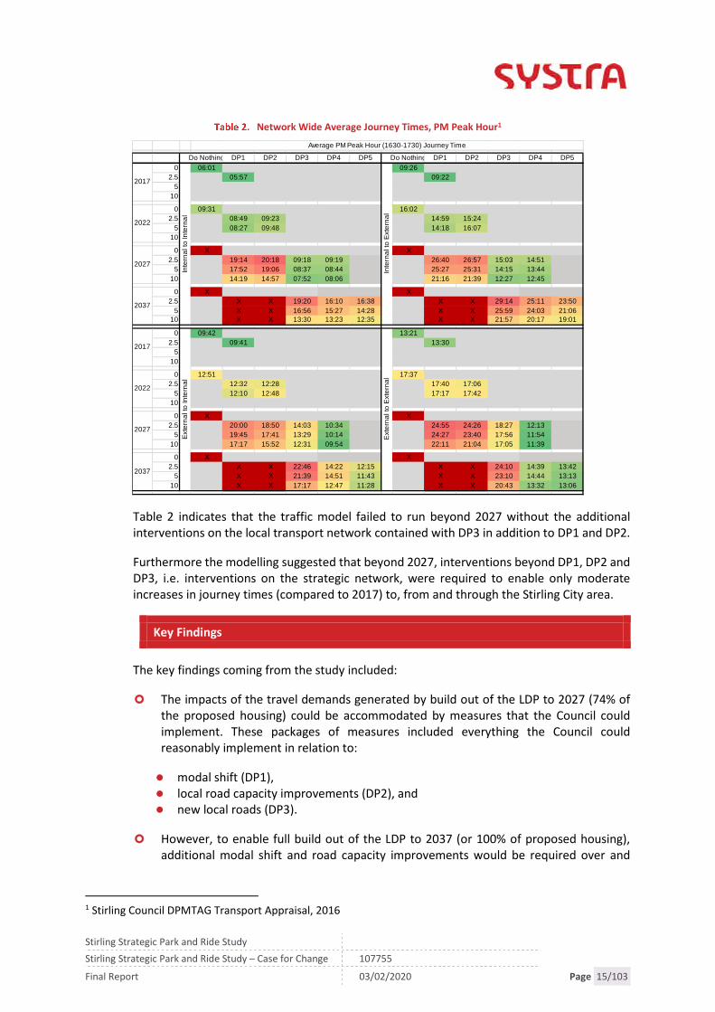
Table 2 below summarises the average PM Peak Hour journey times across Stirling City Areafor internal to internal trips; internal to external trips; external to internal trips and externalto external trips for each scenario.
Stirling Strategic Park and Ride Study
Stirling Strategic Park and Ride Study – Case for Change 107755
Final Report 03/02/2020 Page 15/103
Network Wide Average Journey Times, PM Peak Hour1
Table 2 indicates that the traffic model failed to run beyond 2027 without the additionalinterventions on the local transport network contained with DP3 in addition to DP1 and DP2.
Furthermore the modelling suggested that beyond 2027, interventions beyond DP1, DP2 andDP3, i.e. interventions on the strategic network, were required to enable only moderateincreases in journey times (compared to 2017) to, from and through the Stirling City area.
Key Findings
The key findings coming from the study included:
The impacts of the travel demands generated by build out of the LDP to 2027 (74% ofthe proposed housing) could be accommodated by measures that the Council couldimplement. These packages of measures included everything the Council couldreasonably implement in relation to:
modal shift (DP1), local road capacity improvements (DP2), and new local roads (DP3).
However, to enable full build out of the LDP to 2037 (or 100% of proposed housing),additional modal shift and road capacity improvements would be required over and
1 Stirling Council DPMTAG Transport Appraisal, 2016
Do Nothing DP1 DP2 DP3 DP4 DP5 Do Nothing DP1 DP2 DP3 DP4 DP5
0 06:01 09:26
2.5 05:57 09:22
5
10
0 09:31 16:02
2.5 08:49 09:23 14:59 15:24
5 08:27 09:48 14:18 16:07
10
0 X X
2.5 19:14 20:18 09:18 09:19 26:40 26:57 15:03 14:51
5 17:52 19:06 08:37 08:44 25:27 25:31 14:15 13:44
10 14:19 14:57 07:52 08:06 21:16 21:39 12:27 12:45
0 X X
2.5 X X 19:20 16:10 16:38 X X 29:14 25:11 23:50
5 X X 16:56 15:27 14:28 X X 25:59 24:03 21:0610 X X 13:30 13:23 12:35 X X 21:57 20:17 19:01
0 09:42 13:21
2.5 09:41 13:30
5
10
0 12:51 17:37
2.5 12:32 12:28 17:40 17:06
5 12:10 12:48 17:17 17:42
10
0 X X
2.5 20:00 18:50 14:03 10:34 24:55 24:26 18:27 12:13
5 19:45 17:41 13:29 10:14 24:27 23:40 17:56 11:54
10 17:17 15:52 12:31 09:54 22:11 21:04 17:05 11:39
0 X X
2.5 X X 22:46 14:22 12:15 X X 24:10 14:39 13:42
5 X X 21:39 14:51 11:43 X X 23:10 14:44 13:13
10 X X 17:17 12:47 11:28 X X 20:43 13:32 13:06
Average PM Peak Hour (1630-1730) Journey Time
2017In
tern
alt
oIn
tern
al
Inte
rna
lto
Exte
rna
l
2022
2027
2037
2017
Exte
rna
lto
Inte
rna
l
Exte
rna
lto
Ext
ern
al
2022
2027
2037

Stirling Strategic Park and Ride Study
Stirling Strategic Park and Ride Study – Case for Change 107755
Final Report 03/02/2020 Page 16/103
above local modal shift and local road capacity improvements if significant increases injourney times across the network were to be avoided e.g.:
Improvements to existing motorway junctions (DP4); and Additional motorway junction and strategic park and ride sites on the rail corridor to
the north and south of the city (DP5).
Of note, the traffic modelling highlighted that 38% (AM) to 46% (PM) of vehicular tripshad their origin and destination within Stirling City; and 44% (AM) to 38% (PM) of cartrips had either their origin or destination outside Stirling City. i.e. approximately 38%-44% of car trips into or out of Stirling City were strategic in nature.
In addition, the appraisal highlighted the poor transport opportunities for residentsliving in the ‘eastern villages’ of Plean, Cowie and Fallin.
Transport Scotland’s Response
In recognition that the cumulative consequences of travel demand generated by the LDPproposals beyond 2027 (e.g. the remaining 26% of housing allocations) cannot be met byCouncil interventions alone, and that further interventions over and above what the Councilcan deliver may be required, Transport Scotland’s response to the DPMTAG transportappraisal noted:
“The longer term strategic interventions ….on the trunk road network from Pirnhallto Kier, require further consideration in terms of rationale, feasibility, potentialphasing and deliverability/affordability; and
further work… would be required to determine potential rationale for the park andride interventions.”
Transport Scotland accordingly awarded LRDF funding to investigate this second point, i.e. toinvestigate whether strategic park and ride could help reduce the 38-44 % of vehicles enteringor leaving Stirling City. These trips that are starting or ending within Stirling City are not justas a consequence of new business and residential developments in Stirling City, but alsoexisting destinations both within Stirling City and the wider travel to work area.
Actions Coming from DPMTAG Study
In terms of addressing the issues highlighted by the DPMTAG study:
Stirling Council, via its LTS delivery plans (specifically the Stirling City Area TransportPlan), will seek to:
promote modal shift away from cars for local trips (including the 38-46% of car tripsin the city area which have both their origin and destination in the city i.e. DP1)
manage traffic on local roads within the Stirling City area by maximising existingcapacity and bringing forward additional road capacity improvements (i.e. DP2 andDP3).
In terms of investigating the rationale, feasibility, potential phasing and deliverability/affordability of strategic interventions (i.e. DP4 and DP5):

Stirling Strategic Park and Ride Study
Stirling Strategic Park and Ride Study – Case for Change 107755
Final Report 03/02/2020 Page 17/103
Stirling Council is currently investigating the problems generated at and around M9Junction 10 Craigforth with Transport Scotland and Tactran;
The Council and Transport Scotland are considering the required improvements at andaround M9 Junction 9 Pirnhall in the context of major development proposals in theimmediate vicinity;
Transport Scotland are reviewing the proposed grade separation of M9 Junction 11 KeirRoundabout proposed in the review of STPR; and
In parallel, this study considers how best to increase the modal share of public transport forthose trips entering and leaving the Stirling City area to help reduce the volume of vehiclesentering and leaving the Stirling City area, including the potential rationale for the park andride interventions.
Key Point: The transport appraisal undertaken to inform the Stirling LDP and LTSidentified the need for interventions beyond modal shift and road capacityimprovements within the Stirling City area which could be implemented by StirlingCouncil to help reduce the proportion of car trips entering and leaving the Stirling Cityarea.

Stirling Strategic Park and Ride Study
Stirling Strategic Park and Ride Study – Case for Change 107755
Final Report 03/02/2020 Page 18/103

Stirling Strategic Park and Ride Study
Stirling Strategic Park and Ride Study – Case for Change 107755
Final Report 03/02/2020 Page 19/103
2. METHODOLOGY
2.1 Scottish Transport Appraisal Guidance (STAG)
As required by the conditions of the LRDF, the study has been undertaken in accordance withthe Scottish Transport Appraisal Guidance (STAG) process which provides a framework toassess the performance of different transport options to address identified problems andpresent the results in a consistent manner to inform decision makers. The STAG processcomprises four stages as outlined below:
Pre-Appraisal (Initial Appraisal: Case for Change): where the problems, opportunities,issues and constraints are identified and scoped. Study-specific Transport PlanningObjectives (TPOs) are then identified and an ‘optioneering’ and sifting processundertaken to provide a list of possible options to address the problems;
Initial Appraisal (Preliminary Options Appraisal): potential options are appraisedagainst the TPOs, five STAG criteria and factors concerning deliverability, to ensure thatthey are likely to fulfil the study’s requirements;
Detailed Appraisal (Detailed Options Appraisal): involving more detailed considerationof potential options taken forward following the Initial Appraisal, and presenting theoutcomes to inform investment decision makers. The Detailed Options Appraisal alsoincludes proposals for monitoring and evaluation; and
Post-Appraisal: key elements of this stage involve the application of the monitoring andevaluation proposals developed as part of the appraisal.
The Case for Change identifies whether there is a problem to be solved. It collates andanalyses relevant data and findings from consultation to develop the problems, opportunities,issues and constraints which in turn inform the development of TPOs. The TPOs are initiallyused to ensure options developed as part of the study will meet the TPOs and also, at a laterstage will be appraised against these TPOs.
2.2 Stakeholder Engagement
Participation and consultation are key elements of a STAG study and ensure the interests ofstakeholders are considered in an inclusive, open, transparent and appropriate manner. Inparticular, consultation is useful in the identification and analysis of transport problems andopportunities which forms the starting point of any STAG study.
For this purpose, three workshops were held with stakeholders including representativesfrom community councils, bus and taxi operators, local councillors and the StrathallanCommunity Rail Partnership.
In addition to the workshops, this study has been informed by Stirling Council’s ownconsultation exercise undertaken as part of the Local Transport Strategy.
The outputs of the consultation processes have been detailed in Chapter l.

Stirling Strategic Park and Ride Study
Stirling Strategic Park and Ride Study – Case for Change 107755
Final Report 03/02/2020 Page 20/103
2.3 Collation of Baseline Data
Data used to inform the problems, opportunities, issues and constraints has been collatedfrom a range of sources but primarily the LDP transport appraisal which was undertaken in2016. Where appropriate, data has been updated and all data has been reviewed andinterpreted in the context of the updated Local Transport Strategy and recent planning andpolicy changes.
Additional sources for this study include:
Census 2011; Scottish Household Surveys; Transport Scotland data including transport forecasts; Rail User Surveys (2017); and South Stirling Park and Ride STAG.
2.4 Project Steering Group
The scope of the study was shaped by input from members of the Project Steering Group:
Tactran; Stirling Council; Clackmannanshire Council; Sestrans; Sustran; Transport Scotland; and Network Rail.

Stirling Strategic Park and Ride Study
Stirling Strategic Park and Ride Study – Case for Change 107755
Final Report 03/02/2020 Page 21/103
3. POLICY
3.1 Overview
This chapter sets out the national, regional and local policy backdrop along with the widercontext against which the study is being progressed.
For the purpose of this study, the key policies considered are contained within the:
National Policy:
The National Transport Strategy (2016 Refresh); Strategic Transport Projects Review (2008); Scottish Cities Alliance; National Planning Framework 3; Scotland Route Study, Network Rail, 2016; Climate Change Plan (2018); Cycling Action Plan for Scotland 2017-2020; and Scottish Planning Policy, Scottish Government, 2014.
Local and Regional Policy:
Tactran Regional Transport Strategy 2008-2023; Tactran Park and Ride Strategy and Action Plan (2016); Stirling and Clackmannanshire City Region Deal; Stirling Local Development Plan 2017-2027; Stirling Local Transport Strategy 2017-2027; Clackmannanshire Local Transport Strategy 2010-2014; Clackmannanshire Local Development Plan 2015-2025; and Stirling Community Planning Partnership Local Outcomes Improvement Plan.
3.2 National Policy
National Transport Strategy
The National Transport Strategy (NTS) was first published in 2006 and refreshed in 2016 toreconfirm the high-level objectives set out in the white paper entitled Scotland’s TransportFuture (2004), and the National Transport Strategy (2006). They are to:
Promote economic growth by building, enhancing managing and maintainingtransport services, infrastructure and networks to maximise their efficiency;
Promote social inclusion by connecting remote and disadvantaged communitiesand increasing the accessibility of the transport network;
Protect our environment and improve health by building and investing in publictransport and other types of efficient and sustainable transport which minimiseemissions and consumption of resources and energy;
Improve safety of journeys by reducing accidents and enhancing the personal safetyof pedestrians, drivers, passengers and staff; and

Stirling Strategic Park and Ride Study
Stirling Strategic Park and Ride Study – Case for Change 107755
Final Report 03/02/2020 Page 22/103
Improve integration by making journey planning and ticketing easier and workingto ensure smooth connection between different forms of transport.
The NTS also sets out three strategic outcomes which are intended to provide the focus fordelivering the high-level objectives. The strategic outcomes are to:
Improve journey times and connections: to tackle congestion and the lack ofintegration and connections in transport which impact on our high-level objectivesfor economic growth, social inclusion, integration and safety;
Reduce emissions: to tackle the issues of climate change, air quality and healthimprovement which impact on our high-level objective for protecting theenvironment and improving health; and
Improve quality, accessibility and affordability: to give people a choice of publictransport, where availability means better quality transport services and value formoney or an alternative to the car.
The NTS will be superseded by the NTS2 which is currently in draft and consultation. It isunderstood that publication is imminent. Should this study progress to the next stage, dueconsideration will be taken of the revised NTS.
Relevance to Study: The scope of the study has the potential to support the NTSStrategic Outcomes to improve journey times and connections and the quality,accessibility and affordability of public transport. The study therefore has thepotential to support all three of the NTS’s strategic outcomes.
Strategic Transport Projects Review (STPR), 2008
The Strategic Transport Projects Review (STPR), published in December 2008, set out theScottish Government's 29 transport investment priorities over the period to 2032.
The outcomes of the STPR were structured on a tiered approach to investment, based aroundthe priorities of:
Maintaining and safely operating existing assets; Promoting a range of measures, including innovative solutions, that make better use of
existing capacity; and Promoting targeted infrastructure improvements where these are necessary, affordable
and practicable.
Through Transport Scotland, the Scottish Government are currently taking forward the nextreview of projects (STPR 2).
Relevance to Study: STPR identified a series of strategic park and ride sites includinga site at Bannockburn serving Edinburgh, Glasgow, and Stirling. STPR stated that thesite would be served by either rail services or express bus links to and from the citycentres and areas of economic activity (STPR Project 8).

Stirling Strategic Park and Ride Study
Stirling Strategic Park and Ride Study – Case for Change 107755
Final Report 03/02/2020 Page 23/103
Scottish Cities Alliance
The Scottish Cities Alliance was established in 2011 to progress the Agenda for Cities with theaim to achieve an economically stronger future for Scotland through the joint efforts ofScotland’s seven cities and a long-term investment promotion strategy, in a bid to attractcapital investment to Scotland’s cities.
The Alliance’s purpose is to support the inclusive economic growth of Scotland’s cities andtheir regions by:
Speaking powerfully with a single voice to compete successfully in global markets forinvestment and jobs.
Raising the profile of Scottish cities as smart and sustainable destinations for investment. Informing policy to ensure that the Scottish cities and their regions remain globally
competitive.
To achieve these objectives the Scottish Cities Alliance identifies the need to improveconnections between the cities and with external markets.
Relevance to study: The Scottish Cities Alliance supports the vision of the City Regionsand in particular identifies the interventions required to leverage further value fromthese investments, including infrastructure.
Network Rail: Scotland Route Study,2016
The Scotland Route Study presents a vision of the railway in 2043, and sets out a strategy “forrealising this vision in ways that are deliverable and likely to provide value-for-money forpassengers and funders.”
The strategic objectives set in the study aim to enable economic growth by:
Improving connectivity:
To/from the retail, leisure and tourism sectors of the economy; Business to business connectivity; and Connecting communities.
Improving accessibility:
Improving access to workers for businesses; Access to employment and training opportunities; Reducing carbon and transport sector’s impact on the environment; Improving integration across the transport network; Reducing safety risks for the general public; and Improving affordability and value for money.
The Scotland Route Study provides an evidence base that informs rail industry investmentchoices for Control Periods 6 and 7 (2019 – 2029).

Stirling Strategic Park and Ride Study
Stirling Strategic Park and Ride Study – Case for Change 107755
Final Report 03/02/2020 Page 24/103
The long-term planning process is designed to consider the role that the railway plays insupporting the UK economy over the next 30 years. This includes addressing the demandsthat are likely to be placed in that time, capturing stakeholder aspirations to develop new orimproved train services and to present investment choices for funders to accommodate thesedemands and future aspirations.
The following stages in relation to Stirling outline a number of options that have beenappraised and discussed for inclusion in future control periods.
Options that have been recommended for progression included in the study area:
Improving signalling headways between Dunblane and Perth:
Removes timetabling constraints caused by the 7 – 8min headways on this section ofthe route.
Dunblane to Perth electrification:
Linking in with the existing EGIP programme, the product of the extension willpossibly include journey time improvements and more efficient and streamlinedtimetabling and rolling stock utilisation.
Included in this study is forecast demand for passenger journeys undertaken wholly withinScotland. Figure 2 shows forecast capacity issues on AM peak trains into Glasgow QueenStreet by 2023/24 with particular issues on Aberdeen/Inverness services which are atstanding only capacity at Croy. The analysis does not include additional capacity associatedwith the Revolution in Rail which would relieve some of the crowding identified.

Stirling Strategic Park and Ride Study
Stirling Strategic Park and Ride Study – Case for Change 107755
Final Report 03/02/2020 Page 25/103
Figure 2. Passenger Numbers in 2023/24 into Glasgow QS (08:00 – 09:00)2
Relevance to Study: The Scotland Route Study shares with this study the aim ofencouraging public transport for trips originating or ending in Stirling City. It providesa baseline of proposed improvements which inform the ability to consider furtherenhancements to increase the number of rail passengers into and out of Stirling CityArea. In particular this includes:
Improving signalling headways between Dunblane and Perth
Dunblane to Perth electrification
2 Network Rail, Scotland Route Study, 2016
All servicesAberdeen/Inverness trains only

Stirling Strategic Park and Ride Study
Stirling Strategic Park and Ride Study – Case for Change 107755
Final Report 03/02/2020 Page 26/103
Climate Change Emergency Related Policies
A number of policies relate to the Climate Change Emergency and commitments at local andScottish levels to address the emergency. Relevant policies include:
Climate Change Plan 2018-2032 (RPP3)
The Climate Change Plan is the Scottish Government’s third report on proposals andpolicies for meeting its climate change targets. It sets out how Scotland can deliverits target of 66% emissions reductions, relative to the baseline, for the period 2018–2032.
Scottish Planning Policy, Scottish Government, 2014
SPP identifies a need to shift to more sustainable modes of transport to help meetthe Scottish Government’s greenhouse gas emission targets. Tackling congestion willalso help support sustainable economic growth. The Policy requires that planningauthorities should support development that reduces the need to travel andfacilitates travel by walking, cycling and public transport and freight movement byrail and water.
Relevance to Study: The study’s aim of promoting modal shift for strategic trips hasthe potential for supporting the Scottish Government greenhouse gas emissiontargets.
Cycling Action Plan for Scotland 2017-2020
The third iteration of the Cycling Action Plan for Scotland (CAPS) was published in 2017 andrepresents six years of shared work by partners and a commitment to the 2020 vision. TheCycling Action Plan has been split into five focuses:
Leadership and Partnership Infrastructure, Integration and Road Safety Promotion and Behaviour Change Resourcing Monitoring and Reporting.
Relevance to Study: Of particular relevance to Stirling is the commitment to improveintegration with public transport, through partnership working with ScotRail,bus/coach operators and Regional Transport Partnerships and provide secure cyclestorage at key destinations including transport interchanges.

Stirling Strategic Park and Ride Study
Stirling Strategic Park and Ride Study – Case for Change 107755
Final Report 03/02/2020 Page 27/103
The National Walking Strategy, 2016-26
The National Walking Strategy was launched in 2014 with a vision for a Scotland whereeveryone benefits from walking as part of their everyday journeys, enjoys walking in theoutdoors and where places are well designed to encourage walking. The strategy proposesthe following two Strategic Aims.
Develop a daily walking culture – everyone, everyday
To deliver on creating a culture of walking where everyone walks more often as partof their everyday travel and for recreation and wellbeing.
Develop walkable places and spaces for everyone
To achieve better quality walking environments with attractive, well designed andmanaged built and natural spaces and places for everyone
These themes are supported by additional outcomes and actions including increasing walkingwithin multi-modal journeys.
Relevance to Study: The scope of the study has the potential to support The NationalWalking Strategy by encouraging modal shift which would achieve the outcome toincrease walking within multi-modal journeys.
3.3 Local and Regional Policy
Tactran Regional Transport Strategy 2008-2023
The Tactran Regional Transport Strategy Refresh (RTS) was published in 2015 and sets out avision and strategy for improving the region’s transport infrastructure, services and otherfacilitiesto 2036. Tactran’s Vision is to deliver:
“a transport system, shaped by engagement with its citizens, which helps deliverprosperity and connects communities across the region and beyond, which is sociallyinclusive and environmentally sustainable and which promotes the health and well-beingof all.”
Six broad objective themes were developed to support this Vision, these are:
Economy: To ensure transport helps to deliver regional prosperity. Accessibility, Equity and Social Inclusion: To improve accessibility for all, particularly for
those suffering from social exclusion. The Environment: To ensure that the transport system contributes to safeguarding the
environment and promotes opportunities for improvement. Health and Well-Being: To promote the health and well-being of communities. Safety & Security: To improve the real and perceived safety and security of the transport
network.

Stirling Strategic Park and Ride Study
Stirling Strategic Park and Ride Study – Case for Change 107755
Final Report 03/02/2020 Page 28/103
Integration: To improve integration, both within transport and between transport andother policy areas.
Relevance to Study: This study has the potential to consider interventions whichsupport the RTS objectives relating to economy, accessibility, the environment andintegration.
RTS Delivery Plan (2018) and Park and Ride Strategy (2016)
The Tactran Park and Ride Strategy set out to complement and expand the Regional TransportStrategy aspirations identified above by seeking:
Economy:
To ensure that Park & Ride improves access to town / city centres and areas ofemployment, helping to support economic growth
To improve the efficiency and reliability of the transport system through reducedtown and city centre traffic levels and associated economic costs.
Accessibility:
To improve access to health, leisure and retail facilities by Park & Ride To improve the physical accessibility of the transport system through the provision of
increased Park & Ride.
Environment:
To respect the built environment through reducing the need to build new town andcity centre car parks.
Health and Well-Being:
To help limit / manage travel by private car in urban areas to help meet statutory airquality requirements in the Tactran area.
Safety & Security:
To provide the highest levels of safety and security of passengers and vehicles whenusing Park & Ride.
Integration:
To ensure Park & Ride facilitates integration and is accessible by all modes oftransport.
To ensure integration between land-use planning and provision of public transport.
Stirling Strategic Park and Ride Study
Stirling Strategic Park and Ride Study – Case for Change 107755
Final Report 03/02/2020 Page 29/103
The Strategy proposed promoting new bus and rail based Park & Ride and enhancing existingbus and rail based Park & Ride provision. Actions of relevance to Stirling as included in theTactran RTS Delivery Plan 2016-2021 are:
PR2: New Bus Based Park & Ride: Develop and implement proposals for new Park & Ridesites to the south, west, east and north of Dundee, to the north and east of Perth and tothe south of Stirling
PR2.7 Regional Park & Ride facility- South of Stirling: Implement proposals for a newbus Park & Ride site south of Stirling, incorporating multi- modal and other bestpractice. Maximise the attractiveness of using park and ride to access City centre andbeyond
New Regional Park & Ride facility – North-east Stirling
PR3: Park & Ride at New Rail Station Sites: Support the provision of parking space at newrail stations in the region sufficient to match the anticipated parking demand
PR3.1 Strategic Park & Ride facility at Bannockburn, Stirling: Park and ride facility atBannockburn, serving Edinburgh, Glasgow and Stirling
R5: Support provision of new, relocated and enhanced stations where this will enhanceaccess to the rail network and improve integration with the area being served.
R5.6 Investigate whether a relocated Bridge of Allan Station support LTS objectives
Relevance to Study:
The study specifically takes forward the proposals to investigate the benefit ofnew or enhanced Park and Ride opportunities around Stirling as proposed in theRTS Delivery Plan
The RTS P&R Strategy provides best practice guidance for the design of park andride proposals
Stirling and Clackmannanshire City Region Deal
Stirling Council, in partnership with Clackmannanshire Council and the University of Stirling,has secured an investment of £90.2m, from both the Scottish and UK Governments, in theform of a City Region Deal (CRD). This deal is intended to provide investment in Innovation,Digital, Culture, Heritage and Tourism, Active Travel and Connectivity over the next 10 to 15years with the core aim of generating inclusive economic growth for the region.
Relevance to Study: Stirling City Region Deal is intended to provide investment in anumber of sectors to promote growth in the region. This study recognises the impactgrowth generated by the City Region Deal may have on the transport network andtransport’s role in supporting growth aspirations.

Stirling Strategic Park and Ride Study
Stirling Strategic Park and Ride Study – Case for Change 107755
Final Report 03/02/2020 Page 30/103
Stirling Council Local Development Plan, 2017-2027
The Stirling Local Development Plan was adopted in October 2018 and covers the period2017–2027, while looking to 2037.
By 2037, the Plan aims to have contributed to the delivery of high quality new developmentin places which support local businesses; help sustain and build local communities;contributes to the health and wellbeing of local residents; and are attractive to visitors. Thepolicies include approaches to development which will support growth in a sustainable andinclusive manner.
The main themes for the Plan are:
Placemaking and implementing the Spatial Strategy:
Conserving and enhancing the quality and amenity of the places around us withconsideration given to reducing health and social inequalities and promotingwellbeing.
Climate Change adaptation and mitigation:
New development discouraged in places where climate-related hazards are presentor predicted, such as flood plains. New development must also be more efficient inits use of resources and enable reductions in traffic generation.
Conservation of historic and natural heritage:
Recognising the dependence on natural resources and the ways in which localcommunities interact with these to support employability and health.
Managing and utilising local resources:
Enable protection, conservation and enhancement of biodiversity, landscapes andthe historic environment.
Relevance to Study: The LDP themes of placemaking and implementing the SpatialStrategy align with the study and the plan includes details of a number ofdevelopments (referred to in the DPMTAG Transport Appraisal) which will impact onthe transport network over the next 20 years. Over 8,000 additional homes areproposed in the LDP generating additional travel demands into and out of the studyarea. The scale and location of these developments is addressed in Chapter 4.

Stirling Strategic Park and Ride Study
Stirling Strategic Park and Ride Study – Case for Change 107755
Final Report 03/02/2020 Page 31/103
Stirling Local Transport Strategy, 2017-2027
The second Stirling Local Transport Strategy (LTS) was published in December 2016 and coversthe period 2017-2027 with the ambition to develop a transport network across Stirling thatallows people and goods to get where they need to be safely and efficiently in ways thatimprove their health and don’t damage the environment.
This ambition is supported by key objectives including:
A safer Stirling:
Reduce the numbers of both accidents and casualties Ensure that our transport networks and streets feel safe and secure for all users.
A connected Stirling:
Maintain and improve strategic road and rail transport links between Stirling andScotland’s other cities, and beyond
Maintain and improve transport links into Stirling City and its key employment areas Maintain and improve transport links between the City and Stirling’s rural towns and
villages.
An active and sustainable Stirling:
Encourage and enable more trips to be made by walking, cycling and public transport Ensure sustainable travel choices are at the heart of an integrated transport network Minimise carbon emissions from transport.
An inclusive Stirling:
To ensure that jobs, services and opportunities can be accessed by a choice of meansof travel
Transport networks, including our streets, that are usable by all, including peoplewith mobility difficulties.
A quality place:
Ensure that our street environments, as the principal public space in our settlements,enhance the quality of Stirling’s urban and rural environments
Ensure that our street environments are safe, pleasant, easily navigable andconnected for all users
Continually seek to improve air quality and reduce noise pollution arising from traffic.
A quality transport network:
Maximise the efficiency of our existing transport networks to support the other LTSobjectives
Maintain the safety, maximise the utility, and minimise the whole life costs of ourtransport networks through maintenance programmes.
Stirling Strategic Park and Ride Study
Stirling Strategic Park and Ride Study – Case for Change 107755
Final Report 03/02/2020 Page 32/103
The LTS identifies a number of measures as part of the City Area Transport Plan including thefollowing:
Park and Ride/Park and Choose:
Extending our park and ride network Introduce a southern park and ride site for local and strategic trips Consider park and ride opportunities for traffic from Clackmannanshire for both local
(bus) and strategic (bus or rail) trips Explore low carbon transport and travel hubs at park and choose sites.
Improving the attractiveness of public transport:
Investigate bus priority on commercial and park and ride routes, including: – CityCentre to University/Alloa – City Centre to Bannockburn/ Plean – Castleview P&R toCity Centre – Springkerse P&R to City Centre – Emerging P&R sites to City Centre(including southern P&R along Glasgow Rd)
Improve integration of Stirling Bus and Rail Stations Improve passenger waiting facilities (shelters/seating).
Parking:
Introduce decriminalised parking enforcement Ensure provision of short-stay parking, prioritising car parking for short stay shopping
to meet city centre commercial needs Limit long stay parking within city centre, and relocating majority of long stay parking
to park and ride sites Limit city centre parking over spilling into neighbouring residential areas Investigate opportunities for coach parking Ensure that 6% of public on and off-street parking is available for people with mobility
difficulties Put in place the parking and traffic management measures required to improve road
safety and reduce congestion & pollution and) facilitate access and movement bymobility impaired people, pedestrians, cyclists, public transport and its users, andmotorcyclists.
Durieshill and South Stirling Gateway Transport Package:
Work with Transport Scotland to Maintain and enhance access to Stirling City via thetrunk road network
Southern Park and Ride Roads improvement packages for M9 Junction 9; A91; A872 Active travel connections.
Rail:
Support extension of electrification of rail services from Glasgow/ Edinburgh toDunblane and Dunblane to Perth
Investigate whether a new south Stirling and/or a relocated Bridge of Allan Stationsupport LTS objectives.

Stirling Strategic Park and Ride Study
Stirling Strategic Park and Ride Study – Case for Change 107755
Final Report 03/02/2020 Page 33/103
Support investigation of the re-introduction of Stirling to Alloa to Dunfermlinepassenger services
Work with Network Rail on programmes to improve safety at level crossings.
Relevance to Study: The LTS presents the broader framework of complementaryinterventions of which this study is an integral element. This study has the potentialto support the connected, inclusive and sustainable objectives of the LTS.
Therefore this study will investigate the ability of new park and ride proposalsproposed in the LTS to deliver the objectives of a connected and inclusive Stirling.
This includes ensuring sustainable travel choices are at the heart of an integratedtransport network by improve the active travel choices for people to interchangeopportunities.
Clackmannanshire Local Transport Strategy, 2010-2014
The (current) Clackmannanshire Local Transport Strategy (LTS) covers the period 2010-2014.An updated LTS is currently being prepared
The over-arching aims of the local transport strategy are:
Support and enhance the local economy by:
Developing a sustainable transport system Managing the valuable asset that is the road and footway network Improving
connection between people and markets Tackling traffic growth and congestion.
Manage travel to reduce its environmental impact by:
Reducing the need to travel Encouraging greater use of walking, cycling and public transport Promoting eco-driving techniques Reducing greenhouse gases and other pollutants Managing our carbon footprint.
Improve the transport environment to reduce actual and perceived safety issues by:
Reducing the number of people killed or seriously injured in road traffic accidentsImproving the quality of lighting in our streets.
Work towards a seamless transport system to increase social inclusion by:
Reducing the number of modal interchanges required to make key journeys.

Stirling Strategic Park and Ride Study
Stirling Strategic Park and Ride Study – Case for Change 107755
Final Report 03/02/2020 Page 34/103
Remove barriers to accessibility by enhancing healthy and alternative modes of travelby:
Enhancing health and alternative modes of travel Removing barriers to using publictransport.
Integrate land use and transport planning by:
Reconciling development and sustainability.
Maintain and improve the existing infrastructure by:
Fully utilising the network Reducing maintenance impact on the environment.
Relevance to Study: The objectives of the LTS broadly align with the study includingthe aims for supporting and enhancing the local economy and working towards aseamless transport system to increase social inclusion.
Clackmannanshire Local Development Plan, 2015
The Clackmannanshire LDP was adopted in 2015
The LDP aims to accommodate the growth projected by the General Register Office forScotland, a population increase from around 50,630 in 2010 to 57,629 in 2035, and anincrease in the number of households from around 22,950 to 29,370 over the same period.
The LDP also recognises the importance of transport links to neighbouring areas and recentimprovements including the introduction of rail passenger services to Glasgow and Edinburgh
via Stirling, and the construction of the Clackmannanshire Bridge. The strong links to Stirlingin relation to employment, housing, shopping and leisure are also considered with morethan half of the Clackmannanshire working population aged 16-64 (54%) travellingoutwith Clackmannanshire to work.
Relevance to Study: the LDP recognises the growth targets for Clackmannanshire andthe cross-boundary impacts on Stirling – a key destination for employment, housing,shopping and leisure.
Stirling Community Planning Partnership Local Outcomes Improvement Plan (LOIP):‘The Stirling Plan’
The Stirling Plan focuses partnership delivery towards four priority outcomes:
Prosperous: People are part of a prosperous economy that promotes inclusive growthopportunities across our communities
Healthy: People are healthy and live active, full and positive lives within supportivecommunities

Stirling Strategic Park and Ride Study
Stirling Strategic Park and Ride Study – Case for Change 107755
Final Report 03/02/2020 Page 35/103
Achieving: People are skilled and supported to make a positive contribution to ourcommunities
Resilient: People are part of safe and caring communities within an attractive andsustainable environment.
Areas identified that would benefit from collaborative partnership working included:
Improving access to learning, training and jobs Improving/maintaining our places and environment Connecting people and places – improving transport and broadband.
Relevance to Study: The LOIP identifies the importance of collaborative partnershipworking to connect people and places – a key focus of the study, and inclusive growth.
The study will consider interventions that support the LOIP aims of reducinginequalities in Stirling, including by improving access to jobs, services andopportunities for those living in the more disadvantaged communities.
3.4 Summary
The review of policies relevant to this study has highlighted parallels at both a national andlocal level on many objectives including economic growth, social inclusion improvements, theenvironment and reduced journey times.
In addition, a number of options have been identified for the Stirling area of relevance to thisstudy including a Strategic Park & Ride site south of Stirling (STPR) and areas of economicactivity (STPR Project 8) and investigating a new south Stirling and/or a relocated Bridge ofAllan Station (Stirling LTS).
This review of policy has identified not only options to be included as part of the optiongeneration stage but has also highlighted objectives at a national and local level which mayalign with the TPOs of this study to ensure this study reflects national, regional and local policyobjectives.
Key Point: The study will investigate options that will help deliver national, regionaland local policy objectives of:
Promoting sustainable travel to reduce carbon emissions
Improving inclusivity and access to jobs, services and opportunities to promoteinclusive growth.

Stirling Strategic Park and Ride Study
Stirling Strategic Park and Ride Study – Case for Change 107755
Final Report 03/02/2020 Page 36/103

Stirling Strategic Park and Ride Study
Stirling Strategic Park and Ride Study – Case for Change 107755
Final Report 03/02/2020 Page 37/103
4. SOCIO-ECONOMIC CONTEXT
4.1 Overview
The Stirling City Area is located in the heart of Scotland with a population of approximately55,0003 (2018), which is expected to continue to grow by 2.5% between 2016 and 2021.4 Thearea comprises Stirling City, Bridge of Allan, Bannockburn and the ‘Eastern Villages’ of Plean,Cowie and Fallin. The area includes the city centre and associated employment opportunitiesincluding Stirling University, Forth Valley College, urban small & medium-sized enterprises(SMEs) along with the tourist industry of Stirling City. There are a number of food, technologyand finance businesses in the study area with major employers including Prudential, Capita,Graham’s Family Dairies and the Scottish Environment Protection Agency and approximately33,000 employees in the study area. 5
Stirling is a major tourism destination in Scotland with attractions including Stirling Castle, TheNational Wallace Monument and the Bannockburn Centre. In 2014, there were 4 millionvisitors to the Stirling area6.
Stirling is also home to the University of Stirling which has 14,000 students and 1,500 staffwith plans to grow. Growth plans include the development of a new sports complex oncampus reinforcing Stirling University’s role as Scotland’s University for Sporting Excellenceand City Regional Deal funding for two research hubs at the University; £17 million for a newAquaculture Hub and £5 million for an International Environment Centre7. (across sites inAlloa and at the university). Forth Valley College, Stirling Campus is located on Drip Road,close to Craigforth and is attended by approximately 800 full time students, 100 employeesand includes two evenings of classes a week in addition to term time day classes.
In addition to tourist attractions and education establishments Stirling has a number of majoremployee destinations including the Prudential (over 2,500 employees) and Castle BusinessPark and health destinations including the Stirling Health and Care Village. Prudentialcurrently operate bus services for employees and other local trip attractors could coordinatewith Prudential to make more services viable.
This chapter will summarise the socio-economic context for Stirling City Area including thepopulation, age demographics, employment activity and access to car.
3 National Records of Scotland Area Profile, https://www.nrscotland.gov.uk/statistics-and-data/statistics/stats-at-a-glance/council-area-profiles accessed on 15/01/20194 Projection is a council-wide figure. National Records of Scotland Area Profile,https://www.nrscotland.gov.uk/statistics-and-data/statistics/stats-at-a-glance/council-area-profiles accessedon 15/01/20195 Census 2011, https://www.scotlandscensus.gov.uk, accessed 15/01/20196Invest in Stirling, http://www.investinstirling.com/key-sectors/tourism/ visited on 13/03/20197https://www.stir.ac.uk/about/city-region-deal/ accessed on 13/03/2019

Stirling Strategic Park and Ride Study
Stirling Strategic Park and Ride Study – Case for Change 107755
Final Report 03/02/2020 Page 38/103
4.2 Socio-Economic Data
The majority of data for the economic baseline are derived from the Office of NationalStatistics and 2011 Census data for Scotland. It is important to note that there is an elementof data lag involved. As with all available data at a national scale, there is usually severalyears’ gap between the data capture and present time. There have been no significantlocalised events that have affected the region economically which could be expected tosignificantly alter the picture the available data presents.
The level of data disaggregation varies by dataset and in some cases it is not available at thestudy area level and is instead provided at a local authority level. Where possible,Intermediate Zone Census data has been used, the Intermediate Zones included in the StudyArea are shown in Figure 3 and for the purpose of this report will be referred to as Stirling CityArea. Please note that the Intermediate Zone which covers the South West of Stirling City isa large zone which extends beyond the geographical boundary of the study area (albeit theadditional area covered is sparsely populated).
Figure 3. Stirling Study Area Intermediate Zones 2011 (Open Street Map)

Stirling Strategic Park and Ride Study
Stirling Strategic Park and Ride Study – Case for Change 107755
Final Report 03/02/2020 Page 39/103
4.3 Population
The National Records of Scotland provide details of the study area’s population which showthat the population has grown steadily above the Scottish average (Table 3). Populationprojections are not available at the study area level but for Stirling Council show that theCouncil population is forecast to increase by 4.3% between 2016 and 2026.
Population Growth and Projections in Stirling8
YEAR POPULATION % CHANGE FROM 2008 SCOTLAND %CHANGE FROM
2008
2008 51,709
2012 53,656 3.8% 2.1%
2016 54,554 5.5% 2.8%
2018 54,760 5.9% 3.5%
These figures represent growth across the council areas however the projections reflectgrowth in key areas of development highlighted in the Local Development Plan. Theseinclude:
City Consolidation: 1,678 homes Strategic Development Sites in Stirling include:
South Stirling Gateway (800 homes) Durieshill (2,500 homes)
Core Area Regeneration Sites including:
Cowie (535 homes) Fallin (424 homes) Plean (695 homes)
The LTS notes that Stirling Council expects to have increased the number of homes in andaround the city by 24% by 2037 which is likely to increase traffic levels by 22% at the busiesttimes (further detail in Chapter 5). As detailed above, many of these sites are to the Southand East of the city, with major growth areas such as South Stirling Gateway and Durieshillhaving a significant impact on travel demands on the southern flank of the city.
8 National Records of Scotland Area Profile, https://www.nrscotland.gov.uk/statistics-and-data/statistics/stats-at-a-glance/council-area-profiles accessed on 15/01/2019

Stirling Strategic Park and Ride Study
Stirling Strategic Park and Ride Study – Case for Change 107755
Final Report 03/02/2020 Page 40/103
The Local Development Plan also details the planned employment sites within the study area.These areas will be trip attractors and the main sites identified in the Spatial Strategy includethe following:
Bandeath North (43 ha) and West (41 ha); and Retail sites at Durieshill, South Gateway and Springkerse.
Figure 4 illustrates both residential and employment sites identified in the LDP.
Figure 4. Local Development Plan Sites
Key Point: Stirling City area is forecast to grow with an ambitious Local DevelopmentPlan leading to increased growth in population and jobs in the area above the Scottishaverage. The major development sites are largely around the western, southern andeastern edges of the city.
Stirling Strategic Park and Ride Study
Stirling Strategic Park and Ride Study – Case for Change 107755
Final Report 03/02/2020 Page 41/103
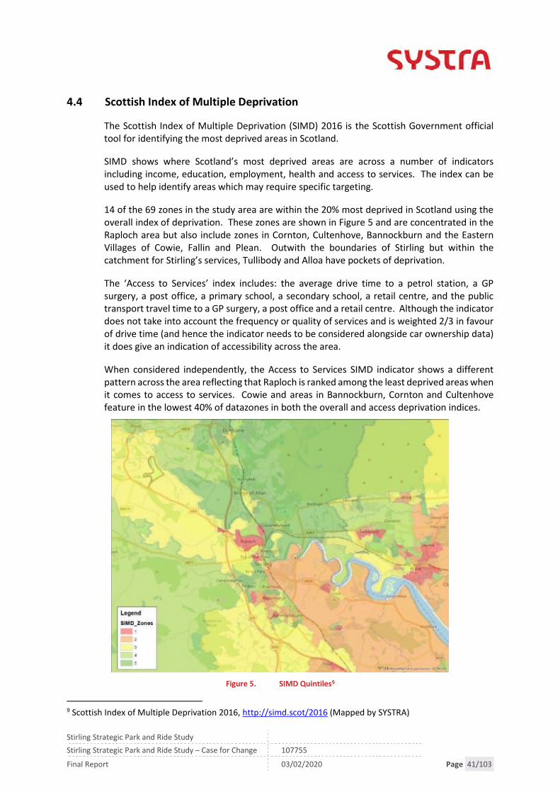
4.4 Scottish Index of Multiple Deprivation
The Scottish Index of Multiple Deprivation (SIMD) 2016 is the Scottish Government officialtool for identifying the most deprived areas in Scotland.
SIMD shows where Scotland’s most deprived areas are across a number of indicatorsincluding income, education, employment, health and access to services. The index can beused to help identify areas which may require specific targeting.
14 of the 69 zones in the study area are within the 20% most deprived in Scotland using theoverall index of deprivation. These zones are shown in Figure 5 and are concentrated in theRaploch area but also include zones in Cornton, Cultenhove, Bannockburn and the EasternVillages of Cowie, Fallin and Plean. Outwith the boundaries of Stirling but within thecatchment for Stirling’s services, Tullibody and Alloa have pockets of deprivation.
The ‘Access to Services’ index includes: the average drive time to a petrol station, a GPsurgery, a post office, a primary school, a secondary school, a retail centre, and the publictransport travel time to a GP surgery, a post office and a retail centre. Although the indicatordoes not take into account the frequency or quality of services and is weighted 2/3 in favourof drive time (and hence the indicator needs to be considered alongside car ownership data)it does give an indication of accessibility across the area.
When considered independently, the Access to Services SIMD indicator shows a differentpattern across the area reflecting that Raploch is ranked among the least deprived areas whenit comes to access to services. Cowie and areas in Bannockburn, Cornton and Cultenhovefeature in the lowest 40% of datazones in both the overall and access deprivation indices.
Figure 5. SIMD Quintiles9
9 Scottish Index of Multiple Deprivation 2016, http://simd.scot/2016 (Mapped by SYSTRA)
Stirling Strategic Park and Ride Study
Stirling Strategic Park and Ride Study – Case for Change 107755
Final Report 03/02/2020 Page 42/103
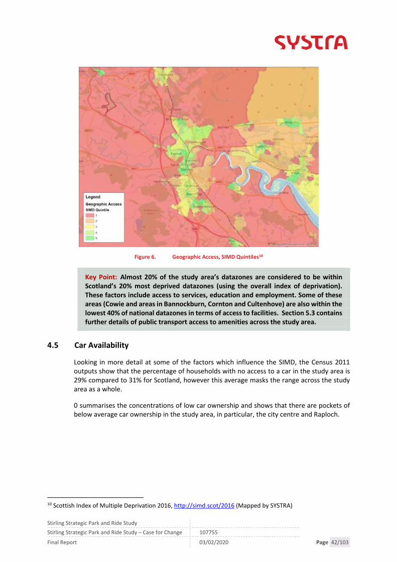
Figure 6. Geographic Access, SIMD Quintiles10
Key Point: Almost 20% of the study area’s datazones are considered to be withinScotland’s 20% most deprived datazones (using the overall index of deprivation).These factors include access to services, education and employment. Some of theseareas (Cowie and areas in Bannockburn, Cornton and Cultenhove) are also within thelowest 40% of national datazones in terms of access to facilities. Section 5.3 containsfurther details of public transport access to amenities across the study area.
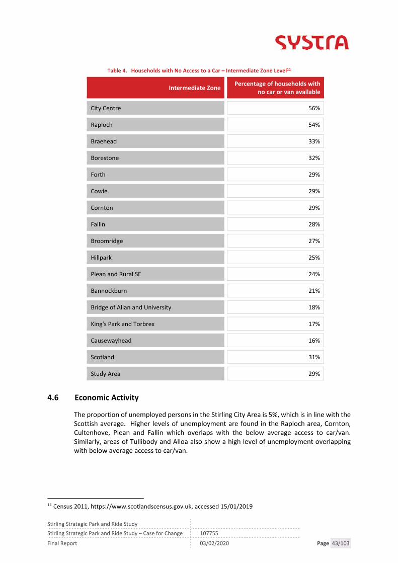
4.5 Car Availability
Looking in more detail at some of the factors which influence the SIMD, the Census 2011outputs show that the percentage of households with no access to a car in the study area is29% compared to 31% for Scotland, however this average masks the range across the studyarea as a whole.
0 summarises the concentrations of low car ownership and shows that there are pockets ofbelow average car ownership in the study area, in particular, the city centre and Raploch.
10 Scottish Index of Multiple Deprivation 2016, http://simd.scot/2016 (Mapped by SYSTRA)
Stirling Strategic Park and Ride Study
Stirling Strategic Park and Ride Study – Case for Change 107755
Final Report 03/02/2020 Page 43/103
Households with No Access to a Car – Intermediate Zone Level11
Intermediate ZonePercentage of households with
no car or van available
City Centre 56%
Raploch 54%
Braehead 33%
Borestone 32%
Forth 29%
Cowie 29%
Cornton 29%
Fallin 28%
Broomridge 27%
Hillpark 25%
Plean and Rural SE 24%
Bannockburn 21%
Bridge of Allan and University 18%
King's Park and Torbrex 17%
Causewayhead 16%
Scotland 31%
Study Area 29%
4.6 Economic Activity
The proportion of unemployed persons in the Stirling City Area is 5%, which is in line with theScottish average. Higher levels of unemployment are found in the Raploch area, Cornton,Cultenhove, Plean and Fallin which overlaps with the below average access to car/van.Similarly, areas of Tullibody and Alloa also show a high level of unemployment overlappingwith below average access to car/van.
11 Census 2011, https://www.scotlandscensus.gov.uk, accessed 15/01/2019

Stirling Strategic Park and Ride Study
Stirling Strategic Park and Ride Study – Case for Change 107755
Final Report 03/02/2020 Page 44/103
Figure 7. Census 2011 Households Economically Active: Unemployed (%)12
Key Point: Whilst economic activity is broadly in line with the Scottish average, thereis variation across the study area with pockets of high levels of unemployment inPlean, Fallin, Cultenhove and Cornton.
4.7 Socio-Economic Summary
The key points arising from the socio-economic analysis are summarised below:
Stirling City area is forecast to grow with an ambitious Local Development Plan leadingto increased growth in population and jobs in the area above the Scottish average. Themajor development sites are largely around the western, southern and eastern edges ofthe city.
Between 2008 and 2018 Stirling Council’s population grew by 5.9% compared to theScottish average of 3.5% with further projections to grow above the Scottish averagesupported by planned developments to the south and east of the city equivalent to a24% increase in homes by 2037.
20% of the study area’s datazones are considered to be within Scotland’s most deprived(using the overall index of deprivation). These factors include access to services,education and employment. Some of these areas (Cowie and areas in Bannockburn,Cornton and Cultenhove) are also within the lowest 40% of national datazones in termsof access to facilities. Section 6.3 contains further details of public transport access toamenities across the study area.
12 Census 2011, https://www.scotlandscensus.gov.uk, accessed 15/01/2019 and mapped by SYSTRA

Stirling Strategic Park and Ride Study
Stirling Strategic Park and Ride Study – Case for Change 107755
Final Report 03/02/2020 Page 45/103
Whilst economic activity is broadly in line with the Scottish average, there is variationacross the study area with pockets of high levels of unemployment in Plean, Fallin,Cultenhove and Cornton.
Households without access to a car in those areas which are within the lowest 20% ofSIMD datazones ranges from 24-56% compared to the study area average of 29% andthe Scottish average of 31%.

Stirling Strategic Park and Ride Study
Stirling Strategic Park and Ride Study – Case for Change 107755
Final Report 03/02/2020 Page 46/103

Stirling Strategic Park and Ride Study
Stirling Strategic Park and Ride Study – Case for Change 107755
Final Report 03/02/2020 Page 47/103
5. TRANSPORT NETWORK AND DEMAND
5.1 Overview
As part of the 2016 DPMTAG transport assessment supporting Stirling Council’s LocalDevelopment Plan, a review was carried out of general access to transport across the Stirlingarea. This chapter reviews, summarises and updates, where necessary, to reflect 2019 andcovers the following topics:
Rail survey data; Census Travel to Work data; Public transport service information; Public transport accessibility to services; and Road network performance.
5.2 Employment and Travel to Work
The Scottish Census 2011 provides details of origins and destinations of workers. Table 5shows that 32,519 people work in the Stirling City Area with 12,108 (37%) of workers comingfrom within the study area (excluding working from home).13 The majority of the remainingworkforce travel predominately from Falkirk (18%) and Clackmannanshire (16%). Car or vandriver or passenger is the most common mode of transport for all origins including 60% of allStirling City Area residents travelling to work in the Stirling City Area. Rail use for employeesin the study area is low for all origins excluding Glasgow residents, 28%.
Travel to Work Origins for Stirling City Area Employees and Mode of Travel *14
Origin of Stirling CityArea employees
Persons%
Train Bus CarOn foot
or cycling
Stirling City Area 12,108 37% 0% 15% 60% 23%
Falkirk 5,885 18% 4% 11% 84% 0%
Clackmannanshire 5,106 16% 2% 12% 86% 1%
‘Rural’ Stirling 3,211 10% 2% 6% 85% 6%
North Lanarkshire 1,175 4% 5% 5% 90% 1%
Perth and Kinross 812 2% 2% 3% 93% 1%
Glasgow City 799 2% 28% 1% 69% 2%
*(excluding working from home)15
13 Intermediate Zones as per Figure 314 Census 2011, https://www.scotlandscensus.gov.uk, accessed 15/01/201915 Other modes of travel not included. Figures may not sum to 100%

Stirling Strategic Park and Ride Study
Stirling Strategic Park and Ride Study – Case for Change 107755
Final Report 03/02/2020 Page 48/103
Table 6 shows that 49% of the Stirling City Area residents work within the study area withGlasgow, Falkirk and Edinburgh also attracting employees. The table suggests that theprincipal destinations outwith the study area lie to the south with car being in the dominantmode of travel this puts pressure on the M9, M80 and associated junctions. In addition,Clackmannanshire residents will travel through the study area on road and rail to access jobsin Glasgow (2%), North Lanarkshire (1%), and, to a lesser degree, Falkirk (7%) depending onthe workplace and resident location in Clackmannanshire and Falkirk.
Bus use is low for all destinations excluding the Stirling City Area (15%) but rail travel toGlasgow (44%) and Edinburgh (34%) is more competitive with car/van drivers/passengers.
Census Travel to Work destinations for Stirling residents and mode of travel1617
The Census also gathers the distance to place of work. The data for Stirling City area residentsis presented below in Figure 8 and shows that 50% of residents travel more than 5km to work,a distance which is likely to be beyond most people’s ability to walk or cycle.
16 Other modes of travel not included. Figures may not sum to 100%17 Census 2011, https://www.scotlandscensus.gov.uk, accessed 15/01/2019
Work destinationof Stirling City
Area ResidentsPersons % Train Bus Car
On foot orcycling
Stirling City Area 12,108 49% 0% 15% 60% 23%
Working at home 2,797 11% 0% 0% 0% 0%
No fixed place ofwork
2,251 9% 2% 4% 85% 6%
Falkirk 1,945 8% 3% 6% 90% 1%
Glasgow City 928 4% 44% 2% 52% 1%
‘Rural’ Stirling 924 4% 3% 7% 82% 6%
Clackmannanshire 866 4% 2% 6% 90% 1%
City of Edinburgh 848 3% 34% 6% 59% 0%

Stirling Strategic Park and Ride Study
Stirling Strategic Park and Ride Study – Case for Change 107755
Final Report 03/02/2020 Page 49/103
Figure 8. Distance Travelled to Work for Stirling City area residents18
Key Point: the data shows that there is a significant inflow and outflow of commuterswith the study area being a net importer of workers coming from surrounding councilareas including Falkirk and Clackmannanshire primarily all arriving by car. This flowof workers into the area puts pressure on the transport network (NB which is furtherexacerbated by workers travelling through the study area to the Central Belt fromClackmannanshire). The travel to work data also suggests that rail is an attractiveoption for Stirling City Area residents working in Glasgow and Edinburgh, but not toor from other key destinations such as Falkirk.
5.3 Access to Employment
SYSTRA has recently undertaken accessibility analysis modelling for Tactran to facilitate themonitoring of the Regional Transport Strategy. The analysis included the use of theaccessibility software, TRACC, which measures and analyses the time taken to travel tovarious destinations using car, public transport and active travel modes. This modellingincludes analysis of access to employment with outputs shown in Figure 9.
The mapping shows accessibility to employment centres and a score of how many are within30 minutes by public transport. The outputs have similarities to the SIMD access to Servicesmapping and show that there are areas with a significantly reduced access to employmentcentres. For example, Cowie, Bannockburn, Cultenhove, Causewayhead and parts of Pleancan only access three employment centres within 30 minutes compared to the 5-9employment centres the majority of the study area can access.
The problem is further exacerbated for those in the Eastern Villages whose ability to accessopportunities (e.g. employment, education and training plus strategic interchange) is limitedby the barriers to active travel such as the distance to Stirling City and the crossing of the A91.
18 Census 2011, https://www.scotlandscensus.gov.uk, accessed 15/01

Stirling Strategic Park and Ride Study
Stirling Strategic Park and Ride Study – Case for Change 107755
Final Report 03/02/2020 Page 50/103
Figure 9. Accessibility to Key Employment Centres19 (TRACC, SYSTRA)
19 Tactran, Monitoring Framework 2018 Progress Report (Draft), 2018.Score of how many employment centres are within 30 minutes based on a value of 1 being those accessible tomost people and 0.5 for those of higher skill which will be open to fewer individuals e.g. academic / hospitals etc

Stirling Strategic Park and Ride Study
Stirling Strategic Park and Ride Study – Case for Change 107755
Final Report 03/02/2020 Page 51/103
5.4 Public Transport: Bus
Bus operator First Group operates a comprehensive network of commercial services acrossthe study area with competition from local operators. Stirling Council subsidises some earlymorning, evening, and Sunday journeys as well as daytime services in the areas that wouldotherwise be unserved. Figure 10 summarises the First services in the Stirling area and thefollowing sections give details of the frequency and routing of the services to severalcommunities of First services.
Bus service information was also collated for the DPMTAG transport assessment and hasallowed for a comparison between the network in 2015 and 2018. This comparison showsthat there have been a large number of services withdrawn or revised, resulting in them nolonger serving particular communities. For example, Service 55 has been withdrawn and nolonger serves Thorsk and Service 59 previously operated from Callander to Falkirk, it nowterminates in Stirling and does not serve Fallin.
Figure 10. Stirling Area Bus Service Network Map20
The table below summarises the bus services for a range of communities highlighted inSection 5.3 as having lower accessibility to services. There have been recent changes to busservices impacting on accessibility including the following:
Services through Throsk have changed significantly with the removal of the Falkirk toCallander and Throsk to Stirling services replaced with the F16. This represents areduction in coverage and frequency for Throsk residents.
20First Group South East and Central Scotland, https://www.firstgroup.com/south-east-and-central-scotland,accessed on 15/01/2019

Stirling Strategic Park and Ride Study
Stirling Strategic Park and Ride Study – Case for Change 107755
Final Report 03/02/2020 Page 52/103
Service 60, Stenhousemuir to Clackmannan, which previously served the Plean area nolonger operates.
Service 38 Stirling to Falkirk no longer serves Cowie. The frequency of the F16 has recently reduced and Service 59 now terminates at Stirling
and does not serve Falkirk via Fallin. Forth Valley Hospital (FVH) is served by two direct connections to Stirling. The number
and frequency of services to Forth Valley Hospital has changed with the removal ofServices 59 and 60 resulting in no direct service from Callander to Forth Valley Hospital.
Bus Services
ROUTE SERVICE FREQUENCY FROM/TO DAYS
Rap
loch
Falkirk - Callander 59 1 hour 06:00-00:00 7 days
Cromlix Road End- Bannockburn
C48 2 hours 07:00-17:00 Mon-Sat
Raploch - CityCentre -CommunityHospital - StNinians
57 30 min 07:30-07:30 7 days
Co
rnto
n
City Centre -Cornton - Bridgeof Allan -University
54 30 min 06:00-23:00 7 days
Cromlix Road End- Bannockburn
C48 2 hours 07:00-17:00 Mon-Sat
Co
wie
Stirling - Menstrie- Tillicoultry -Sauchie - Alloa
52 30 min 06:00-23:00 7 days
Alloa - Tullibody -Stirling -Bannockburn –Cowie
51 15 min 06:00-23:00 7 days
Falli
n
Stirling - Fallin -Airth -Carronshore -Falkirk -Westquarter
F16 1 hr 06:00-21:00 7 days

Stirling Strategic Park and Ride Study
Stirling Strategic Park and Ride Study – Case for Change 107755
Final Report 03/02/2020 Page 53/103
ROUTE SERVICE FREQUENCY FROM/TO DAYS
Ple
anStirling - Plean -Larbert - Falkirk -Linlithgow -Kirkliston -Edinburgh
38 30 min 06:00-00:00 7 daysTh
rosk
Stirling - Fallin -Airth -Carronshore -Falkirk -Westquarter
F16 1 hr 06:00-21:00 7 days
Fort
hV
alle
yR
oya
lHo
spit
al
Stirling - Plean -Larbert - Falkirk -Linlithgow -Kirkliston -Edinburgh
38 30 min 06:00-00:00 7 days
Cromlix Road End– Bannockburn
C48 2 hours 07:00-17:00 Mon-Sat

Stirling Strategic Park and Ride Study
Stirling Strategic Park and Ride Study – Case for Change 107755
Final Report 03/02/2020 Page 54/103
5.5 Scottish Household Survey
The Scottish Household Survey records use of buses and perception of public transport. In2017, “everyday use or almost every day use” of local bus services in the Stirling Council areahas declined by 2% when compared to 2014. This is in contrast to the Scottish figures whichhave remained relatively stable across all frequencies. This may reflect the reduction inservices across the area. Note these figures are for the whole Stirling Council area, not thestudy area.
Use of local Bus services in Stirling Council and Scotland from 2014– 2017 (%)21
2014 2015 2017
Stirling Scotland Stirling Scotland Stirling Scotland
Every day oralmost every day
6.7 9.7 8.0 11.7 4.7 9.7
2-3 times per week 8.1 11.3 7.2 11.6 5.3 10.6
About once a week 6.3 7.6 10.0 8.1 9.1 7.9
About once afortnight or once amonth
11.1 13.6 12.1 14.3 9.7 14.7
Not used in pastmonth
68.0 57.7 62.6 54.2 71.2 57.1
Table 9 presents the perception of local public transport services in Stirling compared toScotland and shows that there has been a decline in the percentage of people who considerpublic transport to be very or fairly convenient from 76.1% in 2011/12 to 68% in 2017. TheScottish average remains consistent at 84.1% and 82.4%.
Adults (16+) views on the convenience of public transport in their area (%)22
2011/12 2014 2017
Stirling Scotland Stirling Scotland Stirling Scotland
Very convenient 33.6 47.9 36.9 48.2 32.1 43.8
Fairly convenient 42.5 36.2 40.0 35.4 35.9 38.6
Neither 5.2 4.0 5.3 4.6 18.1 5.7
21 SHS Local Area Analysis, https://www2.gov.scot/Topics/Statistics/Browse/Transport-Travel/TablesPublications/TransportAcrossScotland22 SHS Local Area Analysis, https://www2.gov.scot/Topics/Statistics/Browse/Transport-Travel/TablesPublications/TransportAcrossScotland

Stirling Strategic Park and Ride Study
Stirling Strategic Park and Ride Study – Case for Change 107755
Final Report 03/02/2020 Page 55/103
2011/12 2014 2017
Stirling Scotland Stirling Scotland Stirling Scotland
Fairlyinconvenient
6.1 4.6 6.9 4.9 5.2 5.7
Veryinconvenient
8.3 3.8 4.8 3.1 5.6 3.5
As part of the consultation phase, attendees of the workshops, including bus operators,identified issues arising which impact on bus services including the low level of remunerationfor concessionary passes and impact that rail timetable changes can have on bus operations.The electrification of the Glasgow-Dunblane route has resulted in rail timetable changes andsubsequently requires bus services to be retimed to meet services. This has implications astimetable changes require a notice period of eight weeks and changing routes to meet railservices can have a knock-on impact on the rest of the route.
Key Point: Stirling has a reasonable commercial bus network, in particular, betweenStirling City, Alloa, Stirling University and Falkirk via Larbert, however in recent yearsthere has been:
a reduction in service provision across some communities as services have beencombined. TRACC modelling and SIMD data shows that although there is areasonable bus network there are many locations within the study area with abelow average access to employment, health and education.
a decline in bus use
a decline in perception of convenience.
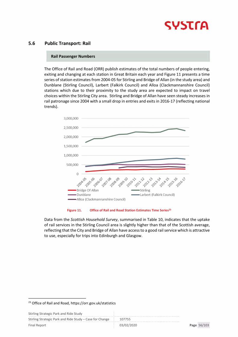
Stirling Strategic Park and Ride Study
Stirling Strategic Park and Ride Study – Case for Change 107755
Final Report 03/02/2020 Page 56/103
5.6 Public Transport: Rail
Rail Passenger Numbers
The Office of Rail and Road (ORR) publish estimates of the total numbers of people entering,exiting and changing at each station in Great Britain each year and Figure 11 presents a timeseries of station estimates from 2004-05 for Stirling and Bridge of Allan (in the study area) andDunblane (Stirling Council), Larbert (Falkirk Council) and Alloa (Clackmannanshire Council)stations which due to their proximity to the study area are expected to impact on travelchoices within the Stirling City area. Stirling and Bridge of Allan have seen steady increases inrail patronage since 2004 with a small drop in entries and exits in 2016-17 (reflecting nationaltrends).
Figure 11. Office of Rail and Road Station Estimates Time Series23
Data from the Scottish Household Survey, summarised in Table 10, indicates that the uptakeof rail services in the Stirling Council area is slightly higher than that of the Scottish average,reflecting that the City and Bridge of Allan have access to a good rail service which is attractiveto use, especially for trips into Edinburgh and Glasgow.
23 Office of Rail and Road, https://orr.gov.uk/statistics

Stirling Strategic Park and Ride Study
Stirling Strategic Park and Ride Study – Case for Change 107755
Final Report 03/02/2020 Page 57/103
Use of Local Train Services in Stirling Council and Scotland from 2014 – 2017 (%)24
2014 2015 2017
Stirling Scotland Stirling Scotland Stirling Scotland
Every day oralmost every day
2.3 2.2 0.2 2.1 2.0 2.6
2-3 times per week 4.7 2.1 4.8 2.5 2.1 2.2
About once a week 5.6 5.0 5.5 4.4 7.3 4.3
About once afortnight or once amonth
23.5 21.2 24.9 20.7 22.4 21.9
Not used in pastmonth
63.9 69.5 64.6 70.2 66.1 69.0
Rail Services
The existing service provision (Dec 2019 timetable) is summarised in Table 11 with thenumber of service and journey time for a range of origin/destinations from/to Stirling stationsin the AM peak. This gives an indication of the overall service and fares. Glasgow QueenStreet has the better service and this reflects the Census Travel to Work data which has thehighest number of workers travelling by rail to Glasgow (44%, 405) compared to Edinburgh(34%, 290 workers). Compared to typical coach and road journey times, rail comparesfavourably with 77 (Edinburgh) and 45 (Glasgow) minute coach journey times and 62(Edinburgh) and 39 (Glasgow) minute road journey times from Stirling station.25
As part of the Revolution in Rail, announced in 2016, 20,000 more seats and 200 new servicesare to be introduced across ScotRail services. In addition, journey times have improved onthe corridor following the electrification of the Stirling, Alloa and Dunblane lines. Many of theservices described above have benefited from increased carriages resulting in less crowdingon routes and improved frequencies and journey times. In 2020 and 2021 further Revolutionin Rail improvements are planned including the following26:
Half hourly service to be introduced between Stirling and Alloa (with most servicescontinuing to / from Glasgow):
Hourly service between Inverness and Perth with services continuing to / fromEdinburgh or Glasgow:
Hourly service between Dundee and Glasgow: and
24 SHS Local Area Analysis, https://www2.gov.scot/Topics/Statistics/Browse/Transport-Travel/TablesPublications/TransportAcrossScotland25 Tactran, Monitoring Framework 2018 Progress Report (Draft), 201826 ScotRail consultation

Stirling Strategic Park and Ride Study
Stirling Strategic Park and Ride Study – Case for Change 107755
Final Report 03/02/2020 Page 58/103
This final phase will enable average journey times on intercity services between the
central belt and Aberdeen and Inverness to reduce by between 5 and 10 minutes.
Dec 2019 Rail Provision (ScotRail)
ROUTE
NUMBER OFSERVICES
BETWEEN 8-9AM
JOURNEY TIMEANYTIME
DAYRETURN
Stirling – Glasgow Queen Street(QS)
4 28-40 min £14.20
Glasgow QS – Stirling 4 27-35 min £14.20
Edinburgh Waverley (W) – Stirling 2 43-45 min £16.10
Stirling – Edinburgh W 3 48-50 min £16.10
Stirling - Perth 2 35-36 min £16.80
Perth - Stirling 2 32-35 min £16.80
Bridge of Allan – Glasgow QS 1 44min £14.20
Bridge of Allan – Edinburgh W 2 53-57 min £16.10
Cornton Level Crossing
The B823 Cornton Road currently crosses the Stirling - Perth railway line at Cornton and givenNetwork Rail’s commitment to meet its safety commitments to the Office of Rail and Road(ORR), it has announced plans to upgrade the crossing to a full-barrier controlled crossing. .The installation of the full barrier crossing is estimated to result in the closure of the B823 forapproximately 50% of an hour with associated impacts on traffic, bus operations and activetravel connections.
5.7 Rail User Surveys – Bridge of Allan and Stirling
Tactran, on behalf of Strathallan Community Rail Partnership (SCRP), and Stirling Councilcommissioned SYSTRA in 2016 (before Revolution in Rail timetable changes) to organise AMpeak period rail passenger travel surveys. The results provide a useful overview of how railstations are used in the area, how people travel to the stations and where they come from.The results for Bridge of Allan and Stirling stations are summarised below.
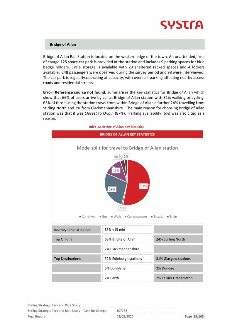
Stirling Strategic Park and Ride Study
Stirling Strategic Park and Ride Study – Case for Change 107755
Final Report 03/02/2020 Page 59/103
Bridge of Allan
Bridge of Allan Rail Station is located on the western edge of the town. An unattended, freeof charge 125 space car park is provided at the station and includes 9 parking spaces for bluebadge holders. Cycle storage is available with 20 sheltered racked spaces and 4 lockersavailable. 248 passengers were observed during the survey period and 98 were interviewed.The car park is regularly operating at capacity, with overspill parking affecting nearby accessroads and residential streets.
Error! Reference source not found. summarises the key statistics for Bridge of Allan whichshow that 66% of users arrive by car at Bridge of Allan station with 31% walking or cycling.63% of those using the station travel from within Bridge of Allan a further 24% travelling fromStirling North and 2% from Clackmannanshire. The main reason for choosing Bridge of Allanstation was that it was Closest to Origin (87%). Parking availability (6%) was also cited as areason.
Bridge of Allan Key Statistics
BRIDGE OF ALLAN KEY STATISTICS
Journey time to station 83% <15 min
Top Origins 63% Bridge of Allan 24% Stirling North
2% Clackmannanshire
Top Destinations 52% Edinburgh stations 31% Glasgow stations
6% Dunblane 2% Dundee
2% Perth 2% Falkirk Grahamston

Stirling Strategic Park and Ride Study
Stirling Strategic Park and Ride Study – Case for Change 107755
Final Report 03/02/2020 Page 60/103
Rail User Surveys – Stirling
Stirling Rail Station is located in the centre of Stirling with a 100 space Season Ticket Holderscar park provided to the north of the station including 3 parking spaces for blue badge holders.To the south is a Pay on Foot 177 space car park that includes 5 parking spaces for blue badgeholders. Cycle storage is provided for 88 cycles. The two car parks are operating at capacity,with the nearby Forthside car park also being used by rail passengers.
Over the survey period, 1,299 passengers were observed boarding train services. Of the 1,299225 were interviewed, giving an effective sample rate of 17%.
Table 13 summarises the key statistics for Stirling which show that 47% of users travel by car(passenger or driver) to Stirling with 58% travelling from within Stirling City. 10% of userssurveyed travelled from Clackmannanshire with 52% of them travelling by car to Stirlingstation, 26% by train and 13% by bus.
Stirling Key Statistics
STIRLING KEY STATISTICS
Journey time to station 70% <15 min
Top Origins 58% within Stirling City 10% Clackmannanshire
5% Tullibody
Top Destinations 32% Edinburgh stations 27% Glasgow stations
7% Dundee 5% Perth
4% Falkirk Grahamston 4% Dunblane

Stirling Strategic Park and Ride Study
Stirling Strategic Park and Ride Study – Case for Change 107755
Final Report 03/02/2020 Page 61/103
5.8 Cycle Hire Scheme at Stirling and Bridge of Allan Stations
NextBike operate a cycle hire scheme at Stirling and Bridge of Allan stations with 60 bikes inlocations across the city and at key destinations such as the University, College and Park andRide sites. The scheme has proved popular with recent research showing it has the secondhighest simultaneous use of bikes in the UK (Behind Glasgow) of 11.5%27.
5.9 Recent Public Transport Studies
Stirling Stations Study – Stirling Area Stations’ Feasibility (2017)
The DPMTAG transport appraisal Stirling Council undertook to inform their LocalDevelopment Plan highlighted requirements to investigate strategic transport interventionsto prevent the congestion within the Stirling City area.
The Stirling Stations Study report reviewed whether there were any ‘physical show stoppers’to potential strategic rail transport interventions of a Stirling South station and ‘relocated’Bridge of Allan station and considered passenger demand forecasts for the options.
If and when appropriate, the data collected in these studies will be used in later stages of thisstudy.
Tay Estuary Rail Study (2003)
A potential rail halt at Bannockburn emerged from the Scottish Executive’s Central ScotlandCorridor Study and subsequent work. The intervention was investigated further through theTay Estuary Rail Study (TERS) which was carried out by the regional transport partnership –Tactran. It was identified that at that time (i.e. pre-EGIP improvements) there was a physicalbarrier of the headway on some services which would be compounded further with additionalstops and services should a rail halt be instated.
The Extended Tay Estuary Study (2009) identified a potential new station located with accessfrom the A91 south of Stirling. Three potential locations were identified in the Engineeringand Operations Report and discussed further. The report identified that there were concernswithin the rail industry regarding performance impacts of a potential station at Bannockburn,both on the current and proposed EGIP timetables and the associated dis-benefits for existingusers. The study catchment model estimated new patronage generated by a station atBannockburn to be 63,000 journeys per annum providing revenue of £241k per annum (at2008 prices). Actual demand at Bannockburn will be higher but this will be abstracted fromStirling – giving congestion and air quality benefits rather than economic and also potentiallyreleasing car parking spaces at Stirling to meet currently suppressed demand, which mayresult in the generation of more rail journeys.
The study suggested that a new station would cost between £5.5m and £8m. Based on these2009 figures, the new rail halt would not generate sufficient new revenue to cover journeytime dis-benefits for existing passengers or the annual station operating cost.
27https://www.bbc.co.uk/news/uk-scotland-39291959 accessed 28/03/19
Stirling Strategic Park and Ride Study
Stirling Strategic Park and Ride Study – Case for Change 107755
Final Report 03/02/2020 Page 62/103
The subsequent Stirling Stations Study suggested that following the signalling improvementsinstigated by the Edinburgh to Glasgow Improvement Programme (EGIP), both the headroomissue had been removed (although performance issues associated with shorter turnaroundsmay exist) and that public transport trips would increase by between 40-66,000 per year28
with the introduction of a new station to the south of Stirling or relocated Bridge of Allanstation.29
South Stirling Park and Ride
Transport Scotland’s Strategic Transport Projects Review in 2008 identified a Strategic Park &Ride site at Bannockburn serving Edinburgh, Glasgow, and Stirling. The site would be servedby either rail services or express bus links to and from the city centres and areas of economicactivity (STPR Project 8). This aligned with proposals in both the Stirling LTS and the TactranRTS.
In 2010, a study investigated the feasibility of a new Park & Ride site to the south of Stirling.The study followed the principles of STAG. The study found that two potential sites couldfulfil the objectives of a Park and Ride to the South of Stirling. The locations were:
West of the A872 Glasgow Road between the Pirnhall Road crossroads and the MiltonRoundabout; and
East of the A872 Glasgow Road just east of Hillhead.
The latter site was identified as the preferred location based on land use objectives.
The study concluded that a P&R facility located off the A872 Glasgow Road was likely toattract its patronage from local trips into and out of Stirling and also from those wanting touse strategic bus services to other major cities such as Edinburgh and Glasgow with predicteddaily trips of 376 by 2022.
Key Points:
Frequent rail services to/from Glasgow/Edinburgh and Stirling/Bridge of Allan.
Services are well used with steady growth and a good proportions of commutertrips to these destinations using rail
Rail journey times between Glasgow/Edinburgh and Stirling City are competitivewith car
EGIP and Revolution in Rail have increased frequency and capacity of rail servicesin the study area
Two thirds of passengers access Bridge of Allan and Stirling stations by car, addingtraffic to the surrounding road network
Ten per cent of passengers using Stirling station travel from Clackmannanshire
28 Rail patronage varies depending on the combination of stations tested and locations.29 Note: the rail halt was not included in the Edinburgh to Glasgow Improvement Programme (EGIP) as it did notconform to the core objectives of the project.

Stirling Strategic Park and Ride Study
Stirling Strategic Park and Ride Study – Case for Change 107755
Final Report 03/02/2020 Page 63/103
5.10 Road Network
Existing Situation
As part of the DPMTAG transport appraisal, a detailed review of the existing road situationwas undertaken. This process identified a number of key pinch points on the network wherequeueing currently occurs during both peak periods, including:
Craigs Roundabout: Queues can form on all arms but most notably on the Kerse Road(500m), Goosecroft Road (450m) and Wellgreen Road (330m) approaches.
Customs (or Clock) Roundabout: During the morning and evening peak period, longqueues can form on the principal links, with traffic sometimes blocking back to theSainsbury’s junction to the west (350m) or to Dumyat Road to the north (860m).
Borestone Roundabout: Queues can manifest on most of the approaches during thepeak periods; 500m on Burghmuir Road North, 370m on A9 Bannockburn Road and840m on Borestone Crescent/Randolph Terrace.
The A91 experiences significant congestion during the peak periods, particularly theevening peak period with rolling queues often developing between most of the keyconnections; 2.27km southbound towards Pirnhall, 500m southbound approachingMillhall Roundabout, and 600-800m on all approaches to Manor Powis Roundabout.
M9 Junction 9 Pirnhall: Regularly experiences queues on the southbound approach outof Stirling and on the westbound off-ramp from the motorway.
M9 Junction 11 Keir Roundabout: The junction experiences long queues during the peakperiods, most notably southbound during the PM peak from the A9 where the queuecan typically reach 1.5-2.0km.
Future Situation
Figure 4 (Chapter 4) illustrated the key sites identified in Stirling Council’s LDP. These siteswill become major trip generators and attractors, and include South Stirling Gateway andDurieshill developments in close proximity to the congested Pirnhall junction, Prudentiallocated next to Craigforth and Cowie, Fallin and Plean developments to the south east of thecity. Each of these existing and planned attractors and generators is located on the outskirtsof the city and will result in additional vehicular movements putting increasing pressure onthe pinch points whether traffic is travelling into or out of Stirling City.
Figure 12 illustrates a potential Do-Nothing situation i.e. assigning the 2027 vehiculardemands to an unchanged (2017) road network. It includes the potential impact of thegenerated traffic associated with the Local Development Plan, and suggests significantpressure will be placed on key routes across the city.
In Paramics, the yellow circles are termed ‘hotspots’ and reflected where traffic is essentiallyrunning at or near a queued state. With all of the development traffic loaded onto the roadnetwork, most of the internal routes in and around Stirling are predicted to be fully queuedfor large parts of the day. “Hotspots” are identified on key approaches to the city includingthe A91 North of Skeoch Road Roundabout, Pirnhall Road, A9 Falkirk Road and the A84approach to the city.

Stirling Strategic Park and Ride Study
Stirling Strategic Park and Ride Study – Case for Change 107755
Final Report 03/02/2020 Page 64/103
The traffic modelling also indicated that 38-44% of all car trips in the model area have theirorigins or destinations outside the Stirling City area which reflects both the high proportionof people travelling into or out of Stirling City area to work (Stirling is a net importer of jobs)and also that the car is the dominant mode and this is likely to continue without intervention.
Figure 12. 2027 Do-Nothing30
30 Stirling Council, Stirling Local Development Plan DPMTAG Study, 2016

Stirling Strategic Park and Ride Study
Stirling Strategic Park and Ride Study – Case for Change 107755
Final Report 03/02/2020 Page 65/103
5.11 Journey Times Comparison
To further evidence the predicted impact on potential delays in Stirling, Table 14 summarisesthe predicted differences in average journey times for a number of key route sections in thestudy area (Appendix F presents details of all journey times). The figures compare 2017 andforecast future years of 2027 and 2037 with the Local Development Plan allocations in placeand interventions identified in the DPMTAG Study referred to as Delivery Packages 1-3.Interventions include the following:
DP1: Encourage sustainable travel choices (e.g. integrating the bus and rail station andimprove city cycle network)
DP2: Improve network efficiency (e.g. Upgrade improvements at junctions includingMuirton, Millhall and Manor Powis roundabouts)
DP3: Local network interventions (e.g. Completion of outer Ring Road with the Kildeanto Airthrey Road link across the River Forth and phased dualling of A91)
Table 14 and Figure 13 show route sections with significant journey time increases between2017 and 2037 (with DP1-3 interventions). The identified sections are on routes which act asgateways to the city and are located close to planned trip attractors and generators. Thishighlights the impact planned development is likely to have on vehicle traffic in the study areain future years even following mitigation in the form of DP1-3. Many of these routes alsoserve as access points to the current transport interchanges of Stirling Bus and Rail stationand Castleview P&R highlighting that more sustainable transport options will also beimpacted by the growing traffic issues in the study area.
No significant journey time increases were highlighted to the north of the study area which isdirectly related to the completion of outer Ring Road with the Kildean to Airthrey Road linkacross the River Forth relieving pressures to the north.
PM Peak Hour Journey Times (2017, 2027 and 2037)
JOURNEY TIME COMPARISON PM PEAKHOUR
2017* 2027* 2037*
A - A9 NB from Plean 05:29 10:24 25:36
B - B9124 WB 03:48 10:07 19:50
C - Glasgow Rd SB 03:49 06:04 16:28
D - A872 NB 02:48 10:32 14:35
E - Snowden Pl / Queens Rd SB 02:16 02:21 02:32
F - Snowden Pl / Queens Rd NB 01:59 01:59 02:05
G - Millennium Way WB 02:46 06:04 16:48
H - A84 EB 01:55 04:33 15:38
I - A91(Manor Powis - Muirton) NB 02:01 11:32 18:15

Stirling Strategic Park and Ride Study
Stirling Strategic Park and Ride Study – Case for Change 107755
Final Report 03/02/2020 Page 66/103
JOURNEY TIME COMPARISON PM PEAKHOUR
2017* 2027* 2037*
J - A91 (Pirnhall - Greencornhills) SB 01:10 03:08 10:37
* mm:ss
Figure 13. PM Peak Hour Change in Journey Times (2017 to 2037)
Stirling Strategic Park and Ride Study
Stirling Strategic Park and Ride Study – Case for Change 107755
Final Report 03/02/2020 Page 67/103
Key Point: Due to the limited number of routes through the Stirling City Area, thereare a number of pinch points within, and at the gateways to, the Stirling City Areathrough which all traffic passes as identified in the “hotspots” above.
Traffic modelling indicates that development proposed within the LDP willsignificantly increase the journey times and queuing at these locations withconsequential adverse impacts likely. Journey time comparisons show that routes onapproach to the city and transport interchanges are forecast to have increasedjourney times even following the introduction of mitigation measures identified inthe DPMTAG.
5.12 Parking
There are a total of 37 public car parks within the Stirling Council area. These car parks arefree or operate as Pay & Display. Appendix D summarise the availability of parking in the citycentre operated by Stirling Council and other operators.
In total, there are around 3,400 public parking spaces in the city centre. There are many morepublic on and off-street parking spaces available across the city area, as well as substantialprivate parking at Prudential, Castle Business Park, University of Stirling, Burghmuir andStirling retail parks. In addition to 276 parking spaces available at Stirling railway station,there are 102 parking spaces at Dunblane railway station and Bridge of Allan railway stationcurrently has 154 spaces.
Given parking in the Stirling City Area is readily available and relatively low cost compared toalternative modes of transport, this situation makes it increasingly challenging to encouragea switch to the existing Park and Ride sites for trips into the City and sustainable travel options.For example, parking for a family of four at the Forthside Car Park is £1.40 compared to £3.60from the Park and Ride (2 adults and 2 children).
Stirling Council have adopted a new car parking policy and community parking managementplan to help redress this issue and bring forward a parking regime which both supports citycentre retail while also promoting more sustainable modes for commuter travel.
Key Points: A charging regime is being introduced to ensure that Council operatedpublic car parking charges complement the existing park and ride services.Nonetheless, there remains significant public car parking in the City Centre andprivate non-residential parking around the City.
5.13 Park & Ride
There are currently two Park & Ride (P&R) sites serving trips into Stirling City. The Castleviewsite is at the west of Stirling City, just off Junction 10 of the M9 motorway and the Springkersesite is at the east of Stirling City, just off the A91 at Springkerse Retail Park. Both sites offerregular services to Stirling City Centre however there are no longer distance options (e.g. toGlasgow or Edinburgh).

Stirling Strategic Park and Ride Study
Stirling Strategic Park and Ride Study – Case for Change 107755
Final Report 03/02/2020 Page 68/103
The Stirling Council Annual Monitoring Statement provides a good source of key facts aroundthe Springkerse and Castleview P&R services:
The Springkerse P&R facility provides parking for around 215 cars while Castleview offerparking for up to 200 cars.
Springkerse P&R opened in September 2006 followed by Castleview P&R opening inSeptember 2008. Usage peaked in 2010 and 2011 with 355,877 passenger journeys atCastleview in 2010 and 141,422 in 2011 at Springkerse Figure 14.
Usage has declined in recent years with a 17% reduction for Castleview since 2010 and63% reduction since 2011 for Springkerse.
Figure 14. Park and Ride Use 31
As discussed previously, the parking availability in Stirling City impacts on the attractivenessof park and ride. The DPMTAG study compared the cost of using P&R with the cost of parkingin Stirling railway station, Wellgreen, Goosecroft Road, Forthside, or Linden Avenue car parkand found that the costs are comparable and therefore there is no incentive to encourage theuse of the P&R facility. In addition, the modelling forecasts for Stirling show that congestionon the outskirts of the city is expected to grow which would impact on the attractiveness ofSpringkerse as a park and ride.
This situation makes it increasingly challenging to encourage a switch to Park and Ride andsustainable travel options with traffic contributing to entering and leaving the area. In 2010a Parking Strategy was introduced in Stirling to simplify parking charges which resulted in asignificant reduction in charges for some parking areas, for example, Lindon Avenue andForthside car parks were reduced from £2.60 to £1 in 2010. These parking changes coincidedwith a drop in patronage at both park and ride sites.
31 Stirling Council data

Stirling Strategic Park and Ride Study
Stirling Strategic Park and Ride Study – Case for Change 107755
Final Report 03/02/2020 Page 69/103
Stirling Council subsequently adopted a new Parking Strategy in 2019 that aims to supportpark and ride, therefore, this study will focus on complementary measures to induce a modalshift into and out of the Stirling City Area whilst reinforcing the need to maintain acomplementary parking strategy.
Key Points: Two local Park & Ride sites currently exist enabling a transfer from car to
bus for trips into the city. Whilst usage has declined in recent years Stirling Councilhas adopted a new parking strategy, and consequential charging regime, to supportpark and ride usage.
5.14 Summary of Transport Network
There are a number of existing transport problems and issues in Stirling and the surroundingsettlements that act as a barrier to movement and as a disincentive to travel by sustainableand active modes:
Rail summary:
Frequent services to/from Glasgow/Edinburgh and Stirling/Bridge of Allan. Services are well used with steady growth and a good proportions of commuter trips
to these destinations using rail Rail journey times between Glasgow/Edinburgh and Stirling City are competitive with
car EGIP and Revolution in Rail have increased frequency and capacity of rail services in
the study area Two thirds of passengers access bridge of Allan and Stirling stations by car, adding
traffic to the surrounding road network Ten per cent of passengers using Stirling station travel from Clackmannanshire.
Road summary:
Due to the limited number of routes (six) through Stirling City Area, there are anumber of pinch points within, and at the gateways to, the Stirling city area throughwhich all traffic passes. Traffic modelling indicates that development proposed withinthe LDP will significantly increase the journey times and queuing at these locationswith consequential adverse impacts likely.
Future year traffic modelling has also indicated that the generated traffic associatedwith the LDP development sites will place added pressure on the local and strategictransport networks, particularly in the south and east of Stirling.
The traffic model suggests 38-44% of all car trips in the model area are external-internal trips which reflects that Stirling is a net importer of jobs and car is thedominant mode.
The projected LDP development, particularly at locations at and around the edge ofthe City, will see the amount of traffic in the city grow by around 24% compoundingthe problems at already busy junctions. In particular:
A91 corridor from Manor Powis to M9 Junction 9 Pirnhall
Craigforth/Keir
Clock Roundabout/Causewayhead Road

Stirling Strategic Park and Ride Study
Stirling Strategic Park and Ride Study – Case for Change 107755
Final Report 03/02/2020 Page 70/103
Craigs roundabout
Main routes into the City Centre restricting access to rail and coachservices the Stirling Rail and Bus Stations.
Bus summary:
Stirling has a reasonable commercial bus network, in particular, between Stirling City,Alloa, Stirling University and Falkirk via Larbert, however in recent years there hasbeen a:
reduction in service provision across some communities as serviceshave been combined. TRACC modelling and SIMD data shows thatalthough there are a reasonable bus services on key corridors thereare many locations within the study area with a below average accessto employment, health and education.
decline in bus use
decline in perception of convenience.
Park and Ride summary:
Two Local park and ride sites currently exist enabling a transfer from car to bus fortrips into the city. Whilst usage has declined in recent years Stirling Council hasadopted a new parking strategy, and consequential charging regime, to support parkand ride usage.

Stirling Strategic Park and Ride Study
Stirling Strategic Park and Ride Study – Case for Change 107755
Final Report 03/02/2020 Page 71/103
6. CONSULTATION
6.1 Workshop Consultation
Participation and consultation are key elements of a STAG study and ensure the interests ofstakeholders are considered in an inclusive, open, transparent and appropriate manner. Inparticular, consultation is useful in the identification and analysis of transport problems andopportunities which forms the starting point of any STAG study.
For this purpose, three workshops were held:
A steering group workshop was held with representatives from Stirling Council,Clackmannanshire Council, Sestrans, Sustrans, Transport Scotland, Tactran and NetworkRail on January 16th 2019
Two stakeholder workshops held on February 20th and 21st 2019 attended by localcommunity councils32, bus and taxi operators, local councillors and the StrathallanCommunity Rail Partnership.
Figure 15. Stakeholders Consulted
The workshops were well attended with a combined attendance of 20-30 persons attendingthe wider stakeholder sessions. Following a brief introduction to the study, participants wereinvited to consider the problems, opportunities, issues and constraints across the study area,before going on to discuss a range of potential interventions to be appraised as part of thestudy. Full details of the sessions are included in Appendices A and B.
32 At the time of the workshop there were no Community Councils covering the Eastern Villages.
CommunityCouncils
Bridge of AllanCommunity Council
CausewayheadCommunity Council
St NiniansCommunity Council
Electedmembers
Local councillors
TransportOperators
Stirling TaxiAssociation
First Bus
TransportOrganisations
Tactran
Sestrans
Sustrans
Network Rail
Transport Scotland
StrathallanCommunity Rail
Partnership
LocalAuthorities
Stirling Council
ClackmannanshireCouncil

Stirling Strategic Park and Ride Study
Stirling Strategic Park and Ride Study – Case for Change 107755
Final Report 03/02/2020 Page 72/103
In addition, some of those organisations unable to attend the stakeholder workshopsincluding Forth Valley College, Stirling University and Forth Valley College were contacted byemail, phone, or face to face to gather views.
A number of themes emerged from the three events including the following:
Convenience of public transport including cost and availability:
A number of stakeholders highlighted that access to public transport services rangedacross the study area. This included:
the location of stations in relation to resident populations resulting indriving to stations and
accessibility of buses and rail stations (Bridge of Allan in particular).Bus timetabling was raised by a problem for both operators and users,in particular services outwith the peak and timetable changesimpacting on connections to bus services.
These comments are supported by survey data (Section 5.7) showingthat stations have a high drive in catchment.
Ticketing and fare costs were raised by a number of stakeholders highlighting thatticketing structures are complex and multi-modal ticketing systems would makepublic transport more attractive (Table 11).
Reliability issues were also highlighted, in particular increased congestion impactingon journey times and the attractiveness of the Park and Ride sites (5.10).
Mixed views on parking in the study area:
There were mixed views on parking in the study area with problem parking in vicinityof Bridge of Allan station and Stirling University but an acknowledgement that thelack of parking enforcement in the city can attract drivers in (5.12).
Perception of congestion on a number of routes impacting on travel through the city:
A number of stakeholders raised issues of congestion on a number of approachesincluding Craigforth, Clock Roundabout and the A91. As above, this impacts on theattractiveness of bus travel (5.10).
For a full list of the outcomes from the stakeholder events, refer to Appendices A and B.
6.2 Stirling Council Local Transport Strategy Consultation
In addition to the workshops, the study has been informed by Stirling Council’s ownconsultation exercise undertaken as part of the Local Transport Strategy.
The Stirling Council Local Transport Strategy (LTS) was updated in 2016 and included anextensive consultation exercise which has informed this Case for Change process. Theapproach included engaging with key stakeholder organisations, and residents via a series ofmeetings, public consultation events including an online survey which received over 500responses. This consultation exercise has been used to inform the baseline reporting,problems, opportunities, issues and constraints section of this study and supported by further

Stirling Strategic Park and Ride Study
Stirling Strategic Park and Ride Study – Case for Change 107755
Final Report 03/02/2020 Page 73/103
consultation undertaken with key stakeholders including community councils and transportoperators.
A number of key issues emerged from the consultation exercise and give an insight into howtravel is portrayed by residents in the study area.
On the topic of increased travel times, the majority of 290 respondents (75%) would beprepared to accept no more than a 10 minute increase in bus or car journey time because ofan increase in traffic congestion.
When asked what they would be prepared to do to minimise congestion in the long term 56%of 304 respondents stated they would use public transport more often, 48% said they wouldcycle more often, 38% said they would walk more often and 20% said they would be travelless often, if their journeys permitted.
Of those who travel by car, 49% do have the option of using a different mode of travel, forexample: walk; cycle; car share; use bus or rail and could make this travel choice five days aweek (42% down to one day a week (12%).
47% of responded stated that “nothing” would encourage them to use park and ride withreasons including time constraints, lack of trust in buses, inconvenient and, in some cases, therespondent already used park and ride. Of those who would consider park and ride a morereliable bus service, parking in city centre being limited/ expensive and a Nextbike station atthe park and ride were cited as changes which would encourage them to try P&R.

Stirling Strategic Park and Ride Study
Stirling Strategic Park and Ride Study – Case for Change 107755
Final Report 03/02/2020 Page 74/103

Stirling Strategic Park and Ride Study
Stirling Strategic Park and Ride Study – Case for Change 107755
Final Report 03/02/2020 Page 75/103
7. PROBLEMS, OPPORTUNITIES, ISSUES AND CONSTRAINTS
7.1 Overview
The identification of actual and perceived problems and opportunities form the starting pointand ultimately the rationale for a STAG study. It is important for problems and opportunitiesto be considered in the wider context, and issues and constraints are therefore also taken intoconsideration.
Problems, Opportunities, Issues and Constraints, as defined by the STAG guidance, are:
Problems: existing and future problems with the transport system which result in ashortfall in meeting objectives, e.g. lengthy journey times, poor transport access toservices;
Opportunities: possibilities to improve the transport system and the way it is used, e.g.improve journey times;
Issues: factors that influence how people use the transport networks and therefore maybe underlying issues that influence the problems and opportunities
Constraints: the bounds within which the study is being undertaken, e.g. availablefunding, policy or environmental designations.
Previous work should always form part of the proportionate approach to STAG appraisal,avoiding unnecessary and costly duplication of effort. The DPMTAG study, completed in 2016,included a thorough review of baseline data and identification of problems, opportunities,issues and constraints. These have been used as the starting point and amended, added toor updated, where appropriate.
The identification of problems, opportunities, issues and constraints has been informed bythe outcomes from the Socio-Economic Context and Transport Network chapters.
7.2 Problems
Transport network constrains Local Development Plan and City Region Dealaspirations
As described in Section 1.2, Stirling Council undertook a transport appraisal to inform itsemerging Local Development Plan and Local Transport Strategy. This appraisal consideredthe transport impacts of the development proposals proposed for the LDP. Modelling wasundertaken and identified that the impacts of travel generated by the development and trafficgrowth within the area would lead to significant increases in traffic and associated journeytime increases.
Across a range of journey time routes within the study area there are forecast to be significantincreases in journey times by 2027 and 2037, so much so that the model was unable to runduring some time periods without interventions in place.
The modelling outcome was that the impacts of the travel demands generated by 74% of theproposed housing (to 2027, as defined in the LDP) could be accommodated by measures thatthe Council could implement. These packages of measures included everything the Council

Stirling Strategic Park and Ride Study
Stirling Strategic Park and Ride Study – Case for Change 107755
Final Report 03/02/2020 Page 76/103
could reasonably implement in relation to: modal shift, local road capacity improvements,new local roads.
The study concluded that to enable full build out of the LDP to 2037 (or 100% of proposedhousing), and limit the constraints on development, additional modal shift and road capacityimprovements would be required over and above local modal shift and local road capacityimprovements e.g. improvements to existing motorway junctions and additional motorwayjunction and strategic park and ride sites on the rail corridor to the north and south of thecity. Without these further interventions, the development plans for the study area wouldbe constrained by the transport network.
The success and competitiveness of the City Region Deal proposals within Stirling City arelikely to be undermined by congestion affects (e.g. queuing and increased journey time)around the edge of the city by decreasing their accessibility to those outwith the city.
This evidence aligns with the Draft National Transport Strategy which acknowledges that:
Our cities are growing. A limited supply of affordable city centre housing has led to moresuburban areas with greater numbers of housing developments impacting on travel needsand patterns, particularly to city centres…More vehicles also means more congestion, andbusinesses located in or supplying firms in city centres are seeing increasing journey times,thus impacting on costs and overall business performance. Due to these congestioneffects, there is a growing recognition of the need to tackle the volume of vehicles throughmeasures to effectively manage demand and encourage more sustainable travel options.
Key Point: Transport network constrains Local Development Plan and City RegionDeal aspirations. DPMTAG modelling shows that traffic problems arising from growthcan only be eased by both increased road capacity and maximising modal shift fromcar.
Use of existing bus based Park and Ride declining, exacerbating traffic issues
There are currently two bus based local Park & Ride sites in Stirling as described in section6.14.
The current decline in use at the bus P&R facilities is not impacting significantly on travel inthe area, however, as highlighted above, traffic growth is anticipated to constraindevelopment, and this growth in traffic alongside a declining use of bus P&R will exacerbatethe situation in the coming years. It is therefore important to understand what is contributingto the decline in use.
A number of factors are considered to have impacted on the decline in use including:
The termination of the Castleview tourist bus service to Stirling Council; and Availability and low cost of parking in Stirling City affecting the attractiveness of Park and
Ride.
It is hoped however that this issue will be addressed by introducing Stirling’s Parking Policy &Community Parking Management Plans.

Stirling Strategic Park and Ride Study
Stirling Strategic Park and Ride Study – Case for Change 107755
Final Report 03/02/2020 Page 77/103
In addition, future year traffic modelling forecasts for Stirling suggest that:
Delays on the outskirts of the city are expected to increase around the Springkerse P&R.This would impact on the attractiveness of Springkerse as a Park and Ride option, withthe P&R site lying within the congested area.
Delays on the main corridors into the city centre will decrease the attractiveness of busbased park and ride. Due to the nature of the corridors, there are limited opportunitiesto introduce bus priority measures along the route and at junctions along the route.
Key Point: Use of existing bus based Park and Ride declining, which if not addressedcould exacerbate traffic issues in the future.
Access to jobs, services and opportunities:
Sections 4.4 (Deprivation), 4.5 (Car availability) and 5.3 (Access to employment) identify that14 of the study area’s 69 SIMD zones are within the 20% most deprived in Scotland using theoverall index of deprivation and a number of areas, including Cowie are considered to havelow Access to Services (20-40% most deprived). This reflects the bus service provision andinterchange opportunities for these communities.
Accessibility modelling (see section 5.3) shows that, with regards to access to majoremployment sites with 30 minutes travel time by public transport, Cowie, Bannockburn,Cultenhove, Causewayhead and parts of Plean can access three employment centres within30 minutes compared to the 5-9 centres the majority of the study area can access. Theseareas contain most of the 14 datazones within the study area that are within the lowest 20%of datazones as defined by SIMD.
The accessibility issues highlighted above have been exacerbated further by recent changesto the bus network (see section 5.4). A comparison between the bus network in 2015 and2018 shows that there have been a large number of services withdrawn from the network orrevised resulting in them no longer serving particular communities including the following:
Services through Throsk have changed significantly with the removal of the Falkirk toCallander and Throsk to Stirling services replaced with the F16. This represents areduction in coverage and frequency for Throsk residents.
Service 60, Stenhousemuir to Clackmannan, no longer operates. Service 38 Stirling to Falkirk no longer serves Cowie. The frequency of the F16 has recently reduced and Service 59 now terminates at Stirling
and does not cover Falkirk via Fallin.
Services operate from the various communities to Stirling City but the reduction in serviceshighlights the lack of connectivity experienced by some communities, including the EasternVillages, to opportunities beyond Stirling. Consultees reported an increased number ofstudents driving from Clackmannanshire to education destinations in Stirling due toreductions in bus services with Forth Valley College identifying the connectivity of bus/railservices beyond Stirling as reducing the attractiveness of attending the college. Cost andconvenience of interchange between modes was also identified.

Stirling Strategic Park and Ride Study
Stirling Strategic Park and Ride Study – Case for Change 107755
Final Report 03/02/2020 Page 78/103
As part of the consultation phase, attendees of the workshops, including bus operators,identified issues which impact on bus services including the low level of remuneration forconcessionary passes and the impact that rail timetable changes can have on bus operations.The electrification of the Stirling-Dunblane-Alloa line has resulted in rail timetable changesand subsequently requires bus services to be retimed to meet rail services. This hasimplications as timetable changes require a notice period of eight weeks and changing routesto meet rail services can have a knock-on impact on the rest of the route.
The problem is further exacerbated for those in the Eastern Villages whose ability to accessopportunities (e.g. employment, education and training plus strategic interchange) is limitedby the barriers to active travel such as the distance to Stirling City and the crossing of the A91.
Key Points:
Areas of deprivation in the communities of Plean, Cowie, Fallin, Cornton andBannockburn are remote from interchange opportunities and have a lower level ofaccess to services compared to the local and national average.
This is exacerbated by a limited and declining bus service preventing effectiveinterchange opportunities for trips to wider employment opportunities.
Access to Rail Stations
Tactran, on behalf of Strathallan Community Rail Partnership (SCRP), commissioned SYSTRAin 2016 to organise AM peak period rail passenger travel surveys in the SCRP area. The resultsprovide a useful overview of how rail stations are used in the area, how people travel to thestations and where they come from. The key statistics show that the drive-in proportion forboth Bridge of Allan and Stirling stations is high with 66% of users arriving by car at Bridge ofAllan and 47% at Stirling stations. This is contributing to parking capacity problems at Bridgeof Allan in particular, with consultees reporting overflow parking problems in the surroundingarea.
To Bridge of Allan station, 63% of all passengers are travelling from within Bridge of Allan anda further 24% travelling from Stirling North. At Stirling station 58% travel from within Stirling.City with a further 10% travelling from Clackmannanshire. Of those travelling fromClackmannanshire, 52% of them travel by car to Stirling station, 26% by train and 13% by bus.
This data shows that a high proportion of short trips to Bridge of Allan are completed by carand Stirling station attracts car trips into the city centre, including car trips fromClackmannanshire (bringing traffic into the city centre via either the congested Clock or CraigsRoundabouts). In the AM peak, car park occupancy was at 88% at Stirling and 94% at Bridgeof Allan33 however feedback from consultation suggests that the Bridge of Allan car park isregularly overcapacity with commuter parking on residential streets.
Although the problems at Bridge of Allan (parking issues) and Stirling (increased traffic inStirling city centre) manifest themselves in different ways at each location, the root cause ofthe problem is the same – accessibility of the station and mode choice.
33 Rail User Surveys - 2016

Stirling Strategic Park and Ride Study
Stirling Strategic Park and Ride Study – Case for Change 107755
Final Report 03/02/2020 Page 79/103
The dominance of the car in accessing rail opportunities is likely to be a consequence of manyfactors including:
evening bus service availability; coordination of timetables and; and the ability to provide bus priority on corridors linking to Stirling station.
The ability to use active travel to access the rail interchange opportunities is also limited fromPlean, Cowie and Fallin due to both the distance from these locations as well as the physicalbarrier of the motorway.
Key Point: Current access to rail stations and car park capacities are contributing toroad traffic on approaches to Stirling station and parking issues at Bridge of Allanstation. The root cause of the problem is accessibility of the station and mode choice.The extent of bus interchange at stations (especially off-peak), severance issues foractive travel from eastern villages, and station parking put constraints on the abilityto get more people onto the rail network in the study area.
7.3 Opportunities
Trip attractors and planned developments are located on the edge of Stirling Cityproviding the opportunity to shift strategic trips to sustainable modes.
Many of Stirling’s key trip attractors and generators, (see section 4.1), and development sites,are located close to major road junctions and the rail network or are located outside of thecity. These include Prudential and Forth Valley College located at M9 Junction 10 Craigforthand South Stirling Gateway and Durieshill and are expected to have a significant impact ontravel demands on the southern flank of the city.
The location of these existing and planned trip attractors and generators on the outskirts ofthe city could provide an opportunity to capture car trips travelling on the strategic roadnetwork on bus and coach and rail network.
In addition to serving these planned developments there are a number of communities withbelow average access to services, but which have also been identified as residential growthareas. These communities are also located on or near strategic routes (e.g. Plean, Cowie,Fallin) and could benefit from these improved strategic connections.
Modelling undertaken to assess the impact of the planned developments showed that 44%(AM) to 38% (PM) of car trips had either their origin or destination outside the Stirling Cityarea and are therefore strategic in nature. These trips could be captured via park andride/choose opportunities on the outskirts of the city.
Figure 16 shows the location of these trip attractors and highlights the potential forconnecting to these sites on the outskirts of Stirling or key approach roads into the centre.

Stirling Strategic Park and Ride Study
Stirling Strategic Park and Ride Study – Case for Change 107755
Final Report 03/02/2020 Page 80/103
Figure 16. Stirling Trip Attractors
Stirling’s ability to be used as a strategic park and ride site for major events atGleneagles and across central Scotland
Stirling’s central location in Scotland makes it suitable to act as a strategic Park and Ride oractive travel hub interchange for major events in central Scotland, for example as was thecase for the 2014 Ryder Cup and 2019 Solheim Cup at Gleneagles. This could reducecongestion on the approaches to Glasgow on the M80 and Edinburgh on the M9.
Existing rail and long-distance bus/coach services
There are currently two bus-based P&R sites in Stirling; Castleview and Springkerse. Thesesites are served by local bus services yet long distance bus and coach services regularly passin close proximity to existing Castleview P&R site adjacent to M9 (J10) and potential park andride sites. Examples of existing services which could be altered to serve existing or new parkand ride sites include:

Stirling Strategic Park and Ride Study
Stirling Strategic Park and Ride Study – Case for Change 107755
Final Report 03/02/2020 Page 81/103
Citylink/Megabus M8, M9 and 909 services – Serving Stirling and depending on theservice, coaches travel in along the A872 and onwards directly to the M9 (when headingnorth), to Bridge of Allan or return south to Glasgow or Edinburgh;
Citylink/Megabus M10 service – Glasgow to Inverness along the M9 corridor; First services 38 and X36 from Falkirk and Denny along Falkirk/Bannockburn Road and
Glasgow Road to Stirling; and First Services 51 and 52 from Clackmannanshire to Stirling along Hillfoots Road and Alloa
Road.
These long-distance services could be utilised to increase the number of accessibledestinations both into the Stirling City Area and also as an interchange for strategic trips andto a wider range of local destinations.
With regard to rail, again, many of the existing and proposed trip generators lie to the northand south of the City in close proximity to rail lines with regular services to Edinburgh,Glasgow and Perth (see 5.6.3).
7.4 Issues
Low Access to Car in Some Areas including Plean, Fallin, Cowie, Cornton and Raploch
Access to car across the study area is marginally lower than the Scottish average however thismasks variations across the area. Plean, Fallin, Cowie, Cornton and Raploch are highlightedas having significantly above the Scottish average with up to 45% not having access to a car.Coupled with the public transport provisions discussed above this limits the access to jobs,services and opportunities for these communities.
Commuter Movements Impacting on the road network
The Scottish Census 2011 provides details of origins and destinations of workers. Sixty-threeper cent of those working in the Study Area travel in from outwith the area and 40 of residentsin the study area commute out of the area. The data shows that the Stirling City Area is a netimporter of employees putting a strain on the transport network.
12,108 (37%) of workers come from within the Stirling City Area (excluding working fromhome) and the majority of the remaining workforce travel from Falkirk (18%) andClackmannanshire (16%). Car or van driver or passenger is the most common mode oftransport for all origins including 60% of all Stirling City Area residents travelling to work inthe study area. 49% of Stirling City Area residents work in the study area with Glasgow, Falkirkand Edinburgh also attracting employees34. These destinations show that the majority of themovements are to and from the south. With car being the dominant mode of travel, this putspressure on the M9, M80 and associated junctions.
In addition, Clackmannanshire residents travel through Stirling Council on road and rail linksto access jobs in Glasgow (2% of Clackmannanshire residents), North Lanarkshire (1%), and
34 11% work from home.

Stirling Strategic Park and Ride Study
Stirling Strategic Park and Ride Study – Case for Change 107755
Final Report 03/02/2020 Page 82/103
Falkirk (7%). Proposed housing growth in Clackmannanshire and Stirling Council will continueto put increasing demand of travel into and through the study area.
Impact on Existing Passengers
The introduction of a new service or stop, be it rail, bus or coach, may have an impact onexisting users. The impact on existing users can arise in two ways:
The introduction of a new stop may result in a service reduction at another communityon the bus route or rail line to balance the additional journey time. In the case of busroutes, consultation would not be required to make this change.
An additional stop will also result in additional journey time for existing passengers. Forrail, this is anticipated to be between two and three minutes.
7.5 Constraints
Timing
Interventions need to be introduced by 74% of LDP build out (LDP predicts this to be2027) to help maintain accessibility of Stirling City area as transport modelling indicatessignificantly increased delays at this point.
Physical Constraints
Historical battlefield areas throughout Stirling Council. The River Forth travelling through Stirling and the surrounding areas.
Timetable / signalling will constrain ability to introduce new stops
A previous study35 reviewed the impacts of a new rail station on timetabling. The analysiswas based on the assumption that the Stirling ‘local’ services (which are Dunblane –Edinburgh and Alloa/Stirling – Glasgow Queen St) could call at a station on the line. Thisanalysis was undertaken prior to the release of the December 2018 timetable.
The analysis assumed an additional two minutes extra time added to the Larbert to Stirling(and reverse) running times to allow for the call at a new station. As a result of the change,the turnaround time at Alloa or Dunblane would need to be reduced. Subject to the turnaround windows at Alloa and/or Dunblane resulting from the Revolution in Rail timetablechanges this may reduce the turnaround window, below the five minutes recommendedminimum allowed in the Network Rail Planning Rules. It could also limit the possibility ofextending further services to Alloa.
35 Stirling Stations Study – Stirling Area Stations’ Feasibility (2017)

Stirling Strategic Park and Ride Study
Stirling Strategic Park and Ride Study – Case for Change 107755
Final Report 03/02/2020 Page 83/103
Implications of Full Barrier Crossing at Cornton.
The B823 Cornton Road currently crosses the railway line at Cornton and given Network Rail’scommitment to meet its safety commitments to the Office of Rail and Road (ORR), it hasannounced plans for the installation of an upgraded crossing to full-barrier control. Thelocation of the crossing is likely to affect options associated with rail stations on that sectionof the line (see para 6.6.5).
7.6 Summary
A baseline review of transport data and national, regional and local planning policy has led tothe identification of a number of problems, opportunities, issues and constraints.
These show a growing and attractive city which draws employees, tourists and shoppers tothe area but with significant increases in journey times and delays forecast as a consequenceof the build out of the Local Development Plan proposals across a City area with limited routechoices. Traffic modelling for Stirling’s LDP has shown that a significant modal shift away fromsingle occupancy car use is required for both trips within and into and out of the City area.
Many of the existing major trip generators are to the western and eastern edges of the studyarea, while most of the development proposals are on the southern and eastern edges of thestudy area. In addition, 38%-44% of current car trips have their origin or destination outwiththe City area.
Areas with below average access to employment and low car ownership have also beenidentified in the Eastern Villages and Cornton. The Eastern Villages have also been identifiedin the LDP as locations for significant housing development.
There is both a need to enable a modal shift for current strategic trips entering and leavingthe Stirling City area, as well as an opportunity to capture the trips originating and ending atexisting and proposed trip generators around the edge of the City area on or near corridorsserved by strategic coach or rail.

Stirling Strategic Park and Ride Study
Stirling Strategic Park and Ride Study – Case for Change 107755
Final Report 03/02/2020 Page 84/103

Stirling Strategic Park and Ride Study
Stirling Strategic Park and Ride Study – Case for Change 107755
Final Report 03/02/2020 Page 85/103
8. TRANSPORT PLANNING OBJECTIVES
8.1 Overview
STAG appraisals are objective-led rather than solution-led. Therefore, Transport PlanningObjectives (TPOs) have been developed to reflect the problems, opportunities andparameters analysed in Chapter 7 and also the established national, regional and local policyframework set out in Chapter 3. The TPOs essentially reflect the outcomes sought and willdirectly inform the appraisal of the performance of different options.
It is acknowledged that TPOs may not be fully SMART at the earlier stages of the appraisalprocess, however, they should be subject to review and refinement as the process developsand more detail comes forward. This is important to ensure study objectives provide aframework against which performance can be assessed as part of monitoring and evaluationactivities following the implementation / construction of measures.
8.2 Study Objectives
The consideration of the inter-related problems and opportunities, stakeholder consultationcarried out as part of this study and review of the wider national, regional and local policysetting has informed the development three study objectives.
Access to employment opportunities and to services, other than within Stirling, are limitedfor communities outside of the city, especially given recent reductions in bus services. Theseproblems, combined with an understanding that there is above average unemployment andbelow average car ownership in some areas, have led to the development of TPO1 - Improvetransport access to healthcare, employment, education and training for residents of Plean,Cowie, Fallin, Bannockburn and Cornton.
Journey time delays through and on approach to the city occurs close to key trip attractorswith these pinch points expected to be exacerbated following the development of proposalscontained within the LDP and the location. The location of these existing and planned majortrip attractors close to the strategic road and rail networks provide an opportunity to addressthese problems and have led to the development of TPO2 - Support LDP and CRD growthaspirations by reducing the modal share of cars entering, leaving or passing through theStirling City Area.
Stirling City and communities in the Stirling City Area are well located on the strategictransport network, yet opportunities to transfer to sustainable modes for strategic trips facea number of existing and potential future constraints.
Currently, vehicular access to rail stations is contributing to traffic on approaches to, andparking issues at both Stirling and Bridge of Allan rail stations. As the level of traffic increasesas a result of the development proposals in the LDP, further pressure will be put on the keyroutes serving the stations and the availability of parking at the stations.
Local, regional and national economic and transport policies all seek to improve theaccessibility between our major settlements by public transport. TPO3 was developed tobuild upon these problems and opportunities with an understanding of the constraintsassociated with changes to rail infrastructure and service provision. TPO3 - Improve the

Stirling Strategic Park and Ride Study
Stirling Strategic Park and Ride Study – Case for Change 107755
Final Report 03/02/2020 Page 86/103
competitiveness of sustainable modes compared to the private car for strategic tripsbetween Stirling City Area and key origins/destinations in the Central Belt
TPO1: Improve transport access to healthcare, employment, education and trainingfor residents of Plean, Cowie, Fallin, Bannockburn and Cornton.
- Measurements: Accessibility mapping comparing baseline and future year publictransport timetables to a range of destinations/services.
TPO2: Support LDP and CRD growth aspirations by reducing the modal share of carsentering, leaving or passing through the Stirling City Area.
- Measurements: Census Travel to Work mode share data, Mode share surveys,ANPR surveys, (INRIX and Bluetooth) journey time and queuing.
TPO3: Improve the competitiveness of sustainable modes compared to the privatecar for strategic trips between Stirling City Area and key origins/destinations in theCentral Belt
- Measurements: Generalised journey time comparison between car (modelledtimes or INRIX journey times) and public transport including interchange andservice interval penalties.
To ensure all problems, opportunities, issues and constraints were considered and addressedas part of the Transport Planning Objectives a mapping process was undertaken to showlinkages and is presented in Figure 17.

Stirling Strategic Park and Ride Study
Stirling Strategic Park and Ride Study – Case for Change 107755
Final Report 03/02/2020 Page 87/103
Figure 17. TPO Mapping to Problems, Issues, Opportunities and Constraints

Stirling Strategic Park and Ride Study
Stirling Strategic Park and Ride Study – Case for Change 107755
Final Report 03/02/2020 Page 88/103

Stirling Strategic Park and Ride Study
Stirling Strategic Park and Ride Study – Case for Change 107755
Final Report 03/02/2020 Page 89/103
9. OPTION GENERATION
9.1 Overview
This chapter describes the option generation process undertaken. The purpose of this stageis to derive a range of options which should be informed by the study’s Transport PlanningObjectives (TPOs), STAG Criteria and alleviate the problems or address the opportunitiesidentified. It is important that the option generation, and the subsequent sifting anddevelopment that follows, is carried out in a logical and transparent manner.
9.2 Option Generation Process
In line with STAG, options were informed by the TPOs and were generated through a numberof methods, including:
consideration of previous studies through the statutory planning process (transport and land use plans) consultation workshops consideration of known problems and opportunities a gap analysis of the existing transport network and committed measures professional judgement flowing from a structured decision making process by the study
team.
Consideration of Previous Studies
While it was important not to approach the study with pre-conceptions, it was also prudentto draw on the findings of previous work that looked into the transport problems and futurerequirements of Stirling.
The Statutory Planning Process
Documents produced through the statutory planning process, such as the Local TransportStrategy (LTS) and the Local Development Plan, include examination of transport problemsand opportunities within the study area. As such, potential transport solutions presented inthese documents were considered in relation to the study’s TPOs and, where appropriate,were used as inspiration for the options generated.
9.3 Option Generation
Through this option generation process 99 individual interventions were generated as part ofthe initial long list of interventions (details of all “long-list” options are in Appendix E). Optionswere generated across all modes of transports and geographically across the study area, andbeyond. To appraise these options comprehensively a process was developed to consolidatethese individual interventions to a manageable number of clean options. This processenabled options and combinations of options to be sifted using the following steps:
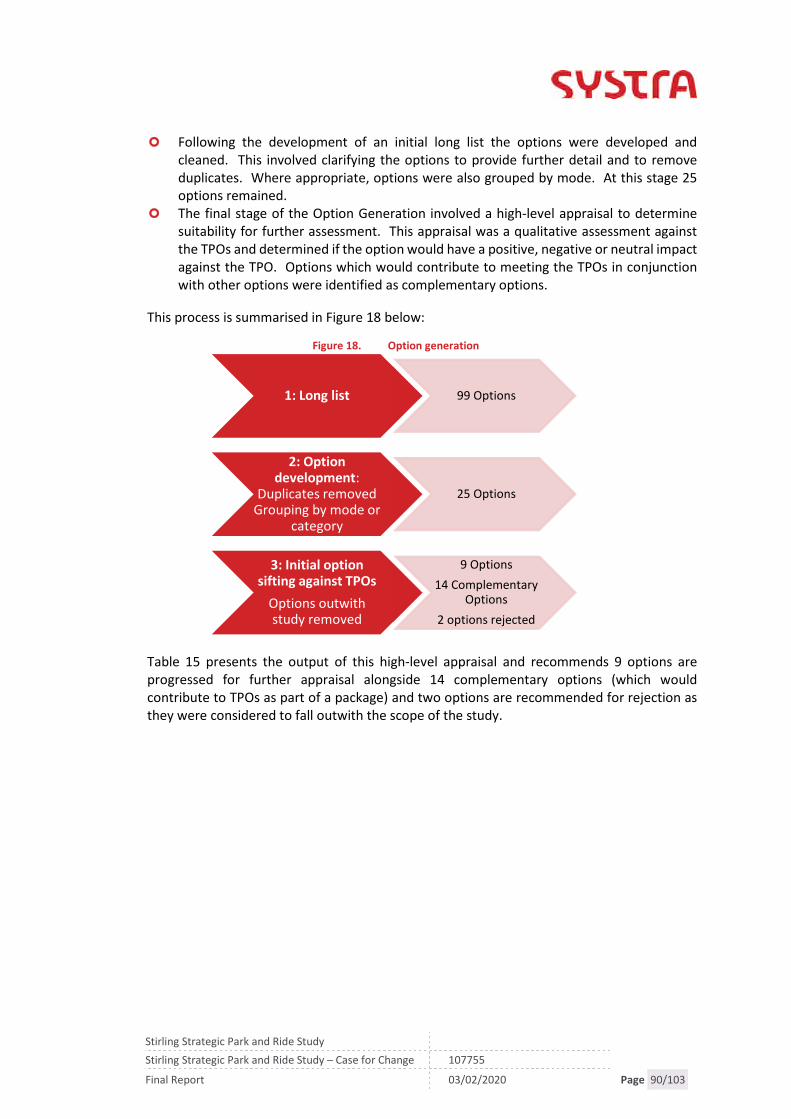
Stirling Strategic Park and Ride Study
Stirling Strategic Park and Ride Study – Case for Change 107755
Final Report 03/02/2020 Page 90/103
Following the development of an initial long list the options were developed andcleaned. This involved clarifying the options to provide further detail and to removeduplicates. Where appropriate, options were also grouped by mode. At this stage 25options remained.
The final stage of the Option Generation involved a high-level appraisal to determinesuitability for further assessment. This appraisal was a qualitative assessment againstthe TPOs and determined if the option would have a positive, negative or neutral impactagainst the TPO. Options which would contribute to meeting the TPOs in conjunctionwith other options were identified as complementary options.
This process is summarised in Figure 18 below:
Figure 18. Option generation
Table 15 presents the output of this high-level appraisal and recommends 9 options areprogressed for further appraisal alongside 14 complementary options (which wouldcontribute to TPOs as part of a package) and two options are recommended for rejection asthey were considered to fall outwith the scope of the study.
1: Long list 99 Options
2: Optiondevelopment:
Duplicates removedGrouping by mode or
category
25 Options
3: Initial optionsifting against TPOs
Options outwithstudy removed
9 Options
14 ComplementaryOptions
2 options rejected
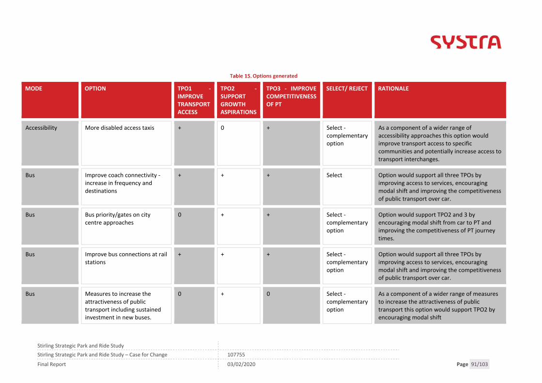
Stirling Strategic Park and Ride Study
Stirling Strategic Park and Ride Study – Case for Change 107755
Final Report 03/02/2020 Page 91/103
Options generated
MODE OPTION TPO1 -IMPROVETRANSPORTACCESS
TPO2 -SUPPORTGROWTHASPIRATIONS
TPO3 - IMPROVECOMPETITIVENESSOF PT
SELECT/ REJECT RATIONALE
Accessibility More disabled access taxis + 0 + Select -complementaryoption
As a component of a wider range ofaccessibility approaches this option wouldimprove transport access to specificcommunities and potentially increase access totransport interchanges.
Bus Improve coach connectivity -increase in frequency anddestinations
+ + + Select Option would support all three TPOs byimproving access to services, encouragingmodal shift and improving the competitivenessof public transport over car.
Bus Bus priority/gates on citycentre approaches
0 + + Select -complementaryoption
Option would support TPO2 and 3 byencouraging modal shift from car to PT andimproving the competitiveness of PT journeytimes.
Bus Improve bus connections at railstations
+ + + Select -complementaryoption
Option would support all three TPOs byimproving access to services, encouragingmodal shift and improving the competitivenessof public transport over car.
Bus Measures to increase theattractiveness of publictransport including sustainedinvestment in new buses.
0 + 0 Select -complementaryoption
As a component of a wider range of measuresto increase the attractiveness of publictransport this option would support TPO2 byencouraging modal shift

Stirling Strategic Park and Ride Study
Stirling Strategic Park and Ride Study – Case for Change 107755
Final Report 03/02/2020 Page 92/103
MODE OPTION TPO1 -IMPROVETRANSPORTACCESS
TPO2 -SUPPORTGROWTHASPIRATIONS
TPO3 - IMPROVECOMPETITIVENESSOF PT
SELECT/ REJECT RATIONALE
Bus/Coach Bus/coach Park and Rideopportunities at the followingsites:- Pirnhall/South Stirling- Relocated Springkerse site
Select Option would support all three TPOs byimproving access to services, encouragingmodal shift and improving the competitivenessof public transport over car.
Cycling Segregated, designatedwalking and cycling routes tokey destinations such as theCity Centre, University andPark and Ride sites.
+ 0 0 Select -complementaryoption
As a component of a wider range ofaccessibility approaches to improve access tointerchanges this option would improvetransport access for specific communities andpotentially increase access to transportinterchanges.
Cycling Widen the NextBike cordonout of the city and promote
+ 0 0 Select -complementaryoption
As a component of a wider range ofaccessibility approaches to improve access tointerchanges this option would improvetransport access for specific communities andpotentially increase access to transportinterchanges.
Initiatives Improve car sharing offering inthe study area by incentivisingcar sharing and encouragingmore car clubs
0 + + Select -complementaryoption
Option would support TPOs 2 and 3 byimproving access to services and encouragingmodal shift by increasing more sustainabletransport options available.

Stirling Strategic Park and Ride Study
Stirling Strategic Park and Ride Study – Case for Change 107755
Final Report 03/02/2020 Page 93/103
MODE OPTION TPO1 -IMPROVETRANSPORTACCESS
TPO2 -SUPPORTGROWTHASPIRATIONS
TPO3 - IMPROVECOMPETITIVENESSOF PT
SELECT/ REJECT RATIONALE
Integration Improve bus and cycleintegration at bus shelters andon buses by allowing bikes onbuses and installing cycleparking at shelters
+ 0 0 Select -complementaryoption
As a component of a wider range ofaccessibility approaches to improve access tointerchanges this option would improvetransport access for specific communities andpotentially increase access to transportinterchanges.
Integration Create a multi-modal ticketingsystem and optimise pricingstructure
0 + + Select -complementaryoption
As a component of a wider range of measuresto increase the attractiveness of publictransport this option would support TPO2 andTPO3 by encouraging modal shift andimproving the competitiveness of publictransport.
Integration Promote activities toencourage more sustainabletravel including travel plans,Low Emission Zones, car-freedays, incentives to leave thecar at home and WorkplaceParking Levy
0 + + Select -complementaryoption
As a component of a wider range of measuresto increase the attractiveness of publictransport this option would support TPO2 byencouraging modal shift.
Land use planning Change in land-use policy e.g.develop industry close tohousing, relocate University tocity centre campus.
0 0 0 Reject Although a change in land use and location oftrip attractors and generators would impact ontravel in the study area it is outwith the scopeof the study.
Stirling Strategic Park and Ride Study
Stirling Strategic Park and Ride Study – Case for Change 107755
Final Report 03/02/2020 Page 94/103
MODE OPTION TPO1 -IMPROVETRANSPORTACCESS
TPO2 -SUPPORTGROWTHASPIRATIONS
TPO3 - IMPROVECOMPETITIVENESSOF PT
SELECT/ REJECT RATIONALE
Other Community transport - targetat interchange opportunities
+ 0 + Select -complementaryoption
As a component of a wider range ofaccessibility approaches this option wouldimprove transport access to specificcommunities and potentially increase access totransport interchanges.
Other Consider changing school timesto mitigate school traffic
Reject Although a change in school times maymitigate transport problems in the study areait is outwith the scope of the study.
Other Light rail from Pirnhall/Durieshill (into Stirling)
+ + + Select Option would support all three TPOs byimproving access to services, encouragingmodal shift and improving the competitivenessof public transport over car.
Park andRide/Choose
Potential for other tripattractors to use Prudentialbus services (from city centreand around Central Scotland,e.g. Forth Valley College)
+ + + Select Option would support all three TPOs byimproving access to services, encouragingmodal shift and improving the competitivenessof public transport over car.
Park andRide/Choose
Improvements to existing P&Rincluding- strategic coach/bus services;- improved frequency;- improved walking and cyclingconnections/facilities
+ + + Select Option would support all three TPOs byimproving access to services, encouragingmodal shift and improving the competitivenessof public transport over car.

Stirling Strategic Park and Ride Study
Stirling Strategic Park and Ride Study – Case for Change 107755
Final Report 03/02/2020 Page 95/103
MODE OPTION TPO1 -IMPROVETRANSPORTACCESS
TPO2 -SUPPORTGROWTHASPIRATIONS
TPO3 - IMPROVECOMPETITIVENESSOF PT
SELECT/ REJECT RATIONALE
(including Nextbike);- tourism bus;- connections to employmentand education destinations;- active travel hub with goodconnections;- shuttle buses connecting P&Rsites- low carbon transport- mix P&R sites with other uses
Parking Manage parking in the citycentre – review the parkingpolicy in the city;charging/fares for park andride; and consider differentroles for bays throughout theday/night
0 + + Select -complementaryoption
As a financial incentive to shift to publictransport the rebalancing of parking charges inthe study area would contribute towards TPO2and 3 by supporting modal shift and makingpublic transport more competitive.
Parking Increased parking at stations:- Stirling;- Dunblane;- Bridge of Allan;- Alloa;- Larbert
+ 0 + Select Increased parking at stations increases the caraccessibility to interchanges and journey timecompetitiveness of park and ride journeys(TPO1 and 3) however increased parking mayresult in an increase in driving trips to stationswhich may have previously been sustainabletrips (neutral TPO2).
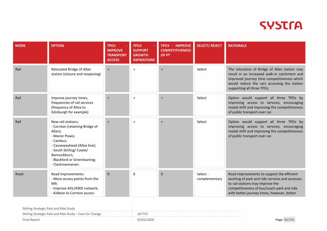
Stirling Strategic Park and Ride Study
Stirling Strategic Park and Ride Study – Case for Change 107755
Final Report 03/02/2020 Page 96/103
MODE OPTION TPO1 -IMPROVETRANSPORTACCESS
TPO2 -SUPPORTGROWTHASPIRATIONS
TPO3 - IMPROVECOMPETITIVENESSOF PT
SELECT/ REJECT RATIONALE
Rail Relocated Bridge of Allanstation (closure and reopening)
+ + + Select The relocation of Bridge of Allan station mayresult in an increased walk-in catchment andimproved journey time competitiveness whichwould reduce the cars accessing the stationsupporting all three TPOs.
Rail Improve journey times,frequencies of rail services(frequency of Alloa toEdinburgh for example)
+ + + Select Option would support all three TPOs byimproving access to services, encouragingmodal shift and improving the competitivenessof public transport over car.
Rail New rail stations:- Cornton (retaining Bridge ofAllan);- Manor Powis;- Cambus;- Causewayhead (Alloa line);- South Stirling/ Cowie/Bannockburn;- Blackford or Greenloaning;- Clackmannanan.
+ + + Select Option would support all three TPOs byimproving access to services, encouragingmodal shift and improving the competitivenessof public transport over car.
Road Road improvements:- More access points from theM9;- Improve A91/A905 network;- Kildean to Cornton access
0 0 0 Select -complementary
Road improvements to support the efficientworking of park and ride services and accessesto rail stations may improve thecompetitiveness of bus/coach park and ridewith better journey times, however, better
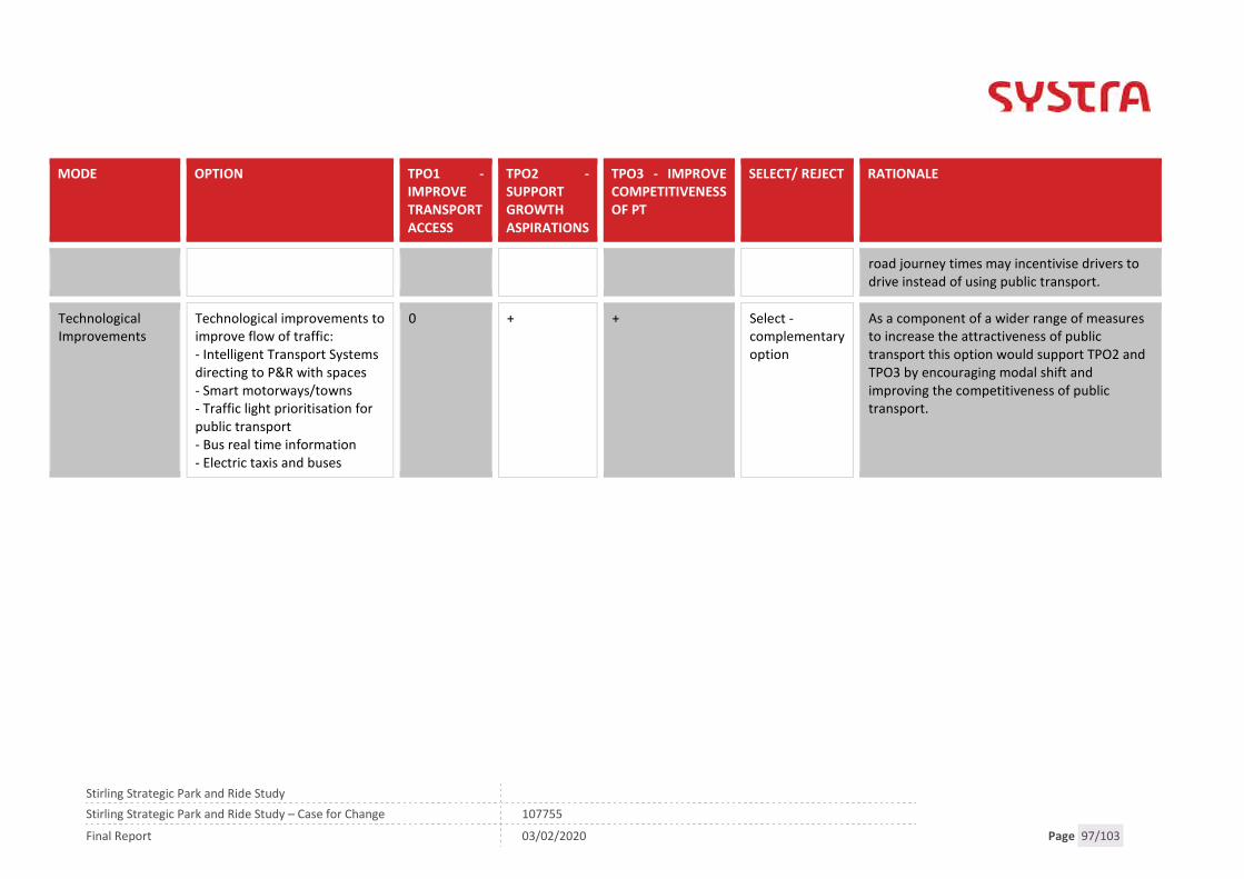
Stirling Strategic Park and Ride Study
Stirling Strategic Park and Ride Study – Case for Change 107755
Final Report 03/02/2020 Page 97/103
MODE OPTION TPO1 -IMPROVETRANSPORTACCESS
TPO2 -SUPPORTGROWTHASPIRATIONS
TPO3 - IMPROVECOMPETITIVENESSOF PT
SELECT/ REJECT RATIONALE
road journey times may incentivise drivers todrive instead of using public transport.
TechnologicalImprovements
Technological improvements toimprove flow of traffic:- Intelligent Transport Systemsdirecting to P&R with spaces- Smart motorways/towns- Traffic light prioritisation forpublic transport- Bus real time information- Electric taxis and buses
0 + + Select -complementaryoption
As a component of a wider range of measuresto increase the attractiveness of publictransport this option would support TPO2 andTPO3 by encouraging modal shift andimproving the competitiveness of publictransport.

Stirling Strategic Park and Ride Study
Stirling Strategic Park and Ride Study – Case for Change 107755
Final Report 03/02/2020 Page 98/103
Stirling Strategic Park and Ride Study
Stirling Strategic Park and Ride Study – Case for Change 107755
Final Report 03/02/2020 Page 99/103
10. REFERENCE CASE AND DO-MINIMUM
Do-Minimum Case
In order to develop the options, and propose improvements to transport into Stirling, it isnecessary to first understand the Do-Minimum case. This Do-Minimum scenario includesrelevant transport and planning developments that may affect the study, and will be thebaseline against which each option is appraised. This represents the outcome scenario if nooptions from this study are taken forward.
There can be a number of different do minimum scenarios and this has been considered aspart of the Do Minimum specification however, at this stage, one Do Minimum has beenproposed and includes:
Local Development Plan allocations as per LDP 2014.
Reference Case
In addition to the Do-Minimum Case a Reference Case has also been included. A ReferenceCase includes other non-controversial but as yet uncommitted transport schemes and/ordevelopment profiles, which can be used as a baseline for option comparison. A ReferenceCase may be included as part of the appraisal, its inclusion will be confirmed in the InitialAppraisal.
To be confirmed.

Stirling Strategic Park and Ride Study
Stirling Strategic Park and Ride Study – Case for Change 107755
Final Report 03/02/2020 Page 100/103

Stirling Strategic Park and Ride Study
Stirling Strategic Park and Ride Study – Case for Change 107755
Final Report 03/02/2020 Page 101/103
11. SUMMARY
SYSTRA was commissioned by regional transport partnership Tactran to collate the evidencebehind a Case for Change in considering how best to increase the modal share of publictransport for those trips entering and leaving the Stirling City Area.
The work builds on the recommendations of Stirling Council’s DPMTAG Transport Appraisalsupporting the Local Development Plan and will help to reduce the volume of vehiclesentering and leaving the Stirling City Area, and increase the potential for the park and rideinterventions.
The LDP builds on these ambitions with planned housing developments and job opportunities.In 2015/16, Stirling Council undertook a transport appraisal in line with DPMTAG to inform itsLDP and LTS. The DPMTAG highlighted that without providing both alternatives to the car, aswell as additional road capacity, for existing and new trips expected via the LDP and City Dealproposals, modelling predicts that Stirling could suffer from traffic delays with acorresponding impact on the economic performance. The DPMTAG process highlighted aneed for change and proposed to investigate these issues further and identify and appraisepotential interventions to reduce car trips into/out of Stirling.
This report has drawn on the outputs of the DPMTAG and further investigated the currenttransport conditions and impacts associated with the LDP highlighting:
Stirling is an importer of workers coming from surrounding councils including Falkirk andClackmannanshire primarily all arriving by car.
This flow of workers into the area puts pressure on the transport network and is furtherexacerbated by workers travelling through Stirling to the Central Belt fromClackmannanshire.
Planned developments are largely on the outskirts of the city where congestion isforecast in 2027 and 2037 on motorway junctions and these developments and locationson the strategic road and rail network have been identified as opportunities to reducecar trips into Stirling and also improve access from the Eastern Villages.
Areas with below average access to employment and services, especially to locationsbeyond Stirling and Falkirk, and with low car ownership, have been identified in theEastern Villages.
Opportunities to address these problems exist within the area. Opportunities include theexisting strategic road and rail network in the area and current long-distance bus and coachservices passing in close proximity.
Constraints were also identified and considered at this stage including the physical constraintsassociated with the road infrastructure and River Forth and constraints associated with railincluding.
These problems, opportunities, issues and constraints demonstrate that there is a case forchange and the following Transport Planning Objectives have been built upon them. As thestudy progresses, they will be SMARTened to ensure they are relevant and effective for boththe appraisal and any subsequent monitoring and evaluation:

Stirling Strategic Park and Ride Study
Stirling Strategic Park and Ride Study – Case for Change 107755
Final Report 03/02/2020 Page 102/103
TPO1: Improve transport access to healthcare, employment, education and training forresidents of Plean, Cowie, Fallin, Bannockburn and Cornton.
TPO2: Support LDP and CRD growth aspirations by reducing the modal share of carsentering, leaving or passing through the Stirling City Area.
TPO3: Improve the competitiveness of sustainable modes compared to the private carfor strategic trips between Stirling City Area and key origins/destinations in the CentralBelt
The opportunities identified were built upon to develop options which would meet theTransport Planning Objectives. A large number of options have been identified to addressthese problems and these options have been refined to be taken forward for Initial Appraisal.

Stirling Strategic Park and Ride Study
Stirling Strategic Park and Ride Study – Case for Change 107755
Final Report 03/02/2020 Page 103/103
SYSTRA provides advice on transport, to central, regional and local government, agencies,developers, operators and financiers.
A diverse group of results-oriented people, we are part of a strong team of professionalsworldwide. Through client business planning, customer research and strategy developmentwe create solutions that work for real people in the real world.
For more information visit www.systra.co.uk
Other locations:
France:Bordeaux, Lille, Lyon, Marseille, Paris
Northern Europe:Astana, Copenhagen, Kiev, London, Moscow, Riga, Wroclaw
Southern Europe & Mediterranean: Algiers, Baku, Bucharest,Madrid, Rabat, Rome, Sofia, Tunis
Middle East:Cairo, Dubai, Riyadh
Asia Pacific:Bangkok, Beijing, Brisbane, Delhi, Hanoi, Hong Kong, Manila,Seoul, Shanghai, Singapore, Shenzhen, Taipei
Africa:Abidjan, Douala, Johannesburg, Kinshasa, Libreville, Nairobi
Latin America:Lima, Mexico, Rio de Janeiro, Santiago, São Paulo
North America:Little Falls, Los Angeles, Montreal, New-York, Philadelphia,Washington
Birmingham (Newhall Street)5th Floor, Lancaster House, Newhall St,Birmingham, B3 1NQT: +44 (0)121 393 4841
Birmingham (Suffolk Street)8th Floor, Alpha Tower, Crowne Plaza, Suffolk Street,Birmingham, B1 1TTT: +44 (0)121 393 4841
Dublin2nd Floor, Riverview House, 21-23 City Quay,Dublin 2,IrelandT: +353 (0) 1 566 2028
EdinburghProspect House, 5 Thistle Street,Edinburgh, EH2 1DFT: +44 (0)131 460 1847
Glasgow7th Floor, 124 St Vincent Street,Glasgow, G2 5HFT: +44 (0)141 468 4205
Leeds100 Wellington Street,Leeds, LS1 1BAT: +44 (0)113 360 4842
London3rd Floor, 5 Old Bailey,London, EC4M 7BAT: +44 (0)203 855 0079
Liverpool5th Floor, Horton House,Exchange FlagsLiverpool, L2 3PFT: +44 (0)151 607 2278
Manchester16th Floor, City Tower, Piccadilly Plaza,Manchester, M1 4BTT: +44 (0)161 504 5026
NewcastleFloor B, South Corridor, Milburn House, Dean Street,Newcastle, NE1 1LET: +44 (0)191 249 3816
Perth13 Rose Terrace,Perth, PH1 5HAT: +44 (0)131 460 1847
WokingDukes Court, Duke Street,Woking, Surrey, GU21 5BHT: +44 (0)1483 357705

Registered Office SYSTRA Ltd, 3rd Floor 5 Old Bailey, London, England, EC4M 7BA.Registered Number 3383212
Page 1/9
Report Appendix A – Steering Group Workshop
Steering Group Workshop 107755
Page 2/9
INFORMATION NOTESTIRLING STRATEGIC PARK AND RIDE APPRAISAL
STEERING GROUP WORKSHOP
IDENTIFICATION TABLE
Client/Project owner Tactran
Project Stirling Strategic Park and Ride Appraisal
Title of Document Steering Group Workshop
Type of Document Information Note
Date 28/01/2019
Reference number 107755
Number of pages 9
1. INTRODUCTION
1.1.1 SYSTRA Limited (SYSTRA) was commissioned by Regional Transport Partnership Tactran inNovember 2018 to undertake a multi-modal transport appraisal of transport movementsin Stirling.
1.1.2 This study is focused on investigating options to reduce the level of traffic travelling intoand out of the City, from origins and to destinations, which are beyond most people’sability to walk or cycle. As ScotRail and Network Rail are continuing to pursueprogrammes to improve train capacity and journey times, the study will focus primarily,but not exclusively, on bus/coach and rail park & ride opportunities to help get peopleinto and out of the Stirling City area.
1.1.3 As part of the Pre-Appraisal (Case for Change) stage of the study the Steering Group wasinvited to take part in a Workshop focussing on Problems, Opportunities, Issues andConstraints, Transport Planning Objectives and Option Generation. The workshop tookplace on January 16th at Tactran’s offices in Perth.
1.1.4 This note summarises the discussions at this workshop and should be read in conjunctionwith Appendix D Workshop Presentation on which the group were commenting. Thispresentation was amended to take into consideration the points made at the workshop.
Steering Group Workshop 107755
Page 3/9
1.2 Attendees
ATTENDEE ORGANISATION
Carol Barclay Network Rail
Ross Miller Sustran
Kevin Argue Stirling Council
Lesley Deans Clackmannanshire Council
Iain Clement SYSTRA
Claire Mackay SYSTRA
Jonathan Padmore Tactran
Stuart Tilston Transport Scotland
Steering Group Workshop 107755
Page 4/9
2. PROBLEMS, OPPORTUNITIES, ISSUES AND CONSTRAINTS
2.1 Overview
The identification of actual and perceived problems and opportunities form the startingpoint and ultimately the rationale for a STAG study. It is important for problems andopportunities to be considered in the wider context, and issues and constraints aretherefore also taken into consideration.
Problems, Opportunities, Issues and Constraints, as defined by the STAG guidance, are:
Problems: existing and future problems with the transport system which result in ashortfall in meeting objectives, e.g. lengthy journey times, poor transport access toservices;
Opportunities: possibilities to improve the transport system and the way it is used, e.g.improve journey times;
Issues: uncertainties that the study may not be in a position to resolve, but must workin the context of, e.g. impact of new developments; and
Constraints: the bounds within which the study is being undertaken, e.g. availablefunding, policy or environmental designations.
2.1.1 The baseline transport conditions were presented by the SYSTRA project team to theSteering Group. Attendees were then invited to comment on or contribute to the initialProblems, Opportunities, Issues and Constraints identified by SYSTRA.
2.1.2 Additional Problems, Opportunities, Issues and Constraints identified by the SteeringGroup are noted below and supporting data will be sourced where possible.
2.2 Problems
Perceived high cost of public transport which is connected to a decline in bus useand therefore service. For example, Park and Ride is the most expensive way totravel just now for a family paying a fare for each member.
Inconvenience of Public Transport Transport poverty which could mean that someone is forced into owning a car
because there is no public transport option for travel to work/study. In Bridge of Allan, passengers are driving distances to the station of less than 1.5
miles.
2.3 Opportunities
Low Emission Zones, similar to those in Glasgow and Edinburgh, could makesustainable modes more attractive.
Opportunities arising from Stirling’s City Region Deal Maximise the competitiveness of rail (v car journey times) Congestion on the A91 could encourage a move towards sustainable modes of
travel Effectiveness of the parking strategy to discourage driving into the city
Steering Group Workshop 107755
Page 5/9
2.4 Issues
Introducing new stops (rail and bus) could have a knock on impact on other users– increased journey times or stops removed.
Declining bus service impacted by congestion on the road network
2.5 Constraints
New developments severed by the existing infrastructure (motorway, railway lineetc)

Steering Group Workshop 107755
Page 6/9
3. TRANSPORT PLANNING OBJECTIVES
Transport Planning Objectives clarify what the study aims to achieve and are the basisfor directing and guiding the study process. They can evolve through the life of thestudy and must reflect the evidence base and established policy directives. Thefollowing points were made by the attendees:
TPOs should take cognisance of the other council areas travelling to or throughStirling.
Tourism – want to encourage sustainable travel to Stirling as a tourist destination(noting that the Castle car park is in the Castle Esplanade)
Support the vitality of Stirling City Centre.
3.1.1 The following TPOs were discussed and proposed by the group to be refined further:
Reduce the volume of traffic entering, leaving or passing through the Stirling CoreArea
Improve the attractiveness and affordability of sustainable modes for local trips:
Bridge of Allan and North Stirling to Stirling City Centre Stirling’s Eastern Villages to Stirling City Centre
Improve the attractiveness and affordability of sustainable modes for strategictrips:
To Scotland’s Major Cities and the Forth Valley Royal Hospital
3.2 Option Generation
Rail
New Bannockburn/South Stirling Rail Station and service (DPMTAG/LTS/STPR).Potential location at Cowie.
Relocated Bridge of Allan station (closure and reopening) (DPMTAG/LTS) Improve journey times, frequencies of rail services (frequency of Alloa to
Edinburgh) Clackmannan P&R (rail halt) Dunfermline to Stirling rail connectivity Increased parking at Stirling railway station
Park and Ride
A southern park and ride site for local and strategic trips (LTS) Low carbon transport and travel hubs at park and choose sites (LTS) at all potential
sites Consider park and ride opportunities for traffic from Clackmannanshire, potentially
NE Stirling (LTS/LDP) Increase park and ride capacity at Bridge of Allan station Investigate bus priority on key commercial and park and ride routes (LTS) Potential to mix P&R sites with other uses (eg. park and ride sites to be used by
freight)

Steering Group Workshop 107755
Page 7/9
Strategic coach services calling at existing P&R Park and ride opportunity at Alloa (currently 40-50 spaces)
Bus
Improve journey times, frequencies and destinations of bus/coach (LTS) Bus gates in Stirling City Centre
Integration
Improve integration of Stirling Bus and Rail Stations (LTS) Bus and cycle integration at bus shelters (cycle parking at shelter etc) MaaS - Ticketing, car sharing, car hubs Opportunities to put bikes on buses
Parking
Manage parking in the city centre (LTS) – review the charging mechanism for parkand ride, for example, a standard charge for parking in place of bus fares. Dependson location (ie close to a retail park with spaces)
Travel plans Workplace parking levy Additional parking at Larbert Different roles for parking – loading bay during the day, available for parking during
the night
Cycling
Widen the NextBike cordon out of the city Community transport Improved sustainable access to big employers and large events
Fares
Reduced fares for bus and rail/integrated/flexible ticketing. Integrate car share,bike, bus, train
Optimise ticket pricing structure to attract users
Technological improvements
Electronic/Live LTS coming into Stirling. Direct visitors to P&R with space.Information on the way into the city and online
Smart motorways/Smart towns – changing the speeds, closing the routes Traffic lights – change in prioritization of flows depending on congestion/air quality New technology and the negative impact it can have on driver behavior (eg.
Reliance on satnav)

Steering Group Workshop 107755
Page 8/9
Initiatives
Travel plans and promotions (LTS) Travel plans and promotions across council boundaries LEZ, car free zones/days, restricting car access to the city. Car free days working its
way round the city. Encourage staff not to drive – reduced business rates as an incentive. Would be
cross boundary issues
3.3 Other Comments
3.3.1 The following additional points were raised during discussion:
Prudential is the biggest bus service provider in Stirling and there are still parkingissues at their sites.
Clackmannanshire has a high use of bus and the majority of rail journeys from Alloaare to Glasgow (not Edinburgh which has one service a day in each direction)
Following the development of Stirling’s Parking Strategy they intend to introduceCommunity Parking Management Plans (CPMP) in Stirling to generate a higherturnover of parking in Stirling.
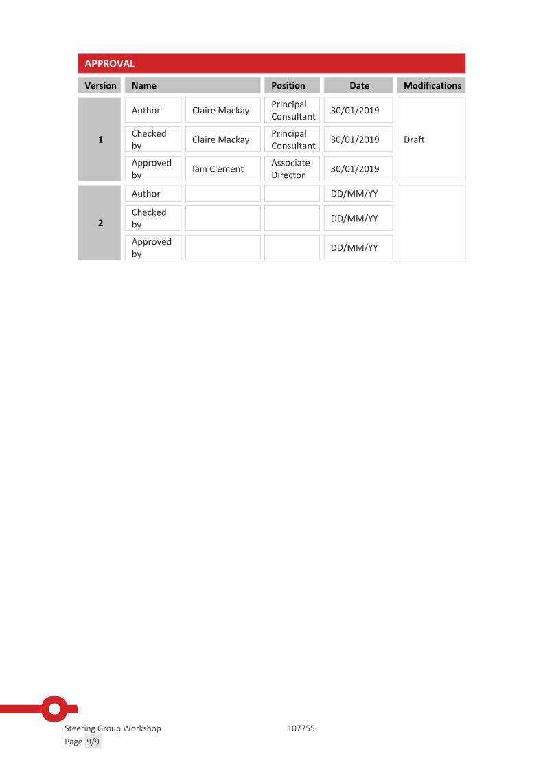
Steering Group Workshop 107755
Page 9/9
APPROVAL
Version Name Position Date Modifications
1
Author Claire MackayPrincipalConsultant
30/01/2019
DraftCheckedby
Claire MackayPrincipalConsultant
30/01/2019
Approvedby
Iain ClementAssociateDirector
30/01/2019
2
Author DD/MM/YY
Checkedby
DD/MM/YY
Approvedby
DD/MM/YY
Registered Office SYSTRA Ltd, 3rd Floor 5 Old Bailey, London, England, EC4M 7BA.Registered Number 3383212
Page 1/9
Report Appendix B – Stakeholder Workshop

Stakeholder Workshop 107755
Page 2/9
INFORMATION NOTESTIRLING STRATEGIC PARK AND RIDE APPRAISAL
STAKEHOLDER WORKSHOP
IDENTIFICATION TABLE
Client/Project owner Tactran
Project Stirling Strategic Park and Ride Appraisal
Title of Document Stakeholder Workshop
Type of Document Information Note
Date 27/02/2019
Reference number 107755
Number of pages 9
1. INTRODUCTION
1.1.1 SYSTRA Limited (SYSTRA) was commissioned by Regional Transport Partnership Tactran inNovember 2018 to undertake a multi-modal transport appraisal of transport movementsin Stirling.
1.1.2 This study is focused on investigating options to reduce the level of traffic travelling intoand out of the City, from origins and to destinations, which are beyond most people’sability to walk or cycle. As ScotRail and Network Rail are continuing to pursueprogrammes to improve train capacity and journey times, the study will focus primarily,but not exclusively, on bus/coach and rail park & ride opportunities to reduce the level oftraffic entering and passing through Stirling City area.
1.1.3 As part of the Pre-Appraisal (Case for Change) stage of the study stakeholders were invitedto take part in a Workshop focussing on Problems, Opportunities, Issues and Constraints,and Option Generation. The workshops took place at the Mayfield Centre on February20th 2019 (10.30am-midday) and at Wallace High on February 21st (7pm-8.30pm).
1.1.4 This note summarises the discussions at this workshop
1.1.5 Representatives from the following organisations were represented:
Stirling Taxi Association Councillors Causewayhead Community Council Bridge of Allan Community Council St Ninians Community Council First Bus Strathallan Community Rail Partnership Stirling Council Tactran SYSTRA
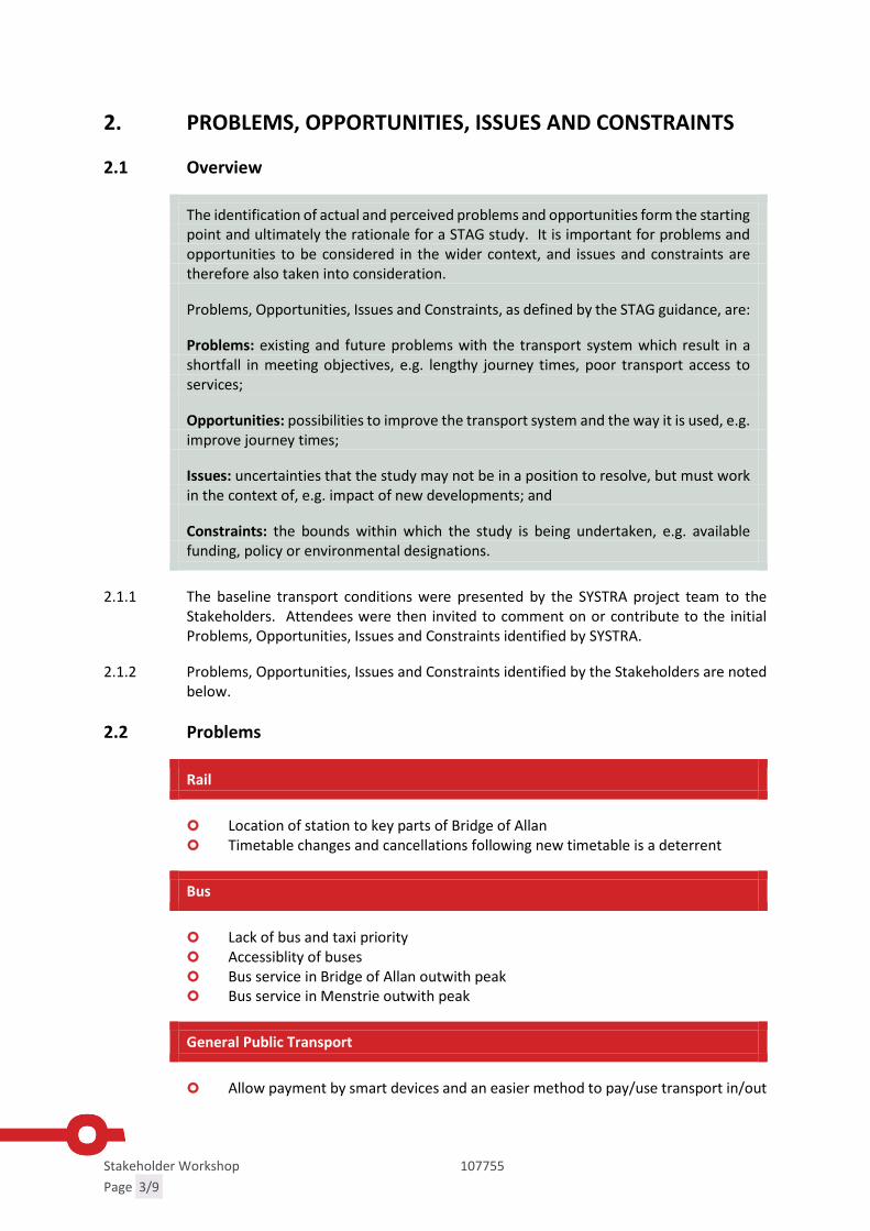
Stakeholder Workshop 107755
Page 3/9
2. PROBLEMS, OPPORTUNITIES, ISSUES AND CONSTRAINTS
2.1 Overview
The identification of actual and perceived problems and opportunities form the startingpoint and ultimately the rationale for a STAG study. It is important for problems andopportunities to be considered in the wider context, and issues and constraints aretherefore also taken into consideration.
Problems, Opportunities, Issues and Constraints, as defined by the STAG guidance, are:
Problems: existing and future problems with the transport system which result in ashortfall in meeting objectives, e.g. lengthy journey times, poor transport access toservices;
Opportunities: possibilities to improve the transport system and the way it is used, e.g.improve journey times;
Issues: uncertainties that the study may not be in a position to resolve, but must workin the context of, e.g. impact of new developments; and
Constraints: the bounds within which the study is being undertaken, e.g. availablefunding, policy or environmental designations.
2.1.1 The baseline transport conditions were presented by the SYSTRA project team to theStakeholders. Attendees were then invited to comment on or contribute to the initialProblems, Opportunities, Issues and Constraints identified by SYSTRA.
2.1.2 Problems, Opportunities, Issues and Constraints identified by the Stakeholders are notedbelow.
2.2 Problems
Rail
Location of station to key parts of Bridge of Allan Timetable changes and cancellations following new timetable is a deterrent
Bus
Lack of bus and taxi priority Accessiblity of buses Bus service in Bridge of Allan outwith peak Bus service in Menstrie outwith peak
General Public Transport
Allow payment by smart devices and an easier method to pay/use transport in/out

Stakeholder Workshop 107755
Page 4/9
Public transport - additional time taken for end to end journey Lack of funding (the percentage of fares) There is not a multi-modal ticketing system available Cost of transport is a deterrent and the pricing structure is complex Inconvenience of public transport - timing outwith peak times
Parking
City Centre parking charges and availability of parking The parking and volume of cars that are accessing the University Overspill parking near train stations Lack of parking enforcements Overspill parking for University Parking dispersal from Bridge of Allan station, Northern Villages, University and
Dunblane Inequity of parking fees
Park and ride
Suitable locations far enough out for park & ride sites No park & ride site towards the south
Road
Continual flooding and closure of the A907 (Alloa Road) No entrance/exits from A811 to the M9 Prudential and Craigforth Roundabout Congestion at Clock Roundabout Congestion on the A91 Congestion on Glasgow Road if park & ride at Pirnhall
Other
Full barrier closure Tourist access Live at home students
Environment
Vehicle Emissions
Accessibility
Access to care village Disabled access to/from Northbound platform at Bridge of Allan to disabled parking
spaces is impossible Restrictions on use of taxis - Taxi Card, dial a journey 24hrs notice Accessibility and booking wheelchair space on rail services

Stakeholder Workshop 107755
Page 5/9
Cycling
Lack of safe cycle routes and need more cycle parks - as in Clacks Unsafe routes for cyclists- Airthrey Road/WHS dual pavement confusion
2.3 Opportunities
Availability of city deal Funding Build upon the existing and well established park & rides sites available Broad area of surrounding land to build/create peripheral transport options Convenient locations for bus and rail stops/interchanges Strong cycling community and E-bikes will become available Increasing number of cyclists Liaise with local employers e.g. University Influence University development plan- campus in city, accommodation
2.4 Issues
Low adoption of low emission buses Road closures, facilities and road traffic accidents impacting on congestion/
reliability Lack of preparation during winter for road surfaces No joined up agreements of rail, taxi and bus services Low cost of city centre parking Developing better road routes Parking charges are punitive to those who cannot pay Congestion reduces appeal of public transport Transit from other areas Increase of home delivery (exponential increase) Encouraging younger generation to use more public transport Where are Bridge of Allan rail users coming from?
2.5 Constraints
Existing roads that cannot be better developed Need to change buses and taxis to ultra low emission vehicles Partnership agreements to allow investments Cost, dispensation for taxi/bus operators to ensure investment Road network limits for bus land adoption Major events in Edinburgh and Glasgow putting pressure on public transport Legal set up for bus services

Stakeholder Workshop 107755
Page 6/9
2.6 Option Generation
Rail
Relocated Bridge of Allan station (closure and reopening) Improve rail journey times Improve Alloa to Edinburgh rail frequency Increase parking at Stirling railway station Do not relocate Bridge of Allan Station Increase parking at Bridge of Allan station Improve parking at and signage to train stations Connect rail to the West Coast Mainline Re-open the Alloa to Dunfermline Railway Rail station at Bannockburn/South Stirling Clackmannan rail park and ride Station at Cornton/Causewayhead (in addition to Bridge of Allan) Station at Manor Powis (park and ride) Station at Cambus Station at Causewayhead Station at Cowie Park and ride opportunity at Alloa (currently 40-50 spaces) Station at Blackford or Greenloaning Station at Plean
Park and Ride / Choose
A southern park and ride site for local and strategic trips Investigate bus priority on key commercial and park and ride routes Strategic coach services calling at existing P&R Provide park & ride sites at Pirnhall Bus park & ride for Clackmannanshire Residents Tourism bus from park & ride site Higher frequency of park & ride Green Travel Hub at Springkerse, swap to other side of A91, EV charging,
café/tourist draw on top floor to take advantage of the view, bridge tocycle/walking routes
Park & choose with high quality walking/cycling routes to City Centre
Bus
Improve journey times, frequencies and destinations of bus/coach Bus gates in Stirling City Centre Growth of passengers on buses by sustained investment for new buses Bus lanes on the A91, A907 and Causewayhead Road Bus services at rail stations
Integration
Improve integration of Stirling Bus and Rail Stations Integration of ticketing schemes

Stakeholder Workshop 107755
Page 7/9
Cycling
Widen the NextBike cordon out of the city and encourage its use Designated cycle/walking routes connecting busy areas
Fares
Optimise ticket pricing structure to attract users Junction improvements on Dumbarton Road to alleviate congestion Improve A91/A905 network More access points from the M9 Ensure bus routes are given priority by gritters when there is snow
Accessibility
More disabled access taxis
Other
City Centre campus for University Develop industry close to housing- developer's contribution Change school times like St. Modan’s to reduce school traffic on Causewayhead
Road Improve longer distance public transport links e.g. coach and rail Provide easier access to/from Cumbernauld and Motherwell Lightrail from Pirnhall/Durieshill.

Stakeholder Workshop 107755
Page 8/9
APPROVAL
Version Name Position Date Modifications
1
Author Claire MackayPrincipalConsultant
27/02/2019
DraftCheckedby
Claire MackayPrincipalConsultant
27/02/2019
Approvedby
Iain ClementAssociateDirector
27/02/2019
2
Author DD/MM/YY
Checkedby
DD/MM/YY
Approvedby
DD/MM/YY

Stakeholder Workshop 107755
Page 9/9
Report Appendix C – Steering Group WorkshopPresentation

Stirling Strategic Park and Ride StudySteering Group Workshop
16th January 2019

Agenda
Stirling LRDFPage 2
Time Session
12.50-13.00 Introductions and background
13.00-13.35 Problems, opportunities, issues and constraints
13.35-14.20 Setting the Transport Planning Objectives
14.20-14.30 Tea and coffee break
14.30-15.10 Option Generation Workshop

Introductions and background
Stirling LRDFPage 3

Study Background
Stirling Council DPMTAG outcomes:
Without both providing alternatives to the car, and additional road capacity, for both existing and new trips (expected via the LDP and City Deal proposals), Stirling could suffer from congestion with a corresponding impact on the economic performance, as well as the social impacts of deteriorating air quality
The eastern villages of Plean, Cowie and Fallin, where an additional 1500 homes are proposed, are relatively poor communities with poor transport links to jobs, services and opportunities. Especially to locations beyond Stirling City and Falkirk
The appraisal identified that addressing the trips entering/leaving Stirling City (approximately 44% of car trips in the am peak) would be likely to require strategic interventions
To investigate these issues further and identify and appraise interventions to reduce car trips into/out of Stirling City funding has been provided as part of the Local Rail Development Fund (LRDF) from Transport Scotland
Stirling LRDFPage 4

Where are we?
Stirling LRDFPage 5
LRDF Study will follow the STAG process
Input from this Steering Group
There will be decision points throughout the study
Dec
isio
n p
oin
ts
Case for Change
Detailed Options
Appraisal
Preliminary Options
Appraisal

Baseline Review, Problems, Opportunities, Issues and Constraints
Stirling LRDFPage 6

Baseline Review: Policy
Planning PolicyNational Planning Framework 3
Stirling Local Development Plan 2017-2017
Transport Policy Tactran Regional Transport Strategy 2008-2023
Park and Ride Strategy and Action Plan (2016), Tactran
Stirling Local Transport Strategy 2017-2027
Clackmannanshire Local Transport Strategy 2010-2014
Economic Policy
Stirling and Clackmannanshire City Region Deal
Social Policy
Stirling CPP Local Outcome Improvement Plan
Stirling LRDFPage 7
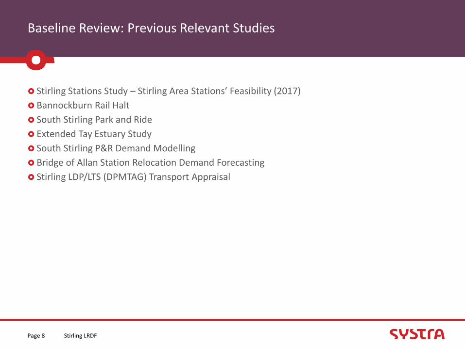
Baseline Review: Previous Relevant Studies
Stirling Stations Study – Stirling Area Stations’ Feasibility (2017)
Bannockburn Rail Halt
South Stirling Park and Ride
Extended Tay Estuary Study
South Stirling P&R Demand Modelling
Bridge of Allan Station Relocation Demand Forecasting
Stirling LDP/LTS (DPMTAG) Transport Appraisal
Stirling LRDFPage 8

Baseline Review: Socio-economic
Population growth above the Scottish average
Above average growth in over-65s
Older populations are concentrated in the rural areas
14 SIMD zones within the 20% most deprived in Scotland.
Low access to car in Raploch and Eastern Villages
Below average unemployment but higher levels of unemployment in the Raploch area, Plean and Fallin
Stirling LRDFPage 9

Baseline Review: Population and Growth
Existing key trip generators• City Centre• University• Prudential / Forth Valley College / Castle
Business Park• Springkerse
Growth Areas• Forthside• Kildean• South Stirling Gateway / Durieshill• Plean/Cowie/Fallin
Stirling LRDFPage 10

Baseline Review: Travel to Work (excludes study)
To Stirling 51% of workers coming from within Stirling district (excluding
working from home)
From Falkirk (16%) and Clackmannanshire (14%)
66% of all Stirling residents travelling to work in Stirling use car
Rail use for employees in Stirling is low for all origins excluding Glasgow residents, 23%.
From Stirling
47% of Stirling residents work within the Stirling Council area
Bus use low for all destinations excluding Stirling (11%)
Rail travel to Glasgow (26%) and Edinburgh (35%) is more competitive with car/van drivers/passengers
Model Data
Approx. car 50% trips are internal to internal (48-56% AM and PM)
Approx. 40% car trips are either internal to external or external to internal (38%-44%)
Stirling LRDFPage 11
70% work in Stirling Council

Baseline Review: Transport
Significant reduction in First bus services in the Stirling Area.
Cowie, Fallin and Plean have all seen a reduction in service
Decline in the percentage of people who consider public transport (not exclusively bus) to be very or fairly convenient from 76.1% in 2011/12 to 68% in 2017. The Scottish average remains consistent at 84.1% and 82.4%. (SHS)
Stirling LRDFPage 12
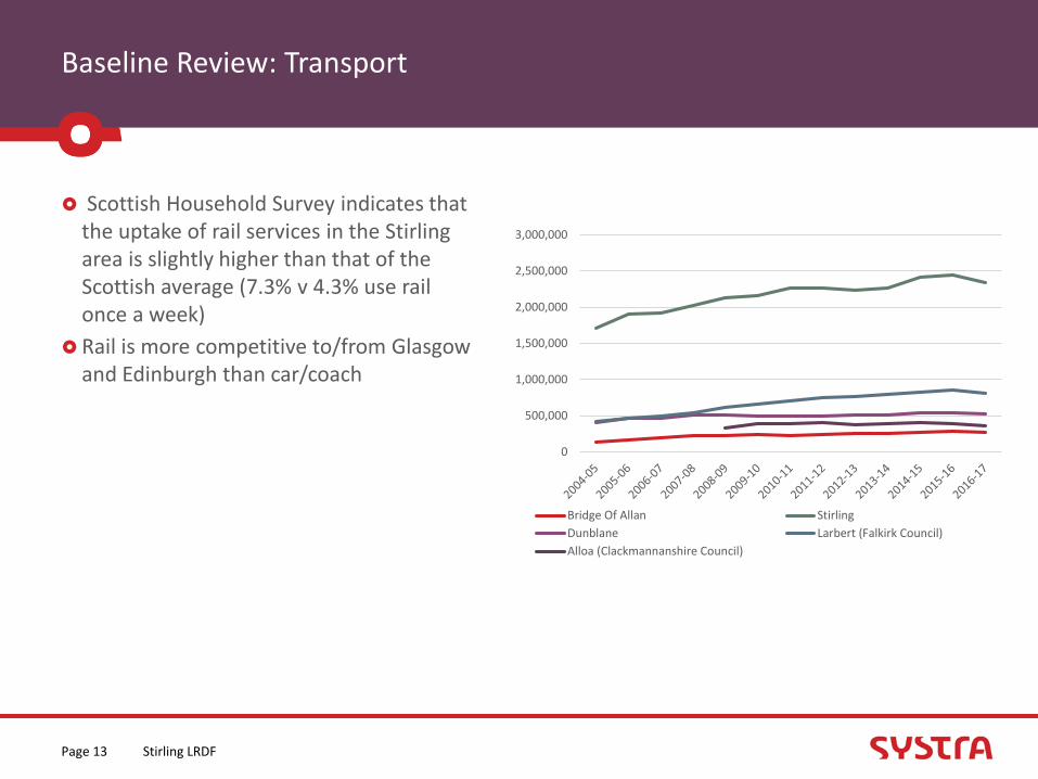
Baseline Review: Transport
Scottish Household Survey indicates that the uptake of rail services in the Stirling area is slightly higher than that of the Scottish average (7.3% v 4.3% use rail once a week)
Rail is more competitive to/from Glasgow and Edinburgh than car/coach
Stirling LRDFPage 13
0
500,000
1,000,000
1,500,000
2,000,000
2,500,000
3,000,000
Bridge Of Allan Stirling
Dunblane Larbert (Falkirk Council)
Alloa (Clackmannanshire Council)
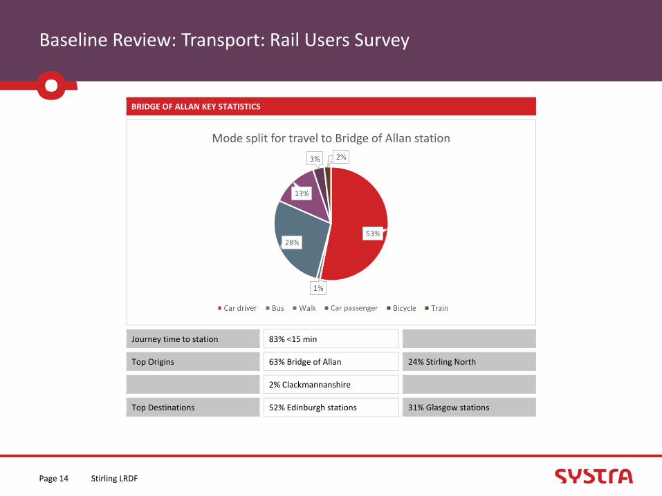
Baseline Review: Transport: Rail Users Survey
Stirling LRDFPage 14
BRIDGE OF ALLAN KEY STATISTICS
Journey time to station 83% <15 min
Top Origins 63% Bridge of Allan 24% Stirling North
2% Clackmannanshire
Top Destinations 52% Edinburgh stations 31% Glasgow stations

Baseline Review: Transport: Rail Users Survey
Stirling LRDFPage 15
STIRLING KEY STATISTICS
Journey time to station 70% <15 min
Top Origins 58% within Stirling City 15% Clackmannanshire
Top Destinations 32% Edinburgh stations 27% Glasgow stations
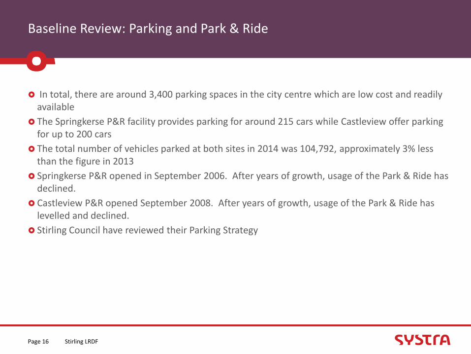
Baseline Review: Parking and Park & Ride
In total, there are around 3,400 parking spaces in the city centre which are low cost and readily available
The Springkerse P&R facility provides parking for around 215 cars while Castleview offer parking for up to 200 cars
The total number of vehicles parked at both sites in 2014 was 104,792, approximately 3% less than the figure in 2013
Springkerse P&R opened in September 2006. After years of growth, usage of the Park & Ride has declined.
Castleview P&R opened September 2008. After years of growth, usage of the Park & Ride has levelled and declined.
Stirling Council have reviewed their Parking Strategy
Stirling LRDFPage 16

Baseline Review: Road
The DPMTAG highlighted that:Currently The A91 experiences significant congestion during the
peak periods, particularly the evening peak period with rolling queues often developing between most of the key connections.
M9 Junction 9 Pirnhall regularly experiences significant congestion on the southbound approach out of Stirling and on the westbound off-ramp from the motorway.
M9 Junction 11 Keir Roundabout experiences severe congestion during the peak periods, most notably southbound during the PM peak from the A9.
Forecast
Forecast congestion at above locations in the PM Peak by 2027
Stirling LRDFPage 17

Problems
Stirling LRDFPage 18
Below average level of car ownership in some areas including Plean, Fallin, Cowie and Raploch.
Above average unemployment in Raploch, Plean and Fallin.
Above average (and growing) over 65 population in rural areas
Declining bus service
14 SIMD zones are within the 20% most deprived in Scotland
Travelling to Bridge of Allan station by car is high at Bridge of Allan (66%) compared to Dunblane (44%)
Incomplete cycle network, severance and safety issues for cycling and walking
Rail travel is increasing but there are capacity issues arising both on services and at station car parks.
Reliance on private car for journeys to work.
Increasing congestion on Stirling’s roads
Declining use of park and ride sites.
Low cost and central parking in Stirling city centre reduces the competitiveness of sustainable modes
Dispersed nature of rural areas in Stirling makes it difficult to serve by public transport.
40% of trips into Stirling
Rail brings trips into Stirling city centre
Stirling station car park at or near capacity
Congestion forecast as a result of LDP and City
Deal developments
Poor links from areas of SIMD to jobs and
services
Parking at major employment
destinations such as Prudential, University of Stirling and Forth Valley Royal Hospital
High cost of public transport.
Transport povertyInconvenience of public
transport

Opportunities
Stirling LRDFPage 19
Major development sites located on the strategic road network, including Plean, Cowie and Fallin
Compact city centre, attractive to sustainable travel options
Strong community groups willing to be involved in exploring and delivering solutions
Major development sites allow a range of transport solutions to
be explored.
Strategically located to Scotland’s cities by road and rail network
Gateway to Loch Lomond & TrossachsNational Park
Development of active travel networks help to support rural economic activity
Sustainable expansion sites more easy to serve than disparate development
Existing long distance bus and coach services passing in close proximity to existing
Benefits associated with the Stirling -Dunblane - AlloaElectrification (faster trains/reduced JTs)
Durieshill brings easily accessible opportunities for those in Plean to new jobs and services
The Stirling and Clackmannanshire City Region Deal provides the scope to improve infrastructure
Opportunity to link new park and ride sites with Stirling’s tourism sites, major employers and health services
Development of national cycle network offer opportunities to connectrural communities.
Rail competitive to all of Scotland's major
cities. Maximise competitiveness.
University of Stirling/FV Hospital/ Prudential located close to strategic
network connections
Stirling’s central location within Scotland’s strategic transport network
Being able to act as a strategic P&R site for events across Scotland
Development related infrastructure improvements could resolve existing issues (University, Pru etc)
Low Emission Zones could make sustainable modes more attractive
Effectiveness of the parking strategy could discourage driving into
the city centre
Congestion on the A91 could encourage a shift to sustainable modes
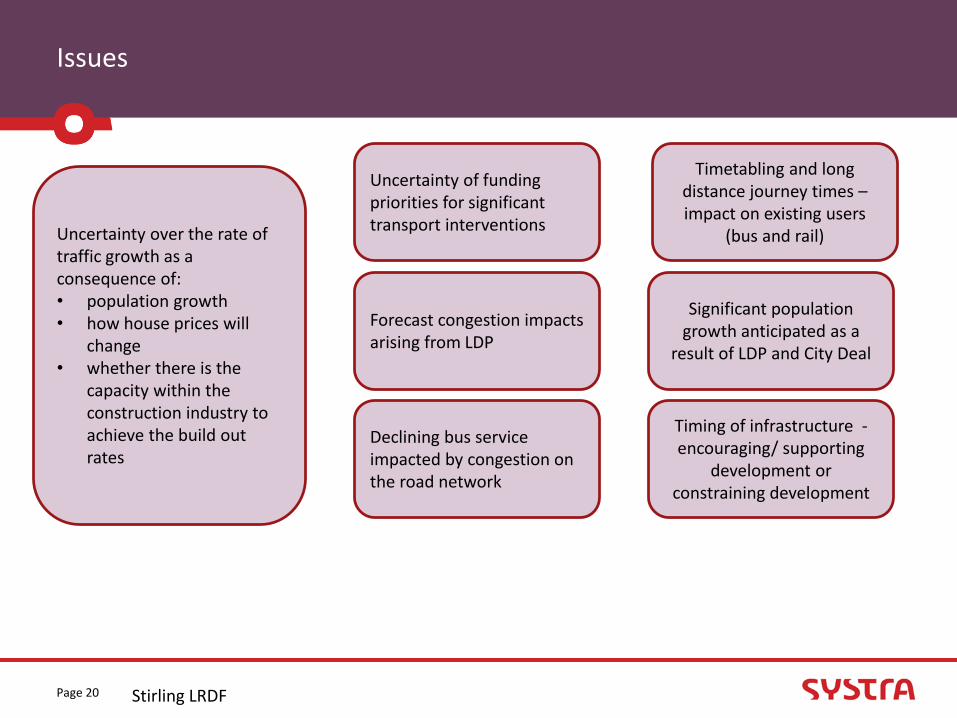
Issues
Stirling LRDFPage 20
Uncertainty over the rate of traffic growth as a consequence of:• population growth• how house prices will
change • whether there is the
capacity within the construction industry to achieve the build out rates
Uncertainty of funding priorities for significant transport interventions
Forecast congestion impacts arising from LDP
Declining bus service impacted by congestion on the road network
Timetabling and long distance journey times –impact on existing users
(bus and rail)
Timing of infrastructure -encouraging/ supporting
development or constraining development
Significant population growth anticipated as a
result of LDP and City Deal

Constraints
Stirling LRDFPage 21
Any changes to existing services or new services need to be able to operate on a commercial basis.
Flood risk may be a significant constraint impacting on development andtransport interventions
Large legacy of built heritage within Stirling city and surrounding areas
Major development sites allow a range of transport solutions to
be explored.
Rail capacity at Glasgow Queen station dictates the length of trains on services north out of Glasgow.
Potential severance of developments by Pirnhall Roundabout, M9 and M80 (active modes) and A91
Historical battlefield areas throughout Stirling Council
Majority of parking opportunities within the city are adjacent to one of the pinch points (Craigs Roundabout)
Expansion of rail infrastructure is constrained by bridges and other structures
Greenbelt / Landscape
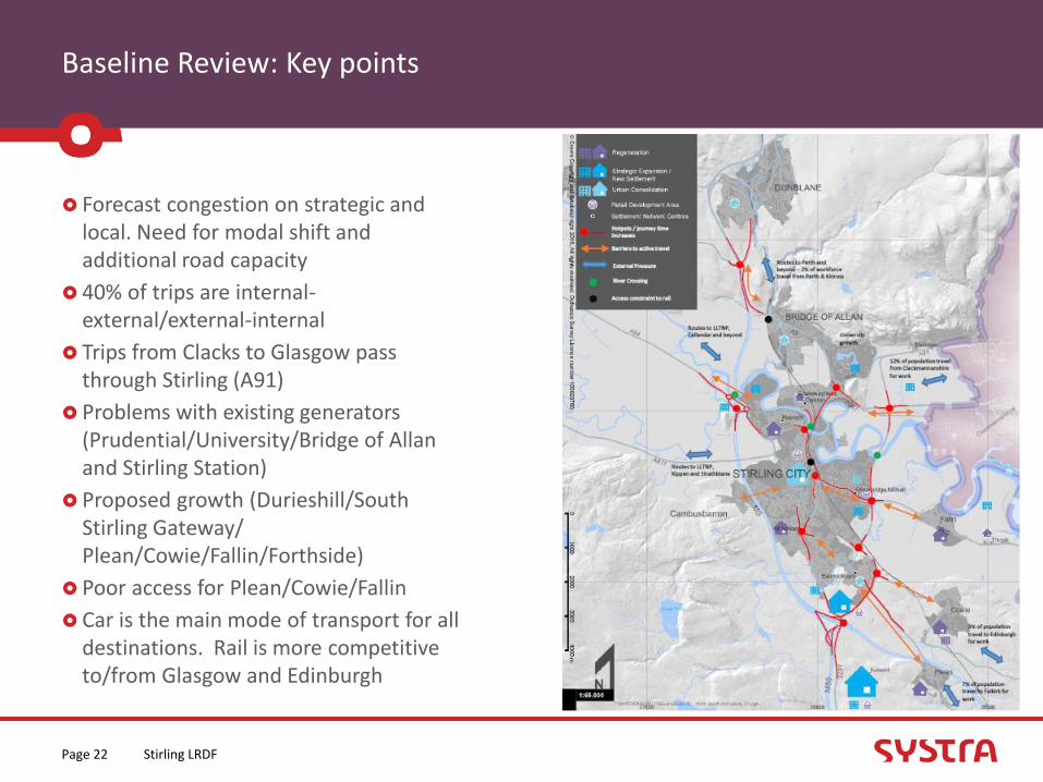
Baseline Review: Key points
Forecast congestion on strategic and local. Need for modal shift and additional road capacity
40% of trips are internal-external/external-internal
Trips from Clacks to Glasgow pass through Stirling (A91)
Problems with existing generators (Prudential/University/Bridge of Allan and Stirling Station)
Proposed growth (Durieshill/South Stirling Gateway/ Plean/Cowie/Fallin/Forthside)
Poor access for Plean/Cowie/Fallin
Car is the main mode of transport for all destinations. Rail is more competitive to/from Glasgow and Edinburgh
Stirling LRDFPage 22

Transport Planning Objectives
Stirling LRDFPage 23

Transport Planning Objectives
Purpose of TPOs: Clarifies what the study aims to achieve
Basis for directing and guiding the study process
Provide basis for appraisal of alternative options
Central to monitoring and evaluation
Facilitate accountability of the decision maker
Can evolve through the study
Objectives should:
Reflect evidence base and established policy directives
Reflect multi-modal nature of study
Be SMART(Specific, Measurable, Attainable, Relevant, Timed)
Be manageable in number
Stirling LRDFPage 24
Transport Planning Objectives
Emerging TPOs for discussion: Reduce the volume of traffic entering, leaving or passing through the Stirling Core Area
Improve the attractiveness and affordability of sustainable modes for local trips:
Bridge of Allan and North Stirling to Stirling City Centre
Stirling’s Eastern Villages to Stirling City Centre
Improve the attractiveness and affordability of sustainable modes for strategic trips:
To Scotland’s Major Cities and the Forth Valley Royal Hospital
Stirling LRDFPage 25

Option Generation
Stirling LRDFPage 26

Option Generation
To derive a range of options which should provide the solutions to meet the Transport Planning Objectives and alleviate the problems or address the opportunities identified.
Derive options which fully reflect the range available.
Option generation should not be constrained at this stage.
Measures can be packaged if appropriate
Existing options have been collated from: previous studies; and
the statutory planning process (transport and land use plans);
Stirling LRDFPage 27

Option Generation - Workshop
Rail
New Bannockburn/South Stirling Rail Station and service (DPMTAG/LTS/STPR). Potential location at Cowie.
Relocated Bridge of Allan station (closure and reopening) (DPMTAG/LTS)
Improve journey times, frequencies of rail services (frequency of Alloa to Edinburgh)
Clackmannan P&R (rail halt)
Dunfermline to Stirling rail connectivity
Increased parking at Stirling station
Park and Ride
A southern park and ride site for local and strategic trips (LTS)
Low carbon transport and travel hubs at park and choose sites (LTS) at all potential sites
Consider park and ride opportunities for traffic from Clackmannanshire, potentially NE Stirling (LTS/LDP)
Increase park and ride capacity at Bridge of Allan station
Investigate bus priority on key commercial and park and ride routes (LTS)
Potential to mix P&R sites with other uses (eg. park and ride sites to be used by freight)
Strategic coach serving existing P&R
Park and ride opportunity at Alloa (currently 40-50 spaces)
Bus
Improve journey times, frequencies and destinations of bus/coach (LTS)
Bus gates in Stirling City Centre
Stirling LRDFPage 28

Option Generation - Workshop
Integration
Improve integration of Stirling Bus and Rail Stations (LTS)
Bus and cycle integration at bus shelters (cycle parking at shelter etc)
MaaS - Ticketing, car sharing, car hubs
Opportunities to put bikes on buses
Parking
Manage parking in the city centre (LTS) – review the charging mechanism for park and ride, for example, a standard charge for parking in place of bus fares. Depends on location (ie close to a retail park with spaces)
Workplace parking levy
Additional parking at Larbert
Different roles for parking – loading bay during the day, available for parking during the day
Cycling
Widen the NextBike cordon out of the city
Community transport
Improved sustainable access to big employers and large events
Stirling LRDFPage 29
Option Generation - Workshop
Fares
Reduced fares for bus and rail/integrated/flexible ticketing. Integrate car share, bike, bus, train
Optimise ticket pricing structure to attract users
Technological improvements
Electronic/Live LTS coming into Stirling. Direct visitors to P&R with space. Information on the way into the city and online
Smart motorways/Smart towns – changing the speeds, closing the routes
Traffic lights – change in prioritization of flows depending on congestion/air quality
New technology and the negative impact it can have on driver behavior (eg. Reliance on satnav)
Initiatives
Travel plans and promotions (LTS)
Travel plans and promotions across council boundaries
LEZ, car free zones/days, restricting car access to the city. Car free days working its way round the city.
Encourage staff not to drive – reduced business rates as an incentive. Would be cross boundary issues
Stirling LRDFPage 30
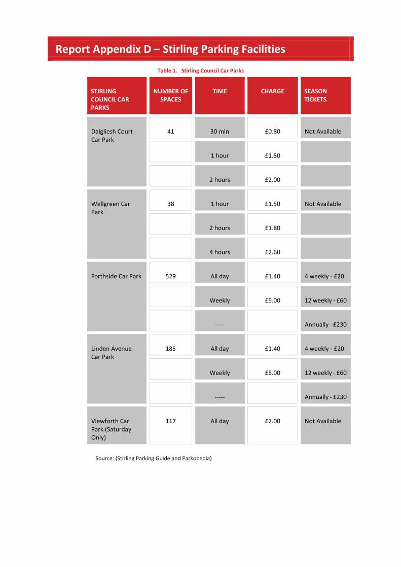
Report Appendix D – Stirling Parking Facilities
Table 1. Stirling Council Car Parks
STIRLINGCOUNCIL CARPARKS
NUMBER OFSPACES
TIME CHARGE SEASONTICKETS
Dalgliesh CourtCar Park
41 30 min £0.80 Not Available
1 hour £1.50
2 hours £2.00
Wellgreen CarPark
38 1 hour £1.50 Not Available
2 hours £1.80
4 hours £2.60
Forthside Car Park 529 All day £1.40 4 weekly - £20
Weekly £5.00 12 weekly - £60
----- Annually - £230
Linden AvenueCar Park
185 All day £1.40 4 weekly - £20
Weekly £5.00 12 weekly - £60
----- Annually - £230
Viewforth CarPark (SaturdayOnly)
117 All day £2.00 Not Available
Source: (Stirling Parking Guide and Parkopedia)
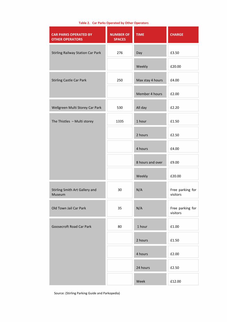
Table 2. Car Parks Operated by Other Operators
CAR PARKS OPERATED BYOTHER OPERATORS
NUMBER OFSPACES
TIME CHARGE
Stirling Railway Station Car Park 276 Day £3.50
Weekly £20.00
Stirling Castle Car Park 250 Max stay 4 hours £4.00
Member 4 hours £2.00
Wellgreen Multi Storey Car Park 530 All day £2.20
The Thistles – Multi storey 1335 1 hour £1.50
2 hours £2.50
4 hours £4.00
8 hours and over £9.00
Weekly £20.00
Stirling Smith Art Gallery andMuseum
30 N/A Free parking forvisitors
Old Town Jail Car Park 35 N/A Free parking forvisitors
Goosecroft Road Car Park 80 1 hour £1.00
2 hours £1.50
4 hours £2.00
24 hours £2.50
Week £12.00
Source: (Stirling Parking Guide and Parkopedia)

Report Appendix E – Option Sifting
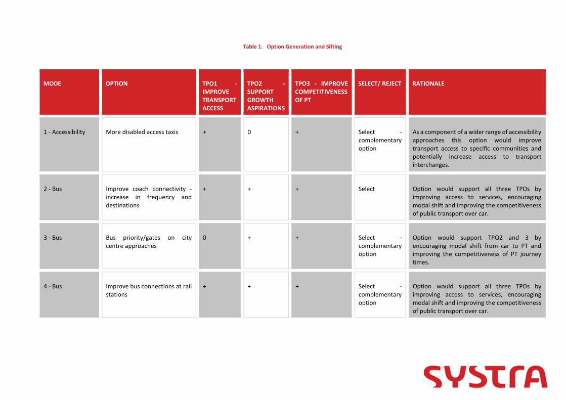
Table 1. Option Generation and Sifting
MODE OPTION TPO1 -IMPROVETRANSPORTACCESS
TPO2 -SUPPORTGROWTHASPIRATIONS
TPO3 - IMPROVECOMPETITIVENESSOF PT
SELECT/ REJECT RATIONALE
1 - Accessibility More disabled access taxis + 0 + Select -complementaryoption
As a component of a wider range of accessibilityapproaches this option would improvetransport access to specific communities andpotentially increase access to transportinterchanges.
2 - Bus Improve coach connectivity -increase in frequency anddestinations
+ + + Select Option would support all three TPOs byimproving access to services, encouragingmodal shift and improving the competitivenessof public transport over car.
3 - Bus Bus priority/gates on citycentre approaches
0 + + Select -complementaryoption
Option would support TPO2 and 3 byencouraging modal shift from car to PT andimproving the competitiveness of PT journeytimes.
4 - Bus Improve bus connections at railstations
+ + + Select -complementaryoption
Option would support all three TPOs byimproving access to services, encouragingmodal shift and improving the competitivenessof public transport over car.

MODE OPTION TPO1 -IMPROVETRANSPORTACCESS
TPO2 -SUPPORTGROWTHASPIRATIONS
TPO3 - IMPROVECOMPETITIVENESSOF PT
SELECT/ REJECT RATIONALE
5 - Bus Measures to increase theattractiveness of publictransport including sustainedinvestment in new buses.
0 + 0 Select -complementaryoption
As a component of a wider range of measuresto increase the attractiveness of publictransport this option would support TPO2 byencouraging modal shift
6 - Bus/Coach Bus/coach Park and Rideopportunities at the followingsites:
- Pirnhall/South Stirling
- Relocated Springkerse site Select
Option would support all three TPOs byimproving access to services, encouragingmodal shift and improving the competitivenessof public transport over car.
7 - Cycling
Segregated, designated walkingand cycling routes to keydestinations such as the CityCentre, University and Park andRide sites. + 0 0
Select -complementaryoption
As a component of a wider range of accessibilityapproaches to improve access to interchangesthis option would improve transport access forspecific communities and potentially increaseaccess to transport interchanges.
8 - CyclingWiden the NextBike cordon outof the city and promote + 0 0
Select -complementaryoption
As a component of a wider range of accessibilityapproaches to improve access to interchangesthis option would improve transport access forspecific communities and potentially increaseaccess to transport interchanges.

MODE OPTION TPO1 -IMPROVETRANSPORTACCESS
TPO2 -SUPPORTGROWTHASPIRATIONS
TPO3 - IMPROVECOMPETITIVENESSOF PT
SELECT/ REJECT RATIONALE
9 - Initiatives
Improve car sharing offering inthe study area by incentivisingcar sharing and encouragingmore car clubs 0 + +
Select -complementaryoption
Option would support TPOs 2 and 3 byimproving access to services and encouragingmodal shift by increasing more sustainabletransport options available.
10 - Integration
Improve bus and cycleintegration at bus shelters andon buses by allowing bikes onbuses and installing cycleparking at shelters + 0 0
Select -complementaryoption
As a component of a wider range of accessibilityapproaches to improve access to interchangesthis option would improve transport access forspecific communities and potentially increaseaccess to transport interchanges.
11 - Integration
Create a multi-modal ticketingsystem and optimise pricingstructure 0 + +
Select -complementaryoption
As a component of a wider range of measuresto increase the attractiveness of publictransport this option would support TPO2 andTPO3 by encouraging modal shift and improvingthe competitiveness of public transport.
12 - Integration
Promote activities toencourage more sustainabletravel including travel plans,Low Emission Zones, car-freedays, incentives to leave the carat home and Workplace ParkingLevy 0 + +
Select -complementaryoption
As a component of a wider range of measuresto increase the attractiveness of publictransport this option would support TPO2 byencouraging modal shift.

MODE OPTION TPO1 -IMPROVETRANSPORTACCESS
TPO2 -SUPPORTGROWTHASPIRATIONS
TPO3 - IMPROVECOMPETITIVENESSOF PT
SELECT/ REJECT RATIONALE
13 - Land useplanning
Change in land-use policy e.g.develop industry close tohousing, relocate University tocity centre campus. 0 0 0 Reject
Although a change in land use and location oftrip attractors and generators would impact ontravel in the study area it is outwith the scopeof the study.
14 - OtherCommunity transport - targetat interchange opportunities + 0 +
Select -complementaryoption
As a component of a wider range of accessibilityapproaches this option would improvetransport access to specific communities andpotentially increase access to transportinterchanges.
15 - OtherConsider changing school timesto mitigate school traffic Reject
Although a change in school times may mitigatetransport problems in the study area it isoutwith the scope of the study.
16 - OtherLight rail from Pirnhall/Durieshill (into Stirling) + + + Select
Option would support all three TPOs byimproving access to services, encouragingmodal shift and improving the competitivenessof public transport over car.
17 - Park andRide/Choose
Potential for other tripattractors to use Prudential busservices (from city centre andaround Central Scotland, e.g.Forth Valley College) + + + Select
Option would support all three TPOs byimproving access to services, encouragingmodal shift and improving the competitivenessof public transport over car.

MODE OPTION TPO1 -IMPROVETRANSPORTACCESS
TPO2 -SUPPORTGROWTHASPIRATIONS
TPO3 - IMPROVECOMPETITIVENESSOF PT
SELECT/ REJECT RATIONALE
18 - Park andRide/Choose
Improvements to existing P&Rincluding- strategic coach/bus services;- improved frequency;
- improved walking and cyclingconnections/facilities(including Nextbike);- tourism bus;
- connections to employmentand education destinations;- active travel hub with goodconnections;- shuttle buses connecting P&Rsites- low carbon transport
- mix P&R sites with other uses + + + Select
Option would support all three TPOs byimproving access to services, encouragingmodal shift and improving the competitivenessof public transport over car.
19 - Parking
Manage parking in the citycentre – review the parkingpolicy in the city; charging/faresfor park and ride; and considerdifferent roles for baysthroughout the day/night 0 + +
Select -complementaryoption
As a financial incentive to shift to publictransport the rebalancing of parking charges inthe study area would contribute towards TPO2and 3 by supporting modal shift and makingpublic transport more competitive.
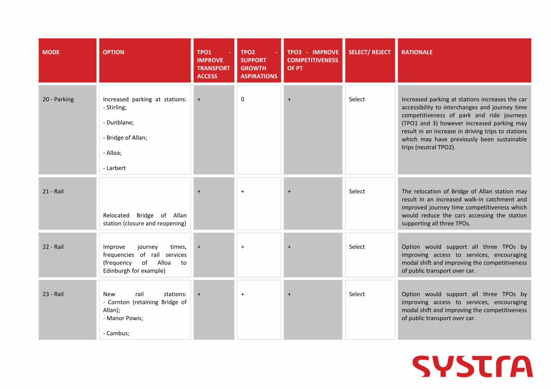
MODE OPTION TPO1 -IMPROVETRANSPORTACCESS
TPO2 -SUPPORTGROWTHASPIRATIONS
TPO3 - IMPROVECOMPETITIVENESSOF PT
SELECT/ REJECT RATIONALE
20 - Parking Increased parking at stations:- Stirling;
- Dunblane;
- Bridge of Allan;
- Alloa;
- Larbert
+ 0 + Select Increased parking at stations increases the caraccessibility to interchanges and journey timecompetitiveness of park and ride journeys(TPO1 and 3) however increased parking mayresult in an increase in driving trips to stationswhich may have previously been sustainabletrips (neutral TPO2).
21 - Rail
Relocated Bridge of Allanstation (closure and reopening)
+ + + Select The relocation of Bridge of Allan station mayresult in an increased walk-in catchment andimproved journey time competitiveness whichwould reduce the cars accessing the stationsupporting all three TPOs.
22 - Rail Improve journey times,frequencies of rail services(frequency of Alloa toEdinburgh for example)
+ + + Select Option would support all three TPOs byimproving access to services, encouragingmodal shift and improving the competitivenessof public transport over car.
23 - Rail New rail stations:- Cornton (retaining Bridge ofAllan);- Manor Powis;
- Cambus;
+ + + Select Option would support all three TPOs byimproving access to services, encouragingmodal shift and improving the competitivenessof public transport over car.

MODE OPTION TPO1 -IMPROVETRANSPORTACCESS
TPO2 -SUPPORTGROWTHASPIRATIONS
TPO3 - IMPROVECOMPETITIVENESSOF PT
SELECT/ REJECT RATIONALE
- Causewayhead (Alloa line);
- South Stirling/ Cowie/Bannockburn;
- Blackford or Greenloaning;
- Clackmannanan.
24 - Road
Road improvements:- More access points from theM9;- Improve A91/A905 network;- Kildean to Cornton access
0 0 0 Select -complementary
Road improvements to support the efficientworking of park and ride services and accessesto rail stations may improve thecompetitiveness of bus/coach park and ridewith better journey times, however, betterroad journey times may incentivise drivers todrive instead of using public transport.
25 - TechnologicalImprovements
Technological improvements toimprove flow of traffic:- Intelligent Transport Systemsdirecting to P&R with spaces
- Smart motorways/towns
- Traffic light prioritisation forpublic transport
0 + + Select -complementaryoption
As a component of a wider range of measuresto increase the attractiveness of publictransport this option would support TPO2 andTPO3 by encouraging modal shift and improvingthe competitiveness of public transport.

MODE OPTION TPO1 -IMPROVETRANSPORTACCESS
TPO2 -SUPPORTGROWTHASPIRATIONS
TPO3 - IMPROVECOMPETITIVENESSOF PT
SELECT/ REJECT RATIONALE
- Bus real time information
- Electric taxis and buses
Accessibility More disabled access taxis Reject Duplicate 1
Bus Improve coach connectivity Reject Duplicate 2
Bus Bus priority on city centreapproaches
Reject Duplicate 3
Bus Bus services at rail stations Reject Duplicate 4
Bus Growth of passengers on busesby sustained investment fornew buses
Reject Duplicate 5
Bus Bus gates in Stirling City Centre Reject Duplicate 3
Bus Bus Priority on A91 into the CityCentre
Reject Duplicate 3

MODE OPTION TPO1 -IMPROVETRANSPORTACCESS
TPO2 -SUPPORTGROWTHASPIRATIONS
TPO3 - IMPROVECOMPETITIVENESSOF PT
SELECT/ REJECT RATIONALE
Bus Bus lanes on the A91, A907 andCausewayhead Road
Reject Duplicate 3
Bus Give more priority to busservices
Reject Duplicate 3
Cycling Segregated, direct cycle routesfrom City Centre into University
Reject Duplicate 7
Cycling Designated cycle/walkingroutes connecting busy areas
Reject Duplicate 7
Cycling Encourage use of NextBikeScheme
Reject Duplicate 8
Cycling Widen the NextBike cordon outof the city and promote
Reject Duplicate 8
Fares Reduced fares for bus andrail/integrated/flexibleticketing. Integrate car share,bike, bus, train
Reject Duplicate 11

MODE OPTION TPO1 -IMPROVETRANSPORTACCESS
TPO2 -SUPPORTGROWTHASPIRATIONS
TPO3 - IMPROVECOMPETITIVENESSOF PT
SELECT/ REJECT RATIONALE
Fares Optimise ticket pricingstructure to attract users
Reject Duplicate 11
Initiatives Enhancing car sharing Reject Duplicate 9
Integration Improve integration of StirlingBus and Rail Stations (LTS)
Reject Duplicate 4
Integration Bus and cycle integration at busshelters and on buses (cycleparking at shelter, bikes onbuses etc)
Reject Duplicate 10
Integration MaaS - Ticketing, car sharing,car hubs
Reject Duplicate 9/12
Integration Create a multi-modal ticketingsystem and optimise pricingstructure
Reject Duplicate 11
Integration Direct segregated cycle linkfrom all existing and new park& rides to city centre
Reject Duplicate 7/18
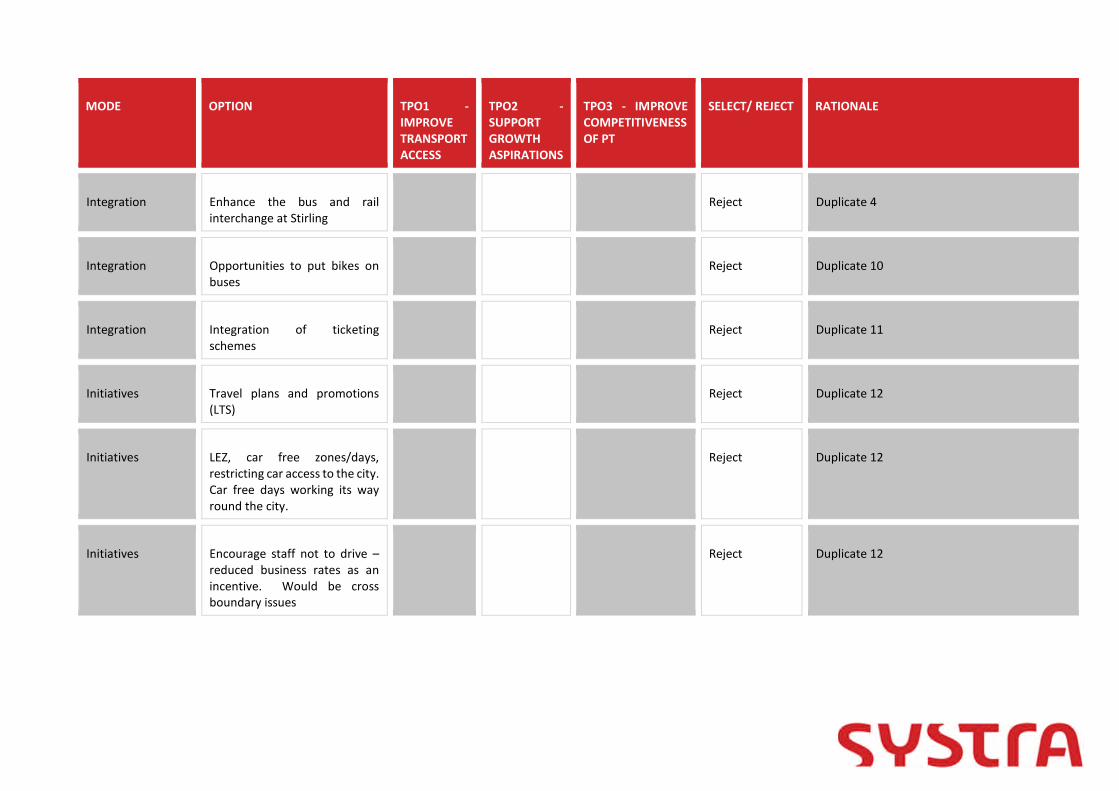
MODE OPTION TPO1 -IMPROVETRANSPORTACCESS
TPO2 -SUPPORTGROWTHASPIRATIONS
TPO3 - IMPROVECOMPETITIVENESSOF PT
SELECT/ REJECT RATIONALE
Integration Enhance the bus and railinterchange at Stirling
Reject Duplicate 4
Integration Opportunities to put bikes onbuses
Reject Duplicate 10
Integration Integration of ticketingschemes
Reject Duplicate 11
Initiatives Travel plans and promotions(LTS)
Reject Duplicate 12
Initiatives LEZ, car free zones/days,restricting car access to the city.Car free days working its wayround the city.
Reject Duplicate 12
Initiatives Encourage staff not to drive –reduced business rates as anincentive. Would be crossboundary issues
Reject Duplicate 12

MODE OPTION TPO1 -IMPROVETRANSPORTACCESS
TPO2 -SUPPORTGROWTHASPIRATIONS
TPO3 - IMPROVECOMPETITIVENESSOF PT
SELECT/ REJECT RATIONALE
Initiatives Travel plans and promotionsacross council boundaries (carsharing)
Reject Duplicate 12
Land use planning City Centre campus forUniversity
Reject Duplicate 13
Land use planning Develop industry close tohousing- developer'scontribution
Reject Duplicate 13
Other Community transport - targetat interchange opportunities
Reject Duplicate 14
Other Improved sustainable access tobig employers and large events
Reject Duplicate 12
Other Change school times like St.Modans to avoid school trafficon Causewayhead Road
Reject Duplicate 15
Other Provide easier access to/fromCumbernauld and Motherwell(coach/rail)
Reject Duplicate 2
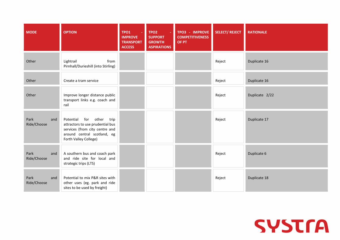
MODE OPTION TPO1 -IMPROVETRANSPORTACCESS
TPO2 -SUPPORTGROWTHASPIRATIONS
TPO3 - IMPROVECOMPETITIVENESSOF PT
SELECT/ REJECT RATIONALE
Other Lightrail fromPirnhall/Durieshill (into Stirling)
Reject Duplicate 16
Other Create a tram service Reject Duplicate 16
Other Improve longer distance publictransport links e.g. coach andrail
Reject Duplicate 2/22
Park andRide/Choose
Potential for other tripattractors to use prudential busservices (from city centre andaround central scotland, egForth Valley College)
Reject Duplicate 17
Park andRide/Choose
A southern bus and coach parkand ride site for local andstrategic trips (LTS)
Reject Duplicate 6
Park andRide/Choose
Potential to mix P&R sites withother uses (eg. park and ridesites to be used by freight)
Reject Duplicate 18

MODE OPTION TPO1 -IMPROVETRANSPORTACCESS
TPO2 -SUPPORTGROWTHASPIRATIONS
TPO3 - IMPROVECOMPETITIVENESSOF PT
SELECT/ REJECT RATIONALE
Park andRide/Choose
Park and ride opportunity atAlloa (currently 40-50 spaces)
Reject Duplicate 20
Park andRide/Choose
Improvements to existing P&Rincluding strategic coach/busservices, improved frequency,improved walking and cyclingconnections/facilities(including Nextbike), tourismbus, connections toemployment and educationdestinations, active travel hubwith good connections, goodfacilities
Reject Duplicate 18
Park andRide/Choose
Shuttle buses connecting P&Rhubs
Reject Duplicate 18
Park andRide/Choose
Relocated Springkerse withimproved facilities
Reject Duplicate 18
Park andRide/Choose
Provide park & ride sites atPirnhall
Reject Duplicate 6

MODE OPTION TPO1 -IMPROVETRANSPORTACCESS
TPO2 -SUPPORTGROWTHASPIRATIONS
TPO3 - IMPROVECOMPETITIVENESSOF PT
SELECT/ REJECT RATIONALE
Park andRide/Choose
Tourist bus going to all sitesfrom park & ride
Reject Duplicate 18
Park andRide/Choose
Higher frequency of park & ride Reject Duplicate 18
Park andRide/Choose
Park and ride facilities - makeuse of existing long distanceservices, tourism bus,connections to employmentand education destinations,active travel hub with goodconnections, good facilities
Reject Duplicate 18
Park andRide/Choose
Green Travel Hub atSpringkerse, swap to other sideof A91, EV charging,café/tourist draw on top floorto take advantage of the view,bridge to cycle/walking routes
Reject Duplicate 18
Park andRide/Choose
Low carbon transport andtravel hubs at park and choosesites (LTS) at all potential sites
Reject Duplicate 18
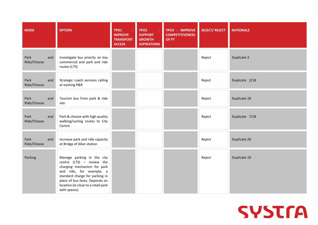
MODE OPTION TPO1 -IMPROVETRANSPORTACCESS
TPO2 -SUPPORTGROWTHASPIRATIONS
TPO3 - IMPROVECOMPETITIVENESSOF PT
SELECT/ REJECT RATIONALE
Park andRide/Choose
Investigate bus priority on keycommercial and park and rideroutes (LTS)
Reject Duplicate 3
Park andRide/Choose
Strategic coach services callingat existing P&R
Reject Duplicate 2/18
Park andRide/Choose
Tourism bus from park & ridesite
Reject Duplicate 18
Park andRide/Choose
Park & choose with high qualitywalking/cycling routes to CityCentre
Reject Duplicate 7/18
Park andRide/Choose
Increase park and ride capacityat Bridge of Allan station
Reject Duplicate 20
Parking Manage parking in the citycentre (LTS) – review thecharging mechanism for parkand ride, for example, astandard charge for parking inplace of bus fares. Depends onlocation (ie close to a retail parkwith spaces)
Reject Duplicate 19

MODE OPTION TPO1 -IMPROVETRANSPORTACCESS
TPO2 -SUPPORTGROWTHASPIRATIONS
TPO3 - IMPROVECOMPETITIVENESSOF PT
SELECT/ REJECT RATIONALE
Parking Travel plans Reject Duplicate 12
Parking Workplace parking levy Reject Duplicate 12
Parking Different roles for parking –loading bay during the day,available for parking during thenight
Reject Duplicate 19
Parking Increased parking at stations: a)Stirling, b) Dunblane, c) Bridgeof Allan, d) Alloa, e) Larbert
Reject Duplicate 20
Parking Additional parking at Larbert Reject Duplicate 20
Rail New Bannockburn/SouthStirling Rail Station and service(DPMTAG/LTS/STPR)
Reject Duplicate 23
Rail Relocated Bridge of Allanstation (closure and reopening)(DPMTAG/LTS)
Reject Duplicate 21

MODE OPTION TPO1 -IMPROVETRANSPORTACCESS
TPO2 -SUPPORTGROWTHASPIRATIONS
TPO3 - IMPROVECOMPETITIVENESSOF PT
SELECT/ REJECT RATIONALE
Rail Improve journey times,frequencies of rail services(frequency of Alloa toEdinburgh)
Reject Duplicate 22
Rail Dunfermline to Stirling railconnectivity
Reject Duplicate 22/23
Rail Fare managementto encourage rail trips withinthe travel to work area of thestirling/strathallancommnunities
Reject Duplicate 11
Rail Park & ride at Dunblane(increased parking provision)
Reject Duplicate 20
Rail New station at Cornton (retainBridge of Allan Station)
Reject Duplicate 23
Rail Rail halt at Manor Powis (parkand ride)
Reject Duplicate 23
Rail Link to WCML Reject Duplicate 22

MODE OPTION TPO1 -IMPROVETRANSPORTACCESS
TPO2 -SUPPORTGROWTHASPIRATIONS
TPO3 - IMPROVECOMPETITIVENESSOF PT
SELECT/ REJECT RATIONALE
Rail Station at Cambus Reject Duplicate 23
Rail New station at Causewayhead(Alloa line)
Reject Duplicate 23
Rail Provide a station betweenDunblane and Gleneagles atBlackford or Greenloaning tocapture people from Crieff etc
Reject Duplicate 23
Rail New Cowie/South Stirling RailStation and service(DPMTAG/LTS/STPR)
Reject Duplicate 23
Rail Railway halt at Cowie andCausewayhead
Reject Duplicate 23
Rail South Stirling Train Station Reject Duplicate 23
Rail Rail park & ride on southside ofStirling (Plean/Cowie) withconnection from M9
Reject Duplicate 23

MODE OPTION TPO1 -IMPROVETRANSPORTACCESS
TPO2 -SUPPORTGROWTHASPIRATIONS
TPO3 - IMPROVECOMPETITIVENESSOF PT
SELECT/ REJECT RATIONALE
Rail Rail station at Cambus Reject Duplicate 23
Rail Increase the number of trainsto Alloa
Reject Duplicate 22
Rail Clackmannanshire P&R (railhalt)
Reject Duplicate 23
Rail Re-open the Alloa toDunfermline Railway
Reject Duplicate 23
Rail Increased parking at Stirlingrailway station
Reject Duplicate 20
Rail Increase parking capacity atstations (and signage)
Reject Duplicate 20
Rail Decreased parking at Stirlingrailway station
Reject Duplicate 20
Road More access points from theM9 (addresses problems atCraigforth)
Reject Duplicate 24
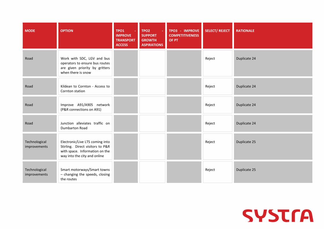
MODE OPTION TPO1 -IMPROVETRANSPORTACCESS
TPO2 -SUPPORTGROWTHASPIRATIONS
TPO3 - IMPROVECOMPETITIVENESSOF PT
SELECT/ REJECT RATIONALE
Road Work with SDC, LGV and busoperators to ensure bus routesare given priority by gritterswhen there is snow
Reject Duplicate 24
Road Kildean to Cornton - Access toCornton station
Reject Duplicate 24
Road Improve A91/A905 network(P&R connections on A91)
Reject Duplicate 24
Road Junction alleviates traffic onDumbarton Road
Reject Duplicate 24
Technologicalimprovements
Electronic/Live LTS coming intoStirling. Direct visitors to P&Rwith space. Information on theway into the city and online
Reject Duplicate 25
Technologicalimprovements
Smart motorways/Smart towns– changing the speeds, closingthe routes
Reject Duplicate 25

MODE OPTION TPO1 -IMPROVETRANSPORTACCESS
TPO2 -SUPPORTGROWTHASPIRATIONS
TPO3 - IMPROVECOMPETITIVENESSOF PT
SELECT/ REJECT RATIONALE
Technologicalimprovements
Traffic lights – change inprioritization of flowsdepending on congestion/airquality
Reject Duplicate 25
Technologicalimprovements
Provide real time information -bus
Reject Duplicate 25
Technologicalimprovements
Electric taxis and buses Reject Duplicate 25
Report Appendix F Environmental
1. STIRLING - ENVIRONMENTAL PRE-APPRAISAL
1.1.1 In this pre-appraisal we have considered the following environmental sub-criteria:
Noise; Global air quality - carbon dioxide (CO2); Local air quality - particulates (PM10) and nitrogen dioxide (NO2); Hydrology, Hydrogeology and Flooding; Geology; Biodiversity and habitats; Landscape; Visual amenity; Agriculture and soils; and Cultural heritage.
1.2 Noise
1.2.1 Ten candidate noise management areas have been identified in Stirling by the ScottishGovernment for further study as these are in the top 1% of transport noise locations inScotland. All are linked to road traffic noise. With the increases forecast in road trafficand population over the period of the Strategy it is likely that the number of peoplesubject to noise impacts may increase. Major noise contributors within Stirling comprisepredominately of road and railway traffic. Stirling City Council’s website indicates thatpublic noise complaints made are predominately for ‘anti-social behaviour’.
1.3 Air Quality
1.3.1 There are no Air Quality Management Areas (AQMAs) within Stirling. Local monitoringdata shows that annual mean NO2 and annual mean PM10 concentrations are well belowtheir relevant objectives. This includes monitoring sites at locations close the A9 and A905junction where high traffic volumes and queuing at the roundabout are likely to lead toelevated roadside pollutant concentrations.
1.4 Hydrology, Hydrogeology and Flooding
Hydrology
1.4.1 Stirling contains four surface water bodies recorded by SEPA, the River Forth, River Teith,Allan Water and Bannock Burn. To the north east the River Forth (Upper Estuary ID:200437 and River ID: 4700) are both classified as having an overall status of Moderate(2017). Allan Water (ID:6832) which enters the River Forth to the north of the city is alsoclassified by SEPA as having an overall status of Moderate (2017) as does the River Teith(ID: 6834) which enters the River Forth to the north west of the city. The Bannock Burn(ID: 6830) flows from south west to north east entering the Forth Estuary east of Stirling.The Pelstream Burn, Town Burn and Raploch Burn are not recorded by SEPA, however thelatter flows in the north of Stirling whilst the other two are present in the east.
Hydrogeology
1.4.2 SEPA records two groundwater bodies below Stirling, the Stirling aquifer (ID:150571)classified as having an overall status of Poor (2017) and Teith and Forth Valleys aquifer(ID:150809) classified as having an overall status of Good (2017). Ochils North (ID:150499)and Carron and Touch (ID150598) are also located in close proximity and have overallconditions of Good.
1.4.3 There are two dominant aquifers below the greater Stirling area. In the west a largeigneous complex dominates the geology, this Permian intrusion is classed as a lowproductivity aquifer and contains small amounts of groundwater in near surfaceweathered zones and secondary fractures, with rare springs. The eastern section ofStirling is dominated by the Clackmannan group, this aquifer is regarded as beingmoderately productive, this is a multi-layered aquifer with low yields except wheredisturbed by mining. Passage Group sandstone has moderate yields up to 10l/s.
1.4.4 The DWQR website does not record any private water supplies however a number of TypeB supplies are present in the much wider surrounds. Stirling is not within a Drinking WaterProtected Area for surface water although one is present immediately west of Stirlingbeyond Cambusbarron. Stirling is within a Drinking Water Protected area forgroundwater.
Flooding
1.4.5 Areas surrounding the above identified rivers are shown to be at high risk from fluvialflooding on the SEPA online flood mapping. Surface water flooding is shown in pocketsthroughout the region from low to high risk. Coastal flooding is isolated to areasimmediately adjacent to the estuarine section of the River Forth in the north/east ofStirling and the Bannock Burn east of Stirling. The closest SEPA recorded flood defencesare in Bridge of Allan and Alloa. North of Stirling an area where groundwater couldinfluence the duration and extent of flooding from other sources is recorded but this isnot recorded elsewhere.
1.5 Conservation Value
1.5.1 The River Teith is a Special Area of Conservation due to the presence of several species oflamprey and, to a lesser extent, salmon. Several kilometres downstream of Stirling theFirth of Forth is SSSI, Special Protection Area and Ramsar designated.
1.6 Geology
1.6.1 The majority of Stirling is covered by Late and Post-Glacial Raised Beach Deposits whichincludes marine and estuarine alluvium. Areas to the north and south of the city aredominated by Glacial Tills, with pockets of flood plain alluvium found along the channelsof the watercourses in places.
1.6.2 Stirling is underlain by two main rock groups, separated by a dominant fault line. The OldRed Sandstone succession is found in the north of the city. These red sandstones areseparated from the Carboniferous sedimentary succession, found in the centre and southof Stirling, by the Ochil Fault. Both of these successions have their own igneouscomplexes, with considerable extrusive and intrusive igneous rock recorded across thearea. The Carboniferous succession is known to be coal bearing. Extensive miningthroughout this succession is well documented, with the whole of Stirling within a CoalAuthority Coal Mining Reporting area, however Development High Risk Areas arepredominantly in the south and east.

1.6.3 As an urban area contamination can be anticipated due to previous industrial usesincluding along the line of the railway and sidings, as well as gasworks.
1.6.4 No special designations relating to geology and soils are located in Stirling. Within closeproximity to Stirling Abbey Craig is a SSSI, recorded for beetles. Several GeologicalConservation review sites are located west in the Touch Hills.
1.7 Biodiversity and habitats
1.7.1 Within 5 km of the Stirling area, a number of sites have been statutorily designated fortheir biodiversity and/or habitat interest (Table 1). These statutorily designated natureconservation sites must be considered when developments have the potential to impacton their qualifying features. The following designations are included:
Special Protection Areas (SPA) are designated under the EU Birds Directive andprovide protection to sites that support internationally important bird populations;
Special Areas of Conservation (SAC) are designated under EU Habitats Directive andsafeguard populations of species listed in the directive and the best examples ofhabitats listed in the directive;
Ramsar sites are designated under the Convention on Wetlands of InternationalImportance and are usually linked to the SPA and SAC network. All have anunderpinning SSSI designation (see below);
Sites of Special Scientific Interest (SSSI) are designated under the NatureConservation (Scotland) Act 2004 and safeguard nationally important speciespopulations or habitats.
1.7.2 Within 5 km of the Stirling area, there are two SACs, one SPA and five SSSIs (Table 1).Depending on the location, nature and scale of any proposed development, the qualifyingfeatures of these sites are potentially vulnerable to adverse impacts due to directdamage/loss of habitats, habitat fragmentation, barriers to species movement, loss ofconnectivity between important sites/habitats and disturbance to or degradation of thequalifying feature. The principal potential impacts that may affect these sites are listed inTable 1. In addition to the SSSI designation, Balquhidderock Wood is also a Local NatureReserve.
1.7.3 There are six areas listed on the Ancient Woodland Inventory (AWI) within the Stirlingarea, and sixty AWI compartments in a wider 2 km buffer (Map 2). Scottish Planning Policyidentifies ancient woodland as ‘an important and irreplaceable national resource thatshould be protected and enhanced’. AWI sites within the Stirling area are vulnerable todirect loss and damage, fragmentation, loss of connectivity and degradation and shouldbe considered at an early stage of any proposed development.
1.7.4 In line with Policy 1.3 of the Stirling Local Development Plan 2018, any new developmentsshould take account of impacts on the Central Scotland Green Network (CSGN) plus localGreen Network and Open Space strategies. Importantly, options to contribute to theseinitiatives or their objectives should be considered in any proposed development. TheCSGN has mapped integrated habitat networks for a number of habitat types: neutralgrassland, acid grassland, heathland, wetland and woodland. The Stirling area and areaswithin 5 km support part of the network for all these habitats.
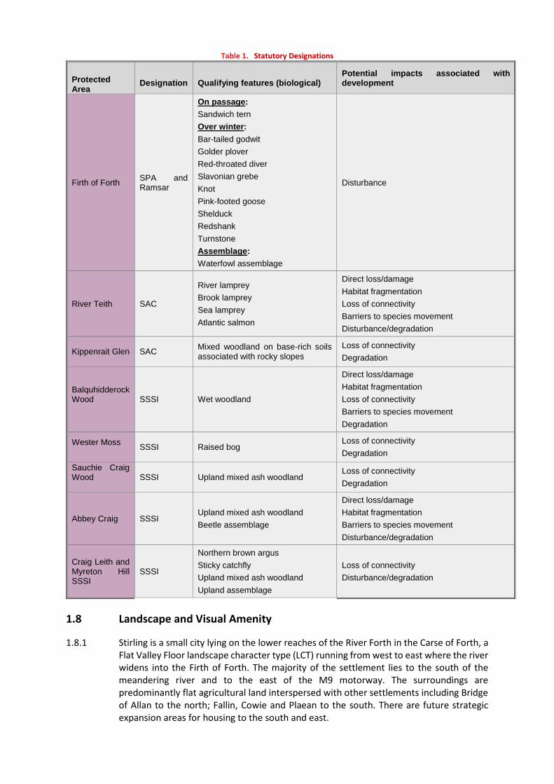
Table 1. Statutory Designations
ProtectedArea
Designation Qualifying features (biological)Potential impacts associated withdevelopment
Firth of ForthSPA andRamsar
On passage:
Sandwich tern
Over winter:
Bar-tailed godwit
Golder plover
Red-throated diver
Slavonian grebe
Knot
Pink-footed goose
Shelduck
Redshank
Turnstone
Assemblage:
Waterfowl assemblage
Disturbance
River Teith SAC
River lamprey
Brook lamprey
Sea lamprey
Atlantic salmon
Direct loss/damage
Habitat fragmentation
Loss of connectivity
Barriers to species movement
Disturbance/degradation
Kippenrait Glen SACMixed woodland on base-rich soilsassociated with rocky slopes
Loss of connectivity
Degradation
BalquhidderockWood SSSI Wet woodland
Direct loss/damage
Habitat fragmentation
Loss of connectivity
Barriers to species movement
Degradation
Wester MossSSSI Raised bog
Loss of connectivity
Degradation
Sauchie CraigWood SSSI Upland mixed ash woodland
Loss of connectivity
Degradation
Abbey Craig SSSIUpland mixed ash woodland
Beetle assemblage
Direct loss/damage
Habitat fragmentation
Barriers to species movement
Disturbance/degradation
Craig Leith andMyreton HillSSSI
SSSI
Northern brown argus
Sticky catchfly
Upland mixed ash woodland
Upland assemblage
Loss of connectivity
Disturbance/degradation
1.8 Landscape and Visual Amenity
1.8.1 Stirling is a small city lying on the lower reaches of the River Forth in the Carse of Forth, aFlat Valley Floor landscape character type (LCT) running from west to east where the riverwidens into the Firth of Forth. The majority of the settlement lies to the south of themeandering river and to the east of the M9 motorway. The surroundings arepredominantly flat agricultural land interspersed with other settlements including Bridgeof Allan to the north; Fallin, Cowie and Plaean to the south. There are future strategicexpansion areas for housing to the south and east.

1.8.2 The city has an extensive historic core, with scheduled monuments including StirlingCastle, extensive conservation areas and many listed buildings. There are also threeextensive battlefield sites surrounding the city. There are many parks and greenspaces.
1.8.3 The wider setting of the city and Forth valley includes the Ochil Hills, a Lowland Hills LCTto the northeast and the East Touch Fringe, a Farmed Hill Fringe LCT to the southwest.
1.8.4 Stirling and its surrounding settlements do not lie within a designated landscape. Howeverthree local landscape designations bracket the river valley, bordering the mainsettlement: the Keir Local Landscape Area (LLA) to the northwest; the Western Ochilscovering the Ochil Hills and their fringes to the north and northeast and the Southern HillsLLA covering the Touch, Gargunnock and Fintry Hills to the west.
1.8.5 The Stirling greenbelt surrounds much of the main settlement, separating it from othernearby settlements including Bridge of Allan, Fallin and Cowie as well as areas betweenthe M9 and western edges and the A91 and northeast Stirling.
1.8.6 There are four inventory Garden & Designed Landscapes either in or around Stirling: twoclose to the castle, the grounds of Airthrey Castle which host the University campus andthe Keir estate north of Bridge of Allan.
1.8.7 Potential visual receptors include:
Tourists visiting Stirling and surrounding attractions including Bannockburn and theWallace monument
residents of/ visitors to Stirling and surrounding settlements users of the A and B roads passing through and round the settlements cyclists on Cycle Routes 76 and 765 passing through the area drivers on the M9 users of the many core paths within and surrounding the settlements, including
those overlooking the setting of Stirling and the Forth from the southern edge ofthe Ochils and the eastern Touch Hill fringes.
1.9 Agriculture and soils
1.9.1 Scotland Environment Web’s ‘National Scale Land Capability for Agriculture Map’ showsthe land within/surrounding Stirling comprises of land with the following classifications:
Class 7 – Urban; Class 3.1 - Land capable of producing consistently high yields of a narrow range of
crops and/ or moderate yields of a wider range. Short grass leys are common; and Class 4.1 - Land capable of producing a narrow range of crops, primarily grassland
with short arable breaks of forage crops and cereal.
1.9.2 The Stirling area has a proud agricultural history and is an important area for livestock andcrop farming in Scotland.
1.10 Cultural heritage
1.10.1 Little is known of the earliest settlement at Stirling, but the remains of an Iron Age vitrifiedhill fort are located on Gowanhill. The Roman road north to Ardoch Fort passed throughthe King’s Park area before crossing the River Forth. Situated on a rocky crag, StirlingCastle dates from the twelfth century and the town was established as a Royal Burgh byDavid I (1124-53). The medieval town was concentrated on the sloping ridge below thefortified crag. Stirling occupies a strategic location at what was the lowest bridging pointon the River Forth between the Highlands and Lowlands of Scotland. Many importantbattles in Scottish history took place in sight of the town within the surrounding land
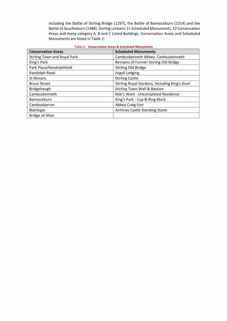
including the Battle of Stirling Bridge (1297), the Battle of Bannockburn (1314) and theBattle of Sauchieburn (1488). Stirling contains 11 Scheduled Monuments, 12 ConservationAreas and many category A, B and C Listed Buildings. Conservation Areas and ScheduledMonuments are listed in Table 2.
Table 2. Conservation Areas & Scheduled Monuments
Conservation Areas Scheduled Monuments
Stirling Town and Royal Park Cambuskenneth Abbey, Cambuskenneth
King’s Park Remains of Former Stirling Old Bridge
Park Place/Randolphfield Stirling Old Bridge
Randolph Road Argyll Lodging
St Ninians Stirling Castle
Bruce Street Stirling Royal Gardens, including King's Knot
Bridgehaugh Stirling Town Wall & Bastion
Cambuskenneth Mar's Wark - Uncompleted Residence
Bannockburn King's Park - Cup & Ring Mark
Cambusbarron Abbey Craig Fort
Blairlogie Airthrey Castle Standing Stone
Bridge of Allan

SYSTRA provides advice on transport, to central, regional and local government, agencies,developers, operators and financiers.
A diverse group of results-oriented people, we are part of a strong team of professionalsworldwide. Through client business planning, customer research and strategy developmentwe create solutions that work for real people in the real world.
For more information visit www.systra.co.uk
Other locations:
France:Bordeaux, Lille, Lyon, Marseille, Paris
Northern Europe:Astana, Copenhagen, Kiev, London, Moscow, Riga, Wroclaw
Southern Europe & Mediterranean: Algiers, Baku, Bucharest,Madrid, Rabat, Rome, Sofia, Tunis
Middle East:Cairo, Dubai, Riyadh
Asia Pacific:Bangkok, Beijing, Brisbane, Delhi, Hanoi, Hong Kong, Manila,Seoul, Shanghai, Singapore, Shenzhen, Taipei
Africa:Abidjan, Douala, Johannesburg, Kinshasa, Libreville, Nairobi
Latin America:Lima, Mexico, Rio de Janeiro, Santiago, São Paulo
North America:Little Falls, Los Angeles, Montreal, New-York, Philadelphia,Washington
Birmingham (Newhall Street)5th Floor, Lancaster House, Newhall St,Birmingham, B3 1NQT: +44 (0)121 393 4841
Birmingham (Suffolk Street)8th Floor, Alpha Tower, Crowne Plaza, Suffolk Street,Birmingham, B1 1TTT: +44 (0)121 393 4841
Dublin2nd Floor, Riverview House, 21-23 City Quay,Dublin 2,IrelandT: +353 (0) 1 566 2028
EdinburghProspect House, 5 Thistle Street,Edinburgh, EH2 1DFT: +44 (0)131 460 1847
Glasgow7th Floor, 124 St Vincent Street,Glasgow, G2 5HFT: +44 (0)141 468 4205
Leeds100 Wellington Street,Leeds, LS1 1BAT: +44 (0)113 360 4842
London3rd Floor, 5 Old Bailey,London, EC4M 7BAT: +44 (0)203 855 0079
Liverpool5th Floor, Horton House,Exchange FlagsLiverpool, L2 3PFT: +44 (0)151 607 2278
Manchester16th Floor, City Tower, Piccadilly Plaza,Manchester, M1 4BTT: +44 (0)161 504 5026
NewcastleFloor B, South Corridor, Milburn House, Dean Street,Newcastle, NE1 1LET: +44 (0)191 249 3816
Perth13 Rose Terrace,Perth, PH1 5HAT: +44 (0)131 460 1847
WokingDukes Court, Duke Street,Woking, Surrey, GU21 5BHT: +44 (0)1483 357705


