
1
SOUTHEAST O‘AHU GEOLOGY FIELD TRIP GUIDE
Scott K. Rowland (Hawai‘i Institute of Geophysics & Planetology)Michael O. Garcia (Department of Geology & Geophysics)
UNIVERSITY OF HAWAI‘I AT MĀNOA

2
Above: Geologic map of O‘ahu, from Macdonald et al. (1983)
This guide borrows from previous guides written by George Walker, Ralph Moberly, and Steve Self

1
INTRODUCTIONThis field trip will examine
the geologic structure, history,and features of thesoutheastern part of Ko‘olauVolcano. Many of the originalliterature sources are difficult tofind so we have tended to citemore recent compilations suchas Volcanoes in the Sea(Macdonald et al. 1983). TheIsland of O‘ahu is constructedfrom two shield volcanoes,Wai‘anae and Ko‘olau (frontinside cover; Figure 1). Both ofthese volcanoes were at onetime at least the size thatKīlauea is today, and probablyeven larger (Figure 2).Wai‘anae is the older of the two(subaerial flows are ~3.9 to~2.8 million years old; e.g.,Presley et al. 1997) and makesup the western part of O‘ahu.Ko‘olau is younger and makes up theeastern part. Its subaerial shield flows are~2.9 million to 2.1 million years old, and aswe will see later, after these shield flows hadbeen eroded for a considerable time,rejuvenated activity occurred, lasting untilperhaps as recently as 30 to 50 thousandyears ago.
The life history of a Hawaiian volcanohas been summarized by Macdonald et al.(1983) and Peterson & Moore (1987; Figure3). In short, as the oceanic lithospherepasses over the upwelling mantle that iscalled the Hawaiian hotspot, it firstencounters a region of low amounts ofmelting on the edge of the hotspotproducing alkalic magma, then a region ofhigh amounts of melting in the center of thehotspot producing tholeiite magma, andfinally another region of low amounts ofmelting on the other side of the hotspotproducing alkalic magma. Thecorresponding volcanic stages are thealkalic pre-shield stage (e.g., Lō‘ihi), the tholeiite shield stage (e.g., Mauna Loa and Kīlauea), the post-shield alkalic stage (e.g., Hualālai and Mauna Kea), and finally an erosional stage (e.g., Kohala) onceit has moved completely off the hotspot. Following extended periods of erosion, both gradual andcatastrophic, some Hawaiian volcanoes undergo a period of rejuvenation. The lavas erupted during
Figure 2: Kīlauea (A) and Ko‘olau (B) volcanoes drawn at the samescale (from Walker 1987). Kīlauea contours are in feet, Ko‘olaucontours (also in feet) are generalized from present topography (solid)and inferred (dashed) to show the original form of the shield volcano.Note that Ko‘olau has probably subsided by at least 1000 m since itmoved off the hotspot.
Figure 1. Shaded relief image of O‘ahu. The dashed line approximates the boundarybetween Wai‘anae and Ko‘olau.

2
this rather enigmatic stage are commonly strongly alkalic, occasionally contain mantle xenoliths, andthe eruptions are spread far enough in time and space that they result in individual monogenetic vents(tuff cones, scoria cones, and lava shields). The relationship between this activity and the hotspot isnot yet fully understood. Eventually, 100,000 to ~2 million years later, even the rejuvenation activityceases. The volcano is worn down by rain and waves, and subsides until only coral reefs remainabove sea level. Because plate motion is to the northwest, into colder water, reef growth gets slowerand slower and finally is unable to keep up with erosion and subsidence. The volcano ends its life as itbegan, as a seamount (Figure 3).
KO‘OLAU VOLCANOKo‘olau volcano started its life
as a seamount above theHawaiian hotspot ~4 million yearsago. It broke sea level some timeprior to 2.9 million years ago, theage of the oldest subaerial lavas(Haskins & Garcia 2004). Duringits tholeiite shield stage, Ko‘olauvolcano eventually reached anelevation of at least 2000 m (thecurrent highest elevation is ~1100m). Ko‘olau does not haveevidence of having ever gonethrough the post-shield alkalicstage. Only 2-3 outcrops ofalkalic basalt have beendiscovered near the top of thetholeiite section where thebeginning of a transition to fullyalkalic eruptions might beexpected. Why this stage might be skipped is not clear but it should be pointed out that the volume ofpost-shield volcanics on other Hawaiian volcanoes varies considerably from only a little (e.g. Kaua‘i) toa lot (e.g. Mauna Kea). Therefore, it is entirely possible that there was a relatively small amount ofpost-shield alkalic lava erupted on Ko‘olau but that it has been eroded or avalanched away.
Ko‘olau possessed the typical structural features of a Hawaiian volcano, specifically a caldera aswell as two to three rift zones radiating away from the caldera (Figure 4). The rift zones are the causeof the northwest-southeast elongated plan view shape of Ko‘olau, and this shape was accentuated bycatastrophic avalanching of the northeast side of the volcano. We will examine evidence for thesemajor structural features as well as for the catastrophic avalanche during our field trip. Gradualsubsidence combined with both gradual and catastrophic erosion have combined to produce thecurrent, smaller edifice.
The main tholeiite shield-building stage of Ko‘olau volcano ended somewhere around 2.1 millionyears ago (e.g. Langenheim & Clague 1987), and erosion took over as the dominant geologic process.As on other Hawaiian volcanoes, the northeast side of the volcano (facing the prevailing tradewinds)was eroded to a greater degree than the leeward side. As shown in Figure 5, there are very largerainfall gradients from northeast to southwest across the crest of Ko‘olau, with rainfall values climbingfrom ~50 to >300 and back to ~50 inches per year within only 25 km. This has led to very unevendegrees of erosion of the volcano. For example, there are remnants of the original shield surfacealong most of the southwest flank of Ko‘olau, but essentially none on the northeast flanks. Remnantsof the old shield surface take the form of planezes between amphitheater-headed valleys, and many ofthem are highlighted today by expensive subdivisions.
Figure 3: Sequence of diagrams illustrating the life history of Hawaiian volcanoes(adapted from Peterson & Moore 1987).

3
REJUVENATED VOLCANISMThe rejuvenated stage of Hawaiian
volcanism has produced dramatic sceneryand has attracted attention for a long time.The Hawaiian stories of Pele, the goddessof volcanoes, has her stopping on eachisland as she journeyed from Kaua‘i toHawai‘i (e.g. Westervelt 1963), and eachof the places she is said to have restedturns out to be what modern geologistsconsider to be a site of rejuvenatedvolcanism. The rejuvenation-stagevolcanism on Ko‘olau is called theHonolulu Volcanic Series. About 40Honolulu Volcanic Series vents have beenidentified and they are all concentratedwithin the southeastern third of theelongate Ko‘olau edifice (Figure 4).
Presently, there are many competingideas for the origin of rejuvenation-stagevolcanism. One mechanism is related tothe giant avalanches that have occurredon some of the Hawaiian volcanoes. The idea is that the removal of a large overburden by theavalanche causes the lithosphere and underlying mantle to rebound a little bit, accompanied bydepressurization and partial melting. Although this mechanism has been shown to have occurredduring the post-shield alkalic stage of Wai‘anae volcano (Presley et al. 1997), no studies have linkedany specific giant avalanches to specific rejuvenation volcanic features. In particular, the Nu‘uanulandslide occurred well before the oldest known Honolulu Volcanic Series eruptions. Additionally,giant avalanches have occurred off Mauna Loa, which is still in its tholeiitic shield stage (e.g. Moore etal. 1989).
Another proposed mechanism involves northwestward movement of the lithosphere dragginghotspot material downstream. The hot mantle material conducts heat to the overlying lithosphere,causing it to melt (Gurriet 1987). One problem withthis idea is it provides no explanation for the break intime between the end of the post-shield alkalic stageand the rejuvenation stage. One of the more popularmodels involves depressurization of the upper mantledue to flexure of the oceanic lithosphere. Essentially,the lithosphere is considered as a lever that is beingpushed downward at the hotspot end (i.e., under theisland of Hawai‘i), and moving upward ~300 km“downstream”. The upward motion depressurizes theunderlying upper mantle, leading to small amounts ofpartial melting and the production of highly alkalicmagmas. Most recently, numerical modeling by Ribe& Christensen (1999) predicts that there will bemantle upwelling and the production of alkalicmagmas 300-500 km downstream of the hotspotcenter. It is definitely possible that more than onemechanism is at work. Perhaps the heating of the lithosphere model explains the early Honolulu
Figure 4. Geological/structural map of the southeast part of Ko‘olauvolcano, showing the location of the old caldera (C), rift zones (graylines), and rejuvenation-stage (Honolulu Volcanic Series) vents and lavaflows. Adapted from a map by George Walker.
Figure 5. Rainfall map for O‘ahu (isohyets are ininches/year; from Macdonald et al. 1983). Note thegreat differences in rainfall over extremely shortdistances, particularly parallel to the direction of theprevailing tradewinds (northeast to southwest).

4
Volcanic Series activity, and the lithospheric flexure model explains the later Honolulu Volcanic Seriesactivity. Careful age dating by Ozawa et al. (2003) shows that within the Honolulu Volcanic Seriesthere are two pulses of magmatism separated by a hiatus of ~250,000 years. The earlier pulse, whichlasted from 800,000 to 360,000 years ago, may have been due to mantle upwelling. The later pulse,from 100,000 to 30,000 years ago, may have been due to lithospheric flexure. Downward flexure isstill occurring under Hawai‘i and 30,000 years isn’t very long ago geologically - there is the possibilitythat rejuvenated volcanism could occur again on Ko‘olau!
STOP 1. NU‘UANU PALI OVERLOOKAfter driving up Nu‘uanu valley you reach the pali overlook. Geomorphologically this location is a
wind gap, where the heads of two oppositely-trending valleys intersect (Figure 6). On most days thisgeomorphic term is very appropriate. The view looks out to the windward side of O‘ahu, across whatwas the volcanic center of Ko‘olau volcano. In particular, the Kapa‘a area, the Ka‘iwa ridge, andOlomana all consist of thick lava flows that all dip very slightly towards a point centered in Kawainuimarsh. They therefore are intra-caldera lavas and the slight dips record inward sagging due tosubsidence over the old magma chamber (Walker 1988). Kawainui marsh also corresponds to thecenter of a gravity high (Strange et al. 1965) and overlies a zone of high seismic-velocity rocks (Adams
& Furumoto 1965). The boundary of thick, slightly inward-dipping lavas and thin, steeper outward-dipping lavas is therefore the caldera margin. It can be mapped to within a few hundred meters insome places but elsewhere is obscured by water or alluvium. It grazes the base of the Nu‘uanu pali inthe vicinity of the overlook.
Figure 6. Air photo looking west, of the Nu‘uanu pali (from Macdonald et al. 1983). Valley erosion workingnortheast and ~parallel retreat working southwest has produced wind gaps at the heads of Nu‘uanu and Kalihivalleys, and it is through (actually just below) these wind gaps that the first two cross-Ko‘olau tunnels (dashed)were built. Kōnāhuanui (918 m) and Lanihuli (803 m) are the two highest points on Ko‘olau.

5
In the far distance, the Mōkapu peninsula forms the northeastern-most point on O‘ahu and theKāne‘ohe Marine Corps Air Station is located there. The peninsula is composed of at least six closely-spaced rejuvenation-stage volcanic vents and lava flows. If you look to the right (along the pali) fromthe lookout you can see steeply dipping scoria and ash deposits from another rejuvenation stage ventthat was perched high on an eroded windward Ko‘olau slope. These north-dipping (to the right fromthis vantage point), red-colored scoria layers unconformably overlie south-dipping (to the left) ‘a‘ā andpāhoehoe flank lava flows. In places the contact between the flank flows and the rejuvenation-stagescoria and ash is sharp enough to put your finger on. This contact represents a time break of ~1.5million years.
Walking down the old Pali Road allowsgood views of pāhoehoe and ‘a‘ā flows(Figure 7) in cross-section perpendicular tothe direction in which they were flowing. Thefirst pāhoehoe flow you encounter consists ofnumerous lens- or lozenge-shaped flow unitscalled “toes”. Here they tend to be ~0.5 mwide and 20-30 cm high. The first ‘a‘ā flowalong the road is more difficult to examinebecause it is high in the section. However, itis possible to identify the basal clinker layer(with kind of a rubbly appearance), thecentral “core” (with steep, roughly verticalfractures), and the upper clinker layer (rubbly,with plants growing on it). There is also adike cutting through these flows. This dikehas a squiggly margin and is vesicular; bothsuggest that it was emplaced at a shallowdepth. Also somewhat unusual is itsorientation, striking ~north-south, which isroughly orthogonal to the typical Ko‘olau dike trend.
Nu‘uanu pali is one of the most spectacular geological features on O‘ahu (pali is the Hawaiianword for cliff). Many Hawaiian islands have pali but the Nu‘uanu pali is considered the classic exampleand is commonly just called “the Pali” (Stearns and Vaksvik 1935). Some pali are along the coast(e.g., north shores of Kaua‘i and Moloka‘i) and others are inland (e.g., on O‘ahu and Ni‘ihau). A widerange of suggestions have been offered to explain the origin of Nu‘uanu (and other) pali:1) Faulting - Dana (1891), the first geologist to visit Hawai‘i, proposed that great fractures wereresponsible for these cliffs. Such a fault would have at least 1 km of offset to have created theNu‘uanu Pali.2) Fluvial erosion - A young captain in the U.S. Army (George Dutton) visited Hawaii in the late 19th
century. He was a keen observer and his observations led him to conclude that erosion was the maincause of the pali (Dutton, 1883).3) Marine erosion - Some subsequent geologists combined marine erosion with faulting in explainingthe pali’s origin (e.g., Hinds, 1931).4) Caldera rim - This idea has been at least informally discussed based on the fact that the Ko‘olauvolcano caldera boundary grazes the pali in a few places, as does the margin of a Ko‘olau rift zone,just below the Nu‘uanu pali overlook (Macdonald et al. 1983; Walker 1987).5) Headwall of the Nu‘uanu landslide (see next section) - Marine surveys north of O‘ahu revealed thatthe northeast side of the Ko‘olau volcano collapsed into the ocean, removing ~40% of the old volcano(Moore and Clague, 2002; Satake et al., 2002). The location of the headwall for this landslide hasbeen debated but some have suggested it is the pali (Carracedo 1999). Hydrothermal alteration in the
Figure 7. Photo showing the typical nature of ‘a‘ā and pāhoehoe flowswhen viewed in cross-section. The cores of ‘a‘ā flows are resistantrelative to the top and bottom clinker layers. The pāhoehoe flows consistof innumerable toes and here differential erosion has accentuatedvesicle-poor (resistant) and vesicle-rich (less resistant) flow-parallelsheaths in each toe. Note that this cross section (low on the cliff belowMakapu‘u point) is oblique to the flow directions.

6
rift zone was thought to weaken the rocks and make them more susceptible to failure (Carracedo1999).
So we have many alternative models that can explain the formation of Pali. What keyobservations are needed to test these hypotheses?A) The shape of the pali - it is not a linear feature. Instead, it is scalloped with many embayments.Thus, a pure fault origin is unlikely. Also, the numerous scalloped features make a pure avalanchescar explanation problematic.B) Length of the pali - it extends well beyond the old Ko‘olau caldera margins. It is not the remnants ofan old caldera rim although locally it coincides with the rim.C) Residual ridges, remnants of the old Ko‘olau volcano, extending from the pali. These include theMokulua islands, Olomana, Kapa‘a, and the Keolu hills. Any avalanche scarp must be oceanward ofthese remnants.D) Former sea level stands were never high enough. Although sea level has fluctuation greatly overthe last two million years since the Ko‘olau volcano was formed, it was never high enough on O‘ahu tohave eroded the base of the pali (except at the Makapu‘u end). Also, there are no relict marinefeatures near the pali.
So what are we left with? As we explain below our current preferred model for the origin of theNu‘uanu pali is a combination of a head start provided by the giant avalanche followed by the fluvialerosion idea proposed by Capt. Clarence Dutton in 1883.
GIANT AVALANCHESJim Moore provided evidence that much
of the northeast flank of Ko‘olau volcano (aswell as much of E. Moloka‘i volcano; Figure8) avalanched onto the ocean floor (Moore1964). The idea was controversial at thetime but recent sampling has shown thatthe hummocky material spreadnortheastward from O‘ahu does indeedconsist of Ko‘olau lavas. Additionally, side-scan sonar data collected around the eightmain Hawaiian islands in the 1980sidentified at least 17 additional depositsfrom giant avalanches (Moore et al. 1989;Figure 9). We now know that the avalancheassociated with Ko‘olau (named theNu‘uanu avalanche) is one of the largestlandslides on Earth, with blocks up to 40 kmlong and 2 km tall having slid as far as 100km (Moore and Clague, 2002).
As we noted above, any avalanche scarmust be seaward of the seaward-mostremnant of the Ko‘olau volcano (Figure 10).This puts it at least a kilometer or so oceanward of the current coastline (i.e., just northeast of theMokulua islands. Immediately after the avalanche there would have been a cliff perhaps 2000 m high,which obviously would have been very unstable. Smaller avalanches and rapid marine and streamerosion would have caused this cliff to be eroded back (southwest). This process of “parallel retreat”has been documented at a number of locations on Earth, including along the northwest part of India(Widdowson & Cox 1996). Basically it states that if a cliff is produced (e.g., by an avalanche), it willpersist as a cliff as it is eroded landward. If the rocks involved are basalt lavas such as in Hawai‘i, the
Figure 8. Map of bathymetry off the north coasts of O‘ahu and Moloka‘ifirst used by Moore (1964) to postulate and outline the deposits of giantavalanches. Adapted from Moore (1964).

7
process is aided by the fact that almost all such flows posses roughly vertical cooling joints, that arecontinually exposed by erosion and weathering.
Not all the retreat was parallel, however. Aswe noted above there is evidence that fluvialerosion resulted in the formation ofamphitheater-headed valleys (Figures 5, 9),giving the pali its scalloped form. These scallopsare the coalesced heads of these valleys. Thenortheast-trending ridges are remnants of theridges that once separated the valleys.Olomana, for example, is a high point on theridge that separates Maunawili and Waimānalovalleys (Figure 10).
How catastrophic was the Nu‘uanuavalanche? After all, there are landslides thatjust creep slowly downslope. The best evidencefor catastrophe is that the Nu‘uanu avalanchedeposit had enough momentum to flow uphill onthe ocean floor. Figure 8 shows that theavalanche material flowed down off the flank ofKo‘olau, crossed the Hawaiian Deep (a moat-likedepression due to the weight of the island), andmanaged to lap up the other side of the
Hawaiian Deep. This required aclimb of roughly 300 m, andremember this was against waterresistance. A creeping landslidecould not have achieved this. Aninevitable question is how big of atsunami would such acatastrophic avalanche cause?The answer is that it would bedevastating within Hawai‘i (i.e.,>200 m high; Satake et al. 2002)but opinions vary about whetheror not it could also devastateother places such as the westcoast of North America. There iscurrently considerable debateabout whether a particulardeposit on the south flank ofLāna‘i was formed by a giant-avalanche-generated tsunami orby high sea level followed bytilting of the island.
Figure 9. Map showing the locations of giant avalanche andslump deposits off the 8 main Hawaiian islands (adapted fromMoore et al. 1989). The distal ends of some of the deposits arecharacterized by hummocky terrain (stippled).
Figure 10. Air photo of the southeast end of the pali (view is to the West; fromMacdonald et al. 1983). The view is to the northwest and was taken from aboveMakapu‘u. All flows to the left of the crest dip to the southwest. The plain northeastof the crest (occupied by houses and agricultural fields) consists of coral reef andbeach sand deposits formed during the +3 m Waimānalo stand of the sea 143,000-106,000 years ago. The approximate boundary of the caldera is indicated by adashed line. Olomana (444 m), under the cloud shadow, is the highest remnant ofthe pre-avalanche Ko‘olau volcano seaward of the pali. Other pre-avalancheremnants are indicated with R.

8
STOP 2. H-3 DIKESExposed along a section of the
H-3 freeway is the interior of the oldKo‘olau northwest rift zone (Figure11). This is identified by the highconcentration of 0.5-1.5 m-thickdikes, almost all of which strikenorthwest (e.g. Walker 1987; Figure12). Dikes are the mechanism bywhich magma propagates within avolcano from the magma chamber tothe point of eruption. Theyessentially slice through the pre-existing rock like knives. Indeed, thedimensions of dikes are similar tothose of knives. Studies on Kīlaueaand here on Ko‘olau show that typicaldike dimensions are as follows:Length (measured on a map from apoint above the magma chamber tothe eruption site) can be as much asa few 10s of km. Height (measured during dike propagation by locating the shallowest and deepestearthquakes along the dike trace) is typically 1-2 km. And thickness (measured in locations such asthis outcrop at H-3) is <1 m. Dikes are therefore much much thinner than they are tall or long.
George Walker, during his tenure asMacdonald Professor of Volcanology at theUniversity of Hawai‘i, conducted anexhaustive study of the Ko‘olau dike swarm,measuring and mapping thousands of dikes.One of his observations was that dikeintensity drops considerably in the areascorresponding to thick, caldera-filling lavas.He considered that there was no reason toexpect that dikes avoid intruding within thecaldera. Instead, he considered thatsubsidence within the caldera carried lavasdownward (along with any dikes thatintruded into them) below the level of thecurrent erosional surface (Walker 1987;1988).
Walker (1987) also pointed out thatmost of the Ko‘olau dikes have a relativelyconsistent northwest strike but they dip toboth the northeast and southwest. In manylocations, in a traverse perpendicular tostrike the dip will swing back and forth frompredominantly southwest to predominantlynortheast. In other places most dikes willhave one of these dips but there will be afew with the other so that they produce a braided pattern. Most of the dikes show prominent coolingfractures that grade from closely spaced at the dike margin to farther spaced at their centers. Many
Figure 11. Photograph of Ko‘olau dikes exposed in a roadcut along the PaliHighway. Guardrail is ~1 m high for scale.
Figure 12. Map of part of Ko‘olau volcano showing the locations andtrends of dikes (from Walker 1987). Note that dike intensity drops offmarkedly in the region of the caldera C.

9
also have glassy margins. Some show flow-differentiation-induced concentrations of vesicles, andmany of these vesicles have been filled with zeolites and other secondary minerals.
KĀNE‘OHE BAYA scenic overlook gives us a good
view of Kāne‘ohe Bay and beyond(Figure 13). A fringing reef extendsacross almost the whole of the bay,from Mōkapu (to our right) to Kualoa offin the distance. Sand bars havedeveloped in a few locations. Kapapaisland, on the outer edge of the reef, is~5 m high and preserves a fossil beachfrom a slightly higher stand of sea level3-4000 years ago. Patch reefs dot theinner waters of the bay. The islandnear the center is Moku o Lo‘e(Coconut Island) and it has beenaugmented artificially. It is home to theHawai‘i Institute of Marine Biology, partof the University of Hawai‘i.
In the late 1960s and early 1970s Kāne‘ohe Bay was an environmental disaster. Carelessdevelopment caused huge volumes of mud to be washed into the bay whenever it rained (which isoften here). Eventually much of the coral and most of the fish were dead or nearly dead and the influxof terrestrial nutrients spawned blooms of algae and exotic invertebrates. Public outcry led to strongerenvironmental laws regarding development and runoff control and today the bay is considerablyhealthier.
In the distance is a triangular peak, ‘Ōhulehule. It is a resistant peak partially because it has ahigh concentration of relatively resistant dikes in it. Additionally, from this viewpoint, the lavas in thehills to the right dip to the right (northeast) whereas the lavas in the hills to the left dip to the left(southwest). It is pretty clear therefore, that ‘Ōhulehule represents the axis of the rift zone.
STOP 3. WAIMĀNALOWe will next drive through the towns of Kailua
and Waimānalo. These towns mostly overlie ancientcoral reefs, and in places and calcareous sanddunes. Recent drill-hole studies in Kailua recordhigher and lower stands of sea level and theirassociated migration of the coastline. That samehigh stand of the sea recorded by the fossil beach onKapapa island, for example, was associated withmost of what is now Kailua town being under water.Semi-lithified dunes are exposed along the mainhighway just southeast of the Waimānalo shoppingarea (Figure 14). The dunes and reef in Waimānalocorrespond to an older episode of higher sea level,the 106,000-136,000 year-old +3 m Waimānalo stand. The record of changing sea level on O‘ahu isvery complex (Figure 15), and is currently being unraveled by the Coastal Geology group in UHMānoa’s Dept. of Geology & Geophysics, headed by Chip Fletcher.
Figure 13. Photo across Kāne‘ohe bay looking along the axis of the Ko‘olaurift zone.
Figure 14. Photo of semi-lithified sand dunes alongKalaniana‘ole hwy., in the town of Waimānalo.

10
The back of Waimānalo is bounded by an extension of the Nu‘uanu pali, and is spectacularlyfluted. During heavy rains each of these flutes contains a succession of water falls and plunge pools,and they contribute to the parallel retreat of the pali.
STOP 4. MAKAPU‘U LOOKOUTFrom the Makapu‘u lookout we can look back along the windward side of southeastern Ko‘olau
volcano (Figure 16). All the shield stage lava flows in this area are truncated at their upslope ends,and slope uphill toward their sources, now gone, to the north. The cliffs behind Sea Life Park are anextension of the same pali that we first observed at the Pali Lookout. Here, however, because of theproximity of the ocean, marine erosion has contributed to development of the pali.
The lookout sits in a natural pass formed by an old valley. The rounded boulders just east of theparking area are reminders that a stream once flowed down this valley. As with the lava flows makingup the pali, the head of the valley has been truncated by erosion.
The northernmost vents of the Koko fissure, part of the Honolulu Volcanic Series rejuvenationstage, lie just offshore from the Makapu‘u lookout (Figure 17). The most prominent, light-toned islandis Mānana (also called Rabbit Island), a tuff cone containing melilite nephelenite clasts with sodalitecrystals. Palagonitization of the fine-grained tuff has produced its light tan color. Inland from Mānanais Moku Hope, the remnant of a scoria cone and small lava flow. It is interesting that there were such
Figure 15. Composite diagram of the different facies, ages, and profiles of limestone found both above and below sea level on O‘ahu (byChip Fletcher and the University of Hawai‘i Coastal Geology Group: http://www.soest.hawaii.edu/coasts/cgg_main.html).

11
different styles of volcanism from these two locations so close to each other, with Mānana showingstrong interaction with external water and Moku Hope showing none. However, geochemicallyMānana is different from all other vents along the Koko Rift and therefore probably erupted at adifferent time (technically separating it from the Koko Rift proper). There is some debate about islandnames. Most maps give the name of Moku Hope as Kā‘ohikaipu. According to Puku‘i et al. (1974)Kā‘ohikaipu, in olden days, instead referred to a small rock in the mouth of a small inlet on the southcoastline of Moku Hope.
An additional Koko Rift vent openedagainst the pali, just this side of the largewedding chapel (green roof). Very littlevent structure was produced but lava,known as the Kaupō flow, flowedoceanward to form the peninsula onwhich Sea Life Park is built. This samelava is exposed as the black rockoutcrops adjacent to Makapu‘u beach.The Kaupō flow is alkali olivine basaltand has been dated at ~32,000 to100,000 years old (Gramlich et al. 1971;Ozawa et al. 2003).
Most of the Ko‘olau lavas nearMakapu‘u lookout are aphyric but a feware very rich in olivines (≥20 volume %).An example is the oceanite flow about100 meters east of the parking lot. Theolivines within this flow settled before theflow completely solidified (Figure 18).The distributions of the olivines havebeen used to calculate lava viscosities,and lavas such as these at Makapu‘uyield values of 103-104 Pa s.
After leaving the lookout we will drive down the beheaded valley. The slope is steeper than thedips of the Ko‘olau flows so we are driving down-section. On either side of the valley the shield-
Figure 17. Schematic sketch map of the Koko rift (by H. Stearns; fromMacdonald et al. 1983). The dashed line indicates the presumed shorelineprior to the eruptions. Note that Mānana (Rabbit island) lies northwest of thetrend of the rest of the vents, which is remarkably linear. Age dates are fromGramlich et al. (1971).
Figure 16. View plane diagram looking northwest from Makapu‘u lookout (by Lorin T. Gill, Moanalua Gardens Foundation).

12
building flows are clearly evident. An old road to a lighthouse offers a very pleasant hike (~1 hourround trip) to a spectacular overlook that offers fine 360º views of the eastern end of O‘ahu. This isalso a prime whale-watching location between November and April. At the bottom of the hill thehighway turns sharply to the right (southwest). The flat area on the ocean side of the road will someday hopefully be a state park. Prior to 1946 the area was a ranch but most of it was inundated by the1946 tsunami. Run-up heights were >20 feet in this area (Macdonald et al. 1983; Figure 19), andwater reached inland essentially to where the highway is today.
STOP 5. KALAMA LAVA FLOW AND SANDY BEACHWe will stop near a surface outcrop of another
Koko Rift lava flow. This alkali olivine basalt flowwas erupted from a scoria cone in Kalama Valley35,000 to 80,000 years ago (Gramlich et al 1971),and it flowed out the valley (south) and wasdiverted northeastward along the coastline by theflank of Koko Crater (Figure 17). Most of the flowis today obscured by houses and a golf course. Onthe coastline, wave action has worn away the topparts of the flow to expose the interior. This flowhas characteristics of both pāhoehoe and ‘a‘ā, andwas probably transitional between the two. Crudecolumnar cooling joints are evident around some ofthe tidepools.
This stop also affords a good view of thesoutheast flank of Koko Crater, by far the tallest tuffcone along the Koko Rift. Koko Crater is actuallytwo coalesced craters, both of which are higher ontheir southwest (downwind) sides. The elevationdifference is so great that access into the crater iseasy via the upwind end. Erosional gullies are
prominent on the flanks (and inner walls) of KokoCrater. Additionally, it is clear that the topmost fewmeters of tuff are more resistant to weathering thanthe layers beneath this. This relationship hasproduced significant undercutting of the crater rim andsome of the ridges between gullies (Figure 20). Thereis at least one ridge that locally forms a natural bridgedue to this undercutting. Along the crater rim areexposures that illustrate how the ash layers of a tuffcone bank up the inner walls, over the rim, and downthe flanks. The City & County of Honolulu maintains adryland botanical garden inside Koko Crater.
Between Sandy Beach and Lāna‘i Lookout (ournext stop) is Hālona (“the blowhole”), a spouting horn.There are fractures within the Koko Crater tuff thatextend from near sea level to the top of a wave-cutplatform. Waves crashing against the coastline force a
Figure 18. “Ideal” sinking process that causes concentrationof olivine phenocrysts near (but not at) the bottom of a lavaflow. Sections a, b, c, and d are arranged in order ofincreasing time. Note how the crystals sink (if not caught bya solidification front moving down from above) until they landon the more slowly-moving solidification front moving up frombelow. Modeling of this process allows an estimate of theviscosity (from Rowland & Walker 1988).
Figure 19. Map showing tsunami run-up (in feet) on O‘ahuduring the April 1, 1946 tsunami (from Macdonald et al.1983). Star indicates locatin of ranch abandandoned aftertsunami. The waves approached Hawai‘i from the north,having been generated from the Aleutian subduction zone.

13
strong spray through the fractures and up into the air. The coastal shelf here is dangerous because itis often washed by large waves.
STOP 6. LĀNA‘I LOOKOUTEven though the island of Moloka‘i is
much more obvious from here, this locationis named Lāna‘i lookout. It sits on the lowerflanks of Koko and Kahauloa craters andprobably includes material from both vents.Except for a few small lava flows, almost allof the erupted material in this area ishydromagmatic ash. In the wave-cutsections there is abundant evidence of thenature of hydromagmatic (sometimes called“Surtseyan”) eruptions. Observed eruptionsof other oceanic volcanoes such asCapelinhos, Surtsey, and Taal (Machado etal. 1967; Moore et al. 1966; Thorarinsson1967; Figure 21) were characterized bydiscrete explosions, each a few seconds toa few minutes apart. Each explosion is steam-driven and strong enough to fragment the eruptingmagma into sand-sized particles.
So-called “base surges” arecommonly associated withhydromagmatic eruptions, andfrom the parking lot there is a niceview back across the highway ofdune bedding in the ash layers,giving good evidence of lateraldeposition in this particularlocation (Figure 22). You can seein the sections below the parkinglot that there is also ampleevidence of more vertical (i.e.,airfall) deposition also havingtaken place during the eruption.
At Lāna‘i lookout, hundreds oflayers are exposed in theoutcrops, each was deposited bya discrete explosion during theeruption. Most of the ash (nowlithified to tuff) making up theselayers is sand-sized, attesting tothe power of the steamexplosions during the eruption. Afew layers also contain
accretionary lapilli (Figure 23, balls of mud that form as fine ash particles adhere to a nucleus of somesort (usually a slightly larger fragment). Individual accretionary lapilli are crudely layered and areimportant because they indicate the presence of liquid water in the eruption cloud (and thereforetemperatures of <100º C).
Figure 20. Photograph of the Koko Crater rim showing the undercuttingcaused by greater lithification of the outermost layers. Note thatnumerous rain gullies cut into the flanks.
Figure 21. Photograph of Surtsey (Iceland) during the eruption that led to the term“Surtseyan” (often used interchangeably with hydromagmatic). Note the multipleblasts, both dark (sediment-laden) and light (mostly steam), each of which deposits asingle layer of ash. Photo by T. Einarsson, from Decker & Decker (1998).

14
Xenoliths of the underlying rocks are common. These xenoliths were ripped from the conduit asthe violent steam explosions took place. Here, the xenoliths consist mainly of Ko‘olau shield-stagebasalts and reef limestone. Occasional xenoliths of earlier Koko rift tuff can sometimes be found.There are also juvenile fragments, usually with a fluid or ragged appearance. The largest of thexenoliths and juvenile bombs depressed, compacted, and/or disrupted the ash beds on which they
landed to form “bomb sags” (Figure 24). Three-dimensional analysis of these bomb sags can beused to determine the direction (and thus thevent) from which the particular bomb came.
About 1 m above mean sea level is a shelfon which we will walk. Make sure you don’t turnyour back on the ocean!! One explanation ofthis shelf is that it was cut by a slightly higherstand of sea level. However, evidence for thisparticular sea level cannot be found elsewhereon O‘ahu. Additionally, in Hanauma Bay theshelf is conspicuously non-horizontal, being afew cm above sea level in the back of the bayand 1-2 m above sea level near the bay mouth.An alternative explanation, given by Wentworth
(1938), is that the shelf indicates the level of water-saturatedtuff. Where the waves are high (such as along the exposedcoastline) the tuff is saturated 1-2 m above sea level butwhere the waves are small (such as at the back of HanaumaBay) it is saturated only slightly above sea level. Becausewet tuff is more resistant to erosion than dry tuff, the dry tuffjust above the level of saturation is preferentially eroded (bycurrent sea level), forming the tuff.
Exposed under a wave-cut overhang are two largeexposures of limestone (Figure 25). They are composedmostly of coral branch fragments with a few shells. On thetop of the larger exposure is ~0.5 m of poorly-developedlimey soil. This strongly suggests that the limestone is in
place, as opposed to having been ripped out of avent wall and deposited here. It also indicates thatthis particular location was subaerial at the time ofthe eruption, consisting of reef material from a highstand of the ocean.
One of the small Koko rift lava flows is exposedon a high point below and in front of the parking area.On close examination this lava is at least partiallycomposed of large lumps of spatter which must have
Figure 22. Photo of dune bedding in the wall of the next gully northof the cove below Lāna‘i lookout.
Figure 23. Photo of accretionary lapilli.
Figure 24. Photo of bomb sag (marking pen for scale).

15
been accumulating rapidly enough to form a flow. The source of the flow is on the uphill side of thehighway and it flowed down the valley formed by the flanks of Koko and Kahauloa craters (Figure 17).This flow has been dated at 40,000 years (Gramlich et al. 1971).
STOP 7. HANAUMA BAYHanauma Bay (Figure 26) is a world famous snorkeling destination that has almost become too
popular for its own good. The bay sits within the crest of two closely-spaced tuff cones who’s seawardrims were breached by the ocean. A reef developed within the bay and between this reef and thebeach the water is calm, shallow, and clear. This is ideal for tourists to go snorkeling in as long as
there aren’t too many of them. Dating ofthe reef shows that the ocean gainedentrance to the craters ~7000 years ago(e.g., Kelly 1980) Evidence for two cratersforming the bay comes from its plan-viewshape as well as from exposures alongthe northern shelf around the bay’speriphery. Here it is clear that an oldersequence of ash layers was cut by gulliesprior to deposition of a younger sequence(Figure 27). The time interval indicated bythese gullies almost certainly is notsignificant - no soil is present - and mightrepresent as little as a few hours.
Just outside the entrance to HanaumaBay is a scenic stop that allows you toview the less-eroded south flank ofKo‘olau volcano (Figure 28). Here,planezes (approximating the old shieldsurface) alternate with deep valleys.
Exposed in the walls of these valleys are many Ko‘olau lava flows. Most of the prominent, dark layersare the dense “core” of ‘a‘ā lava flows, which are cliff-formers relative to clinker layers and pāhoehoeflows that tend to be slope-formers.
The dips of some lava flows areslightly greater than those of theplanezes, and this has been used asevidence that the planezes are not theoriginal shield surface. Instead, theymay have been lowered (and steepenedsomewhat) by sheet wash that removedchemically altered rock without incisinggullies or valleys (Macdonald et al.1983). In some instances, however, thedips of the flows and the planezes arethe same, and elsewhere the flow dipsare actually steeper. The downslopeends of all the ridges have beensteepened by marine erosion duringhigher stands of the ocean.Immediately below the scenic stop isthe sprawling suburb of Hawai‘i Kai,built since the early 1960s by Henry
Figure 25. Photo of large reef fragment exposed by wave erosion belowthe Lāna‘i lookout. Note the poorly-developed soil on the top, stronglysuggesting that these fragments are in their natural position. Backpack(arrow) gives scale.
Figure 26. Air photo of Hanauma Bay (by Eva Ng and Donielle Chittenden).

16
Kaiser. The area originally was marshy wetlands that were dredged to produce dry land and boatpassages.
STOP 8. KAIMUKĪFrom Kaimukī (sometimes called Pu‘u o Kaimukī) on
exceptionally clear days, it is sometimes possible to see 7Hawaiian shield volcanoes (Ko‘olau, Wai‘anae, WestMoloka‘i, East Moloka‘i, Lāna‘i, West Maui, and East Maui).Kaimukī is a Honolulu volcanic series (rejuvenation stage)vent that was produced by dry, as opposed tohydromagmatic, activity. Instead of shallow, steam-drivenexplosions, the lava welled peacefully out of the ground andflowed away in all directions. The result was a shallow-sloped “satellitic” shield with a crater at its summit. the totalthickness of lava is probably around 60 m (Macdonald et al.1983). Satellitic shields are a common type of vent onHawaiian volcanoes and form when the erupting magma hasa low amount of gas bubbles. They have formed on Kīlaueain 1920 (Mauna Iki; Figure 29), 1969-1974 (Mauna Ulu),1986-1992 (Kūpaianaha), and 1992 to today (part of the Pu‘u‘Ō‘ō vent complex). While active, these Kīlauea satelliticshields had lava ponds at their summits and lava bothoverflowed the rims of the ponds and fed out the wallsthrough lava tubes. The crater at Kaimukī is still obvious,although filled with houses.
It is possible to include Kaimukī in a sort-of straight line that extends from Lē‘ahi at its south end tothe “Training School” vent on its north end. Early workers (e.g. Winchell 1947; Stearns 1985) as wellas some modern geologists have included Kaimukī with some other Honolulu Series vents as part ofthe “Ka‘au rift”, named for Ka‘au Crater, a maar in the back of Pālolo valley (Figure 30). However,unlike the Koko Rift, there is little to no geological (or geochemical) evidence that these vents arerelated. Together, Kaimukī and its immediate neighbors to the north and south (Figure 31) do provideexcellent examples of the vents produced by the three most common eruptive styles on Hawaiian
Figure 27. Block diagram (by George Walker) toillustrate the gullied discordances that are foundat many points in the walls around HanaumaBay. These discordances mark the contactbetween older and younger tuff cones. Thewaviness of the contact is due to gullies cut inthe older cone, probably by running water.
Figure 28. View plane diagram looking northwest from the Hawai‘i Kai overlook (by Lorin T. Gill, Moanalua Gardens Foundation).

17
shield volcanoes. Lē‘ahi (Diamond Head) is a tuff cone, formed by hydromagmatic activity. Mau‘umaeis a scoria cone, formed by “dry” lava fountaining. Based partially on water-well drill logs and anexposure in an old quarry, Wentworth (1951) and Macdonald et al. (1983) determined the sequence ofthese three vents to be Mau‘umae first, Lē‘ahi second, and Kaimukī third (Figure 32). All three ofthem overlie sediments that in turn, unconformably overlie shield-stage Ko‘olau basalts.
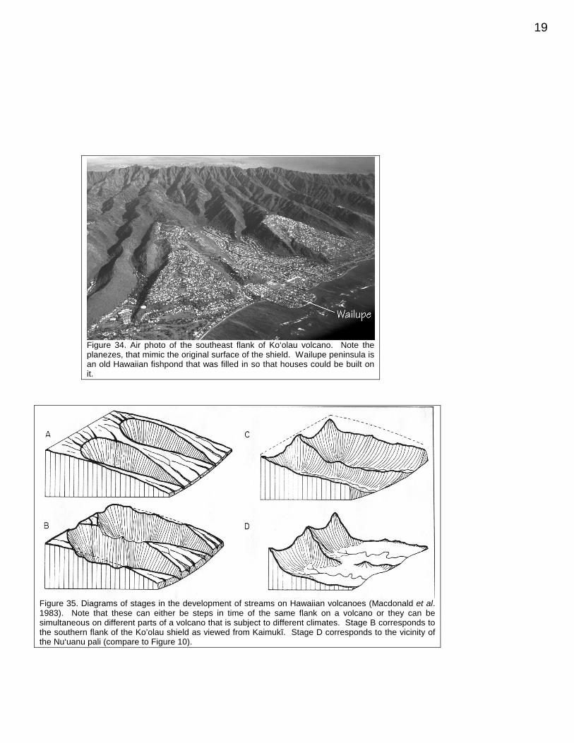
Kaimukī is an excellent place for a long-distance look at the profile of the Koko Rift(Figure 33). Additionally, there are good views ofthe planezes that perhaps preserve the oldKo‘olau shield surface (Figure 34; the planezes inthis area correlate very strongly with expensivehouse prices). Hawaiian erosional valleystypically have an amphitheater shape, with headsthat are wider than their mouths. Figure 35(Macdonald et al. 1983) shows how a greaterdegree of erosion in the uplands produces thesevalleys. Figure 35 is presented as anevolutionary sequence of valley development.The different stages, however, can occur on thesame volcano if there is a large range in rainfall
amounts.The valleys cut intoKo‘olau are quiteimpressive, and theyhave U-shaped profilesunlike the V-shapetypical of stream-cutvalleys. The relativelyflat floors of the valleysindicate infilling bysediments and to alimited extent,rejuvenation-stage lavasand pyroclastics, andextending the valley walls downward until they merge gives an impression of how much material hasbeen eroded (Figure 36). A water well drilled near the middle of Mānoa valley passed through ~360 mof sediment (including limestone) before hitting Ko‘olau basalt. This contact is ~300 m below presentsea level and indicates that at least this amount of subsidence has occurred since the valley wasinitially cut.
Most of the sediment that eroded out of these valleys worked its way oceanward and wasdeposited along the south coast of O‘ahu. Here it is intercalated with buried reef limestone andoccasional rejuvenation-stage lavas and tephra. Metropolitan Honolulu (including Waikīkī; Figure 37)is built on these sediments. The sediments have very little bearing strength and high-rise buildings inHonolulu are therefore built on concrete piles driven through the soft sediment until they bottom out oneither a limestone or rejuvenation-stage lava layer. Some buildings are built on >1000 piles that maybe up to 60 m long.
Figure 29. Photo of Mauna Iki (the gently sloping mound on thehorizon), a satellitic shield on the southwest rift zone of Kīlaueathat formed between January and August of 1920.
Figure 30. Map showing purported “rifts” derived by connecting locations of Honolulu VolcanicSeries vents from Winchell (1947; A) and Stearns (1985; B). In B, note that one of these rifts hasonly two points(!) and some have only three or four.

18
Lē‘ahi is ~2 km southwest of the summit ofKaimukī, and is probably Honolulu’s most famouslandmark. As noted above it is a tuff cone,produced by hydromagmatic eruptions. Growth-position tree molds have been found in the lowestlayers of Lē‘ahi ash indicating that at least part ofthe eruption occurred on land (Macdonald et al.1983). The “diamonds” for which Diamond Headis named, were actually calcite crystals. Thecalcite was precipitated in fractures and betweenash layers having originally dissolved out of coralxenoliths included in the ash. Some of the calcitemay also derive from weathering of the ash. FromKaimukī it is clear that the far (southwest) rim ofLē‘ahi is higher than the near rim, and the dips ofthe layers at the highest point indicate that it wasonce even higher. This view direction isessentially the same as the prevailing trade windsand undoubtedly this difference in height is due tomore material having been deposited on thedownwind side of the vent.
Figure 32. Cross section along the “Diamond Head Rift” showing the age relationships betweenLē‘ahi, Kaimukī, Mau‘umae, and the underlying Ko‘olau basalts (after Wentworth 1951). Notethe 10x vertical exaggeration.
Figure 31. Map showing detail of the southern end of the so-called “Diamond Head Rift” (by George Walker). The dashedcontours give the shape of the Kaimukī shield and have aninterval of 40 feet.
Figure 33. Sketch of the view east from the highest point on Lē‘ahi (by George Walker). Note theprofile of the Koko Rift, as well as the valleys (separated by planezes) cut into the Ko‘olau shield.KH = Koko Head, HB = Hanauma Bay, KC = Koko Crater.
19
Figure 34. Air photo of the southeast flank of Ko‘olau volcano. Note theplanezes, that mimic the original surface of the shield. Wailupe peninsula isan old Hawaiian fishpond that was filled in so that houses could be built onit.
Figure 35. Diagrams of stages in the development of streams on Hawaiian volcanoes (Macdonald et al.1983). Note that these can either be steps in time of the same flank on a volcano or they can besimultaneous on different parts of a volcano that is subject to different climates. Stage B corresponds tothe southern flank of the Ko’olau shield as viewed from Kaimukī. Stage D corresponds to the vicinity ofthe Nu‘uanu pali (compare to Figure 10).

20
Figure 36. Sketch of the view looking northward from off Waikīkī beach. Note the largeamphitheater valleys of Mānoa and Pālolo and the planezes (P) between them. The dashed linesshow the extensions of the valley walls beneath the present fill of alluvium. A Honolulu VolcanicSeries flow, on which main University of Hawai‘i Mānoa campus sits, is shown (schematically) withthe dotted pattern.
Figure 37. Photograph of Waikīkī and downtown Honolulu from the highest point on Lē‘ahi.The flat land on which these buildings are built consists almost entirely of sediments washedout of the valleys being cut into the Ko‘olau shield, as well as carbonate material andrejuvenation-stage pyroclastics and lavas. Note Wai‘anae volcano in the distance.

21
THE MEANINGS OF SOME HAWAIIAN PLACE NAMES AND WORDS(from Puku‘i et al. 1974; Puku‘i and Elbert 1986)
‘a‘ā glowing, fiery (as with fiery eyes)Hālona peering placeHanauma curved bay, or hand-wrestling bayHawai‘i (no known meaning)Hilo (town) first night of new moon, or a Polynesian voyager (unclear which, if either)Honolulu protected bayKa‘au fortyKahauloa the tall hau treeKa‘iwa the ‘iwa (frigate bird)Kailua two currents, or 2 baysKaimukī ki (ti) oven (a place for cooking ti roots)Kalaniana‘ole a Hawaiian prince (lit. the chief without measure)Kalihi the edgeKāne‘ohe bamboo husband (a particular husband was cruel like a bamboo knife)Kā‘ohikaipu hold back the container (blocking an inlet of debris)Kapa‘a solid, or the closingKapapa the flat surfaceKawainui the big waterKīlauea spewingKoko bloodKōnāhuanui large fat innardsKo‘olau windwardKualoa long backLāna‘i conquest dayLanihuli turning royal chiefLē‘ahi the brow of an ‘ahi (tuna)Makapu‘u hill beginning, or bulging eyeMānana buoyantMānoa vastMauna Kea white mountainMauna Loa long mountainMaunawili twisted mountainMau‘umae wilted grassMōkapu kapu (taboo) districtMokoli‘i little lizardMoku Hope island behindMokulua two islandsMoku o Lo‘e island of Lo‘e (a person)Moloka‘i (no known meaning)Nu‘uanu cool heightO‘ahu (no known meaning)‘Ōhulehule joining of wavesOlomana forked hillpāhoehoe satin, perhaps paddle-likepali cliffPaikō Pico (the name of a Portuguese resident here)Pālolo clayWai‘anae mullet water (a place to catch mullet)Waikīkī spouting waterWailupe kite waterWaimānalo potable water

22
CITED REFERENCES
Adams WM, Furumoto AS (1965) A seismic refraction study of the Koolau volcanic plug. PacificScience 19:269-305
Carracredo JC (1999) Growth, structure, instability and collapse of Canarian volcanoes andcomparisons with Hawaiian volcanoes, J Volcanol Geotherm Res 94:1-19
Decker RW, Decker B (1998) Volcanoes (3rd ed.). WH Freeman & Co, New York: 321 ppGramlich JW, Lewis VA, Naughton JJ (1971) Potassium-argon dating of Holocene basalts of the
Honolulu Volcanic Series. Geol Soc Am Bull 82:1399-1404Gurriet P (1987) A thermal model for the origin of post-erosional alkalic lava, Hawaii. Earth Planet Sci
Lett 82:153-158Haskins EH, Garcia MO (2004) Scientific drilling reveals geochemical heterogeneity within the Ko‘olau
Shield, Hawai‘i. Contrib Mineral Petrol 147:162-188Hinds NEA (1931) The relative ages of the Hawaiian landscapes. Univ Calif Pub, Bull Dept Geol Sci
20:143-260Kelly ML (1980) Radiocarbon dates from the Hawaiian Islands - a compilation. US Geol Surv Open
File Rpt 79-1700:37 ppLangenheim VAM, Clague DA (1987) Stratigraphic framework of volcanic rocks of the Hawaiian
Islands. US Geol Surv Prof Pap 1350:55-84Macdonald GA, Abbot AT, Peterson FL (1983) Volcanoes in the Sea the Geology of Hawaii. Univ
Hawai‘i Press, Honolulu: 517 ppMachado F, Parsons WH, Richards AF, Mulford JW (1962) Capelinhos eruption of Fayal volcano,
Azores, 1957-1958. J Geophys Res 67:3519-3529Moore JG (1964) Giant submarine landslides on the Hawaiian ridge. US Geol Surv Prof Pap 501-D:95-
98Moore JG, Nakamura K, Alcaraz A (1966) The 1965 eruption of Taal volcano. Science 151:955-960Moore JG, Clague DA, Holcomb RT, Lipman PW, Normark WR, Torresan ME (1989) Prodigious
submarine landslides on the Hawaiian ridge. J Geophys Res 94 no. B12:17,465-17,484Moore JG, Clague DA (2002) Mapping the Nuuanu and Wailau Landslides in Hawaii. In: Takahashi E,
Lipman PW, Garcia MO, Naka J, Aramaki S (Eds) Hawaiian Volcanoes: Deep UnderwaterPerspectives, Am Geophys Union Monogr 128:223-244
Ozawa A, Tagami T, Garcia MO (2003) Magmatic pulses in the Honolulu rejuvenated-stage volcanism:evidence from K-Ar dating. Cities on Volcanoes III Conference (Hilo, Hawai‘i) abstract volume: 97
Peterson DW, Moore RB (1987) Geologic history and evolution of geologic concepts, Island of Hawaii.US Geol Surv Prof Pap 1350:149-190
Presley TK, Sinton JM, Pringle M (1997) Postshield volcanism and catastrophic mass wasting of theWaianae Volcano, Oahu, Hawaii: Bull Volcanol 58:597-616
Puku‘i MK, Elbert SH, Mo‘okini ET (1974) Place Names of Hawai‘i. Univ. Hawai‘i Press, Honolulu: 289pp
Puku‘i MK, Elbert SH (1986) Hawaiian Dictionary. Univ Hawai‘i Press, Honolulu: 572 ppRibe NM, Christensen UR (1999) The dynamical origin of Hawaiian volcanism. Earth Planet Sci Lett
171:517-531Rowland SK, Walker GPL (1988) Mafic-crystal distributions, viscosities, and lava structures of some
Hawaiian lava flows. J Volcanol Geotherm Res 35:55-66Satake K, Smith JR, Shinozaki K (2002) Volume estimate and tsunami modeling for the Nuuanu and
Wailau landslides, In: Takahashi E, Lipman PW, Garcia MO, Naka J, Aramaki S (Eds) HawaiianVolcanoes: Deep Underwater Perspectives, Am Geophys Union Monogr 128:333-348
Stearns HT, Vaksvik (1935) Geology and ground-water resources of the island of Oahu, Hawaii. BullHawaii Div Hydrography 1:1-479
Stearns HT (1985) Geology of the State of Hawaii (2nd ed). Pacific Books, Palo Alto:335 pp

23
Strange WE, Machesky LF, Woollard GP (1965) A gravity survey of the island of Oahu, Hawaii. PacificScience 19:350-353
Thorarinsson S (1967) The Surtsey eruption and related scientific work. The Polar Record 13:571-578Walker GPL (1987) The dike complex of Koolau volcano, Oahu: internal structure of a Hawaiian rift
zone. USGS Prof Pap 1350:962-996Walker GPL (1988) Three Hawaiian calderas: an origin through loading by shallow intrusions? J
Geophys Res 93 no. B12:14,773-14,784Wentworth CK (1938) Marine bench-forming processes: water-level weathering. J Geomorph 6:6-32Wentworth CK (1951) Geology and groundwater resources of the Honolulu-Pearl Harbor area, Oahu,
Hawaii. Honolulu Board of Water Supply:111 ppWestervelt WD (1963) Hawaiian Legends of Volcanoes. Reprinted from the 1916 edition by C. E.
Tuttle Co, Inc, Vermont: 205 ppWiddowson M, Cox KG (1996) Uplift and erosional history of the Deccan traps, India: Evidence from
laterites and drainage patterns of the Western Ghats and Konkan Coast. Earth Planet Sci Lett137:57-69
Winchell H (1947) Honolulu series, Oahu, Hawai‘i. Bull Geol Soc Am 58:1-48
24


