
(Jun-Aug, 2014)
Issued on Jul 22, 2014
Issued by:
Dr. Khalid M Malik
(Director)
Seasonal Hydro Meteorological outlook
for Indus River Basin
NATIONAL AGROMET CENTER (NAMC)
PAKISTAN METEOROLOGICAL DEPARTMENT
SECTOR H-8/2, ISLAMABAD Phone: +92-51-9250592 Email: [email protected]
http://namc.pmd.gov.pk/
Seasonal weather outlook (Jun-Aug, 2014)
2
4.1. Introduction
1. Introduction
A variety of methods including dynamical models, statistical methods, regional expert
judgments and combination of them are being used to generate long-range weather
forecast by the different climate prediction centers around the world. National Agromet
Center (NAMC), Pakistan Meteorological Department adopts an ensemble approach to
formulate seasonal weather outlook for south Asian countries included in South Asian
Association for Regional Cooperation (SAARC) (on experimental basis), taking into
consideration available products from major climate prediction centres by using Global
Climate Models (GCMs).
This Climate Outlook developed for entire Indus Basin irrespective of national boundaries of
neighboring countries. Thus, this product may differ from the official forecasts issued in
those countries. Indus Basin seasonal (precipitation) outlook is predicted from ECHAM4
global climate models by using persisted sea surface temperature on 0000 Jun 01, 2014.
Model is then tuned up by subtracting additional moisture from output. During validation of
model, it was observed from past predictions by the model that it predicts above forecast
than observed in the region. Therefore, to make the model forecast close to observation,
Regional Correction Factor (RCF) for each month has been calculated to compute
subtraction of additional moisture.
Accuracy of Outlook seasonal weather mainly depend upon SST used in global climate
models. Even with use of accurate SST, still is uncertainty in the climate forecast due to
chaotic internal variability of the atmosphere. For further information concerning this and
other guidance products, users are strongly advised to contact their National Meteorological
Services.
As the region receive most of the water during monsoon season as well as rise of day
temperature during summer season (April- Sept) will cause increase in discharge water in
the rivers. As a result, the period of predicted weather outlook for Indus Basin is from April-
Sept.
This outlook will be updated regularly on before 15th of every month for next three
months during summer season (April-September).
Acknowledgement: NAMC is gratefully acknowledges, the International Research Institute
(IRI) for climate and Society for providing access of dynamical prediction of Global Climate
Model ECHAM4P5, developed and operated by European Center for Medium-Range Weather
Forecasts model’s simulations and hindcast data to support the formulation of seasonal
weather outlook of Pakistan. Special acknowledge to Dr. M. Benno Blumenthal by providing
guidance and assistance for using IRI climate software. All the output graphics have been
prepared by using IRI climate software.
Classification of average, below average and above average
Below Average (Blw. Ave) < -15 %,
Average precipitation range (Ave) = -15 to +15 %,
Above Average (Abv.Ave) > +15 %

Seasonal weather outlook (Jun-Aug, 2014)
3
Note: Average precipitation is computed by using Global Precipitation Climatology Centre
(GPCC) gridded data by resolution (0.5x0.5o) latitude by longitude
2. Map and brief of Indus river Basin and its sub region tributaries
Indus River basin is main basin in Asia. It originates from China at an elevation of 5500 m.
The catchment area contains seven of the world’s highest peaks after Mount Everest. The
total inflow from China in the Indus river basin is estimated at 181.62 km3. Total inflow
from Afghanistan to Pakistan in the Indus basin is estimated at 21.5 km3, 15.5 km
3 from
the Kabul river (of which 10 km3 come from Kunar river, which first enters Afghanistan from
Pakistan and then flows back to Pakistan after joining the Kabul river) and 6 km3 from other
tributaries (Pansjir, Gomal, Margo, Shamal, Kuram). The mean annual inflow into Pakistan
from India through the western tributaries comprising the Jhelum and the Chenab
(considering the Indus Water Treaty) amounts to 170.27 km3. The mean annual natural
inflow into Pakistan through the eastern rivers (the Ravi, the Beas and the Sutlej) is
estimated at 11.1 km3. The flow in the Indus river depends on the season, it decreases
during the winter and floods the banks during the monsoons.
The Indus river has two main tributaries, the Kabul (Upper Indus and Kabul) on the right
bank and the Panjnad on the left. The Panjnad is the flow resulting from five main rivers:
the Jhelum and Chenab, known as the western rivers with the Indus river, and the Ravi,
Beas and Sutlej, known as the eastern rivers.
This hydro-meteorological climate outlook is developed keeping in view the needs of water
managers, authorities engaged in DRM, agriculture and power sector who are directly
concerned to changes in precipitation patterns in Indus Basin. Experts from related fields
are encouraged for feedback so that the climate outlook may further fine-tuned as
per societal needs.

Seasonal weather outlook (Jun-Aug, 2014)
4
3. Synoptic situation
Location of jet stream (U wind at 200 hPa) is at normal position with slightly higher than normal intensity over west. Most of the region including Pakistan, western Nepal and Sri Lanka may prevail below normal zonal winds at 200 hPa.
A trough at 500 hPa is expected to be over west of the country. However a strong ridge may prevail over the country during the season which causes to reduce influence of monsoon over the country.
Surface temperatures are expected to be on higher side than normal all over the country with higher values over central parts.. However, northern and southern parts may prevail normal surface temperature.
North Atlantic Oscillation (NAO) is in negative phase (-0.92) during May. As a result normal track of western disturbances will persist. http://www.cpc.ncep.noaa.gov/products/precip/CWlink/pna/norm.nao.monthly.b5001.current.ascii.table
ENSO-neutral continued during April 2014, but with above-average sea surface temperatures (SST) developing over much of the eastern tropical Pacific. The monthly SST indices were warmer than average in all regions, except for Niño-1+2. The model predictions of ENSO for this summer and beyond are indicating an increased likelihood of El Niño compared with those from last month. Most of the models indicate that ENSO-neutral (Niño-3.4 index between -0.5°C and 0.5°C) will persist through part of the remainder of the Northern Hemisphere spring 2014, most likely transitioning to El Niño during the summer. There remains uncertainty as to exactly when El Niño will develop and an even greater uncertainty as to how strong it may become. This uncertainty is related to the inherently lower forecast skill of the models for forecasts made in the spring. While ENSO-neutral is favored for Northern Hemisphere spring, the chance of El Niño increases during the remainder of the year, exceeding 65% during the summer. .(http://iri.columbia.edu/our-expertise/climate/forecasts/enso/current/?enso_tab=enso-cpc_update)
Probability outlook: La Nina (1%), Neutral (30%) and El Nino (69 %) during May-Jun-Jul, 2014 season
Arabian Sea Surface Temperatures are expected to be slightly above normal near western coastal belt of Pakistan.
Caspian Sea surface temperatures expected to be slightly above normal over southern half and below normal over upper half.
Mediterranean Sea surface temperatures are normal to slightly above normal.
Bay of Bengal Sea Surface Temperatures are close to normal.
Seasonal weather outlook (Jun-Aug, 2014)
5
4. Seasonal weather outlook (Jun-Aug, 2014)
4.1. Summary
Normal to below normal surface runoff water is expected during the season (JJA)
Synthesis of the latest model forecasts for Jun-to-Aug 2014 (JJA), current
synoptic situation and regional weather expert’s judgment indicates that
normal to slightly below normal surface runoff water is expected during the predicted season with significantly below over eastern and western rivers
(Jhelum, Chenab, Ravi and Sutlej), above normal over trunk and average over Indus and Kabul rivers. Day temperatures are likely to be above normal
during whole predicted months over catchment areas of the basin.
4.2. Seasonal surface runoff water outlook:
Surface runoff water in the Indus river basin including Upper Indus, Kabul,
Panjnad and Trunk Indus has been predicted on the basis of expected rainfall in the catchment areas of Indus basin and day temperature in the
region during predicted season. The main points of water availability outlook are as under:-
Synoptic situation and model seasonal outlook shows that enough
surface runoff water is likely over catchment areas of main reservoir
(Terbala dam). No short fall of surface runoff water is likely during the season in Terbela dam.
Short fall of surface runoff water in the catchment areas of Mangla dam is expected during the season.
Surface runoff water in the Ravi river will be slightly on higher side during the month of September
Average surface runoff water is expected in Upper Indus, Kabul and Indus river Basin as a whole.
Below average surface runoff water is expected in Panjnad basin with significantly low over the eastern rivers (the Ravi and the Sutlej) and
average over the western rivers (the Jhelum and the Chenab) Surface runoff water in Indus Basin will gradually increase during
predicted season Urban / flash flooding over southern parts of the country can’t be ruled
out.

Seasonal weather outlook (Jun-Aug, 2014)
6
Note: Departure of Area-weighted rainfall of Indus Basin and its sub-region
has been computed by subtracting ECHAM predicted monthly/seasonally rainfall from GPCC of corresponding month/season.
5. Monthly outlook
5.1. Jun, 2014
Comparison of expected (red bar), average (blue bar) and departure (green line) of rainfall from normal over catchment area of Indus and its sub-regions.
Indus Basin: Average rainfall is expected over catchment area of Indus baisn and above normal day temperature over the region. That would result
above normal surface runoff water in the rivers.
-40.0
-35.0
-30.0
-25.0
-20.0
-15.0
-10.0
-5.0
0.0
Jun, 2014 Jul, 2014 Aug, 2014 Jun-Aug, 2014
Pe
rce
nta
ge d
ep
artu
re
Predicted month/season
Departure of area weighted rainfall of Indus Basin from normal (1981-2010)
-1.7
8.1
-0.5 -0.5
-9.3
-12.0-10.0-8.0-6.0-4.0-2.00.02.04.06.08.010.0
0.0
10.0
20.0
30.0
40.0
50.0
60.0
70.0
Indus kabul punjnad trunk upp_ind
in P
erc
en
tage
(%
)
pre
cip
itat
ion
in m
m/m
on
th
Average, expected and departure rainfall from normal for Jun, 2014
ave
exp
dep (%)
Seasonal weather outlook (Jun-Aug, 2014)
7
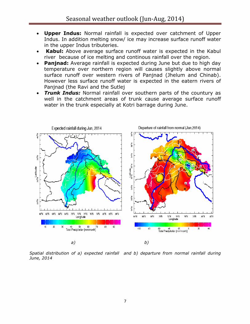
Upper Indus: Normal rainfall is expected over catchment of Upper
Indus. In addition melting snow/ ice may increase surface runoff water in the upper Indus tributeries.
Kabul: Above average surface runoff water is expected in the Kabul river because of ice melting and continous rainfall over the region.
Panjnad: Average rainfall is expected during June but due to high day temperature over northern region will causes slightly above normal
surface runoff over western rivers of Panjnad (Jhelum and Chinab). However less surface runoff water is expected in the eatern rivers of
Panjnad (the Ravi and the Sutlej Trunk Indus: Normal rainfall over southern parts of the countury as
well in the catchment areas of trunk cause average surface runoff water in the trunk especially at Kotri barrage during June.
a) b)
Spatial distribution of a) expected rainfall and b) departure from normal rainfall during June, 2014

Seasonal weather outlook (Jun-Aug, 2014)
8
5.2. July, 2014
Comparison of expected (red bar), average (blue bar) and departure (green line) of rainfall from normal over catchment area of Indus and its sub-regions.
Indus Basin: Below Normal rainfall is expected over Indus baisn indicates
below normal runoff water in the rivers. However abover average day temperature are exepcted over northern region causes increase intensity of
surface runoff in the Indus Basin. No shortfall of water would be observed in the water reserviors during July. Better water management would lead to fill
Tarbela reservior as per schedule.
Upper Indus: Below normal rainfall is expected over catchment of
Upper Indus. Water flow in the Indus will be expected as normal. Above normal day temperature will increase surface runoff level over
northern areas rivers such as Konar and Swat rivers. Kabul: Below normal rainfall in the catchment areas is likely as well as
above day temperature would generate normal flow in the kabul river. Panjnad: Below normal rainfall in the catchment would cause below
normal surface runoff in western rivers. Below normal surface runoff water is expected over eastern rivers (the Ravi and the Sutlej) as well
as western rivers (the Chinab and the Jhelum). Water shortage is expected around bank of the basin. This would give negative impact
on the agricultural land in the region. Trunk Indus: Significantly below normal rainfall over southern parts
of the countury and in the foothills of Suliman rainges will causes decrease water flow in the trunk Indus. Below normal water flow is
expected in the trunk especially at Kotri barrage during July.
-35.5-30.1
-21.3
-47.6
-29.9
-60.0
-50.0
-40.0
-30.0
-20.0
-10.0
0.0
0.0
20.0
40.0
60.0
80.0
100.0
120.0
140.0
160.0
180.0
200.0
Indus kabul punjnad trunk upp_ind
in P
erc
en
tage
(%
)
pre
cip
itat
ion
in m
m/m
on
th
Average, expected and departure rainfall from normal for Jul, 2014
ave
exp
dep (%)

Seasonal weather outlook (Jun-Aug, 2014)
9
a) b)
Spatial distribution of a) expected rainfall and b) departure from normal rainfall during July, 2014
5.3. August, 2014
Comparison of expected (red bar), average (blue bar) and departure (green line) of rainfall
from normal over catchment area of Indus and its sub-regions
Indus Basin: Normal rainfall is expected over catchment area of Indus
baisn that would lead to normal surface runoff water in the rivers.
-8.5
26.1
-3.9
-15.6-13.3
-20.0
-15.0
-10.0
-5.0
0.0
5.0
10.0
15.0
20.0
25.0
30.0
0.0
20.0
40.0
60.0
80.0
100.0
120.0
140.0
160.0
180.0
Indus kabul punjnad trunk upp_ind
in P
erc
en
tage
(%
)
pre
cip
itat
ion
in m
m/m
on
th
Average, expected and departure rainfall from normal for Aug, 2014
ave
exp
dep (%)
Seasonal weather outlook (Jun-Aug, 2014)
10
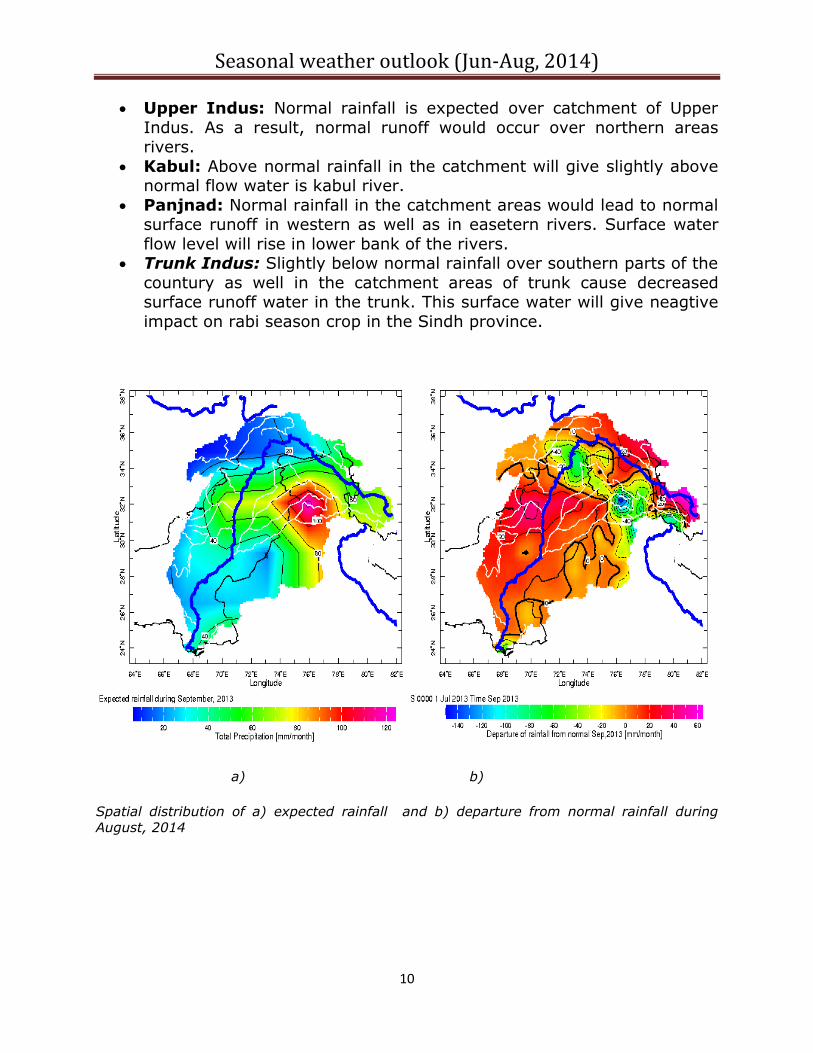
Upper Indus: Normal rainfall is expected over catchment of Upper
Indus. As a result, normal runoff would occur over northern areas rivers.
Kabul: Above normal rainfall in the catchment will give slightly above normal flow water is kabul river.
Panjnad: Normal rainfall in the catchment areas would lead to normal surface runoff in western as well as in easetern rivers. Surface water
flow level will rise in lower bank of the rivers. Trunk Indus: Slightly below normal rainfall over southern parts of the
countury as well in the catchment areas of trunk cause decreased surface runoff water in the trunk. This surface water will give neagtive
impact on rabi season crop in the Sindh province.
a) b)
Spatial distribution of a) expected rainfall and b) departure from normal rainfall during August, 2014

Seasonal weather outlook (Jun-Aug, 2014)
11
5.1. Seasonally (Jun-Aug,2014)
Comparison of expected (red bar), average (blue bar) and departure (green line) of rainfall from normal over catchment area of Indus and its sub-regions.
Indus Basin: As a whole, Normal rainfall is expected over catchment area
of Indus baisn and may yield normal surface runoff water in the rivers. However day temperature is expected above normal over northern region
would help increase snow melt component in the river. As such, no shortfall of surface runoff likely in the main reservior (Terbela).
Upper Indus: Slightly below normal rainfall is expected over
catchment of Upper Indus. In addition melting of snow/ ice may
increase surface runoff water in the rivers. Kabul: Average surface runoff water is expected in the Kabul river
during the predicted season. No short fall is likely from kabul river during the season.
Panjnad: Average rainfall is expecpected during the season that would lead to normal surface runoff in the castchment of Panjnad. No
significant short fall of surface runoff is likely in all the rivers (the Jhelum, the Chenab, the Ravi, and the Sutlej).
Trunk Indus: Below normal rainfall over southern parts of the countury as well in the catchment areas of trunk cause decreased
surface runoff water in the trunk region during the season. That surface runoff water would give negative impact on agriculture in the
southern parts of the country.
-19.2
1.0
-11.2
-27.4
-19.1
-30.0
-25.0
-20.0
-15.0
-10.0
-5.0
0.0
5.0
0.0
50.0
100.0
150.0
200.0
250.0
300.0
350.0
400.0
450.0
Indus kabul punjnad trunk upp_ind
in P
erc
en
tage
(%
)
pre
cip
itat
ion
in m
m/m
on
th
Average, expected and departure rainfall from normal for Jun-Aug, 2014
ave
exp
dep (%)

Seasonal weather outlook (Jun-Aug, 2014)
12
a) b)
Spatial distribution of a) expected rainfall and b) departure from normal rainfall during the season (Jun-Aug, 2014).
Note: Research wing of NAMC is regularly monitoring variation in synopitc situation of the
globe and using different global climate models regional weather prediction data for
prepration of this weather outlook. Seasonal weather outlook for SAARC region will be
issues 10th of every month with three months in advance weather outlook. Lastest seasonal
weather summay can be download from NAMC web site mentioned below:
http://namc.pmd.gov.pk/


