
Elias Sime and Fenta Nigate BNWI/BDU
Report for BNWI Staff
Advanced GIS Application
in Water Resources
Management Training

Elias Sime and Fenta Nigate BNWI/BDU
Contents 1. TRAINING DESCRIPTION ...................................................................................................... 1
2. OBJECTIVES ............................................................................................................................... 1
3. Content of the training ....................................................................................................... 2
4. TRAINING METHODOLOGY ................................................................................................. 3
Training Computer Environment .............................................................................................................. 3
5. Planned Schedule .................................................................................................................. 3
6. VENUE ........................................................................................................................................... 3
7. Actual Schedule ..................................................................................................................... 4
8. Result............................................................................................................................................ 4
9. PHOTO PREVIEW DURING EXECUTING THE TRAINING ......................................... 6

Elias Sime and Fenta Nigate BNWI/BDU
1
1. TRAINING DESCRIPTION
With many challenges facing the country in the efficient management of the
water/natural resources and the environment in the country, there had been call for
better techniques of environmental research, analysis and monitoring towards
better policy formulation and development in the country. GIS stand as one of the
potential tools for good environmental data collation, analysis and monitoring of
the resources in the country. With the field of Geographical Information System
cutting across different fields and areas of specialization, its application is very
crucial and critical to finding solutions to modern day environmental problems and
natural resources management. The application and integration of GIS technology
into water and other natural resources management is very important in the
effective monitoring, control and management of these resources. The use of
Information Technology and availability of software programs like the GIS program
have a great role to play in resource management, environmental monitoring and
control, spatial data processing, storage, indexing, retrieval, analysis and
communication of spatial information of environmental resource data.
Thus, the aim of the training is to equip researchers with the basics and advanced
application of GIS and RS in water quality, hydrogeology and socioeconomics data
collection, handling, retrieving and analysis.
2. OBJECTIVES
The proposed training builds on a previously conducted training at basic level. It
seeks to provide the knowledge and skills needed to improve the efficiency of
water resources management through the integration of GIS, RS and GPS.
Specifically, the training includes;
1. Introduction to GIS
2. Introduction on Water Resources Information (WRI) database management;
Introduction to additional tools that can be used to
Identifying and mapping environmentally sensitive locations and
3. Using GPS technology to map water resources and environmental data
collection and creation.

Elias Sime and Fenta Nigate BNWI/BDU
2
4. Capacity building for continuous monitoring and modelling of water, water
quality and sediment transport in the environment by integrating GIS with
other models.
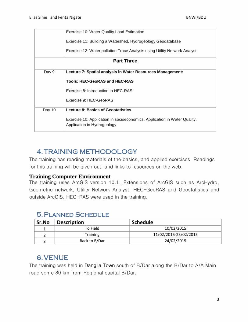
3. Content of the training
In line with the objectives indicated above, the training content was as mentioned
below.
Table of Content
Date Subject
Part One
Day 1 –Day 4 Lecture 1: Introduction to GIS
Exercise 1: Introduction to ArcMap, ArcCatalog, ArcToolbox
Lecture 2: Geodesy, Map Coordinate Systems, Projections
Exercise 2:, Georeferncing, Define projection, Digitization
Lecture 3: Spatial Data Models
Exercise 3: Vector Structure and raster structure
Lecture 4: Introduction to Spatial analysis
Exercise 4: Data sources for GIS in Water Resources management, GPS,
Updating, Data extracting, Editing Geospatial data
Lecture 5: Database
Exercise 5: Geodatabase
Exercise 6: Visualization, Map layout
Part TWO
Day 5- Day 8 Lecture 6: Spatial analysis in Water Resources Management:
Tools: Hydrologic Tools and ArcHydro
Exercise 7: Watershed, Stream Network Characterization, Zonal Statistics.
Exercise 8: Derivation of Geomorphological and Morphological Parameters
Exercise 9: Runoff Estimation
Elias Sime and Fenta Nigate BNWI/BDU
3
Exercise 10: Water Quality Load Estimation
Exercise 11: Building a Watershed, Hydrogeology Geodatabase
Exercise 12: Water pollution Trace Analysis using Utility Network Analyst
Part Three
Day 9 Lecture 7: Spatial analysis in Water Resources Management:
Tools: HEC-GeoRAS and HEC-RAS
Exercise 8: Introduction to HEC-RAS
Exercise 9: HEC-GeoRAS
Day 10 Lecture 8: Basics of Geostatistics
Exercise 10: Application in socioeconomics, Application in Water Quality,
Application in Hydrogeology
4. TRAINING METHODOLOGY
The training has reading materials of the basics, and applied exercises. Readings
for this training will be given out, and links to resources on the web.
Training Computer Environment The training uses ArcGIS version 10.1. Extensions of ArcGIS such as ArcHydro,
Geometric network, Utility Network Analyst, HEC-GeoRAS and Geostatistics and
outside ArcGIS, HEC-RAS were used in the training.
5. Planned Schedule
Sr.No Description Schedule 1 To Field 10/02/2015
2 Training 11/02/2015-23/02/2015
3 Back to B/Dar 24/02/2015
6. VENUE
The training was held in Dangila Town south of B/Dar along the B/Dar to A/A Main
road some 80 km from Regional capital B/Dar.

Elias Sime and Fenta Nigate BNWI/BDU
4
7. Actual Schedule
The training was held for 10 days starting from Thursday February 19, 2015 to
Saturday February 28, 2015. Originally the training was intended for 15 days
including the transportation date and it included RS application in water resources
management.
8. Result
The training was initiated mainly by Goraw Goshu and Fenta Nigate with the
understanding of the GIS and its tools are very important for water resources
management analysis and policy decision support and thus researchers working in
the area need to capacitate the use of the tools in their research. The training was
conducted by Elias Sime. A total of 12 BNWI researchers attended the training. The
list of the researchers is in table below. Except few of the researchers who couldn’t
attend the whole training due to some inconveniences most of the researchers
attended the whole part. It was not possible to start the training on the planned
date due to the inconveniences caused mainly by transportation facility
arrangement. However, it was managed to cover all the training contents within the
planned duration. Trainee witnessed that they have got the most out of the training.
Some however, expressed their concern that GIS and its application was their first
time they expressed they may need extra effort to catch up. From the evaluation
we did on the last day the trainee expressed their opinion on the training.
Overwhelmingly, the admired the commitment the BNWI and the B/Dar University
to made possible to fund and arrange such trainings. And, appreciated the way it
was organized and delivered. They also expressed their opinion what they thought
should be corrected in the future for such kind of training organizations and
delivering. They also expressed that they got beyond their expectation in terms of
the importance of GIS application in water resources management and its use.
Future trainings in different areas should also be encouraged to deliver to improve
the capacity of the researchers.
Table: Trainee attended the training
Sr.
No
Name Attendance Remark
1 Goraw Goshu Had some previous knowledge

Elias Sime and Fenta Nigate BNWI/BDU
5
2 Fenta Nigatea “
3 Mesenbet Yibeltal “
4 Demese Alemaw “
5 Sisay Asres “
6 Belachew Getnet No previous Knowledge
7 Biazinlign Solomon Had very few
8 Zebasil Tasew No Previous Knowledge
9 Gebeyaw Had Some Previous Knowledge
10 Chalachew Abebe “
11 Dr. Taddesse Tafere No Previous Knowledge
12 Shimeles Aynalem Had some Previous Knowledge Secretarial activities were performed by Sofanit Yirga

Elias Sime and Fenta Nigate BNWI/BDU
6
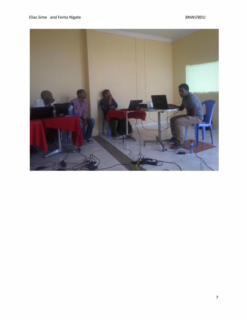
9. PHOTO PREVIEW DURING EXECUTING THE
TRAINING
Elias Sime and Fenta Nigate BNWI/BDU
7

Elias Sime and Fenta Nigate BNWI/BDU
8

Elias Sime and Fenta Nigate BNWI/BDU
9

Elias Sime and Fenta Nigate BNWI/BDU
10


