Chapter 7: PHYSICAL DEVELOPMENT 7- 1
Comprehensive Development Plan, 2010-2016
Chapter 7 Physical Development Plan
7.1 Introduction
In view of the need to sustain the vital role of Angeles City in the
Global Gateways framework, long-term capital investment to ensure access
and connectivity between commodities and people is imperative. Decisions in
this regard will dwell on at least three basic questions, namely: a) what type
of infrastructures to be built; b) their location; and, c) timing. To ensure
continuity of economic activities, road construction and maintenance must
consider an “all-season” type of engineering interventions both for external
and internal mobility. Complementation of land transport and air transport
assumes foremost importance. Linkage of the City and the Clark Special
Economic and Freeport Zone would require adaptation to communications
technology of global standards. Local policies on physical development shall
consider structures and technology that are in harmony with the City’s unique
natural resource endowment and capacity.
7.2 Challenges
7.2.1 Land Use
Zoning Violations and Enforcement. Full compliance to the provisions
of the existing Zoning Ordinance has yet to be realized. This is

Chapter 7: PHYSICAL DEVELOPMENT 7- 2
Comprehensive Development Plan, 2010-2016
expected since some commercial establishments may have to relocate
elsewhere and/or put up additional investments on mitigating
measures in order to address land use conflicts and incompatibility
issues. Nonetheless, the City is exerting efforts to address this
concern.
Declining supply of agricultural lands. As the most dominant urban
center in Central Luzon that is strategically located right at the heart of
the Metropolitan Clark Area, the land demand for urban expansion in
Angeles City is very high. In 2007, the City Agriculturist’s Office
documented about 1,284.752 hectares of land devoted to Agriculture.
On the premise that urbanization does not happen overnight, these
remaining agricultural lands must be protected from conversion for
food security and livelihood reasons.
Emerging land use conflicts in residential zones. A number of
residential subdivisions in Angeles City especially those built decades
earlier were originally intended as low density residential areas or R-1
in the Zoning Ordinance. Today, the strong demand for commercial
land necessitates the transformation of their original use into
commercial or mix uses. However, R-1 only allows low intensity
commercial activities such as those that do not generate heavy traffic.
On one hand, enterprising property owners want zoning upgrade. On
the other hand, some homeowners would like to maintain the original
ambiance of their residential neighborhood. These opposing views
create tension and reduce socio-economic productivity. The City must
take the lead role in addressing this concern.

Chapter 7: PHYSICAL DEVELOPMENT 7- 3
Comprehensive Development Plan, 2010-2016
7.2.2 Infrastructure Support
1. Transportation
Road. As of 2008, Angeles City has a road density of 3.9851
kilometer for every square kilometer, which is actually higher
compared with the national road density of 0.632. However, using
the City’s projected population data from its 2007 Socio-Economic
Profile (SEP), its kilometer road density per 1,000 population is
0.71, which is immensely lower than the standard urban road
density of 2.43 kilometer per 1,000 population ratio. In addition,
road congestions are being experienced in the central business
district (CBD) area of the City particularly along the MacArthur
Highway. Other concerns that impede road accessibility are the
following:
1. Absence of New Road Network System or local access roads to
major transport utilities of the City such as SCTEx, NLEx and
Diosdado Macapagal International Airport (DMIA);
2. Lack of funding support for the implementation of the proposed
East Circumferential Road (ECR) Project; and,
3. Lack of protection for all road pavements.
1 Angeles City SEP 2008
2 Infrastructure Development Chapter, Medium Term Philippine Development Plan 1999-2004.
3 HLURB, CLUP Guidebook Volume 2, A Guide to Sectoral Studies in the CLUP Preparation, pp 208.

Chapter 7: PHYSICAL DEVELOPMENT 7- 4
Comprehensive Development Plan, 2010-2016
Traffic Management. It was reported that the City has a pending
traffic ordinance at the Sangguniang Panlungsod. This ordinance is
assumed to respond to traffic management issues, as follows:
1. Safety of pedestrians and commuters;
2. Unorganized operation of public utility vehicles (PUVS). This
includes the (i) unlimited and uncoordinated issuance of
franchises resulting to voluminous number of vehicles (including
tricycles in the City); (ii) illegal operation of “colorum” vehicles
(jeepneys and tricycles); and, (iii) substandard tricycles; and,
3. Illegal encroachment of buildings and business establishments
on all roads.
Air Transport. DMIA is currently being developed to be the
Premier Gateway Airport of the Philippines. As of the end of
December 2008, DMIA4 is averaging at least seventy-seven (77)
flights per week in both international and domestic flights. This
caters to various air carriers, among them are Tiger Airways of
Singapore flying the Clark-Singapore, Air Asia of Malaysia Clark-
Kuala Lumpur and Kotakinabalu, Asiana Airlines of Korea via Clark-
Incheon in South Korea, and, local carriers Cebu Pacific Air via
Clark-Hong Kong, Thailand, Macau and Singapore, and South East
Asian Airlines (Seair) flies via Clark-Caticlan. This anticipated air
traffic will directly emulate road traffic due to lack of local road
accessibility to the airport.
4 Angeles City SEP 2008

Chapter 7: PHYSICAL DEVELOPMENT 7- 5
Comprehensive Development Plan, 2010-2016
Rail Transport. In addition to being a fast and reliable
transportation system, a railway is an alternative mode to the
mainly road-based transportation system in the country. However,
the uncertainty of the completion of the NORTHRAIL Project Phase
I- Section 2 (Malolos to Clark Section) is the foremost concern.
NorthRail aims to serve as a catalyst for the development of this
area and the Clark - Subic corridor. Similarly, the dispersal of
Metro Manila population towards Central Luzon and provision of a
major trunkline to and from Metro Manila’s LRT System are
envisioned under the Project
2. Utilities
Basic and essential infrastructures for water, power and
telecommunication are already in place in the City. However,
upgrading and expansion of the existing coverage of these service
utilities and provision of water and power source alternatives are
essential to sustain current and future service requirements.
7.3 Potentials
7.3.1 Geographical Advantages: Within the Metropolitan Clark
Area
With the encouraging location feature of Pampanga, it is said that the
province is at the crossroads of regional development. Its major urban areas
have rapidly grown into a metropolitan area or central place serving not only
the requirements of Pampanga but of the region as well. This is a result of a

Chapter 7: PHYSICAL DEVELOPMENT 7- 6
Comprehensive Development Plan, 2010-2016
balanced mix of natural resource, human capital stock, and integrated
infrastructure support.
Figure 7-1 Metropolitan Clark Area
Source: Angeles City SEP, 2008
Shown in Figure 7-1 is the diagram of the Metropolitan Clark Area. The
urban core may start from Sto. Tomas all the way to Mabalacat to include the
adjoining municipalities of Mexico, Bacolor, and Porac. The urban fringe
would be the rest of Pampanga to include Bamban and Concepcion, in Tarlac
Province. Due to the access provided by the established road systems, the
Metro Clark Area could be easily accessed by the neighboring cities of Gapan,
Olongapo, Malolos, and Tarlac.

Chapter 7: PHYSICAL DEVELOPMENT 7- 7
Comprehensive Development Plan, 2010-2016
Strategically located at the heart of Metropolitan Clark Area, Angeles
City is expected to experience accelerated urbanization within the short and
medium terms faster than its neighboring towns and cities within the
metropolitan area.
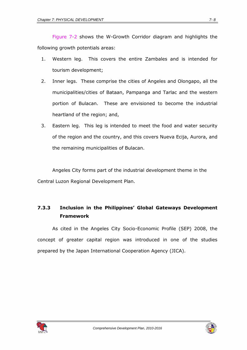
7.3.2 Within the Industrial Heartland of the W-Growth Corridor
The W-Growth Corridor defines Central Luzon’s vital investment areas.
These areas represent the key cities and municipalities of the region, which
when plotted on the map form the shape of the “W”.
Source: Angeles City SEP, 2008
Figure 7-2. The Central Luzon W-Growth Corridor
Chapter 7: PHYSICAL DEVELOPMENT 7- 8
Comprehensive Development Plan, 2010-2016
Figure 7-2 shows the W-Growth Corridor diagram and highlights the
following growth potentials areas:
1. Western leg. This covers the entire Zambales and is intended for
tourism development;
2. Inner legs. These comprise the cities of Angeles and Olongapo, all the
municipalities/cities of Bataan, Pampanga and Tarlac and the western
portion of Bulacan. These are envisioned to become the industrial
heartland of the region; and,
3. Eastern leg. This leg is intended to meet the food and water security
of the region and the country, and this covers Nueva Ecija, Aurora, and
the remaining municipalities of Bulacan.
Angeles City forms part of the industrial development theme in the
Central Luzon Regional Development Plan.
7.3.3 Inclusion in the Philippines’ Global Gateways Development
Framework
As cited in the Angeles City Socio-Economic Profile (SEP) 2008, the
concept of greater capital region was introduced in one of the studies
prepared by the Japan International Cooperation Agency (JICA).

Chapter 7: PHYSICAL DEVELOPMENT 7- 9
Comprehensive Development Plan, 2010-2016
Figure 7-3. Global Gateways Development Framework
Source: Angeles City SEP, 2008
Due to proximity and access, as shown in Figure 7-3, it was observed
that a conurbation with a radius of 100 kilometers from Metro Manila is
increasingly becoming pronounced. The areas forming part of the conurbation
include CALABARZON, Metro Manila, and Central Luzon. It must be noted that
each of the said regions has its own respective strengths which when
complemented by the other regions will likely produce a synergistic effect.
Metro Manila is a huge market for the produce of Southern Tagalog
and Central Luzon. It is the country’s center of finance, trade and commerce,
among others. Enhancing the transportation link between Metro Manila and
its neighboring regions will redound to improved economies of scale that will
benefit both the producers and the consumers in terms of improved

Chapter 7: PHYSICAL DEVELOPMENT 7- 10
Comprehensive Development Plan, 2010-2016
profitability (due to reduced transportation cost) and affordable prices (due to
competition), respectively. This is just one illustration of the many potential
benefits of agglomerating the regional economies under the greater capital
region.
1. Presence of three major roads in the City
Figure 7-4 shows the following three arterial roads in Central Luzon that
directly pass the city:
a. MacArthur Highway. This is the oldest inter-regional highway that
connects Northern and Central Luzon provinces from the national
metropolis. Its original name was the Manila North Road (MNR) but
was renamed MacArthur Highway, after it was concreted in the middle
of the twentieth century, since this was the route traveled by the
American Liberation Forces led by General Douglas MacArthur from
Pangasinan province to Manila when they liberated the country from
the Japanese occupation forces.
Source: Angeles City SEP, 2008
Figure 7-4 Arterial Roads in Angeles City

Chapter 7: PHYSICAL DEVELOPMENT 7- 11
Comprehensive Development Plan, 2010-2016
The 5.44 kilometer portion in Angeles City starts at Km 81+260
(Boundary with the City of San Fernando) and ends at Km 86+700
(Boundary with the Municipality of Mabalacat).
b. North Luzon Expressway (NLEx). NLEX was formerly known as
North Diversion Road. This is a limited-access toll expressway that
connects Metro Manila to the provinces of the Central and Northern
Luzon regions.
NLEx begins in Quezon City specifically at the cloverleaf
interchange of Epifanio Delos Santos Avenue (EDSA), and ends at
Mabalacat, Pampanga.
c. Subic-Clark-Tarlac Expressway (SCTEx). This 94-kilometer four-
lane expressway started its operation in April 2008. It serves as a
direct and exclusive road connection between major development
areas of Central Luzon (Subic, Clark and Tarlac). Its southwestern
terminus is at the Subic Bay Freeport Zone in Zambales, then passes
through the interchanges of the North Luzon Expressway near the
Clark Special Economic Zone in Angeles City, and the Central Techno
Park in Tarlac City, Tarlac. Its northeastern terminus is in La Paz,
Tarlac.
2. A natural resource-rich area in the western area of the city
Table 7-1 shows that from the total City land area of 6,217.37
hectares, 698.42 hectares of which or more than eleven percent is
considered bush or forest cover. This area is in Barangay Sapangbato

Chapter 7: PHYSICAL DEVELOPMENT 7- 12
Comprehensive Development Plan, 2010-2016
which is in western side of the City as shown in the 2009 General Land
Use Map of Angeles City (Figure 7-5).
Table 7-1 Estimated Area and Percentage Share of the
Different General Land Use Categories
in Angeles City, 2009
No.
Land Use Area (Ha) Percent (%)
Share
1 Built-up 2,762.08 44.43%
2 Agricultural/Cultivated Land 1,543.51 24.83%
3 Agricultural/Tropical Grass 843.75 13.57%
4 Bush/ Forest Cover 698.42 11.23%
5 DMIA Runway/ Complex 224.39 3.61%
6 Abacan River 145.22 2.34%
Total 6,217.37 100.00%
Figure 7-5 Existing General Land Use Map of Angeles City, 2009
Source: Angeles City CLUP, 2010-2020
Chapter 7: PHYSICAL DEVELOPMENT 7- 13
Comprehensive Development Plan, 2010-2016
7.4 Goals
Angeles City’s physical development goal is to manage the growth of
the City such that the feature of the built environment, including the nature,
level and location of land using activities:
Supports the envisioned role of Angeles City to be a world-class and
environmentally sound residential center;
Enhances economic productivity through light and export industries;
Sustains the access to basic services;
Develops an integrated infrastructure that sustains access to basic
services; and,
Creates a balanced and organized urban environment.
7.5 Objectives
The specific objectives that will have to be pursued to realize the
physical development goal is to create a physical environment that will
provide the following:
7.5.1 Clean, green and healthy community;
7.5.2 Settlement development directed away from environmentally
critical and resource reserve areas;
7.5.3 Safe, efficient and reliable transportation system;

Chapter 7: PHYSICAL DEVELOPMENT 7- 14
Comprehensive Development Plan, 2010-2016
7.5.4 Adequate and effective drainage, sewerage, and flood control
system;
7.5.5 Sufficient water supply system;
7.5.6 Stable power supply system; and,
7.5.7 Reliable and interconnected telecommunication facilities.
7.6 Targets
7.6.1 Land Use
100% of the open spaces of residential subdivisions are vegetated;
100% of the idle lands within the City are vegetated;
100% compliance to the Zoning Ordinance, the Building Code, and
other development controls;
Zero settlements in hazards-prone areas and resource reserves; and,
Identified re-settlers.
7.6.2 Infrastructure Support
The rest of the City can be accessed from the CBD not to exceed 45
minutes anytime of the day;

Chapter 7: PHYSICAL DEVELOPMENT 7- 15
Comprehensive Development Plan, 2010-2016
100% implementation of City and national traffic codes/laws that
include the improvement of pedestrian and commuters’ facilities and
establishment of authorized terminals;
Surrounding grade is fully drained within 10 minutes after a heavy
downpour (25-year return period);
Zero localized flooding areas in Angeles City;
Established easement along the riverbanks;
Prepared City Drainage and Sewerage Master Plan;
Established new water source;
Established other power source; and,
Fully interconnected telecommunication providers within the City.
7.7 Strategies and Policies
7.7.1 "Super Regions” of the Philippines
The Super Regions harness the economic strengths of the major areas
of the country as well as the knowledge and technology sector, with much
larger economies of scale more attractive to investors, lenders and aid
donors. These are informal groupings of parts of regions and provinces of
the Philippines based on their economic strengths. This was established
pursuant to Executive Order (EO) No. 561, series of 2006. The following
Super Regions serve as development strategy groups:

Chapter 7: PHYSICAL DEVELOPMENT 7- 16
Comprehensive Development Plan, 2010-2016
a. North Luzon Agribusiness Quadrangle (NLAQ). NLAQ is composed of
the Cordillera Administrative Region (CAR), Regions I and II, and
portion of Region III, specifically the Northern municipalities of Aurora,
Nueva Ecija, Tarlac and Zambales. This development blueprint plans
to boost agricultural production and economic activity in the North
Luzon Agribusiness Quadrangle (NLAQ).
b. Luzon Urban Beltway (LUB). This region acts as a globally competitive
logistics and services center by improving and integrating the transport
infrastructure system in the Super Region to better serve industries
and travelers; ensuring the sufficient supply of power and reducing its
costs; providing clean water; and addressing the flooding situation in
its urban areas. This includes the southern part of Aurora, Nueva
Ecija, Zambales and Tarlac, Pampanga, Bulacan, Bataan, National
Capital Region Cavite, Laguna, Batangas, Romblon, Quezon, Mindoro
and Marinduque.
To achieve this aim, the Government plans to develop major
seaports in Subic and Batangas and improve roads and railways that
will make access to the ports easier and faster. This involves the
improvement of Ninoy Aquino International Airport (NAIA) and DMIA
as premier gateways of the country, and the road and railway systems
connecting these airports to the Subic and Batangas Ports, Metro
Manila, and the rest of South Luzon.

Chapter 7: PHYSICAL DEVELOPMENT 7- 17
Comprehensive Development Plan, 2010-2016
To provide the growing energy requirements of the Super
Region, the LUB priority infrastructure projects also include several
power generation and transmission projects.
c. Central Philippines. This Super Region is composed of the entire Bicol
Region, Western, Central, and Eastern Visayas, the provinces of
Romblon, Palawan, and Camiguin, and the island of Siargao. Its unique
and lush natural wonders, as well as its warm and friendly people
attract almost a third of the country’s foreign tourists. Central
Philippines is therefore envisioned to be the premier tourist destination
in the country.
d. The Mindanao Super Region, which is composed of Regions IX, X (except
Camiguin), XI, XII, Caraga (except Siargao), and the Autonomous
Region of Muslim Mindanao (ARMM), has a competitive edge in
agribusiness, especially in high value crops, which can be further
harnessed by major infrastructure support.
7.7.2 Global Gateway Logistic City
This is a 177-hectare Master Planned Aviation Oriented Logistics and
Business Center of Excellence located at Clark Field, Pampanga, an hour
north of Metro Manila. It will host business enterprises and operations with
priority given to aviation and logistics related businesses, including but not
limited to warehousing, distribution, transportation and related multi-nodal
logistics; light industrial and manufacturing; administrative, management and

Chapter 7: PHYSICAL DEVELOPMENT 7- 18
Comprehensive Development Plan, 2010-2016
business offices and complementary commercial and retail operations that
are present in and around major International Airports, Aviation Complexes
and Aerotropolis. Over 4,500,000 square meters of turn-key facilities,
ranging from warehouses and light industrial facilities to modern office
buildings and commercial and retail outlets are being design-built for direct
lease to locators.
This project is expected to create a minimum of 35,000 new jobs to a
maximum of 70,000, depending on the mix of locators attracted to Clark and
the final mix of facilities built over the seven year planned build-out period.
The ground breaking ceremony of this project was held on 25 August 2008.
7.7.3 Expanded W-Growth Corridor
As discussed under 7.3.1, the development of Central Luzon is
anchored on the “W” growth corridor strategy that aims to maximize the
comparative advantages of the seven provinces and the growth areas in the
region. This corridor also enhances the development roles of the areas in the
corridor and in effect prioritizes development interventions in the area to
benefit the rest of the region.

Chapter 7: PHYSICAL DEVELOPMENT 7- 19
Comprehensive Development Plan, 2010-2016
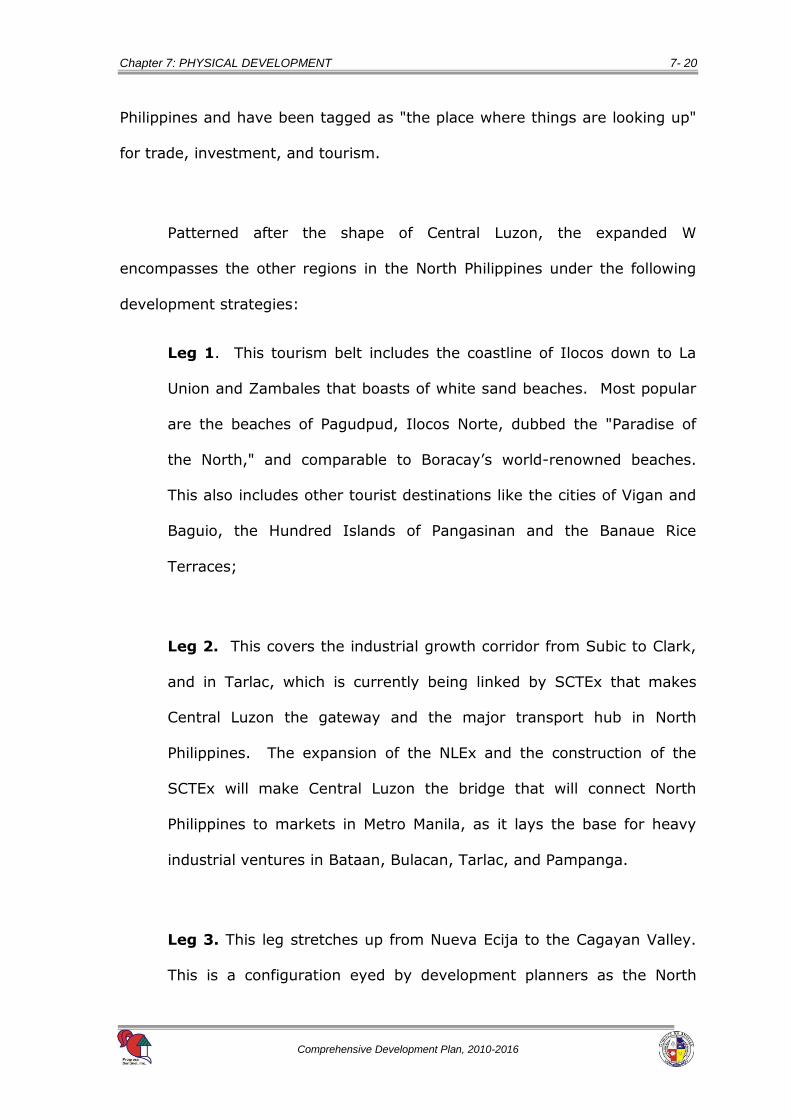
In 2002, this strategy was expanded up north as shown in Figure 7-6.
This aims to transform North Philippines and the province of Aurora into the
country’s premiere investment and tourism destinations.
The Ilocos, Cagayan Valley and Central Luzon regions and the
Cordillera Administrative Region (CAR) are collectively known as North
Figure 7-6 Expanded W-Growth Corridor
Source: http://www.northphil.gov.ph
Chapter 7: PHYSICAL DEVELOPMENT 7- 20
Comprehensive Development Plan, 2010-2016
Philippines and have been tagged as "the place where things are looking up"
for trade, investment, and tourism.
Patterned after the shape of Central Luzon, the expanded W
encompasses the other regions in the North Philippines under the following
development strategies:
Leg 1. This tourism belt includes the coastline of Ilocos down to La
Union and Zambales that boasts of white sand beaches. Most popular
are the beaches of Pagudpud, Ilocos Norte, dubbed the "Paradise of
the North," and comparable to Boracay’s world-renowned beaches.
This also includes other tourist destinations like the cities of Vigan and
Baguio, the Hundred Islands of Pangasinan and the Banaue Rice
Terraces;
Leg 2. This covers the industrial growth corridor from Subic to Clark,
and in Tarlac, which is currently being linked by SCTEx that makes
Central Luzon the gateway and the major transport hub in North
Philippines. The expansion of the NLEx and the construction of the
SCTEx will make Central Luzon the bridge that will connect North
Philippines to markets in Metro Manila, as it lays the base for heavy
industrial ventures in Bataan, Bulacan, Tarlac, and Pampanga.
Leg 3. This leg stretches up from Nueva Ecija to the Cagayan Valley.
This is a configuration eyed by development planners as the North
Chapter 7: PHYSICAL DEVELOPMENT 7- 21
Comprehensive Development Plan, 2010-2016
Philippines’ agriculture and fisheries centers. The province of Nueva
Ecija also leads in agricultural and fisheries research.
7.7.4 Subic-Clark Alliance Development Council (SCADC)
In 2001, the Subic Clark Area Development (SCAD) was created by
virtue of a Memorandum of Understanding (MOU) signed by the respective
concerned agencies, namely: Bases Conversion Development Authority
(BCDA), Clark Development Corporation (CDC), Subic Bay Metropolitan
Authority (SBMA) and Department of Trade and Industry (DTI).
The SCAD Task Force aims to ensure that Clark, Subic, and other
economic zones in Central Luzon shall enjoy “common investment incentive
packages, with the least amount of bureaucratic red tape”.
To rationalize resources and harmonize strategies in the development
of Subic-Clark Corridor, the Subic-Clark Area Development Council (SCAD
Council) was created on 01 February 2006. SCAD Council was renamed as
the Subic-Clark Alliance for Development Council (SCADC) in May 2006.
The principal objective of the SCADC is to ensure the development of
Subic, Clark, and the area between them, otherwise known as the SCAD
Corridor, into a logistics center in the Asia Pacific region.

Chapter 7: PHYSICAL DEVELOPMENT 7- 22
Comprehensive Development Plan, 2010-2016
7.8 Programs and Projects
7.8.1 Land Use Regulation Enhancement Program
1. Strict Implementation and Compliance with Zoning Ordinance
Zoning violations occur, wherein a number of establishments
issued with Certificate of non-Conformance (CNC) have yet to comply
with the provisions of the Zoning Ordinance (ZO).
It was only after the approval of the Revised Zoning Ordinance (RZO)
in 2000 that non-conforming establishments were issued CNC and were given
ample time to conform to the ordinance. However, the implementation has
not been fully realized.
7.8.2 Road Rehabilitation and Development Program
1. Circumferential Road Development Project connecting NLEX and SCTEX
As shown in Figure 7-4, two arterial roads pass through the city,
however, these two roads are not directly connected. In this regard,
the project will involve the following components:
Component 1. Construction of SCTEx’ Manuali Interchange Project;
and,
Component 2. Construction of Pulung Maragul By-Pass / Diversion
Road Project.
2. Angeles City By-Passes Road Project
The City’s major roads are already considered heavily
congested, thus, construction of alternative routes or bypass roads will
resolve road congestion and possibly bring in economic activities.

Chapter 7: PHYSICAL DEVELOPMENT 7- 23
Comprehensive Development Plan, 2010-2016
Possible inclusion in this project is the construction of the Diamond By-
Pass Road and Marisol-Pandan Road.
3. Bicycle Lane Construction Project
Due to increase in oil prices, people resort to other means of
transportation like bicycles and motorcycles. The government has the
moral responsibility of providing the need for infrastructure support to
this option. Since there is an increasing desire of the people to try
other means of transportation, the City needs to construct a lane
intended for this trend for convenience, economics, as well as the safe
mobility of people. This could also lessen the slow movement of motor
vehicles brought about by the presence of slow moving bicycles and
motorcycles along the main road pavement/areas.
4. Creation of Quick Report/Response and Repair Teams
Through these teams, the City could easily determine and act on
the unconditioned roads and damaged bridges that need immediate
and fast repair, fallen trees and other obstacles that hamper traffic
flow, vehicles involved in accidents and overflowing rivers, especially
during rainy seasons. These teams could be organized with the
existing personnel of the Office of the City Engineer, Disaster
Management Office, and Home Emergency Response Office. This
undertaking could also motivate the private sector’s involvement.

Chapter 7: PHYSICAL DEVELOPMENT 7- 24
Comprehensive Development Plan, 2010-2016
5. East Circumferential Road Project
This project that includes the construction of new roads in the
eastern part of the City is being envisioned to be the completion of the
City’s circumferential road.
6. Barangay Bridges Construction Project
This involves upgrading and rehabilitation of barangay bridges in
the City. This will include Balibago-Duquit Bridge and Bagong Silang-
Sitio Mali Bridge.
7. Barangay Road Improvement Project
Barangay Roads need to be upgraded or improved periodically
due to their deteriorating level of service. The Project will comprise of
the following barangay priorities:
Concreting of Maura, Cavite & Francisco Streets (Balibago)
Barangay Road Improvement in Cutcut, Sto. Cristo and Sta.
Trinidad (Miranda Extension, Kalayaan Street)
Concreting of Barangay Road, Sitio Manga (Pulungbulu)
Concreting of T. Claudio, Peralta, Sta. Juliana, P. Nuqui, B. Aquino
Streets (Salapungan)
Concreting of a portion of San Jose Street (Sto. Domingo)

Chapter 7: PHYSICAL DEVELOPMENT 7- 25
Comprehensive Development Plan, 2010-2016
7.8.3 Traffic Management and Improvement Program
1. Passage of City Traffic Code
This Code will depend on the outcome of the Joint Traffic
Engineering and Management Study (TEAMS) of the PNP-TEG-PTRO
and the CEO for some vital roads and intersections.
2. Vertical Parking and Terminal Development Project
One of the common scenes in the City roads is the use of the
road as the PUVs “loading terminals”. This scene becomes a habit to
all PUV drivers due to lack of designated City PUV terminals (standby
area) particularly public utility jeepneys (PUJs). The sides of San
Nicolas Public Market along Miranda and Rizal Streets; and Luna and
Aguinaldo Streets are being proposed for the terminal location.
This can be implemented in coordination with different public
transport associations. The City can determine the possible sites
suitable for standby terminals.
3. Development of PUV Loading and Unloading Bays Project
Loading and unloading by public utility vehicles (PUVs), both
intra- and inter-city routes, not only create major concerns on traffic
but to passengers’ safety as well. The provision of a designated
loading and unloading bays in key areas is one of the alternatives that
must be considered in traffic improvement. Provision of waiting shed
must be included to this solution.

Chapter 7: PHYSICAL DEVELOPMENT 7- 26
Comprehensive Development Plan, 2010-2016
4. Sidewalk and Road Encroachment Clearing Project
This also involves proper study on the long-standing concern of
irregular grade of pavement along major sidewalks in the City proper,
particularly the streets of Miranda, Rizal, Jesus, Plaridel and Sto.
Rosario. The present situation makes it risky to residents due to
uneven elevations and grades.
In addition, issuance of a regulation is necessary for an effective
implementation of this sidewalk improvement. This also includes
covering of the left and right sides of critical creeks and canals like the
Lazatin Creek.
5. Street Lighting Project
This project is not only for visuals but for the protection of the
populace. Proposal includes installation of sodium lamps in street
lighting because of its apparent economic and environmental benefits.
6. Construction of Skywalks or Pedestrian Overpass Project
Increasing flow of traffic is unavoidable, so for the safety of
pedestrians as well as for purposes of lessening traffic congestion,
construction of skywalks in strategic locations is inevitable.
7. Joint Traffic Engineering and Management Study (TEAMS) of PNP-TEG-
PTRO and the CEO for some vital roads and intersections
Traffic congestions are being observed in front of Robinsons
Mall, Jenra Mall, Angeles University Foundation (AUF) and intersections
Chapter 7: PHYSICAL DEVELOPMENT 7- 27
Comprehensive Development Plan, 2010-2016
along MacArthur such as A. Gueco, 1st St. and at the at Bayanihan
Park’s roundabout area. A proper and focused study should be
conducted more particularly on the aforementioned intersections.
Possible inclusions in the study are proposals like (i) imposition of fees
on roadside parking; (ii) prohibition through legislation of funeral
marchers during peak hours; and, (iii) regulation of the operation of
tricycles, pedicabs, calesas and the like.
8. Proper Orientation and Training of Traffic Enforcers
Traffic enforcers involved in traffic management especially those
newly-hired must be given proper and adequate training on traffic
enforcement and management. Sometimes the visibility and number
of traffic enforcers are not assurance in the solution of traffic-related
concerns. The Balibago area, particularly the intersection of MacArthur
and A. Gueco, and in front of Robinson’s Mall, experiences a day-long
slow vehicle movement. This traffic personnel training and orientation
must be institutionalized.
9. Urban Renewal Project
Angeles City is burdened with complex socio-economic and
human settlement problems such as increasing population,
unemployment, environmental pollution, among many others. These
concerns resulted to urban blights wherein part of the City falls into
disrepair with abandoned buildings, high local unemployment, and
crowded uninviting City scenery.

Chapter 7: PHYSICAL DEVELOPMENT 7- 28
Comprehensive Development Plan, 2010-2016
In this regard, particular areas have to undergo urban
transformation that includes redevelopment of discarded private
properties to make it valuable.
7.8.4 Abacan River Monitoring, Rehabilitation and Development
Program
1. Abacan River Comprehensive Development Project
Major components of the project include the following:
a. Road and Bridges Construction;
b. Linear Park Development;
c. Establishment and Reclamation of Riverbank; and,
d. River Protection through the proposed Massive Propagation of
Bamboos Project.
7.8.5 Service Utilities Improvement Program
1. Sapangbato Renewable (Wind) Power Project
This project aims to develop a renewable power source for the
City.
2. Metro Clark Bulk Water System
This project aims to develop an alternative water source.
3. Reactivation/Establishment of an Emergency Network

Chapter 7: PHYSICAL DEVELOPMENT 7- 29
Comprehensive Development Plan, 2010-2016
The PHOENIX BASE system was an effective emergency network
system in the past. In this regard, the reactivation or establishment of
a new emergency network is being recommended.
4. Regulation on the Erection of Electric Posts and Installation of Electrical
Lines
The location of electric posts is not properly regulated, thus
becomes eye sore to the public. The uncontrolled installation of
wirings (electrical, telephone lines of three companies operating in the
City) creates an inconvenient view because of the spaghetti-type
hanging wirings.
5. Abacan Bulk Water Impounding Project
This project aims to develop an alternative surface source of
water for domestic and industrial water uses.


