Cambium Inc.
P.O. Box 325 52 Hunter Street East, Peterborough Ontario, K9H 1G5
Telephone: (866) 217.7900 Facsimile: (705) 742.7907
cambium-inc.com
PETERBOROUGH WASTE WATER TREATMENT PLANT GENERATION PROJECT
Cambium Reference No.: 3005-001
Water Assessment Report
2014-04-25
Water Assessment Report
2014-04-25
Peterborough Waste Water Treatment Plant Generation Project
Peterborough Utilities Services Inc.
Prepared by Cambium Inc. Reference: 3005-001 Page i
TABLE OF CONTENTS
1.0 INTRODUCTION ...................................................................................................................................... 1
1.1 CONTACTS ............................................................................................................................................. 1
1.2 PROJECT LOCATION ............................................................................................................................. 2
2.0 WATER RECORDS REVIEW .................................................................................................................. 3
2.1 OTONABEE RIVER ................................................................................................................................. 5
2.2 SPECIES AT RISK................................................................................................................................... 6
2.3 SUMMARY OF WATER RECORDS ........................................................................................................ 6
3.0 SITE INVESTIGATION ............................................................................................................................ 8
3.1 OBSERVATIONS ..................................................................................................................................... 8
3.2 SITE INVESTIGATION SUMMARY ......................................................................................................... 9
4.0 CONCLUSIONS ..................................................................................................................................... 10
REFERENCES
LIST OF APPENDED FIGURES
Figure 1 Project Location Plan
Figure 2 Assessment Area
LIST OF INSERTED TABLES
Table 1 Proponent and Consultant Contact Information ............................................................................... 2
Table 2 Summary of Records Reviewed Under O. Reg. 359/09 .................................................................. 4
Table 3 Summary of Resources Consulted in Records Review ................................................................... 5
Table 4 Summary of Water Bodies Present Following Records Review ...................................................... 7
LIST OF APPENDICES
Appendix A Correspondence
Appendix B Field Notes
Appendix C Site Photographs
Water Assessment Report
2014-04-25
Peterborough Waste Water Treatment Plant Generation Project
Peterborough Utilities Services Inc.
Prepared by Cambium Inc. Reference: 3005-001 Page 1
1.0 INTRODUCTION
Cambium Inc. (Cambium) was retained by Peterborough Utilities Incorporated (PUI) to complete the necessary
documentation, in accordance with Ontario Regulation (O. Reg.) 359/09 – Renewable Energy Approvals under
Section V.0.1 of the Ontario Environmental Protection Act, for the operation of a Renewable Energy Generation
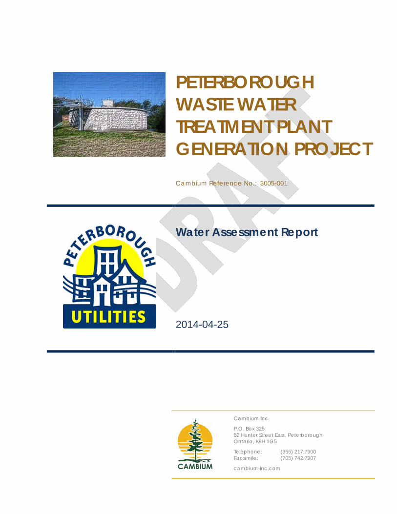
Facility at the Peterborough Waste Water Treatment Plant (WWTP) located at 425 Kennedy Road, in
Peterborough, Ontario (the Site).
The official name of the project is: Peterborough Waste Water Treatment Plant Generation Project.
PUI intends to design, build and commission a 400 kilowatt (kW) combined heat and power (CHP) facility by
utilizing methane generated at the Peterborough WWTP (the facility). As per O. Reg. 359/09, this is considered
to be a Class 3 anaerobic digestion facility that utilizes biomass organic matter.
Under O. Reg. 359/09 applicable renewable energy projects must undertake a water assessment, in the form of a
records review and a site investigation, to identify water features in the vicinity of a proposed renewable energy
project. This report outlines the findings of the water assessment, which has been completed in accordance with
Sections 29 through 31 of O. Reg. 359/09, and is submitted as part of a Renewable Energy Approval (REA)
application for the Facility.
1.1 CONTACTS
PUI is the applicant and Cambium is the engineering consultant representing PUI. Contact information for PUI
and Cambium is provided below:
Water Assessment Report
2014-04-25
Peterborough Waste Water Treatment Plant Generation Project
Peterborough Utilities Services Inc.
Prepared by Cambium Inc. Reference: 3005-001 Page 2
Table 1 Proponent and Consultant Contact Information
Name Title Address Phone Fax Email
Kevin McKeown
Peterborough Utilities Inc. (Generation Project Manager)
1867 Ashburnham Dr., Peterborough, Ontario K9J 6Z5
705‐748‐9301 ext. 1309
705‐743‐5988 [email protected]
Jim Bailey Cambium Inc. (REA Consultant)
52 Hunter St. E Peterborough, Ontario K9H 1G5
705-742-7900 ext. 201
705-742-7907 [email protected]
Christine Teixeira
Cambium Inc. (REA Project Coordinator)
52 Hunter St. E Peterborough, Ontario K9H 1G5
705-742-7900 ext. 216
705-742-7907 [email protected]
Andrea Coppins Cambium Inc. (Natural Heritage Coordinator)
52 Hunter St. E Peterborough, Ontario K9H 1G5
705-742-7900 ext. 207
705-742-7907 [email protected]
Note: Shaded cells indicate primary contact for the Water Assessment Report
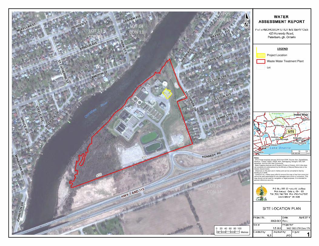
1.2 PROJECT LOCATION
The facility is proposed to be located at the existing WWTP located at 425 Kennedy Road, in Peterborough,
Ontario, within the City limits of Peterborough. The facility will be situated on approximately 0.096 hectares (ha)
(0.24 acres) of land (the project location) located within the WWTP property boundary of 13.21 ha (32.66 acres).
The WWTP, operated by the City of Peterborough, is located approximately 1.2 kilometers (km) south‐south‐east
of downtown Peterborough. The regional location of the Peterborough WWTP is shown on Figure 1.
All project components, including primary project components as well as supplemental infrastructure such as
connection points, transformers, electrical lines, will be contained within the identified project location. With the
exception of a small gas conditioning unit and a transformer, all project components will be housed within an
existing building on the Site. The project location, a 120 metre (m) setback for water bodies, and the 300 m
assessment area are illustrated on Figure 2.
Water Assessment Report
2014-04-25
Peterborough Waste Water Treatment Plant Generation Project
Peterborough Utilities Services Inc.
Prepared by Cambium Inc. Reference: 3005-001 Page 3
2.0 WATER RECORDS REVIEW
O. Reg. 359/09 requires applicants to conduct a records review for the proposed project location and the area
within 120 m of the outer boundary of the project location. Cambium has extended the records review search
area to a distance of 300 m from the project location boundary to screen the surrounding area for the presence of
lakes supporting lake trout, as required under the regulation. As such, any occurrences of water bodies within the
assessment area of 300 m are included within this report. The assessment area is illustrated on Figure 2.
The records review was completed consistent with Section 30 of O. Reg. 359/09, which states that a water
assessment records review must determine whether a project location is:
In a water body,
Within 120 m of the average annual high water mark of a lake, other than a lake trout lake that is at or
above development capacity,
Within 300 m of the average annual high water mark of a lake trout lake that is at or above development
capacity,
Within 120 m of the average annual high water mark of a permanent or intermittent stream, or
Within 120 m of a seepage area.
Table 2 summarizes the sources that are required to be contacted to confirm whether any of the above noted
water features are present at, or surrounding, the project location.

Water Assessment Report
2014-04-25
Peterborough Waste Water Treatment Plant Generation Project
Peterborough Utilities Services Inc.
Prepared by Cambium Inc. Reference: 3005-001 Page 4
Table 2 Summary of Records Reviewed Under O. Reg. 359/09
List of Records Contacted for this Project
Records that relate to water bodies that are maintained by: i. the Ministry of Natural Resources (MNR), Yes ii. the Crown in right of Canada, Yes iii. a conservation authority, if the project
location is in the area of jurisdiction of the conservation authority,
Yes
iv. each local and upper-tier municipality in which the project location is situated,
Yes
v. the planning board of an area of jurisdiction of a planning board in which the project location is situated,
N/A; the City of Peterborough does not have a planning board. The City Official Plan (OP) was consulted.
vi. the municipal planning authority of an area of jurisdiction of a municipal planning authority in which the project location is situated,
N/A; the City of Peterborough does not have a municipal planning authority.
The City OP was consulted.
vii. the local roads board of a local roads area in which the project location is situated,
N/A
viii. the Local Services Board of a board area in which the project location is situated, and
N/A
ix. the Niagara Escarpment Commission, if the project location is in the area of the Niagara Escarpment Plan.
N/A
To conduct the records review as outlined above, Cambium consulted the resources described in Table 3 to
obtain information related to water bodies in the vicinity of the proposed project. Information obtained includes
the boundaries of any applicable water bodies, the type and characteristics of the water body, plant and animal
composition of the water body, and ecosystem characteristics of the land and water within the assessment area.
Further information pertaining to the terrestrial and wetland environments in the vicinity of the project location is
included in the report entitled Natural Heritage Records Review and Site Investigation Report (Cambium Inc.,
2014), also submitted as a component of this REA application.
Water Assessment Report
2014-04-25
Peterborough Waste Water Treatment Plant Generation Project
Peterborough Utilities Services Inc.
Prepared by Cambium Inc. Reference: 3005-001 Page 5
Table 3 Summary of Resources Consulted in Records Review
Description Source
Online Resources Status of Species listed under the Species at Risk Act (SARA; 2002)
Online data, current to 2014-03-06
Status of Species listed under the Endangered Species Act (ESA; 2007)
Online data for listed species, current to 2014-03-06
Ontario Crown Land Use Policy Atlas Online data (mapping tool), current to 2014-03-06 Natural Heritage Information Centre (NHIC) data related to species, plant communities, wildlife habitat and natural areas – UTM squares 17TQK1305, 17TQK1306, 17TQK1405, 17TQK1406
Data download from NHIC for use with Cambium internal GIS. Data last updated 2013-10-13
Land Information Ontario (LIO) Online data, last downloaded 2013-10-13 City of Peterborough OP: Consolidated December 31, 2009 Online document, accessed 2014-04-04
Direct Agency Consultation Ministry of Natural Resources, Peterborough District, Renewable Energy Program Coordinator
Joe Halloran did not identify any unknown water bodies or Crown Land in the vicinity of the project location.
Ministry of Natural Resources, Peterborough District Species at Risk Biologist
Information regarding SAR was provided via the Program Coordinator. No aquatic SAR present.
Ministry of Natural Resources, Peterborough District Fisheries Biologist
Holly Simpson provided a list of fish species known to inhabit the Otonabee River in the vicinity of the project location, and confirmed that there is important walleye spawning habitat upstream and downstream of the project location within the Otonabee River.
Otonabee Region Conservation Authority, Watershed Biologist
Erin McGauley confirmed that the Otonabee River is a warm water watercourse containing a number of fish species, none of which are at risk in Ontario.
Fisheries and Oceans Canada, Fisheries Protection One-Window
Brenda Spearin confirmed that the records provided by Otonabee Conservation are consistent with their files and that there are no known records of aquatic SAR within the vicinity of the project location.
The following sections identify all water bodies identified within the assessment area (300 m) of the project
location, as defined in O. Reg.359/09.
2.1 OTONABEE RIVER
Based on a screening of the general project area, the only water body identified within the 300 m assessment
area was the Otonabee River. The high water mark of the Otonabee River, which is regulated by the Trent
Severn Waterway, is located approximately 80 m from the project location, as illustrated on Figure 2. The
Otonabee River is characterized by a warm water thermal regime, and supports a variety of fish species. The
Otonabee River is a part of the Trent Severn Waterway (TSW) and connects Katchewanooka Lake in the north to
Rice Lake in the south. There are a series of dams and locks along the Otonabee River that are used for
hydroelectric generation and navigation purposes. The project location is outside of the floodplain, and the
Development Control Area (DCA) enforced by Otonabee Conservation.
Otonabee Conservation and the MNR provided a list of fish species known to inhabit the Otonabee River in the
vicinity of the project location. The species present include: brown bullhead, rock bass, white sucker, mottled
Water Assessment Report
2014-04-25
Peterborough Waste Water Treatment Plant Generation Project
Peterborough Utilities Services Inc.
Prepared by Cambium Inc. Reference: 3005-001 Page 6
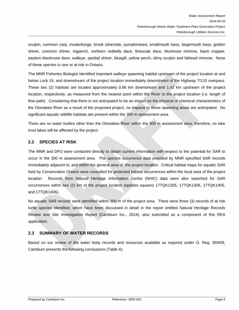
sculpin, common carp, muskellunge, brook silverside, pumpkinseed, smallmouth bass, largemouth bass, golden
shiner, common shiner, logperch, northern redbelly dace, finescale dace, bluntnose minnow, black crappie,
eastern blacknose dace, walleye, spottail shiner, bluegill, yellow perch, slimy sculpin and fathead minnow. None
of these species is rare or at risk in Ontario.
The MNR Fisheries Biologist identified important walleye spawning habitat upstream of the project location at and
below Lock 19, and downstream of the project location immediately downstream of the Highway 7/115 overpass.
These two (2) habitats are located approximately 0.86 km downstream and 1.42 km upstream of the project
location, respectively, as measured from the nearest point within the River to the project location (i.e. length of
flow path). Considering that there is not anticipated to be an impact on the physical or chemical characteristics of
the Otonabee River as a result of the proposed project, no impacts to these spawning areas are anticipated. No
significant aquatic wildlife habitats are present within the 300 m assessment area.
There are no water bodies other than the Otonabee River within the 300 m assessment area; therefore, no lake
trout lakes will be affected by the project.
2.2 SPECIES AT RISK
The MNR and DFO were contacted directly to obtain current information with respect to the potential for SAR to
occur in the 300 m assessment area. The species occurrence data provided by MNR specified SAR records
immediately adjacent to, and within the general area of, the project location. Critical habitat maps for aquatic SAR
held by Conservation Ontario were consulted for protected habitat occurrences within the local area of the project
location. Records from Natural Heritage Information Centre (NHIC) data were also searched for SAR
occurrences within two (2) km of the project location (species squares 17TQK1305, 17TQK1306, 17TQK1405,
and 17TQK1406).
No aquatic SAR records were identified within 300 m of the project area. There were three (3) records of at risk
turtle species identified, which have been discussed in detail in the report entitled Natural Heritage Records
Review and Site Investigation Report (Cambium Inc., 2014), also submitted as a component of this REA
application.
2.3 SUMMARY OF WATER RECORDS
Based on our review of the water body records and resources available as required under O. Reg. 359/09,
Cambium presents the following conclusions (Table 4):
Water Assessment Report
2014-04-25
Peterborough Waste Water Treatment Plant Generation Project
Peterborough Utilities Services Inc.
Prepared by Cambium Inc. Reference: 3005-001 Page 7
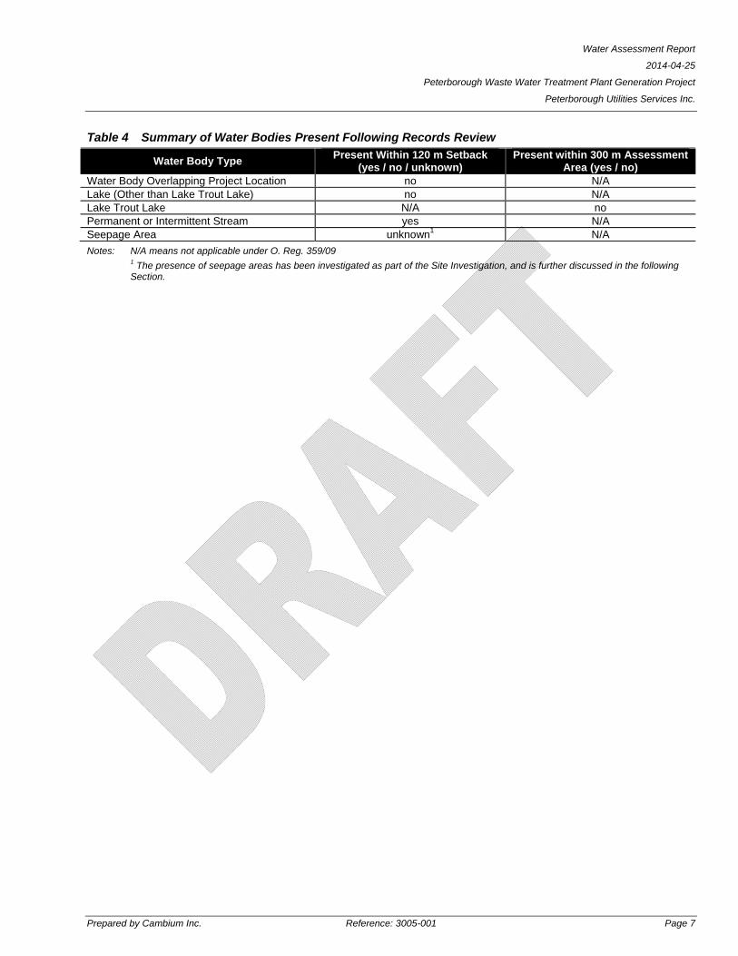
Table 4 Summary of Water Bodies Present Following Records Review
Water Body Type Present Within 120 m Setback
(yes / no / unknown) Present within 300 m Assessment
Area (yes / no) Water Body Overlapping Project Location no N/A Lake (Other than Lake Trout Lake) no N/A Lake Trout Lake N/A no Permanent or Intermittent Stream yes N/A Seepage Area unknown1 N/A
Notes: N/A means not applicable under O. Reg. 359/09 1 The presence of seepage areas has been investigated as part of the Site Investigation, and is further discussed in the following Section.
Water Assessment Report
2014-04-25
Peterborough Waste Water Treatment Plant Generation Project
Peterborough Utilities Services Inc.
Prepared by Cambium Inc. Reference: 3005-001 Page 8
3.0 SITE INVESTIGATION
In accordance with Section 31 of O. Reg. 359/09, a Site Investigation was completed to verify the results of the
water records review, and to determine whether any additional water bodies exist within 120 m of the project
location. In the event that additional natural features were identified, the boundaries and setback distances of
each feature from the project location would be determined.
Considering that no lake trout lakes were identified within 300 m of the project location through the records
review, and lakes of this type would be clearly identifiable from aerial imagery and the records review completed
as described in the preceding Section, further investigation of the 300 m assessment area is not necessary.
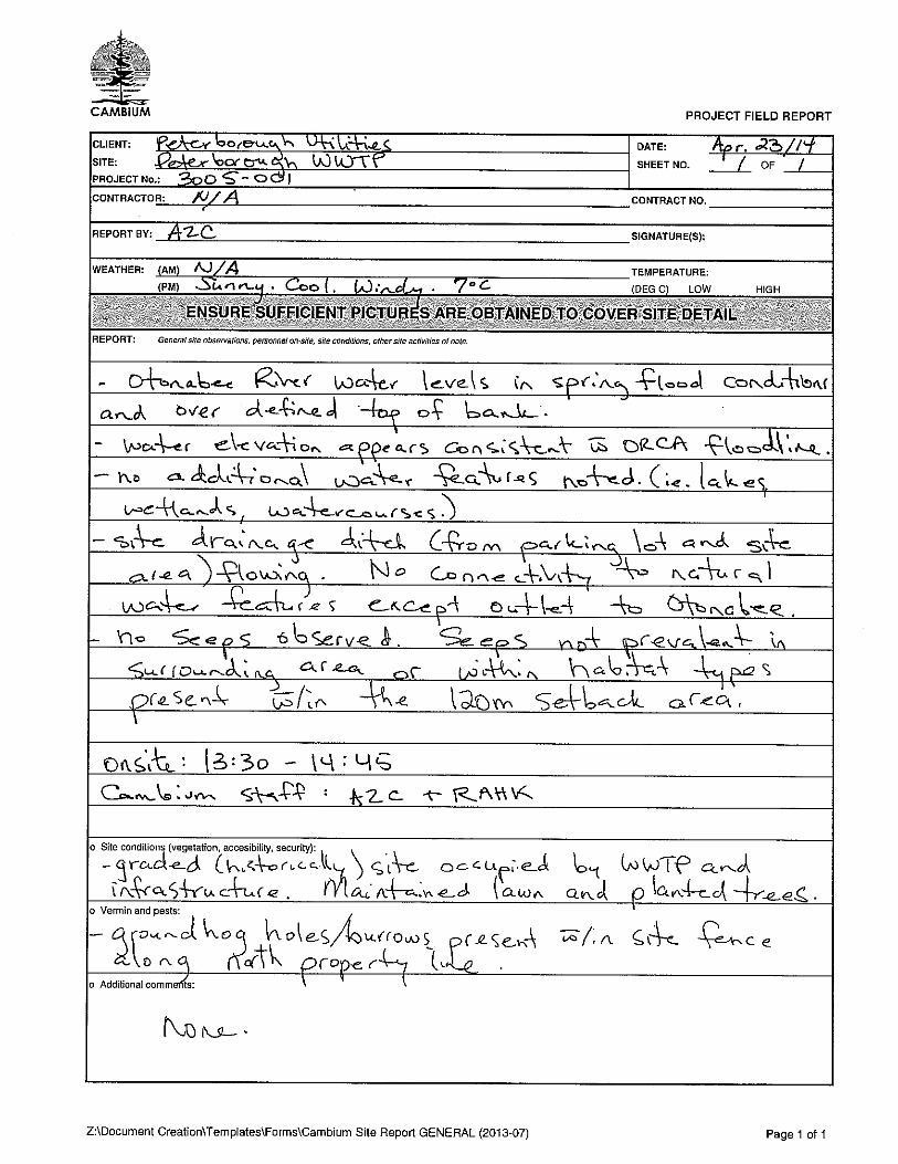
The Site Investigation was completed by qualified Cambium personnel on April 23, 2014. Observations of the
land, water and potential seepage areas of the project location and surrounding 120 m setback area were made.
The following information is provided in accordance with O. Reg. 359/09:
Date and time of Site Investigation (24 hour clock): April 23, 2014 13:30 – 14:45
Duration of the Site visit: 1.25 hours
Weather conditions: Sunny, windy and cool. 7° Celsius (C)
Observation methods: see Section 3.1
Name and qualifications of person completing the Site Investigation:
Andrea Coppins, B.E.S. Hon., Dipl. – Natural Heritage Project Coordinator
Reiner Krueger, B.Sc., Dipl. – Ecological Technician
Field notes: see Appendix B
Site photographs: included in Appendix C
3.1 OBSERVATIONS
The 120 m assessment area was searched using visual means by walking the area and looking for low lying
areas with water that may indicate seepage, drainage courses, or other standing or flowing water. Attention was
also paid to identifying congregations of hydrophytic plants (i.e. plants indicative of a wetland or aquatic
environment) within the 120 m setback that may indicate a high groundwater table or seepage area. The Site
Investigation was completed during the optimal seasonal conditions of early spring, when water elevations are
highest as a result of snow melt and increased precipitation. These climatic conditions are ideal for identifying
seepage areas and intermittent watercourses, as well as permanent water features.
Water Assessment Report
2014-04-25
Peterborough Waste Water Treatment Plant Generation Project
Peterborough Utilities Services Inc.
Prepared by Cambium Inc. Reference: 3005-001 Page 9
The project location was confirmed to be consistent with the description of the area provided in the records
review. The project location consists of an existing building that will be retro-fitted with new equipment, a paved
outdoor area that will be utilized for temporary storage and staging during the installation, and a small area of
previously graded lawn that will accommodate a new transformer. There are no water bodies, intermittent or
permanent watercourses, or seepage areas within the project location.
The area to the west of the project location is dominated by the Peterborough WWTP and associated
infrastructure and is characterized by a constructed environment that has been graded to suit the land use. There
were no water features identified in this area.
The area to the north of the project location is occupied in part by the Peterborough WWTP, but is predominantly
comprised of the Otonabee River and the shoreline features associated with the River. There is a small patch of
mixed wooded area between the WWTP and the shore of the Otonabee River. This wooded area is
approximately 0.3 ha in area. According to the Ecological Land Classification System for Southern Ontario (ELC;
Lee et. al, 1998), this wooded area is classified as a Fresh – Moist Ash Lowland Deciduous forest type, which is a
terrestrial community. There was no evidence of seepage within the wooded area; however the wooded area was
submerged by spring flood waters at the time of the Site Investigation. Based on the proximity to the Otonabee
River, and familiarity with local River conditions and the riparian environment surrounding the Otonabee River, the
presense of seeps in the area that was submerged by flood waters is not anticipated. Moreover, no ground
disturbance is proposed outside of the identified project location; therefore, in the event that seeps were identified
in the wooded area there is no reasonably anticipated impact to these features as a result of the proposed project.
To the east of the project location the land use is primarily residential and the topography increases considerably
with distance to the east and south. There is no evidence of any seeps or water bodies in these directions within
120 m of the project location. It should be noted that private properties in the neighboring Collison Heights
subdivision were not accessed to make direct observations; however the streets were walked and no indication of
drainage that would indicate a watercourse or seepage area was documented.
3.2 SITE INVESTIGATION SUMMARY
No additional water bodies, watercourses or seepage areas were identified as a result of the Site Investigation.
Information obtained during the records review process was consistent with ground conditions observed at the
time of the Site Investigation.

Water Assessment Report
2014-04-25
Peterborough Waste Water Treatment Plant Generation Project
Peterborough Utilities Services Inc.
Prepared by Cambium Inc. Reference: 3005-001 Page 10
4.0 CONCLUSIONS
This Water Assessment Report has been prepared in accordance with Section 29 of O. Reg. 359/09 and is
submitted as part of a REA application for the Peterborough Waste Water Treatment Plant Generation Project.
Should you have any questions or comments with respect to the enclosed, please do not hesitate to contact the
undersigned at (705) 742-7900 ext. 207.
Respectfully submitted,
Cambium Inc.
Andrea Coppins, B.E.S. Hons., Dipl.
Natural Heritage Coordinator
\\vmapp\projects\3000 to 3999\3005-001 Peterborough Utilities - REA Peterborough WWTP\Deliverables\Drafts\DRAFT - Water Assessment Report (ACTIVE - AZC)\2014-03-25 RPT Water Assessment (Draft).docx
Water Assessment Report
2014-04-25
Peterborough Waste Water Treatment Plant Generation Project
Peterborough Utilities Services Inc.
Prepared by Cambium Inc. Reference: 3005-001 Page 11
REFERENCES
Cambium Inc. (2014). Natural Heritage Records Review and Site Investigation Report - Peterborough Waste
Water Treatment Plant Generation Project.
Conservation Ontario. (2013, 05 28). Otonabee Conservation. Retrieved 03 21, 2014, from 2013 Aquatic Species
at Risk: http://www.conservation-ontario.on.ca/what-we-do/watershed-stewardship/aquatic-species-at-risk
Ontario Ministry of Natural Resources. (2013, 07 02). Retrieved 03 21, 2014, from Natural Heritage Information
Centre: http://www.mnr.gov.on.ca/en/Business/NHIC/index.html
Ontario Ministry of Natural Resources. (March 2010). Natural Heritage Reference Manual for Natural Heritage
Policies of the Provincial Policy Statement, 2005. Second Edition. Toronto: Queen's Printer for Ontario.
248 pp.

Water Assessment Report
2014-04-25
Peterborough Waste Water Treatment Plant Generation Project
Peterborough Utilities Services Inc.
Cambium Inc.
Appended Figures
P.O. Box 325, 52 Hunter Street EastPeterborough, Ontario, K9H 1G5Tel: (705) 742.7900 Fax: (705) 742.7907www.cambium-env.com
COLLISON AVE
SO
UTH
PAR
KD
R
GRAHAM AVE
ST
CA
TH
ER
INE
ST
MCKELLAR ST
ST
EE
LE
AV
E
HOWDEN ST
SP
RU
CE
AV
E
ARNDON AVE
DENNE CRES
MAXWELL AVE
COLLISON CRES
RIVERVIEW HT
KENNEDY RD
RIV
ER
SID
E D
R
SH
ER
IN A
VE
LOT 24
CON 14
LOT 14
CON 11LOT 13
CON 11
LOT 25
CON 14
Oto
nabee
River
CAMERON ST
JO
HN
ST
ON
DR
MO
NA
GH
AN
RD
PA
RK
ST
S
HWY 7 AND 115
NLB April 20143005-0011:5,0001111Figure:Created by: Checked by:Date:Project No.:Scale: JABProjection:
NAD 1983 UTM Zone 17N
ºWATER WATER WATER WATER ASSESSMENT REPORTASSESSMENT REPORTASSESSMENT REPORTASSESSMENT REPORTPETERBOROUGH UTILITIES SERVICES425 Kennedy Road, Peterborough, Ontario
SITE LOCATION PLAN0 20 40 60 80 100
Metres
Project Location
Waste Water Treatment Plant
Lot
LEGEND
Notes:- 2012 image acquired January 2014 from ESRI. Source: Esri, DigitalGlobe,GeoEye, i-cubed, USDA, USGS, AEX, Getmapping, Aerogrid, IGN, IGP,swisstopo, and the GIS User Community- Base mapping features are © Queen's Printer of Ontario, 2010 (this doesnot constitute an endorsement by the Ministry of Natural Resources or theOntario Government).- Distances on this plan are in metres and can be converted to feet bydividing by 0.3048.- Cambium Inc. makes every effort to ensure this map is free from errors butcannot be held responsible for any damages due to error or omissions. Thismap should not be used for navigation or legal purposes. It is intended forgeneral reference use only.
Rev.:
425
400
415
BarrieBelleville
Burlington
Huntsville
Lindsay
Orillia
Oshawa
Pembroke
Peterborough
Prince Edward
Toronto
BancroftHaliburton
Renfrew
Index Map
0 50 100
km
L a k e O n a t r i oL a k e O n a t r i o
SITE
A l g o n q u i n
P a r k

P.O. Box 325, 52 Hunter Street EastPeterborough, Ontario, K9H 1G5Tel: (705) 742.7900 Fax: (705) 742.7907www.cambium-env.com
80 m
COLLISON AVE
SO
UTH
PA
RK
DR
GRAHAM AVE
HOWDEN ST
ARNDON AVE
DENNE CRES
MAXWELL AVE
COLLISON CRES
RIVERVIEW HT
KENNEDY RD
SH
ER
IN A
VE
210
205
195
215
19
0
190
19
0
LOT 24 CON 14
LOT 14
CON 11
LOT 13
CON 11
LOT 25
CON 14
Oto
nabee
Rive
r
CAMERON ST
PA
RK
ST
S
HWY 7 AND 115 NLB April 20143005-0011:3,5002222Figure:Created by: Checked by:Date:Project No.:Scale: JABProjection:
NAD 1983 UTM Zone 17N
ºWATERWATERWATERWATERASSESSMENT REPORTASSESSMENT REPORTASSESSMENT REPORTASSESSMENT REPORTPETERBOROUGH UTILITIES SERVICES425 Kennedy Road, Peterborough, Ontario
ASSESSMENT AREA0 20 40 60 80 100
Metres
Waste Water Treatment Plant
Boundary
Project Location
120 Metre Setback
300 Metre Assessment Area
Contour ( 5m )
Lot
Wetland Area
Approximate Distance From
Project Area to Otonabee River
LEGEND
Notes:- 2012 image acquired January 2014 from ESRI. Source: Esri, DigitalGlobe,GeoEye, i-cubed, USDA, USGS, AEX, Getmapping, Aerogrid, IGN, IGP,swisstopo, and the GIS User Community- Base mapping features are © Queen's Printer of Ontario, 2010 (this doesnot constitute an endorsement by the Ministry of Natural Resources or theOntario Government).- Distances on this plan are in metres and can be converted to feet bydividing by 0.3048.- Cambium Inc. makes every effort to ensure this map is free from errors butcannot be held responsible for any damages due to error or omissions. Thismap should not be used for navigation or legal purposes. It is intended forgeneral reference use only.
Rev.:
425
400
415

Water Assessment Report
2014-04-25
Peterborough Waste Water Treatment Plant Generation Project
Peterborough Utilities Services Inc.
Cambium Inc.
Appendix A
Correspondence

1
Sadie Bachynski
From: Jennifer Clinesmith <[email protected]>Sent: February-21-14 12:52 PMTo: Andrea CoppinsCc: Erin McGauley; Cambium File; Jim Bailey; Sadie BachynskiSubject: RE: Peterborough Waste Water Treatment Generation REA Project (3005-001)Attachments: CambiumREADataReq.pdf; 2014-ST002 425 Kennedt Road DCA Map 21Feb14.bmp
Good afternoon Andrea – In follow‐up to your email below, attached is a memo from Erin with the Natural Heritage information that is held by ORCA. Based on our current information, the location of the proposed facility is not subject to Ontario Regulation 167/06, this Authority’s ‘Development, Interference with Wetlands, and Alterations to Shorelines and Watercourses’ regulation under Section 28 of the Conservation Authorities Act; no permit is required. I have attached a map of the area showing the extent of the regulated area for your files. Let me know if we can be of any further assistance and have a great weekend. Jennifer Jennifer Clinesmith, MSc, MCIP, RPP Manager, Planning & Development Services Otonabee Region Conservation Authority Tel: 705‐745‐5791 x215 [email protected] Please consider the environment. Don't print this e‐mail unless you really need to. This communication is intended for use only by the individual(s) to whom it is specifically addressed and should not be read by, or delivered to, any other person. Such communication may contain privileged or confidential information. If you have received this information in error, please notify us immediately by returning the communication to the sender or by sending it to [email protected]. We thank you in advance for your cooperation and assistance.
From: Andrea Coppins [mailto:[email protected]] Sent: Wednesday, February 05, 2014 11:26 AM To: Jennifer Clinesmith Cc: Erin McGauley; Cambium File; Jim Bailey; Sadie Bachynski Subject: Peterborough Waste Water Treatment Generation REA Project (3005-001) Hello Jennifer, Cambium is in the process of assisting Peterborough Utilities Inc. with a Renewable Energy Act approval for enhancements to the WWTP facility on Kennedy Road to allow for the capture of biogas from the existing process at the facility, and conversion of the biogas to energy. The facility is intended to be a 400 kilowatt (kW) combined heat and power (CHP) facility. This is considered to be a Class 3 anaerobic digestion facility that utilizes biomass organic matter as per the Renewable Energy Act Regulation (O. Reg. 359/09). PUI has been awarded a FIT 2.1 Contract for the sale of the electricity generated to the Ontario Power Authority.

2
I have attached a Figure that illustrates the Project Location, and the area identified includes the full extent of the area in which works (including temporary construction disturbance/materials storage) are proposed to be completed. With the exception of the installation of a small transformer and a pad to hold a generator, all of the works will be contained within an existing building on the Site. The building is identified within the Project Location on the attached Figure. The generator pad and all materials storage/construction area will be on an existing paved surface outside of the building. The only disturbance to the ground surface will be for the installation of the transformer and the subsurface power line between the transformer and the building (the line will be beneath an existing paved surface). I have reviewed the mapping available through the County of Peterborough website for the Project Location, and it appears that the works will all be completed outside of the ORCA Development Control Area, as outlined below:
‐ the Otonabee River is approximately 85 m to the north of the Project Location ‐ the floodplain is approximately 55 m to the north of the Project Location ‐ the DCA line on the County GIS site is illustrated approximately 40 m north of the Project Location ‐ the Project location is outside of the designated natural heritage buffers applicable to ORCA (i.e. 120 m from
PSW, 30 m from other wetlands, 15 m from watercourse top of bank) I have attached a simple screen shot of the mapped features from the County website (Project Location identified in red). Based on this review, unless there is additional/updated information that I am currently unaware of, it appears as though a permit for the proposed works will not be required from the ORCA office. Please confirm, and if additional or more current information is available that would affect this interpretation please provide. Because the Project Location is within 120 m of the Otonabee River (a designated setback identified in O. Reg. 359/09), and in consideration that this area may contain significant fisheries resources that would need to be identified for the REA, Cambium would like to request data that ORCA may have on file pertaining to the Project Location. Specifically, the following information would be of value:
‐ watercourse/drain classifications and thermal stream classifications ‐ regulation limits and floodplain mapping (if different from the information available on the County of
Peterborough GIS site) ‐ fish and benthic community information ‐ natural environment studies in and/or adjacent to the study area ‐ regionally or locally significant/rare flora, fauna, vegetation communities ‐ any additional natural environment data you may have for the indicated area
I have copied Erin Gauley directly on this email; however if there are additional persons that I should contact within the ORCA office, please let me know. The first Public Information Centre (PIC) for this project is scheduled to be held on March 6, 2014. I have attached the Notice of Proposal and First Meeting, in the event that there is interest in ORCA staff attending the consultation session. In light of the approaching PIC, it would be great to receive a response to the above items prior to the end of February so that the information can be presented to the public at that time. If you have any questions or comments with regard to this email, please do not hesitate to contact me for further information/clarification. Best regards, Andrea Zavitz Coppins, B.E.S. Hon., Dipl. Project Coordinator, Cambium Inc. Environmental ∙ Geotechnical ∙ Planning Building Sciences ∙ Materials Testing T: 705.742.7900 ext.207 F: 705.742.7907 M: 705.740.4896
3
1.866.217.7900 PO Box 325, 52 Hunter Street East Peterborough, Ontario, K9H 1G5 www.cambium‐env.com Please consider the environment before printing this email note. This document, inclusive of attachments is intended solely for the use of the recipient and may contain personal information which is subject to guidelines regarding the collection, storage and disclosure of private and personal information of individuals. This is regulated by the Personal Information Protection and Electronic Documents Act, S.C. 2000 C5. If you are not the intended recipient or do not agree to comply with the Act above, please notify the sender by return email or telephone and delete the original message and attachments without making a copy.
No virus found in this message. Checked by AVG - www.avg.com Version: 2013.0.3462 / Virus Database: 3684/7064 - Release Date: 02/05/14
The Otonabee Region Conservation Authority 250 Milroy Drive, Peterborough, Ontario, K9H 7M9
Phone: 705-745-5791 Fax: 705-745-7488 email: [email protected]
Page 1 of 1
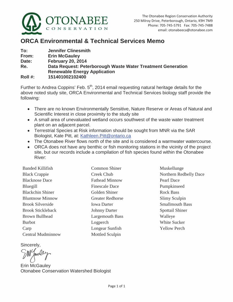
ORCA Environmental & Technical Services Memo
To: Jennifer Clinesmith From: Erin McGauley Date: February 20, 2014 Re. Data Request: Peterborough Waste Water Treatment Generation
Renewable Energy Application Roll #: 151401002102400
Further to Andrea Coppins’ Feb. 5th, 2014 email requesting natural heritage details for the above noted study site, ORCA Environmental and Technical Services biology staff provide the following:
There are no known Environmentally Sensitive, Nature Reserve or Areas of Natural and Scientific Interest in close proximity to the study site
A small area of unevaluated wetland occurs southwest of the waste water treatment plant on an adjacent parcel.
Terrestrial Species at Risk information should be sought from MNR via the SAR Biologist, Kate Pitt, at: [email protected]
The Otonabee River flows north of the site and is considered a warmwater watercourse. ORCA does not have any benthic or fish monitoring stations in the vicinity of the project
site, but our records include a compilation of fish species found within the Otonabee River:
Banded Killifish Black Crappie Blacknose Dace Bluegill Blackchin Shiner Bluntnose Minnow Brook Silverside Brook Stickleback Brown Bullhead Burbot Carp Central Mudminnow
Common Shiner Creek Chub Fathead Minnow Finescale Dace Golden Shiner Greater Redhorse Iowa Darter Johnny Darter Largemouth Bass Logperch Longear Sunfish Mottled Sculpin
Muskellunge Northern Redbelly Dace Pearl Dace Pumpkinseed Rock Bass Slimy Sculpin Smallmouth Bass Spottail Shiner Walleye White Sucker Yellow Perch
Sincerely,
Erin McGauley Otonabee Conservation Watershed Biologist


Water Assessment Report
2014-04-25
Peterborough Waste Water Treatment Plant Generation Project
Peterborough Utilities Services Inc.
Cambium Inc.
Appendix B
Field Notes

Water Assessment Report
2014-04-25
Peterborough Waste Water Treatment Plant Generation Project
Peterborough Utilities Services Inc.
Cambium Inc.
Appendix C
Site Photographs
Water Assessment Report
2014-04-25
Peterborough Waste Water Treatment Plant Generation Project
Peterborough Utilities Services Inc.
Prepared by Cambium Inc. Reference: 3005-001
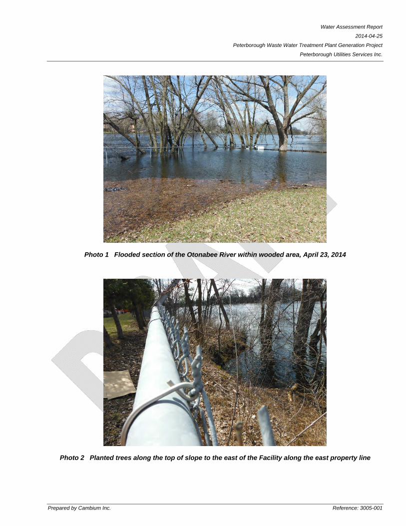
Photo 1 Flooded section of the Otonabee River within wooded area, April 23, 2014
Photo 2 Planted trees along the top of slope to the east of the Facility along the east property line

Water Assessment Report
2014-04-25
Peterborough Waste Water Treatment Plant Generation Project
Peterborough Utilities Services Inc.
Prepared by Cambium Inc. Reference: 3005-001
Photo 3 The Project Location


