
Policy Adopted 3-10-00
Page 1 of 31
DEPARTMENT OF TRANSPORTATION
OFFICE OF THE COMMISSIONER
DECLARATORY RULING NO. 2000-01
DRIVEWAY PERMITS
I, Leon S. Kenison, commissioner of the department of transportation, do hereby issue
this document as a declaratory ruling in order to provide guidance as to the specific
applicability and implementation of RSA 236:13. Following the adoption of the Administrative
Procedures Act, RSA 541-A, the department adopted administrative rules, Part Tra 302, which
were in force between January 1, 1994 and January 1, 1999. By subsequent legislative
enactment, the authority of the department to enact rules for administration of this statutory
provision was exempted from the requirements of the administrative procedures act in
accordance with RSA 541-A: 21 (g).
By ruling dated January 21, 1999, the text of former administrative rule Tra 302, entitled
“Driveway Permits” was adopted by me as a declaratory ruling by reference, and has been used
since that date by the staff of this department in the processing and issuance of driveway
permits and other decisions regarding access control on the state highways.
This ruling modifies the text of Declaratory Ruling 99-01, and the attached provisions
shall hereafter be used by the staff of the department in the processing and issuance of
driveway permits and other decisions regarding access control on the state highways until
further modified by subsequent action of the commissioner of the department of transportation.
Dated: March 10, 2000
_________________________________
Leon S. Kenison
Commissioner of Transportation
Policy Adopted 3-10-00
Page 2 of 31
DEPARTMENT OF TRANSPORTATION
OFFICE OF THE COMMISSIONER
Policy Relating to Driveways and Access to the State Highway System
1. Purpose. ..............................................................................................................................................................3
2. Scope. ...................................................................................................................................................................3
3. Definitions...........................................................................................................................................................4
4. Application Procedure for Driveway Permits.................................................................................................7
5. Application for Driveway Permit .....................................................................................................................8
6. Application for Driveway Permit to Major Entrances...................................................................................9
7. Issuance of Permits. .........................................................................................................................................15
8. Driveway Limitations. .....................................................................................................................................16
9. Right-of-Way Restrictions ..............................................................................................................................17
10. Driveway Characteristics and Distances. ....................................................................................................18
11. Permits for Temporary Driveways ..............................................................................................................19
12. Drainage. ........................................................................................................................................................20
13. Construction and Costs. ................................................................................................................................20
14. Guarantee of Completion..............................................................................................................................21
15. Maintenance Responsibility. .........................................................................................................................22
16. Permit Extension...........................................................................................................................................23
17. Permit Renewal.............................................................................................................................................23
18. Revocation or Suspension of Permit ...........................................................................................................24
APPENDIX I .........................................................................................................................................................25
APPENDIX II .......................................................................................................................................................26
APPENDIX III......................................................................................................................................................28
APPENDIX IV ......................................................................................................................................................31
Policy Adopted 3-10-00
Page 3 of 31
Policy Relating to Driveways and Access to the State Highway System
Statutory Authority: RSA 21-L: 12, IX, and RSA 236:13
1. Purpose.
The purpose of this policy is to provide a uniform procedure throughout the state for
receipt of applications, review of submissions, and issuance of driveway permits. All review of
requests for access to the state highway system shall be in accordance with the following
principles:
(a) Provide maximum safety and protection to the traveling public through the orderly
control of traffic movement,
(b) Minimize conflict points;
(c) Acquire appropriate sight distance on or to any class I, III or the state maintained
portion of class II highways;
(d) Maintain the serviceability of affected highways, which could require alterations to
the existing highway;
(e) Monitor the design and construction of driveway entrances and exits; and
(f) Maintain compliance with RSA 236:13, effective July 1, 1971, as amended, the
language of which is contained in Appendix III.
2. Scope.
(a) The review of requests for issuance of a driveway permit is the responsibility of the
commissioner of the department of transportation. This operational responsibility is delegated
to the division of operations, bureau of turnpikes, and the bureau of highway maintenance and
its district offices. All permits shall be issued in the name of the director of the division of
administration and signed by the district engineer or the assistant district engineer.
(b) This policy shall be applicable to all alterations of existing driveways and proposed
driveways to or from a state maintained highway. Unless otherwise noted, all sections of this
policy shall concern regulation and administration of both new driveway installation and
modification procedures that impact the state highway.
(c) All aspects of the proposed or permitted construction or modifications within the
state highway shall conform to applicable department rules, standards and specifications.
Policy Adopted 3-10-00
Page 4 of 31
(d) In cases where a permit is requested for a limited access highway as defined in RSA
230:44 and 45, the number of permanent points of access as specified in the acquisition
documents on file at the bureau of right-of-way shall not be exceeded.
(e) In cases where an applicant is seeking a permit for a simple residential driveway, the
applicant may shorten the permit process in accordance with section 5.
(f) Where entrances to state highways have been constructed after July 1, 1971 without
benefit of a permit, or not constructed according to the permit issued, the entrances shall be
considered non-conforming. Upon notification by the district engineer, the owner shall apply
for a permit and make the necessary alterations as required by this policy.
(g) Compliance with this policy shall not relieve the applicant from the responsibility to
comply with other federal, state or local ordinances, rules or regulations.
(h) In cases where a permit has been denied, the applicant may initiate the appeals
process by submitting in writing a request for a hearing.
(i) Appendix I contains a list of highway districts and locations from which permit
applications may be requested. Appendix II contains figures of typical driveway design
standards for illustrative purposes, and standard conditions applicable to all permits. Appendix
III contains a copy of the driveway statute, RSA 236:13 and Appendix IV contains a sample of
a request for a wetland permit from the Department of Environmental Services.
3. Definitions.
(a) "Algebraic difference" means the absolute value of the arithmetic difference
between 2 grades in a driveway. For example, a driveway with one grade of +2% and a second
grade of -3% would have an algebraic difference of 5%. The algebraic difference provides a
numerical guideline for establishing maximum safe grade differentials.
(b) "All-season safe sight distance" means a line that encounters no visual obstruction
between 2 points, each at a height of 1.14 meters or 3 feet 9 inches above the pavement,
allowing for a snow windrow and/or seasonal changes. The line represents the line of sight
between the operator of a vehicle using the driveway (point 1) and the operator of a vehicle
approaching from either direction (point 2).
(c) "Alteration" means any work on a driveway including, but not limited to:
(1) Paving and repaving;
(2) Regrading;
(3) Widening;
(4) Changing its use;
(5) Changes in existing drainage affecting the highway; and

Policy Adopted 3-10-00
Page 5 of 31
(6) Reconstruction.
(d) "Applicant" means the owner, or authorized representative of the owner, of the
property for which a driveway permit is sought.
(e) "Barrier island" means the land area, such as but not limited to raised or curbed
areas, low shrubs, and grass, dividing one access point from another, for the purpose of
preventing other access or for channelization.
(f) "Channelization" means the separation or regulation of traffic movements into
definite paths of travel by use of traffic islands or pavement marking.
(g) "Commercial establishment" means any place at which business is regularly
conducted.
(h) “Common Driveway” means an access point designed for use by 2 or more
separate parcels of property, to be designed in accordance with the standards contained in
Appendix II, Figure II and XVII.
(i) "Curb" means a raised edge of concrete, asphalt, granite or wood delineating a
travel lane, parking area, shoulder, or edge of an island area.
(j) "Department" means the department of transportation of the State of New
Hampshire.
(k) "District engineer" means the highway district engineer, the assistant district
engineer, the turnpike administrator or assistant or any person so designated by any of the
preceding.
(l) "Driveway" means any point of vehicular access, including public or private
roads, to or from a state highway, regardless of how the driveway is configured within the
property of the applicant.
(m) "Frontage" means the distance that a parcel of land has in common with a state
highway. If the property fronts on two state highways, the amount of frontage shall not be
added, but separately calculated for each highway.
(n) "Grade" means the inclination of a driveway, which is determined as the change
in the vertical distance of the driveway to a corresponding horizontal distance. The grade is
measured in % (percent) units. For example, a 1 meter rise in the driveway, referenced from
the point of intersection with the state maintained highway over a horizontal distance of 25
meters, or a 2 foot rise in the driveway, referenced from the point of intersection with the state
maintained highway, over a horizontal distance of 50 feet, would result in a driveway grade of
+4%.
Policy Adopted 3-10-00
Page 6 of 31
(o) "Industrial establishment" means any establishment designed for, or at which
manufacturing, assembling, warehousing or fabricating of any kind is undertaken.
(p) "Level of service" means a measure of a road's utility which is expressed by
category and is determined by designed vehicular speed and traffic volume as defined in the
current edition of the Highway Capacity Manual, Special Report 209, published by the
Transportation Research Board, National Research Council, Washington, D.C.
(q) “Lot of Record” means a parcel of land that was separately described and
delineated by deed or on a locally approved subdivision plan recorded in the applicable registry
of deeds on or before July 1, 1971, regardless of how a local municipality may define the term
in its land use ordinances.
(r) "Major traffic generator" means any residential, commercial or industrial
establishment that generates or is projected to generate traffic which significantly lowers or
could adversely affect the current level of service of a state highway.
(s) "Major entrance" means any driveway that serves a commercial establishment,
industrial establishment, shopping mall, subdivision, town road or a major traffic generator, tobe designed in accordance with Appendix II, Figures II to VII inclusive and XVII to XXII
inclusive.
(t) "Parcel" means a tract of land under single or common ownership, including any
proposed commercial or industrial establishment or subdivision even though acquired by more
than 1 conveyance or held nominally by more than 1 owner.
(u) "Residential driveway" means an access point designed to serve a dwelling, and
includes an access point serving 2 or more parcels, which is called a common driveway, to be
designed in accordance with Appendix II, Figure I, II, XVI, or XVII, as appropriate.
(v) "Right-of-way" means state-owned property, easements or other interests
therein, dedicated to state highway purposes.
(w) "Right-of-way line" means the boundary line between the state right-of-way and
the abutting parcel of land.
(x) "Shoulder" means that portion of the roadway, contiguous with the travel lane,
designed for safety, to improve road capacity, and to provide lateral support of the base and
surface courses of the roadway.
(y) "State Highway" or "Highway" means the entire area within the right-of-way of
all state maintained class I and III highways as well as state maintained portions of class II
highways, as defined in RSA 229:5.
(z) "Swale" means a shallow depression in the surface of the land of specified depth
and distance from the travel lane, designed and constructed to drain surface waters.
Policy Adopted 3-10-00
Page 7 of 31
4. Application Procedure for Driveway Permits.
(a) The driveway permit process begins with the submission of a completed
"Application For Driveway Permit" form to the district engineer. The form is available at the
locations shown in Appendix 1.
(b) The district engineer shall examine a submitted application within a reasonable
period, not to exceed 60 days, and notify the applicant of any additional documents or
information required to classify the application as complete.
(c) In the case of major entrances, an applicant shall submit a preliminary traffic impact
study and conceptual design plan prior to submission of detailed design plans for the complete
application. A preliminary review of the submitted information shall be conducted by the
department, the purpose of which is to minimize engineering costs to applicants through the
identification of engineering concerns and discussion of strategies to resolve such concerns.
(d) The district engineer shall review the application and any supporting documents or
other information submitted, and shall issue a driveway permit or deny the application within a
reasonable time, not to exceed 120 days. This review period shall begin upon receipt of a
complete application, and shall not include time necessary for review of preliminary conceptual
designs in the case of major entrances, or time necessary for an applicant to respond to
department request(s) for additional documents or information needed to complete an
application.
Policy Adopted 3-10-00
Page 8 of 31
5. Application for Driveway Permit
(a) All applications for driveway permits shall be printed legibly or typewritten on the
form obtained from staff of the department.
(b) Complete applications shall contain the following:
(1) The applicant's name, address and telephone number;
(2) The contact person's name, address, and telephone number, if different from
the applicant;
(3) The number of driveways requested;
(4) The location of the proposed driveways with respect to which side of the
road, distance and compass direction to the nearest utility pole, indicating the
pole number, or to a nearby landmark if there is no pole in the vicinity;
(5) The name or route number of the state highway involved;
(6) The name of the municipality in which the proposed driveway is located;
(7) The type of driveway proposed and its anticipated use;
(8) A sketch or plan of the property and adjacent highway, indicating north
arrow, existing and proposed drives, town roads, town lines, or other readily
identifiable features or landmarks;
(9) The signature of the landowner; or a letter of authorization signed by the
landowner authorizing another person to sign the application;
(10) The date the application was signed, and;
(11) The applicant shall state whether the property is under consideration by a
local land use board for a subdivision, variance, special exception or site review
approval. If yes, the applicant shall provide a copy of the subdivision plan or
site review plan submitted to the local land use board. This requirement includes
the affirmative duty to submit a copy of any revised plan or plans that are filed
with the local land use board on or before the date of issuance of the driveway
permit.
Policy Adopted 3-10-00
Page 9 of 31
(c) In the case of permits for new driveways only, the applicant, in addition to the above
requirements, shall provide the following information pertinent to access limitations as
regulated in section 8:
(1) The size of the property;
(2) The subdivision history since July 1, 1971 of the parcel from which the
applicant's land was subdivided, with copies of relevant plans and deeds; and
(3) The municipal tax map property reference, and a copy of the municipal tax
map showing the property and abutting properties with names and addresses of
abutters.
(d) Upon receipt of an application for driveway permit, and if no additional information
is requested for evaluation purposes, the district engineer shall review the permit application
and issue or deny the permit in writing.
(e) The district engineer may waive any of the above requirements for good cause
shown.
6. Application for Driveway Permit to Major Entrances.
(a) If the district engineer determines that the proposed use will create a “major
entrance” or be classed as a “major traffic generator”, the applicant shall not be granted a
permit under section 5 above. The district engineer shall require the submission of additional
information before evaluation of the effect of the proposed driveway on the highway.
(b) The additional information necessary to complete the application and as required by
the district engineer may include, but shall not be limited to, any or all of the following:
(1) Plans drawn to a scale of 1 cm =250 cm or 500 cm, or 1 inch = 20 or 50 feet,
that shall clearly indicate the character and extent of the proposed work; the
scale to be specified by the district engineer;
(2) Site plans with contour and elevation drawings of the unmodified land, and
the land as proposed to be modified;
(3) The location of all proposed and existing driveways on both sides of the
highway to a distance sufficient to allow analysis for safety;
(4) The alignment and grade of the highway to a distance sufficient to allow
analysis for safety;
(5) The layout of all proposed and existing modifications within the parcel;
Policy Adopted 3-10-00
Page 10 of 31
(6) The location of proposed and existing utility services including, but not
limited to, water, sewerage, power, telephone, gas and lighting;
(7) A description of all existing and proposed traffic control devices, to include
manufacturer’s performance standards of proposed materials, and the proposed
locations for such devices. The applicant shall provide this information for a
sufficient distance from the proposed drive to permit the district engineer to
fully evaluate the effect of the drive on traffic control devices;
(8) A description of all proposed barrier islands;
(9) Driveway profiles drawn to scale in either metric or English scale units, as
specified by the district engineer. Acceptable metric units used in combination
are 1 cm = 250 cm horizontal, 1 cm = 50 cm vertical; or 1 cm = 500 cm
horizontal, 1 cm = 100 cm vertical. Acceptable English units used in
combination are 1 inch = 20 feet horizontal, 1 inch = 4 feet vertical; or
1 inch = 50 feet horizontal, 1 inch = 10 feet vertical;
(10) Highway cross-sections drawn to either a horizontal and vertical scale of 1
cm = 50 cm, or 1 inch = 5 feet, or a horizontal and vertical scale of 1 cm = 100
cm, or 1 inch = 10 feet; as specified by the District Engineer;
(11) Utility relocation plans;
(12) Highway typical sections;
(13) Deeds or easements necessary to provide additional right-of-way to
accommodate required modifications, to provide access for installation,
maintenance, repair, or reconstruction of traffic control devices, and to provide
space for snow storage and utilities;
(14) Lighting plans, drawn to a scale of 1 cm = 250 cm, or 1 inch = 20 feet,
including maintenance agreements between the applicant and the power
company;
(15) Traffic signal specifications and plans drawn to a scale of 1 cm = 250 cm,
or 1 inch = 20 feet, showing the identity of the designer and including any
agreements between the applicant and the power company;
(16) Pavement widening plans drawn to a metric scale of 1 cm = 250 cm or
1 cm = 500 cm, or an English scale of 1 inch = 20 or 50 feet;
(17) Traffic control plans for maintenance of traffic to be used during
construction of the driveway and pavement widening; based on the appropriate
section of the current Manual of Uniform Traffic Control Devices;
Policy Adopted 3-10-00
Page 11 of 31
(18) Proposed and existing guardrail types and locations;
(19) All-season safe sight distance line shown on the plans required under (1),
(2) (4), (9), and (10) above; and
(20) Separate pavement marking plan drawn to a metric scale of 1 cm = 250 cm,
or 1 cm = 500 cm, or an English scale of 1 inch = 20 feet or 50 feet showing
lane use, striping modifications, and manufacturer’s performance standards for
proposed marking materials. The applicant shall provide this information for a
sufficient distance from the proposed drive to permit the district engineer to
fully evaluate the effect of the proposed driveway on pavement makings.
(c) In some instances applicants seeking driveway permits are required to obtain
Wetland Permits for driveway work that is within the right-of-way. When this type of situation
exists, the following additional procedure shall be used.
(1) The applicant shall prepare wetland permit applications, with the Department
being identified as a co-applicant. The district shall furnish the cover letter (see
appendix IV);
(2) Wetland permit applications shall be signed by the applicant (or their
engineering consultant) and by the district representative;
(3) Information regarding the wetlands permit application and the proposed
impact on the highway right-of-way shall be forwarded to the department of
transportation bureau of environment by the applicant through the district office;
(4) Substantial impacts to highway rights-of-way shall be reviewed with the
director of the division of operations and authorized prior to grant of a driveway
permit;
(5) The driveway permit shall include a condition that makes the applicant liable
for compliance with any permit conditions or requirements that the wetlands
board may impose; and
(6) Bond requirements and conditions, as described in section 14, shall be of
sufficient amount to provide security for compliance with any conditions that
might be imposed by the wetlands board, including monitoring of permit
conditions for the specified period of time.
(d) In instances where the proposed driveway may impact highway drainage, the district
engineer shall require a drainage report for the permit review process which shall include, but
shall not be limited to, any or all of the following:
Policy Adopted 3-10-00
Page 12 of 31
(1) The type of drainage methodology used, such as the Rational Method,
SCSTR55 or SCSTR20;
(2) Plans and hydrology computations showing the existing and the proposed
site conditions, indicating:
a. Contours;
b. Site layout;
c. Watershed areas;
d. Contributing off-site watershed areas; and
e. Effects on adjacent properties;
(3) Plans showing locations, sizes, structural details, and invert elevations of the
existing and proposed drainage structures including:
a. Culverts;
b. Underdrains;
c. Ditches;
d. Catch basins; and
e. Detention ponds;
(4) If computer programs are used in the report, all input values shall be
presented and clearly documented and all output summaries shall be made
available upon request;
(5) Plans and details showing any necessary erosion control methods shall be
presented;
(6) Copies of permits issued by federal and state agencies for site approvals shall
be provided when requested by the district engineer; and
(7) An indication of how the applicant shall maintain or mitigate the site
pre-condition flow rate.
(e) Drainage computations shall be based on 10 and 50-year storm events that shall
include all interior drainage improvements and all state maintained structures/ditches that may
be influenced by the development. If the impact upon state highway drainage is minor, the
district engineer may authorize computations to be based on 10 and 25-year events.

Policy Adopted 3-10-00
Page 13 of 31
(f) When post-condition flow rates exceed pre-condition flow rates, in any season, the
additional flow must be retained and metered to match the pre-existing conditions, or the
additional flow shall be addressed in some other manner approved by the district engineer.
(g) The need for and scope of a traffic impact study shall be determined at a "scoping"
meeting attended by the applicant or its representative, the district engineer and other
appropriate department personnel. The district engineer shall consider input from all attendees
when determining the need for and scope of a traffic impact study.
(h) In instances when generated traffic could adversely affect level of service, the
district engineer shall require a traffic impact study for the permit review process, which may
include, but not be limited to, any or all of the following:
(1) Project description including:
a. Location map;
b. Surrounding area description;
c. Area street network;
d. Size and land use;
e. Phasing; and
f. Proposed modification(s) to the roadway;
(2) Existing roadway conditions within study area including:
a. Geometrics;
b. Traffic control devices;
c. Speed limits;
d. Sight distances;
e. Pavement grades; and
f. Description of any planned roadway modifications in or near the study
area;
(3) Existing traffic data including:
Policy Adopted 3-10-00
Page 14 of 31
a. 24-hour directional counts for at least 3 weekdays and 1 weekend on
all state highways within the study area;
b. Turning movement counts at all intersections during analysis periods;
c. Vehicle classification data; and
d. Peak hour factors, which shall be derived from 15 minute turning
movement counts;
(4) Projected background traffic data including assumed growth rates and their
bases, and trip generation data and their bases, for other proposed developments
in the area;
(5) Project only trip generation rates including:
a. Percent entering/exiting;
b. Trips generated during each analysis period;
c. A full weekday and a full weekend day;
d. Trip category breakdown and basis for use, such as pass-by, diverted,
or new; and
e. Trip distribution and their bases;
(6) Traffic flow networks and capacity analysis for all analysis periods;
(7) Signal warrant volumes and analysis if a traffic signal is proposed;
(8) Summary of capacity analysis results for all analysis periods, including
queuing analysis;
(9) Summary of proposed highway modifications; and
(10) An appendix including:
a. Traffic data collected;
b. Calculations for seasonal adjustments;
c. Growth rates;
d. Trip generation;
Policy Adopted 3-10-00
Page 15 of 31
e. Trip distribution; and
f. Complete capacity analysis calculations and results.
(i) Traffic volume data, both existing and projected, shall be analyzed for typical peak
month conditions for the area.
(j) Trip generation assumptions not based on ITE published rates shall be fully
documented. Project trip generation and distribution shall be presented on a study area
traffic flow network.
(k) Adjustment factors, other than recommended default values, used in capacity
analysis shall be fully documented.
(l) The reports and plans shall be stamped by either an engineer or land surveyor, as
appropriate, who holds a New Hampshire license granted pursuant to RSA Chapter
310-A.
(m) Due to the nature and complexity of some proposed projects, it is possible that the
need for all additional informational requirements will not be discovered at one time.
However, every reasonable effort shall be made to inform the applicant as early as
possible in the permit review process of what, if any, additional information has become
necessary to fully review the request for a permit.
(n) It is recognized that certain entrances may generate traffic that adversely affects the
highway level of service for short duration. While it may be impractical to construct
physical improvements to the highway to alleviate this, traffic control plans will be
required which effectively deal with the increased traffic.
7. Issuance of Permits.
(a) A driveway construction permit shall be issued if the application and supporting
information demonstrates that the safety of the traveling public can be adequately protected by:
(1) The location of the driveway on the parcel;
(2) The drainage structures, traffic control devices, and channelization islands to
be installed by the applicant;
(3) The establishment of line and grades to protect and promote highway
drainage and permit a safe and controlled approach to the highway in all seasons
of the year; and
(4) Any other term, condition or specification deemed necessary for the safety
of the traveling public by the district engineer.
Policy Adopted 3-10-00
Page 16 of 31
(b) The permit shall be issued in writing to the applicant, with a copy to the appropriate
municipality, and contain the following information:
(1) The name of the issuing district;
(2) The specific location of the permitted driveway;
(3) The standard conditions applicable to all permits as contained in Appendix
II;
(4) Any other term, condition, or specification deemed necessary by the district
engineer for the safety of the traveling public; and
(5) The signature of the district engineer or assistant district engineer.
(c) The district engineer may require the applicant to record the permit, and any
easement deeds received, at the applicant's own expense, in the appropriate county registry of
deeds in order to provide notice to the public of special conditions attached to the permitted
driveway.
(d) A driveway permit shall be denied if the applicant fails to submit information
required by the district engineer to determine whether a permit shall be issued.
(e) A driveway permit shall be denied if the proposed driveway will cause an
unreasonable hazard to the traveling public.
(f) The issuance or denial of a permit may be appealed by filing a request for an appeal
hearing pursuant to this policy.
(g) Requests for an appeal hearing should be submitted in writing to:
State of New Hampshire
Department of Transportation, P.O. Box 483
Concord, N. H. 03302-0483
Attention: Hearing Examiner
8. Driveway Limitations.
(a) No more than 1 driveway shall be permitted to a single parcel of land or lot of
record, on a single highway unless there is all season safe sight distance of 122 meters, or 400
feet in both directions along the highway. If the all-season safe sight distance cannot be
Policy Adopted 3-10-00
Page 17 of 31
obtained, and the driveway is not an unreasonable hazard to the traveling public, the single
driveway shall be located at the safest point as determined by the district engineer.
(b) When frontage along the highway is 152 meters, or 500 feet or less, no more than 2
driveways to a single parcel of land or lot of record shall be permitted, so long as all season
safe sight distance can be maintained for all driveways and there are no other significant safety
risks that could endanger the traveling public.
(c) Except as provided in subsection (d), when frontage on a single parcel of land or lot
of record does exceed 152 meters, or 500 feet, no more than 3 driveways or accesses shall be
permitted. The construction of internal street systems or service roads outside the highway
right of way shall be utilized, if practicable, to provide greater safety for the subdivision
occupants as well as other highway users, and to maintain the level of service of the highway.
(d) The district engineer may grant exceptions to (c) above if warranted by unusual
conditions. In determining whether an exception may be granted, the district engineer shall
consider the following factors:
(1) Whether the literal enforcement of the policy will result in unnecessary
hardship to the applicant, which hardship may be demonstrated by:
a. The presence of topographical features of the property which
unreasonably restrict internal street access, such as mountains, ravines,
lakes, rivers and wetlands;
b. Restrictive parcel area and depth which unreasonably constricts
internal street access; or
c. Other unique characteristics such as frontages in excess of 305 meters,
or 1000 feet or historic considerations; and
(2) Whether the grant of a driveway permit is consistent with the spirit and
intent of this policy as expressed in the Purpose section above.
9. Right-of-Way Restrictions
(a) Parking, loading, vending or servicing of vehicles shall not take place on the state
highway or in the right of way.
(b) Items including, but not limited to, permanent or portable buildings, signs, lights,
displays, fuel tanks or septic systems shall not be permitted on, over, or under the state
highway or the right of way.
(c) Access to the state highway from the parcel other than by a permitted driveway(s)
shall be prohibited by appropriate barrier islands, including natural landscaping.
Policy Adopted 3-10-00
Page 18 of 31
10. Driveway Characteristics and Distances.
(a) Except as provided in (b) below, the maximum width of any driveway shall be 15.2
meters, or 50 feet measured parallel to the highway centerline at the right-of-way line.
(b) In the case of major entrances, the district engineer shall evaluate safety and
capacity criteria to determine the width necessary for safe channelization of traffic. Major
entrances designed in accordance with Appendix II, Figures II, III, VI, VII, XVII, XVIII, and
XXI shall be considered a single access point to the state highway system.
(c) In rural areas a driveway shall not access a state highway within 61 meters, or 200
feet of the intersection of that highway with another road. In urban areas, a driveway shall not
access a state highway within 30 meters, or 100 feet of the intersection of that highway with
another road. In either case, no driveway shall encroach upon the curved section of the corner.
The district engineer shall lower these requirements only if evaluation of sight distance, parcel
size, or other relevant safety considerations warrant such modification.
(d) The intersection of the centerline of a driveway with the travel lane of a state
maintained highway should form an angle as close as is practicable to 90 degrees but in no case
shall be less than 60 degrees. Right turn only one way drives may be less than 60 degrees.
(e) The radius of a driveway at the point it meets the edge of pavement shall not extend
beyond the applicant's frontage without written permission of the abutter.
(f) The district engineer shall consider factors including but not limited to the following
in approving driveway grades:
(1) In rural areas grades shall be constructed downward from the highway
surface at a grade of not more than 6 percent, for at least 1 car length of 6
meters, or 20 feet or to the existing ditch line, and shall slope up or down not
more than 6 percent a further distance sufficient to accommodate expected
vehicle storage;
(2) In urban areas the grade shall not be more than 6 percent up or down beyond
the curb line a distance sufficient to accommodate expected vehicle storage;
(3) The slope of the highway cross-section shall also be taken into account; and
(4) Highway drainage shall not be impeded.
(g) In the driveway beyond the approach area referred to in (f) above, the maximum
grade of any driveway for a major entrance shall be 8 percent; for all other driveways the
maximum grade shall be 15 percent. The algebraic difference between any 2 adjacent grades in
a driveway shall not exceed 10 percent. The district engineer shall consider grades in excess of
Policy Adopted 3-10-00
Page 19 of 31
the above if adequate provision is made for safety and the prevention of erosion problems
during construction as well as after completion.
(h) Slopes on either side of a driveway shall be gradual enough to minimize the hazard
to a vehicle leaving the state maintained highway for any reason.
11. Permits for Temporary Driveways
(a) There are a variety of situations where a driveway is necessary to alleviate a
temporary need to cross state right-of-way. Logging operations, utility maintenance and
commercial/residential construction are examples.
(b) Temporary driveway permits shall have a stipulated time limit. When bonds are
required, they shall be posted at 110% - 150% of the estimated cost to repair or restore
potential damage to slopes, shoulders and pavement. Safety of the permittee and the traveling
public is of primary concern, and the district engineer may on the permit require use of
flaggers, signs, cones and other traffic control devices.
(1) Logging Operations - A permit and a bond shall be required. Exceptions to
the permitting and bonding specifications may be granted if the access is
through an existing permitted drive that can safely handle the trucking (this
would include lot clearing where the access is the same as the permanent
driveway and the permit has been approved by the District Engineer). Bonding
may be waived if the applicant has consistently responded in an acceptable
manner to the requirements of previous permits. In no case shall the actual
logging operations be conducted within the State right-of-way.
(2) Construction/Heavy Vehicles - These operations shall be treated in the same
manner as logging operations whenever the driveway is temporary in nature.
(3) Utility Maintenance or Service - Routine utility maintenance may be
conducted within the right-of-way once the location has been approved by the
district engineer. Written permits and bonding are not required.
(4) Signage – A black on orange “Trucks Entering” sign, of 36" by 36"
dimension, with side road indicators, shall be erected by the permittee if the
drive sight distance is less than 500 feet, or special circumstances, such as
downgrades, are present. Specification sheets and typicals are to be provided
with the drive application. If the operation is suspended for 30 or more days, the
signs are to be removed and reinstalled by the permittee when operations begin
again. When erected, the signs are to be maintained by the permittee for quality
and effectiveness, as determined by the district engineer.
(c) Permission shall not be granted for temporary operations by the district engineer in
instances where the right of way is designated “limited or controlled access”. Exceptions are
Policy Adopted 3-10-00
Page 20 of 31
allowed for utility maintenance for pre-existing utility crossings and for unusual circumstances
to alleviate a hardship approved by the Commissioner and, where applicable, the Federal
Highway Administration. Bonding, as described in section 14, is required.
12. Drainage.
(a) All drainage features to be used in connection with construction shall be specified
on the permit.
(b) All drainage features shall be installed as specified on the permit. The type of
material, strength, length, size and cover required over drainage structures shall be in
conformance with department specifications.
(c) In no case shall the permitted construction cause water to stand (pond) on the
pavement, shoulders, or within the limits of the right-of-way.
(d) In the absence of a well defined ditch or a curb, a shallow depression or swale when
approved by the district engineer is considered to be a drainage structure as specified in (b)
above. This swale shall be constructed beyond the edge of the shoulder to accommodate
drainage and the storage of snow.
(e) In cases where property development increases drainage runoff, such that existing
structures in the highway are rendered inadequate or the increased runoff rate results in an
impairment of design capacity, the applicant shall be required to provide improvements to
drainage structures to accommodate that increased water runoff, and to secure drainage rights
downstream.
13. Construction and Costs.
(a) Unless construction begins within one year from the date of issue, the permit shall
expire. The permit holder shall notify the district engineer in accordance with the permit prior
to starting construction within the right-of-way.
(b) As a condition of the permit, the applicant, or its grantees, successors, or assigns,
shall be required to construct or to pay for the cost of maintenance of traffic, the total cost of all
driveway construction and alterations and any associated modifications that are made to the
state maintained highway, and other affected property.
(c) A contractor approved by the department shall accomplish installation of required
traffic signals and pavement markings.
(d) When highway construction or reconstruction is undertaken jointly by the state and
another party, each party shall contribute to the cost of driveway alteration, modification or
restoration in amounts appropriate under all surrounding circumstances. Such amounts shall be
negotiated and agreed upon by the department and the other party.
Policy Adopted 3-10-00
Page 21 of 31
(e) When the size and complexity of a driveway installation requires a department
representative to monitor and inspect the project, the cost of such inspection and monitoring
shall be invoiced to and paid for by the permittee.
(f) The permittee shall prohibit the general use of driveways by the public until such
time as all the work has been completed and all the conditions of the permit have been met,
unless the district engineer determines that the work not yet completed has no substantial
impact on safety or drainage.
(g) As a condition of the permit, it is the responsibility of the permittee to notify the
district engineer, propose design changes and request approval of alterations made necessary
by:
(1) Inconsistencies in design criteria noted on approved plans;
(2) Errors or omissions in survey, plan preparation, or the like; or
(3) Adverse conditions found in the field during construction.
(h) The district engineer may, as a condition of the permit, require the permittee to file
plans with the department reflecting the elements of the driveway "as built" if the complexity
of the installation, or the approved changes made in the field to the plan as originally permitted,
warrant such action.
14. Guarantee of Completion.
(a) The district engineer shall require, for those driveway permits which have been so
conditioned, a surety bond or letter of credit, payable to the State of New Hampshire, in an
amount not less than 110% and not more than 150% of the approved estimate of cost for
modifications, repairs or restoration of slopes, shoulders or pavement within the highway, from
or on behalf of the applicant.
(b) The permittee shall be entitled to a release of the original surety performance bond
or letter of credit upon receipt of all of the following:
(1) A written request for release directed to the attention of the district engineer;
(2) Completion of the modifications in accordance with the terms of the permit;
(3) The tender of a surety bond or letter of credit in such amount as to secure the
cost of repair for any failure of any modification made by the permit holder for a
period of 2 years from the date of acceptance by the department; and
Policy Adopted 3-10-00
Page 22 of 31
(4) In the case of large projects where 2 or more distinct sections of highway or
highways are to be modified, the district engineer may release a portion, but less
than all, of the area from the obligation of the bond when modifications to that
portion are complete.
(c) For those driveways which have been conditioned on the future installation of
approved traffic control features, such as signals or additional lanes to control increased traffic
volume and/or growth of the initial development, the applicant shall provide a surety bond or
letter of credit sufficient to secure reasonably anticipated need for such features for a period
until all such necessary devices are installed or 10 years from the date of acceptance of the
construction by the department, whichever occurs first.
15. Maintenance Responsibility.
(a) The permittee, or its grantees, successors, and assigns served by a driveway shall be
responsible for:
(1) Maintenance of the driveway from the edge of the highway pavement or paved
shoulder, if existing;
(2) Maintenance of all approved and/or required upstream and downstream
drainage alterations including but not limited to:
a. Pipe extensions;
b. Open ditches;
c.Swales and/or drainage systems, and
d. Detention ponds, with the exception of connecting catch basins, manholes or
other specified structures at highway cross culverts;
(3) All driveway pavement markings and all traffic control signs on the drive with
the exception of the stop sign or yield sign; and
(4) Operational costs of electric service for traffic signals and streetlights that are
required by the permit.
(b) The department may maintain all modifications made to and within the highway
including traffic signals which were required by the district engineer who issued the permit,
unless such maintenance is the responsibility of a political subdivision or is specifically
excluded as a condition of the permit. If maintenance responsibilities are allocated to the
department, the district engineer shall require as a condition of the permit that the applicant
provide appropriate deeds reflecting conveyance of additional right of way or easement rights
to assure that department personnel have full right to enter and access any structure or
improvement to be maintained.
(c) The department may also specifically maintain the following drainage structures:
Policy Adopted 3-10-00
Page 23 of 31
(1) The driveway culverts carrying surface water in roadside ditches under
driveways within the state highway, provided said driveway culverts were
initially installed according to permit conditions;
(2) Drainage systems within the highway limits, serving existing state highways,
constructed for the purpose of controlling highway and surface water run-off;
and
(3) Catch basins, manholes or other specified connecting drainage structures
constructed at the end of cross highway culverts or parallel culverts serving the
state highway system.
16. Permit Extension.
(a) In the case where construction or modification has begun within 1 year from the date
of issue but has not been completed within the year, the applicant shall apply for a permit
extension prior to any further construction.
(b) The district engineer shall consider any changes that have occurred to the property
and the surrounding area and modify the original permit if necessary, before issuing a permit
extension.
17. Permit Renewal.
(a) In the case where construction or modification to a permitted driveway has not
begun within 1 year from the date of issue, the permit shall expire and the applicant shall apply
for a permit renewal prior to any construction.
(b) Requests for permit renewals shall:
(1) Reference the permit number;
(2) State whether all information contained in the original permit application is
still current and accurate, and if not, what information has changed and how it
has changed;
(3) State whether there has been any change in the use of the land surrounding
the subject property;
(4) State any other material facts or circumstances; and
(5) Provide proof of a valid performance bond, if such was required as a
condition for the initial permit.

Policy Adopted 3-10-00
Page 24 of 31
(c) The district engineer shall consider any changes that have occurred to the property
or to the surrounding area and the intended use of the property, and then modify the original
permit if necessary, before issuing a permit renewal or denying the renewal under Section 7.
18. Revocation or Suspension of Permit
a) With Notice: If the terms and conditions of a permit are violated by a permit holder,
and the district engineer finds that the violation does not constitute an immediate hazard to
public health, safety or welfare, the district engineer shall give written notice via certified mail
to the permit holder of an intention to suspend or revoke the permit, and a statement of the facts
or conduct upon which the department intends to base its action. The notice of intent to
suspend or revoke shall advise the permit holder of its right to contest the proposed action
through an adjudicative proceeding held pursuant to RSA 541-A in the event that action is not
taken to correct the deficiency described in the notice on or before the date specified in the
notice for revocation.
(b) Without Notice: If the district engineer is advised of a violation of the terms or
conditions of a permit which constitutes a danger to the public health, safety or welfare, the
district engineer shall immediately suspend the permit without an opportunity for the permittee
to be heard in advance of such suspension. This action, once communicated to the permittee,
shall result in the immediate cessation of all work on the driveway or highway, with the
exception of work required to restore the area to a safe and passable condition for motorists.
The notice of suspension shall be in writing, and shall advise the permit holder of its right to
contest the action through an adjudicative proceeding held pursuant to RSA 541-A. The notice
shall be sent by certified mail, and may be served upon the permittee in hand by any person.
Proof of such service shall be placed on a copy of the notice, to be retained in the records of the
department.
(c) The department shall schedule a hearing upon the request of a permittee within 10
calendar days of the effective date of any suspension order made pursuant to (b), above, and
within a reasonable time in all other cases, to allow the permit holder an opportunity to show
compliance with the terms and conditions of the permit.
(d) Nothing in this section shall be construed to require the department to complete an
administrative hearing process prior to contacting the department of justice for assistance, or to
prevent the department from seeking remedies in a court of competent jurisdiction prior to
completion of the administrative hearing process.
Policy Adopted 3-10-00
Page 25 of 31
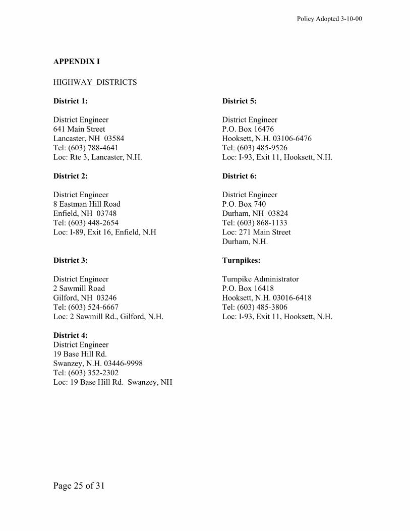
APPENDIX I
HIGHWAY DISTRICTS
District 1: District 5:
District Engineer District Engineer
641 Main Street P.O. Box 16476
Lancaster, NH 03584 Hooksett, N.H. 03106-6476
Tel: (603) 788-4641 Tel: (603) 485-9526
Loc: Rte 3, Lancaster, N.H. Loc: I-93, Exit 11, Hooksett, N.H.
District 2: District 6:
District Engineer District Engineer
8 Eastman Hill Road P.O. Box 740
Enfield, NH 03748 Durham, NH 03824
Tel: (603) 448-2654 Tel: (603) 868-1133
Loc: I-89, Exit 16, Enfield, N.H Loc: 271 Main Street
Durham, N.H.
District 3: Turnpikes:
District Engineer Turnpike Administrator
2 Sawmill Road P.O. Box 16418
Gilford, NH 03246 Hooksett, N.H. 03016-6418
Tel: (603) 524-6667 Tel: (603) 485-3806
Loc: 2 Sawmill Rd., Gilford, N.H. Loc: I-93, Exit 11, Hooksett, N.H.
District 4:
District Engineer
19 Base Hill Rd.
Swanzey, N.H. 03446-9998
Tel: (603) 352-2302
Loc: 19 Base Hill Rd. Swanzey, NH
Policy Adopted 3-10-00
Page 26 of 31
APPENDIX II
TYPICAL DESIGN STANDARDS
This appendix includes typical design standards for various driveway/access situations. These
typical designs are for illustrative purposes. Applicants may wish to use typical designs as
guides; however, designs must be adapted to reflect specific circumstances. Requirements of
site or safety may dictate different solutions that must receive concurrence from the district
engineer. Applicants are referred to section 15 of this document for a description of the
maintenance responsibilities borne by the state and applicants for driveway improvements,
traffic control devices, and pavement markings.
FIGURE: English Unit Measurements:
I. Residential Drive-Rural/Urban
II. Common Drive-Rural/Urban
III. Single Drives-Major Entrance-Rural/Urban
IV. One-Way Drives-Major Entrance-Rural/Urban
V. Two-Way Drives-Major Entrance-Rural/Urban
VI. Divided Drive-Major Entrance-Rural/Urban
VII. Alternate Major Entrance - Rural Urban
VIII. Alternate Land Subdivision Plans
IX. Typical Rural Drives in Cut and Fill Sections
X. Typical Urban Drives in Cut and Fill Sections
XI. Typical Acceleration-Deceleration Lanes for Right Turns
XII. Typical By-Pass Shoulder
XIII. Turning Template, Bus and Trailer Truck
XIV. Turning Template, Single Unit and Passenger
XV. Turning Template WB 60 and WB 62 Design Vehicle
Metric Unit Measurements
XVI. Residential Drive-Rural/Urban
XVII. Common Drive-Rural/Urban
XVIII. Single Drives-Major Entrance-Rural/Urban
XIX. One-Way Drives-Major Entrance-Rural/Urban
XX. Two-Way Drives-Major Entrance-Rural/Urban
XXI. Divided Drive-Major Entrance-Rural/Urban
XXII. Alternate Major Entrance - Rural Urban
XXIII. Alternate Land Subdivision Plans
XXIV. Typical Rural Drives in Cut and Fill Sections
XXV. Typical Urban Drives in Cut and Fill Sections
XXVI. Typical Acceleration-Deceleration Lanes for Right Turns
XXVII. Typical By-Pass Shoulder

Policy Adopted 3-10-00
Page 27 of 31
XXVIII. Turning Template, Bus and Trailer Truck
XXIX. Turning Template, Single Unit and Passenger
XXX. Turning Template WB 60 and WB 62 Design Vehicle
STANDARD CONDITIONS OF DRIVEWAY PERMITS:
1. Failure to adhere to the standards and engineering drawings previously approved shall render
this permit null and void.
2. Failure to start or complete construction of said facility within one calendar year of the date
of this permit shall require application for permit extension or renewal in accordance with the
Driveway Policy.
3. Facilities constructed in violation of the permit specifications or the Policy shall be corrected
immediately upon notification by a Department representative, or the costs of removing or
correcting said facility shall be fully borne by the owner.
4. The landowner shall indemnify and hold harmless the Department and its duly appointed
agents and employees against any action for personal injury and/or property damage sustained
by reason of the exercise of this permit.
5. No structures, including buildings, permanent or portable signs, lights, displays, fences,
walls, etc. shall be permitted on, over, or under the highway right of way.
6. No parking, catering, or servicing shall be conducted within the highway right of way.
7. The applicant shall comply with all applicable ordinances and regulations of the municipality
and other state agencies.

Policy Adopted 3-10-00
Page 28 of 31
APPENDIX III
DRIVEWAY STATUTE
RSA 236:13 Driveways and Other Accesses to the Public Way.
I. It shall be unlawful to construct, or alter in any way that substantially affects the size or
grade of, any driveway, entrance, exit, or approach within the limits of the right-of-way of any
class I or class III highway or the state maintained portion of a class II highway that does not
conform to the terms and specifications of a written permit issued by the commissioner of
transportation.
II. Pursuant to this section, a written construction permit application must be obtained from
and filed with the department of Transportation by any abutter affected by the provisions of
paragraph I. Before any construction or alteration work is commenced; said permit application
shall have been reviewed, and a construction permit issued by said department. Said permit
shall:
(a) Describe the location of the driveway, entrance, exit, or approach. The location
shall be selected to most adequately protect the safety of the traveling public.
(b) Describe any drainage structures, traffic control devices, and channelization
islands to be installed by the abutter.
(c) Establish grades that adequately protect and promote highway drainage and
permit a safe and controlled approach to the highway in all seasons of the year.
(d) Include any other terms and specifications necessary for the safety of the
traveling public.
III. For access to a proposed commercial or industrial enterprise, or to a subdivision, all of
which for the purposes of this section shall be considered a single parcel of land, even though
acquired by more than one conveyance or held nominally by more than one owner:
(a) Said permit application shall be accompanied by engineering drawings showing
information as set forth in paragraph II.
(b) Unless all season safe sight distance of 400 feet in both directions along the
highway can be obtained, the commissioner shall not permit more than one access to a single
parcel of land, and this access shall be at that location which the commissioner determines to be
safest. The commissioner shall not give final approval for use of any additional access until it
has been proven to him that the 400 foot all season safe sight distance has been provided.
Policy Adopted 3-10-00
Page 29 of 31
(c) For the purposes of this section, all season safe sight distance is defined as a line
which encounters no visual obstruction between 2 points, each at a height of 3 feet 9 inches
above the pavement, and so located as to represent the critical line of sight between the
operator of a vehicle using the access and the operator of a vehicle approaching from either
direction.
IV. No construction permit shall allow:
(a) A driveway, entrance, exit, or approach to be constructed more than 50 feet in
width, except that a driveway, entrance, exit, or approach may be flared beyond a width of 50
feet at its junction with the highway to accommodate the turning radius of vehicles expected to
use the particular driveway, entrance, exit or approach.
(b) More than 2 driveways, entrances, exits or approaches from any one highway to
any one parcel of land unless the frontage along the highway exceeds 500 feet.
V. The same powers concerning highways under their jurisdiction as are conferred upon
the commissioner of transportation by paragraphs I, II, III and IV, shall be conferred upon the
planning board in cities and towns wherein the planning board has been granted the power to
regulate the subdivision of land as provided in RSA 674:35 and, they shall adopt such
regulations as are necessary to carry out the provisions of this section.
VI. The commissioner of transportation or planning board shall retain continuing
jurisdiction over the adequacy and safety of every existing driveway, entrance, exit, and
approach to a highway, whether or not such access was constructed or installed pursuant to a
permit under this section, and, unless the access is a public highway, the owners of property to
which the access is appurtenant shall have continuing responsibility for the adequacy of the
access and any grades, culverts, or other structures pertaining to such access, whether or not
located within the public right of way. If any such access is or becomes a potential threat to the
integrity of the highway or its surface, ditches, embankments, bridges, or other structures, or a
hazard to the safety of the traveling public, by reason of siltation, flooding, erosion, frost
action, vegetative growth, improper grade, or the failure of any culvert, traffic control device,
drainage structure, or any other feature, the commissioner of transportation or planning board
or their designee may issue an order to the landowner or other party responsible for such access
to repair or remove such hazardous condition and to obtain any and all permits required
therefore. The order shall describe the hazard, prescribe what corrective action or alteration in
the location or configuration of such access shall be required, and set a reasonable time within
which the action shall be completed. Such an order shall be sent by certified mail, and shall be
enforceable to the same extent as a permit issued under this section. If the order is not
complied with within the time prescribed, the commissioner or planning board or their designee
may cause to be taken whatever action is necessary to protect the highway and the traveling
public, and the owner or other responsible party shall be civilly liable to the state or
municipality for its costs in taking such action.
THE ABOVE STATUTE IS CURRENT TO THE DATE OF ISSUANCE OF THIS
POLICY; THE CURRENT TEXT OF THE REVISED STATUTES ANNOTATED

Policy Adopted 3-10-00
Page 30 of 31
SHOULD BE CHECKED TO ASSURE THAT NO CHANGES HAVE OCCURRED IN
THE TEXT OF THE LAW.
Policy Adopted 3-10-00
Page 31 of 31
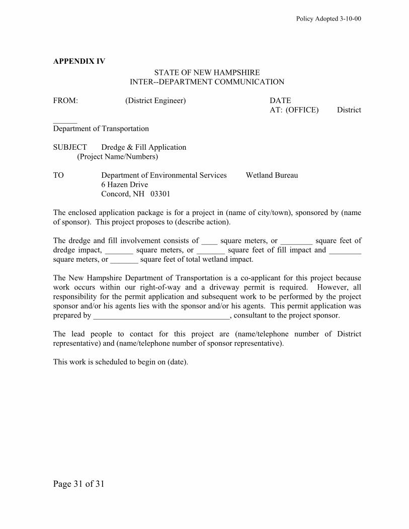
APPENDIX IV
STATE OF NEW HAMPSHIRE
INTER--DEPARTMENT COMMUNICATION
FROM: (District Engineer) DATE
AT: (OFFICE) District
______
Department of Transportation
SUBJECT Dredge & Fill Application
(Project Name/Numbers)
TO Department of Environmental Services Wetland Bureau
6 Hazen Drive
Concord, NH 03301
The enclosed application package is for a project in (name of city/town), sponsored by (name
of sponsor). This project proposes to (describe action).
The dredge and fill involvement consists of ____ square meters, or ________ square feet of
dredge impact, _______ square meters, or _______ square feet of fill impact and ________
square meters, or _______ square feet of total wetland impact.
The New Hampshire Department of Transportation is a co-applicant for this project because
work occurs within our right-of-way and a driveway permit is required. However, all
responsibility for the permit application and subsequent work to be performed by the project
sponsor and/or his agents lies with the sponsor and/or his agents. This permit application was
prepared by __________________________________, consultant to the project sponsor.
The lead people to contact for this project are (name/telephone number of District
representative) and (name/telephone number of sponsor representative).
This work is scheduled to begin on (date).

DGN
FigureI
HOUSE
R = RADIUS (SEE TABLE)R.O.W.R.O.W.
HOUSE
CORNER LOT
TURN AROUND
EDGE OF PAVEMENT
OR PAVED SHOULDER, WHERE EXISTING
ANGLE OF ENTRY 60^ - 90^
R R
{
DESIRABLE
200’ RURAL
100’ URBANDRIVE
W = DRIVE WIDTHS
EVERY EFFORT SHOULD BE MADE TO CONSTRUCT
NEW DRIVES AND TO REDIRECT EXISTING DRIVES
TO AN ANGLE OF ENTRY OF 75^ OR MORE
VALUES OF R (RURAL)
90^
75^
60^
15’
20’
20’
10’
15’
20’
10’
10’
15’
5’
10’
15’
5’
5’
10’
5’
5’
5’
5’
5’
5’
ANGLE
OF
ENTRY 12’ 14’ 16’ 18’ 20’ 22’ 24’
1) IN MOST CASES, URBAN R VALUES WILL BE LARGER.
2) CURBING, IF PRESENT, COULD BE FLARED TO FIT
DRIVE, OR ENDED AS SHOWN ON FIGURE X.
RESIDENTIAL DRIVE -- RURAL/URBAN
W
12’ MIN.
24’ MAX.W =
DATE
11/27/2006
3) NO PART OF ANY DRIVE SHALL BE CONSTRUCTED
OUTSIDE OF APPLICANT’S FRONTAGE.
À
BUSINESS/HOUSE
R.O.W.R.O.W.
EDGE OF PAVEMENT OR PAVED SHOULDER WHERE EXISTING
R R
D1
CORNER LOT
R = RADIUS (SEE TEMPLATE
AS APPROPRIATE)
ANGLE OF ENTRY
75^ - 90^
BUSINESS/
HOUSE
NOTES:
ANGLE AS APPROPRIATE
1
1
W
W ={12’ MIN. (RESIDENTIAL ONLY)
50’ MAX.
DESIRABLE
200’ RURAL
100’ URBAN
DRIVE
1) D DISTANCE VARIES - MINIMUM 30’ OR R.O.W. LINE WHICH
EVER IS GREATER. HIGHER TRAFFIC COUNT WILL NECESSITATE
LARGER D .
2) CURBING IF PRESENT, COULD BE FLARED TO FIT DRIVE OR
ENDED AS SHOWN ON FIGURE X.
3) WHERE REQUIRED, SEE FIGURES XI AND XII
FOR LANE WIDENING.
4) COMMON DRIVES SHALL BE PAVED TO A POINT 20 FEET
FROM THE EDGE OF THE STATE HIGHWAY IF PAVED.
COMMON DRIVE - RESIDENTIAL OR MAJOR ENTRANCE
RURAL/URBANDATE
11/27/2006
DGN
FigureII
À
SINGLE DRIVES -- MAJOR ENTRANCE -- RURAL/URBAN
NOTES: 3) TOWN ROADS SHOULD BE TREATED
AS MAJOR ENTRANCES.
R R
R
R
EDGE OF PAVEMENT
R.O.W.
R.O
.W.
1) CURBING, IF PRESENT COULD
BE FLARED TO FIT DRIVE OR
END AS SHOWN ON FIGURE IX
2) NO PART OF ANY DRIVE SHALL
BE CONSTRUCTED OUTSIDE OF
APPLICANT’S FRONTAGE.
4) WHERE REQUIRED, SEE FIGURES
XI AND XII FOR LANE WIDENING
R = RADIUS
(USE APPLICABLE TEMPLATE ON
FIGURES XII AND XIII)
W =30’ MIN.
50’ MAX.{
ANGLE OF ENTRY 75^ - 90^
ANGLE OF ENTRY
75^ - 90^SEE NOTE 2
200’ DESIRABLE - RURAL
100’ DESIRABLE - URBAN
W
W
COMMERCIAL/
INDUSTRIAL/
SUBDIVISION
DATE
SEE NOTE 2
11/27/2006
DGN
FigureIII
ÀÀ
200’ D
ES
IR
AB
LE
- R
UR
AL
100’ D
ES
IR
AB
LE
- U
RB
AN
À
DATE
11/27/2006
ONE-WAY DRIVES -- MAJOR ENTRANCE -- RURAL/URBAN
2) NO PART OF ANY DRIVE SHALL
BE CONSTRUCTED OUTSIDE OF
APPLICANT’S FRONTAGE.
4) THIS CONFIGURATION SHALL BE
CONSIDERED 2 ACCESS POINTS.
NOTES: 1) CURBING, IF PRESENT, COULD
BE FLARED TO FIT DRIVE OR
ENDED AS SHOWN ON FIGURE X.
MEDIAN
EDGE OF PAVEMENT OR PAVED SHOULDER WHERE EXISTING
R.O.W.
R = RADIUS (SMALL) = 3.5’ ALWAYS
R = RADIUS (LARGE)
(USE APPLICABLE TEMPLATE ON
FIGURES XIII, XIV, OR XV)
S
L
W =30’ MIN.
50’ MAX.{
COMMERCIAL/
INDUSTRIAL
ANGLE OF
ENTRY
45^ - 90^
W W50’ DESIRABLE
20’ MIN.
200’ DESIRABLE - RURAL
100’ DESIRABLE - URBAN
SEE NOTE 2
S SR RL LR R
3) WHERE REQUIRED, SEE FIGURE XI
FOR LANE WIDENING.
DGN
FigureIV
R.O
.W.
À
À
À
À
DATE
11/27/2006
TWO-WAY DRIVES -- MAJOR ENTRANCE -- RURAL/URBAN
1) CURBING, IF PRESENT, COULD
BE FLARED TO FIT DRIVE OR
ENDED AS SHOWN ON FIGURE X.
2) NO PART OF ANY DRIVE SHALL
BE CONSTRUCTED OUTSIDE OF
APPLICANT’S FRONTAGE.
3) CUSTOMER SERVICES MUST BE
SET BACK SUFFICIENTLY TO
PREVENT ENCROACHMENT ON
RIGHT-OF-WAY.
4) WHERE REQUIRED, SEE FIGURES
XI AND XII FOR LANE WIDENING.
5) THIS CONFIGURATION SHALL BE
CONSIDERED 2 ACCESS POINTS.
NOTES:
W W
R R R R
ANGLE OF
ENTRY
75^ - 90^
50’ DESIRABLE
30’ MIN.
15
’
MIN
.
COMMERCIAL/
INDUSTRIAL
W =30’ MIN.
50’ MAX.{
R = RADIUS
(USE APPLICABLE
TEMPLATE ON
FIGURES XIII,
XIV OR XV)
R.O.W.
R.O
.W.
EDGE OF PAVEMENT OR PAVED SHOULDER WHERE EXISTING
200’ DESIRABLE - RURAL
100’ DESIRABLE - URBAN
SEE NOTE 2
DGN
FigureV
(SERVICE
STATION)
À
À

DATE
11/27/2006
DIVIDED DRIVE -- MAJOR ENTRANCE -- RURAL/URBAN
TRAFFIC SIGNAL REQUIREMENTS, PAVEMENT MARKINGS, SIGNS
AND GEOMETRY MAY VARY WHERE CONDITIONS WARRANT AS
DETERMINED BY THE DEPARTMENT OF TRANSPORTATION.
WHEN N.H.D.O.T. ENGINEERING REVIEW SHOWS NECESSITY,
HIGHWAY MODIFICATIONS INCLUDING, BUT NOT LIMITED TO,
WIDENING, TRAFFIC SIGNALS, SIGNING AND PAVEMENT
MARKING WILL BE REQUIRED.
THIS ENTRANCE SHALL BE CONSIDERED 1 ACCESS POINT
= CURB
= RADIUS TANGENT POINTS
NOTE:
100’
R=50’
R =
125’
R =
200’
CURB CURB RIGHT TURN LANE
150’
MINIMUM
15
0’ M
IN
.
300’ D
ES
IR
AB
LE
R=3’
22
’
MIN
.
20’
20’
24’
24’ 24’
20’
20’
20’
24’ 24’
4’
6’
12’
150’
25:1 TAPER
R=3.5
’
R=1’
R=1’
R=
3.5
’
R=5’ R=5’4’
4’
12
’
À
À
. .R=3’
.
A
A
A
A
12’12’
12’
4’
10’
DGN
FigureVI
12’
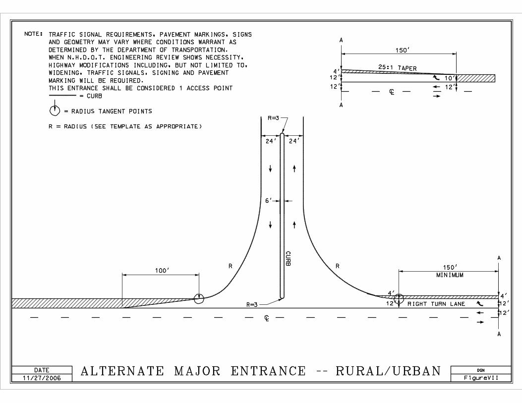
DATE
11/27/2006ALTERNATE MAJOR ENTRANCE -- RURAL/URBAN
TRAFFIC SIGNAL REQUIREMENTS, PAVEMENT MARKINGS, SIGNS
AND GEOMETRY MAY VARY WHERE CONDITIONS WARRANT AS
DETERMINED BY THE DEPARTMENT OF TRANSPORTATION.
WHEN N.H.D.O.T. ENGINEERING REVIEW SHOWS NECESSITY,
HIGHWAY MODIFICATIONS INCLUDING, BUT NOT LIMITED TO,
WIDENING, TRAFFIC SIGNALS, SIGNING AND PAVEMENT
MARKING WILL BE REQUIRED.
THIS ENTRANCE SHALL BE CONSIDERED 1 ACCESS POINT
= CURB
= RADIUS TANGENT POINTS
R = RADIUS (SEE TEMPLATE AS APPROPRIATE)
NOTE:
R R
R=3
R=3
24’ 24’
6’
150’
MINIMUM
RIGHT TURN LANE
100’
CU
RB
12’
12’
12’
12’
12’ 12’
10’
25:1 TAPER
150’
4’4’
4’
À
A
A
À
A
A
DGN
FigureVII
DATE
11/27/2006
ALTERNATE LAND SUBDIVISION PLANS
R.O.W.
R.O.W.
THIS
NOT THIS
MAIN HIGHWAY
MAIN HIGHWAY
RESULTS:
R.O.W.
R.O.W.
À
À
DGN
FigureVIII
- BETTER RESIDENTIAL AMENITY
- IMPROVED HIGHWAY ACCESS SAFETY

DGN
FigureIX
DATE
11/27/2006
TYPICAL RURAL DRIVE IN FILL SECTION
TYPICAL RURAL DRIVE IN CUT SECTION
1) GRADES OF MAJOR ENTRANCES
BEYOND THE PLATFORM
SHOULD NOT EXCEED 8%.
2) GRADES OF OTHER DRIVES
BEYOND THE PLATFORM
SHOULD NOT EXCEED 15%.
3) THE ALGEBRAIC DIFFERENCE
BETWEEN TWO ADJACENT GRADES
SHOULD NOT EXCEED 10%.
4) DITCHES ARE RECOMMENDED
FOR UNCURBED DRIVEWAYS IN
CUT SLOPES.
5) USE SLOPE END SECTIONS ON
CULVER PIPES.
6) ALL DRIVEWAYS SHALL HAVE
A SECTION CONTIGUOUS TO
THE HIGHWAY WHICH
APPROXIMATES LEVEL GROUND.
NOTES:
OLD GROUND CULVERT WHERE NEEDED
(12" MIN. OR AS SPECIFIED)
BREAK
POINTGRADE
GRADE
A-A DRIVEWAY
CROSS SECTION
A
A
DITCH DRIVE
SLOPE
OLD GROUND
VARIABLE
GRADE
À
DITCH
CULVERT (12" MIN.
OR AS SPECIFIED)
BREAK POINTS
GRADE
A
A
EDGE OF
SHOULDER
EDGE OF
SHOULDER
CU
T S
LO
PE
PLATFORM
20’ MIN. DESIRABLE
PLATFORM
20’ MIN. DESIRABLE
FIL
L S
LO
PE
DATE
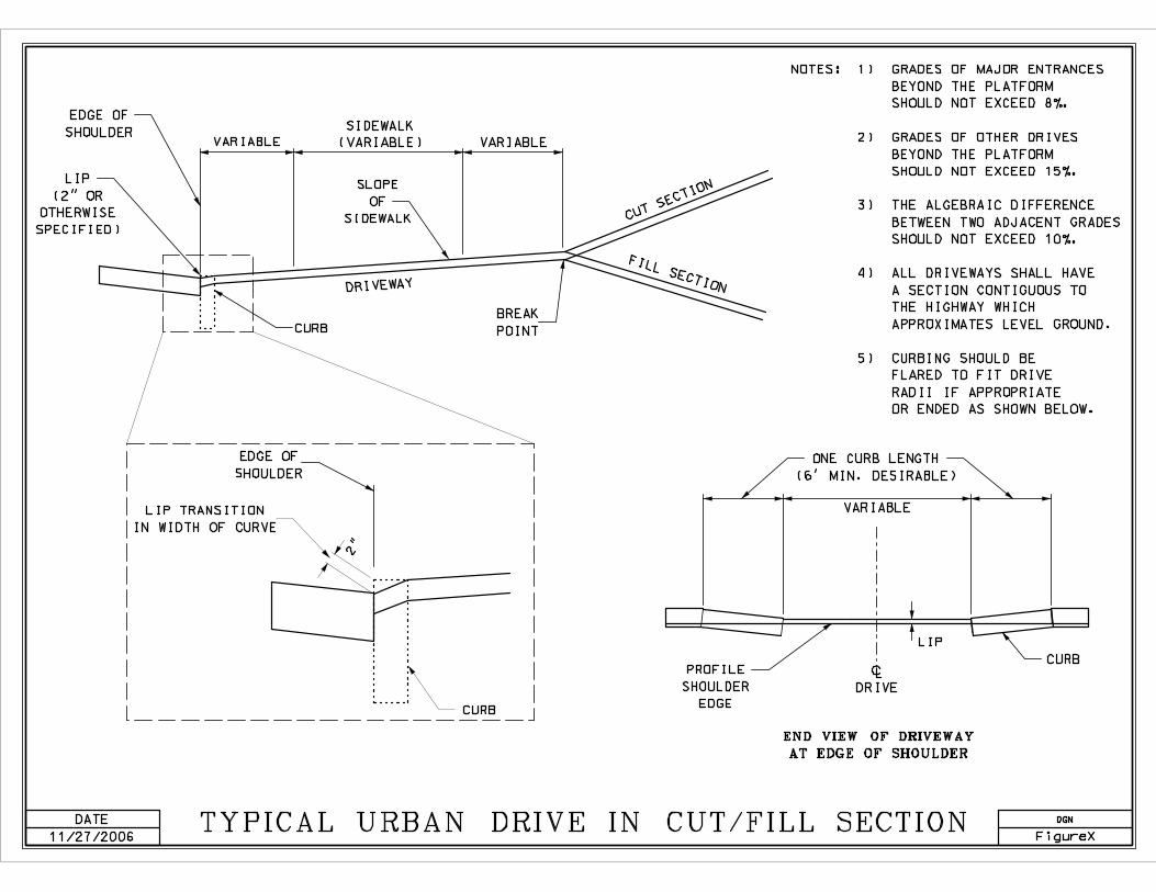
11/27/2006TYPICAL URBAN DRIVE IN CUT/FILL SECTION
1) GRADES OF MAJOR ENTRANCES
BEYOND THE PLATFORM
SHOULD NOT EXCEED 8%.
2) GRADES OF OTHER DRIVES
BEYOND THE PLATFORM
SHOULD NOT EXCEED 15%.
3) THE ALGEBRAIC DIFFERENCE
BETWEEN TWO ADJACENT GRADES
SHOULD NOT EXCEED 10%.
4) ALL DRIVEWAYS SHALL HAVE
A SECTION CONTIGUOUS TO
THE HIGHWAY WHICH
APPROXIMATES LEVEL GROUND.
5) CURBING SHOULD BE
FLARED TO FIT DRIVE
RADII IF APPROPRIATE
OR ENDED AS SHOWN BELOW.
NOTES:
END VIEW OF DRIVEWAY
AT EDGE OF SHOULDER
LIP
(2" OR
OTHERWISE
SPECIFIED)
VARIABLE
SIDEWALK
(VARIABLE) VARIABLE
SLOPE
OF
SIDEWALK
CURB
BREAK
POINT
DRIVEWAY
CUT SECTION
FILL SECTION
LIP TRANSITION
IN WIDTH OF CURVE
EDGE OF
SHOULDER
CURB
PROFILE
SHOULDER
EDGE
À
DRIVE
LIP
CURB
VARIABLE
ONE CURB LENGTH
(6’ MIN. DESIRABLE)
DGN
FigureX
EDGE OF
SHOULDER
2"
DATE
11/27/2006
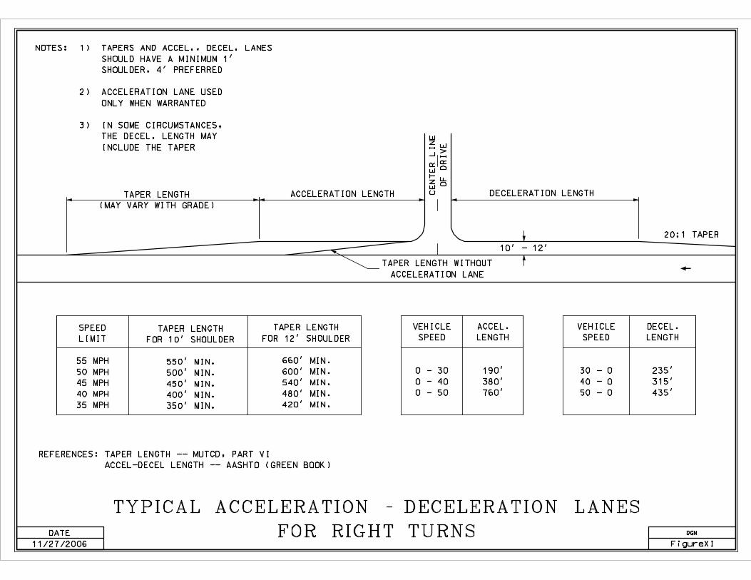
TYPICAL ACCELERATION - DECELERATION LANES
FOR RIGHT TURNS
SPEED
LIMIT
55 MPH
50 MPH
45 MPH
40 MPH
35 MPH
TAPER LENGTH
FOR 10’ SHOULDER
550’ MIN.
500’ MIN.
450’ MIN.
400’ MIN.
350’ MIN.
TAPER LENGTH
FOR 12’ SHOULDER
660’ MIN.
600’ MIN.
540’ MIN.
480’ MIN.
420’ MIN.
VEHICLE
SPEED
0 - 30
0 - 40
0 - 50
ACCEL.
LENGTH
190’
380’
760’
VEHICLE
SPEED
30 - 0
40 - 0
50 - 0
DECEL.
LENGTH
235’
315’
435’
REFERENCES: TAPER LENGTH -- MUTCD, PART VI
ACCEL-DECEL LENGTH -- AASHTO (GREEN BOOK)
CE
NT
ER
LIN
E
OF
DR
IVE
TAPER LENGTH
(MAY VARY WITH GRADE)
ACCELERATION LENGTH DECELERATION LENGTH
20:1 TAPER
TAPER LENGTH WITHOUT
ACCELERATION LANE
10’ - 12’
DGN
FigureXI
NOTES: 1) TAPERS AND ACCEL., DECEL. LANES
SHOULD HAVE A MINIMUM 1’
SHOULDER, 4’ PREFERRED
2) ACCELERATION LANE USED
ONLY WHEN WARRANTED
3) IN SOME CIRCUMSTANCES,
THE DECEL. LENGTH MAY
INCLUDE THE TAPER
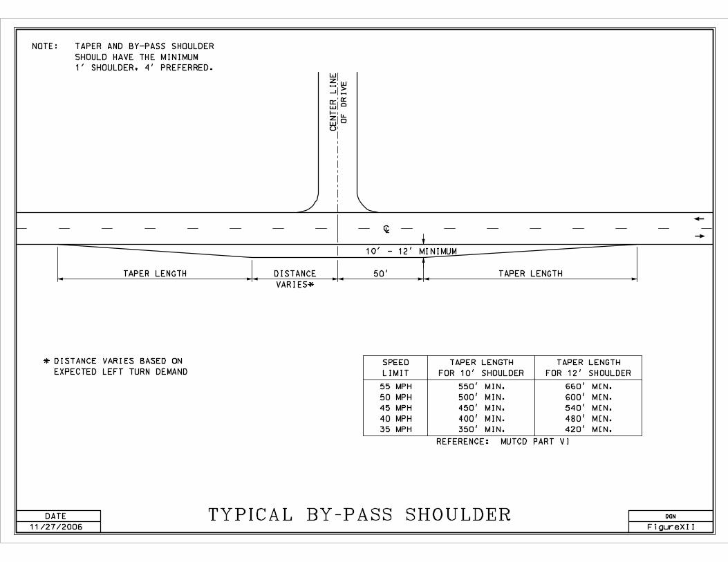
DATE
11/27/2006
TYPICAL BY-PASS SHOULDER
55 MPH
50 MPH
45 MPH
40 MPH
35 MPH
REFERENCE: MUTCD PART VI
NOTE: TAPER AND BY-PASS SHOULDER
SHOULD HAVE THE MINIMUM
1’ SHOULDER, 4’ PREFERRED.
TAPER LENGTH 50’ TAPER LENGTH
CE
NT
ER
LIN
E
OF
DR
IVE
10’ - 12’ MINIMUM
À
SPEED
LIMIT
DGN
FigureXII
TAPER LENGTH
FOR 10’ SHOULDER
550’ MIN.
500’ MIN.
450’ MIN.
400’ MIN.
350’ MIN.
660’ MIN.
600’ MIN.
540’ MIN.
480’ MIN.
420’ MIN.
TAPER LENGTH
FOR 12’ SHOULDER
* DISTANCE VARIES BASED ON
EXPECTED LEFT TURN DEMAND
DISTANCE
VARIES*


