
Downstream of Adel on the North Raccoon
A rock dam
at the Bennett Access.
The North Raccoon River is a mostly freeflowing river surrounded by rural areas in a wooded val-ley. It is known as a place of solitude and good fishing. At its upper navigable reaches in Sac County, the river flows through a heavily glaciated area with unique scenery. A dozen rock dams (also known as fishing riffles) can be navigated by experienced paddlers, but many will wish to portage them. One low-head dam at Adel must be portaged on the designated path. Clay bluffs, along with occasional rock outcroppings, can be observed at various points along the river. Near Van Meter, the North and South branches converge to form the Raccoon River. Commerce Ledges at Walnut Woods State Park forms rapids at moderate to high flows that can be challenging -- it can be portaged on the river right. Channel catfish can be caught at deeper pools, near log jams, and along cut banks.
Major fish species present: Channel catfish
Minor fish species present: Bullhead, smallmouth bass, flathead catfish, walleye
"
"
"
"
"
"
!
!!
!
!!!
!
!
! !! !
!
!
!
!!
!
!
!
!
!
!
!
!
!
!
!
!
!
!!!
!
!!
!
!
!
!
!
!
!
!
!
!
!!!
!!##
#
#
##
#
#
#
#
#
#
#
#
##
#
#
#
#
#
#
#
#
#
#
#
#
#
#
##
#
#
#
#
#
#
#
##
#
#
#
#
#
#
#
#
#
#
#
¬«39
¬«4
¬«415
¬«44
¬«17
¬«
¬«144
¬«4
¬«71
¬«173
¬«50
¬«221
¬«46
¬«9
¬«36
¬«124
¬«401
¬«930
¬«45
¬«383
¬«160
¬«141
¬«25
¬«30
¬«175
¬«7
¬«928
¬«141
¬«4
¬«175
¬«928
¬«28
¬«5
£¤69
£¤71
£¤20
£¤69
£¤6
§̈¦80
§̈¦35
§̈¦235
!
!
GUTHRIE DALLAS
BOONEGREENE
CALHOUN
SAC
CARROLL
POLK
¬«141
4
5 mi
N
1 mi. 2 mi.
N
1 mi. 2 mi.
N
510
152025
30
355
1015
20
5
25
10
30
35
40
4550
55
60
65
40
45
50
55
60
6570
75
80
8590
95100
105
110
115120
125
130
135
140
145150
155
160
165
170
175
180
185
North
Raccoon
River
South
Middle
Raccoon River
Lake City
Sac City
Jefferson
Coon Rapids
Perry
Ankeny
Urbandale
Grimes
Des Moines
Panora
Carroll
Dallas Center
Adel
Van Meter
Linden
Raccoon
River
North
Raccoon
River
!
!|
Chatauqua Park
Hyde Park
Hagge Park
Grant Park
Vogel Access
Rainbow Bend
Hobbs Access
Wright Access
Butrick Bluff
Richey Access
Snyder Access
P-28 AccessCowles Access
Jackson Access
Bennett Access
Henderson Park
Riverside Park
Shearer Access
Commerce Ledges
McDonald Access
Sac City Access(DNR Wildlife)
Perry Boat Ramp
Sportsmen's Park
Adel Island Park
Highway 44 Access
Two RiversBoonevilleAccess
White Horse Access
McMahon Access
Brown Bridge Access
Nations Bridge Park
North RaccoonAccess
Squirrel Hollow Park
Adkins Bridge Access
Spring Valley AccessSpringbrook State Park
Highway 141 River Access
Marlowe Ray
McCammond Access Des MoinesWaterworks Park
Kinnick-FellerRiverside Park
Merritt Access
Carroll County Access
Walnut WoodsState Park
Almer Noyd Wildlife Area
South Raccoon Access
Middle RaccoonRiver Access
EarlhamBridge
PleasantValley
!l
!l
!l!l
!l
!l
!l
!l
!l
!|!|
!|
!|
!|
!|
!|!|
!|
!|
!|
!|
!|
!|
!|
!|
!|
!_
!_
!_
!_ !_
!_
!_!_
!_
!_
!_
!_
!_
!_
!_
!|
!y
!y
!y!y
!y !y
!y
!y
!y
!y
!y
!y
!y
!y
!y
!y!y
!y
!y!y
!y
!y
!y
!²
!²
!²
!² !²
!²
!²
!²
!²
!²
!²
!²
!²
!9
!9
!9!9
!9
!9
!9
!9
!9!9
!9
!9
!9!9!9
!9!9
!9
!9
!9
!9
!m
!m
!m
!m!m
!m
!m!m
!m
!m
!m
!m
!m
!n!n
!n
!n
!n
Lake Panorama Dam!nLenon Mill Dam
Redfield DamWater Works Dam
Scott StreetDamPuckerbrush
Access!|
6
North Raccoon River Map 1
North Raccoon River and Raccoon River
Map 2
Portaging at Adel.
The North Raccoon’s clay bluffs in Greene County. Legend
²nm
|y
9
Hard-surface boat ramp
Carry down access
Campground
Rapids or rock dam
Dam (danger!)Drinking water near river
!_ Restroom
5-mile markers, from mouth
Watercraft campsite
Federal or state highway
City or town
Paved & unpaved roads
Public land
!l Fishing access| Unmaintained access
The Raccoon River in West Des Moines and Des Moines offers a tranquil greenbelt in the heart of
Iowa’s most urbanized area.
Expedition &
Fishing Guide
North Raccoon River, South Raccoon River, Middle Raccoon
River, and Raccoon River
Water Trails
Iowa
Be safe out there!
Wear a life jacket!They really do save lives. It won’t work if you don’t wear it.
Don’t boat under the influenceFor your safety, don’t use alchohol or drugs on the water.
Watch for hazardsOn rivers, hazards like dams, fences, snags, rocks, and bridge abuttments may be present. Dams and snags in particular can be killers. Avoid them!
Plan to get wet!You may capsize, so dress for the weather. When the water and/or weather get cold, warm-when-wet clothing and a wetsuit are needed.
Stay legal!Most land along these rivers is privately owned – these waters are navigable and open to the public, but you must respect private property.
Littering is a crime – pack out everything you bring in. Report littering or dumping by calling 888-NOLITTR.
Report environmental problems (fish kills, contaminants, etc.) to the Field Ofiice serving the county you are in:
Polk/Dallas: (515) 725-0268Guthrie/Greene/Carroll: (712) 243-1934 Calhoun/Sac: (712) 262-4177
ResourcesSee www.iowadnr.gov/watertrails/ for water trails information and our most recent listing of canoe/kayak liveries.
River gageswaterdata.usgs.gov or www.rivergages.com
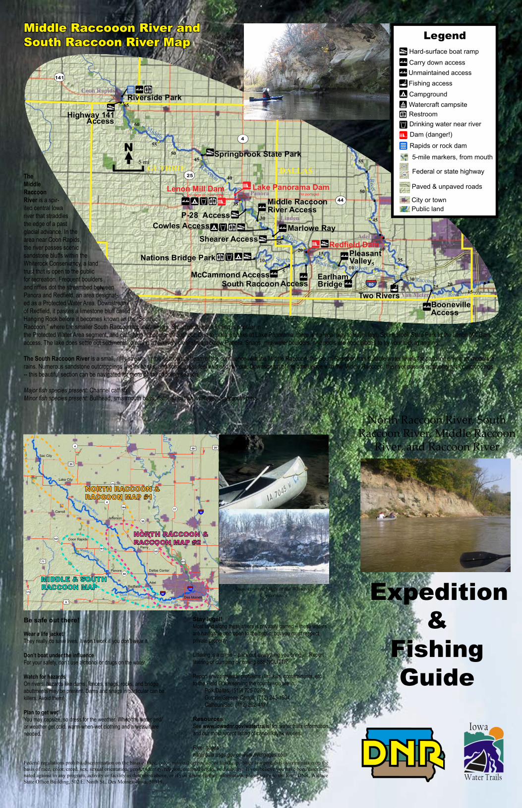
The Middle Raccoon River is a spir-ited central Iowa river that straddles the edge of a past glacial advance. In the area near Coon Rapids, the river passes scenic sandstone bluffs within the Whiterock Conservancy, a land trust that is open to the public for recreation. Frequent boulders and riffles dot the streambed between Panora and Redfield, an area designat-ed as a Protected Water Area. Downstream of Redfield, it passes a limestone bluff called Hanging Rock before it becomes known as the “South Raccoon,” where the smaller South Raccoon tributary enters. Smallmouth bass fishing is popular in the Protected Water Area segment, and catfishing is popular throughout. Due to private banks at Lake Panorama, there is no legal way to travel from Springbrook State Park to the Lenon Mill Dam access. The lake does settle out sediments, creating a relatively clear stream below Panora. Snags, mid-water boulders, and pools are good places to try your luck at angling.
The South Raccoon River is a small, riffly stream. In the section upstream of the confluence with the Middle Raccoon, the South Raccoon has suitable water levels for paddling only after moderate rains. Numerous sandstone outcroppings line its banks, and some areas feel wild and remote. Downstream of the confluence with the Middle Raccoon, the river passes additional rock outcroppings -- this beautiful section can be navigated for more of the paddling season.
Major fish species present: Channel catfishMinor fish species present: Bullhead, smallmouth bass, flathead catfish, walleye, largemouth bass
Hanging Rock on the Middle
Raccoon River
Federal regulations prohibit discrimination on the basis of race, color, national origin, sex or handicap. State law prohibits discrimination on the basis of race, color, creed, sex, sexual orientation, gender identity, religion, national origin, or disability. If you believe you have been discrimi-nated against in any program, activity or facility as described above, or if you desire further information, please write to the Iowa DNR, Wallace State Office Building, 502 E. Ninth St., Des Moines, Iowa, 50319.
"
"
"
"
"
"
!
!!
!
!!!
!
!
! !! !
!
!
!
!!
!
!
!
!
!
!
!
!
!
!
!
!
!
!!!
!
!!
!
!
!
!
!
!
!
!
!
!
!!!
!!##
#
#
##
#
#
#
#
#
#
#
#
##
#
#
#
#
#
#
#
#
#
#
#
#
#
#
##
#
#
#
#
#
#
#
##
#
#
#
#
#
#
#
#
#
#
#
¬«39
¬«4
¬«415
¬«44
¬«17
¬«
¬«144
¬«4
¬«71
¬«173
¬«50
¬«221
¬«46
¬«9
¬«36
¬«124
¬«401
¬«930
¬«45
¬«383
¬«160
¬«141
¬«25
¬«30
¬«175
¬«7
¬«928
¬«141
¬«4
¬«175
¬«928
¬«28
¬«5
£¤69
£¤71
£¤20
£¤69
£¤6
§̈¦80
§̈¦35
§̈¦235
!
!
GUTHRIE DALLAS
BOONEGREENE
CALHOUN
SAC
CARROLL
POLK
¬«141
4
5 mi
N
1 mi. 2 mi.
N
510
152025
30
355
10
1520
5
25
10
30
35
40
4550
55
60
65
40
45
50
55
60
6570
75
80
8590
95100
105
110
115120
125
130
135
140
145150
155
160
165
170
175
180
185
North
Raccoon
River
Lake City
Sac City
Jefferson
Coon Rapids
Perry
Ankeny
Urbandale
Grimes
Des Moines
Panora
Carroll
Dallas Center
Adel
Van Meter
Linden
Raccoon
River
North
Raccoon
River
Raccoon RiverSouth
Middle
Raccoon
River
!
!|
Chatauqua Park
Hyde Park
Hagge Park
Grant Park
Vogel Access
Rainbow Bend
Hobbs Access
Wright Access
Butrick Bluff
Richey Access
P-28 AccessCowles Access
Jackson Access
Bennett Access
Riverside Park
Shearer Access
McDonald Access
Sac City Access(DNR Wildlife)
Two RiversBoonevilleAccess
White Horse Access
McMahon Access
Brown Bridge Access
Nations Bridge Park
North RaccoonAccess
Springbrook State Park
Highway 141Access
Marlowe Ray
McCammond Access
Merritt Access
Carroll County Access
Almer Noyd Wildlife Area
South Raccoon Access
Middle RaccoonRiver Access
EarlhamBridge
PleasantValley
!l
!l!l
!l
!l
!l
!l
!l
!|!|
!|
!|
!|
!|!|
!|
!|
!|
!|
!|
!|
!|
!_
!_
!_
!_
!_
!_
!_
!_
!_
!|
!y
!y!y
!y
!y
!y
!y
!y
!y
!y!y
!y
!y
!y
!²
!²
!²
!²
!²
!²
!²
!9
!9
!9
!9
!9
!9
!9!9!9
!9!9
!9
!9
!9
!9
!m
!m
!m
!m!m
!m
!m
!m
!m
!m
!n
!n
Lake Panorama Dam!nLenon Mill Dam
Redfield Dam
(no portage)(portage on river right)
¬«4
¬«415
¬«44
¬«17
¬«7
3
¬«144
¬«28
¬«316¬«173
9
¬«30
¬«141
¬«25
¬«141
¬«4
¬«175
¬«141
£¤71
£¤20
£¤20£¤69
£¤6
£¤71
§̈¦80
§̈¦35
§̈¦235
Sac City
Jefferson
Carroll
Lake City
Coon Rapids
Panora
RedfieldAdel
Des Moines
Perry
Dallas Center
North Raccoon River
Middle Raccoon River
South Raccoon RiverRaccoon River
MIDDLE & SOUTH RACCOON MAP
NORTH RACCOON & RACCOON MAP #1
NORTH RACCOON & RACCOON MAP #2
Middle Raccooon River and South Raccoon River Map
Snow-covered bluffs at the Whiterock Conservancy.
Legend
²nm
|y
9
Hard-surface boat ramp
Carry down access
Campground
Rapids or rock dam
Dam (danger!)Drinking water near river
!_ Restroom
5-mile markers, from mouth
Watercraft campsite
Federal or state highway
City or town
Paved & unpaved roads
Public land
!l Fishing access| Unmaintained access


