ã2017CaliforniaInstituteofTechnology.Governmentsponsorshipacknowledged.
NISAR:TheNASA-ISROSARMission
LivingontheEdge:TheUpsandDownsofaCoastalExistenceAbout 40% of world’s population and 39% of U.S.residents live in coastal areas, much of which is lowelevation land. Coastal regions contain significantresourcesthatsupportthelivelihoodofmillionsofpeople,providingfood,protectionandawidevarietyofeconomic
opportunities.Theyhostcriticalinfrastructurerelatedtotransportation, fisheries, tourism and oil exploration.However, coastal resources and infrastructure arevulnerabletotheocean’smoods,e.g.,erosionbywaves,sealevelrise,stormsurgesandhurricanes.
CoastalRegionsandOceanMoods
Coastalregionscontainrichenvironmentsthatprovidelivelihoodsformillionsofpeopleworldwide.However,becauseoftheirlocationatthemarginbetweenlandandwater,theseareasareatriskfromfluctuatingconditionsthatexacerbatelandloss,threateningtheverygroundbeneathpeople’sfeet.
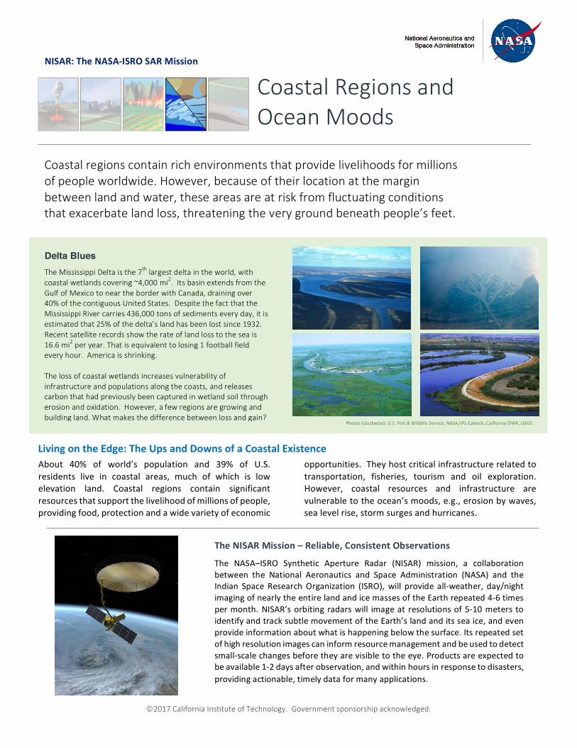
Delta Blues TheMississippiDeltaisthe7thlargestdeltaintheworld,withcoastalwetlandscovering~4,000mi2.ItsbasinextendsfromtheGulfofMexicotoneartheborderwithCanada,drainingover40%ofthecontiguousUnitedStates.DespitethefactthattheMississippiRivercarries436,000tonsofsedimentseveryday,itisestimatedthat25%ofthedelta’slandhasbeenlostsince1932.Recentsatelliterecordsshowtherateoflandlosstotheseais16.6mi2peryear.Thatisequivalenttolosing1footballfieldeveryhour.Americaisshrinking.Thelossofcoastalwetlandsincreasesvulnerabilityofinfrastructureandpopulationsalongthecoasts,andreleasescarbonthathadpreviouslybeencapturedinwetlandsoilthrougherosionandoxidation.However,afewregionsaregrowingandbuildingland.Whatmakesthedifferencebetweenlossandgain?
TheNISARMission–Reliable,ConsistentObservations
The NASA–ISRO Synthetic Aperture Radar (NISAR) mission, a collaborationbetween the National Aeronautics and Space Administration (NASA) and theIndian SpaceResearchOrganization (ISRO),will provideall-weather,day/nightimagingofnearlytheentirelandandicemassesoftheEarthrepeated4-6timespermonth.NISAR’sorbiting radarswill imageatresolutionsof5-10meterstoidentifyandtracksubtlemovementoftheEarth’slandanditsseaice,andevenprovideinformationaboutwhatishappeningbelowthesurface.Itsrepeatedsetofhighresolutionimagescaninformresourcemanagementandbeusedtodetectsmall-scalechangesbeforetheyarevisibletotheeye.Productsareexpectedtobeavailable1-2daysafterobservation,andwithinhoursinresponsetodisasters,providingactionable,timelydataformanyapplications.
Photos(clockwise):U.S.Fish&WildlifeService,NASA/JPL-Caltech,CaliforniaDWR,USGS
ã2017CaliforniaInstituteofTechnology.Governmentsponsorshipacknowledged.
Cont.fromfrontpage
Land loss in lowelevation coastal regions isdrivenbyacomplexarrayoffactors.Inthewetlands,wave-inducederosion is often tied to the health of the wetlandvegetation,whoserootsacttoholdthesoiltogether.Inaddition to erosion from physical wave action that isincreasedduringstormsurges,thepresenceoftoxinsorwaterofthewrongsalinityortemperaturecanstresstheplants, causing them to have less robust roots. Theerosionisexacerbatedbyalackoftheinfluxofsedimentthatwouldhelprebuildtheland,andthislosssignificantlyreducesthedepositionofnewsoiltooffsetthelosstotheocean. The sediment carried by the river is eithercapturedupstream indamsorprevented fromenteringthewetlandsby levees intendedtopreventstormsurgefrom reaching population centers and economic assetsalongtheriverfeedingthedelta.In the end, however, the wetland loss leads to deeperinlandintrusionofthestormwaters,apositivefeedbackloopwherebythewetlandsrecede,leavingcoastalcitiesatgreaterriskfromhighwindsandwaterduringstormsthatblowinfromtheocean.
Itisencouragingtolearnthatinafewareascoastaldeltasare actually expanding rather than losing ground.Understandingthedifferencebetweenlandlossandlandgain may be critical to saving the deltas, because thisinformation informshow to reverse the land loss in theshrinkingdeltas.With coastal populations growing at rates nearing 10%everydecadeandtheconcomitantincreasingdemandforocean resources, it becomes critical to understand theprocesses by which coastal wetlands are resilient orbecomevulnerabletotheocean’smood.Satelliteimagingisthemostefficientandreliablemethodtomonitorthestatus of low elevation coastal regions given their largesizeandglobalgeographicdistribution. Inparticular,theoft-presentlayerofcloudscoveringtheseareasrequiresradarimaging,whichpiercesthroughclouds,providinganon-demandaccessto imageryofcoastalareas. BecauseNISARisaNASAinstrument,itsdatawillbeavailablefreeofcharge,sothatitcanbeusedtoreducerisktolifeandpropertythroughouttheUnitedStates.
NationalAeronauticsandSpaceAdministration Formoreinformation,visithttp://nisar.jpl.nasa.gov/applications
JetPropulsionLaboratory/CaliforniaInstituteofTechnology/Pasadena,California/www.jpl.nasa.gov
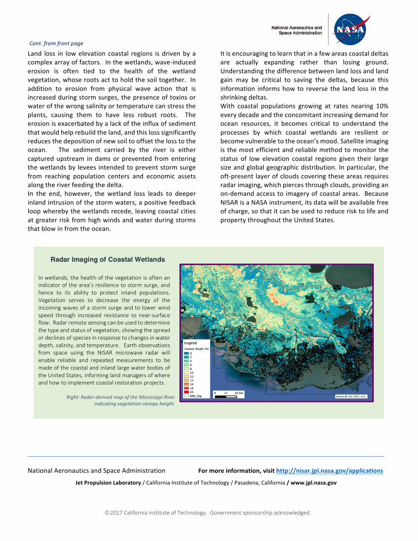
Inwetlands, thehealthof thevegetationisoftenanindicatorofthearea’sresiliencetostormsurge,andhence to its ability to protect inland populations.Vegetation serves to decrease the energy of theincomingwavesofastormsurgeandto lowerwindspeed through increased resistance to near-surfaceflow.Radarremotesensingcanbeusedtodeterminethetypeandstatusofvegetation,showingthespreadordeclinesofspeciesinresponsetochangesinwaterdepth,salinity,andtemperature.Earthobservationsfrom space using the NISAR microwave radar willenable reliable and repeated measurements to bemadeofthecoastalandinlandlargewaterbodiesoftheUnitedStates,informinglandmanagersofwhereandhowtoimplementcoastalrestorationprojects. Right:Radar-derivedmapoftheMississippiRiver
indicatingvegetationcanopyheight.
Radar Imaging of Coastal Wetlands


