- - -
23
Monroe County
Land & Water Resource Management Plan
2018-2028
- - -
23
Land & Water Resource Management Plan
Table of Contents Page
Table of Contents………………………………………………………………………….. i
Chapter 1, Introduction.......................................................................................................... 1
Background.................................................................................................................... 1
Public Participation…………………………………………………………………… 2
Relationship to Other Plans…………………………………………………………... 2
County Approval……………………………………………………………………... 3
Chapter 2, County Characteristics………………………………………………………… 4
Location, Size, and Population……………………………………………………….. 4
Geography and Geology……………………………………………………………… 5
Surface Water Resources……………………………………………………………... 5
Land Use and Trends…………………………………………………………………. 7
Chapter 3, Resource Assessment…………………………………………………………... 12
Cropland and Gully Erosion………………………………………………………….. 12
Cropland Transect Survey……………………………………………………………. 12
Storm Water and Construction Sites…………………………………………………. 15
Streambank Erosion………………………………………………………………….. 16
Fish Habitat…………………………………………………………………………… 17
Animal Waste………………………………………………………………………… 19
Nutrient Management………………………………………………………………… 21
Woodland……………………………………………………………………………... 23
County Forest………………………………………………………………………… 24
Wetlands……………………………………………………………………………… 24
Invasive Plants………………………………………………………………………... 25
Watershed Rankings and DNR Basin Plan Recommendations………………………. 27
Chapter 4, Goals, Objectives, & Actions…………………………………………………... 28
Sediment Delivery……………………………………………………………………. 29
Phosphorus and Manure Runoff……………………………………………………… 30
Preservation of Farmland……………………………………………………………... 30
Invasive Plant Species………………………………………………………………... 32
Cold Water Fishery…………………………………………………….……………... 32
Private Forest Lands………………………………………………………………….. 33
Chapter 5, NR 151 Agricultural Performance Standards………………………………… 34
NR 151 Implementation Strategy and Compliance Procedures……………………… 35
Information and Education…………………………………………………………… 35
Priority Farm Identification…………………………………………………………... 35
Compliance Determination…………………………………………………………… 35
Enforcement………………………………………………………………………… 36
i
- - -
23
Appeals……………………………………………………………………………….. 36
Chapter 6, Monitoring and Evaluation…………………………………………………….. 37
Geographic Information System (GIS)……………………………………………….. 37
Cropland Transect Survey……………………………………………………………. 37
Water Quality Monitoring……………………………………………………………. 37
Annual Accomplishment Report……………………………………………………... 38
Chapter 7, Information and Education Strategy…………………………………………… 39
Workshops…………………………………………………………………………….. 39
Agricultural Advisory Team………………………………………………………….. 39
Media…………………………………………………………………………………. 39
Educational Programming……………………………………………………………. 40
Chapter 8, Coordination…………………………………………………………………… 41
List of Appendices
Plan References……………………………………………………………………………. 1-A
Citizen Survey……………………………………………………………………………... 2-A
Monroe County NR 151 Evaluation Form………………………………………………… 5-A
Best Management Practice Definitions……………………………………………………. 7-A
Meeting Agendas………………………………………………………………………….. 10-A
Citizen & Technical Advisory Committee……………………………………………… 12-A
List of Maps
Map 1, PLSS Townships of Monroe County……… ……………………………………….. 4
Map 2, DNR River Basins and Watersheds of Monroe County….………………….……... 6
Map 3, Permitted Non-Metallic Mines of Monroe County……………......……………….. 9
Map 4, New Rural Addresses in Monroe County Since January 1, 2000……….…….…… 10
Map 5, 2018 NR 151 Inventory of Monroe County…….……......…………………………. 20
Map 6, Levels of Nitrates in Tested Wells of Monroe County………………………….….. 21
Map 6, Wetlands of Monroe County………………………………………………………. 24
Map 7, Shaded Relief of Monroe County………...………………………………………… 9-A
ii
- - -
23
Chapter One – Introduction
BACKGROUND
Wisconsin Act 27 (the 1997-1999 Budget Bill) and Wisconsin Act 9 (the 2000-2001 Budget
Bill), amended Chapter 92 of the Wisconsin Statutes, requiring counties to develop Land and
Water Resource Management (LWRM) plans. The intent of this change is to foster and support
a locally led process that improves decision-making, streamlines administrative and delivery
mechanisms, and better utilizes local, state, and federal funds to protect Wisconsin’s land and
water resources.
Monroe County has developed a 10 year LWRM plan (2018-2028). The first LWRM plan was
approved by the Land and Water Conservation Board in April of 1999. Followed by approved
revisions in 2005 & 2010.
Since completion of the original 1999 plan, several programs, rules, and land use trends have
impacted resource management in Monroe County.
Use Value Assessment continues to impact resource decisions being made by landowners.
NR 151 created runoff performance standards and prohibitions.
Monroe County completed the implementation of 2 Nonpoint Source Priority Watersheds
(Lake Tomah and the Middle Kickapoo River), and the Jersey Valley - Discovery Farm
Program.
The conversion of farms from dairy to cash cropping, and the larger and expanded dairies
have led to increased competition for available cropland.
Consolidation of farms has led to more acres and cattle controlled by fewer individuals.
Monroe County currently has four CAFO’s and more will be permitted in the future.
Wisconsin’s Phosphorus Water Quality Standards for surface waters were adopted on
December 1, 2010. These revisions allowed municipalities to meet water quality goals
through Phosphorous-trading or adaptive management.
A considerable amount of agricultural and forested land is now being used for rural
residences and recreational property, increasing the chances for conflicts between producers
and the rest of the public.
Invasive species are an increasing concern to the general public along with municipalities.
The formation of the County Deer Advisory Councils (CDAC) along with Deer Management
Area Program (DMAP) has put deer management at the local level. Chronic Wasting disease
is a concern of many residents and leadership of Monroe County.
Monroe County passed a non-metallic mining reclamation ordinance that requires
reclamation of all active quarries. Over the last 10 years there has been an shift of activity
from limestone quarries to sand mines to meet the growing demands from natural gas.
With the passage of the Working Lands Initiative, Monroe County landowners will no longer
be eligible to participate in the Farmland Preservation program by signing new agreements;
unless they reside in a designated Agricultural Enterprise Area (AEA). Monroe County has
two AEA’s encompassing 7 townships.
Monroe County and local units of government have completed “Smart Growth” plans,
1
- - -
23
written to guide officials when making decisions on land use issues. Many Municipalities
will be updating their comprehensive plans over the next couple years.
PUBLIC PARTICIPATION
Monroe County formed a citizen & advisory committee to develop and support the 2018 LWRM
Plan. Members represent agency staff, all realms of agriculture in Monroe County along with
citizens were asked to provide input into this plan. Public input was also gained through a
survey available to customers that came into our office, available on the LCD website, FSA
newsletter and Schools were targeted for input.
In addition to the survey and personal correspondence with the citizen members listed, Monroe
County staff and cooperating agency staff have had many informal discussions with the public
concerning Monroe County resource issues. These discussions are taken into consideration
when decisions are made on resource management priorities. The draft plan was reviewed by the
citizen & advisory committee, advisors and agency staff.
RELATIONSHIP TO OTHER PLANS
Several resource management plans have been previously developed that have a relationship to
this plan. Data from these plans was reviewed in the preparation of the Monroe County LWRM
plan:
1. State of the Basin Plans, Wisconsin DNR.
These reports provide an overview of land and water resource quality in the basin and
outlines actions to take to address problems
The State of the Lower Wisconsin River Basin, 2002
Website - https://dnr.wi.gov/topic/Watersheds/basins/lowerwis/
The State of the Bad Axe – La Crosse River Basin,2002
Website -https://dnr.wi.gov/topic/Watersheds/basins/balax/
The State of the Black-Buffalo-Trempealeau Basin, 2002
Website - https://dnr.wi.gov/topic/Watersheds/basins/bbt/
2. Monroe County Farmland Preservation Plan, 2014.
This plan was prepared for the purpose of identifying important farmlands and to aid in the
effort to protect farmlands by enabling farmers to participate in the Farmland Preservation
Program.
3. Monroe County Soil Erosion Control Plan, 1988
This plan was written to meet the requirements of Chapter 92 of Wisconsin Statutes. The
plan identifies areas where soil erosion standards are not being met and identifies procedures
and priorities for controlling erosion.
4. Hydrologic Assessment of the Kickapoo Watershed, Southwestern Wis., 1998
This plan was written by the Wisconsin Geological and Natural History Survey and the UW
Department of Geological Engineering for the Trout Unlimited Home Rivers Initiative
project in the Kickapoo Watershed. The report provides an assessment of the hydrologic
conditions in the watershed and makes recommendations for improvement.
5. Nonpoint Watershed Control Plans
2

- - -
23
These plans were written to provide guidance for the implementation of nonpoint
watershed projects in the county.
Nonpoint Source Control Plan for Lake Tomah, 1994
The water quality objectives of this plan were to:
a. reduce sediment delivery from upland sources by 60%
b. reduce sediment tonnage from streambanks by 70%
c. reduce organic pollution from livestock waste by 75%
d. high priority landowners should implement 590 plans
Nonpoint Source Control Plan for the Middle Kickapoo River, 1991
The water quality objectives of this plan were to:
a. reduce sediment delivery from upland sources by 50%
b. reduce sediment tonnage from streambank sites by 60%
c. reduce organic pollution from livestock wastes by 60%
d. high priority landowners should implement Nutrient Management Plans
6. Wastewater Treatment Facilities –Adaptive Management (Phosphorous) Plans: These
Plans were developed in response to the 2010, NR 102 and NR217 modifications to meet
new water quality based effluent limits for phosphorous - 0.075 mg/L.
https://dnr.wi.gov/topic/SurfaceWater/AmWqtMap.html
Sparta - Water Quality Trading Plan, 2014
Tomah - Adaptive Management Plan, 2017
Norwalk – Water Quality Trading Plan, 2018
Fort McCoy, Adaptive Management Plan, 2018
VVP Group, Norwalk – Water Quality Trading Plan, 2019
7. Monroe County Comprehensive Plan, 2014
This plan was written to meet the state’s “Smart Growth” legislation. It is intended to guide
elected officials and staff when making land use decisions.
Websitehttp://www.co.monroe.wi.us/wp-
content/uploads/2015/02/MonroeCounty_ComprehensivePlan_Revised%209-24-14.pdf
under Zoning Department
8. Lake Tomah Management Plan
This plan, completed in 2009, was prepared by agency staff and Tomah Lake Committee
members. The plan defines goals and activities to improve attributes of Lake Tomah.
9. 9 Key Element Plan
The Land Conservation Department in consultation with DNR is considering over the next
few years of seeking EPA approval on a watershed plan that focuses on groundwater
monitoring and or flood mitigation.
COUNTY APPROVAL
The Monroe County Land Conservation Committee held a public hearing on the Monroe County
LWRM plan on January ____, 2019.
3

- - -
23
The Monroe County Land and Water Resource Management Plan was reviewed and approved by
the Monroe County Board of Supervisors on February___, 2019.
Chapter Two – County Characteristics
LOCATION, SIZE, AND POPULATION
Monroe County, established in 1854, is located in west central Wisconsin and is bordered on the
west by La Crosse County, on the south by Vernon County, on the east by Juneau County, and
on the north by Jackson County. The county is approximately 33 miles from east to west and 30
miles across from north to south. The total area is approximately 581,300 acres, or 908 square
miles. The population in 1980 was 35,074, rising to an estimated 46,109 in 2017. Sparta (9,881)
and Tomah (9,491) are the largest cities. Sparta, located in the west-central part of the county, is
the county seat. Twenty-four townships make up the county. The Fort McCoy Military
Reservation is located in parts of six townships and encompasses 60,000 acres. The Central
Wisconsin Conservation Area, owned primarily by the U.S. Fish and Wildlife Service (USFS)
and managed cooperatively by USFWS and Wisconsin DNR, is located on 16,000 acres of Scott
Township.
MAP 1 – PLSS TOWNSHIPS OF MONROE COUNTY
4
- - -
23
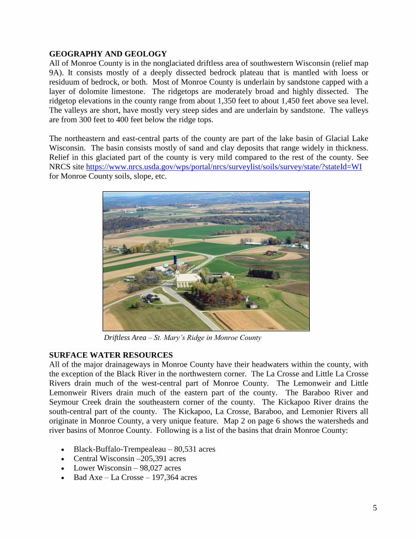
GEOGRAPHY AND GEOLOGY
All of Monroe County is in the nonglaciated driftless area of southwestern Wisconsin (relief map
9A). It consists mostly of a deeply dissected bedrock plateau that is mantled with loess or
residuum of bedrock, or both. Most of Monroe County is underlain by sandstone capped with a
layer of dolomite limestone. The ridgetops are moderately broad and highly dissected. The
ridgetop elevations in the county range from about 1,350 feet to about 1,450 feet above sea level.
The valleys are short, have mostly very steep sides and are underlain by sandstone. The valleys
are from 300 feet to 400 feet below the ridge tops.
The northeastern and east-central parts of the county are part of the lake basin of Glacial Lake
Wisconsin. The basin consists mostly of sand and clay deposits that range widely in thickness.
Relief in this glaciated part of the county is very mild compared to the rest of the county. See
NRCS site https://www.nrcs.usda.gov/wps/portal/nrcs/surveylist/soils/survey/state/?stateId=WI
for Monroe County soils, slope, etc.
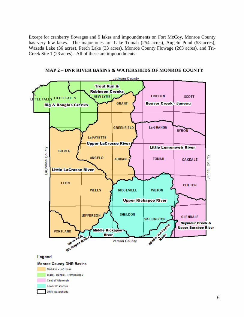
SURFACE WATER RESOURCES
All of the major drainageways in Monroe County have their headwaters within the county, with
the exception of the Black River in the northwestern corner. The La Crosse and Little La Crosse
Rivers drain much of the west-central part of Monroe County. The Lemonweir and Little
Lemonweir Rivers drain much of the eastern part of the county. The Baraboo River and
Seymour Creek drain the southeastern corner of the county. The Kickapoo River drains the
south-central part of the county. The Kickapoo, La Crosse, Baraboo, and Lemonier Rivers all
originate in Monroe County, a very unique feature. Map 2 on page 6 shows the watersheds and
river basins of Monroe County. Following is a list of the basins that drain Monroe County:
Black-Buffalo-Trempealeau – 80,531 acres
Central Wisconsin –205,391 acres
Lower Wisconsin – 98,027 acres
Bad Axe – La Crosse – 197,364 acres
Driftless Area – St. Mary’s Ridge in Monroe County
5
- - -
23
Except for cranberry flowages and 9 lakes and impoundments on Fort McCoy, Monroe County
has very few lakes. The major ones are Lake Tomah (254 acres), Angelo Pond (53 acres),
Wazeda Lake (36 acres), Perch Lake (33 acres), Monroe County Flowage (263 acres), and Tri-
Creek Site 1 (23 acres). All of these are impoundments.
MAP 2 – DNR RIVER BASINS & WATERSHEDS OF MONROE COUNTY
6
- - -
23
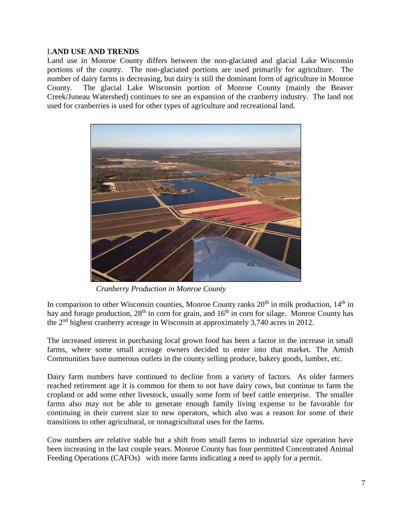
LAND USE AND TRENDS
Land use in Monroe County differs between the non-glaciated and glacial Lake Wisconsin
portions of the county. The non-glaciated portions are used primarily for agriculture. The
number of dairy farms is decreasing, but dairy is still the dominant form of agriculture in Monroe
County. The glacial Lake Wisconsin portion of Monroe County (mainly the Beaver
Creek/Juneau Watershed) continues to see an expansion of the cranberry industry. The land not
used for cranberries is used for other types of agriculture and recreational land.
In comparison to other Wisconsin counties, Monroe County ranks 20th in milk production, 14th in
hay and forage production, 28th in corn for grain, and 16th in corn for silage. Monroe County has
the 2nd highest cranberry acreage in Wisconsin at approximately 3,740 acres in 2012.
The increased interest in purchasing local grown food has been a factor in the increase in small
farms, where some small acreage owners decided to enter into that market. The Amish
Communities have numerous outlets in the county selling produce, bakery goods, lumber, etc.
Dairy farm numbers have continued to decline from a variety of factors. As older farmers
reached retirement age it is common for them to not have dairy cows, but continue to farm the
cropland or add some other livestock, usually some form of beef cattle enterprise. The smaller
farms also may not be able to generate enough family living expense to be favorable for
continuing in their current size to new operators, which also was a reason for some of their
transitions to other agricultural, or nonagricultural uses for the farms.
Cow numbers are relative stable but a shift from small farms to industrial size operation have
been increasing in the last couple years. Monroe County has four permitted Concentrated Animal
Feeding Operations (CAFOs) with more farms indicating a need to apply for a permit.
7
Cranberry Production in Monroe County

- - -
23
PL566 Structure in Portland Township (CC-29)
The two main land uses consuming prime agricultural land in Monroe County are development
and non-metallic mining. Land development is consuming about a section of land per year since
the year 2000 (See Pg. 9, 10, &11); which has changed our clientele and types of water quality
issues the LCD is dealing with. The natural gas industrial technology change for utilizing frac
sand has impacted Monroe County. Six out of the 45 permitted mines in Monroe County are frac
sand consuming 3,193 acres (see map 3 on pg. 9). As compared to most gravel mines, the frac
sand mines cover many more acres per mile.
Compounding these land use changes with climate change has impacted certain regions of
Monroe County since 2007. Based on the 2018 La Crosse Meteorologist Report, 16 major flood
events have occurred within the driftless area since 2007, leading to major agriculture,
infrastructure and personal property damage. The volume of rain is not as much of a problem as
the rainfall intensity of these events. Monroe County has received 2-6 inches of rain per hour in
some areas that have jeopardized our history of conservation practices. Most conservation
practices are designed for a 10 year storm event or 4.2 inch rain event over a 24 hour period. The
rain events we are experiencing range in the 500-1,000 year storm events. This trend is forcing
us to look at our practice designs and land use decisions within the floodplain. For example, on
August 28, 2018, three PL566 dam structures breached in the Town of Portland leading to major
devastation in the Coon Creek Watershed.
8
Tri-Creek Impoundment

- - -
23
MAP 3 – PERMITTED (45) NON-METALLIC MINES OF MONROE COUNTY
9

- - -
23
10
MAP 4 – NEW RURAL ADDRESSES IN MONROE COUNTY
SINCE JANUARY 1, 2000

- - -
23
Monroe County loses one section of Ag land per year
Non-Metallic Mining Development
11
- - -
23
Chapter Three - Resource Assessment
CROPLAND AND GULLY EROSION Monroe County has participated in inventories and surveys designed to determine cropland soil
loss rates. Stockham, Vandewalle & Gutheinz, Inc. prepared a soil loss inventory for Monroe
County in 1988 to meet Chapter 92 requirements. At that time, the average sheet and rill erosion
rate for cropland in Monroe County was determined to be 6.6 tons/acre/year. Township erosion
rates varied from 3.2 tons/acre year to 9.3 tons/acre/year. About 50% of Monroe County
cropland (74,800 acres) was determined to be eroding at rates greater than the allowable rate.
Soil loss and sediment delivery inventories were completed as a part of the planning process for
two Nonpoint Watershed projects in Monroe County. The plan used WIN, a computer model
developed by the Wisconsin DNR, to determine sediment delivery rates to surface waters. The
inventory results showed 6,068 tons of sediment delivered annually to streams from upland
sources in the Middle Kickapoo River Watershed in Monroe County.
The Nonpoint Source Control Plan for the Lake Tomah Priority Lake Project was completed in
2002. Inventory results showed 1,115 tons of sediment delivered annually. Since the completion
of these Non-Point Projects, cropping practices and the type of crops grown have changed as
discussed in the previous chapter.
.
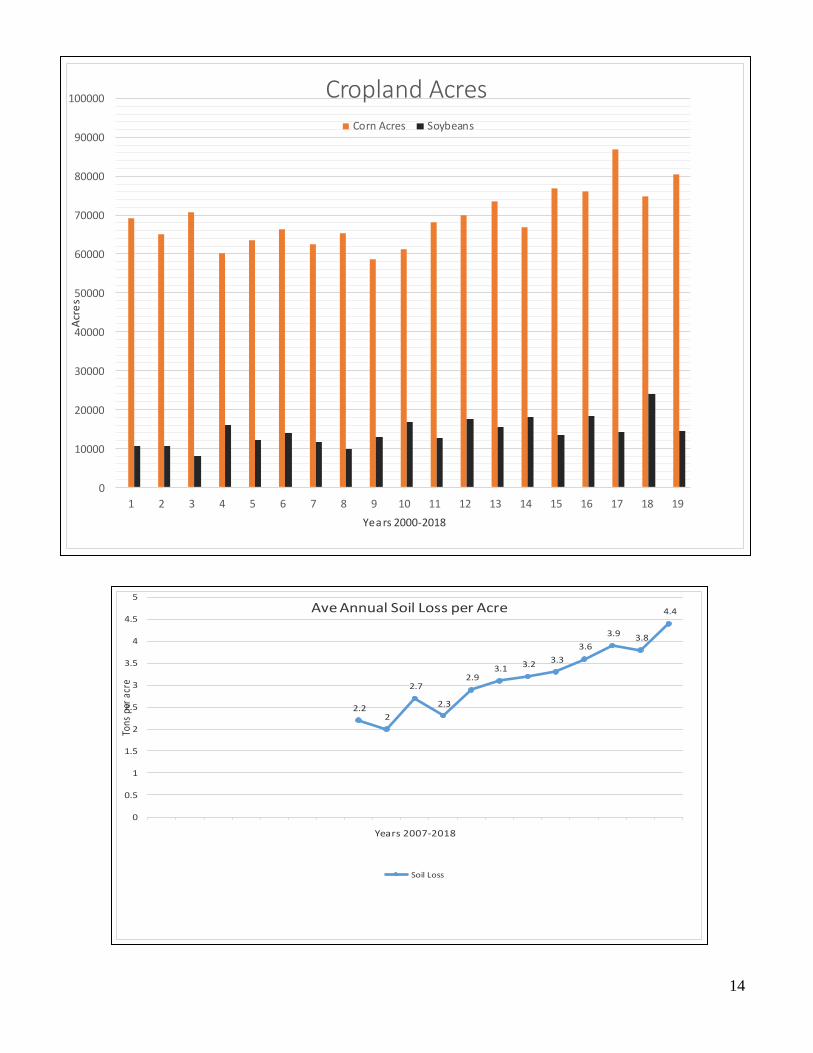
Since 1999, the Monroe County Land Conservation Department has completed a transect survey
of the county for the purpose of inventorying tillage methods, type and acreage of crops being
planted, crop residue cover, and average annual soil loss on a county-wide basis. This survey
method is considered statistically reliable and is a good tool to analyze soil loss issues. The chart
below shows some of the survey results.
A couple factors have led to this increase in soil erosion. Conversion of hay land to row crops
due to the financial crisis in dairy farming; more farmers are renting cropland where rotation of
the whole farm is occurring vs. individual fields & or strips; along with increased tillage
(turbo/vertical) to maximize yields has really ramped up the erosion rates in Monroe County.
CROPLAND TRANSECT SURVEY
The Monroe County LCD will continue to conduct an annual countywide transect survey of
cropland to gather information on conservation tillage and soil loss rates. The survey provided a
database of reliable information that can be used to monitor trends. These trends can be used to
direct program activities, including information and education efforts. An example of the data
collected and cropping trends are displayed on page 13.
12
- - -
23
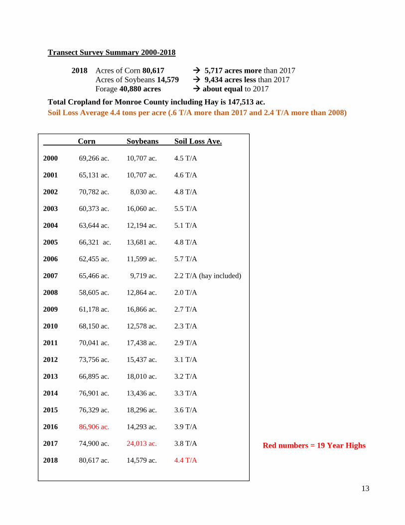
Transect Survey Summary 2000-2018
2018 Acres of Corn 80,617 5,717 acres more than 2017
Acres of Soybeans 14,579 9,434 acres less than 2017
Forage 40,880 acres about equal to 2017
Total Cropland for Monroe County including Hay is 147,513 ac.
Soil Loss Average 4.4 tons per acre (.6 T/A more than 2017 and 2.4 T/A more than 2008)
Red numbers = 19 Year Highs
Corn Soybeans Soil Loss Ave.
2000 69,266 ac. 10,707 ac. 4.5 T/A
2001 65,131 ac. 10,707 ac. 4.6 T/A
2002 70,782 ac. 8,030 ac. 4.8 T/A
2003 60,373 ac. 16,060 ac. 5.5 T/A
2004 63,644 ac. 12,194 ac. 5.1 T/A
2005 66,321 ac. 13,681 ac. 4.8 T/A
2006 62,455 ac. 11,599 ac. 5.7 T/A
2007 65,466 ac. 9,719 ac. 2.2 T/A (hay included)
2008 58,605 ac. 12,864 ac. 2.0 T/A
2009 61,178 ac. 16,866 ac. 2.7 T/A
2010 68,150 ac. 12,578 ac. 2.3 T/A
2011 70,041 ac. 17,438 ac. 2.9 T/A
2012 73,756 ac. 15,437 ac. 3.1 T/A
2013 66,895 ac. 18,010 ac. 3.2 T/A
2014 76,901 ac. 13,436 ac. 3.3 T/A
2015 76,329 ac. 18,296 ac. 3.6 T/A
2016 86,906 ac. 14,293 ac. 3.9 T/A
2017 74,900 ac. 24,013 ac. 3.8 T/A
2018 80,617 ac. 14,579 ac. 4.4 T/A
13
- - -
23
0
10000
20000
30000
40000
50000
60000
70000
80000
90000
100000
1 2 3 4 5 6 7 8 9 10 11 12 13 14 15 16 17 18 19
Acr
es
Years 2000-2018
Cropland AcresCorn Acres Soybeans
2.22
2.7
2.3
2.93.1 3.2 3.3
3.6
3.9 3.8
4.4
0
0.5
1
1.5
2
2.5
3
3.5
4
4.5
5
Tons
per
acr
e
Years 2007-2018
Ave Annual Soil Loss per Acre
Soil Loss
14
- - -
23
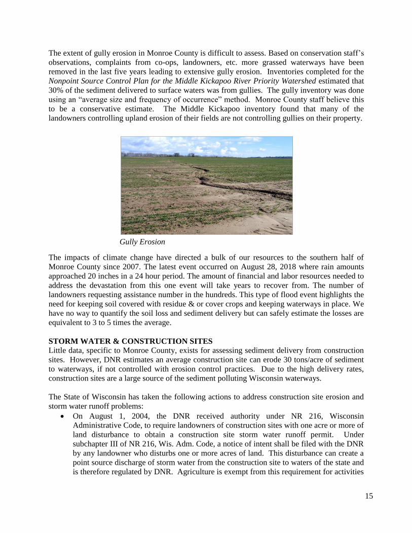
The extent of gully erosion in Monroe County is difficult to assess. Based on conservation staff’s
observations, complaints from co-ops, landowners, etc. more grassed waterways have been
removed in the last five years leading to extensive gully erosion. Inventories completed for the
Nonpoint Source Control Plan for the Middle Kickapoo River Priority Watershed estimated that
30% of the sediment delivered to surface waters was from gullies. The gully inventory was done
using an “average size and frequency of occurrence” method. Monroe County staff believe this
to be a conservative estimate. The Middle Kickapoo inventory found that many of the
landowners controlling upland erosion of their fields are not controlling gullies on their property.
The impacts of climate change have directed a bulk of our resources to the southern half of
Monroe County since 2007. The latest event occurred on August 28, 2018 where rain amounts
approached 20 inches in a 24 hour period. The amount of financial and labor resources needed to
address the devastation from this one event will take years to recover from. The number of
landowners requesting assistance number in the hundreds. This type of flood event highlights the
need for keeping soil covered with residue & or cover crops and keeping waterways in place. We
have no way to quantify the soil loss and sediment delivery but can safely estimate the losses are
equivalent to 3 to 5 times the average.
STORM WATER & CONSTRUCTION SITES
Little data, specific to Monroe County, exists for assessing sediment delivery from construction
sites. However, DNR estimates an average construction site can erode 30 tons/acre of sediment
to waterways, if not controlled with erosion control practices. Due to the high delivery rates,
construction sites are a large source of the sediment polluting Wisconsin waterways.
The State of Wisconsin has taken the following actions to address construction site erosion and
storm water runoff problems:
On August 1, 2004, the DNR received authority under NR 216, Wisconsin
Administrative Code, to require landowners of construction sites with one acre or more of
land disturbance to obtain a construction site storm water runoff permit. Under
subchapter III of NR 216, Wis. Adm. Code, a notice of intent shall be filed with the DNR
by any landowner who disturbs one or more acres of land. This disturbance can create a
point source discharge of storm water from the construction site to waters of the state and
is therefore regulated by DNR. Agriculture is exempt from this requirement for activities
Gully Erosion
15

- - -
23
such as planting, growing, cultivating and harvesting of crops for human or livestock
consumption and pasturing of livestock as well as sod farms and tree nurseries.
Agriculture is not exempt from the requirement to submit a notice of intent for one or
more acres of land disturbance for the construction of structures such as barns, manure
storage facilities or barnyard runoff control systems. (See s. NR 216.42(2), Wis. Adm.
Code.) Furthermore, construction of an agricultural building or facility must follow an
erosion and sediment control plan consistent with s. NR 216.46, Wis. Adm. Code and
including meeting the performance standards of s. NR 151.11, Wis. Adm. Code.
An agricultural building or facility is not required to meet the post-construction
performance standards of NR 151.12, Wis. Admin. Code. Local municipalities can apply
to DNR to fulfill the technical and administrative requirements of this rule (authorized
local program). These rules and standards are currently enforced by DNR in Monroe
County. Additional information and forms can be found at
https://dnr.wi.gov/topic/StormWater/learn_more/regulations.html
Since January 1, 2005, state statutes require all municipalities to adopt and enforce the
requirements of the Uniform Dwelling Code (UDC) for one and two family dwellings.
The UDC is administered by the Wisconsin Department of Commerce. Part of the UDC
requires planning, installation, and inspection of erosion control practices, no matter the
size of the construction site. Monroe County declined to participate in the UDC
inspection process, leaving the responsibility to local municipalities. Most of them have
contracted with certified private inspection agencies to fulfill the requirements of the rule.
At this point it is not clear how well the contracted inspectors are enforcing the erosion
control requirements of the UDC.
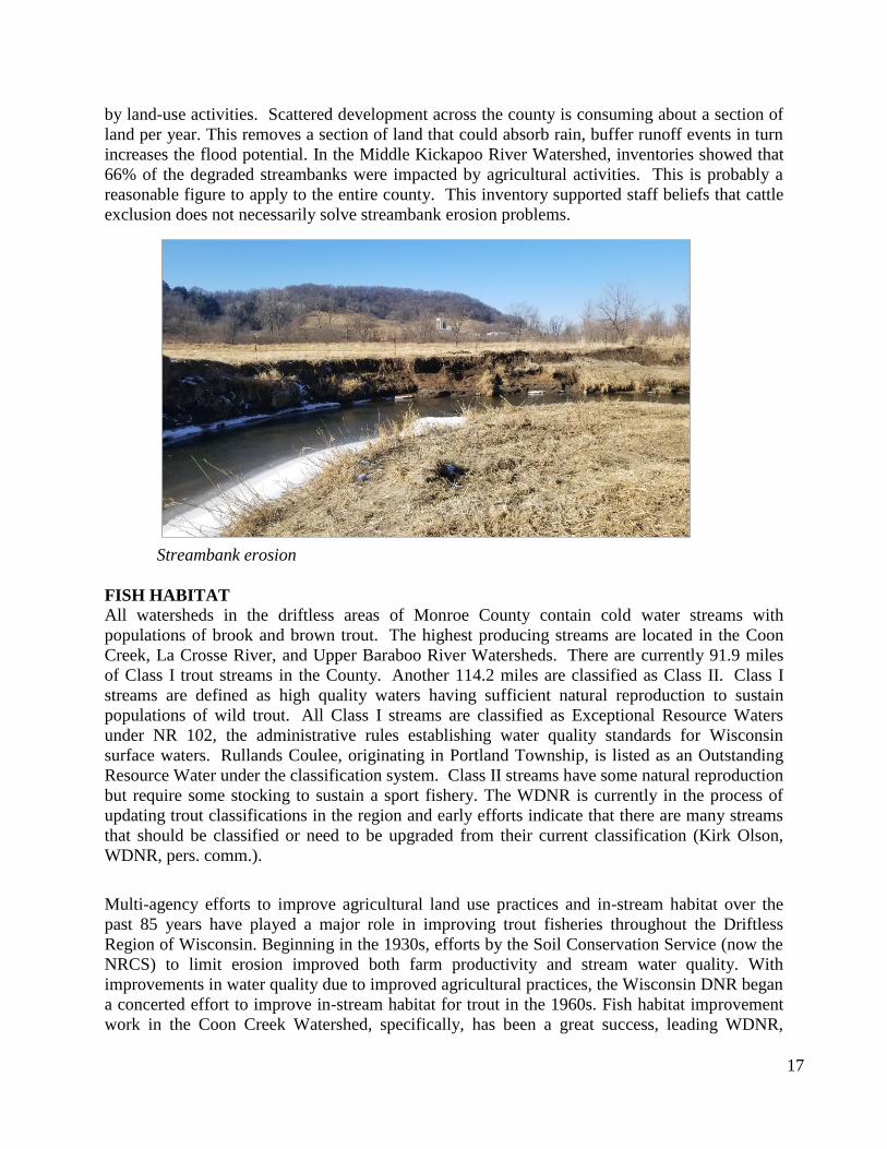
STREAMBANK EROSION
Because of the steep topography of Monroe County, sediment from eroding streambanks is a
major contributor to the degradation of Monroe County surface waters. The Middle Kickapoo
River Watershed inventory shows that 34% of the sediment loading to surface waters from all
sources is from streambank erosion. The Lake Tomah Watershed inventory shows that 40% of
the sediment loading from all sources is from streambank erosion. Monroe County staff believes
these figures would be consistent with all watersheds within the county except for the Beaver
Creek/Juneau and Trout Run watersheds outside of the driftless area. These two particular
watersheds have low stream velocities and less of an impact from agriculture. Multiple streams
in these watersheds have cranberry flowages on them, and streambanks are sometimes impacted
by fluctuations in flows caused by the flooding and draining of water at the cranberry operations.
Streambank erosion is caused by steep stream gradients, land use practices which lead to greater
runoff along with increased precipitation regimes (climate change) in the last few years have
resulted in greater soil erosion & sediment delivery from streams. Many sites in the driftless area
have recession rates that exceed 1 foot per year. Overtime, sites not maintained in grass cover
revert back to trees and other woody vegetation that results in exposed soil and therefore an
increased potential to erode and widening of the stream channel. Trees fall into streams and
further accelerate the process.
Although streambank erosion occurs naturally, the problems can be accelerated and intensified
16
- - -
23
by land-use activities. Scattered development across the county is consuming about a section of
land per year. This removes a section of land that could absorb rain, buffer runoff events in turn
increases the flood potential. In the Middle Kickapoo River Watershed, inventories showed that
66% of the degraded streambanks were impacted by agricultural activities. This is probably a
reasonable figure to apply to the entire county. This inventory supported staff beliefs that cattle
exclusion does not necessarily solve streambank erosion problems.
Streambank erosion
FISH HABITAT
All watersheds in the driftless areas of Monroe County contain cold water streams with
populations of brook and brown trout. The highest producing streams are located in the Coon
Creek, La Crosse River, and Upper Baraboo River Watersheds. There are currently 91.9 miles
of Class I trout streams in the County. Another 114.2 miles are classified as Class II. Class I
streams are defined as high quality waters having sufficient natural reproduction to sustain
populations of wild trout. All Class I streams are classified as Exceptional Resource Waters
under NR 102, the administrative rules establishing water quality standards for Wisconsin
surface waters. Rullands Coulee, originating in Portland Township, is listed as an Outstanding
Resource Water under the classification system. Class II streams have some natural reproduction
but require some stocking to sustain a sport fishery. The WDNR is currently in the process of
updating trout classifications in the region and early efforts indicate that there are many streams
that should be classified or need to be upgraded from their current classification (Kirk Olson,
WDNR, pers. comm.).
Multi-agency efforts to improve agricultural land use practices and in-stream habitat over the
past 85 years have played a major role in improving trout fisheries throughout the Driftless
Region of Wisconsin. Beginning in the 1930s, efforts by the Soil Conservation Service (now the
NRCS) to limit erosion improved both farm productivity and stream water quality. With
improvements in water quality due to improved agricultural practices, the Wisconsin DNR began
a concerted effort to improve in-stream habitat for trout in the 1960s. Fish habitat improvement
work in the Coon Creek Watershed, specifically, has been a great success, leading WDNR,
17
- - -
23
county, and private organizations to look at improvement possibilities for other streams in the
region. From 1996-1999, Trout Unlimited (TU) administered a Home Rivers Initiative project in
the Kickapoo Watershed. This project, the second nationally by TU, was intended to improve
environmental conditions, raise public awareness of resource issues, and lay the groundwork for
continuing efforts. Trout Unlimited successfully assisted with the establishment of a community
group called Valley Stewardship Network to lead educational efforts in the watershed and
providing water quality monitoring. This group remains active in watershed issues nearly 20
years later.
The Trout Unlimited Kickapoo Watershed Project funded a study called Hydrologic Assessment
of the Kickapoo Watershed, Southwestern Wisconsin. The Wisconsin Geological and Natural
History Survey (WGNHS) and the University of Wisconsin Department of Geological
Engineering (UW) did the study. The goals of this study were to (1) characterize the regional
and local groundwater flow systems, spatial and temporal variations in base flow and
temperature, and the distribution and movement of fine sediment; (2) identify areas that are
critical to stream habitat quality; and (3) develop quick and inexpensive assessment methods that
can be used by land management agencies and local citizens to monitor the condition of the
watershed. The study made the following recommendations: (1) due to water temperature
concerns, construction of spring ponds should be discouraged; (2) groundwater recharge should
be maintained by protecting wooded hill slopes (discourage development on these sites); (3)
control sources of sediment, focused on streambanks, barnyards, pastures, and cultivated fields;
and (4) target a variety of geologic settings for stream restoration projects in order to restore a
variety of habitats. The study concludes that the results should apply to nearby watersheds with
similar geology and topography but recommends collecting base flow and temperature data in
other watersheds. It also recommends a study on how the volume of fine sediment stored in
stream channels is changing.
Portions of the Upper La Crosse River Basin have also been the recipients of surface water
monitoring efforts. Fishery biologists at the Directorate of Public Works, Environmental
Division - Natural Resources Branch at Fort McCoy have collected water quality data on Silver
and Tarr Creek, since 1993. Characteristics being monitored include turbidity, temperature,
dissolved oxygen, and flow. Water samples are also being analyzed for nutrients and fecal
coliform. In addition, IBI data (Index of Biotic Integrity) is being collected for Fort McCoy
streams. This biological data is an assessment of the fish community and is useful in
determining limiting factors for a fishery as well as assessing the potential for improvement. In
summary, test results from Fort McCoy’s testing shows good water quality, low nutrient and
pesticide levels, and high turbidity and total suspended solids at certain site.
In recent years, Monroe County has worked closely with fishery staff at Fort McCoy on trout
habitat and water quality issues near Fort McCoy. This partnership has been valuable for
completing trout habitat work, completing stream monitoring, and seeking solutions to water
quality issues. Since the development of the initial version of the Monroe County Land and
Water Resource Management plan in 1999, Fort McCoy, Monroe County, DNR, US Fish and
Wildlife Service, NRCS, and local organizations partnered to complete fish habitat improvement
in the Coles Valley Creek watershed. This partnership resulted in a re-classification of Coles
Valley Creek to a Class I trout stream.
18

- - -
23
In addition to the priority area established by Trout Unlimited, the DNR has established several
fishery areas in Monroe County. Among those are the Little La Crosse River system, Farmers
Valley Creek, Big Creek, and Rullands Coulee Creek (tributary to Coon Creek). These areas are
priority areas for stream habitat improvement using Trout Stamp money. In order to use this
money, land must be available for public use, either through public easements or ownership.
ANIMAL WASTE
Pollution problems from animal wastes originate largely from two principal sources; barnyard
runoff and land spreading of manure (primarily winter spreading on steep slopes or fields in
flood plains). Runoff from barnyards and land-spread wastes can pollute surface and
groundwater with bacteria, sediment, ammonia and nutrients. Barnyards inventoried for the
Middle Kickapoo River Watershed project were found to contribute an average annual
phosphorus load of 14.8 lbs. The Lake Tomah inventory showed an average phosphorus load of
55.8 lbs. The difference in the loading can be attributed to larger farms located on or close to the
stream channels. Inventories were conducted using the BARNY computer model.
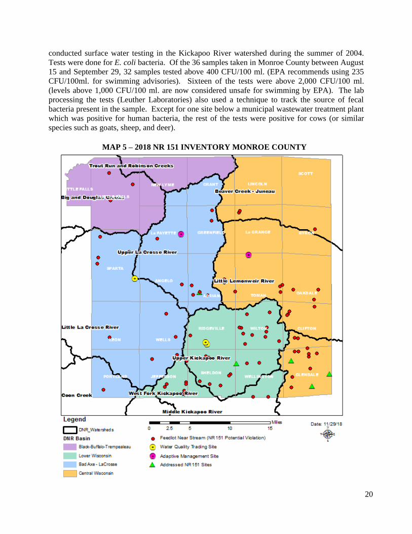
In the spring of 2018, the Land Conservation Department inventoried all feedlots/barnyards
within the Water Quality Management Area (300’) that violate NR 151.08 prohibitions (Map 5
on pg. 20). From that survey, 78 barnyards were identified as not in compliance with state NR
151 rules. These facilities are typically small in animal numbers but more frequent than
anticipated. However, the evolution of the dairy industry to large farms is occurring in Monroe
County. There are now four Concentrated Animals Feeding Operations (CAFOs) on board with
the DNR permitting requirements and more farms holding under 1,000 animal units to avoid
regulations.
Since the completion of the inventories for the two watershed projects, many farms have
expanded their operations, resulting in fewer barnyards and more confined herds. The result of
this trend is fewer barnyard runoff issues, but more land spreading problems. Monroe County’s
number one complaint is manure spreading or stacking in the Water Quality Management Area
since the manure consistency on large farms with sand bedding or mattresses is liquid.
In Monroe County, the majority of the dairy expansions are located in the Lower Wisconsin and
Bad Axe – La Crosse Basins. Historic fish kills have been related to either nutrients or in some
cases pesticide application.
Lake Tomah fish kill April 4, 2005, from presumed manure runoff and high BOD levels
under the ice.
Lake Tomah July 10, 2006, found dead black crappies.
Beaver Creek fish kill May 6, 2008, from a chemical spill which washed down a storm
drain in Sparta.
Lake Tomah fish kill June 5, 2017, from columnaris, a bacterial infection; there was high
runoff the week before the fish kill and warm air temperatures at time of fish kill, which
may have contributed to the columnaris.
Moore Creek fish kill September 26, 2017, from a manure spill that ran into the stream
resulting in low dissolved oxygen levels.
The Valley Stewardship Network, a local nonprofit group (see http://www.kickapoovsn.org/) 19
- - -
23
conducted surface water testing in the Kickapoo River watershed during the summer of 2004.
Tests were done for E. coli bacteria. Of the 36 samples taken in Monroe County between August
15 and September 29, 32 samples tested above 400 CFU/100 ml. (EPA recommends using 235
CFU/100ml. for swimming advisories). Sixteen of the tests were above 2,000 CFU/100 ml.
(levels above 1,000 CFU/100 ml. are now considered unsafe for swimming by EPA). The lab
processing the tests (Leuther Laboratories) also used a technique to track the source of fecal
bacteria present in the sample. Except for one site below a municipal wastewater treatment plant
which was positive for human bacteria, the rest of the tests were positive for cows (or similar
species such as goats, sheep, and deer).
20
MAP 5 – 2018 NR 151 INVENTORY MONROE COUNTY

- - -
23
NUTRIENT MANAGEMENT Historically, proper nutrient management has not been a high priority with most dairy farmers.
Animal waste has been looked upon as something that needs to be disposed of, not as an asset.
Over-application of nutrients can result in nutrients not being used by plants. The nutrients,
primarily nitrates or phosphorous, can then end up in surface or groundwater. During the Middle
Kickapoo River watershed inventory, well water samples were analyzed for nitrate
contamination. The results showed 7.4% of the samples exceeded the state standard of 10 mg/l
while 57.4% of the samples showed results between 2-10 mg/l. The same tests were completed
in the Lake Tomah Watershed. The results showed 28% of the samples exceeded the 10 mg/l
standard and 56% of the samples were between 2-10 mg/l.
The LCD has received increased drinking water complaints of high nitrates from private
landowners due to nearby manure applications. This is compounded with land use decisions that
insert development within agriculture. Most of the complaints originate north of I-90 in the
sandstone aquifers where very little buffering occurs.
21
MAP 6 – LEVELS OF NITRATES IN TESTED WELLS OF
MONROE COUNTY
- - -
23
Well samples in Lake Tomah were also analyzed for triazine, a family of chemical compounds
which contain the herbicide atrazine. Sample results showed 23% of the wells tested for atrazine
had levels above the Preventive Action Limit of 0.3 µg/l. Detectable levels of atrazine were
found in 47% of the wells tested. Atrazine prohibition areas are now in effect in portions of
Adrian, Tomah, and La Grange Townships.
In the spring of 1991, the Nutrient and Pest Management Program (NPM) of the University of
Wisconsin conducted a Farm Assessment Technique (FAT) survey in the Middle Kickapoo
River Watershed. The FAT is an assessment of land users’ nutrient and pest management
practices. The intent of the assessment is to gain an understanding of what farmers are doing in
the area of agri-chemical management, why they are using these specific management practices,
and potential obstacles to adopting recommended Best Management practices. The survey
results showed 38.9% of the farmers were grossly over recommended application rates for
nitrogen (more than 65 lbs. /acre over). Another 19% were 10-65 lbs. /acre over recommended
nitrogen application rates. The survey also showed that 83.3% of the farmers were more than 40
lbs. /acre over maintenance levels for phosphorus. The FAT made the following
recommendations:
Information and education programming should be focused on farmers and agri-business
Whole farm nutrient management needs to be a priority. Place more emphasis on
nitrogen management rather that structural solutions.
Use of “at and below” label rates for pesticide application
Base programs on known characteristics of farmers within watersheds
Promote BMPs based on attitudes towards the practice
Since that study, Monroe County resource agencies have sponsored several nutrient management
planning classes for farmers wishing to prepare their own nutrient management plan. In
addition, a limited amount of cost-sharing has been available through the EQIP program
administered by USDA, through funding provided to counties from Wisconsin DATCP, and
through cost-sharing provided by Monroe County. This cost-sharing is for landowners wishing
to hire private consultants to prepare nutrient management plans, or to participate in group
planning sessions. These sessions have been held annually by the Farm Management instructor
at Western Technical College.
Citizens’ concerns with algae blooms in Lake Tomah prompted soil testing, groundwater &
surface water testing in the Lake Tomah Watershed in 2003-2018. The purpose of the sampling
was to determine phosphorus levels in the watershed. The soil tests revealed Ag soils had an
average phosphorus level of 40 ppm, while urban soils averaged 49 ppm. The statewide average
for agricultural soils is 52 ppm, well above the 30 ppm considered the upper limit for corn
production. The 22 groundwater tests completed in the watershed resulted in an average
phosphorus level of 77 ug/l. This is very high for groundwater but not a health concern to those
who drink it. The average level in Lake Tomah using 1998 data was 178 ug/l, considered
extremely high. The average level in a Wisconsin impoundment is 65 ug/l. After a multi-year
planning effort, the City of Tomah, Wisconsin DNR, and Monroe County have cooperated on a
rehabilitation project in Lake Tomah. The project is designed to reduce phosphorus levels in the
lake, improve fish habitat, and make Lake Tomah a better recreational resource.
22
- - -
23
A positive trend in the cranberry industry is the increased use of nutrient management planning.
NRCS, through their statewide special allocation for the cranberry industry, has made cost-share
money available for nutrient management planning that is being utilized by the growers.
UW-Discovery Farms, a farmer-led research program through University of Wisconsin
Extension completed a 7 year study from 2010-2017 to evaluate how land use and agricultural
management affect water quality. Water quality research was conducted on 4 farming systems
and two non-agricultural areas in Monroe and Vernon Counties in the 4,500 acre Jersey Valley
Watershed. Soil, nitrogen and phosphorus runoff was measured via monitoring at the edges of
fields, within stream and within the lake.
Discovery Farms worked to provide resources to farmers related to the impact of tillage practices
on soil loss, the balance of phosphorus loss from soil loss or manure and nutrient applications,
and seasonal risks of manure application. Farmers also participated in whole farm walkover
assessments for conservation practices, nitrogen use efficiency evaluations and cover cropping
demonstrations. Annual field days and meetings were held to share new information and connect
with area farmers to hear feedback on the project and their approach to conservation and water
quality protection throughout the project. A final report on the project is available at
http://www.uwdiscoveryfarms.org/research-library/watershed/edge-of-field-water-quality-in-
two-wisconsin-water
WOODLAND
Of the 576,000 acres of land in Monroe County, approximately 297,886 acres (51.7%) are
forested. Of this amount, 221,592 acres are owned by non-forest industry private owners (2017
Forest Inventory data). The major cover type in the county is oak-hickory (50. 5%). The major
natural resource concern associated with woodland in Monroe County is pastured woodlots.
Pastured woodlots result in increased runoff and more gully erosion. Watersheds with pastured
woodlots are more susceptible to flash flooding, excess siltation in streambeds, and streambank
erosion. Middle Kickapoo River watershed inventory results showed that 47% of the woodlots
in the Billings and Brush Creek watersheds were pastured. This is probably above the
countywide average, but the problem exists throughout the county. The major pollution
problems from grazed woodlands are in the south half of the county where the most intensive
agriculture is located. There is not enough forge under a wooded canopy to sustain most large
livestock.
Since the implementation of Use Value Assessment, agricultural land is assessed according to
four classifications, with pasture receiving the lowest assessed value. Grazed woodland is
assessed as pasture, thus giving a landowner tax incentive to graze the woodlands. Since
productive woodland has a high tax rate due to Use Value Assessment, it can also be argued that
participation in the Managed Forest Law has increased due to this method of assessment.
Another problem identified by forestry staff in Monroe County is a practice called “high-grade
logging”. This common occurrence is the practice of harvesting the best timber from a site and
leaving the rest. This practice diminishes the stand’s productivity and potential by removing the
best genetic stock and leaving trees that have poor form.
23
- - -
23
Land use practices are also identified as a problem for forestry. Woodlands that are parceled off
for rural home construction often result in woodlots being removed from commodity production.
The timber in these parcels is often no longer managed for timber production. Residents have
identified the breaking up of large tracts of forest land as a major concern.
COUNTY FOREST
The Monroe County Forest is approximately 7,300 acres located mostly in the northern part of
the county. Collectively, the Town of New Lyme, Town of Lincoln and the Town of Byron
contain ninety percent of the County Forest Lands. Most of this land was acquired as tax
delinquent lands in the early 1900’s; in 1933 the county board approved the entry of County
Forest Lands into the Forest Crop Law. These forest lands are predominately either well drained
or poorly drained sandy soils with forest cover types of oak (4,037 acres), white pine (879 acres
and red pine (802 acres). The Monroe County Forest harvests about 80 acres of timber per year
with an annual average revenue of $70,000.
WETLANDS
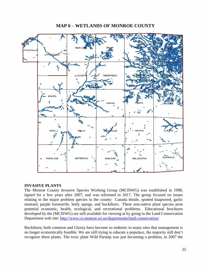
As is the case statewide and nationally, Monroe County has experienced a decline in the number
and quality of wetlands. The DNR wetlands inventory map for Monroe County shows 56,000
acres of wetlands (9.9% of the land area), the majority located along major stream corridors and
in the Lemonweir and Beaver Creek watersheds in the northeast part of the county. (See map 6
on page 24) shows the wetlands in Monroe County according to the DNR wetlands inventory.
Construction of new and expanded cranberry beds has traditionally been done in wetlands. Now,
however, new construction is frequently done in upland soil types, avoiding wetlands.
As more people purchase land in Monroe County for recreational uses, there has been an
increased interest in the restoration of previously converted wetlands. State and federal
programs, primarily the Wetlands Reserve Program (WRP) administered by NRCS and the
Partners for Fish and Wildlife Program administered by USFWS, have been available to cost-
share this type of restoration. The Conservation Reserve Program (CRP) and the (Conservation
Reserve Enhancement Program (CREP) are also sources of funding for wetland restoration
activities. These programs are further described in Chapter 8.
The Wisconsin DNR and the US Army Corp of Engineers require mitigation when natural
wetland sites are destroyed. Several mitigations have taken place in Monroe County during the
past 15 years. In many cases, the mitigated wetlands are probably of lesser quality than the
original wetland which had been destroyed.
Because of a change in attitude concerning the value of wetlands, laws restricting the drainage of
wetlands, and programs that encourage restoration, the wetland acreage in Monroe County has
most likely been maintained or increased throughout the past decade. This is only speculation by
staff, as no firm data is available.
24
- - -
23
INVASIVE PLANTS The Monroe County Invasive Species Working Group (MCISWG) was established in 1998,
lapsed for a few years after 2007, and was reformed in 2017. The group focused on issues
relating to the major problem species in the county: Canada thistle, spotted knapweed, garlic
mustard, purple loosestrife, leafy spurge, and buckthorn. These non-native plant species pose
potential economic, health, ecological, and recreational problems. Educational brochures
developed by the (MCISWG) are still available for viewing at by going to the Land Conservation
Department web site: http://www.co.monroe.wi.us/departments/land-conservation/
Buckthorn, both common and Glossy have become so endemic in many sites that management is
no longer economically feasible. We are still trying to educate a populace, the majority still don’t
recognize these plants. The toxic plant Wild Parsnip was just becoming a problem, in 2007 the
MAP 6 – WETLANDS OF MONROE COUNTY
25

- - -
23
original MCIPWG did produce an educational flier on parsnip but it has since spread along most
of our road system and in many cases into adjoining open areas and field edges making
management difficult. Phragmites is a huge problem in the eastern half of the state and in
Jackson Co. however there are only a couple of known spots in Monroe County, hopefully we
will be able to nip them in the bud. Teasel is another one that has the potential to do a lot of harm
to our riparian corridors and roadsides. We have initiated some management and our hope is it
can be stopped before it gets to a “critical mass”. Japanese knotweed apparently evolved in Asian
volcanic larva fields and is powerful enough to grow in concrete slabs. We have initiated some
management and outreach having learned the best timing and herbicides to spray. We are
attempting to map all of the knotweed populations in the county using the smart phone app
GLEDN and we really want to get ahead of this one. Multiflora Rose is a common problem as is
Japanese Barberry, but in some ways it is the ones we don’t know are here or at least haven’t
spotted them that are the biggest threats. It doesn’t seem to take long for some of these plants to
take off from a single infestation, so we are also trying to educate about the invasive plants not
here yet using plastic models, slideshows and, of course, the internet.
In order to be eligible for grants and be a more effective entity, the new group is in the process
of becoming a CISMA- Cooperative Weed Management Area. The group is still comprised of
representatives from a variety of county, state and federal agencies, and a core group of
landowners who are motivated by their own experiences battling invasive plants. The group
meets regularly, always starting the meeting with a pre-meeting field trip to look at and discuss
one of the major Invasive species in easy travel distance. To date, these include both kinds of
buckthorn, Japanese Knotweed, Barberry, Amur Maple, Asian Honeysuckle, Autumn Olive,
Bristly Locust, Garlic Mustard, Teasel and Wild Parsnip. The group plans to revisit the same
sites to see what effects our meeting/landowner education has had and double down if it hasn’t.
Additionally, the new group provided two trainings with the Highway Department and organized
a Public Field day on Invasive species management at the Pine View Campground on Fort
McCoy. MCISWG will continue to organize Field days at other venues around the county to
meet demand. The Highway Department is working on a comprehensive plan which will include
mapping and some targeted herbicide applications. The Towns Association is also actively
pursuing ways to help patrolmen get invasive species mapped and managed.
The Land Conservation Department created a grant for landowners present at our field days to
assist successful applicants with some cost share towards management expenses. There are
currently several volunteer efforts going on around the county and the City of Sparta is meeting
with local groups and contractors to get ahead of the invasive shrubs trying to take over the
beautiful new link from Amundson Park to the Sparta Elroy bike trail.
Currently, there is an informational webpage on the Monroe County Extension website:
https://monroe.uwex.edu/agriculture/monroe-county-invasive-species-workgroup The MCISWG
plan on increasing outreach and media presence to educate residents and other entities in Monroe
County on the problems that invasive species cause and craft management strategies with them.
26

- - -
23
WATERSHED RANKINGS & DNR BASIN PLAN RECOMMENDATIONS Management and water quality trading pursuits in the upper La Crosse River Watershed,
improvements to non-point runoff – reduction of sediment and agricultural runoff are essential
for downstream water quality criteria for municipalities (NPDES Permits). Phosphorus
reductions beyond these municipalities are equally important to reduce cumulative sediment
(phosphorus) effects to downstream waters such as Lake Neshonoc, the Mississippi River and
Gulf of Mexico.
2018 IMPARED WATERS (303D) OF MONROE COUNTY
Local Waterbody
Name Pollutant Impairment Indicator
TMDL
Priority
Confirmed
Year
Angelo Pond Mercury Contaminated Fish Tissue Low No
Baraboo River Total Phosphorus Impairment Unknown High 2015
Big Creek Total Phosphorus Water Quality Use Restrictions Low 2014
Council Creek Total Phosphorus Degraded Biological Community High 2015
Creek 23-13b Sediment/TSS Degraded Habitat N/A 2009
Dustin Creek Total Phosphorus Water Quality Use Restrictions Low 2017
Kickapoo River Total Phosphorus Impairment Unknown Low 2017
Kickapoo River Total Phosphorus Impairment Unknown Low 2015
La Crosse River Total Phosphorus Impairment Unknown Low 2015
Little La Crosse River Total Phosphorus Impairment Unknown Low 2015
Little Lemonweir River Total Phosphorus Impairment Unknown High 2013
Local Water Total Phosphorus Degraded Biological Community Low 2017
Lost Lake on Ranch Creek Mercury Contaminated Fish Tissue Low 2013
Mill Creek Total Phosphorus Impairment Unknown High 2015
Morris Creek Total Phosphorus Degraded Biological Community Low 2011
North Flowage Mercury Contaminated Fish Tissue Low No
Printz Creek Sediment/TSS Degraded Habitat Low Yes
Seymour Creek Total Phosphorus Impairment Unknown High 2013
Soper Creek Total Phosphorus Impairment Unknown Medium 2015
South Fork Lemonweir BOD Low DO Low Yes
South Fork Lemonweir Total Phosphorus Impairment Unknown Low 2015
South Fork Lemonweir Total Phosphorus Low DO, Degraded Biological Community High 2015
Stillwell Creek Sediment/TSS Elevated Water Temperature N/A 2007
Tomah Lake Total Phosphorus Eutrophication, Excess Algae, High pH N/A 2017
27

- - -
23
28

- - -
23
Chapter Four – Goals, Objectives, & Actions Resource professionals agree that sediment and nutrients contained in runoff are the main
nonpoint source threats to Monroe County surface waters. The main nutrient problem is
phosphorus as sited in the 2018 DNR report to Congress (pg. 27). These are the same pollution
problems brought up in discussions with citizens of Monroe County.
The major resource concerns of Monroe County are:
1. Soil Erosion – The three primary sources of soil erosion are cropland, gully, and
streambank erosion. Due to the increased use of tillage, sheet, rill, and gully erosion
contribute a majority of the sediment delivered to our streams and rivers.
2. Surface & Groundwater Quality – Phosphorous contamination of surface water and
nitrates in groundwater are the identified limitation to water quality. Feedlots and land
spreading are the main sources of contamination.
3. Development - The loss of prime farmland and conversion to hard surface has increased
the amount and delivery of sediment.
4. Invasive Plant Species – This issue is effecting our infrastructure (Right of Way), river
and stream corridors and reproduction of our native forest on public and private lands.
5. Management of privately owned forest land and stream restoration.
6. Destruction and/or degradation of wetlands
The goals listed below are the priority issues of the Citizen Advisory Committee and technical
staff in Monroe County. The LCD will utilize the Best Management Practices listed in appendix
7A & 8A to meet goals.
SEDIMENT DELIVERY Reducing sediment delivery from cropland has historically been the top goal of NRCS and LCD
conservation efforts in Monroe County. The problem is driven mainly by topography in the
driftless area, government commodity programs, and development. Prime farmland is being
converted to housing, forcing agriculture to operate in the highly erodible land. The most recent
new challenges in the cropland erosion area are an increase in the acreage of corn silage and an
increase in the number of organic operations. Larger dairy operations are using more corn silage
which leaves less residue cover. Higher prices for organically produced food have resulted in
many farmers converting to organic farming. This method of farming requires increased tillage
because of the inability to use herbicides for weed control. Conservation tillage, especially no-
till is an essential practice to keep soil loss to a minimum on Monroe County’s steep crop fields.
Sediment delivery from construction sites continues to be an issue in parts of the county.
Dwellings are being constructed in areas that are not suited to construction. The fact that only 11
of 24 townships in Monroe County have adopted county zoning supplements this problem. Rules
requiring compliance with Uniform Dwelling Code (UDC) provisions are helping to address this
issue, but compliance with the erosion control provisions of UDC are inconsistent.
Climate change has expedited the issue of sediment delivery in Monroe County over the last 10
years. 100-500 year storm events are becoming more common. The last event on August 28,
2018 brought 12 plus inches of rain in the southern portions of Monroe County. Rainfall
29

- - -
23
intensity in the 2-6 inches per hour quantity is hard to prepare for in the driftless landscape under
current land use practices.
“Climate change alone is probably the greatest challenge humans have ever faced throughout our
entire existence. The challenge is so great because the battle is not with external enemies but a war
within ourselves.”
― Emily Hunter
Goal 1: Reduce sediment delivery to surface waters
Action Items:
1. Conservation planning should meet tolerable soil loss (“T”). Staff will continue to
emphasize no-till, contour strips, and cover crops to meet soil loss goals.
2. Utilize the Agriculture Advisory Team to implement a standard (Land Stewardship) of
farming, where all land use activities meet “T.”
3. Controlling gully and streambank erosion will be high priority items for cost-share
programs in Monroe County.
4. Encourage and promote a land use planner position in Monroe County. This would
provide a sustainable, economic and environmental decision making process that would
comply with meeting water quality goals while providing the tools to protect prime
farmland.
5. Emphasize flood mitigation practices utilizing Monroe County funds. This can
potentially alleviate cost related to damage by climate change events.
6. Continue the transect survey to assess trends in soil erosion rates.
7. Promote the Conservation Reserve Enhancement Program (CREP) as a tool for trapping
sediment and nutrients along our water bodies by installing buffer strips.
8. Assist landowners in meeting NR 151 performance standards and prohibitions.
9. Promote land stewardship through the Monroe County Awards Program. This recognizes
individuals practicing land stewardship: conservation farmer, conservationist and tree
farmer of the year.
10. Continue to collaborate with Fort McCoy on monitoring and implementing sediment
reduction strategies on our cold water streams.
PHOSPHORUS and MANURE RUNOFF
Recent trends towards larger and confined dairy herds have reduced the runoff problems from
barnyards and feedlots. However, as is the case statewide, runoff from liquid manure spread on
frozen ground has become an increased threat. A major fish kill in a local lake during the spring
of 2005, and a manure runoff-caused kill in a local stream in August of 2007 & 2017 brought
attention to this problem. Also, recent testing in the Lake Tomah Watershed shows very high
phosphorus levels in the lake, in the soils, and in the groundwater.
Goal 2: Reduce phosphorus runoff to surface waters
Action Items:
1. Encourage farmers to develop nutrient management plans meeting the current 590
standard whether using cost-share dollars, a private consultant or an in-house farmer
developed plan.
2. Promote the Farmland Preservation Program in the seven townships enrolled through the
30

- - -
23
Agricultural Enterprise Areas. Participants are required to follow a conservation and
nutrient management plan and meet the NR151 prohibitions.
3. Enforce the existing manure storage ordinance to ensure manure storage facilities meet
current NRCS standards and specifications. Staff will encourage farmers to build
structures for the long term vs. short time periods to avoid sensitive time periods on the
landscape.
4. Update the Manure Storage Ordinance to better reflect current technology and farming
practices.
5. Inventory and address all feedlots not meeting the NR151 prohibitions. Utilize all
available sources of funding to address issues from barnyards/feedlots.
6. Assist landowners in conjunction with the DNR in meeting NR 151 performance
standards and prohibitions.
7. Assist municipalities and businesses meeting the new phosphorous water quality
standard. This would include the DNR adaptive management and phosphorous trading
program. Focus on streambank stabilization, fish habitat, buffer strips and grade
stabilization structures to reduce phosphorous inputs. This provides a relationship bridge
between the county and the point source managers while providing another revenue
source.
PRESERVATION OF FARMLAND
Conversion of farmland to non-agricultural uses (development & non-metallic mining) is a
concern to both rural and urban residents of Monroe County. Public input on the Comprehensive
Plan development echoes the concerns in the comprehensive plan development for the City of
Sparta, majority of townships and Monroe County. Monroe County loses about a section of land
to development/non-metallic mining per year (see attached map). This trend is highlighted in the
Wisconsin Food, Land & Water study completed in 2017. Modernization of agriculture and new
technologies are barely keeping up with the consumption of farmland and protections of prime
farmland is needed.
Goal 3: Assist landowners and local units of government with programs and policies that
encourage preservation of prime farmland
Action Items:
1. Encourage and promote a land use planner position in Monroe County. This would
provide a sustainable, economic and environmental decision making process that would
comply with meeting water quality goals while providing the tools (FLP Zoning) to
protect prime farmland.
2. The Land Use Planner will work with towns in creating and or updating their
comprehensive plans. Providing this service will eliminate any financial barriers to
planning, while provide professional expertise to implement plans to reflect the goals of
the towns and County.
3. The Land Use Planner will provide professional expertise to guide towns through the
process of adopting farmland preservation zoning.
4. Assist Monroe County landowners with applying for Agricultural Enterprise Areas under
the Working Lands Initiative. This allows landowners the opportunity to protect farmland
through the Farmland Preservation Program.
31
1
- - -
23
5. Promote land legacy programs such as the Mississippi Valley Conservancy that keep
sensitive lands together and protected from development and erosion within the driftless
area of Western Wisconsin. https://www.mississippivalleyconservancy.org/
6. Work with the Monroe County Agricultural Advisory Team in building initiatives to
change the current trend.
INVASIVE PLANT SPECIES
Invasive plants are a growing concern and have the potential to seriously degrade wildlife
habitat, grazing land, and the amount and quality of native plant species in our forest.
Goal 4: Monitor & manage the spread of invasive species and educate the public on this
subject
Action Items:
1. Participate and promote participation in the Monroe County Invasive Species Working
Group. This would include development of a CISMA, tours, seeking grants and potential
staff, etc.
2. Provide training for invasive plant ID and control method to municipal road crews.
3. Continue to educate the public on invasive species, including field days, displays, and
brochure distribution
4. Develop a website with interactive, timely information for landowners of Monroe County
to easily access information on invasive species.
5. Provide cost-sharing to landowners in managing invasive plants. This will provide
funding to insure proper management techniques, treatment options, field identification
and overall stimulate invasive plant management on private lands.
COLD WATER FISHERY
In addition to addressing nutrient and sedimentation problems in the county, agency staff see a
need to continue our past emphasis on improving the cold water fishery in the county. Studies
and cooperative efforts by Trout Unlimited, DNR, Fort McCoy fishery staff, NRCS, USFWS,
and local conservation clubs show a need and an interest in continuing this effort. Benefits:
Public access, green space, aesthetics, bank stabilization, increased flood capacity, fishing,
recreation, tourism, etc.
Goal 5: Improve the cold water fishery & access to streams in Monroe County Action Items:
1. Cooperate with local organizations and state and federal agencies to identify streams that
will benefit from habitat improvement work, then work with those groups to install
fishery practices.
2. Continue to seek and promote landowner participation in the Monroe County fishing
easement program. This provides fishing access to valuable trout streams in Monroe
County. Maintain GIS layer for public access opportunities while improving usability.
3. Continue to provide expertise to local schools on water quality and stream restoration.
The school programs provide LUNKERS for easement properties implementing habitat.
4. Promote the Conservation Reserve Enhancement Program (CREP) through one-on-one
contacts, news releases and the LCD web site.
5. Cooperate with the DNR water quality & fish inventory surveys to pinpoint fishery
32
- - -
23
limitations.
6. Assist landowners in meeting NR 151 performance standards and prohibitions.
7. Assist municipalities and businesses meeting the new phosphorous water quality
standard. This would include the DNR adaptive management program and phosphorous
trading. Focus on streambank stabilization, fish habitat, buffer strips and grade
stabilization structures.
PRIVATE FOREST LANDS
Many factors continue to put more stress on management of private forest lands, including
higher tax rates due to use value assessment, the importance placed on the recreational value of
forest land, improper harvesting methods, and forest fragmentation due to home construction and
other land use decisions.
Goal 6: Improve forest management on private lands
Action Items:
1. Educate landowners on forestry management programs available in Monroe County.
2. Hold landowner workshops and tours in conjunction with state, county and private
foresters promoting forest stewardship.
3. Promote and provide landowners information pertaining to the Deer Management
Assistance Program (DMAP) and the Manage Forest Law (MFL) program.
4. Provide and promote the LCD tree sales program.
5. Promote good forest stewardship through the Monroe County Stewardship Awards
Program.
6. Work with municipalities on the importance of trees, promote plantings and tree
preservation.
33
3

- - -
23
Chapter Five – NR151 Ag Performance Standards
Rules to control polluted runoff from farms and other sources in Wisconsin went into effect on
October 1, 2002 & revised in 2010, 2013 then again in November 2018 (No. 755). DNR rule NR
151 sets performance standards and prohibitions for farms. The DATCP rule, ATCP 50,
identifies conservation practices that farmers must follow to meet performance these standards.
For information on both rules, go to the following link on the DNR web site:
https://dnr.wi.gov/topic/Nonpoint/AgPerformanceStandards.html. County Land Conservation
Departments have primary responsibility for implementing the standards. Following are the Ag
performance standards and prohibitions:
NR 151.02 – Land where crops are grown shall be cropped to “T” using RUSLE II.
Monroe County farmers are expected to meet the “T” standard by using some or all of these
practices from ATCP 50: contour farming, crop rotations, cover and green manure crop,
diversions, filter strips, and residue management. In addition, planners recommend grassed
waterways, grade stabilization structures, and critical area stabilization to control ephemeral
erosion.
NR 151.05 - New, altered, or abandoned manure storage facilities must meet NRCS standards.
Facilities must meet NRCS standard 313 (waste storage facility), 360 (closure of waste
impoundments, and/or 634 (manure transfer). Monroe County enforces a manure storage
ordinance to address these issues.
NR 151.06 - Runoff shall be diverted from contacting feedlots, manure storage areas, and
barnyard areas located within water quality management areas (WQMA).
Monroe County farmers need to use diversions, roof runoff systems, subsurface drains, and
underground outlets to meet this standard.
NR 151.07 – Crop and livestock producers applying manure and other nutrients to agricultural
fields shall do so according to a certified nutrient management plan.
Landowners must hire a certified agronomist or prepare their own plan by completing a certified
course. Plans must meet NRCS Nutrient Management Standard 590. This standard was in effect
on January 1, 2008, except for land in watersheds containing impaired waters and watersheds
containing exceptional or outstanding resource waters. These watersheds had a January 1, 2005
implementation date. See map 10 on page 31 for Monroe County nutrient management
implementation status.
NR 151.08 – All livestock producers shall comply with 4 manure management prohibitions:
no manure storage facility overflow
no unconfined manure piles in water quality management areas
no direct runoff from a feedlot or stored manure into waters of the state
no unlimited livestock access to waters of the state in a location where high
concentrations of animals prevent maintenance of adequate sod or self-sustaining
vegetative cover
34
- - -
23
Monroe County farmers would use these practices to address problems with the prohibitions:
manure store facilities, barnyard runoff systems, access roads and crossings, diversions, filter
strips, livestock fencing, livestock watering facilities, prescribed grazing, streambank
stabilization, and riparian buffers.
NR151 IMPLEMENTATION STRATEGY AND COMPLIANCE PROCEDURES
The following identifies the procedures the LCD may use in regards to compliance with NR 151,
ATCP 50, and local regulations. Also the information identifies the procedures, including
notice, hearing, enforcement, and appeals process that will apply if the County takes action
against a landowner for failure to implement conservation practices under Chapter NR 151 or
related local regulations. The implementation of compliance strategy is based on staff and
funding availability.
INFORMATION AND EDUCATION
Monroe County LCD, NRCS, and UWEX staff regularly inform landowners of the requirements
of NR 151. This effort will continue in an attempt to encourage voluntary compliance with the
rules. We have used newsletters, FSA electronic newsletter, newspaper columns, direct
mailings, the Monroe County web site, Facebook and handouts to get the word out.
PRIORITY FARM IDENTIFICATION
For NR 151 evaluations, information and education activity, and implementation priority will be
given to the following farms:
Participating in the Farmland Preservation Program.
Located in Water Quality Management Areas identified in the 2018 inventory (pg. 21)
Participating in the DNR Phosphorous Adaptive Management Program outlined for
municipalities.
NOD/NOI participants
Located in watersheds draining to 303(d) waters
Permitted through the Monroe County Manure Storage Ordinance.
In response to formal citizen complaints
for any landowner requesting a determination
prior to signing SWRM grant cost-share agreements with landowners
NR 151 assessments will be used to determine when farm operators are eligible for barnyard
runoff cost-sharing through the state or federal programs. Priority for nutrient management plan
cost-sharing will go to landowners requiring a plan for program participation & or permits.
COMPLIANCE DETERMINATION
Priority Farms identified above will utilize a combination of tools to achieve compliance
determinations. Example: farms that participate in the Farmland Preservation Program will
utilize a combination of on-site evaluations every two years and self-certification when not
conducting walkovers; this will require nutrient management plan update (checklist). A records
inventory will be conducted using existing plans, agreements, and contracts. On-site evaluations
will utilize the evaluation form included in the appendix to this document. The form includes a
signature page and date for the landowner and the LCD evaluator. Compliance data will be
tracked using the county geographic information system. Landowners with completed
35

- - -
23
determinations will receive the following:
Copy of the inspection (trip) report with a landowner signature page.
Letter with instructions on appeal procedures if the landowner does not agree with the
findings
Recommendations for measures needed to achieve compliance, including an explanation
of the technical standards and maintenance requirements
Schedule for achieving compliance with the standards
The status of available cost-sharing for recommended practices
ENFORCEMENT
Enforcement of actions associated with NR 151.09 will be coordinated with the DNR. If a
landowner continues to remain in noncompliance with the state performance standards, or should
a landowner refuse technical and/or financial assistance from the LCD, the LCD will forward all
information corresponding to the infraction(s) to the DNR and will notify the landowner(s) by
registered mail that they are subject to an enforcement action pursuant to NR 151.09. The DNR
contact for Monroe County is the Non-Point Source Coordinator in the La Crosse office.
APPEALS Any person aggrieved by a decision of the Monroe County Land Conservation Department may
file a written appeal of the decision with the Monroe County Land Conservation Committee, 820
Industrial Dr., Suite 3, Sparta WI 54656 within 30 days of the Departments decision. A hearing
on the appeal shall be commenced within 60 days of the date of the appeal.
36
- - -
23
Chapter Six – Monitoring and Evaluation
GEOGRAPHIC INFORMATION SYSTEM (GIS)
The development of GIS capabilities greatly enhances monitoring and evaluation capabilities,
especially when data can be shared between agencies. The Monroe County LCD has been an
active participant in Monroe County’s records modernization effort and will continue to
cooperate in the advancement of this technology. Monroe County is currently using GIS to
monitor and evaluate a variety of resource issues. Monroe County currently shares data with
federal and state agencies and private companies who agree to data sharing.
NR 151 information as well as conservation practice records are stored in various layers of our
GIS system. Examples: Permitted manure storage facilities, feedlot violations, stream
restorations, CREP sites, etc. Farmland Preservation participants are inspected every two years
for compliance and information tracking is essential to program monitoring.
CROPLAND TRANSECT SURVEY
The Monroe County LCD will continue to conduct an annual countywide transect survey of
cropland to gather information on conservation tillage and soil loss rates. The survey provides a
database of reliable information that can be used to monitor trends. These trends can be used to
direct program activities, including information and education efforts. (See page 13 & 14)
WATER QUALITY MONITORING
Water quality data provides the true evaluation of nonpoint pollution control efforts. The
Monroe County LCD will encourage continued water quality monitoring efforts by the
Wisconsin DNR, Discovery Farms, Municipalities and Fort McCoy, and will cooperate with any
of those efforts.
Monroe County funded a portion of the water quality monitoring conducted by the Valley
Stewardship Network (VSN) in the Kickapoo River Watershed, and will continue to cooperate
with similar efforts in the county. The VSN testing includes water temperatures, e-coli, and
turbidity. The testing by VSN provides an indication of what problems exist, and what effect
best management practices on the landscape have on water quality. For instance, testing in 2005
downstream from a barnyard runoff system constructed in 2004 will provide data on the impact
of that barnyard. Before construction of BMP’s, this barnyard was a violation of NR 151
prohibitions. VSN plans a continuation of its water quality testing efforts in the Kickapoo
Watershed. Monroe County will be a supporter of these efforts. The following is from the VSN
website at http://www.kickapoovsn.org/
Groundwater sampling & monitoring is a goal of the Monroe County LCD. Pursuit of baseline
data for the county is needed and should focus on sandstone aquifers within the region north of
Interstate-90. The LCD will work with the Monroe County Health Department and the Stevens
Point Water Quality lab. Recent efforts by the state has highlighted a common threat of increased
levels of Nitrates in groundwater. With 2,000 building permits issued across Monroe County
since 2001; more and more citizens are building and putting drinking water wells in historic
agricultural areas and perched water tables leading to more nitrate issues.
37

- - -
23
Monroe County does a significant amount of trout habitat restoration work, water quality
monitoring is used by partner agencies to assess the potential of streams being considered for
work. Coles Valley Creek, recently upgraded to Class I after extensive habitat work, was
monitored by Fort McCoy and DNR staff to assess water quality and habitat conditions and the
probability of success. Fort McCoy staff conducts ongoing water quality testing in this
watershed, both within Fort McCoy and outside their boundaries. Fort McCoy’s extensive
program has tested for metals, pesticides in a 1993-1996 study, and currently focuses on
limnology and stream water quality. They also collaborate with USGS (2014) on sediment and
stream flow monitoring by installing a gaging station on Silver Creek.
The Monroe County LCD cooperated with DNR and UWEX on water quality testing efforts in
the Lake Tomah Watershed to determine the sources of excessive phosphorus levels in the lake.
Tests included soil phosphorus levels in agricultural and urban soils, phosphorus and nitrogen
levels in groundwater samples in the watershed, and phosphorus levels in Lake Tomah. This
information was used in the Lake Tomah Management Plan.
A Targeted Watershed Assessment (TWA) was conducted in the Big-Douglas HUC 10 and
Rathbone-Soper HUC 12 watersheds in 2014. Fish, habitat, macroinvertebrates, and water
chemistry were monitored to evaluate and document current stream conditions and potential
impairments. Details of the Water Quality Management Plan can be found on the DNR webpage
at: https://dnr.wi.gov/water/TwaPlanDetail.aspx?key=85679285.
Monitoring of the Moore-Tri Creeks area was completed in 2017. Water quality, fish, and
macroinvertebrate data was collected in order to assess the Moore Creek HUC 12 watershed. The
results and summary of this assessment is projected to be completed in 2019.
ANNUAL ACCOMPLISHMENT REPORTS
Annual accomplishment reports are submitted to DATCP as required. The reports include
financial reports and actions and accomplishments related to work plan goals. These reports
typically include quantity of installed practices, resulting pollutant load reductions, I & E
activity, and progress on meeting NR 151 standards.
38
- - -
23
Chapter Seven – Information and Education Strategy
A variety of action items relating to information and education have been listed in previous
chapters. These items, including announcements on conservation practices and cost-sharing, will
be accomplished with the development of brochures, individual contacts with landowners, group
meetings and demonstrations, newspaper articles, LCD websites & Facebook, and educational
curriculums in schools. These items will be implemented by the LCD, NRCS, UW-Extension,
DNR, and FSA.
WORKSHOPS
In addition to the previously mentioned items, University of Wisconsin Extension- Monroe
County hosts and conducts several educational workshops and programming throughout the year
that include numerous topics related to conservation issues. The educational programming by
UW Extension includes:
A series of three UW Extension updates for Agronomy Professionals the focus on
pest management, soil and nutrient management, and general crop management in the
major crops grown in the region.
Summer field days for farmers and crop management updates for farmers held in the
winter.
Workshops for livestock farmers that include pasture management and related topics
to soil and nutrient management.
On-farm trials with cooperating farmers.
Stewardship Recognition Program
Monroe County Dairy Breakfast
The above meetings typically have topics related to conservation tillage, nutrient management
and the Farmland Preservation Program. They often also include updates on cost-share programs
and needed conservation practices from USDA-NRCS and the Land Conservation Department.
AGRICULTURAL ADVISORY TEAM
The Monroe County Agriculture Advisory Team was formed in 2017 to identify barriers for
adopting a standard of land stewardship, conservation, and solutions to identified issues. This
group is charged with supporting & leading Monroe County through the challenges facing
agriculture. Challenges include: development and the consumption of prime farmland; along
with the increase use of tillage and farming above tolerable “T” soil losses. This group supports
LCD efforts and will be leaned on to disseminate new standards, information, and education.
MEDIA
The Monroe County website & Facebook have become a valuable tool for disseminating
information. Material can be simply added or removed from these sites, and they are being used
more commonly by the public to retrieve information. The Monroe County Manure Storage
Ordinance, Nonmetallic Mining Reclamation Ordinance, as well as brochures on CREP,
Farmland Preservation, storm water permits, and NR-151 rules are located on the web site for
easy accessing to the public.
39

- - -
23
EDUCATIONAL PROGRAMMING
Environmental Programs in Monroe County schools will always be a LCD priority, our kids hold
our future. Each year we provide in school presentation on water quality and the LCD stream
restoration program. Hold tours in conjunction with our DNR partners showcasing LCD work
and water quality improvements. Provide students with the opportunity to attend one of the
environmental camps offered in Wisconsin with scholarships. Hold a poster contest in
conjunction with the Wisconsin Land & Water education program.
The major goals of our information and education activities are as follows:
Make landowners and the general public aware of NR-151 standards and prohibitions.
Make landowners and the general public aware of services offered by Monroe County
LCD to address NR 151 issues.
Make the public aware of the problems caused by nonpoint source pollution.
Make landowners and the general public aware of programs and practices available
from all agencies to address nonpoint source pollution issues.
Make the public aware of rules and regulations administered by all agencies and
assist them in following the rules and regulations.
Make construction contractors aware of their obligations to learn about and follow
natural resource rules and regulations.
Assist local schools with environmental education especially regarding soil and water
conservation.
40
=

- - -
23
Chapter Eight – Coordination
The goals of the Monroe County Land and Water Resource Management Plan will be
accomplished through coordination with local, state, and federal agencies and private
organizations. Monroe County has always attempted to make the best use of all resources in
addressing conservation issues. Program issues and ideas are discussed frequently with staff
from all agencies. The Monroe County LCD has a working relationship with staff from state and
federal agencies as well as neighboring counties. Following are resources used for conservation
efforts in Monroe County:
USDA Programs –
1. Environmental Quality Incentives Program (EQIP). Provides cost-sharing through
NRCS for a variety of conservation practices (see BMP definitions in appendix) to
address erosion and nutrient management issues.
See http://www.wi.nrcs.usda.gov/programs/eqip.html
2. Wildlife Habitat Incentives Program (WHIP). Provides cost-sharing through NRCS
for fish and wildlife habitat improvement practices.
See http://www.wi.nrcs.usda.gov/programs/whip.html
3. Conservation Reserve Program (CRP). Provides incentives through the Farm
Services Agency to set aside land for conservation purposes.
See http://www.fsa.usda.gov/FSA/webapp?area=home&subject=copr&topic=crp
4. Conservation Reserve Enhancement Program (CREP). A multi-agency effort that
provides incentives from FSA and the State of Wisconsin to create buffers along
streams and waterways.
See https://datcp.wi.gov/Pages/Programs_Services/CREP.aspx
Wetlands Reserve Program (WRP). Provides cost-sharing from NRCS to restore
wetlands previously altered for agricultural use.
See http://www.wi.nrcs.usda.gov/programs/wrp.html
5. Conservation Stewardship Program (CSP). Encourages farm and forestry
landowners to maintain existing conservation practices and adopt new ones.
Administered by NRCS. See http://www.wi.nrcs.usda.gov/programs/csp/cstp.html
6. Farm and Ranch Lands Protection Program (FRPP). The purpose of this NRCS
program is to protect agricultural lands by limiting non-agricultural uses. This
program is a potential source of funding for purchase of development rights.
See http://www.wi.nrcs.usda.gov/programs/fpp.html
Wisconsin DNR Programs –
1. Targeted Runoff Management Program (TRM). Provides grants for a variety of
conservation practices to address severe water quality problems.
See https://dnr.wi.gov/Aid/targetedRunoff.html
2. Notice of Discharge. Notice of Discharge (NOD) Project Grants are provided to local
units of government (typically counties) by the Department of Natural Resources and
the Department of Agriculture, Trade and Consumer Protection. The purpose of these
grants is to provide cost sharing to farmers who are required to install agricultural
best management practices to comply with Notice of Discharge requirements.
41

- - -
23
See https://dnr.wi.gov/topic/nonpoint/noticesOfDischarge.html
3. Managed Forest Law (MFL). Provides a tax incentive in exchange for long term
sound forest management. See https://dnr.wi.gov/topic/forestlandowners/mfl/
4. Lake Management Planning Grants. Provides grants to local governments and lake
organizations to analyze lake and watershed conditions.
See
https://dnr.wi.gov/Aid/documents/SurfaceWater/LakeMgmtPlanningGrantOverview.
5. Lake Classification & Ordinance Development Grants. Provides grants to Counties
and other units of local government to classify lakes and develop local regulations or
ordinance projects to protect and improve lakes. See
https://dnr.wi.gov/Aid/SurfaceWater.html.
6. Aquatic Invasive Species (AIS) Prevention and Control Grants. Provides grants to
share the costs of aquatic invasive species education programs and provides help with
projects that prevent new introductions, control existing populations, and restore
habitat. See https://dnr.wi.gov/Aid/SurfaceWater.html.
Lake Protection Grants. Provides grants for lake protection and restoration projects to
protect or improve water quality, habitat, or lake ecosystems. See
https://dnr.wi.gov/Aid/SurfaceWater.html.
7. River Protection Grants. Provides grants to local governments for planning and
assessment activities to assist in river protection activities. See
https://dnr.wi.gov/Aid/documents/SurfaceWater/RiverGrantOverview.pdf
8. Trout Stamp Program. Funds from the sale of inland trout stamps are designated for
trout habitat improvement work. Monroe County and cooperating agencies partner
with DNR to combine funds and resources from other programs to complete trout
habitat work.
9. County Conservation Aids. This Fish and Wildlife Management Grant Program was
created to assist Wisconsin Counties in the improvement of the fish and wildlife
resources. Monroe County annually uses this program for a habitat improvement
project in the county. See https://dnr.wi.gov/aid/countyconservation.html
Wisconsin DATCP Programs –
1. Soil and Water Resource Management Grants. Grants awarded to counties through
this program fund county conservation staff and finance cost-share projects for
landowners.https://datcp.wi.gov/Pages/Programs_Services/SWRMResourcesForCoun
ties.aspx
2. Working Lands Initiative. This program, which became law in 2009, includes the
ability for farmers and local governments to establish voluntary Agricultural
Enterprise Areas, landowners to sign farmland preservation agreements and the
option for local zoning jurisdictions to adopt farmland preservation zoning
https://datcp.wi.gov/Pages/Programs_Services/FarmlandPreservation.aspx
42

- - -
23
US Fish and Wildlife Service Programs – 1. Partners for Fish and Wildlife Program. Program used in Wisconsin to assist in
wetland restoration, fish and wildlife habitat improvement, and restoration of habitats
of special concern. In Monroe County, restoration of Karner Blue Butterfly habitat,
restoration of oak savannah, restoration of brook trout streams, and wetland
restorations have been the highest priority projects. More information is available at
http://www.fws.gov/midwest/wisconsinpartners/
University of Wisconsin Discovery Farms – 1. Jersey Valley Watershed Project. A monitoring project in the Jersey Valley
Watershed concluded in 2017 which evaluated current conditions and practices in an
effort to determine management strategies to reduce nonpoint runoff. More
information is available at http://www.uwdiscoveryfarms.org/
Existing Monroe County Ordinances and Programs –
1. Monroe County Manure Storage Ordinance. Administered by the Monroe County
LCD to assure all construction, alteration, and closure of manure storage systems
meet NRCS standards.
2. Monroe County Nonmetallic Mining Ordinance. Administered by the Monroe
County LCD to assure proper closure of nonmetallic mines. This ordinance also
addresses erosion control at mine sites.
3. Monroe County Shoreland Zoning Ordinance. Administered by the Monroe County
Zoning office for the purpose of controlling the intensity of development and creating
buffers in water quality management areas.
4. Monroe County Zoning Ordinance. Administered by the Monroe County Zoning
office with the intent of regulating a variety of land use issues. Only 11 townships in
Monroe County have adopted County Zoning.
5. Monroe County Farmland Preservation Program. This program provides income tax
relief to participants who protect farmland and follow conservation & nutrient
management plan. New & existing participants must meet conservation standards set
forth in NR 151 standards and prohibitions.
6. Agriculture Enterprise Areas (AEA’s) - Participation in Farmland Preservation
Program is only allowed through (AEA’s). Since 2014, Monroe County has two
designated AEA’s: SE Headwaters of Monroe County and Scenic Ridge and Valley,
which comprise of 7 townships in Monroe County.
To view the above referenced ordinances (items 1-4), click on the link to the Monroe County
Code of Ordinances available at http://www.co.monroe.wi.us/services/monroe-county-code-of-
ordinances/
43
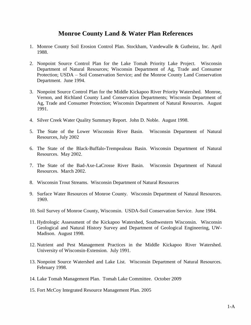
- - -
23
Monroe County Land & Water Plan References
1. Monroe County Soil Erosion Control Plan. Stockham, Vandewalle & Gutheinz, Inc. April
1988.
2. Nonpoint Source Control Plan for the Lake Tomah Priority Lake Project. Wisconsin
Department of Natural Resources; Wisconsin Department of Ag, Trade and Consumer
Protection; USDA – Soil Conservation Service; and the Monroe County Land Conservation
Department. June 1994.
3. Nonpoint Source Control Plan for the Middle Kickapoo River Priority Watershed. Monroe,
Vernon, and Richland County Land Conservation Departments; Wisconsin Department of
Ag, Trade and Consumer Protection; Wisconsin Department of Natural Resources. August
1991.
4. Silver Creek Water Quality Summary Report. John D. Noble. August 1998.
5. The State of the Lower Wisconsin River Basin. Wisconsin Department of Natural
Resources, July 2002
6. The State of the Black-Buffalo-Trempealeau Basin. Wisconsin Department of Natural
Resources. May 2002.
7. The State of the Bad-Axe-LaCrosse River Basin. Wisconsin Department of Natural
Resources. March 2002.
8. Wisconsin Trout Streams. Wisconsin Department of Natural Resources
9. Surface Water Resources of Monroe County. Wisconsin Department of Natural Resources.
1969.
10. Soil Survey of Monroe County, Wisconsin. USDA-Soil Conservation Service. June 1984.
11. Hydrologic Assessment of the Kickapoo Watershed, Southwestern Wisconsin. Wisconsin
Geological and Natural History Survey and Department of Geological Engineering, UW-
Madison. August 1998.
12. Nutrient and Pest Management Practices in the Middle Kickapoo River Watershed.
University of Wisconsin-Extension. July 1991.
13. Nonpoint Source Watershed and Lake List. Wisconsin Department of Natural Resources.
February 1998.
14. Lake Tomah Management Plan. Tomah Lake Committee. October 2009
15. Fort McCoy Integrated Resource Management Plan. 2005
1-A

- - -
23
Monroe County Land & Water Plan
Citizen Survey Results
Number of votes is indicated after each response
1. Which of the following items do you feel are the biggest threats to Monroe County’s
natural resources?
Agricultural Nutrient Management – 61
Development - 46
Agricultural Chemicals - 42
Soil Erosion - 42
Invasive Species - 38
Political Decisions - 32
Non-Metallic Mining - 29
Row Crops – 23
Wetland Drainage - 23
Climate Change - 20
Urban Property Management - 19
Domestic & Industrial Waste - 18
Construction Erosion - 17
Forest Management - 16
Fish & Wildlife Populations - 10
Land Clearing – 6
2. Consider the bodies of water in Monroe County that you are familiar with. How do
you believe the water quality is of those streams and lakes?
Good – 39
Average - 28
Poor – 10
Excellent - 4
3. Are you familiar with any groundwater problems in Monroe County? If so, what
might be a groundwater pollution source?
Agricultural Waste – 47
Commercial Fertilizer – 37
Domestic & Industrial Waste – 31
Pesticides – 27
Non-Metallic Mining – 15
Abandon or Open Wells – 13
2-A

- - -
23
4. Many Monroe County dairy farmers are expanding their operations. Do you think
farmers planning for expansion should be required to obtain a nutrient
management plan prior to adding more cattle? The nutrient management plan
would assure the landowner is able to utilize animal waste according to accepted
standards.
Yes - 78
No – 3
5. Do you think Monroe County needs other ordinances dealing with land use or
nonpoint pollution (e.g. soil erosion, manure spreading)?
Yes – 49
No - 28
6. The landscape/land use of Monroe County is changing. Should Monroe County be
working with municipalities (county, townships, & cities) to assist with the
development of land use plans?
Yes – 77
No – 6
7. Is the Farmland Preservation Program and/or other similar programs protecting
the rural character of Monroe County?
Unsure – 45
Yes – 29
No – 8
8. Should Monroe County farmers be required to follow a conservation plan that
meets the tolerable soil loss standard?
Yes – 78
No – 3
9. Do you believe enough is being done to protect the wetlands in Monroe County?
If not, do you have any solutions?
No – 36
Yes – 34
10. Which services should the Monroe County Land Conservation Department focus on
over the next 10 years?
Agricultural Waste Management – 67
Soil Erosion Management Practices – 61
Streambank Protection & Trout Stream Restoration – 56
Land Use Planning – 49
Providing Environmental Education – 42
3-A
- - -
23
Invasive Species Assistance – 41
Maintenance of Installed Conservation Practices – 40
Farmland Preservation & Agricultural Economic Development – 39
Flood Mitigation – 39
Water Quality Monitoring of Surface Waters – 38
Wetland Enhancement or Restoration – 35
Groundwater Protection – 31
Wildlife Habitat Enhancement – 24
Forest Management – 23
Drinking Water Testing/Monitoring – 18
Urban Storm Water & Erosion Control – 17
Fishing Easements & Public Land Acquisition – 15
Rotational Grazing – 6
4-A

- - -
23
MONROE COUNTY INVENTORY AND EVALUATION FORM for
AGRICULTURAL PERFORMANCE STANDARDS AND PROHIBITIONS
NR 151, RUNOFF MANAGEMENT
Landowner - Operator -
Evaluated by - Date -
YES NO
NR 151.02 Sheet, Rill and Wind Erosion
Land where crops are grown shall be cropped to “T” using RUSLE II.
Is there a current farm plan?
Does the existing farm plan meet “T” using RUSLE II?
Is the operator following the farm plan?
NR 151.05 Manure Storage Facilities New, altered, or abandoned manure storage facilities must meet NRCS standards.
NR 151.05 (2) New Construction and Alterations
Is there a manure storage facility at this site?
What year was the facility constructed? ____________
Has the original facility been altered? If yes, when?
Is the facility certified as meeting NRCS standards?
NR 151.05 (3) Closure
Has any manure been added or removed in past 24 months?
Is retention of the facility warranted based on future use?
NR 151.05 (4) Failing and Leaking Existing Facilities
Does the facility as is pose a public health threat, a threat to fish and aquatic life, or is it
violating groundwater standards? ____________
NR 151.06 Clean Water Diversions
Runoff shall be diverted from contacting feedlots, manure storage areas, and barnyard areas
located within water quality management areas (WQMA).
Is a feedlot, barnyard, or manure storage area located in a WQMA?
If yes, is clean water being diverted?
NR 151.07 Nutrient Management
Crop and livestock producers applying manure and other nutrients to agricultural fields shall do
so according to a certified nutrient management plan.
Does this farm have a certified 590 nutrient management plan?
If yes, who prepared the plan? ______________________________
When was the plan prepared? ____________
When was the last update prepared? ____________
Does any cropland drain to outstanding, exceptional, or impaired waters? ____________
5-A
- - -
23
________________________________________________________________________
YES NO
NR 151.08 Manure Management Prohibitions (refer to definitions on page 3)
All livestock producers shall comply with these manure management prohibitions:
Does this operation have any manure storage facility overflow?
Does this operation have any unconfined manure piles in water quality management
areas?
Does this operation have any direct runoff from a feedlot or stored manure into waters of
the state?
Does this operation allow unlimited livestock access to waters of the state in a location
where high concentrations of animals prevent the maintenance of adequate sod or self-
sustaining vegetative cover?
TAX PARCEL MEETS ALL STANDARDS
AND PROHIBITIONS? (Y/N) IF NO, WHAT STANDARDS/PROHIBITIONS ARE NON-COMPLIANT?
Monroe Co LCD Staff Signature - _________________________________Date - ___________
Landowner Signature - __________________________________________ Date - ___________
6-A

- - -
23
BEST MANAGEMENT PRACTICE DEFINITIONS
Access Roads and Crossings: A Road or pathway which confines or directs the movement of
livestock or farm equipment, and which is designed and installed to control surface water runoff.
Barnyard Runoff Control System: Structural measures to redirect surface runoff around the
barnyard and collect, convey, or temporarily store runoff from the barnyard.
Contour Strip Cropping: Tilling and planting across the slope following the contours of the
land, and breaking the field into alternating bands of row crops and hay or small grains.
Cover and Green Manure Crop: Close-growing grasses, legumes, or small grains grown to
control erosion when major crops do not furnish adequate cover.
Critical Area Planting: Planting grass, legumes or other vegetation to protect small, badly
eroding areas.
Crop Rotation: Changing the crops grown in a field, usually in a planned sequence.
Crop Residue Management: Any tillage method that leaves crop residue on the surface to
reduce erosion.
Diversion: An earthen embankment and channel, similar to a terrace, constructed across a slope
to collect water, divert it to a stable outlet, and protect an area downslope.
Filter Strips: An area of herbaceous vegetation that separates an environmentally sensitive area
from cropland, grazing land or disturbed land.
Grade Stabilization Structure: An earthen, concrete or other structure built across a
drainageway to prevent gully erosion.
Grass Waterway: A natural or constructed channel shaped, graded, and established with
suitable cover as needed to prevent erosion by runoff waters.
Livestock Fencing: Excluding livestock in order to protect an erodible area or practice, or
restricting human access to areas which may pose a hazard to humans.
Livestock Watering Facilities: A trough, tank, pipe, conduit, spring development, pump, well,
or other device installed to deliver drinking water to livestock.
Manure Storage Facility: A structure for the temporary storage of manure for the period of
time that is needed to safely land spread the manure and reduce the risks of nonpoint source
pollution.
7-A
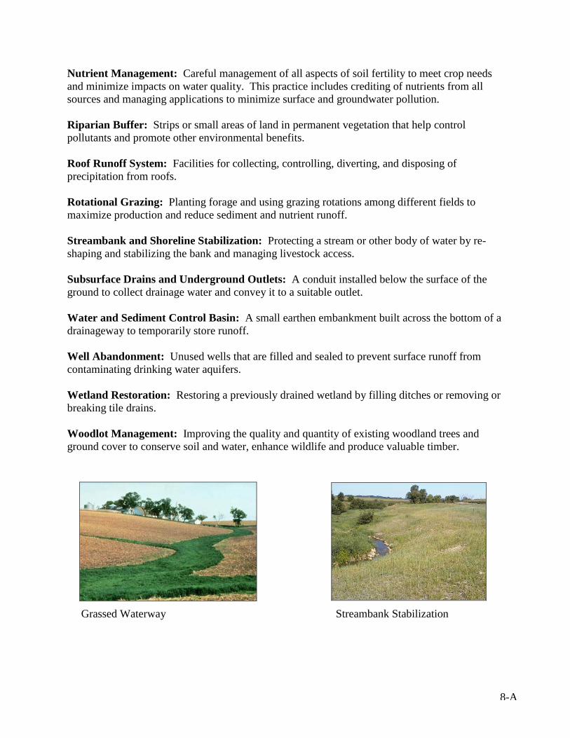
- - -
23
Nutrient Management: Careful management of all aspects of soil fertility to meet crop needs
and minimize impacts on water quality. This practice includes crediting of nutrients from all
sources and managing applications to minimize surface and groundwater pollution.
Riparian Buffer: Strips or small areas of land in permanent vegetation that help control
pollutants and promote other environmental benefits.
Roof Runoff System: Facilities for collecting, controlling, diverting, and disposing of
precipitation from roofs.
Rotational Grazing: Planting forage and using grazing rotations among different fields to
maximize production and reduce sediment and nutrient runoff.
Streambank and Shoreline Stabilization: Protecting a stream or other body of water by re-
shaping and stabilizing the bank and managing livestock access.
Subsurface Drains and Underground Outlets: A conduit installed below the surface of the
ground to collect drainage water and convey it to a suitable outlet.
Water and Sediment Control Basin: A small earthen embankment built across the bottom of a
drainageway to temporarily store runoff.
Well Abandonment: Unused wells that are filled and sealed to prevent surface runoff from
contaminating drinking water aquifers.
Wetland Restoration: Restoring a previously drained wetland by filling ditches or removing or
breaking tile drains.
Woodlot Management: Improving the quality and quantity of existing woodland trees and
ground cover to conserve soil and water, enhance wildlife and produce valuable timber.
Grassed Waterway Streambank Stabilization
8-A
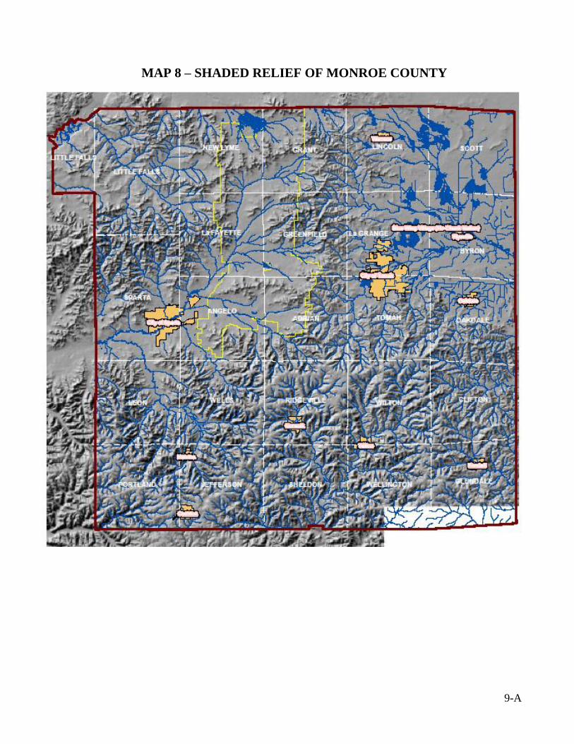
- - -
23
MAP 8 – SHADED RELIEF OF MONROE COUNTY
9-A
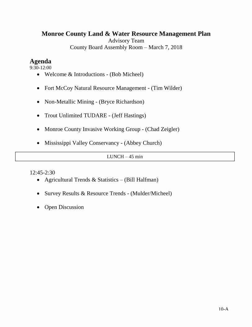
- - -
23
Monroe County Land & Water Resource Management Plan Advisory Team
County Board Assembly Room – March 7, 2018
Agenda 9:30-12:00
Welcome & Introductions - (Bob Micheel)
Fort McCoy Natural Resource Management - (Tim Wilder)
Non-Metallic Mining - (Bryce Richardson)
Trout Unlimited TUDARE - (Jeff Hastings)
Monroe County Invasive Working Group - (Chad Zeigler)
Mississippi Valley Conservancy - (Abbey Church)
12:45-2:30
Agricultural Trends & Statistics – (Bill Halfman)
Survey Results & Resource Trends - (Mulder/Micheel)
Open Discussion
LUNCH – 45 min
10-A
- - -
23
Monroe County Land & Water Resource Management Plan
Advisory Team
County Board Assembly Room – December 19, 2018
Agenda 1:30-3:30
Welcome & Introductions
Presentation
Survey Results & Resource Trends
Land Conservation Department - 10 year work plan
Open Discussion
11-A
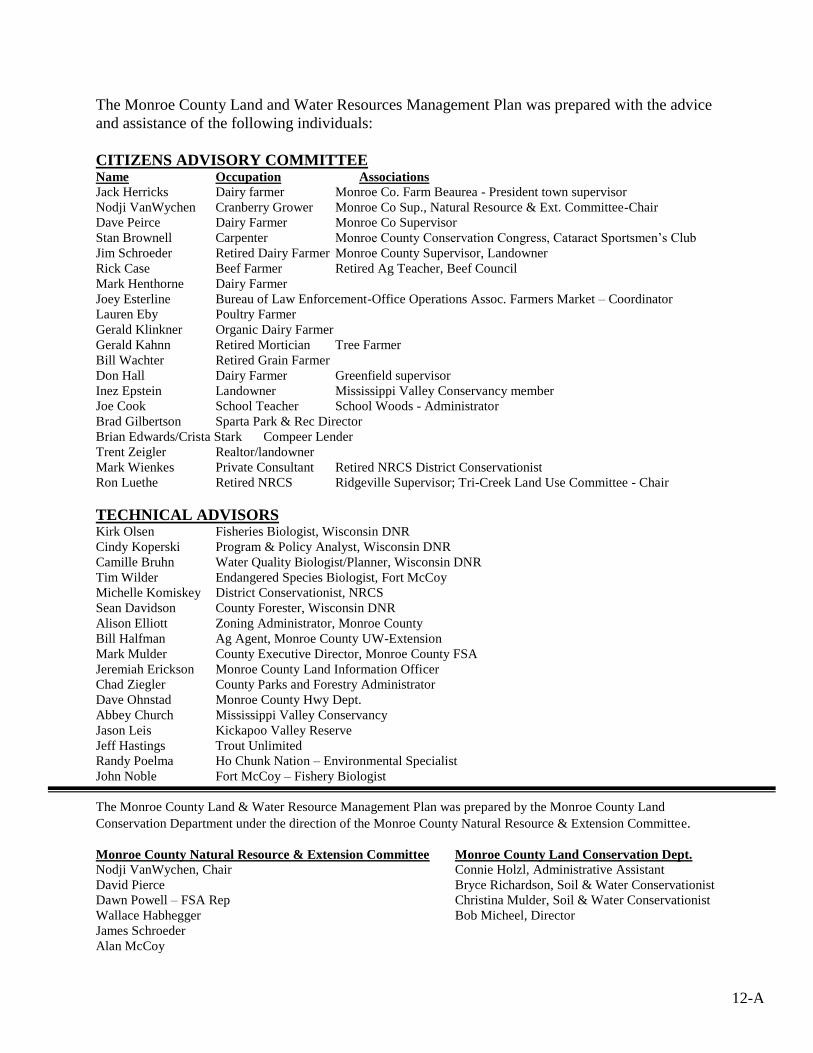
- - -
23
The Monroe County Land and Water Resources Management Plan was prepared with the advice
and assistance of the following individuals:
CITIZENS ADVISORY COMMITTEE Name Occupation Associations Jack Herricks Dairy farmer Monroe Co. Farm Beaurea - President town supervisor
Nodji VanWychen Cranberry Grower Monroe Co Sup., Natural Resource & Ext. Committee-Chair
Dave Peirce Dairy Farmer Monroe Co Supervisor
Stan Brownell Carpenter Monroe County Conservation Congress, Cataract Sportsmen’s Club
Jim Schroeder Retired Dairy Farmer Monroe County Supervisor, Landowner
Rick Case Beef Farmer Retired Ag Teacher, Beef Council
Mark Henthorne Dairy Farmer
Joey Esterline Bureau of Law Enforcement-Office Operations Assoc. Farmers Market – Coordinator
Lauren Eby Poultry Farmer
Gerald Klinkner Organic Dairy Farmer
Gerald Kahnn Retired Mortician Tree Farmer
Bill Wachter Retired Grain Farmer
Don Hall Dairy Farmer Greenfield supervisor
Inez Epstein Landowner Mississippi Valley Conservancy member
Joe Cook School Teacher School Woods - Administrator
Brad Gilbertson Sparta Park & Rec Director
Brian Edwards/Crista Stark Compeer Lender
Trent Zeigler Realtor/landowner
Mark Wienkes Private Consultant Retired NRCS District Conservationist
Ron Luethe Retired NRCS Ridgeville Supervisor; Tri-Creek Land Use Committee - Chair
TECHNICAL ADVISORS Kirk Olsen Fisheries Biologist, Wisconsin DNR
Cindy Koperski Program & Policy Analyst, Wisconsin DNR
Camille Bruhn Water Quality Biologist/Planner, Wisconsin DNR
Tim Wilder Endangered Species Biologist, Fort McCoy
Michelle Komiskey District Conservationist, NRCS
Sean Davidson County Forester, Wisconsin DNR
Alison Elliott Zoning Administrator, Monroe County
Bill Halfman Ag Agent, Monroe County UW-Extension
Mark Mulder County Executive Director, Monroe County FSA
Jeremiah Erickson Monroe County Land Information Officer
Chad Ziegler County Parks and Forestry Administrator
Dave Ohnstad Monroe County Hwy Dept.
Abbey Church Mississippi Valley Conservancy
Jason Leis Kickapoo Valley Reserve
Jeff Hastings Trout Unlimited
Randy Poelma Ho Chunk Nation – Environmental Specialist
John Noble Fort McCoy – Fishery Biologist
The Monroe County Land & Water Resource Management Plan was prepared by the Monroe County Land
Conservation Department under the direction of the Monroe County Natural Resource & Extension Committee.
Monroe County Natural Resource & Extension Committee Monroe County Land Conservation Dept. Nodji VanWychen, Chair Connie Holzl, Administrative Assistant
David Pierce Bryce Richardson, Soil & Water Conservationist
Dawn Powell – FSA Rep Christina Mulder, Soil & Water Conservationist
Wallace Habhegger Bob Micheel, Director
James Schroeder
Alan McCoy
12-A


