
1 Mineral Resources which are not Ore Reserves do not have demonstrated economic viability. The estimate of Mineral Resources may be
materially affected by environmental, permitting, legal, title, taxation, socio-political, marketing, operational cost, metal price, mining control, dilution or other relevant issues. There has been insufficient exploration to define these Inferred Mineral Resources as an Indicated or Measured Mineral Resource, as there is insufficient close-spaced drill hole data to adequately define grade and geological continuity for this structurally complex deposit. It is uncertain if further exploration will result in upgrading the Inferred Mineral Resource to an Indicated or Measured Mineral Resource category or to Ore Reserves.
1
Mako Mineral Resource Increase & Britannia Exploration Results Update
HIGHLIGHTS:
The JORC Inferred Resource1 for the Mako Lode in the Llanberris compartment has
increased by 25% to 160,000 tonnes at 9.5g/t Au (ranging between 6 and 11 g/t Au)
for 47,700 ounces of gold,
The updated Resource includes for the first time a hangingwall lode known as the
Tiger Up-Dip Lode and which is now being accessed for mining, and
Diamond drilling of the adjacent Britannia – Mako exploration target is
approximately 45% complete, with five areas emerging as having resource
potential.
Australian gold producer Castlemaine Goldfields Limited (ASX Code: CGT) announces an updated Mineral Resource within the Ballarat gold mine for the high grade Mako Lode currently being mined, and also positive exploration results from the Britannia compartment drilling program.
Updated Mako Resource:
An updated geological model has been completed following the addition of data from 20 diamond drill holes and with knowledge gained from underground detailed mapping of gold-bearing quartz veining and associated geological structures from three locations within the Mako resource that have now been accessed for production.
A total JORC Inferred Mineral Resource1 of:
160,000 tonnes at 9.5 g/t gold for 47,700 ounces
is estimated for the Mako Lode in the Llanberris compartment of the Ballarat gold mine. This estimate is after depletion of approximately 7,800 tonnes mined to date within the resource. The revised Inferred Mineral Resource represents a 32% increase in tonnes and 25% increase in total gold ounces defined for the mining area in Llanberris when compared to the previous (January 2012) resource estimate of 121,000 tonnes at 10g/t Au for 38,300 ounces of gold.
The new estimate includes 21,000 tonnes at 8.5 g/t Au as the inaugural JORC Inferred Resource for the Tiger Up-Dip Lode which was recently infill drilled and resource modeled. Mine development is now cutting across to this gold lode to develop an additional ore source.
An eight hole drill program aimed to extend the Mako resource north has just been completed and drilling is in progress testing for southern extensions to the Mako Lode. The company is optimistic that these programs will see a further expansion of resources close to existing mining areas in the Llanberris compartment.
ASX Release – 5/04/2012 F
or p
erso
nal u
se o
nly

2
Britannia – Mako Drill Results:
The infill diamond drilling program in the Britannia compartment is nearing half way with 4 of the planned 9 sections of holes complete and covering approximately 160m of mineralisation strike length. Five areas have emerged as having resource potential to meet assumptions in the long term mine plan and have been prioritised for infill drilling. Best results to date are:
3.5 m @ 26.9 g/t Au from 84.0 m in CBU189,
11.1 m @ 10.6 g/t Au from 97.5 m in CBU206,
1.1 m @ 88.1 g/t Au from 6.3 m in CBU234,
3.95 m @ 21.8 g/t Au from 22.45 m in CBU191,
3.6 m @ 74.2 g/t Au from 45.4 m in CBU191,
5.1 m @ 8.1 g/t Au from 55.9 m in CBU192,
3.9 m @ 6.1 g/t Au from 71.9 m in CBU192,
3.5 m @ 43.1 g/t Au from 98.0 m in CBU158,
4.65 m @ 7.0 g/t Au from 105.05 m in CBU217,
Figure 1. Location of Mako Inferred Resource and active mining area in Llanberris
relative to the Britannia compartment exploration drill program
Updated JORC Inferred Resource Mako & Tiger Up-Dip Lodes:
160,000 t @ 9.5 g/t Au Britannia-Mako diamond drill program 4 of 9 sections completed.
Resource target infill drilling now begun
For
per
sona
l use
onl
y
3
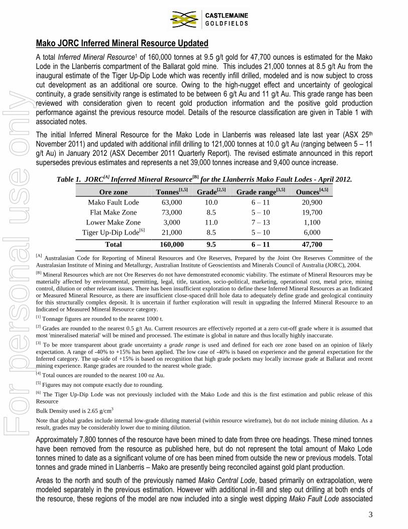
Mako JORC Inferred Mineral Resource Updated
A total Inferred Mineral Resource1 of 160,000 tonnes at 9.5 g/t gold for 47,700 ounces is estimated for the Mako Lode in the Llanberris compartment of the Ballarat gold mine. This includes 21,000 tonnes at 8.5 g/t Au from the inaugural estimate of the Tiger Up-Dip Lode which was recently infill drilled, modeled and is now subject to cross cut development as an additional ore source. Owing to the high-nugget effect and uncertainty of geological continuity, a grade sensitivity range is estimated to be between 6 g/t Au and 11 g/t Au. This grade range has been reviewed with consideration given to recent gold production information and the positive gold production performance against the previous resource model. Details of the resource classification are given in Table 1 with associated notes.
The initial Inferred Mineral Resource for the Mako Lode in Llanberris was released late last year (ASX 25th November 2011) and updated with additional infill drilling to 121,000 tonnes at 10.0 g/t Au (ranging between 5 – 11 g/t Au) in January 2012 (ASX December 2011 Quarterly Report). The revised estimate announced in this report supersedes previous estimates and represents a net 39,000 tonnes increase and 9,400 ounce increase.
Table 1. JORC[A]
Inferred Mineral Resource[B]
for the Llanberris Mako Fault Lodes - April 2012.
Ore zone Tonnes[1,5]
Grade[2,5]
Grade range[3,5]
Ounces[4,5]
Mako Fault Lode 63,000 10.0 6 – 11 20,900
Flat Make Zone 73,000 8.5 5 – 10 19,700
Lower Make Zone 3,000 11.0 7 – 13 1,100
Tiger Up-Dip Lode[6]
21,000 8.5 5 – 10 6,000
Total 160,000 9.5 6 – 11 47,700
[A] Australasian Code for Reporting of Mineral Resources and Ore Reserves, Prepared by the Joint Ore Reserves Committee of the
Australasian Institute of Mining and Metallurgy, Australian Institute of Geoscientists and Minerals Council of Australia (JORC), 2004.
[B] Mineral Resources which are not Ore Reserves do not have demonstrated economic viability. The estimate of Mineral Resources may be
materially affected by environmental, permitting, legal, title, taxation, socio-political, marketing, operational cost, metal price, mining
control, dilution or other relevant issues. There has been insufficient exploration to define these Inferred Mineral Resources as an Indicated
or Measured Mineral Resource, as there are insufficient close-spaced drill hole data to adequately define grade and geological continuity
for this structurally complex deposit. It is uncertain if further exploration will result in upgrading the Inferred Mineral Resource to an
Indicated or Measured Mineral Resource category.
[1] Tonnage figures are rounded to the nearest 1000 t.
[2] Grades are rounded to the nearest 0.5 g/t Au. Current resources are effectively reported at a zero cut-off grade where it is assumed that
most 'mineralised material' will be mined and processed. The estimate is global in nature and thus locally highly inaccurate.
[3] To be more transparent about grade uncertainty a grade range is used and defined for each ore zone based on an opinion of likely
expectation. A range of -40% to +15% has been applied. The low case of -40% is based on experience and the general expectation for the
Inferred category. The up-side of +15% is based on recognition that high grade pockets may locally increase grade at Ballarat and recent
mining experience. Range grades are rounded to the nearest whole grade.
[4] Total ounces are rounded to the nearest 100 oz Au.
[5] Figures may not compute exactly due to rounding.
[6] The Tiger Up-Dip Lode was not previously included with the Mako Lode and this is the first estimation and public release of this
Resource
Bulk Density used is 2.65 g/cm3
Note that global grades include internal low-grade diluting material (within resource wireframe), but do not include mining dilution. As a
result, grades may be considerably lower due to mining dilution.
Approximately 7,800 tonnes of the resource have been mined to date from three ore headings. These mined tonnes have been removed from the resource as published here, but do not represent the total amount of Mako Lode tonnes mined to date as a significant volume of ore has been mined from outside the new or previous models. Total tonnes and grade mined in Llanberris – Mako are presently being reconciled against gold plant production.
Areas to the north and south of the previously named Mako Central Lode, based primarily on extrapolation, were modeled separately in the previous estimation. However with additional in-fill and step out drilling at both ends of the resource, these regions of the model are now included into a single west dipping Mako Fault Lode associated
For
per
sona
l use
onl
y

4
with late fault movement and strong clay development. Mining to date from the central access into this Mako Fault Lode has given additional confidence to the continuity of this controlling structure. Difficult ground conditions have been encountered to date in the mining of the Mako Fault mineralisation.
The new geological model and estimate incorporates information from 20 additional diamond holes, and all available underground mapping. Mapping information has been spatially registered and used to interpolate quartz vein geometries and arrays between drillhole data. The method of estimation and parameters used are the same as in the previous resource estimation with an additional 184 sample assays being used to estimate gold grades (total of 503 samples).
Figure 2. Long section showing the revised Mako Lodes and Tiger Up-Dip Inferred Resource models and additional drill
holes locations used with underground mapping information for the new model.
Geological data has been interpreted on section and wireframed, block modeled and with grade estimate made using Inverse Distance techniques. The Mineral Resource block model grade was estimated using the inverse distance with power of 2 interpolator, on 0.75m assay composites and with a 55 g/t Au top cut. Hole locations, geological drill logs, surveys, sampling techniques and analytical performance are to appropriate standards. Sampling, geological and estimation results have been validated by the Competent Person. Diamond core recovery can be poor in faulted zones associated with gold mineralisation. Sample recovery is recorded and has been appropriately incorporated into this estimation. Core loss is ascribed a grade of zero although the company is gaining evidence that this is probably an understatement of the gold grade in portions of low drill core recovery within close proximity to the major fault zones.
New drill sample assay data is both from full core samples and half cut core samples where both halves have been analysed by 2000g accelerated cyanide leach (LeachWELL© 24 hour bottle roll) with AAS determination. Where half core samples were taken, assay values used in the new estimate are the arithmetic average grade of both half core assay values (i.e. 100% of the core available is analysed for gold). The company uses a series of external standard and blank sample material to monitor assay quality with results being within expectations.
For
per
sona
l use
onl
y

5
The following changes to the geological model are noted for this revised estimate:-
The Mako Fault (footwall) Lode has been extended down dip on most portions of the central area by an average of 21m,
This extension is greater on southern sections of the Mako Fault Lode where it averages 29m,
The flat quartz veins which comprise the “Flat Makes Lode” have been extended approximately 40m south, with the Lower Make Lode extended 14-16m further to the south,
The vertical height of the Flat Make model has been increased due to underground observation that substantial quartz veining occurs as sub-vertical cleavage or bedded [controlled/orientated] veins between the more laterally continuous spur veins. Mine engineering analysis suggests it will be more economical to mine the interstitial veins and sets of sub-horizontal spurs as a whole and hence the decision to bulk together the previous Make models into a single lode for most sections,
The majority of the additional tonnes in the updated estimate come from the Flat Make Lode. This is considered valid given the additional mined volumes of quartz in areas outside the previous model where higher than expected quartz content has been observed and sent as ore for processing,
The previous model interpreted a northern termination of the Mako Fault Lode pinching down to a point; further drill intersections have provided additional up-dip continuation to the model.
The Pioneer cross course fault, which was previously modeled to dislocate the Southern Mako Lode from the Central Mako Lode, has now been removed from the model thus making the main Mako Fault gold mineralisation continuous. The Pioneer fault was not intersected where expected in the Lower Llanberris Decline and it was deduced that survey inaccuracies in surface drill hole BDD008 and wedge holes (drilled in 1991) had created the apparent geological offset. For purposes of the revised resource the BDD008 holes have been re-located to be consistent with surrounding drill and mining information. This required an approximate 6m horizontal and 1m vertical shift in the hole collar.
As a general geological observation there are many smaller areas of high gold grade drill intersections which are not included in the resource estimate. This is particularly evident in the wedge area between the Mako Fault and Flat Make Lodes, and immediately above the Flat Make Lode for short east-west distances (~3-10m). Further work is being undertaken to resolve the continuity of structure, quartz veining and mineralisation for these areas so that they may be modeled and economically assessed.
A nine hole program to test the northern extensions of the Mako Resource is just completed with assay results expected over the next two months. Drill sections step out progressively 10m, 40m, 70m and 100m north from the Inferred Resource. Preliminary interpretation is that a flat lying, arsenopyrite rich and strongly brecciated quartz vein horizon occurs across at least the northern most two sections with moderately weaker west dipping fault structures to that seen to the south. Closer to the resource a number of faults and quartz intervals have been logged which may extend the known mineralisation.
The Company is also optimistic that a six hole drill program which has just begun from the end of the Lower Llanberris Decline will be successful in extending the Mako Lode mineralisation south of the existing resource limits.
Britannia – Mako Fault Zone Exploration Results:
The diamond drill program within the Britannia compartment on the Mako Fault zone is approximately 45% complete with over 3000m drilled since early January 2012. Five areas showing resource potential have been named:- North Anticline, Bengal Fault (Vertical HW structures), Mako Breccia Syncline, Mako Breccia Anticline and South Anticline (see Figure 3).
Assay intersections not previously released and shown in Figures 4 to 7 are given in Table 2 in Appendix 1.
For
per
sona
l use
onl
y

6
The program is testing an Exploration Target1 in the range 100,000 - 300,000 tonnes at a grade range of 3 g/t Au to 9 g/t Au for between 20,000 oz Au to 60,000 oz Au based on similar mineralisation identified in the Llanberris compartment on the Mako Fault Zone.
Drill Sections are spaced approximately 30m along strike and 20m down dip with two sections at the south separated by 70m from the other two northern sections. This 70m gap in the program will be tested in the coming month prior to estimation of an Inferred Resource.
Figure 3. Long projection of the Mako Fault Zone Exploration Targets in the Britannia compartment showing completed
drill sections relative to existing drill information obtained in 2010-11 (plus surface hole BDD004; 1987). Also shown are
the first five resource target areas to emerge from results to date and which require follow-up drilling.
The North Anticline mineralisation, within 15m of the existing Woah Hawp decline, is a narrow 2m to 5m wide sub-vertical set of auriferous quartz spur veins interpreted to lie along the First Chance anticline axis (see Figure 4). The best results along the North Anticline are found to occur close to where it intersects west dipping fault structures such as the Mako, Bengal and Siberian Faults. The best results along the North Anticline are found to occur close to where it intersects west dipping fault structures such as the Mako Fault (8.8m @ 6.3 g/t Au in CBU213), the newly named Bengal Fault (1.1m @ 88.1 g/t Au in CBU234) and the newly named Siberian Fault (3.0m @ 7.6 g/t Au in CBU194).
1 An Exploration Target is a hypothetical view of mineralised reef which is not necessarily economic. It is not a Mineral Resource or Ore Reserve. There is no guarantee that tonnages will be either realised or economic. Further exploration, including underground development and diamond drilling is required and ongoing
Figure 7
Figure 6
Figure 5 Figure 4
BBeennggaall TTaarrggeett
For
per
sona
l use
onl
y

7
The Bengal Fault is structurally correlated along ~160m of strike length, although the middle portion includes a 70m length with no drilling to date and this area is a priority drill target. This sub-vertical mineralisation occurs on the hangingwall to the Mako Fault with common sub-vertical spur quartz veins emanating away from the Bengal fault. To date some of the best gold intersections in the program have come from this target (3.6m @ 74.2 g/t Au in CBU191, 4.4m @ 17.2 g/t Au in CBU234, 11.1m @ 10.6 g/t Au in CBU206).
Figure 4. Northern most Britannia cross section with new results in red.
The initial surface and 2010 high grade drill intersections into the Mako Fault at the northern end of Britannia compartment identified a somewhat distinctive quartz vein breccia with common massive quartz spur veins. The two breccia zone targets form part of a shallow dipping fault zone with surrounding spurry quartz veins, between 2.5m and 5.5m high and that are correlated across most of the compartment.
Where the Mako Fault Breccia is close to the First Chance syncline axis increased quartz volumes are evidenced with higher gold grades such as 5.1m @ 8.1 g/t Au and 3.9m @ 6.1 g/t Au in CBU192 on section 510N. Termed the Mako Breccia Syncline this specific location close to the syncline has not been tested to date across the middle sections of the compartment.
Mako Fault & Quartz Breccia
Bengal Fault Siberian Fault
Mako Breccia Anticline Target
Mako Breccia Syncline Target
North Anticline Target
For
per
sona
l use
onl
y
8
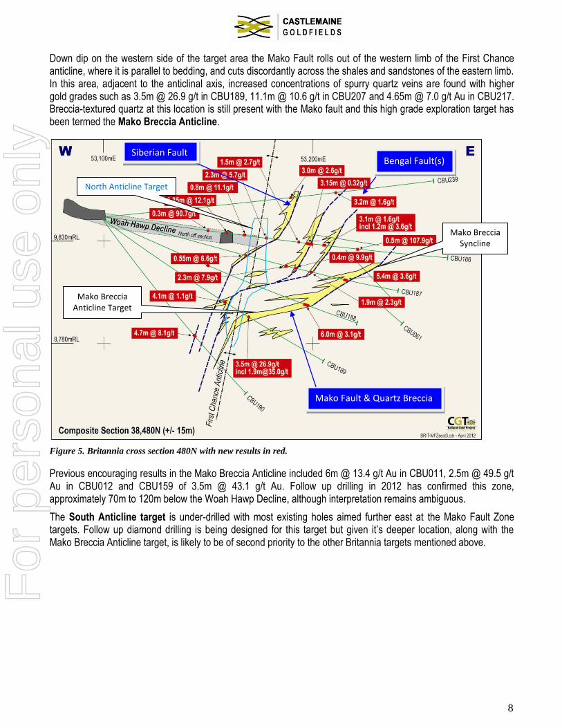
Down dip on the western side of the target area the Mako Fault rolls out of the western limb of the First Chance anticline, where it is parallel to bedding, and cuts discordantly across the shales and sandstones of the eastern limb. In this area, adjacent to the anticlinal axis, increased concentrations of spurry quartz veins are found with higher gold grades such as 3.5m @ 26.9 g/t in CBU189, 11.1m @ 10.6 g/t in CBU207 and 4.65m @ 7.0 g/t Au in CBU217. Breccia-textured quartz at this location is still present with the Mako fault and this high grade exploration target has been termed the Mako Breccia Anticline.
Figure 5. Britannia cross section 480N with new results in red.
Previous encouraging results in the Mako Breccia Anticline included 6m @ 13.4 g/t Au in CBU011, 2.5m @ 49.5 g/t Au in CBU012 and CBU159 of 3.5m @ 43.1 g/t Au. Follow up drilling in 2012 has confirmed this zone, approximately 70m to 120m below the Woah Hawp Decline, although interpretation remains ambiguous.
The South Anticline target is under-drilled with most existing holes aimed further east at the Mako Fault Zone targets. Follow up diamond drilling is being designed for this target but given it’s deeper location, along with the Mako Breccia Anticline target, is likely to be of second priority to the other Britannia targets mentioned above.
Mako Fault & Quartz Breccia
Bengal Fault(s)
Mako Breccia Anticline Target
Mako Breccia Syncline
North Anticline Target
Siberian Fault
For
per
sona
l use
onl
y

9
Figure 6. Britannia cross section 410N with new results in red.
The results emerging from drilling in Britannia provide encouragement that the exploration target for the Mako Fault Zone and associated hangingwall mineralisation will be converted into future resources, albeit from up to five possible zones. It is notable that the Mako Fault is generally flatter lying than known in the Llanberris compartment and has significantly less late faulting and accompanying clay alteration.
The brecciated and sometimes arsenopyrite rich Mako targets are similar to the high grade mineralised areas within the northern parts of the Mako Resource in Llanberris and it may be an important conclusion for mine exploration that the best results to date are occurring close to both the anticline and syncline regions of the First Chance eastern fold limb.
With the Mako and associated hangingwall mineralisation on the Bengal, Siberian and Anticline axes being found across most the Britannia compartment, encouragement is given to infill drilling the higher grade regions that are now emerging.
Mako Fault & Quartz Breccia
Vertical mineralisation Bengal Fault
Mako Breccia Anticline Target
South Anticline Target
Vertical Bengal Target
For
per
sona
l use
onl
y

10
Figure 7. Southern most Britannia cross section 380N with new results in red.
Competent Person’s Statement Information in this document which relates to Exploration Results, and Mineral Resources in this announcement is based on
information compiled by Mr Wessley Edgar, a full time employee and Exploration Manager for Castlemaine Goldfields
Limited, who is a member of the Australasian Institute of Mining & Metallurgy, and who has the relevant experience as a
Competent Person, as defined in the 2004 edition of the ‘Australasian Code for Reporting of Exploration Results, Mineral
Resources and Ore Reserves (the JORC Code)’. Mr Edgar, has given and has not withdrawn prior to lodgment, his written
consent to be named in this Announcement as the person responsible for the Exploration Results and Mineral Resources
statements and to the inclusion of these statements in the form and context in which they appear.
Lower Llanberris Decline cross cutting to Mako ore
Mako Fault & Quartz Breccia
Mako Breccia Anticline Target
South Anticline Target
Vertical Bengal Target
For
per
sona
l use
onl
y

11
Appendix 1 Table of Assay Results
Gold assay intervals are length weighted grade averages with typically <2m internal dilution, although lower grades and greater internal dilution may be included only where the dilution is predominantly quartz veining (60-100% quartz), core loss or fault material.
No top cut off grade is used other than listed in the tables as “TC55” which is the equivalent intersection gold grade using a 55g/t Au top cut identical to that used for Resource block model grade estimation. Minimum sample interval is 0.3m. Core loss or unsampled intervals are ascribed a gold grade of zero. Collar coordinates and survey information are in local mine grid. “HW” is shorthand for hangingwall.
Table 2. Britannia compartment exploration drill hole intersections
Drillhole Collar
Depth From
Gold Intersection TC55 Exploration Target Gold Lode
North East RL Azimuth Dip (m) (metres, g/t Au) (g/t)
CBU157 53078.18 38378.60 9858.18 97.4 -57.6 94.6 4.2m @ 8.4 g/t same undefined
104.4 5.6m @ 3.7 g/t same Mako Breccia Anticline
CBU158 53077.92 38378.65 9858.15 97.6 -66.1 98.0 3.5m @ 43.1 g/t 15.5 South Anticline
116.4 1.5m @ 22.2 g/t same undefined - below Mako
CBU159 53077.68 38378.68 9858.20 94.6 -75.7 145.4 4.4m @ 5.0 g/t same Spur vein adjacent to Anticline
CBU174 53045.92 38412.96 9854.71 108.6 -24.0 163.9 2.4m @ 4.2 g/t same Mako Breccia
CBU175 53045.11 38413.24 9854.75 109.1 -28.9 155.6 3.8m @ 1.3 g/t same Mako Breccia
CBU186 53098.71 38492.47 9841.11 96.7 -7.6 52.2 0.3m @ 90.7 g/t 55 Western limb
59.1 0.35m @ 12.1 g/t same Western limb
68.65 0.8m @ 11.1 g/t same Western limb
79.45 2.3m @ 5.7 g/t same North Anticline
95.9 1.5m @ 2.7 g/t same undefined
100.25 3.15m @ 0.32 g/t same undefined
107.2 3.1m @ 1.6 g/t same Vertical Bengal Zone
including 1.2m @ 3.6 g/t same Vertical Bengal Zone
120.15 0.5m @ 107.9 g/t 27.2 undefined
CBU187 53098.64 38492.59 9841.89 95.3 -15.8 49.1 1.7m @ 4.4 g/t same Western limb
57.0 0.2m @ 53.2 g/t same Western limb
76.45 0.55m @ 6.6 g/t same Vertical Bengal Zone
104.8 1.9m @ 2.3 g/t same Vertical Bengal Zone
122.2 5.4m @ 3.6 g/t same Mako Breccia
CBU188 53098.57 38492.58 9840.62 94.6 -26.1 67.2 0.4m @ 17.7 g/t same Western limb
75.25 0.75m @ 353.3 g/t 49.2 Spur on North Anticline
86.9 0.8m @ 21.0 g/t 86.9m Spur vein
97.27 6.0m @ 3.1 g/t same Mako Breccia
CBU189 53098.48 38492.40 9840.36 102.7 -35.7 84.0 3.5m @ 26.9 g/t 22.9 Vertical Bengal Zone
including 1.9m @ 35.0 g/t 30.0 Vertical Bengal Zone
CBU190 53098.53 38492.10 9839.67 106.0 -52.4 69.3 4.7m @ 8.1 g/t 6.3 Western limb
CBU191 53161.52 38507.41 9830.24 85.6 1.6 14.2 1.2m @ 3.9 g/t same undefined
22.45 3.95m @ 21.8 g/t 16.5 Vertical Siberian Zone
including 2.4m @ 34.9 g/t 26.2 Vertical Siberian Zone
45.5 3.6m 2 74.2 g/t 16.4 Vertical Bengal Zone
56.8 0.6m @ 35.8 g/t same undefined
62.6 4.1m @ 3.1 g/t same undefined above Mako
Syncline
For
per
sona
l use
onl
y

12
Drillhole
Collar Depth From
Gold Intersection TC55 Exploration Target
Gold Lode North East RL Azimuth
Dip (m) (metres, g/t Au) (g/t)
CBU192 53161.49 38507.41 9829.66 88.6 -21.0 7.4 0.45m @ 9.3 g/t same North Anticline
55.9 5.1m @ 8.1 g/t same Mako Spurs above Breccia
71.9 3.9m @ 6.1 g/t same Mako Fault & Breccia
CBU193 53161.45 38507.35 9828.90 89.5 -47 8.2 3.5m @ 2.0 g/t same North Anticline
39.0 6.5m @ 2.6 g/t same Mako Breccia
CBU194 53160.98 38506.84 9828.49 104.6 -73 15.9 3.0m @ 7.6 g/t same North Anticline
22.9 1.1m @ 20.6 g/t same undefined
CBU206 53076.03 38438.69 9849.82 108.1 -13.9 97.9 11.1m @ 10.6 g/t 9.3 Vertical Bengal Zone
CBU207 53075.94 38438.69 9848.66 106.6 -52.6 95.5 2.3m @ 10.0 g/t same Mako Breccia near Anticline
CBU208 53075.55 38438.79 9848.33 106.8 -46.7 - No significant assay - Western limb
CBU213 53158.75 38505.66 9828.42 194.8 -84.5 36.8 8.8m @ 6.3 g/t 4.4 North Anticline
CBU214 53075.90 38438.83 9849.01 110.6 -47.1 - assay awaited - Mako Breccia
CBU215 53067.27 38414.52 9853.33 108.0 -25.6 135.0 2.8m @ 5.9 g/t same undefined
includes
0.25m @ 51.4 g/t same undefined
143.2 0.8m @ 32.8 g/t 26.8 single spur vein
150.4 2.4m @ 2.0 g/t same Mako Breccia
CBU216 53067.24 38414.34 9852.83 113.5 -40 118.7 2.9m @ 0.6 g/t same Mako Spurs above Breccia
123.95
3.0m @ 3.1 g/t same Mako Fault & Breccia
CBU217 53066.98 38414.37
9852.42 110.0 -53.4 105.05
4.65m @ 7.0 g/t same Mako Breccia near Anticline
includi
ng 2.6m @ 9.8 g/t same Mako Breccia near Anticline
CBU234 53161.47 38507.29 9829.91 90.7 -7.7 5.7 1.1m @ 88.1 g/t 27.2 North Anticline
22.4 2.1m @ 2.0 g/t same undefined
37.2 1.4m @ 22.9 g/t same HW to Bengal Fault
43.5 4.4m @ 17.2 g/t 7.8 Vertical Bengal Zone
59.1 3.7m @ 1.9 g/t same undefined above Mako
Syncline
CBU235 53161.46 38507.29 9829.36 89.0 -31.6 10.4 3.4m @ 2.2 g/t same North Anticline
18.2 2.0m @ 1.4 g/t same undefined
26.4 5.2m @ 3.9 g/t same Bengal Fault
51.4 10.6m @ 1.6 g/t same Mako Breccia
including
2.0m @ 4.9 g/t same Mako Breccia
CBU236 53161.32 38507.24 9828.54 90.8 -60.3 7.3 0.7m @ 32.2 g/t same North Anticline
17.4 1.6m @ 30.0 g/t 21.4 Bengal Fault near Anticline
37.2 6.8m @ 1.0 g/t same Mako Breccia
48.4 2.4m @ 5.3 g/t same undefined
70.5 1.5m @ 3.4 g/t same undefined
CBU0239
53098.44 38492.49 9841.70 94.8 7.8 89.0 3.0m @ 2.6 g/t same Vertical Siberian Zone
110.4 3.2m @ 1.6 g/t same Vertical Bengal Zone
For
per
sona
l use
onl
y

13
ABOUT CASTLEMAINE GOLDFIELDS LIMITED
Castlemaine Goldfields Limited (CGT) holds significant exploration titles encompassing five substantial goldfields in Central Victoria. This land holding gives the Company access to two of the three largest historical gold producing areas in Victoria (totaling some 17 million ounces of gold). CGT has 100% of the Ballarat, Castlemaine, Tarnagulla, Berringa and Sebastian Goldfields (the later subject to a JV), with approved Mining and Exploration Licences over the key areas.
The primary focus is to return the Ballarat Gold project to production at a targeted annualised rate of approximately 50,000 ounces per year during the second half of 2012. Resumption of mine development commenced in March 2011 with first ore accessed mid-year and initial gold production occurring in September 2011.
The first JORC Inferred Resource estimate for the Mako Lode in the Ballarat mine was announced in November 2011 and last updated in April 2012 to 160,000 tonnes at 9.5 g/t Au for 47,700 ounces of gold, and will underpin production for the mine in 2012.
An Independent Technical Review in late 2011 by Snowden Mining Consultants quantified Exploration Targets beyond the Mako Lode Resource at Ballarat in the range of 400,000t to 750,000t at a grade of between 4 g/t and 8 g/t, for between 70,000 and 165,000 ounces of gold. Note that Exploration Targets are conceptual in nature and there is insufficient information to establish whether further exploration, either by drilling or mine access into the mineralisation will result in the determination of a Mineral Resource or Ore Reserve.
It is anticipated that with further exploration success a similar rate of gold production could also be sourced from the Castlemaine goldfield. Substantial value will be added to the Ballarat project from resource discoveries and development of CGT’s other existing Central Victorian projects.
The inaugural JORC Inferred Resource estimate for the Chewton Deposit, and remnants at the Wattle Gully Mine at Castlemaine, totaling 686,000 ounces of gold was announced in 2008 (ASX:CGT release 2nd June 2008).
CGT’s five gold projects within the Central Victorian Goldfields shown in
blue with past production for the 3 prominent goldfields.
For
per
sona
l use
onl
y


![Mako port mar13[1]](https://cdn.vdocuments.mx/doc/165x107/54622f14b1af9fbc4d8b50c0/mako-port-mar131.jpg)


