The Nowruz Oil Spill in the Arabian Gulf: Case Study of Saudi Arabia
Abdullah S. AI-Amirah
Un iversity of Riyad
16
INTRODUCTION
The Arabian Gulf has suffered from hundreds of oil spills, some of them reported but most unreported. In many cases the amounts of the spills and their causes are usually undetermined. During 1978-1979, tanker captains reported to the Japan Oceanographic Data Center about 412 oil slicks in the Gulf and its approaches. ' Table 1 shows major oil spills exceeding 3,000 barrels which occurred between August, 1980, and August, 1982. Although these are relatively current, it should be noted that other significant oil spills have occurred since oil was discovered in the region by Iran in 1908.
It is almost impossible to have accurate information or data concerning oil pollution in the Gulf area since the official concern of many of the Arabian Gulf States has not existed until recent years. In some states it is difficult to obtain information about the oil spills or accidents because the facts are usually considered confidential. It is the opinion of some officials of these countries that collecting statistics or gathering information concerning oil pollution or some other similar matters affects national security.
Furthermore, oil companies do not admit or record any of the spills or slicks unless they are major accidents that might be noticed later. The Hasbah oil spill cited in Table 1 exemplifies this policy. 2 During another occasion, ARAMCO used sand to make the oil sink in very sensitive areas in order to clean the water surface in a very short period of time.
Data concerning oil pollution are usually collected by the oil companies which own or operate the facilities. Therefore, it is almost impossible to obtain this information, and if it is available, it is often misleading. Taking into consideration the sensitive nature of the Gulf, the high level of production and oil exports, and the Gulf States' wealth, it is vital that the Gulf States prepare a good environmental protection program and policies along with advanced monitoring programs and equipment. The purpose of this paper is

to analyze a major oil pollution problem with environmental and international implications.
THE ARABIAN GULF
The Arabian Gulf occupies an area of 226,000 square km., which is about 1,000 km. in length and 200-300 km. in width. The Gulf is characterized by its shallowness and has an average depth of 35 meters. The deepest part of the Gulf is near its entrance at the Strait of Hormuz? The Arabian Gulf has a very gentle slope on the Arabian side and a steep slope near the Iranian coast. (Figure 1).
Beginning in late May and early June, low pressure develops over Asia which produces counter-clockwise winds. The Arabian Gulf lies in the southwest edge of this pressure, and therefore it is affected by the northwestern winds. During June and sometimes in July, the
velocity of the winds is very high. By mid-July northwestern wind speeds decrease until August which is the calmest month. October and November are transitional periods and the low pressure over Asia weakens . By November through February winter storms start to affect the area with a variation of speeds and directions from time to time. As the centers of the storm fronts move eastward across the Mediterranean and the Middle East and approach the Arabian Gulf, they sometimes create southeast or southern winds. March and April are transitional periods because temperatures begin to rise and some thunderstorms may occur.4
The loss of sea water due to high evaporation rates, which is not compensated by rainfall and river input, causes different water levels. Consequently, the water level of the Arabian Gulf is lower
TABLE 1
Selected Oil Spills in the Arabian Gulf
Barrels Date Source Location Spilled Type of Oil Cause
Aug 80 ' Gremona 2S"12 'N, 50"38 'E 7,000 bunker oil open valve Spanish-92, 345 Bahrain
OWT S Aug 80 ' unknown 2S"OS 'N, 50"30 'E up to 19,250 undetermined undetermined 2 Oct 80 ' Hasbah Swell 27"50 'N, 49"40 'E up to 98,000 crude blow-out
Arabian American Hasbah field, Saudi 19 dead Oil Arabia
Jun-Oct 81 2 Production, storage, Southwestern Iran 23,800 crude & refined attacks during & refiner facilities Southwestern Iraq petroleum war Irani
products Iraq 20 Aug 81 2 storage tanks 29"02 'N, 48"10'E 742,000 naphtha fire
Kuwait National Sharaybah, Kuwait kerosene & Petroleum Co. heavy diesel
12 Jan 823 Annabelle, bulk 30"25 'N, 49"02 'E off 3,738 fuel mil ita ry attack, carrier, GR- Bandar Khomeini, explosion 38,001 OWT Iran fractured
hull plating 20 Aug 823 Corinthian ll-89,194 25"23 'N, 57"05'E off 9,000 fuel , diesel & explosion &
OWT Arab Fujairah, United lubricating fire scuttling Emirates
Source 1: Richard Golob, et aI., " Analysis of Oil Pollution in the Kuwait Action Plan Region," Manama, Bahrain, 6-10 December 1980, p. 24, 27. Source 2: aSIR, The 1982 Oil Spill Expert 's Guide: An International Summary and Review, p. 35,37. Source 3: aSIR, The 1983 Oil Spill Expert's Guide: An International Summary and Review, p. 31 , 36.
17

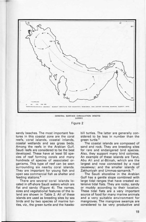
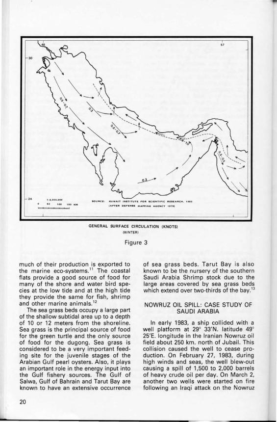
than it is in the Gulf of Oman, These differences of water levels cause the water to rush through the Strait of Hormuz to the Arabian Gulf causing anticlockwise surface currents parallel to the Iranian side, These currents start to weaken as they flow north along the Arabian side, Also, subsurface currents occur in the Gulf because the fresh water input is not equal to the evaporation rate, As density of the water increases, it sinks and flows back to the Gulf entrance through the Strait of Hormuz beneath the less dense inflow (Figures 2 & 3) ,5
The temperature of the surface water varies from winter to summer, It is down about 16 degrees centigrade in winter, up to 36 degrees centigrade in summer. Salin ity of the Arabian Gulf waters is about 40 parts per thousand and over 70 parts per thousand in some shallow
coastal areas that are exemplified by restricted bays and lagoons,6
The Arabian Gulf is characterized by two factors, First, it has high salinity due to a high evaporation rate when compared with little fresh water input. Saline conditions are also attributed to the slight exchange of water with the Indian Ocean because of the narrow passage at the Strait of Hormuz, Second is the temperature fluctuation, The high salinity and the wide range of temperature control and limit the occurrence and distribution of marine life in the Gulf,7
THE PHYSICAL AND BIOLOGICAL STRUCTURE OF THE SAUDI COASTAL
ZONE IN THE ARABIAN GULF:
The Saudi coastal zone is characterized by its shallowness, its extensive system of bays and lagoons, and its
30
2'
K U WA I T I NST I TUTII 1"0" SC I IINTI I"IC "E •• AllleH, NOW"UZ OIl.. SL.ICK TASK f"ONCII ,
'U:P'OltT NO . I , u.~. I Anll1t U . S-G .•. IIf). 1
BATHYMETRIC MAP OF THE ARABIAN GULF (METERS)
Figure 1
18
30
"UW~IT INSTITUTE I"OR IICIC I'IT I"'C "CSC~RCH. I'" I~"." OI:I"CI'I' .... A .... 'I'IC AC .... C ... "1'1
GENERAL SUR FACE CIRCULATION (KNOTS) ~UMM~B.
Figure 2
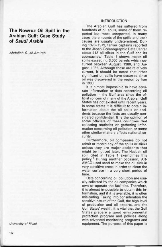
sandy beaches. The most important features in this coastal zone are the coral reefs , coral islands, coastal inlands, coasta l wetlands and sea grass beds. Among the reefs in the Arabian Gulf, Saudi reefs are considered to be the best developed. These have at least 50 species of reef form ing corals and many hundreds of species of associated organ isms. This type of reef can be seen surrounding six nearby coral islands. They are important for young fish and open sea commercial f ish as shelter and feeding stations.s
The re are several coral islands located in off-shore Saudi waters which are flat and sandy (Figure 4) . The names, sizes and vegetational features of the island are shown in Table 2. All of these islands are used as breeding sites by sea birds and by two species of marine turtles, viz., the green turtle and the hawks-
bill turtles. The latter are generally considered to be less in number than the green turtle. 9
The coastal islands are composed of sand and rock. They are breeding sites for rare and endangered bird species. Also, they support many bird colonies. An example of these islands are Tarut, Abu Al i and al-Btinah, which are the largest and now connected by a road causeway; and the smaller islands of Zakhuniyah and Ummas-samamik. 10
The Saudi shoreline in the Arabian Gulf has a gentle slope combined with large tidal ranges that have created extensive tidal flats. They are rocky, sandy or muddy according to their location. These tidal flats are a very important source of food for many marine animals and a very suitable environment for mangroves. The mangrove swamps are considered to be very productive and
19
L
30
24
1. 0 K M
,=,=~~="-,!
KUWAIT IN.TI T UTII 1"0 " . C.I: N Tl fP ,C " ....... "CH. , .. ,
I A nC" D.I"I:N. C MA~"ING A GE N CV ",.,
GENERAL SURFACE CIRCULATION (KNOTS)
IWINTERI
Figure 3
much of their production is exported to the marine eco-systems. l' The coastal flats provide a good source of food for many of the shore and water bird species at the low tide and at the high tide they provide the same for fish, shrimp and other marine animals.'2
The sea grass beds occupy a large part of the shallow subtidal area up to a depth of 10 or 12 meters from the shoreline. Sea grass is the principal source of food for the green turtle and the only source of food for the dugong. Sea grass is considered to be a very important feeding site for the juvenile stages of the Arabian Gulf pearl oysters. Also, it plays an important role in the energy input into the Gulf fishery sources. The Gulf of Salwa, Gulf of Bahrain and Tarut Bay are known to have an extensive occurrence
20
of sea grass beds. Tarut Bay is also known to be the nursery of the southern Saudi Arabia Shrimp stock due to the large areas covered by sea grass beds which extend over two-thirds of the bay. 13
NOWRUZ OIL SPILL: CASE STUDY OF SAUDI ARABIA
In early 1983, a ship collided with a well platform at 29° 33'N. latitude 49° 25'E. longitude in the Iranian Nowruz oil field about 250 km. north of Jubail. This collision caused the well to cease production. On February 27, 1983, during high winds and seas, the well blew-out causing a spill of 1,500 to 2,000 barrels of heavy crude oil per day. On March 2, another two wells were started on fire following an Iraqi attack on the Nowruz

Ras 8/ . Mish 'ab V
SAUDI ARABIA
oL� ____ ~10~ __ ~2~O~ __ ~~~ ____ ~~I~ __ ~~km
• HARQUS ISLAND
#> AL·'ARABIYAH ISLAND
, KARAN ISLAND
• KURAYN ISLAND
ISLAND
ISLAND
O Fasbr al-Eling
an·Naiwah
r(:
I Ouaravvah,
o BAHRAIN GULF OF\) BAHRAIN
,,~\~ '-__ L-__ ---'~ ____ .l-____ -L __________ ..L ________ ___1 JAZI RAT AS - SAMAMI ~\
SOURCEI HUSSEIN H. BINDAGTI , SAUDI ARABIA AND ITS GULF OF PLACE IN THE WORLD, "". SALWAH
SAUDI ARABIAN GULF COASTAL ZONE
Figure 4
oil field. The estimated amount of burned oil was 16,000 barrels per day.14 On the 12th and 19th of April. Iraq attacked two wells of the Ardeshire Oil Field 53 km.
south of the Nowruz Oil Field. This action produced a fire at these two wells and caused a small spil1. 1s
The amount of spill and the number
21
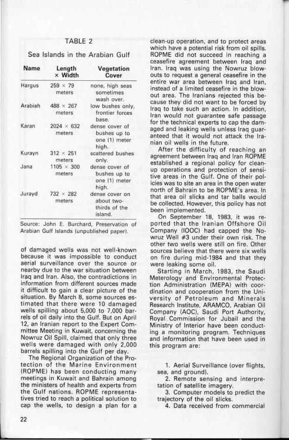
TABLE 2
Sea Islands in the Arabian Gulf
Name Length Vegetation x Width Cover
Hargus 259 x 79 none, high seas meters sometimes
wash over. Arabiah 488 x 267 low bushes only,
meters frontier forces base.
Karan 2024 x 632 dense cover of meters bushes up to
one (1) meter high.
Kurayn 312 x 251 scattered bushes meters only.
Jana 1105 x 300 dense cover of meters bushes up to
one (1) meter high.
Jurayd 732 x 282 dense cover on meters about two-
thirds of the island.
Source : John E. Burchard, Preservation of Arabian Gulf Islands (unpublished paper).
of damaged wells was not well-known because it was impossible to conduct aerial surveillance over the source or nearby due to the war situation between Iraq and Iran. Also, the contradictions in information from different sources made it difficult to gain a clear picture of the situation. By March 8, some sources estimated that there were 10 damaged wells spilling about 5,000 to 7,000 barrels of oil daily into the Gulf. But on April 12, an Iranian report to the Expert Committee Meeting in Kuwait, concerning the Nowruz Oil Spill, claimed that only three wells were damaged with only 2,000 barrels spilling into the Gulf per day.
The Regional Organization of the Protection of the Marine Environment (ROPME) has been conducting many meetings in Kuwait and Bahrain among the ministers of health and experts from the Gulf nations. ROPME representatives tried to reach a political solution to cap the wells, to design a plan for a
22
clean-up operation, and to protect areas which have a potential risk from oil spills. ROPME did not succeed in reaching a ceasefire agreement between Iraq and Iran. Iraq was using the Nowruz blowouts to request a general ceasefire in the entire war area between Iraq and Iran, instead of a limited ceasefire in the blowout area. The Iranians rejected this because they did not want to be forced by Iraq to take such an action. In addition, Iran would not guarantee safe passage for the technical experts to cap the damaged and leaking wells unless Iraq guaranteed that it would not attack the Iranian oil wells in the future .
After the difficulty of reaching an agreement between Iraq and Iran ROPME established a regional policy for cleanup operations and protection of sensitive areas in the Gulf. One of their policies was to site an area in the open water north of Bahrain to be ROPME's area. In that area oil slicks and tar balls would be collected. However, this policy has not been implemented.
On September 18, 1983, it was reported that the Iranian Offshore Oil Company (IOOC) had capped the Nowruz Well #3 under their own risk. The other two wells were still on fire. Other sources believe that there were six wells on fire during mid-1984 and that they were leaking some oil.
Starting in March, 1983, the Saudi Meterology and Environmental Protection Administration (MEPA) with coordination and cooperation from the University of Petroleum and Minerals Research Institute, ARAMCO, Arabian Oil Company (AOC), Saudi Port Authority, Royal Commission for Jubail and the Ministry of Interior have been conducting a monitoring program. Techniques and information that have been used in this program are :
1. Aerial Surveillance (over flights, sea, and ground).
2. Remote sensing and interpretation of satellite imagery.
3. Computer models to predict the trajectory of the oil slicks.
4. Data received from commercial
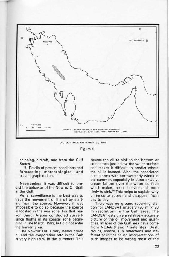
57
30 OIL SIGHTINGS m
24 l . l . 000, OOO
KUWAIT INaTITUTIE ,.01'11 SCII:MTI"' C "IE'KARCH .
NOWRUZ OIL. SLICK TASK ... ORCE RIE~OAT NO. 1. 1 •• :1 .
OIL SIGHTINGS ON MARCH 23. 1983
Figure 5
shipping, aircraft, and from the Gulf States.
5. Details of present conditions and forecasting meteorological and oceanographic data.
Nevertheless, it was difficult to predict the behavior of the Nowruz Oil Spill in the Gulf.
Aerial surveillance is the best way to trace the movement of the oil by starting from the source. However, it was impossible to do so because the source is located in the war zone. For that reason Saudi Arabia conducted surveil lance flights in its coastal zone beginning in late March, 1983, but did not enter the Iranian area .
The Nowruz Oil is very heavy crude oil and the evaporation rate in the Gulf is very high (50% in the summer) . This
causes the oil to sink to the bottom or sometimes just below the water surface and makes it difficult to predict where the oil is located. Also, the associated dust storms with northwesterly winds in the summer, especially in June or July, create fallout over the water surface which makes the oil heavier and more likely to sink.16 This helps to explain why oil tends to appear and disappear from day to day.
There was no ground receiving station for LANDSAT imagery (80 m x 80 m resolution) in the Gulf area . The LANDSAT data give a relatively accurate picture of the oil movement and quantities. Images of the Gulf area have come from NOAA 6 and 7 satellites . Dust, clouds, smoke, sun reflections and different salinities cause interpretations of such images to be wrong most of the
23
2'
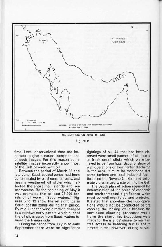
OIL SIGHTINGS
FLIGHT ROUTE -
K UWA IT INST ITUTE I'"OR SCIENT I I'"IC RItSItAACI-i
RII!:,"OAT N O . :I , 1 •• :1 ,
OIL SIGHTINGS ON APRIL 16. 1983
Figure 6
time. Local observational data are important to give accurate interpretations of such images. For this reason some satellite images incorrectly show most of the Gulf covered with oil.
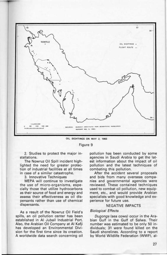
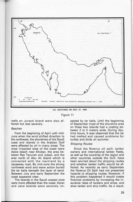
Between the period of March 23 and late June, Saudi coastal zones had been contaminated by oil sheens, tar balls, and heavily weathered oil slicks which affected the shoreline, islands and sea ecosystems. By the beginning of May it was estimated that at least 75,000 barrels of oil were in Saudi waters. 17 Figures 5 to 12 show the oil sightings in Saudi coastal zones during that period. By mid-June the wind direction changed to a northwesterly pattern which pushed the oil slicks away from Saudi waters toward the Iranian side.
During the period from July 19 to early September there were no significant
24
sightings of oil. All that had been observed were small patches of oil sheens or fresh small slicks which were believed to be from local Saudi offshore oil well operations or from tanker discharge in the area. It must be mentioned that some tankers and local industrial facilities used the Nowruz Oil Spill and deliberately discharged waste oil into the Gulf.
The Saudi plan of action required the determination of the areas of economic and environmental significance which must be well-monitored and protected. It stated that shoreline clean-up operations would not be conducted before capping the leaking wells because the continued cleaning processes would harm the shoreline . Exceptions were made for the islands' shores to maintain free access to breeding turtles and to protect birds. However, during surveil-

57
30 OIL SIGHTINGS •
FLIGHT ROUTE -
24
SOURCE , k UWA I T IHSTI TUT Ir I"OR SC I IEN TII"IC ReSC A RCH , REP'ORT N O , :t, 1 • • '
01 L 51 GHTI NG5 ON APR I L 25. 1983
Figure 7
lance flights between mid-July and early September, oil was observed on most shorelines of the affected islands and the plan had not been implemented as was intended. This was very harmful to birds, turtles, and coral reefs of the islands. Nevertheless, during the clean-up operations, about 300 tons of oil were collected from Saudi coastal zones.
Clean-up operations faced a major problem. The long distance traveled by the oil from the source to Saudi waters, along with the weather conditions of the area, created heavily weathered oil. Clean-up equipment was ineffective because the tar balls were too dry to be collected by skimmers. Also, it was impossible to use common dispersants on the weathered oil because these worsen the situation and make the oil more toxic.
The positive impact on the public as
a result of the Nowruz Oil Spill is that it initiated an environmental awareness among the public. Young people, old people, even children were very concerned about the danger to fish in the Gulf and the water resource. Occasional exaggerated reports and news in the international and local media caused people to realize that pollution is something that affects their daily life and it now occupies a greater space in their consciousness. Public concern and knowledge about pollution and its effects will put pressure on governmental agencies to work harder, conduct studies, and combat the pollution, as well as provide a healthy environment for the people. Currently there are not many environmental specialists in the country. Therefore, this type of incident, and the resultant public awareness, might create
25

30
24 1 • .1 , 000,000
KUW"I T I H S T I TUT It; 1'01'1 SC I It:NTI P'IC:; "' •• I[ A"' (: H ,
R ll t"O R T NO. :t . "" .
OIL SIGHTINGS ON 26 APRIL 1983
Figure 8
the urge in some people to specialize in environmental studies.
The Nowruz Oil Spill raised many questions among agencies and authorities responsible for environmental protection. They realized the national need for a data base concerning the Saudi Gulf ecosystems and oil pollution data, and they identified the necessity for remote sensing and strong monitoring program services. They discovered a shortage of oil spill combating equipment designed according to Arabian Gulf climate conditions, and the need for trained manpower for clean-up operations. This event was an experience which caused agencies in Saudi Arabia to examine their inability to deal effectively with a large oil spill accident.
In the plan of action by MEPA in response to the Nowruz Oil Spill it was
26
stated that MEPA will prepare, coordinate, or commission the following:
1. Scientific Studies. -Monitoring, studying, and as
sessing the impact of pollution on the Saudi Coastal Zone ecosystems including coral reefs, slat marshes, mangroves, seagrass beds, and fishery nurseries. These studies were scheduled for a period of five years.
-Monitoring and assessing fishery food chains in relation to heavy metals and other oil-induced toxic compounds, including an evaluation of public health aspects.
-Further developing and assessing satellite imagery and computer modeling of oil spills' trajectories. This study was scheduled for a period of two years.
1 , 1.000, 000
51
01 L SIGHTINGS •
FLIGHT ROUTE _
30
.0 100 KUw ... IT 1 ... . T,TUTIt .. 0" K.E ... T,,,IC , .. I:.C ... .. CH
REPORT NO . J , I"' .
OIL SIGHTINGS ON MAY 2. 1983
Figure 9
2. Studies to protect the major installations.
The Nowruz Oil Spill incident highlighted the need for greater protection of industrial facilities at all times in case of a similar catastrophe.
3. Innovative Techniques MEPA will continue to investigate
the use of micro -organisms, especially those that utilize hydrocarbons as their source of food and energy and assess their effectiveness as oil dispersants rather than use of chemical dispersants.
As a result of the Nowruz Oil Field's spills, an oil pollution center has been established in AI Jubail Industrial Port. Also, the Arabian Oil Company at AI Kafj i has developed an Environmental Division for the first time since its creation. A worldwide data search concerning oil
pollution has been conducted by some agencies in Saudi Arabia to get the latest information about the impact of oil pollution and the latest techniques of combating this pollution .
After the accident several proposa ls and bids from many overseas companies and governmental agencies were reviewed . These contained techniques used to combat oil pollution , new equipment, etc., and would provide Arabian specialists with good knowledge and experience for future use.
NEGATIVE IMPACTS Biological Effects
Dugongs (sea cows) occur in the Arabian Gulf in the Gulf of Salwa. Their number was estimated to be only 50 individuals ; 31 were found killed on the Saudi shorelines. According to a report by World Wildlife Federation (WWF), al -
27
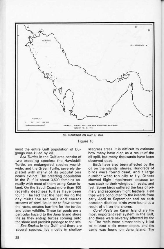
57
30
OIL SIGHTINGS •
• 0 100
SOU "Cit. KUWAIT INSTITUTE ,.OR SCII!:NTI,.IC RI!:SItAACH
AI!:1"O " T NO. , . 1 •• :1.
Oil SIGHTINGS ON MAY 9. 1983
Figure 10
most the entire Gulf population of Dugongs was killed by oi l.
Sea Turtles in the Gulf area consist of two breed ing species : the Hawksbill Turtle, an endangered species worldwide ; and the Green Turtle, severely depleted with many of its populations nearly extinct. The breeding population in the Gulf is about 3,500 females annually with most of them using Karan Island. On the Saudi Coast more than 100 recently dead sea turtles have been found. The fact that the heat during the day melts the tar balls and causes streams of semi-liqu id tar to flow across the rocks, creates barriers for the turtles and other w ildlife. These tar pools are a particular hazard to the Jana Island shore life as they entrap turtles com ing onto the shore and prohibit passage to the sea.
Sea Snakes in the Gulf, and there are several species, live mostly in shallow
28
seagrass areas. It is difficult to estimate how many have died as a result of the oil spill , but many thousands have been observed dead.
Birds have also been affected by the oil on the islands' shores. Hundreds of birds were found dead, and a large number were too oily to fly . Others showed flight impairment because tar was stuck to their wingtips, : .easts, and feet. Some birds suffered the loss of primary and secondary flight feathers. Field trips were conducted to the islands from early April to September and on each occasion disabled birds were found as a result of oil on the shores.
Coral Reefs on Karan Island are the most important reef system in the Gulf, and these were severely affected by the oil. The reefs were almost totally killed to at least a six meter depth, and the same was found on Jana Island. The
57
30
OIL SIGHTINGS •
24 ! l a , GOO ,OOO
'10 K'"
'----..... ""'. .aURCII:! KUWAIT ""'TITUTE 1'"0'" SCIENTIP"C RESE A RC H, RE~RT N O.7, 1"2.
OIL SIGHTINGS ON MAY 27. 1983
Figure 11
reefs on Jurayd Island were also affected but less severely.
Beaches
From the beginning of April until midJune when the wind shifted direction to the northwest, the shorelines of the Saudi coast and islands in the Arabian Gulf were affected by oil in many areas. The most impacted sites of the coast were Azizia beach near Khobar, the area between Ras Tanurah and Jubail , and the area north of Abu Ali Island which is connected with the mainland by a causeway road. By mid-June the strong northwest wind and wave action buried the tar balls beneath the layer of sand. Between July and early September the coast appeared clear.
The islands in the Saudi coastal zone were more affected than the coast. Karan and Jana Islands were severely im-
pacted by tar balls. Until the beginning of September most of the shoreline area on these two islands had a coating between 2 to 5 meters wide. During daytime hours, it was observed that the tar had melted and caused problems fo r turtles and birds all summer.
Shipping Routes
Since the Nowruz oil spill, tanker owners and international tanker fleets, as well as the countries of the region and other countries outside the Gulf, have been worried about the shipping routes and whether tanker traffic would be affected. As recently as early September the Nowruz Oil Spill had not presented hazards to shipping routes. However, if this problem happened it would create financial problems by increasing the insurance rates of tankers and ships, and slow tanker and ship traffic. As a result,
29

48 57
30
24 1 , 2 . 000, 000
100 110 KM
OVERFLIGHT ROUTES CONDUCTED BETWEEN JULY 19 AND SEPTEMBER 10
Figure 12
TABLE 3
Desalination Plants in the Saudi Arabian Gulf Coast
Location MGD 1000 M3 / Day
Khobar 1* 5 Khobar 11 ** 189.25 Jubail** 15.140 Jubail 1* 30 Jubail 11 * 210 Khafji ** 0.454
* Source : Oil Spill Intell igence Report, May 6, 1983, p. 1. H Rick Shedeker, " Multi-Front Search on for Alternative Sources of Water," Saudi Gazette, July 20, 1983, p. 4. (After Ukayli and Husain, Decision Making in Water Resources Planning for Saudi Arabia, Research Institute U.P.M. Dhahran, 1983).
30
the Saudi economy would suffer because the country would be forced to reduce its export and import activities. Also, the international oil market would be affected because Saudi Arabia represents a large source of oil to many countries in the world, especially in the U.S. and Western Europe.
Fishing Industry
For about four months, from the beginning of April until early August, the government stopped commercial fishing along the Saudi Arabian Gulf coastline. The Saudi Fisheries Company was affected by the ban because the Arabian Gulf provides an important part of the total fish catch . In 1982, 3,731 tons were caught from the Arabian Gulf and 1,089 from the Red Sea. 1a At the time of the ban the Saudi Fisheries Company was forced to concentrate their activity. in the
Red Sea. As a result they were faced with some problems. First, the transportation expenditure from the Red Sea to the eastern province and middle region required additional marketing and consumed cost. Second, people in the eastern province and middle region prefer the Gulf fish to the Red Sea fish . Third, the psychological factor that some fish were polluted decreased the demand for all fish. These factors caused a decrease in company monthly income by 22% or more (personal communication).
About 1,430 individual fishermen live in approximately 20 fishing communities on the Saudi Arabian Gulf Coast. The average monthly income per person is about $2,000. For four months the estimated loss was approximately $11,440,000. In some communities on the Saudi Arabian Gulf coastline, for example Qatif, fish is very important in the daily meal. Consequently, there were some individuals who fished regardless of the ban, brought small amounts of fish from the nearby shore, and sold it at extremely high prices in retail markets.
Destination Plants
Saudi Arabia has six desalination plants in the Arabian Gulf coastline region (See Table 3). The plants not only provide a major source of water for the eastern province, but also provide water for the Riyadh area which is about 500 km. southwest of Jubail. Jubail II desalination plant, the world's largest plant started operating in February, 1983, provides the Riyadh area with 210 MGD (its full capacity is about 264 MGD). As a result of the importance of the desalination plants, the Saline Water Conversion Corporation placed protective domes and fish mesh nets around water intakes of the desalination plants. Between the period of April 11 and late June, some of the desalination plants were closed or decreased the production of water capacity. During that period, some people tended to take advantage of the Nowruz incident by storing and selling thousands of cartons of bottled water. It has not been said that such action took place in Saudi Arabia, but similar cases were discovered in Kuwait and Qatar.
CONCLUSION
Oil pollution presents fundamental dangers to the world 's marine environment. The Arabian Gulf, with its unique physical features and its focus as the world's center of oil production, is always under the threat of oil pollution. The environmental concerns were not prevalent in most of the Gulf States until the early 1980s. However, the Nowruz Oil Spill provided the example of the danger facing the Gulf ecosystem. This occurred while the Arabian Gulf States are experiencing a rapid industrialization and urbanization, consequently this will increase the amount of oil pollution and other potential hazards.
The need for stronger coordinated environmental programs among the Gulf States appears to be essential to preserve the Arabian Gulf environment. For Saudi Arabia and the rest of the Gulf States the latest incident of the Iranian Nowruz Oil Spill has been a good examination of their preparation and ability to face such an accident. It was also an opportunity for environmental issues to be presented and for plans, standards, and the environmental quality to be evaluated.
NOTES
1. Richard Golob, et al ., " Analysis of Oil Pollution in the Kuwait Action Plan Reg ion," Manama, Bahrain, 6-10 Dec. 1980, p. 23.
2. A. Joseph's paper in the 1983 oil spill conference indio cates that on October 2, 1980 Saudi Hasbah Well 6 had a blow-out about 100 km. off the Saudi shoreline. Nineteen people were killed in that accident and the daily spillage was from 6-10,000 barrels for nine days. In the beginning ARAMCO reported it as a gas blow-out, and not until October 9 did ARAMCO reveal to the countries concerned that some dispersants might be needed. In addition, ARAMCO had not reported that the well was producing oil until October 11 . Moreover, ARAMCO's clean-up operations on October 9 consisted of spraying chemical dispersants and it was not until October 16 that they started using skimmers to collect the oi l from the sea surface in the ARAMCO area.
3. B. H. Burser, ed ., The Persian Gulf, Spring Verlag (New York: Heidelberg Berline, 1973), p. 3.
4. R. O. Wil liams, ARAMCO, Meteorologic and Oceanographic Data Book for the Eastern Province Region of Saudi Arabia (Dhahran : Environmental Unit, ARAMCO, 1979), pp. 7-8.
5. Ibid, p. 3.
6. Ibid., pp. 99, 98.
31
7. P. W. Basson, et aI., Biotop of the Western Arabian Gulf Marine Life and Environment of Saudi Arabia (Dhahran : ARAMCD, 1981), p. 25.
8. John E. Burchard, Conservation Goals for the Arabian Gulf coastal zone in Saudi Arabia (unpublished paper).
9. John E. Burchard, Preservation of Arabian Gulf Islands and Coral Reefs (unpublished paper).
10. Burchard.
11. Ibid.
12. Ibid.
13. Ibid.
14. ROPME, Nowruz Incident: " Final Report of Expert Committee Meeting," Kuwait, 11-12 April 1983, p. 2.
15. Oil Spill Intelligence Report, 22 Apr il 1983, p. 1.
16. Kuwait Institute for Scientific Research, "Nowruz Oil Slick Task Force," Status Report No. 7, p. 2.
17. NEPA, The Nowruz Oil Spill 1983 Plan of Action, May 1983, p. 1.
18. Saudi Fisheries Company, 1983 Report, March 1983, (Arabic), p. 17.
BIBLIOGRAPHY
Adm, R., et al. " Maritime Traffic Control and Aids to Navi · gation in the Gulf and the Approaches Thereto." International Workshop, Manama, Bahrain. 6- 1 0 December 1980.
AI -Deghaiter, M., et al. MEPA Marine Weather Services Operational Models. MEPA, Jeddah, Saud i Arabia, 1983.
AI-Kassab, l. " Development and Related Issues of Regional Interest." Regional Seminar, Bahrain, 28-30 November 1982.
ARAMCO. Facts and Figures 1981. Dhahran, Saudia Arabia, 1981 .
Basson, P. W. et al. Biotop of rhe Western Arabian Gulf Marine Life and Environment of Saudi Arabia. Dhahran : ARAMCO, 1981 .
Belen, M. S. " Spreading, Dispersion, and Evaporation of Oil Slicks in the Arabian Gulf." 1981 Oil Spill Conference.
Belen, M. S. et al. Statistical Determination of Oil Spill in Transport Operations in the Arabian Gulf. Dhahran, Saudi Arabia: Research Institute, University of Petroleum and Minerals, 1983.
Burchard, John E. " Conservation Goals for the Arabian Gulf Coastal Zone in Saud i Arabia." (Unpublished paper).
--. " Preservation of Arabian Gulf Islands and Coral Reefs." (Unpublished paper).
Burser, B. H. et al. Analysis of Oil Pollution in rhe Kuwait Action Plan Region. IMCO/ UNEP International Workshop, Manama, Bahrain, 6-10 December 1980.
32
Cuddeback, J. E. " Refinery and Terminal Oily Water Discharge." Presented at Regional Seminar on Technical Aspects of Oily Water Discharges. Bahrain, 20- 30 November 1982.
Golob, Richard, et al. Analysis of Oil Pollurion in rhe Kuwait Action Plan Region. IMCO/UNEP International Workshop, Manama, Bahrain, 6-10 December 1980.
Hayes, M. O. et al. " Oil Pollution in the Arabian Gulf : A Preliminary Survey." Technical Report Carried Out for Kuwait Engineering Operation and Management Co., Kuwait, December 1977.
Joseph, A. C. M. " The Hasbah 6 (Saud i Arabia) Blowout : The Effects of an International Oil Spill as Experienced in Qatar." 1983 Oil Spill Conference.
Khosrari, Yadollah. "Survey of Socio-Economic Activities and Their Environmental Consequences in the Kuwait Action Plan." UNEP. Meeting on Co-operation Projects of the Kuwait Action Plan. Kuwait, 11 - 15 April 1981.
Kuwait Institute for Scientific Research. " Nowruz Oil Slick Task Force." Starus Reports Nos. 1-7, 1983.
Lehr, W. J. and Cekirge, H. M. " Oil Movements in the Arabian Gulf." Petroleum and the Marine Environment Conference. Monaco, 1980.
Lindon, O. " Biological Impact and Effects on Fisheriers of Oil Spill in Bahrain." August-September 1980. IMCO/ UNEP International Workshop. Manama, Bahrain, 1980.
Manners, Ian R. North Sea Oil Environmental Planning: The Unired Kingdom Experience. Austin, Texas: University of Texas.
Marine Pollution Bulletin. February, 1983. MEPA. The Nowruz Oil Spill 1983 Plan of Action. May 1983. Ministry of Petroleum and Minerals Resources. Saudi Arabia,
Perroleum Sraristical Bullerin. Saudi Arabia, 1980. National Research Council-National Academy of Science's
Ocean Affairs Board. Perroleum in the Marine Environmenr. Washington D.C.: National Academy of Science, 1975.
Nelson, A. " Effects of Oil Industry Related Pollution on Marine Resources of the Kuwait Action Plan." IMCO/ UNEP International Workshop. Manama, Bahrain, 6-10 December 1980.
Oil Spill Intelligence Report. The 1982 Oil Spill Expert's Guide: An International Summary and Review. August 1982.
Oil Spill Intelligence Report. 22 April 1983. Oil Spill Intelligence Report. The 1983 Oil Spill Expert's Guide:
An International Summary and Review. June 1983. Organization for Economic Co-operation and Development.
The Cosr of Oil Spill. Paris: 1982. ROPME. " Nowruz Incident: Final Report of Expert Commit
tee Meeting." Kuwait, 11-12 April 1983. Royal Commission for Jubail and Yanbu . Madinar AI-Jubail
AI-Sinaiyeh : Oil Spill Risk Assessment. March 1983. Ryan, P. B. "Regional Oily Water Discharge Problem." Pre
sented at Regional Seminar on Technica l Aspects of Oily Water Discharges. Bahrain, 28-30 November 1982.
Saudi Fisheries Company. 1983 Report. March 1983. (In Arabic).
The Research Institute. A Report on the Oil Slick in the Arabian Gulf. Dhahran, Saudi Arabia: University of Petroleum and Minerals, April 1983.
Williams, R. O. ARAMCO-Mereorologic and Oceanographic Data Book for rhe Eastern Province Region of Saudi Arabia. Dhahran : Environmental Unit, ARAMCO, 1979.


