
Implementing Great Lakes
Coastal Wetland Monitoring
Dr. Donald G. Uzarski
Director of CMU Institute for Great Lakes Research
Director of CMU Biological Station
Associate Professor of Biology
Session 9

Session Overview
• Session Includes Four Talks
– All Talks Part of the Same GLRI Funded Project
1:40 A Basin-Wide Great Lakes Coastal Wetland Monitoring Program • Donald Uzarski, Central Michigan University
2:00 Great Lakes Coastal Wetland Monitoring Program: Support of
Restoration Activities Across the Basin • Matthew Cooper, University of Notre Dame
2:20 Ecological Restoration Efforts in the St. Louis River Estuary:
Application of Great Lakes Monitoring Data • Valerie Brady, University of Minnesota, Duluth
2:40 Great Lakes Coastal Monitoring Provides Baseline Plant Data for
Sustainable Wetland Restoration Project • Dennis Albert, Oregon State University

Session Overview
• Introduce the Origin of our Project
– Formation of the Great Lakes Coastal
Wetlands Consortium (GLCWC)
– GLCWC Partners with Great Lakes
Environmental Indicators (GLEI)
– GLRI Request for Proposals

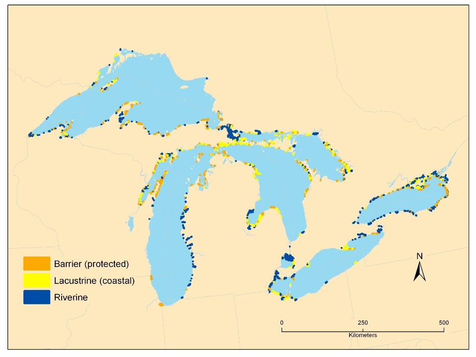
About the Great Lakes Coastal
Wetlands Consortium
• GLNPO RFP for $1.2 million (+600K
Supplemental) in 2000
– In response to SOLEC 96’ and 98’
• Indicators of ecosystem health
– Develop Bi-national Standardized Monitoring Program
Based on SOLEC Indicators
• Few, if any, SOLEC indicators were developed

The Great Lakes Coastal
Wetlands Consortium • 2000 Consortium was formed
• Joint facilitation GLC and GLNPO
– 150 + Participants • 50 organizations (Federal, State/Provincial,
Academic, NGOs)
• 2000 Consortium put out an RFP
– Develop and evaluate metrics and protocols for measuring ecosystem health
The Great Lakes Coastal
Wetlands Consortium • Development and Evaluation Process had to
Consider: – Cost
– Measurability
– Basin wide applicability
– Data availability
– Sensitivity to change
– Endpoint levels
– Statistical approach.
• Six proposals were selected by peer review.
The Great Lakes Coastal
Wetlands Consortium
• Six proposals
• Conducted Pilot Studies 2002 – Bain et al. (Ontario)
– de Szalay et al. (Erie)
– Ingram et al. (Ontario)
– Timmermans et al. (Erie)
– Uzarski et al. (Michigan & Huron)
– Wilcox et al. (Michigan)

The Great Lakes Coastal
Wetlands Consortium
• Six proposals
• Conducted Pilot Studies 2002 – Bain et al. (Ontario)
– de Szalay et al. (Erie)
– Ingram et al. (Ontario)
– Timmermans et al. (Erie)
– Uzarski et al. (Michigan & Huron)
– Wilcox et al. (Michigan)
Combined data
+ Uzarski et al. Superior data
The Great Lakes Coastal
Wetlands Consortium • During the Metric Development Phase
– Parallel project with different goals
• Great Lakes Environmental Indicators (GLEI)
group
• GLEI goal:
– To develop an integrated set of
environmental indicators that can be used
to assess the condition of the coastal
margins of all five Great Lakes.
The Great Lakes Coastal
Wetlands Consortium • 2007 Duluth, MN- Consortium and GLEI
– Ensure the best possible product
• Still considering – Cost
– Measurability
– Basin wide applicability
– Data availability
– Sensitivity to change
– Endpoint levels
– Statistical approach
– …and specific to wetlands

The Great Lakes Coastal
Wetlands Consortium
• Consortium Submitted Final Product to US
EPA March 2008.
• http://www.glc.org/wetlands/
• GLRI- GLNPO RFP for $10M to Monitor
Coastal Wetlands using GLCWC protocols
2009
• Awarded in 2010

A Basin-Wide Great Lakes Coastal
Wetland Monitoring Program
Dr. Donald G. Uzarski
Director of CMU Institute for Great Lakes Research
Director of CMU Biological Station
Associate Professor of Biology

Presentation Outline
• Briefly Discuss Some Results to Date
• Data Base and Users
• Supporting Restoration and Conservation Efforts
• Supporting Additional Research Projects
• Training and Jobs Created
• Interested Parties Including China
• Post 2015
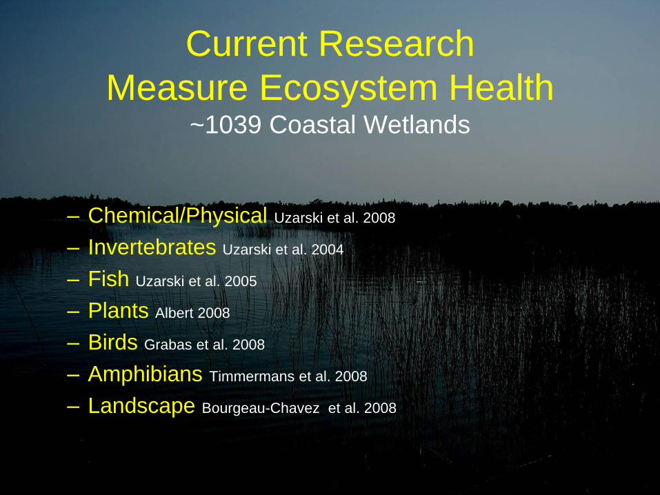
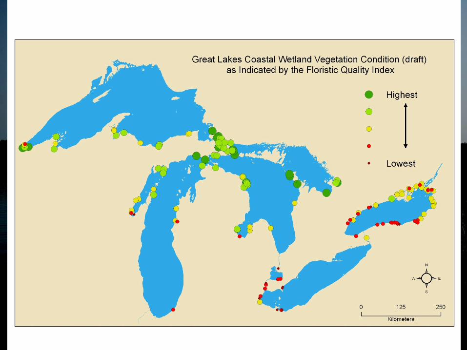
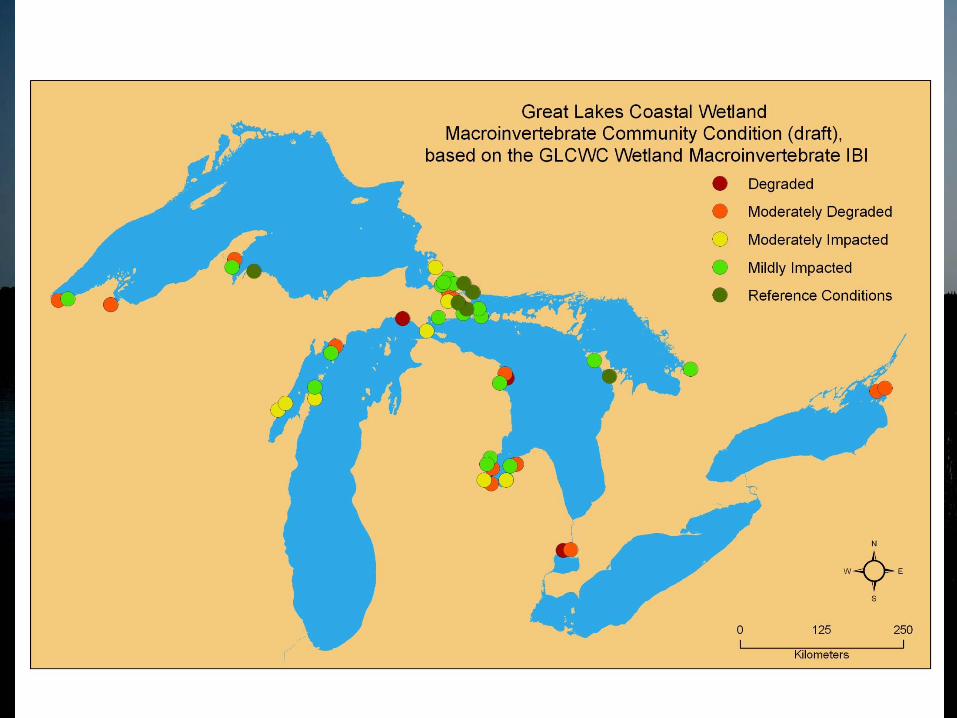
Current Research
Measure Ecosystem Health ~1039 Coastal Wetlands
– Chemical/Physical Uzarski et al. 2008
– Invertebrates Uzarski et al. 2004
– Fish Uzarski et al. 2005
– Plants Albert 2008
– Birds Grabas et al. 2008
– Amphibians Timmermans et al. 2008
– Landscape Bourgeau-Chavez et al. 2008

Category Scores
• Extremely Degraded: (0 to 15% of possible score)
• Degraded: (>15 to 30% of possible score)
• Moderately Degraded: (>30 to 50% of possible score)
• Moderately Impacted: (>50 to 70% of possible score)
• Mildly Impacted: (>70% to 85% of possible score)
• Reference Conditions: (>85 to 100% of possible score)

Statistical Design
• maximize efficiency in detecting both • Status
• Trends
• Status and Trends are conflicting goals

Statistical Design
• Status = Capture Spatial Variance
• What is the status or health of (all) GL wetlands?
Statistical Design
• Trends = Capture Temporal Variance
• How is GL wetland health changing over time?
• Sample fewer sites, repeatedly
XXXX XX XX XXX XXX XX X X XXX XX X X X XX
XXXX XX XX XXX XXX XXX XXX XX X X XXX
XXX XX X X XX XXX XX XXX XX XXX XXX XXX XXX
XX XXX XXXXX X X XX XXX XX XXX XX XXX XXX X
XX XXXXX X X XX XXX XX XXX XX XXX XXX XXX XXX
XX XXX XXX XX XXX XXXXX X X XXXXXXX XX X
X X XXXX XX X X XXXXXXX X XXX X X XXX
XX XXXXX XX XXX XXX XXXX XXX XXX XXX X X X
XXXXXXXXXX XXXXXXXXX X X X XXX
XXXXXXXXXX XX XXXXX XX XXXXX
XXXX XX XX XXX XXX XX X X XXX XX X X X XX
XXXX XX XX XXX XXX XXX XXX XX X X XXX
XXX XX X X XX XXX XX XXX XX XXX XXX XXX XXX
XX XXX XXXXX X X XX XXX XX XXX XX XXX XXX X
XX XXXXX X X XX XXX XX XXX XX XXX XXX XXX XXX
XX XXX XXX XX XXX XXXXX X X XXXXXXX XX X
X X XXXX XX X X XXXXXXX X XXX X X XXX
XXXX XX XX XXX XXX XX X X XXX XX X X X XX
XXXX XX XX XXX XXX XXX XXX XX X X XXX
XXX XX X X XX XXX XX XXX XX XXX XXX XXX XXX
XX XXX XXXXX X X XX XXX XX XXX XX XXX XXX X
XX XXXXX X X XX XXX XX XXX XX XXX XXX XXX XXX
XX XXX XXX XX XXX XXXXX X X XXXXXXX XX X
X X XXXX XX X X XXXXXXX X XXX X X XXX
XX XXXXX XX XXX XXX XXXX XXX XXX XXX X X X
XXXXXXXXXX XXXXXXXXX X X X XXX
XXXXXXXXXX XX XXXXX XX XXXXX
XXXX XX XX XXX XXX XX X X XXX XX X X X XX
XXXX XX XX XXX XXX XXX XXX XX X X XXX
XXX XX X X XX XXX XX XXX XX XXX XXX XXX XXX
XX XXX XXXXX X X XX XXX XX XXX XX XXX XXX X
XX XXXXX X X XX XXX XX XXX XX XXX XXX XXX XXX
XX XXX XXX XX XXX XXXXX X X XXXXXXX XX X
X X XXXX XX X X XXXXXXX X XXX X X XXX
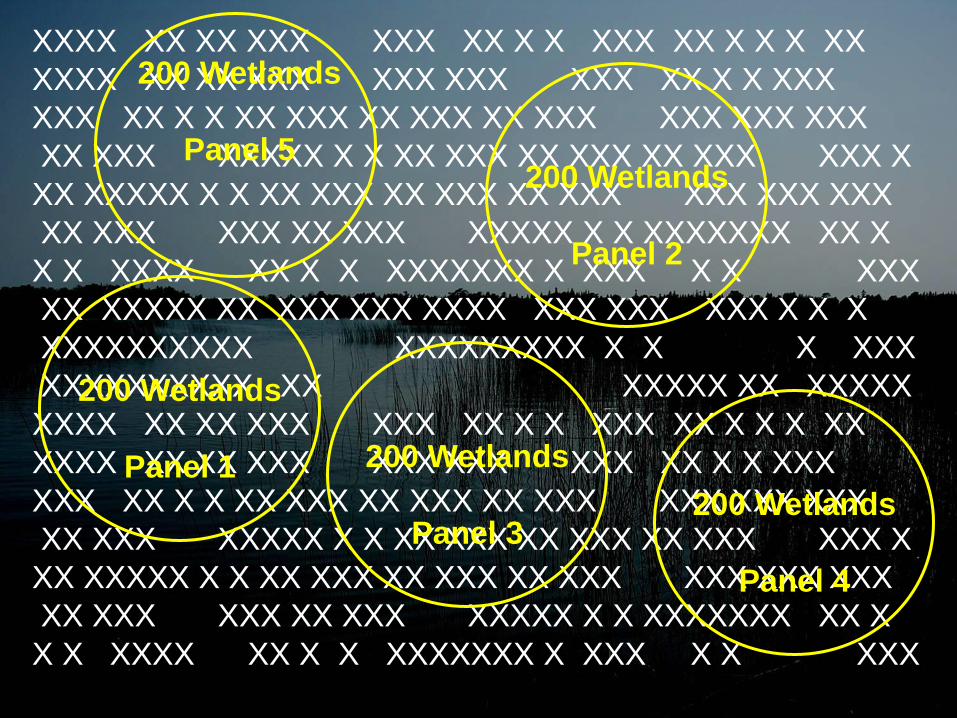
200 Wetlands
Panel 2
200 Wetlands
Panel 1 200 Wetlands
Panel 3 200 Wetlands
Panel 4
200 Wetlands
Panel 5

XXXX XX XX XXX XXX XX X X XXX XX X X X XX
XXXX XX XX XXX XXX XXX XXX XX X X XXX
XXX XX X X XX XXX XX XXX XX XXX XXX XXX XXX
XX XXX XXXXX X X XX XXX XX XXX XX XXX XXX X
XX XXXXX X X XX XXX XX XXX XX XXX XXX XXX XXX
XX XXX XXX XX XXX XXXXX X X XXXXXXX XX X
X X XXXX XX X X XXXXXXX X XXX X X XXX
XX XXXXX XX XXX XXX XXXX XXX XXX XXX X X X
XXXXXXXXXX XXXXXXXXX X X X XXX
XXXXXXXXXX XX XXXXX XX XXXXX
XXXX XX XX XXX XXX XX X X XXX XX X X X XX
XXXX XX XX XXX XXX XXX XXX XX X X XXX
XXX XX X X XX XXX XX XXX XX XXX XXX XXX XXX
XX XXX XXXXX X X XX XXX XX XXX XX XXX XXX X
XX XXXXX X X XX XXX XX XXX XX XXX XXX XXX XXX
XX XXX XXX XX XXX XXXXX X X XXXXXXX XX X
X X XXXX XX X X XXXXXXX X XXX X X XXX
200 Wetlands
Panel 2
200 Wetlands
Panel 1 200 Wetlands
Panel 3 200 Wetlands
Panel 4
200 Wetlands
Panel 5
D=20
B=20
C=20
F=20 G=20
E=20
J=20
A=20
I=20
H=20
D=20
B=20
C=20
F=20 G=20
E=20
J=20
A=20
I=20
H=20
D=20
B=20
C=20
F=20 G=20
E=20
J=20
A=20
I=20
H=20
D=20
B=20
C=20
F=20 G=20
E=20
J=20
A=20
I=20
H=20
D=20
B=20
C=20
F=20 G=20
E=20
J=20
A=20
I=20
H=20
XXXX XX XX XXX XXX XX X X XXX XX X X X XX
XXXX XX XX XXX XXX XXX XXX XX X X XXX
XXX XX X X XX XXX XX XXX XX XXX XXX XXX XXX
XX XXX XXXXX X X XX XXX XX XXX XX XXX XXX X
XX XXXXX X X XX XXX XX XXX XX XXX XXX XXX XXX
XX XXX XXX XX XXX XXXXX X X XXXXXXX XX X
X X XXXX XX X X XXXXXXX X XXX X X XXX
XX XXXXX XX XXX XXX XXXX XXX XXX XXX X X X
XXXXXXXXXX XXXXXXXXX X X X XXX
XXXXXXXXXX XX XXXXX XX XXXXX
XXXX XX XX XXX XXX XX X X XXX XX X X X XX
XXXX XX XX XXX XXX XXX XXX XX X X XXX
XXX XX X X XX XXX XX XXX XX XXX XXX XXX XXX
XX XXX XXXXX X X XX XXX XX XXX XX XXX XXX X
XX XXXXX X X XX XXX XX XXX XX XXX XXX XXX XXX
XX XXX XXX XX XXX XXXXX X X XXXXXXX XX X
X X XXXX XX X X XXXXXXX X XXX X X XXX
200 Wetlands
Panel 2
200 Wetlands
Panel 1 200 Wetlands
Panel 3 200 Wetlands
Panel 4
200 Wetlands
Panel 5
D=20
B=20
C=20
F=20 G=20
E=20
J=20
A=20
I=20
H=20
D=20
B=20
C=20
F=20 G=20
E=20
J=20
A=20
I=20
H=20
D=20
B=20
C=20
F=20 G=20
E=20
J=20
A=20
I=20
H=20
D=20
B=20
C=20
F=20 G=20
E=20
J=20
A=20
I=20
H=20
D=20
B=20
C=20
F=20 G=20
E=20
J=20
A=20
I=20
H=20
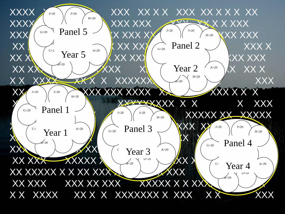
Panel 1
Year 1
Panel 2
Year 2
Panel 3
Year 3 Panel 4
Year 4
Panel 5
Year 5
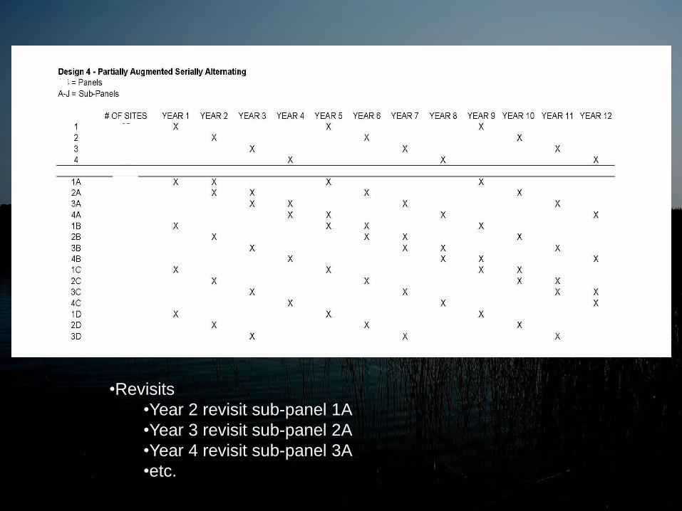
•Revisits
•Year 2 revisit sub-panel 1A
•Year 3 revisit sub-panel 2A
•Year 4 revisit sub-panel 3A
•etc.

Chosen Design • Randomly Selecting Wetlands to Sample
– Re-sample Subset Two Consecutive Years
• Stratify by Region by Lake
• Design Superior to Others
– Good Estimate of Variation in Wetland x Year Interaction.
– Eventually Sample Many Different Sites
– Less Impact on Wetland from Over Sampling • Sampling Year after Year = Disturbance
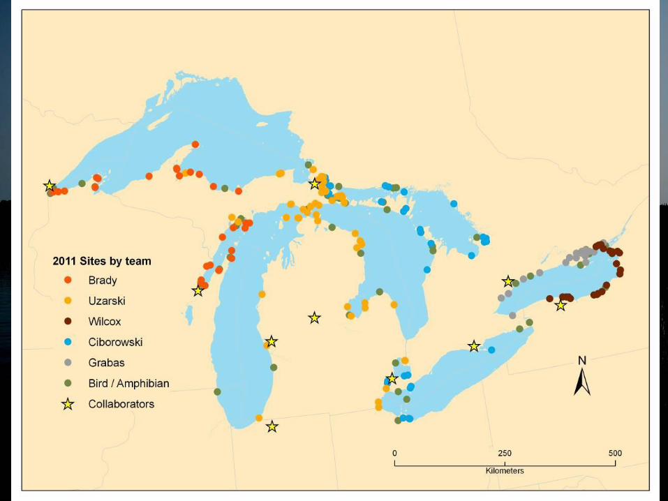

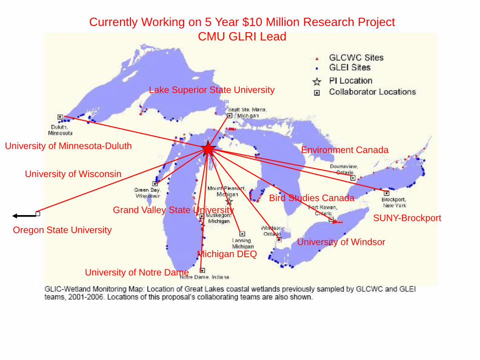
Currently Working on 5 Year $10 Million Research Project
CMU GLRI Lead
University of Minnesota-Duluth
University of Wisconsin
Grand Valley State University
University of Notre Dame
Lake Superior State University
Michigan DEQ
University of Windsor
Bird Studies Canada
Environment Canada
SUNY-Brockport
Oregon State University
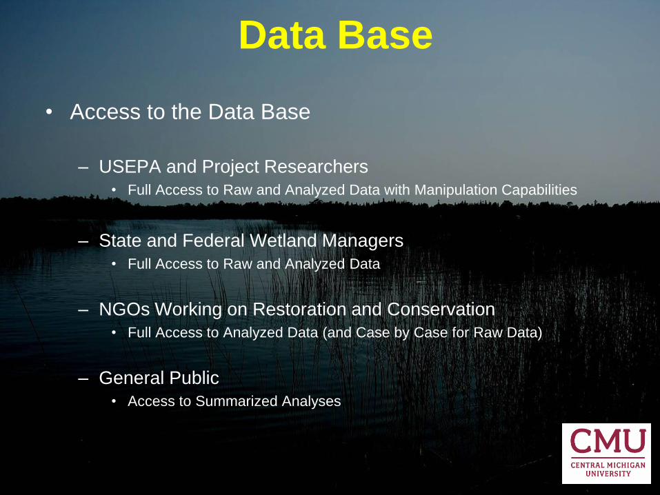
Data Base
• Access to the Data Base
– USEPA and Project Researchers
• Full Access to Raw and Analyzed Data with Manipulation Capabilities
– State and Federal Wetland Managers
• Full Access to Raw and Analyzed Data
– NGOs Working on Restoration and Conservation
• Full Access to Analyzed Data (and Case by Case for Raw Data)
– General Public
• Access to Summarized Analyses
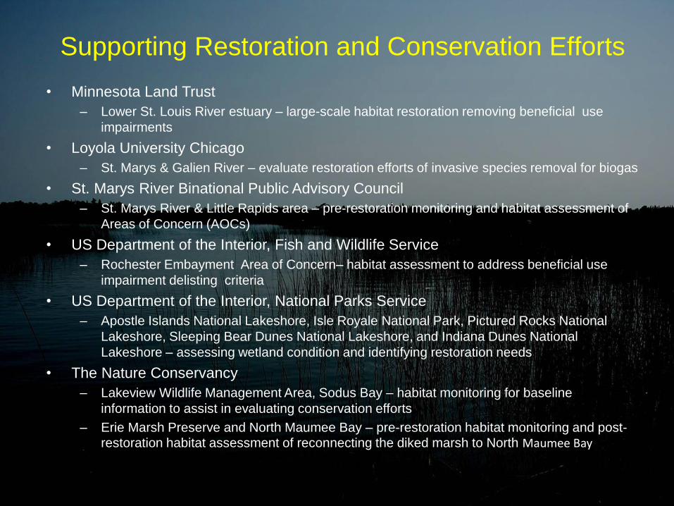
Supporting Restoration and Conservation Efforts
• Minnesota Land Trust
– Lower St. Louis River estuary – large-scale habitat restoration removing beneficial use
impairments
• Loyola University Chicago
– St. Marys & Galien River – evaluate restoration efforts of invasive species removal for biogas
• St. Marys River Binational Public Advisory Council
– St. Marys River & Little Rapids area – pre-restoration monitoring and habitat assessment of
Areas of Concern (AOCs)
• US Department of the Interior, Fish and Wildlife Service
– Rochester Embayment Area of Concern– habitat assessment to address beneficial use
impairment delisting criteria
• US Department of the Interior, National Parks Service
– Apostle Islands National Lakeshore, Isle Royale National Park, Pictured Rocks National
Lakeshore, Sleeping Bear Dunes National Lakeshore, and Indiana Dunes National
Lakeshore – assessing wetland condition and identifying restoration needs
• The Nature Conservancy
– Lakeview Wildlife Management Area, Sodus Bay – habitat monitoring for baseline
information to assist in evaluating conservation efforts
– Erie Marsh Preserve and North Maumee Bay – pre-restoration habitat monitoring and post-restoration habitat assessment of reconnecting the diked marsh to North Maumee Bay
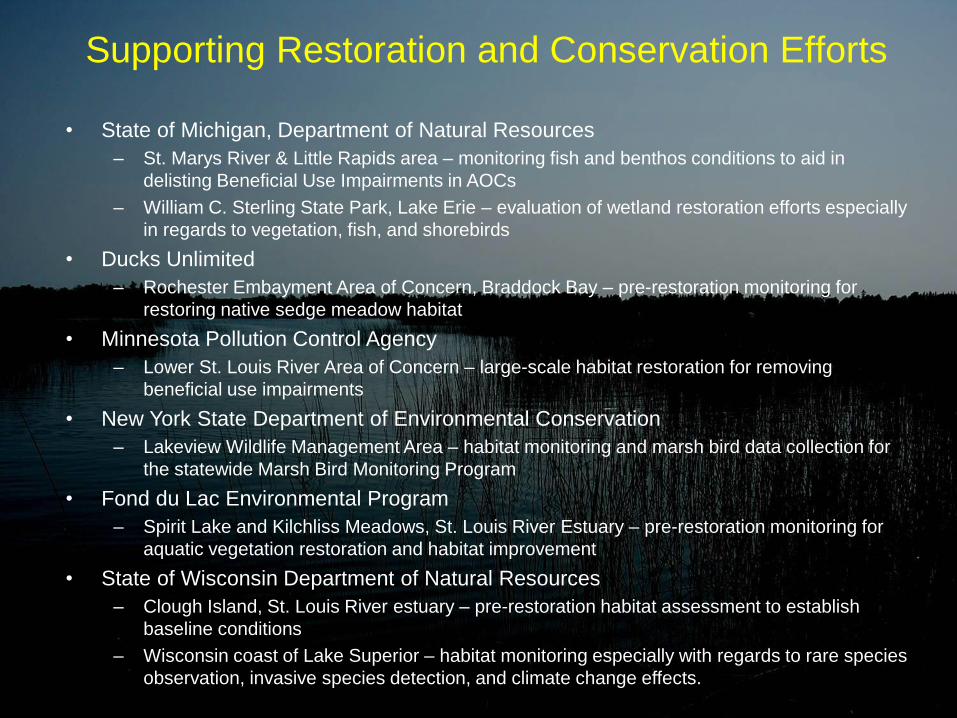
Supporting Restoration and Conservation Efforts
• State of Michigan, Department of Natural Resources
– St. Marys River & Little Rapids area – monitoring fish and benthos conditions to aid in
delisting Beneficial Use Impairments in AOCs
– William C. Sterling State Park, Lake Erie – evaluation of wetland restoration efforts especially
in regards to vegetation, fish, and shorebirds
• Ducks Unlimited
– Rochester Embayment Area of Concern, Braddock Bay – pre-restoration monitoring for
restoring native sedge meadow habitat
• Minnesota Pollution Control Agency
– Lower St. Louis River Area of Concern – large-scale habitat restoration for removing
beneficial use impairments
• New York State Department of Environmental Conservation
– Lakeview Wildlife Management Area – habitat monitoring and marsh bird data collection for
the statewide Marsh Bird Monitoring Program
• Fond du Lac Environmental Program
– Spirit Lake and Kilchliss Meadows, St. Louis River Estuary – pre-restoration monitoring for
aquatic vegetation restoration and habitat improvement
• State of Wisconsin Department of Natural Resources
– Clough Island, St. Louis River estuary – pre-restoration habitat assessment to establish
baseline conditions
– Wisconsin coast of Lake Superior – habitat monitoring especially with regards to rare species
observation, invasive species detection, and climate change effects.

Uzarski Lab Spin-Off Projects • North Maumee Bay chemical/physical characteristics and
community composition of Diked vs. Un-Diked Wetlands
• Importance of coastal wetlands to offshore fishes of the Great
Lakes: Dietary support and habitat utilization
• Spatial variation in macroinvertebrate communities within two
emergent plant zones in Great Lakes coastal wetlands
• Functional indicators of Great Lakes coastal wetland health
• Evaluating environmental DNA detection alongside standard fish
sampling in Great Lakes coastal wetland monitoring
• Impacts of drainage outlets on Great Lakes coastal wetlands
• Effects of anthropogenic disturbance affecting coastal wetland
vegetation
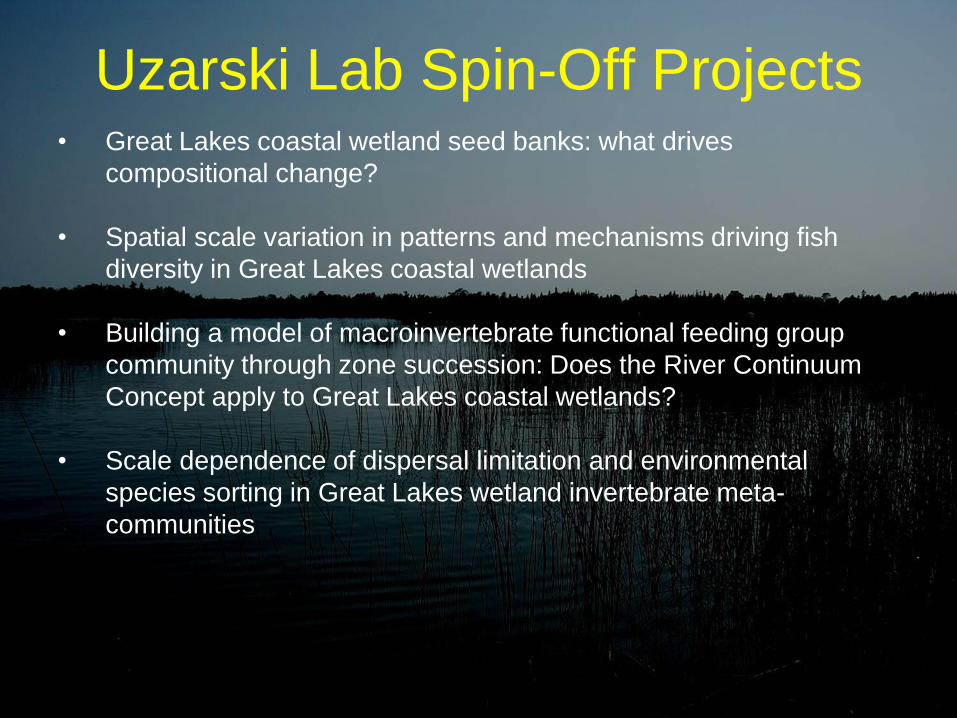
Uzarski Lab Spin-Off Projects • Great Lakes coastal wetland seed banks: what drives
compositional change?
• Spatial scale variation in patterns and mechanisms driving fish
diversity in Great Lakes coastal wetlands
• Building a model of macroinvertebrate functional feeding group
community through zone succession: Does the River Continuum
Concept apply to Great Lakes coastal wetlands?
• Scale dependence of dispersal limitation and environmental
species sorting in Great Lakes wetland invertebrate meta-
communities

Uzarski Lab Spin-Off Projects • Larval fish use and assemblage composition between different
wetland types
• Determining wetland health for selected Great Lakes Coastal
Wetlands and incorporating management recommendations
• Invertebrate co-occurrence trends in the wetlands of the Upper
Peninsula and Western Michigan and the role of habitat
disturbance levels
• Fish species co-occurrence in northern Michigan Wetlands
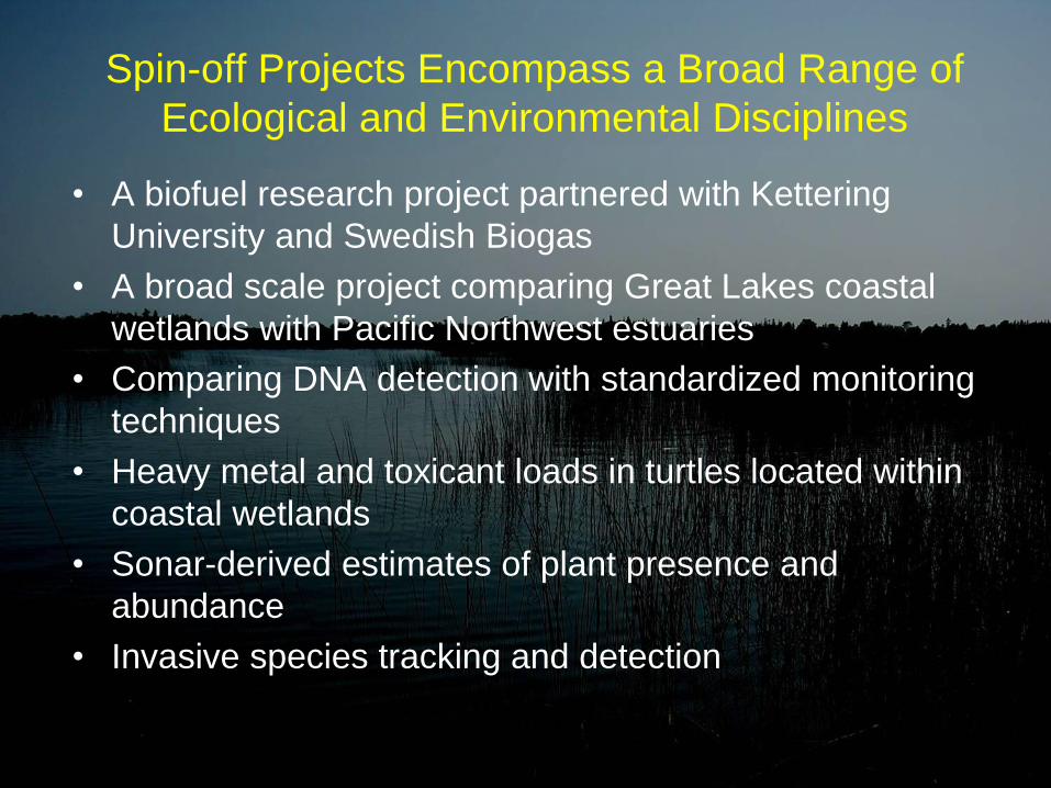
Spin-off Projects Encompass a Broad Range of
Ecological and Environmental Disciplines
• A biofuel research project partnered with Kettering
University and Swedish Biogas
• A broad scale project comparing Great Lakes coastal
wetlands with Pacific Northwest estuaries
• Comparing DNA detection with standardized monitoring
techniques
• Heavy metal and toxicant loads in turtles located within
coastal wetlands
• Sonar-derived estimates of plant presence and
abundance
• Invasive species tracking and detection

Jobs Created/Supported
Principle Investigators: 14
Post-doctoral researchers: 1
Graduate students: 30
Undergraduate students: 52
Technicians: 25
122 Paid Positions & 21 Volunteers
Threatened & Endangered Species • Birds
• Common terns (threatened in Wisconsin & Minnesota), Duluth-Superior Harbor; Allouez Bay, WI,
• Least Bittern (Threatened in New York), Hebblethwaite Drian wetland Lake Erie, Ontario
• Black Tern (Endangered in New York), northern Lake Michigan; Lake St. Clair wetlands
• Nesting pairs of bald eagles (special concern), St. Louis River estuary, Allouez Bay, WI
• Common loons (special concern), Madeline Island, WI and various wetland types within island complexes
• Sandhill cranes (special concern), Allouez Bay, WI;
• Sora rails (special concern), Fish Creek Wetland, WI; Hebblethwaite Drian wetland Lake Erie, Ontario
• Yellow rails (special concern), Munuscong River Delta, MI
• American white pelican (special concern)
• Wilson’s snipe (special concern)
• Wilson’s phalarope (special concern)
• Northern harrier (special concern)
• Forster’s tern (special concern)
• Vegetation
• Michigan monkey-flower (federally threatened), Epoufette Bay
• American lotus (rare plant), western Lake Erie marshes
• Montevidense’s arrowhead (rare plant), western Lake Erie Marshes
• Several orchid species considered rare but not federally or state listed were found within several coastal
wetlands: Loesel’s twayblade, rose pogonia, grass-pink, and hooded ladies’-tresses orchids
• Beck’s water marigold (species of conservation interest)
• Houghton’s goldenrod (species of special concern), Scott Point Wetland Complex
• Wild rice (special concern), Lake St. Clair wetlands; Long Point Lake Erie; White River northern Lake Michigan
• Fish
• Grass pickerel (rare), Presqu’ile Bay Marsh, Lake Ontario
• Reptiles
• Eastern fox snake (threatened), Point Au-Baril, Lake Erie
• Blanding’s turtle (at risk, Ontario), North Maumee Bay Lake Erie
• Eastern musk turtle (at risk, Ontario), Roberts Island and Tobie’s Bay, Honey Harbor, Ontario

Invasive Species – Vegetation
• Expansion of frog-bit (Hydrocharis morsus-range) in western Lake Erie, Lake St. Clair, and the St. Marys River
• Distinguishing Phagmites australis subspecies into native and invasive populations to improve tracking and
expansion data, especially in Northern Lake Huron where the native species is predominant
• Signs of Phragmites australis australis control were documented in Saginaw Bay (Lake Huron), Green Bay
(Lake Michigan), and the western basin of Lake Erie.
• Phragmites expansion in northern Lake Huron and Georgian Bay wetlands was noted
• Eurasian water-milfoil, throughout the Great Lakes basin
• Narrow-leaf cattail and hybrid cattails, throughout the Great Lakes basin
• Curly pondweed, throughout the Great Lakes basin
• Sago pondweed, Lake Ontario basin, 73% of sites
• Reed canary grass, Lake Ontario basin, 55% of sites
• Field thistle, Lake Ontario basin, 18% of sites
• Flowering-rush, Lake Ontario basin, 14% of sites
• Curly dock, Lake Ontario basin, 5% of sites
• Water chestnut, Lake Ontario basin, 5% of sites
– Fish
• Round goby
• Alewife
• Eurasian carp
• White perch
• Goldfish
• Rudd
• Tubenose goby, Quarry Island, Georgian Bay Lake Huron; Lake St. Clair delta
– Invertebrates
• Chinese mystery snail, Tobie’s Bay wetland


Post 2015
• Stratified Random Design
– Allows Subsampling
• 80-100 Sites Per Year (?)
• Sample Fewer Groups of Organisms (?)

Thank You!


