
Dwarakish & Ganasri, Cogent Geoscience (2015), 1: 1115691http://dx.doi.org/10.1080/23312041.2015.1115691
HYDROSPHERE | REVIEW ARTICLE
Impact of land use change on hydrological systems: A review of current modeling approachesG.S. Dwarakish1 and B.P. Ganasri1*
Abstract: Hydrologic modeling plays a very important role in assessing the seasonal water availability, which is necessary to take decisions in water resources manage-ment. Both climate and land use and land cover change have great influence on the hydrological response of a watershed. The main aim of this study is to provide a detailed review of studies which have been carried out to analyze the hydrologi-cal impacts of land use change, and also to evaluate different scenario modeling approaches. In addition, a brief description of basic hydrologic models which are used to simulate the stream flow is provided. This review paper tried to explain the importance of model comparison and performance evaluation in modeling stud-ies. The following conclusions may be drawn from this review: (1) it is necessary to model the possible impacts of land use change and climate change in order to pro-ceed with effective water resources management, (2) it is important to analyze the variation in hydrological response in catchments with different land use characteris-tics and climatic conditions and also under climate scenarios, and (3) integration of different models with hydrologic models can be considered as an efficient method to forecast future trends in hydrological response.
Subjects: Environment Change & Pollution; Surface Hydrology; Water Engineering
Keywords: water; hydrologic modeling; land use and land cover; climate change; rainfall–runoff models
*Corresponding author: B.P. Ganasri, Department of Applied Mechanics and Hydraulics, National Institute of Technology Karnataka, Srinivasanagara PO, Surathkal 575 025, India E-mail: [email protected]
Reviewing editor:Lucia De Stefano, Universidad Complutense de Madrid, Spain
Additional information is available at the end of the article
ABOUT THE AUTHORSDr. G.S. Dwarakish, started his teaching career during 1993 and after completing his PhD in the area of Applications of RS & GIS for Water Resources Engineering and Coastal and Ocean Engineering, currently serving as a Professor and the Head of the Department of Applied Mechanics & Hydraulics, N.I.T.K., Surathkal, India. He has completed eight R&D projects and published 150+ technical papers in international/national journals and conferences. He was a Guest Editor-in-Chief of special issue on Remote Sensing and GIS Applications of International Journal of Earth Sciences and Engineering and editor of Aquatic Procedia, Vol. 4, 2015, published by Elsevier.
Ms. B.P. Ganasri has awarded M.Tech degree in Remote Sensing and GIS in the year 2012. Currently working as a Research Scholar in the area of Application of RS and GIS for Water Resources Engineering in N.I.T.K., Surathkal, India. She has published four Journal and seven International Conference papers.
PUBLIC INTEREST STATEMENTThe conservation of land and water resources is significant for the sustainable development of mankind. But, the rapid development in the pace of industrialization and urbanization has put pressure on the natural resources of the earth leading to degradation and becoming a global problem. In addition to climate change, land use change is one of the important human interventions altering the quality and quantity of surface and ground water. It is essential to model the complex relationship between various hydrological processes and their behavior in relation to human induced modifications. Present study talks about, how human activities are affecting the environment and impacts of change in climate and natural vegetation on the availability of water resources? and how to predict future change? This information helps people to realize the effect of human activities on climate change and hence it makes them to take necessary precautions regarding conservation of the resource.
Received: 17 June 2015Accepted: 16 October 2015Published: 15 December 2015
© 2015 The Author(s). This open access article is distributed under a Creative Commons Attribution (CC-BY) 4.0 license.
Page 1 of 18
G.S. Dwarakish

Page 2 of 18
Dwarakish & Ganasri, Cogent Geoscience (2015), 1: 1115691http://dx.doi.org/10.1080/23312041.2015.1115691
1. IntroductionWater is one of the essential components of the environment and requires proper planning and management to achieve its sustainable utilization. Global advances in the economy and standards of living have resulted in a growing dependency on water resources (Legesse, Vallet-Coulomb, & Gasse, 2003; Nandakumar & Mein, 1997). In addition to climate change, land use change is one of the important human interventions altering the quality and quantity of both surface and ground water. The study of hydrological cycle and hydrological response of a catchment have become very complex due to complicated inter-relationship between various hydrological components such as precipitation, evaporation, transpiration, infiltration, and runoff. Both climate and land use change have adverse implications on the natural hydrologic system in terms of variation in the runoff re-gime, evapotranspiration (ET), subsurface flow, infiltration, etc., (Lørup, Refsgaard, & Mazvimavi, 1998; McColl & Aggett, 2007; Xu & Singh, 1998). The major factors contributing to land use change includes demographic changes, climatic variability, national resource conservation policies, and so-cio-economic factors (Elfert & Bormann, 2010; Mao & Cherkauer, 2009). According to Lin, Verburg, Chang, Chen, and Chen (2009), the factors that drive land-use change in any watershed include the altitude, slope, distance from the river, soil erosion coefficient, distance from major roads, distance from a built-up area, and population density. However, analyzing the land use and land cover change (LUCC) and identifying its driving factors is very complex (Niehoff, Fritsch, & Bronstert, 2002; Verburg, Schot, Dijst, & Veldkamp, 2004).
In order to understand the natural hydrologic system, researchers have investigated the relation-ship between climate, land use, and hydrological processes (Bormann, Breuer, Gräff, Huisman, & Croke, 2009; Nandakumar & Mein, 1997; Tang, Yang, Hu, & Gao, 2011). These studies generally agree that stream flow generation capacity is also dependent on vegetation type. The development of hydrologic models that consider spatio-temporal watershed characteristics helps in accurate pre-diction of dynamic water balance of a watershed (Costa, Botta, & Cardille, 2003; He & Hogue, 2012; Lørup et al., 1998). Therefore, hydrologic models have become increasingly important tools for the management of the water resources (Sarkar & Kumar, 2012; Shirke, Kawitkar, & Balan, 2012; Suliman, Jajarmizadeh, Harun, & Mat Darus, 2015). They are used for flow forecasting to support reservoir operation, flood mitigation, spillway design studies, and many other purposes (Sarkar & Kumar, 2012; Shirke et al., 2012). The basic approach in hydrologic modeling is that the model is used to calculate stream flow based on meteorological data and catchment characteristics, which are available in a basin or in its vicinity (Lørup et al., 1998; Ye, Zhang, Liu, Li, & Xu, 2013).
Recent studies have demonstrated the potential of an integrated modeling approach to evaluate the impact of land use changes on water resources (McColl & Aggett, 2007; Wijesekara et al., 2012). Choi and Deal (2008) combined a semi-distributed hydrologic model and a dynamic urban growth model (LEAMluc) for examining the implications of urbanization on the hydrological processes in the basin. They found that the land use scenarios generated by the model show noticeable changes in surface flow in some areas as a result of very high population growth. He and Hogue (2012) have used a semi-distributed model to evaluate the impact of future urbanization on flow regimes and found that increasing development increases the total annual runoff and wet season flows. Integrating land use models with a precipitation-runoff model provides quantitative information about the effects of land use intensities and strategies on hydrological output. Different land uses in different sub-watersheds yield significantly different hydrologic output (Lin et al., 2009).
The major objective of this paper is to provide a detailed review on the applicability of various hy-drologic models to analyze the effects of LUCC on hydrological processes. Also, provides an insight into the importance of LUCC and climate change scenario-based studies. The paper is organized in six sections: Section 2 includes a brief introduction to basic hydrologic models and the role of remote sensing in hydrologic modeling, Section 3 describes the application of hydrologic models in studying the impact of LUCC, Section 4 gives scenario-based simulation of hydrologic response, Section 5 in-cludes the comparison of models and performance evaluation, Section 6 deals with discussion, and conclusions are given in Section 7.
Page 3 of 18
Dwarakish & Ganasri, Cogent Geoscience (2015), 1: 1115691http://dx.doi.org/10.1080/23312041.2015.1115691
2. Hydrological modelsHydrological processes at the catchment scale are no longer stationary when the changes taking place in the catchment are highly variable in nature (Cornelissen, Diekkrüger, & Giertz, 2013; Mauser & Bach, 2009). Various models are available to solve the hydrological problems. Rainfall–Runoff (RR) prediction is one of the most complicated processes in environmental modeling. This is due to the spatial and temporal variability of topographical characteristics, rainfall patterns, and the number of parameters to be derived during the calibration (Nandakumar & Mein, 1997).
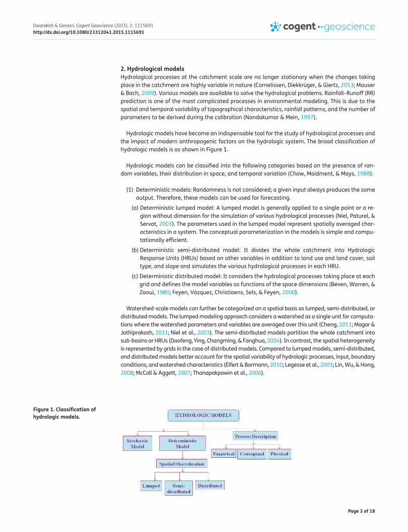
Hydrologic models have become an indispensable tool for the study of hydrological processes and the impact of modern anthropogenic factors on the hydrologic system. The broad classification of hydrologic models is as shown in Figure 1.
Hydrologic models can be classified into the following categories based on the presence of ran-dom variables, their distribution in space, and temporal variation (Chow, Maidment, & Mays, 1988):
(1) Deterministic models: Randomness is not considered; a given input always produces the same output. Therefore, these models can be used for forecasting.
(a) Deterministic lumped model: A lumped model is generally applied to a single point or a re-gion without dimension for the simulation of various hydrological processes (Niel, Paturel, & Servat, 2003). The parameters used in the lumped model represent spatially averaged char-acteristics in a system. The conceptual parameterization in the models is simple and compu-tationally efficient.
(b) Deterministic semi-distributed model: It divides the whole catchment into Hydrologic Response Units (HRUs) based on other variables in addition to land use and land cover, soil type, and slope and simulates the various hydrological processes in each HRU.
(c) Deterministic distributed model: It considers the hydrological processes taking place at each grid and defines the model variables as functions of the space dimensions (Beven, Warren, & Zaoui, 1980; Feyen, Vázquez, Christiaens, Sels, & Feyen, 2000).
Watershed-scale models can further be categorized on a spatial basis as lumped, semi-distributed, or distributed models. The lumped modeling approach considers a watershed as a single unit for computa-tions where the watershed parameters and variables are averaged over this unit (Cheng, 2011; Magar & Jothiprakash, 2011; Niel et al., 2003). The semi-distributed models partition the whole catchment into sub-basins or HRUs (Daofeng, Ying, Changming, & Fanghua, 2004). In contrast, the spatial heterogeneity is represented by grids in the case of distributed models. Compared to lumped models, semi-distributed, and distributed models better account for the spatial variability of hydrologic processes, input, boundary conditions, and watershed characteristics (Elfert & Bormann, 2010; Legesse et al., 2003; Lin, Wu, & Hong, 2008; McColl & Aggett, 2007; Thanapakpawin et al., 2006).
Figure 1. Classification of hydrologic models.

Page 4 of 18
Dwarakish & Ganasri, Cogent Geoscience (2015), 1: 1115691http://dx.doi.org/10.1080/23312041.2015.1115691
(2) Stochastic models: The output of these models is at least partially random. Therefore, these models make statistical predictions. Stochastic models are classified as space independent or space correlated depending on whether random variables in space influence each other.
The hydrological models can also be classified according to whether the hydrological processes are described as conceptual, empirical, or fully physically based (Figure 1). Empirical models, such as Artificial Neural Networks (ANNs), Fuzzy Logic, Genetic Algorithm (GA) etc., are used to establish a relationship between rainfall and runoff to predict runoff in different catchments (Chen, Wang, & Tsou, 2013; Halff, Halff, & Azmoodeh, 1993; Shirke et al., 2012). Empirical models contain no physical transformation function to relate input to output; such models usually build a relationship between input and output based on hydro-meteorological data (Sarkar & Kumar, 2012; Sudheer, Gosain, & Ramasastri, 2002). ANN models are capable of modeling non-linear relationships between inputs and outputs. Thus, daily runoff forecasting using ANN models has become quite important for effec-tive planning and management of water resources (Shirke et al., 2012). Ondieki (1996) has investi-gated four catchments ranging from semi-humid to semi-arid catchments to evaluate the water resource potential of non-perennial streams. This study has concluded that rainfall would have some relationship with runoff as well as suspended sediment load. However, the rainfall alone could not explain the runoff variance efficiently, which can be attributed to antecedent moisture content, rainfall intensity, and physical catchment characteristics such as geology, soil, slope, and land use and land cover conditions (Costa et al., 2003). The major limitation of empirical models is due to the absence of explicit consideration of physical processes such as subsurface flow, surface runoff, and infiltration in the catchment. Also, these numerical models are not capable of modeling the influ-ence of change in vegetation on various hydrological components.
Conceptual rainfall–runoff models are simplifications of the complex processes of runoff genera-tion in a catchment. The particular components of these models often have to be described by em-pirical functions based on the observation of certain processes. Viviroli, Zappa, Gurtz, and Weingartner (2009) introduces a semi-distributed hydrological modeling system preecipitation-runoff-evapo-transpiration HRU Model that implements a conceptual process-oriented approach and has been developed, especially to suit conditions in mountainous environments with their highly variable environmental and climatic conditions. Also, an built-in automatic calibration model significantly reduces the amount of user intervention that is usually required for tuning the model parameters. Monte Carlo model is the one, which can be used to obtain estimates of parameter uncertainties. Valent, Szolgay, and Riverso (2012) have used lumped conceptual model, Hron rainfall runoff model which is a modified version of Hydrologiska Bryåns Vattenbalansavdelning model to predict runoff and also to test the calibration procedure. Results suggested that the model have uncertainties with respect to conceptualization of complex runoff generation process and the quality of input data (Tian, Xu, & Zhang, 2013). Parajka et al. (2006) have utilized scatterometer data in a conceptual semi-distributed model to study the soil moisture dynamics which alter the hydrological processes.
In contrast, the physically based distributed models are able to explicitly represent the spatial variability of the important land surface characteristics such as topographic elevation, slope, aspect, vegetation, soil as well as climatic parameters including precipitation, temperature, and ET distribu-tion (Akbari & Singh, 2012; Grayson, Moore, & McMahon, 1992; Niehoff et al., 2002; Wijesekara et al., 2012). Shen and Phanikumar (2010) utilized the Process-based Adaptive Watershed Simulator (PAWS) to evaluate the integrated hydrological response of the surface–subsurface system using a novel non-iterative method that couples runoff and groundwater flow to vadose zone processes ap-proximating the 3D Richards equation. The model solves the governing equations for the major hy-drological processes efficiently so that large-scale applications become relevant. The model performance may deteriorate in catchments dominated by perched water table dynamics because the model assumes that soil moisture does not flow laterally in the unsaturated part of the soil column.

Page 5 of 18
Dwarakish & Ganasri, Cogent Geoscience (2015), 1: 1115691http://dx.doi.org/10.1080/23312041.2015.1115691
2.1. Model functionality and complexityWhile choosing a model for specific application, it is important to consider its applicability to simu-late the impact of land use and climate change and also prediction performance (Abushandi & Merkel, 2013; Schreider et al., 2002; Ty, Sunada, Ichikawa, & Oishi, 2012). The model functionality and complexity can become major criteria in model selection. The model functionality differs in terms of hydrologic process representation, the equations adopted to simulate these processes and model discretization (Hogue, Gupta, & Sorooshian, 2006; Xu & Singh, 1998). In addition, model com-plexity can be defined by the estimated data, resources, time, and cost that are required to param-eterize and calibrate a model, as well as the professional judgment and experience required to operate these models (Shen & Phanikumar, 2010; Verma, Jha, & Mahana, 2010).
The description of several widely-used hydrological models is provided in Table 1. Models represent hydrologic processes such as (1) Soil–Vegetation–Atmosphere Transfer processes: canopy rain inter-ception and evaporation, stem flow, canopy snow interception, snowmelt, vegetation transpiration, and soil evaporation; (2) Soil moisture storage and runoff generation processes: infiltration, depres-sion storage, subsurface runoff, Horton (infiltration excess) overland flow; (3) channel routing; and (4) other processes: groundwater flow, glacier melt, lakes, wetlands (Jiang et al., 2007; Post & Jones, 2001; Thanapakpawin et al., 2006). The equations adopted to simulate these processes vary between models. Empirical approaches are based on experimentally derived simple relationships such as linear regressions. Empirical methods for calculating evaporation include radiation-based equations (e.g. Priestley–Taylor) (Wu & Johnston, 2007) and snow melt phenomena using degree-day method, whereby the rate of melting increases as the air temperature increases (Wijesekara et al., 2012). Whereas, the analytical model use simplified assumptions to derive solutions for the governing equa-tions which are used to describe conservation of mass, momentum, and/or energy. Examples include
Table 1. Description of hydrologic models related to model functionality and complexityModel Main components Evapotranspiration Overland flow Subsurface flow Spatial scaleHEC-HMS (Verma et al., 2010)
Precipitation, losses, baseflow, runoff transformation, and routing
Priestley–Taylor CN, kinematic wave equations, Soil moisture accounting model
Linear reservoir volume accounting model, exponential recession model
Semi-distributed
MIKE SHE (Wijesek-ara et al., 2012)
Interception, overland/channel flow, unsaturated/saturated zone, snowmelt; aquifer/rivers exchange, advection/dispersion of solutes, plant growth, soil ero-sion, and irrigation
Based on canopy stor-age and soil evapora-tion
2-D diffusive wave equations (St. Venant equations)
3-D groundwater flow (Green Ampt infiltration method)
Distributed
SWAT (Wu & John-ston, 2007)
Hydrology, weather, sedi-mentation, soil temperature and properties, crop growth, nutrients, pesticides, agricultural management, and channel and reservoir routing
Penman–Monteith, Hargreaves, Priestley–Taylor
CN method Lateral subsurface flow/ground flow (Green and Ampt equation)
Semi-distributed
WaSiM (Elfert & Bormann, 2010)
Evapotranspiration, soil module, infiltration, overland flow, inter-flow, base flow routing
Penman–Monteith Horton overland flow Green and Ampt equation
Distributed
DHSVM (Thanapak-pawin et al., 2006)
Surface and subsurface flow, soil moisture, snow cover, runoff, and evapotranspiration
Penman–Monteith equation
Saturation excess and infiltration ex-cess mechanisms
Saturated subsurface flow
Distributed
VIC model (Mao & Cherkauer, 2009)
Infiltration, runoff, baseflow processes, evapotranspiration
Penman–Monteith equation
Soil property based surface flow simula-tion
Variable infiltration capacity curve
Distributed
PAWS (Shen & Phanikumar, 2010)
Overland flow, snowpack, soil moisture, groundwater flow, and stream flow
Penman Monteith + root extraction
Manning’s formula + kinematic wave for-mulation + coupled to Richards equation
Green and Ampt equation
Distributed

Page 6 of 18
Dwarakish & Ganasri, Cogent Geoscience (2015), 1: 1115691http://dx.doi.org/10.1080/23312041.2015.1115691
the Green–Ampt equation, which describes the infiltration of rainfall or snowmelt into the subsurface (Li et al., 2009). In physically-based models, mass transfer, momentum, and energy are simulated using partial differential equations which are solved by various numerical methods such as the St. Venant equations for surface flow (Kim, Warnock, Ivanov, & Katopodes, 2012), the Richards equation for unsaturated zone flow (Elfert & Bormann, 2010), the Penman–Monteith equation for evapotranspi-ration which is recommended for calculating reference evapotranspiration by the Food and Agricultural Organization (Cornelissen et al., 2013; Mackay, 2001; Mao & Cherkauer, 2009; Wu & Johnston, 2007). When compared to empirical and analytical models, the physically based models are characterized by higher intrinsic accuracy for predicting the effect of land use disturbances or climate change. However, these models are quite data intensive (Shen & Phanikumar, 2010).
The model functionality also depends on the model’s ability to spatially discretize the watershed based on soil and vegetation (He & Hogue, 2012; Wooldridge, Kalma, & Kuczera, 2001). The purpose of discretizing a watershed into different units is to account for the spatial variability and pathways of water movement and to describe geologic and land cover variability and the effects of slope and aspect on hydrologic response (Chien, Yeh, & Knouft, 2013; Wu & Johnston, 2007). Apart from spatial discretization, the time step at which model simulations are performed (i.e. temporal discretization) is also important. Some models can only run at a specific time interval (e.g. sub-daily, daily, or monthly). Time discretization may affect the ability of a model to predict the output. In addition, temporal discretization has important implications for data availability and preparation (model complexity) (Chien et al., 2013).
The model complexity is equally important while evaluating the ability of the models to simulate the desired land use and climate change scenarios. In many applications, modelers face data scar-city problems which lead to the selection of low complexity lumped and/or conceptual models. However, when more detailed results are needed, a fully distributed and/or physically based ap-proach may be required and it may be necessary to collect the detailed data to apply the model (Elfert & Bormann, 2010). The low-complexity models are typically characterized by modest require-ments regarding meteorological data (e.g. monthly temperature and precipitation data) and low overall input data requirements. Whilst the medium-complexity models involve higher requirements regarding meteorological data (e.g. daily temperature and precipitation data) and medium overall model input requirements. The highly complex models, on the other hand, require more frequent meteorological data (e.g. hourly to daily temperature and precipitation data) and very high overall model input requirements (Chien et al., 2013; Niu & Sivakumar, 2013). The set of models given in Table 1 are the examples for models with high complexity, since these models require minimum 5–10 years of input data-sets for the calibration and validation of the models. These models require more simulation time period, because of semi-distributed or distributed-based watershed discre-tization. For example, Hydrologic Engineering Center’s Hydrologic Modeling System (HEC-HMS) con-tinuous simulation framework based on soil moisture and linear reservoir volume accounting model requires 10–12 model parameters to represent surface and sub-surface hydrological processes. This requires more number of input data to estimate these parameters, which makes the model complex (Verma et al., 2010).
2.2. Role of remote sensing in hydrologic modelingPhysically based hydrologic models are an important evolutionary step in representing hydrological processes using spatially distributed data. Better representation of physical processes in space and time needs the availability of digital products (e.g. distributions of elevation, soil, vegetation) and remotely sensed data (e.g. soil moisture, vegetation), along with new technologies for measuring temporal and spatial variability in precipitation (Daofeng et al., 2004; Ruelland, Ardoin-Bardin, Billen, & Servat, 2008). The distributed hydrological models need spatially variable rainfall and temperature data, which now can be obtained from Tropical Rainfall Measuring Mission precipitation products, Advanced Very High Resolution Radiometer, Moderate Resolution Imaging Spectroradiometer, and Landsat images with high spatial and temporal resolution (Haigen et al., 2015). For topography-based hydrologic models, digital elevation models such as Shuttle Radar Topography Mission, ASTER

Page 7 of 18
Dwarakish & Ganasri, Cogent Geoscience (2015), 1: 1115691http://dx.doi.org/10.1080/23312041.2015.1115691
are routinely used to describe the land-surface topography, which contains crucial information about the surface water flow and the interaction of surface water and ground water (Khan, Tuteja, & Sharma, 2013). With the development of remote sensing and satellite technology, the satellite data can be used to derive a variety of surface parameters such as radiant surface temperature and vegetation fraction; these variables can be used for both spatial and temporal comparisons, and for regional hydrologic modeling of important hydrological processes. One of the important hydrologic model inputs such as land use and land cover can be obtained from Landsat TM images, LISS-III and LISS-IV images (Bhagyanagar, Kawal, Dwarakish, & Surathkal, 2012). The recent missions of European Space Agency included Sentinel series operational satellites with an aim to meet earth observation. These satellites are capable of providing data for various applications including sea-surface topography, sea-surface height and significant wave height, ocean and land-surface tem-perature, ocean and land-surface color, sea and land ice topography, sea-water quality and pollution monitoring, inland water monitoring, climate monitoring and modeling, land-use change monitor-ing, fire detection, weather forecasting, and measuring earth’s thermal radiation for atmospheric applications (https://earth.esa.int/web/guest/missions/esa-operational-eo-missions).
3. Application of hydrologic models to study the impact of LUCCThe water and energy balances are significantly influenced by land cover pattern via its effect on tran-spiration, interception, evaporation, and infiltration (Delgado, Llorens, Nord, Calder, & Gallart, 2010; Mao & Cherkauer, 2009; Nandakumar & Mein, 1997; Öztürk, Copty, & Saysel, 2013). The transformation of earth’s land surface has many consequences for biophysical and ecological system in terms of urban heat islands, alteration in stream flow pattern, global atmospheric circulation, and extinction of living species (Schreider et al., 2002; Yu, Zang, Wu, Liu, & Na, 2011). The rapid increase in population has led to change in land use in terms of deforestation aimed at improving agricultural production (Lørup et al., 1998). In a number of semi-arid regions, this has resulted in land degradation due to soil erosion, re-duced productivity, and problem of drought (He & Hogue, 2012; Legesse et al., 2003; Lørup et al., 1998; Ondieki, 1996).
In the upper Midwestern United States, the hydrology is affected by human activities through conversion of forest and prairie grasslands to agricultural lands (Mao & Cherkauer, 2009). Jing and Ross (2015) have assessed the possible relationship between LUCC and stream flow due to mining activities by using Hydrological Simulation Program-Fortran (HSPF) model. Study elucidated that the mining affected basins experienced tremendous increase in stream flow; necessitates implementa-tion of reclamation schemes to improve the hydrological condition of the basin.
The heterogeneous distribution of various hydrologic components made it difficult to understand the hydrologic response to changes (Delgado et al., 2010; Niu & Sivakumar, 2013; Siriwardena, Finlayson, & McMahon, 2006). In recent years, many researchers have investigated the relationship between land use change and hydrologic response in catchments (He & Hogue, 2012; Isik, Kalin, Schoonover, Srivastava, & Graeme Lockaby, 2013; Legesse et al., 2003; Lørup et al., 1998; Mao & Cherkauer, 2009; Nandakumar & Mein, 1997; Niel et al., 2003; Ondieki, 1996; Öztürk et al., 2013). These methods mostly rely on lumped, distributed, conceptual, or physical models. Lørup et al. (1998), have combined a statistical method with hydrological modeling i.e. Nedbor–Afstromnings Model, a lumped conceptual model in order to distinguish between the effects of climate variability and LULC change on runoff through studying six semi-arid catchments. As model gave reasonably good performance, the difference between simulated and observed flow was considered to be a key test variable to assess the impact of land use change on catchment runoff.
In the process of analyzing the effect of vegetation pattern, one should consider not only the per-centage of different land use categories, but also the variation in the characteristics of specific land use class, e.g. type of crop and other management aspects (Lørup et al., 1998; Warburton, Schulze, & Jewitt, 2012). Thanapakpawin et al. (2006) utilized the Distributed Hydrology-Soil Vegetation Model (DHSVM), a spatially explicit landscape/hydrology model that recognizes spatial heterogene-ity of the watershed to simulate forest-crop expansion and crop to forest reverse expansion scenario
Page 8 of 18
Dwarakish & Ganasri, Cogent Geoscience (2015), 1: 1115691http://dx.doi.org/10.1080/23312041.2015.1115691
based on land use transition during the period 1989–2000. They found that the expansion of high-land crop fields led to slightly higher regulated annual and wet season water yields compared to similar expansion in lowland-midland zone.
The better understanding of basin hydrology and the relationship between land use change and relative variation in ET, baseflow, and surface runoff generation and associated water distribution is helpful to watershed planners and decision-makers (Tang et al., 2011; Thanapakpawin et al., 2006; Wang et al., 2012). A thorough understanding of the rainfall–runoff relationship is vital in modeling and designing urban drainage (Laouacheria & Mansouri, 2015). Numerical models such as Regression, ANN, Fuzzy, and GA are data-driven models which are not capable of modeling spatially explicit re-lationship of hydrologic response with respect to physical characteristics of the basin. In contrast, process-based distributed models have the potential to quantify and forecast the dynamics of water availability with land use and climate change (Haigen et al., 2015). However, these models are data intensive and not applicable to catchments with sparse data-sets (Elfert & Bormann, 2010; Lin et al., 2008; Thanapakpawin et al., 2006). In the review of Lørup et al. (1998) it is mentioned that, (Onstad & Jamicson, 1970) have made one of the first attempts to use a hydrological model for predicting the effect of land use change on runoff and experienced the lack of data to validate the results. In order to meet the data requirements of physically based distributed model, Thanapakpawin et al. (2006) utilized the Diurnal interpolation scheme from Variable Infiltration Capacity (VIC) model to sub-divide the daily records into three-hourly temperature, radiation, and relative humidity.
It is a well-established fact that the clearance of tropical forest land leads to an increase in the annual runoff. In order to demonstrate such impacts, Costa et al. (2003) studied the relationship between precipitation, discharge, ET, and LULC change in a large catchment (175,360 km2) by con-sidering 50-years long time series data using statistical analysis. Their study revealed that the con-version of forest land to grass land leads to reduction in ET value and an associated increase in runoff. The rate of change of hydrologic response of a catchment to land use change is influenced by intensity of conversion of natural vegetation through human activity and location of change with-in the catchment. The interaction of land use and hydrologic processes exhibits spatial and temporal variation, as fluxes of water within a catchment vary vertically and laterally.
In contrast to previous studies, Niehoff et al. (2002) investigated the impact of land surface condi-tions on storm–runoff generation at the meso-scale by considering three catchments which repre-sent different characteristic land use patterns. Later, Warburton et al. (2012) have studied the difference in hydrological response in three diverse, complex, and operational South African catch-ments by using the conceptual and physical, Agricultural Catchments Research Unit (ACRU) model. To analyze the influence of heterogeneity associated with the vegetation cover on stream flow pat-terns, three different catchments were selected. Results showed that the contribution of different land uses to the stream flow generated from a catchment is not proportional to the relative area of that land use. Furthermore, the location of specific land uses within a catchment has a role in the response of the stream flow of the catchment.
4. Scenario-based simulation of hydrological response in a catchmentIt is of interest to simulate the effect of possible changes in climate variables and land use that may occur in the near-future by considering scenario conditions. Climate change has its direct influence on runoff which is one of the major components of hydrological cycle (Huang et al., 2015). Westmacott and Burn (1997) used the Mann–Kendall trend test and a regionalization procedure to quantify the severity of climatic effects within the river basin, which is helpful to increase awareness of future consequences for water resource systems planning and management strategies. Results indicate that the timing of a hydrologic event was influenced to a greater extent due to changes in temperature. Legesse et al. (2003) assessed the sensitivity of water resources to land use change as well as climatic variability in a semi-arid to sub-humid basin. Results show that the physically based semi-distributed model is capable of representing the dynamics of the hydrograph at monthly scale better than at the daily scale. The climate scenario study revealed that the hydrologic system seems

Page 9 of 18
Dwarakish & Ganasri, Cogent Geoscience (2015), 1: 1115691http://dx.doi.org/10.1080/23312041.2015.1115691
to be more reactive to an increase in rainfall than to a decrease in rainfall. Also, the system response depends not only on the quantity but also on the quality of rainfall and the number of rainy days. This requires the model to run at less than a day interval, which is very much data intensive.
Li et al. (2009) and Öztürk et al. (2013) observed that the influence of climatic variability is more significant on surface hydrology than land use change. The impact of change in temperature is dif-ficult to assess clearly because the temperature fluctuation will have its own effect on other hydro-meteorological variables also (Legesse et al., 2003). Huang et al. (2015) have simulated the runoff of the upstream of Minjiang River for nine climate change scenarios by varying precipitation, tempera-ture, and potential evapotranspiration. Study elucidated that precipitation variation has more influ-ence on simulated runoff than the temperature variation. The upstream of Minjiang River is located in alpine-cold region, which is a plateau climate and subtropical climate region. In the study area, the rainfall drops from Songpan, Heishui to Mao, Wenchuan county, and increases from Wenchuan to downstream of Dujiangyan. The daily maximum precipitation is more than 200 mm, and annual average evaporation is 600–800 mm.
Simulating the hydrologic response of a catchment to different scenario conditions involves cali-brating and validating the model using present conditions and running the model with parameters for newly framed scenarios and comparing the results (Elfert & Bormann, 2010; Isik et al., 2013; Legesse et al., 2003; Li et al., 2009; Niu & Sivakumar, 2013; Siriwardena et al., 2006). Model calibra-tion is a process of manual/automatic adjustment of model parameters to match between predicted and observed values based on objective functions. Normally, physically based models, such as PRMS, SWAT, etc., involve large number of model parameters making the models complex. However, sen-sitivity analysis can suggest on which parameter is more sensitive than others in predicting simula-tion results. Model validation is a process of evaluating the ability of model to simulate the hydrological components of a catchment by calibrated model parameters for different conditions than calibration period. Therefore, model simulation period is divided into two different sets; calibra-tion and validation data-set (Legesse et al., 2003). Siriwardena et al. (2006) formulated calibration strategies based on time step (monthly and annually) and exponent “c” of objective function (0.5 and 1.0). It is observed that slightly better results were obtained by calibrating the model using these strategies. Elfert and Bormann (2010) have done manual calibration of WaSiM-ETH by com-paring predicted result with observed values for a period of 10-years data-set. Initial two years of data were used as warm-up period to reduce the effect of model’s initial conditions on the output. WaSiM-ETH model was calibrated and validated by considering three quality measures such as mean absolute water balance error, coefficient of determination, and model efficiency. In the physi-cally based spatially distributed model, the temporal aggregation of fluxes as well as increased spatial scale resulted in the improvement of model efficiency (Elfert & Bormann, 2010).
In order to study the effect of future LU/LC patterns on hydrological systems, researchers formu-lated various scenarios, which are as shown in Table 2. The agricultural scenarios based on Special Report on Emissions Scenarios of International Panel on Climate Change and also national policy measures were implemented to see the variations in hydrologic components. Mainly, the conversion of agricultural land to urban, forest land, and grassland was considered for the analysis (Niu & Sivakumar, 2013; Wu & Johnston, 2007). Scenario-based studies imply that even a validated catch-ment model might not be able to simulate significant changes in the water flows when large parts of the catchment of interest are affected by an extreme land use change (Legesse et al., 2003). According to Mao and Cherkauer (2009), forests have the lowest spring total runoff, which is mainly due to higher annual ET that keeps soil moisture levels low, leading to increased infiltration. However, grassland, woodland, and cropland have higher spring total runoffs because of their lower ET losses and more rapid loss of winter snow cover. In addition, the scenarios based on land use policy and urban development provide opportunity to take valid decisions in selecting land use policies that can promote reduction in natural hazard (He & Hogue, 2012; McColl & Aggett, 2007). Generally, scenario-based studies do not try to reconstruct the vegetation history but only attempt to propose the pos-sible and plausible scenarios for studying the potential impact on hydrology.

Page 10 of 18
Dwarakish & Ganasri, Cogent Geoscience (2015), 1: 1115691http://dx.doi.org/10.1080/23312041.2015.1115691
With advances in research, many hydrological models are integrated with land use change mod-els. The spatial pattern optimization model (OLPSIM) and Conversion of Land Use and its Effects at a Small regional extent (CLUE-s) model were integrated with a hydrologic model, HEC-HMS based on Soil Conservation Service Curve Number (SCS-CN) (Nagaraj & Yaragal, 2008) approach to investigate the impact of more realistic developmental scenarios on watershed by considering driving factors (Lin et al., 2009). More recently, Sahu, Mishra, and Eldho (2012) have compared the performance of four modified SCS-CN methods in computing surface runoff in two catchments in Maharashtra State, India. Their study mentioned that in spite of the much larger catchment area of the Kalu watershed compared with those of the US watersheds, used for developing the SCS-CN model, all the four modi-fied SCS-CN-based models performed reasonably well. Wijesekara et al. (2012) have undertaken a study to assess the impact of potential land use changes over next 20 years on the hydrologic pro-cesses by combining the Cellular Automata model and MIKE-SHE/MIKE11 hydrologic model. The results showed that there is a reduction of net capacity of water retention on surface due to the expansion of built-up and agricultural area which has led to an increase in surface runoff caused by a reduction in infiltration.
Table 2. LUCC scenariosSerial No. Author(s) name Scenario details1 Thanapakpawin et al. (2006) (1) Reversal of all croplands back to evergreen needleleaf forests (above 1000 MSL)
and to deciduous broadleaf forests (below 1000 MSL)(2) Doubling the cropland area by adding new crop cells(3) Doubling of cropland that is limited to either highland zones or lowland(4) Doubling of cropland that is limited to midland basin zones
2 Choi and Deal (2008) (1) Base economic growth (current population)(2) High economic growth (125% weight to population projection)(3) Uber economic growth (150% weight to population projection)
3 Elfert and Bormann (2010) (1) Change from agricultural land into forest(2) Change from agricultural land into urban area(3) Change from agricultural land into forest and urban area in equal parts
4 Wijesekara et al. (2012) (1) Evergreen to Agriculture/Built-up(2) Deciduous to Agriculture/Built-up(3) Agriculture to Built-up/Rangeland/Parkland(4) Rangeland/parkland to Built-up/Agriculture
5 He and Hogue (2012) (1) Scenario 1: Current development(2) Scenario 2: Doubles scenario 1(3) Scenario 3: Doubles scenario 2(4) Scenario 4: Triples scenario 2
6 Cornelissen et al. (2013) LU1 scenario: (1) Economic growth(2) Improved political and socio-economic situation(3) Innovations in agricultural sector(4) Expansion of cultivated areas by 15%
LU2 scenario:(1) Economic stagnation(2) Protected forests are not controlled(3) No new technology that enhance production(4) Expansion of cultivated areas by 30%
LU3 scenario(1) Business as usual(2) Productivity does not increase(3) Expansion of cultivated areas by 20%

Page 11 of 18
Dwarakish & Ganasri, Cogent Geoscience (2015), 1: 1115691http://dx.doi.org/10.1080/23312041.2015.1115691
In recent times, Global Circulation Models (GCMs) and Regional Climate Models (RCMs) are being used to generate estimates for future changes in climate. GCMs are efficient in studying the future changes in climate. GCMs have high temporal resolution with low spatial resolution. It is essential to downscale GCM results to regional climate variable. Downscaling is a process of developing the rela-tionship between large-scale variables and small-scale variables to represent the local climatic con-ditions (Ribalaygua et al., 2013; Wibig et al., 2015). Despite the ongoing development in GCMs and RCMs, uncertainty exists on the magnitude of the changes in temperature, precipitation, green house gasses, aerosols, etc., (Ghosh & Misra, 2010; Merritt et al., 2006). Furthermore, these global and regional models are less reliable in simulating detailed spatial and temporal features. Given the difficulties in deducing future climatic trends by using GCMs and RCMs, Tong, Sun, Ranatunga, He, and Yang (2012) preferred to use a range of hypothetical climate scenarios. Also, a study by Wang et al. (2015) considering hypothetical scenarios revealed that, stream flows are highly correlated to precipitation, while weakly correlated to temperature under humid climatic conditions. In contrary to, the soil moisture and actual evaporation are likely to vary with temperature. The integration of models provided a comprehensive picture of the watershed by incorporating the dominant land use transitions and their impact on the land phase of the hydrologic processes. This is an improvement over the use of a single scenario such as an increase in deforestation or afforestation (Niehoff et al., 2002; Öztürk et al., 2013; Tong et al., 2012; Wijesekara et al., 2012).
5. Model comparison and performance evaluationThe comparison of models enables the identification of possible sources of uncertainty in hydrologic modeling and acts as valuable basis for the investigation of the effects of different model structures on model prediction (Cornelissen et al., 2013; Jiang et al., 2007; Viney et al., 2009). If hydrological models are applied within a single study, model calibration often results in reliable simulation of the past. However, the influence of model choice and model calibration on the simulation of climate and land use change impacts remains unclear, even if uncertainties and climate is considered (Kumar, Marks, Dozier, Reba, & Winstral, 2013). The different model structures capture different aspects of the catchment response and, therefore, more aspects of the catchment response are captured in the combined model (Butts, Payne, Kristensen, & Madsen, 2004). Breuer et al. (2009) have applied 10 lumped, semi-lumped, and fully distributed hydrological models to analyze their performance in scenario-based runoff prediction. Depending on the spatial support and the associated data aggre-gation and interpolation, models deal differently with model input, which leads to differences in model output. They achieved a better comparison of model results by homogenizing important model input data such as precipitation, temperature, and Leaf Area Index. However, forcing model to use comparable model inputs can help to avoid drawing wrong conclusions with respect to the effects of model structure (Huisman et al., 2009). This implies that during the selection of models to study the effect of model structure and functionality on the output, it is necessary to consider the consistency among selected model inputs and time steps. Also, when the aim of the study is to tackle different aspects in single modeling framework, then it is more appropriate to integrate two or more models with different functionalities.
Butts et al. (2004) developed a modeling framework that permits changes in the model structure, including both conceptual and physically based process descriptions, to be made within the same modeling tool. Their results show that the model performance is quite sensitive to model structure. Also, the distributed routing and distributed rainfall information increase the simulation accuracy and predictive capability of the model. The sensitivity of stream flow simulations to variations in ac-ceptable model structure was at least as large as uncertainties arising from parametric and meas-urement uncertainty, but the model simulations appeared to be less sensitive to rainfall uncertainty. Biondi, Versace, and Sirangelo (2010) utilized a precipitation-dependent Hydrologic Uncertainty Processor (HUP) for assessing the hydrologic uncertainty in predicting actual stream flow based on the precipitation information available. Their study found that hydrologic uncertainty grows with the value of discharge predicted by the model and that it is higher when associated with higher precipi-tation values.

Page 12 of 18
Dwarakish & Ganasri, Cogent Geoscience (2015), 1: 1115691http://dx.doi.org/10.1080/23312041.2015.1115691
Singh, Bankar, Salunkhe, Bera, and Sharma (2013) have used SWAT CUP software to describe and demonstrate the use of different approaches such as the Sequential Uncertainty domain parameter Fitting (SUFI-2), Generalized Likelihood Uncertainty Equation for stream-flow measurement and best parameter estimation for stabilizing the correlation between the simulated parameters and observed parameters. Laouacheria and Mansouri (2015) have used Watershed Bounded Network model (WBNM) and HEC-HMS hydrological models to predict the runoff hydrographs of urban catch-ments and also evaluated the effect of parameters on the shape of the runoff hydrograph. It is found that, catchment size does not affect the routing calculations but it has a direct influence on the unit hydrograph.
Cornelissen et al. (2013) have studied four different model types (WaSiM, SWAT, UHP-HRU model, and GR4J model) that vary in complexity, spatial resolution, and process representation to differenti-ate between effects caused by model choice and also to improve the understanding of hydrological processes and to provide new insight into the influence of land use and climate change on discharge behavior. The variation between simulation qualities of the models can be attributed to uncertainty in input data, calibration strategy, parameterization, and difference in model structure (Breuer et al., 2009; Cornelissen et al., 2013; Huisman et al., 2009).
A study by Laouacheria and Mansouri (2015) revealed that CN and lag time are more sensitive in estimating peak discharge by HEC-HMS model, where as in case of WBNM model, initial loss, and lag parameter are more sensitive. An analysis of ensemble model predictions shows that the best en-sembles are not necessarily those containing the best individual models. Conversely, it appears that some models that predict well individually do not necessarily combine well with other models (Viney et al., 2009). Bormann et al. (2009) investigated the impact of data resolution of land use informa-tion on simulated water balances for current catchment conditions and land use scenarios, and found that spatially distributed models are more suitable when compared to lumped models to ana-lyze the effects of the patterns of land use change.
In order to measure the model performance, many researchers have used a standard set of crite-ria comprising a combination of numerical measures and graphical plots. Lørup et al. (1998) have used not only numerical measures such as Nash–Sutcliffe model efficiency (Figure 2(A) and (F)), er-ror index, and model efficiency (Figure 2(C)) (Choi & Deal, 2008; Cornelissen et al., 2013; Elfert & Bormann, 2010; He & Hogue, 2012; Li et al., 2009; Lin et al., 2009; Mao & Cherkauer, 2009; Niu & Sivakumar, 2013; Troin, Vallet-Coulomb, Piovano, & Sylvestre, 2012) but also graphical plots includes joint plots of the simulated and observed hydrographs, scatter plots, and flow duration curves to test the model performance. When Nash–Sutcliffe coefficient becomes zero, which indicates that mod-el’s prediction is no better than using the mean of the observed values (Choi & Deal, 2008; Öztürk et al., 2013).
Different criteria assess the performance in different ways. The coefficient of efficiency (Figure 2(E)) (Bormann et al., 2009; Jiang et al., 2007; McColl & Aggett, 2007; Siriwardena et al., 2006) is used as a measure of goodness of fit, whereas the bias (He & Hogue, 2012) and absolute percentage bias (Bormann et al., 2009; Breuer et al., 2009; Li et al., 2009; Thanapakpawin et al., 2006) are used to describe difference between simulated and observed long-term water balance. In addition, Root Mean Square Error (RMSE) and relative RMSE (Niu & Sivakumar, 2013) provide information on the agreement between measured and simulated data and emphasize large deviations (Breuer et al., 2009; Jiang et al., 2007; Li et al., 2009; Thanapakpawin et al., 2006). Thanapakpawin et al. (2006) used Relative Efficiency (Erel), a modified form of Nash–Sutcliffe efficiency because Erel is more sensi-tive to systematic over or under estimation in model prediction as it is based on relative deviation instead of absolute values (Figure 2(D)). As analyses are improved from basic hydrologic prediction to scenario-based studies, Bormann et al. (2009) have introduced a criterion called “scenario effect”, which is defined as the difference in long-term water flow between simulations of the current state and future scenario conditions. The performance of several well-known models in the estimation of runoff is described in Table 3, whilst a graphical representation is given in Figure 2.

Page 13 of 18
Dwarakish & Ganasri, Cogent Geoscience (2015), 1: 1115691http://dx.doi.org/10.1080/23312041.2015.1115691
Figure 2. The graphical representation of different models performance.
Table 3. The performance of different models in estimating the runoffSerial No. Model name Correlation
coefficientEfficiency Reference
figure1 MIKE-SHE (Öztürk et al., 2013) 0.72 0.52 (Nash–Sut-
cliff)Figure 2(A)
2 VIC (Mao & Cherkauer, 2009) 0.91 (Index of agreement, d)
0.74 (Nash–Sut-cliff)
Figure 2(B)
3 WaSiM-ETH (Elfert & Bormann, 2010)
0.83 (Coefficient of determination)
0.81 (Model ef-ficiency)
Figure 2(C)
4 DHSVM (Thanapakpawin et al., 2006)
– 0.74 (Relative efficiency)
Figure 2(D)
5 HSPF (He & Hogue, 2012) 0.87 0.72 (Nash–Sut-cliff)
Figure 2(E)
6 SWAT (Li et al., 2009) – 0.53 (Nash–Sut-cliff)
Figure 2(F)
Page 14 of 18
Dwarakish & Ganasri, Cogent Geoscience (2015), 1: 1115691http://dx.doi.org/10.1080/23312041.2015.1115691
6. DiscussionThe present review is concerned with the modeling approaches to assess the impact of land use changes on hydrologic response at catchment scale and also discusses the importance of scenario-based studies. In addition, a brief description about model comparison in order to identify uncertain-ties is also provided. From the literature, it is clear that human activities are the major drivers leading to dynamic changes in land use and climate, which in turn makes it very difficult to fully understand the hydrologic response, since the hydrologic components are distributed heterogeneously. In order to model the complex system many models have been developed which range from lumped concep-tual models all the way to physically based distributed models. Among them, the physically based models are capable of representing the physical characteristics of watershed in an explicit way. In contrast, the semi-distributed and fully-distributed models are efficient in representing the spatial heterogeneity of the watershed. Most of the studies have evaluated the impact of land use change by considering catchments in a single climatic condition. However, it is equally important to analyze the variation in the hydrologic response in catchments with different land use characteristics and climatic conditions.
Several studies revealed that the conversion of forest land to grass land or crop land leads to re-duction in ET value and an associated increase in surface flow. Recently, Legesse et al. (2003), Siriwardena et al. (2006), Elfert and Bormann (2010), Li et al. (2009), Isik et al. (2013), and Niu and Sivakumar (2013) attempted to simulate the impact of scenario-based changes in land use and cli-mate on the hydrologic system. The results of climate scenario study showed that the influence of climate variability is more significant when compared to land use change. These scenario-based studies do not try to project the real future changes, but are attempts to assess the implications of possible future changes. This shows that, more emphasis is necessary towards the development of models which can predict future changes in climate and land use pattern in more realistic manner.
Lin et al. (2009) and Wijesekara et al. (2012) have integrated the hydrologic models with land use change models to study the impact of foreseeable changes. Since, LUCC models are reasonably good at forecasting the near-future changes in LULC pattern by considering drivers such as demo-graphic, socio-economic, national policies, etc., GCM and RCM models have been developed to simu-late the real future climate change pattern. However, many researchers preferred scenario-based forecasting due to difficulties and uncertainties associated with downscaling techniques and repre-sentation of detailed spatial features in climate models.
On the other hand, the integration of variety of models is an improvement over the use of single scenario. Also, the present study has reviewed the importance of comparison of models in identify-ing possible sources of uncertainties in hydrologic modeling. Based on the present review, it can be concluded that the variation between the simulating efficiency of the models can be attributed to uncertainty in the calibration strategy, model input and structure and parameterization. When the aim of the study is to tackle different aspects in single modeling framework, then it is more appropri-ate to integrate two or more models with different functionalities.
7. ConclusionsIn the present review, an attempt has been made to understand the importance of hydrologic mod-els in simulating hydrologic responses such as stream flow, ET, ground water flow, subsurface flow, etc., by considering climate and land use as major influencing factors. Based on this review, the fol-lowing important points are highlighted:
(1) The physically based semi-distributed and distributed hydrologic simulation models are more suitable for studying the effect of land use change, as land use pattern is heterogeneous in nature.
(2) Future research has to be focused on the analysis of possible changes in the LU/LC pattern by considering biophysical and socio-economic factors in a vegetation diverse catchment.

Page 15 of 18
Dwarakish & Ganasri, Cogent Geoscience (2015), 1: 1115691http://dx.doi.org/10.1080/23312041.2015.1115691
(3) The integration of land use change models and climate change models (GCM and RCM) with hydrologic models can improve the efficiency of predicting the hydrologic response. Since, these models are capable of providing more realistic forecasts.
(4) All the models are associated with uncertainties; therefore, the comparison of models based on the evaluation criterion can help in identifying the uncertainties.
(5) The accurate estimation of model parameters plays critical role by influencing the accuracy of model prediction.
(6) To date, studies have been conducted to know the hydrologic changes in single hydroclimatic condition; very few studies have been carried out related to comparative evaluation in differ-ent hydroclimatic conditions. Therefore, it is equally important to analyze the variation in the hydrologic response in catchments with different land use characteristics and climatic conditions.
FundingThe authors received no direct funding for this research.
Author detailsG.S. Dwarakish1
E-mail: [email protected]. Ganasri1
E-mail: [email protected] Department of Applied Mechanics and Hydraulics, National
Institute of Technology Karnataka, Srinivasanagara PO, Surathkal 575 025, India.
Citation informationCite this article as: Impact of land use change on hydrological systems: A review of current modeling approaches, G.S. Dwarakish & B.P. Ganasri, Cogent Geoscience (2015), 1: 1115691.
ReferencesAbushandi, E., & Merkel, B. (2013). Modelling rainfall runoff
relations using HEC-HMS and IHACRES for a single rain event in an arid region of Jordan. Water Resources Management, 27, 2391–2409. http://dx.doi.org/10.1007/s11269-013-0293-4
Akbari, S., & Singh, R. (2012). Hydrological modelling of catchments using MIKE SHE. IEEE-International Conference on Advances in Engineering, Science and Management, 335–340.
Beven, K., Warren, R., & Zaoui, J. (1980). SHE: Towards a methodology for physically-based distributed forecasting in hydrology. Hydrological Forecasting, The Oxford Symposium, IAHS-AISH, 133–137.
Bhagyanagar, R., Kawal, M. B., Dwarakish, G. S., & Surathkal, S. (2012). Land use/land cover change and urban expansion during 1983–2008 in the coastal area of Dakshina Kannada district, South India. Journal of Applied Remote Sensing, 6, 63–76.
Biondi, D., Versace, P., & Sirangelo, B. (2010). Uncertainty assessment through a precipitation dependent hydrologic uncertainty processor: An application to a small catchment in southern Italy. Journal of Hydrology, 386, 38–54. http://dx.doi.org/10.1016/j.jhydrol.2010.03.004
Bormann, H., Breuer, L., Gräff, T., Huisman, J. A., & Croke, B. (2009). Assessing the impact of land use change on hydrology by ensemble modelling (LUCHEM) IV: Model sensitivity to data aggregation and spatial (re-)distribution. Advances in Water Resources, 32, 171–192. http://dx.doi.org/10.1016/j.advwatres.2008.01.002
Breuer, L., Huisman, J. A., Willems, P., Bormann, H., Bronstert, A., & Croke, B. F. (2009). Assessing the impact of land use change on hydrology by ensemble modeling
(LUCHEM)I: Model intercomparison with current land use. Advances in Water Resources, 32, 129–146. http://dx.doi.org/10.1016/j.advwatres.2008.10.003
Butts, M. B., Payne, J. T., Kristensen, M., & Madsen, H. (2004). An evaluation of the impact of model structure on hydrological modelling uncertainty for streamflow simulation. Journal of Hydrology, 298, 242–266. http://dx.doi.org/10.1016/j.jhydrol.2004.03.042
Chen, S. M., Wang, Y. M., & Tsou, I. (2013). Using artificial neural network approach for modelling rainfall–runoff due to typhoon. Journal of Earth System Science, 122, 399–405. http://dx.doi.org/10.1007/s12040-013-0289-8
Cheng, S.-j. (2011). The best relationship between lumped hydrograph parameters and urbanized factors. Natural Hazards, 56, 853–867. http://dx.doi.org/10.1007/s11069-010-9596-4
Chien, H., Yeh, P. J.-F., & Knouft, J. H. (2013). Modeling the potential impacts of climate change on streamflow in agricultural watersheds of the Midwestern United States. Journal of Hydrology, 491, 73–88. http://dx.doi.org/10.1016/j.jhydrol.2013.03.026
Choi, W., & Deal, B. M. (2008). Assessing hydrological impact of potential land use change through hydrological and land use change modeling for the Kishwaukee River basin (USA). Journal of Environmental Management, 88, 1119–1130. http://dx.doi.org/10.1016/j.jenvman.2007.06.001
Chow, T. V., Maidment, R. D., & Mays, W. L. (1988). Applied hydrology (2010 ed.). New York, NY: Tata McGraw-Hill.
Cornelissen, T., Diekkrüger, B., & Giertz, S. (2013). A comparison of hydrological models for assessing the impact of land use and climate change on discharge in a tropical catchment. Journal of Hydrology, 498, 221–236. http://dx.doi.org/10.1016/j.jhydrol.2013.06.016
Costa, M. H., Botta, A., & Cardille, J. A. (2003). Effects of large-scale changes in land cover on the discharge of the Tocantins River, Southeastern Amazonia. Journal of Hydrology, 283, 206–217. http://dx.doi.org/10.1016/S0022-1694(03)00267-1
Daofeng, L., Ying, T., Changming, L., & Fanghua, H. (2004). Impact of land-cover and climate changes on runoff of the source regions of the Yellow River. Journal of Geographical Sciences, 14, 330–338. http://dx.doi.org/10.1007/BF02837414
Delgado, J., Llorens, P., Nord, G., Calder, I. R., & Gallart, F. (2010). Modelling the hydrological response of a Mediterranean medium-sized headwater basin subject to land cover change: The Cardener River basin (NE Spain). Journal of Hydrology, 383, 125–134. http://dx.doi.org/10.1016/j.jhydrol.2009.07.024
Elfert, S., & Bormann, H. (2010). Simulated impact of past and possible future land use changes on the hydrological response of the Northern German lowland “Hunte”

Page 16 of 18
Dwarakish & Ganasri, Cogent Geoscience (2015), 1: 1115691http://dx.doi.org/10.1080/23312041.2015.1115691
catchment. Journal of Hydrology, 383, 245–255. http://dx.doi.org/10.1016/j.jhydrol.2009.12.040
Feyen, L., Vázquez, R., Christiaens, K., Sels, O., & Feyen, J. (2000). Application of a distributed physically-based hydrological model to a medium size catchment. Hydrology and Earth System Sciences, 4, 47–63. http://dx.doi.org/10.5194/hess-4-47-2000
Ghosh, S., & Misra, C. (2010). Assessing hydrological impacts of climate change: Modeling techniques and challenges. The Open Hydrology Journal, 4, 115–121. http://dx.doi.org/10.2174/1874378101004010115
Grayson, R. B., Moore, I. D., & McMahon, T. A. (1992). Physically based hydrologic modeling: Is the concept realistic? Water Resources Research, 26, 2659–2666. http://dx.doi.org/10.1029/92WR01259
Haigen, Z., Shengtian, Y., Zhiwei, W., Xu, Z., Ya, L., & Linna, W. (2015). Evaluating the suitability of TRMM satellite rainfall data for hydrological simulation using a distributed hydrological model in the Weihe River catchment in China. Journal of Geographical Sciences, 25, 177–195.
Halff, A. M., Halff, H. M., & Azmoodeh, M. (1993). Predicting runoff from rainfall using neural network. In Engineering hydrology (pp. 760–765). New York, NY: American Society of Civil Engineers.
He, M., & Hogue, T. S. (2012). Integrating hydrologic modeling and land use projections for evaluation of hydrologic response and regional water supply impacts in semi-arid environments. Environmental Earth Science, 65, 1671–1685. http://dx.doi.org/10.1007/s12665-011-1144-3
Hogue, T. S., Gupta, H., & Sorooshian, S. (2006). A “user-friendly” approach to parameter estimation in hydrologic models. Journal of Hydrology, 320, 202–217. http://dx.doi.org/10.1016/j.jhydrol.2005.07.009
Huang, S., Zang, W., Xu, M., Li, X., Xie, X., Li, Z., & Zhu, J. (2015). Study on runoff simulation of the upstream of Minjiang River under future climate change scenarios. Natural Hazards, 75, 139–154. http://dx.doi.org/10.1007/s11069-014-1090-y
Huisman, J. A., Breuer, L., Bormann, H., Bronstert, A., Croke, B. F., Frede, H. G., … Willems, P. (2009). Assessing the impact of land use change on hydrology by ensemble modeling (LUCHEM) III: Scenario analysis. Advances in Water Resources, 32, 159–170. http://dx.doi.org/10.1016/j.advwatres.2008.06.009
Isik, S., Kalin, L., Schoonover, J. E., Srivastava, P., & Lockaby, G. B. (2013). Modeling effects of changing land use/cover on daily streamflow: An artificial neural network and curve number based hybrid approach. Journal of Hydrology, 485, 103–112. http://dx.doi.org/10.1016/j.jhydrol.2012.08.032
Jiang, T., Chen, Y. D., Xu, C.-Y., Chen, X., Chen, X., & Singh, V. P. (2007). Comparison of hydrological impacts of climate change simulated by six hydrological models in the Dongjiang Basin, South China. Journal of Hydrology, 336, 316–333. http://dx.doi.org/10.1016/j.jhydrol.2007.01.010
Jing, Z., & Ross, M. (2015). Hydrologic modeling impacts of post-mining land use changes on streamflow of Peace River, Florida. Chinese Geographical Science. doi:10.1007/s11769-015-0745-2
Khan, U., Tuteja, N. K., & Sharma, A. (2013). Delineating hydrologic response units in large upland catchments and its evaluation using soil moisture simulations. Environmental Modelling and Software, 46, 142–154. http://dx.doi.org/10.1016/j.envsoft.2013.03.005
Kim, J., Warnock, A., Ivanov, V. Y., & Katopodes, N. D. (2012). Coupled modeling of hydrologic and hydrodynamic processes including overland and channel flow. Advances in Water Resources, 37, 104–126. http://dx.doi.org/10.1016/j.advwatres.2011.11.009
Kumar, M., Marks, D., Dozier, J., Reba, M., & Winstral, A. (2013). Evaluation of distributed hydrologic impacts of temperature-index and energy-based snow models. Advances in Water Resources, 56, 77–89. http://dx.doi.org/10.1016/j.advwatres.2013.03.006
Laouacheria, F., & Mansouri, R. (2015). Comparison of WBNM and HEC-HMS for runoff hydrograph prediction in a small urban catchment. Water Resources Management, 29, 2485–2501. http://dx.doi.org/10.1007/s11269-015-0953-7
Legesse, D., Vallet-Coulomb, C., & Gasse, F. (2003). Hydrological response of a catchment to climate and land use changes in Tropical Africa: Case study South Central Ethiopia. Journal of Hydrology, 275, 67–85. http://dx.doi.org/10.1016/S0022-1694(03)00019-2
Li, Z., Liu, W. Z., Zhang, X. C., & Zheng, F. L. (2009). Impacts of land use change and climate variability on hydrology in an agricultural catchment on the Loess Plateau of China. Journal of Hydrology, 377, 35–42. http://dx.doi.org/10.1016/j.jhydrol.2009.08.007
Lin, Y. P., Verburg, H. P., Chang, C. R., Chen, H. Y., & Chen, M. H. (2009). Developing and comparing optimal and empirical land-use models for the development of an urbanized watershed forest in Taiwan. Landscape and Urban Planning, 92, 242–254. http://dx.doi.org/10.1016/j.landurbplan.2009.05.003
Lin, Y. P., Wu, P. J., & Hong, N. M. (2008). The effects of changing the resolution of land-use modeling on simulations of land-use patterns and hydrology for a watershed land-use planning assessment in Wu-Tu, Taiwan. Landscape and Urban Planning, 87, 54–66. http://dx.doi.org/10.1016/j.landurbplan.2008.04.006
Lørup, J. K., Refsgaard, J. C., & Mazvimavi, D. (1998). Assessing the effect of land use change on catchment runoff by combined use of statistical tests and hydrological modelling: Case studies from Zimbabwe. Journal of Hydrology, 205, 147–163. http://dx.doi.org/10.1016/S0168-1176(97)00311-9
Mackay, D. S. (2001). Evaluation of hydrologic equilibrium in a mountainous watershed: Incorporating forest canopy spatial adjustment to soil biogeochemical processes. Advances in Water Resources, 24, 1211–1227. http://dx.doi.org/10.1016/S0309-1708(01)00040-9
Magar, R. B., & Jothiprakash, V. (2011). Intermittent reservoir daily-inflow prediction using lumped and distributed data multi-linear regression models. Journal of Earth System Sciences, 120, 1067–1084. http://dx.doi.org/10.1007/s12040-011-0127-9
Mao, D., & Cherkauer, K. A. (2009). Impacts of land-use change on hydrologic responses in the Great Lakes region. Journal of Hydrology, 374, 71–82. http://dx.doi.org/10.1016/j.jhydrol.2009.06.016
Mauser, W., & Bach, H. (2009). PROMET—Large scale distributed hydrological modelling to study the impact of climate change on the water flows of mountain watersheds. Journal of Hydrology, 376, 362–377. http://dx.doi.org/10.1016/j.jhydrol.2009.07.046
McColl, C., & Aggett, G. (2007). Land-use forecasting and hydrologic model integration for improved land-use decision support. Journal of Environmental Management, 84, 494–512. http://dx.doi.org/10.1016/j.jenvman.2006.06.023
Merritt, W. S., Alila, Y., Barton, M., Taylor, B., Cohen, S., & Neilsen, D. (2006). Hydrologic response to scenarios of climate change in sub watersheds of the Okanagan basin, British Columbia. Journal of Hydrology, 326, 79–108. http://dx.doi.org/10.1016/j.jhydrol.2005.10.025
Nagaraj, M. K., & Yaragal, S. C. (2008). Sensitivity of land cover parameter in runoff estimation using GIS. ISH Journal of Hydraulic Engineering, 14, 41–51. http://dx.doi.org/10.1080/09715010.2008.10514891

Page 17 of 18
Dwarakish & Ganasri, Cogent Geoscience (2015), 1: 1115691http://dx.doi.org/10.1080/23312041.2015.1115691
Nandakumar, N., & Mein, R. G. (1997). Uncertainty in rainfall–runoff model simulations and the implications for predicting the hydrologic effects of land-use change. Journal of Hydrology, 192, 211–232. http://dx.doi.org/10.1016/S0022-1694(96)03106-X
Niehoff, D., Fritsch, U., & Bronstert, A. (2002). Land-use impacts on storm-runoff generation: scenarios of land-use change and simulation of hydrological response in a meso-scale catchment in SW-Germany. Journal of Hydrology, 267, 80–93. http://dx.doi.org/10.1016/S0022-1694(02)00142-7
Niel, H., Paturel, J. E., & Servat, E. (2003). Study of parameter stability of a lumped hydrologic model in a context of climatic variability. Journal of Hydrology, 278, 213–230. http://dx.doi.org/10.1016/S0022-1694(03)00158-6
Niu, J., & Sivakumar, B. (2013). Study of runoff response to land use change in the East River basin in South China. Stochastic Environmental Research and Risk Assessment. doi:10.1007/s00477-013-0690-5
Ondieki, C. M. (1996). Potential of episodic flows in some four representative non-perennial river flow catchments in semi arid Laikipia district, Kenya. Environmental Monitoring and Assessment, 45, 285–299. http://dx.doi.org/10.1023/A:1005751331595
Onstad, C. A., & Jamieson, D. G. (1970). Modelling the effects of land use modifications on runoff. Water Resources Research, 6, 1287–1295.
Öztürk, M., Copty, N. K., & Saysel, A. K. (2013). Modeling the impact of land use change on the hydrology of a rural watershed. Journal of Hydrology, 497, 97–109. http://dx.doi.org/10.1016/j.jhydrol.2013.05.022
Parajka, J., Naeimi, V., Blöschl, G., Wagner, W., Merz, R., & Scipal, K. (2006). Assimilating scatterometer soil moisture data into conceptual hydrologic models at the regional scale. Hydrology and Earth System Sciences, 10, 353–368. http://dx.doi.org/10.5194/hess-10-353-2006
Post, D. A., & Jones, J. A. (2001). Hydrologic regimes of forested, mountainous, headwater basins in New Hampshire, North Carolina, Oregon and Puerto Rico. Advances in Water Resources, 24, 1195–1210. http://dx.doi.org/10.1016/S0309-1708(01)00036-7
Ribalaygua, J., Torres, L., Pórtoles, J., Monjo, R., Gaitán, E., & Pino, M. R. (2013). Description and validation of a two-step analogue/regression downscaling method. Theoretical and Applied Climatology, 114, 253–269. http://dx.doi.org/10.1007/s00704-013-0836-x
Ruelland, D., Ardoin-Bardin, S., Billen, G., & Servat, E. (2008). Sensitivity of a lumped and semi-distributed hydrological model to several methods of rainfall interpolation on a large basin in West Africa. Journal of Hydrology, 361, 96–117. http://dx.doi.org/10.1016/j.jhydrol.2008.07.049
Sahu, R., Mishra, S., & Eldho, T. (2012). Performance evaluation of modified versions of SCS curve number method for two watersheds of Maharashtra, India. ISH Journal of Hydraulic Engineering, 18, 27–36. http://dx.doi.org/10.1080/09715010.2012.662425
Sarkar, A., & Kumar, R. (2012). Artificial neural networks for event based rainfall–runoff modeling. Journal of Water Resource and Protection, 04, 891–897. http://dx.doi.org/10.4236/jwarp.2012.410105
Schreider, S. Y., Jakeman, A. J., Letcher, R. A., Nathan, R. J., Neal, B. P., & Beavis, S. G. (2002). Detecting changes in streamflow response to changes in non-climatic catchment conditions: Farm dam development in the Murray–Darling basin, Australia. Journal of Hydrology, 262, 84–98. http://dx.doi.org/10.1016/S0022-1694(02)00023-9
Shen, C., & Phanikumar, M. S. (2010). A process-based, distributed hydrologic model based on a large-scale method for surface–subsurface coupling. Advances in Water Resources, 33, 1524–1541. http://dx.doi.org/10.1016/j.advwatres.2010.09.002
Shirke, Y., Kawitkar, R., & Balan, S. (2012). Artificial neural network based runoff prediction model for a reservoir. International Journal of Engineering Research and Technology, 1(3), 1–4.
Singh, V., Bankar, N., Salunkhe, S. S., Bera, K. A., & Sharma, J. R. (2013). Hydrological stream flow modelling on Tungabhadra catchment: Parameterization and uncertainty analysis using SWAT CUP. Current Science, 104, 1187–1199.
Siriwardena, L., Finlayson, B. L., & McMahon, T. A. (2006). The impact of land use change on catchment hydrology in large catchments: The Comet River, Central Queensland, Australia. Journal of Hydrology, 326, 199–214. http://dx.doi.org/10.1016/j.jhydrol.2005.10.030
Sudheer, K. P., Gosain, A. K., & Ramasastri, K. S. (2002). A data-driven algorithm for constructing artificial neural network rainfall–runoff models. Hydrological Processes, 16, 1325–1330. http://dx.doi.org/10.1002/(ISSN)1099-1085
Suliman, A. A., Jajarmizadeh, M., Harun, S., & Mat Darus, I. Z. (2015). Comparison of semi-distributed, GIS-based hydrological models for the prediction of streamflow in a large catchment. Water Resources Management, 29, 3095–3110. http://dx.doi.org/10.1007/s11269-015-0984-0
Tang, L., Yang, D., Hu, H., & Gao, B. (2011). Detecting the effect of land-use change on streamflow, sediment and nutrient losses by distributed hydrological simulation. Journal of Hydrology, 409, 172–182. http://dx.doi.org/10.1016/j.jhydrol.2011.08.015
Thanapakpawin, P., Richey, J., Thomas, D., Rodda, S., Campbell, B., & Logsdon, M. (2006). Effects of landuse change on the hydrologic regime of the Mae Chaem river basin, NW Thailand. Journal of Hydrology, 334, 215–230.
Tian, Y., Xu, Y. P., & Zhang, X. J. (2013). Assessment of climate change impacts on river high flows through comparative use of GR4J, HBV and Xinanjiang Models. Water Resources Management, 27, 2871–2888. http://dx.doi.org/10.1007/s11269-013-0321-4
Tong, S. T. Y., Sun, Y., Ranatunga, T., He, J., & Yang, Y. J. (2012). Predicting plausible impacts of sets of climate and land use change scenarios on water resources. Applied Geography, 32, 477–489. http://dx.doi.org/10.1016/j.apgeog.2011.06.014
Troin, M., Vallet-Coulomb, C., Piovano, E., & Sylvestre, F. (2012). Rainfall–runoff modeling of recent hydroclimatic change in a subtropical lake catchment: Laguna Mar Chiquita, Argentina. Journal of Hydrology, 475, 379–391. http://dx.doi.org/10.1016/j.jhydrol.2012.10.010
Ty, T. V., Sunada, K., Ichikawa, Y., & Oishi, S. (2012). Scenario-based impact assessment of land use/cover and climate changes on water resources and demand: A case study in the Srepok River Basin, Vietnam—Cambodia. Water Resources Management, 26, 1387–1407. http://dx.doi.org/10.1007/s11269-011-9964-1
Valent, P., Szolgay, J., & Riverso, C. (2012). Assessment of the uncertainties of a conceptual hydrologic model by using artificially generated flows. Slovak Journal of Civil Engineering, 20, 35–43.
Verburg, P. H., Schot, P. P., Dijst, M.J., & Veldkamp, A. (2004). Land use change modelling: current practice and research priorities. GeoJournal, 61, 309–324. http://dx.doi.org/10.1007/s10708-004-4946-y
Verma, A. K., Jha, M. K., & Mahana, R. K. (2010). Evaluation of HEC-HMS and WEPP for simulating watershed runoff using remote sensing and geographical information system. Paddy and Water Environment, 8, 131–144. http://dx.doi.org/10.1007/s10333-009-0192-8
Viney, N. R., Bormann, H., Breuer, L., Bronstert, A., Croke, B. F., Frede, H. G., … Willems, P. (2009). Assessing the impact of land use change on hydrology by ensemble modelling (LUCHEM) II: Ensemble combinations and predictions.

Page 18 of 18
Dwarakish & Ganasri, Cogent Geoscience (2015), 1: 1115691http://dx.doi.org/10.1080/23312041.2015.1115691
© 2016 The Author(s). This open access article is distributed under a Creative Commons Attribution (CC-BY) 4.0 license.You are free to: Share — copy and redistribute the material in any medium or format Adapt — remix, transform, and build upon the material for any purpose, even commercially.The licensor cannot revoke these freedoms as long as you follow the license terms.
Under the following terms:Attribution — You must give appropriate credit, provide a link to the license, and indicate if changes were made. You may do so in any reasonable manner, but not in any way that suggests the licensor endorses you or your use. No additional restrictions You may not apply legal terms or technological measures that legally restrict others from doing anything the license permits.
Cogent Geoscience (ISSN: 2331-2041) is published by Cogent OA, part of Taylor & Francis Group. Publishing with Cogent OA ensures:• Immediate, universal access to your article on publication• High visibility and discoverability via the Cogent OA website as well as Taylor & Francis Online• Download and citation statistics for your article• Rapid online publication• Input from, and dialog with, expert editors and editorial boards• Retention of full copyright of your article• Guaranteed legacy preservation of your article• Discounts and waivers for authors in developing regionsSubmit your manuscript to a Cogent OA journal at www.CogentOA.com
Advances in Water Resources, 32, 147–158. http://dx.doi.org/10.1016/j.advwatres.2008.05.006
Viviroli, D., Zappa, M., Gurtz, J., & Weingartner, R. (2009). An introduction to the hydrological modelling system PREVAH and its pre- and post-processing-tools. Environmental Modelling and Software, 24, 1209–1222. http://dx.doi.org/10.1016/j.envsoft.2009.04.001
Wang, G., Zhang, J., Pagano, T., Xu, Y., Bao, Z., Liu, Y., … Wan, S. (2015). Simulating the hydrological responses to climate change of the Xiang River basin, China. Theoretical and Applied Climatology. doi:10.1007/s00704-015-1467-1
Wang, S., Zhang, Z., McVicar, T. R., Zhang, J., Zhu, J., & Guo, J. (2012). An event-based approach to understanding the hydrological impacts of different land uses in semi-arid catchments. Journal of Hydrology, 416–417, 50–59. http://dx.doi.org/10.1016/j.jhydrol.2011.11.035
Warburton, M. L., Schulze, R. E., & Jewitt, P. G. (2012). Hydrological impacts of land use change in three diverse South African catchments. Journal of Hydrology, 414–415, 118–135. http://dx.doi.org/10.1016/j.jhydrol.2011.10.028
Westmacott, J. R, & Burn, D. H (1997). Climate change effects on the hydrologic regime within the Churchill-Nelson River Basin. Journal of Hydrology, 202, 263–279. http://dx.doi.org/10.1016/S0022-1694(97)00073-5
Wibig, J., Maraun, D., Benestad, R., Kjellstrom, E., Lorenz, P., & Christensen, B. O. (2015). Chapter 10: Projected change—Models and methodology (pp. 189–215). doi:10.1007/978-3-319-16006-1_10
Wijesekara, G. N., Gupta, A., Valeo, C., Hasbani, J. G., Qiao, Y., Delaney, P., & Marceau, D. J. (2012). Assessing the impact of future land-use changes on hydrological processes in the Elbow River watershed in southern Alberta, Canada. Journal of Hydrology, 412–413, 220–232. http://dx.doi.org/10.1016/j.jhydrol.2011.04.018
Wooldridge, S., Kalma, J., & Kuczera, G. (2001). Parameterisation of a simple semi-distributed model for assessing the impact of land-use on hydrologic response. Journal of Hydrology, 254, 16–32. http://dx.doi.org/10.1016/S0022-1694(01)00489-9
Wu, K., & Johnston, C. A. (2007). Hydrologic response to climatic variability in a Great Lakes Watershed: A case study with the SWAT model. Journal of Hydrology, 337, 187–199. http://dx.doi.org/10.1016/j.jhydrol.2007.01.030
Xu, C. Y., & Singh, V. P. (1998). A review on monthly water balance models for water resources investigations. Water Resources Management, 12, 31–50.
Ye, X., Zhang, Q., Liu, J., Li, X., & Xu, C. Y. (2013). Distinguishing the relative impacts of climate change and human activities on variation of streamflow in the Poyang Lake catchment, China. Journal of Hydrology, 494, 83–95. http://dx.doi.org/10.1016/j.jhydrol.2013.04.036
Yu, W., Zang, S., Wu, C., Liu, W., & Na, X. (2011). Analyzing and modeling land use land cover change (LUCC) in the Daqing City, China. Applied Geography, 31, 600–608. http://dx.doi.org/10.1016/j.apgeog.2010.11.019


