
Deep exploration: reasons and results15 August 2013
Chris WijnsGroup Geophysicist, First Quantum Minerals

What is “undercover”?
• Is not lack of outcrop– Deeply weathered in-situ regolith is usually amenable to soil
geochemistry for geological and alteration mapping
• Is not leached regolith (leached of target metal)– still usually holds other geochemical indicators (Chile=Mo,
Kamoa=Zn,Pb)
• Is transported overburden that masks or displaces surface geochemical expression of mineralisation– e.g., windblown sand, transported gravel, young surface
volcanic flows
Reasons for looking deep
• Junior purpose: get an intersection, doesn’t matter if it will ever be economic
• Top end of town: have $$, will probably mine it (more concerned with tonnes than profit)
• “Research hole”: geological understanding will let us explore better near the surface
• Junior purpose: get an intersection, doesn’t matter if it will ever be economic
• Top end of town: have $$, will probably mine it (more concerned with tonnes than profit)
• “Research hole”: geological understanding will let us explore better near the surface

Do we really need to look deep?
• As an industry … maybe• As individual companies … no• Do we need to look under cover? … Yes
• As an industry … maybe• As individual companies … no• Do we need to look under cover? … Yes
First Quantum deep exploration examples
• NiS deep drilling on seismic + concept• Sed Cu deep drilling on concept alone• NiS deep drilling on seismic + concept• Sed Cu deep drilling on concept alone
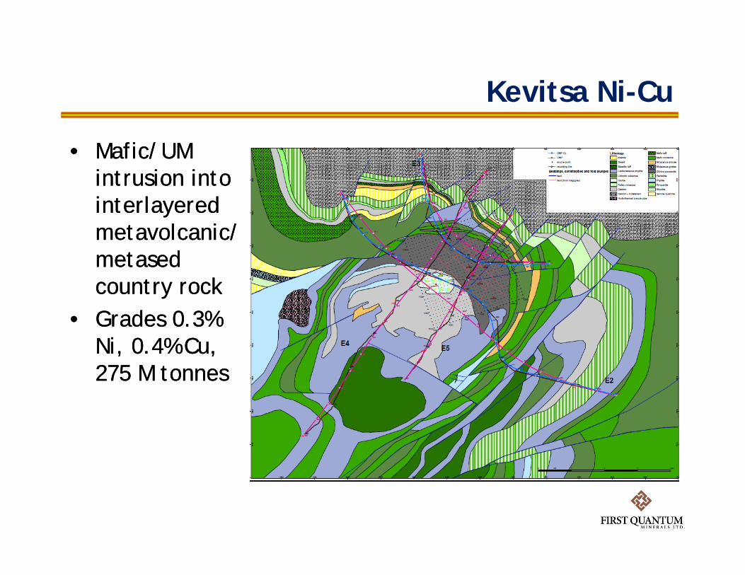
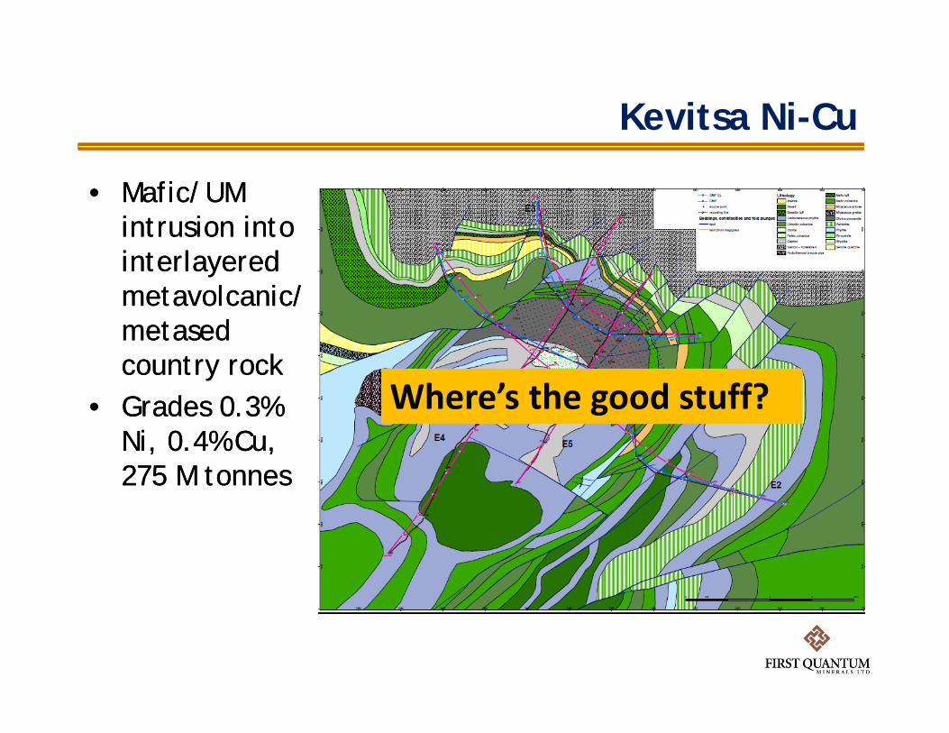
Kevitsa Ni-Cu
• Mafic/UM intrusion into interlayered metavolcanic/metased country rock
• Grades 0.3% Ni, 0.4% Cu, 275 M tonnes
• Mafic/UM intrusion into interlayered metavolcanic/metased country rock
• Grades 0.3% Ni, 0.4% Cu, 275 M tonnes
Kevitsa Ni-Cu
• Mafic/UM intrusion into interlayered metavolcanic/metased country rock
• Grades 0.3% Ni, 0.4% Cu, 275 M tonnes
• Mafic/UM intrusion into interlayered metavolcanic/metased country rock
• Grades 0.3% Ni, 0.4% Cu, 275 M tonnes
Where’s the good stuff?

• Base of intrusion interpretation to constrain exploration for contact style ore
• Base of intrusion interpretation to constrain exploration for contact style ore
Base of intrusion
Defining base of intrusion
Base of intrusion
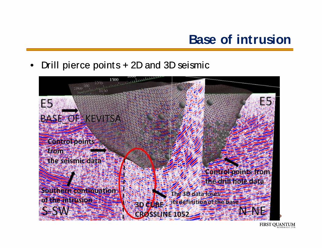
Base of intrusion
• Drill pierce points + 2D and 3D seismic• Drill pierce points + 2D and 3D seismic

Extension of intrusion?

Extension of intrusion?
• Deep drill hole 1.7 km• Deep drill hole 1.7 km

Gravity and magnetics
Magnetics (RTP)
Gravity (Bouguer)

Sediment-hosted Cu
• African Copperbelt = Lufilian Arc• African Copperbelt = Lufilian Arc

Copperbelt deposit settings
• Schematic stratigraphy, fluid/metal sources, and traps• Schematic stratigraphy, fluid/metal sources, and traps
Hitzman et al, 2010
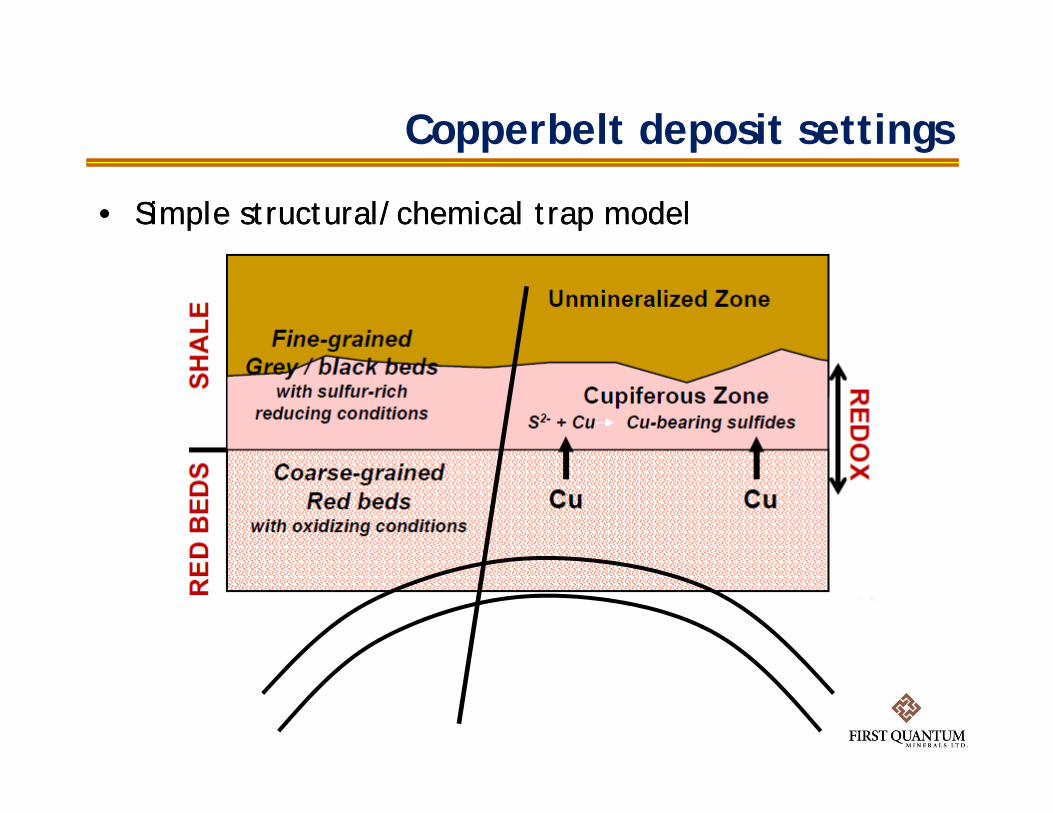
Copperbelt deposit settings
• Simple structural/chemical trap model• Simple structural/chemical trap model

Copperbelt deposit settings - ores
• predominantly in clastic (less commonly carbonate) sediments; (1) large tonnage deposits in dark shales and carbonates above thick red bed sequence
• predominantly in clastic (less commonly carbonate) sediments; (1) large tonnage deposits in dark shales and carbonates above thick red bed sequence
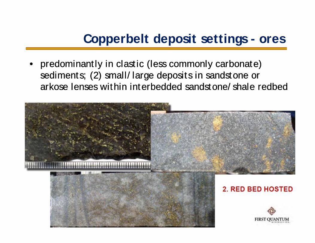
Copperbelt deposit settings - ores
• predominantly in clastic (less commonly carbonate) sediments; (2) small/large deposits in sandstone or arkose lenses within interbedded sandstone/shale redbed
• predominantly in clastic (less commonly carbonate) sediments; (2) small/large deposits in sandstone or arkose lenses within interbedded sandstone/shale redbed
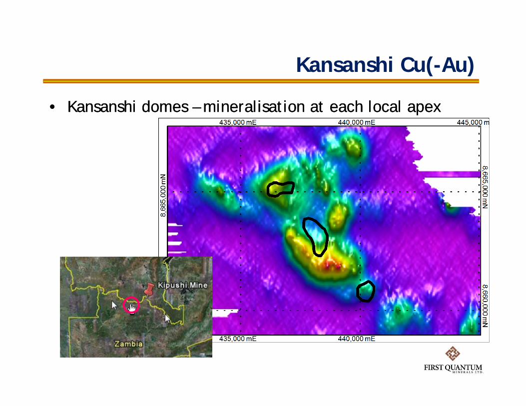
Kansanshi Cu(-Au)
• Kansanshi domes – mineralisation at each local apex• Kansanshi domes – mineralisation at each local apex

Kansanshi Cu(-Au)
• Kansanshi domes – mineralisation at each local apex• Kansanshi domes – mineralisation at each local apex
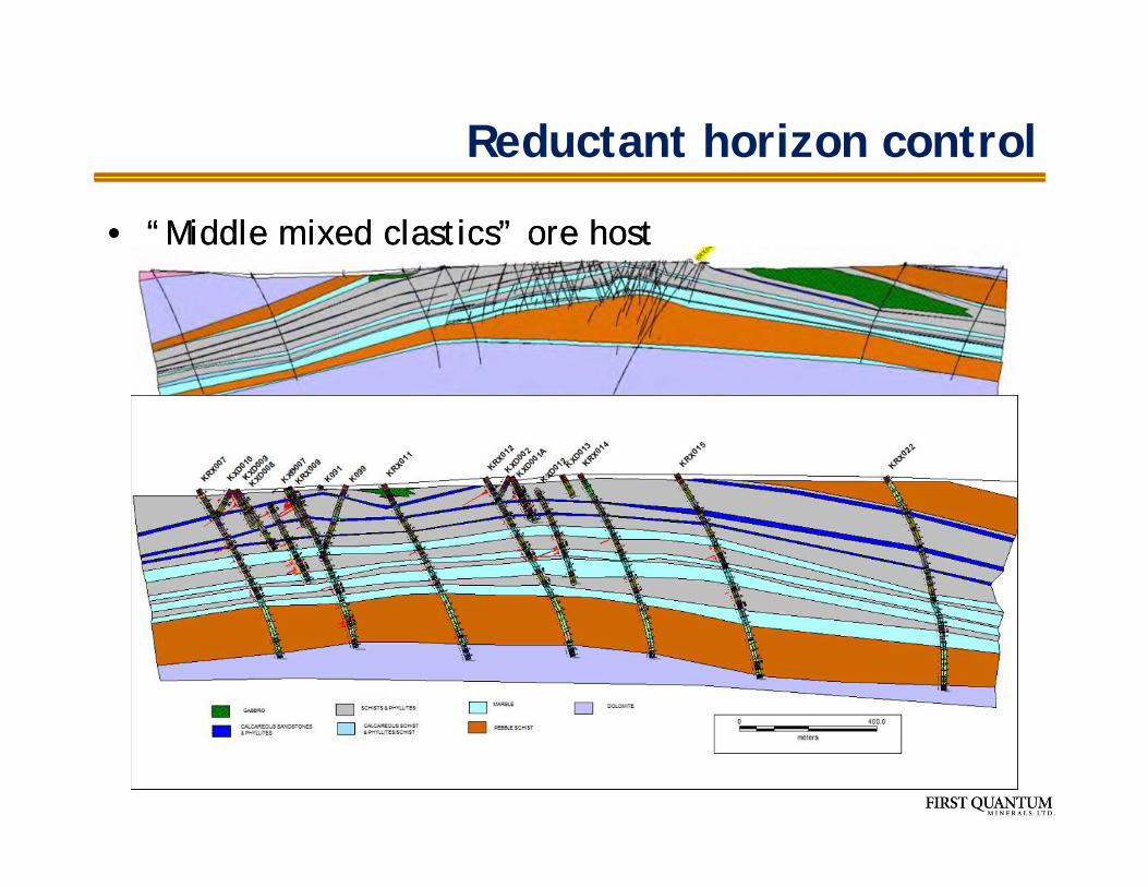
Reductant horizon control
• “Middle mixed clastics” ore host• “Middle mixed clastics” ore host
Drilling result
• Nil• Nil

Mapping basement domes with AMT
• AMT conductivity, 16 – 8192 Hz, 1+ km depth resolution
• Control line mappingbasement in the west,dominated by Mwashiashale to east
• AMT conductivity, 16 – 8192 Hz, 1+ km depth resolution
• Control line mappingbasement in the west,dominated by Mwashiashale to east
50 0 50 100 150 200 250
metres
Scale 1:5000
First Quantum Minerals ltdAMT Resistivity SectionLine 3 West of Frontier
Boreholes Overlaid
GRS
121252284301316325336344354369391419455506572677822994
117313471501163817831942
Resistivityohm.m
100 m
FTRC021
100 m
200
FTRC042
100 m
200
FTRC044
100 m
FTRC045
500
750
1000
1250
500750
10001250
658000 658250 658500
658000 658250 658500

Mapping basement domes with AMT
• AMT conductivity, 16 – 8192 Hz, 1+ km depth resolution• AMT conductivity, 16 – 8192 Hz, 1+ km depth resolution
100 0 100 200 300 400 500 600 700
metres
Scale 1:10000-145 -2 4 11 18 30 45 62 78100 155 249 443 822 1827 5441
Resistivityohm.m
100 m
200
FD004
100 m
200
300
FD005
100 m
200
300
400
FD019 FD020
100 m
200
FD085
100 m
200
FD086FD087FD089
100 m
FTCC032
100 m
200
FTRC041
100 m
FTRC075
100 m
FTRC076
100 m
FTRC077
100 m
FTRC078
100 m
FTRC083
100 m
FTRC084FTRC090
100 m
FTRC093FTRC094FTRC096
100 m
FTRC108
100 m
FTRC109
100 m
FTRC110
100 m
FTRC111
FTRC112
100 m
FTRC113
100 m
FTRC114
100 m
LRC063
100 m
LRC066
100 m
200
LRC125
250
500
750
1000
1250
250500
7501000
1250
658750 659000 659250 659500 659750 660000 660250 660500 660750 661000 661250 661500 661750 662000 662250
658750 659000 659250 659500 659750 660000 660250 660500 660750 661000 661250 661500 661750 662000 662250
Mwashia shale
Mwashia shale
Basement?Basement?

Mapping basement domes with AMT
• Long regional lines < 40 km for detection of hidden basement domes
• Long regional lines < 40 km for detection of hidden basement domes
10000 11000 12000 13000 14000 15000 16000 17000 18000 19000 20000 21000 22000 23000 24000 25000 26000 27000 28000 29000 30000 31000 32000 33000 34000 35000 36000 37000 38000 39000 40000 41000
10000 11000 12000 13000 14000 15000 16000 17000 18000 19000 20000 21000 22000 23000 24000 25000 26000 27000 28000 29000 30000 31000 32000 33000 34000
Depth extent 1.4 km

Conclusions
• For First Quantum, deep drilling is about geology and not metal– improving stratigraphic and structural understanding to help
shallow targeting
• Seeing deep is a fight against physics– seismic = $$ vs objectives– geologically constrained inversions of various data sets
• Explorability depends on deposit style– Drill deep for hydrothermal systems with huge alteration
footprints– NiS cannot afford exploration by deep drilling
End
• What is “under cover”?• Do we need to look deep?• What is “under cover”?• Do we need to look deep?

Pyhasalmi
• 2012 production: 12,600 t Cu, 25,600 t Zn, 891,700 Py• home of the worlds deepest sauna at 1440 metres• 2012 production: 12,600 t Cu, 25,600 t Zn, 891,700 Py• home of the worlds deepest sauna at 1440 metres


![employee.gsi.gov.in1] INDEX Assi Assistant Engineer Gr. I Laboratory Assist.(Geophysicist) Gr.I Laboratory Assist.(Geophysicist)Gr.II 4 CHEMISTRY 4 TRANSPORT Driver Special Grade Driver](https://cdn.vdocuments.mx/doc/165x107/5af945fe7f8b9a44658d7c9d/1-index-assi-assistant-engineer-gr-i-laboratory-assistgeophysicist-gri-laboratory.jpg)