
Groundwater Sustainability Infrastructure Index (GSII): a measure of sustainability
in groundwater management
Project Inception Workshop
in groundwater management
Project Inception WorkshopComparative research of groundwater management in the coastal
areas in Southeast Asia
UNESCO-IHE Institute for Water Education, Delft, The Netherlands3-7 December, 2012
1Dr Sangam Shrestha and 2Dr Vishnu Pandey1Dr. Sangam Shrestha and 2Dr. Vishnu Pandey1Asst. Professor, Asian Institute of Technology (AIT), Thailand
2Researcher, University of Yamanashi, Japan
Presentation Outline
1 Context1. Context
2. Issues
3. Objectives
4. Study area
5. Conceptual framework
6. Results and discussion
7. Summary and conclusions

1. Context
Groundwater: a major source of water supply in many cities
Extraction > Recharge water level (↓) well yield (↓) land subsidence water level (↓), well yield (↓), land subsidence,
salinity intrusions, etc.
Sustainable groundwater management?
One of the strategies Strengthening “GW sustainability infrastructures”
2. Issues
What does “GW sustainability infrastructures” ymean?
• need a definition/scopeneed a definition/scope
Sustainability is a perspective how to Sustainability is a perspective, how to quantify?
• need a generic framework and INDEX
Sustainability refer to time, long-term commitment, how to evaluate?commitment, how to evaluate?
• calculation of index over space and time scale

3. Objectives
to develop a conceptual framework for evaluating
j
to develop a conceptual framework for evaluating ‘groundwater sustainability infrastructures’
to illustrate the framework with a case study in Kathmandu Valley, Nepal
China4. Study Area (1)Bhutan
B l d h
NEPAL
y ( )
India
Bangladesh
Watershed area: 664km2
(GW basin: 327km2)
Srilanka
( )
Rainfall ~1755mm/yr, Tmax/Tmin=29.1°C/2.2°C
Underground: Shallow aquifer, Aquitard, Deep aquifer
Population (2011 estimate): Population (2011 estimate): ~2.5*106, 84.3% in urban areas
Recharge is only 44.5% of GWRecharge is only 44.5% of GW extraction and 6.4% of rainfall amount within rechargeable areas

4. Study area (2)
Management Intervention??
Fig Stages of groundwater development in Kathmandu ValleyFig . Stages of groundwater development in Kathmandu Valley aquifer and corresponding impacts
5. Conceptual framework (1)p ( )
Indicator-based Conceptual FrameworkIndicator based Conceptual Framework• Index (1), components (5), indicators (15)
Calculates • ‘Groundwater Sustainability Infrastructure Index”• Groundwater Sustainability Infrastructure Index
The infrastructures refer to: The infrastructures refer to:
• Knowledge practice and institutional responsibility;• Knowledge, practice, and institutional responsibility; whose adequate strengthening may help to achieve sustainability in groundwater management.

Fig. Five dimensions of sustainability and groundwatersustainability infrastructures.
5. Conceptual framework (2)p ( )Index Component
1. Groundwater
ilit
y S
II)
monitoring (GwM)
tain
abi
dex
(G
S
2. Knowledge generation and dissemination (KgD)
er S
ust
ure
In
d ( g )
3. Groundwater
4 Publicnd
wat
est
ruct
u 3. Groundwater management plans/ programmes (GmP)4. Public participation (PuP)
5. Institutional Gro
un
Infr
as
responsibility (InR)
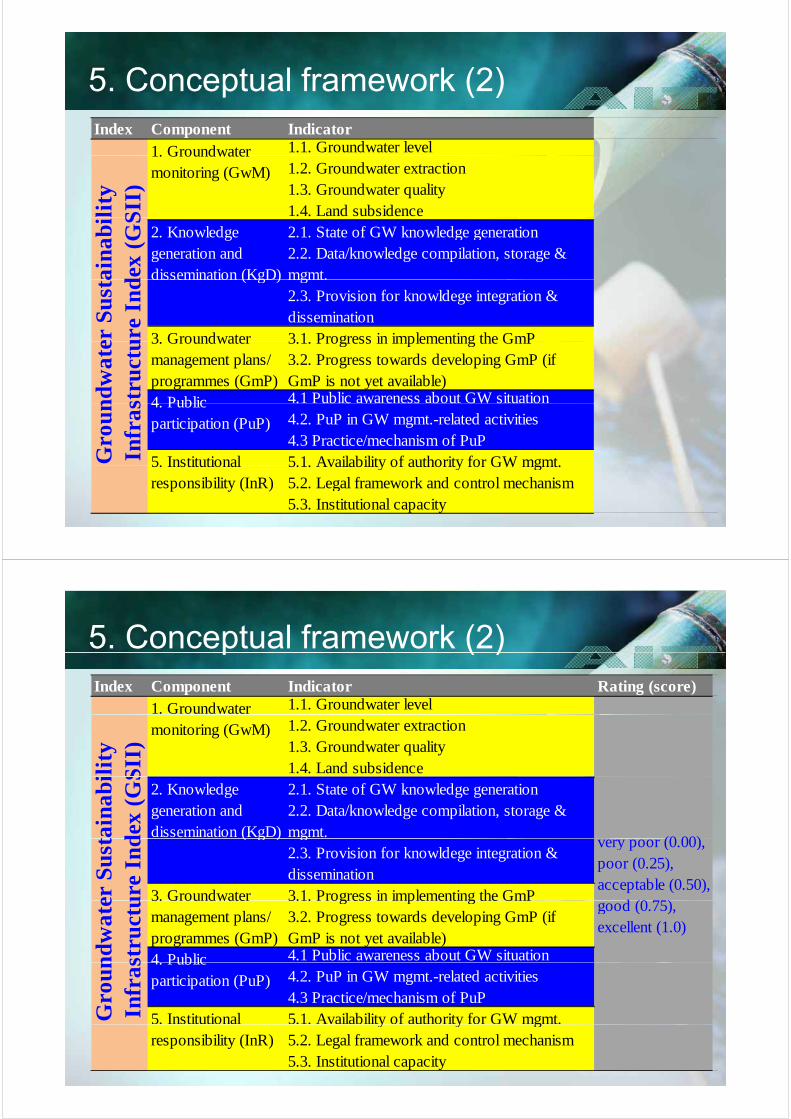
5. Conceptual framework (2)p ( )Index Component Indicator
1.1. Groundwater level1. Groundwater1.2. Groundwater extraction1.3. Groundwater quality1.4. Land subsidenceli
ty
SII
)1. Groundwater monitoring (GwM)
2.1. State of GW knowledge generation 2.2. Data/knowledge compilation, storage & mgmt.ai
nab
id
ex (
GS
2. Knowledge generation and dissemination (KgD) mgmt.
2.3. Provision for knowldege integration & dissemination3 1 Progress in implementing the GmPer
Su
sta
ure
In
d dissemination (KgD)
3 Groundwater 3.1. Progress in implementing the GmP3.2. Progress towards developing GmP (if GmP is not yet available)4.1 Public awareness about GW situation4 Publicn
dw
ate
stru
ctu 3. Groundwater
management plans/ programmes (GmP)
. ub c w e ess bou GW s u o4.2. PuP in GW mgmt.-related activities4.3 Practice/mechanism of PuP5 1 Availability of authority for GW mgmt
4. Public participation (PuP)
5 InstitutionalGro
un
Infr
as
5.1. Availability of authority for GW mgmt.5.2. Legal framework and control mechanism5.3. Institutional capacity
5. Institutional responsibility (InR)
5. Conceptual framework (2)p ( )Index Component Indicator Rating (score)
1.1. Groundwater level1. Groundwater 1.2. Groundwater extraction1.3. Groundwater quality1.4. Land subsidenceil
ity
SII
)
monitoring (GwM)
2.1. State of GW knowledge generation 2.2. Data/knowledge compilation, storage & mgmt.
(0 00)tain
abi
dex
(G
S
2. Knowledge generation and dissemination (KgD) g
2.3. Provision for knowldege integration & dissemination3.1. Progress in implementing the GmP
very poor (0.00), poor (0.25), acceptable (0.50),
d (0 75)er S
ust
ure
In
d ( g )
3. Groundwater 3.1. Progress in implementing the GmP3.2. Progress towards developing GmP (if GmP is not yet available)4.1 Public awareness about GW situation
good (0.75), excellent (1.0)
4 Publicnd
wat
est
ruct
u 3. Groundwater management plans/ programmes (GmP)
4.2. PuP in GW mgmt.-related activities4.3 Practice/mechanism of PuP5.1. Availability of authority for GW mgmt.
4. Public participation (PuP)
5. Institutional Gro
un
Infr
as
y y g5.2. Legal framework and control mechanism5.3. Institutional capacity
responsibility (InR)

5 Conceptual framework (3)5. Conceptual framework (3)Index Component Indicator Description Rating (score)
1.1. Groundwater level1.2. Groundwater extraction
1. Groundwater monitoring
The strenght of this component is reflected by availability of monitoring networks, their
Very poor (0.00), poor (0.25), acceptable (0.50), good (0.75),
1.3. Groundwater quality1.4. Land subsidence
2.1. State of knowledge generation (Geometry and hydrogeologic characteristics of hydrogeologic re
inde
x
g(GwM)
y y gspatial and temporal coverage, governments' commitment and continuous funding for monitoring activities
p ( ) g ( )excellent (1.0)
2. Knowledge generation and
The strength of this component is reflected by the level of knowledge generation about
Very poor (0.00), poor (0.25), acceptable (0.50), good (0.75),
units, recharge characteristics and amount, continuously updated groundwater model, current status of groundwater environment, future status of groundwater environment, etc)2.2. Data and knowledge compilation, storage and ra
stru
ctur
generation and dissemination (KgD)
by the level of knowledge generation about current and future status of groundwater environment; and their collection, integration, management, and dissemination aspects
acceptable (0.50), good (0.75), excellent (1.0)
g p , gmanagement (groundwater extraction, level, quality, well statistics; land subsidence, hydrogeology, current and future status of groundwater environment etc.)2.3. Provision for knowldege integration and ab
ilit
y in
fr
g gdissemination3.1. Availability and degree of implementation of plans/programmes 3.2. Progress towards developing management plans (if the plan is not yet developed)er
sus
tain
a
3. Groundwater management plans/programmes (GmP)
The strength of this component is reflected progress in implementation of plans (if plan is available) and by evaluation of ongoing attempts to develop such plans (if plans are
Very poor (0.00), poor (0.25), acceptable (0.50), good (0.75), excellent (1.0)
plans (if the plan is not yet developed)
4.1 Public awareness about groundwater situation4.2. Public participation in groundwater management-related activities4 3 Practice/mechanism of public praticipation
4. Public participation (PuP)
The strength of this component is reflected by awareness, participation interest, practice and mechanism of public participation in groundwater management activities
Very poor (0.00), poor (0.25), acceptable (0.50), good (0.75), excellent (1.0)
roun
dwat
e (GmP) attempts to develop such plans (if plans are not yet available)
4.3 Practice/mechanism of public praticipation5.1. Authority for groundwater management5.2. Legal framework and control mechanism5.3. Institutional capacity
groundwater management activities5. Institutional responsibility (InR)
The strength is reflected by availability of separate authority, legal framework and control mechanism, and institutional capacity in groundwater management
Very poor (0.00), poor (0.25), acceptable (0.50), good (0.75), excellent (1.0)
Gr
5 Conceptual framework (4)5. Conceptual framework (4)
Indicator selectionIndicator selection
Computation of indicator values and normalization : through a qualitative expert rating approach during the groundwater expert meeting (4– 5 July, 2010) in Kathmandu, Nepal. The situation of each indicator in terms of achievement of groundwater sustainability was classified into four classes in a scale of 0– 1: very poor (0.00), poor (0.25), acceptable (0.50), good (0.75) and excellent (1.0).

5 Conceptual framework (4)5. Conceptual framework (4)
WeightingWeighting
As primary objective of this paper was to introduce the framework, equal weights were assigned to the indicators of each components and components of the GSII.
Aggregation Aggregation
6. Results and discussion (1)6. Results and discussion (1)
Name Score Name ScoreIndexS.N.
Indicator Component
1.1 Groundwater level 0.501.2 Groundwater extraction 0.251.3 Groundwater quality 0.25
Groundwater monitoring (GwM)
0.25
1.4 Land subsidence 0.00
Continuous record (WL & quality) f 1999from 1999,
50 monitoring wells BUT spatial & temporal coverage,
poor data quality, inadequacy in storage and dissemination, frequency of missing-data????q y g
GW extraction: exact no. are unknown, partial data of 1999/2000 only no continuous1999/2000 only, no continuous monitoring
Land subsidence: no monitoring

6 Results and discussion (1)6. Results and discussion (1)
K l d /I f ti S
Current state of knowledge generationKnowledge/Information SourceGeometry of hydrogeologic units Metcalf & Eddy (2000); this study Hydrogeology (Hydraulic conductivity/Transmissivity, storage coefficient, groundwater
Binnie & Partners (1973; 1988); JICA (1990); Metcalf & Eddy (2000); KC (2003); this study.
2.1 State of GW knowledge generation 0.752.2 Data/knowledge compilation, storage & 0.25
Knowledge generation and
storage coefficient, groundwater storage volume) Groundwater extraction database Metcalf & Eddy (2000), Acres International (2004). Groundwater levels GWRDP/DoI, Kathmandu, Nepal. Water quality JICA, 1990; Khadka, 1993; Jha et al., 1997; Kharel et al., 1998; g p g
management2.3 Provision for knowldege integration and
dissemination0.00
0 24
Knowledge generation and dissemination (KgD)
0.33ENPHO, 1999; Karmacharya and Pariyar, 1999; Metcalf & Eddy, 2000; Khatiwada et al., 2002; Acres International, 2004; ENPHO, 2005; Gurung et al., 2007; Chapagain et al., 2009a;b; etc.
Recharge to aquifer Binnie & Partners (1988) JICA (1990) Gautam & Rao (1991)Recharge to aquifer Binnie & Partners (1988), JICA (1990), Gautam & Rao (1991). Current status of groundwater environment (Drivers, Pressures, State, Impacts, and Responses)
This study.
Groundwater model JICA (1990); Acres International (2004). But continuously ( ); ( ) yupdated groundwater model is not available
Vulnerability of shallow aquifer to pollution
Pathak et al. (2009)
Surface & groundwater interaction - F t t t f d t d St d b P d t lFuture status of groundwater under climatic and non-climatic change
Study on progress by Pandey et al.
GIS data: surface topography, land cover, river networks etc.
NGIIP 2004.
6. Results and discussion (1)( )
3 1 Progress in implementation of GmP 0 000.24
3.1 Progress in implementation of GmP 0.003.2 Progress towards developing GmP (if GmP
is not yet available)0.25
Groundwater management plans/programmes (GmP)
0.13
No such plans are available, BUT progress towards developing groundwater management plans/programmes isdeveloping groundwater management plans/programmes is underway…
6. Results and discussion (1)( )
Public are aware about problems related to GW depletion; but not aware about which area is better for GW
/d l t?use/development?
Some NGOs has started stakeholders’ meetingsSome NGOs has started stakeholders meetings, awareness raising programs (through students) etc; but are in initial stage and needs institutional leadership!
4 1 Public awareness about GW situation 0 504.1 Public awareness about GW situation 0.504.2 PuP in GW mgmt.-related activities 0.254.3 Practice/mechanism of PuP 0.00
Public participation (PuP) 0.25
6. Results and discussion (1)6. Results and discussion (1)
Existing institutional arrangementExisting institutional arrangement
Government Agency Groundwater related tasks Ministry of Water Resources (MoWR)/Dep. of Irrigation
Irrigation •Groundwater Resources Development Board (GWRDB) •Groundwater Resources Development Project (GWRDP)
–Oversees policy related to groundwater irrigation –Implementing body of GWRDB
(GWRDP) Ministry of Physical Planning & Works (MoPPW) •Nepal Water Supply Corporation (NWSC)
–Drinking water supply (surface & groundwater) in urban centers.
•Department of Water Supply & Sewerage (DWSS)
g )–Drinking water supply (surface & groundwater) in areas outside the coverage of NWSC.
Ministry of Industry & Commerce (MoIC)
5 1 A il bilit f A th it f GW t 0 50
Ministry of Industry & Commerce (MoIC)•Department of Geology & Mines (DoGM)
–Geological survey and databases
Ministry of Population & Environment (MoPE) –Groundwater quality protection Ministry of Science & Technology (MoST) D f H d l & M l (DHM)
C ll i & f li d5.1 Availability of Authority for GW mgmt. 0.50
5.2 Legal framework and control mechanism 0.005.3 Institutional capacity 0.25
Institutional responsibility (InR)
0.25•Department of Hydrology & Meteorology (DHM) –Collection & storage of climate data Water & Energy Commission Secretariat (WECS) Apex body for water resources policy &
planning

6. Results and discussion (1)6. Results and discussion (1)
Name Score Name ScoreIndexS.N.
Indicator Component
1.1 Groundwater level 0.501.2 Groundwater extraction 0.251.3 Groundwater quality 0.25
Groundwater monitoring (GwM)
0.25q y
1.4 Land subsidence 0.002.1 State of GW knowledge generation 0.752.2 Data/knowledge compilation, storage & 0.25
( )
Knowledge generation andg p g
management2.3 Provision for knowldege integration and
dissemination0.00
0 24
Knowledge generation and dissemination (KgD)
0.33
3.1 Progress in implementation of GmP 0.003.2 Progress towards developing GmP (if GmP
is not yet available)0.25
0.24Groundwater management plans/programmes (GmP)
0.13
4.1 Public awareness about GW situation 0.504.2 PuP in GW mgmt.-related activities 0.254.3 Practice/mechanism of PuP 0.00
Public participation (PuP) 0.25
5.1 Availability of Authority for GW mgmt. 0.505.2 Legal framework and control mechanism 0.005.3 Institutional capacity 0.25
Institutional responsibility (InR)
0.25
Fig. The GSII parameter values in Kathmandu Valley

7. Summary and conclusions (1)7. Summary and conclusions (1)
Developed an index- GSII -as a tool to measure GW sustainability.
Evaluation of state of ‘groundwater sustainability infrastructures’ in Kathmandu Valley shows: Situation of the infrastructures is relatively poor
Coverage of monitoring is inadequate and data quality, t d di i ti t i tistorage and dissemination aspects are poor in practice
Aquifers are being mined faster than being recharged, no GW mgmt plans and stakeholders’ participationGW mgmt. plans, and stakeholders participation
Knowledge generation is relatively good, albeit, highly scattered, non-coordinated and inaccessible from a single window (e.g., office or library or information center)
7. Summary and conclusions (2)y ( )
overall GSI is relatively poor (GSI index =0.24). On a l ti l th it ti f k l d ti irelative scale, the situation of knowledge generation is
better (score =0.33) and that of GW mgmt. plans is the worst (score =0 13) Adequate attentions are required toworst (score =0.13). Adequate attentions are required to boost the GSI and subsequently achieve the goal of sustainable GW mgmt. g
Recommendations
to assume institutional responsibility in GW mgmt., to facilitate access to available knowledgebase, to encourage participation of CBOs or local government bodies (wards) to prepare and update inventory of wells, water levels and extractionwater levels and extraction


