FAUNA AND HABITAT SPECIALISTS
Gladstone LNG Plant and Pipeline Curtis Island
Curtis Island Water Mouse,
Powerful Owl and Wading Bird Investigations
Report prepared for
URS Australia

BAAM Pty Ltd File No: 0154-004 Version 0
Document Control Sheet
File Number: 0154-004
Project Manager: Adrian Caneris
Client: URS Australia
Project Title: Curtis Island Water Mouse, Powerful Owl and Wading Bird Investigations
Project Author/s: Brett Taylor and Adrian Caneris
Project Summary: To investigate the potential occurrence of Water Mouse, Powerful Owl and wader/shorebird species on the south-western extent of Curtis Island in relation to the proposed Gladstone LNG Plant and pipeline.
Draft Preparation History Draft No. Date draft
completed Reviewed by Issued by
015-004 Draft A 08/01/09 Jedd Appleton Brett Taylor
Revision/ Checking History TrackVersion Date of Issue Checked by Issued by 015-004 Version 0 21/01/09 Terry Reis Paulette Jones
Document Distribution Destination Revision 1 Date
Dispatched 2 Date
Dispatched 3 Date
Dispatched Client Copy 1 -
digitalA 08/01/09 0 21/01/09
Client Copy 1 - hard copy
0 21/01/09
PDF - server A 08/01/09 0 21/01/09 PDF – backup –
archivedDisk/tape
A 08/01/09 0 21/01/09
Hard Copy -library 0 21/01/09

BAAM Pty Ltd File No: 0154-004 Version 0
NOTICE TO USERS OF THIS REPORT
Copyright and reproduction
This report and all indexes, schedules, annexures or appendices are subject to copyright pursuant to the Copyright Act 1968 (Cth). Subject to statutory defences, no party may reproduce, publish, adapt or communicate to the public, in whole or in part, the content of this report without the express written consent of Biodiversity Assessment and Management Pty Ltd.
Purpose of Report
Biodiversity Assessment and Management Pty Ltd has produced this report in its capacity as {consultants} for and on the request of URS Australia (the "Client") for the sole purpose of assessing the presence and habitat values for Water Mouse, Powerful Owl and wader/shorebirds on the site of the proposed Gladstone LNG plant and pipeline (the "Specified Purpose"). This information and any recommendations in this report are particular to the Specified Purpose and are based on facts, matters and circumstances particular to the subject matter of the report and the Specified Purpose at the time of production. This report is not to be used, nor is it suitable, for any purpose other than the Specified Purpose. Biodiversity Assessment and Management Pty Ltd disclaims all liability for any loss and/or damage whatsoever arising either directly or indirectly as a result of any application, use or reliance upon the report for any purpose other than the Specified Purpose.
This report has been produced solely for the benefit of the Client. Biodiversity Assessment and Management Pty Ltd does not accept that a duty of care is owed to any party other than the Client. This report is not to be used by any third party other than as authorised in writing by Biodiversity Assessment and Management Pty Ltd and any such use shall continue to be limited to the Specified Purpose. Further, Biodiversity Assessment and Management Pty Ltd does not make any warranty, express or implied, or assume any legal liability or responsibility for any third party's use in whole or in part of the report or application or use of any other information or process disclosed in this report and to the full extent allowed by law excludes liability in contract, tort or otherwise, for any loss or damage sustained by any person or body corporate arising from or in connection with the supply or use of the whole part of the report through any cause whatsoever.
Biodiversity Assessment and Management Pty Ltd has used information provided to it by the Client and governmental registers, databases, departments and agencies in the preparation of this report. Biodiversity Assessment and Management Pty Ltd does not know, nor does it have any reason to suspect, that the information provided to it was false, inaccurate, incomplete or misleading at the time of its receipt. This report is supplied on the basis that while Biodiversity Assessment and Management Pty Ltd believes all the information in it is deemed reliable at the time of publication, it does not warrant its accuracy or completeness and to the full extent allowed by law excludes liability in contract, tort or otherwise, for any loss or damage sustained by any person or body corporate arising from or in connection with the supply or use of the whole or any part of the information in this report through any cause whatsoever.
Signed on behalf of Date: 21/01/09
Biodiversity Assessment and Management Pty Ltd
Managing Director

BAAM Pty Ltd Page i File No: 0154-004 Version 0
Curtis Island Water Mouse, Powerful Owl and Wading Bird Investigations
Gladstone LNG Plant and Pipeline, Curtis Island
Table of Contents 1.0 INTRODUCTION.....................................................................................................................1
2.0 STUDY AREA DESCRIPTION ...............................................................................................1 2.1 LOCATION.............................................................................................................................1 2.2 LAND USE AND TERRESTRIAL FEATURES ................................................................................1 2.3 PROPOSED ACTIVITIES ..........................................................................................................1
3.0 ECOLOGICAL PLANNING FRAMEWORK............................................................................3 3.1 COMMONWEALTH ENVIRONMENT PROTECTION AND BIODIVERSITY CONSERVATION ACT 1999...3 3.2 QUEENSLAND NATURE CONSERVATION ACT 1992 ..................................................................3 3.3 QUEENSLAND VEGETATION MANAGEMENT ACT 1999..............................................................3 3.4 QUEENSLAND LANDS PROTECTION (PEST AND STOCK ROUTE MANAGEMENT) ACT 2002 ..........4 3.5 QUEENSLAND COASTAL PROTECTION AND MANAGEMENT ACT 1995........................................4 3.6 QUEENSLAND FISHERIES ACT 1994 .......................................................................................4 3.7 BIODIVERSITY PLANNING ASSESSMENT ..................................................................................5
4.0 STUDY METHODOLOGY.......................................................................................................5 4.1 DESK TOP ............................................................................................................................5 4.2 FIELD SURVEY ......................................................................................................................5
4.2.1 Survey Effort and Site Selection......................................................................................5 4.2.2 Survey Techniques .........................................................................................................6
5.0 RESULTS AND RECOMMENDATIONS ................................................................................6 5.1 ESSENTIAL HABITAT MAPPING ...............................................................................................6 5.2 TARGET SPECIES ..................................................................................................................7
5.2.1 Water Mouse Xeromys myoides .....................................................................................7 5.2.2 Powerful Owl Ninox strenua..........................................................................................14 5.2.3 Wader and Shorebird Species ......................................................................................15
6.0 BIBLIOGRAPHY...................................................................................................................18
List of Figures
Figure 2.1 Study Area Locality
Figure 5.1 Water Mouse Habitat Assessment Sites – Curtis Island
List of Appendices
Appendix 1 Terrestrial Vertebrate Species List
Appendix 2 Essential Habitat Mapping

Curtis Island Water Mouse, Powerful Owl and Wading Bird Investigations Gladstone LNG Plant and Pipeline, Curtis Island for URS Australia
BAAM Pty Ltd Page ii File No: 0154-004 Version 0
List of Abbreviations
BAAM - Biodiversity Assessment and Management Pty Ltd BPA - Biodiversity Planning Assessment DEWHA - Commonwealth Department of Environment, Water, Heritage and the Arts DPIF - Queensland Department of Primary Industries and Fisheries EPA - Queensland Environmental Protection Agency EPBC Act - Commonwealth Environment Protection and Biodiversity Conservation Act 1999EVR - Endangered, Vulnerable or Rare IPA Queensland Integrated Planning Act 1997 LP Act - Queensland Lands Protection (Pest and Stock Route Management) Act 2002 NC Act - Queensland Nature Conservation Act 1992NRW - Queensland Department of Natural Resources and Water RE - Regional Ecosystem SEQ - South-east Queensland VM Act - Queensland Vegetation Management Act 1999

Curtis Island Water Mouse, Powerful Owl and Wading Bird Investigations Gladstone LNG Plant and Pipeline, Curtis Island for URS Australia
BAAM Pty Ltd Page 1 File No: 0154-004 Version 0
1.0 INTRODUCTION
This report has been prepared for URS Australia for the purpose of providing an independent, targeted assessment of the potential occurrence of, and habitat values for, Powerful Owl Ninox strenua, Water Mouse Xeromys myoides and migratory wading birds of properties located on the south-west portion of Curtis Island.
It is understood that the assessment is to focus on all suitable coastal habitats within the study area for Water Mouse and wading birds, while assessment of Powerful Owl habitat values will focus on the area of the proposed construction of a 100 m pipeline easement.
The specific aims of the assessments are to provide:
� An evaluation and comment on the presence or absence of Water Mouse, Powerful Owl and migratory wader species within the study area and the implications of such for the proposed development;
� An assessment and comment onsignificant terrestrial faunal habitats suitable for Water Mouse, Powerful Owl and wading bird species within the study area and the implications of such for the proposed development; and
� Identification of potential impacts on Water Mouse, Powerful Owl and wading bird species and associated habitat, and recommendations for impact mitigation and management, including the need for further, more detailed assessments.
Nomenclature used in this report follows Clayton et al. (2006).
All following observations and recommendations are based on a review of available literature and site investigations undertaken by Adrian Caneris and Brett Taylor on 15 to 17 December 2008 (inclusive).
2.0 STUDY AREA DESCRIPTION
2.1 LOCATION
The study area is situated on Curtis Island, located adjacent to the coast 5 km to the north
of Gladstone. The study area is centred on the south-western portion of the island (Figure2.1) and comprises approximately 14 km2 of freehold land contained in Lots 11DS220, 27DS220, 10DS220, 28DS220, 7DS220 (Mark J. Graving, Ross W. Graving and Colin G. Graving); 9DS220 (Santos P/L); 2RP602284 (Central Queensland Ports Authority); and 1RP602284 (Kemsip P/L).
2.2 LAND USE AND TERRESTRIAL FEATURES
The vegetation in the study area is dominated by older regrowth, having been cleared in the past. Open eucalypt forest dominates the study area with marine plains and mangrove communities along much of the shoreline. The site is situated on undulating land rising from sea level to a maximum of approximately 140 m elevation in the eastern extent of the study area. A number of ephemeral creeks/gullies drain the site, generally flowing west. The few man-made structures on the site are restricted to grazing infrastructure. The study area is bordered to the north by Graham Creek, a wide estuarine creek, and to the east by a low range. The south-west shoreline of the island borders the remainder of the study area.
Current landuse in the study area is restricted to low intensity cattle grazing. Much of the island north of Graham Creek is contained in conservation reserves. The Garden Island Conservation Park lies east of the southern tip of the study area. The closest settlement is South End, located on the south-east tip of the island.
2.3 PROPOSED ACTIVITIES
The proposed activities will involve the construction of a Liquefied Natural Gas (LNG) plant on the southern portion of the study area. A gas pipeline and road including a 100 m cleared corridor will extend approximately 8.2 km from Laird Point in the north-west to the site of the LNG plant in the south of the study area.
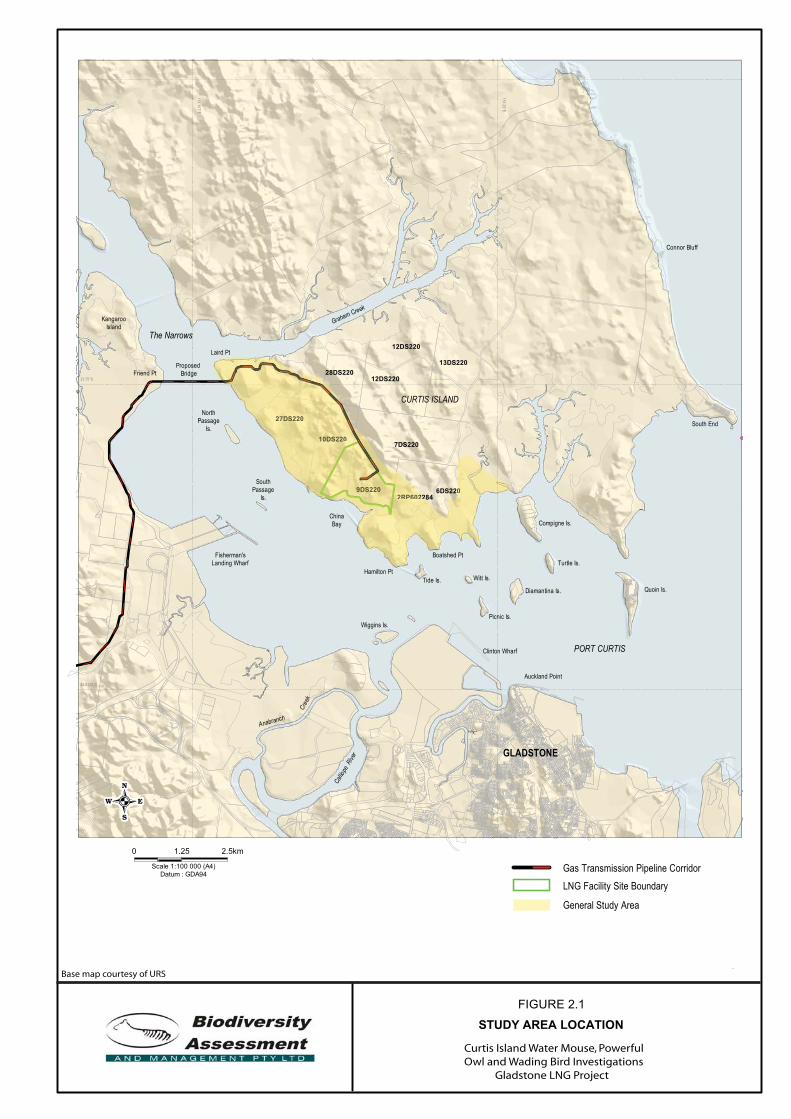
FIGURE 2.1
STUDY AREA LOCATION
Proposed Bridge
Wiggins Is.
Friend Pt
KangarooIsland
The Narrows
Anabranch
Cree
k
SouthPassage
Is.
Fisherman'sLanding Wharf
NorthPassage
Is.
Laird Pt
Turtle Is.Boatshed Pt
Clinton Wharf
Hamilton PtTide Is.
Picnic Is.
Witt Is.
Diamantina Is.
Call io
peRiv
er GLADSTONE
PORT CURTIS
CURTIS ISLAND
Auckland Point
Graham Creek
Compigne Is.
South End
Quoin Is.
Connor Bluff
ChinaBay
23.75°S
23.8333°S
151.167°E
151.25°E
9DS220
28DS22013DS220
12DS220
12DS220
10DS2207DS220
6DS2202RP602284
27DS220
Gas Transmission Pipeline Corridor0 1.25
Scale
2.5km
ScaleScale 1:100 000 (A4)Datum : GDA94
LNG Facility Site Boundary
General Study Area
9DS220
10DS220
02RP6022
27DS220
Curtis Island Water Mouse, PowerfulOwl and Wading Bird Investigations Gladstone LNG Project
Base map courtesy of URS

Curtis Island Water Mouse, Powerful Owl and Wading Bird Investigations Gladstone LNG Plant and Pipeline, Curtis Island for URS Australia
BAAM Pty Ltd Page 3 File No: 0154-004 Version 0
3.0 ECOLOGICAL PLANNING FRAMEWORK
The primary ecological planning framework for the study area incorporates legislation at the Commonwealth and State levels. In addition, planning for this area should have regard for the intent of regional and local statutory planning instruments.
3.1 COMMONWEALTH ENVIRONMENTPROTECTION AND BIODIVERSITYCONSERVATION ACT 1999
The Commonwealth Environment Protection and Biodiversity Conservation Act 1999(EPBC Act) protects the environment, particularly matters of National Environmental Significance (Protected Matters). It streamlines national environmental assessment and approvals process, protects Australian biodiversity and integrates management of important natural and cultural places.
The EPBC Act, administered by the Commonwealth Department of the Environment, Water, Heritage and the Arts (DEWHA), is designed to provide for the conservation of biodiversity through the protection of threatened species and ecological communities, migratory, marine and other protected species listed under the Act.
In planning for the study area, there may be a requirement for a referral to DEWHA in accordance with the EPBC Act Policy Statement 1.1: Significant Impact Guidelines, Matters of National Environmental Significance (DEH 2006) for assessment against the EPBC Act. A requirement for Commonwealth referral in relation to terrestrial vertebrates will be dependant on the species of conservation significance and their associated habitats that are recorded in the study area, and the likelihood of those species and habitats being significantly impacted by the project.
3.2 QUEENSLAND NATURE CONSERVATION ACT 1992
Planning for the study area must address the guidelines and provisions of Queensland’s Nature Conservation Act 1992 (NC Act). The NC Act is the principal legislation for the conservation and management of the State’s
native flora and fauna and is administered by the Queensland Environmental Protection Agency (EPA). The key goal of the NC Act is the preservation of Endangered, Vulnerable and Rare (EVR) species of flora and fauna as listed under the Nature Conservation (Wildlife) Regulation 1994.
The NC Act (Section 68) states that:
‘Protected wildlife is to be managed to—
(a) conserve the wildlife and its values and, in particular to— (i) ensure the survival and natural development of the wildlife in the wild; and (ii) conserve the biological diversity of the wildlife to the greatest possible extent; and (iii) identify, and reduce or remove, the effects of threatening processes relating to the wildlife; and (iv) identify the wildlife’s critical habitat and conserve it to the greatest possible extent; and …’.
Protected wildlife is linked to the Queensland Vegetation Management Act 1999 through the mapping of Remnant Vegetation and associated Essential Habitat contained therein.
3.3 QUEENSLAND VEGETATION MANAGEMENT ACT 1999
The purpose of the Vegetation Management Act 1999 (VM Act) is to regulate the clearing of native vegetation (i.e. Remnant Vegetation mapped as Regional Ecosystems (REs) that are: Endangered, Of Concern and Not of Concern) to maintain ecological processes, ensure there is no loss of biodiversity or increase in land degradation from vegetation clearing and manage the effects of clearing. In addition, some areas of remnant vegetation are further classified as Essential Habitat under the VM Act with specific reference to conservation significant species listed under the NC Act.
The VM Act is administered by the Queensland Department of Natural Resources and Water (NRW) certified mapping of Remnant Vegetation and Essential Habitat. Clearing of native vegetation mapped as REs and/or Essential Habitat is subject to assessment by the NRW against the Regional
Curtis Island Water Mouse, Powerful Owl and Wading Bird Investigations Gladstone LNG Plant and Pipeline, Curtis Island for URS Australia
BAAM Pty Ltd Page 4 File No: 0154-004 Version 0
Vegetation Management Code for Coastal Bioregions (NRW 2006).
3.4 QUEENSLAND LANDS PROTECTION (PESTAND STOCK ROUTE MANAGEMENT) ACT2002
The main purpose of the Lands Protection (Pest and Stock Route Management) Act 2002(LP Act) legislation is to provide pest management for agricultural lands. The LP Act lists several species of flora and fauna that are considered Class 1, 2 or 3 pests under the Act.
In addition, there may be environmental weeds that are not listed under the LP Act may be present within the study area.
Future planning in the study area should incorporate appropriate weed and pest management.
3.5 QUEENSLAND COASTAL PROTECTION AND MANAGEMENT ACT 1995
The main objective of the State Coastal Management Plan as required under the Queensland Coastal Protection and Management Act 1995 is to provide for coastal management policy direction and define how these directions should be implemented by government, industry and the community. The State Coastal Plan has the effect of a State planning policy under the Queensland Integrated Planning Act 1997 (IPA) and is therefore a matter of State interest.
The State Coastal Plan is one of the matters that are coordinated and integrated into new planning schemes during their preparation, with regard to and for impact assessment applications, and considered in Ministerial community infrastructure designations.
In areas where a regional coastal management plan has not yet been prepared, erosion prone areas previously designated under the now repealed Beach Protection Act 1968 are taken to be the default coastal management districts.
The erosion prone area is the width of the coast that is considered to be vulnerable to coastal erosion and tidal inundation over a 50-year planning period. Where no regional coastal management plan has been prepared, an area within a designated Erosion Prone
Area is taken to be a coastal management district under Section 168 of the Coastal Act.Calculation of the erosion prone area is based on:
� a short-term erosion component from extreme storm events;
� a long-term erosion component where gradual erosion is occurring;
� a shoreline recession component due to sea level rise associated with climate change; and
� a dune scarp component, where slumping of the scarp face occurs following erosion.
3.6 QUEENSLAND FISHERIES ACT 1994
The Queensland Fisheries Act 1994 states that its main purpose is to ‘provide for the use, conservation and enhancement of the community’s fisheries resources and fish habitats …’ in an ecologically sustainable manner.
Future planning for the study area must have regard for the presence of marine plants in terrestrial environments. There is a requirement for a permit from the Department of Primary Industries and Fisheries’ Queensland Fisheries Service (QFS) prior to any disturbance to or removal of marine plants.
The Fisheries Act 1994 (Section 8) defines marine plants as:
(1) Marine plant includes the following—
(a) a plant (a tidal plant) that usually grows on, or adjacent to, tidal land, whether it is living, dead, standing or fallen;
(b) material of a tidal plant, or other plant material on tidal land;
(c) a plant, or material of a plant, prescribed under a regulation or management plan to be a marine plant.
(2) Marine plant does not include a plant that is a declared pest under the Land Protection (Pest and Stock Route Management) Act 2002.

Curtis Island Water Mouse, Powerful Owl and Wading Bird Investigations Gladstone LNG Plant and Pipeline, Curtis Island for URS Australia
BAAM Pty Ltd Page 5 File No: 0154-004 Version 0
QFS policy requires that works or activities associated with applications for marine plant permits or development approvals have zero or minimal adverse impact on marine plants or fish habitats. All such works or activities are assessed against criteria that aim to meet the objective of protection and enhancement of fish habitats, including marine plants. Unavoidable permitted impacts will require compensation.
3.7 BIODIVERSITY PLANNING ASSESSMENT
The EPA has prepared Biodiversity Planning Assessments (BPAs) for a number of Queensland Bioregions (as defined under the VM Act) in order to provide broadscale ecological data to advise a range of planning and decision-making processes.
The BPAs are based on the Biodiversity Assessment and Mapping Methodology (EPA 2002) using vegetation mapping data generated by the Queensland Herbarium. The methodology identifies areas with various levels of significance for biodiversity reasons, such as threatened ecosystems or taxa, large tracts of habitat in good condition, ecosystem diversity, landscape context and connection, and buffers to wetland or other types of habitat important for the maintenance of biodiversity or ecological processes.
The BAMM assigns three levels of Biodiversity Significance:
State Significance – Areas assessed as being significant for biodiversity at the bioregional or state scales. They also include areas assessed by other studies/processes as being significant at national or international scales;
Regional Significance – Areas assessed as being significant for biodiversity at the sub-bioregional scale. These areas have lower significance for biodiversity than areas assessed as being of State significance; and
Local Significance and Other Values – Areas assessed as not being significant for biodiversity at State or Regional scales. Local values are of significance at the local government scale.
The methodology uses seven diagnostic criteria: Habitat for EVR taxa; Ecosystem value; Tract size; Relative size of Regional Ecosystem; Condition; Ecosystem diversity;
and Context and connection, utilizing Queensland Herbarium RE mapping and buffered EVR flora and fauna records. Three supplementary criteria refine the mapped information by incorporating local knowledge and expert opinion. These are: Essential and general habitat for priority taxa; Special biodiversity values; and Corridors. Expert Panel Reports are compiled to document the decision-making process for assessing the supplementary criteria.
4.0 STUDY METHODOLOGY
4.1 DESK TOP
Prior to the field survey, public databases were searched in order to provide background information regarding the terrestrial vertebrate fauna known from the region and local area. Where deemed necessary, expert opinion was consulted regarding the target species involved.
Information gained from this phase of the study was used to:
� Ensure that survey methods were designed to detect the target species of significance known from the study area; and
� Determine the likelihood of the target species occurring if suitable habitat was located within the study area. Those species known from recent, nearby records are considered more likely to occur if suitable habitat is located.
4.2 FIELD SURVEY
4.2.1 Survey Effort and Site Selection
The field program involved a site investigation conducted over two days and two nights in order to assess the extent and quality of wildlife habitat and to determine the presence, or likely presence, of the target at-risk species known from, or predicted to occur, within the local area. This was undertaken in accordance with the EPA’s Queensland Parks and Wildlife Service’s Scientific Purposes Permit No. WISP02791605 and Queensland Department of Primary Industries and

Curtis Island Water Mouse, Powerful Owl and Wading Bird Investigations Gladstone LNG Plant and Pipeline, Curtis Island for URS Australia
BAAM Pty Ltd Page 6 File No: 0154-004 Version 0
Fisheries’ (DPIF) Animal Ethics Committee Certification No. CA 2005/10/81.
The general survey approach was to visit and sample representative faunal habitats over the study area, recording the target fauna species by observations of actual animals, recognition of characteristic vocalisations, and/or identification of animal signs. Where no animal observations/signs were recorded, habitat was assessed for suitability of the target species occurrence. This involved the following specific techniques:
4.2.2 Survey Techniques
Diurnal Habitat Searches and Assessment
Active diurnal searches for traces of Water Mouse activity (nesting mounds and feeding areas) were undertaken in suitable habitat (mangroves with adjacent saltmarsh). In addition, wading birds were recorded in the area throughout the study period.
Searches of suitable habitat were conducted for traces of Powerful Owl activity (owl pellets) and suitable tree hollows for roosting.
Nocturnal Surveys
A combination of high-powered spotlights and head torches was used to search for Powerful Owl individuals as well as nocturnal mammals, an important prey item for the species.
During the spotlighting sessions, searches for Powerful Owl were assisted by the use of call playback.
Incidental (Opportunistic) Records
During the survey period, fauna observations were continuous and species records were obtained outside of the systematic methodology of the survey. All of the incidental vertebrate fauna species observed during the field survey are listed in Appendix1.
5.0 RESULTS AND RECOMMENDATIONS
5.1 ESSENTIAL HABITAT MAPPING
The ‘essential habitat’ associated with RE mapping under the VM Act is shown in Appendix 2. Essential habitat, as mapped by the EPA, is vegetation in which a species has been known to occur, or is predicted to occur, that is Endangered, Vulnerable, Rare or threatened under the NC Act. The essential habitat mapped for the study area is for two species: Beach Stone-curlew Esacusmagnirostris and Koala Phascolarctos cinereus.
Beach Stone-curlew
Under the VM Act, essential habitat for the Beach Stone-curlew (listed as Vulnerable) is described as:
“All types of undisturbed beaches and littoral habitat, both surf and sheltered exposure on mainland and islands, especially near river mouths and mangrove-backed areas. Nest at back of beach/sandbank (occasionally among sparse grass or shingle with plant debris) or on coral ridge above high tide mark, often near creek or estuary”
Essential habitat for Beach Stone-curlew has been mapped under the VM Act in remnant habitat outside of the study area, in shoreline habitat along the south-eastern coastline. The essential habitat includes all REs along ecotones with beaches. Although the essential habitat mapping is based on a single record, it is likely the species would be found in suitable habitat along all coastal sections of the study area.
The Beach Stone-curlew generally occurs singularly or in pairs, and occasionally in small groups. The species inhabits sandy beaches, especially where sandflats, mudflats or reefs are exposed at low tide. Adult birds appear to be sedentary.
It should be noted that two adult birds were observed foraging along the coastline at South End during the field survey (Section 5.2.3).
Curtis Island Water Mouse, Powerful Owl and Wading Bird Investigations Gladstone LNG Plant and Pipeline, Curtis Island for URS Australia
BAAM Pty Ltd Page 7 File No: 0154-004 Version 0
Koala
Under the VM Act essential habitat for the Koala (listed as Vulnerable within the SEQ bioregion) is described as:
“Open (structurally complex with mixture young/mature/old growth, especially 30-80 cm dbh), mixed (rich in number and species diversity of food trees) eucalypt forest and woodland at lower altitude in undulating country on relatively deep and usually high nutrient soil (main species - Eucalyptus tereticornis, E. fibrosa, E. propinqua; E. umbra, E. grandis, E. microcorys, E. tindaliae, E. resinifera, E. populnea; E. robusta, E. nigra, E. signata).”
Patches of essential habitat for Koala have been mapped under the VM Act throughout the northern and central portions of the study area. REs classified as essential habitat in the study area include: RE12.3.3; RE12.3.7; and RE12.3.11. There is no WildNet database record of this species in the study area or surrounds.
5.2 TARGET SPECIES
In general, there is little literature based in the region encompassing the study area and surrounds regarding the target species. The following sections on each target species present a summary of information obtained from a desktop review of available information, followed by the results of the field investigation and subsequent recommendations for further detailed assessment and mitigating potential impacts.
5.2.1 Water Mouse Xeromys myoides
General Profile
Status: NC Act Vulnerable; EPBC Act Vulnerable.
Historical occurrence within the study area:There is no database record for this species on the study area or surrounding area.
Ecology and Habitat: The Water Mouse (or False Water Rat) is a nocturnal, terrestrial carnivore and is one of Australia’s most poorly known rodents. They require relatively large areas of intertidal flats over which to forage, together with suitable adjacent areas for nest
sites. Home ranges of around 0.7 ha have been recorded and individuals are known to cover distances of up to 2.9 km within these areas. Food for this species primarily consists of marine crustaceans, bivalves and other invertebrates. Small amounts of plant material have been found in their stomachs, though this is thought to have originated from their ingested prey (Van Dyck 1996; Gynther and Janetzki 2008).
The species builds termitarium-like mounds up to 60 cm high and digs tunnels. The nests, regardless of type or structure, primarily serve as diurnal refuges and reproductive sites. Nests often occupy naturally elevated ground and utilise the bases of fallen trees or logs for support of the nest structure (Van Dyck 1996; Gynther and Janetzki 2008).
Distribution and Breeding: The Water Mouse is patchily distributed in the Northern Territory, and from the Gold Coast to Proserpine in Queensland (Menkhorst and Knight 2004).
Generally, there is only one sexually active male present in a nest and nests may be used by successive generations over a number of years. Once constructed, nests are continuously added to, with the larger mounds or nests having potential to provide significant historical information about populations and habitats over time (Van Dyck 1996).
Threats: The species is threatened by swamp and mangrove reclamation, feral predators, changes to water tables, and offshore pollution (Gynther and Janetzki 2008).
Field Survey Results
A total of 12 sites were assessed within the study area for Water Mouse suitability. A search of each site was conducted to look for signs of Water Mouse activity (nesting mounds, feeding middens) and general habitat suitability. The locations of habitat assessment sites are shown on Figure 5.1.GPS locations for each site and site habitat assessment results and recommendations for further assessment are listed in Table 5.1.
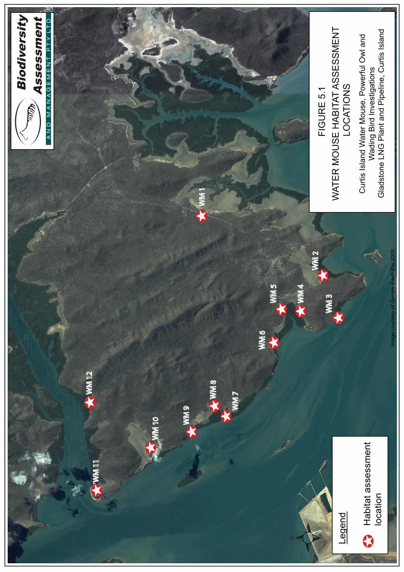
WM
1
WM
2
WM
3WM
4
WM
5
WM
6
WM
7WM
8
WM
9
WM
10
WM
11
WM
12
FIG
UR
E 5
.1W
ATE
R M
OU
SE
HA
BIT
AT A
SS
ES
SM
EN
T
L
OC
ATIO
NS
Cur
tis Is
land
Wat
er M
ouse
, Pow
erfu
l Ow
l and
W
adin
g B
ird In
vest
igat
ions
Gla
dsto
ne L
NG
Pla
nt a
nd P
ipel
ine,
Cur
tis Is
land
Lege
nd Hab
itat a
sses
smen
tlo
catio
nIm
age
cour
tesy
of G
oogl
e E
arth
Pro
200
9
Curtis Island Water Mouse, Powerful Owl and Wading Bird Investigations Gladstone LNG Plant and Pipeline, Curtis Island for URS Australia
BAAM Pty Ltd Page 9 File No: 0154-004 Version 0
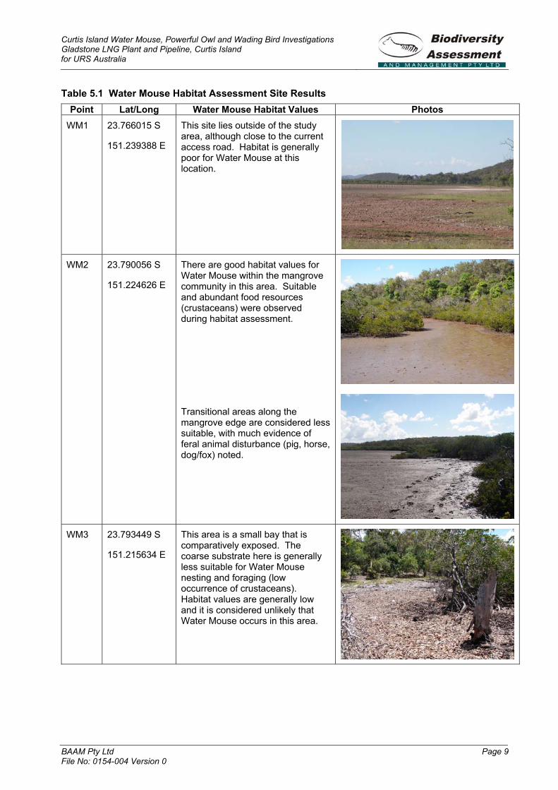
Table 5.1 Water Mouse Habitat Assessment Site Results Point Lat/Long Water Mouse Habitat Values Photos
WM1 23.766015 S
151.239388 E
This site lies outside of the study area, although close to the current access road. Habitat is generally poor for Water Mouse at this location.
WM2 23.790056 S
151.224626 E
There are good habitat values for Water Mouse within the mangrove community in this area. Suitable and abundant food resources (crustaceans) were observed during habitat assessment.
Transitional areas along the mangrove edge are considered less suitable, with much evidence of feral animal disturbance (pig, horse, dog/fox) noted.
WM3 23.793449 S
151.215634 E
This area is a small bay that is comparatively exposed. The coarse substrate here is generally less suitable for Water Mouse nesting and foraging (low occurrence of crustaceans). Habitat values are generally low and it is considered unlikely that Water Mouse occurs in this area.

Curtis Island Water Mouse, Powerful Owl and Wading Bird Investigations Gladstone LNG Plant and Pipeline, Curtis Island for URS Australia
BAAM Pty Ltd Page 10 File No: 0154-004 Version 0
Point Lat/Long Water Mouse Habitat Values Photos WM4 23.785429 S
151.216038 E
This area has been subject to high levels of disturbance with abundant rubbish and feral animal disturbance. There are moderate habitat values for Water Mouse within the mangrove area.
An access track has disturbed the key transitional zone (marine couch/mangrove interface).
WM5 23.782492 S
151.215740 E
Habitat less disturbed than WM4. Food resources outside of mangrove area are generally low. Moderate habitat values for Water Mouse within mangroves.
Two Eastern Curlews Numenius madagascariensis observed foraging in mudflat area.
Curtis Island Water Mouse, Powerful Owl and Wading Bird Investigations Gladstone LNG Plant and Pipeline, Curtis Island for URS Australia
BAAM Pty Ltd Page 11 File No: 0154-004 Version 0
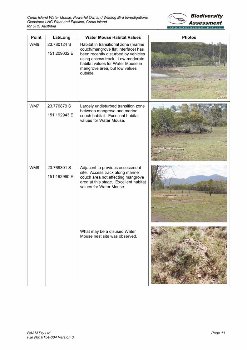
Point Lat/Long Water Mouse Habitat Values Photos WM6 23.780124 S
151.209032 E
Habitat in transitional zone (marine couch/mangrove flat interface) has been recently disturbed by vehicles using access track. Low-moderate habitat values for Water Mouse in mangrove area, but low values outside.
WM7 23.770879 S
151.192943 E
Largely undisturbed transition zone between mangrove and marine couch habitat. Excellent habitat values for Water Mouse.
WM8 23.769301 S
151.193960 E
Adjacent to previous assessment site. Access track along marine couch area not affecting mangrove area at this stage. Excellent habitat values for Water Mouse.
What may be a disused Water Mouse nest site was observed.

Curtis Island Water Mouse, Powerful Owl and Wading Bird Investigations Gladstone LNG Plant and Pipeline, Curtis Island for URS Australia
BAAM Pty Ltd Page 12 File No: 0154-004 Version 0
Point Lat/Long Water Mouse Habitat Values Photos WM9 23.763815 S
151.189256 E
Mangrove area provides moderate values for Water Mouse.
Evidence of pig presence/damage on edges of mangroves. Coarse substrate in area adjacent to mangroves less suitable for Water Mouse.
WM10 23.755714 S
151.185700 E
Wide claypan/mudflat area behind mangrove habitat. Food resources generally less abundant than in other areas. Generally low habitat values for Water Mouse at this location.
Wading birds including Eastern Reef Egret Egretta sacra observed foraging in area.

Curtis Island Water Mouse, Powerful Owl and Wading Bird Investigations Gladstone LNG Plant and Pipeline, Curtis Island for URS Australia
BAAM Pty Ltd Page 13 File No: 0154-004 Version 0
Point Lat/Long Water Mouse Habitat Values Photos WM11 23.744946 S
151.173784 E
Mangrove habitat at Laird Point in the north-western extent of study area.
Mangroves along western edge of Laird Point restricted to thin strip adjacent to coastline with low habitat values for Water Mouse.
Mangrove/marine couch transition zone east of Laird Point subject to some disturbance adjacent to existing access road. Moderate habitat values for Water Mouse in mangroves.
Eastern Curlew and Whimbrel Numenius phaeopus observed foraging on sand flats at Point.
WM12 23.743176S
151.193913E
Large areas of mangrove habitat. Abundant food resources observed during survey. Moderate habitat values for Water Mouse in mangroves.
No distinctive signs of current Water Mouse activity were observed during the December 2008 survey. However, given the brief nature of the survey and the large size of the study area, the results are not considered conclusive. Portions of the marine habitats of the study area hold relatively large tracts of potential habitat and would provide suitable foraging resources.
No known targeted trapping surveys for Water Mouse have been conducted on Curtis Island or the adjacent mainland (Van Dyck, pers comm.). Water Mouse has been detected to the south of the study area on the Fraser Coast (Van Dyck, pers comm.) and targeted surveys have detected the species in North Queensland between Proserpine and Cape Palmerston (Ball 2004). Water Mouse captured near Proserpine were often in very similar habitat to that found in the study area and population densities were found to be low compared to populations further south. Ball (2004) states it is ‘highly likely’ the species
range will be extended from its’ known distribution with further targeted surveys.
Recommendations
It is recommended that intensive targeted trapping surveys be conducted to confirm the presence/absence of Water Mouse within suitable habitats proposed for disturbance by the project (Table 5.1).
A minimum survey effort should be 300 trap nights / site (i.e. 100 Elliott traps X 3 nights or 150 Elliott traps X 2 nights). Two nights is a minimum survey effort. The trapping should be conducted so as to coincide with tidal events where high tide is in later part of the afternoon to allow for extended trapping time during nocturnal period, prior to incoming tide requiring trap removal from site for animal ethics reasons.
It is also recommended that the project managers seek to ensure feral species

Curtis Island Water Mouse, Powerful Owl and Wading Bird Investigations Gladstone LNG Plant and Pipeline, Curtis Island for URS Australia
BAAM Pty Ltd Page 14 File No: 0154-004 Version 0
management planning and active control within any habitats found to support Water Mouse.
5.2.2 Powerful Owl Ninox strenua
General Profile
Status: NC Act Vulnerable.
Historical occurrence within the study area:There is one WildNet database record of this species from the general area, however this search was based on a 15 km radius centred on the study area and is therefore likely to have been from the mainland. A further seven records were shown with a wider search radius of 25 km. One individual Powerful Owl was observed in the study area by a URS Australia employee during a May 2008 fauna survey (GPS coordinates: 23.760062 S; 151.208312 E).
Ecology and Habitat: Pairs of Powerful Owls occupy large, probably permanent, home ranges of about 1,000 ha (Higgins 1999; Garnett and Crowley 2000), although in Victoria ranges larger than 4000 ha have been recorded (Soderquist and Gibbons 2007). Their principle prey is medium-sized mammals, particularly possums and gliders, which often represent more than 50% of their diet, but which also includes other birds, flying-foxes, rats and insects (Webster et al. 1999; Higgins 1999).
Adult birds roost in a variety of tree species, including exotics. Commonly, the roost tree has thick vegetation in which the owl can escape from the mobbing activities of smaller avian species. During breeding, adults usually roost in close proximity to the nest tree (Webster et al. 1999). The species occurs in mountain rainforests, gullies and forest margins, sparser hilly woodlands, coastal forests, woodlands, scrubs, exotic pine plantations and large trees in private/public gardens (Pizzey and Knight 2003). Powerful Owls are most likely observed at sites with mature dry forest, many live hollow-bearing trees, diverse habitats within 2 km, and not much pure regrowth within 5 km (Loyn et al.2001).
Distribution and Breeding: This species is found in south-eastern Australia from Victoria north to Eungella, Queensland, and it is most
common on the eastern slopes of the Great Dividing Range (Garnett and Crowley 2000).
Powerful Owls breed once per year from May to August. Nests are located in large tree hollows, usually at a considerable height above the ground (10-40 m) (Beruldsen 2003). Consequently, the presence of large hollow-bearing trees is important for breeding as well as smaller hollows for the persistence of its prey species.
Threats: Widespread clearing of Powerful Owl habitat has reduced the amount of available habitat by almost half. However the species is still persistent and stable in remaining habitats (Garnett and Crowley 2000). Forestry practices have the potential to impact this species through the removal of hollow bearing trees that provide suitable nesting locations or shelter for prey species. However, most logging on mainland Australia now occurs in a mosaic pattern consisting of logged and unlogged areas, and studies have suggested that the Powerful Owl can persist in such mosaics by nesting in unlogged areas and foraging in logged or regrowth areas (Kavanagh et al. 1995).
Field Survey Results
No Powerful Owl was detected during the December field survey, however given the brevity of the survey it cannot be concluded that the species does not occur in the study area. During two nights of spotlighting and call playback, only Southern Boobook Ninox boobook was recorded, the species being common across the study area. No arboreal mammals were detected (important prey for Powerful Owls).
As much of the study area has undergone logging in the past, particularly in the east and south, eucalypts of a suitable age with large hollows were not abundant. Larger trees with hollows capable of supporting nesting Powerful Owls and arboreal mammals were sparsely scattered throughout the eastern and southern sections of the study area. In the north-east and western edge of the study area larger hollow-bearing trees were more abundant. However, the brevity of this survey did not allow for a detailed assessment of this area, particularly the western portion of the study area that follows a low ridgeline and is relatively inaccessible.
Curtis Island Water Mouse, Powerful Owl and Wading Bird Investigations Gladstone LNG Plant and Pipeline, Curtis Island for URS Australia
BAAM Pty Ltd Page 15 File No: 0154-004 Version 0
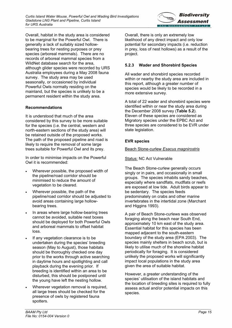
Overall, habitat in the study area is considered to be marginal for the Powerful Owl. There is generally a lack of suitably sized hollow-bearing trees for nesting purposes or prey species (arboreal mammals). There are no records of arboreal mammal species from a WildNet database search for the area, although glider species were recorded by URS Australia employees during a May 2008 fauna survey. The study area may be used seasonally, or occasioned by individual Powerful Owls normally residing on the mainland, but the species is unlikely to be a permanent resident within the study area.
Recommendations
It is understood that much of the area considered by this survey to be more suitable for the species (i.e. the central, western and north-eastern sections of the study area) will be retained outside of the proposed works. The path of the proposed pipeline and road is likely to require the removal of some large trees suitable for Powerful Owl and its prey.
In order to minimise impacts on the Powerful Owl it is recommended:
� Wherever possible, the proposed width of the pipeline/road corridor should be minimised to reduce the amount of vegetation to be cleared.
� Wherever possible, the path of the pipeline/road corridor should be adjusted to avoid areas containing large hollow-bearing trees.
� In areas where large hollow-bearing trees cannot be avoided, suitable nest boxes should be deployed for both Powerful Owls and arboreal mammals to offset habitat loss.
� If any vegetation clearance is to be undertaken during the species’ breeding season (May to August), those habitats should be thoroughly checked one day prior to the works through active searching in daytime hours and spotlighting and call playback during the evening prior. If breeding is identified within an area to be disturbed, this should be postponed until the young have left the nesting hollow.
� Wherever vegetation removal is required, all large trees should be checked for the presence of owls by registered fauna spotters.
Overall, there is only an extremely low likelihood of any direct impact and only low potential for secondary impacts (i.e. reduction in prey, loss of nest hollows) as a result of the project.
5.2.3 Wader and Shorebird Species
All wader and shorebird species recorded within or nearby the study area are included in this report, although a greater number of species would be likely to be recorded in a more extensive survey.
A total of 22 wader and shorebird species were identified within or near the study area during the December 2008 survey (Table 5.2).Eleven of these species are considered as Migratory species under the EPBC Act and three species are considered to be EVR under state legislation.
EVR species
Beach Stone-curlew Esacus magnirostris
Status: NC Act Vulnerable
The Beach Stone-curlew generally occurs singly or in pairs, and occasionally in small groups. The species inhabits sandy beaches, especially where sandflats, mudflats or reefs are exposed at low tide. Adult birds appear to be sedentary. The species feeds predominately on crabs and other marine invertebrates in the intertidal zone (Marchant and Higgins 1993).
A pair of Beach Stone-curlews was observed foraging along the beach near South End, approximately 10 km east of the study area.Essential habitat for this species has been mapped adjacent to the south-eastern boundary of the study area (EPA 2003). The species mainly shelters in beach scrub, but is likely to utilise much of the shoreline habitat periodically for foraging. It is considered unlikely the proposed works will significantly impact local populations in the study area given the area of suitable habitat.
However, a greater understanding of the species’ utilisation of the island habitats and the location of breeding sites is required to fully assess actual and/or potential impacts on this species.
Curtis Island Water Mouse, Powerful Owl and Wading Bird Investigations Gladstone LNG Plant and Pipeline, Curtis Island for URS Australia
BAAM Pty Ltd Page 16 File No: 0154-004 Version 0
Table 5.2. Wader and shorebird species observed in or near the study area
Scientific Name Common Name NC Act Status EPBC Act StatusButorides striata Striated Heron Least Concern
Egretta intermedia Intermediate Egret Least Concern
Egretta sacra Eastern Reef Egret Special Least Concern Migratory
Pelecanus conspicillatus Australian Pelican Least Concern
Phalacrocorax melanoleucos Little Pied Cormorant Least Concern
Phalacrocorax varius Pied Cormorant Least Concern
Pandion haliaetus Osprey Special Least Concern Migratory
Esacus magnirostris Beach Stone-curlew Vulnerable
Haematopus longirostris Pied Oystercatcher Least Concern
Haematopus fuliginosus Sooty Oystercatcher Rare
Vanellus miles Masked Lapwing Least Concern
Charadrius ruficapillus Red-capped Plover Least Concern
Numenius phaeopus Whimbrel Special Least Concern Migratory
Numenius madagascariensis Eastern Curlew Rare Migratory
Tringa nebularia Common Greenshank Special Least Concern Migratory
Xenus cinereus Terek Sandpiper Special Least Concern Migratory
Actitis hypoleucos Common Sandpiper Special Least Concern Migratory
Heteroscelus brevipes Grey-tailed Tattler Special Least Concern Migratory
Calidris ruficollis Red-necked Stint Special Least Concern Migratory
Larus novaehollandiae Silver Gull Least Concern
Sterna bergii Crested Tern Special Least Concern Migratory
Sterna hirundo Common Tern Special Least Concern Migratory
Sooty Oystercatcher Haematopus fuliginosus
Status: NC Act Rare
This species is restricted to marine shoreline habitats, with a preference for rocky substrates, coral reefs, headlands and sandy beaches near intertidal mudflats and rocky areas (Marchant and Higgins 1993).
One individual was observed on a rocky islet near South End 10 km east of the study area. Sooty Oystercatcher generally prefers to forage on rocky substrates, but will occasion sand flats/salt pans. The habitats within the study area hold generally low value and potential and it is considered unlikely any significant detrimental impacts would result from proposed actions.
Eastern Curlew Numenius madagascariensis
Status: NC Act Rare; EPBC Act Migratory
Eastern Curlews occur on sheltered coasts, and are often recorded in saltmarsh and on mudflats within mangroves. They mainly forage on intertidal mudflats and sandflats, and roost on sandy spits and islets, in mangroves and saltmarsh, and along the high water mark on beaches (Higgins and Davies 1996).
The Eastern Curlew breeds in eastern Siberia during the northern hemisphere summer. Adults vacate breeding areas around June and migrate through Asia on their way to Australia and New Zealand, mostly arriving in eastern Australia by late August and September. The Australian Eastern Curlew population is
Curtis Island Water Mouse, Powerful Owl and Wading Bird Investigations Gladstone LNG Plant and Pipeline, Curtis Island for URS Australia
BAAM Pty Ltd Page 17 File No: 0154-004 Version 0
estimated at 19,000 and numbers have fallen significantly in some southern areas.
During the December 2008 survey this species was commonly observed at low tide on sandflats/mudflats at South End, 10 km east of the study area. Within the study area a pair of Eastern Curlews were observed foraging at WM5 (Figure 5.1) and another pair were observed on sandflats at Laird Point. The species is likely to periodically utilise much of the shoreline habitat, and nearby mudflats within the study area, during low tide periods. Impacts on populations of this species from the proposed works are considered to be minor and are restricted to reduction of foraging and possible roosting habitat within the study area. The preferred foraging habitat in the local area appeared to be low-tide marine plains adjacent to South End.
Other wader/shorebird species
Migratory species (EPBC Act)
Whimbrel and Eastern Reef Egret are species found in a variety of coastal habitats including tidal flats, estuaries and mangroves. Whimbrel was relatively common throughout the study area and was observed or heard calling in some of the mangrove sites during the Water Mouse survey and was observed foraging at Laird Point. An Eastern Reef Egret was observed foraging at Water Mouse survey site WM10. Impacts on populations of these species from the proposed works are considered to be minor and are restricted to reduction of foraging and roosting habitat within the study area.
Terek Sandpiper and Grey-tailed Tattler are known to forage on tidal mudflats, estuaries and mangroves. Both species were observed foraging on beach habitat near South End. Impacts on populations of either species from the proposed works are considered to be minor and are restricted to a reduction of foraging habitat within the study area.
Common Greenshank, Common Sandpiper and Red-necked Stint are listed as Migratory species. These are common species and all may be found in a variety of saline and freshwater habitats. These species are unlikely to be significantly impacted by the proposed works. Common Tern, Crested Tern and Osprey are wide-ranging species that are
unlikely to be significantly impacted by the proposed works.
The remaining wader/shorebird species are not listed under legislation. Striated Heron and Pied Oystercatcher are essentially coastal species that will forage in a variety of habitats. The remaining species are all common and may be found in a variety of saline and freshwater habitats. None of these species are likely to be significantly impacted by the proposed works.
Recommendations
Wader/shorebird species were observed in relatively low numbers within the study area. Habitat values appeared to be low for many species due to low foraging potential. There is abundant existing habitat elsewhere on Curtis Island and surrounds. The majority of the observed waders, both in terms of species and number of individuals, were recorded foraging on more suitable habitat (sand/mudflats) 10 km to the east of the study area at South End. As such, recommendations are as follows:
� a more detailed study be conducted to ascertain the use of the study area by wader species, particularly in regards to use of the area for roosting at high tide;
� the proposed works should at all times minimise disturbance to the foreshore/intertidal zone within the study area; and
� it is considered that no referral under the EPBC Act is necessary in relation to these species in the areas investigated for this study.

Curtis Island Water Mouse, Powerful Owl and Wading Bird Investigations Gladstone LNG Plant and Pipeline, Curtis Island for URS Australia
BAAM Pty Ltd Page 18 File No: 0154-004 Version 0
6.0 BIBLIOGRAPHY
Ball, D (2004). Distribution and habitat of the False Water Rat, Xeromys myoides Thomas, 1889 (Rodentia: Muridae) in intertidal areas of central eastern Queensland. Memoirs of the Queensland Museum, 49: 487-494.
Beruldsen, G (2003). Australian birds, their nests and eggs. Phoenix Offset, China.
Clayton, M, Wombey, JC, Mason, IJ, Chesser, RT and Wells, A (2006).CSIRO List of Australian Vertebrates – A reference with conservation status.CSIRO Publishing, Collingwood.
Department of Environment and Heritage (DEH) (2006). ‘EPBC Act Policy Statement 1.1 Significant Impact Guidelines: Matters of National Environmental Significance.’ Australian Government, Canberra.
EPA. (2002). ‘Biodiversity Assessment and Mapping Methodology.’ Environmental Protection Agency Biodiversity Planning Unit, Biodiversity Branch Version 2.1, July 2002. Brisbane.
Garnett, ST and Crowley, GM (2000). Theaction plan for Australian birds.Environment Australia, Canberra.
Gynther, IC and Janetzki, H (2008). ‘False Water-rat.’ In: S Van Dyck and R Strahan (eds.), The mammals of Australia. Reed New Holland, Sydney. pp. 664-665.
Higgins, PJ (ed.) (1999). Handbook of Australian, New Zealand and Antarctic birds, Vol 4, Parrots to dollarbird. OxfordUniversity Press, Melbourne.
Higgins, PJ and Davies, SJJF (eds.) (1996).Handbook of Australian, New Zealand and Antarctic birds, Vol 3, Snipe to pigeons. Oxford University Press, Melbourne.
Kavanagh, RP, Debus, SJS, Tweedie, T and Webster, R (1995). ‘Distribution of nocturnal forest birds and mammals in north-eastern New South Wales: Relationships with environmental
variables and management history.’ Wildlife Research, 22: 359-377.
Loyn, RH, McNabb, EG, Volodina, L and Willig, R (2001). ‘Modelling landscape distributions of large forest owls as applied to managing forests in north-east Victoria, Australia.’ BiologicalConservation, 97: 361-376.
Marchant, S and Higgins, PJ (eds.) (1993).Handbook of Australian, New Zealand and Antarctic birds, Vol 2, Raptors to lapwings. Oxford University Press, Melbourne.
Menkhorst, PW and Knight, F (2004). A field guide to the mammals of Australia.Oxford University Press, Melbourne.
Pizzey, G and Knight, F (2003). The field guide to the birds of Australia.HarperCollins, Sydney.
Soderquist, T and Gibbons, D (2007). ‘Home range of the powerful owl (Ninoxstrenua) in dry sclerophyll forest.’ Emu,107: 177-184.
Van Dyck, S (1996). ‘Xeromys myoidesThomas, 1889 (Rodentia: Muridae) in mangrove communities of North Stradbroke Island, southeast Queensland.’ Memoirs of the Queensland Museum, 42: 337-366.
Webster, A, Cooke, R, Jameson, G and Wallis, R (1999). ‘Diet, roosts and breeding of Powerful Owls Ninox strenuain a disturbed, urban environment: A case for cannibalism? Or a case of infanticide?’ Emu, 99: 80-83.
Appendix 1: Terrestrial Vertebrate Species List
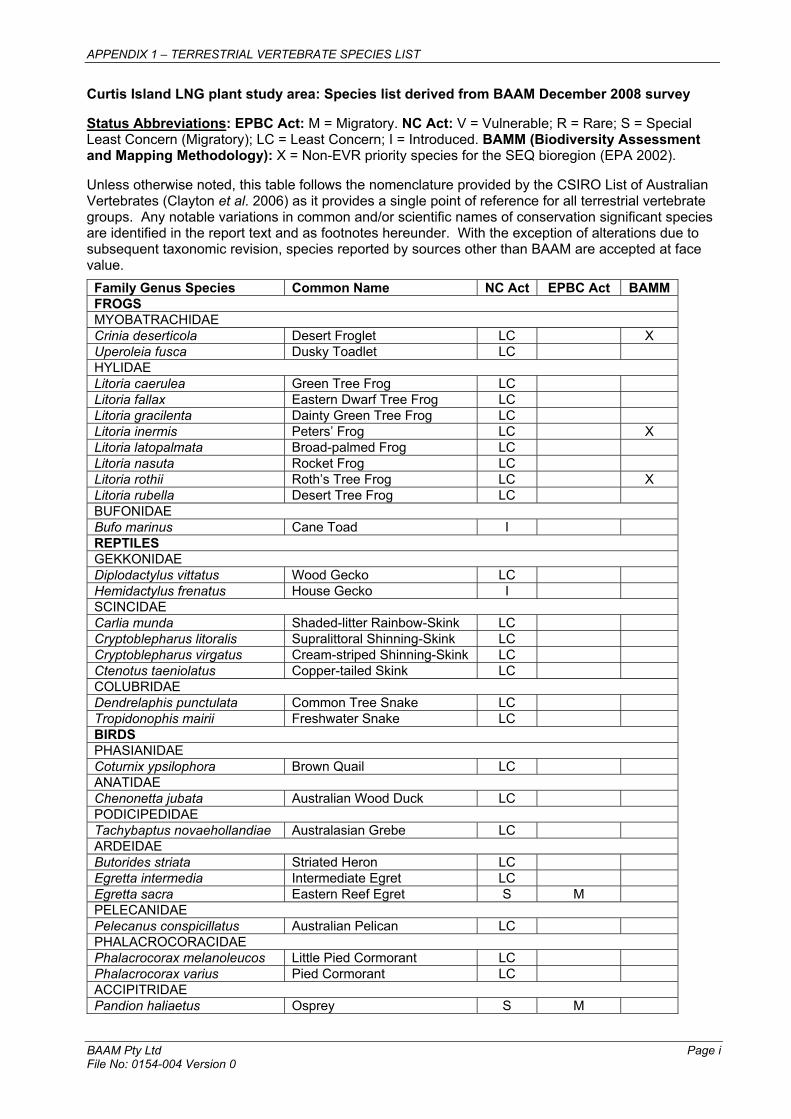
APPENDIX 1 – TERRESTRIAL VERTEBRATE SPECIES LIST
BAAM Pty Ltd Page i File No: 0154-004 Version 0
Curtis Island LNG plant study area: Species list derived from BAAM December 2008 survey
Status Abbreviations: EPBC Act: M = Migratory. NC Act: V = Vulnerable; R = Rare; S = Special Least Concern (Migratory); LC = Least Concern; I = Introduced. BAMM (Biodiversity Assessment and Mapping Methodology): X = Non-EVR priority species for the SEQ bioregion (EPA 2002).
Unless otherwise noted, this table follows the nomenclature provided by the CSIRO List of Australian Vertebrates (Clayton et al. 2006) as it provides a single point of reference for all terrestrial vertebrate groups. Any notable variations in common and/or scientific names of conservation significant species are identified in the report text and as footnotes hereunder. With the exception of alterations due to subsequent taxonomic revision, species reported by sources other than BAAM are accepted at face value.
Family Genus Species Common Name NC Act EPBC Act BAMM FROGSMYOBATRACHIDAE Crinia deserticola Desert Froglet LC X Uperoleia fusca Dusky Toadlet LC HYLIDAELitoria caerulea Green Tree Frog LCLitoria fallax Eastern Dwarf Tree Frog LCLitoria gracilenta Dainty Green Tree Frog LCLitoria inermis Peters’ Frog LC X Litoria latopalmata Broad-palmed Frog LCLitoria nasuta Rocket Frog LCLitoria rothii Roth’s Tree Frog LC X Litoria rubella Desert Tree Frog LCBUFONIDAE Bufo marinus Cane Toad I REPTILESGEKKONIDAE Diplodactylus vittatus Wood Gecko LC Hemidactylus frenatus House Gecko I SCINCIDAE Carlia munda Shaded-litter Rainbow-Skink LCCryptoblepharus litoralis Supralittoral Shinning-Skink LCCryptoblepharus virgatus Cream-striped Shinning-Skink LCCtenotus taeniolatus Copper-tailed Skink LCCOLUBRIDAE Dendrelaphis punctulata Common Tree Snake LCTropidonophis mairii Freshwater Snake LCBIRDSPHASIANIDAE Coturnix ypsilophora Brown Quail LC ANATIDAEChenonetta jubata Australian Wood Duck LC PODICIPEDIDAE Tachybaptus novaehollandiae Australasian Grebe LC ARDEIDAEButorides striata Striated Heron LCEgretta intermedia Intermediate Egret LCEgretta sacra Eastern Reef Egret S M PELECANIDAEPelecanus conspicillatus Australian Pelican LC PHALACROCORACIDAE Phalacrocorax melanoleucos Little Pied Cormorant LCPhalacrocorax varius Pied Cormorant LCACCIPITRIDAE Pandion haliaetus Osprey S M
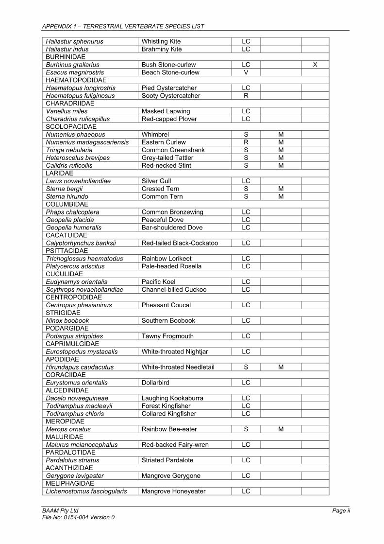
APPENDIX 1 – TERRESTRIAL VERTEBRATE SPECIES LIST
BAAM Pty Ltd Page ii File No: 0154-004 Version 0
Haliastur sphenurus Whistling Kite LCHaliastur indus Brahminy Kite LCBURHINIDAE Burhinus grallarius Bush Stone-curlew LC X Esacus magnirostris Beach Stone-curlew V HAEMATOPODIDAE Haematopus longirostris Pied Oystercatcher LC Haematopus fuliginosus Sooty Oystercatcher R CHARADRIIDAE Vanellus miles Masked Lapwing LCCharadrius ruficapillus Red-capped Plover LCSCOLOPACIDAE Numenius phaeopus Whimbrel S M Numenius madagascariensis Eastern Curlew R M Tringa nebularia Common Greenshank S M Heteroscelus brevipes Grey-tailed Tattler S M Calidris ruficollis Red-necked Stint S M LARIDAELarus novaehollandiae Silver Gull LC Sterna bergii Crested Tern S M Sterna hirundo Common Tern S M COLUMBIDAE Phaps chalcoptera Common Bronzewing LCGeopelia placida Peaceful Dove LCGeopelia humeralis Bar-shouldered Dove LCCACATUIDAE Calyptorhynchus banksii Red-tailed Black-Cockatoo LC PSITTACIDAETrichoglossus haematodus Rainbow Lorikeet LCPlatycercus adscitus Pale-headed Rosella LCCUCULIDAE Eudynamys orientalis Pacific Koel LCScythrops novaehollandiae Channel-billed Cuckoo LCCENTROPODIDAE Centropus phasianinus Pheasant Coucal LC STRIGIDAENinox boobook Southern Boobook LC PODARGIDAE Podargus strigoides Tawny Frogmouth LC CAPRIMULGIDAEEurostopodus mystacalis White-throated Nightjar LC APODIDAEHirundapus caudacutus White-throated Needletail S M CORACIIDAE Eurystomus orientalis Dollarbird LC ALCEDINIDAE Dacelo novaeguineae Laughing Kookaburra LCTodiramphus macleayii Forest Kingfisher LCTodiramphus chloris Collared Kingfisher LCMEROPIDAE Merops ornatus Rainbow Bee-eater S M MALURIDAE Malurus melanocephalus Red-backed Fairy-wren LC PARDALOTIDAEPardalotus striatus Striated Pardalote LC ACANTHIZIDAEGerygone levigaster Mangrove Gerygone LC MELIPHAGIDAELichenostomus fasciogularis Mangrove Honeyeater LC

APPENDIX 1 – TERRESTRIAL VERTEBRATE SPECIES LIST
BAAM Pty Ltd Page iii File No: 0154-004 Version 0
Melthreptus albogularis White-throated Honeyeater LCPhilemon corniculatus Noisy Friarbird LCPACHYCEPHALIDAE Colluricincla harmonica Grey Shrike-thrush LC DICRURIDAE Dicrurus bracteata Spangled Drongo LCMyiagra rubecula Leaden Flycatcher LCARTAMIDAE Cracticus nigrogularis Pied Butcherbird LCGymnorhina tibicen Australian Magpie LCArtamus leucorhynchus White-breasted Woodswallow LCCAMPEPHAGIDAE Coracina novaehollandiae Black-faced Cuckoo-shrike LCLalage leucomela Varied Triller LCORIOLIDAE Sphecotheres vieilloti Australasian Figbird LC CORVIDAE Corvus orru Torresian Crow LC HIRUNDINIDAE Hirundo neoxena Welcome Swallow LCPetrochelidon nigricans Tree Martin LCDICAEIDAEDicaeum hirundinaceum Mistletoebird LC NECTARINIIDAE Cinnyris jugularis Olive-backed Sunbird LC X MAMMALSMACROPODIDAEMacropus giganteus Eastern Grey Kangaroo LC EQUIDAEEquus caballus Horse I SUIDAESus scrofa Pig I

Appendix 2: Essential Habitat Mapping

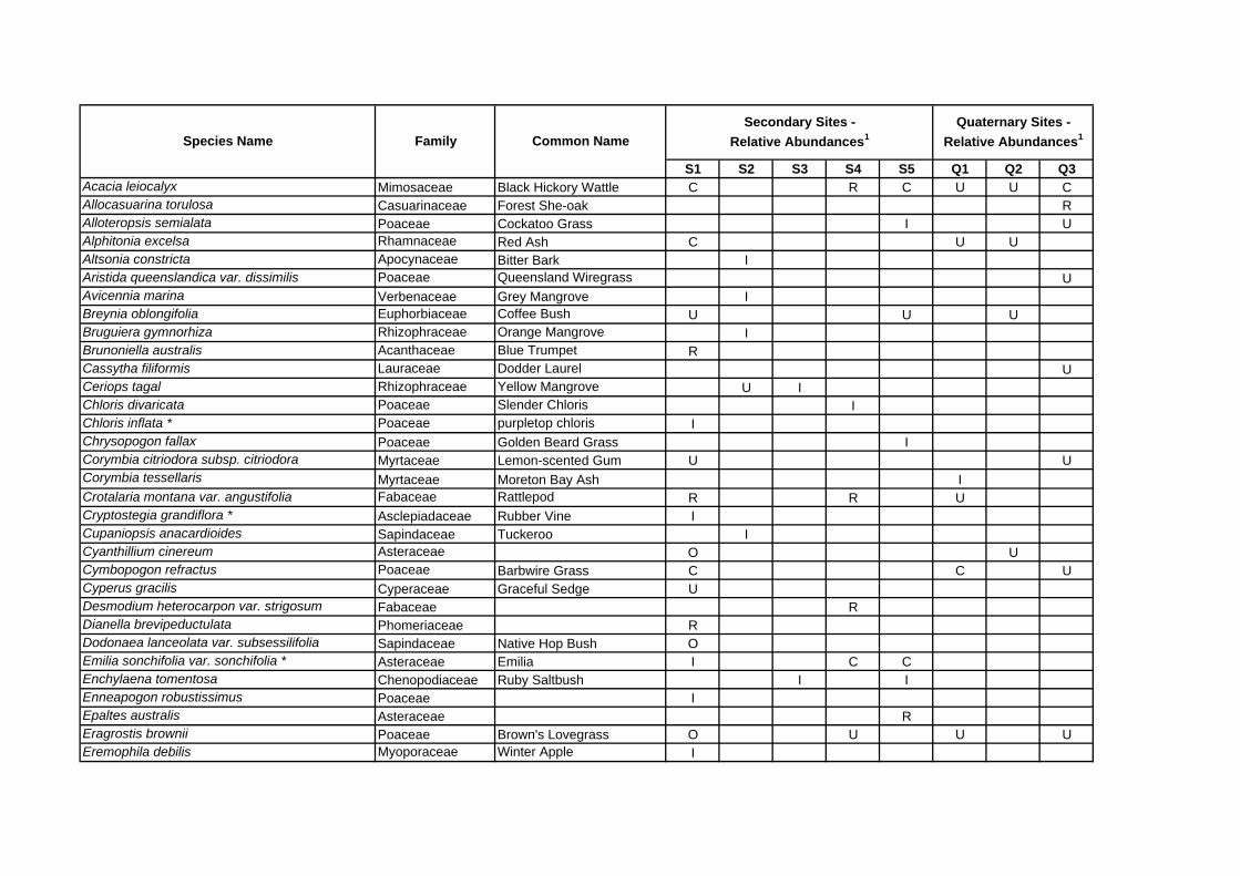
S1 S2 S3 S4 S5 Q1 Q2 Q3Acacia leiocalyx Mimosaceae Black Hickory Wattle C R C U U CAllocasuarina torulosa Casuarinaceae Forest She-oak RAlloteropsis semialata Poaceae Cockatoo Grass I UAlphitonia excelsa Rhamnaceae Red Ash C U UAltsonia constricta Apocynaceae Bitter Bark IAristida queenslandica var. dissimilis Poaceae Queensland Wiregrass UAvicennia marina Verbenaceae Grey Mangrove IBreynia oblongifolia Euphorbiaceae Coffee Bush U U UBruguiera gymnorhiza Rhizophraceae Orange Mangrove IBrunoniella australis Acanthaceae Blue Trumpet RCassytha filiformis Lauraceae Dodder Laurel UCeriops tagal Rhizophraceae Yellow Mangrove U IChloris divaricata Poaceae Slender Chloris IChloris inflata * Poaceae purpletop chloris IChrysopogon fallax Poaceae Golden Beard Grass ICorymbia citriodora subsp. citriodora Myrtaceae Lemon-scented Gum U UCorymbia tessellaris Myrtaceae Moreton Bay Ash ICrotalaria montana var. angustifolia Fabaceae Rattlepod R R UCryptostegia grandiflora * Asclepiadaceae Rubber Vine ICupaniopsis anacardioides Sapindaceae Tuckeroo ICyanthillium cinereum Asteraceae O UCymbopogon refractus Poaceae Barbwire Grass C C UCyperus gracilis Cyperaceae Graceful Sedge UDesmodium heterocarpon var. strigosum Fabaceae RDianella brevipeductulata Phomeriaceae RDodonaea lanceolata var. subsessilifolia Sapindaceae Native Hop Bush OEmilia sonchifolia var. sonchifolia * Asteraceae Emilia I C CEnchylaena tomentosa Chenopodiaceae Ruby Saltbush I IEnneapogon robustissimus Poaceae IEpaltes australis Asteraceae REragrostis brownii Poaceae Brown's Lovegrass O U U UEremophila debilis Myoporaceae Winter Apple I
Secondary Sites - Relative Abundances1
Quaternary Sites - Relative Abundances1Species Name Family Common Name
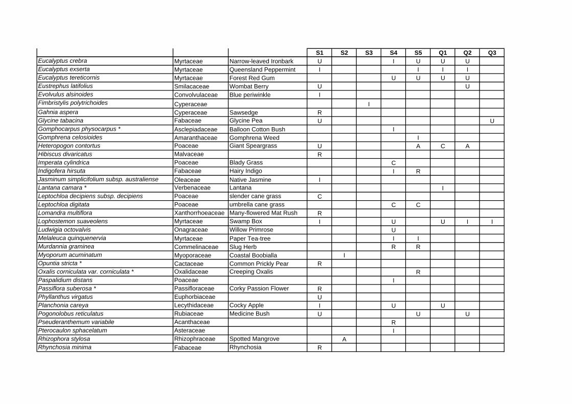
S1 S2 S3 S4 S5 Q1 Q2 Q3Eucalyptus crebra Myrtaceae Narrow-leaved Ironbark U I U U UEucalyptus exserta Myrtaceae Queensland Peppermint I I I IEucalyptus tereticornis Myrtaceae Forest Red Gum U U U UEustrephus latifolius Smilacaceae Wombat Berry U UEvolvulus alsinoides Convolvulaceae Blue periwinkle IFimbristylis polytrichoides Cyperaceae IGahnia aspera Cyperaceae Sawsedge RGlycine tabacina Fabaceae Glycine Pea U UGomphocarpus physocarpus * Asclepiadaceae Balloon Cotton Bush IGomphrena celosioides Amaranthaceae Gomphrena Weed IHeteropogon contortus Poaceae Giant Speargrass U A C AHibiscus divaricatus Malvaceae RImperata cylindrica Poaceae Blady Grass CIndigofera hirsuta Fabaceae Hairy Indigo I RJasminum simplicifolium subsp. australiense Oleaceae Native Jasmine ILantana camara * Verbenaceae Lantana ILeptochloa decipiens subsp. decipiens Poaceae slender cane grass CLeptochloa digitata Poaceae umbrella cane grass C CLomandra multiflora Xanthorrhoeaceae Many-flowered Mat Rush RLophostemon suaveolens Myrtaceae Swamp Box I U U I ILudwigia octovalvis Onagraceae Willow Primrose UMelaleuca quinquenervia Myrtaceae Paper Tea-tree I IMurdannia graminea Commelinaceae Slug Herb R RMyoporum acuminatum Myoporaceae Coastal Boobialla IOpuntia stricta * Cactaceae Common Prickly Pear ROxalis corniculata var. corniculata * Oxalidaceae Creeping Oxalis RPaspalidium distans Poaceae IPassiflora suberosa * Passifloraceae Corky Passion Flower RPhyllanthus virgatus Euphorbiaceae UPlanchonia careya Lecythidaceae Cocky Apple I U UPogonolobus reticulatus Rubiaceae Medicine Bush U U UPseuderanthemum variabile Acanthaceae RPterocaulon sphacelatum Asteraceae IRhizophora stylosa Rhizophraceae Spotted Mangrove ARhynchosia minima Fabaceae Rhynchosia R

S1 S2 S3 S4 S5 Q1 Q2 Q3Sarcocornia quinqueflora Chenopodiaceae Bead Weed IScleria brownii Cyperaceae I USida hackettiana Malvaceae C USida rhombifolia * Malvaceae Common Flannel Weed U OSporobolus virginicus Poaceae Saltwater Couch IThemeda triandra Poaceae Kangaroo Grass RVitex trifolia var. trifolia Lamiaceae Coastal Vitex IXanthorrhoea johnsonii Xanthorrhoeaceae Grass Tree R
Key:1 Relative abundances: A – Abundant (>100 plants per transect); C – Common (50-100 plants); O – Occasional (20-49 plants); U – Uncommon 5 – 20 plants; R – Rare (<5 plants); I – Incidental (recorded outside transect but within same RE). * - denotes exotic species
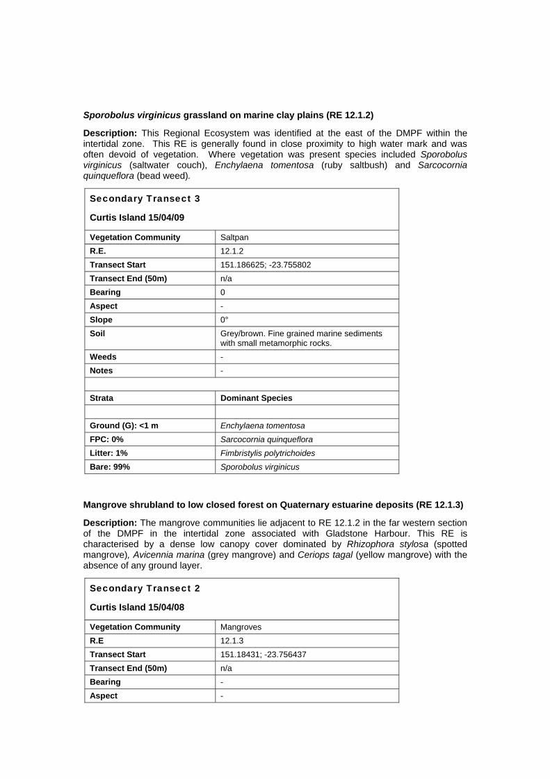
Sporobolus virginicus grassland on marine clay plains (RE 12.1.2)
Description: This Regional Ecosystem was identified at the east of the DMPF within the intertidal zone. This RE is generally found in close proximity to high water mark and was often devoid of vegetation. Where vegetation was present species included Sporobolus virginicus (saltwater couch), Enchylaena tomentosa (ruby saltbush) and Sarcocornia quinqueflora (bead weed).
Secondary Transect 3
Curtis Island 15/04/09
Vegetation Community Saltpan R.E. 12.1.2 Transect Start 151.186625; -23.755802 Transect End (50m) n/a Bearing 0 Aspect - Slope 0° Soil Grey/brown. Fine grained marine sediments
with small metamorphic rocks. Weeds - Notes - Strata Dominant Species Ground (G): <1 m Enchylaena tomentosa FPC: 0% Sarcocornia quinqueflora Litter: 1% Fimbristylis polytrichoides Bare: 99% Sporobolus virginicus
Mangrove shrubland to low closed forest on Quaternary estuarine deposits (RE 12.1.3)
Description: The mangrove communities lie adjacent to RE 12.1.2 in the far western section of the DMPF in the intertidal zone associated with Gladstone Harbour. This RE is characterised by a dense low canopy cover dominated by Rhizophora stylosa (spotted mangrove), Avicennia marina (grey mangrove) and Ceriops tagal (yellow mangrove) with the absence of any ground layer.
Secondary Transect 2
Curtis Island 15/04/08
Vegetation Community Mangroves R.E 12.1.3 Transect Start 151.18431; -23.756437 Transect End (50m) n/a Bearing - Aspect -
Secondary Transect 2
Curtis Island 15/04/08
Slope 0° Soil Grey/brown marine sediments and sub-angular
rocks Weeds - Notes - Strata Dominant Species Shrub (S1): 2-3 m Avicennia marina FPC: 80% Ceriops tagal Rhizophora stylosa Ground (G): No groundcover species present FPC: 0% Litter: 10% Bare: 90%
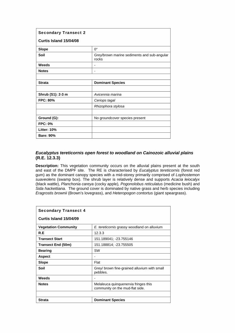
Eucalyptus tereticornis open forest to woodland on Cainozoic alluvial plains (R.E. 12.3.3)
Description: This vegetation community occurs on the alluvial plains present at the south and east of the DMPF site. The RE is characterised by Eucalyptus tereticornis (forest red gum) as the dominant canopy species with a mid-storey primarily comprised of Lophostemon suaveolens (swamp box). The shrub layer is relatively dense and supports Acacia leiocalyx (black wattle), Planchonia careya (cocky apple), Pogonolobus reticulatus (medicine bush) and Sida hackettiana. The ground cover is dominated by native grass and herb species including Eragrostis brownii (Brown’s lovegrass), and Heteropogon contortus (giant speargrass).
Secondary Transect 4
Curtis Island 15/04/09
Vegetation Community E. tereticornis grassy woodland on alluvium R.E 12.3.3 Transect Start 151.189041; -23.755146 Transect End (50m) 151.188814; -23.755505 Bearing SW Aspect - Slope Flat Soil Grey/ brown fine-grained alluvium with small
pebbles. Weeds - Notes Melaleuca quinquenervia fringes this
community on the mud-flat side. Strata Dominant Species
Secondary Transect 4
Curtis Island 15/04/09
Canopy (T1): 14-18 m Eucalyptus tereticornis FPC: 16% Mid-Storey (T2): 6-8 m Lophostemon suaveolens Eucalyptus tereticornis Shrub (S1): 1-2 m Planchonia careya FPC: 5% Sida hackettiana Ground (G): <1 m Eragrostis brownii FPC: 44% Heteropogon contortus Litter: 45% Imperata cylindrica Bare: 11% Leptochloa digitata
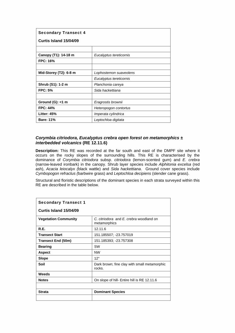
Corymbia citriodora, Eucalyptus crebra open forest on metamorphics ± interbedded volcanics (RE 12.11.6)
Description: This RE was recorded at the far south and east of the DMPF site where it occurs on the rocky slopes of the surrounding hills. This RE is characterised by the dominance of Corymbia citriodora subsp. citriodora (lemon-scented gum) and E. crebra (narrow-leaved ironbark) in the canopy. Shrub layer species include Alphitonia excelsa (red ash), Acacia leiocalyx (black wattle) and Sida hackettiana. Ground cover species include Cymbopogon refractus (barbwire grass) and Leptochloa decipiens (slender cane grass).
Structural and floristic descriptions of the dominant species in each strata surveyed within this RE are described in the table below.
Secondary Transect 1
Curtis Island 15/04/09
Vegetation Community C. citriodora and E. crebra woodland on metamorphics
R.E. 12.11.6 Transect Start 151.185507; -23.757019 Transect End (50m) 151.185393; -23.757308 Bearing SW Aspect NW Slope 12° Soil Dark brown; fine clay with small metamorphic
rocks. Weeds Notes On slope of hill- Entire hill is RE 12.11.6 Strata Dominant Species

Secondary Transect 1
Curtis Island 15/04/09
Canopy (T1): 12-16 m Corymbia citriodora subsp. citriodora FPC: 25% Eucalyptus crebra Eucalyptus exserta Mid-Storey (T2): 6-10 m Eucalyptus crebra Corymbia citriodora subsp. citriodora Shrub (S1): 1-4 m Acacia leiocalyx FPC: 40% Alphitonia excelsa Pogonolobus reticulatus Sida hackettiana Ground (G): <1 m Cyanthillium cinereum FPC: 46% Cymbopogon refractus Litter: 54% Heteropogon contortus Bare: 0% Leptochloa decipiens
Eucalyptus crebra, E. tereticornis grassy woodland on metamorphosed sediments and interbedded volcanics (RE 12.11.14)
Description: This RE is present across the lower slopes at the north of the DMPF site and is characterised by a canopy of Eucalyptus tereticornis (forest red gum) and E. crebra (narrow-leaved ironbark). The shrub layer is dominated by Pogonolobus reticulatus (medicine bush), Planchonia careya (cocky apple) and Acacia leiocalyx (black wattle). Ground cover species include Cymbopogon refractus (barbwire grass) and Leptochloa decipiens (slender cane grass).
Structural and floristic descriptions of the dominant species in each strata surveyed within this RE are described in the table below.
Secondary Transect 5
Curtis Island 15/04/09
Vegetation Community E. tereticornis & E. crebra open woodland on metamorphics
R.E. 12.11.14 Transect Start 151.188355; -23.750094 Transect End (50m) 151.188654; -23.749966 Bearing S Aspect - Slope flat Soil Dark brown; fine clay with small metamorphic
rocks. Weeds Notes

Secondary Transect 5
Curtis Island 15/04/09
Strata Dominant Species Canopy (T1): 8-14 m Eucalyptus crebra FPC: 17% Eucalyptus tereticornis Mid-Storey (T2): 6-8 m Eucalyptus crebra Eucalyptus tereticornis Eucalyptus exserta Shrub (S1):1-3 m Acacia leiocalyx FPC: 25% Breynia oblongifolia Pogonolobus reticulatus Ground (G):<1 m Cymbopogon refractus FPC: 67% Emilia sonchifolia var. sonchifolia * Litter: 32% Heteropogon contortus Bare: 1% Leptochloa decipiens


