
Geologic Road, Trail, and Lake Guides to Utah’s Parks and Monuments 2012 Utah Geological Association Publication 29 (third edition) P.B. Anderson and D.A. Sprinkel, editors
CONTENTS Introduction Road Guides: Mt. Carmel Junction to Coral Pink Sand Dunes State Park ....................................................... 8 {15.5 miles via U.S. Highway 89 and Sand Dune Road} Coral Pink Sand Dunes State Park to Kanab ........................................................................... 18 {21.0 miles via Sand Dune Road, Hancock Road and U.S. Highway 89} Mt. Carmel Junction to Kanab -- U.S. Highway 89 (17.4 miles) ............................................ 26 Acknowledgments ................................................................................................................................ 31 References ............................................................................................................................................ 31
INTRODUCTION The Colorado Plateau region of southern Utah is world renowned for its colorful and varied Mesozoic strata, dramatic cliff-and-bench topography, and the national parks and monuments that preserve and interpret this wonderful geology for the citizens of the world – including Zion, Capital Reef, and Bryce Canyon National Parks. Despite the arid and semiarid climate of the region, flowing water has been the principal geologic agent in sculpting the landscapes of these parks. Indeed, water is by far the most important geologic fluid eroding and shaping the land surface of our planet. However, under the right conditions flowing air (wind) or flowing ice (glaciers) can become the dominant geologic fluid in the creation of landforms on Earth’s surface. Coral Pink Sand Dunes State Park (CPSDSP) is a prime example of the role that eolian (an adjective referring to wind activity, derived from Aeolus – the Greek god of the wind; also commonly spelled as aeolian) processes can have in creating a distinctive landscape within a region otherwise dominated by fluvial (stream) erosion. The park is located in southwestern Kane County about 10 miles (16 km) west of Kanab, Utah (20 miles/32 km by road) (figure 1). We suspect that, over the years, only a small percentage of the professional geologists, geology students, and geologically inclined tourists who have traveled U.S. Highway 89 between the Zion National Park area and Kanab have ever ventured off the main road to visit the Coral Pink Sand Dunes. We hope this geologic road guide may entice more to do so – the side trip is well worth it.
GEOLOGIC ROAD GUIDES TO CORAL PINK SAND DUNES STATE PARK AND VICINITY, UTAH Richard L. Ford, Weber State University, Ogden, Utah Terry W. Massoth, Salt Lake City, Utah David E. Wilkins, Boise State University, Boise, Idaho
1

R.L. Ford, T.W. Massoth, and D.E. Wilkins Geologic Road Guides to Coral Pink Sand Dunes State Park and Vicinity, Utah
2
Figu
re1.
Ind
ex m
ap sh
owin
g th
e lo
catio
n of
Cor
al P
ink
Sand
Dun
es S
tate
Par
k (C
PSD
SP) i
n K
ane
Coun
ty, U
tah
(For
d an
d ot
hers
, 201
0).

P.B. Anderson and D.A. Sprinkel, editors 2012 Utah Geological Association Publication 29 (third edition)
3
Coral Pink Sand Dunes, one of the largest areas of active dunes on the Colorado Plateau, is an elongate dune field (7 miles by 1 mile or less) containing a wide variety of eolian features – all composed of a fine-grained, extremely well-sorted sand of a striking “coral pink” color. In addition, the dune field dramatically straddles a prominent bedrock escarpment created by repeated movement on the Sevier fault. The northern half of the dune field lies on federal land managed by the Bureau of Land Management (BLM); the southern half comprises CPSDSP. The state park, established in 1963, provides various recreational opportunities related to the dunes including hiking, camping, and OHV riding. The ease of access to textbook examples of many different types of dunes, as well as the interesting relationship between the dune field and the Sevier fault, are the primary reasons we have developed these road guides. The geology on view between Mt. Carmel Junction and Kanab, part of the “Grand Staircase” of southern Utah, on one’s way to CPSDSD is also worthy of a geologic road guide. The Coral Pink Sand Dunes lie within a geologic region known as the Basin and Range/Colorado Plateau structural transition zone (figure 2). The transition zone is that part of the Colorado Plateau that was affected by extensional faulting, more characteristic of the Basin and Range Province farther to the west. Basin and Range extension began during Miocene time (approximately 15 million years ago) and continues today (Davis, 1999). Within the transition zone, this deformation created east-west-tilted structural blocks, bounded by widely spaced, north-south-trending, west-dipping, high-angle normal faults – namely the Hurricane, Sevier, and Paunsaugunt faults (Anderson and Christenson, 1989; Davis 1999). The Sevier fault zone is the principal structural feature to be seen along the routes covered by these road guides and has played a significant role in the creation of the Coral Pink Sand Dunes. It is the northern portion of a 300-mile-long (480 km) fault zone that includes the Toroweap and Aubray faults in Arizona (Anderson and Christenson, 1989; Davis, 1999; Lund and others, 2008). This fault system extends from the Grand Canyon to central Utah, where it loses its discrete character within Miocene volcanic rocks. The Sevier fault and the other normal faults of the Basin and Range/Colorado Plateau transition zone lay within the southern portion of the Intermountain Seismic Belt (ISB). The ISB is a north-south-trending zone of seismicity that extends from northwestern Montana to Las Vegas, Nevada. The Wasatch fault of northern Utah is the most infamous fault within this zone of active earthquake activity. However, large (Richter magnitude/ML 7.0-7.5) prehistoric earthquakes also have occurred in southern Utah and could occur again in the future (Christenson and Nava, 1992). During the historic period, magnitude-5.7 (ML) and 5.5+ earthquakes occurred near Kanab, Utah, in 1887 and 1959, respectively (Anderson and Christenson, 1989) and at least two smaller magnitude earthquakes have occurred along the trend of the Sevier fault (Davis, 1999). Although the Sevier fault lacks evidence of a major surface-rupturing earthquake during the Holocene (last 10,000 years), its documented offset of Quaternary ( 560 ka) volcanic rocks near Glendale, Utah (Reber and others, 2001), and its historic seismicity suggest the fault is active. As mentioned above, the long-term uplift and erosion of this part of the Colorado Plateau has created a distinctive and picturesque cliff-and-bench topography known as the Grand Staircase. Traveling the routes of these road guides provides the opportunity to see and study two of the steps of the staircase and the Mesozoic formations that comprise them. Kanab is located on a lower step or tread underlain by the Petrified Forest Member of the Chinle Formation (Upper Triassic). The maroon mudstone beds of the Petrified Forest Member are the oldest rocks you are likely to see while following these road guides, though this unit is typically a slope former and very poorly exposed. Just north and framing

R.L. Ford, T.W. Massoth, and D.E. Wilkins Geologic Road Guides to Coral Pink Sand Dunes State Park and Vicinity, Utah
4
Figure 2. Basin and Range/Colorado Plateau structural transition zone in southwestern Utah (modified from Anderson and Christenson, 1989). Coral Pink Sand Dunes State Park (CPSDSP) lies astride the trace of the Sevier fault (Ford and others, 2010).

P.B. Anderson and D.A. Sprinkel, editors 2012 Utah Geological Association Publication 29 (third edition)
5
Kanab, the Vermilion Cliffs are one of the prominent risers between steps of the staircase. The Vermilion Cliffs are comprised of resistant red sandstones of the Moenave (Triassic-Jurassic) and Kayenta (Lower Jurassic) Formations. The next step or bench is called the Wygaret Terrace and is underlain by relatively soft rocks of the Lamb Point Tongue of the Navajo Sandstone (Lower Jurassic), Tenney Canyon Member of the Kayenta Formation (Lower Jurassic), and the lower portion of the Navajo Sandstone (main body; Lower Jurassic). The next riser coincides with the imposing White Cliffs, held up by the resistant strata of the upper part of the Navajo Sandstone, Temple Cap Sandstone (Middle Jurassic), and Co-op Creek Limestone Member of the Carmel Formation (Middle Jurassic) (Doelling and others, 2010). The Navajo Sandstone is locally divided into three informal subunits based on color: a lower brown subunit; a middle red/pink subunit; and an upper white subunit (Biek and others, 2010). In addition, the Carmel Formation, as presently mapped in this general area, consists of four formal members: Co-op Creek Limestone Member; Crystal Creek Member; Paria River Member; and the Winsor Member (in ascending order) (Biek and others, 2010). Figure 3 is a stratigraphic column of the Mesozoic formations exposed in the vicinity of CPSDSP. The fossils and sedimentary structures preserved in these bedrock units record a long-term shift from depositional environments dominated by fluvial processes (Chinle, Moenave, and Kayenta Formations) to environments dominated by eolian processes (Navajo Sandstone) to deposition in a marine environment (Temple Cap Sandstone and Carmel Formation). See the reports by Doelling and others (2010) for a complete discussion of the entire Grand Staircase, and its constituent stratigraphic units. The road guides presented here (figure 4) serve to describe the geologic setting and major features of Coral Pink Sand Dunes State Park (CPSDSP), as well as the geology to be seen along the two paved roads that provide access to the park from Highway 89 – Sand Dune Road (also called Yellowjacket Road, and recently designated Kane County road 1000) and Hancock Road (Kane County road 1100). Taken together, our road guides to and from CPSDSP also serve to link two other geologic road guides published in this volume: Zion National Park to Mt. Carmel Junction (Biek and others, this volume); and Kanab to Big Water (Doelling and others, this volume). If you do not have time to visit the dune field, we have also prepared a road guide for the stretch of Highway 89 between Mt. Carmel Junction and Kanab. The descriptions of the dunes and eolian processes that can be observed in the park are drawn from field studies conducted by the authors (Wilkins and Ford, 2007; Wilkins and others, 2002 and 2003; and Ford and others, 2010). Our description of the bedrock geology along the routes draws heavily from previously published geologic maps of the area (Sargent and Philpott, 1987; Doelling and others, 1989) and previously published road logs, most notably those prepared by Rigby (1976) and Baars (2002). We are indebted to these fellow geologists for their careful and detailed work. For more detail about the geology and geomorphology of the park consult the companion report by Ford and others (2010).

R.L. Ford, T.W. Massoth, and D.E. Wilkins Geologic Road Guides to Coral Pink Sand Dunes State Park and Vicinity, Utah
6
Figure 3. Stratigraphic column of the Mesozoic bedrock units exposed in the vicinity of Coral Pink Sand Dunes State Park (Ford and others, 2010; modified from Doelling and others, 1989).
P.B. Anderson and D.A. Sprinkel, editors 2012 Utah Geological Association Publication 29 (third edition)
7
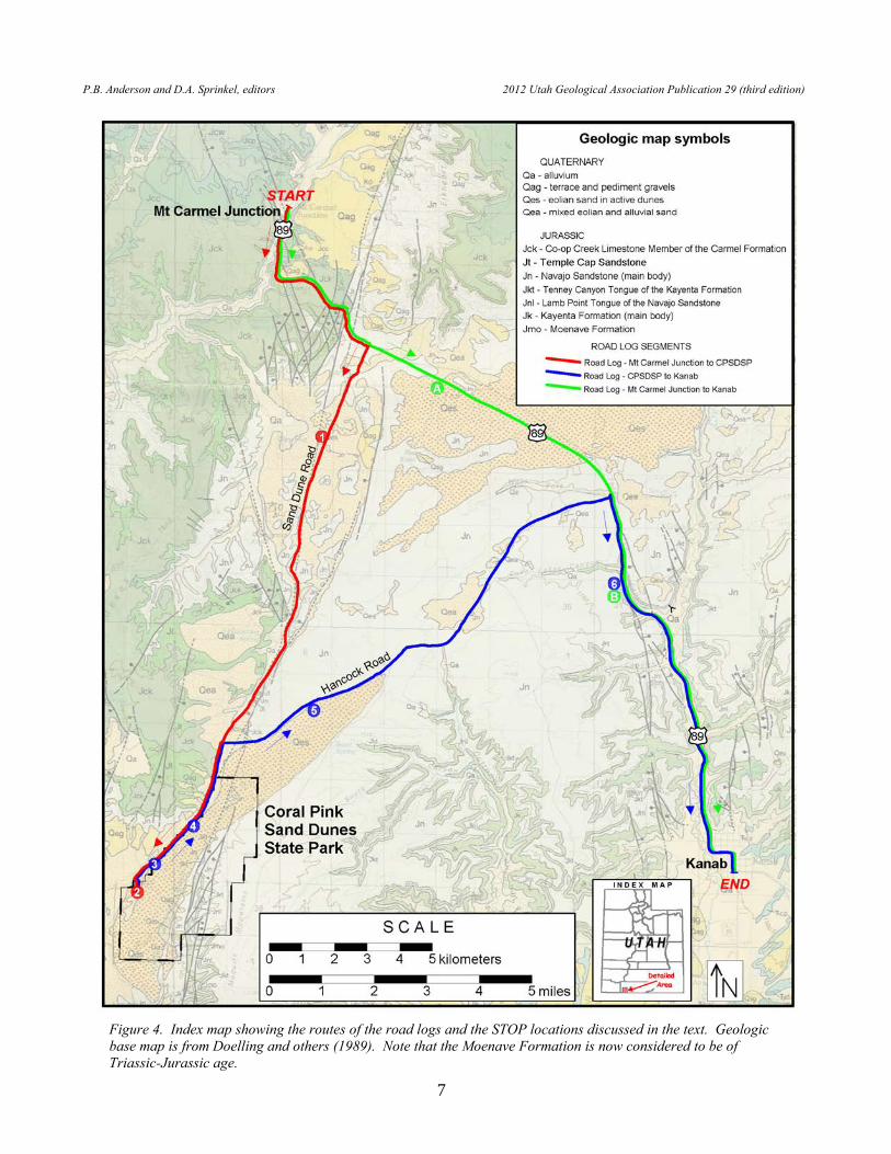
Figure 4. Index map showing the routes of the road logs and the STOP locations discussed in the text. Geologic base map is from Doelling and others (1989). Note that the Moenave Formation is now considered to be of Triassic-Jurassic age.

R.L. Ford, T.W. Massoth, and D.E. Wilkins Geologic Road Guides to Coral Pink Sand Dunes State Park and Vicinity, Utah
8
MT. CARMEL JUNCTION TO CORAL PINK SAND DUNES STATE PARK This road guide begins at Mt. Carmel Junction, the junction of U.S. Highway 89 and Utah Highway 9, and proceeds southward along U.S. Highway 89 and Sand Dune Road (Kane County road 1000) to Coral Pink Sand Dunes State Park (figure 4; red route). Both highways are paved. There are no services along this route, so be sure to have sufficient drinking water and gasoline. There will be a small fee to enter the state park, where restrooms are available. Significant traffic is to be expected along Highway 89, so the driver will need to maintain a safe and steady speed. Road guides are most effective if a designated passenger reads the entries to the driver and other passengers, preferably ahead of actually reaching the mile point of the log entry. When making suggested or impromptu stops, find a safe place to pull completely off the road and be mindful of traffic when exiting and re-entering your vehicle. Driving time for the 16 miles is less than an hour, but be sure to allot ample time at STOP 2 to explore the dunes on foot. MILEAGE DESCRIPTION INTERVAL/CUMULATIVE 0.0 0.0 BEGIN road guide at the junction of U.S. Highway 89 and Utah Highway 9 at
Mt. Carmel Junction (elevation 5198 ft.). Reset or otherwise “zero” your odometer. DRIVE SOUTH on U.S. Highway 89 toward Kanab.
Mt. Carmel Junction lies at the southern end of Long Valley, which was carved
by the southwest-flowing East Fork of the Virgin River. The northeast-southwest-trending, west-dipping Sevier fault lies to the east of Long Valley; the valley roughly parallels the surface trace of the fault. The White Cliffs of the Grand Staircase are also visible to the east of Long Valley and Mt. Carmel Junction, below a plateau known as the GLENDALE BENCH (approxate elevation 7000 ft.). The rocks exposed in the hillslopes and road cuts in the immediate vicinity of Mt. Carmel Junction are gray and tan limestone beds of the Co-op Creek Limestone and pinkish-red siltstone and sandstone of the Crystal Creek Members of the Carmel Formation (Middle Jurassic); these same units cap the Glendale Bench. This relationship provides a general sense of the vertical displacement, about 2000 feet (600 m), along this segment of the Sevier fault (Davis, 1999). Many of the limestone beds of the Co-op Creek Limestone Member are highly fossiliferous, including distinctive star-shaped crinoid columnals (figure 5) (Isocrinus, formerly Pentacrinus) (Biek and others, 2010).
The commercial development at Mt. Carmel Junction is the legacy of Jack and
Fern Morrison, a ranching family that homesteaded the site in 1931, correctly speculating as to where the planned Highway 9 from Zion National Park would join U.S. Highway 89. Renowned artist Maynard Dixon, known for his landscape paintings of the American west, built a summer home north of Mt. Carmel Junction in 1939. Mt. Carmel Junction is named for the older settlement of Mt. Carmel, located about a mile to the north on Highway 89, which in turn is named for a mountain range located in modern-day Israel.

P.B. Anderson and D.A. Sprinkel, editors 2012 Utah Geological Association Publication 29 (third edition)
9
0.3 0.3 Bridge over the VIRGIN RIVER (East Fork). The headwaters of the East Fork Virgin River lay in the Pink Cliffs to the north. As the road climbs off the floodplain, the Temple Cap Sandstone (Middle Jurassic) is exposed at road level on the right. You may also catch a quick glimpse of the uppermost Navajo Sandstone exposed on either side of the river in the canyon to the right. As the road ascends, it crosses the contact between Temple Cap Sandstone and the overlying Carmel Formation.
0.9 1.2 Mile Post 80. The Co-op Creek Limestone Member is exposed in the road cut
on the left and in the road cuts encountered over the next several miles. 0.2 1.4 View of the White Cliffs straight ahead. 1.3 2.7 Road begins to traverse the Sevier fault zone. In contrast to its simple geometry
farther north, this portion of the Sevier fault is characterized by numerous northeast-southwest-trending splays and several related northwest-southeast-trending normal faults in the hanging wall (Reber and others, 2001; Sargent and Philpott, 1987; Doelling and others, 1989).
0.3 3.0 Red sandstone of the middle portion of the Navajo Sandstone (Lower Jurassic) is
exposed at road level. In this general area the Sevier fault zone places Navajo Sandstone, up on the east, against the Co-op Creek Limestone Member. The road is now built upon rocks of the up-thrown or footwall. Prepare to turn right in half a mile.
0.5 3.5 TURN RIGHT onto access/frontage road to Coral Pink Sand Dunes State Park. 0.2 3.7 TURN RIGHT (south) onto Sand Dune Road (Kane County road 1000).
Road is built on the middle portion of the Navajo Sandstone, commonly covered by a veneer of Quaternary alluvium and eolian deposits.
Figure 5. Crinoid columnals (Isocrinus, formerly Pentacrinus) preserved on a bedding plane of limestone in the Co-op Creek Limestone Member of the Carmel Formation (Middle Jurassic).

R.L. Ford, T.W. Massoth, and D.E. Wilkins Geologic Road Guides to Coral Pink Sand Dunes State Park and Vicinity, Utah
10
0.2 3.9 Temple Cap Sandstone and Carmel Formation are exposed in the skyline ridge straight ahead.
0.4 4.3 RED KNOLL (elevation 6565 ft.) is visible to the left (east). This erosional
remnant of Navajo Sandstone is capped by Quaternary stream gravels, indicating the magnitude of fluvial erosion across this landscape during the last 2 to 3 million years (figure 6).
1.3 5.6 PARK ON HIGHWAY SHOULDER in the vicinity of junction with gravel
road (right) that leads to CLAY FLAT (elevation 5560 ft.). STOP 1: CLAY FLAT BASIN. To the east (left), Red Knoll is visible on the
skyline and a prominent linear, west-facing, bedrock escarpment is visible in the middle ground (figure 6). Red strata of the middle portion of the Navajo Sandstone are exposed in this fault-line scarp, which marks the trace of the west-dipping Sevier fault. Assessing the recent history of movement along the Sevier fault has proven to be difficult because the fault cuts through Mesozoic-aged bedrock along most of its length in southern Utah (Lund and others, 2008). This greatly limits the opportunity to document its recent movement through the analysis of fault scarps and stratigraphic offset of unconsolidated Quaternary deposits.
As our location is once again on the hanging-wall (down-thrown) side of the
fault, Clay Flat coincides with a major left step in en echelon fault segments. Reber and others (2001) call this area the Yellowjacket Spring bend and interpret this geometry as the result of the linkage of two underlapping fault segments. At several locations along the scarp Anderson and Christenson (1989) observed distinct compound slope profiles consisting of a rounded upper segment and a steep, planar lower segment. This scarp morphology is consistent with relatively recent movement along the fault.
Clay Flat is a small playa located about 0.75 miles (1.2 km) to the west. The
surrounding topographic basin, located just south of a bend or left step in the trace of the Sevier fault, is a local depocenter filled with Quaternary alluvium and eolian deposits. South of this location, Anderson and Christenson (1989) observed striations on fault surfaces exposed in the scarp that indicate a horizontal component of movement along the fault known as left-lateral (sinistral) slip. They interpret Clay Flat as a pull-apart-like structure created by extension and subsidence in the vicinity of the fault bend. In the absence of offset Quaternary deposits, Anderson and Christenson (1989) argue that the presence of Clay Flat basin is further evidence of active fault movement or creep along the Sevier fault during the late Quaternary.
CONTINUE SOUTH on Sand Dune Road. Note the stabilized/vegetated
parabolic dunes on both sides of the road. Driving south, the road converges with the fault-line scarp to the east.

P.B. Anderson and D.A. Sprinkel, editors 2012 Utah Geological Association Publication 29 (third edition)
11
Figure 6. Shaded relief map of the area covered by the road logs showing key geographic features. Note the west-facing scarp of the Sevier fault.

R.L. Ford, T.W. Massoth, and D.E. Wilkins Geologic Road Guides to Coral Pink Sand Dunes State Park and Vicinity, Utah
12
1.1 6.7 Cattle guard. 1.0 7.7 MONUMENT KNOLL (elevation 6060 ft.) on the right (west). Most of this
conical hill is composed of the upper white subunit of the Navajo Sandstone. A small exposure of Temple Cap Sandstone caps the hill.
0.5 8.2 The mesa on the right is bounded by northwest-southeast-trending normal faults
related to the Sevier fault. These smaller faults, oriented perpendicular to the Sevier fault, which offset layers on the down-thrown side of the master fault are called hanging-wall normal faults. The lower slickrock slope exposes white, cross-bedded sandstone of the upper portion of the Navajo Sandstone. The middle and upper portion of the mesa are held up by the Temple Cap Sandstone and Co-op Creek Limestone Member of the Carmel Formation. The road is now ascending Yellowjacket Canyon, which has been carved by a north-flowing tributary of the East Fork Virgin River. For the next several miles the road closely parallels the trace of the Sevier fault.
0.6 8.8 Cattle guard. 0.4 9.2 White sandstone (on the right) of the upper portion of the Navajo Sandstone is
faulted against red sandstone (on the left) of the middle Navajo Sandstone. The road is built on the fault trace.
0.4 9.6 Ranch house and corral on right are sited near Yellowjacket Spring, which may
be related to groundwater flow along the plane of the Sevier fault. 0.1 9.7 The main trace of the Sevier Fault is at the base of the prominent escarpment
east (left) of the road, which exposes red strata of the middle portion of Navajo Sandstone. The continuation of this scarp to the south is a prominent feature in CPSDSP.
1.2 10.9 A block of Temple Cap Sandstone and Carmel Formation on left side of road is
in fault-contact with Navajo Sandstone. The road begins to diverge from the surface trace of the Sevier fault.
0.9 11.8 Road crosses the drainage divide (approximate elevation 6200 ft.) between
Yellowjacket Canyon and Sand Canyon Wash. Sand Canyon Wash flows south, through CPSDSP, and joins Kanab Creek south of Fredonia, Arizona.
0.2 12.0 The Coral Pink Sand Dunes are visible to the left. Here sand ramps from the
lower part of the dune field climb over the bedrock escarpment created by the Sevier fault.
0.1 12.1 Junction with Hancock Road on left. The mesa at 2 o’clock is called ESPLIN
POINT (elevation 6824 ft.), part of the BLOCK MESAS (figure 6). The Block Mesas are local horst blocks uplifted by high-angle normal faults, which roughly

P.B. Anderson and D.A. Sprinkel, editors 2012 Utah Geological Association Publication 29 (third edition)
13
parallel the Sevier fault. These uplifts expose the same stratigraphic units that give rise to the White Cliffs farther north, namely the upper portion of the Navajo Sandstone, Temple Cap Sandstone, and Co-op Creek Limestone Member of the Carmel Formation. These three units are clearly exposed in Esplin Point. CONTINUE STRAIGHT/SOUTH on Sand Dune Road.
0.6 12.7 On the left is a turn-off to a dry lake bed. A primitive camping site is maintained
by the Bureau of Land Management (BLM). 0.1 12.8 Sign marking the northern boundary of CORAL PINK SAND DUNES STATE
PARK (CPSDSP), which opened in 1963 and covers 3730 acres of active dunes and adjacent land. The land for the state park was purchased from the BLM.
1.0 13.8 Cattle guard. 0.2 14.0 The bedrock escarpment to the left (east) exposes the same stratigraphic units
that comprise the Vermilion Cliffs farther south, namely the Moenave (Triassic-Jurassic) and Kayenta (Lower Jurassic) Formations, in addition to the Navajo Sandstone. Unlike the relatively simple geometry in the area of Yellowjacket Canyon, here the Sevier fault is a complex zone of braided fault segments. The plateau at the top of the fault-controlled escarpment is called the MOQUITH MOUNTAINS (approxate elevation 7000 ft.).
1.3 15.3 TURN LEFT (east) onto the access road to the park entrance station, visitor’s
center, and campground. PAY ENTRANCE FEE. CONTINUE SOUTH on main park road.
0.2 15.5 TURN LEFT (east) into parking lot. STOP 2: STAR DUNE OVERLOOK. The earliest scientific treatment of the
dune field is Herbert Gregory’s (1950) description of the dunes in his general survey of the geology and geography of the Zion National Park area. Botanist Elias Castle (1954) may have been the first to use the term “coral pink” to describe the color of the dunes. The friable and poorly cemented middle portion of the Navajo Sandstone is the likely source of the bulk of the quartz sand for the Coral Pink Sand Dunes (Doelling and others, 1989). The reddish orange (coral pink) color of the sand is likely inherited from iron oxide grain coatings and cement of the Navajo Sandstone (M.J. Chan, University of Utah, personal communication, 2010).
Several regional winds are likely involved in the formation of the dune field
(Ford and others, 2010). A break in the Vermilion Cliffs south of the park, due to offset on the Sevier fault, likely allows winds to accelerate (Venturi effect) through the gap between the Moquith and Moccasin Mountains and to entrain loose sand on the Moccasin Terrace. As the gap widens in the vicinity of the park and the winds impinge upon the bedrock scarp of the Sevier fault, velocity may decrease to allow deposition. The southern portion of the dune field has a

R.L. Ford, T.W. Massoth, and D.E. Wilkins Geologic Road Guides to Coral Pink Sand Dunes State Park and Vicinity, Utah
14
distinct south-north orientation, reflecting the influence of this southerly wind. Here in the generally vicinity of the overlook, about 2 miles (3.2 km) north of the southern end of the dune field, the orientation of the dune field changes to southwest-northeast. This may reflect the influence of prevailing southwesterly winds blowing up from Rosy Canyon, another wind gap in the Vermilion Cliffs to the southwest. Again, the fault-related scarp on the eastern edge of the dune field may act to slow these winds enough to initiate deposition at the base of the scarp. The sand deposited at the base of the scarp is the obvious source for the dunes that climb the fault scarp and extend approximately 4 miles (6.4 km) northeast onto BLM land. This secondary sand movement may be facilitated by an acceleration of the wind as it flows through the narrow, 1-mile (1.6 km) gap between Esplin Point and the scarp of the Sevier fault. A recent study by Jewell and Nicoll (2011) documents the importance of southerly winds, related to the passage of extratropical cyclones and their trailing cold fronts during the late winter and early spring, to eolian sand transport in the dune fields of the Great Basin. We have also personally experienced sand-mobilizing southerly winds, probably related to a regional monsoon circulation, during mid summer. Thus, the Coral Pink Sand Dunes appear to owe their existence to an abundant supply of fine-grained sand primarily from the Navajo Sandstone, strong prevailing southerly and southwesterly winds, and the decelerating influence of the Sevier fault-line scarp.
The large dune (figure 7) directly east of the overlook structure is an excellent
example of a star dune (Ford and others, 2010). Star dunes commonly have a high central peak and three or four curving arms (figure 8), with multiple slip faces, that radiate outward from the central mass. Star dunes form where winds from more than two directions have contributed to sand accumulation. They tend to grow vertically, rather than migrating horizontally, and contain a greater volume of sand than any other dune type (Lancaster, 1995). Star dunes typically achieve heights of 45 to 450 feet (14-137 m), though some modern star dunes in the Namib Desert are reported to rise as much as 900 feet (274 m) above their interdune base (McKee, 1982). The lone star dune at CPSDSP rises approximately 100 feet (30 m) above its base and has three sinuous arms and
Figure 7. View to the east from the overlook area (STOP 2) showing the solitary star dune. The bedrock escarpment visible in the background, created by movement and subsequent erosion along the Sevier fault, forms the eastern boundary of the dune field. The forested plateau at the top of the scarp is called the Moquith Mountains.

P.B. Anderson and D.A. Sprinkel, editors 2012 Utah Geological Association Publication 29 (third edition)
15
several smaller secondary arms. Wilkins and others (2003) were surprised to learn, through the study of aerial photographs, that this star dune did not exist in1960, but is clearly evident on photographs from 1997. The photographs suggest that several transverse dunes merged, sometime between 1960 and 1997, to form the lone star dune. A ground-penetrating radar (GPR) transect (figure 9) across an arm of the star dune reveals the presence of unidirectional, high-angle cross-bedding, which supports the transverse-dune origin of this feature (Wilkins and others, 2002; 2003). Most star dunes are thought to be composed of low- to
Figure 8. View eastward from the peak of the star dune down one of its radiating arms.
Figure 9. GPR transect, oriented southwest-northeast, from the base to the crest of the star dune. The dune-bedrock interface (contact with underlying Navajo Sandstone) was confirmed with a hand auger. The internal radar stratigraphy shows high-angle slip faces and truncation surfaces that record multiple generations of migrating dunes. The reflectors below the dune-bedrock interface, within the Navajo Sandstone, are suggestive of southwest-dipping cross-beds.

R.L. Ford, T.W. Massoth, and D.E. Wilkins Geologic Road Guides to Coral Pink Sand Dunes State Park and Vicinity, Utah
16
moderate-angle, ripple-laminated sand (Nielson and Kocurek, 1987). Thus, the recent history and internal structure of this dune suggests a distinctive mode of star dune formation here at CPSDSP (Ford and others, 2010).
A large barchan-like dune, located approximately 0.2 miles (0.3 km) south-
southwest of the star dune, is also visible from the overlook structure (Ford and others, 2010). Barchans have a distinctive crescent shape in plan view, a steep concave slip face, and “horns” extending downwind from the central mass of the dune (figure 10). Barchans are the stable dune type in areas where the directional variability of the wind is less than 15˚ and generally occur in areas with a limited sand supply (Lancaster, 1995); as the sand supply increases barchans coalesce to form barchanoid ridges. It is puzzling that a dune type so indicative of a unidirectional wind regime is in such close proximity to a star dune, indicative of multidirectional winds (Ford and others, 2010). The key may be that the isolated barchan at CPSDSP is not a freely migrating dune, but instead has formed largely upwind of a small knob of Navajo Sandstone. Ford and others (2010) believe this dune is not a true barchan, but rather a current crescent. Current crescents are horseshoe-shaped dunes that accumulate where winds are deflected around topographic obstacles such as boulders, escarpments, or hills (Pye and Tsoar, 1990). Sand is deposited both in front of the obstacle and on either side in two tapering wings that resemble the horns of a true barchan. The 1960 and 1997 aerial photography mentioned above support this interpretation, as the current crescent formed when a migrating transverse dune impinged onto and wrapped around the bedrock knob (Wilkins and others, 2003). Wilkins and others (2003) speculate that the formation of the current crescent may have modified the local wind regime, concentrating flow downwind and leading to the formation of the isolated star dune.
Starting at the current cresent and panning your view to the south, a cluster of
ponderosa pine (Pinus ponderosa) is visible in the southernmost portion of the dune field. This stand contrasts with the surrounding pinyon-juniper woodland
Figure 10. Morphology of the major types of dunes. Arrows indicate the formative prevailing wind direction (Ford and others, 2010; modified from McKee, 1979).

P.B. Anderson and D.A. Sprinkel, editors 2012 Utah Geological Association Publication 29 (third edition)
17
found outside the more active dune field and exists as a disjunct population, as ponderosa are more generally found at higher elevations on the cliffs and plateau to the east (Moquith Mountains). What conditions allowed the ponderosa within the dune field to become established and thrive at this lower elevation? Examination of tree rings in cores collected from 19 ponderosa pines show that the trees date back to at least 1559 (Wilkins and others, 2005; 2007), with new trees continuing to become established up to the present. The earliest date places the initial growth of the stand around the start of the Little Ice Age (LIA). The LIA was a period between the mid-16th century and 1850 when northern hemisphere summer temperatures were generally cooler than the period since 1960 (Matthews and Briffa, 2005). In the Colorado Plateau region, this period was considerably more variable in both temperature and precipitation (Salzer and Kipfmueller, 2005) – the timing of those variable conditions included periods of increased moisture that would have increased dune stability, since moist dunes do not readily migrate, and allowing the trees time to germinate and become established. Once established, ponderosa can withstand partial burial of several meters up the main trunk. The trees also seem to be changing the local wind regime, as the shelter belt they form appears to keep sediments from being transported easily, and so the dunes in this portion of the dune field have become partially stabilized by vegetation.
A short (0.5 miles, 0.8 km) nature trail begins near the overlook structure and
traverses into the dune field. Interpretative signs along the trail focus on the relationships between vegetation and certain dune forms. Along the trail you can see excellent examples of nebkhas (also called shrub-coppice dunes) -- mounds or hummocks of sand trapped by clumps of vegetation. On flat surfaces wind velocities may decrease as much as 50 percent on the downwind side of a shrub or bush (Francis, 1994). Both the decrease in velocity and the physical obstruction of the stems or branches cause deposition of wind-blown particles within the plant, including sand, silt, organic debris, and nutrients attached to dust particles, which may locally improve the soil fertility. A nebkha will develop where the plants grow fast enough to remain on top of the accumulating mound. Nebkhas may eventually reach 3 to 15 feet (1-5 m) in height and 6 to 30 feet (2-9 m) in diameter. The nebkhas in the Coral Pink Sand Dunes are generally less than 6 feet (2 m) in height (Ford and others, 2010). Although several different plant species found within CPSDSP are adapted to the stress of progressive burial by wind-blown sand, most of the large nebkas are associated with Wyethia scabra (“mule ears”) (Castle, 1954).
Before continuing on to the next segment of the road guide, and if time permits,
we encourage you to explore the dune field on foot from this access point, including a hike to the top of the star dune and the developed nature trail.
END OF ROAD GUIDE. RETRACE YOUR ROUTE to the park entrance station/visitor center and Sand
Dune Road to begin the CORAL PINK SAND DUNES TO KANAB road guide.

R.L. Ford, T.W. Massoth, and D.E. Wilkins Geologic Road Guides to Coral Pink Sand Dunes State Park and Vicinity, Utah
18
CORAL PINK SAND DUNES STATE PARK TO KANAB This road guide begins at the entrance station/visitor center at Coral Pink Sand Dunes State Park and proceeds northeastward along Sand Dune Road (Kane County road 1000) and Hancock Road (Kane County road 1100) to its junction with U.S. Highway 89, and then southeastward on U.S. 89 to Kanab, Utah (figure 4, blue route). The Sand Dunes Road-Hancock Road portion of the route comprises the state-designated Ponderosa/Coral Pink Sand Dunes Scenic Backway. All of the roads are paved; however, there are no services along this route (until reaching Kanab), so be sure to have sufficient drinking water and gasoline. Restrooms are available at the Ponderosa Grove Recreation Site (STOP 5). Once back on Highway 89, significant traffic is to be expected so the driver will need to maintain a safe and steady speed. Road guides are most effective if a designated passenger reads the entries to the driver and other passengers, preferably before reaching the mile point of the log entry. When making suggested or impromptu stops, find a safe place to pull completely off the road and be mindful of traffic when exiting and re-entering your vehicle. Driving time for the 21 miles is less than an hour, but be sure to allot ample time at STOPS 3, 4, and 5 to explore the dunes on foot. MILEAGE DESCRIPTION INTERVAL/CUMULATIVE 0.0 0.0 Drive west to the main road beyond the visitor’s center and reset your odometer.
TURN RIGHT (north) onto Sand Dune Road. On the left is another view of ESPLIN POINT (elevation 6824 ft.), one of the BLOCK MESAS. The Block Mesas are local horst blocks uplifted by high-angle normal faults, which roughly parallel the Sevier fault. These uplifts expose the same stratigraphic units that give rise to the White Cliffs farther north, namely the upper portion of the Navajo Sandstone, Temple Cap Sandstone, and Co-op Creek Limestone Member of the Carmel Formation. These three units are clearly exposed in Esplin Point (figure 11).
Figure 11. View to the northwest of Esplin Point, one of the Block Mesas. Navajo Sandstone (Jn), Temple Cap Sandstone (Jtc), and the Co-op Creek Limestone Member of the Carmel Formation (Jc) are exposed in the cliff face. Foreground area is covered by mixed eolian and alluvial sediments (Ford and others, 2010).

P.B. Anderson and D.A. Sprinkel, editors 2012 Utah Geological Association Publication 29 (third edition)
19
0.5 0.5 PARK AT THE SMALL TURNOUT on right side of road. WALK approximately 50 yards (46 m) to the south. STOP 3: TRANSVERSE DUNES. From this vantage point one can look
toward the south into the most active portion of the dune field, characterized by the presence of large, well-developed transverse dunes. Transverse dunes, generally associated with unidirectional winds, are asymmetric ridges of sand with a single slip-face orientation; the ridge crests are oriented perpendicular or transverse to the prevailing winds (Summerfield, 1991). The crests of the transverse dunes at CPSDSP have a prominent northwest-southeast orientation, indicating a prevailing southwesterly wind, and rise 30 to 50 feet (9-15 m) above their adjacent interdune swales. Two of the three major types of transverse dunes are present in the park; isolated barchans are not present here (Ford and others, 2010). Just north/downwind of the star dune, the transverse dunes have relatively straight crests and are thus classified as transverse ridges. Minor surface irregularities commonly create corkscrew-like vortices in the airflow over a transverse ridge and these vortices distort the ridge into a sinuous form called a barchanoid ridge (Summerfield, 1991). The transverse ridges to the south grade downwind (to the north) into classic barchanoid ridges (figure 12) visible from this vantage point, which nicely display the alternating linguoid (protruding) and barchanoid (recessed) elements characteristic of this dune type (Ford and others, 2010).
Cross-bedded Navajo Sandstone is also visible at this location, exposed in the floor of a small incised channel leading into the dune field. This exposure provides perspective on the relatively thin active dunes compared to the thick underlying Navajo bedrock (lithified dunes). CONTINUE NORTH on Sand Dune Road.
Figure 12. View to southwest from the bedrock escarpment east of the dune field toward the area of STOP 3. The active central portion of the dune field is dominated by barchanoid ridges that nicely display the alternating linguoid (protruding) and barchanoid (recessed) elements characteristic of this dune type. Esplin Point is the mesa on the right beyond the dune field.

R.L. Ford, T.W. Massoth, and D.E. Wilkins Geologic Road Guides to Coral Pink Sand Dunes State Park and Vicinity, Utah
20
1.0 1.5 PARK in small parking lot on right side of road just before the cattle guard. WALK northeast to the crest of the linear dune that forms the western boundary of the dune field at this location.
STOP 4: CATTLE GUARD TURNOUT. From this vantage point one can
observe the brachanoid ridges of the active core of the dune field and the area where they impinge upon the bedrock escarpment to the east. At the escarpment, many of the brachanoid ridges are transformed into climbing dunes and echo dunes. Echo dunes are so named because their slip faces parallel, or echo, a nearby obstacle, typically a bedrock cliff. Flow separation creates a vortex immediately upwind of the cliff that acts to “sweep out” a corridor between the slip face of the dune and the cliff (Cooke and others, 1993).
This general location is also the habitat of the Coral Pink Sand Dunes tiger
beetle (Cicindela limbata albissima). Tiger beetles are predatory insects that prefer open, sparsely vegetated habitats, such as sand dunes. Many species of tiger beetles inhabit the dune fields of the western United States, and several species are only found in specific dune fields, including the Coral Pink Sand Dunes tiger beetle. Surprisingly, the Coral Pink Sand Dunes tiger beetle appears to regularly inhabit only a small portion (approximately 200 acres or 81 ha) of the total dune field, making its geographical range one of the smallest of any organism known to science (Knisley and Hill, 2001). A conservation area, visible from this vantage point, was established in 1998 to protect the beetles’ primary habitat. Knisley and Hill (2001) note that the vegetative cover in the interdune swales of the conservation area/primary habitat is significantly greater than in the other interdune areas of the dune field. Off-highway vehicles are not permitted in the western portion of the conservation area where most of the beetles are found. These conservation measures appear to be working, as the population of the Coral Pink Sand Dunes tiger beetle has been relatively stable since monitoring began in 1992.
CONTINUE NORTH on Sand Dune Road. 1.0 2.5 Leaving the state park and entering federal land managed by the Bureau of Land
Management (BLM). 0.7 3.2 Junction with Hancock Road; TURN RIGHT (east). Hancock Road leads
back to U.S. Highway 89. 0.3 3.5 The slope gradient increases significantly as the road crosses the trace of the
Sevier fault, which is largely buried here by eolian sand. 0.2 3.7 The road is climbing the fault-line escarpment of the Sevier fault and will
traverse the Wygaret Terrace over the next several miles. The Wygaret Terrace is the stripped structural surface, or tread, lying between the White Cliffs to the north and the Vermilion Cliffs to the south. The dune field, to the right of the road, also ramps up and over the fault-line escarpment in this general area.

P.B. Anderson and D.A. Sprinkel, editors 2012 Utah Geological Association Publication 29 (third edition)
21
Between here and its junction with Highway U.S. 89, Hancock Road is built on the middle red subunit of the Navajo Sandstone, locally buried by eolian sand.
0.7 4.4 Cattle guard. 0.8 5.2 TURN LEFT into Ponderosa Grove Recreation Site (Campground). 0.1 5.3 Cross cattle guard and PARK in parking lot near restrooms. WALK about ¼
mile east, across Hancock Road and along the trail to the top of the first dune. STOP 5: PARABOLIC DUNES. Here, atop the exposed rocks of the footwall
of the Sevier fault, large parabolic dunes dominate the landscape. Combined with the groves of ponderosa pines located in the interdune swales, the parabolic dunes create a geomorphic character distinctly different from the lower portion of the dune field within the state park. Parabolic dunes are U- or V-shaped in plan with two trailing arms, typically vegetated, that point upwind (figure 10). They are common in sand accumulations that are at least partially stabilized by vegetation. The top of the fault-line escarpment appears to act as a flow expansion point that reduces wind velocity and promotes deposition. The higher elevation results in more net precipitation and greater vegetative cover, leading to the formation of parabolic dunes. Local disturbance of the vegetative cover and remobilization of the dune sand can give rise to circular or elliptical depressions between the arms called blowouts, numerous examples of which can be observed at this site.
The first dune encountered in walking from the parking lot, which marks the
northwestern boundary of the dune field, is best termed a vegetated linear dune. There are many subtypes of linear dunes and their origins are generally poorly understood (Cooke and others, 1993). However, this dune (and its correlatives marking the southern boundary of the dune field) is clearly made up of the remnant arms of large parabolic dunes whose central noses and other arms have been blown away (Ford and others, 2010).
0.1 5.4 Return to Hancock Road and TURN LEFT (northeast). 0.5 5.9 The White Cliffs of the Grand Staircase, exposing the white upper subunit of the
Navajo Sandstone, are visible on the horizon straight ahead. 0.7 6.6 Road passes the northeastern terminus of the dune field. 0.4 7.0 The Pink Cliffs and the Paunsaugunt Plateau, host to Bryce Canyon National
Park, are visible on the horizon straight ahead. The cliffs expose lower Tertiary limestone and marl beds of the Claron Formation. The sand road to the left parallels the southern boundary of the upper dune field and leads to Sand Spring (Warning: this road crosses areas of deep, soft sand).
1.1 8.1 Cattle guard.

R.L. Ford, T.W. Massoth, and D.E. Wilkins Geologic Road Guides to Coral Pink Sand Dunes State Park and Vicinity, Utah
22
2.5 10.6 Cattle guard. 2.1 12.7 Cattle guard. At this point the road has dropped into the incised drainage of
West Fork, a tributary of Three Lakes Canyon and Kanab Creek. 0.1 12.8 JUNCTION WITH U.S. HIGHWAY 89; TURN RIGHT (south) towards
Kanab. Red sandstone of the middle subunit of the Navajo Sandstone is exposed on the left at road level. Between here and the town of Kanab, Highway 89 follows the incised, south-flowing drainage of Kanab Creek and its tributaries (figure 6). As the regional structural dip is gently inclined to the north, the road will descend both topographically and stratigraphically, passing progressively older rock units at road level.
0.5 13.3 The road has dropped into Three Lakes Canyon; the uppermost of the three lakes
is visible on the right. 0.5 13.8 The road now passes the lowermost of the three lakes and will descend through
several formational contacts within the next mile – first the contact between the main body of the Navajo Sandstone and the underlying Tenney Canyon Tongue of the Kayenta Formation -- and then the contact between the Tenney Canyon and the underlying Lamb Point Tongue of the Navajo Sandstone.
0.7 14.5 Junction. Road on right ascends Cave Lake Canyon. 0.1 14.6 PULL OFF HIGHWAY ONTO RIGHT SHOULDER. STOP 6: INTERTONGUING OF NAVAJO AND KAYENTA
FORMATIONS. Moqui Cave, a classic roadside attraction of the American West, is on the left. The term “moqui” was formerly used to refer to the Hopi people and is also applied to the iron oxide concretions (“moqui marbles”) commonly found weathering out of the Navajo Sandstone (Chan and Parry, 2002). Here the “cave” has been dug in cross-bedded sandstone of the Lamb Point Tongue, near its upper contact with the overlying Tenney Canyon Tongue of the Kayenta Formation. Looking down the road to the east, there is an excellent view of the far canyon wall in which the intertonguing relationship between the Jurassic Navajo Sandstone and Kayenta Formation is clearly evident. Cross-bedded sandstone of the Lamb Point Tongue of the Navajo Sandstone is exposed at the base of the cliff. Midslope, overlying the Lamb Point Tongue, are red sandstone beds of the Tenney Canyon Tongue of the Kayenta Formation. The canyon wall is capped by white cross-bedded sandstone of the main body of the Navajo Sandstone. The Lamb Point and Tenney Canyon Tongues represent a time of transition between the river-dominated depositional system of the Kayenta Formation and the wind-dominated depositional system represented by the Navajo Sandstone. The Lamb Point Tongue pinches out to the west; the Tenney Canyon Tongue pinches out to the east.

P.B. Anderson and D.A. Sprinkel, editors 2012 Utah Geological Association Publication 29 (third edition)
23
The Navajo Sandstone represents eolian deposition in a large coastal to inland
desert, similar to the modern Sahara. Orientation of the large-scale cross-beds, essentially the lithified slip faces of the Jurassic dunes, indicates that the Jurassic winds blew primarily from the north and northwest (Stokes, 1986; Parrish and Peterson, 1988; Peterson, 1988). The Navajo Sandstone is 90 to 98% clear quartz with minor amounts of feldspar, magnetite, tourmaline, staurolite, zircon, garnet, and mica. This mineral composition suggests the source area of the sand was dominated by metamorphic rocks (Doelling and others, 1989). The detrital zircons found within the Navajo Sandstone suggests that the sediments were eroded from the Appalachian Mountains, Canadian Shield, and the Ancestral Rocky Mountains (Dickinson and Gehrels, 2003). The sand was probably transported westward by large rivers and deposited on a coastal plain and shallow-water shelf located up-wind of the Navajo erg. Geologists use the Arabic term “erg” to refer to large (≥ 48 square miles or 125 km2) desert areas dominated by wind-deposited sand and complex dune forms; smaller areas of dunes, such as the Coral Pink Sand Dunes, are called “dune fields” (Pye and Tsoar, 1990).
CONTINUE STRAIGHT ON U.S. 89. 0.7 15.3 Soft-sediment deformation in the uppermost cross-bedded sandstone beds of the
Lamb Point Tongue of the Navajo Sandstone is visible to the left above road level (figure 13). The contorted beds are overlain by red sandstone of the Tenney Canyon Tongue.
0.2 15.5 Three Lakes Canyon and the highway join the incised valley of Kanab Creek.
The road on the left ascends Kanab Canyon and leads to the Best Friends Animal
Figure 13. Soft-sediment deformation (contorted beds in center of photograph) preserved in the uppermost sandstone bed of the Lamb Point Tongue of the Navajo Formation at the contact with the overlying Tenney Canyon Tongue of the Kayenta Formation. Note the prominent cross stratification within the Lamb Point Tongue and the red sandstone of the Tenney Canyon Tongue.

R.L. Ford, T.W. Massoth, and D.E. Wilkins Geologic Road Guides to Coral Pink Sand Dunes State Park and Vicinity, Utah
24
Sanctuary. About a half a mile up this road abandoned glass sand mines are visible in the western wall of the canyon. These mines extracted sandstone for glass manufacturing and filling decorative bottles from the Lamb Point Tongue of the Navajo Sandstone. Assays reported by Doelling and others (1989) indicate the sandstone at this location is approximately 98% silica (SiO2). CONTINUE STRAIGHT ON U.S. 89.
1.0 16.5 Road crosses KANAB CREEK. On the left, at road level, red sandstones of the
main body of the Kayenta Formation underlie white cross-bedded sandstones of the Lamb Point Tongue of the Navajo Sandstone
1.1 17.6 Port of Entry on left (east) side of road. 0.8 18.4 The road has crossed the lower contact of the Kayenta Formation (main body)
and channel sandstone beds of the Springdale Sandstone Member of the Moenave Formation (Lower Jurassic) are exposed at road level.
0.2 18.6 Kanab Creek lies at the bottom of a classic arroyo, a steep-walled channel
incised into unconsolidated Quaternary valley-fill and floodplain deposits. 1.1 19.7 Kanab city limits (elevation 4973 ft.). The cliffs visible to the east and west are
the Vermilion Cliffs, that part of the Grand Staircase that exposes resistant red sandstone of the Moenave (Upper Triassic-Lower Jurassic) and Kayenta (Lower Jurassic) Formations. The town of Kanab is built on Quaternary alluvium that largely covers the non-resistant mudstones of the underlying Petrified Forest Member of the Chinle Formation (Upper Triassic). The variegated mudstone of the Chinle Formation is locally exposed at the base of the Vermilion Cliffs.
Kanab is the Paiute word for a willow basket used to carry a baby on its
mother’s back. The first non-Native Americans to settle the Kanab area were cattlemen who lived in dugouts along Kanab Creek beginning in the late 1850s. Mormon (LDS) pioneers built a fort at Kanab in 1864. The area was deserted by white settlers in 1866 during Utah’s Black Hawk War. The town was resettled in 1870 under the direction of LDS President Brigham Young (Bennett, 1999).
0.7 20.4 View east down Center Street of SAVAGE POINT (elevation 5605 ft.) with its
whitewashed “K”. The base of the cliff is held up by the Moenave Formation, which is overlain by the main body of the Kayenta Formation. A small outcrop of the Lamb Point Tongue of the Navajo caps the peak.
Kanab was the base of operations for the Second Powell Survey (1871-1872),
which explored and mapped the southern part of Utah and Arizona north of the Grand Canyon. Members of the survey team spent the winter of 1872-1873 in Kanab completing the first preliminary map of the Grand Canyon region, which was carried to Salt Lake City and put on an eastbound train on February 25, 1873 (Bartlett, 1962).

P.B. Anderson and D.A. Sprinkel, editors 2012 Utah Geological Association Publication 29 (third edition)
25
The geologic scenery around Kanab, particularly the Vermilion Cliffs, has played an important role in establishing the Western film genre. More than 300 films, television shows, and commercials have been filmed in the area, beginning with Deadwood Coach in 1927 (Bennett, 1999).
0.6 21.0 STOPLIGHT. JUNCTION OF U.S. HIGHWAY 89 AND U.S. HIGHWAY
89A. END OF ROAD GUIDE.

R.L. Ford, T.W. Massoth, and D.E. Wilkins Geologic Road Guides to Coral Pink Sand Dunes State Park and Vicinity, Utah
26
MT. CARMEL JUNCTION TO KANAB ALONG U.S. HIGHWAY 89 This road guide begins at Mt. Carmel Junction, at the junction of U.S. Highway 89 and Utah Highway 9, and proceeds southward along U.S. Highway 89 to Kanab, Utah (figure 4, green route). This route is part of the state-designated Mt. Carmel Scenic Byway. This road guide links two other geologic road guides published in this volume: Zion National Park to Mt. Carmel Junction (Biek and others, 2012); and Kanab to Big Water (Doelling and others, 2012). There are no services along this route until reaching Kanab, so be sure to have sufficient drinking water and gasoline. Significant traffic is to be expected along Highway 89, so the driver will need to maintain a safe and steady speed. Road guides are most effective if a designated passenger reads the entries to the driver and other passengers, preferably ahead of actually reaching the mile point of the log entry. If you wish to stop along the route, find a safe place to pull completely off the road and be mindful of traffic when exiting and re-entering your vehicle. Driving time for the 17 miles is less than half an hour. MILEAGE DESCRIPTION INTERVAL/CUMULATIVE 0.0 0.0 BEGIN road guide at the junction of U.S. Highway 89 and Utah Highway 9 at Mt. Carmel Junction (elevation 5198 ft.). Reset or otherwise “zero” your
odometer. DRIVE SOUTH on U.S. Highway 89 toward Kanab.
Mt. Carmel Junction lies at the southern end of Long Valley, which was carved by the southwest-flowing East Fork of the Virgin River. The northeast-southwest-trending, west-dipping Sevier fault lies to the east of Long Valley; the valley roughly parallels the surface trace of the fault. The White Cliffs of the Grand Staircase are also visible to the east of Long Valley and Mt. Carmel Junction, below a plateau known as the GLENDALE BENCH (approximate elevation 7000 ft.). The rocks exposed in the hillslopes and road cuts in the immediate vicinity of Mt. Carmel Junction are gray and tan limestone beds of the Co-op Creek Limestone and pinkish-red siltstone and sandstone of the Crystal Creek Members of the Carmel Formation (Middle Jurassic); these same units cap the Glendale Bench. This relationship provides a general sense of the vertical displacement, about 2000 feet (610 m), along this segment of the Sevier fault (Davis, 1999). Many of the limestone beds of the Co-op Creek Limestone Member are highly fossiliferous, including distinctive star-shaped crinoid columnals (figure 5) (Isocrinus, formerly Pentacrinus) (Biek and others, 2010). The commercial development at Mt. Carmel Junction is the legacy of Jack and Fern Morrison, a ranching family that homesteaded the site in 1931, correctly speculating as to where the planned Highway 9 from Zion National Park would join U.S. Highway 89. Renowned artist Maynard Dixon, known for his landscape paintings of the American west, built a summer home north of Mt. Carmel Junction in 1939. Mt. Carmel Junction is named for the older settlement of Mt. Carmel, located about a mile to the north on Highway 89, which in turn is named for a mountain range located in modern-day Israel.
0.3 0.3 Bridge over the VIRGIN RIVER (East Fork). The headwaters of the East Fork

P.B. Anderson and D.A. Sprinkel, editors 2012 Utah Geological Association Publication 29 (third edition)
27
Virgin River lay in the Pink Cliffs to the north. As the road climbs off the floodplain, the Temple Cap Sandstone (Middle Jurassic) is exposed at road level on the right. You may also catch a quick glimpse of the uppermost Navajo Sandstone exposed on either side of the river in the canyon to the right. As the road ascends, it crosses the contact between Temple Cap Sandstone and the overlying Carmel Formation.
0.9 1.2 Mile Post 80. The Co-op Creek Limestone Member is exposed in the road cut on the left and in the road cuts encountered over the next several miles. 0.2 1.4 View of the White Cliffs straight ahead.
1.3 2.7 Road begins to traverse the Sevier fault zone. In contrast to its simple geometry
farther north, this portion of the Sevier fault is characterized by numerous northeast-southwest-trending splays and several related northwest-southeast-trending normal faults in the hanging wall (Reber and others, 2001; Sargent and Philpott, 1987; Doelling and others, 1989).
0.3 3.0 Red sandstone of the middle portion of the Navajo Sandstone (Lower Jurassic) is exposed at road level. In this general area the Sevier fault zone places Navajo Sandstone, up on the east, against the Co-op Creek Limestone Member. The road is now built upon rocks of the up-thrown or footwall, namely the red middle subunit of the Navajo Sandstone. 0.5 3.5 Access road to Coral Pink Sand Dunes State Park on the right. CONTINUE SOUTH on U.S. Highway 89. 1.4 4.9 SUMMIT 6110 ft. Drainage divide between the Virgin River and Kanab Creek. It is all downhill from here -- to Kanab.
0.3 5.2 MILE POST 76. PULL ONTO THE SIDE ROAD TO THE RIGHT.
STOP A: DIANAS THRONE (elevation 6284 ft.). Dianas Throne, part of the White Cliffs, is visible to the north across Highway 89. White and red-stained sandstones of the upper white subunit of the Navajo Sandstone hold up the cliff face. West of Diana’s throne, the white Navajo Sandstone is overlain by the darker tan/light brown rocks of the Temple Cap Sandstone, which in turn is capped by the lighter Carmel Formation. A short walk to the south down this side road provides a good view of RED KNOLL (elevation 6565 ft.) (figure 6). This erosional remnant of Navajo Sandstone is capped by Quaternary stream gravels, indicating the magnitude of fluvial erosion across this landscape during the last 2 to 3 million years.
CONTINUE SOUTH on U.S. Highway 89. For the next several miles the road crosses an area of vegetated/stabilized sand
dunes known as the Sand Hills that largely bury the Navajo Sandstone bedrock.

R.L. Ford, T.W. Massoth, and D.E. Wilkins Geologic Road Guides to Coral Pink Sand Dunes State Park and Vicinity, Utah
28
1.5 6.7 The Pink Cliffs and the Paunsaugunt Plateau, host to Bryce Canyon National Park, are visible on the horizon to the left (north). The cliffs expose lower Tertiary limestone and marl bedss of the Claron Formation. 1.5 8.2 Mile Post 73. The road has crossed the eastern edge of the Sand Hills and is once again built on the middle red subunit of the Navajo Sandstone. 1.0 9.2 Junction on the right with Hancock Road, another access to Coral Pink Sand Dunes State Park. CONTINUE SOUTH ON U.S. Highway 89. 0.5 9.7 The road has dropped into Three Lakes Canyon; the uppermost of the three lakes is visible on the right. 0.5 10.2 The road now passes the lowermost of the three lakes and will descend through several formational contacts within the next mile – first the contact between the main body of the Navajo Sandstone and the underlying Tenney Canyon Tongue of the Kayenta Formation -- and then the contact between the Tenney Canyon and the underlying Lamb Point Tongue of the Navajo Sandstone. 0.7 10.9 Junction. Road on right ascends Cave Lake Canyon. 0.1 11.0 PULL OFF HIGHWAY ONTO RIGHT SHOULDER. STOP B (6): INTERTONGUING OF NAVAJO AND KAYENTA FORMATIONS. Moqui Cave, a classic roadside attraction of the American West, is on the left. The term “moqui” was formerly used to refer to the Hopi people and is also applied to the iron oxide concretions (“moqui marbles”) commonly found weathering out of the Navajo Sandstone (Chan and Parry, 2002). Here the “cave” has been dug in cross-bedded sandstone of the Lamb Point Tongue, near its upper contact with the overlying Tenney Canyon Tongue of the Kayenta Formation. Looking down the road to the east, there is an excellent view of the far canyon wall in which the intertonguing relationship between the Jurassic Navajo Sandstone and Kayenta Formation is clearly evident. Cross-bedded sandstone of the Lamb Point Tongue of the Navajo Sandstone is exposed at the base of the cliff. Midslope, overlying the Lamb Point Tongue, are red sandstone beds of the Tenney Canyon Tongue of the Kayenta Formation. The canyon wall is capped by white cross-bedded sandstone of the main body of the Navajo Sandstone. The Lamb Point and Tenney Canyon Tongues represent a time of transition between the river- dominated depositional system of the Kayenta Formation and the wind- dominated depositional system represented by the Navajo Sandstone. The Lamb Point Tongue pinches out to the west; the Tenney Canyon Tongue pinches out to the east. The Navajo Sandstone represents eolian deposition in a large coastal to inland desert, similar to the modern Sahara. Orientation of the large-scale cross-beds,

P.B. Anderson and D.A. Sprinkel, editors 2012 Utah Geological Association Publication 29 (third edition)
29
essentially the lithified slip faces of the Jurassic dunes, indicates that the Jurassic winds blew primarily from the north and northwest (Stokes, 1986; Parrish and Peterson, 1988; Peterson, 1988). The Navajo Sandstone is 90 to 98 percent clear quartz with minor amounts of feldspar, magnetite, tourmaline, staurolite, zircon, garnet, and mica. This mineral composition suggests the source area of the sand was dominated by metamorphic rocks (Doelling and others, 1989). The detrital zircons found within the Navajo Sandstone suggests that the sediments were eroded from the Appalachian Mountains, Canadian Shield, and the Ancestral Rocky Mountains (Dickinson and Gehrels, 2003). The sand was probably transported westward by large rivers and deposited on a coastal plain and shallow-water shelf located up-wind of the Navajo erg. Geologists use the Arabic term “erg” to refer to large (≥ 48 square miles or 125 km2) desert areas dominated by wind-deposited sand and complex dune forms; smaller areas of dunes, such as the Coral Pink Sand Dunes, are called “dune fields” (Pye and Tsoar, 1990). CONTINUE STRAIGHT ON U.S. 89.
0.7 11.7 Soft-sediment deformation in the uppermost cross-bedded sandstone beds of the Lamb Point Tongue of the Navajo Sandstone is visible to the left above road level (figure 13). The contorted beds are overlain by red sandstone of the Tenney Canyon Tongue.
0.2 11.9 Three Lakes Canyon and the highway join the incised valley of Kanab Creek. The road on the left ascends Kanab Canyon and leads to the Best Friends Animal Sanctuary. About a half a mile up this road abandoned glass sand mines are visible in the western wall of the canyon. These mines extracted sand for glass manufacturing and filling decorative bottles from the Lamb Point Tongue of the Navajo Sandstone. Assays reported by Doelling and others (1989) indicate the sandstone at this location is approximately 98% silica (SiO2). CONTINUE STRAIGHT ON U.S. 89. 1.0 12.9 Road crosses KANAB CREEK. On the left, at road level, red sandstones of the main body of the Kayenta Formation underlie white cross-bedded sandstones of the Lamb Point Tongue of the Navajo Sandstone 1.1 14.0 Port of Entry on left (east) side of road. 0.8 14.8 The road has crossed the lower contact of the Kayenta Formation (main body) and channel sandstone beds of the Springdale Sandstone Member of the Moenave Formation (Lower Jurassic) are exposed at road level. 0.2 15.0 Kanab Creek lies at the bottom of a classic arroyo, a steep-walled channel incised into unconsolidated Quaternary valley-fill and floodplain deposits. 1.1 16.1 Kanab city limits (elevation 4973 ft.). The cliffs visible to the east and west are the Vermilion Cliffs, that part of the Grand Staircase that exposes resistant red

R.L. Ford, T.W. Massoth, and D.E. Wilkins Geologic Road Guides to Coral Pink Sand Dunes State Park and Vicinity, Utah
30
sandstone of the Moenave (Upper Triassic-Lower Jurassic) and Kayenta (Lower Jurassic) Formations. The town of Kanab is built on Quaternary alluvium that largely covers the non-resistant mudstones of the underlying Petrified Forest Member of the Chinle Formation (Upper Triassic). The variegated mudstone of the Chinle Formation is locally exposed at the base of the Vermillion Cliffs. Kanab is the Paiute word for a willow basket used to carry a baby on its mother’s back. The first non-Native Americans to settle the Kanab area were cattlemen who lived in dugouts along Kanab Creek beginning in the late 1850s. Mormon (LDS) pioneers built a fort at Kanab in 1864. The area was deserted by white settlers in 1866 during Utah’s Black Hawk War. The town was resettled in 1870 under the direction of LDS President Brigham Young (Bennett, 1999). 0.7 16.8 View east down Center Street of SAVAGE POINT (elevation 5605 ft.) with its whitewashed “K”. The base of the cliff is held up by the Moenave Formation, which is overlain by the main body of the Kayenta Formation. A small outcrop of the Lamb Point Tongue of the Navajo caps the peak. Kanab was the base of operations for the Second Powell Survey (1871-1872),
which explored and mapped the southern part of Utah and Arizona north of the Grand Canyon. Members of the survey team spent the winter of 1872-1873 in Kanab completing the first preliminary map of the Grand Canyon region, which was carried to Salt Lake City and put on an eastbound train on February 25, 1873 (Bartlett, 1962).
The geologic scenery around Kanab, particularly the Vermilion Cliffs, has played an important role in establishing the Western film genre. More than 300 films, television shows, and commercials have been filmed in the area, beginning with Deadwood Coach in 1927 (Bennett, 1999). 0.6 17.4 STOPLIGHT. JUNCTION OF U.S. HIGHWAY 89 AND U.S. HIGHWAY 89A. END OF ROAD GUIDE.

P.B. Anderson and D.A. Sprinkel, editors 2012 Utah Geological Association Publication 29 (third edition)
31
ACKNOWLEGMENTS We would like to thank Paul Anderson and Doug Sprinkel, the editors of this volume, for their careful review of our road logs. Doug Sprinkel also provided the stratigraphic column presented as Figure 3. Sarah George (Natural History Museum of Utah) provided great companionship and assistance to R. Ford during an excursion to double check the mileages. The authors are responsible for any remaining errors or omissions.
REFERENCES Anderson, R.E., and Christenson, G.E., 1989, Quaternary faults, folds, and selected volcanic features in
the Cedar City 1°x 2° quadrangle, Utah: Utah Geological and Mineral Survey Miscellaneous Publication 89-6, 29 p.
Baars, D.L., 2002, A traveler’s guide to the geology of the Colorado Plateau: Salt Lake City, The University of Utah Press, 294 p.
Bartlett, R.A., 1962, Great surveys of the American west: Norman, University of Oklahoma Press, 408 p.
Bennett, C.L., 1999, Roadside history of Utah: Missoula, Montana, Mountain Press Publishing, 401 p.
Biek, R.F., Willis, G.C., Hylland, M.D., and Doelling, H.H., 2010, Geology of Zion National Park, Utah, in Sprinkel, D.A., Chidsey, T.C., Jr., and Anderson, P.B., editors, Geology of Utah’s parks and monuments: Utah Geological Association Publication 28 (third edition), p. 379-406.
Biek, R.F., Willis, G.C., Hylland, M.D., and Doelling, H.H., this volume, Geologic road guides to Zion National Park, Utah, in Anderson, P.B., editors, Geologic road, trail, and lake guides to Utah’s Parks and Monuments: Utah Geological Association Publication 29 (third edition), 89 p.
Castle, E.S., 1954, The succession of vegetation on a southern Utah sand dune: Provo, Brigham Young University, M.S. thesis, 98 p.
Chan, M.A., and Parry, W.T., 2002, Rainbow of rocks, mysteries of sandstone colors and concretions in Colorado Plateau canyon country: Utah Geological Survey Public Information Series 77, 17 p.
Christenson, G.E., and Nava, S.J., 1992, Earthquake hazards of southwestern Utah, in Harty, K.M., editor, Engineering and environmental geology of southwestern Utah: Utah Geological Association Publication 21, p. 123-138.
Cooke, R., Warren, A., and Goudie, A., 1993, Desert geomorphology: London, CRC Press, 526 p.
Davis, G.H., 1999, Structural geology of the Colorado Plateau region of southern Utah with special emphasis on deformation bands: Geological Society of America Special Paper 342, 157 p.
Dickinson, W.R., and Gehrels, G.E., 2003, U-Pb ages of detrital zircons from Permian and Jurassic eolian sandstones of the Colorado Plateau, USA: paleogeographic implications: Sedimentary Geology, v. 163, p. 29-66.
Doelling, H.H., Davis F.D., and Brandt, C.J., 1989, The geology of Kane County, Utah: Utah Geological and Mineral Survey Bulletin 124, 192 p.
Doelling, H.H., Blackett, R.E., Hamblin, A.H., Powell, J.D., and Pollock, G.L., 2010, Geology of Grand Staircase-Escalante National Monument, Utah, in Sprinkel, D.A., Chidsey, T.C., Jr., and Anderson, P.B., editors, Geology of Utah’s parks and monuments: Utah Geological Association Publication 28 (third edition), p. 193-235.
Doelling, H.H., Blackett, R.E., Hamblin, A.H., Powell, J.D., and Pollock, G.L., this volume, Geologic road guides to Grand Staircase-Escalante National Monument, Utah, in Anderson, P.B., and

R.L. Ford, T.W. Massoth, and D.E. Wilkins Geologic Road Guides to Coral Pink Sand Dunes State Park and Vicinity, Utah
32
Sprinkel, D.A., editors, Geologic road, trail and lake guides to Utah’s Parks and Monuments: Utah Geological Association Publication 29 (third Edition), 70 p.
Ford, R.L., Gillman, S.L., Wilkins, D.E., Clement, W.P., and Nicoll, K., 2010, Geology and geomorphology of Coral Pink Sand Dunes State Park, Utah, in Sprinkel, D.A., Chidsey, T.C., Jr., and Anderson, P.B., editors, Geology of Utah’s parks and monuments: Utah Geological Association Publication 28 (third edition), p. 379-406.
Francis, C.F., 1994, Plants on desert hillslopes, in Abrahams, A.D., and Parsons, A.J., editors, Geomorphology of desert environments: London, Chapman and Hall, p. 243-254.
Gregory, H.E., 1950, Geology and geography of the Zion Park region Utah and Arizona: U.S. Geological Survey Professional Paper 220, 200 p.
Jewell, P.W., and Nicoll, K., 2011, Wind regimes and aeolian transport in the Great Basin, U.S.A.: Geomorphology, v. 129, p. 1-13.
Knisley, C.B., and Hill, J.M., 2001, Biology and conservation of the Coral Pink Sand Dunes tiger beetle, Cicindela limbata albissima: Western North American Naturalist, v. 60, no. 4, p. 381-394.
Lancaster, N., 1995, Geomorphology of desert dunes: London, Routledge, 290 p.
Lund, W.R., Knudsen, T.R., and Vice, G.S., 2008, Paleoseismic reconnaissance of the Sevier fault, Kane and Garfield Counties, Utah: Utah Geological Survey Special Publication 122, 31 p.
Matthews, J.A., and Briffa, K.R., 2005, The ‘Little Ice Age’: re-evaluation of an evolving concept: Geografiska Annaler: Series A, Physical Geography, v. 87, p. 17-36.
McKee, E.D., 1979, Introduction to a study of global sand seas, in McKee, E.D., editor, A study of global sand seas: U.S. Geological Survey Professional Paper 1052, p. 1-19.
McKee, E.D., 1982, Sedimentary structures in dunes of the Namib Desert, South West Africa: Geological Society of America Special Paper 188, 64 p.
Nielson, J., and Kocurek, G., 1987, Surface processes, deposits, and development of star dunes: Dumont dune field, California: Geological Society of America Bulletin, v. 99, p. 177-186.
Parrish, J.T., and Peterson, F., 1988, Wind directions predicted from global circulation models and wind directions determined from eolian sandstones of the western United States—a comparison: Sedimentary Geology, v. 56, p. 261-282.
Peterson, F., 1988, Pennsylvanian to Jurassic eolian transportation systems in the western United States: Sedimentary Geology, v. 56, p. 207-260.
Pye, K., and Tsoar, H., 1990, Aeolian sand and sand dunes: London, Unwin Hyman, 396 p.
Reber, S., Taylor, W.J., Stewart, M., and Schiefelbein, I.M., 2001, Linkage and reactivation along the northern Hurricane and Sevier faults, southwestern Utah, in Erskine, M.C., editor, The geologic transition, High Plateaus to Great Basin – a symposium and field guide (The Mackin Volume): Salt Lake City, Utah Geological Association Publication 30, p. 379-400.
Rigby, J.K., 1976, Northern Colorado Plateau: Dubuque, Iowa, Kendall/Hunt Publishing, 207 p.
Salzer, M.W., and Kipfmueller, K.F., 2005, Reconstructed temperature and precipitation on a millennial timescale from tree-rings in the southern Colorado Plateau, U.S.A.: Climatic hange, v. 70, p. 465-487.
Sargent, K.A., and Philpott, B.C., 1987, Geologic map of the Kanab quadrangle, Kane County, Utah, and Coconino County, Arizona: U.S. Geological Survey Geologic Quadrangle Map GQ-1603, scale 1:62,500.
Stokes, W.L., 1986, Geology of Utah: Utah Museum of Natural History Occasional Paper 6, 309 p.
Summerfield, M.A., 1991, Global geomorphology: New York, Longman Scientific & Technical, 537 p.

P.B. Anderson and D.A. Sprinkel, editors 2012 Utah Geological Association Publication 29 (third edition)
33
Wilkins, D.E., and Ford, R.L., 2007, Nearest neighbor methods applied to dune field organization: the Coral Pink Sand Dunes, Kane County, Utah, USA: Geomorphology, v. 83, p. 48-57.
Wilkins, D.E., Ford, R.L., and Clement, W.P., 2002, Internal structure of a star dune imaged using ground-penetrating radar [abs.]: EOS, Transactions of the American Geophysical Union, v. 83, p. F587.
Wilkins, D.E., Ford, R.L., and Clement, W.P., 2003, GPR and GIS use in documenting a distinctive mode of star dune formation: XVI INQUA Congress Programs with Abstracts: Reno, NV, The Desert Research Institute, p. 85.
Wilkins, D.E., Ford, R.L., Clement, W.P., and Nicoll, K., 2005, Little Ice Age behavior of the Coral Pink Sand Dunes, Kane County, Utah [abs.]: Geological Society of America Abstracts with Programs, v. 37, p. 426.
Wilkins, D.E., Ford, R.L., Clement, W.P., and Nicoll, K., 2007, Multiproxy evidence for late Holocene climate change, Coral Pink Sand Dunes, Utah [abs.]: Association of American Geographers 2007 Annual Meeting (San Francisco, CA) Online Program.


