
Anne Clements & Associates Pty Limited
Figures
0 100metres
200
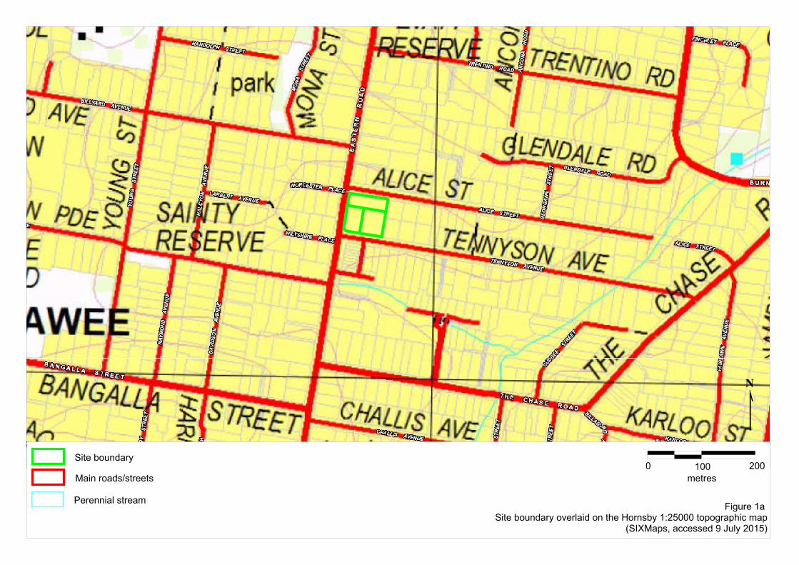
Figure 1a Site boundary overlaid on the Hornsby 1:25000 topographic map
(SIXMaps, accessed 9 July 2015)
Site boundary
Main roads/streets
Perennial stream
Alice StreetAlice StreetAlice StreetAlice StreetAlice StreetAlice StreetAlice StreetAlice StreetAlice Street
Tennyson AvenueTennyson AvenueTennyson AvenueTennyson AvenueTennyson AvenueTennyson AvenueTennyson AvenueTennyson AvenueTennyson Avenue
Chilton ParadeChilton ParadeChilton ParadeChilton ParadeChilton ParadeChilton ParadeChilton ParadeChilton ParadeChilton Parade
East
ern
Roa
dEa
ster
n R
oad
East
ern
Roa
dEa
ster
n R
oad
East
ern
Roa
dEa
ster
n R
oad
East
ern
Roa
dEa
ster
n R
oad
East
ern
Roa
d
0 80metres
160
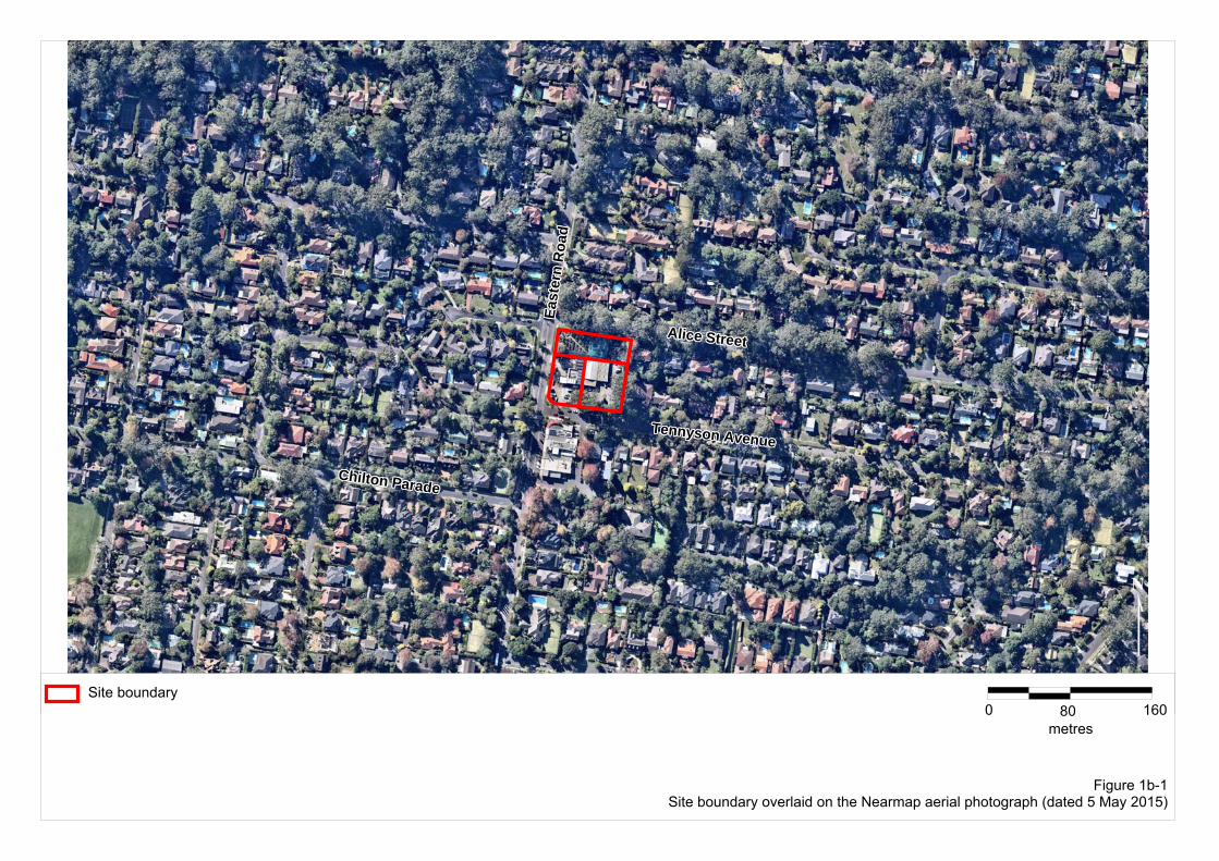
Figure 1b-1Site boundary overlaid on the Nearmap aerial photograph (dated 5 May 2015)
Site boundary
Tennyson AvenueTennyson AvenueTennyson AvenueTennyson AvenueTennyson AvenueTennyson AvenueTennyson AvenueTennyson AvenueTennyson Avenue
Alice StreetAlice StreetAlice StreetAlice StreetAlice StreetAlice StreetAlice StreetAlice StreetAlice Street
East
ern
Roa
dEa
ster
n R
oad
East
ern
Roa
dEa
ster
n R
oad
East
ern
Roa
dEa
ster
n R
oad
East
ern
Roa
dEa
ster
n R
oad
East
ern
Roa
d
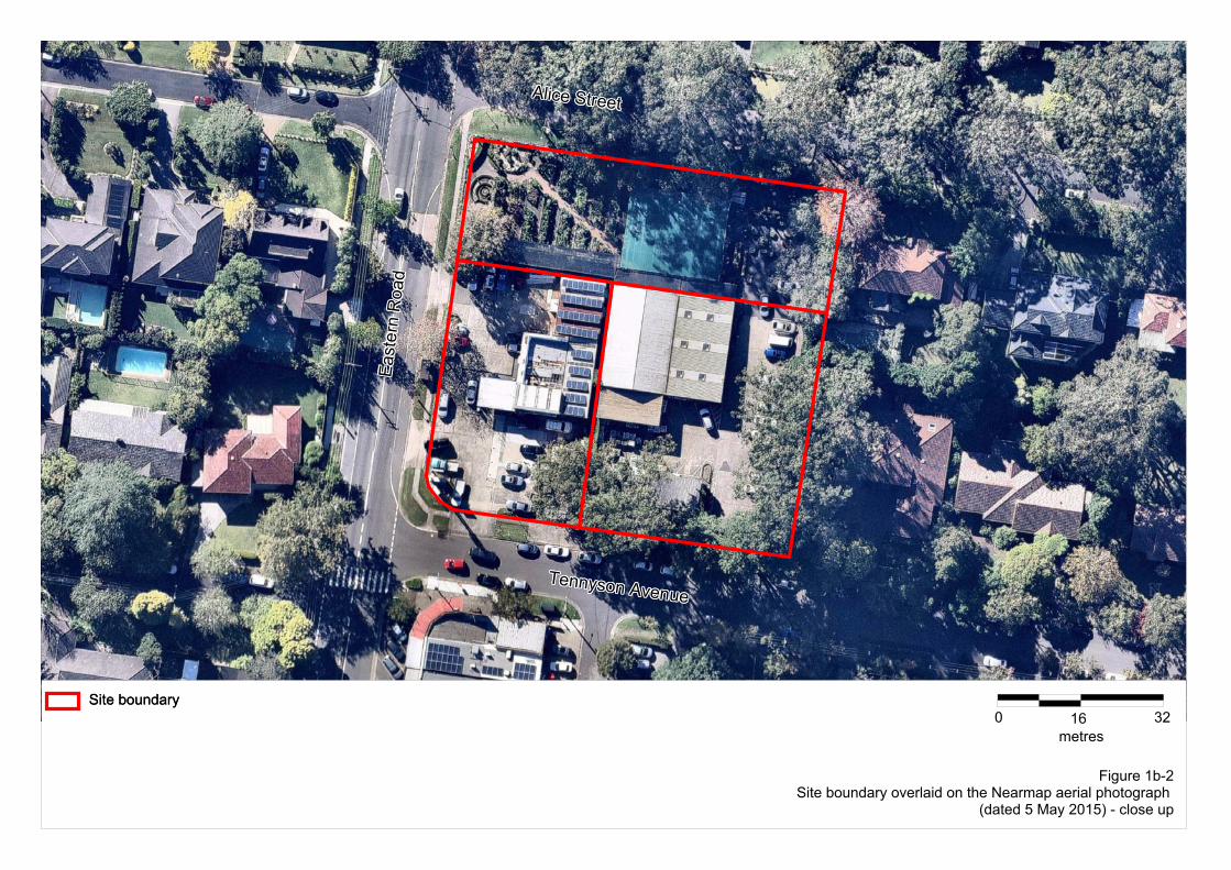
0 16metres
32Site boundarySite boundary
Figure 1b-2Site boundary overlaid on the Nearmap aerial photograph
(dated 5 May 2015) - close up
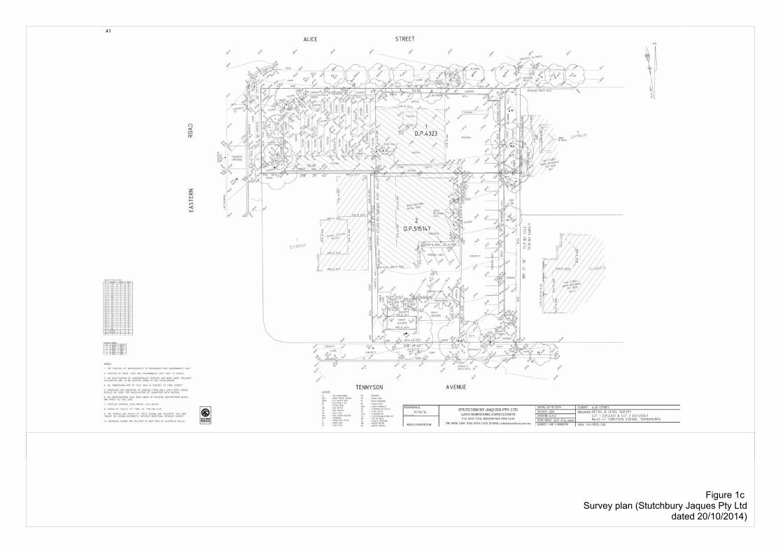
Figure 1c Survey plan (Stutchbury Jaques Pty Ltd
dated 20/10/2014)
0 100Metres (m)
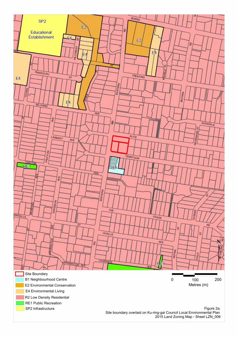
200Site BoundaryB1 Neighbourhood CentreE2 Environmental ConservationE4 Environmental Living
R2 Low Density ResidentialRE1 Public RecreationSP2 Infrastructure Figure 2a.
Site boundary overlaid on Ku-ring-gai Council Local Environmental Plan 2015 Land Zoning Map - Sheet LZN_006
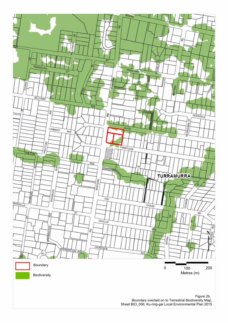
Boundary
Biodiversity
0 100Metres (m)
200
Figure 2b. Boundary overlaid on to Terrestrial Biodiversity Map,
Sheet BIO_006, Ku-ring-gai Local Environmental Plan 2015
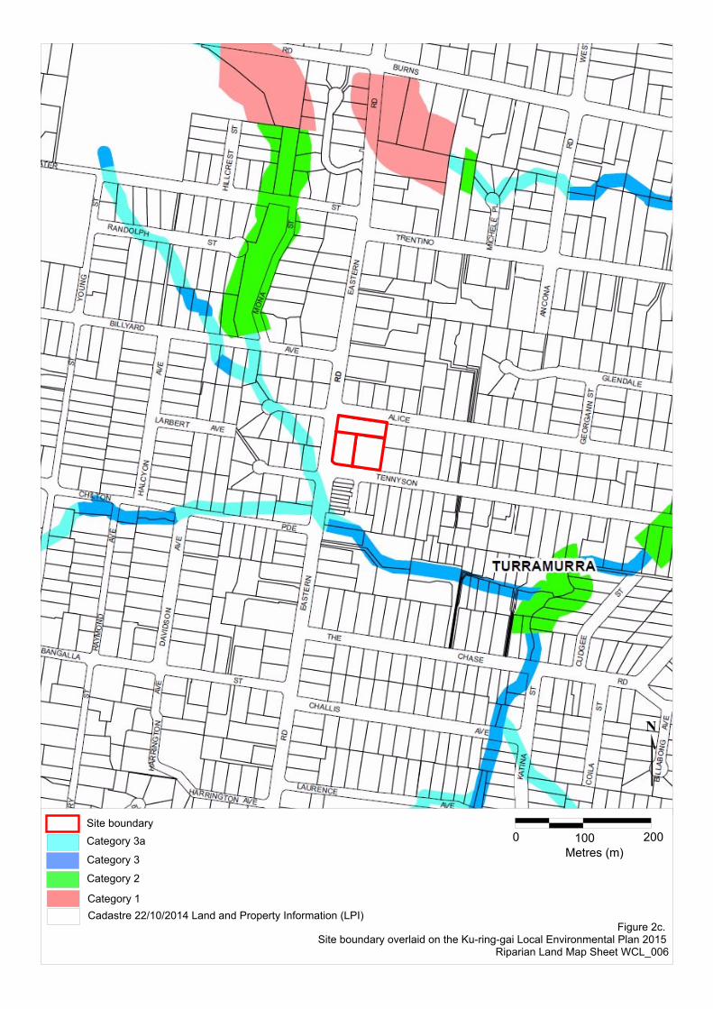
Site boundaryCategory 3a
Category 3
Category 2
Category 1Cadastre 22/10/2014 Land and Property Information (LPI)
0 100Metres (m)
200
Figure 2c. Site boundary overlaid on the Ku-ring-gai Local Environmental Plan 2015
Riparian Land Map Sheet WCL_006
0 100metres
200
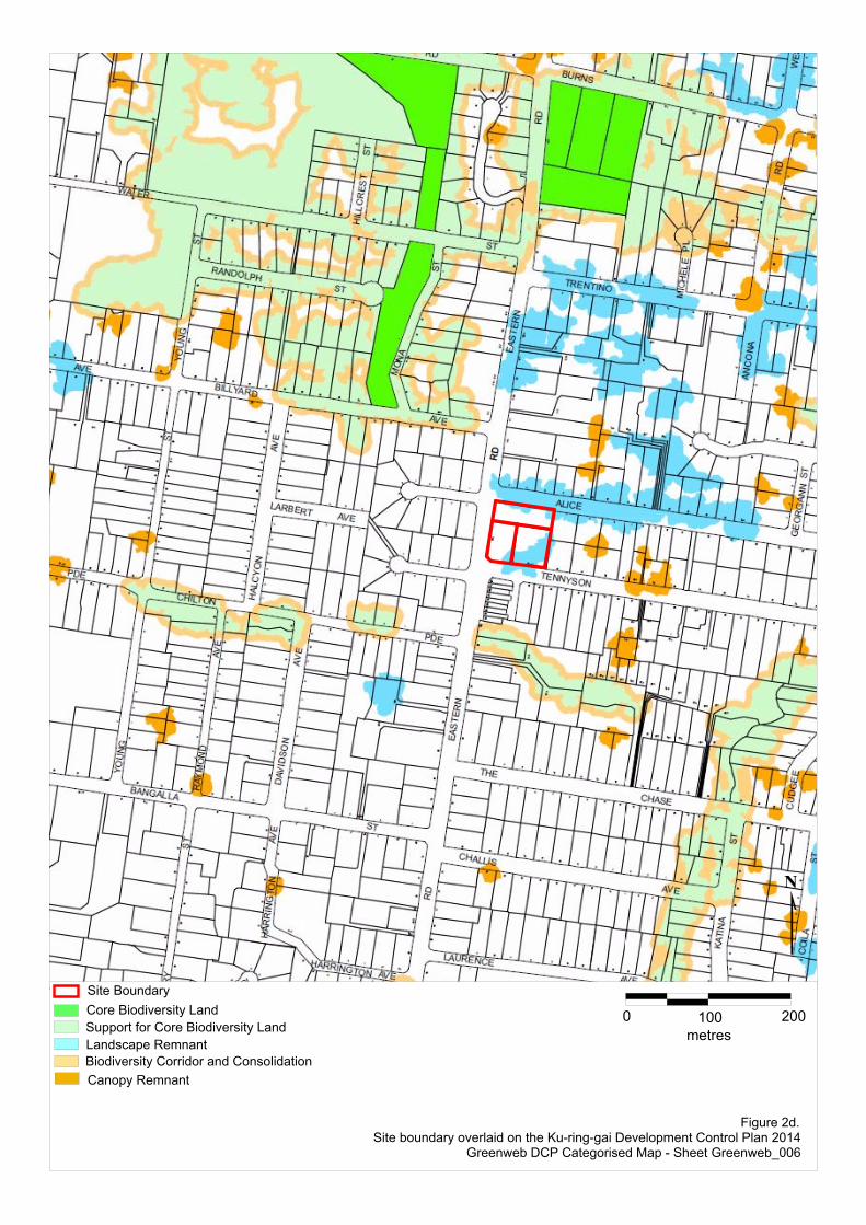
Site BoundaryCore Biodiversity LandSupport for Core Biodiversity LandLandscape RemnantBiodiversity Corridor and ConsolidationCanopy Remnant
Figure 2d.Site boundary overlaid on the Ku-ring-gai Development Control Plan 2014
Greenweb DCP Categorised Map - Sheet Greenweb_006
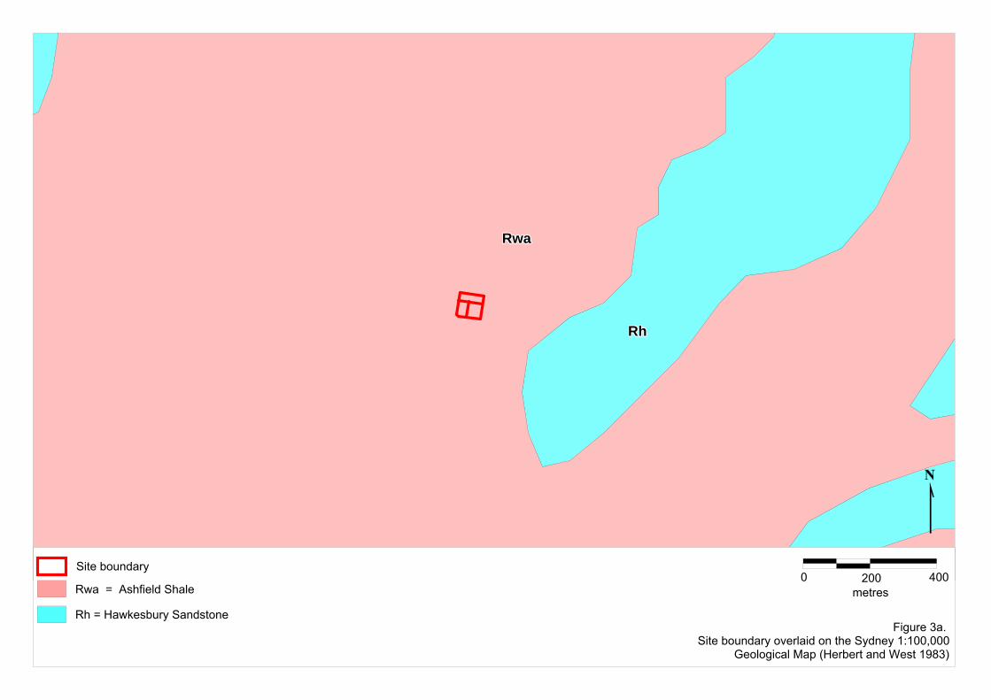
Figure 3a. Site boundary overlaid on the Sydney 1:100,000
Geological Map (Herbert and West 1983)
Site boundary0 200
metres400
RwaRwaRwaRwaRwaRwaRwaRwaRwa
RhRhRhRhRhRhRhRhRh
Rh = Hawkesbury Sandstone
Rwa = Ashfield Shale

lhlhlhlhlhlhlhlhlh
gygygygygygygygygy
gygygygygygygygygy
gygygygygygygygygy
wpwpwpwpwpwpwpwpwp
gngngngngngngngngn
0 200metres
400
Figure 3b.Site boundary overlaid on the Sydney 1:100,000 Soil Landscape Map
(Chapman et al. 1989)
Site boundary
wp = West Pennant Hills
gn = Glenorie
lh = Lucas Heights
gy = Gymea
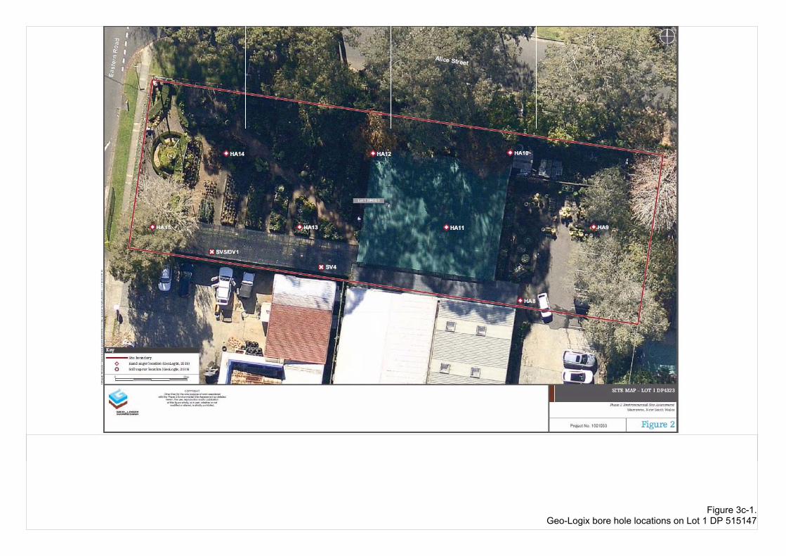
Figure 3c-1.Geo-Logix bore hole locations on Lot 1 DP 515147
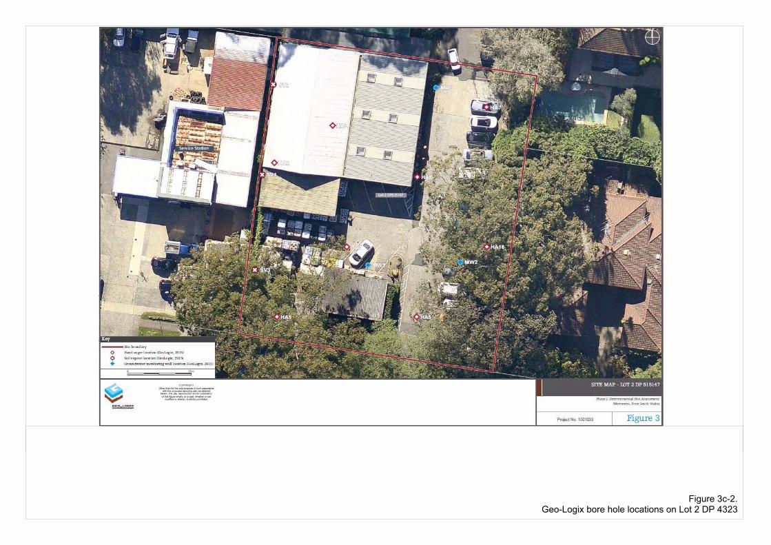
Figure 3c-2.Geo-Logix bore hole locations on Lot 2 DP 4323
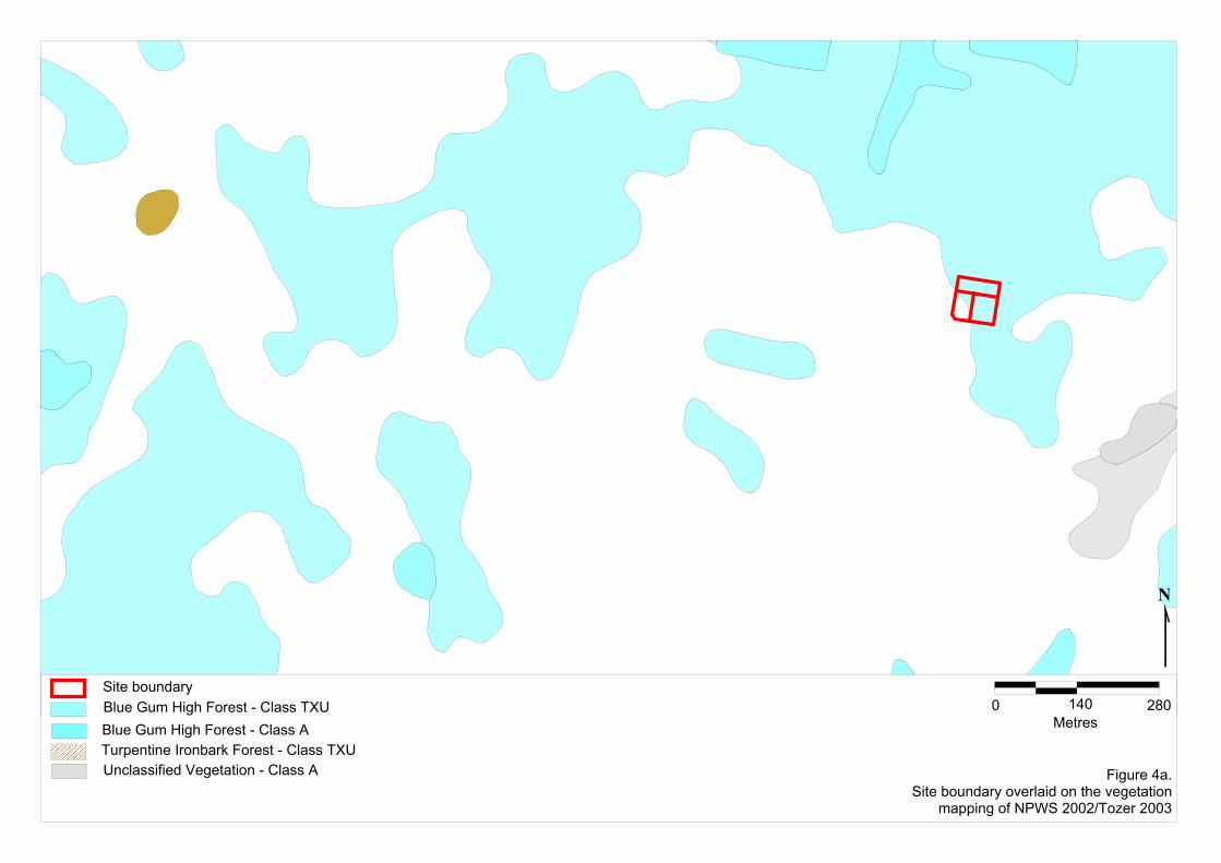
Site boundary0 140 280
MetresBlue Gum High Forest - Class TXU
Figure 4a.Site boundary overlaid on the vegetation
mapping of NPWS 2002/Tozer 2003
Blue Gum High Forest - Class A
Unclassified Vegetation - Class ATurpentine Ironbark Forest - Class TXU
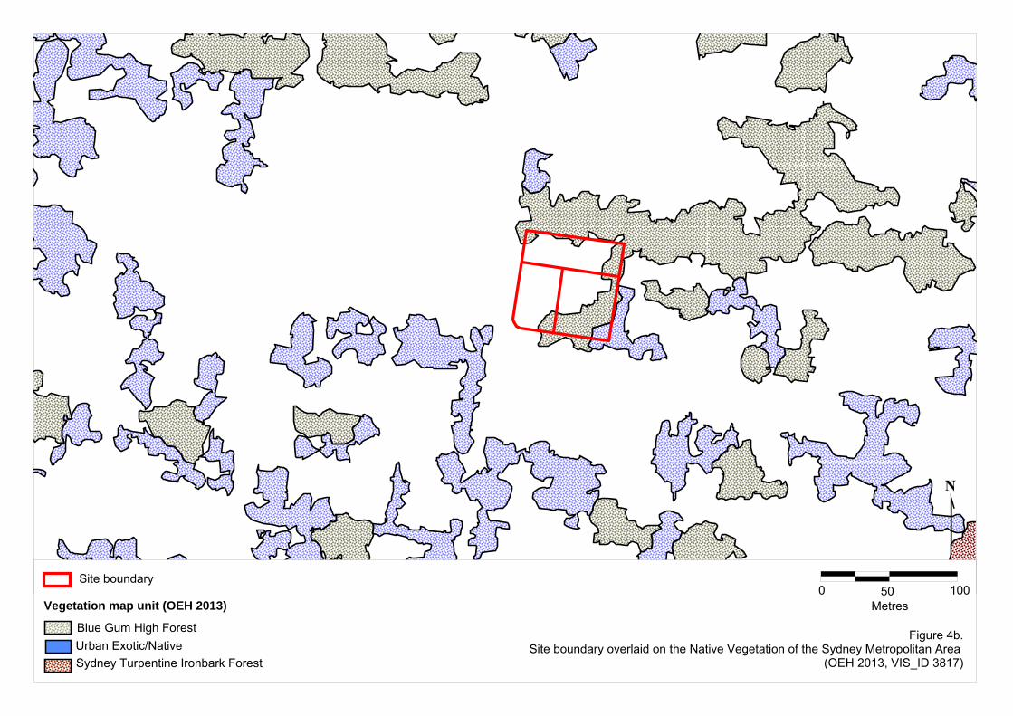
Figure 4b.Site boundary overlaid on the Native Vegetation of the Sydney Metropolitan Area
(OEH 2013, VIS_ID 3817)
Site boundary0 50
Metres100
Urban Exotic/NativeBlue Gum High Forest
Sydney Turpentine Ironbark Forest
Vegetation map unit (OEH 2013)
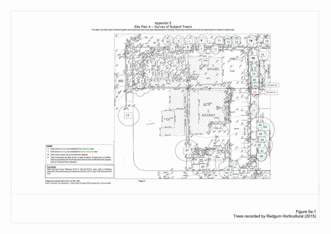
Figure 5a-1Trees recorded by Redgum Horticultural (2015)
161616161616161616
151515151515151515
191919191919191919202020202020202020
212121212121212121
333333333333333333
353535353535353535343434343434343434363636363636363636
323232323232323232 313131313131313131
303030303030303030
111111111111111111 121212121212121212 131313131313131313
272727272727272727
Tennyson AvenueTennyson AvenueTennyson AvenueTennyson AvenueTennyson AvenueTennyson AvenueTennyson AvenueTennyson AvenueTennyson Avenue
292929292929292929
373737373737373737
282828282828282828
Alice StreetAlice StreetAlice StreetAlice StreetAlice StreetAlice StreetAlice StreetAlice StreetAlice Street
East
ern
Roa
dEa
ster
n R
oad
East
ern
Roa
dEa
ster
n R
oad
East
ern
Roa
dEa
ster
n R
oad
East
ern
Roa
dEa
ster
n R
oad
East
ern
Roa
d
171717171717171717
111111111
555555555
252525252525252525
262626262626262626
888888888 101010101010101010
232323232323232323
222222222
444444444
333333333666666666
141414141414141414
181818181818181818
777777777
999999999
0 16Metres
32Site boundarySite boundary
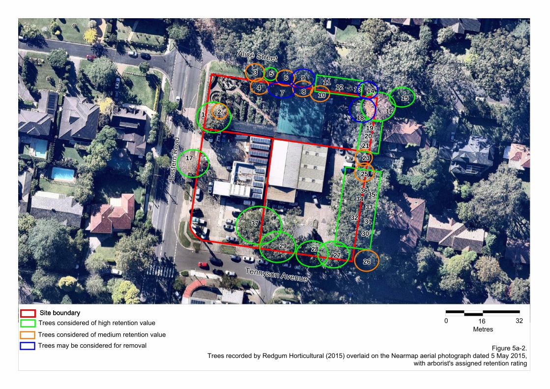
Figure 5a-2.Trees recorded by Redgum Horticultural (2015) overlaid on the Nearmap aerial photograph dated 5 May 2015,
with arborist's assigned retention rating
Trees considered of high retention value
Trees considered of medium retention valueTrees may be considered for removal
Spot HSpot HSpot HSpot HSpot HSpot HSpot HSpot HSpot H
Spot ISpot ISpot ISpot ISpot ISpot ISpot ISpot ISpot I
Spot JSpot JSpot JSpot JSpot JSpot JSpot JSpot JSpot J
Spot GSpot GSpot GSpot GSpot GSpot GSpot GSpot GSpot G
Spot ESpot ESpot ESpot ESpot ESpot ESpot ESpot ESpot E
Spot KSpot KSpot KSpot KSpot KSpot KSpot KSpot KSpot K
Spot FSpot FSpot FSpot FSpot FSpot FSpot FSpot FSpot F
Spot CSpot CSpot CSpot CSpot CSpot CSpot CSpot CSpot C Spot DSpot DSpot DSpot DSpot DSpot DSpot DSpot DSpot D
Spot BSpot BSpot BSpot BSpot BSpot BSpot BSpot BSpot B
Spot PSpot PSpot PSpot PSpot PSpot PSpot PSpot PSpot P
Transect 1Transect 1Transect 1Transect 1Transect 1Transect 1Transect 1Transect 1Transect 1
Spot ASpot ASpot ASpot ASpot ASpot ASpot ASpot ASpot A
Spot LSpot LSpot LSpot LSpot LSpot LSpot LSpot LSpot L
Spot NSpot NSpot NSpot NSpot NSpot NSpot NSpot NSpot N
Spot MSpot MSpot MSpot MSpot MSpot MSpot MSpot MSpot M
Spot OSpot OSpot OSpot OSpot OSpot OSpot OSpot OSpot O
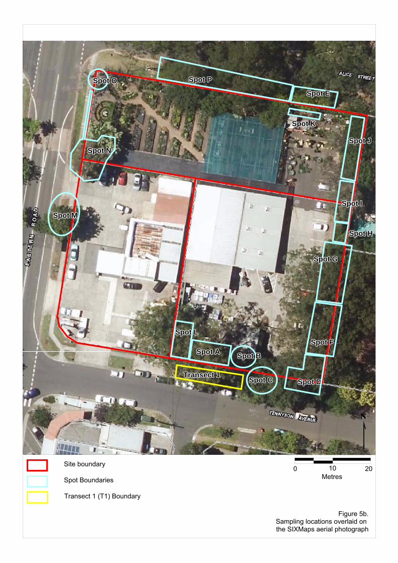
0 10 20Metres
Site boundary
Spot Boundaries
Transect 1 (T1) Boundary
Figure 5b.Sampling locations overlaid on the SIXMaps aerial photograph

Tennyson AveTennyson AveTennyson AveTennyson AveTennyson AveTennyson AveTennyson AveTennyson AveTennyson Ave
East
ern
Rd
East
ern
Rd
East
ern
Rd
East
ern
Rd
East
ern
Rd
East
ern
Rd
East
ern
Rd
East
ern
Rd
East
ern
Rd
Alice StAlice StAlice StAlice StAlice StAlice StAlice StAlice StAlice St
292929292929292929282828282828282828 272727272727272727
373737373737373737
303030303030303030313131313131313131323232323232323232333333333333333333343434343434343434353535353535353535363636363636363636
Figure 6a.Calculated Tree Protection Zones (TPZ) and Structural Root Zones (SRZ)
of the local native canopy trees overlaid on the survey plan
0 15metres
30Site boundarySite boundaryTree Protection Zone (TPZ)
Structural Root Zone (SRZ)Estimated TPZ
Estimated SRZ
Brick retaining wall
Estimated tree location
Surveyed tree location

Tennyson AveTennyson AveTennyson AveTennyson AveTennyson AveTennyson AveTennyson AveTennyson AveTennyson Ave
East
ern
Rd
East
ern
Rd
East
ern
Rd
East
ern
Rd
East
ern
Rd
East
ern
Rd
East
ern
Rd
East
ern
Rd
East
ern
Rd
ttt
292929292929292929282828282828282828 272727272727272727
373737373737373737
303030303030303030313131313131313131323232323232323232333333333333333333343434343434343434353535353535353535363636363636363636
Figure 6b.Calculated Tree Protection Zones (TPZ) and Structural Root Zones (SRZ)
of the local native canopy trees overlaid on the Nearmap aerial photograph (dated 5 May 2015)
0 15metres
30Site boundarySite boundaryTree Protection Zone (TPZ)
Structural Root Zone (SRZ)Estimated TPZ
Estimated SRZ
Brick retaining wall
Estimated tree location
Surveyed tree location
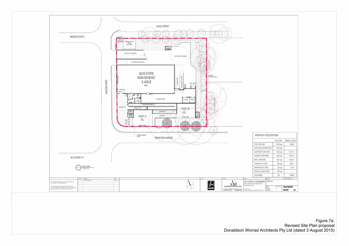
Figure 7a.Revised Site Plan proposal
Donaldson Worrad Architects Pty Ltd (dated 3 August 2015)
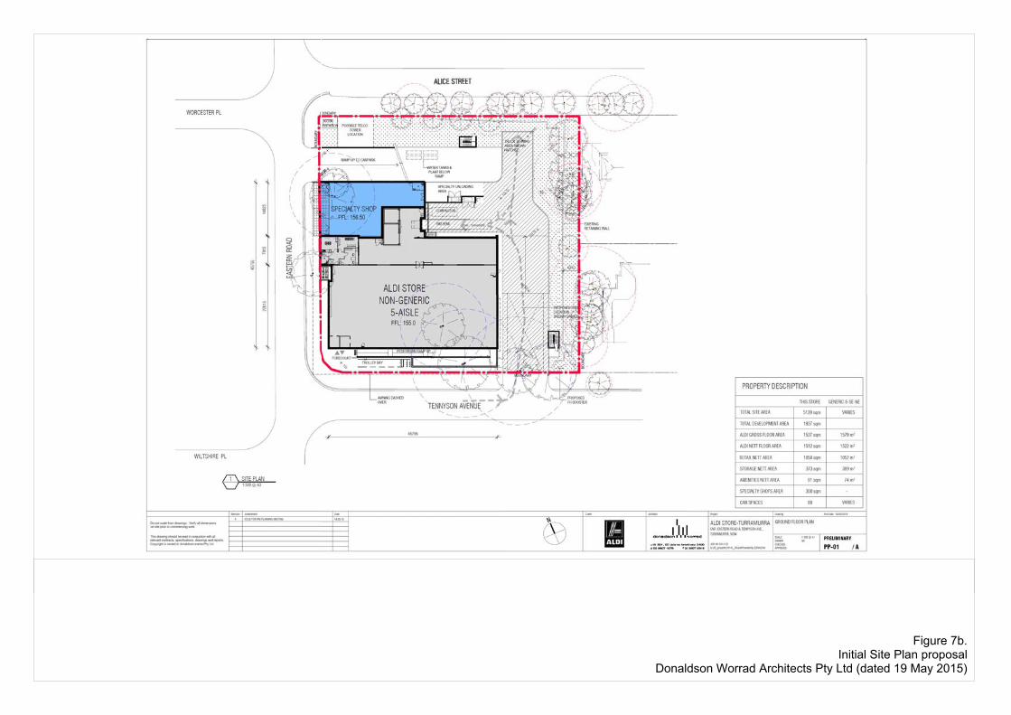
Figure 7b.Initial Site Plan proposal
Donaldson Worrad Architects Pty Ltd (dated 19 May 2015)
Tennyson AveTennyson AveTennyson AveTennyson AveTennyson AveTennyson AveTennyson AveTennyson AveTennyson Ave
East
ern
Rd
East
ern
Rd
East
ern
Rd
East
ern
Rd
East
ern
Rd
East
ern
Rd
East
ern
Rd
East
ern
Rd
East
ern
Rd
Alice StAlice StAlice StAlice StAlice StAlice StAlice StAlice StAlice St
292929292929292929282828282828282828 272727272727272727
373737373737373737
303030303030303030313131313131313131323232323232323232333333333333333333343434343434343434353535353535353535363636363636363636
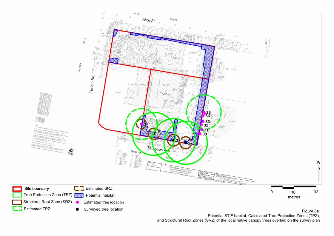
Figure 8a.Potential STIF habitat, Calculated Tree Protection Zones (TPZ),
and Structural Root Zones (SRZ) of the local native canopy trees overlaid on the survey plan
Site boundarySite boundaryTree Protection Zone (TPZ)
Structural Root Zone (SRZ)
Estimated TPZ
Estimated SRZ
Estimated tree location
Surveyed tree location
Potential habitat0 16
metres32
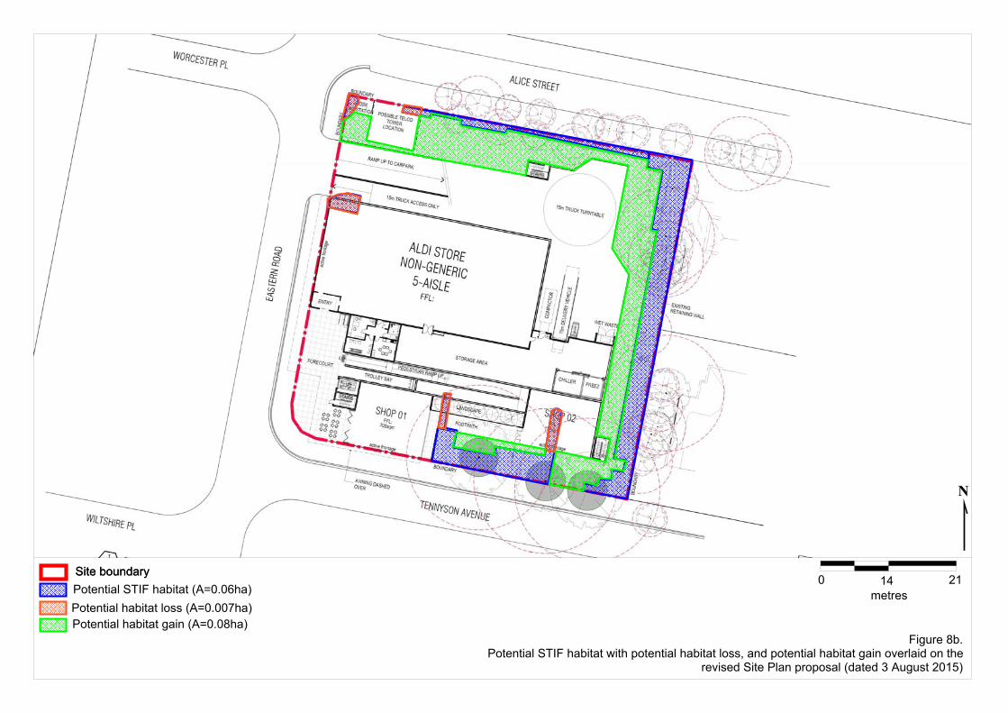
Figure 8b.Potential STIF habitat with potential habitat loss, and potential habitat gain overlaid on the
revised Site Plan proposal (dated 3 August 2015)
0 14metres
21Site boundarySite boundaryPotential STIF habitat (A=0.06ha)Potential habitat loss (A=0.007ha)Potential habitat gain (A=0.08ha)

Anne Clements & Associates Pty Limited
Tables
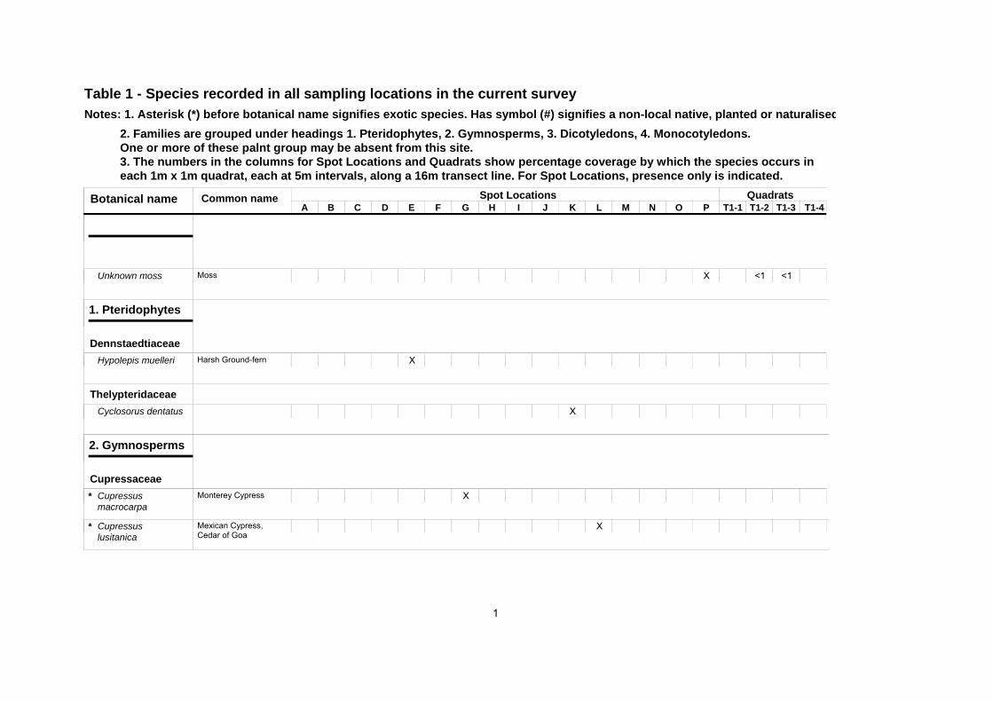
Notes: 1. Asterisk (*) before botanical name signifies exotic species. Has symbol (#) signifies a non-local native, planted or naturalisedTable 1 - Species recorded in all sampling locations in the current survey
2. Families are grouped under headings 1. Pteridophytes, 2. Gymnosperms, 3. Dicotyledons, 4. Monocotyledons. One or more of these palnt group may be absent from this site. 3. The numbers in the columns for Spot Locations and Quadrats show percentage coverage by which the species occurs in each 1m x 1m quadrat, each at 5m intervals, along a 16m transect line. For Spot Locations, presence only is indicated.
Quadrats Spot Locations C D
Botanical name A B E F G H I J K L M N O P T1-1 T1-2 T1-3 T1-4
Common name
Unknown moss X <1 <1Moss
1. Pteridophytes
Dennstaedtiaceae XHypolepis muelleri Harsh Ground-fern
Thelypteridaceae Cyclosorus dentatus X
2. Gymnosperms
Cupressaceae Cupressus macrocarpa
X* Monterey Cypress
Cupressus lusitanica
X* Mexican Cypress, Cedar of Goa
1
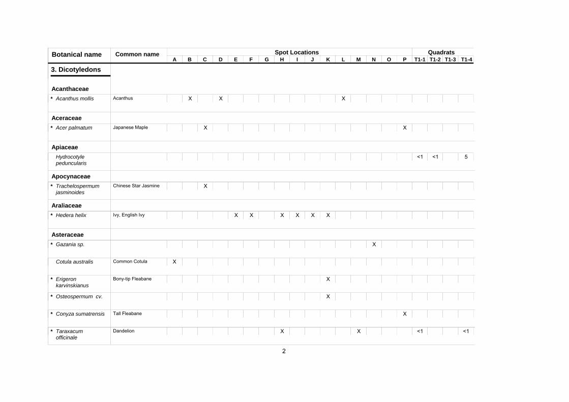
Quadrats Spot Locations C D
Botanical name A B E F G H I J K L M N O P T1-1 T1-2 T1-3 T1-4
Common name
3. Dicotyledons
Acanthaceae XAcanthus mollis X X* Acanthus
Aceraceae Acer palmatum X X* Japanese Maple
Apiaceae Hydrocotyle peduncularis
<1 <1 5
Apocynaceae Trachelospermum jasminoides
X* Chinese Star Jasmine
Araliaceae XHedera helix X X X X X* Ivy, English Ivy
Asteraceae Gazania sp. X*
Cotula australis XCommon Cotula
Erigeron karvinskianus
X* Bony-tip Fleabane
Osteospermum cv. X*
Conyza sumatrensis X* Tall Fleabane
Taraxacum officinale
X X <1 <1* Dandelion
2

Quadrats Spot Locations C D
Botanical name A B E F G H I J K L M N O P T1-1 T1-2 T1-3 T1-4
Common name
XSoliva sessilis X 20 3 1* Bindi-eye, Jo-Jo
Sonchus oleraceus X X* Common Sow-thistle, Milk-thistle
Brassicaceae Lepidium sp. <1*
Cardamine hirsuta X <1 <1* Common Bittercress
Buxaceae Buxus sp. X X X X*
Caryophyllaceae XCerastium
glomeratum <1* Mouse-ear Chickweed
Stellaria media X X <1* Chickweed
Polycarpon tetraphyllum
X* Four-leaf Allseed
Crassulaceae Sedum sp. X*
Euphorbiaceae Phyllanthus tenellus X*
Euphorbia leucocephala
X* Pascuita
Homalanthus populifolius
XBleeding heart, Native Poplar
3
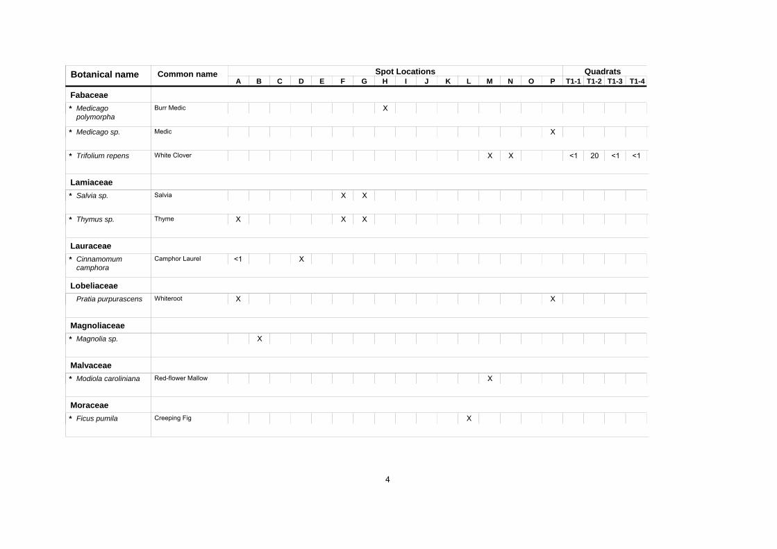
Quadrats Spot Locations C D
Botanical name A B E F G H I J K L M N O P T1-1 T1-2 T1-3 T1-4
Common name
Fabaceae Medicago polymorpha
X* Burr Medic
Medicago sp. X* Medic
Trifolium repens X X <1 20 <1 <1* White Clover
Lamiaceae Salvia sp. X X* Salvia
Thymus sp. X X X* Thyme
Lauraceae XCinnamomum
camphora <1* Camphor Laurel
Lobeliaceae Pratia purpurascens X XWhiteroot
Magnoliaceae Magnolia sp. X*
Malvaceae Modiola caroliniana X* Red-flower Mallow
Moraceae Ficus pumila X* Creeping Fig
4
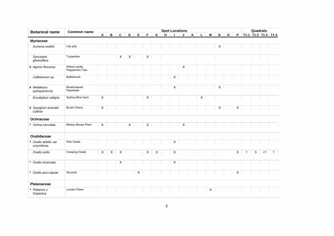
Quadrats Spot Locations C D
Botanical name A B E F G H I J K L M N O P T1-1 T1-2 T1-3 T1-4
Common name
Myrtaceae Acmena smithii XLilly-pilly
XSyncarpia glomulifera
X XTurpentine
Agonis flexuosa X# Willow-myrtle, Peppermint Tree
Callistemon sp. XBottlebrush
Melaleuca quinquenervia
X X# Broad-leaved Paperbark
Eucalyptus saligna X X XSydney Blue Gum
Syzygium australe cultivar
X X X# Brush Cherry
Ochnaceae XOchna serrulata X X X* Mickey Mouse Plant
Oxalidaceae Oxalis debilis var. corymbosa
X* Pink Oxalis
Oxalis exilis X X X X X X X 1 3 <1 1Creeping Oxalis
Oxalis incarnata X X*
XOxalis pes-caprae X* Soursob
Platanaceae Platanus x hispanica
X* London Plane
5
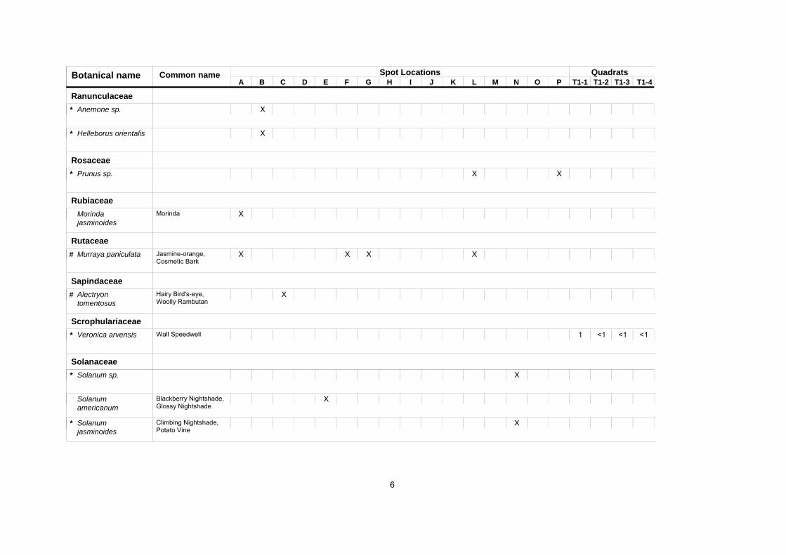
Quadrats Spot Locations C D
Botanical name A B E F G H I J K L M N O P T1-1 T1-2 T1-3 T1-4
Common name
Ranunculaceae Anemone sp. X*
Helleborus orientalis X*
Rosaceae Prunus sp. X X*
Rubiaceae Morinda jasminoides
XMorinda
Rutaceae Murraya paniculata X X X X# Jasmine-orange,
Cosmetic Bark
Sapindaceae Alectryon tomentosus
X# Hairy Bird's-eye, Woolly Rambutan
Scrophulariaceae Veronica arvensis 1 <1 <1 <1* Wall Speedwell
Solanaceae Solanum sp. X*
XSolanum americanum
Blackberry Nightshade, Glossy Nightshade
Solanum jasminoides
X* Climbing Nightshade, Potato Vine
6
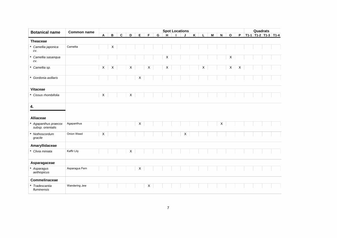
Quadrats Spot Locations C D
Botanical name A B E F G H I J K L M N O P T1-1 T1-2 T1-3 T1-4
Common name
Theaceae Camellia japonica cv.
X* Camellia
Camellia sasanqua cv.
X X*
XCamellia sp. X X X X X X X*
XGordonia axillaris *
Vitaceae XCissus rhombifolia X*
4.
Alliaceae XAgapanthus praecox
subsp. orientalisX* Agapanthus
Nothoscordum gracile
X X* Onion Weed
Amaryllidaceae XClivia miniata * Kaffir Lily
Asparagaceae XAsparagus
aethiopicus * Asparagus Fern
Commelinaceae Tradescantia fluminensis
X* Wandering Jew
7
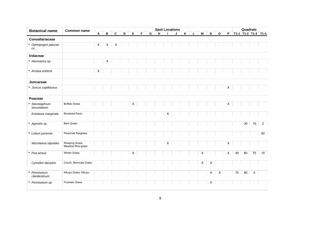
Quadrats Spot Locations C D
Botanical name A B E F G H I J K L M N O P T1-1 T1-2 T1-3 T1-4
Common name
Convallariaceae Ophiopogon jaburan cv.
X X X*
Iridaceae Neomarica sp. X*
Aristea ecklonii X*
Juncaceae Juncus capillaceus X*
Poaceae XStenotaphrum
secundatum X* Buffalo Grass
Entolasia marginata XBordered Panic
Agrostis sp. 30 15 2* Bent Grass
Lolium perenne 60* Perennial Ryegrass
Microlaena stipoides X XWeeping Grass, Meadow Rice-grass
XPoa annua X X 40 80 75 10* Winter Grass
Cynodon dactylon X XCouch, Bermuda Grass
Pennisetum clandestinum
X X 70 80 5* Kikuyu Grass, Kikuyu
Pennisetum sp. X* Fountain Grass
8
Quadrats Spot Locations C D
Botanical name A B E F G H I J K L M N O P T1-1 T1-2 T1-3 T1-4
Common name
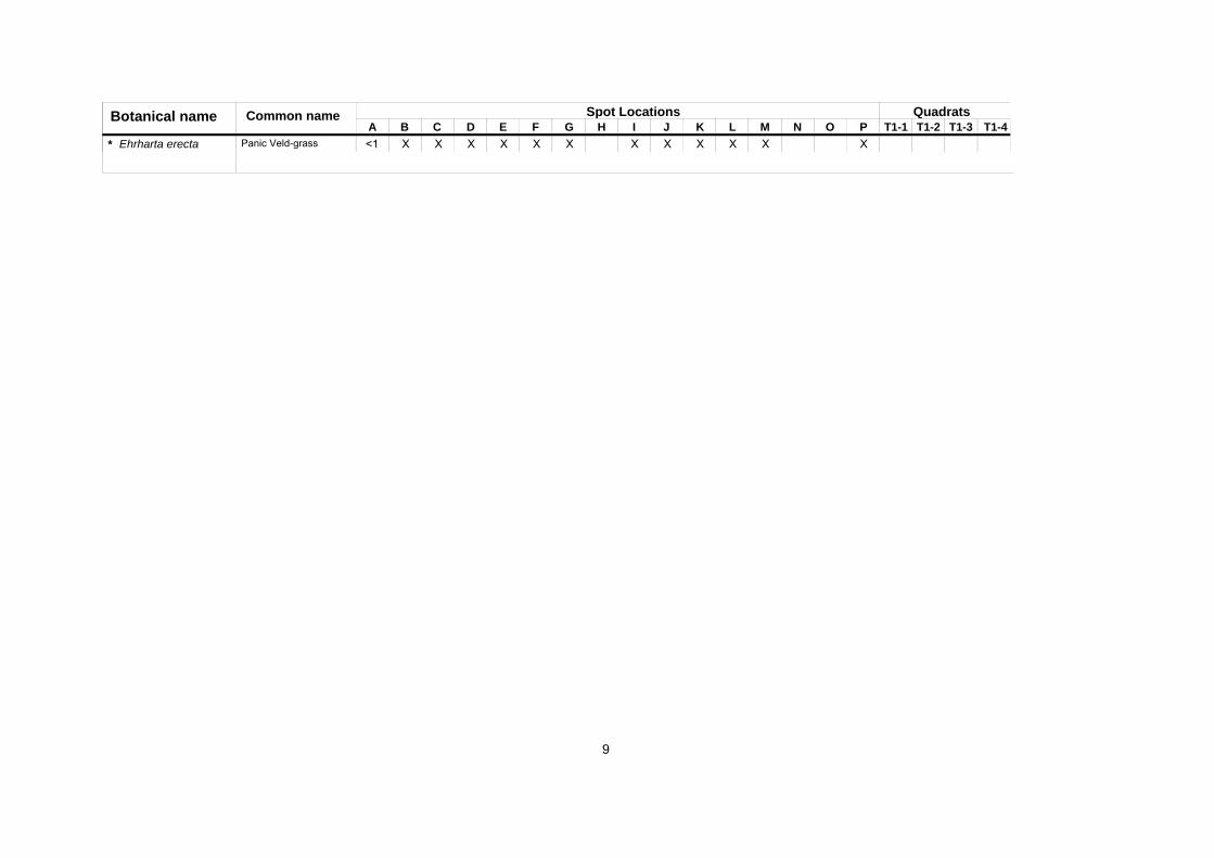
X XEhrharta erecta <1 X X X X X X X X X X* Panic Veld-grass
9


