March 2004
ENGINEERING EVALUATION OF CITY OF SPRINGFIELD
FLOOD HAZARD REDUCTION PROJECT BETWEEN HOLLAND AVENUE AND CAMPBELL AVENUE
Prepared for: City of Springfield Missouri
Department of Public Works
Prepared by:
Wright Water Engineers, Inc. (WWE) Denver, Colorado
ENGINEERING EVALUATION OF
CITY OF SPRINGFIELD FLOOD HAZARD REDUCTION PROJECT BETWEEN
HOLLAND AVENUE AND CAMPBELL AVENUE
Prepared for: City of Springfield Missouri
Department of Public Works
Prepared by:
Wright Water Engineers, Inc. (WWE) Denver, Colorado
March 2004
i
TABLE OF CONTENTS
Page
1.0 PURPOSE......................................................................................................................... 1
2.0 SUMMARY OF MAJOR FINDINGS.................................................................................. 2
3.0 BASIS OF EVALUATION................................................................................................. 3
4.0 NATURE OF STUDY AREA, INCLUDING FLOODING HISTORY AND FLOOD FLOW PROJECTIONS................................................................................................................. 5 4.1 Watershed Characteristics.................................................................................................. 5 4.2 Nature of Neighborhood Between Holland and Campbell Avenues................................... 5 4.3 Flood Flow Projections........................................................................................................ 6 4.4 Nature of Fassnight Creek Channel in Study Reach and of the Flooding Problem ........... 8
5.0 ASSESSMENT OF FLOOD RISK .................................................................................. 10 5.1 Flood History ..................................................................................................................... 10 5.2 Prior Flood Studies ........................................................................................................... 12 5.3 Rainfall-Runoff Data.......................................................................................................... 12 5.4 Flooding Depths and Velocities, and Significance of July 12, 2000 Flood....................... 13
5.4.1 Flood Depths and Velocities ............................................................................. 13 5.4.2 Significance of July 12, 2000 Flood .................................................................. 14
5.5 Bridge Overtopping and Emergency Access.................................................................... 16 5.6 Flood Duration................................................................................................................... 18 5.7 Number of Structures in Floodplain .................................................................................. 18 5.8 Significance of Underground Pipes, Limit of Floodplain Map........................................... 19 and Number of Complaint Calls ........................................................................................ 19 5.9 Channel Between Jefferson and Bennett Street Bridge ................................................... 20 5.10 Comparison to South Creek Conveyance Capacity and to .............................................. 20 Upstream Fassnight Channel Capacity ............................................................................ 20 5.11 Sanitary Sewer Backups................................................................................................... 21 5.12 Contribution to Nuisance Conditions in Basements and Crawlspaces ............................ 21 5.13 Summary of Flood Risk in Study Reach ........................................................................... 21
6.0 OVERVIEW OF CITY OF SPRINGFIELD FLOODPLAIN ACQUISITION PROGRAM ..22
7.0 POTENTIAL FLOOD RISK REDUCTION ALTERNATIVES EVALUATED BY CITY OF SPRINGFIELD AND WWE ............................................................................................. 25 7.1 Background and Initial Alternatives Evaluated ................................................................. 25 7.2 Feasibility of Upstream Detention..................................................................................... 28 7.3 Additional Elements of Flood Control Suggested by ........................................................ 31 Property Owners/Residents in Study Reach .................................................................... 31 7.4 Preferred Alternative ......................................................................................................... 34 7.5 WWE Analysis of Alternatives Evaluated ......................................................................... 35
8.0 FLOODPLAIN POLICY QUESTIONS ............................................................................ 38
9.0 SUMMARY OF PROPERTY OWNER QUESTIONS, CONCERNS AND CRITICISMS .43
10.0 EVALUATION OF CITY HYDRAULIC AND HYDROLOGY MODELS .......................... 46 10.1 Hydraulic Model (HEC-RAS)............................................................................................. 46
10.1.1 Bridges/Culverts ................................................................................................ 46
ii
10.1.2 Channel Manning’s “n” Factors (Friction Factor) .............................................. 48 10.1.3 Bank Station Locations...................................................................................... 49 10.1.4 Hydraulic Profiles .............................................................................................. 50 10.1.5 Cross-Sections .................................................................................................. 51 10.1.6 Boundary Conditions ......................................................................................... 51 10.1.7 Ineffective Flow Areas ....................................................................................... 51 10.1.8 Flow Input Values.............................................................................................. 51 10.1.9 Split Flow Areas ................................................................................................ 51
10.2 “Culvert Master” Program—Long Culvert from Holland Avenue to Jefferson Avenue ..... 52 10.3 Large Printed 3- and 6-hr 100-year Floodplain Maps....................................................... 52 10.4 Hydrologic Model (HEC-1 Model) ..................................................................................... 52
10.4.1 Sub-basin Areas................................................................................................ 52 10.4.2 Channel Routing Parameters............................................................................ 52 10.4.3 Model Network Setup ........................................................................................ 52 10.4.4 Curve Numbers and Lag Times ........................................................................ 53 10.4.5 Runoff Volumes................................................................................................. 53 10.4.6 Runoff Peaks..................................................................................................... 53
10.5 Detention Basin Options ................................................................................................... 54 10.5.1 Basin Volumes .................................................................................................. 54 10.5.2 Peak Runoff Reduction ..................................................................................... 54
11.0 WWE ANALYSIS AND RECOMMENDATIONS............................................................. 55
REFERENCES ........................................................................................................................... 63
iii
PHOTOGRAPHS
1-26 ............................................................................................................................... End of Document
TABLES
1 Fassnight Creek Watershed Characteristics and Flood Flows at Key Locations............................ 6 2 Summary of 100-Year and Other Flood Flow Estimates for Fassnight Creek at Various Locations ........................................................................................................................ 7 3 City of Springfield Rainfall—Return Frequency Data for Fassnight Creek at Various Locations ...................................................................................................................... 13 4 Depth of Floodwater over Bennett Street Bridge Under Current Conditions Based on Calculations by City........................................................................ 17 5 Bennett Street Overtopping Depths, Assuming that Crossing Capacity is Upgraded to Include 5-Cell Box Culvert ............................................................................................................. 33 6 Actual Storage versus Estimated Storage Volumes for Proposed Fassnight Creek Basins A, B and C ............................................................................................................... 54
FIGURES
1 Fassnight Creek Watershed .................................................................................. End of Document 2 Fassnight Creek HEC-RAS Cross-section Upstream of Campbell Street Bridge ......................... 48 3 Fassnight Creek HEC-RAS Cross-section In Reach Between Bennett Street and Campbell ...... 49 4 100-year, 3-hr Encroachment Water Surface Profile..................................................................... 50
DRAWINGS
1 Detailed Map of the Study Reach ......................................................................... End of Document
APPENDIX
A HEC-1 Computer Model ........................................................................................ End of Document
991-168.070 Wright Water Engineers, Inc. (WWE) Page 1 March 2004
Engineering Evaluation of City of Springfield Flood Hazard Reduction Project Between Holland Avenue and Campbell Avenue
1.0 PURPOSE
The City of Springfield, Missouri Department of Public Works retained Wright Water Engineers,
Inc. (WWE)1 to evaluate the need for and feasibility of a proposed flood hazard reduction project
on Fassnight Creek in the reach between Campbell Avenue (downstream) and Holland Avenue
(upstream). This is referred to as the “study reach” in this report. The study reach is about 0.76
miles (3,385 feet) long, measured along the centerline of the stream channel. The project
essentially consists of acquiring approximately 20 residences that are currently in the 100-year
floodplain (some are also in the floodway, or “core” of the floodplain) in conjunction with the
construction of additional open channel and culvert conveyance capacity. Drawing 1 provides a
detailed map of the study reach, while Figure 1 shows the Fassnight Creek watershed. Figure 1
and Drawing 1 are at the back of the report.
This review was prompted by questions and concerns expressed by neighborhood residents about
the proposed project and a desire from Public Works staff to obtain an independent assessment
of the project. Representative questions that WWE was asked by the City of Springfield (City)
to address include:
1. What is the level of flooding risk to the public in this reach of Fassnight Creek?
2. Is the City’s proposal to purchase and relocate certain homes, followed by
construction of improvements that will provide adequate conveyance capacity for
the 100-year flood, reasonable, consistent with national floodplain management
practice, and necessary?
1 The primary WWE staff members who prepared this evaluation were Jonathan E. Jones, P.E. and Thomas Langan. Kenneth R. Wright, P.E., who founded WWE in 1961, served as reviewer for Messrs. Jones and Langan. WWE has extensive national experience with flood risk evaluation and reduction.
Engineering Evaluation of City of Springfield Flood Hazard Reduction Project Between Holland Avenue and Campbell Avenue
991-168.070 Wright Water Engineers, Inc. (WWE) Page 2 March 2004
3. Are there alternative proposals which have not been evaluated to date that appear
more feasible?
4. What is WWE’s recommendation as to how the City should approach the project?
This report addresses these questions and others that are closely related, including many
concerns and questions which were posed to WWE by community residents and property owners
(see Section 9).
2.0 SUMMARY OF MAJOR FINDINGS
On the basis of many factors described herein, there is significant risk to public health, safety,
and welfare due to Fassnight Creek flooding in the reach between Campbell Avenue and Holland
Avenue. The City’s proposal to acquire certain homes (on a voluntary basis and at fair market
value), followed by construction of open channel and culvert improvements that will convey the
100-year flood, is prudent, consistent with national floodplain management policies, and
necessary.
Based on suggestions from neighborhood residents, as well as our assessment of this situation,
alternatives to the City’s proposal were carefully evaluated. These alternatives were designed to
enable the existing homes to remain in place. However, these alternatives fail to provide an
acceptable level of flood hazard reduction and are otherwise not feasible.
Neighborhood property owners have raised many reasonable questions and concerns regarding
the project. They have also provided valuable historical information. The most important theme
that emerged from discussions with property owners can be stated as follows: The flooding risk
in the neighborhood is not as severe as portrayed by the City, and the proposed project is an
over-reaction to the situation. As stated by one of the homeowners: the proposed cure is worse
than the underlying disease. WWE gave careful consideration to these concerns, which are
described in detail in Section 9. In fact, our evaluation of alternatives which focused on the
Engineering Evaluation of City of Springfield Flood Hazard Reduction Project Between Holland Avenue and Campbell Avenue
991-168.070 Wright Water Engineers, Inc. (WWE) Page 3 March 2004
control of smaller, frequently occurring floods was in direct response to this concern. WWE’s
evaluation also included the specific alternative for reducing flood risk suggested by property
owners in the study reach (see Section 7). However, as explained herein, this is not a situation
where it is reasonable to address only small, frequently occurring storms, nor would the
alternative suggested by the property owners adequately address the existing flood risk.
In the course of conducting this evaluation, many important policy questions related to flood
hazard reduction arose. To assure that our understanding of these policy issues was correct, we
interviewed 11 national experts (see Section 8).
WWE’s overall recommendation is for the City to proceed with its preferred alternative
(described in Section 7) as planned and proposed. We recommend an approach which
emphasizes voluntary acquisition of flood-prone properties and a phased approach to
construction of improvements. The City has repeatedly stated to property owners that this
program is voluntary and that approach should continue. Logically, the first reach to address
should be between the Bennett Street bridge crossing of Fassnight Creek and Campbell Avenue.
The next reach would be between the Bennett Street bridge and Jefferson Avenue. Subsequent
phases would address the remaining reach from Jefferson Avenue to Holland Avenue.
Additional recommendations are provided in Section 11.
3.0 BASIS OF EVALUATION
To conduct this evaluation, WWE did the following:
• Interviewed Public Works Department staff.
• Interviewed neighborhood residents and property owners. Interviews were
conducted both over the phone and in person (Jonathan E. Jones, P.E. of
WWE met with about one dozen homeowners on October 21, 2003).
Engineering Evaluation of City of Springfield Flood Hazard Reduction Project Between Holland Avenue and Campbell Avenue
991-168.070 Wright Water Engineers, Inc. (WWE) Page 4 March 2004
• Interviewed national floodplain experts on important policy questions.
• Interpreted topographic mapping, aerial photographs, the applicable 1991
Flood Insurance Rate Map (FIRM) and other documents of this kind.
• Field inspected the study reach of Fassnight Creek and the upstream
watershed in October 2003.
• Reviewed and independently ran hydrologic and hydraulic computer models
for Fassnight Creek in the study reach. These models were prepared by the
City to generate peak flood flows for various return frequency storms, and to
define the corresponding floodplains for these storms. We also worked with
City staff to evaluate the feasibility of new alternatives.
• Reviewed and utilized information provided by neighborhood residents,
primarily Messrs. David Dugan and Larry Barnett.
• Reviewed and utilized information provided by Public Works Department
staff.
• Reviewed and utilized information from federal, state and local governments
and other sources that address flooding, and relevant flood hazard literature.
• Conducted independent engineering analysis.
• Requested that City staff and Mathews Associates (MA) review a draft
version of the report, to check it for factual accuracy and to assure that WWE
was properly conveying City policy regarding flood risk reduction. WWE
also requested that neighborhood property owners who have provided input to
the City and/or WWE previously review a DRAFT version of the report for
factual accuracy.
Engineering Evaluation of City of Springfield Flood Hazard Reduction Project Between Holland Avenue and Campbell Avenue
991-168.070 Wright Water Engineers, Inc. (WWE) Page 5 March 2004
WWE sincerely appreciates the considerable amounts of information and assistance that were
provided by both neighborhood residents/property owners and City staff.
4.0 NATURE OF STUDY AREA, INCLUDING FLOODING HISTORY AND FLOOD FLOW PROJECTIONS
4.1 Watershed Characteristics
The Fassnight Creek watershed is delineated on Figure 1. The watershed upstream from
Campbell Avenue is approximately 3.17-square-miles-in size. The watershed is highly
developed, with about 50% impervious area. Although the predominant land use is residential,
there are also major commercial and industrial land uses including various shopping centers,
Southwest Missouri State University (SMS) and St. John’s Hospital, among others. The
Fassnight Creek channel slopes from east to west at an average of about 0.5%. Runoff potential
is high not only because of the large amount of impervious area but also because soils are
generally clayey. Portions of the Fassnight Creek main channel and major tributaries are in
buried conduits while other reaches are in open channels.
The watershed upstream from Campbell Avenue responds rapidly to rainfall events, and the
creek is “flashy” in nature, with sharply rising and falling water levels, flows, and velocities.
This point was emphasized by many property owners interviewed by WWE and demonstrated in
a sequence of photographs taken by Mr. Dugan of a storm in June 2003.
4.2 Nature of Neighborhood Between Holland and Campbell Avenues
The residential community in the study reach is generally attractive and well maintained. Based
on inspection of aerial photographs, the homes were typically constructed in the 1930s and 40s.
Housing density is about 3-4 homes per acre. As discussed below, there are many long-time
community residents, and WWE was fortunate to interview many of them. Photographs 1-6
provide representative views of the neighborhood.
Engineering Evaluation of City of Springfield Flood Hazard Reduction Project Between Holland Avenue and Campbell Avenue
991-168.070 Wright Water Engineers, Inc. (WWE) Page 6 March 2004
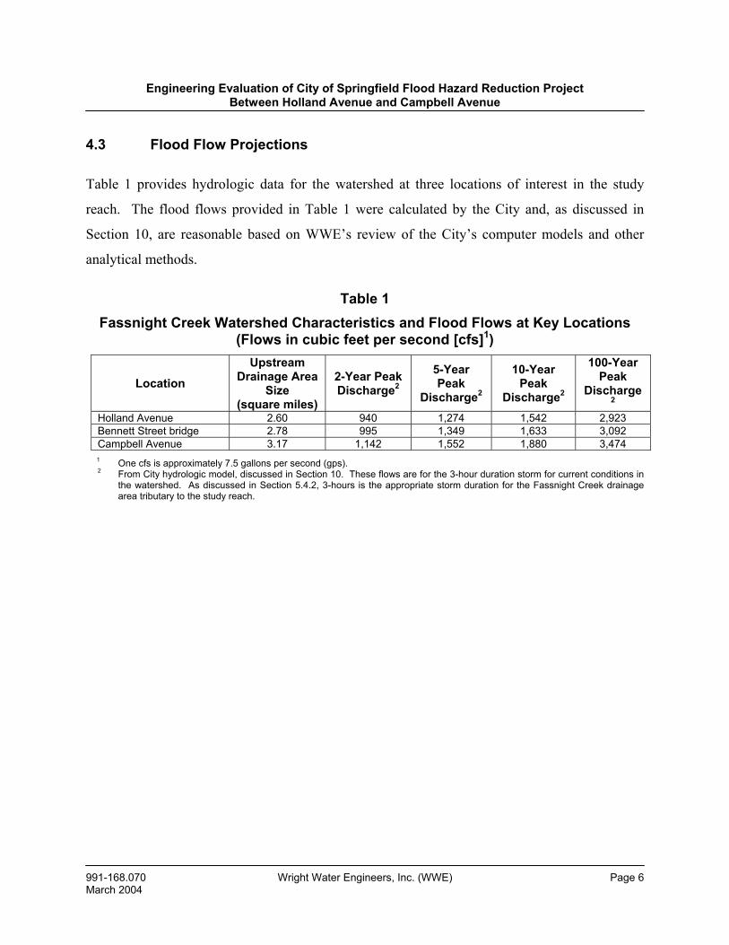
4.3 Flood Flow Projections
Table 1 provides hydrologic data for the watershed at three locations of interest in the study
reach. The flood flows provided in Table 1 were calculated by the City and, as discussed in
Section 10, are reasonable based on WWE’s review of the City’s computer models and other
analytical methods.
Table 1 Fassnight Creek Watershed Characteristics and Flood Flows at Key Locations
(Flows in cubic feet per second [cfs]1)
Location
Upstream Drainage Area
Size (square miles)
2-Year Peak Discharge2
5-Year Peak
Discharge2
10-Year Peak
Discharge2
100-Year Peak
Discharge2
Holland Avenue 2.60 940 1,274 1,542 2,923 Bennett Street bridge 2.78 995 1,349 1,633 3,092 Campbell Avenue 3.17 1,142 1,552 1,880 3,474 1 One cfs is approximately 7.5 gallons per second (gps). 2 From City hydrologic model, discussed in Section 10. These flows are for the 3-hour duration storm for current conditions in
the watershed. As discussed in Section 5.4.2, 3-hours is the appropriate storm duration for the Fassnight Creek drainage area tributary to the study reach.
Engineering Evaluation of City of Springfield Flood Hazard Reduction Project Between Holland Avenue and Campbell Avenue
991-168.070 Wright Water Engineers, Inc. (WWE) Page 7 March 2004
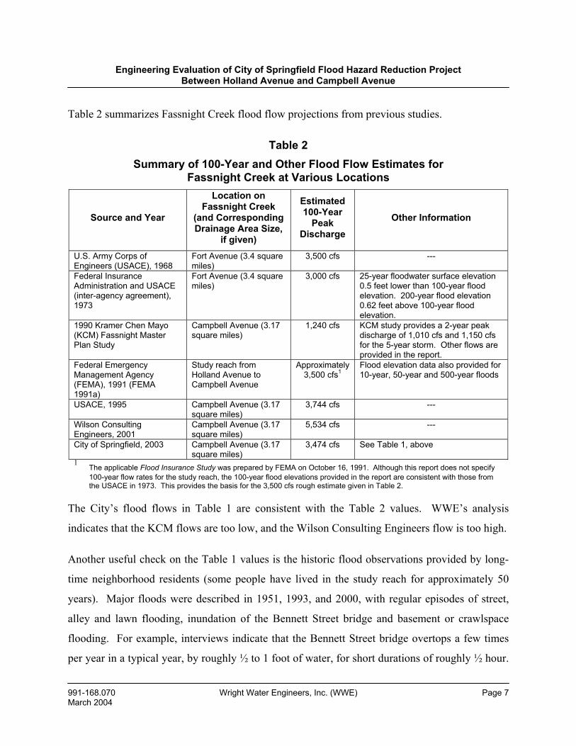
Table 2 summarizes Fassnight Creek flood flow projections from previous studies.
Table 2 Summary of 100-Year and Other Flood Flow Estimates for
Fassnight Creek at Various Locations
Source and Year
Location on Fassnight Creek
(and Corresponding Drainage Area Size,
if given)
Estimated 100-Year
Peak Discharge
Other Information
U.S. Army Corps of Engineers (USACE), 1968
Fort Avenue (3.4 square miles)
3,500 cfs ---
Federal Insurance Administration and USACE (inter-agency agreement), 1973
Fort Avenue (3.4 square miles)
3,000 cfs 25-year floodwater surface elevation 0.5 feet lower than 100-year flood elevation. 200-year flood elevation 0.62 feet above 100-year flood elevation.
1990 Kramer Chen Mayo (KCM) Fassnight Master Plan Study
Campbell Avenue (3.17 square miles)
1,240 cfs KCM study provides a 2-year peak discharge of 1,010 cfs and 1,150 cfs for the 5-year storm. Other flows are provided in the report.
Federal Emergency Management Agency (FEMA), 1991 (FEMA 1991a)
Study reach from Holland Avenue to Campbell Avenue
Approximately 3,500 cfs1
Flood elevation data also provided for 10-year, 50-year and 500-year floods
USACE, 1995 Campbell Avenue (3.17 square miles)
3,744 cfs ---
Wilson Consulting Engineers, 2001
Campbell Avenue (3.17 square miles)
5,534 cfs ---
City of Springfield, 2003 Campbell Avenue (3.17 square miles)
3,474 cfs See Table 1, above
1 The applicable Flood Insurance Study was prepared by FEMA on October 16, 1991. Although this report does not specify 100-year flow rates for the study reach, the 100-year flood elevations provided in the report are consistent with those from the USACE in 1973. This provides the basis for the 3,500 cfs rough estimate given in Table 2.
The City’s flood flows in Table 1 are consistent with the Table 2 values. WWE’s analysis
indicates that the KCM flows are too low, and the Wilson Consulting Engineers flow is too high.
Another useful check on the Table 1 values is the historic flood observations provided by long-
time neighborhood residents (some people have lived in the study reach for approximately 50
years). Major floods were described in 1951, 1993, and 2000, with regular episodes of street,
alley and lawn flooding, inundation of the Bennett Street bridge and basement or crawlspace
flooding. For example, interviews indicate that the Bennett Street bridge overtops a few times
per year in a typical year, by roughly ½ to 1 foot of water, for short durations of roughly ½ hour.
Engineering Evaluation of City of Springfield Flood Hazard Reduction Project Between Holland Avenue and Campbell Avenue
991-168.070 Wright Water Engineers, Inc. (WWE) Page 8 March 2004
All of these observations tend to support the Table 1 flow estimates, and they provide the basis
for our evaluation.
4.4 Nature of Fassnight Creek Channel in Study Reach and of the Flooding Problem
Most of the development in the study area occurred in the 1930s–40s, and it was common at that
time (not only in Springfield, but nationally) to not reserve sufficient space for the conveyance of
flood flows. At that time, to the extent that drainage design occurred, there was rarely provision
of an adequate, safe pathway for flows through urbanized areas. Typically, natural drainage
channels were placed in pipes or narrowed through fill placement, and there was little
recognition of the space that floodwaters would occupy (i.e., the floodplain). Unfortunately, this
is the case for the Fassnight Channel from Holland Avenue to Campbell Avenue. The channel
closed culvert is not large enough to convey flood flows. As a result, flows spill out of the
channel culvert and move through the neighborhood, via streets, alleys and yards, while
inundating crawl spaces and basements (first floor flooding has not been experienced by the
people we interviewed, although 1993 and 2000 flood levels were nearly at first floor levels in
many homes).
Immediately upstream from Holland Avenue, Fassnight Creek consists of an open channel (see
Photographs 7 and 8). On the east side of Holland Avenue, Fassnight Creek transitions from an
open channel into two 12-feet-wide by 5-feet-high side-by-side concrete box culverts (see
Photograph 9). As shown on Drawing 1, these box culverts continue downstream to the west
side of Jefferson Avenue, a distance of approximately 1,400 feet. On the west side of Jefferson
Avenue, the box culverts end (Photograph 10) and an open channel section continues to the
Bennett Street bridge. Photographs 11-15 show the open channel between Jefferson Avenue and
the Bennett Street bridge, while Photographs 16-19 provide various views of the Bennett Street
bridge, which consists of a two-cell 10-feet-by-2.5-feet box culvert. From the Bennett Street
bridge downstream to Campbell Avenue, Fassnight Creek is an open channel with a mature
Engineering Evaluation of City of Springfield Flood Hazard Reduction Project Between Holland Avenue and Campbell Avenue
991-168.070 Wright Water Engineers, Inc. (WWE) Page 9 March 2004
riparian corridor and large trees growing on the channel banks (see Photographs 20-22 for
representative views).
From the Bennett Street bridge upstream to Holland Avenue, the conveyance capacity of
Fassnight Creek in its current condition is substantially smaller than not only the 100-year flood,
but much smaller (and more frequently occurring) floods, as well. Hydraulic modeling
conducted by the City (and checked by WWE) indicates that the maximum capacity of the two
12-feet-by-5-feet box culverts at overtopping is about 1,060 cfs (assuming no debris blockage),
which is roughly equivalent to about the 5-year peak discharge at Holland Avenue. (It is also
noteworthy that 1,060 cfs is about one-third of the 100-year flood at Holland Avenue.)
Consequently, in all floods greater than or equal to approximately the 5-year event, the capacity
of the existing box culverts will be exceeded, and that portion of the flow not carried by the
culverts will move through the neighborhood. The conveyance capacity of the open channel
between Jefferson Avenue and the Bennett Street bridge is actually less than that of the two
upstream box culverts. This is due to a combination of factors including limited space,
inadequate maintenance, the channel is privately owned and the City does not have access to it,
collapsing railroad tie walls, a sharp bend, backwater from the Bennett Street bridge and, in
general, a channel reach that is not efficient hydraulically. This reach of channel, in its current
condition, has capacity for roughly the 2-year flood flows.
The Bennett Street bridge is grossly undersized, which is why it is inundated a few times per
year on average, based on interviews with community residents and City staff. As discussed in
Sections 5, 8 and 11, this creates an unsafe situation for pedestrians and motorists and is a matter
that should be urgently addressed by the City. Downstream from the Bennett Street bridge, the
floodplain widens substantially (see Drawing 1). As noted by neighborhood residents, there is
some debris in the channel bottom downstream from Bennett Street, which should be removed to
minimally increase conveyance capacity (see Photographs 20-22). Some of this channel is
privately owned, which will influence the feasibility and nature of maintenance activities.
Currently, it would be necessary for maintenance to be performed by the property owners.
Engineering Evaluation of City of Springfield Flood Hazard Reduction Project Between Holland Avenue and Campbell Avenue
991-168.070 Wright Water Engineers, Inc. (WWE) Page 10 March 2004
In light of the limited conveyance capacity described above, it is not surprising that the 100-year
floodplain is extensive, as shown on Drawing 1. Drawing 1 depicts both the FEMA 100-year
floodplain and floodway boundaries (from Jefferson Avenue downstream) and the 100-year
floodplain boundary based on the City’s hydrologic and hydraulic modeling, from Jefferson
Avenue upstream. Drawing 1 demonstrates that there are 76 homes, two churches and one
business in the 100-year floodplain in the study reach (Holland to Campbell Avenue), and 28
homes, one church and one business in the floodway in this reach.
To summarize, between the Bennett Street bridge and Holland Avenue, the conveyance capacity
of the existing system ranges from less than the 2-year storm to approximately the 5-year storm.
In storms greater than this range (2- to 5-year), flood flows leave the dedicated conveyances (box
culverts and open channel) and flow through the neighborhood, in streets, alleys, and yards.
5.0 ASSESSMENT OF FLOOD RISK
This section summarizes WWE’s assessment of flood risk in the study reach. Flood risk is a
function of many factors including, as examples: frequency, magnitude, and duration of
flooding; number of structures in the floodplain and floodway; amount of property damage
caused by various floods; nature and degree of flood hazard; impairment of street traffic flow
and of emergency vehicle access; frequency and magnitude of bridge overtopping; nature of land
use in affected neighborhoods and immediately adjoining areas; flood history; and others. These
factors are discussed, as follows.
5.1 Flood History
Flooding history is an extremely important factor regarding risk assessment. It is well known
that the relevant reach of Fassnight Creek has experienced significant floods frequently over the
past 50 years. For example, based on interviews with City staff, documents reviewed, and
interviews with property owners, major floods have occurred in 1951, 1993, and 2000. Three
large events in 50 years represent a significant flood risk. Accounts vary as to which of these
Engineering Evaluation of City of Springfield Flood Hazard Reduction Project Between Holland Avenue and Campbell Avenue
991-168.070 Wright Water Engineers, Inc. (WWE) Page 11 March 2004
three floods (1951, 1993 and 2000) produced the largest peak discharges through the study
reach. Mr. Wilbur Teal (439 W. Stanford) stated that the 1951 flood was the worst event. Mr.
Warren Rankin (251 E. Bennett) became a resident of Springfield in 1952 and bought his current
home (on Bennett Street immediately adjacent to the Bennett Street bridge across Fassnight
Creek) in 1954. Mr. Rankin, who practiced civil engineering throughout his career and who is
knowledgeable on drainage and flood control issues, stated that the 1993 flood produced the
highest flood level at his home. Photographs 23 and 24 indicate Mr. Rankin pointing to the
maximum historic flood depths at his home, while Photograph 25 shows Mr. Rankin’s house in
relation to the Bennett Street bridge. Data collected by City staff indicate that the July 12, 2000
flood (which occurred during the night) produced the highest flood levels on Fassnight Creek in
the study reach. City staff surveyed high water marks at a number of locations in the study reach
shortly after the July 12, 2000 flood. In any case, it is clear that the relevant neighborhoods are
subject to periodic large flood flows.
There have also been numerous smaller floods that exceeded the capacity of the stream channel
and Bennett Street bridge, and which caused flows to move through yards, streets, and alleys.
Our interviews with long-time residents in the channel reach between Jefferson Avenue and the
Bennett Street bridge indicate that typically every one to two years (and in some years, more
than once), flood flows exceed the current channel capacity. Interviews also indicate that the
Bennett Street bridge typically overtops a few times per year in an average year. The frequency
of basement or crawlspace flooding is reportedly about once every 2-5 years. Some of this
flooding is caused by sanitary sewer back-ups (in fact, as presented in Section 9, some property
owners have stated that sewer backups are the primary source of their flooding). These facts
indicate that there is risk associated with small, frequently occurring storms in addition to larger,
less frequent storms.
Engineering Evaluation of City of Springfield Flood Hazard Reduction Project Between Holland Avenue and Campbell Avenue
991-168.070 Wright Water Engineers, Inc. (WWE) Page 12 March 2004
5.2 Prior Flood Studies
As summarized in Table 2, many studies have calculated large 100-year flood flows on Fassnight
Creek, including analyses by the USACE and FEMA. In 1990-91, the City commissioned a
comprehensive master plan study of Fassnight Creek, which was conducted by KCM of Seattle,
Washington. This study noted numerous flooding problems along Fassnight Creek and
characterized the reach between Holland Avenue and the Bennett Street bridge as one of the
most significant problems in the entire watershed (FEMA 1991a). The FIRM, published by
FEMA in 1991, delineates a substantial floodplain from Jefferson Avenue downstream (FEMA
1991b). FEMA did not delineate the floodplain upstream from Jefferson Avenue. As discussed
in Section 8, this is counter to FEMA’s standard policy of delineating floodplains up to the
location where a watershed is smaller than one-square-mile in size, or where the floodplain is
less than 200 feet wide (FEMA 1999).
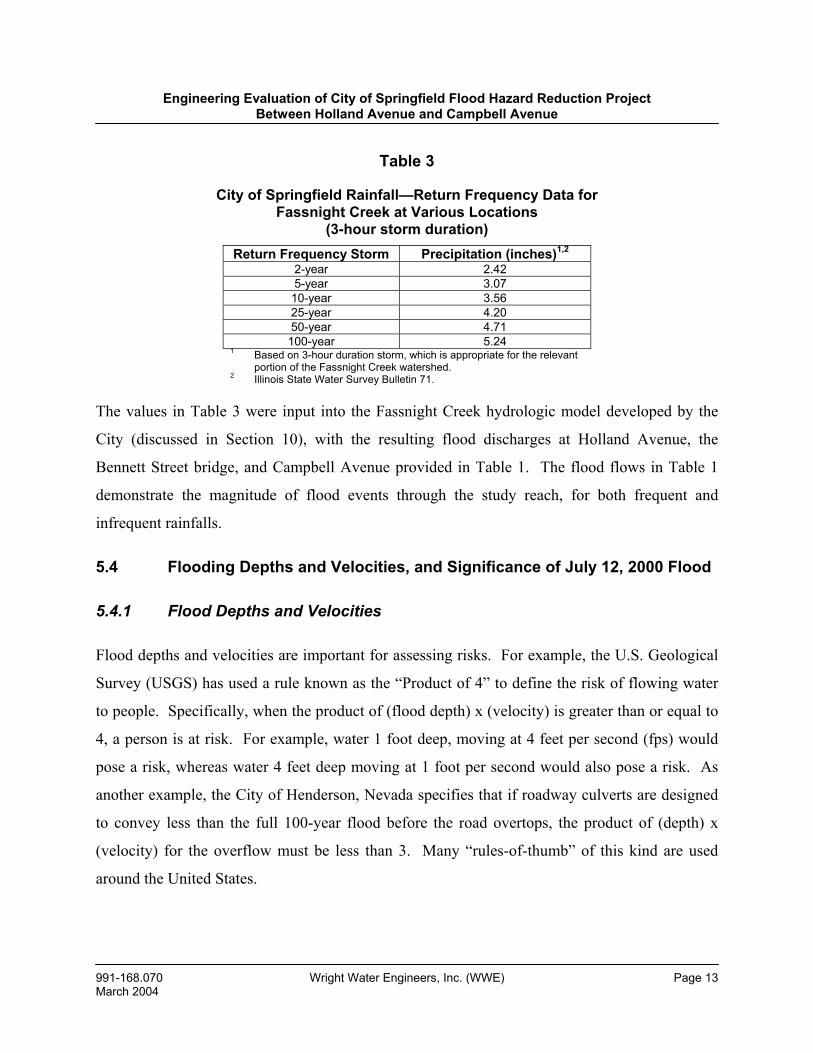
5.3 Rainfall-Runoff Data
Statistically derived data regarding rainfall intensities are important for establishing flood risks.
Table 3 summarizes rainfall return frequency data for Springfield, based on long-term
precipitation data gathered by the National Weather Service and statistically analyzed by the
Midwestern Climate Center.
Engineering Evaluation of City of Springfield Flood Hazard Reduction Project Between Holland Avenue and Campbell Avenue
991-168.070 Wright Water Engineers, Inc. (WWE) Page 13 March 2004
Table 3
City of Springfield Rainfall—Return Frequency Data for Fassnight Creek at Various Locations
(3-hour storm duration) Return Frequency Storm Precipitation (inches)1,2
2-year 2.42 5-year 3.07
10-year 3.56 25-year 4.20 50-year 4.71 100-year 5.24
1 Based on 3-hour duration storm, which is appropriate for the relevant portion of the Fassnight Creek watershed.
2 Illinois State Water Survey Bulletin 71.
The values in Table 3 were input into the Fassnight Creek hydrologic model developed by the
City (discussed in Section 10), with the resulting flood discharges at Holland Avenue, the
Bennett Street bridge, and Campbell Avenue provided in Table 1. The flood flows in Table 1
demonstrate the magnitude of flood events through the study reach, for both frequent and
infrequent rainfalls.
5.4 Flooding Depths and Velocities, and Significance of July 12, 2000 Flood
5.4.1 Flood Depths and Velocities
Flood depths and velocities are important for assessing risks. For example, the U.S. Geological
Survey (USGS) has used a rule known as the “Product of 4” to define the risk of flowing water
to people. Specifically, when the product of (flood depth) x (velocity) is greater than or equal to
4, a person is at risk. For example, water 1 foot deep, moving at 4 feet per second (fps) would
pose a risk, whereas water 4 feet deep moving at 1 foot per second would also pose a risk. As
another example, the City of Henderson, Nevada specifies that if roadway culverts are designed
to convey less than the full 100-year flood before the road overtops, the product of (depth) x
(velocity) for the overflow must be less than 3. Many “rules-of-thumb” of this kind are used
around the United States.
Engineering Evaluation of City of Springfield Flood Hazard Reduction Project Between Holland Avenue and Campbell Avenue
991-168.070 Wright Water Engineers, Inc. (WWE) Page 14 March 2004
The City prepared a hydraulic model for the reach between Holland Avenue and Campbell
Avenue using the well-accepted model, HEC-RAS. For any given peak flow rate, this model
will calculate the floodplain width, flood depths, and flood velocities at many locations (based
on defined cross-sections within the model). The City ran this model for the 2-, 5-, 10-, 25-, 50-,
and 100-year floods on Fassnight Creek. Inspection of model output indicates that hazardous
combinations of flood depths and velocities exist at multiple locations between Campbell
Avenue and Holland Avenue for both frequent and infrequent floods. This observation does not
hold for all locations within the 100-year floodplain, but only for certain locations. For example,
floodwaters moving from east to west along Bennett Street have relatively high velocities and
pose more of a hazard than other locations. This observation was confirmed by inspection of
videotape taken by Mr. Greg Davison, who resides on Bennett Street near the Bennett Street
bridge crossing of the creek. Mr. Davison videotaped two floods in July 2000 from his front
porch. In this video, water levels on a chain link fence were evident; Photograph 26 shows this
chain link fence, located on the east side of Mr. Davison’s yard. Photograph 26 was taken from
Mr. Davison’s living room window. The City surveyed the high water mark on this chain link
fence following the July 12, 2000 flood, along with other locations in the study reach.
5.4.2 Significance of July 12, 2000 Flood
An aspect of flood depth that has generated much discussion within the neighborhood is that
(according to a number of the property owners we interviewed) the 100-year flood does not
produce first floor flooding, but only flooding of basements and crawlspaces. The basis for this
assertion is that City staff apparently told property owners in the study reach that the July 12,
2000 storm was the “100-year flood.” During this event, although many homes in the study
reach experienced basement and crawlspace flooding, were surrounded by water, and had
floodwater very close to first flood levels, with the exception of Mr. Greg Davison’s residence
(where one room had wet carpet) there are no other known cases where first floor flooding
occurred. WWE independently evaluated the available precipitation and flow data for the July
Engineering Evaluation of City of Springfield Flood Hazard Reduction Project Between Holland Avenue and Campbell Avenue
991-168.070 Wright Water Engineers, Inc. (WWE) Page 15 March 2004
12, 2000 flood and offers the following observations regarding the statement that this event was
the 100-year flood:
1. The City’s conclusion that the July 12, 2000 flood had a return frequency of 100-
years was reasonable for a 6-hour rainfall duration. However, when determining
flood risks, it is important to evaluate the rainfall duration which maximizes peak
flows for the drainage area in question. For example, the appropriate storm
duration to use for a 100-acre drainage area might be 1-hour, or less, while the
appropriate storm duration to use for a 50-square-mile drainage area might be 12-
hours, or longer. In the case of the Fassnight Creek watershed in the study reach,
the appropriate rainfall duration for defining flood risks is not 6-hours (duration
of the July 12, 2000 rainfall), but 3-hours. If the 100-year, 3-hour duration storm
had occurred on July 12, 2000 rather than the 100-year, 6-hour duration storm, the
peak flow would have been larger, and flood depths would have been higher.
Using the City’s hydrologic and hydraulic models, described in Section 10 of this
report, WWE has contrasted flood flows and depths for the 100-year, 6-hour and
100-year, 3-hour duration storms. At Holland Avenue, the 100-year, 6-hour peak
flow is 2,124 cfs, whereas the 100-year, 3-hour peak flow is 2,923 cfs, an increase
of 38%. At the Bennett Street bridge, the 100-year, 6-hour duration peak flow is
2,256 cfs, whereas the 100-year, 3-hour peak flow is 3,092 cfs, an increase of
about 37%. If these larger flood flows had occurred on July 12, 2000, flood
depths would have been substantially larger than they were. WWE’s analysis
indicates that in the reach between Jefferson Avenue and the Bennett Street
bridge, flood depths for the 100-year, 3-hour duration storm are about 0.6 feet
higher than flood depths for the 100-year, 6-hour storm. In the reach between
Holland Avenue and Jefferson Avenue, the 100-year, 3-hour flood depths are
about 0.75 feet higher.
Engineering Evaluation of City of Springfield Flood Hazard Reduction Project Between Holland Avenue and Campbell Avenue
991-168.070 Wright Water Engineers, Inc. (WWE) Page 16 March 2004
The bottom line is that when the most technically correct and appropriate 100-
year flood storm duration is used, flood depths in the study reach are roughly 0.6
to 0.75 feet higher than were observed during the July 12, 2000 flood; such depths
would have been above first floor elevations in many of the residences.
2. Another factor which needs to be accounted for when assessing future flood risk
in the study reach is that, according to the City’s hydrologic modeling, when the
Fassnight watershed is fully developed, flood flows will be modestly higher than
they are currently. For example, at Holland Avenue, the 100-year, 3-hour peak
flow will increase from 2,923 cfs (as shown in Table 1) to 3,025 cfs, an increase
of about 3.5%. This would translate into a small increase in the 100-year
floodwater surface elevation.
3. As discussed in Section 10, the City calibrated its hydraulic (flood elevation)
model, HEC-RAS, to the July 12, 2000 flood. The City’s selection of certain
friction loss parameters resulted in over-estimating the magnitude of this flood.
In summary, for the three reasons given above, the City has overstated the magnitude of the July
12, 2000 flood. The event, although severe, was not a “true” 100-year flood. If such a flood
were to occur, there would be first floor flooding in the study reach. In addition, as described in
Section 8, according to interviews that we conducted, there is no differentiation between first
floor flooding and basement or crawlspace flooding from the standpoint of evaluating flood
hazards.
5.5 Bridge Overtopping and Emergency Access
The bridge at Bennett Street is particularly problematic from a risk standpoint. Interviews
indicate that this bridge overtops by roughly ½ to 1 foot of water a few times per year in a
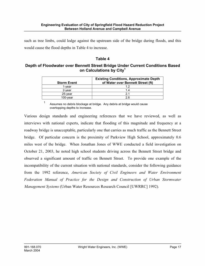
typical year. Table 4 summarizes overtopping depths at the bridge, for various storms based on
calculations by the City. Note that Table 4 assumes that there is no debris blockage. Debris,
Engineering Evaluation of City of Springfield Flood Hazard Reduction Project Between Holland Avenue and Campbell Avenue
991-168.070 Wright Water Engineers, Inc. (WWE) Page 17 March 2004
such as tree limbs, could lodge against the upstream side of the bridge during floods, and this
would cause the flood depths in Table 4 to increase.
Table 4 Depth of Floodwater over Bennett Street Bridge Under Current Conditions Based
on Calculations by City1
Storm Event
Existing Conditions, Approximate Depth of Water over Bennett Street (ft)
1-year 1.2 2-year 1.4 25-year 2.1
100-year 2.6 1 Assumes no debris blockage at bridge. Any debris at bridge would cause
overtopping depths to increase.
Various design standards and engineering references that we have reviewed, as well as
interviews with national experts, indicate that flooding of this magnitude and frequency at a
roadway bridge is unacceptable, particularly one that carries as much traffic as the Bennett Street
bridge. Of particular concern is the proximity of Parkview High School, approximately 0.6
miles west of the bridge. When Jonathan Jones of WWE conducted a field investigation on
October 21, 2003, he noted high school students driving across the Bennett Street bridge and
observed a significant amount of traffic on Bennett Street. To provide one example of the
incompatibility of the current situation with national standards, consider the following guidance
from the 1992 reference, American Society of Civil Engineers and Water Environment
Federation Manual of Practice for the Design and Construction of Urban Stormwater
Management Systems (Urban Water Resources Research Council [UWRRC] 1992).
Engineering Evaluation of City of Springfield Flood Hazard Reduction Project Between Holland Avenue and Campbell Avenue
991-168.070 Wright Water Engineers, Inc. (WWE) Page 18 March 2004
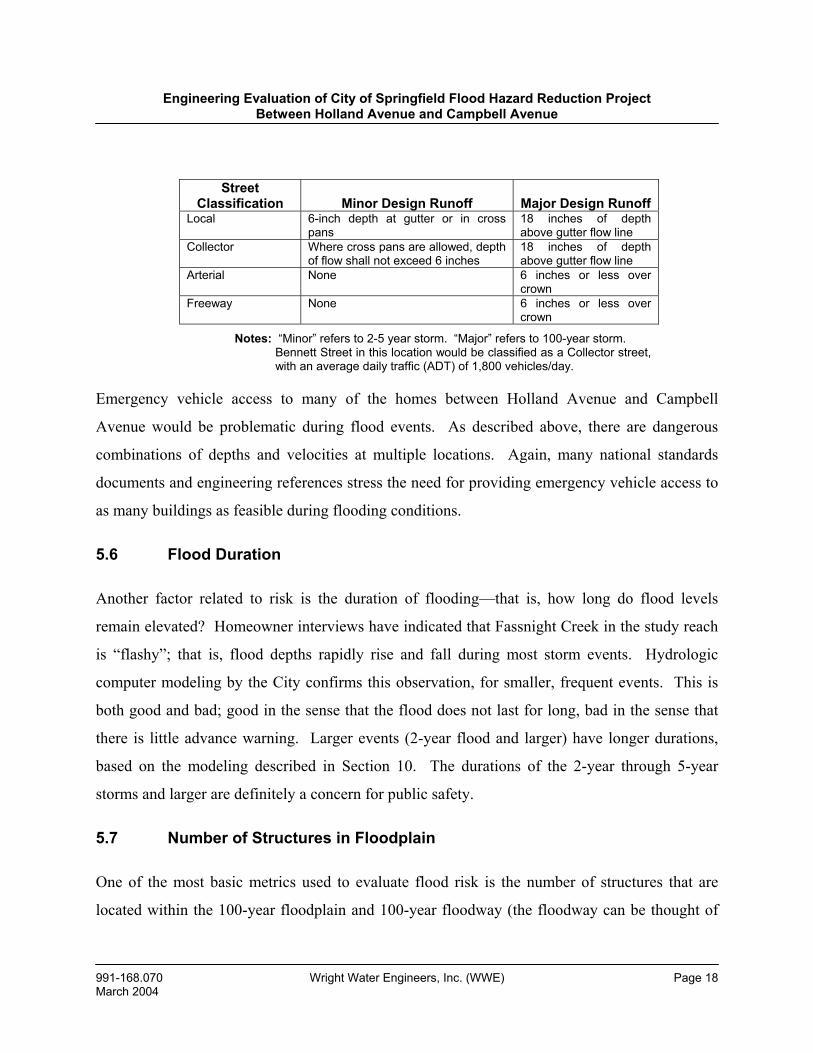
Street Classification
Minor Design Runoff
Major Design Runoff
Local 6-inch depth at gutter or in cross pans
18 inches of depth above gutter flow line
Collector Where cross pans are allowed, depth of flow shall not exceed 6 inches
18 inches of depth above gutter flow line
Arterial None 6 inches or less over crown
Freeway None 6 inches or less over crown
Notes: “Minor” refers to 2-5 year storm. “Major” refers to 100-year storm. Bennett Street in this location would be classified as a Collector street,
with an average daily traffic (ADT) of 1,800 vehicles/day.
Emergency vehicle access to many of the homes between Holland Avenue and Campbell
Avenue would be problematic during flood events. As described above, there are dangerous
combinations of depths and velocities at multiple locations. Again, many national standards
documents and engineering references stress the need for providing emergency vehicle access to
as many buildings as feasible during flooding conditions.
5.6 Flood Duration
Another factor related to risk is the duration of flooding—that is, how long do flood levels
remain elevated? Homeowner interviews have indicated that Fassnight Creek in the study reach
is “flashy”; that is, flood depths rapidly rise and fall during most storm events. Hydrologic
computer modeling by the City confirms this observation, for smaller, frequent events. This is
both good and bad; good in the sense that the flood does not last for long, bad in the sense that
there is little advance warning. Larger events (2-year flood and larger) have longer durations,
based on the modeling described in Section 10. The durations of the 2-year through 5-year
storms and larger are definitely a concern for public safety.
5.7 Number of Structures in Floodplain
One of the most basic metrics used to evaluate flood risk is the number of structures that are
located within the 100-year floodplain and 100-year floodway (the floodway can be thought of
Engineering Evaluation of City of Springfield Flood Hazard Reduction Project Between Holland Avenue and Campbell Avenue
991-168.070 Wright Water Engineers, Inc. (WWE) Page 19 March 2004
as the “core” of the floodplain, where the level of risk is highest) on a unit, length, or area basis.
For unknown reasons, FEMA failed to extend the FIRM mapping on Fassnight Creek upstream
as far as it normally does (to the point where the watershed is less than 1-square-mile in size).
This point of demarcation in the Fassnight Creek watershed would be approximately National
Avenue. The City delineated the 100-year floodplain and floodway for the reach between
Holland Avenue and Campbell Avenue, based on the 100-year flood flows provided in Table 1.
The resulting floodplain and floodway boundaries are provided on Drawing 1.
City staff informed WWE that on a unit area and unit length basis, Fassnight Creek between
Holland Avenue and the Bennett Street bridge crossing has one of the highest concentrations of
structures in the 100-year floodplain and floodway in the City. Drawing 1 shows that there are
76 homes, two churches and one business in the study reach 100-year floodplain, and that 28
homes, one church and one business are in the floodway. The City and MA also found that
Bennett Street is impassible during even minor rainfall events, as shown in Table 4.
5.8 Significance of Underground Pipes, Limit of Floodplain Map and Number of Complaint Calls
Two factors which increase flood risks in the study area are the presence of the large
underground box culverts and the lack of a formal regulatory floodplain/floodway upstream from
Jefferson Avenue. The buried culverts likely provide a false sense of security to some local
residents; moreover, we anticipate that some residents do not even know that these culverts exist
and that there is a significant drainageway passing through this neighborhood. Another problem
with piped conveyances vs. open channels is that they are more subject to debris blocking.
Safety is generally enhanced in an open channel, as well.
The lack of a defined regulatory floodway and floodplain upstream from Jefferson Avenue likely
provides a false sense of security for some unsuspecting property owners. It is probable that
there have been property transactions in the reach between Jefferson Avenue and Holland
Avenue where both seller and purchaser did not know that the property in question was located
Engineering Evaluation of City of Springfield Flood Hazard Reduction Project Between Holland Avenue and Campbell Avenue
991-168.070 Wright Water Engineers, Inc. (WWE) Page 20 March 2004
in an area that would be flooded by the 100-year flood (and in many cases, in smaller floods as
well).
Most municipal public works departments, including Springfield’s, maintain records of
complaints regarding public infrastructure, including drainage systems. City records indicate
that this reach of Fassnight Creek has, over time, received numerous complaint calls. For
example, there were 15 complaints from property owners in the study reach following the July
12, 2000 flood.
5.9 Channel Between Jefferson and Bennett Street Bridge
The open channel in the backyards of the residences on the south side of Bennett Street between
the bridge and Jefferson Avenue poses unusual safety hazards. The channel comes precariously
close to the homes (see Photographs 11-15). Channel side slopes are nearly vertical in places.
The side slopes are collapsing into the channel. There is inadequate channel stability protection.
Flow velocities are high. During certain flows, the sharp bend in the channel could create a
hydraulic jump (rapid increase in flood depth). For all of these reasons, WWE is very concerned
about public safety in this reach of the channel. In addition, should the channel widen laterally,
the structural integrity of one or more of the homes could be compromised.
5.10 Comparison to South Creek Conveyance Capacity and to Upstream Fassnight Channel Capacity
The City has put the conveyance capacity of the two existing 12-feet-wide by 5-feet-high
culverts (between Holland Avenue and Jefferson Avenue) into context by comparing them
against box culverts on South Creek. Where South Creek passes beneath Jefferson Avenue,
there are five box culverts with dimensions 15 feet wide by 6 feet high. These culverts serve an
urbanized watershed that is 1.8 square miles in size. By contrast, on Fassnight Creek between
Holland Avenue and Jefferson Avenue, there are two 12 feet by 5 feet box culverts serving an
urbanized watershed that is about 2.6 square miles in size. The South Creek box culverts were
Engineering Evaluation of City of Springfield Flood Hazard Reduction Project Between Holland Avenue and Campbell Avenue
991-168.070 Wright Water Engineers, Inc. (WWE) Page 21 March 2004
designed in the early 1990s to convey the 100-year flood. The Fassnight Creek box culverts,
constructed in 1935, have adequate capacity for about the 5-year flood.
Another useful comparison is to contrast the large channel capacity of Fassnight Creek
immediately upstream from Holland (see Photographs 7 and 8) vs. downstream from Holland
(Photograph 9), where the conveyance is in the form of a box culvert.
5.11 Sanitary Sewer Backups
Due to infiltration and inflow into sanitary sewers during runoff events, the sanitary sewer
system in the affected neighborhood has periodically surcharged and caused basement flooding.
This is common with older sewer systems throughout the U.S. The City of Springfield has an
aggressive program to reduce infiltration and inflow, which commits approximately $18M to
rehabilitate the public sewer system. The City has completed approximately 40% of the
recommended public sewer rehabilitation in the Fassnight Creek watershed. Even if the
problem of sewer surcharging could be eliminated in the study reach, the risk of surface flooding
would not change. In addition, studies indicate that approximately 50% of infiltration & inflow
is from the private sewer system, which is under the control of the individual property owners.
5.12 Contribution to Nuisance Conditions in Basements and Crawlspaces
The frequent introduction of floodwater into basements and crawlspaces is problematic from the
standpoint of nuisance conditions such as odor, mold, mildew, need for cleaning, etc. The
problem of mold and mildew is currently receiving substantial attention in the media.
5.13 Summary of Flood Risk in Study Reach
For the many reasons described above, WWE has concluded that flood risks along Fassnight
Creek in the reach between Holland Avenue and Campbell Avenue are high, and represent a
significant threat to public health, safety and welfare.
Engineering Evaluation of City of Springfield Flood Hazard Reduction Project Between Holland Avenue and Campbell Avenue
991-168.070 Wright Water Engineers, Inc. (WWE) Page 22 March 2004
6.0 OVERVIEW OF CITY OF SPRINGFIELD FLOODPLAIN ACQUISITION PROGRAM
Following the major flood of 1993 in Springfield, the Citizens Storm Water Committee (CSWC)
recommended that the City and Greene County adopt proactive stormwater management policies
to minimize future flooding by acquiring flood-prone properties and structures within designated
floodplain and sinkhole areas. The CSWC recognized that floodwaters adversely impact
neighborhoods, both financially and personally, and that the flooding cycle had to be broken.
The CSWC identified the following community benefits from acquiring designated floodplains:
• Protects floodways from future development
• Reduces flood damage to existing properties
• Provides opportunity to increase conveyance system capacity
• Improves water quality by providing:
Bank stabilization
Open and green space
Routine maintenance
• Increases recreational and quality of life opportunities for the community
On this basis, both the City of Springfield and Greene County have adopted floodplain
acquisition programs, and have purchased properties subject to flood risk. Springfield was the
first municipality in Missouri to adopt a floodplain acquisition program (in 1993). The City
acquired 17 homes in the Ferguson sinkhole area in 1994, and the County acquired multiple
homes in the Shadowood area (Ward Branch) in 2001. The City has also acquired
approximately 100 high priority structures since that time, all of which were in flood-prone
areas. The July 12, 2000 storm demonstrated the benefits of the acquisition program within the
Engineering Evaluation of City of Springfield Flood Hazard Reduction Project Between Holland Avenue and Campbell Avenue
991-168.070 Wright Water Engineers, Inc. (WWE) Page 23 March 2004
Ferguson sinkhole area. This neighborhood would have sustained significant damages and
possibly loss of life given the rate at which this sinkhole filled with stormwater (in less than five
hours).
Hundreds of American cities have voluntary floodplain acquisition programs. This practice is
strongly encouraged by FEMA, state agencies, and engineering references. A leading example
near Springfield is the City of Tulsa, Oklahoma, which has purchased over 1,000 flood-prone
properties. This is one reason why Tulsa carries the highest (best) flood preparedness status
from FEMA of any city currently participating in the National Flood Insurance Program.
Representatives of the City of Tulsa provided WWE with considerable background information
on their flood hazard reduction program, including a May 1994 publication entitled, From
Rooftop to River, Tulsa’s Approach to Floodplain and Stormwater Management. Representative
statements from the “Policy Framework” section of this document are as follows:
• Floodplain and stormwater management is a matter of time and space
allocation. Water requires space and must be stored and conveyed, in
either appropriate or inappropriate places.
• Floodplains are natural storage and conveyance facilities, and all
stormwater management efforts should be directed toward helping
them serve that function.
• Acquisition and relocation should be used to reduce, over time, the
occupancy and value of exposed property in flood hazard areas.
• Public park, recreation and open space use of the floodplain is the
best policy (this statement is under the sub-heading “Preventive
Policies”).
Engineering Evaluation of City of Springfield Flood Hazard Reduction Project Between Holland Avenue and Campbell Avenue
991-168.070 Wright Water Engineers, Inc. (WWE) Page 24 March 2004
Floodplain acquisition programs are popular with elected officials because in the long run, they
typically save public monies; promote public health, safety, and welfare; and break the cycle of
repeated flooding. An excellent example of this is a bill that is now in the U.S. House of
Representatives, HR 253. HR 253, approved in July by the House Financial Services
Committee, is designed to put an end to repetitive federal flood insurance claims by authorizing
a five-year program of aid to cover 75% of the costs of buying out property owners in flood-
prone areas or helping them elevate, relocate, or otherwise flood-proof their homes and
businesses. This provision provides the positive incentive. The negative incentive is also
demonstrated by the bill’s title: Two Floods and You Are Out of the Taxpayers’ Pocket Act of
2003.
Acquisition of flood-prone properties in Springfield is prioritized based on the following criteria:
• Proximity to sinkholes (because protection through system improvements is
often not feasible or cost-effective)
• Probability of recurring flooding
• History of flood damage
• Properties covered by flood insurance to maximize limited funding and to
minimize future expenditures
When construction of a stormwater improvement project is not cost-effective or it is not practical
to provide flood protection, and when a property meets the above guidelines, owner(s) are
contacted to determine their interest in the voluntary acquisition program. If the property owner
indicates an interest, the City retains a certified real estate appraiser to establish the market value
of a property. The property is appraised in a pre-flood condition; however, the appraisal does
take into account location of property, i.e., within a designated floodplain or floodway. The City
then makes an offer to acquire property based upon the certified real estate appraisal less any
flood insurance proceeds. This voluntary program offers considerable flexibility to the property
Engineering Evaluation of City of Springfield Flood Hazard Reduction Project Between Holland Avenue and Campbell Avenue
991-168.070 Wright Water Engineers, Inc. (WWE) Page 25 March 2004
owners in terms of scheduling a time for closing on the acquisition. In addition, the City pays
for customary closing costs with the exception of the pro-rated real estate taxes.
Floodplain acquisition is only one of many steps that the City presently takes to reduce flood
risks; other mitigation measures include, for example:
• Major drainage master planning
• Updating/correcting floodplain maps
• Channel construction
• Retention/detention pond construction
• Channel stabilization
• Active participation in many other facets of the National Flood Insurance
Program, including the City’s current status with FEMA of a cooperative
technical partner
• Community education
7.0 POTENTIAL FLOOD RISK REDUCTION ALTERNATIVES EVALUATED BY CITY OF SPRINGFIELD AND WWE
7.1 Background and Initial Alternatives Evaluated
To address the flood risks described in Section 5, the City Public Works Department, along with
MA, initially evaluated three alternatives, all of which were designed to meet the established
objective of protecting properties in the study reach from the 100-year flood. An open house
public meeting with the neighborhood was held on May 22, 2003 to discuss preliminary findings
for the three design alternatives. (Section 9 of this report summarizes key property owner
questions and concerns).
Engineering Evaluation of City of Springfield Flood Hazard Reduction Project Between Holland Avenue and Campbell Avenue
991-168.070 Wright Water Engineers, Inc. (WWE) Page 26 March 2004
One of the three alternatives studied added the maximum feasible size box culvert under Bennett
Street to increase flow capacity. Detailed analysis demonstrated that although this approach
would increase the below-ground conveyance capacity from the current level of about a 5-year
storm to roughly a 10-year storm, this was an inadequate solution for the 100-year flood, as it
would lower the flood elevation by less than 0.5 feet in areas where water depths were as much
as 3 feet. The capital cost of this alternative was about $4 million.
The other two alternatives included an open, grassed channel to carry floodwater. The channel
would need to be approximately 100 feet wide and would be similar in appearance to the channel
constructed between the Erie and Ferguson sinkholes in southwest Springfield. One of the open
channel alternatives included the removal of the existing 12 feet by 5 feet culverts while the
other keeps the existing culverts and uses a slightly narrower channel. Homes that front on the
south side of Bennett from Kimbrough to the Bennett Street bridge would need to be removed by
either moving or demolition to provide sufficient space to construct the necessary channel. As
many as five houses north of Bennett and west of Jefferson may be too low to be protected and
therefore, may need to be removed, even with construction of improvements.
Other elements common to all three of these alternatives include:
• The construction of a three-cell box culvert between Holland Avenue and
Kimbrough Avenue. The dimensions of each cell (opening) would be 12 feet
by 5 feet. (This new culvert would add to the capacity of the current box
culverts in this reach, which would remain in place.)
• Closing Roanoke Avenue at Bennett Street to permit construction of the open
channel on the south side of Bennett Street.
• The construction of a five-cell box culvert at Jefferson Avenue, with each cell
dimension of 12 feet by 5 feet to match the capacity from Holland to
Kimbrough Avenues.
Engineering Evaluation of City of Springfield Flood Hazard Reduction Project Between Holland Avenue and Campbell Avenue
991-168.070 Wright Water Engineers, Inc. (WWE) Page 27 March 2004
• Bennett Street bridge capacity increase, described below.
• Selected channel improvements downstream from the Bennett Street bridge to
Campbell Avenue.
In addition to the three basic alternatives described above, MA evaluated the following
alternatives:
1. Construct open channel in Bennett Street right-of-way: This option was excluded
because it required the closure of Bennett, an east/west collector that provides
system continuity for motorists between Campbell and Ingram Mill. The closure
of Bennett Street also restricted access to adjacent residential properties.
2. Relocate Bennett Street and construct new channel in right-of-way: This option
was excluded due to the high cost, neighborhood disruption and additional
property acquisitions.
3. Various detention alternatives; see Section 7.2 for discussion.
To evaluate all of the alternatives described above, as well as an alternative suggested by
property owners in the study reach, the City prepared two computer models. One of these
models generates flood flows (and is referred to as a hydrologic model) while the second defines
floodplain characteristics (width, depth, velocity, etc.) for the given flood flows (this is referred
to as a hydraulic model). Section 10 of this report provides a detailed review by WWE of the
City’s hydrologic and hydraulic computer models. WWE thoroughly tested these models and
found that they produce reasonable results.
A particular challenge for the City and MA with all of the alternatives has been designing a new
Bennett Street bridge over Fassnight Creek. Because the Bennett Street road surface is only
about 4 feet above the flow line of the channel, it was difficult for the City and MA to design a
bridge that would carry the 100-year flow without overtopping and not cause floodwater to back
Engineering Evaluation of City of Springfield Flood Hazard Reduction Project Between Holland Avenue and Campbell Avenue
991-168.070 Wright Water Engineers, Inc. (WWE) Page 28 March 2004
onto properties south and east of the bridge. Due to this design constraint, consideration was
given to relocating or closing Bennett Street between Utah and Jefferson, but this option was not
recommended due to the collector status of Bennett Street and its significant daily traffic load.
Analysis by the City and MA demonstrates that to accommodate the 100-year flood, without
elevating the grade of Bennett Street (which would probably not be feasible), the Bennett Street
bridge should consist of a 15-cell box culvert, with each cell having dimensions of 10 feet by 4
feet. These box culverts would span a total width of about 160 feet. Consequently, the
Fassnight Channel would need to be widened substantially both upstream and downstream of the
box culvert to assure proper flow transitions.
7.2 Feasibility of Upstream Detention
On July 9, 2003, representatives of the City and neighborhood met to discuss the alternatives.
Councilmen Bob Jones and Gary Deaver were present, and Mr. Deaver chaired the meeting.
This meeting had been requested by Messrs. Larry Barnett (1423 S. Kimbrough) and David
Dugan (1410 S. Kimbrough), on behalf of the University Park Neighborhood Association
(UPNA). Mr. Barnett serves as the President of the UPNA while Mr. Dugan is Secretary of the
UPNA. Based on information provided to WWE by the City, during the July 9th meeting, Mr.
Dugan stated that he and the UPNA wanted an alternative to be evaluated that would preserve
the homes along the south side of Bennett. The City noted that they began to develop the project
with few house removals, but determined that it would not be feasible to construct a box culvert
with 100-year capacity. This prompted Mr. Dugan to suggest that the City should evaluate the
feasibility of four upstream detention locations, to reduce Fassnight flood flows in the study area.
These locations were:
1. An unspecified area of the St. John’s Hospital Property.
2. The Park Board land southwest of National and Bennett.
3. The City property immediately west of the art museum parking lot.
Engineering Evaluation of City of Springfield Flood Hazard Reduction Project Between Holland Avenue and Campbell Avenue
991-168.070 Wright Water Engineers, Inc. (WWE) Page 29 March 2004
4. The Park Board land in the vicinity of the wading pool in Phelps Grove Park.
Prior to the July 9th meeting, Public Works had investigated the possibility of upstream regional
detention and determined that it did not appear to be feasible. Studies, by the City, of detention
basins in Springfield show that a rule of thumb exists for identifying potential regional detention
basins to reduce downstream flows by 50% to 75% as needed in this case. Generally, 20 acre-
feet (AF) of detention storage are required for every 100 acres of developed drainage area.
Because detention areas typically average 2 feet to 4 feet of depth, 5 to 10 acres of land are
needed for construction of detention for every 100 acres of urbanized watershed. For the
Fassnight watershed of about 1,800 acres, an area of 90 to 180 acres would be required to reduce
flows necessary to provide flood protection. Through studies of detailed aerial photographs,
topographical contours and property ownerships, Public Works determined there were no
possible opportunities for regional detention basins in the Fassnight watershed to meet the
objective of 100-year flood protection in the project area.
Nevertheless, Public Works proceeded with a detailed study of the four locations specified by
the UPNA to determine the potential for flood reduction in the project area, both individually
and in combination, and to estimate the cost of construction of the basins. In summary:
1. The St. John’s campus has met all stormwater regulations so any detention
improvements on the site would likely be completely at City cost (taxpayer
expense). The site has been completely developed so construction would be
expensive and possible only with St. John’s cooperation. Approximately 6 AF of
detention storage could reduce flows from the 40-acre drainage area by about
two-thirds. A 100-year peak flow reduction of about 6% would result at Holland
Avenue, which translates into a reduced 100-year flood depth of well under 0.5
feet. The preliminary construction cost estimates range from $1.0-$2.3 million,
depending on whether open or enclosed detention would be feasible. Costs could
Engineering Evaluation of City of Springfield Flood Hazard Reduction Project Between Holland Avenue and Campbell Avenue
991-168.070 Wright Water Engineers, Inc. (WWE) Page 30 March 2004
be higher due to numerous unknowns that could ultimately be significant. Due to
the high cost and low benefit, this option is not feasible.
2. Park Board land southwest of National and Bennett between the tennis courts and
the landscape display was studied. It was determined that 1.9 acres of land could
be excavated and the existing box culvert removed to produce approximately 9.8
AF of storage. The reduction in 100-year peak flow at Holland Avenue would be
less than 1%, with an insignificant decrease in flood depth. The preliminary
construction cost estimate is $312,500, which does not include any cost for use of
the land. It is not known if the Park Board would permit use of the land for this
purpose. WWE’s assessment of this site is that the benefits are far too small to
justify such a large expenditure.
3. The City land immediately west of the art museum parking lot was studied. It
was determined that 1.9 acres of land could be excavated to produce
approximately 7.4 AF of storage. The reduction in 100-year peak flow would be
less than 1% at Holland Avenue, with an insignificant decrease in flood depth.
The preliminary construction cost estimate is $208,750. This project would
involve the removal of what appears to be a historic amphitheater. The history of
the facility is not known and it is not known if removal of this facility for this
purpose would be acceptable to the public. WWE’s assessment of this site is that
the benefits are far too small to justify such a large expenditure.
4. Park Board land east of the Lutheran Church and along the south of Phelps Grove
Park was studied. The location of the wading pool is too small to develop a
detention basin, but the larger area east of the pool to Virginia Avenue was
studied. It was determined that 5.2 acres of land could be excavated to produce
approximately 33 AF of storage. The reduction in 100-year peak flow would be
less than approximately 5% at Holland Avenue, for a flood depth reduction of far
Engineering Evaluation of City of Springfield Flood Hazard Reduction Project Between Holland Avenue and Campbell Avenue
991-168.070 Wright Water Engineers, Inc. (WWE) Page 31 March 2004
less than 0.5 feet. The preliminary construction cost estimate is $512,500 which
does not include any cost for use of the land. The site currently has about 50
mature trees and a walking trail that would be removed as part of the project. It is
not known if the Park Board would permit use of the land for this purpose or if
such a project within a park would have public acceptance. WWE’s assessment of
this site is that the benefits are far too small to justify such a large expenditure.
Detention basin options 2, 3 and 4 considered in combination would reduce the 100-year peak
flood elevation in the study reach by less than 0.5 feet. The preliminary construction cost of the
three options totals about $1,034,000, which does not include any cost for the use of Park Board
property. Considering the minimal benefit that would be received for a $1 million expenditure
and the high likelihood of a negative public view of these projects, Public Works would not
recommend that any of these sites be developed as detention basins for the purpose of
controlling flooding in the study reach. WWE agrees with this conclusion.
7.3 Additional Elements of Flood Control Suggested by Property Owners/Residents in Study Reach
During the July 9, 2003 meeting, Mr. Dugan (again on behalf of the UPNA) stated that in
addition to the four detention facilities described in 7.2, above, the following improvements
should be studied by the City:
1. Improve the conveyance capacity of the channel downstream from the Bennett
Street bridge, because this area acts as a “bottleneck” to flow, and backs water up
into the neighborhood.
2. Increase the capacity of the Bennett Street bridge.
3. Increase the capacity of the channel between the Bennett Street bridge and
Jefferson Avenue, or at least better maintain the existing channel.
A brief evaluation of these recommendations from Mr. Dugan and the UPNA is as follows:
Engineering Evaluation of City of Springfield Flood Hazard Reduction Project Between Holland Avenue and Campbell Avenue
991-168.070 Wright Water Engineers, Inc. (WWE) Page 32 March 2004
• The UPNA is correct when it indicates that the channel downstream from the
Bennett Street bridge needs to be improved. The City’s preferred option
includes this feature. However, hydraulic modeling conducted by the City
indicates that the major cause of water backing up in the reach between the
Bennett Street bridge and Jefferson Avenue is the Bennett Street bridge, itself.
Even if there were no downstream obstructions, the flooding situation
between the bridge and Jefferson Avenue would be essentially the same as it
is now. In addition, City staff have discussed the feasibility of modifying the
channel downstream of the Bennett Street bridge with representatives of the
USACE and Missouri Department of Natural Resources (MDNR). Although
the USACE and MDNR are willing to work with communities to reduce flood
risk, there are still environmental permitting constraints associated with any
proposals of this kind. Both of these governmental entities encourage
methods that restore streams to natural conditions, and which preserve
existing vegetation.
• The UPNA is correct that the capacity of the Bennett Street bridge must be
significantly increased. As discussed in Section 5, the bridge is currently far
undersized. The difficulty posed by the short vertical distance (height)
between the top of the existing bridge and the bottom of the Fassnight
Channel is demonstrated in Table 5. Table 5 assumes that a 5-cell box culvert
with dimensions 8 feet wide by 3.5 feet high is installed (this can be
contrasted with the two existing box culverts which are 10 feet wide by 2.5
feet high). Table 5 assumes that the current road grade is not altered.
• A significant constraint to widening this bridge is right of way. There is little
room available for widening the bridge to the east or west before encountering
private property, not only for the bridge, itself, but also for upstream and
downstream channel transitions. The upstream channel transition (expansion)
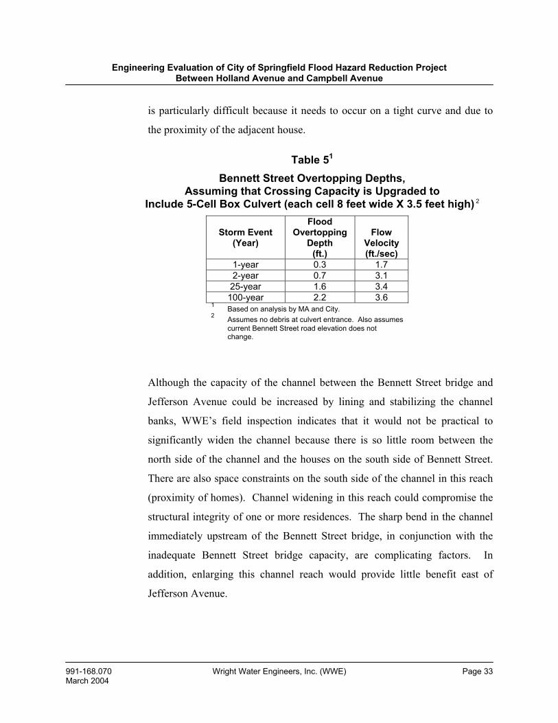
Engineering Evaluation of City of Springfield Flood Hazard Reduction Project Between Holland Avenue and Campbell Avenue
991-168.070 Wright Water Engineers, Inc. (WWE) Page 33 March 2004
is particularly difficult because it needs to occur on a tight curve and due to
the proximity of the adjacent house.
Table 51
Bennett Street Overtopping Depths, Assuming that Crossing Capacity is Upgraded to
Include 5-Cell Box Culvert (each cell 8 feet wide X 3.5 feet high) 2
Although the capacity of the channel between the Bennett Street bridge and
Jefferson Avenue could be increased by lining and stabilizing the channel
banks, WWE’s field inspection indicates that it would not be practical to
significantly widen the channel because there is so little room between the
north side of the channel and the houses on the south side of Bennett Street.
There are also space constraints on the south side of the channel in this reach
(proximity of homes). Channel widening in this reach could compromise the
structural integrity of one or more residences. The sharp bend in the channel
immediately upstream of the Bennett Street bridge, in conjunction with the
inadequate Bennett Street bridge capacity, are complicating factors. In
addition, enlarging this channel reach would provide little benefit east of
Jefferson Avenue.
Storm Event (Year)
Flood Overtopping
Depth (ft.)
Flow
Velocity (ft./sec)
1-year 0.3 1.7 2-year 0.7 3.1
25-year 1.6 3.4 100-year 2.2 3.6
1 Based on analysis by MA and City. 2 Assumes no debris at culvert entrance. Also assumes
current Bennett Street road elevation does not change.
Engineering Evaluation of City of Springfield Flood Hazard Reduction Project Between Holland Avenue and Campbell Avenue
991-168.070 Wright Water Engineers, Inc. (WWE) Page 34 March 2004
7.4 Preferred Alternative
The City and MA evaluated the advantages, disadvantages and costs of all of the alternatives
described above, including alternatives suggested by current property owners in the study reach.
The City and MA determined that the 100-year open channel option which leaves the two
existing 12 feet by 5 feet box culverts in place is the preferred option. Specific proposed
improvements are as follows. All of these would be designed to convey the 100-year flood:
1. Campbell to Bennett—increase existing channel capacity, by either widening
existing channel or constructing new channel, roughly parallel to existing
channel.
2. Bennett Street bridge—construct new box culverts with additional capacity.
3. Bennett to Jefferson—acquire flood-prone properties, construct new open
channel.
4. Jefferson Crossing—add triple box culvert with each cell 12 feet wide by 5 feet
high.
5. Roanoke Crossing—delete crossing and close the street.
6. Holland Avenue to Kimbrough Avenue—add triple box culvert with each cell 12
feet wide by 5 feet high.
The recommended project phasing begins downstream and proceeds upstream:
1. Campbell to Bennett—improve existing conveyance capacity in a manner suitable
to USACE and MDNR, possibly by widening the channel to one side and by
using “bioengineered” channel stabilization methods to promote a “natural”
appearance and maintain a riparian corridor.
Engineering Evaluation of City of Springfield Flood Hazard Reduction Project Between Holland Avenue and Campbell Avenue
991-168.070 Wright Water Engineers, Inc. (WWE) Page 35 March 2004
2. Bennett Street—construct box culverts with additional capacity.
3. Bennett to Jefferson—acquire flood-prone properties, construct grass/modular
block channel.
4. Jefferson Avenue—construct triple box culvert, to supplement existing culvert.
5. Jefferson to Kimbrough—acquire flood-prone properties, construct grass/modular
block channel.
6. Kimbrough to Holland—acquire flood-prone property, construct triple box
culvert adjacent to existing culvert in vicinity of the Trinity Lutheran Church.
In total, about 20 properties would need to be acquired, with the exact number to be determined
during final design. Real estate and construction costs are estimated to total approximately $3
million. Funding for improvements from Jefferson Avenue to Campbell Avenue was provided
by the 1999 Stormwater Bond Issue, while the 2001 Stormwater Bond Issue provided additional
funding to extend the project from Jefferson Avenue to Holland Avenue. This addition was
partially attributable to the large flood of 2000. Helpful background information regarding these
bond issues was provided to WWE by Ms. Linda Barnett, a neighborhood resident and member
of the UPNA.
7.5 WWE Analysis of Alternatives Evaluated
WWE has reviewed the various alternatives that were defined by the City, MA and property
owners in the study reach. In addition, following the October 21, 2003 field meeting between
Mr. Jones of WWE and neighborhood residents/property owners, WWE recommended that the
City conduct additional analysis regarding the feasibility of controlling smaller, frequent events,
such as the 2- to 5-year storm. WWE’s view was that although such an approach would not
address the 100-year flood, the existing flood risk in the reach between Jefferson Avenue and the
Bennett Street bridge could be reduced without the need to acquire (remove) any of the homes.
Engineering Evaluation of City of Springfield Flood Hazard Reduction Project Between Holland Avenue and Campbell Avenue
991-168.070 Wright Water Engineers, Inc. (WWE) Page 36 March 2004
The City analyzed this approach and provided WWE with their analysis. The City’s analysis
demonstrated the following major points:
• It would be feasible to increase the Bennett Street bridge capacity up to about
a 1-year flood without overtopping (see Table 5). The 2-year flood would
cause overtopping. The new bridge could not be widened more without
impacting the adjacent houses to the point where property acquisition would
come into play.
• With a new Bennett Street bridge in place (with 1-year capacity), overflow
velocities during the 2-year through 100-year floods would range from about
1.7 to 3.6 feet per second (see Table 5). The resulting combinations of depths
and velocities would be unsafe, based on engineering reference/review and
WWE’s interviews with national experts (see Section 8).
• Concrete lining the channel from Bennett to Jefferson would increase
velocities through this section to the point of increasing overtopping velocities
at the Bennett Street bridge, under certain conditions. In addition, WWE is
concerned that concrete lining this reach of the channel might increase the
potential for a hydraulic jump (abrupt increase in water surface elevation) to
occur at the sharp downstream bend in the channel, and this would not be
acceptable design practice.
• WWE asked the City to evaluate the feasibility of increasing the head (water
surface elevation) on the two existing 12-feet-wide by 5-feet-high box
culverts at Holland Avenue. This approach would push 20%-30% more flow
through the boxes, but it would also increase velocities in the channel between
Jefferson and Bennett during events exceeding about a 2-year storm. This
concept would also create additional backwater east of Holland, which could
be problematic for property owners in that area.
Engineering Evaluation of City of Springfield Flood Hazard Reduction Project Between Holland Avenue and Campbell Avenue
991-168.070 Wright Water Engineers, Inc. (WWE) Page 37 March 2004
WWE considered the potential for flood-proofing homes in the study reach as a means of either
avoiding the need for major channel construction, or reducing the scope of such construction.
Flood-proofing measures include such activities as elevating doorways, sealing low windows,
elevating structures, etc. to reduce a structure’s susceptibility to flooding damages. FEMA
recognizes elevating structures and relocation as flood-proofing techniques for residential
structures. Flood-proofing is not feasible in the relevant reach of Fassnight Creek, for the
following reasons:
• Utilized on such a large scale, the practice would not be consistent with the
objectives and mandates of FEMA and the National Flood Insurance Program.
• The significant safety issues associated with flooding would not be addressed
by flood-proofing.
• Flood-proofing does not address the underlying problem—inadequate
conveyance capacity for frequent and infrequent flood events.
It is also important to note that current regulations would not permit residential or commercial
structures within a designated FEMA floodway or within the 100-year floodplain, without the
lowest floor being elevated at least 1 foot above the 100-year flood elevation (a basement or
crawlspace would be considered the lowest floor).
In summary, although the frequent flood alternative requested by WWE would reduce the
frequency of overtopping at the Bennett Street crossing, and would not require house acquisition,
the frequency and magnitude of overtopping at that location would still be unacceptable. In
addition, as noted above, this approach could create new problems and would not provide an
improved level of protection beyond roughly a 2-year storm. Flood-proofing is not feasible. For
these reasons, WWE has concluded that the City’s preferred option (summarized in Section 7.4)
is the most feasible alternative and the one that should be pursued.
Engineering Evaluation of City of Springfield Flood Hazard Reduction Project Between Holland Avenue and Campbell Avenue
991-168.070 Wright Water Engineers, Inc. (WWE) Page 38 March 2004
8.0 FLOODPLAIN POLICY QUESTIONS
In the course of conducting our evaluation, a number of significant questions related to
floodplain policy have arisen. These questions include the following:
1. From the standpoint of acquiring properties that are in a 100-year floodplain, is
there a distinction between basement or crawlspace flooding and first floor
flooding?
2. Is there a distinction between sanitary wastewater which enters a residence under
flooding conditions (due to the sanitary sewers surcharging and backing-up into
the basement) versus floodwater not associated with sanitary sewers?
3. The current Flood Insurance Rate Map (FIRM) stops the flood hazard area at
Jefferson Avenue, yet the Fassnight Creek watershed is approximately 2.8 square
miles in size upstream from this location. Is this consistent with standard FEMA
map preparation procedures? In other words, where does FEMA typically
terminate a FIRM?
4. When a municipality is aware of special flood hazard areas (areas within a 100-
year floodplain) that have not been mapped, what is the obligation of the
municipality to address the issue? What means are available for the municipality
in this regard?
5. Are municipal floodplain acquisition programs typically voluntary in nature?
Under what circumstances will a municipality condemn properties?
6. What is FEMA’s policy for hydraulic evaluation of large underground box
culverts with respect to debris accumulation, leading to conveyance capacity
reduction?
Engineering Evaluation of City of Springfield Flood Hazard Reduction Project Between Holland Avenue and Campbell Avenue
991-168.070 Wright Water Engineers, Inc. (WWE) Page 39 March 2004
7. What is the allowable risk of overtopping of bridges, such as the Bennett Street
bridge, in terms of frequency, depth and velocity?
To obtain answers to these questions, WWE interviewed recognized experts in floodplain
management and reviewed relevant literature such as FEMA regulations and standard
engineering reference books. Some of the experts were asked all of the questions listed above,
while other interviews focused on specific questions. The floodplain experts who we
interviewed include:
• Curt Chandler, P.E.—Senior staffer with Henderson, Nevada who
previously worked for FEMA in Washington, D.C., where he prepared
regulations for the National Flood Insurance Program, and who is nationally
recognized in flood hazard reduction.
• Ronald Flanagan—R.D. Flanagan Associates in Tulsa, Oklahoma. Mr.
Flanagan has major responsibility for the City of Tulsa’s award-winning flood
hazard reduction program. Tulsa has the highest rating from FEMA of any
municipality in the United States for flood hazard mitigation/preparedness.
• Ronald Rossmiller, Ph.D., P.E.—Previously professor of civil engineering at
Iowa State University and National Stormwater Director for HDR, Inc., a
leading engineering firm. Dr. Rossmiller has instructed continuing
engineering education courses for over 25 years at the University of
Wisconsin and frequently addresses floodplain management.
• Michael Ports, P.E., P.H.—Principal with Black and Veatch Consulting
Engineers in Kansas City, Missouri. Mr. Ports has practiced for over 30
years, and much of his work has focused on the National Flood Insurance
Program, for FEMA. Mr. Ports is a national expert in this subject area for the
American Society of Civil Engineers (ASCE).
Engineering Evaluation of City of Springfield Flood Hazard Reduction Project Between Holland Avenue and Campbell Avenue
991-168.070 Wright Water Engineers, Inc. (WWE) Page 40 March 2004
• Robert Houghtalen, Ph.D., P.E.—Dr. Houghtalen is Professor of Civil
Engineering at the Rose-Hulman Institute of Technology in Indiana. He
instructs continuing engineering education classes around the United States
for ASCE on floodplain modeling and management, and is co-author of two
leading engineering references in this area. He previously worked for FEMA.
• Brian Hyde, P.E.—Senior Staff Member with the Colorado Water
Conservation Board and recognized authority on floodplain management. Mr.
Hyde has been very active with publishing and speaking nationally in this
subject area.
• Allen Taylor, P.E.—Director of the City of Boulder, Colorado Floodplain
Management Program. Boulder is recognized nationally as a leader in flood
hazard reduction and floodplain management and Mr. Taylor has considerable
experience with the questions listed above. Mr. Taylor is also active in
national professional societies that address flood hazard reduction.
• George Ridel, C.F.M.—Floodplain Management and Mitigation Branch
Manager, Missouri State Emergency Management Agency. Mr. Ridel has
extensive experience and understanding of floodplain management and
acquisition issues in the state of Missouri.
• John Liou, Ph.D., P.E.—Chief Hydrologist, Federal Emergency
Management Agency, Region 8, long-time and highly recognized authority on
the National Flood Insurance Program.
• David Mallory, P.E.—Senior Project Engineer, Denver Urban Drainage and
Flood Control District (UDFCD). Following eight years of work experience
in the private sector, Mr. Mallory became a staff member of the UDFCD,
Engineering Evaluation of City of Springfield Flood Hazard Reduction Project Between Holland Avenue and Campbell Avenue
991-168.070 Wright Water Engineers, Inc. (WWE) Page 41 March 2004
where he now has a leading role in floodplain management issues for the 42
cities and counties within the Denver Metropolitan Area.
• Diana Herrera—Federal Emergency Management Agency-National Flood
Insurance Program Bureau and Statistical Agency, Houston, Region 6. Ms.
Herrera has expertise on the National Flood Insurance Program.
Based on interviews with the individuals listed above, as well as literature reviews, the key
policy-related questions can be answered as follows.
1. From the perspective of floodplain regulators, there is no practical distinction
between first floor flooding and basement/crawlspace flooding. If a structure is in
a 100-year floodplain and water can get into the structure, there is flood risk.
From the specific standpoint of floodplain acquisition programs, there is no
distinction between properties that have first floor flooding versus those that only
have basement or crawlspace flooding.
2. From a FEMA regulatory perspective, there is no distinction between sanitary
wastewater which enters a home during a flood and floodwater from surface
sources.
3. FEMA normally defines regulatory floodplain/floodway boundaries for areas that
are 1 square mile in size and larger, or where the floodplain width is at least 200
feet. The Fassnight Creek drainage area from Holland Avenue upstream is 2.8
square miles in size and the floodplain width throughout much of the reach
between Holland and Campbell is wider than 200 feet. Thus, this reach of
Fassnight Creek should have been included on the 1991 FIRM.
4. When a municipal government is aware of an area that should be included on a
FIRM but is not included, the municipality does have responsibility to take one or
more of the following actions:
Engineering Evaluation of City of Springfield Flood Hazard Reduction Project Between Holland Avenue and Campbell Avenue
991-168.070 Wright Water Engineers, Inc. (WWE) Page 42 March 2004
• Prepare a “Letter Of Map Amendment” (LOMA) and submit the LOMA to
FEMA for review and approval.
• Notify FEMA and request that FEMA update the floodplain mapping.
• Prepare city floodplain maps that include the area in question. For example,
the City of Tulsa maintains comprehensive floodplain maps which depict both
the FEMA-determined floodplains and floodplains determined by the City.
The City determines flood risks and makes other decisions related to
floodplain management based on the information contained on these maps.
• Notify property owners that they are in a 100-year floodplain, whether or not
their properties appear on the relevant FIRM. Encourage them to purchase
flood insurance.
• Proceed with steps necessary to reduce flood hazards in the relevant area.
5. Municipal floodplain acquisition programs are almost exclusively voluntary.
Floodplain acquisition programs funded with federal or state funds are required to
be voluntary. Municipalities performing floodplain acquisition exclusively
funded locally have more flexibility with acquisition programs and can condemn
properties under the power of eminent domain, when the proposed improvements
clearly benefit public health, safety and welfare (i.e., are performed for the
“public good”).
6. Culverts are normally evaluated as unobstructed if there is no evidence to the
contrary. When a municipality or community can demonstrate that a culvert has
experienced past blockage, the culvert should be modeled with an appropriate
reduction factor. If a locality is aware of blockage, the municipality would
typically inform FEMA and the FIRM would be reevaluated based on the quality
of the evidence.
Engineering Evaluation of City of Springfield Flood Hazard Reduction Project Between Holland Avenue and Campbell Avenue
991-168.070 Wright Water Engineers, Inc. (WWE) Page 43 March 2004
7. Design of the new Bennett Street bridge should address the 100-year flood. Risks
to pedestrians or people in vehicles in the 100-year flood and smaller events
should be minimized to the maximum extent practical. Assured emergency
vehicle access is especially important. See Section 5.5 for recommended
overtopping criteria from the ASCE and Water Environment Federation (WEF).
9.0 SUMMARY OF PROPERTY OWNER QUESTIONS, CONCERNS AND CRITICISMS
Many questions and concerns have been raised by property owners near Fassnight Creek in the
reach between Holland Avenue and Campbell Avenue regarding the proposed project. These
have been expressed directly to City staff via conversations and correspondence, in
questionnaires that approximately 20 homeowners responded to (and which were provided to
WWE by Mr. David Dugan), and in conversations and correspondence with WWE. Of
particular value to WWE was an October 21, 2003 field meeting that Jonathan Jones of WWE
had with approximately one dozen residents, which included a driving tour of the Fassnight
Creek watershed conducted by David Dugan and Larry Barnett, followed by a walking
inspection of the Fassnight Creek channel, from Jefferson Avenue to a location downstream
from the Bennett Street bridge. In addition, Mr. Dugan has provided substantial background
information to WWE, which has been quite valuable, and many long-term residents of the
neighborhood provided important information regarding flooding history. Mr. Greg Davison,
who resides on the north side of Bennett Street between Jefferson Avenue at the Bennett Street
bridge, videotaped two flood events (July 3 and 12, 2003). We have reviewed this video footage
to better understand how floodwaters move through the study area and to check the hydrologic
and hydraulic computer models of Fassnight Creek that were originally developed by the City.
Although many of the comments made by property owners were critical of the City’s handling of
the proposed project, project features, or both, other comments have been neutral or supportive
of the project and/or the City. Indeed, the neighborhood questionnaires and other documents that
we have reviewed and our interviews, provide a broad range of perspectives and questions from
Engineering Evaluation of City of Springfield Flood Hazard Reduction Project Between Holland Avenue and Campbell Avenue
991-168.070 Wright Water Engineers, Inc. (WWE) Page 44 March 2004
property owners in the study reach, ranging from those adamantly opposed to relocating to those
prepared to promptly relocate.
Based on our review of correspondence, meeting notes, telephone conversation notes, and
information provided to us by Messrs. Dugan and Barnett, WWE’s understanding of the major
criticisms of the project is as follows. Section 9 identifies the criticisms while Section 11
addresses them.
1. There has been poor communication from the City to the neighborhood.
Communications have been inadequate, inconsistent, and in general, lacking an
appropriate level of explanation.
2. The flooding problem has been overstated by the City. What really exists here is
a case of nuisance flooding, which occurs all over the city. The City’s hydrologic
computer model for Fassnight Creek calculated peak flows that are unrealistically
large.
3. This is a classic case where “the cure is worse than the disease.” The City’s
proposal goes well beyond what is necessary to address the problem. Messrs.
Dugan and Barnett, speaking on behalf of the University Park Neighborhood
Association, have repeatedly stated that they desire an option that preserves the
homes along the south side of Bennett Street.
4. The City’s “mind is made up” that this project must move forward given the
history of the relevant bond issue. There are many factors that are prompting the
City to want to move ahead with this project, in addition to flood control. The
City should have canvassed the neighborhood before specifying that bond monies
would be allocated toward improving the Fassnight channel in the study reach.
5. Although everyone who we have spoken to agrees that safety is a legitimate issue,
especially the frequency and magnitude of flooding at the Bennett Street bridge,
Engineering Evaluation of City of Springfield Flood Hazard Reduction Project Between Holland Avenue and Campbell Avenue
991-168.070 Wright Water Engineers, Inc. (WWE) Page 45 March 2004
neighborhood safety can be significantly improved without a project of this
magnitude.
6. Although there is regular flooding of streets and yards in the study reach, the
depths are not significant and the duration of flooding is short.
7. Sanitary sewer backups are a significant source of the water in basements, and
such backups can be addressed without the proposed project, primarily through
the diligent installation of backwater valves.
8. The City has drawn attention to the flooding problem in the study reach and has
thereby reduced property values.
9. The City should not be calling attention to the fact that the 100-year floodplain
should have been extended farther upstream on the 1991 FIRM. Formal
designation of a larger area as “Zone A” (regulatory floodplain) will cause
problems for property owners who suddenly find themselves in Zone A.
10. Due to inaction over the past approximately ½ year, the City has left homeowners
in a state of limbo; it has not provided a clear statement of how it intends to
proceed.
11. The City has allowed development to occur in the watershed without detention, so
peak flows have increased. The City has over-utilized the detention “buy-out”
(fee in lieu of) program.
12. The Fassnight Channel is not properly maintained.
13. The flood risk is greater downstream from Jefferson Avenue than upstream from
Jefferson Avenue.
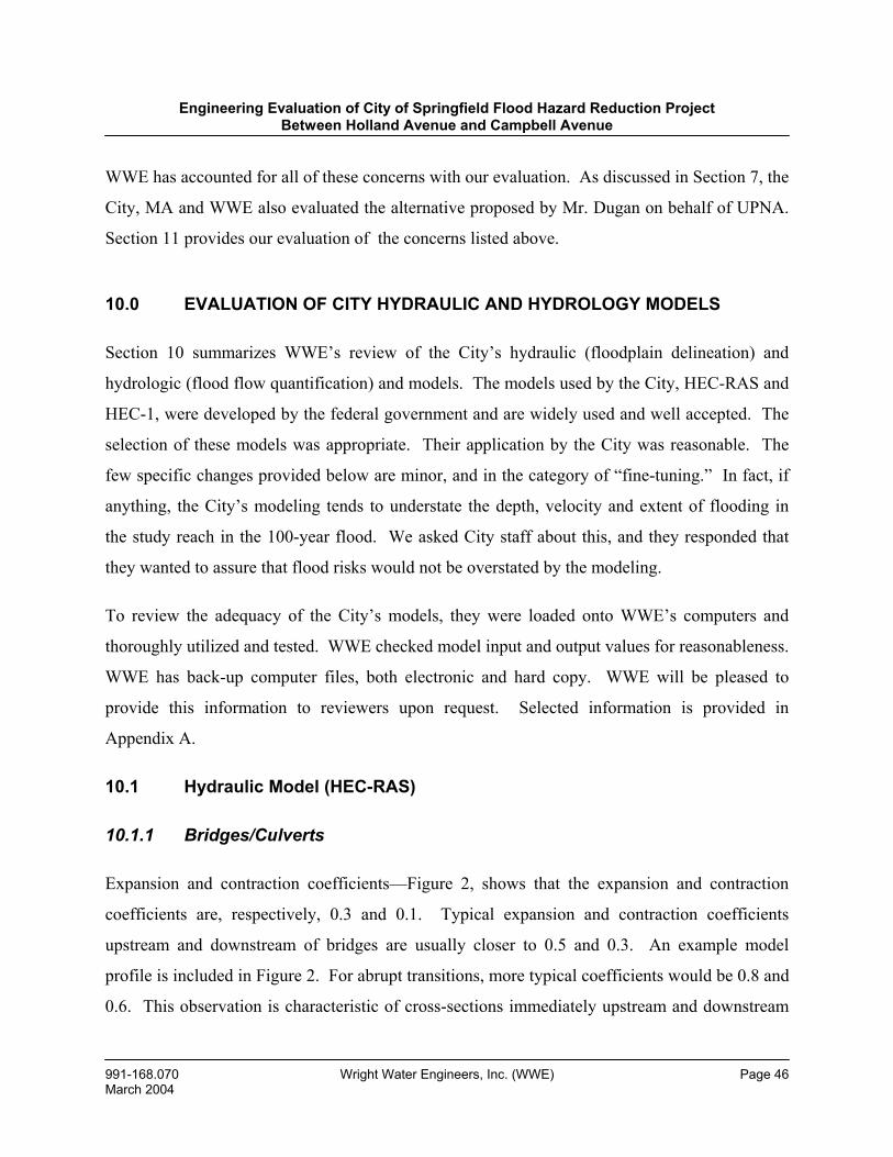
Engineering Evaluation of City of Springfield Flood Hazard Reduction Project Between Holland Avenue and Campbell Avenue
991-168.070 Wright Water Engineers, Inc. (WWE) Page 46 March 2004
WWE has accounted for all of these concerns with our evaluation. As discussed in Section 7, the
City, MA and WWE also evaluated the alternative proposed by Mr. Dugan on behalf of UPNA.
Section 11 provides our evaluation of the concerns listed above.
10.0 EVALUATION OF CITY HYDRAULIC AND HYDROLOGY MODELS
Section 10 summarizes WWE’s review of the City’s hydraulic (floodplain delineation) and
hydrologic (flood flow quantification) and models. The models used by the City, HEC-RAS and
HEC-1, were developed by the federal government and are widely used and well accepted. The
selection of these models was appropriate. Their application by the City was reasonable. The
few specific changes provided below are minor, and in the category of “fine-tuning.” In fact, if
anything, the City’s modeling tends to understate the depth, velocity and extent of flooding in
the study reach in the 100-year flood. We asked City staff about this, and they responded that
they wanted to assure that flood risks would not be overstated by the modeling.
To review the adequacy of the City’s models, they were loaded onto WWE’s computers and
thoroughly utilized and tested. WWE checked model input and output values for reasonableness.
WWE has back-up computer files, both electronic and hard copy. WWE will be pleased to
provide this information to reviewers upon request. Selected information is provided in
Appendix A.
10.1 Hydraulic Model (HEC-RAS)
10.1.1 Bridges/Culverts
Expansion and contraction coefficients—Figure 2, shows that the expansion and contraction
coefficients are, respectively, 0.3 and 0.1. Typical expansion and contraction coefficients
upstream and downstream of bridges are usually closer to 0.5 and 0.3. An example model
profile is included in Figure 2. For abrupt transitions, more typical coefficients would be 0.8 and
0.6. This observation is characteristic of cross-sections immediately upstream and downstream
Engineering Evaluation of City of Springfield Flood Hazard Reduction Project Between Holland Avenue and Campbell Avenue
991-168.070 Wright Water Engineers, Inc. (WWE) Page 47 March 2004
of bridges in all of the Fassnight Creek model runs. This modification should not significantly
change the model results, but could cause a slight increase in water surface elevations upstream
of the bridges.
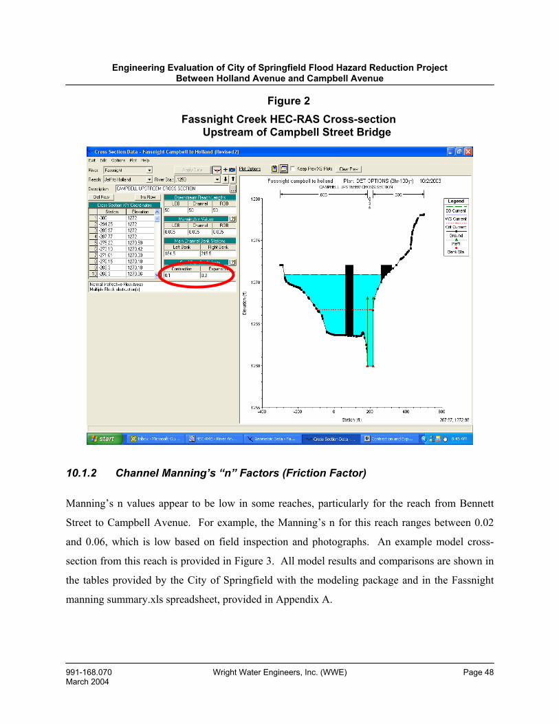
Engineering Evaluation of City of Springfield Flood Hazard Reduction Project Between Holland Avenue and Campbell Avenue
991-168.070 Wright Water Engineers, Inc. (WWE) Page 48 March 2004
10.1.2 Channel Manning’s “n” Factors (Friction Factor)
Manning’s n values appear to be low in some reaches, particularly for the reach from Bennett
Street to Campbell Avenue. For example, the Manning’s n for this reach ranges between 0.02
and 0.06, which is low based on field inspection and photographs. An example model cross-
section from this reach is provided in Figure 3. All model results and comparisons are shown in
the tables provided by the City of Springfield with the modeling package and in the Fassnight
manning summary.xls spreadsheet, provided in Appendix A.
Figure 2 Fassnight Creek HEC-RAS Cross-section
Upstream of Campbell Street Bridge
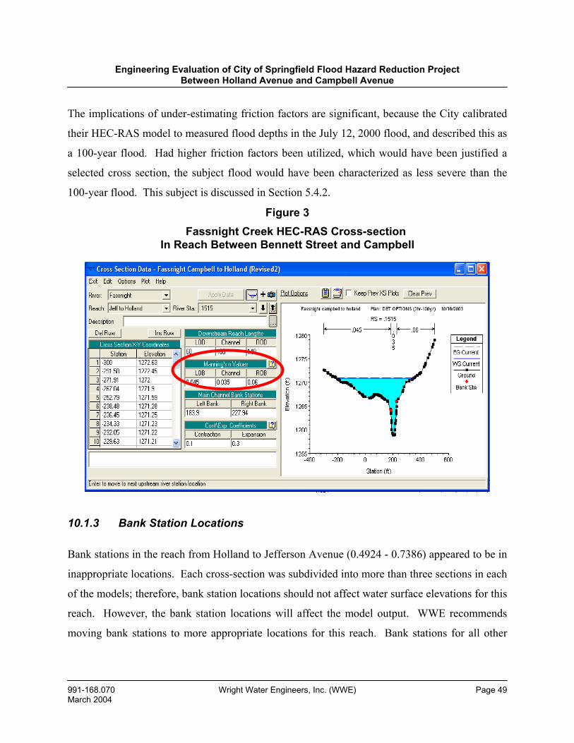
Engineering Evaluation of City of Springfield Flood Hazard Reduction Project Between Holland Avenue and Campbell Avenue
991-168.070 Wright Water Engineers, Inc. (WWE) Page 49 March 2004
The implications of under-estimating friction factors are significant, because the City calibrated
their HEC-RAS model to measured flood depths in the July 12, 2000 flood, and described this as
a 100-year flood. Had higher friction factors been utilized, which would have been justified a
selected cross section, the subject flood would have been characterized as less severe than the
100-year flood. This subject is discussed in Section 5.4.2.
10.1.3 Bank Station Locations
Bank stations in the reach from Holland to Jefferson Avenue (0.4924 - 0.7386) appeared to be in
inappropriate locations. Each cross-section was subdivided into more than three sections in each
of the models; therefore, bank station locations should not affect water surface elevations for this
reach. However, the bank station locations will affect the model output. WWE recommends
moving bank stations to more appropriate locations for this reach. Bank stations for all other
Figure 3 Fassnight Creek HEC-RAS Cross-section
In Reach Between Bennett Street and Campbell

Engineering Evaluation of City of Springfield Flood Hazard Reduction Project Between Holland Avenue and Campbell Avenue
991-168.070 Wright Water EngineeMarch 2004
reaches appear to be in appropriate locations. Although this change should be made, model
results are not affected.
10.1.4 Hydraulic Profiles
The hydraulic profile for the Encroachment (3-hr, 100-year) storm appears to demonstrate that
one cross-section station is missing. WWE has indicated the apparent location in Figure 4. We
recommend that this cross-section be added for the sake of consistency between models. The
cross-section that appears to be missing is located at river station 0.4868, at the Jefferson Avenue
culvert outlet. All other hydraulic profiles appear to be reasonable.
Figure 4 100-year, 3-hr Encroachment Water Surface Profile
Station 4868 Miles
rs, Inc. (WWE) Page 50
Station .4868 miles
Engineering Evaluation of City of Springfield Flood Hazard Reduction Project Between Holland Avenue and Campbell Avenue
991-168.070 Wright Water Engineers, Inc. (WWE) Page 51 March 2004
10.1.5 Cross-Sections
Cross-section selection and spacing appear to be reasonable and consistent with general
floodplain modeling practices.
10.1.6 Boundary Conditions
A critical depth boundary condition was used for all model runs. A critical depth boundary
condition should be a reasonable assumption for all of the HEC-RAS model runs.
10.1.7 Ineffective Flow Areas
Ineffective flow areas were input upstream and downstream of all culverts and appeared to be
placed at rational locations.
10.1.8 Flow Input Values
Flow input values for model frequencies were spot checked against the Fassnight Summary.xls
spreadsheet for the DET OPTION (3-hr, 100-year storm) HEC-RAS model (see Appendix A).
HEC-RAS model input was consistent with the values in the summary spreadsheet. It is unclear
where the values at the inflow to the Holland Avenue came from, though they are close to the
values from Culvert Master minus the flow at the top of the reach.
10.1.9 Split Flow Areas
For the smaller storm event frequencies (i.e. 5-year), split flow was predicted in some of the
cross-sections between Holland and Jefferson Avenue. WWE could not verify that split flow
scenarios actually exist based on the topography provided. WWE would recommend taking a
closer look at areas of split flow to be sure that these conditions actually exist and are modeled
accurately. This should not change model results.
Engineering Evaluation of City of Springfield Flood Hazard Reduction Project Between Holland Avenue and Campbell Avenue
991-168.070 Wright Water Engineers, Inc. (WWE) Page 52 March 2004
10.2 “Culvert Master” Program—Long Culvert from Holland Avenue to Jefferson Avenue
All model input and output appear to be reasonable for this computer model, which calculates
culvert hydraulics.
10.3 Large Printed 3- and 6-hr 100-year Floodplain Maps
WWE reviewed the large floodplain maps that the City printed for us, which are based on HEC-
RAS. The floodplain delineations look consistent with HEC-RAS model elevations for the
mapped events.
10.4 Hydrologic Model (HEC-1 Model)
10.4.1 Sub-basin Areas
Sub-basin areas were compared relative to adjacent basins for apparent size using the basin
delineation map provided by the City of Springfield. All sub-basins areas appeared to be
reasonable based on comparative relationships. Sub-basin areas were checked using the attached
FSNTDET.OUT HEC-1 output file. (See Appendix A.)
10.4.2 Channel Routing Parameters
WWE performed a channel routing input parameter check on element CRF78 by scaling off of
the sub-basin delineation map. Spot checks against the FSNTDET.OUT HEC-1 output file
showed that model routing length parameters were reasonable.
10.4.3 Model Network Setup
WWE examined the model network setup using the network line schematic in the HEC1
FSNTDET.OUT file. The model schematic was only checked to model design flow point F11B,
which corresponds to the end of the HEC-RAS model segment. The model schematic appeared
Engineering Evaluation of City of Springfield Flood Hazard Reduction Project Between Holland Avenue and Campbell Avenue
991-168.070 Wright Water Engineers, Inc. (WWE) Page 53 March 2004
to accurately reflect the hydrology of the basin. The model schematic was also verified against
the sub-basin map.
10.4.4 Curve Numbers and Lag Times
Curve numbers and lag times were not reviewed in detail, but a quick check indicates that they
are reasonable. More extensive input data and aerial coverage would be required to perform a
more sophisticated evaluation.
10.4.5 Runoff Volumes
A reasonableness check was performed for the total runoff volumes in the hydrologic model by
comparing the total rainfall depth and drainage area to runoff volume predicted in the model.
Runoff volumes estimated by the HEC-1 model for model location F11B (Near Campbell
Avenue) was 55% of the total precipitation volume for the 100-year, 3-hr storm event. This
runoff percentage appears to be a reasonable number based on the curve numbers and percent
imperviousness of the modeled watersheds.
10.4.6 Runoff Peaks
Peak runoff rates were checked by comparing unit peak runoff rates for the Fassnight Creek
watershed to the South Creek watershed. The South Creek drainage area is similar in
imperviousness and density of development. A unit peak discharge rate of 1.7 cfs/acre was
estimated for the Fassnight drainage for the 100-year, 3-hr event at Campbell Avenue. The unit
peak discharge for South Creek was 1.8 cfs/acre at Campbell Avenue. These values compare
closely, indicating reasonable runoff peaks for the HEC-1 model.
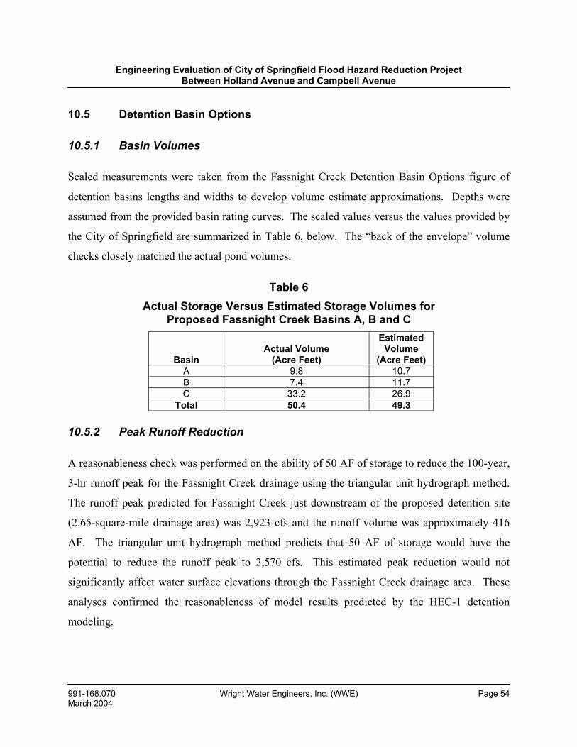
Engineering Evaluation of City of Springfield Flood Hazard Reduction Project Between Holland Avenue and Campbell Avenue
991-168.070 Wright Water Engineers, Inc. (WWE) Page 54 March 2004
10.5 Detention Basin Options
10.5.1 Basin Volumes
Scaled measurements were taken from the Fassnight Creek Detention Basin Options figure of
detention basins lengths and widths to develop volume estimate approximations. Depths were
assumed from the provided basin rating curves. The scaled values versus the values provided by
the City of Springfield are summarized in Table 6, below. The “back of the envelope” volume
checks closely matched the actual pond volumes.
Table 6 Actual Storage Versus Estimated Storage Volumes for
Proposed Fassnight Creek Basins A, B and C
10.5.2 Peak Runoff Reduction
A reasonableness check was performed on the ability of 50 AF of storage to reduce the 100-year,
3-hr runoff peak for the Fassnight Creek drainage using the triangular unit hydrograph method.
The runoff peak predicted for Fassnight Creek just downstream of the proposed detention site
(2.65-square-mile drainage area) was 2,923 cfs and the runoff volume was approximately 416
AF. The triangular unit hydrograph method predicts that 50 AF of storage would have the
potential to reduce the runoff peak to 2,570 cfs. This estimated peak reduction would not
significantly affect water surface elevations through the Fassnight Creek drainage area. These
analyses confirmed the reasonableness of model results predicted by the HEC-1 detention
modeling.
Basin
Actual Volume
(Acre Feet)
Estimated Volume
(Acre Feet) A 9.8 10.7 B 7.4 11.7 C 33.2 26.9
Total 50.4 49.3
Engineering Evaluation of City of Springfield Flood Hazard Reduction Project Between Holland Avenue and Campbell Avenue
991-168.070 Wright Water Engineers, Inc. (WWE) Page 55 March 2004
11.0 WWE ANALYSIS AND RECOMMENDATIONS
As discussed in Sections 4 and 5 of this report, there is a significant flooding problem on
Fassnight Creek in the study reach, between Holland Avenue (upstream) and Campbell Avenue
(downstream). The current conveyance capacity of Fassnight Creek, which consists of two 12-
feet-wide by 5-feet-high box culverts between Holland Avenue and Jefferson Avenue, and an
open channel from Jefferson Avenue downstream to Campbell Avenue, is between a 2-year and
5-year flood. Larger storm events exceed this conveyance capacity and flood the neighborhood
in the study reach. The area has a significant flooding history, with major floods in 1951, 1993
and 2000 and numerous smaller floods (which have caused street, alley, yard and basement or
crawlspace flooding). Of particular concern is the Bennett Street bridge, which is inundated
several times per year in a typical year. As shown on the 1991 FIRM and on 100-year floodplain
mapping prepared by the City of Springfield (see Drawing 1), there is a substantial 100-year
floodplain through the study reach, and many structures are located in the floodway, as well. In
short, by any standard, there is a significant flood risk in the study reach and action of some sort
must be taken to mitigate the risks to public health, safety and welfare.
The alternatives that were formulated and reviewed by the City Public Works Department and
MA (see Section 7) were reasonable and consistent with standard engineering practice. The City
and MA also carefully evaluated alternative proposals made by property owners in the study
reach and WWE. Based on all of the alternatives evaluated, WWE has concluded that the City’s
current “preferred alternative” (described in Section 7.4) should be implemented. The City’s
proposal to acquire certain homes (on a voluntary basis and at fair market value), followed by
construction of open channel and culvert improvements that will convey the 100-year flood, is
prudent, consistent with national floodplain management policies, and necessary.
The alternative offered by neighborhood residents (described in Section 7) was logical and
helpful; unfortunately, implementing that alternative would not provide an adequate level of
flood hazard reduction. As Jonathan Jones explained to the approximately one-dozen property
Engineering Evaluation of City of Springfield Flood Hazard Reduction Project Between Holland Avenue and Campbell Avenue
991-168.070 Wright Water Engineers, Inc. (WWE) Page 56 March 2004
owners who he met with on October 21, 2003, the basic problem with the neighborhood
alternative is that it does not address the fact that (in very rough terms) the 100-year flood at
Holland is about 3,000 cfs and the existing underground box culverts will convey about 1,000
cfs; this leaves about 2,000 cfs of flow that must move to the west through streets, alleys, yards,
basements, crawlspaces, etc.
WWE asked the City to evaluate an alternative that would address smaller, frequently occurring
floods. WWE’s hope was that such an alternative would significantly reduce flood hazards,
while enabling the homes to remain in the study reach. As described in Section 7, there are a
number of significant problems associated with this alternative, including the fact that it would
not adequately reduce flood risk.
As discussed in Section 8, many important floodplain policy questions arose in the course of this
evaluation, for which we sought the advice and counsel of national floodplain management
experts, and conducted literature review. We recommend that City officials carefully review
Section 8, because the experts’ advice indicates that the City should take action in certain areas.
Having discussed the Fassnight Creek situation with these experts, we are confident that
implementation of the City’s preferred alternative would be consistent with sound floodplain
management practice, nationally.
Section 9 summarizes major questions, concerns and criticisms posed by property owners in the
study reach to the City and WWE. These were valuable. WWE offers the following
observations regarding the criticisms raised by property owners:
• Regarding the assertion that neighborhood reaction to the project should have
been obtained in advance of the bond issue, the City has indicated to WWE
that it agrees with this criticism and will respond by initiating major
drainageway master plans in the City, which will include public input and
dialogue.
Engineering Evaluation of City of Springfield Flood Hazard Reduction Project Between Holland Avenue and Campbell Avenue
991-168.070 Wright Water Engineers, Inc. (WWE) Page 57 March 2004
• The City has not overstated the flooding problem in the study reach. The
flooding history of the area is well documented and goes back over 50 years.
The facts indicate that the area is subject to regular flooding, including large
events in 1951, 1993 and 2000.
• WWE fully understands the concern that the City’s preferred alternative
seems to go beyond what is necessary to address the problem. However, as
discussed in Section 7, alternatives were evaluated that address small,
frequently occurring events (rather than the 100-year flood) and which would
result in fewer home acquisitions. However, despite being expensive to
implement, these alternatives would not significantly reduce the 100-year
floodplain and would result in an unacceptably high level of risk to public
health, safety and welfare.
• The City had many legitimate reasons for assigning this project as one of the
highest priority flood control projects in the City. The criteria that the City
relied upon include, as examples: number of complaints received; number of
homes in the floodplain and floodway; flooding history; assessment of hazard
to the public and outside recommendations (such as the 1990 KCM study
which identified this reach of Fassnight Creek as the most problematic in the
watershed). These criteria are consistent with the national norm for public
works departments.
• Property owners acknowledge that there are serious safety issues associated
with the Bennett Street bridge overtopping a few times per year, in a typical
year; however, they were hopeful that increased channel capacity upstream
and downstream and a larger bridge could address this issue. WWE carefully
evaluated this possibility. Unfortunately, even if a major project were
undertaken to create 1-year bridge capacity, this would still result in
Engineering Evaluation of City of Springfield Flood Hazard Reduction Project Between Holland Avenue and Campbell Avenue
991-168.070 Wright Water Engineers, Inc. (WWE) Page 58 March 2004
unacceptably large overtopping depths and excessive velocities during larger
floods.
• WWE can understand the perception of some property owners that flood
depths are shallow in much of the study area; however, the City’s computer
modeling demonstrates that there are 100-year flood depths of 3 feet or more
in some areas, and hazardous combinations of flood depths and velocities at
many locations in the study reach. In many events, the duration of the
flooding is short. However, hydrologic modeling shows that for larger events,
high flows can exist for 30 minutes or longer, and this is certainly cause for
concern.
• Even if sanitary sewer backups could be prevented in the study reach, the
homes that are currently in the 100-year floodplain will continue to be in the
floodplain. The nature of surface flooding in both frequent and infrequent
storms will not change in response to sanitary sewer system upgrades. It is
important for property owners to recognize that backwater valves are not
guaranteed to work during floods, require maintenance, and are subject to
debris accumulation. Although it is prudent to install such devices for homes
located in floodplains (they are required in the 2003 International Plumbing
Code, Section 715, “where the flood level rims of plumbing fixtures are below
the elevation of the next upstream manhole in the public sewer”), they should
not be viewed as a “cure-all.”
• Some property owners have expressed concern that the City intends to extend
official, regulatory floodplain mapping (FIRM) upstream from Jefferson
Avenue, thereby placing properties into the regulatory floodplain which are
not currently shown on the FIRM floodplain. Our interviews with national
experts indicate that the City has a fundamental responsibility to extend
Engineering Evaluation of City of Springfield Flood Hazard Reduction Project Between Holland Avenue and Campbell Avenue
991-168.070 Wright Water Engineers, Inc. (WWE) Page 59 March 2004
floodplain mapping upstream to at least the location where the watershed is 1
square mile in size (roughly, National Avenue). A responsibility of municipal
government is to inform the public of areas that are subject to flood risk.
There are a number of options that the City has for extending the present
floodplain mapping, (see Section 8), and it is not mandatory for this extension
to occur via an updated FIRM or “Letter of Map Revision (LOMR).” For
various reasons, the preferred approach may be for the City to publish and
disseminate its own floodplain maps, independent from FEMA. This would
alert residents to the flood hazards, without the potential stigma of a “Zone A”
designation. Tulsa, Oklahoma has adopted and published a Flood Hazard
Atlas, which has been vital to its flood risk reduction program. The Fassnight
Creek floodplain between Jefferson and National Avenues, as defined by the
City, should be included in this type of local atlas.
• WWE empathizes with homeowner frustration at being “left in limbo” from
late this summer until the date of this report. However, the City put the
project on hold so that an outside, independent review (by WWE) could be
conducted. This review was primarily stimulated by questions and concerns
expressed by community residents and property owners.
• Regarding concerns that the City has allowed development to occur in the
watershed without detention and has over-utilized the detention “buy-out”
program, WWE observes that the Fassnight Creek watershed was largely
developed by 1970. This is not a case where there has been extensive new
development within the last decade. The City has not over-utilized detention
buy-outs in the Fassnight Creek watershed. Information provided by the
Public Works Department demonstrates that 0.74 AF of detention buy-out has
occurred in this watershed since 1983, which is insignificant given the
magnitude of flooding. For example, 0.74 AF is the necessary 100-year
Engineering Evaluation of City of Springfield Flood Hazard Reduction Project Between Holland Avenue and Campbell Avenue
991-168.070 Wright Water Engineers, Inc. (WWE) Page 60 March 2004
detention volume for about 4 acres of developed land, which is about one-
quarter of 1% (0.25%) of the watershed area at Holland Avenue.
• Although the property owners are correct in asserting that the Fassnight Creek
channel has not been adequately maintained from Jefferson Avenue
downstream, maintenance is currently the property owners’ responsibility, as
the City does not have maintenance easements for this channel segment. In
addition, even if the channel in question were concrete lined and completely
clear of debris, there would still be a significant flood risk to the
neighborhood given the magnitude of the flood flows. The City does not have
maintenance easements for the channel between the Bennett Street bridge and
Jefferson Avenue. Also, maintenance between the Bennett Street bridge and
Campbell Avenue would require permits from the USACE and MDNR.
These regulatory authorities are concerned about maintenance activities that
would modify the current “natural” appearance of the channel and riparian
corridor and space/easement limitations.
• The flood risk is greater from Jefferson Avenue downstream than it is
between Holland Avenue and Jefferson Avenue. However, there is still
significant risk in the upstream reach, since the capacity of the existing box
culverts is only about the 5-year flood. The extensiveness of the floodplain
between Holland and Jefferson is shown on Drawing 1.
The City Public Works Department has stated to neighborhood residents/property owners and to
WWE that the City’s goal would be to proceed with voluntary acquisition of homes that are
identified for the preferred alternative to be implemented. In addition, the City recommends that
the project be constructed in phases, beginning with Campbell Avenue to the Bennett Street
bridge, followed by the bridge to Jefferson Avenue, followed by Jefferson Avenue to Holland
Avenue. WWE concurs with the City’s approach on both of these points. Just as it is important
Engineering Evaluation of City of Springfield Flood Hazard Reduction Project Between Holland Avenue and Campbell Avenue
991-168.070 Wright Water Engineers, Inc. (WWE) Page 61 March 2004
to acknowledge the views of those property owners who wish to stay in the neighborhood, it is
also important to recognize the views of those who would like the City to acquire their properties
at this time. Phased implementation is consistent with this philosophy.
WWE has not conducted a benefit/cost (B/C) analysis for the proposed project. Such an
evaluation would go beyond the scope of our review. A B/C analysis for the Fassnight Project
would likely result in a ratio that is favorable compared to other potential City flood control
projects, based on such factors as:
• Large number of properties in the 100-year floodplain (79) and floodway (30)
in the study reach.
• Frequency of flooding.
• Number of complaints received by the City.
• Significant safety risks related to bridge overtopping and lack of emergency
vehicle access.
• Pubic benefits associated with project (improved public safety, increased
flood protection and property values for the neighborhood as a whole, better
“connection” of parks, greenway access, less time spent by City staff
addressing flooding in the study reach, etc.).
A number of the experts we interviewed suggested that it would prudent for the City to obtain
options for those homes where the current owners do not wish to sell. These options would state
that at such time as the current property owner decides to sell, the City would have first right of
refusal on the property. WWE concurs with this recommendation. In addition, we recommend
that the City send letters to property owners who choose to not participate in the voluntary
acquisition program indicating that the offer was made, and informing them that they are
residing in a high-risk area.
Engineering Evaluation of City of Springfield Flood Hazard Reduction Project Between Holland Avenue and Campbell Avenue
991-168.070 Wright Water Engineers, Inc. (WWE) Page 62 March 2004
Until the conveyance capacity of the Bennett Street bridge is increased, WWE recommends that
the City install signs on both sides of the bridge, warning motorists and pedestrians to not cross
the bridge when overtopping is occurring (for suitable sign designs see
www.ctre.iastate.edu/pubs/itcd/lowwater.pdf,). We anticipate and understand that some property
owners will not concur with this recommendation, but this hazard is so significant that
immediate action is warranted, and we do not see a reasonable short-term alternative. We also
suggest that the City inform emergency medical services about the flooding status at the Bennett
Street bridge, and define alternative access routes.
WWE recommends that the City take steps to extend the present Fassnight Creek floodplain
mapping upstream from Jefferson Avenue to at least National Avenue. The City should also
suggest that it would be prudent to purchase flood insurance. In short, good communication
between City staff and property owners is essential.
We hope that this evaluation has been helpful, and look forward to discussing our findings with
all interested parties. Again, we sincerely appreciate the information and assistance provided by
community residents and property owners and representatives of the City Public Works
Department.
Engineering Evaluation of City of Springfield Flood Hazard Reduction Project Between Holland Avenue and Campbell Avenue
991-168.070 Wright Water Engineers, Inc. (WWE) Page 63 March 2004
REFERENCES
American Association of State Highway and Transportation Officials (AASHTO). 1991. Model Drainage Manual. Washington: ISBN I-56051-010-2, 3-3–4, 9-6–9.
Debo, T. N., and A. J. Reese. 2003. Municipal Stormwater Management. New York: Lewis Publishers, 194-5, 214-5, 366, 375.
Federal Emergency Management Agency (FEMA). 2001. Supplemental Property Acquisition and Elevation Assistance (44 CFR Part 209), Federal Register 66:32666-73.
Federal Emergency Management Agency (FEMA). 1999. Flood Insurance Study Guidelines and Specifications for Study Contractors. Federal Emergency Management Agency, 2-1.
Federal Emergency Management Agency (FEMA). 1991a. Flood Insurance Study: City of Springfield Missouri, Greene County. Community Number – 290149.
Federal Emergency Management Agency (FEMA). 1991b. FIRM: Flood Insurance Rate Map, City of Springfield, Missouri, Greene County. National Flood Insurance Program, Community-Panel Number 290149 0006 B.
International Code Council (ICC). 2003. 2003 International Residential Code for One- and Two-Family Dwellings. International Code Council, Inc, 58-60.
United States Department of Transportation (USDOT). August 1979. Design of Urban Highway Drainage: State-of-the-Art. Washington: Federal Highway Administration, FHWA-TS-79-225, 1-5, 5-7.
Urban Water Resources Research Council (UWRRC). 1992. Design and Construction of Urban Stormwater Management Systems. Reston: American Society of Civil Engineers and Water Environment Federation, 255-59.
C:\PF\991-168\070frl(mds)\Report.doc

PHOTOGRAPHS
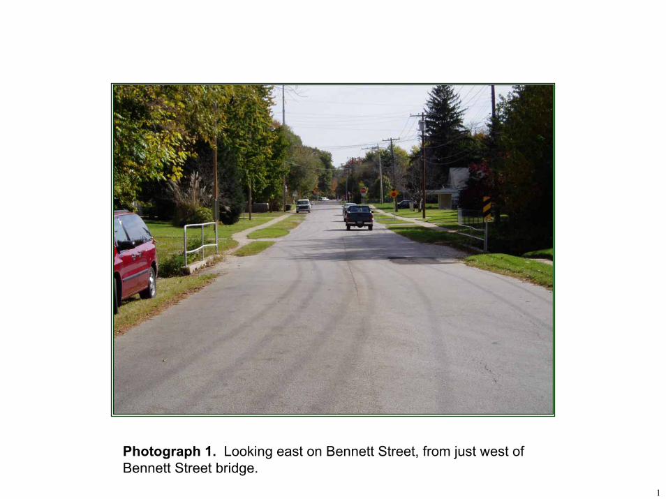
1
Photograph 1. Looking east on Bennett Street, from just west of Bennett Street bridge.
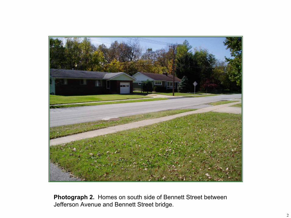
2
Photograph 2. Homes on south side of Bennett Street between Jefferson Avenue and Bennett Street bridge.
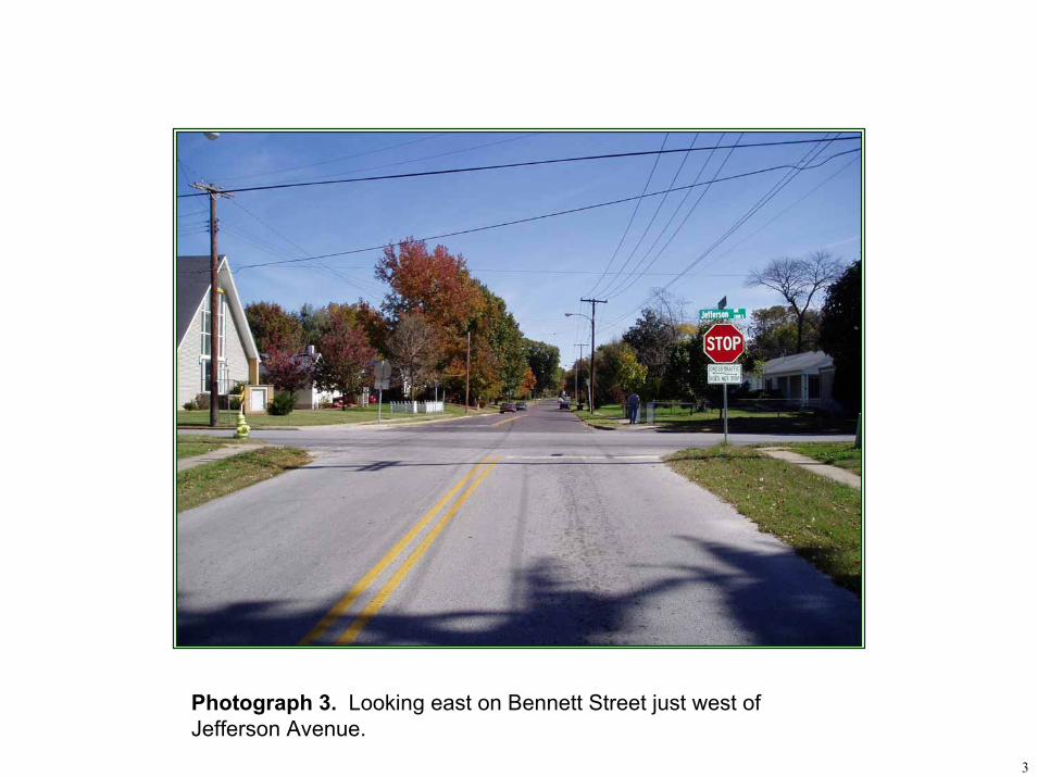
3
Photograph 3. Looking east on Bennett Street just west of Jefferson Avenue.
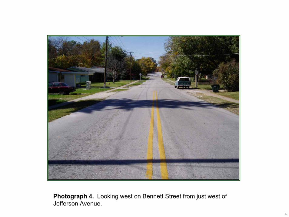
4
Photograph 4. Looking west on Bennett Street from just west of Jefferson Avenue.
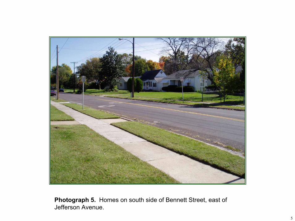
5
Photograph 5. Homes on south side of Bennett Street, east of Jefferson Avenue.
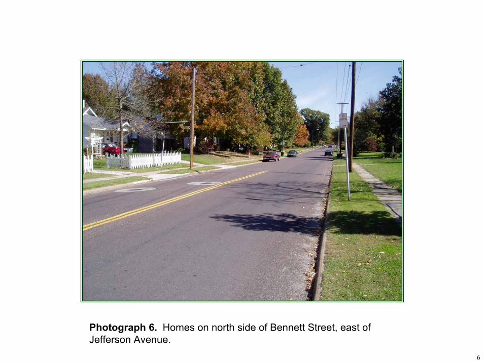
6
Photograph 6. Homes on north side of Bennett Street, east of Jefferson Avenue.
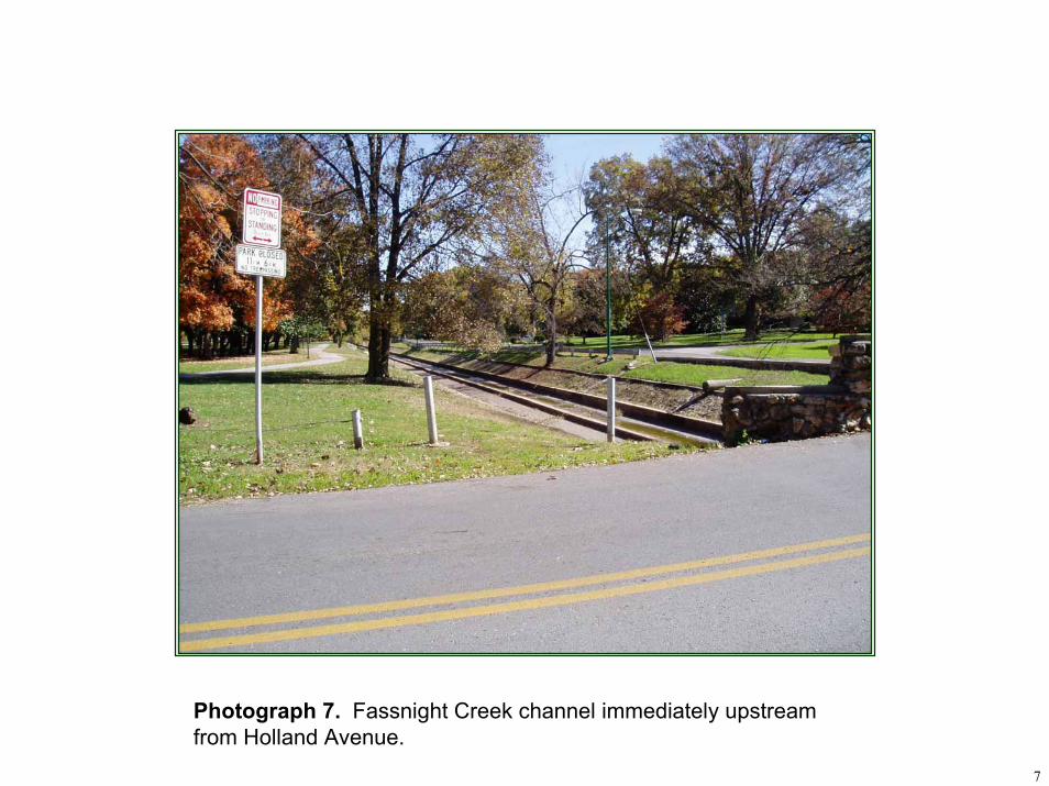
7
Photograph 7. Fassnight Creek channel immediately upstream from Holland Avenue.
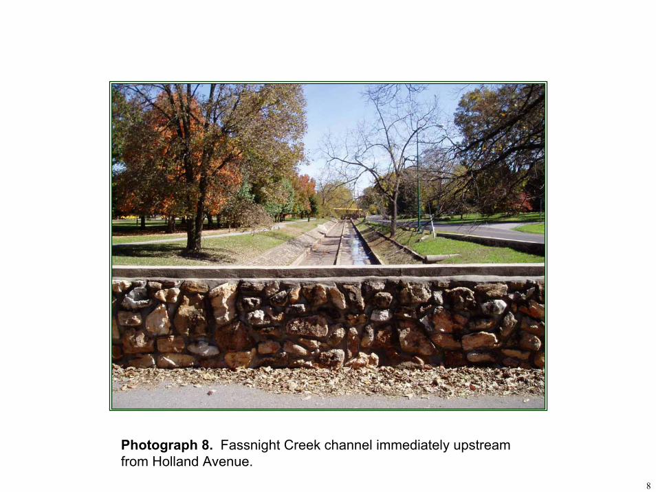
8
Photograph 8. Fassnight Creek channel immediately upstream from Holland Avenue.
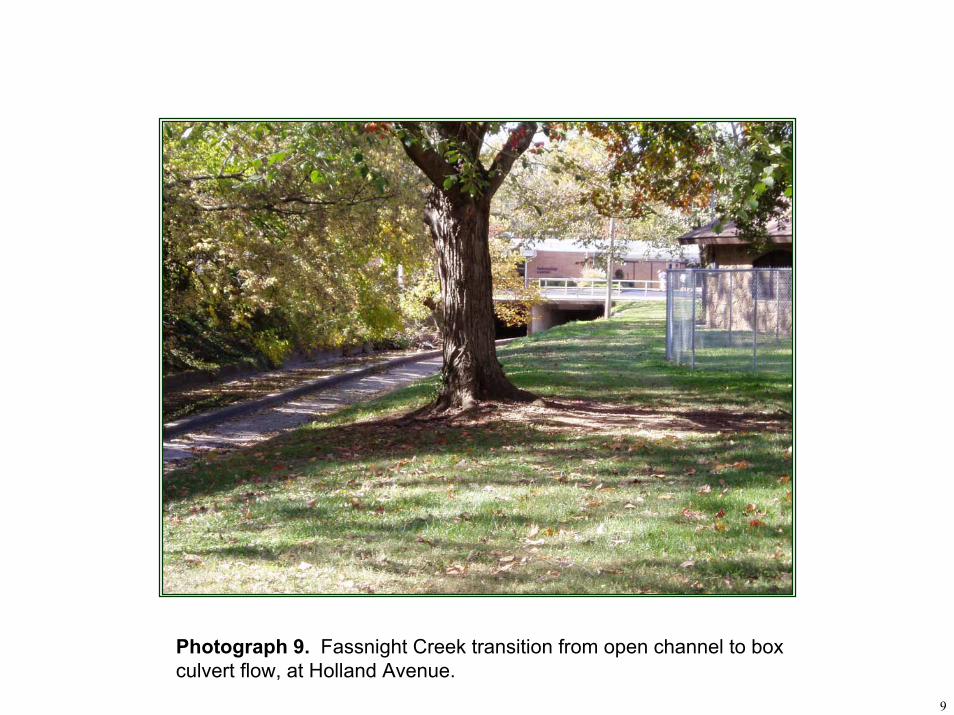
9
Photograph 9. Fassnight Creek transition from open channel to box culvert flow, at Holland Avenue.
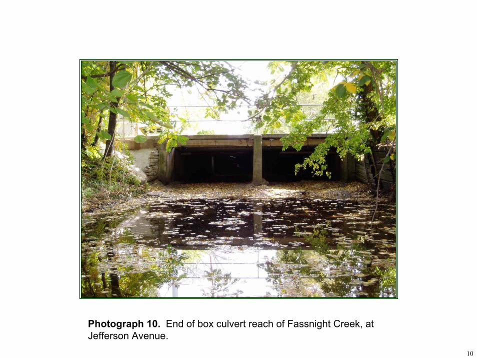
10
Photograph 10. End of box culvert reach of Fassnight Creek, at Jefferson Avenue.
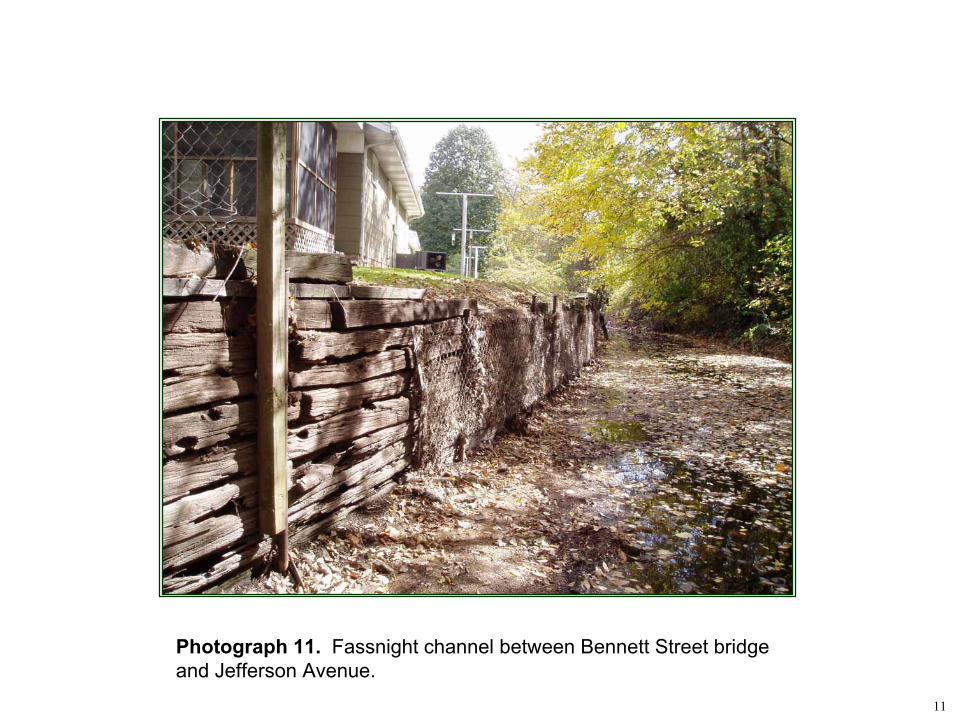
11
Photograph 11. Fassnight channel between Bennett Street bridge and Jefferson Avenue.
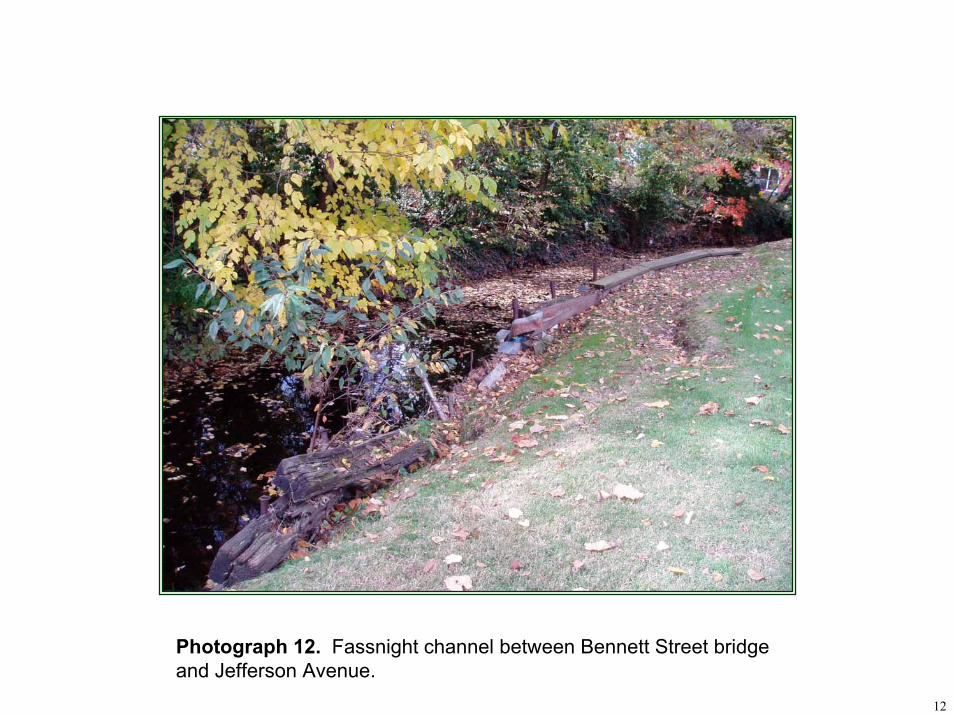
12
Photograph 12. Fassnight channel between Bennett Street bridge and Jefferson Avenue.
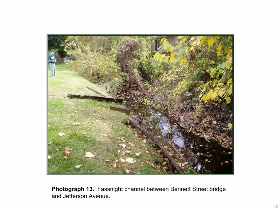
13
Photograph 13. Fassnight channel between Bennett Street bridge and Jefferson Avenue.
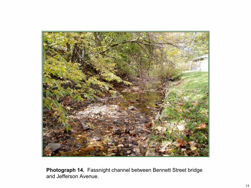
14
Photograph 14. Fassnight channel between Bennett Street bridge and Jefferson Avenue.
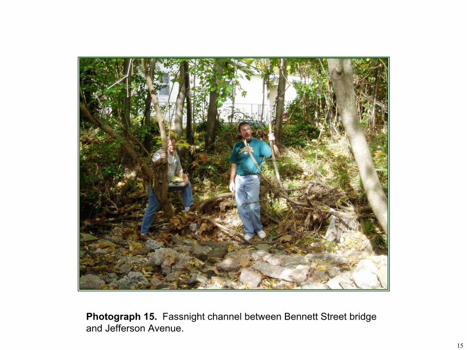
15
Photograph 15. Fassnight channel between Bennett Street bridge and Jefferson Avenue.
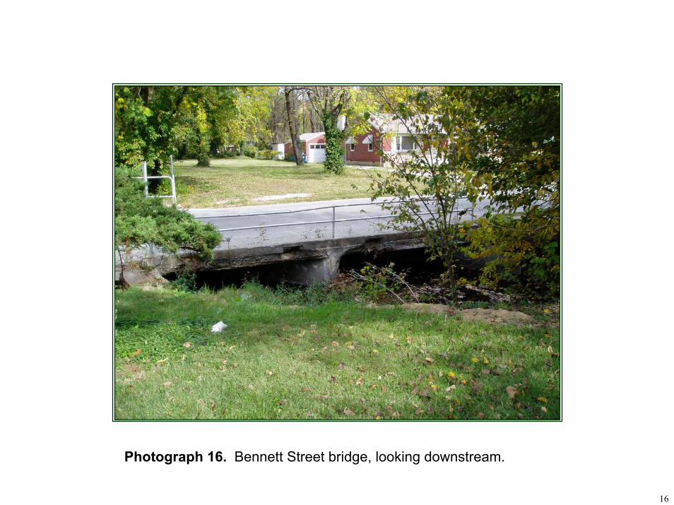
16
Photograph 16. Bennett Street bridge, looking downstream.
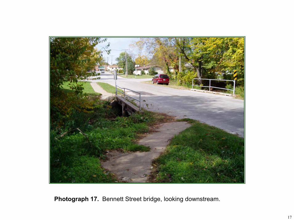
17
Photograph 17. Bennett Street bridge, looking downstream.
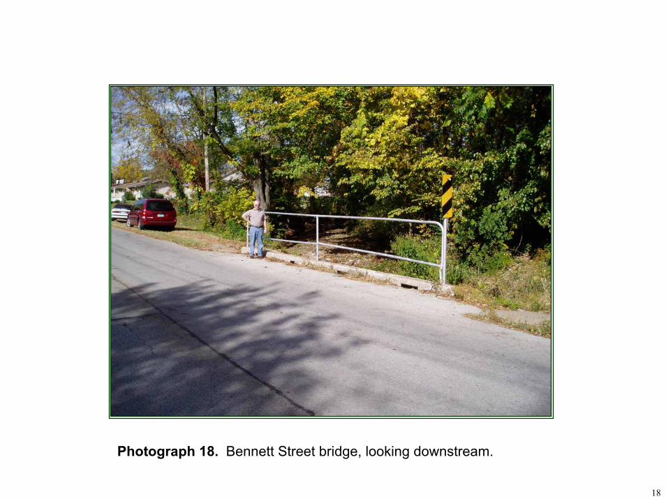
18
Photograph 18. Bennett Street bridge, looking downstream.
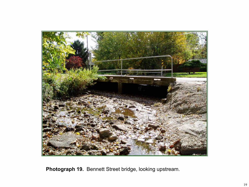
19
Photograph 19. Bennett Street bridge, looking upstream.
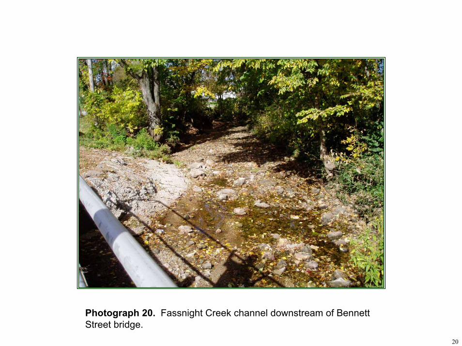
20
Photograph 20. Fassnight Creek channel downstream of Bennett Street bridge.
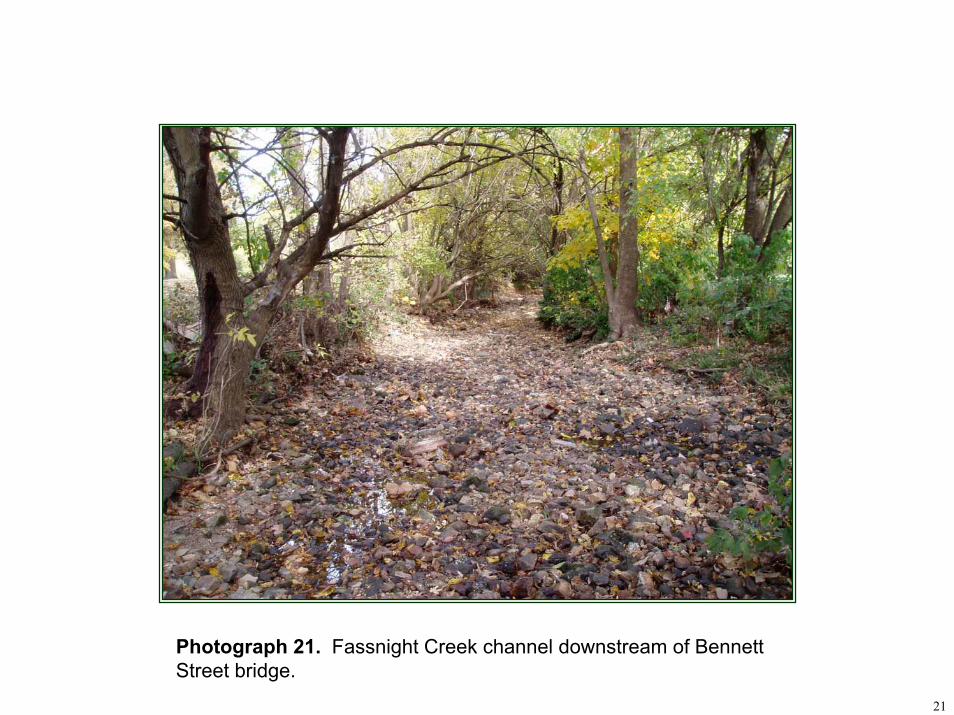
21
Photograph 21. Fassnight Creek channel downstream of Bennett Street bridge.
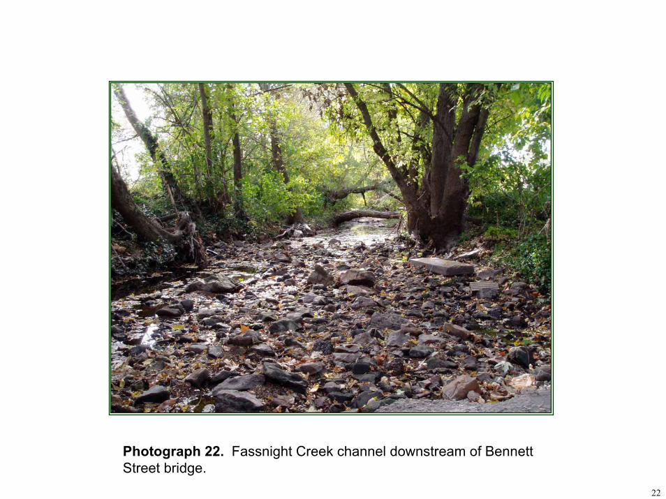
22
Photograph 22. Fassnight Creek channel downstream of Bennett Street bridge.
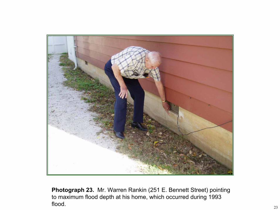
23
Photograph 23. Mr. Warren Rankin (251 E. Bennett Street) pointing to maximum flood depth at his home, which occurred during 1993 flood.
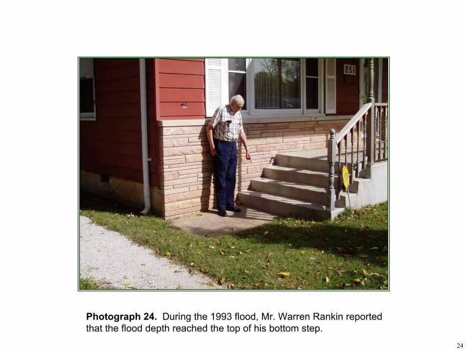
24
Photograph 24. During the 1993 flood, Mr. Warren Rankin reported that the flood depth reached the top of his bottom step.
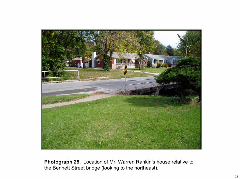
25
Photograph 25. Location of Mr. Warren Rankin’s house relative to the Bennett Street bridge (looking to the northeast).
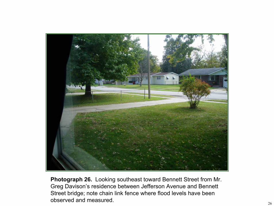
26
Photograph 26. Looking southeast toward Bennett Street from Mr. Greg Davison’s residence between Jefferson Avenue and Bennett Street bridge; note chain link fence where flood levels have been observed and measured.
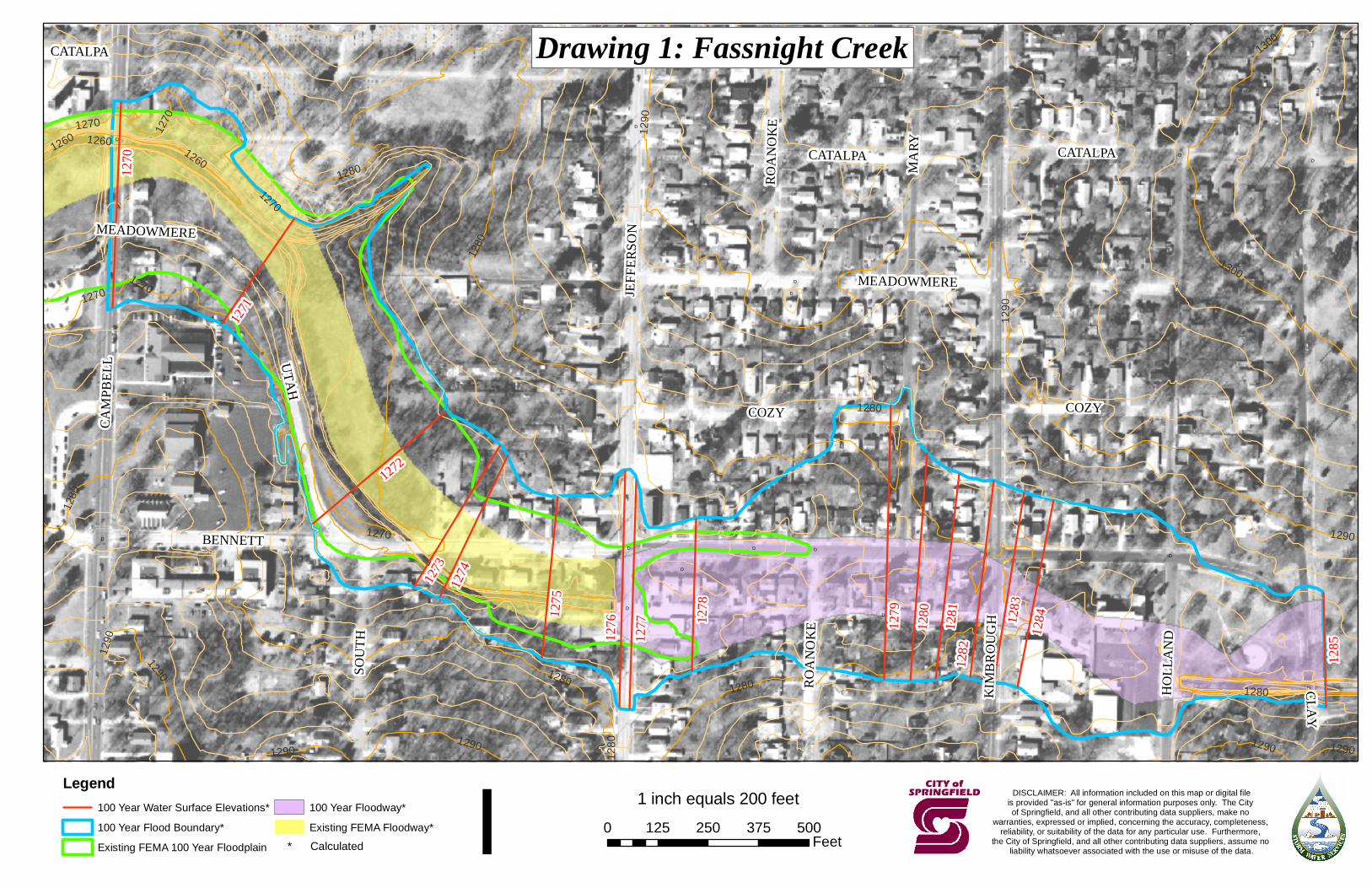
DD D D
D
D
D
DDD
D
D
D D D
D
D
D
D
D
D
D
D
D BENNETT
CLAY
MARY
HOLL
AND
CAMP
BELL
JEFF
ERSO
N
UTAH
KIMB
ROUG
H
COZY
CATALPA
MEADOWMERE
SOUT
H
ROAN
OKE
CATALPA
COZY
CATALPA
MEADOWMERE
ROAN
OKE
1280
1290
1270
1300
1260
1300
1260
1270
1280
1280
12701260
1280
1270
1290
1280
12901290
1270
1280
1290
1290
1290
1280
1290
1270
1280 1290
1279
1276
1277 12
8012
81
1270
1282
1283
1284
1272
1273
1275
1274
1278
1271
1285
DISCLAIMER: All information included on this map or digital fileis provided "as-is" for general information purposes only. The City of Springfield, and all other contributing data suppliers, make no
warranties, expressed or implied, concerning the accuracy, completeness, reliability, or suitability of the data for any particular use. Furthermore,
the City of Springfield, and all other contributing data suppliers, assume no liability whatsoever associated with the use or misuse of the data.* Calculated
Legend100 Year Water Surface Elevations*100 Year Flood Boundary*Existing FEMA 100 Year Floodplain
100 Year Floodway*Existing FEMA Floodway* I
1 inch equals 200 feet0 125 250 375 500
Feet
Drawing 1: Fassnight Creek
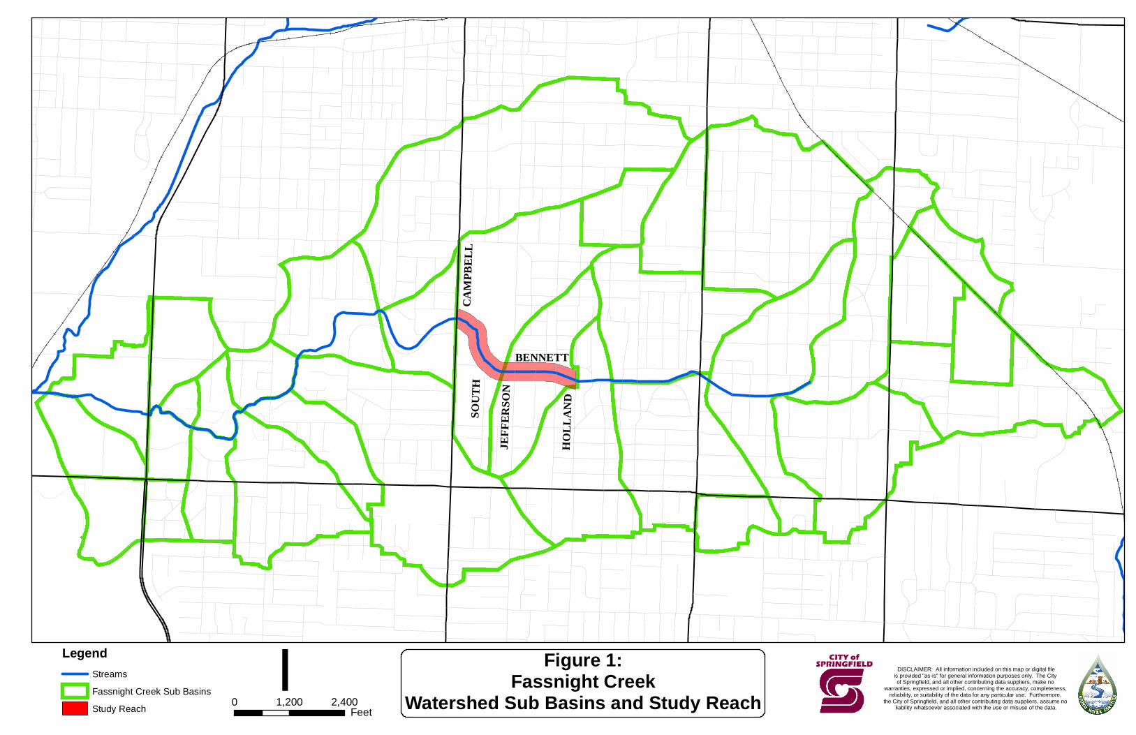
CAM
PBEL
LSO
UTH
JEFF
ERSO
N
HOLL
AND
BENNETT
LegendStreamsFassnight Creek Sub BasinsStudy Reach
DISCLAIMER: All information included on this map or digital fileis provided "as-is" for general information purposes only. The City of Springfield, and all other contributing data suppliers, make no
warranties, expressed or implied, concerning the accuracy, completeness, reliability, or suitability of the data for any particular use. Furthermore,
the City of Springfield, and all other contributing data suppliers, assume no liability whatsoever associated with the use or misuse of the data.
I0 1,200 2,400Feet
Figure 1:Fassnight Creek
Watershed Sub Basins and Study Reach

APPENDIX A
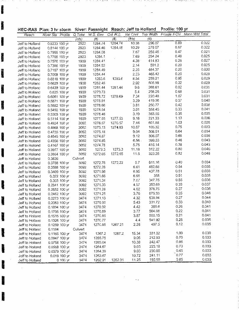
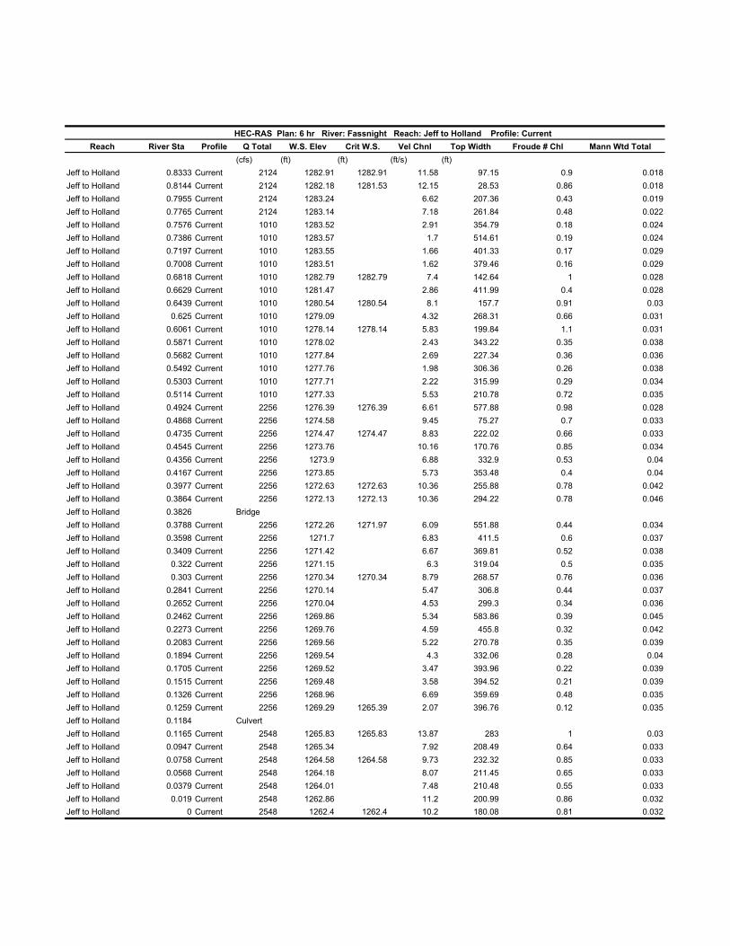
HEC-RAS Plan: 6 hr River: Fassnight Reach: Jeff to Holland Profile: CurrentReach River Sta Profile Q Total W.S. Elev Crit W.S. Vel Chnl Top Width Froude # Chl Mann Wtd Total
(cfs) (ft) (ft) (ft/s) (ft)Jeff to Holland 0.8333 Current 2124 1282.91 1282.91 11.58 97.15 0.9 0.018Jeff to Holland 0.8144 Current 2124 1282.18 1281.53 12.15 28.53 0.86 0.018Jeff to Holland 0.7955 Current 2124 1283.24 6.62 207.36 0.43 0.019Jeff to Holland 0.7765 Current 2124 1283.14 7.18 261.84 0.48 0.022Jeff to Holland 0.7576 Current 1010 1283.52 2.91 354.79 0.18 0.024Jeff to Holland 0.7386 Current 1010 1283.57 1.7 514.61 0.19 0.024Jeff to Holland 0.7197 Current 1010 1283.55 1.66 401.33 0.17 0.029Jeff to Holland 0.7008 Current 1010 1283.51 1.62 379.46 0.16 0.029Jeff to Holland 0.6818 Current 1010 1282.79 1282.79 7.4 142.64 1 0.028Jeff to Holland 0.6629 Current 1010 1281.47 2.86 411.99 0.4 0.028Jeff to Holland 0.6439 Current 1010 1280.54 1280.54 8.1 157.7 0.91 0.03Jeff to Holland 0.625 Current 1010 1279.09 4.32 268.31 0.66 0.031Jeff to Holland 0.6061 Current 1010 1278.14 1278.14 5.83 199.84 1.1 0.031Jeff to Holland 0.5871 Current 1010 1278.02 2.43 343.22 0.35 0.038Jeff to Holland 0.5682 Current 1010 1277.84 2.69 227.34 0.36 0.036Jeff to Holland 0.5492 Current 1010 1277.76 1.98 306.36 0.26 0.038Jeff to Holland 0.5303 Current 1010 1277.71 2.22 315.99 0.29 0.034Jeff to Holland 0.5114 Current 1010 1277.33 5.53 210.78 0.72 0.035Jeff to Holland 0.4924 Current 2256 1276.39 1276.39 6.61 577.88 0.98 0.028Jeff to Holland 0.4868 Current 2256 1274.58 9.45 75.27 0.7 0.033Jeff to Holland 0.4735 Current 2256 1274.47 1274.47 8.83 222.02 0.66 0.033Jeff to Holland 0.4545 Current 2256 1273.76 10.16 170.76 0.85 0.034Jeff to Holland 0.4356 Current 2256 1273.9 6.88 332.9 0.53 0.04Jeff to Holland 0.4167 Current 2256 1273.85 5.73 353.48 0.4 0.04Jeff to Holland 0.3977 Current 2256 1272.63 1272.63 10.36 255.88 0.78 0.042Jeff to Holland 0.3864 Current 2256 1272.13 1272.13 10.36 294.22 0.78 0.046Jeff to Holland 0.3826 BridgeJeff to Holland 0.3788 Current 2256 1272.26 1271.97 6.09 551.88 0.44 0.034Jeff to Holland 0.3598 Current 2256 1271.7 6.83 411.5 0.6 0.037Jeff to Holland 0.3409 Current 2256 1271.42 6.67 369.81 0.52 0.038Jeff to Holland 0.322 Current 2256 1271.15 6.3 319.04 0.5 0.035Jeff to Holland 0.303 Current 2256 1270.34 1270.34 8.79 268.57 0.76 0.036Jeff to Holland 0.2841 Current 2256 1270.14 5.47 306.8 0.44 0.037Jeff to Holland 0.2652 Current 2256 1270.04 4.53 299.3 0.34 0.036Jeff to Holland 0.2462 Current 2256 1269.86 5.34 583.86 0.39 0.045Jeff to Holland 0.2273 Current 2256 1269.76 4.59 455.8 0.32 0.042Jeff to Holland 0.2083 Current 2256 1269.56 5.22 270.78 0.35 0.039Jeff to Holland 0.1894 Current 2256 1269.54 4.3 332.06 0.28 0.04Jeff to Holland 0.1705 Current 2256 1269.52 3.47 393.96 0.22 0.039Jeff to Holland 0.1515 Current 2256 1269.48 3.58 394.52 0.21 0.039Jeff to Holland 0.1326 Current 2256 1268.96 6.69 359.69 0.48 0.035Jeff to Holland 0.1259 Current 2256 1269.29 1265.39 2.07 396.76 0.12 0.035Jeff to Holland 0.1184 CulvertJeff to Holland 0.1165 Current 2548 1265.83 1265.83 13.87 283 1 0.03Jeff to Holland 0.0947 Current 2548 1265.34 7.92 208.49 0.64 0.033Jeff to Holland 0.0758 Current 2548 1264.58 1264.58 9.73 232.32 0.85 0.033Jeff to Holland 0.0568 Current 2548 1264.18 8.07 211.45 0.65 0.033Jeff to Holland 0.0379 Current 2548 1264.01 7.48 210.48 0.55 0.033Jeff to Holland 0.019 Current 2548 1262.86 11.2 200.99 0.86 0.032Jeff to Holland 0 Current 2548 1262.4 1262.4 10.2 180.08 0.81 0.032
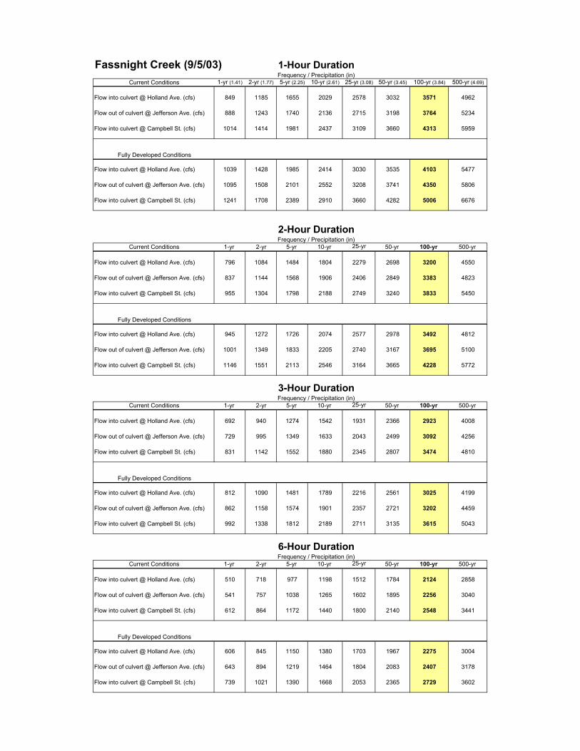
Fassnight Creek (9/5/03) 1-Hour DurationFrequency / Precipitation (in)
Current Conditions 1-yr (1.41) 2-yr (1.77) 5-yr (2.25) 10-yr (2.61) 25-yr (3.08) 50-yr (3.45) 100-yr (3.84) 500-yr (4.69)
Flow into culvert @ Holland Ave. (cfs) 849 1185 1655 2029 2578 3032 3571 4962
Flow out of culvert @ Jefferson Ave. (cfs) 888 1243 1740 2136 2715 3198 3764 5234
Flow into culvert @ Campbell St. (cfs) 1014 1414 1981 2437 3109 3660 4313 5959
Fully Developed Conditions
Flow into culvert @ Holland Ave. (cfs) 1039 1428 1985 2414 3030 3535 4103 5477
Flow out of culvert @ Jefferson Ave. (cfs) 1095 1508 2101 2552 3208 3741 4350 5806
Flow into culvert @ Campbell St. (cfs) 1241 1708 2389 2910 3660 4282 5006 6676
2-Hour DurationFrequency / Precipitation (in)
Current Conditions 1-yr 2-yr 5-yr 10-yr 25-yr 50-yr 100-yr 500-yr
Flow into culvert @ Holland Ave. (cfs) 796 1084 1484 1804 2279 2698 3200 4550
Flow out of culvert @ Jefferson Ave. (cfs) 837 1144 1568 1906 2406 2849 3383 4823
Flow into culvert @ Campbell St. (cfs) 955 1304 1798 2188 2749 3240 3833 5450
Fully Developed Conditions
Flow into culvert @ Holland Ave. (cfs) 945 1272 1726 2074 2577 2978 3492 4812
Flow out of culvert @ Jefferson Ave. (cfs) 1001 1349 1833 2205 2740 3167 3695 5100
Flow into culvert @ Campbell St. (cfs) 1146 1551 2113 2546 3164 3665 4228 5772
3-Hour DurationFrequency / Precipitation (in)
Current Conditions 1-yr 2-yr 5-yr 10-yr 25-yr 50-yr 100-yr 500-yr
Flow into culvert @ Holland Ave. (cfs) 692 940 1274 1542 1931 2366 2923 4008
Flow out of culvert @ Jefferson Ave. (cfs) 729 995 1349 1633 2043 2499 3092 4256
Flow into culvert @ Campbell St. (cfs) 831 1142 1552 1880 2345 2807 3474 4810
Fully Developed Conditions
Flow into culvert @ Holland Ave. (cfs) 812 1090 1481 1789 2216 2561 3025 4199
Flow out of culvert @ Jefferson Ave. (cfs) 862 1158 1574 1901 2357 2721 3202 4459
Flow into culvert @ Campbell St. (cfs) 992 1338 1812 2189 2711 3135 3615 5043
6-Hour DurationFrequency / Precipitation (in)
Current Conditions 1-yr 2-yr 5-yr 10-yr 25-yr 50-yr 100-yr 500-yr
Flow into culvert @ Holland Ave. (cfs) 510 718 977 1198 1512 1784 2124 2858
Flow out of culvert @ Jefferson Ave. (cfs) 541 757 1038 1265 1602 1895 2256 3040
Flow into culvert @ Campbell St. (cfs) 612 864 1172 1440 1800 2140 2548 3441
Fully Developed Conditions
Flow into culvert @ Holland Ave. (cfs) 606 845 1150 1380 1703 1967 2275 3004
Flow out of culvert @ Jefferson Ave. (cfs) 643 894 1219 1464 1804 2083 2407 3178
Flow into culvert @ Campbell St. (cfs) 739 1021 1390 1668 2053 2365 2729 3602