Evading Dam-Nation: Land Use History of the Lower Cosumnes River Watershed, ca. 1820-2016
Michelaina Johnson Advisors: Peter Sahlins and Kerwin Lee Klein
UC Berkeley Undergraduate History Thesis, High Honors June 11th, 2017
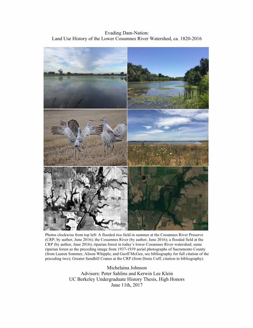
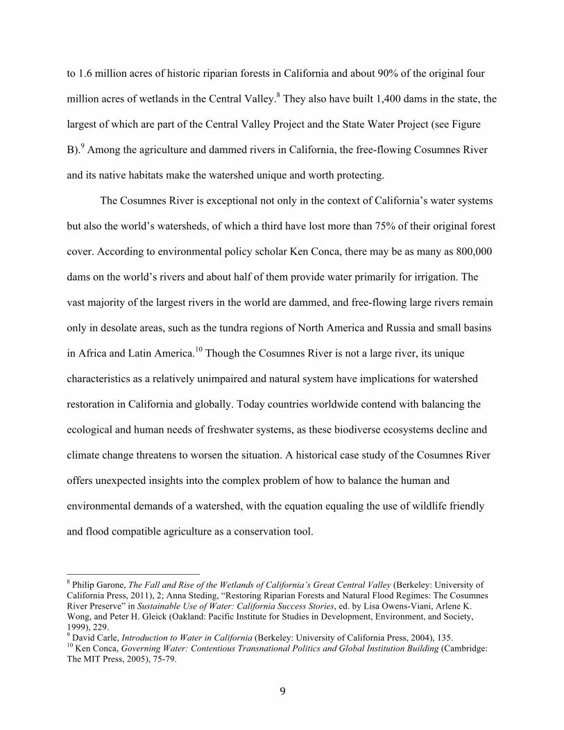
Photos clockwise from top left: A flooded rice field in summer at the Cosumnes River Preserve (CRP; by author, June 2016); the Cosumnes River (by author, June 2016); a flooded field at the CRP (by author, June 2016); riparian forest in today’s lower Cosumnes River watershed; same riparian forest as the preceding image from 1937-1939 aerial photographs of Sacramento County (from Lauren Sommer, Alison Whipple, and Geoff McGee, see bibliography for full citation of the preceding two); Greater Sandhill Cranes at the CRP (from Denis Cuff; citation in bibliography).
2
Table of Contents Table of Contents 2 Acknowledgements 3-4 I. Introduction 5-13 II. The Plains Miwok and the Native Landscape 13-18 III. “The Herculean Task”: Reclamation and the Advent of Agriculture 18-27 IV. Dammed if You Do, Dammed if You Don’t 27-37 V. A Remnant Remains 37-50 VI. Protecting What Remains: The Establishment of the Cosumnes River Preserve 50-52 VII. The Cosumnes River Preserve Redefines Restoration 52-62
VIII. Conclusion 62-68 IX. Epilogue 68-74 List of Figures 75-82 Bibliography 83-92
3
Acknowledgments
This thesis was very rewarding to research and write, and I appreciate the assistance of
the many people who made my dream and the Cosumnes River Preserve a reality. This project
was by no means a singular effort and would not have been possible without the financial
support of the HAAS Scholars Program and the guidance of the program’s administrator, Leah
Carroll. I send a special thanks to the staff at the Cosumnes River Preserve, especially Harry
McQuillen and Sara Sweet, for hosting me for two months in the summer of 2016, as I did the
research and interviews necessary to make this thesis possible. To Mark Ackerman and Alex
Cabrera, thank you for making me feel welcome. To Mike and Charity Eaton, thank you for your
generosity of time and your boundless hospitality.
I am also grateful to the people, especially the volunteers of the Habitat Restoration
Team, who sculpted and restored the landscape that I love. I had the pleasure of interviewing two
of the team members: Rick Hicks and Joe Watson. I am also indebted to several other people
who agreed to be interviewed and shared their experiences with me: Alison Whipple, Dr. Jeffrey
Mount, Eugenia Olson, Ken and Ron Oneto, Wendel Flint, Butch Loretz, Carson Jeffres, Mike
Johnson, Robin Cox, Dawit Zeleke, Huey Johnson, Mike Eaton, Rich Reiner, Duane Martin Jr.,
Bill and Diane Kirkham, Melinda Frost-Hurzel, Steve McCormick, Harry McQuillen, and Chris
Unkel.
This thesis would not have been possible without the support and encouragement of my
faculty advisors Kerwin Lee Klein and Peter Sahlins. I am also grateful to the many archivists
and librarians, especially Dawn Collings at UC Davis’ map library, who dug up treasures I didn’t
know existed. I thank my friend Lina for making the map of the Cosumnes River Preserve.
4
Last but not least, there is the whole community of people who did not directly contribute
to this paper but have molded my academic and personal growth. My incredible UC Berkeley
professors, notably Claire Kremen and Laurel Larsen, laid the foundation from which I
constructed this project. My grandma, Carol, deserves a special shout out for her support and
editing. A special thanks to my roommate and best friend, Ayla, for the laughs and insights. I am
very grateful to the rest of my family and friends, especially my mom Kathryn, my grandpa
John, and my lifetime best friend Gena, for listening to my ideas and for the car that drove me
around this summer. I am blessed to have you all in my life!
~Michelaina Johnson
5
I. Introduction The Cosumnes River diverges from the popular history of California’s rivers as the last
river without a major dam and as the home of some of the largest native habitats remaining in the
Central Valley. Of the 20 rivers draining the western Sierra Nevada Mountains, only the
Cosumnes River runs free. Large dams impede the flow of the 19 other rivers to generate a
reliable urban water supply and to help irrigate seven million acres of farmland in the Central
Valley.1 A century and a half ago, that farmland was a landscape of native habitat occupied and
managed by Native Americans. White settlers, who started arriving to California in droves in the
1850s, valued the land for its profit potential and not its native habitat and biodiversity. Today,
the opposite is true. The powerful environmental nonprofit, The Nature Conservancy (TNC), and
a leading waterfowl conservation organization, Ducks Unlimited, established the Cosumnes
River Preserve (CRP) in 1987 to protect the river’s free flow and native flora and fauna (notably
its unique riparian—river bank—forest) and to restore the river’s floodplain. Since its founding,
the CRP has curtailed historic habitat destruction and demonstrated that agriculture and native
habitat conservation are compatible. That groundbreaking realization redefined conservation
policy in California. The Cosumnes River watershed, though still a highly modified system, has
become the riparian and floodplain restoration model for the Sacramento-San Joaquin Delta and
the Central Valley’s rivers, thanks to the efforts of the CRP’s partners, including TNC, DU, the
Bureau of Land Management, and the Sacramento County Department of Parks and Recreation.
A sizeable, dedicated community of volunteers, staff, researchers, and locals today manage and
restore the Preserve’s 48,859 acres.
1 Dylan S. Ahearn et al., “Temporal Dynamics of Stream Water Chemistry in the Last Free-Flowing River Draining
the Western Sierra Nevada, California,” Journal of Hydrology 295, no. 1–4, August 10, 2004, 47; “Federal Agencies Release Data Showing California Central Valley Idle Farmland Doubling During Drought,” NASA, October 21, 2015, accessed November 4, 2016, http://landsat.gsfc.nasa.gov/federal-agencies-release-data-showing-california-central-valley-idle-farmland-doubling-during-drought/.
6
The Cosumnes watershed had experienced nearly a century and a half’s worth of
engineering before Californians recognized its ecological value. Between 1848 and 1860, over
300,000 entrepreneurs from across the globe came to California with dreams of becoming rich
through mining gold and establishing an inland agricultural Eden by reclaiming the state’s native
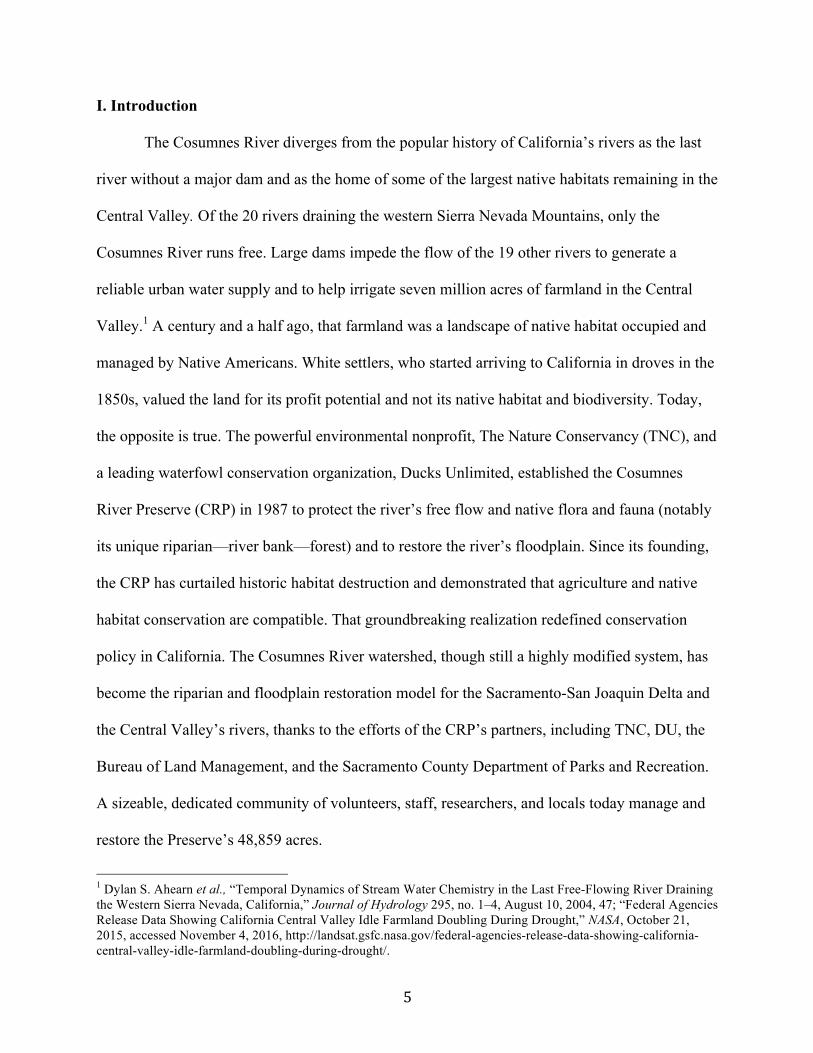
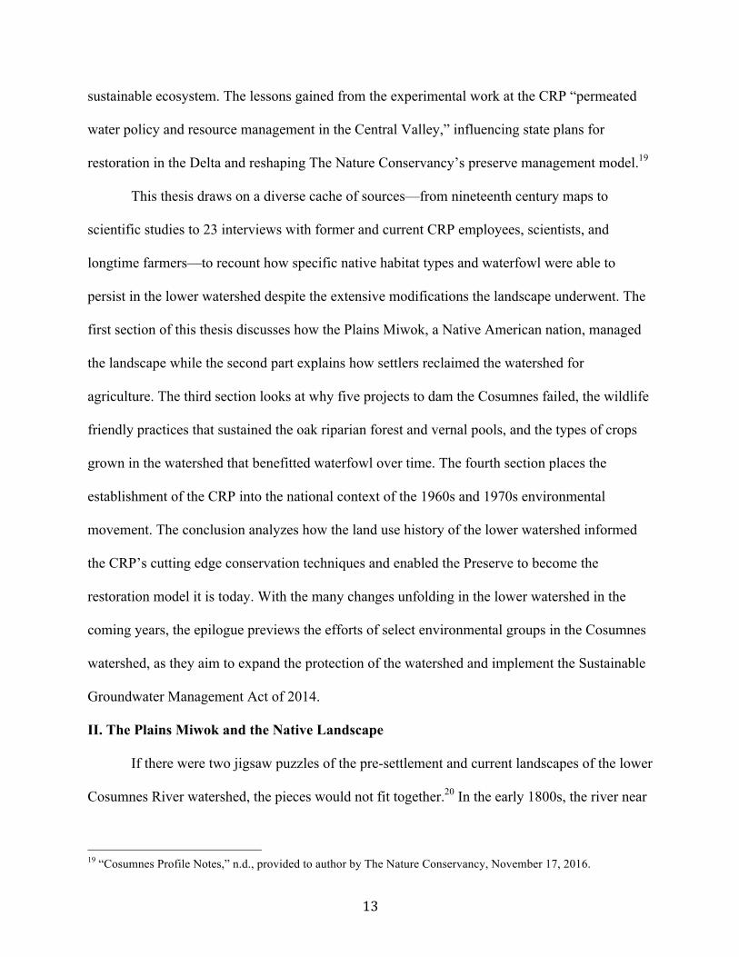
Figure one (the figures in the body of the thesis are labeled numerically and the figures in the ‘List of Figures’ are labeled alphabetically): This map shows the lower Cosumnes River watershed and delineates in black the properties that comprise the core of the Cosumnes River Preserve. The different colored properties are integral to recounting the story of unintentional native habitat preservation in the lower watershed and are mentioned frequently throughout the thesis. The blue denotes a river or stream, the most important being the Cosumnes River to the north (map created by Lina Aoyama, November 2016). landscapes and engineering its waterways.2 The Cosumnes River was not modified to the extent
that its larger northern and southern neighbors—the American River and Mokelumne River,
2 Stephanie Sabine Pincetl, Transforming California: A Political History of Land Use and Development (Baltimore:
Johns Hopkins University Press, 1999), 2.
7
respectively—were because it had less overall volume and low base flow in the summer. In
terms of volume and water storage potential, the Cosumnes is modest: the average annual flow is
357,082 acre-feet and the vast majority of the river’s water comes from rain rather than snow,
meaning that it has poor water storage potential compared to the state’s other rivers.3 The
Mokelumne River’s average annual flow is 741,000 acre-feet and the American River’s average
annual runoff is 2.7 million acre-feet, and both have two or more major dams.4 Like the other
rivers that flow directly into the Delta, the Cosumnes has three main forks—the North, Middle,
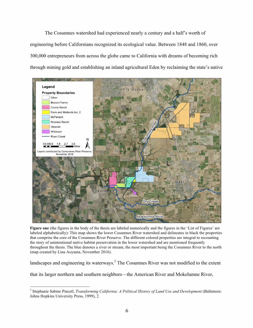
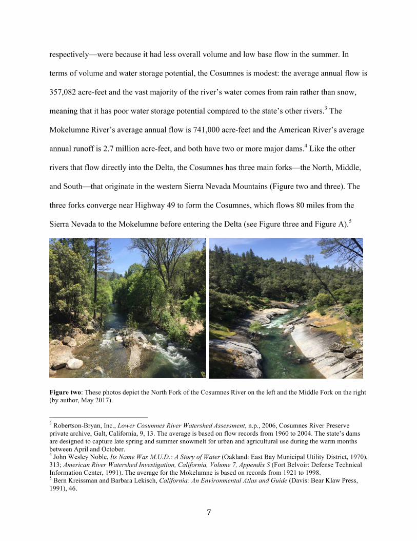
and South—that originate in the western Sierra Nevada Mountains (Figure two and three). The
three forks converge near Highway 49 to form the Cosumnes, which flows 80 miles from the
Sierra Nevada to the Mokelumne before entering the Delta (see Figure three and Figure A).5
Figure two: These photos depict the North Fork of the Cosumnes River on the left and the Middle Fork on the right (by author, May 2017).
3 Robertson-Bryan, Inc., Lower Cosumnes River Watershed Assessment, n.p., 2006, Cosumnes River Preserve
private archive, Galt, California, 9, 13. The average is based on flow records from 1960 to 2004. The state’s dams are designed to capture late spring and summer snowmelt for urban and agricultural use during the warm months between April and October.
4 John Wesley Noble, Its Name Was M.U.D.: A Story of Water (Oakland: East Bay Municipal Utility District, 1970), 313; American River Watershed Investigation, California, Volume 7, Appendix S (Fort Belvoir: Defense Technical Information Center, 1991). The average for the Mokelumne is based on records from 1921 to 1998. 5 Bern Kreissman and Barbara Lekisch, California: An Environmental Atlas and Guide (Davis: Bear Klaw Press, 1991), 46.
8
Figure three: This map shows the Cosumnes, Dry Creek and Mokelumne watersheds in relation to the city of Sacramento. Dry Creek is a tributary of the Cosumnes, and both are tributaries of the Mokelumne River. The image also features the three forks of the Cosumnes River (from Robertson-Bryan, Inc., Lower Cosumnes River Watershed Assessment, 4).
The Delta is the largest estuary on the west coast of the United States at 738,000 acres. It drains
the water that falls in the Central Valley, which accounts for roughly 45% of California’s surface
water flow.6 The Cosumnes River watershed contributes less than two percent of the water
flowing into the Delta, yet its unregulated flow has allowed some of the largest native riparian
plant communities remaining in the state to flourish. The riparian plants and habitats along the
Cosumnes include wetlands, grasslands, vernal pools, and the largest oak riparian forest
remaining in the state.7 Since 1850, people have diked and drained 90% of the estimated 922,000
6 Jay Lund et al., Envisioning Futures for the Sacramento-San Joaquin Delta (San Francisco: Public Policy Institute of California, 2007), 2, 12; Peter S. Alagona, After the Grizzly: Endangered Species and the Politics of Place in California (Berkeley: University of California Press, 2013), 198.
7 A vernal pool is a type of seasonal wetland that forms in a depression in the ground where an impervious soil layer prevents rainwater from draining into the subsoil.
9
to 1.6 million acres of historic riparian forests in California and about 90% of the original four
million acres of wetlands in the Central Valley.8 They also have built 1,400 dams in the state, the
largest of which are part of the Central Valley Project and the State Water Project (see Figure
B).9 Among the agriculture and dammed rivers in California, the free-flowing Cosumnes River
and its native habitats make the watershed unique and worth protecting.
The Cosumnes River is exceptional not only in the context of California’s water systems
but also the world’s watersheds, of which a third have lost more than 75% of their original forest
cover. According to environmental policy scholar Ken Conca, there may be as many as 800,000
dams on the world’s rivers and about half of them provide water primarily for irrigation. The
vast majority of the largest rivers in the world are dammed, and free-flowing large rivers remain
only in desolate areas, such as the tundra regions of North America and Russia and small basins
in Africa and Latin America.10 Though the Cosumnes River is not a large river, its unique
characteristics as a relatively unimpaired and natural system have implications for watershed
restoration in California and globally. Today countries worldwide contend with balancing the
ecological and human needs of freshwater systems, as these biodiverse ecosystems decline and
climate change threatens to worsen the situation. A historical case study of the Cosumnes River
offers unexpected insights into the complex problem of how to balance the human and
environmental demands of a watershed, with the equation equaling the use of wildlife friendly
and flood compatible agriculture as a conservation tool.
8 Philip Garone, The Fall and Rise of the Wetlands of California’s Great Central Valley (Berkeley: University of
California Press, 2011), 2; Anna Steding, “Restoring Riparian Forests and Natural Flood Regimes: The Cosumnes River Preserve” in Sustainable Use of Water: California Success Stories, ed. by Lisa Owens-Viani, Arlene K. Wong, and Peter H. Gleick (Oakland: Pacific Institute for Studies in Development, Environment, and Society, 1999), 229.
9 David Carle, Introduction to Water in California (Berkeley: University of California Press, 2004), 135. 10 Ken Conca, Governing Water: Contentious Transnational Politics and Global Institution Building (Cambridge: The MIT Press, 2005), 75-79.
10
Despite the Cosumnes River’s significance, the river has received little historical
scholarly attention, as most environmental scholars of California have focused on the human
destruction of the state’s natural landscapes and waterways.11 For example, historian Norris
Hundley researched the major water projects of California, notably the Central Valley Project;
historian Robert Kelley investigated hydraulic mining and engineering in the Sacramento Valley;
and sociologist Karen O’Neill analyzed the origins of flood control on the Sacramento River.12
Two scholars, Karen Louise Bennett and Philip Garone, laid the groundwork for rethinking
California’s environmental history, emphasizing the contingent factors in how dam project
failures and human land uses produced the opposite outcome of what they were designed for,
namely preserving floodwaters and sustaining native fauna. In “The River That Got Away,”
Bennett explored why the five water projects proposed for the Cosumnes between 1907 and 1968
failed and saved the river’s free flow, which was one of the landscape’s unique features that
inspired The Nature Conservancy to establish the CRP in 1987.13 In The Fall and Rise of the
Wetlands of California’s Great Central Valley, Garone looked at how rice, corn, wheat, and
other crop fields inadvertently became surrogate wetlands for migrating waterfowl in the Central
Valley after people destroyed most of the waterfowls’ ancestral feeding grounds.14 This thesis,
similar to Bennett’s and Garone’s approaches, focuses on the role of contingency in telling the
11 Most contemporary texts in California water literature disregard the river, either briefly mentioning its
“diminutive” size or skipping it altogether. See Tim Palmer, Field Guide to California Rivers, California Natural History Guides, no. 105 (Berkeley: University of California Press, 2012), 6; Jeffrey F. Mount, California Rivers and Streams: The Conflict between Fluvial Process and Land Use (Berkeley: University of California Press, 1995); William L. Kahrl, The California Water Atlas (Los Altos: The Governor’s Office of Planning and Research, 1979).
12 Norris Hundley, The Great Thirst: Californians and Water -a History, rev. ed. (Berkeley: University of California Press, 2001); Robert Lloyd Kelley, Battling the Inland Sea: Floods, Public Policy, and the Sacramento Valley (Berkeley: University of California Press, 1998); Karen M. O’Neill, Rivers by Design: State Power and the Origins of U.S. Flood Control (Durham: Duke University Press, 2006).
13 Karen Louise Bennett, “The River That Got Away: An Investigation into the Proposed Development Projects, the Players and the Political Climate That Helped Shape the Fate of the Cosumnes River” (Master’s Thesis, California State University, Sacramento, 1997). 14 Garone, The Fall and Rise, 2.
11
story of how farming practices and failed dam projects unintentionally preserved the largest oak
riparian forest remaining in the state, as well as waterfowl and other rare native habitat types.
The failed dam projects also enabled the Cosumnes to remain the only major river out of
20 draining the western Sierra Nevada to have unregulated flow, which allows its floodwaters to
shape the Cosumnes watershed’s floodplain. For that reason, this thesis borrows environmental
historian Mark Cioc’s “eco-biography” framework from The Rhine: An Eco-Biography, 1815-
2000 to recount how and why the lower Cosumnes River watershed “became a degraded
biological habitat” and to detail the ideologies that motivated farmers, ranchers, and
conservationists to modify the landscape in particular ways.15 Another historian, Richard White,
characterized rivers as organic machines that mold their surrounding landscape, stating, “Like us,
rivers work. They absorb and emit energy; they arrange the world.”16 A river’s work is done with
water—especially when there is lots of it. Human inhabitants in the lower watershed have
understood the power of the Cosumnes’ floodwaters and related to the river through the work it
demands of them, changing their land use practices to live with the river’s nearly annual
flooding.
Understanding the historical land uses that support agriculture, floodplain restoration, and
native flora and fauna is timely and necessary, as contemporary policymakers and scientists
debate how to best implement the government mandated restoration of the Sacramento-San
Joaquin Delta and the Central Valley’s rivers. In search of successful examples of riparian
restoration and land management models for those regions, researchers at UC Davis,
policymakers, and natural resource managers have looked to the Cosumnes River. The fact that
this seemingly insignificant river and its lower watershed are considered the exceptions rather
15 Mark Cioc, The Rhine: An Eco-Biography, 1815-2000 (Seattle: University of Washington Press, 2002), 4. 16 Richard White, The Organic Machine (New York: Hill and Wang, 1995), 3-4.
12
than the norms for California’s rivers raises two questions: Why were the Cosumnes River and
its native habitats spared the extreme modifications that the other rivers in the Central Valley
suffered over the past century and a half? Why did The Nature Conservancy and Ducks
Unlimited protect this unique landscape in 1987?
The failures to dam the river—on the part of a few water agencies, private companies,
and the Bureau of Reclamation as well as the predominance of wildlife friendly land uses along
the riparian corridor—unintentionally spared the lower Cosumnes River watershed from the
worst of the environmental engineering that the other rivers in the Central Valley suffered.
Spurred on by a statewide push to protect California’s disappearing native habitats, The Nature
Conservancy capitalized on the uniqueness of the Cosumnes River and, in partnership with
Ducks Unlimited, established the Cosumnes River Preserve in 1987.
The Preserve today is a 45,859-acre patchwork of agriculture, private property with
conservation easements, and native habitats, including vernal pools, grasslands, oak riparian
forest, blue oak woodlands, and managed wetlands.17 The Nature Conservancy and Ducks
Unlimited first established the CRP as a traditional preserve designed to protect 1,100 acres of
oak riparian forest.18 Yet, within the first few years of working in the area, the CRP’s
conservation biologists recognized the pivotal role that agriculture and flooding historically
played in the local ecosystem and swiftly incorporated them into their conservation efforts,
which were cutting edge in the mid-1990s. The Preserve’s conservation strategies and multi-
partner management model reimagined the traditional structure of a nature preserve from
separating native habitats from anthropogenic land use to integrating both to maintain a
17 Kleinschmidt Associates, “Cosumnes River Preserve Management Plan,” n.p., 2008, 2-12, accessed October 10,
2015, http://www.cosumnes.org/about-the-preserve/. 18 The Nature Conservancy, “California Nature Conservancy Dedicates Cosumnes River Preserve,” press release, May 30, 1987, provided to author by The Nature Conservancy, November 17, 2016.
13
sustainable ecosystem. The lessons gained from the experimental work at the CRP “permeated
water policy and resource management in the Central Valley,” influencing state plans for
restoration in the Delta and reshaping The Nature Conservancy’s preserve management model.19
This thesis draws on a diverse cache of sources—from nineteenth century maps to
scientific studies to 23 interviews with former and current CRP employees, scientists, and
longtime farmers—to recount how specific native habitat types and waterfowl were able to
persist in the lower watershed despite the extensive modifications the landscape underwent. The
first section of this thesis discusses how the Plains Miwok, a Native American nation, managed
the landscape while the second part explains how settlers reclaimed the watershed for
agriculture. The third section looks at why five projects to dam the Cosumnes failed, the wildlife
friendly practices that sustained the oak riparian forest and vernal pools, and the types of crops
grown in the watershed that benefitted waterfowl over time. The fourth section places the
establishment of the CRP into the national context of the 1960s and 1970s environmental
movement. The conclusion analyzes how the land use history of the lower watershed informed
the CRP’s cutting edge conservation techniques and enabled the Preserve to become the
restoration model it is today. With the many changes unfolding in the lower watershed in the
coming years, the epilogue previews the efforts of select environmental groups in the Cosumnes
watershed, as they aim to expand the protection of the watershed and implement the Sustainable
Groundwater Management Act of 2014.
II. The Plains Miwok and the Native Landscape
If there were two jigsaw puzzles of the pre-settlement and current landscapes of the lower
Cosumnes River watershed, the pieces would not fit together.20 In the early 1800s, the river near
19 “Cosumnes Profile Notes,” n.d., provided to author by The Nature Conservancy, November 17, 2016.
14
where it joined the Mokelumne River in the lower Cosumnes watershed was not confined to one
channel but rather branched into several channels, forming a marshland of dense tules and
willow thickets called the Cosumnes Sink. A sink is a landscape in which a river or stream
spreads into multiple distributary channels, often dominated by seasonal wetlands and willow
thickets.21 The sink flooded annually with the swampland typically remaining submerged for
several months out of the year. According to nineteenth century maps and written accounts,
“dense tules” and “wooded sloughs” dominated the swampland with willow thickets residing
mostly in the north and gradually transitioning into a tule marsh in the south.22 The vegetation
also included blackberry, wild rose, and wild grape, among other emergent vegetation, which are
plants with submerged roots and stems growing out of the water. During the summer, the
channels significantly lost flow, which created a string of lakes and ponds that became habitat
and feeding grounds for native animals. The southern portion of the sink, however, remained wet
due to its low elevation and tidal influence up through the Delta’s sloughs from the San
Francisco Bay. The marshland rapidly gave way to grassland on the outskirts of the sink.23
20 For a virtual demonstration of this, see http://web.stanford.edu/group/west/cgi-bin/projects/delta/map/ (accessed November 10, 2016). 21 AA Whipple et al., “Sacramento-San Joaquin Delta Historical Ecology Investigation: Exploring Pattern and Process,” prepared for the California Department of Fish and Game and Ecosystem Restoration Program, a report of SFEI-ASC’s Historical Ecology Program, publication #672, San Francisco-Estuary Institute-Aquatic Science Center, Richmond, CA, 2012, 298-9, 206.
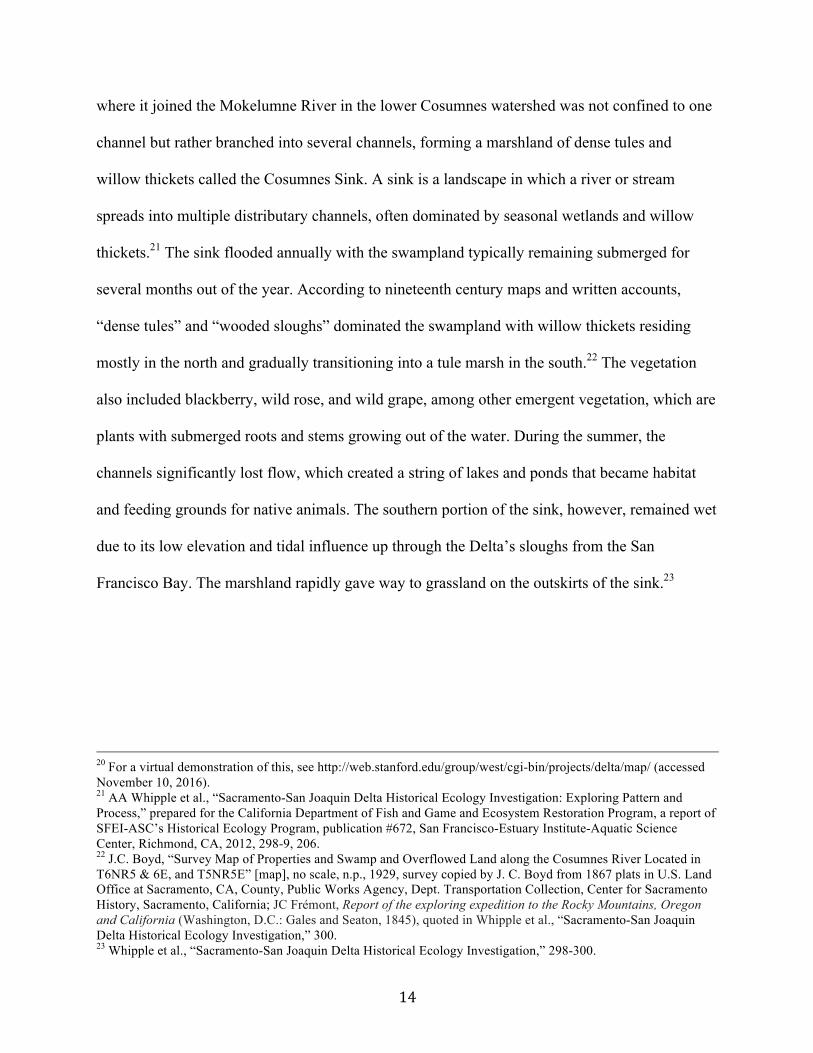
22 J.C. Boyd, “Survey Map of Properties and Swamp and Overflowed Land along the Cosumnes River Located in T6NR5 & 6E, and T5NR5E” [map], no scale, n.p., 1929, survey copied by J. C. Boyd from 1867 plats in U.S. Land Office at Sacramento, CA, County, Public Works Agency, Dept. Transportation Collection, Center for Sacramento History, Sacramento, California; JC Frémont, Report of the exploring expedition to the Rocky Mountains, Oregon and California (Washington, D.C.: Gales and Seaton, 1845), quoted in Whipple et al., “Sacramento-San Joaquin Delta Historical Ecology Investigation,” 300. 23 Whipple et al., “Sacramento-San Joaquin Delta Historical Ecology Investigation,” 298-300.
15
Figure four: This 1859 land case map shows the Cosumnes River branching out into multiple channels near the site of the “Old Indian Rancheria” and forming the Cosumnes Sink (from Whipple et al., “Sacramento-San Joaquin Delta Historical Ecology Investigation,” 299). Contrary to the romantic colonial notion of a pristine and untouched California
landscape, people had resided in and managed the land for thousands of years. Over that time
period, some of the flora and fauna in the Cosumnes Sink evolved to depend on the Plains
Miwok. Deer and tule elk grazed the landscape, naturally maintaining the grasslands and forest
understory. The Plains Miwok also sculpted the landscape to their benefit through annual
controlled burning, which they employed to hunt and to stimulate the growth of certain
vegetation.24 Controlled burning favored the growth of certain plants species, including
24 Michelle L. Stevens and Emilie Zaloza, “Fire, Floodplains and Fish: the Historic Ecology of the Lower Cosumnes
River Watershed,” in Rivers, Fish and the People. Tradition, Science and Historical Ecology of River Fisheries in the American West, ed. by Pei Lin Yu (Salt Lake City: University of Utah Press, 2015), 163-4; Kat Anderson, Tending the Wild: Native American Knowledge and the Management of California’s Natural Resources (Berkeley: University of California Press, 2005), 150-1, 207.
16
milkweed and Indian hemp, which the Miwok harvested for basketry, fishing materials and the
construction of reed boats and houses. Annual burning also enhanced the floodplain for native
fish species, such as the Sacramento splittail and the extinct thicktail chub, by creating favorable
habitat for fish eggs and larvae and by mobilizing nutrients that nourished algae and zooplankton
and thus fed fish.25 The Miwok also managed the landscape through other practices, including
the sowing of seeds, pruning, and weeding.26
The Plains Miwok benefited from the large number of fish, particularly salmon, sturgeon,
and lamprey eels, which formed an integral part of their diet. Millions of migrating waterfowl
and shorebirds also dined off the fish in the Central Valley during their annual winter migration
from South and Central America to the wetlands of northern Alaska and western Canada.27
Ethnobotanists Michelle L. Stevens and Emilie Zaloza described the Miwok relationship with the
ecosystem as “kincentric,” meaning that they “’view themselves as part of an extended
ecological family that shares ancestry.’” This environmental attitude resulted in land-
management techniques that sustained a beneficial environment for the Plains Miwok and
“helped optimize conditions for California native fish species” as well as floral and faunal
species that contributed to Miwok subsistence and material culture.28
The Miwoks near disappearance from the watershed in the second quarter of the
nineteenth century marked a major land use shift in the lower watershed. The early to mid-1800s
witnessed the forced removal and missionization of Plains Miwok and a malaria epidemic from
1830-33 that killed most of the Plains Miwok population. Simultaneously, new human actors—
Spanish explorers, Mexican settlers (Californios), foreign trappers, and white and international
25 Stevens and Zaloza, “Fire, Floodplains and Fish,” 167. 26 For a more in-depth description of the Plains Miwok material culture, see S.A. Barrett and E.W. Gifford, Miwok Material Culture: Indian Life of the Yosemite Region, (Yosemite National Park: Yosemite Association, 1997). 27 Garone, The Fall and Rise, 1. 28 Stevens and Zaloza, “Fire, Floodplains and Fish,” 165-167, 180.
17
settlers—arrived on the scene with distinct ideas of how to manage the landscape. The
introduction of livestock and invasive species, in addition to new human occupants of the land,
“stifled efforts of permanent resettlement by Indians who wished to return to their traditional
territory after the plague [malaria epidemic] had subsided.” These factors contributed to the
severe population decrease of Plains Miwok in the region in the mid-1800s.29
The Plains Miwok, like all indigenous groups in the United States and California,
experienced mass violence, murder, imprisonment, and widespread displacement at the hands of
settlers. Though an analysis of the atrocities carried out against Native Americans is beyond the
scope of this thesis, it must be noted that nearly all of the approximately 310,000 indigenous
people living in California in 1769 were dead nearly a century later with less than 10% of the
population alive in 1876. Historian Benjamin Madley in An American Genocide explained,
During the era when Spaniards, Russians, and Mexicans colonized the coastal region
between San Diego and Fort Ross, California’s Indian population fell from perhaps
310,000 to 150,000 … Under US rule, California Indians died at an even more
astonishing rate. Between 1846 and 1870, California’s Native American population
plunged from perhaps 150,000 to 30,000. By 1880, census takers recorded just 16,277
California Indians. Diseases, dislocation, and starvation were important causes of these
many deaths. However, abduction, de jure, and de facto unfree labor, mass death in
forced confinement on reservations, homicides, battles and massacres also took thousands
of lives and hindered reproduction.30
29 Regina R. Siciliano-Kutchins, “Historical Land Use: A Study of the Early Human Occupation of the North Delta Region of Sacramento County” (Master’s Thesis, California State University, Sacramento, 1980), n.p., 76. 30 Benjamin Madley, An American Genocide: The United States and the California Indian Catastrophe, 1846-1873 (New Haven: Yale University Press, 2016), 3. See this book for a detailed account of the state-sponsored violence against the Native Americans of California and indigenous resistance between 1846 and 1873.
18
Madley called the widespread, state-sponsored violence against Native Americans genocide. The
Plains Miwok were victims of missionization, murder, disease, forced labor, displacement, and
other atrocities. The eradication of indigenous people meant the widespread loss of landscape
stewards, which, along with the settlement of immigrants to California, had drastic impacts on
California’s native flora and fauna and radically transformed the state’s landscape.
III. “The Herculean Task”: Reclamation and the Advent of Agriculture
Maps spanning the years 1859 to 1903 visually depict the evolution of the lower
Cosumnes River watershed from a tule-dominated marshland to a “reclaimed” landscape.31 All
of the maps show the name of the first private landholding in the lower watershed—Rancho San
Jon de los Moquelumnes. The rancho became the pie from which the settlers cut out their
homesteads and ranches in the mid-1860s. In addition, despondent miners and aspiring white
farmers acquired land and township grants to permanently settle in the lower watershed and,
along with hired laborers, executed the arduous tasks of parceling up the newly acquired lands
and of draining the Cosumnes Sink to make room for crops and cattle. The draining of the Delta
generally, along with the deepening and straightening of the Sacramento River, also helped to
drain the Cosumnes Sink. Despite being channeled and leveed, the Cosumnes’ floodwaters
survived the major landscape transformations and haunted farmers for decades to come.
31 Whipple et al., “Sacramento-San Joaquin Delta Historical Ecology Investigation,” 299; G.H. Thompson, “Plat of the Rancho San Juan de los Moquelumnes Finally Confirmed to the Heirs of Anastasio Chabolla” [map], 80 chs: 1 inch, U.S. Surveyor General, 1862, 1980/096/005, Center for Sacramento History, Sacramento, California; Thos S. Stephens, “Map of Ranch San Jon de los Mokelumnes showing the lands awarded to all parties interested in Ranch San Jon de los Mokelumnes according to the decree surveyed and compiled by order of the referees by Thos S. Stephens” [map], no scale, n.p., ca. 1900, Sacramento County Recorder’s Office Collection, Center for Sacramento History, Sacramento, California; H.J. Furley, “Official Map of Sacramento County,” [map], 60 chains: 1 inch, Sacramento County Surveyor Office, 1903, provided to author by the Sacramento County Surveyor Office, June 2016.
19
The first recorded white settler in the lower watershed was a Tennessean named William
Hicks who came to California with the Walker-Chiles Party in 1843.32 After working for the
famous pioneer John Sutter for a few years, Hicks acquired land, which included today’s
Valensin Ranch, in 1847 from his former employer and started running cattle on it. A few years
later, Hicks established a small town called Hicksville on the ranch and, although it only had a
population of 90, the town became the largest settlement between Sacramento and Stockton for a
short time in the mid-1800s.33 Hicksville boomed and busted with the Gold Rush, as did other
towns in the Central Valley, but their transient presence forever altered the landscape.
Between 1848 and 1860, thousands of gold seekers passed through the lower Cosumnes
River region. Towns sprouted up beginning in the 1850s to supply miners with provisions and
services. The town closest to the lower Cosumnes River, Mokelumne City, was founded in 1856
near the confluence of the Cosumnes and Mokelumne (see Figure one). Overnight the town
became a “lumber and shipyard nucleus” and catered to travelers passing through the Delta on
their way to the mines. A massive flood in 1862 obliterated the town and transformed the Central
Valley into a temporary inland sea, washing away whole communities in the process.34 As
mining proved a dying industry in the 1860s, the towns changed character and economic focus,
incentivizing the restructuring of settlement patterns and land exploitation in the Central Valley.
At the same time, thousands of miners abandoned their gilded dreams in the mountains
and streambeds to pursue a new future in the grasslands and swamplands of the Central Valley.
Most of the original settlers in the lower Cosumnes River watershed were former miners and
32 Elizabeth Pinkerton, “Where in the world was Hicksville? Part 2,” Elk Grove Citizen, June 21, 1995. 33 Historic FarmHouse Foundation, “Hicksville Restoration Project,” n.p., 1998, Cosumnes River Preserve private archive, Galt, California, B-1. 34 Thompson, Settlement Geography, 417; Lynn Ingram and Frances Malamud-Roam, The West Without Water: What Past Floods, Droughts, and Other Climatic Clues Tell Us About Tomorrow (Berkeley: University of California Press, 2013), 31.
20
transplanted farmers seeking a lucrative future in the enterprise that they knew best—agriculture.
As historian David Vaught wrote, “The first generation of California farmers, it must be
remembered, had not intended to farm at all, but having failed in the mines, they became
desperate to succeed on the land. In their haste to adapt to their new surroundings, they
committed themselves not only to the market but to community life as well—and with a resolve
and a sense of permanence that can only be described as remarkable.”35 The settlers’
determination to establish permanent community started with acquiring private properties and
township grants from the federal government.
There were at least 31 people who originally settled the lower watershed and purchased
parcels of the 35,508-acre Rancho San Jon de los Moquelumnes in the late 1860s from the
family of Anastasio Chabolla, the deceased Californio owner who had obtained the rancho from
a land grant issued by the Mexican governor José Manuel Micheltorena in 1844.36 The new
owners divided the property into parcels of various acreages and promptly got to work
reclaiming the land for agricultural production and pastureland. When the estimated 31 settlers
acquired the parcels, the lower watershed was still a “swamp and overflowed land” with
“timbered” sloughs and “tules,” according to an 1864 Plat of the Rancho Sanjon de los
Moquelumnes (see Figure C).37 Nevertheless, the new property owners had the economic
incentive and grit to transform the landscape from a “wasteland” to an agricultural Eden and
establish communities that were integral to the state’s trade network.38
35 David Vaught, After the Gold Rush: Tarnished Dreams in the Sacramento Valley (Baltimore: Johns Hopkins
University Press, 2007), 220. 36 Siciliano-Kutchins, “Historical Land Use,” 14; G.H. Thompson, “Plat of the Rancho San Juan de los Moquelumnes.” As a result of the rancho’s ill-defined boundaries and the legal shifts in governance when California became a state in 1850, the rancho became the focus of a legal land ownership debate. Due to the ensuing court case, Chabolla’s heirs did not receive a patent of ownership to the rancho until 1865. 37 Ibid.; G.H. Thompson, “Plat of the Rancho San Juan de los Moquelumnes.” I counted 31 distinct names on Stephens’ map, although the map is such poor quality that the exact number is difficult to discern. 38 Kelley, Battling the Inland Sea, 41.
21
The two largest land buyers of the rancho sales were John McFarland and Obed Harvey,
who pioneered the transformation of the lower watershed.39 As the largest landowner, Harvey
had a vested interest in the prosperity of the region and founded the town of Galt in 1869, which
competed with Liberty, a pioneer town located a few miles south.40 The Dry Creek Township
(which included Galt) and the lower watershed were part of the Sacramento Valley’s wheat
boom, which spread through the region around the late 1860s.41 Harvey made sure that Galt
became a market center for his wheat and the produce of other growers in the lower watershed
by persuading the Western Pacific Railroad Company in 1869 to construct a train line between
Galt and Sacramento. The line connected Galt with the national economy and the state‘s network
of crop and human transportation. According to Galt historian Eugenia Olson, the railroad’s
presence in Galt forced the town of Liberty to relocate to Galt in 1870.42 The construction of the
railroad in Galt facilitated the rise of wheat as a dominant land use in the lower watershed
although the exact acreage is unquantifiable. Hops, corn, and alfalfa fields, small vineyards, and
fruit orchards were also present in the lower watershed but to a lesser degree than cattle, wheat
and grain.43 Fortuitously, grazing would end up benefitting the native habitats that survived
reclamation while the corn, wheat, and alfalfa would nourish waterfowl in the lower watershed
and the rest of the Central Valley.
39 Stephens, “Map of Ranch San Jon de los Mokelumnes.” I added up the acreages of different parcels belonging to the various landowners and came up with these two owning the most land. 40 Thomas Hinckley Thompson and Albert Augustus West, History of Sacramento County, California: With Illustrations Descriptive of Its Scenery, Residences, Public Buildings, Fine Blocks, and Manufactories from Original Sketches by Artists of the Highest Ability (Oakland: Thompson & West, 1880), 327. 41 Vaught, “After the Gold Rush,” 150.
42 Eugenia Olson, interview with Eugenia Olson, interview by Michelaina Johnson, July 7, 2016. Historian Eugenia Olson told me that her conclusion that Harvey sold or traded land with the Western Pacific railroad to persuade them to run through Galt was speculative. Though speculative, her argument makes sense, considering that Liberty would have been the logical choice through which to build the railway since it was older and more established than Galt. 43 Thompson and West, History of Sacramento County, 12; “Bios of historical Galt people,” n.p., n.d., provided to author by the Galt Area Historical Society, July, 2016.
22
Though the white settlers received recognition for masterminding the development and
reclamation of California, it was not their hands that transformed the landscape. Chinese
immigrants and Native Americans were the earliest farm workers in the lower watershed. In an
ironic twist of fate, the Plains Miwok, whose ancestral lands the Californios and white people
usurped, were forced to work as hired hands on ranches in the lower watershed due to the high
demand for labor in the state’s developing agricultural economy. For instance, in the latter
nineteenth century, John McFarland, a large landowner in the lower Cosumnes, hired Miwok
Indians to live on his property and cultivate his wheat fields.44 The presence of Miwoks in the
Cosumnes area after 1850 is not a reconciliatory story but rather a tragic reminder that the Native
Americans of California who did not die prior to the 1850s were subjected to the forces of an
unwelcoming and disempowering society for minority groups. Moreover, reclamation companies
and landowners recruited Chinese immigrant laborers primarily from Chinatown boarding
houses in Sacramento, Stockton, and San Francisco “to farm [and] to carry out the difficult work
of reclamation for white landowners.”45 Chinese laborers were brought to the lower watershed to
build “’wheel barrow levees’” as part of a larger effort to drain the lands aligning the Cosumnes
River though the years of their labor are unknown.46 Chinese and Native American workers were
underpaid for their physically exhausting labor, which entailed using only a shovel and a
wheelbarrow to dam sloughs, cut drainage ditches, build floodgates, and pile up levees.47
44 Albert L. Hurtado, Indian Survival on the California Frontier (New Haven: Yale University Press, 1988), 211,
217. 45 Philip Garone, “Managing the Garden: Agriculture, Reclamation and Restoration in the Sacramento-San Joaquin
Delta,” Delta Narratives Project, Delta Protection Commission, 2015, 26, accessed September 23, 2015, http://www.delta.ca.gov/Delta_Narratives.htm. 46 Siciliano-Kutchins, “Historical Land Use,” 28.
47 George Chu, “Chinatowns in the Delta: The Chinese in the Sacramento-San Joaquin Delta, 1870–1960,” California Historical Society Quarterly 49, no. 1 (1970): 24. For more of a discussion on Chinese labor in California, see Sucheng Chan, This Bittersweet Soil: The Chinese in California Agriculture, 1860-1910 (Berkeley: University of California Press, 1986).
23
Heterogeneous hands crafted a homogenous landscape. Before reclamation, the
Cosumnes Sink was a diverse landscape with “a plexus of diverging and converging channels,”
lakes, sloughs, emergent vegetation, and dense thickets of willows and tules surrounded by
grasslands.48 Beginning in the 1860s, the first reclamation projects were initiated in the lower
watershed, demonstrating the massive labor required to undo the river’s work. Despite the
minimal scholarly information available on reclamation along the Cosumnes, it is clear that the
region did not endure the same widespread reclamation and habitat loss as the rest of the Delta
even though part of the lower watershed resides in the Delta’s boundaries. Geographer John
Thompson in his 1957 dissertation, The Settlement Geography of the Sacramento-San Joaquin
Delta, documented the only recorded reclamation project in the lower watershed, stating,
In 1865 a drainage ditch was dug across the area from the Mokelumne to Beaver Slough
so that the congestion caused by converging Mokelumne and Cosumnes flows could be
alleviated. Levees and higher alluvial land were protected by the ditch at the same time
that it drew water through the lower part of the basin. It was expected the alleviation
would facilitate eventual reclamation of the lower land.
The converging flows of the Mokelumne and Cosumnes Rivers formed the Cosumnes Sink. The
drainage ditch, in addition to levees constructed along the Mokelumne north bank and the
adjacent Cosumnes bank, undoubtedly facilitated the draining of the sink.49
The State of California set up the State Board of Swamp Land Commissioners, also
known as the Swamp Land Commission, in 1861 to coordinate reclamation efforts and to
sponsor flood control projects, particularly on the 2,193,965 acres of swampland granted to
California by the federal Swamp and Overflowed Lands Act of 1850. The Commission had
48 Whipple et al., “Sacramento-San Joaquin Delta Historical Ecology Investigation,” 199-200. 49 Thompson, The Settlement Geography, 215-16.
24
formed 55 reclamation districts by 1865, one of which executed the construction of the drainage
ditch as part of an effort to levee and drain 24,500 acres in the lower Cosumnes and Mokelumne
River watersheds.50 The state legislature dissolved the Commission in 1866 and any hopes of
further state-sponsored reclamation in the lower watershed dissolved along with it.51 According
to environmental historian Philip Garone, the dissolution of the Commission exposed a statewide
debate over which actors—quasi-regional entities, the state or federal government, or private
local enterprises—bore the responsibility of paying for the high cost of reclamation. With respect
to the Cosumnes Sink, private local enterprise won out.
While reclamation efforts in the Delta accelerated due to improved dredging equipment
and technology beginning in the 1870s, the occupants of the lower watershed were relegated to
cumbersome, manual reclamation methods. Chinese workers, among others, built levees and
drainage ditches, dammed sloughs, and burned tules and peat soil—a carbon rich top soil layer
composed of partially decayed vegetation or organic matter—to clear the land surface for
cultivation.52 The difference in reclamation methods for the Delta and the lower Cosumnes was
in part due to the regions’ varying physical landscapes. The Delta encompassed more tidal
islands with deep peat soils that facilitated reclamation using dredges while the Cosumnes had
stronger winter floods, among other factors, that limited the effectiveness of dredging.53 The
amount of acreage reclaimed in the Cosumnes River watershed is unquantifiable. However, a
total of 441,000 acres were reclaimed between 1860 and 1930 in the Delta.54 According to
anthropologist Regina Siciliano-Kutchins, “By the late 1870s the agricultural character of the
50 Garone, “Managing the Garden,” 18-20; Thompson, The Settlement Geography, 215-16. The federal swamplands granted to the state included nearly 500,000 acres within the Delta, which do not appear to encompass any of the lower watershed. 51 Garone, The Rise and Fall, 63. 52 Garone, “Managing the Garden,” 26-28. 53 Alison Whipple, email message to Michelaina Johnson, March 26, 2017. 54 Garone, The Rise and Fall, 63.
25
land [lower Cosumnes River watershed] which exists today [in 1980] was virtually complete and
few Indians were in residence.”55
Reclamation and engineering projects in the Delta also had monumental impacts on the
draining of the lower watershed, especially one specific engineering feat on the Sacramento
River that may have excavated as much soil as was removed in the building of the Panama
Canal. The California Debris Commission (CDC) in the early 1900s obtained state and federal
funds to dig “a wide curving channel from above Rio Vista to Collinsville.” The project, called
the Rio Vista cut, was a mammoth undertaking that deepened and straightened the channel of the
Sacramento River, enabling water to exit the Delta more rapidly and lowering water elevations
throughout the entire Delta, including the lower Cosumnes River. The Rio Vista cut
inadvertently helped to drain the Cosumnes Sink and create favorable conditions for farming as
well as riparian forest growth.56 While the reclamation efforts of people living in the lower
Cosumnes watershed are notable, the drying of the Cosumnes sink was largely the result of
activities that took place elsewhere due to the interconnectivity of the lower Cosumnes with the
Delta and other river systems, including the Sacramento and Mokelumne Rivers. The
reclamation efforts and transportation infrastructure developments in the lower watershed and
throughout the Central Valley created a self-reinforcing cycle in which reclaimed land produced
abundant crop yields that were shipped via boat or train to the market. As the agricultural
economy grew, more farmers purchased land in the lower Cosumnes River watershed and
increased the area’s population, further facilitating the economic growth and the conversion of
natural habitat.
55 Siciliano-Kutchins, “Historical Land Use,” n.p. 56 Kelley, Battling the Inland Sea, 279-281.
26
In less than four decades between 1860 and 1900, the Cosumnes Sink disappeared from
the landscape, leaving behind remnant native habitats and a river that refused to stay confined to
its channels. Two Sacramento County historians, Thomas Hinckley Thompson and Albert
Augustus West, in 1880 wrote about how settlers perceived the work of a river as a destructive
force that required subduing, stating that floods regularly ravaged the landscape in “torrential
streams … rush[ing] annually an immense volume of water on its way to the ocean … carrying
death and destruction along its course.”57 The flood of 1862 spectacularly reinforced that
sentiment. That flood was the largest in recorded history in California, forming “a great sheet of
brown, rippling water [that] extended from the Coast Range to the Sierra Nevada,” that washed
away entire communities, including Mokelumne City, and that drowned one-quarter of the
state’s estimated 800,000 cattle.58 Thompson and West recognized the “herculean task” of
subduing the water systems to man’s will and envisioned a time not too far away:
When immense reservoirs will be constructed, either by the government or the state, for
the impounding of the flood water from the rain and melting snow and its distribution
during the long, dry summer over the thirsty land, doubling and trebling the crops and
bringing greater prosperity to the valley. Then too will the rivers, instead of bringing
down destructive torrents upon the valley, remain within their banks.59
The authors aptly predicted the future of the Central Valley’s rivers, as the federal and state
government, individual farmers, and industry tirelessly engineered the state’s geography to make
the land and its water systems productive. Decades of small-scale engineering feats and public
demand for more water instigated basin size water projects that led to the nearly complete
straightjacketing of the Central Valley’s rivers in dredged channels and levees with engineered
57 Thompson and West, History of Sacramento County, 12. 58 Ingram and Malamud-Roam, The West Without Water, 31. 59 Thompson and West, History of Sacramento County, 13.
27
flood bypasses. In 1915, for instance, a former gold dredge company named Natomo
Consolidated finished a massive project that enclosed the entire 80,000-acre American River
basin with levees and berms, which are artificial embankments.60 With the flood control and
reclamation of the Valley’s watersheds came not only the extreme loss of native habitats but also
the loss of free flowing rivers.
IV. Dammed if You Do, Dammed if You Don’t
The Cosumnes River today is the last free flowing river draining the western Sierra
Nevada Mountains because every proposal to build a major dam on the river failed. Between
1907 and 1968, five water projects proposed more than 30 dams for the Cosumnes. If any one of
those five feats had been executed, the native riparian habitats, particularly the oak riparian
forest, either would have been destroyed or reduced to smaller sized remnants. Before the first
quarter century of the 1900s, the Cosumnes River was not unique but rather was just another
small river in the Central Valley with formidable flood potential. The uniqueness of the
Cosumnes River watershed is the unexpected consequence of a series of government agency
mishaps and financial fiascos that ruined any prospective projects for the river. The low
elevation of the Cosumnes watershed at a peak of 7,500 feet and its small size made the dam
projects have an inherently limited cost-benefit rational since most big dams are managed
conjunctively with a large snowpack.61 Proposed projects for other rivers in the Central Valley
also failed, but no other river flowing west out of the Sierra Nevada was able to evade the
hydraulic development wave that hit California in the 1930s. Environmental policy scholar
Karen Louise Bennett’s 1997 master thesis, The River That Got Away, heavily informs this
section by discussing why the five historic projects for the Cosumnes River failed.
60 Kelley, Battling the Inland Sea, 298-99. 61 Robertson-Bryan, Inc., Lower Cosumnes River Watershed Assessment, 3.
28
The first proposed project for the development of the Cosumnes River competed with the
controversial Hetch Hetchy reservoir project. In 1907, the Department of the Interior granted San
Francisco legal access to develop the Toulumne River in the Hetch Hetchy Valley as a municipal
water supply. The city, however, was met with a major national backlash from wilderness
advocates, led by environmental activist John Muir in 1908, who did not want to see “one of
Nature’s rarest and most precious mountain temples” submerged beneath a reservoir.62 Two
companies, the Bay Cities Water Company and the Sierra Blue Lakes Water and Power
Company, proposed two competing projects to Hetch Hetchy, both of which “targeted the
Cosumnes River as a source of water from about 1900 to 1915.” The Bay Cities’ proposal, called
the American-Cosumnes Project, was the main competitor of the Toulumne River project and
called for the construction of 18 reservoirs on the north fork of the Cosumnes River to supply
104,900 million gallons of water to the city. This project was highly appealing to San Francisco
because it was cheaper and would have provided more acre-feet of water than the Tuolumne
Project.63 The Cosumnes did not have a John Muir to fight for its free flow but rather survived
because of a series of scandals that discredited the Bay Cities Water Company a few years before
President Woodrow Wilson approved the construction of O’Shaughnessy Dam on the Toulumne
River in December 1913.64 Considering the legacy of Hetch Hetchy and the importance of the
Cosumnes River today, Bennett asked, “Did we, as a society, in a sense “trade” (unknowingly)
the preservation of the Hetch Hetchy Valley for the Cosumnes River Preserve?”65
62 Hundley, The Great Thirst, 179-183; John Muir, “Dam Hetch Hetchy!”, accessed November 18, 2016, http://historymatters.gmu.edu/d/5720/. 63 Bennett, “The River That Got Away,” 8, 17-18. 64 Hundley, The Great Thirst, 178-184. The Toulumne River was added to the Wild and Scenic Rivers Act on September 28, 1984. See http://www.tuolumne-river.com/conservation.htm for more information (accessed November 18, 2016). 65 Bennett, “The River That Got Away,” 33.
29
O’Shaughnessy Dam exemplified a larger state trend of the early twentieth century. As
the state’s population increased, town and city water districts started developing regional water
and energy projects in various watersheds in the Central Valley to meet the needs of a growing
population and to control floodwaters. For instance, the East Bay Municipal Utility District
constructed Pardee Dam on the Mokelumne River in 1929 to supply water to people living in the
eastern San Francisco Bay Area. The Sacramento Flood Control Project was another regional
undertaking that was nearly completed by 1944. The project covered 101,000 acres and
controlled the Sacramento River with 980 miles of levees, five low water check dams, and 438
miles of channels and canals.66 Between 1927 and 1940, three entities proposed distinct dam and
reservoir projects for the Cosumnes River as a means to provide flood control, a reliable water
supply, and improved irrigation. El Dorado County Irrigation District in June 1927 looked into
building two dams and reservoirs on the Cosumnes River at Bucks Bar and Pleasant Valley but
for unknown reasons abandoned the project. Less than a decade later, the Sacramento District
U.S. Corp of Engineers investigated flooding in the Mokelumne watershed, which includes the
Cosumnes River and a tributary of the Cosumnes called Dry Creek, and recommended
constructing reservoirs on the Cosumnes. According to Bennett, the Corp of Engineers in 1937
“concluded that flood control along the Cosumnes by means of impounding reservoirs was not
justified at the time,” and instead the Corp recommended using the existing reservoirs on the
Mokelumne to mitigate flooding on the Cosumnes.67 Though the reason not to construct a dam
was vague, the Corp’s decision illustrates the insignificance of the river in the eyes of engineers,
which helped to spare its free flow.
66 Kelley, Battling the Inland Sea, 109. 67 Bennett, “The River That Got Away,” 42, 44-46.
30
The river was still large enough, however, to prompt two more agencies to consider
harnessing the river’s potential. An industrial engineer from Amador County named Earl E.
Storrs proposed in a report in 1942 that the county erect three dams and reservoirs on the
Cosumnes River—Bridgeport dam with a 50,000 acre-foot reservoir, the Russian Diggings dam
with a 38,000 acre-foot reservoir, and Capps Crossing with a 15,000 acre-foot reservoir—for
generating a reliable irrigation and municipal water supply. Storrs urged Amador County to
obtain county of origin water rights to the river as soon as possible out of fear that the federal
BOR would develop the river for the Central Valley Project first. The county’s proposal
ultimately failed because Amador neglected to secure their county of origin water rights “in a
timely manner.”68
The Central Valley Project (CVP) was the first federally sponsored project that connected
developments on multiple watersheds and formed a complex web of plumbing that sent water
from the northern to the southern Central Valley. The passage of the CVP in 1933 by
Californians represented a huge victory for them “after almost two decades of pleading” for
federal funding to construct costly water projects.69 The project entailed the construction of some
of the largest dams and reservoirs in the state, including the 602-foot Shasta Dam and 4,552,000
acre-foot Shasta Reservoir on the Sacramento River and the 340-foot Folsom Dam and
1,120,200 acre-foot Folsom Reservoir on the American River.70 These major hydraulic
developments, in addition to the CVP’s failed water project proposals, highlight the
pervasiveness of federal and state dam construction and of public disregard of the intrinsic value
of free flowing rivers in the twentieth century.
68 Ibid., 50. It is unclear whether the BOR obtained the water rights before Amador County or not. 69 Hundley, The Great Thirst, 250-1; Kelley, Battling the Inland Sea, 308. 70 Hundley, The Great Thirst, 252-253.
31
The BOR, the federal agency in charge of the CVP’s implementation, began to
investigate how to develop and incorporate the Cosumnes River into the CVP. The agency
named their proposal the Cosumnes River Project.71 In September 1964, the National Park
Service submitted their Project Report on the Recreation Potentialities of the Cosumnes River
Division Central Valley Project to the BOR providing data on six dams and reservoirs for the
Cosumnes River, the largest being a 900,000 acre-foot reservoir on the Cosumnes’ main stem.
This project was the most expensive one proposed for the Cosumnes River at $180 million and
provided “for the complete control of the water resources in the basin.”72 According to A Report
on the Feasibility of Water Supply Development, issued by the BOR in 1967, the Cosumnes
River Project would provide irrigation water for 34,749 acres of “productive lands” and an
estimated 25,000 acre-feet of water for municipal and industrial use as well as flood control,
recreation, fish and wildlife enhancement, power generation, and water quality control in the
Cosumnes watershed and the Delta.73 The reasoning behind this massive project was to “create
new economic opportunities and realize the area’s ultimate potential,” which included providing
water and electricity for the 16,000 people that lived in the basin in 1965 and for the 84,000
people that were projected to move to the region by 2020.74
The Cosumnes River basin in the 1960s was predominantly agricultural. Even though the
Cosumnes River Project was designed to benefit farmers, some were opposed to it because they
feared that it would cause them to lose their land, water rights, and access to crossing the river.75
71 Bennett, “The River That Got Away,” 55. 72 U.S. Department of the Interior, “Cosumnes River Division Central Valley Project Water Quality Control Study,” San Francisco: Federal Water Control Administration, 1967, Cosumnes River Preserve private archive, Galt, California.
73 U.S. Department of the Interior, Cosumnes River Division, Central Valley Project, California: A Report on the Feasibility of Water Supply Development, Sacramento: The Region, 1968, Special Collections, Water Resources Archive and Collections, University of California, Riverside. 74 Ibid., 3, 5. The largest town in the lower watershed region, Galt, had a population of only 2,000. 75 Bennett, “The River That Got Away,” 61.
32
Farmers and the counties in the Cosumnes watershed were also afraid that they would lose land
and tax revenue to the BOR’s wildlife mitigation project. Beginning in the 1960s, in response to
public outcry, the federal government mandated that major development projects mitigate for
their environmental damage. According to Bennett, landowners interpreted the “federal
government’s proposal for a mitigation of wildlife and recreation … [as] a ‘taking’ and they
would not give in without a fight.” The opposition delayed the submission of the final project
proposal to Congress by two years, inadvertently causing the project’s original $155 million
price tag to rise to $180 million due to inflation and the cost of mitigation. Despite the increased
cost, the BOR’s commissioner submitted an Initial Phase Report on January 14, 1969 to the
Secretary of Interior, who approved it two days later. From there, the project—sealed with the
findings and support of eight different government agencies—was sent to Congress for what was
expected to be a swift approval. However, the federal government between the late 1960s and
early 1970s had more than doubled its discount rate—a type of imputed interest rate used to
calculate the benefit of federal projects—which made the Cosumnes River Project no longer
economically justifiable. The change in price, among other cost-benefit issues, spurred Congress
to return the proposal to the Bureau of Reclamation for reevaluation. In 1974, two working
groups with representatives from five government agencies, including the Bureau of Land
Management, tried to salvage the project, but high interest rates and a poor cost-benefit ratio
ended up terminating the project.76 None of the projects proposed for the river were scrapped to
spare the river’s flow, but rather competing agencies and projects, financial problems, and ill
timing together over the course of six decades saved the Cosumnes’ floodwaters.
Farmers, similar to federal and state agencies, supported dam construction in the early to
mid-twentieth century. As a matter of fact, farmers agreed with water agencies that the 76 Ibid., 62, 68-69.
33
Cosumnes River’s free flow was “wasted” water that required storage to put it to beneficial use.77
That mindset dated back to the beginning of the Gold Rush when state-sponsored and private
reclamation projects laid the legal and physical groundwork upon which future agencies and
farmers improved the landscape. However, farmers had more apprehensions about dams than the
agencies. The farmers’ main concern was ensuring that water projects did not divert the
Cosumnes River’s flow, which decreased significantly in the summer. As El Dorado County’s
chief engineer S.J. Norris wrote in a report in 1927, “The longer the District delays its
construction of the reservoirs the more difficult it will become to handle the situation owing to
possibilities of the riparian owners becoming united on a policy of opposition to diversion of the
water.”78 Farmers were against any project—mitigation plan, state park, or otherwise—that
might disturb the land that they and their ancestors had worked hard to develop.
The federal government, however, was changing its policies in the mid-twentieth century
to require federal agencies to consider a project’s impact on the environment in their project
reports. For this reason, the Bureau of Reclamation in 1979 Central Valley Project
Reformulation Report recognized the potential environmental damage of the Cosumnes River
Project and the wildlife needs of the lower watershed, noting that “future water needs will also
be affected by environmental concerns which might limit economic growth or channel it into the
directions considered to be most suitable for preservation and enhancement of environmental
quality.”79 The BOR spoke to the growing national concern for endangered and threatened
wildlife and foreshadowed the establishment of the Cosumnes River Preserve in 1987.80
77 Ibid., 56. 78 Ibid., 42; S.J. Norris, El Dorado Irrigation District Report on the Riparian Rights in the Lower Cosumnes River, Oroville: El Dorado Irrigation District, 1927, Cosumnes River Preserve private archive, Galt, California.
79 U.S. Bureau of Reclamation, Cosumnes River Division Reformulation Study, Central Valley Project, California: Concluding Report. S.I.: U.S. Bureau of Reclamation, 1979, Water Resources Archive and Collections, University of California, Riverside, as quoted in Bennett, “The River That Got Away,” 72. 80 Bennett, “The River That Got Away,” 72.
34
Farms and Floods
The failure of every dam project for the Cosumnes River incidentally resulted in the
preservation of the only river free of major dams flowing out of the western Sierra Nevada. The
only notable impoundment within the Cosumnes River watershed is on Sly Park creek, a
tributary of the Cosumnes’ middle fork. The BOR constructed a 190-foot dam and a 41,000 acre-
foot reservoir on the creek in 1953 as part of the American River Division of the Central Valley
Project.81 Even though the CVP was still able to leave its mark on the river, the dam was not
large enough to make an “appreciable effect” on the river’s flow, according to the 2006 Lower
Cosumnes River Watershed Assessment.82 Besides that impoundment, the river has check dams,
which counteract erosion by reducing water flow velocity. Without any major impoundment, the
Cosumnes River’s floodwaters remained a potent force on the landscape, limiting the growing
season and the types of crops that farmers were able to cultivate.
The Cosumnes retained its influence on the landscape through flooding. Due to
California’s Mediterranean climate, the vast majority of the rainfall in the watershed occurs
between December and May and causes flooding on a nearly annual basis.83 For the properties
not protected by levees, flooding restricted the growing season to late spring through fall, forcing
agriculturalists to raise cattle and to grow annual crops, including wheat and corn. Some farmers
supported dam proposals for the river to be able to extend the growing season. For instance, S.J.
Norris wrote in 1927 that one farmer had “too much water come on land in winter and [could]
see no objection to storage of flood water and [did] not object to storage if his practice of wetting
land [was] not interfered with.”84 During particularly strong flood years, the inundations
81 Ibid., 21. 82 Robertson-Bryan, Inc., Lower Cosumnes River Watershed Assessment, 3. 83 A Mediterranean climate is characterized by warm, wet winters and hot, dry summers. 84 S.J. Norris, El Dorado Irrigation District Report, 37.

35
destroyed property, livestock, and crops and, in some cases, put farmers out of business. A few
recorded floods testify to their destruction. Between November 18th and December 10th, 1950, a
series of storms caused severe flooding in the lower watershed, breaching several levees and
inundating approximately 3,900 acres along Dry Creek and 17,600 acres of agricultural land
along the Cosumnes River from Sloughhouse to the river’s confluence with the Mokelumne. A
major rainstorm in December of 1955 surpassed the damage from five years earlier, flooding
5,200 acres along Dry Creek and 24,900 acres of mostly agricultural and grazing land from
Highway 16 to the confluence.85 The cost of damage of the 1950 and 1955 floods along the
Cosumnes River were $234,000 and $1.4 million, respectively. Another major flood in February
1982 drowned cattle and contributed to the bankruptcy of one prominent cattle rancher in the
lower watershed, Charlie Coldani. A friend of Coldani and longtime resident of the lower
watershed, Wendel Flint, in an interview recalled what happened to Coldani’s cattle: “I can
remember … when the floodwater receded, [there were] dead calves hanging off the barbed wire
fence.”86 The largest peak flow in recorded history at Michigan Bar at 93,000 cubic feet per
second took place on January 2nd, 1997 and inundated approximately 24,000 acres. Despite the
estimated $13 million in agricultural losses, this flood was instrumental in exhibiting to a
statewide audience the benefits of floodplain restoration through levee breaching as a means to
mitigate the impacts of major floods.87 In that year, local news agencies featured the Cosumnes
River Preserve as a success story for how to manage floods in a way that reduced damage and
provided environmental benefits, which attracted philanthropic and public agency interest in the
Preserve and drew the attention of researchers at UC Davis and beyond.88 While flooding
85 Robertson-Bryan, Inc., Lower Cosumnes River Watershed Assessment, 15. 86 Wendel Flint, interview with Wendel Flint, interview by Michelaina Johnson, July 28, 2016. 87 Robertson-Bryan, Inc., Lower Cosumnes River Watershed Assessment, 14, 16. 88 Mike Eaton, email message to Michelaina Johnson, April 23, 2017.
36
impinged on agricultural life in the Cosumnes region, it also helped to preserve the largest oak
riparian forest in the state and revealed the opportunities for floodplain restoration in mitigating
flood damage risk.
Groundwater
Beneath the farmers’ feet an unseen change was also impinging on the local ecosystem’s
health and altering the river’s flow regime. Three factors—the introduction of improved pumps
for agricultural irrigation in the early to mid-1900s, the growth of Elk Grove and Galt, and the
construction of levees—contributed significantly to the overdraft of the Cosumnes basin’s
aquifer. By the 1950s, increased groundwater withdrawals had substantially lowered the aquifer
level with two cones of depression forming to the north and south of the river.89 The construction
of levees over time also constrained the river to a narrow channel, which greatly reduced the
amount of groundwater recharge due to the loss of floodplain access. The result was the
conversion of the Cosumnes River from a gaining to a predominantly losing stream, meaning
that the historically high groundwater levels that had supplied base flow to the river during the
summer and fall were now recharging the depleted aquifer.90 Base flows come from groundwater
flow in the meadows of the Cosumnes’ headwater, intermittent gaining reaches in fractured
bedrock of the Sierra Nevada foothills, and historically from the Central Valley’s alluvial plain
wetlands.91 The reduction in base flow had major environmental consequences.
Due to the substantial groundwater overdraft, the non-tidally influenced part of the lower
Cosumnes River watershed tends to run completely dry by the fall. The base flows of the 1990s
were especially low and worsened over the following years with the river, in some cases,
89 Jan Fleckenstein et al., “Managing surface water-groundwater to restore fall flows in the Cosumnes River,” Journal of Water Resources Planning and Management 130, no. 4 (2004): 301. 90 Robertson-Bryan, Inc., Lower Cosumnes River Watershed Assessment, 12. 91 Melinda Hurzel-Frost, Mike Eaton, and Kimberly Petree, 2016 Cosumnes River Watershed Update and Plan, report for the Cosumnes Coalition, November 2016.
37
disconnecting in June and not re-connecting until December or even January.92 The decline in
fall flows has impeded the fall-run Chinook salmon migration and has been identified as “a
primary stressor of spawning success of fall-run Chinook salmon” in the watershed.93 The annual
fall run of Chinook salmon on the Cosumnes occurs from early October through late December,
with a peak in November. By the early 2000s, the salmon situation had become dire with fewer
than 600 fall-run fish consistently migrating through the Cosumnes River.94 More specifically,
one study reported that, during 1997 to 2001, the estimated Chinook salmon run numbered
between 100 to 580 fish based on carcass counts, which were major lows considering that fall
runs had totaled as many as 5,000 over the previous four decades.95 The nearly unfettered
flooding of the Cosumnes River, however, demonstrated the potential of floodplain restoration
for groundwater recharge and enhanced fish migration, which the Cosumnes River Preserve
capitalized on beginning in the 1990s.
V: A Remnant Remains
While the Cosumnes’ floodwaters retained their agency, the area on both sides of the
river, as the rest of the Central Valley, experienced a major transformation. The Central Valley
lost close to 90% of its original vernal pool habitats and about 90% of its original four million
acres of seasonal and perennial wetlands while the state lost 90% of the estimated 922,000 to 1.6
million acres of its historic riparian forests.96 This section has three parts, each tracing how
certain land use practices preserved two rare habitat types—vernal pools and oak riparian
92 Ibid. 93Fleckenstein et al., “Managing surface water-groundwater to restore fall flows in the Cosumnes River,” 309. 94 Ibid., 301. 95 Jan Fleckenstein, Richard Niswonger, and Graham Fogg, “River-Aquifer Interactions, Geologic Heterogeneity, and Low-Flow Management,” Ground Water 44, no. 6, accessed May 26, 2017, http://onlinelibrary.wiley.com/doi/10.1111/j.1745-6584.2006.00190.x/full.
96 Garone, The Fall and Rise, 2; Steding, “Restoring Riparian Forests and Natural Flood Regimes,” 229; “California’s Vernal Pools,” California Department of Fish and Wildlife, last modified June 13, 2013, accessed November 18, 2016, https://www.wildlife.ca.gov/Conservation/Plants/Vernal-Pools.
38
forest—and sustained waterfowl, all of which the CRP protects today. Moreover, this section
relies on scientific studies, aerial images, and interviews, among other sources to infer which
land uses practices saved waterfowl, vernal pools, and oak riparian forest. The historic record is
silent on how some habitats and wildlife survived the conversion of the Central Valley to
agriculture, with one notable exception. Environmental historian Philip Garone’s The Fall and
Rise of the Wetlands of California’s Great Central Valley recounted how waterfowl adapted to
consuming some types of annual crops, such as corn, wheat, and alfalfa in lieu of their natural
diet after the vast majority of their ancestral feeding grounds were destroyed. The same
observation in Garone’s book applies to the waterfowl, including sandhill cranes, in the
Cosumnes watershed. Scientific studies on vernal pools demonstrated that cattle grazing
maintained this sensitive habitat type.97 These studies, when combined with twentieth century
land use maps, can be used to make a compelling case for how the CRP’s protected vernal pools
endured in the lower watershed. The third part employs tree dating, maps, aerial images of
Sacramento County spanning the years 1937 to 1984, and interviews to understand when the oak
riparian forest took root in the lower watershed and why the largest oak riparian forest resides in
that particular location.
Waterfowl
For at least a million years, millions of waterfowl—ducks, geese, swans, sandhill cranes,
and shorebirds—have been using the wetlands of the Central Valley as winter feeding grounds
during their annual migration from Central and South America to the wetlands of northern
Alaska and western Canada. Due to the widespread reclamation of the Central Valley, today’s
97 Sheila J. Barry, “Managing the Sacramento Valley Vernal Pool Landscape to Sustain the Native Flora,” in Ecology, Conservation, and Management of Vernal Pool Ecosystems – Proceedings from a 1996 Conference, ed. by C.W. Witham, et al. (Sacramento: California Native Plant Society, 1998): 236-240. Jaymee T. Marty, “Effects of Cattle Grazing on Diversity in Ephemeral Wetlands,” Conservation Biology 19, no. 5 (2005): 1626-1627.
39
waterfowl no longer find pervasive wetlands but rather hundreds of thousands of acres of
agricultural fields. As Garone explained, “In the Central Valley, the expansion of agriculture …
destroyed natural wetland food sources for waterfowl and forced them to turn to whatever food
became available,” which included rice, alfalfa, wheat, corn, and pastureland, most of which
have been prominent in the lower watershed since the 1850s.98
Though no historical sources about the Cosumnes mention waterfowl, agriculture in the
region was compatible with the waterfowl diet. Following reclamation in the 1860s, the first
recorded crop known to provide sustenance for waterfowl was wheat. The crop was grown in
large quantities on several ranches, including McFarland Ranch, following the wheat boom in
the Sacramento Valley. Waterfowl more than likely consumed a portion of the wheat in the
lower watershed, considering that geese were feasting on wheat grown along the Sacramento
River in the 1880s.99 According to anthropologist Regina Siciliano-Kutchins, ranchers in the
lower watershed gradually shifted from mostly livestock to crops and dairy in the late 1860s and
1870s as a result of land reclamation and the discovery that some crops, particularly grains,
could grow on “adobe” soil.100 One of the first federal wildlife refuges in the state aimed at
protecting waterfowl, the Sacramento Migratory Waterfowl Refuge, grew wheat and alfalfa to
feed the birds, and today’s Cosumnes River Preserve uses corn and rice as a waterfowl food
sources.101
Farmers did not sit by idly as hungry birds consumed their harvest. Ban Hickey, the
descendent of a pioneer family, described how farmers in the mid-1880s protected their
agricultural investment:
98 Garone, The Fall and Rise, 1, 149-155. 99 Ibid., 152. 100 Siciliano-Kutchins, “Historical Land Use,” 37; Thompson and West, History of Sacramento County, 12, 331. 101 Garone, The Fall and Rise, 153-55.
40
The farming land in the Sacramento Valley, and some of the San Joquin [sic], Valley, in
the winter time, would be just swarming with ducks, and geese, and some sand-hill
cranes. The farmers had to hire men just to shoot and keep the geese, and ducks off the
grain, or they would not let the grain get a start, to grow. As an example, or the number
of ducks, and geese, Some of the market hunters, reported killing as many as 350 ducks
in a single day.102
Even though waterfowl adapted to using some annual crops as surrogate wetlands, their
population dropped precipitously from 90 million in 1880 to less than ten million in 1992 due to
the loss of wetlands and hunting.103 One species of waterfowl, the Greater Sandhill Crane—a
four-foot tall, grey-feathered, red-topped bird—especially suffered. By the 1940s, the breeding
population had decreased to fewer than five breeding pairs in the state.104
The sandhill cranes, among other waterfowl, became a fixture of the lower watershed
during the wintertime when they migrated through the Central Valley along the Pacific Flyway.
Local residents would drive on roads surrounding the ranches in the lower watershed to bird
watch. Longtime Galt resident Eugenia Olson remembered that in the 1940s her mother would
take her to see sandhill cranes and geese on ranches along Desmond Road, which are now part of
the Cosumnes River Preserve.105 The land use in the area encompassing Desmond Rd. a decade
prior was “small hay and grain,” according to a 1930 map by L.A. Crawford and E.B. Hurd
102 Ban Hickey, “Excerpts from the History of the Hickey Family,” in Tapestry, A Collection of Writing from Pioneer Days, ed. by Eugenia Olson (Galt: The Galt Area Historical Society, n.d.), 5.
103 Lisa Owens-Vianni, “Winter-Flooded Fields Benefit Farmers and Wildlife,” in Sustainable Use of Water: California Success Stories, ed. by Lisa Owens-Viani, Arlene K. Wong, and Peter H. Gleick (Oakland: Pacific Institute for in Development, Environment, and Society, 1999), 203. 104 “Sandhill Crane,” Audubon Society, accessed November 18, 2016, http://ca.audubon.org/birds-0/sandhill-crane. Thanks in part to the Preserve’s protective measures and the bird being added to the state list of threatened species, the breeding pairs increased to 465 pairs in 2000. 105 Olson, interview with Eugenia Olson.
41
depicting the types of farming in the Sacramento Valley.106 Those crops are wildlife friendly,
which explains why the waterfowl were roosting in the field. Rich Reiner, who grew up in
Sacramento and later lived in the lower watershed, recalled seeing sandhill cranes on Desmond
Rd. in the 1950s.107 Between 1930 and 1984, the crops cultivated in the area changed and
diversified, but most of them remained compatible with waterfowl. By the time The Nature
Conservancy purchased its first property along the Cosumnes in 1984, the crops along Desmond
Rd. included rice, pasture (either clover, alfalfa or pastureland), grain and hay crops, and some
field crops.108 The property growing field crops belonged to the family of long time resident
Wendel Flint who substantiated in an interview that the field crops were a mix of corn, tomatoes,
and sugar beets.109
Vernal Pools
While annual crops benefitted waterfowl, cattle grazing helped to preserve vernal pools
and oak riparian forest. Vernal pools are a type of seasonal wetland that forms in a depression in
the ground where an impervious soil layer prevents rainwater from draining into the subsoil.110
The CRP today protects over 14,100 acres of vernal pool landscape, which is about ten percent
of the total 137,100 acres remaining in the Central Valley.111 Twenty percent, or 2,924 acres, of
those 14,100 acres is located on Valensin Ranch.112 Considering that this ranch, of all the
106 L. A. Crawford and E. B. Hurd, “Type of Farming Areas: Sacramento River Valley, 1930” [map], no scale, n.p.,
1935, Map Case B, Earth Science and Map Collection Library, UC Berkeley. 107 Rich Reiner, interview with Rich Reiner, interview by Michelaina Johnson, July 12, 2016. 108 California Department of Water Resources, “Sacramento Co., 1984 Land Use” [map], no scale, Sacramento: The
Dept., 1984, Map and GIS Data Collection Library, UC Davis. The category of field crops is wide-ranging, covering ten crops from cotton to castor beans to miscellaneous field crops. 109 Flint, interview with Wendel Flint. 110 Kleinschmidt Associates, “Cosumnes River Preserve Management Plan,” 3-2; “California’s Vernal Pools,” California Department of Fish and Wildlife. 111 Ibid. 112 Kleinschmidt Associates, “Cosumnes River Preserve Management Plan,” 7-36-43.
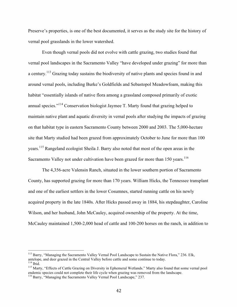
42
Preserve’s properties, is one of the best documented, it serves as the study site for the history of
vernal pool grasslands in the lower watershed.
Even though vernal pools did not evolve with cattle grazing, two studies found that
vernal pool landscapes in the Sacramento Valley “have developed under grazing” for more than
a century.113 Grazing today sustains the biodiversity of native plants and species found in and
around vernal pools, including Burke’s Goldfields and Sebastopol Meadowfoam, making this
habitat “essentially islands of native flora among a grassland composed primarily of exotic
annual species.”114 Conservation biologist Jaymee T. Marty found that grazing helped to
maintain native plant and aquatic diversity in vernal pools after studying the impacts of grazing
on that habitat type in eastern Sacramento County between 2000 and 2003. The 5,000-hectare
site that Marty studied had been grazed from approximately October to June for more than 100
years.115 Rangeland ecologist Sheila J. Barry also noted that most of the open areas in the
Sacramento Valley not under cultivation have been grazed for more than 150 years.116
The 4,356-acre Valensin Ranch, situated in the lower southern portion of Sacramento
County, has supported grazing for more than 170 years. William Hicks, the Tennessee transplant
and one of the earliest settlers in the lower Cosumnes, started running cattle on his newly
acquired property in the late 1840s. After Hicks passed away in 1884, his stepdaughter, Caroline
Wilson, and her husband, John McCauley, acquired ownership of the property. At the time,
McCauley maintained 1,500-2,000 head of cattle and 100-200 horses on the ranch, in addition to
113 Barry, “Managing the Sacramento Valley Vernal Pool Landscape to Sustain the Native Flora,” 236. Elk, antelope, and deer grazed in the Central Valley before cattle and some continue to today. 114 Ibid. 115 Marty, “Effects of Cattle Grazing on Diversity in Ephemeral Wetlands.” Marty also found that some vernal pool endemic species could not complete their life cycle when grazing was removed from the landscape. 116 Barry, “Managing the Sacramento Valley Vernal Pool Landscape,” 237.
43
Figure five: This photo shows a vernal pool at Howard Ranch, a property belonging to the CRP (From The Nature Conservancy, “Cosumnes River Summary Materials,” 1999, provided to author by The Nature Conservancy, November 17, 2016). a small wheat operation, which may have benefitted waterfowl.117 According to the 1930 map by
Crawford and Hurd, the land uses in the region in which Valensin Ranch resided were grazing
lands and “small hay and grains.”118 From at least the 1930s onward, the Valensin family also
leased grazing land to local ranchers. Butch Loretz, a longtime rancher in the area, said in an
interview that his father and he leased grazing land from the Valensin family since the 1930s;
Loretz continues to graze on the ranch except now he leases from the Cosumnes River Preserve
rather than private owners.119
117 Melinda Peak, “Evaluation of Significance of Structures Located within the Valensin Ranch Headquarters,
Sacramento County, California” El Dorado Hills: Peak & Associates, Inc., 1997, Cosumnes River Preserve private archive, Galt, California, 7. 118 Crawford and Hurd, “Type of Farming Areas.”
119 Butch Loretz, interview with Butch Loretz, interview by Michelaina Johnson, July 15, 2016.
44
To builders, the ranch was vacant land ripe for suburban tract housing development that
could meet the needs of Sacramento County’s growing population. A development company
called Crocker Development II had plans to build 4,500 homes, two golf courses and commercial
development on the ranch, and had a $28 million purchase option on the property between 1989
and 1992.120 At the same time, the Preserve had been hoping to acquire Valensin Ranch to
preserve the vernal pools though they were unable to compete with the development company’s
capital. A decline in the real estate market in the early 1990s, however, killed the economic
vitality of Crocket Development II’s plans. In another unplanned and unpredictable scenario, the
dip in the real estate market gave the Preserve enough time to purchase the ranch in a series of
parcels ranging from 140 to 945 acres between 1994 and 1997.121
Cattle ranching has been a major land use in the lower watershed since the 1840s.
Though the history of the other cattle ranches besides Valensin in the region are not as well
documented, the large acreage of vernal pool grasslands on Valensin and two other of the
Preserve’s properties—6,387 acres on Howard Ranch and 2,832 acres on the Forster property—
imply that ranching was an essential part of the historical land management on those properties
as well.122 Together, these three properties contain nearly 86% percent of all vernal pool
grasslands on the Preserve. Valensin Ranch also contains other large remnant habitats, including
270 acres of closed-canopy valley oak forest, making this particular property of countywide
significance with respect to its rich biodiversity and native habitats. As a 1996 report by The
120 “New Conservation Solutions: The Valensin Ranch Project,” n.p., n.d., Cosumnes River Preserve private archive,
Galt, California. 121 Kleinschmidt Associates, “Cosumnes River Preserve Management Plan,” 7-36-43. 122 Kleinschmidt Associates, “Cosumnes River Preserve Management Plan,” 7-55, 60-62.
45
Nature Conservancy remarked, “Thanks to a history of grazing with a relatively small percentage
of cultivated cropland, much of its [Valensin Ranch’s] original habitat remains intact.”123
Oak Riparian Forest
Prior to reduction of water surface elevations in the Cosumnes Sink, oak riparian forests
did not exist in the lower watershed even though The Nature Conservancy originally established
the Cosumnes River Preserve to protect that habitat type. Limited coring of the forest stands on
the Preserve suggests that the oldest stands—meaning a contiguous community of trees
distinguishable from other communities—appeared around the turn of the twentieth century, only
decades after the reclamation and drying of the sink was completed. The Cosumnes’ annual
floodwaters maintained the environmental conditions necessary to sustain the riparian forest
stands. Moreover, due to the Cosumnes’ potent flooding, most farmers along the river opted to
run cattle, which is relatively compatible with riparian forests.
According to the historical landscape reconstruction of the pre-1850 Delta by the San
Francisco Estuary Institute, most of the lower watershed did not have extensive, wide riparian
forests but rather willow stands and wetlands until the landscape was reclaimed beginning in the
mid-nineteenth century. The riparian forests in the early 1800s in the Sacramento-San Joaquin
Delta were located primarily along the higher elevation natural levees of the Sacramento River,
Mokelumne River and in parts of the southernmost reaches of the Delta.124 Though no sources
discuss how the riparian forest stands took root in the lower watershed, former TNC project
123 “New Conservation Solutions: The Valensin Ranch Project.” 124 Whipple et al., “Sacramento-San Joaquin Delta Historical Ecology Investigation,” 82, 298-300. Alison Whipple explained in an email from March 26, 2017 that “there were riparian forests (trees lining the channels), but they probably had more willow than oak and weren't as wide or prevalent it seems as they are now (on balance, it seems there was more area of wetland and willows than riparian forest). Since the woody vegetation lined the channels, it was too narrow/indistinct for that to show up in our mapping [from the “Sacramento-San Joaquin Delta Historical Ecology Investigation”]. It seems it was too wet for trees like oaks to survive in most of the sink area, but they were able to persist along the river channels where there were slightly raised banks (high enough up so the trees didn't die). With reclamation, it seems, the added dryness allowed the new oak stands to establish.”
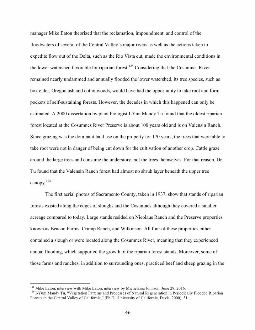
46
manager Mike Eaton theorized that the reclamation, impoundment, and control of the
floodwaters of several of the Central Valley’s major rivers as well as the actions taken to
expedite flow out of the Delta, such as the Rio Vista cut, made the environmental conditions in
the lower watershed favorable for riparian forest.125 Considering that the Cosumnes River
remained nearly undammed and annually flooded the lower watershed, its tree species, such as
box elder, Oregon ash and cottonwoods, would have had the opportunity to take root and form
pockets of self-sustaining forests. However, the decades in which this happened can only be
estimated. A 2000 dissertation by plant biologist I-Yun Mandy Tu found that the oldest riparian
forest located at the Cosumnes River Preserve is about 100 years old and is on Valensin Ranch.
Since grazing was the dominant land use on the property for 170 years, the trees that were able to
take root were not in danger of being cut down for the cultivation of another crop. Cattle graze
around the large trees and consume the understory, not the trees themselves. For that reason, Dr.
Tu found that the Valensin Ranch forest had almost no shrub layer beneath the upper tree
canopy.126
The first aerial photos of Sacramento County, taken in 1937, show that stands of riparian
forests existed along the edges of sloughs and the Cosumnes although they covered a smaller
acreage compared to today. Large stands resided on Nicolaus Ranch and the Preserve properties
known as Beacon Farms, Crump Ranch, and Wilkinson. All four of these properties either
contained a slough or were located along the Cosumnes River, meaning that they experienced
annual flooding, which supported the growth of the riparian forest stands. Moreover, some of
those farms and ranches, in addition to surrounding ones, practiced beef and sheep grazing in the
125 Mike Eaton, interview with Mike Eaton, interview by Michelaina Johnson, June 29, 2016.
126 I-Yum Mandy Tu, “Vegetation Patterns and Processes of Natural Regeneration in Periodically Flooded Riparian Forests in the Central Valley of California,” (Ph.D., University of California, Davis, 2000), 31.
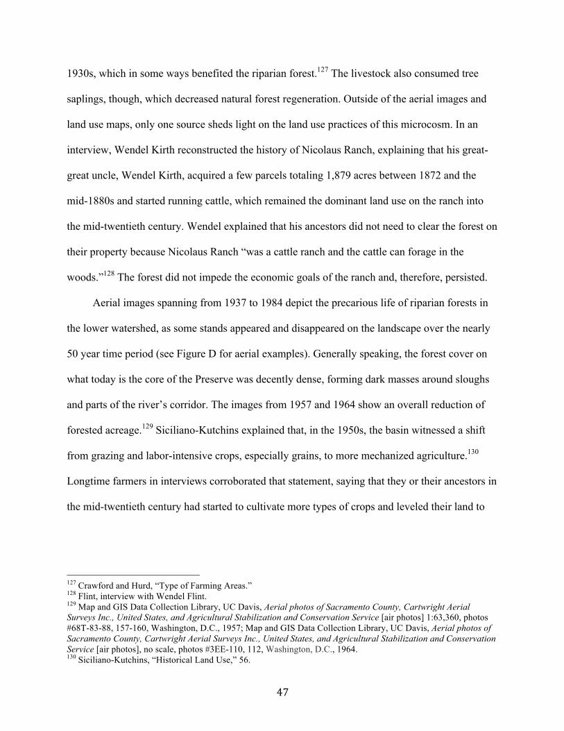
47
1930s, which in some ways benefited the riparian forest.127 The livestock also consumed tree
saplings, though, which decreased natural forest regeneration. Outside of the aerial images and
land use maps, only one source sheds light on the land use practices of this microcosm. In an
interview, Wendel Kirth reconstructed the history of Nicolaus Ranch, explaining that his great-
great uncle, Wendel Kirth, acquired a few parcels totaling 1,879 acres between 1872 and the
mid-1880s and started running cattle, which remained the dominant land use on the ranch into
the mid-twentieth century. Wendel explained that his ancestors did not need to clear the forest on
their property because Nicolaus Ranch “was a cattle ranch and the cattle can forage in the
woods.”128 The forest did not impede the economic goals of the ranch and, therefore, persisted.
Aerial images spanning from 1937 to 1984 depict the precarious life of riparian forests in
the lower watershed, as some stands appeared and disappeared on the landscape over the nearly
50 year time period (see Figure D for aerial examples). Generally speaking, the forest cover on
what today is the core of the Preserve was decently dense, forming dark masses around sloughs
and parts of the river’s corridor. The images from 1957 and 1964 show an overall reduction of
forested acreage.129 Siciliano-Kutchins explained that, in the 1950s, the basin witnessed a shift
from grazing and labor-intensive crops, especially grains, to more mechanized agriculture.130
Longtime farmers in interviews corroborated that statement, saying that they or their ancestors in
the mid-twentieth century had started to cultivate more types of crops and leveled their land to
127 Crawford and Hurd, “Type of Farming Areas.” 128 Flint, interview with Wendel Flint.
129 Map and GIS Data Collection Library, UC Davis, Aerial photos of Sacramento County, Cartwright Aerial Surveys Inc., United States, and Agricultural Stabilization and Conservation Service [air photos] 1:63,360, photos #68T-83-88, 157-160, Washington, D.C., 1957; Map and GIS Data Collection Library, UC Davis, Aerial photos of Sacramento County, Cartwright Aerial Surveys Inc., United States, and Agricultural Stabilization and Conservation Service [air photos], no scale, photos #3EE-110, 112, Washington, D.C., 1964. 130 Siciliano-Kutchins, “Historical Land Use,” 56.
48
install irrigation to increase the carrying capacity.131 For example, around 1955, a prominent
farmer in the lower watershed, Charlie Coldani, leased land from Nicolaus Ranch and instituted a
major transformation of the ranch from grazing to row crops, which required clear-cutting a
portion of the riparian forest. Flint recalled that over the next decade hundreds of acres were
chopped down and burned to make room for tomatoes, winter wheat, safflower, field corn, rice,
and sugar beets.132 The aerial images from 1984 show the riparian forest stands in the lower
watershed the most reduced in size in comparison to other years, which was more than likely the
result of clear-cutting.133
Even though healthy, self-sustaining forest stands of varying ages persevered in the lower
watershed for more than 110 years since the Gold Rush, the forests’ preservation was not
guaranteed. Farmers could and did modify their properties and deforest the rare plant
communities to meet the demands of the market. Dam projects, though never implemented, also
would have inadvertently damaged the forests by impounding the floodwaters behind dams.
Some property owners, such as Wendel Flint, “felt the remaining valley oak woodland should be
preserved as a natural environment” and made the personal decision not to cut down the trees.134
Flint made that choice in 1968 when he was helping his cousin Louis Desmond clear-cut the
riparian forest in the bottom grounds of Nicolaus Ranch. The Preserve acquired that forest—
called the Tall Forest—in 1989 as part of a 465-acre property sale to The Nature Conservancy,
making it one of the first riparian forest stands the CRP acquired.135 Despite all of the landscape
changes the Cosumnes basin underwent, the largest intact riparian forest in the state exists there
131 Loretz, interview with Butch Loretz; Ken Oneto, interview with Ken Oneto, interview by Michelaina Johnson, July 26, 2016; Ron Oneto, interview with Ron Oneto, interview by Michelaina Johnson, July 26, 2016; Mike Johnson, interview with Mike Johnson, interview by Michelaina Johnson, July 15, 2016. 132 Flint, interview with Wendel Flint.
133 Map and GIS Data Collection Library, UC Davis, Aerial photos of Sacramento County, WAC Corp [air photos], no scale, photos #8-60-62, 72-74, 170-173, Eugene, OR, 1984. 134 Flint, interview with Wendel Flint. 135 Kleinschmidt Associates, “Cosumnes River Preserve Management Plan,” 7-29.
49
today and is protected by the CRP. The rest of the Central Valley experienced more intensive
landscape modifications, including damming and deforestation, which led to the loss of 97% of
its original riparian forest.
The oak-dominated riparian forests present in the lower Cosumnes watershed are not
“naturally” supposed to be there. The extensive engineering of the Delta, along with the diking
and draining of the Cosumnes’ floodplain, a century and a half ago created the conditions
necessary for the riparian trees to take root in the lower watershed. The free flowing Cosumnes’
annual floodwaters forced ranchers to practice stock grazing, which partly enabled the forests to
grow. The unforeseen factors of flooding and grazing produced the most “extensive and naturally
reproducing native riparian Valley Oak forest” in the Central Valley.136 Except for some
environmentally conscious landowners like Wendel Flint, no people or agencies took notice of
136 The Nature Conservancy, “California Nature Conservancy Dedicates Cosumnes River Preserve.”
Figure six: This photo depicts a riparian forest stand growing on the edge of a slough in the Cosumnes River Preserve. Tules are located in the front of the image (By author, July 2016).
Figure seven: This photo shows the Tall Forest inundated during a winter flood, which helps to maintain forest regrowth and health (From Carson Jeffres, “Frolicking fat floodplain fish feeding furiously,” California WaterBlog, June 2, 2011, accessed November 28, 2016, https://californiawaterblog.com/2011/06/02/frolicking-fat-floodplain-fish-feeding-furiously/).
50
the Cosumnes’ riparian forests until the 1960s when the public began to value native habitats.
VI. Protecting What Remains: The Establishment of the Cosumnes River Preserve
The first government agencies interested in the lower Cosumnes River watershed’s
ecosystem focused on the riparian forest stands. In 1974, a report was issued to the Sacramento
County Department of Parks and Recreation (SCDPR) detailing the natural resources, open
space and recreational potential of the watershed. The report stressed that the oak woodland as
well as other “riparian habitat along the lower river … [are] constantly being reduced as a result
of pressure from intensifying agricultural practices” and called for the protection of the
threatened habitats in the lower watershed.137 Heeding the advice of the report, the State of
California approved $2.5 million in funding for a 3,450-acre park in the lower watershed, which
was designed to protect the forest and meet the high demand for recreation from Sacramento.
The farmers in the lower watershed, however, vehemently opposed the project out of concern
that they would lose their property and that a park would interfere with farming.138
The conflict between farmers in the lower watershed and the SCDPR embodied a larger
ideological clash in the U.S. between environmentalism and productive land use. Historians
Samuel and Barbara Hays explained in their 1987 Beauty, Health, and Permanence:
Environmental Politics in the United States, 1955-1985 that American city dwellers pioneered
the environmental movement, which started in the years following World War II when
Americans in general began spending more time outdoors. Consequently, Americans, especially
urbanites, reshaped the nation’s perception of the environment from emphasizing nature’s
economic value to stressing nature’s aesthetic, recreational, and intrinsic values.139 In response to
137 Bennett, “The River That Got Away,” 75. 138 Ibid., 74, 78.
139 Samuel P. Hays and Barbara D. Hays, Beauty, Health, and Permanence: Environmental Politics in the United States, 1955-1985 (Cambridge: Cambridge University Press, 1987), 23, 35, 288.
51
the public’s changing attitude and evidence of the negative effects of human activity on the
environment, the federal and state governments beginning in the early 1960s passed legislation to
protect native habitats and threatened and endangered species. Congress passed a series of
endangered species acts in the mid to late 1960s, culminating in the passage of the Endangered
Species Act of 1973. Moreover, the California state legislature passed the California Endangered
Species Act in 1970, which defined endangered species “as any member of the plant or animal
kingdom that is ‘in danger of extinction throughout all or a significant portion of its range’” and
threatened species as “those that are likely to become endangered ‘in the foreseeable future.’”140
SCDPR’s park plan called for the protection of endangered species, particularly sandhill cranes.
Farmers, however, were skeptical of the county’s plan and some of them went so far as to
threaten to cut down trees if the park was established.141 The state legislature adhered to the
farmers’ concerns and did not approve funding for the park in 1977, which killed the project.142
Nevertheless, two state park directors who worked on the proposed county park, Russ Cahill and
Pete Dangermond, decided to take matters into their own hands and brought their appeal to
California’s then Secretary of Resources, Huey Johnson, who served under Governor Jerry
Brown from 1978 to 1982.143
The history of how The Nature Conservancy (TNC) and Ducks Unlimited (DU) established
a nature preserve in the Cosumnes watershed and Johnson’s role in the founding is hard to
discern, but from the sources a fragmented narrative emerges. Johnson, after visiting the
Cosumnes River a few times and seeing the exceptionality of the native habitat and wildlife,
decided to purchase a 40-acre piece of land along the river as the future site of a private
140 Alagona, “After the Grizzly,” 100-102. 141 Reiner and Cox, Legacy Profile, 2. 142 Bennett, “The River That Got Away,” 79.
143 Rich Reiner and Robin Cox, Legacy Profile: Cosumnes River Preserve (long version), January 2015, 2, provided via email by Brynn Pewtherer, June 15, 2016.
52
conservation duck club. His vision was to establish the duck club and then sell it as a wildlife
refuge to the state. His position as Secretary of Resources presented a conflict of interest,
however, so he tried his connections with TNC. As TNC’s former western regional director,
Johnson had ties to the nonprofit and gave two executive directors—one of them being Steve
McCormick—tours of the lower Cosumnes River in hopes of convincing them that TNC should
set up a refuge there.144
Simultaneously, TNC, under McCormick’s leadership, had developed the first California
Critical Areas Campaign, listing the Cosumnes River’s valley oak riparian forest as one of the
priority sites. As a result, Johnson’s interest in the region struck a cord with McCormick, who
helped to steer TNC to install a preserve in the lower watershed and developing relationships
with potential partners.145 TNC ecologist Barbara Malloch designed the first plan in 1981 to
create a preserve in the lower watershed that focused on the preservation of oak riparian forest,
freshwater ponds and marshes, and the Greater Sandhill Crane.146 TNC executed the plan
beginning in 1984 when it purchased the 85-acre Wilkinson parcel. The property’s acreage was
virtually all valley oak riparian forest. One year later in 1985, Johnson sold his property to
TNC.147 By the late 1980s, TNC formed its first partnership with Ducks Unlimited and together
they realized the vision of starting a preserve in the Cosumnes basin.
VII. The Cosumnes River Preserve Redefines Restoration
The Nature Conservancy and Ducks Unlimited officially dedicated the Cosumnes River
Preserve on May 30th, 1987 as a relatively traditional preserve protecting few habitat types,
144 Huey Johnson, interview with Huey Johnson, interview by Michelaina Johnson, July 29, 2016; Reiner and Cox,
Legacy Profile, 2. 145 Steve McCormick, interview with Steve McCormick, interview by Michelaina Johnson, June 5, 2017. 146 Reiner and Cox, Legacy Profile, 2, 18. 147 Kleinschmidt Associates, “Cosumnes River Preserve Management Plan,” 7-20, 7-74. The actual cost of the Wilkinson parcel is not available. Johnson’s property today is called Farm and Wetlands Inc. 2 (see Figure one for its location).
53
including oak riparian forest.148 TNC and DU setting down roots in the lower watershed meant
significant landscape and management changes for the region from profit-driven, private
ownership to conservation-oriented, public-private ownership. In the 1980s, TNC owned the
largest private nature preserve system globally with more than 900 preserves totaling 5,121,522
acres. Beginning in 1958, the environmental powerhouse started protecting land in California
through land acquisitions and the establishment of preserves. By 1991, the Conservancy had
been involved in 209 land acquisition projects totaling 321,786 acres in California. Less than one
percent of that land, or 1,454 acres, comprised the Cosumnes River Preserve.149 Despite its
minute size, the Preserve quickly became a hub for experimental restoration and management
techniques, such as public-private partnerships, that redefined TNC’s institutional preserve
model and restoration strategies statewide.
Ducks Unlimited, as the first partner, expanded the Preserve’s goal to include the
restoration of seasonal wetlands to benefit waterfowl.150 Over the next several years, five
government agencies—the Bureau of Land Management (BLM), the Sacramento County
Department of Regional Parks, the California Department of Water Resources, the California
Department of Fish and Wildlife, and the California State Lands Commission—joined the CRP
as property owners.151 With each consecutive partnership, the Preserve’s acreage and
conservation goals increased along with its leverage and resources. DU was foundational in the
construction of wetland ponds for migrating waterfowl, which BLM today manages along with
providing a wealth of staffing and land management knowledge.152 In addition to the CRP’s
148 Griggs, “California Nature Conservancy Dedicates Cosumnes River Preserve.” 149 Kreissman and Lekisch, California: An Environmental Atlas and Guide, 172-175 150 Reiner and Cox, Legacy Profile, 3. 151 Reiner Cox, Legacy Profile, 4, 18-19; Kleinschmidt Associates, “Cosumnes River Preserve Management Plan,” ES-1. 152 Harry McQuillen, interview with Harry McQuillen, interview by Michelaina Johnson, June 1, 2017.
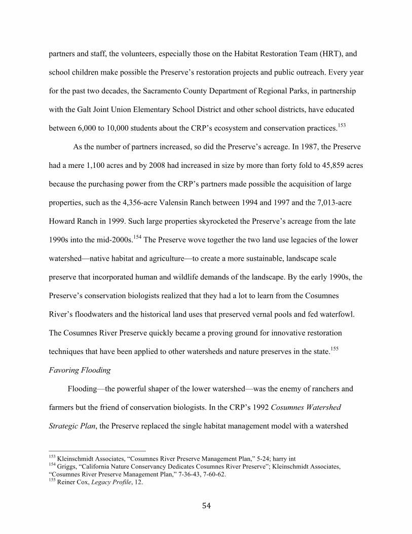
54
partners and staff, the volunteers, especially those on the Habitat Restoration Team (HRT), and
school children make possible the Preserve’s restoration projects and public outreach. Every year
for the past two decades, the Sacramento County Department of Regional Parks, in partnership
with the Galt Joint Union Elementary School District and other school districts, have educated
between 6,000 to 10,000 students about the CRP’s ecosystem and conservation practices.153
As the number of partners increased, so did the Preserve’s acreage. In 1987, the Preserve
had a mere 1,100 acres and by 2008 had increased in size by more than forty fold to 45,859 acres
because the purchasing power from the CRP’s partners made possible the acquisition of large
properties, such as the 4,356-acre Valensin Ranch between 1994 and 1997 and the 7,013-acre
Howard Ranch in 1999. Such large properties skyrocketed the Preserve’s acreage from the late
1990s into the mid-2000s.154 The Preserve wove together the two land use legacies of the lower
watershed—native habitat and agriculture—to create a more sustainable, landscape scale
preserve that incorporated human and wildlife demands of the landscape. By the early 1990s, the
Preserve’s conservation biologists realized that they had a lot to learn from the Cosumnes
River’s floodwaters and the historical land uses that preserved vernal pools and fed waterfowl.
The Cosumnes River Preserve quickly became a proving ground for innovative restoration
techniques that have been applied to other watersheds and nature preserves in the state.155
Favoring Flooding
Flooding—the powerful shaper of the lower watershed—was the enemy of ranchers and
farmers but the friend of conservation biologists. In the CRP’s 1992 Cosumnes Watershed
Strategic Plan, the Preserve replaced the single habitat management model with a watershed
153 Kleinschmidt Associates, “Cosumnes River Preserve Management Plan,” 5-24; harry int 154 Griggs, “California Nature Conservancy Dedicates Cosumnes River Preserve”; Kleinschmidt Associates, “Cosumnes River Preserve Management Plan,” 7-36-43, 7-60-62. 155 Reiner Cox, Legacy Profile, 12.
55
scale model because of cutting edge research that demonstrated that restoring ecological
functions to a landscape created a sustainable ecosystem. The plan set forth distinct goals for
threatened native habitats and the entirety of the river, ensuring “the continuation of the [river’s]
natural hydrological regime” and protecting the “riparian and aquatic communities along the
Cosumnes River, and provid[ing] a link between the River’s floodplain, the foothill belt, and the
River’s upper reaches.”156 The proposed watershed scale preserve was the most expensive
Nature Conservancy project at the time and necessitated new and innovative strategies, for which
the conservation biologists turned to the river itself for solutions.157
Floodwaters had breached the levees along the river since the 1860s, inundating crop fields
with the natural starter pack for a new forest—organic debris, sediment, and seeds. One major
flood in 1985 demonstrated to the CRP staff the restoration potential of intentional levee
breaching to restore the floodplain. In that year, floodwaters breached a levee on a farm adjacent
to the Preserve, covering a 15-acre portion of a tomato field with sand and organic debris. Within
a year, the so-called ‘Accidental Forest’ started to grow with a natural succession of
cottonwoods, Oregon Ash, willow thickets, and eventually valley oaks, demonstrating that the
native habitat of the region returned when the natural function of flooding was reintroduced to
the floodplain.158 UC Davis fluvial geomorphologist Jeffrey Mount in an interview equated that
isolated incident to a light bulb going off for the river restoration community by proving that
levee removals enabled floodwaters to naturally replant forest, which had previously been done
by hand.159 Prior to the mid-1990s, the Preserve’s staff and Habitat Restoration Team volunteers
planted thousands of acorns in hopes that the trees would grow. However, many of the trees
156 Ibid, 8. 157 Ibid., 3. The exact price of the project is unknown. 158 Steding, “Restoring Riparian Forests and Natural Flood Regimes,” 233. 159 Jeffrey Mount, interview with Jeffrey Mount, interview by Michelaina Johnson, July 7, 2016.
56
died.160 The Preserve coordinated two more levee breaches in 1995 and 1997 to facilitate the
restoration of more riparian forest stands, including the ‘Intentional Forest’ on Nicolaus Ranch.
Thus the Preserve pioneered a new floodplain restoration technique called process-based
restoration.161 This strategy entails using natural processes instead of hand planting to drive
forest regrowth. The record-breaking flood year of 1997 exemplified the benefits of this strategy,
as the Preserve’s restored floodplain held massive amounts of floodwaters and mitigated damage
downstream while providing habitat and groundwater recharge. The Preserve’s success with this
flood management technique in 1997 drew the attention of eminent UC Davis scientists whose
subsequent research propelled the CRP to prominence as a test-bed for restoration in the Delta,
Central Valley, and beyond by the turn of the twenty-first century.
Figure eight: The Cosumnes River flooding its floodplain (Robertson-Bryan, Inc., Lower Cosumnes River Watershed Assessment, 23) The Cosumnes Research Group at UC Davis formed in July 1998, in partnership with the
Preserve, to study the natural processes in the Cosumnes watershed in order to improve the
restoration practices not only on site but also in the Mokelumne River watershed and in the
160 Reiner and Cox, Legacy Profile, 5; Tom Griggs, “History of the Riparian Forest Restoration Project, 1988-1990,”
n.p., 1991, Cosumnes River Preserve private archive, Galt, California, 6. 161 Robertson-Bryan, Inc., Lower Cosumnes River Watershed Assessment, 5; Reiner and Cox, Legacy Profile, 5.

57
North Delta.162 The studies conducted by UC Davis researchers have proven groundbreaking for
the fields of ecology and conservation biology, as they have brought science to bear on the
natural processes that sustained the remaining native habitats over the past century and a half and
restored the newer additions of forest. The researchers studied the free flow of the Cosumnes
River to understand how dams affected water quality; groundwater dynamics; how native fish
used a floodplain; how flows change the topography of the floodplain; and how the free-flowing
Cosumnes River could be used to develop a systematic classification of hydrologic variability.163
Together these studies demonstrated the importance of restoring natural processes back to the
ecosystem, specifically granting floodwaters larger access to the river’s ancestral floodplain. The
restoration of the floodplain not only sustains the riparian forest stands that persevere on the
landscape but also create new seasonal wetland habitat for waterfowl and fish and naturally
restored forests.164
Restoring the floodplain revives some aspects of the Cosumnes Sink, including periodic
inundation, sediment deposition, and wetland enhancement. However, the lower watershed, as
well as the Delta, has been “irrevocably altered” to the point that complete restoration of the sink
and its ecosystem is impossible, especially considering that native habitats, such as the oak
riparian forest stands, now exist where they had not before.165 Other considerations that impede
162 “Project History,” UC Davis Center for Watershed Sciences, accessed November 18, 2016, https://watershed.ucdavis.edu/doc/cosumnes-research-group/project-history.
163 Ahearn et al., “Temporal Dynamics of Stream Water”; Peter B. Moyle, Patrick K. Crain, and Keith Whitener, “Patterns in the Use of a Restored California Floodplain by Native and Alien Fishes,” San Francisco Estuary and Watershed Science 5, no. 3 (January 1, 2007): 1-27, accessed October 11, 2016, http://escholarship.org/uc/item/6fq2f838; Eric Booth, Jeff Mount, and Joshua H. Viers, “Hydrologic Variability of the Cosumnes River Floodplain,” San Francisco Estuary and Watershed Science 4, no. 2 (January 1, 2006): 1-19, accessed October 11, 2016, http://escholarship.org/uc/item/71j628tv. 164 Robertson-Bryan, Inc., Lower Cosumnes River Watershed Assessment, 87. 165 Whipple et al., “Sacramento-San Joaquin Delta Historical Ecology Investigation,” p. xx. The investigation also stated, “The majority of the approximately 106,000 acres (42,900 ha) of natural habitat (within the Legal Delta and study area boundary) did not exist historically in their present locations. For example, seasonal wetlands are found where perennial wetlands once existed and willow thickets on artificial levees are now present where tidal wetland
58
the restoration of the landscape include non-native species, channel incision, and artificially
lowered groundwater levels, among others.166 What can be restored to the landscape are natural
processes and ecological function. The Cosumnes River Preserve is the first nature preserve in
the Delta in which ecological function was restored to the floodplain, and their success has made
the CRP become the reference for future floodplain restoration along the Cosumnes’ neighboring
rivers, within the Delta, and beyond.167 As Jeffrey Mount said in an interview, “This natural
living laboratory [the Cosumnes River], I would argue, is probably the best in the country in
terms of what we learn about floodplain systems.”168
Agriculture as a Conservation Tool
Prior to the establishment of the CRP, The Nature Conservancy tended to consider
agriculture incompatible with wildlife and habitat conservation. However, conservation
biologists in the first few years in the lower watershed observed the benefits of cattle grazing for
vernal pools and annual crops for migrating waterfowl. By the early 1990s, the CRP formally
incorporated ranching and an organic rice operation into their conservation efforts not only to
provide habitat for birds but also to generate income to fund the Preserve’s operations.
In 1996, the Preserve partnered with an organic rice grower named Allen Garcia to launch
Living Farms, an experimental farm designed to help meet the ecological and economic demands
required of the Preserve. In the pilot year, Living Farms converted 240 acres of grazing land into
the rice fields on the Crump Ranch and Desmond properties (see Figure one). The pilot year was
very successful economically, yielding 1,081,502 pounds of organic rice to sell and $43,000 in
edges once met water. The Delta has undergone an almost complete transformation, due to land use and water management” (107). 166 Whipple, email message to Michelaina Johnson. 167 April Robinson, Samuel Safran, and Julie Beagle, “A Delta Renewed: A Guide to Science-Based Ecological Restoration in the Sacramento-San Joaquin,” San Francisco Estuary Institute—Aquatic Science Center, a report of SFEI-ASC’s Resilient Landscapes Program, publication #799, Richmond, CA, 2016. 168 Mount, interview with Jeffrey Mount.
59
revenue for habitat improvements for the Preserve. After the harvest, 200 acres of rice fields
were flooded with a few inches of water and converted into surrogate wetlands for waterfowl.169
In addition to the 120,000 pounds of leftover rice intentionally left in the fields, as much as
50,000 pounds of naturally occurring food sources, such as invertebrates and tubers, were
available in the flooded rice fields for waterfowl to consume.170 Over the next several years,
Living Farm’s organic operation expanded to 1,000 acres and incorporated crop rotations
between cattle pasture, nitrogen fixing clover, and organic rice to maintain soil fertility.171 The
waterfowl also benefitted the growers by generating natural fertilizer for the soil and accelerating
rice decomposition via foraging.172 Though Living Farms ceased operations around the year
2000, the Preserve continues to lease approximately 1,000 acres of rice fields in addition to more
than 500 acres of grain and hay crops and nearly 12,350 acres of annual, truck and berry crops.173
In 2008, these crop fields in conjunction with irrigated agriculture covered at least one third of
the Preserve’s approximately 45,859 acres.174
Cattle ranching also formed an integral part of the Preserve’s conservation goals with
grazing on 4,750 acres, or 39%, of the Preserve’s 14,000 acres in 1998.175 The acreage of cattle
ranching more than tripled in a ten-year period thanks to the Preserve acquiring a few critical
grassland and vernal pool rich properties, particularly the 4,356-acre Valensin Ranch and the
169 “The Cosumnes River Preserve Sustainable Farm Plan: A Three Year Transition to Wildlife Friendly Organic Farming,” n.p., 1996, Cosumnes River Preserve private archive, Galt, California. 170 Sylvie M. Brouder and James .E. Hill, “Winter Flooding of Ricelands Provides Waterfowl Habitat,” California Agriculture 46, no. 6 (1995): 58-64. According to Brouder and Hill, 350 pounds per acre of residual rice from a dry, harvested field and 250 pounds per acre of naturally occurring food sources, such as invertebrates and tubers, are available in flooded rice fields for waterfowl to consume as they forage. 171 Steding, “Restoring Riparian Forests and Natural Flood Regimes,” 235. 172 According to Brouder and Hill, flooded rice fields may supply as much as 600 pounds per acre of food, which is approximately 80% of the total amount of food available for waterfowl in one acre of natural wetland. The productivity of flooded rice fields, therefore, indicates that they are a “good alternative to [the] full restoration of original wetlands.” 173 Kleinschmidt Associates, “Cosumnes River Preserve Management Plan,” 3-2. The one third is calculated based on data from this source. 174 Ibid. 175 Steding, “Restoring Riparian Forests and Natural Flood Regimes,” 235-23.
60
7,013 acre Howard Ranch, in the mid to late 1990s and early 2000s. Thanks to the CRP’s
recognition of the value of grazing, “ranching is now viewed as a key conservation activity” for
The Nature Conservancy.176
In fact, wildlife friendly agriculture has become so integral to the Preserve that almost
“90% of the protected lands are maintained in compatible agricultural production, including
grazing, annual crops, and organic rice.”177 The Preserve’s protected lands are owned in fee title
by one of the seven partners or are held under a conservation easement, which entails a
landowner selling the property development and subdivision rights to a CRP partner and placing
certain conservation restrictions on the property. The purpose of the easement is to ensure that
the historic, wildlife compatible land uses present on 21,271 acres, or 46% of the Preserve’s
property, continue in perpetuity.178 Anna Steding praised the CRP’s innovative land
management, declaring, “CRP staff have shown that the ostensibly conflicting land uses of
agriculture, grazing, habitat restoration, and floodplain management can, in fact, be
compatible.”179
While ranchers and farmers are participants in the Preserve’s conservation agenda, their
reasons for selling easements to the CRP and leasing grazing and agriculture land is economic
rather than environmental. Six of the ranchers and agriculturalists I interviewed said that the
economic incentive, coupled with a dip in the market, spurred them to sell one or multiple
easements on their properties to the Preserve. Duane Martin Jr., a cattle rancher based out of the
lower Cosumnes, explained in an interview his reasoning for selling an easement on his property
to the Bureau of Land Management in 1999:
176 Reiner and Cox, Legacy Profile, 13. 177 Kleinschmidt Associates, “Cosumnes River Preserve Management Plan,” 2-12. 178 Ibid. 179 Steding, “Restoring Riparian Forests and Natural Flood Regimes,” 237.
61
The cattle business has gotten tough, and I needed the income to help pay down
the debt on the ranch. And I figured that I was not giving anything up. The
easement says no trees, no vines, no homes. This country floods. It is never going
to be tree ground. Mostly likely isn’t very good vineyard ground and damn sure is
not going to be homes. The only thing I didn’t count on was the geese eating me
out of house and home every winter.
According to the stipulations of the easement, Martin Jr. is not allowed to disturb the wildlife on
his property, meaning that the waterfowl’s grazing decreases the land’s carrying capacity for his
cattle and sometimes decrease his profit.180 For rangeland lessees, such as Butch Loretz, working
with the CRP is not much different than private landowners except for tighter restrictions on how
much grass his cattle are allowed to graze.181 The most significant challenges for farmers, such
as Ron and Ken Oneto, who have easements on their properties, are the crop restrictions, which
limited the Onetos to growing annual and waterfowl compatible crops. As lucrative crops in
California have transitioned in the past decade to vineyards and nut trees, the Onetos have been
able to match the market demand by planting grapes, cherries, and walnuts on their properties
that do not have easements.182
Even though several farmers and ranchers lease and work with the Preserve, many do not
understand why the CRP conserves the native habitats. Some even view the protected land as a
“drain on the economy” and a “waste.”183 Some longtime residents, including the Onetos and
Loretz, do not think that the Preserve maximizes the land’s productivity potential. For instance,
Loretz described the Preserve’s restored, managed wetlands as “productive farmland and
180 Duane Martin Jr., interview with Duane Martin Jr., interview by Michelaina Johnson, June 29, 2016.
181 Loretz, interview with Butch Loretz. 182 Oneto, interview with Ron Oneto; Oneto, interview with Ken Oneto.
183 Martin Jr., interview with Duane Martin Jr.
62
irrigated cattle land [reverting] back to flooded potholes” and the restoration of the riparian forest
understory as “overgrowth” and “a jungle.”184 The farmers’ and ranchers’ perception of the
Preserve speaks to the ideological differences between conservation biologists and
agriculturalists, which have vied for influence in the lower watershed for nearly 40 years.
Conservationists tend to villainize farmers and ranchers, claiming that they overexploit the land
for profit at the expense of native flora and fauna, while farmers and ranchers have a tendency to
view conservation as an unproductive land use because it is not economical.
Both views, however, are too simplistic and do not listen to the other. Farmers and ranchers
in the lower watershed care about their land because it sustains them and helps to feed the
world.185 Some farmers I interviewed said that they intentionally left several acres of native
habitat on their property for wildlife. In some cases, however, this land was not farmable to
begin with and flooded in the wintertime.186 The Preserve, on the other hand, has recognized the
economic and ecological benefits of some types of agriculture, which has enabled the two groups
to work together even though their motives are different. Ultimately the winner of the two groups
working together is not the farmer or conservationist but rather the thousands of hungry
waterfowl and flourishing native habitats that depend upon humans actors making
environmentally conscious decisions to survive in the highly altered Central Valley.
VIII. Conclusion
The lower Cosumnes River watershed is a contested place unlike any other in the Central
Valley. Undammed floodwaters limit farmers’ and ranchers’ autonomy on the landscape and
sustain native habitat remnants. The proliferation of vernal pools and oak riparian forests is a
184 Loretz, interview with Butch Loretz. 185 Martin Jr., interview with Duane Martin Jr.; Oneto, interview with Ron Oneto; Oneto, interview with Ken Oneto.
186 Oneto, interview with Ron Oneto; Oneto, interview with Ken Oneto; Mark Ackerman, interview with Mark Ackerman, interview by Michelaina Johnson, July 21, 2016.
63
picture of the failed hopes of California’s white settlers and the modern state. Two Sacramento
County historians, Thomas Hinckley Thompson and Albert Augustus West, in 1880 captured the
vision of the pioneers of California for the Central Valley’s rivers: “Immense reservoirs will be
constructed, either by the government or the state, for the impounding of the flood water” to
irrigate a “thirsty land” and bring “greater prosperity to the valley.”187 The authors imagined a
California with a strong government that would wield its power for the growth of the state’s
agricultural economy and the taming of its water systems. Because California’s government was
weak in the first several decades following the state’s founding in 1850, county and city water
agencies assumed the responsibility of developing several rivers, including the Mokelumne and
Toulumne rivers, with reservoirs and dams. As the state government gained power, it joined the
hydraulic effort with the Central Valley Project in 1933, building 20 dams and reservoirs over
the course of the next five decades.188 The city, county, and state water agencies were very
successful in carrying out the settlers’ vision of subduing the “destructive torrents” with
“immense reservoirs” for the purpose of flood control, providing irrigation for agriculture, and
creating sustainable municipal water supplies, among other reasons.189
Despite five proposed projects, the Cosumnes River evaded dam-nation, leaving an
unregulated river open to stakeholder contestation. Water agencies today control the flow of all
the rivers draining the western Sierra Nevada, except for the Cosumnes, through timed releases
from dams. As a consequence, the Cosumnes’ floodwaters, in conjunction with unintentionally
wildlife friendly land uses, in the lower watershed have supported oak riparian forests, vernal
pools, and waterfowl. When government policies started to regulate native habitats and
187 Thompson and West, History of Sacramento County, 13. 188 “About the Central Valley Project,” U.S. Bureau of Reclamation, May 18, 2016, accessed December 1, 2016, http://www.usbr.gov/mp/cvp/about-cvp.html. 189 Thompson and West, History of Sacramento County, 13.
64
endangered species in the 1960s, the lower watershed became open to dispute and negotiation
between government agencies, farmers, and private environmental interests. First, the Bureau of
Reclamation in the early 1960s proposed a wildlife mitigation project to offset the environmental
damage of the Cosumnes River Project’s dams and reservoirs, which farmers in the region
vigorously fought against to the point of delaying the project’s submission to Congress by two
years. Roughly a decade later in 1974, the Sacramento County Department of Parks and
Recreation (SCDPR) attempted to construct a 3,450-acre park in the lower watershed to protect
the riparian forests. Farmers along the Cosumnes also opposed this environmental project,
arguing that any “’park would be incompatible with farming, interfering with such operations as
spraying and dusting.’”190 Even though those two projects failed in part because of farmer
resistance, they represent the changing priorities of government agencies from trying to control
the environment to protecting the state’s remaining natural heritage.191
By the time The Nature Conservancy purchased their first property in the lower watershed
in 1984, the farmers were leery of environmental interests buying up their land and disrupting the
agricultural character of their community. As Wendel Flint said in an interview, “The feeling of
the local ranchers was one of muted hostility. They didn’t like the idea of environmentalists nor
did [they] like [the] Nature Conservancy coming in here.”192 Yet, as more partners joined TNC,
including DU and five government agencies, the CRP staff made an effort to integrate local
farmers and ranchers into their conservation efforts through easements and the adoption of
wildlife friendly agriculture. Today, the lower watershed remains a contested space, but tensions
190 Bennett, “The River That Got Away,” 62, 77-78. 191 In 1976, the National Park Service added the Cosumnes River Riparian Woodlands to the list of national natural landmarks. The goal of the National Registry of Natural History Landmarks is “to identify and encourage the preservation of nationally significant examples of the full range of ecological and geological features that constitute the nation’s natural heritage” (Keissman and Lekisch, California: An Environmental Atlas and Guide, 170-173). 192 Flint, interview with Wendel Flint.
65
between conservationists and agriculturalists have eased. In terms of money and land
management, the Preserve—in particular one partner, the Bureau of Land Management (BLM)—
has become an influential actor in the region. The influence of the BLM, as well as the
Preserve’s Sacramento County and state government agency partners, demonstrates the
government’s success in finally asserting some authority over the Cosumnes River. However, in
an ironic twist, the county’s and state’s failure to dam the Cosumnes has become the virtue of the
region today and kept alive the Cosumnes’ native habitats and waterfowl that ultimately attracted
the county, state, and federal government agencies to join TNC and Ducks Unlimited in the
1990s. The CRP’s partners, staff, and researchers today celebrate the state’s failure to dam the
river because it made possible the protection of some of California’s best remaining natural
heritage.
Because the Preserve has demonstrated that agriculture and grazing can be compatible with
conservation, it has become a preserve model for several environmental organizations. The two
other nature preserves located along the fringes of the Delta, the Yolo Bypass Wildlife Area and
Stone Lakes National Wildlife Refuge, were founded after the CRP and also employ wildlife
friendly agriculture to meet the dietary needs of waterfowl.193 Policymakers looking to restore
the heart of the Delta as well as its peripheries have praised the CRP as the ideal model for future
nature reserves and restoration projects in the Delta because it satisfies both human and wildlife
demands of the landscape. The Preserve’s conservation techniques, especially conservation
easements and wildlife friendly farming, attract policymakers because they make farmers active
participants in the restoration of the Delta and respect the Delta’s agricultural heritage. The latter
is especially important considering that about 442,800 acres (or 60%) of the Delta is privately
193 Garone, “The Fall and Rise of the Wetlands of California’s Great Central Valley,” 245-247.
66
owned agricultural land.194 One government agency, the Delta Protection Commission,
established a pilot conservation program in 2010 designed to introduce wildlife friendly land
uses on private properties in the Delta.195
The success of wildlife friendly agriculture has ramifications not only for the Delta but also
for the Central Valley and beyond. Corn, wheat, rice, and alfalfa are cultivated throughout the
Central Valley, and migrating waterfowl forage on the private crop fields. As the CRP has
demonstrated, conservation agencies can partner with farmers to effectively manage crop fields
to maximize the benefit for waterfowl and attract more birds to the site. The Nature Conservancy
has already proven the advantage of public-private partnerships through their BirdReturns
program, which in the pilot year in 2014 paid 32 rice growers in the Sacramento Valley to flood
42 fields totaling 10,000 acres to create surrogate wetlands for waterfowl.196 Another
conservation organization, Point Blue, in partnership with TNC and the Audubon Society and
other environmental groups, is currently researching how to expand the types of crops used for
surrogate wetlands beyond rice. They conducted research at the CRP to study the benefit of
flooded corn and wheat fields for waterfowl.197 Point Blue scientist David Shuford in his co-
authored 2015 study found that the benefits are so immense that he encouraged “Delta farmers to
widely adopt practices beneficial to waterfowl,” specifically flooding corn and wheat fields.198
The Preserve was also one of the first in California to demonstrate the effectiveness of
restoring physical processes and ecological functions to a landscape, which include levee
194 Jay Lund et al., Envisioning Futures for the Sacramento-San Joaquin Delta, 12. 195 The Delta Protection Commission et al., “Delta Working Lands Final Program Final Report,” September 2013, accessed November 23, 2016, http://www.delta.ca.gov/res/docs/landscapes/DWL_Final_Report_9-2013.pdf. 196 Matt Jenkins, “On the Wing,” Nature Conservancy Magazine, August/September 2014, accessed November 23, 2016, http://www.nature.org/magazine/archives/on-the-wing-2.xml. 197 “Waterbirds & Agriculture,” Point Blue, accessed November 23, 2016, http://www.pointblue.org/our-science-and-services/conservation-science/working-lands/waterbirds-agriculture#corn. 198 D. W. Shuford et al. “The benefits of crops and field management practices to wintering water birds in the Sacramento-San Joaquin Delta,” Renewable Agriculture and Food Systems v. 31, no. 6 (2015): 504.
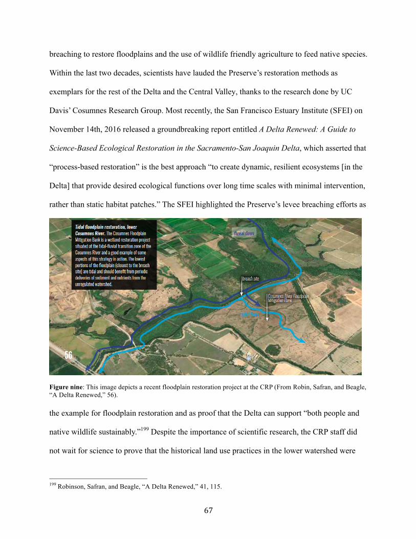
67
breaching to restore floodplains and the use of wildlife friendly agriculture to feed native species.
Within the last two decades, scientists have lauded the Preserve’s restoration methods as
exemplars for the rest of the Delta and the Central Valley, thanks to the research done by UC
Davis’ Cosumnes Research Group. Most recently, the San Francisco Estuary Institute (SFEI) on
November 14th, 2016 released a groundbreaking report entitled A Delta Renewed: A Guide to
Science-Based Ecological Restoration in the Sacramento-San Joaquin Delta, which asserted that
“process-based restoration” is the best approach “to create dynamic, resilient ecosystems [in the
Delta] that provide desired ecological functions over long time scales with minimal intervention,
rather than static habitat patches.” The SFEI highlighted the Preserve’s levee breaching efforts as
Figure nine: This image depicts a recent floodplain restoration project at the CRP (From Robin, Safran, and Beagle, “A Delta Renewed,” 56). the example for floodplain restoration and as proof that the Delta can support “both people and
native wildlife sustainably.”199 Despite the importance of scientific research, the CRP staff did
not wait for science to prove that the historical land use practices in the lower watershed were
199 Robinson, Safran, and Beagle, “A Delta Renewed,” 41, 115.
68
working to conserve the flora and fauna that they desired to protect. Rather, the Preserve’s first
employees were bold, breaching levees, institutionalizing wildlife friendly land uses, and inviting
scientists to research their experimental strategies. As a result of the Preserve’s scientifically
proven success, the CRP has become the foundation for field-redefining conservation work.
IX. Epilogue
Despite the huge strides conservation has made in the lower watershed, the future of the
Preserve is uncertain, especially in the face of climate change, pressures associated with
population growth, proposed hydraulic projects, and the conversion of the properties surrounding
the CRP to non-wildlife compatible land uses. In terms of short-term challenges, several farmers
who live near the Preserve have sold their properties to developers or converted their cattle
ranches to vineyards and nut trees because those crops have become more lucrative. Moreover,
the city of Elk Grove has ballooned in size from about 50,000 in 1990 to 153,454 people in 2010,
necessitating the conversion of rangelands and farms to housing.200 The development of that
open space resulted in a loss of vernal pools and wildlife friendly agriculture, which placed more
wildlife demand on the already strained habitats within the Preserve. Roughly within the last
decade, the CRP has ceased acquiring more properties and easements to focus its staff energy on
the wellbeing of its 48,859 acres, but the lack of growth has come at the cost of historically
wildlife friendly properties being overlaid with concrete and grape vines. As Mike Eaton, who
has lived and worked in the lower watershed for more than 25 years, observed, “Over the past
five years, we've seen a dramatic conversion of open lands in the north Delta—literally
thousands of acres—from open land [that is] farming friendly to cranes [and other species] to
200 Lynda Gledhill, “Elk Grove/Sacramento County city is nation’s fastest-growing/Census confirms status – police, builders, schools try to keep up,” SF Gate, June 25, 2000, accessed November 18, 2016, http://www.sfgate.com/bayarea/article/ELK-GROVE-Sacramento-County-city-is-nation-s-2532741.php.
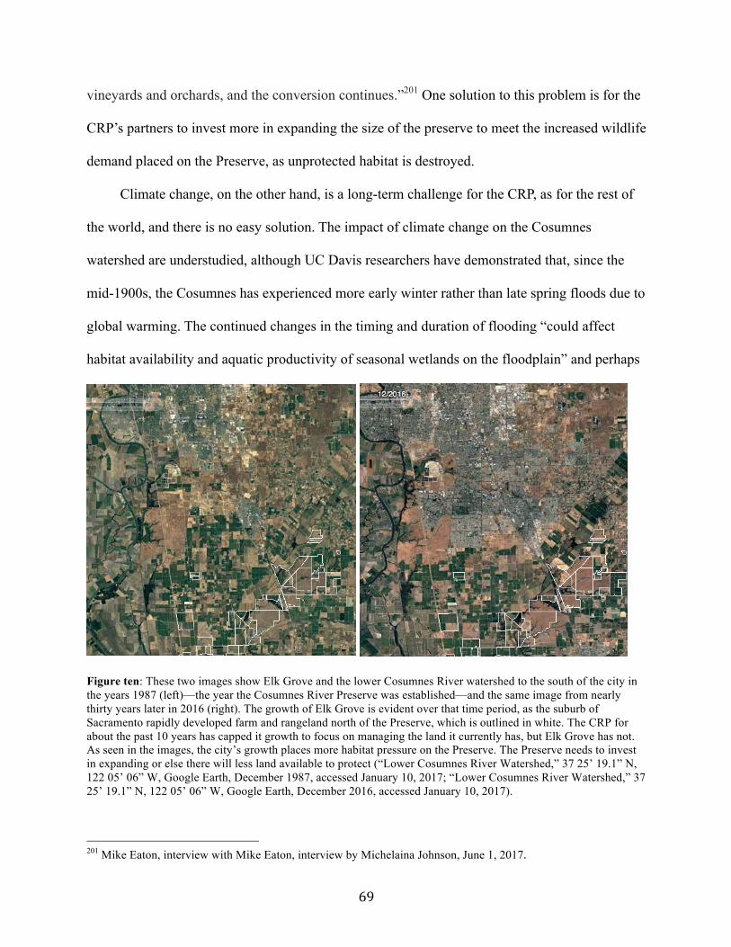
69
vineyards and orchards, and the conversion continues.”201 One solution to this problem is for the
CRP’s partners to invest more in expanding the size of the preserve to meet the increased wildlife
demand placed on the Preserve, as unprotected habitat is destroyed.
Climate change, on the other hand, is a long-term challenge for the CRP, as for the rest of
the world, and there is no easy solution. The impact of climate change on the Cosumnes
watershed are understudied, although UC Davis researchers have demonstrated that, since the
mid-1900s, the Cosumnes has experienced more early winter rather than late spring floods due to
global warming. The continued changes in the timing and duration of flooding “could affect
habitat availability and aquatic productivity of seasonal wetlands on the floodplain” and perhaps
Figure ten: These two images show Elk Grove and the lower Cosumnes River watershed to the south of the city in the years 1987 (left)—the year the Cosumnes River Preserve was established—and the same image from nearly thirty years later in 2016 (right). The growth of Elk Grove is evident over that time period, as the suburb of Sacramento rapidly developed farm and rangeland north of the Preserve, which is outlined in white. The CRP for about the past 10 years has capped it growth to focus on managing the land it currently has, but Elk Grove has not. As seen in the images, the city’s growth places more habitat pressure on the Preserve. The Preserve needs to invest in expanding or else there will less land available to protect (“Lower Cosumnes River Watershed,” 37 25’ 19.1” N, 122 05’ 06” W, Google Earth, December 1987, accessed January 10, 2017; “Lower Cosumnes River Watershed,” 37 25’ 19.1” N, 122 05’ 06” W, Google Earth, December 2016, accessed January 10, 2017).
201 Mike Eaton, interview with Mike Eaton, interview by Michelaina Johnson, June 1, 2017.
70
even the growing season of some crops in the lower watershed.202 According to Philip Garone,
the increasing temperature and seasonal changes in rainfall will also negatively affect vernal
pools and riparian forests. Vernal pools may decrease in size and suffer a loss of endemic floral
and faunal species while “current riparian tree species may no longer experience the conditions
necessary for germination, establishment, and growth.”203 The way that people in the lower
watershed respond to climate change, such as cultivating new crops or managing local water
sources, will also determine how the ecosystem changes. Despite the threat of climate change,
the Preserve is better poised to deal with the consequences than much of the Delta, according to
the SFEI’s criteria, because the CRP has fostered a dynamic native ecosystem through
restoration and employs an adaptive management approach, which entails responding to the
needs of the landscape as it evolves.204
The reality is that policy agendas and priorities of government agencies do not guarantee
environmental protection and restoration, even if the property in question is part of a nature
preserve. For instance, a large property of the CRP called Staten Island recently became
embroiled in the Delta twin tunnels project, also known as the California WaterFix, which called
for the construction of two 40-foot wide, 30-mile long tunnels that would have transported water
from the lower Sacramento River underneath the Delta, including Staten Island, to the Central
Valley Project’s and State Water Project’s pumps at the Clifton Court Forebay to the south.205
The example of the twin tunnels points to the challenge that agencies and organizations working
in the Delta face, as they try to balance the human and environmental needs of such a modified
202 Kleinschmidt Associates, “Cosumnes River Preserve Management Plan,” 2-3. 203 Garone, The Fall and Rise, 266. 204 Robinson, Safran, and Beagle, “A Delta Renewed,” 19. 205 Lauren Sommer, “About that $17 Billion Water Project: Delta Tunnels 101,” KQED Science, July 25, 2016, accessed November 28, 2016, https://ww2.kqed.org/science/2016/07/25/about-that-17-billion-water-project-delta-tunnels-101/.
71
landscape. Considering that the Delta has an extremely modified ecosystem yet supplies 25
million Californians and three millions acre of farmland with water, ecological restoration of the
Delta is very difficult and restoration has been relegated to the Delta’s fringes.206 This is in part
due to the numerous, conflicting demands placed on agencies working in the central Delta as
well as the fact that the best locations for restoration are in the Delta’s periphery.207
The future of the Cosumnes River watershed boils down to the values and priorities of
the stakeholders. The CRP is committed to the preservation and restoration of its protected lands
within the lower watershed and public outreach through education and accessible open spaces.
Recently, another partnership advocacy group has emerged called the Cosumnes Coalition whose
vision entails caring for the Cosumnes at a watershed scale from its headwaters to its confluence
with the Mokelumne River.208 The Cosumnes Coalition Partners and Collaborators have long
worked in the Cosumnes watershed, preserving thousands of acres, removing fish passage
barriers, and sharing Native American traditional ecological and watershed knowledge. The
Cosumnes Coalition was formed in 2014 to monitor water quality, create a coordinated
Watershed Scale Update and Stewardship Plan, and work with agencies to ensure the 2014
Sustainable Groundwater Management Act (SGMA) Sustainability Plans and the Integrated
Regional Water Management Plans include the co-objectives of sustaining ecosystems and
providing water supply.209 SGMA requires local water agencies to form groundwater
sustainability agencies, to monitor groundwater extraction, and to draft plans over the next
206 Matt Weiser, “California to dam Delta sloughs if drought persists,” The Sacramento Bee, March 11, 2014, accessed December 1, 2016, http://www.sacbee.com/news/state/california/water-and-drought/delta/article2592919.html; Garone, The Fall and Rise, 245. 207Whipple, email message to Michelaina Johnson; Garone, The Fall and Rise, 245. 208 “Cosumnes Coalition Vision,” provided via email by Melinda Hurzel-Frost, June 3, 2017. 209 Melinda Hurzel-Frost, email message to Michelaina Johnson, June 11, 2017; Melinda Hurzel-Frost, interview with Melinda Hurzel-Frost, interview by Michelaina Johnson, June 3, 2017; Hurzel-Frost, Eaton, and Petree, 2016 Cosumnes River Watershed Update and Plan, 32, 43. The American River Conservancy has preserved over 6,000 acres while the Sacramento Valley Conservancy has protected a substantial amount of land in the Deer Creek area, which is a tributary of the Cosumnes River.
72
several years that address groundwater overdraft and foster resiliency.210 The Cosumnes
Coalition is engaging stakeholders in the effort to make the Cosumnes River basin a model for
proper groundwater management for other water systems seeking to meet SGMA’s regulations.
In the arena of groundwater recharge, the Cosumnes again has proved groundbreaking due to the
research occurring at the CRP. Specifically, preliminary results from an ongoing University of
California Water study on the Cosumnes River suggest that breaching levees to allow small- and
medium-sized floods to inundate agricultural fields could triple the recharge provided by
irrigation.211 The effectiveness of floodplain restoration and setback levees along the lower
Cosumnes River for groundwater recharge demonstrates the potential of this method not only for
other parts of the Cosumnes but also for rivers in California, as other basins seek to comply with
SGMA. In the eyes of Melinda Frost-Hurzel, engineer and co-founder of the Cosumnes
Coalition, intentional groundwater storage is “really, really important ... because [the aquifer]
does not fill in with sediment and does not require as much maintenance [as a dam].”212 By
focusing on groundwater recharge, the Cosumnes Coalition aims to increase base flows to the
river and sponsor water sustainability for users within the basin and beyond. Enhanced
restoration of the Cosumnes River and recharge of its basin are critical for the health of the South
American River Groundwater Sub-basin and the Cosumnes Groundwater Sub-basin, which
research has demonstrated the Cosumnes River helps to recharge with over 88,000 acre-feet of
water a year.213
210 “Sustainable Groundwater Management Act,” Water Education Foundation, accessed June 3, 2017, http://www.watereducation.org/aquapedia-background/sustainable-groundwater-management-act-sgma. 211 Michelaina Johnson, “Cosumnes River Provides Model for Floodplain Restoration in California,” Water Deeply, April 19, 2017, accessed June 3, 2017, https://www.newsdeeply.com/water/articles/2017/04/19/cosumnes-river-provides-model-for-floodplain-restoration-in-california; “Floodplain Management Can Increase Groundwater Supply,” UC Water, April 9, 2015, accessed June 3, 2017, http://ucwater.org/news/floodplain-management-can-increase-groundwater-supply. 212 Hurzel-Frost, interview with Melinda Hurzel-Frost. 213 Hurzel-Frost, Eaton, and Petree, 2016 Cosumnes River Watershed Update and Plan, 15.
73
Groundwater recharge and storage is just one tool in the toolbox required to fix
California’s complicated and ever growing water problem. The state population is expected to
increase by more than 15 million people, which places further pressure on the Delta’s already
over-allocated water supply. Moreover, the population of the four counties along the Cosumnes
River cumulatively will more than double with Sacramento County and San Joaquin County
absorbing 1.65 million people by 2060.214 In fact, some farmers in the lower watershed
recommended in interviews that a dam be built on the Cosumnes to control its floodwaters and to
provide for irrigation.215 As Duane Martin Jr. said, “If they build more dams in the mountains,
we’d have more water to go down all summer long.”216 The BLM in 2007 drafted a plan to add
more than 55 miles of the North Fork, Middle Fork, and main stem Cosumnes River to the
National Wild and Scenic Rivers system, recognizing that “the Cosumnes is the only Sierra river
that flows from its headwaters to the valley floor without major dams or diversions.
Consequently, it has great value as a scientific reference for how Sierra river ecosystems
function.”217 While the status of the BLM’s plan is not clear, their effort highlights the
exceptional significance of the Cosumnes River and the conflicting agendas within government
agencies on the best use of the river. At the end of the day, agencies, environmental
organizations, and local landowners will decide the future of the CRP and the Delta based on the
land uses they consider most important. As the SFEI stated in the Delta Renewed report, the
success of the Cosumnes River Preserve and the Yolo Bypass Wildlife Area “suggest that the
214 “Sacramento—region counties will see strong population growth,” Sacramento Business Journal, February 1, 2013, accessed November 28, 2016, http://www.bizjournals.com/sacramento/news/2013/01/31/sacramento-region-population-growth.html. 215 Johnson, interview with Mike Johnson; Martin Jr., interview with Duane Martin Jr. 216 Ibid. 217 “BLM draft plan proposes Mokelumne River protection,” Bureau of Land Management, January 2007, accessed November 28, 2016, http://www.foothillconservancy.org/pages/latest_focus.cgi?_pf_=1&magid=27&magi_detail=376&magcatid=. The calculations are based on the population numbers and projects provided in this article.
74
Delta can be renewed into a place that supports both people and native wildlife sustainably, if we
choose to make the investment.”218
218 Robinson, Safran, and Beagle, “A Delta Renewed,” 115.
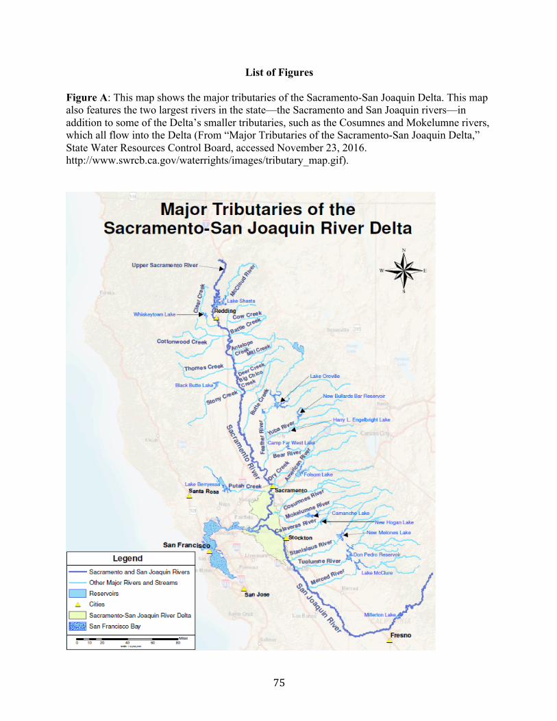
75
List of Figures
Figure A: This map shows the major tributaries of the Sacramento-San Joaquin Delta. This map also features the two largest rivers in the state—the Sacramento and San Joaquin rivers—in addition to some of the Delta’s smaller tributaries, such as the Cosumnes and Mokelumne rivers, which all flow into the Delta (From “Major Tributaries of the Sacramento-San Joaquin Delta,” State Water Resources Control Board, accessed November 23, 2016. http://www.swrcb.ca.gov/waterrights/images/tributary_map.gif).
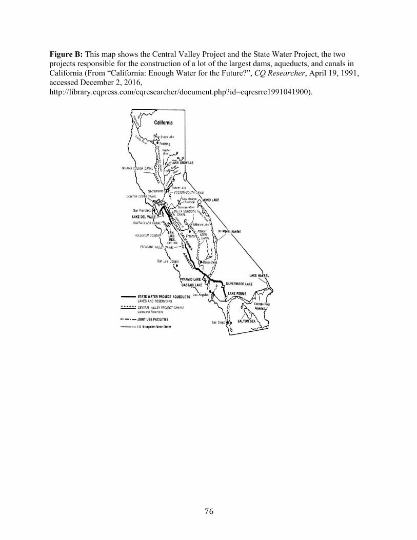
76
Figure B: This map shows the Central Valley Project and the State Water Project, the two projects responsible for the construction of a lot of the largest dams, aqueducts, and canals in California (From “California: Enough Water for the Future?”, CQ Researcher, April 19, 1991, accessed December 2, 2016, http://library.cqpress.com/cqresearcher/document.php?id=cqresrre1991041900).

77
Figure C: This map illustrates the “swamp and overflowed land” and “timbered” sloughs and “tules” along the Cosumnes River in 1864 (From G.H. Thompson, “Plat of the Rancho San Juan de los Moquelumnes Finally Confirmed to the Heirs of Anastasio Chabolla.”).

78
Figure D: The aerial photos below cover the years 1937, 1957, 1964, 1984, and 2016 and visually represent the changes in riparian forest stands present in the lower watershed over the course of 79 years. Other years are not included due to quality issues. The aerial images focus on the bottomland properties: Nicolaus Ranch and the properties on the Preserve known as Beacon Farms, Crump Ranch, and Wilkinson.
Year 1937 (From Lauren Sommer, Alison Whipple, and Geoff McGee, “Explore the Delta Through Time” [map], layer: 1937-1939 aerial photography, 1000 meters: 5000 feet, KQED Quest, San Francisco Estuary Institute – Aquatic Science Center, Bill Lane Center for the American West, and Stanford University, n.d., accessed November 29, 2016, http://web.stanford.edu/group/west/cgi-bin/projects/delta/map/.)
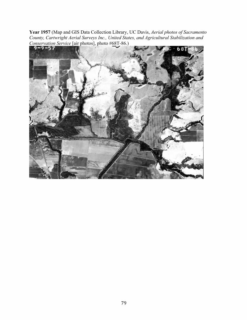
79
Year 1957 (Map and GIS Data Collection Library, UC Davis, Aerial photos of Sacramento County, Cartwright Aerial Surveys Inc., United States, and Agricultural Stabilization and Conservation Service [air photos], photo #68T-86.)
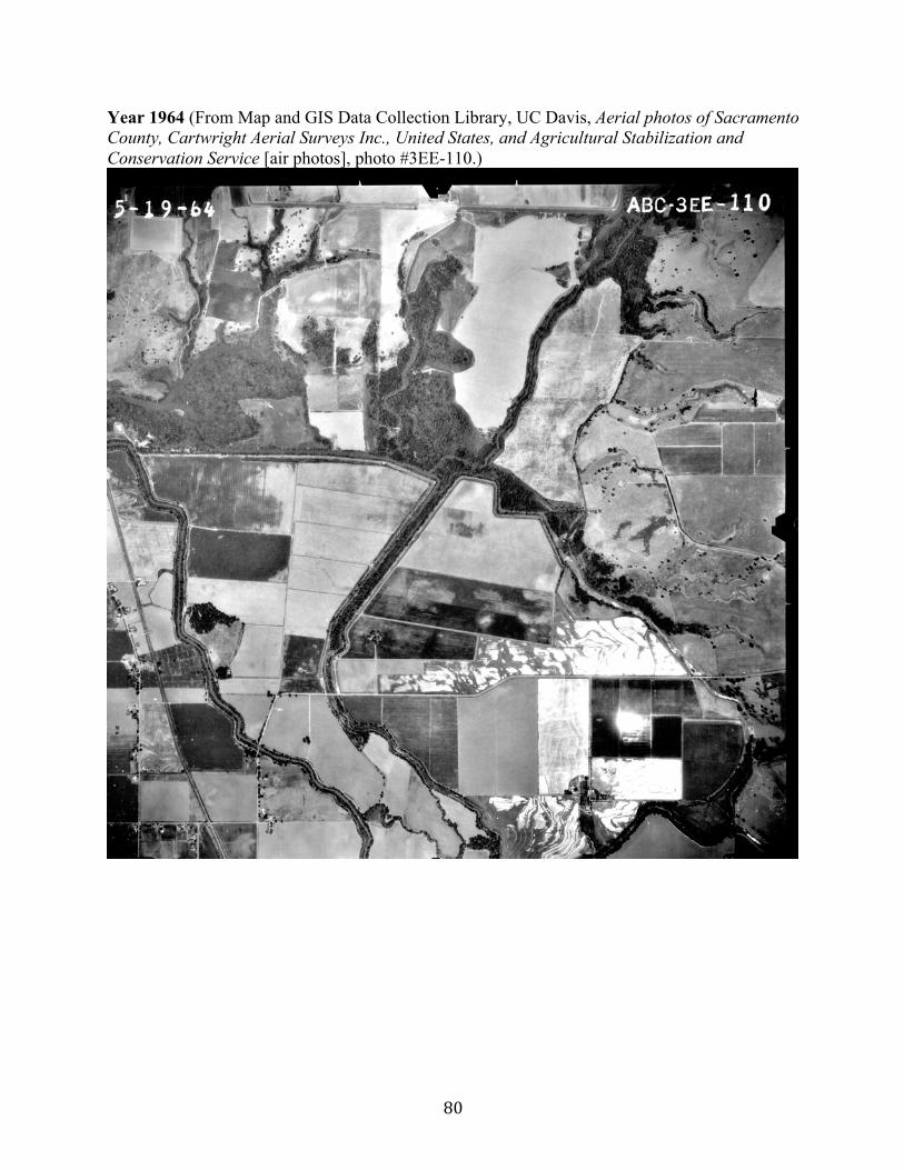
80
Year 1964 (From Map and GIS Data Collection Library, UC Davis, Aerial photos of Sacramento County, Cartwright Aerial Surveys Inc., United States, and Agricultural Stabilization and Conservation Service [air photos], photo #3EE-110.)
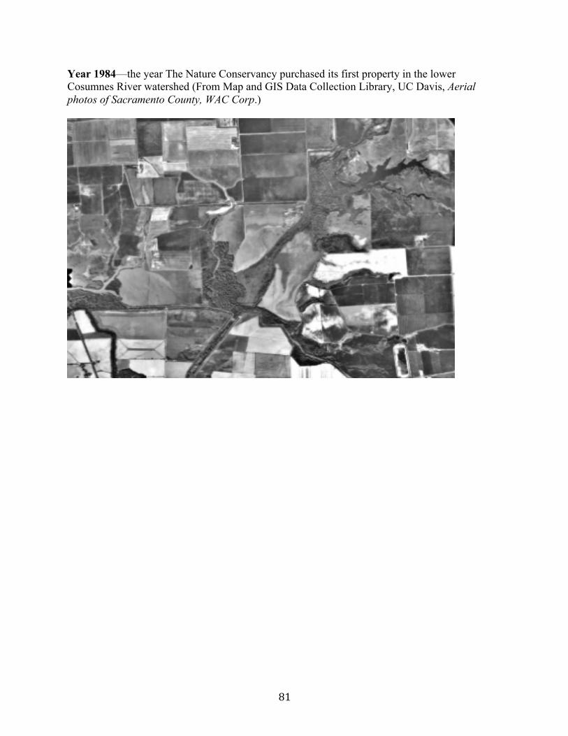
81
Year 1984—the year The Nature Conservancy purchased its first property in the lower Cosumnes River watershed (From Map and GIS Data Collection Library, UC Davis, Aerial photos of Sacramento County, WAC Corp.)
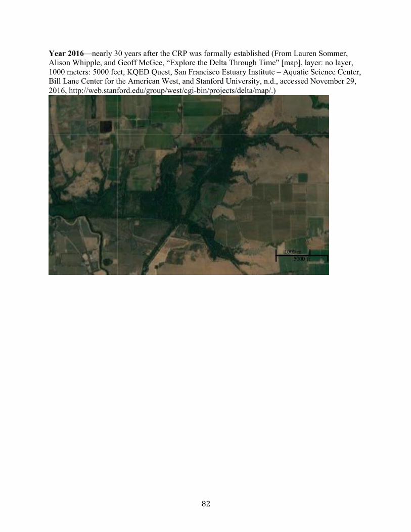
82
Year 2016—nearly 30 years after the CRP was formally established (From Lauren Sommer, Alison Whipple, and Geoff McGee, “Explore the Delta Through Time” [map], layer: no layer, 1000 meters: 5000 feet, KQED Quest, San Francisco Estuary Institute – Aquatic Science Center, Bill Lane Center for the American West, and Stanford University, n.d., accessed November 29, 2016, http://web.stanford.edu/group/west/cgi-bin/projects/delta/map/.)
83
Bibliography Aerial Images Map and GIS Data Collection Library, UC Davis. Aerial photos of Sacramento County, WAC Corp.
[air photos]. No scale. Photos #8-60-62, 72-74, 170-173. Eugene, OR, 1984. ———. Aerial photos of Sacramento County, Cartwright Aerial Surveys Inc., United States, and
Agricultural Stabilization and Conservation Service [air photos]. No scale. Photos #3EE-110, 112. Washington, D.C., 1964.
———. Aerial photos of Sacramento County, Cartwright Aerial Surveys Inc., United States, and
Agricultural Stabilization and Conservation Service [air photos]. 1:63,360. Photos #68T-83-88, 156-157. Washington, D.C., 1957.
———. Aerial photos of Sacramento County, United States Department of Agriculture, Agricultural
Adjustment Administration [air photos]. 1:20,000. Photos #47-43-49. Salt Lake City, UT, 1937. Central Valley “About the Central Valley Project.” U.S. Bureau of Reclamation. May 18, 2016. Accessed December
1, 2016. http://www.usbr.gov/mp/cvp/about-cvp.html. “California: Enough Water for the Future?” CQ Researcher. April 19, 1991. Accessed December 2,
2016. http://library.cqpress.com/cqresearcher/document.php?id=cqresrre1991041900. “Federal Agencies Release Data Showing California Central Valley Idle Farmland Doubling During
Drought.” NASA. October 21, 2015. Accessed November 4, 2016. http://landsat.gsfc.nasa.gov/federal-agencies-release-data-showing-california-central-valley-idle-farmland-doubling-during-drought/.
Cosumnes River Preserve: “Cosumnes Profile Notes.” N.d. Provided to author by The Nature Conservancy. November 17, 2016. Cuff, Denis. “Sandhill cranes bring their trumpet and dance to the Delta each winter.” Contra Costa
Times. June 25, 2014. Accessed November 29, 2016. http://www.cosumnes.org/sandhill-cranes-bring-their-trumpet-and-dance-to-the-delta-each-winter/.
Griggs, Tom, “History of the Riparian Forest Restoration Project, 1988-1990,” n.p., 1991. Cosumnes
River Preserve private archive, Galt, California. Historic FarmHouse Foundation. “Hicksville Restoration Project.” N.p., 1998. Cosumnes River
Preserve private archive, Galt, California. Kleinschmidt Associates. “Cosumnes River Preserve Management Plan.” N.p., 2008. Accessed
October 10, 2015. http://www.cosumnes.org/about-the-preserve/.
84
“Lower Cosumnes River Watershed.” 37 25’ 19.1” N, 122 05’ 06” W. Google Earth, December 1987. Accessed January 10, 2017.
“Lower Cosumnes River Watershed.” 37 25’ 19.1” N, 122 05’ 06” W. Google Earth. December 2016.
Accessed January 10, 2017. “New Conservation Solutions: The Valensin Ranch Project.” N.p., n.d. Cosumnes River Preserve
private archive, Galt, California. Peak, Melinda. “Evaluation of Significance of Structures Located within the Valensin Ranch
Headquarters, Sacramento County, California.” El Dorado Hills: Peak & Associates, Inc., 1997. Cosumnes River Preserve private archive, Galt, California.
“Project History.” UC Davis Center for Watershed Sciences. Accessed November 18, 2016.
https://watershed.ucdavis.edu/doc/cosumnes-research-group/project-history.
Reiner, Rich and Robin Cox. Legacy Profile: Cosumnes River Preserve (long version). January 2015. Provided via email by Brynn Pewtherer. June 15, 2016.
“The Cosumnes River Preserve Sustainable Farm Plan: A Three Year Transition to Wildlife Friendly
Organic Farming.” N.p., 1996. Cosumnes River Preserve private archive, Galt, California. The Nature Conservancy. “Cosumnes River Summary Materials,” 1999. Provided to author by The
Nature Conservancy, November 17, 2016. ———. “California Nature Conservancy Dedicates Cosumnes River Preserve.” Press Release, May
30, 1987. Provided to author by The Nature Conservancy. November 17, 2016. Government Documents Norris, S.J. El Dorado Irrigation District Report on the Riparian Rights in the Lower Cosumnes
River. Oroville: El Dorado Irrigation District, 1927. Cosumnes River Preserve private archive, Galt, California.
U.S. Bureau of Reclamation. Cosumnes River Division Reformulation Study, Central Valley Project,
California: Concluding Report. S.I.: U.S. Bureau of Reclamation, 1979, Water Resources Archive and Collections, University of California, Riverside. Quoted in Bennett, Karen Louise. “The River That Got Away: An Investigation into the Proposed Development Projects, the Players and the Political Climate That Helped Shape the Fate of the Cosumnes River.” Master’s Thesis, California State University, Sacramento, 1997, 72.
U.S. Department of the Interior. Cosumnes River Division, Central Valley Project, California: A
Report on the Feasibility of Water Supply Development. Sacramento: The Region, 1968. Special Collections, Water Resources Archive and Collections, University of California, Riverside.
85
———. “Cosumnes River Division Central Valley Project Water Quality Control Study.” San Francisco: Federal Water Control Administration, 1967. Cosumnes River Preserve private archive, Galt, California.
Maps Boyd, J.C. “Survey Map of Properties and Swamp and Overflowed Land along the Cosumnes River
Located in T6NR5 & 6E, and T5NR5E” [map]. No scale. N.p., 1929. Survey copied by J. C. Boyd from 1867 plats in U.S. Land Office at Sacramento, CA. County, Public Works Agency, Dept. Transportation Collection. Center for Sacramento History, Sacramento, California.
California Department of Water Resources. “Sacramento Co., 1984 Land Use” [map]. No scale.
Sacramento: The Dept., 1984. Map and GIS Data Collection Library, UC Davis.
Crawford, L. A., and E. B. Hurd. “Type of Farming Areas: Sacramento River Valley, 1930” [map]. No scale. N.p., 1935. Map Case B. Earth Science and Map Collection Library, UC Berkeley.
Furley, H.J. “Official Map of Sacramento County,” [map]. 60 chains: 1 inch. Sacramento County
Surveyor Office, 1903. Provided to author by the Sacramento County Surveyor Office. June 2016.
“Major Tributaries of the Sacramento-San Joaquin Delta.” State Water Resources Control Board. Accessed November 23, 2016. http://www.swrcb.ca.gov/waterrights/images/tributary_map.gif.
Sommer, Lauren, Alison Whipple, and Geoff McGee. “Explore the Delta Through Time” [map].
Layer: 1937-1939 aerial photography. 1000 meters: 5000 feet. KQED Quest, San Francisco Estuary Institute – Aquatic Science Center, Bill Lane Center for the American West, and Stanford University, n.d. Accessed November 29, 2016. http://web.stanford.edu/group/west/cgi-bin/projects/delta/map/.
———. “Explore the Delta Through Time” [map]. Layer: No layer. 1000 meters: 5000 feet. KQED
Quest, San Francisco Estuary Institute – Aquatic Science Center, Bill Lane Center for the American West, and Stanford University, n.d. Accessed November 29, 2016. http://web.stanford.edu/group/west/cgi-bin/projects/delta/map/.
Stephens, Thos S. “Map of Ranch San Jon de los Mokelumnes showing the lands awarded to all
parties interested in Ranch San Jon de los Mokelumnes according to the decree surveyed and compiled by order of the referees by Thos S. Stephens” [map]. No Scale. N.p., ca. 1900. Sacramento County Recorder’s Office Collection. Center for Sacramento History, Sacramento, California.
Thompson, G.H. “Plat of the Rancho San Juan de los Moquelumnes Finally Confirmed to the Heirs
of Anastasio Chabolla” [map]. 80 chs: 1 inch. U.S. Surveyor General, 1862. Sacramento County Recorder’s Office Collection. Center for Sacramento History, Sacramento, California.
86
Sacramento-San Joaquin Delta “McCormick-Williamson Tract Project.” California EcoRestore. Accessed November 18, 2016,
http://resources.ca.gov/docs/ecorestore/projects/McCormack_Williamson_Tract_Project.pdf. “Modified Pipeline Tunnel Option,” California Department of Water Resources, December 2014,
accessed November 28, 2016, http://baydeltaconservationplan.com/Libraries/Dynamic_Document_Library/BCDP_Modified_Pipeline_Tunnel_Option_Factsheet_12-19-14.sflb.ashx.
Robinson, April, Samuel Safran, and Julie Beagle, “A Delta Renewed: A Guide to Science-Based
Ecological Restoration in the Sacramento-San Joaquin,” San Francisco Estuary Institute—Aquatic Science Center, a report of SFEI-ASC’s Resilient Landscapes Program, publication #799, Richmond, CA, 2016.
“Sacramento—region counties will see strong population growth.” Sacramento Business Journal.
February 1, 2013. Accessed November 28, 2016. http://www.bizjournals.com/sacramento/news/2013/01/31/sacramento-region-population-growth.html.
Sommer, Lauren. “About that $17 Billion Water Project: Delta Tunnels 101.” KQED Science. July
25, 2016. Accessed November 28, 2016. https://ww2.kqed.org/science/2016/07/25/about-that-17-billion-water-project-delta-tunnels-101/.
The Delta Protection Commission, California Department of Fish and Wildlife Ecosystem
Restoration Program, Ducks Unlimited, and Delta Eco Farms. “Delta Working Lands Final Program Final Report.” September 2013. Accessed November 23, 2016. http://www.delta.ca.gov/res/docs/landscapes/DWL_Final_Report_9-2013.pdf.
Weiser, Matt. “California to dam Delta sloughs if drought persists.” The Sacramento Bee. March 11,
2014. Accessed December 1, 2016. http://www.sacbee.com/news/state/california/water-and-drought/delta/article2592919.html.
Scientific Studies Ahearn, Dylan S, Richard W Sheibley, Randy A Dahlgren, and Kaylene E Keller. “Temporal
Dynamics of Stream Water Chemistry in the Last Free-Flowing River Draining the Western Sierra Nevada, California.” Journal of Hydrology 295, no. 1–4 (2004): 47–63.
Barry, Sheila J. “Managing the Sacramento Valley Vernal Pool Landscape to Sustain the Native
Flora.” In Ecology, Conservation, and Management of Vernal Pool Ecosystems – Proceedings from a 1996 Conference, edited by C.W. Witham, E.T. Bauder, D. Belk, W.R. Ferren Jr., and R. Ornduff, 236-240. Sacramento: California Native Plant Society, 1998.
87
Booth, Eric, Jeff Mount, and Joshua H. Viers. “Hydrologic Variability of the Cosumnes River Floodplain.” San Francisco Estuary and Watershed Science 4, no. 2 (2006): 1-19. Accessed October 11, 2016. http://escholarship.org/uc/item/71j628tv.
Brouder, Sylvie M. and James .E. Hill, “Winter Flooding of Ricelands Provides Waterfowl Habitat,”
California Agriculture 46, no. 6 (1995): 58-64. Fleckenstein, Jan, Michael Anderson, Graham Fogg, and Jeffrey Mount. “Managing surface water-
groundwater to restore fall flows in the Cosumnes River.” Journal of Water Resources Planning and Management 130, no. 4 (2004): 301-316.
Fleckenstein. Jan, Richard Niswonger, and Graham Fogg. “River-Aquifer Interactions, Geologic
Heterogeneity, and Low-Flow Management.” Ground Water 44, no. 6. Accessed May 26, 2017. http://onlinelibrary.wiley.com/doi/10.1111/j.1745-6584.2006.00190.x/full.
Marty, Jaymee T. “Effects of Cattle Grazing on Diversity in Ephemeral Wetlands.” Conservation
Biology 19, no. 5 (2005): 1626-1627. Moyle, Peter B., Patrick K. Crain, and Keith Whitener. “Patterns in the Use of a Restored California
Floodplain by Native and Alien Fishes.” San Francisco Estuary and Watershed Science 5, no. 3 (2007): 1-27. Accessed October 11, 2016. http://escholarship.org/uc/item/6fq2f838.
Shuford, D. W., Reiter, M.E., Strum, K. M., Michelle M., Gilbert, Hickey, C.M., and Golet, G.M.
“The benefits of crops and field management practices to wintering water birds in the Sacramento-San Joaquin Delta.” Renewable Agriculture and Food Systems 31, no. 6 (2015): 495-506.
Other Primary Sources: “Bios of historical Galt people.” N.p., n.d, Provided to author by the Galt Area Historical Society.
July, 2016. “BLM draft plan proposes Mokelumne River protection.” Bureau of Land Management. January
2007. Accessed November 28, 2016. http://www.foothillconservancy.org/pages/latest_focus.cgi?_pf_=1&magid=27&magi_detail=376&magcatid=.
“California’s Vernal Pools.” California Department of Fish and Wildlife. Last modified June 13,
2013. Accessed November 18, 2016. https://www.wildlife.ca.gov/Conservation/Plants/Vernal-Pools.
“Cosumnes Coalition Vision.” Provided via email by Melinda Hurzel-Frost. June 3, 2017. Frémont, JC. Report of the exploring expedition to the Rocky Mountains, Oregon and California.
Washington, D.C.: Gales and Seaton, 1845. Quoted in Whipple AA, Grossinger RM, Rankin D, Stanford B, Askevold RA. “Sacramento-San Joaquin Delta Historical Ecology Investigation:
88
Exploring Pattern and Process.” Prepared for the California Department of Fish and Game and Ecosystem Restoration Program. A report of SFEI-ASC’s Historical Ecology Program, publication #672. San Francisco-Estuary Institute-Aquatic Science Center, Richmond, CA, 2012. 300.
“Floodplain Management Can Increase Groundwater Supply.” UC Water. April 9, 2015. Accessed
June 3, 2017. http://ucwater.org/news/floodplain-management-can-increase-groundwater-supply. Gledhill, Lynda. “Elk Grove/Sacramento County city is nation’s fastest-growing/Census confirms
status – police, builders, schools try to keep up.” SF Gate. June 25, 2000. Accessed November 18, 2016. http://www.sfgate.com/bayarea/article/ELK-GROVE-Sacramento-County-city-is-nation-s-2532741.php.
Hickey, Ban. “Excerpts from the History of the Hickey Family.” In Tapestry, A Collection of Writing
from Pioneer Days. Edited by Eugenia Olson. Galt: The Galt Area Historical Society, n.d.
Hurzel-Frost, Melinda, Mike Eaton, and Kimberly Petree. 2016 Cosumnes River Watershed Update and Plan. Report for the Cosumnes Coalition. November 2016.
Jenkins, Matt. “On the Wing.” Nature Conservancy Magazine. August/September 2014. Accessed
November 23, 2016. http://www.nature.org/magazine/archives/on-the-wing-2.xml. Johnson, Michelaina. “Cosumnes River Provides Model for Floodplain Restoration in California.”
Water Deeply. April 19, 2017. Accessed June 3, 2017. https://www.newsdeeply.com/water/articles/2017/04/19/cosumnes-river-provides-model-for-floodplain-restoration-in-california.
Muir, John. “Dam Hetch Hetchy!” Accessed November 18, 2016.
http://historymatters.gmu.edu/d/5720/. Pinkerton, Elizabeth. “Where in the world was Hicksville? Part 2.” Elk Grove Citizen. June 21, 1995. “Sandhill Crane.” Audubon Society. Accessed November 18, 2016. http://ca.audubon.org/birds-
0/sandhill-crane. Sustainable Groundwater Management Act.” Water Education Foundation. Accessed June 3, 2017.
http://www.watereducation.org/aquapedia-background/sustainable-groundwater-management-act-sgma.
Thompson, Thomas Hinckley and Albert Augustus West. History of Sacramento County, California:
With Illustrations Descriptive of Its Scenery, Residences, Public Buildings, Fine Blocks, and Manufactories from Original Sketches by Artists of the Highest Ability. Oakland: Thompson & West, 1880.
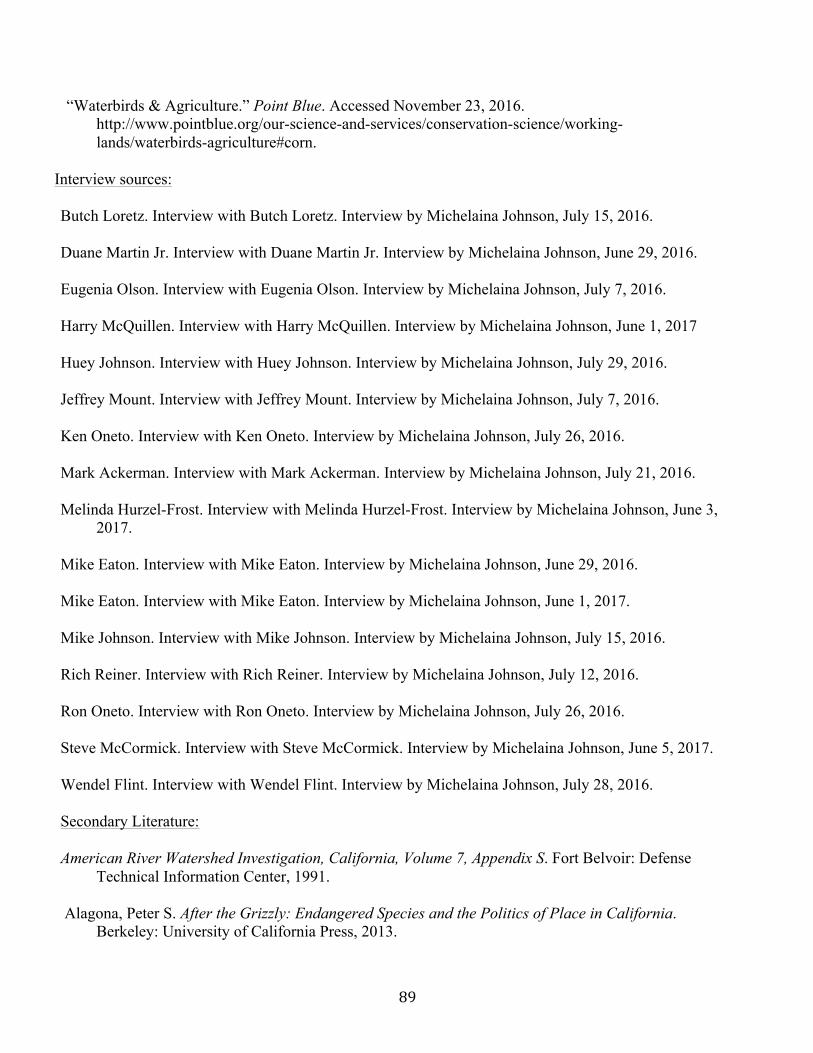
89
“Waterbirds & Agriculture.” Point Blue. Accessed November 23, 2016. http://www.pointblue.org/our-science-and-services/conservation-science/working-lands/waterbirds-agriculture#corn.
Interview sources: Butch Loretz. Interview with Butch Loretz. Interview by Michelaina Johnson, July 15, 2016. Duane Martin Jr. Interview with Duane Martin Jr. Interview by Michelaina Johnson, June 29, 2016.
Eugenia Olson. Interview with Eugenia Olson. Interview by Michelaina Johnson, July 7, 2016. Harry McQuillen. Interview with Harry McQuillen. Interview by Michelaina Johnson, June 1, 2017
Huey Johnson. Interview with Huey Johnson. Interview by Michelaina Johnson, July 29, 2016.
Jeffrey Mount. Interview with Jeffrey Mount. Interview by Michelaina Johnson, July 7, 2016. Ken Oneto. Interview with Ken Oneto. Interview by Michelaina Johnson, July 26, 2016. Mark Ackerman. Interview with Mark Ackerman. Interview by Michelaina Johnson, July 21, 2016. Melinda Hurzel-Frost. Interview with Melinda Hurzel-Frost. Interview by Michelaina Johnson, June 3,
2017.
Mike Eaton. Interview with Mike Eaton. Interview by Michelaina Johnson, June 29, 2016. Mike Eaton. Interview with Mike Eaton. Interview by Michelaina Johnson, June 1, 2017.
Mike Johnson. Interview with Mike Johnson. Interview by Michelaina Johnson, July 15, 2016.
Rich Reiner. Interview with Rich Reiner. Interview by Michelaina Johnson, July 12, 2016.
Ron Oneto. Interview with Ron Oneto. Interview by Michelaina Johnson, July 26, 2016. Steve McCormick. Interview with Steve McCormick. Interview by Michelaina Johnson, June 5, 2017.
Wendel Flint. Interview with Wendel Flint. Interview by Michelaina Johnson, July 28, 2016. Secondary Literature: American River Watershed Investigation, California, Volume 7, Appendix S. Fort Belvoir: Defense
Technical Information Center, 1991. Alagona, Peter S. After the Grizzly: Endangered Species and the Politics of Place in California.
Berkeley: University of California Press, 2013.
90
Anderson, Kat. Tending the Wild: Native American Knowledge and the Management of California’s Natural Resources. Berkeley: University of California Press, 2005.
Bennett, Karen Louise. “The River That Got Away: An Investigation into the Proposed
Development Projects, the Players and the Political Climate That Helped Shape the Fate of the Cosumnes River.” Master’s Thesis, California State University, Sacramento, 1997.
Carle, David. Introduction to Water in California. Berkeley: University of California Press, 2004. Chan, Sucheng. This Bittersweet Soil: The Chinese in California Agriculture, 1860-1910. Berkeley:
University of California Press, 1986. Chu, George. “Chinatowns in the Delta: The Chinese in the Sacramento-San Joaquin Delta, 1870–
1960.” California Historical Society Quarterly 49, no. 1 (1970): 21-37. Cioc, Mark. The Rhine: An Eco-Biography, 1815-2000. Seattle: University of Washington Press,
2002. Conca, Ken. Governing Water: Contentious Transnational Politics and Global Institution Building.
Cambridge: The MIT Press, 2005. Garone, Philip. “Managing the Garden: Agriculture, Reclamation and Restoration in the
Sacramento-San Joaquin Delta.” Delta Narratives Project, Delta Protection Commission, 2015. Accessed September 23, 2015. http://www.delta.ca.gov/Delta_Narratives.htm.
———. The Fall and Rise of the Wetlands of California’s Great Central Valley.
Berkeley: University of California Press, 2011. Hays, Samuel P., and Barbara D. Beauty, Health, and Permanence: Environmental Politics in the
United States, 1955-1985. Cambridge: Cambridge University Press, 1987. Hundley, Norris. The Great Thirst: Californians and Water -a History. Rev. ed. Berkeley:
University of California Press, 2001.
Hurtado, Albert L. Indian Survival on the California Frontier. New Haven: Yale University Press, 1988.
Ingram, Lynn and Frances Malamud-Roam. The West Without Water: What Past Floods, Droughts,
and Other Climatic Clues Tell Us About Tomorrow. Berkeley: University of California Press, 2013.
Kahrl, William L. The California Water Atlas. Los Altos: The Governor’s Office of Planning and
Research, 1979.
91
Kelley, Robert Lloyd. Battling the Inland Sea: Floods, Public Policy, and the Sacramento Valley. Berkeley: University of California Press, 1998.
Kreissman, Bern, and Barbara Lekisch. California, an Environmental Atlas & Guide. Davis: Bear
Klaw Press, 1991. Lund, Jay, Ellen Hanak, William Fleenor, Richard Howitt, Jeffrey Mount, and Peter Moyle.
Envisioning Futures for the Sacramento-San Joaquin Delta. San Francisco: Public Policy Institute of California, 2007.
Mount, Jeffrey F. California Rivers and Streams: The Conflict between Fluvial Process and Land
Use. Berkeley: University of California Press, 1995. Noble, John Wesley. Its Name Was M.U.D.: A Story of Water. Oakland: East Bay Municipal Utility
District, 1970. O’Neill, Karen M. Rivers by Design: State Power and the Origins of U.S. Flood Control. Durham:
Duke University Press, 2006.
Owens-Viana, Lisa. “Winter-Flooded Fields Benefit Farmers and Wildlife.” In Sustainable Use of Water: California Success Stories, edited by Lisa Owens-Viani, Arlene K. Wong, and Peter H. Gleick, 199-213. Oakland: Pacific Institute for Studies in Development, Environment, and Society, 1999.
Palmer, Tim. Field Guide to California Rivers. California Natural History Guides, no. 105. Berkeley:
University of California Press, 2012. Pincetl, Stephanie Sabine. Transforming California: A Political History of Land Use and
Development. Baltimore: Johns Hopkins University Press, 1999. Robertson-Bryan, Inc. Lower Cosumnes River Watershed Assessment. N.p., 2006. Cosumnes River
Preserve private archive, Galt, California. Siciliano-Kutchins, Regina R. “Historical Land Use: A Study of the Early Human Occupation of the
North Delta Region of Sacramento County.” Master’s Thesis, California State University, Sacramento, 1980.
Steding, Anna. “Restoring Riparian Forests and Natural Flood Regimes: The Cosumnes River
Preserve.” In Sustainable Use of Water: California Success Stories, edited by Lisa Owens-Viani, Arlene K. Wong, and Peter H. Gleick, 229-239. Oakland: Pacific Institute for Studies in Development, Environment, and Society, 1999.
Stevens, Michelle L. and Emilie Zaloza. “Fire, Floodplains and Fish: the Historic Ecology of the
Lower Cosumnes River Watershed.” In Rivers, Fish and the People. Tradition, Science and Historical Ecology of River Fisheries in the American West, edited by Pei Lin Yu, 155-187. Salt Lake City: University of Utah Press, 2015.
92
Thompson, John. Settlement Geography of the Sacramento-San Joaquin Delta. PhD diss., Stanford University, 1957.
Tu, I-Yum Mandy. “Vegetation Patterns and Processes of Natural Regeneration in Periodically Flooded Riparian Forests in the Central Valley of California.” PhD diss., University of California, Davis, 2000. Vaught, David. After the Gold Rush: Tarnished Dreams in the Sacramento Valley. Baltimore: Johns
Hopkins University Press, 2007. Whipple AA, Grossinger RM, Rankin D, Stanford B, Askevold RA. “Sacramento-San Joaquin
Delta Historical Ecology Investigation: Exploring Pattern and Process.” Prepared for the California Department of Fish and Game and Ecosystem Restoration Program. A report of SFEI-ASC’s Historical Ecology Program, publication #672, San Francisco-Estuary Institute-Aquatic Science Center, Richmond, CA, 2012.
White, Richard. The Organic Machine. New York: Hill and Wang, 1995.


