88
S C I E N C E & T E C H N O L O G Y T R E N D S
89
Q U A R T E R L Y R E V I E W N o . 1 6 / J u l y 2 0 0 5
7
Effectiveness of the Quasi-Zenith Satellite Systemin Ubiquitous Positioning
TERUHISA TSUJINO
General Unit
1 Introduction
Recently, a variety of research is underway
targeted at “ubiquitous positioning” in many
countries including U.S.A., U.K., France and
Australia. In Japan, for instance, a study on the
application of ubiquitous positioning to the
distribution of goods has been carried out by
University of Tokyo. “Ubiquitous” means “existing
at any place, at any time” or “omnipresent.”
In a future information society, methods for
measuring precisely where you are will be as
important and matter-of- course as ubiquitous
hardware devices such as wearable computers
and IC tags. This trend is heralded by the
fact that millions of mobile phone users have
signed up for positional information services.
Although the positional accuracy currently
available from mobile phone services is still
low, even sometimes giving wrong information,
the mainstream will shift to utilization of the
Global Posit ioning System (GPS) for much
higher accuracy. You can calculate your exact
position using time signals from more than four
GPS satellites simultaneously. GPS has already
established itself as one of the key components of
nation-level infrastructure and has been used in a
variety of social activities.
In ordinary life, time is expressed in terms
of hours, minutes and seconds. In ubiquitous
posit ioning, your location is expressed in
terms of degrees, minutes and seconds to the
precision of one tenth second in both longitude
and latitude*1. Linking positional information
with other sources of information will also
be a commonplace application; geographical
information systems will show you the local area
map, and other systems will provide interesting
related information.
T h e M i n i s t r y o f I n t e r n a l A f f a i r s a n d
Communications (MIAC) has launched a research
project, scheduled to be completed by April of
2007, to build a high-performance infrastructure,
providing police, f ire f ighting agencies and
mar it ime sa fet y agencies with enhanced
emergency calls capabilities for improved safety
and freedom from care. Swift localization of the
transmitter has been a longstanding challenge
in mobi le phone emergency ca l ls. Mobi le
terminals with automatic positional information
transmission capability using GPS will enable
police to reach the spot much more quickly.
However, GPS positioning is often unavailable
in a reas without a clear sk yl ine, such as
mountainous terrain and densely populated areas,
because sufficient GPS satellites are not in sight.
This has been often pointed out as major blind
side in GPS utilization.
The Quasi -Zenith Satellite System (QZSS),
which will be complementary and augmentative
with GPS, will be the most effective in solving
this problem. System development will be carried
out through cooperative effort between the
public sector and governmental organizations,
including the MIAC, the Ministry of Education,
Culture, Sports, Science and Technology (MEXT),
the Ministry of Economy, Trade and Industry
(METI) and the Ministry of Land, Infrastructure
and Transportation (MLIT), Japan's original
satellites system will also provide substantial
impetus and business opportunities to the
aerospace industry.
This ar t icles g ives an overal l picture of
88
S C I E N C E & T E C H N O L O G Y T R E N D S
89
Q U A R T E R L Y R E V I E W N o . 1 6 / J u l y 2 0 0 5
many aspects paving the way to ubiquitous
positioning, including the status of the U.S. GPS
satellite system and its inherent blind side, an
overview of the emergency calls enhancement
project initiated by the MIAC, the architecture
and role of the Quasi -Zenith Satellite System,
and research trends in enhanced positioning
technology under taken by min istr ies and
research organizations. Quasi -Zenith Satellites
can be multipurpose entities: they can be used,
depending on the instruments they carry, for
communications, broadcasting and monitoring
as well as their original purpose of positioning.
However, it is apparent that priority l ies in
positioning (complementation and augmentation
of the existing GPS system) over other missions
such as communications and broadcasting.
I therefore propose that the role of the first
QZSS system concentrate on complementing
and augmenting the GPS system. I also propose
establishing a governmental organization that
presides over the entire project for the early
implementation of a ubiquitous positioning
system using the Quasi-Zenith Satellites.
2 GPS satellites system
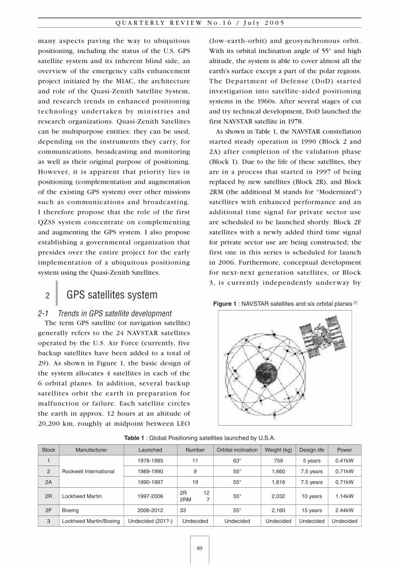
2-1 Trends in GPS satellite developmentThe term GPS satellite (or navigation satellite)
generally refers to the 24 NAVSTAR satellites
operated by the U.S. Air Force (currently, five
backup satellites have been added to a total of
29). As shown in Figure 1, the basic design of
the system allocates 4 satellites in each of the
6 orbital planes. In addition, several backup
satel l ites orbit the earth in preparation for
malfunction or failure. Each satellite circles
the earth in approx. 12 hours at an altitude of
20,200 km, roughly at midpoint between LEO
(low- earth - orbit) and geosynchronous orbit.
With its orbital inclination angle of 55° and high
altitude, the system is able to cover almost all the
earth’s surface except a part of the polar regions.
The Department of Defense (DoD) star ted
investigation into satellite - aided positioning
systems in the 1960s. After several stages of cut
and try technical development, DoD launched the
first NAVSTAR satellite in 1978.
As shown in Table 1, the NAVSTAR constellation
started steady operation in 1990 (Block 2 and
2A) after completion of the validation phase
(Block 1). Due to the life of these satellites, they
are in a process that started in 1997 of being
replaced by new satellites (Block 2R), and Block
2RM (the additional M stands for “Modernized”)
satellites with enhanced performance and an
additional time signal for private sector use
are scheduled to be launched shortly. Block 2F
satellites with a newly added third time signal
for private sector use are being constructed; the
first one in this series is scheduled for launch
in 2006. Furthermore, conceptual development
for next-next generation satellites, or Block
3, is currently independently underway by
Figure 1 : NAVSTAR satellites and six orbital planes [1]
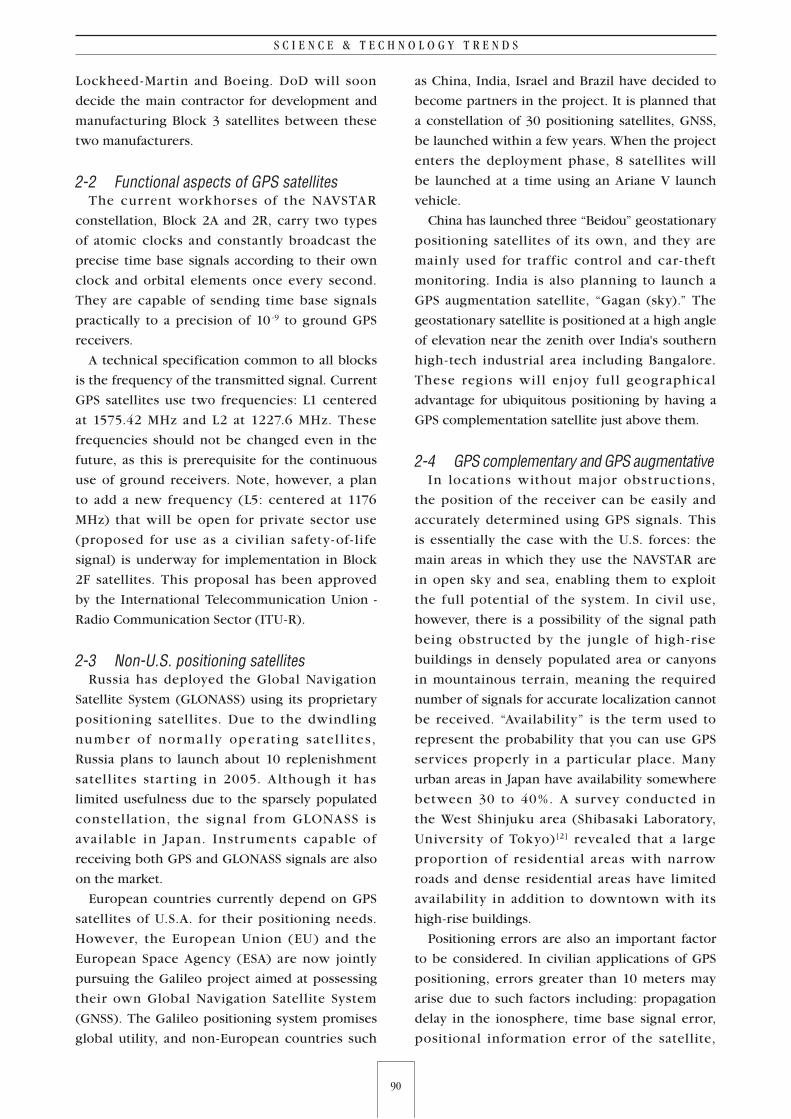
Table 1 : Global Positioning satellites launched by U.S.A.
Block Manufacturer Launched Number Orbital inclination Weight (kg) Design life Power
1
Rockwell International
1978-1985 11 63° 759 5 years 0.41kW
2 1989-1990 9 55° 1,660 7.5 years 0.71kW
2A 1990-1997 19 55° 1,816 7.5 years 0.71kW
2R Lockheed Martin 1997-20062R 122RM 7
55° 2,032 10 years 1.14kW
2F Boeing 2006-2012 33 55° 2,160 15 years 2.44kW
3 Lockheed Martin/Boeing Undecided (201?-) Undecided Undecided Undecided Undecided Undecided
90
S C I E N C E & T E C H N O L O G Y T R E N D S
91
Q U A R T E R L Y R E V I E W N o . 1 6 / J u l y 2 0 0 5
Lockheed -Martin and Boeing. DoD will soon
decide the main contractor for development and
manufacturing Block 3 satellites between these
two manufacturers.
2-2 Functional aspects of GPS satellites The current workhorses of the NAVSTAR
constellation, Block 2A and 2R, carry two types
of atomic clocks and constantly broadcast the
precise time base signals according to their own
clock and orbital elements once every second.
They are capable of sending time base signals
practically to a precision of 10 -9 to ground GPS
receivers.
A technical specification common to all blocks
is the frequency of the transmitted signal. Current
GPS satellites use two frequencies: L1 centered
at 1575.42 MHz and L2 at 1227.6 MHz. These
frequencies should not be changed even in the
future, as this is prerequisite for the continuous
use of ground receivers. Note, however, a plan
to add a new frequency (L5: centered at 1176
MHz) that will be open for private sector use
(proposed for use as a civilian safety- of - life
signal) is underway for implementation in Block
2F satellites. This proposal has been approved
by the International Telecommunication Union -
Radio Communication Sector (ITU-R).
2-3 Non-U.S. positioning satellites Russia has deployed the Global Navigation
Satellite System (GLONASS) using its proprietary
positioning satellites. Due to the dwindling
number of norma l ly operat ing satel l i tes,
Russia plans to launch about 10 replenishment
satel l ites star ting in 2005. A lthough it has
limited usefulness due to the sparsely populated
constel lation, the signal from GLONASS is
avai lable in Japan. Instruments capable of
receiving both GPS and GLONASS signals are also
on the market.
European countries currently depend on GPS
satellites of U.S.A. for their positioning needs.
However, the European Union (EU) and the
European Space Agency (ESA) are now jointly
pursuing the Galileo project aimed at possessing
their own Global Navigation Satellite System
(GNSS). The Galileo positioning system promises
global utility, and non-European countries such
as China, India, Israel and Brazil have decided to
become partners in the project. It is planned that
a constellation of 30 positioning satellites, GNSS,
be launched within a few years. When the project
enters the deployment phase, 8 satellites will
be launched at a time using an Ariane V launch
vehicle.
China has launched three “Beidou” geostationary
positioning satellites of its own, and they are
mainly used for traffic control and car - theft
monitoring. India is also planning to launch a
GPS augmentation satellite, “Gagan (sky).” The
geostationary satellite is positioned at a high angle
of elevation near the zenith over India's southern
high-tech industrial area including Bangalore.
These regions wil l enjoy ful l geographical
advantage for ubiquitous positioning by having a
GPS complementation satellite just above them.
2-4 GPS complementary and GPS augmentativeIn locations without major obstructions,
the position of the receiver can be easily and
accurately determined using GPS signals. This
is essentially the case with the U.S. forces: the
main areas in which they use the NAVSTAR are
in open sky and sea, enabling them to exploit
the full potential of the system. In civil use,
however, there is a possibility of the signal path
being obstructed by the jungle of high - rise
buildings in densely populated area or canyons
in mountainous terrain, meaning the required
number of signals for accurate localization cannot
be received. “Availability” is the term used to
represent the probability that you can use GPS
services properly in a particular place. Many
urban areas in Japan have availability somewhere
between 30 to 40%. A survey conducted in
the West Shinjuku area (Shibasaki Laboratory,
University of Tokyo)[2] revealed that a large
proportion of residential areas with narrow
roads and dense residential areas have limited
availability in addition to downtown with its
high-rise buildings.
Positioning errors are also an important factor
to be considered. In civilian applications of GPS
positioning, errors greater than 10 meters may
arise due to such factors including: propagation
delay in the ionosphere, time base signal error,
positional information error of the satellite,
90
S C I E N C E & T E C H N O L O G Y T R E N D S
91
Q U A R T E R L Y R E V I E W N o . 1 6 / J u l y 2 0 0 5
delay due to water vapor in the troposphere, and
multipath signals on the ground. The main source
of error is delay in the ionosphere. However,
this error can be compensated for using the
frequency difference between L1 and L2. Error
compensation using two frequencies will be
available for civilian applications when Block
2RM of GPS satellites is launched.
Low availability and measurement errors have
been pointed out as drawbacks in the use of
GPS, and the U.S. itself has admitted the need
for systems to complement and augment GPS
satellites.
“Complementary” and “augmentative” systems
have distinct meanings that must be clearly
defined.
“GPS complementary” is to allocate a satellite
(corresponding to one GPS satel l ite) at the
near-zenith position at all times. A near-zenith
satellite transmitting the L -band time based
signal and positional information can be actually
implemented.
“GPS augmentative” would be to improve
GPS accuracy, where, for example, a network of
fixed ground-based reference stations analyzes
errors in the signals received from GPS satellites
and produces corrective information as well as
integrity information for improved accuracy;
this information is distributed to other receiver
stations via various communication links. This
method is called Differential GPS (DGPS).
Methods for distributing GPS augmentative
information to end users have already been
implemented on a chargeable basis using
ground -base FM broadcasting, or by mobile
phones. However, these ser v ices rema in
inaccessible to some regions. I f we have a
near-zenith satellite in place, even regions that
cannot be reached from ground-base stations can
access GPS augmentative information by relaying
the S -band signal. GPS augmentative information
may differ from one locality to another; it is a
subject of future discussion as to how many
meshes are required to cover the whole of
Japan for consistent augmentative information
processing.
3 DOP number that determines GPS accuracy and minimizing atomic clock
3-1 DOP numberTo accurately determine 3 - d imensiona l
coordinates, you have to receive signals from four
or more of the satellites. It is desirable that the
four satellites be spatially arranged so that the
Dilution of Precision (DOP) number is as near to
1 as possible.
DOP is the index number that describes the
geometric quality of a GPS satellite configuration
in the sky. Ideally, one satellite at the zenith and
other three satellites, shifted 120° from each
other, constitutes a regular triangular pyramid.
This ideal configuration is represented by a DOP
number of 1, and it increases as the shape of the
pyramid deviates from the ideal configuration.
The number is calculated by comparing the
actual volume of the triangular pyramid with
that of the ideal configuration. GPS receivers
with accuracy-setting capability can use a DOP
number for setting their own accuracy level.
Although a DOP number of 1 is desirable, it is
very rare that a GPS satellite is actually close
enough to the zenith at any one time. In this
respect, a Quasi-Zenith Satellite in place can be
an effective complementary method to the GPS
system, so that the DOP number can attain value
near 1.
3-2 Minimizing atomic clockThe GPS satellite is an ultra -high precision
atomic clock orbiting the earth. Block 2 and
subsequent NAVSTAR satellites carry two types of
atomic clock: the cesium clock and the rubidium
clock.
Atomic clock components used to be very
large. Recently, however, with the development of
portable atomic clocks[3], they have become small
enough to fit in individual aircraft and vehicles of
U.S. forces. These machines had to receive time
base signals from positioning satellites to obtain
exact time information, but satellite signals have
often had to be replaced by the portable atomic
clock.
The U.S. Defense Advanced Research Project
92
S C I E N C E & T E C H N O L O G Y T R E N D S
93
Q U A R T E R L Y R E V I E W N o . 1 6 / J u l y 2 0 0 5
Agency (DARPA) has been undertaking research
into fabricating ultra-small atomic clock chips of
less than 1 cm3. If grain-sized atomic clock chips
become a reality, they will surely be integrated
into ordinary hand-held devices. Such a device
could be used for positioning applications on a
par with GPS satellites, making exact positioning
possible even if the signal from one of the GPS
satellites is obstructed.
4 Trends in GPS satellite application in Japan
4-1 Framework for GPS satellite applicationJapan, as well as other countries, shares in the
bounty of GPS, which is owned and operated
by the U.S. It has already become an essential
component of our social infrastructure, and many
of our activities could not take place without it.
Can we completely rely on the infrastructure
provided by another country?
In a Japan-U.S. joint communiqué issued in
September 1988, U.S. President Clinton and
Japanese Prime Minister Obuchi declared that
U.S. would continue to provide GPS services
free of charge to the whole world, and Japan
would cooperate in enhancing GPS application
technology. In October of the same year, the
U.S. House Representative and Senate both
passed a bill that prevented the President from
changing this open GPS policy without the
approval of congress. These developments have
enabled Japan to use GPS information without
anxiety, at least for the foreseeable future, and
manufacturing and sales of car navigation systems
in Japan took a sudden upward jump[4].
Although there is certain assurance for the
continuous, unobstructed use of GSP, there
is still some insecurity that access to the GPS
system might one day terminate or precision will
degrade in line with U.S. policy change. One
solution would be for Japan to launch its own
constellation of GPS satellites using proprietary
Japanese technology.
4-2 Typical application of GPSThe main use of GPS lies in acquiring positional
in formation with a var iety of appl ications
i nc lud i ng ca r n av iga t ion , G eog r aph ica l
Information Systems (GIS), geographical markers,
cadastra l su r veys, and cr usta l movement
monitoring. There are many other applications:
meteorological observation using the delay in
electromagnetic waves, anemometric observation
at sea using ref lected electromagnetic waves,
and reference clocks that solely use time base
information. In exploiting Quasi-Zenith Satellite
resources, the most advantageous application
would be enhancing emergency calls, especially
the automatic notification of a transmitter’s
location.
4-3 Enhanced emergency callWith the amazing preva lence of mobi le
phones in recent years, more than half of police
noti f ications are transmitted using mobi le
phones.
When an emergency ca l l i s sent f rom a
fixed-line phone, the sender can be easily located
using the telephone directory database. For
mobile phones, however, few good methods
are available to pinpoint transmitter location
with sufficient precision. In August 2003, IT
Strategy Headquarters stated that localization
and positional information notification of the
transmitter used for emergency calls must be
positioned among the most important and urgent
agenda items in the e - Japan Priority Policy
Program.
The U.S. government has made it mandatory,
since 1999, that mobile phone carriers equip their
devices with automatic positional information
notif ication capability when the subscriber
makes a emergency call (#911), which is called
Enhanced 911 (E911). The EU has also decided
to introduce E112 in 2002. Implementing this
emergency mechanism, however, has not made
much headway. In U.K. and Germany, legislation
review is underway to make this mechanism
mandatory.
In Japan, the decision made by the IT Strategy
Headquarters is equivalent to introducing a
Japanese version of E110 (police), E119 (fire
fighting) and E118 (maritime safety).
Fol lowing the IT Strategy Headquar ters’
decision, the Minister for Internal Affairs and
Communications, Mr. Taro Aso, submitted this
subject to the Information and Communications
92
S C I E N C E & T E C H N O L O G Y T R E N D S
93
Q U A R T E R L Y R E V I E W N o . 1 6 / J u l y 2 0 0 5
Policy Site (chaired by Mr. Yoshihisa Akiyama) for
deliberation (“Enhancement of Emergency calls
in Telecommunication Policy”). The committee
returned some of the deliberation results as
“Technical provisions required for subscriber
local ization in emergency cal ls” ( June 30,
2004)[5].
The repor t (par t ia l) is main ly based on
discussion in the Enhancement of Emergency
Calls Committee (a subdivision of the Information
and Communications Policy Site: chaired by
Prof. Norihisa Doi, Chuo University), whose
constituent members are mainly mobile phone
carr iers such as NTT DoCoMo, KDDI, and
Vodafone.
This partial report discussed the status of
emergency calls from mobile phones and the
need for positional information notification,
technica l condit ions related to posit ional
information notification, the time schedule, items
to be implemented and future assignments.
The schedule for implementation is as follows.
Handling of positional information in emergency
calls will start in April 2007. After this, on-board
positional information notification capability will
be compulsory for all new and updated mobile
phones. The projected prevalence of mobile
phones with this function will be 50% by 2009,
and 90% by 2011.
4-4 Effect of enhanced emergency callsWith the rapid increase in emergency calls
from mobile phones, the quick localization
of the transmitter is sometimes difficult. In
fact, the average time required to reach the
spot has become longer by 1.5 minutes (32%)
in these ten years in Japanese major cities
(ordinance-designated cities). The deterioration
is especially visible in these two or three years.
However, note that the overall time from the
occurrence of accident/incident to notification
to the police or related agency must be shorter
because callers without mobile phones must have
found a fixed-line telephone in the first place,
which may have taken a considerable time. With
the prevalence of mobile phones, it has become
common that multiple emergency calls reach the
authorities simultaneously, making the situation
more confusing; there may be calls from multiple
witnesses of a single incident or independent
witnesses of multiple incidents. Enhancing the
emergency call capability of mobile phones (for
example, E110) is expected to reduce the total
time and aid proper judgment for emergency
action.
If a large-scale disaster occurs, communication
us ing f i xed - l i ne phones may be severely
restr icted. However, emergency response
mechanisms are already in place to give highest
priority to emergency calls and maintain the flow
of communication.
4-5 Accuracy of positional information communication
According to the partial report, the required
accuracy of positional information is as follows:
positional accuracy should be within a radius of
15 m (best-case scenario), and the information
is represented by a latitude and longitude value
(in 0.1 sec unit) and altitude (in 1-m units). The
basic method of obtaining positional information
is to use GPS signals from four or more GPS
satellites; in this case, the practical accuracy of
the data is somewhere between several meters
to several tens of meters. When there is not a
sufficient number of GPS signals available, for
example, in densely populated urban areas
or inside buildings, a synchronization signal
from a base station will be used instead, in
which case positional accuracy will deteriorate
considerably from tens of meters to hundreds
of meters. Even this synchronization signal may
be unavailable in areas such as underground
cities and indoors, where cell-based positioning
will be used. In cell-based positioning, cell IDs
that were obtained from mobile terminals are
stored in a positioning server’s database, and the
relevant positional information is searched from
this database. The positional accuracy of the
cell-based method depends on the density of the
base station network; typical values are several
hundreds of meters in urban areas and about ten
thousand meters in regional areas.
In an open-sky environment, positioning using
GPS signals has clear advantages. However, this
does not apply in the majority of urban areas,
even in low-rise shopping areas and residential
areas. Full -fledged enhancement in emergency

94
S C I E N C E & T E C H N O L O G Y T R E N D S
95
Q U A R T E R L Y R E V I E W N o . 1 6 / J u l y 2 0 0 5
calls, as we expect it to be, may not be realized if
we completely depend on information provided
by U.S. GPS satel l ites because of their low
availability.
To m it igate these problems, the Japan
Aerospace Explorat ion Agency ( JA X A: an
independent administrative entity) is planning
to launch a geostationary Engineering Test
Satellite VIII (ETS -8) equipped with time signal
transmission capability around 2006. It will
be used to validate high-precision positioning.
Although, with its low elevation angle of 45°, it
will have limited capability to complement GPS,
the satellite is expected to play an important role
in enhanced emergency calls (E110, E119, and
E118) development.
5 Mechanism and roles of Quasi-Zenith Satellites
5-1 What is a Quasi-Zenith Satellite System?The Quasi -Zenith Satellite System (QZSS) is
a constellation of three satellites that orbit the
earth in synchronously with the rotation of the
earth (23 hours 56 minutes) on different orbital
planes, with at least one satellite positioned near
the zenith over the country at all times, in low
to middle latitude on the same line of longitude.
The geostationary satellite, on the other hand, is
positioned over the equator at all times, orbiting
every 23 hours and 56 minutes, and its position
is controlled from ground stations so that is does
not deviate from the fixed angle. Viewed from
the middle latitude regions, the geostationary
satel l ite is often invisible from the ground
obstructed by buildings and mountains due to
its low elevation angle (around 45 degrees at
most). The three Quasi-Zenith Satellites round the
earth reciprocating the northern and southern
hemisphere with their orbits cutting a figure of
8 when projected onto the earth’s surface. The
trajectory takes various orbital inclination and
eccentricity values, but is always centered on a
certain longitude.
5-2 Practical example of QZSS and research history in Japan
In the United States, Sirius Satellite Radio
launched three Si r ius satel l i tes for rad io
broadcasting covering the entire American
continent. The number of subscribers has just
recently exceeded 700,000, with a subscription
fee below $10 a month. The company forecasts
that the number will finally reach 50,000,000.
The Sirius satell ites (3.8 ton/satell ite) were
launched one by one using the Proton K launch
vehicle provided by Internat ional Launch
Services (ILS). The satellite bus for the Sirius
system is the LS -1300 series provided by Space
Systems/Loral, the same series as Japan’s MTSAT-1
(Multi - functional Transport Satellite). Because
of the vast stretches of the American continent,
“near-zenith” conditions cannot be maintained at
all places. It is therefore questionable to classify
the Sirius constellation as a Quasi-Zenith Satellite
system. Figure 3 shows the Sirius constellation
orbits, which look similar to those of QZSS.
The idea of Quasi -Zenith Satellites is long
standing in Japan. For example, the idea
w a s pu t fo r w a r d i n 1972 by t he R a d io
Research Laboratories (Ministry of Post and
Telecommunications), which was the predecessor
of the current NiCT (National Institute of
Information and Communication Technology)[8].
Based on the technology level of that time, the
plan to launch a constellation of satellites was
abandoned; decision and control of the orbit
was difficult, and the amount of fuel required
for orbital modification was excessive. Later that
decade (1997), as awareness of the importance
of proprietary positioning satellites as a national
infrastructure deepened, discussion resumed, and
a national project for Quasi-Zenith Satellites was
conducted. In 2002, Advanced Space Business
Corporation (ASBC) was established to promote
QZSS development. ASBC is a joint venture
Figure 2 : Comparison of Quasi-Zenith satellites and Geostationary satellites
Source: JAXA home page [6]

94
S C I E N C E & T E C H N O L O G Y T R E N D S
95
Q U A R T E R L Y R E V I E W N o . 1 6 / J u l y 2 0 0 5
between private companies. From 2003, with the
decision to allocate government budget to related
ministries (MIAC, MEXT, METI, and MLIT), the
full-fledged project has just begun.
5-3 Basic structure and role of GPS complementation QZSS(1) Functions of satellite
For GPS complementation, the Quasi -Zenith
Satellite must carry atomic clocks and antenna
for broadcasting as required mission instruments.
It also includes satellite bus including body
structure, solar panels, power equipments,
altitude control system (including propulsion
systems), TT&C systems, and thermal control
systems. The satellite is launched by a launch
vehicle into the geostationary transfer orbit,
and then the f inal transit ion is made to a
predetermined satellite orbit using an apogee
engine. The satellite must be mounted with an
apogee engine for this operation (note that, if
the satellite is launched using a four-stage launch
vehicle, such as Russia's Proton, an apogee engine
is not required on the satellite side).
To transmit GPS augmentation information,
the satellite must carry transponders to receive
augmentation information from the ground
station and broadcast to the ground. Figure 4
shows an external view of planned full-fledged
version (with positioning, communication, and
broadcast capability) of the Quasi-Zenith Satellite.
(2) Orbit of Quasi-Zenith Satellite
Figure 5 shows the planned trajectory of the
Quasi-Zenith Satellite. To realize this trajectory,
orbital elements are designed in the following
way. First, semi -major axis is designed to be
the same as that of the geostationary orbit.
The apogee must be larger than this by 3,000
to 5,000 km, and the perigee must be smaller
by the same amount. The resultant ellipsoid is
relatively near to a regular circle, with one of the
two focal points coinciding with the center of
Figure 3 : Orbital planes of Sirius satellites
Source: ILS document[7]
Figure 4 : External view of Quasi-Zenith Satellite (plan)
Source: ASBC document
Figure 5 Example of Quasi-Zenith Satellite trajectory projected on the earth’s surface
96
S C I E N C E & T E C H N O L O G Y T R E N D S
97
Q U A R T E R L Y R E V I E W N o . 1 6 / J u l y 2 0 0 5
the earth and other focal point lying within the
earth. The eccentricity for this ellipsoidal orbit is
approximately 0.1.
The orbital inclination is about 45°, covering
the sky in Japan to as far as Australia.
Placing three satellites those are shifted 120°
RAAN (Right Ascension of Ascending Node) to
each other makes three orbital planes, enabling
a constellation arrangement so that the satellite
in each orbital plane covers the Zenith over
Japan in succession. The argument of perigee
is an important parameter in determining the
8 - shaped trajectory; setting this parameter to
270° enables the placement of the apogee in
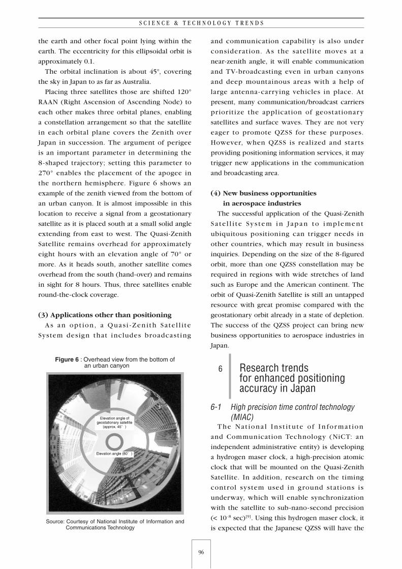
the northern hemisphere. Figure 6 shows an
example of the zenith viewed from the bottom of
an urban canyon. It is almost impossible in this
location to receive a signal from a geostationary
satellite as it is placed south at a small solid angle
extending from east to west. The Quasi-Zenith
Satellite remains overhead for approximately
eight hours with an elevation angle of 70° or
more. As it heads south, another satellite comes
overhead from the south (hand-over) and remains
in sight for 8 hours. Thus, three satellites enable
round-the-clock coverage.
(3) Applications other than positioning
A s a n opt ion, a Quas i - Zen i th Sate l l i te
System design that includes broadcast ing
and communication capability is also under
considerat ion. As the satel l ite moves at a
near-zenith angle, it will enable communication
and TV-broadcasting even in urban canyons
and deep mountainous areas with a help of
large antenna - carrying vehicles in place. At
present, many communication/broadcast carriers
pr ior it ize the appl ication of geostationary
satellites and surface waves. They are not very
eager to promote QZSS for these purposes.
However, when QZSS is real ized and starts
providing positioning information services, it may
trigger new applications in the communication
and broadcasting area.
(4) New business opportunities
in aerospace industries
The successful application of the Quasi-Zenith
S a te l l i t e Sy s tem i n Japa n to i mplement
ubiquitous positioning can trigger needs in
other countries, which may result in business
inquiries. Depending on the size of the 8-figured
orbit, more than one QZSS constellation may be
required in regions with wide stretches of land
such as Europe and the American continent. The
orbit of Quasi-Zenith Satellite is still an untapped
resource with great promise compared with the
geostationary orbit already in a state of depletion.
The success of the QZSS project can bring new
business opportunities to aerospace industries in
Japan.
6 Research trends for enhanced positioning accuracy in Japan
6-1 High precision time control technology (MIAC)
T he Nat iona l I n s t i t u te o f I n for mat ion
and Communication Technology (NiCT: an
independent administrative entity) is developing
a hydrogen maser clock, a high-precision atomic
clock that will be mounted on the Quasi-Zenith
Satellite. In addition, research on the timing
control system used in ground stat ions is
underway, which will enable synchronization
with the satellite to sub-nano-second precision
(< 10 -8 sec)[9]. Using this hydrogen maser clock, it
is expected that the Japanese QZSS will have the
Figure 6 : Overhead view from the bottom of an urban canyon
Source: Courtesy of National Institute of Information and Communications Technology
96
S C I E N C E & T E C H N O L O G Y T R E N D S
97
Q U A R T E R L Y R E V I E W N o . 1 6 / J u l y 2 0 0 5
world’s best timing accuracy.
To support these efforts, the Information and
Communication Policy Bureau of MIAC is now
drafting technical guidelines for S -band satellite
communication, which will be required in GPS
augmentation using Quasi-Zenith Satellites.
6-2 High-precision positioning experiment system (MEXT)
I n t he jo i nt e f for t o f fou r m i n i s t r ie s ,
the Research and Development Bureau of
MEXT presides over the entire progress of
the experimental system for high -precision
positioning. JAXA is undertaking research to
estimate and forecast orbital information with
very high precision, and broadcast it to users.
Multiple monitor stations located in and outside
Japan receive positioning signal broadcast by the
Quasi -Zenith Satellite, and the orbit and time
information of the Quasi-Zenith and GPS orbital
elements are estimated and forecast based on
these signals. The feasibility of satellite -borne
experimental instruments is also under study
aimed at higher performance and precision in
the next-generation positioning system. These
include a device for inter-satellite ranging and an
ultra-high-precision accelerometer.
6-3 Key technology for a lighter satellite with longer operating life (METI)
M E T I’s “Deve lopment o f Fu nd a ment a l
Technologies for Next- Generation Satellites”
project is undertaking a variety of elemental
t e c h n o l o g y d e ve l op m e nt s i n c lu d i n g : a
h ig h - e f f ic ienc y t he r m a l cont ro l s y s tem
incorporated in satel l ite body structures,
next-generation ion engine, a composite material
for large body structures, and a satellite-borne
lithium battery. The ion engine has a larger
specific impulse and longer life than conventional
chemical rockets, which make it a better thrust
source for controlling the Quasi-Zenith Satellite
orbit. Elemental technology development for
the lithium battery has been assigned to New
Energy and Industrial Technology Development
O r g a n i z a t i o n ( N E D O : a n i n d e p e n d e n t
administrative entity).
6-4 High-precision positioning system with GPS (MLIT)
Civil Aviation Bureau of MLIT is developing
MTSAT Satellite -based Augmentation System
(MSAS). This MTSAT (Multi-functional Transport
Satellite)-aided system was planned for advanced
air navigation, and it has almost reached the
stage ready for operation. Reliability factors
for this system such as integrity and service
consistency, as well as accuracy and availability,
have already been verified[10]. However, MTSAT
must be put into practical operation before MSAS
starts operation. The launch of the MTSAT-1R
satellite is scheduled for February 2005 (this is
a replacement satellite for the MTSAT-1 that was
lost in 1999 due to the unsuccessful launch of the
H-II launch vehicle).
The Electronic Navigation Research Institute
(ENRI: an independent administrative entity)
is undertaking, as well as MSAS-related studies,
research into Quasi -Zenith Satel l ite - a ided
high-accuracy positioning systems. In 2003 and
2004, ENRI developed an analysis system that
generates GPS augmentation information from the
GPS signal received by electric reference points
located throughout Japan. This was an off- line
data processing system. From 2005, ENRI has
started developing an on-line real-time system for
processing data from electronic reference points
and for generating GPS augmentation information.
The development of receiver prototypes is also
included in the project. ENRI is also studying an
integrity monitoring method for Quasi -Zenith
Satel l ites based on the results of the MSAS
research.
6-5 Enhancement of positioning accuracyThanks to the concerted efforts of three
Ministries (MIAC, MEXT, and MLIT) to refine
high - precision positioning technology and
appl icat ion to the Quasi - Zen ith Satel l i te
System, the current level of lateral error by GPS
positioning (approx. 11 m) will be reduced
to less than 1 m. In addition, contr ibution
to er rors f rom such factors including the
ionosphere, time accuracy, satellite position, and
troposphere are reduced by magnitude of 1-digit
to a level measured in centimeters. With these
98
S C I E N C E & T E C H N O L O G Y T R E N D S
99
Q U A R T E R L Y R E V I E W N o . 1 6 / J u l y 2 0 0 5
enhancements in positional accuracy, position
display in 0.1 sec will serve its purpose.
7 QZSS will further expand GPS applications The complementary effect provided by QZSS to
GPS will not be limited to enhancing emergency
call processing. Various GPS applications have
been explained in 4 -2. The following are some
examples of how QZSS can complement and
augment GPS in many fields of application.
(1) Navigation
Car navigation systems commonly used in
Japan have on-board autonomous navigation or
map-matching functions, as well as having GPS
receivers. They navigate the driver by displaying
the car’s present position on the map using a
combination of these technologies. The current
level of accuracy is sufficient for ordinary car
drivers. For the main navigation system for
pedestrians, KDDI provides mobile phones with
a GPS receiver function. However, automatic
position notification to the police in the case of
emergency has not been implemented. The E911
system in the U.S. is not necessarily highly valued
because of the low availability of the required
number of GPS signals. Areas where four or
more GPS satellites are simultaneously in sight
are scattered. By the same token, the enhanced
emergency call system to be introduced in Japan
in 2007 may not show its full potential. However,
by complementing and augmenting GPS using
QZSS, this problem will largely disappear. At
the same time, I confidently expect that the
hand-held navigation device and Location-Based
Service (LBS) market will grow dramatically.
(2) Railway traffic control
When applying control using GPS to a railway
network that includes mountainous areas,
the unavailability of the required number of
GPS signals will largely nullify the benefit of
the control system, just as is the case with
car navigation. This problem can be largely
solved if a satellite is always positioned at a
near-zenith angle. The National Traffic Safety
and Environment Laboratory (an independent
admin ist rat ive ent it y) insta l led a pseudo
Quasi -Zenith Satellite in Kumamoto city and
carried out a control experiment using GPS[11].
The experiment was carried out in cooperation
with the Kumamoto city transportation authority.
According to the report, the time ratio with
signal availability increased from 24% to 72%,
which clearly demonstrated the effect of the
Quasi-Zenith Satellite. In addition, the feasibility
of train position detection with 1-m precision was
well demonstrated. It pointed out, however, that
to control trains running at high speed, measures
are required to eliminate the blurring effect
caused by multipaths.
A similar experiment was carried out by Future
University-Hakodate (Hakodate city).
(3) Land Survey
The use of GPS will promote efficiency in
land survey. Conflict of interest often occurs in
relation to demarcation of land, and differences
of interest are often settled in court. The future
trend in this field is that land demarcation will
be determined by electronic means, based on
the exact electronic survey results of public
property (including roads and r ivers). The
“Electric Survey and Demarcation of Public
Properties” project is in progress supported
by more than hundred members of the Diet.
According to the Japan Federation of Survey
Planning Association, surveys using GPS are only
useful in limited areas and at certain times, so
the project presupposes the use of conventional
transit surveys, eliminating the use of GPS. In this
case, it is forecast that it will take nearly 200 years
to complete the demarcation of all places in Japan
(including privately owned land). The reason
for the elimination of GPS is that the satellite is
in sight for only a limited period of time, and
the signal is easily obstructed by mountains
and nearby buildings (generally, GPS survey is
unavailable in places where the elevation angle is
less than 15°). Introduction of the Quasi-Zenith
Satellite that complements the GPS signal will
enable more efficient GPS -aided surveys, and
the whole process of land demarcation will very
probably be completed in the first half of this
century.
98
S C I E N C E & T E C H N O L O G Y T R E N D S
99
Q U A R T E R L Y R E V I E W N o . 1 6 / J u l y 2 0 0 5
(4) Other applications
The Forum for Social Basis in Enhanced
Positioning (a Non-Profit Organization) set up a
committee (Round-Table Conference of Satellite
Positioning Users: chaired by Prof. Ryosuke
Shibasaki, University of Tokyo) and compiled a
report “Proposals for Satellite Positioning System:
Perspective from Private Sector”[12]. This report
pointed out that, in addition to the applications
mentioned in the previous sections, various
sectors would greatly benefit from ubiquitous
positioning including quick-to -spot businesses,
sightseeing, management of goods or waste
disposal, maritime construction, and robotics.
Only a few possible QZSS applications are
given above. QZSS, as one of the key national
infrastructures, will activate various sectors in
industry, and promote the development of new
products and services.
8 Conclusions — Proposals to promote QZSS development—Ubiquitous positioning wil l change many
aspects of our lives; it is expected to improve
the level of security and safety, and to enhance
economic activities. However, the U.S. GPS, an
essential part of ubiquitous positioning, has
a serious blind side, because it is a go -around
satel l ite, it is obstructed depending on the
location and time. This is the inherent nature
of GPS that can hinder the full exploitation
of its capacity as the most basic positioning
method. Truly ubiquitous positioning requires
a quasi -zenith satellite to be positioned above
us at all times, and complements and augments
GPS. It has often been pointed out that aerospace
development projects in Japan have few elements
that arouse the interest of the general public.
The Quasi-Zenith Satellite is an exception in this
respect, and can be a national infrastructure that
will support our lives and industries for 50 or
100 years to come. The project is gathering huge
interest from all quarters, and will be pushed
forward by the Japanese government.
Although QZSS has great technical potential
such as communication and broadcasting as
well as positioning application, it seems that
implementing all these aspects simultaneously
will entail excessive difficulties in terms of
technology and development framework. This
approach may hinder the early completion of
the system. Among these aspects, positioning
application is of utmost importance and urgency
as a key infrastructure of a nation, and can be
a driving force of social renovation and the
creation of new values. I propose that the first
QZSS concentrate on functions that complement
and augment GPS. This will enable steady, rapid
development and the early implementation
of ubiquitous positioning, which will greatly
contribute to the enhanced safety and security
of citizens, and to activating the economy by
providing brand new services.
The Counci l for Science and Technology
Pol icy (CSTP) decided in Sept. 2004 that
the governmental organization by which all
development efforts and operation framework of
the QZSS “should be determined at the early stage
before completion of QZSS feasibility studies.”
This was a step forward; before this, CSTP had
proposed that government organization was to
be decided “when QZSS feasibility studies were
complete.” However, Japan is still lagging behind
U.S., which already has an organization called
Interagency GPS Executive Board (IGEB) and
its sub -committee, GPS Interagency Advisory
Council (GIAC)[13], which decides development
pol icy and distr ibute resources. A lthough
each organization is making efforts to solve its
own technical problems, we do not have the
principal organization to lead the whole process
of development and to be responsible for the
collective agenda such as the economic feasibility
and integrity of the satellite system.
To promote the well balanced development
of the wide area relating ubiquitous positioning,
and especially for the rapid realization of the
QZSS, I strongly recommends the establishment
of a governmental organization, like the IGEB in
U.S.A, that will preside over the entire progress in
related fields.
Acknowledgements
The subjects and discussion in this paper are
inspired by the lecture delivered by Mr. Hiroshi
100
S C I E N C E & T E C H N O L O G Y T R E N D S
101
Q U A R T E R L Y R E V I E W N o . 1 6 / J u l y 2 0 0 5
Nishiguchi in the National Institute of Science
and Technology Policy (NISTEP) on Aug. 4, 2004
(“Effectiveness of Quasi-Zenith Satellite System
as Viewed from National Strategy”). I am also
indebted to those concerned in MIAC, MEXT,
NiCT, ENRI, JAXA, ASBC for their kind offers of
materials and useful discussion.
Notes
*1 One tenth second of latitude (north/south
direction) is equivalent to approximately
3m on the earth's surface everywhere in
the world, but a distance equivalent to one
tenth second of longitude becomes shorter
in high-latitude regions. The typical value in
Japan is approximately 2m.
Acronyms and full spellings
•ASBC Advanced Space Business Corporation
•DoD Department of Defense
•DOP Dilution of Precision
•ENRI E lec t ron ic Nav igat ion Resea rch
Institute
•GPS Global Positioning System
•JAXA Japan Aerospace eXploration Agency
•METI Min istr y of Economy, Trade and
Industry
•MEXT Ministry of Education, Culture, Sports,
Science and Technology
•MIAC Min ist r y of Interna l A f fa i rs and
Communications
•MLIT Ministry of Land, Infrastructure and
Transportation
•NAVSTAR
NAVigation System with Timing And
Ranging
•NiCT National Institute of Information and
Communications Technology
•QZSS Quasi-Zenith Satellite System
•RAAN Right Ascension of Ascendingl globe
through which a satellite travels from
south to north crossing the equatorial
plane. Zero of r ight ascension is
defined as the direction of the sun on
Vernal Equinox Day.)
References
[1] “NAVSTAR satellites and six orbital planes”:
http://www.vxm.com/21R.111.html
[2] Document presented in #3 “Council for
Science and Technology Policy , Conference
on Positioning technology in Aerospace
E xplo i t a t ion : me a su rement br a nch ,
Positioning Subconference”, Document
No.3 - 3: “Publ ic nature of posit ioning
augmentation technology using Quasi-zenith
s a te l l i te”, Adva nced Space bus i nes s
Corporation, Dec. 4, 2003 (in Japanese)
[3] “DARPA develops portable atomic clock,”
Government Computer News, April 17, 2003:
http://www.gcn.com/voll_nol/daily-uptates
/25302-1.html
[4] H. Nishiguchi, Lecture of National Institute
of Science and Technology Policy (#142)
delivered in National Institute of Science
and Technology Policy: “Effectiveness of
Quasi-Zenith Satellite System as Viewed from
National Strategy”, Sept. 2004 (in Japanese)
[5] Repor t #2015, “Techn ica l condit ions
required to obtain transmitter position
information from emergency call”: a part
of “A pol icy for Enhanced Emergency
calls in Telecommunication enterprises”,
Telecommunication Council, June 30, 2004
(in Japanese)
[6] JAXA home page “High precision positioning
system using Quasi-Zenith Satellite”:
http://qzss.jaxa.jp/
[7] ILS’s Mission Overview “SIRIUS 1 Launch on
the Proton Launch Vehicle”:
http://www.ilslaunch.com/launches/cbin/Mi
ssion_Overview/proton/Sirius1MissionOverv
iew.pdf
[8] Takahashi: “Satellite orbits and their suited
missions”, Denpaken Kiho, Vol18, No.97,
1972 (in Japanese)
[9] National Inst itute of In formation and
Communications Technology home page
“Time base management system” ( in
Japanese):
http://www2.nict.go.jp/dk/c271/j/time/time
.html
[10] Counci l for Science and Technology,
Conference on Positioning technology
in Aerospace Exploitation: measurement
branch (#1), Document No.1-3: “Overview
of Multifunctional Transport Satellite-based
Augmentation System”, Japan Civil Aviation
100
S C I E N C E & T E C H N O L O G Y T R E N D S
101
Q U A R T E R L Y R E V I E W N o . 1 6 / J u l y 2 0 0 5
Bureau, Ministry of Land, Infrastructure and
Transportation, Oct 28, 2003:
http://www8.cao.go.jp/cstp/tyousakai/cosmo/
sokuihaihu01/siryo1-3.pdf
[11] Mizuma: “Technology development for
Quasi -Zenith Satellite application on high
speed traffic vehicles”, National Traffic
Safety and Environment Laboratory, Apr. 14,
2004 (in Japanese)
[12] For u m for Soc i a l Ba s i s i n E n ha nced
Positioning (a Non-Profit Organization):
“Proposals for Satellite Positioning System:
Perspective from Private Sector”, Apr. 2004
(in Japanese)
[13] CHARTER “Interagency GPS Executive
Board”, IGEB:
http://www.igeb.gov/charter.shtml
(Original Japanese version: published in January 2005)


