
Dr.S.Arun Das
Curriculum Vitae
His area of Specialization is on, Climate Change and Spatial Analysis and Planning. His main focus is on the implications of Climate Change on Agriculture and Urban Land Use Planning (Rural Urban Migration and pressure on Urban Land). With an aid of GIS and Remote Sensing and Geomorphological principles augmented analysis he has developed Comprehensive City Development Plan for Mysore City until 2100. To his credit he has published 33 research papers. He hates publishing paper in paid journals. Another 30 research paper publication title and material are yet to be published. His total research presentations in National and at International Universities, accounts to more than 70 research papers. He has been invited by 45 University colleges and institutions to give special lectures.
Being a member of IGU commission for Land use and Land Cover change for sustainable Asia, he was invited for annual meeting at Japan in 2010, 2011, 2012, 2013 2014 and 2015. In 2015 he was invited to IGU Moscow meeting and in 2017 for AAG meeting at Boston USA. That apart he has travelled to North Africa, Sri Lanka (2 Times), China, Singapore, Thailand, and Qatar. He served as South Asia Team Head and a member of International Geographical Union Commission on Land Use Land Cover for Sustainable Asia. He is associated with global academic bodies such as American Association of Geographers, Japanese Geoscience Union and also Member of IGU Commission on Risk and Hazard. Until today he has completed Four International projects and one is ongoing. He has mainly worked on Desertification process in Karnataka, Agriculture Status of Villages in Karnataka Micro Level planning and Management. He has identified the Physiographic and agriculture status of villages in Karnataka to eradicate the regional disparities existing in Karnataka at village level, as well as worked on Forest Fringe Governance. He has conducted ground truth investigation and travelled widely in India. His future plan is to create awareness on process of desertification among the schools children and for the villagers.
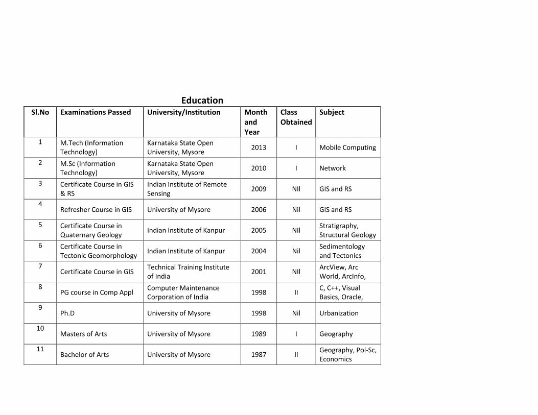
Education Sl.No Examinations Passed University/Institution Month
and Year
Class Obtained
Subject
1 M.Tech (Information Technology)
Karnataka State Open University, Mysore
2013 I Mobile Computing
2 M.Sc (Information Technology)
Karnataka State Open University, Mysore
2010 I Network
3 Certificate Course in GIS & RS
Indian Institute of Remote Sensing
2009 NIl GIS and RS
4 Refresher Course in GIS University of Mysore 2006 Nil GIS and RS
5 Certificate Course in Quaternary Geology
Indian Institute of Kanpur 2005 NIl Stratigraphy, Structural Geology
6 Certificate Course in Tectonic Geomorphology
Indian Institute of Kanpur 2004 Nil Sedimentology and Tectonics
7 Certificate Course in GIS
Technical Training Institute of India
2001 NIl ArcView, Arc World, ArcInfo,
8 PG course in Comp Appl
Computer Maintenance Corporation of India
1998 II C, C++, Visual Basics, Oracle,
9 Ph.D University of Mysore 1998 Nil Urbanization
10 Masters of Arts University of Mysore 1989 I Geography
11 Bachelor of Arts University of Mysore 1987 II
Geography, Pol-Sc, Economics

Invited as Resource Person
Year Name of the Workshop Name of the Organizer Title of the Paper Presented. Date & Place National/
International
1 2007 MapInfo GIS Workshop Srikanth First Grade
College, Mysore. Applications and Prospects in GIS Feb 28th 2007 National
2 2008 MapInfo GIS Workshop Vanil Vilas Urs Borading
College Applications and Prospects in GIS April 7th 2008 National
3 2008 Natural Resources
Management Challenges and Opportunities of 21st Century
Mahajana's First Grade College, Mysore
Emerging Challenges in Forest Resource Management Strategies
14th April 2008 National
4 2008 MapInfo GIS Workshop Mahajana's First Grade
College, Mysore Hand on Experience on MapInfo GIS
April 19,20,21st 2008
National
5 2008 Recent Applications in
Environment Management Karnataka State Open
University, Mysore Remote Sensing Applications for
Environmental Studies July 24th 2008 National
6 2008 Applied Geomorphology Dept. of PG Studies in Geography, Maharanis
College for Women.
DEM and TIN Modeling in Geomorphology
Dec. 3rd 2008 National
7 2009 Advanced Geomorphology Dept. of PG Studies in Geography, Maharanis
College for Women. Slope analysis TIN and DEM model. 25th Nov 2009 College
8 2009 Disaster Management JSS Womens College,
Chamarajanagar Earthquake Disaster Management 6th Feb 2009 National
9 2009 Geography Lecture Series Bhanumaiah First Grade
College, Mysore Recent Applications in Geography 23rd April 2009 College
10 2009 Field Surveying Dept. of PG Studies in Geography, Maharanis
College for Women. Theodolite Surveying 5th July 2009 College
11 2009 Climate Change and Disaster
Management
Dept. of Geography, Mahajana's College
Mysore
Earthquake Preparedness and Management
6th March 2010 College
12 2010 Disaster Management and
Climate Change
Department of Geography, Mahajana's
College, Mysore.
Earthquake Disaster Management Preparedness and Ill prepared ness
6th March 2010 National
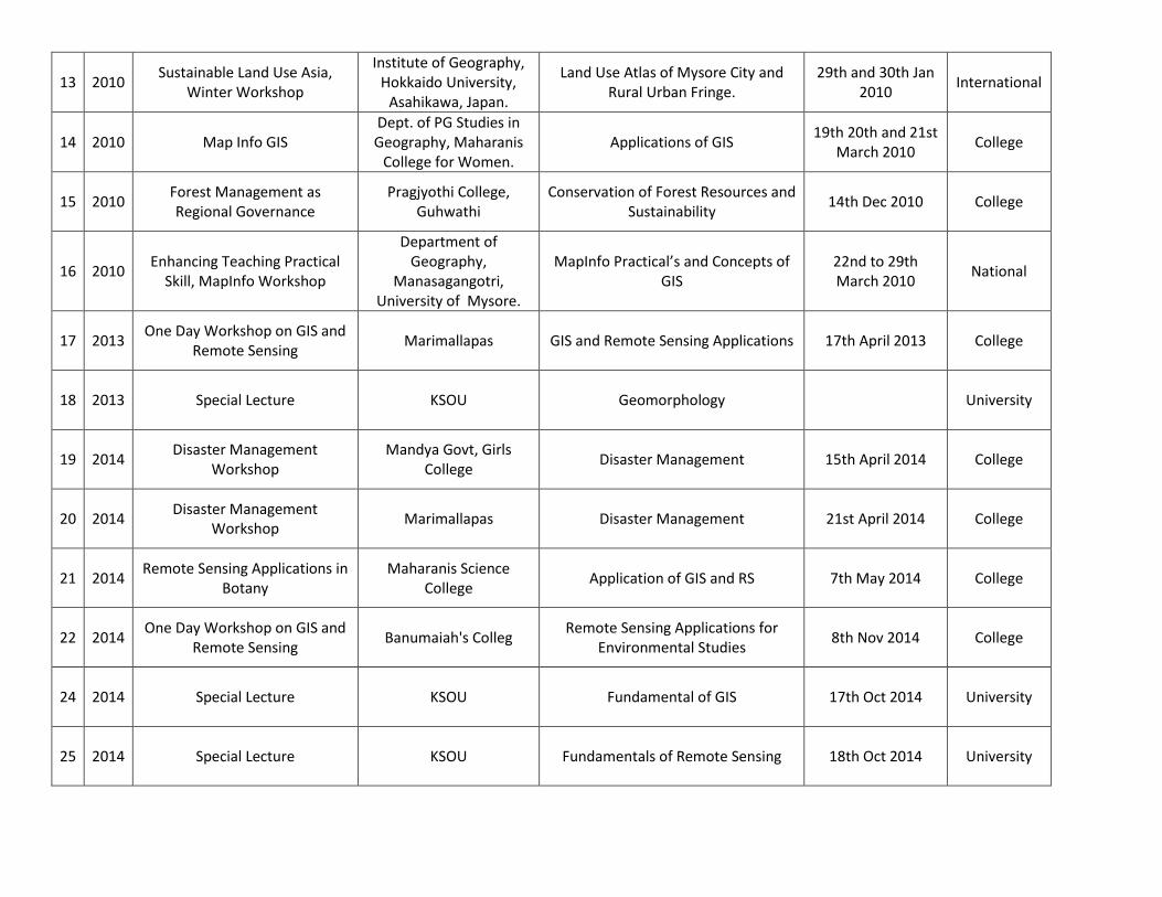
13 2010 Sustainable Land Use Asia,
Winter Workshop
Institute of Geography, Hokkaido University,
Asahikawa, Japan.
Land Use Atlas of Mysore City and Rural Urban Fringe.
29th and 30th Jan 2010
International
14 2010 Map Info GIS Dept. of PG Studies in Geography, Maharanis
College for Women. Applications of GIS
19th 20th and 21st March 2010
College
15 2010 Forest Management as Regional Governance
Pragjyothi College, Guhwathi
Conservation of Forest Resources and Sustainability
14th Dec 2010 College
16 2010 Enhancing Teaching Practical
Skill, MapInfo Workshop
Department of Geography,
Manasagangotri, University of Mysore.
MapInfo Practical’s and Concepts of GIS
22nd to 29th March 2010
National
17 2013 One Day Workshop on GIS and
Remote Sensing Marimallapas GIS and Remote Sensing Applications 17th April 2013 College
18 2013 Special Lecture KSOU Geomorphology University
19 2014 Disaster Management
Workshop Mandya Govt, Girls
College Disaster Management 15th April 2014 College
20 2014 Disaster Management
Workshop Marimallapas Disaster Management 21st April 2014 College
21 2014 Remote Sensing Applications in
Botany Maharanis Science
College Application of GIS and RS 7th May 2014 College
22 2014 One Day Workshop on GIS and
Remote Sensing Banumaiah's Colleg
Remote Sensing Applications for Environmental Studies
8th Nov 2014 College
24 2014 Special Lecture KSOU Fundamental of GIS 17th Oct 2014 University
25 2014 Special Lecture KSOU Fundamentals of Remote Sensing 18th Oct 2014 University
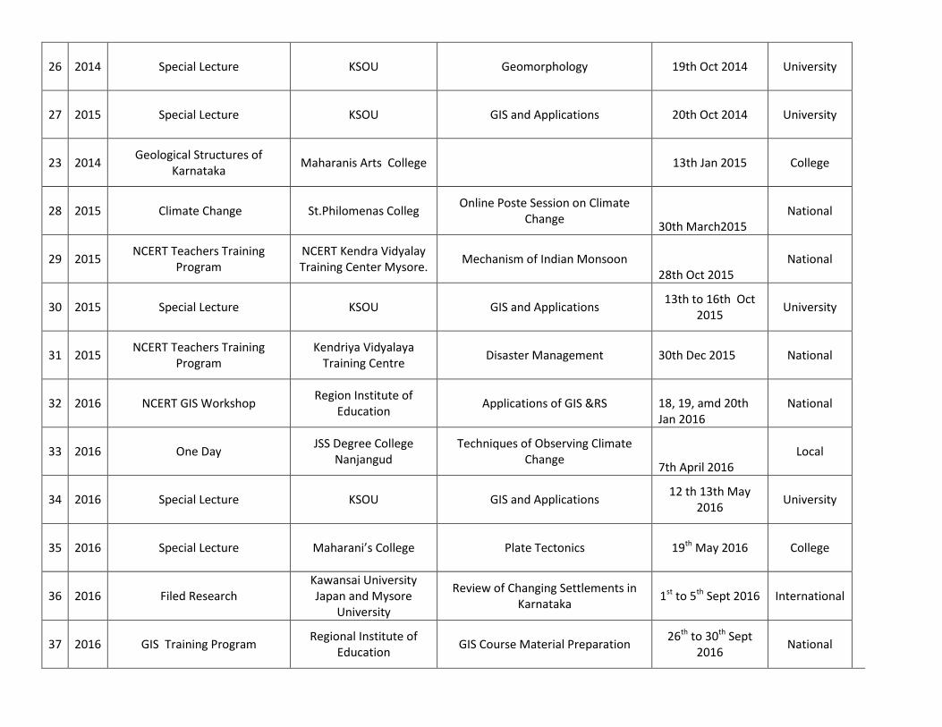
26 2014 Special Lecture KSOU Geomorphology 19th Oct 2014 University
27 2015 Special Lecture KSOU GIS and Applications 20th Oct 2014 University
23 2014 Geological Structures of
Karnataka Maharanis Arts College 13th Jan 2015 College
28 2015 Climate Change St.Philomenas Colleg Online Poste Session on Climate
Change 30th March2015
National
29 2015
NCERT Teachers Training Program
NCERT Kendra Vidyalay Training Center Mysore.
Mechanism of Indian Monsoon 28th Oct 2015
National
30 2015 Special Lecture KSOU GIS and Applications
13th to 16th Oct 2015
University
31 2015
NCERT Teachers Training Program
Kendriya Vidyalaya Training Centre
Disaster Management 30th Dec 2015 National
32 2016 NCERT GIS Workshop
Region Institute of Education
Applications of GIS &RS 18, 19, amd 20th Jan 2016
National
33 2016 One Day
JSS Degree College Nanjangud
Techniques of Observing Climate Change
7th April 2016 Local
34 2016 Special Lecture KSOU GIS and Applications
12 th 13th May 2016
University
35 2016 Special Lecture Maharani’s College Plate Tectonics 19th May 2016 College
36 2016 Filed Research Kawansai University Japan and Mysore
University
Review of Changing Settlements in Karnataka
1st to 5th Sept 2016 International
37 2016 GIS Training Program
Regional Institute of Education
GIS Course Material Preparation 26th to 30th Sept
2016 National

38 2016 GIS Training Program Regional Institute of
Education GIS Training
24th Oct to 28th 2016
National
39 2016 Special Lecture Maharani’s College Theodolite Survey Practical’s 18th Nov 2016 College
40 2016
PU College Geography Teachers Refresher Program
Maharajas College GIS and Remote Sensing 29th Nov 2016 State
41 2017 Special Lecture JSS College Ooty Road Disaster Management 24th March 2017 College
42 2017 Geography Lecture Series
Maharanis PG College for Women Mysore
Hydro Morphological and Hydro Pedological Assessment
21-Apr-17 University
43 2017
NCERT School Teachers Training Workshop
Region Institute of Education
Applications of GIS &RS 19 and 20th Sep
2017 National
44 2017 ICQ
Women’s First Grade College Hunsur
Career building in Geography 9/21/2017 University
45 2017 Geography Lecture Series
Maharanis PG College for Women Mysore
Geomorphic Life in Himalayas 23-Nov-17 University

Invited to Present Papers at Foreign Universities
Sl.No Topic Presented Host University Date of Presentation
1 Uncertainty, complex and Over Lapping Laws of Forest Buffer
Zones of South India
American Association of
Geographers, Boston USA
8th April
2017
2
Un-extracted and un-delineated Western Ghats of Karnataka
extracted as a separate physiographic entity employing ASTER
DEM Data. IGU Osmania, University, Hyderabad
19th March
2017
3 Identifying the phases of Indian Agriculture towards Desertification
along Forest Fringe, of Karnataka State, Moscow, Russia. IGU, Moscow RUSSIA 20-Aug-15
4 Administrative Discrepancies of Karnataka State Forest Department
and its consequences at a Village level. JPGU Tokyo Japan. JPGU Kyoto JAPAN
24 - 28 May
2015
5 Process of Desertification a Challenging Resilience - Forest
Management as Regional governance in Southern India Kyoto University JAPAN 8-Aug-13
6 Regional Governance of Forest and its Fringe. Mysore District,
India.
Jogakuin University Hiroshima
JAPAN 3-Aug-13
7 Land Grabbing for Religious Purpose, A Case Study of Mysore
City
Hokkaido University Asahikawa
JAPAN 30-Jan-12
8
India's Foreign (Silk) Policy, Improved Production, Techniques and
its impact on the Re- emergence of Silk Land Use in Southern
Karnataka, INDIA.
Hokkaido University Asahikawa
JAPAN 30-Jan-12
9 Chaired session on " Disaster Information based education " Hokkaido University Asahikawa
JAPAN 30-Jan-12
10 Site Selection Analysis of Solid Waste Dumping around Mysore
City for Future City Planning
South Eastern University SRI
LANKA
19 - 21 April
2011
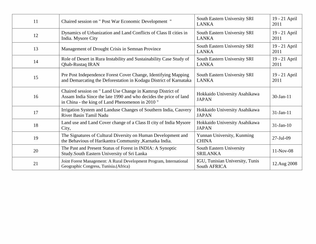
11 Chaired session on " Post War Economic Development " South Eastern University SRI
LANKA
19 - 21 April
2011
12 Dynamics of Urbanization and Land Conflicts of Class II cities in
India. Mysore City
South Eastern University SRI
LANKA
19 - 21 April
2011
13 Management of Drought Crisis in Semnan Province South Eastern University SRI
LANKA
19 - 21 April
2011
14 Role of Desert in Rura Instability and Sustainability Case Study of
Qhab-Rustaq IRAN
South Eastern University SRI
LANKA
19 - 21 April
2011
15 Pre Post Independence Forest Cover Change, Identifying Mapping
and Demarcating the Deforestation in Kodagu District of Karnataka
South Eastern University SRI
LANKA
19 - 21 April
2011
16
Chaired session on " Land Use Change in Kamrup District of
Assam India Since the late 1990 and who decides the price of land
in China - the king of Land Phenomenon in 2010 "
Hokkaido University Asahikawa
JAPAN 30-Jan-11
17 Irrigation System and Landuse Changes of Southern India, Cauvery
River Basin Tamil Nadu
Hokkaido University Asahikawa
JAPAN 31-Jan-11
18 Land use and Land Cover change of a Class II city of India Mysore
City,
Hokkaido University Asahikawa
JAPAN 31-Jan-10
19 The Signatures of Cultural Diversity on Human Development and
the Behavious of Harikantra Community ,Karnatka India.
Yunnan University, Kunming
CHINA 27-Jul-09
20 The Past and Present Status of Forest in INDIA: A Synoptic
Study.South Eastern University of Sri Lanka
South Eastern University
SRILANKA 11-Nov-08
21 Joint Forest Management: A Rural Development Program, International
Geographic Congress, Tunisia.(Africa)
IGU, Tunisian University, Tunis
South AFRICA 12.Aug 2008

Invited to Present Papers at Indian Universities
Sl.No Title of the Paper Presented Host
University Date and Year Conference
1 Examining the Importance of Crop Combination in the Rainfed Agriculture Regions of Mysore District
International Geographers Union
17th March to 19th March 2017
International
2 Human elephant conflict: An uncertain and fear full life of Nagarahole Forest Fringe Villages.
International Geographers Union
17th March to 19th March 2017
International
3 Un-extracted and un-delineated Western Ghats of Karnataka extracted as a separate physiographic entity employing ASTER DEM data.
International Geographers Union
17th March to 19th March 2017
International
5 Analyzing the causes of farmers suicide
in the transitional zone of Karnataka. I
GU Delhi
Delhi 18 - 20 March2016 International
Geographical Union
6
Geomorphological Classification of
Mysore City as a basis for
Comprehensive City Development and
Planning
SNDT
University
Pune India
4 - 6 Nov 2015 International
Geographical Union

7
Green Revolution and its implication on
Climate Change leading to
Desertification: Situation of Karnataka,
INDIA. Shillong
North Eastern
University
Shillong India
18 - 19 Sept 2014 Indian Society of
Geomatics
8 Livestock Population as an Indicator of
Desertification
Kashmir
University
Srinagar
4 -5 June 2014 International
Geographical Union
9 Regional Disparities and Mirco Level
planning for Villages of Mysore District,
CWRD, Calicut, Kerala, India.
Centre Water
Research
Department
Calicut India
6 - 8 May 2011 National Association
of Geog India NAGI
10
Pre Post Independence Forest Cover
Change, Identifying Mapping and
Demarcating the Deforestation in Kodagu
District of Karnataka
University of
Mysore India 5 - 6 Nov 2011
Forrest Management
as Regional
Governance
11 Research Methodology in GIS and
Remote Sensing
University of
Mysore India 8 - 16 Aug 2011
Iran Research
Students Association
of Mysore
University
12
Forest Management as Regional
Governance ,Guwhathi University,
Assam
Cotton College
Guwhathi
India
11 - 13 Dec 2010 International
Geographical Union
13
Re-habitation and land use change around
the forest– a case of Mysore district,
Karnataka, India - Guwhathi University,
Assam
Cotton College
Guwhathi
India
11 - 13 Dec 2010 International
Geographical Union

14 Dying Lakes of Mysore District, Punjab
University, Chandigarh, India
Punjab
University
Chandigarh
India
19 - 21 Nov 2010 National Association
of Geog India NAGI
15 Forest Management In Karnataka,
Punjab
University
Chandigarh
India
19 - 21 Nov 2010 National Association
of Geog India NAGI
16 Land Use Planning Flaws of Mysore
City.
Bangalore
University,
Bangalore
India
19 - 21 Feb 2010 Indian Insitute of
Indian Geographers
17 The Land Degradation, Sustainability and
Management- A Challenge of Rural
India.Interanationl, Bilaspur India.
PG Dubey
College,
Bilaspur India
7 - 9 Oct 2009 Indian Society of
Geomatics
18
Changing Land Use and Land
Degradation around Rural Urban Fringe
of Mysore City India.Interanationl,
Bilaspur India
PG Dubey
College,
Bilaspur India
7 - 9 Oct 2009 Indian Society of
Geomatics
19
Land Use And Land Cover:
Transformation, Implications And
Projections; Bangalore - Mysore
Corridor, India. India.Interanationl,
Bilaspur India
PG Dubey
College,
Bilaspur India
7 - 9 Oct 2009 Indian Society of
Geomatics
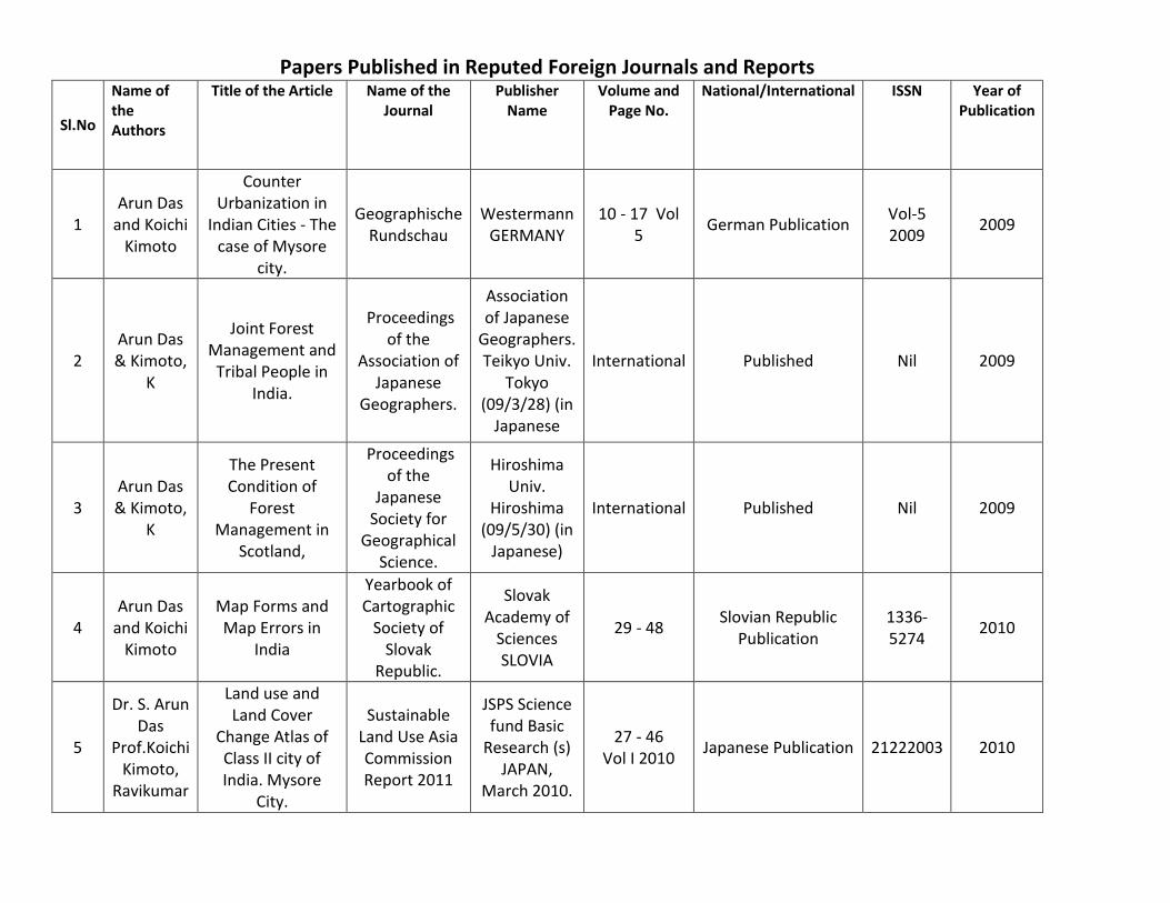
Papers Published in Reputed Foreign Journals and Reports
Sl.No
Name of the Authors
Title of the Article Name of the Journal
Publisher Name
Volume and Page No.
National/International ISSN Year of Publication
1 Arun Das
and Koichi Kimoto
Counter Urbanization in
Indian Cities - The case of Mysore
city.
Geographische Rundschau
Westermann GERMANY
10 - 17 Vol 5
German Publication Vol-5 2009
2009
2 Arun Das & Kimoto,
K
Joint Forest Management and
Tribal People in India.
Proceedings of the
Association of Japanese
Geographers.
Association of Japanese
Geographers. Teikyo Univ.
Tokyo (09/3/28) (in
Japanese
International Published Nil 2009
3 Arun Das & Kimoto,
K
The Present Condition of
Forest Management in
Scotland,
Proceedings of the
Japanese Society for
Geographical Science.
Hiroshima Univ.
Hiroshima (09/5/30) (in
Japanese)
International Published Nil 2009
4 Arun Das
and Koichi Kimoto
Map Forms and Map Errors in
India
Yearbook of Cartographic
Society of Slovak
Republic.
Slovak Academy of
Sciences SLOVIA
29 - 48 Slovian Republic
Publication 1336-5274
2010
5
Dr. S. Arun Das
Prof.Koichi Kimoto,
Ravikumar
Land use and Land Cover
Change Atlas of Class II city of India. Mysore
City.
Sustainable Land Use Asia Commission Report 2011
JSPS Science fund Basic
Research (s) JAPAN,
March 2010.
27 - 46 Vol I 2010
Japanese Publication 21222003 2010
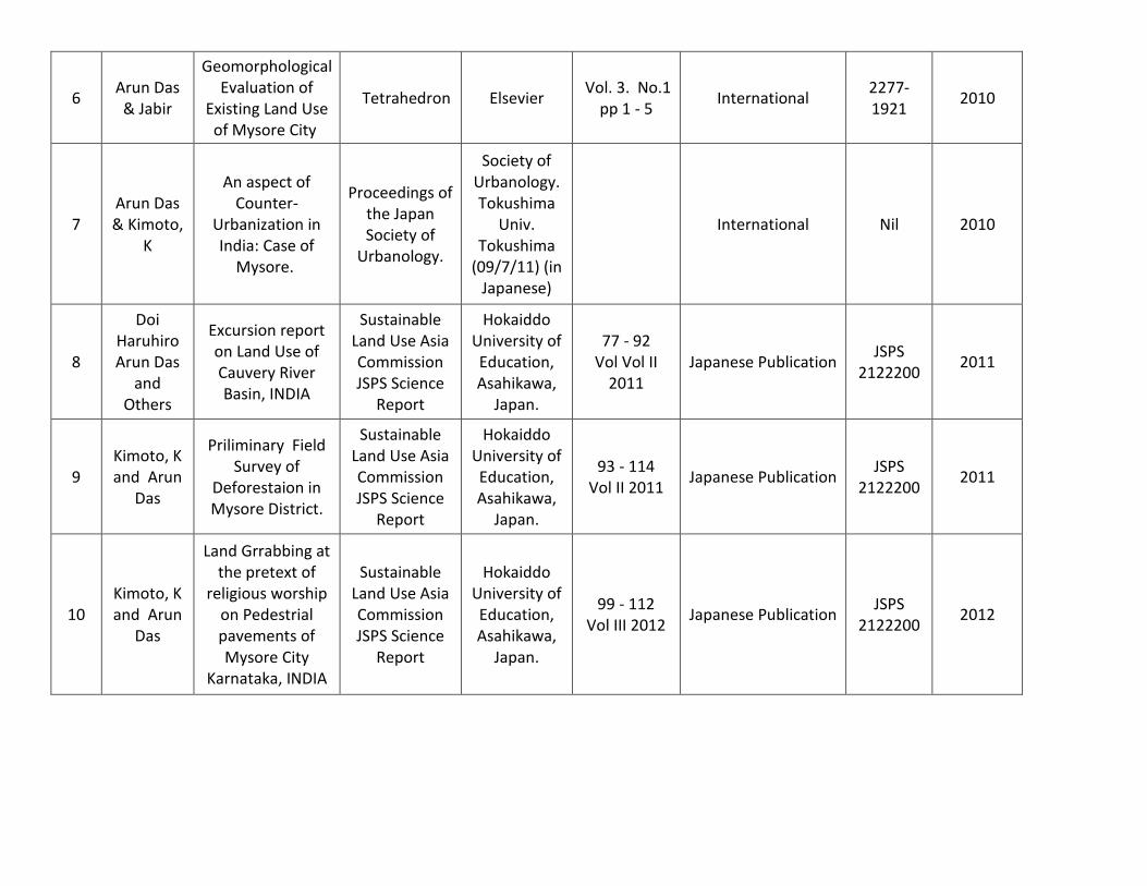
6 Arun Das & Jabir
Geomorphological Evaluation of
Existing Land Use of Mysore City
Tetrahedron Elsevier Vol. 3. No.1
pp 1 - 5 International
2277-1921
2010
7 Arun Das & Kimoto,
K
An aspect of Counter-
Urbanization in India: Case of
Mysore.
Proceedings of the Japan Society of
Urbanology.
Society of Urbanology. Tokushima
Univ. Tokushima
(09/7/11) (in Japanese)
International Nil 2010
8
Doi Haruhiro Arun Das
and Others
Excursion report on Land Use of Cauvery River Basin, INDIA
Sustainable Land Use Asia Commission JSPS Science
Report
Hokaiddo University of Education, Asahikawa,
Japan.
77 - 92 Vol Vol II
2011 Japanese Publication
JSPS 2122200
2011
9 Kimoto, K and Arun
Das
Priliminary Field Survey of
Deforestaion in Mysore District.
Sustainable Land Use Asia Commission JSPS Science
Report
Hokaiddo University of Education, Asahikawa,
Japan.
93 - 114 Vol II 2011
Japanese Publication JSPS
2122200 2011
10 Kimoto, K and Arun
Das
Land Grrabbing at the pretext of
religious worship on Pedestrial pavements of Mysore City
Karnataka, INDIA
Sustainable Land Use Asia Commission JSPS Science
Report
Hokaiddo University of Education, Asahikawa,
Japan.
99 - 112 Vol III 2012
Japanese Publication JSPS
2122200 2012

11
Hassan Ahmadi
and Arun Das
Redefining the Border line of the
Neka River's Watershed with
Comparing ASTER, SRTM, Digital
Topography DEM, and Topographic Map by GIS and Remote Sensing
Techniques
Life Science Journal
Elsevier 2012;9(3)
2061 -2068 Vol 9
Elsevier Amsterdam Netherlands
1097-8135
2013
12
Hassan Ahmadi
and Arun Das
Redefining the watershed line
and stream networks via
digital resources and topographic
map using GIS and remote sensing (case study: the
Neka River’s watershed)
Natural Hazards
Springer
June 2014, Volume 72, Issue 2, pp
711-722
Springer Netherlands 0921-030X
2014
13 Arun Das,
and Ravikumar
Comparative analysis of Land
use sustainability of Agricultural
Zones in Karnataka, India”.
Sustainable Land Use Asia Commission JSPS Science
Report
Hokaiddo University of Education, Asahikawa,
Japan.
127 - 148 Vol V 2014
International JSPS
2122200 2014
14 Arun Das, and Jabir
Urban Land Use Land Cover
Change In Indian Cities - A Synoptic view of Mysore, Karnataka, INDIA
Sustainable Land Use Asia Commission JSPS Science
Report
Hokaiddo University of Education, Asahikawa,
Japan.
149 - 160 Vol V 2014
International JSPS
2122200 2014

15 Arun Das
and Others
Land use Sustainability of
Agriculture zones Springer
Exploring Sustainable Land Use in Monsoon
Asia
Chapter 6 International
ISBN: 978-981-10-5926-1
2017
16 Arun Das
and Others
Urban Land Use Land Cover
Change In Indian Cities - A Synoptic view of Mysore, Karnataka, INDIA
Springer
Exploring Sustainable Land Use in Monsoon
Asia
Chapter 9 International
ISBN: 978-981-10-5926-2
2017
Papers Published in Refereed Journals
Sl. No
Name of the Authors
Title of the Article Name of the Journal
Publisher Name
National/International Year Vol &Page No. ISSN
1
Iraj Eskandarian
Dr.S.Arun Das
The Effect of Sangsari clan in Developing and
Attracting Tourism in
Semnan Province, Iran.
Asian Journal of Development
Matters
Rural Development
for Appropriate
Development Trust.
International Vol. 4.No.2 May 2010
PP 83 - 92 0973-9629
2
Iraj Eskandarian
& Dr. S. Arun Das
An analysis of tourism situation
in semanan province, Iran.
Southern Economist
Southern Economist, New Delhi.
National Vol. 2. Issue 10 Oct
2010 PP 37 - 49 0038- 4046

3 Iraj & Arun
Das
Tourism Potential Effectiveness on
Economic Development
with use of SWOT model, Semnan,
Iran.
Journal on Banking Financial
Services and Insurance Research
Sri Krishna International Research & Education
Consortium
International Vol. 1. Issue 8 Nov 2011
PP 119 - 129 2231-4288
4 Iraj & Arun
Das
Role and Position of
Multidimensional Planning in Developing Tourism In
Semnan Province, IRAN.
International Journal of Business
Economics and Management
Research
Sri Krishna International Research & Education
Consortium
International Vol. 2. Issue 12 Dec 2011 PP 157 - 170
2229-4848
5 Iraj & Arun
Das
Mobilization of Government in
Improving Tourism in
Semnan, IRAN.
International Journal of
Multidisciplinary Mangement
Studies
Sri Krishna International Research & Education
Consortium
International Vol. 1. Issue 3 Dec 2011
PP 89 - 99 2249-8834
6 Iraj & Arun
Das
Assessment of Tourism Abilities
of Protected Region Parivar in
Semana
A Journal of Advances in
Management, IT & Social Sciences
Sri Krishna International Research & Education
Consortium
International Vol. 1. Issue 3 Sep 2011
PP 95 - 101 2231-4571
7 Iraj & Arun
Das
Campus Interview Market Solutions
to Attract and Develop Tourism in the province of
Semana
International Journal of Social and Economics
Research
Indian Journals
International Vol. 2. Issue 3 June 2011 PP 381 - 389
2249-6270
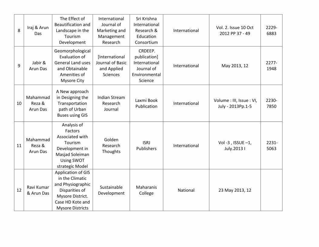
8 Iraj & Arun
Das
The Effect of Beautification and Landscape in the
Tourism Development
International Journal of
Marketing and Management
Research
Sri Krishna International Research & Education
Consortium
International Vol. 2. Issue 10 Oct
2012 PP 37 - 49 2229-6883
9 Jabir & Arun Das
Geomorphological Evaluation of
General Land uses and Obtainable
Amenities of Mysore City
[International Journal of Basic
and Applied Sciences
CRDEEP. publication] International
Journal of Environmental
Science
International May 2013, 12 2277-1948
10 Mahammad
Reza & Arun Das
A New approach in Designing the Transportation path of Urban
Buses using GIS
Indian Stream Research Journal
Laxmi Book Publication
International Volume : III, Issue : VI,
July - 2013Pp.1-5 2230-7850
11 Mahammad
Reza & Arun Das
Analysis of Factors
Associated with Tourism
Development in Masjad Soleiman
Using SWOT strategic Model
Golden Research Thoughts
ISRJ Publishers
International Vol -3 , ISSUE –1,
July.2013 I 2231-5063
12 Ravi Kumar & Arun Das
Application of GIS in the Climatic
and Physiographic Disparities of
Mysore District. Case HD Kote and Mysore Districts
Sustainable Development
Maharanis College
National 23 May 2013, 12

13 Jabir & Arun Das
Evaluation of Recreational site selection and the
prospects of recreational
Establishments in Mysore City
International Journal of
Environmental Sciences
CRDEEP. publication] International
Journal of Environmental
Science
International Vol. 3 No.1. 2014. Pp. 17-21
2277-1948
14 Jabir & Arun Das
Geomorphology of Mysore city
International Journal of Basic
and Applied Sciences
Centre for Rural
Development Ecology and Environment
Protection
International Vol. 3. No.1. 2014. Pp.
1-5 2277-1921
15 Arun Das
Pre and Post Preparedness In
Earthquake Disaster
Management
Special Volume Mahajana's
College National Published 2014 NIl
16 Nngaraj
and Arun Das
Cropping Pattern and Crop Ranking of Mysore District
International Journal of Research
Granthaalayah
Granthaalayah International Vol -5 , ISSUE –4,
April.2017 2350-0530
17 Nngaraj
and Arun Das
Cropping Pattern and Crop
combination of Mysore District
International journal of
Research in Management
and Social Sciences
Granthaalayah
Council for Academics
International Vol - 5 Issue 3 July -
Sept 2017 2322-0899

Completed and Ongoing International Collaborative Research Projects
Sl.No Area of Research Name of the
Director/PI/Co PI Period Total
Years Institution of
Affiliation Funding Agency
From To
1 Forest Management as Regional
Governance in Karnataka Prof. Koichi Kimoto and
Arun Das S
19th Sept 2007
10th March 2008
6 months
Jogakuin University, Japan
Japanese Society for the Promotion of Science(JSPS)
2 Sustainable Land and Land Cover for ASIA
Prof. Himiyama Prof Koichi Kimoto and Dr. S.Arun Das
1st April 2009
31st March 2012
3 Hokkaido University,
Asahikawa Japan
Japanese Society for the Promotion of Science(JSPS)
3 Forest Management as Regional
Governance in Karnataka Prof. Koichi Kimoto and
Arun Dr.Das S 1st April
2010
31st March 2013
3 Jogakuin University,
Japan
Japanese Society for the Promotion of Science(JSPS)
4 Sustainable Land and Land Cover for ASIA
Prof. Himiyama Prof Koichi Kimoto and Dr. S.Arun Das
1st April 2012
31st March 2015
3 Hokkaido University,
Asahikawa Japan
Japanese Society for the Promotion of Science(JSPS)
5 Regional Governance of Forest
and its Fringe Prof. Koichi Kimoto and Dr
Arun Das S 1st April
2013
31st March 2017
3 Jogakuin University,
Japan
Japanese Society for the Promotion of Science(JSPS)
6 Development and Cultural Change in Rural Socities of
Forest Fringe Villages
Prof. Tatsumi and Dr Arun Das S
1st Sep 2017
30th Aug 2018
1 Fukuoka University,
Japan
Japanese Society for the Promotion of Science(JSPS)


