
DREDGED MATERIAL SETTLEMENT FROM
MARSH CREATION PROJECTS CONDUCTED IN
COASTAL LOUISIANA
Thomas McGinnisCPRA – Operations Division
Lafayette Regional OfficeNational Conference on Ecosystem Restoration
August 28, 2018
committed to our coastcommitted to our coast

Coastal Protection and Restoration Authority of Louisiana
Attributes Deficiencies
Immediate correction of elevation deficiencies Does not address the overall problem
Minimizes post construction costs High planning and construction costs
Low liability during and after the project life High resources cost
Symbols are completed or ongoing projectsShading are future projects in Louisiana’s Master Plan
From 2017 CPRA Master Plan
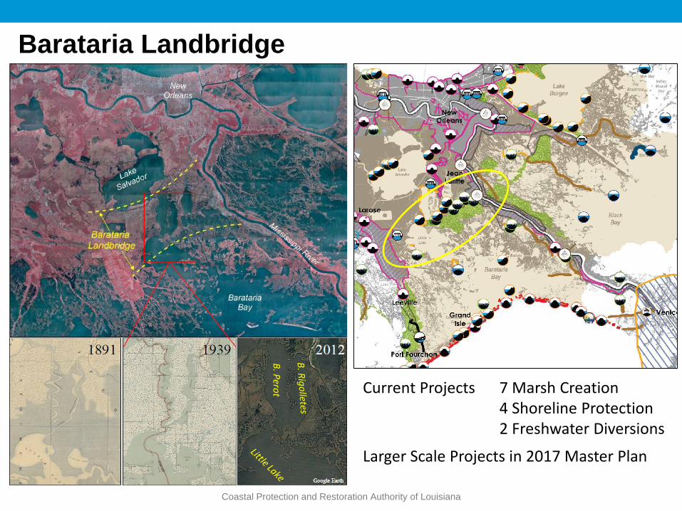
Barataria Landbridge
Coastal Protection and Restoration Authority of Louisiana
Current Projects 7 Marsh Creation 4 Shoreline Protection 2 Freshwater Diversions
Larger Scale Projects in 2017 Master Plan
B. P
erot

Coastal Protection and Restoration Authority of Louisiana

Coastal Protection and Restoration Authority of Louisiana
~711ac
~1,174ac
BA-36 Planning- Geotech of borrow and fill areas
- Target Elevation of MHW = 0.85 ftNAVD88 for most of project life
- Short-Term:Substrate Compaction- Long- Term: Subsidence (3.7 cm/y)
From: LDNR. 2004. BA-36 Final Design Report
Different Fill Elevations
2.5’ Fill Elevation

Coastal Protection and Restoration Authority of Louisiana
CWPPRA: $16.2 MCIAP: 17.5 MState Surplus: 2.4 MTotal Cost: $36.1 M
Constructed 10/2008 – 03/2010
Total Acres: 2,789Dredged Material: ~9 M yd3
Iterative, Sequential Filling
Monitoring: 03/2010 – 02/2016
2017 OM&M Report by Melissa Hymel
BA-36 Construction

Coastal Protection and Restoration Authority of Louisiana
~711ac
~1,174ac
BA-36 Results
Based on a series of elevation surveys either conducted in or transformed to Geoid 12A
52% of Volume Remainedsince Construction

Coastal Protection and Restoration Authority of Louisiana
~711ac
~1,174ac
2.66’
0.82’
2.23’
0.79’
HME = 0.65’

Coastal Protection and Restoration Authority of Louisiana
BA-37 Little Lake Shoreline Protection / Dedicated Dredging Near Round Lake
Southeastern lake rim of the Landbridge
Freshwater and Sediment cut-off when Bayou Lafouche was dammed at the Mississippi R.
2017 Operations, Maintenance, and Monitoring Report by Glen Curole and Ben Hartman

Coastal Protection and Restoration Authority of Louisiana
BA-37 Little Lake Shoreline Protection / Dedicated Dredging
Major Project Components:Shoreline ProtectionMarsh Creation/Nourishment
Program: CWPPRA
Constructed in Sp 2006 and has been monitored for 10 years
~3.6 M yd3 of material was dredged from the adjacent lake bottom
CRMS6303

Coastal Protection and Restoration Authority of Louisiana
Planned and Actual Sediment Elevation Curves for BA-37
X
-0.02 m NAVD88, Initial Marsh Elevation
27 % > EstimatedElevation
2005 ‘06 ’07 ‘08 ‘09 ‘10 ‘11 2016 Elevation Surveys

Coastal Protection and Restoration Authority of Louisiana
0
20
40
60
80
100
2005 2006 2007 2008 2009 2010 2011 2012
Lan
d (
%)
Percent Land over Time
CRMS6303in
BA-37Land Increased 49% by 6 years after the
dredge addition
2005 – 1Y Pre Construction 2008 – 2Y Post Construction
2012 – 6Y Post Construction
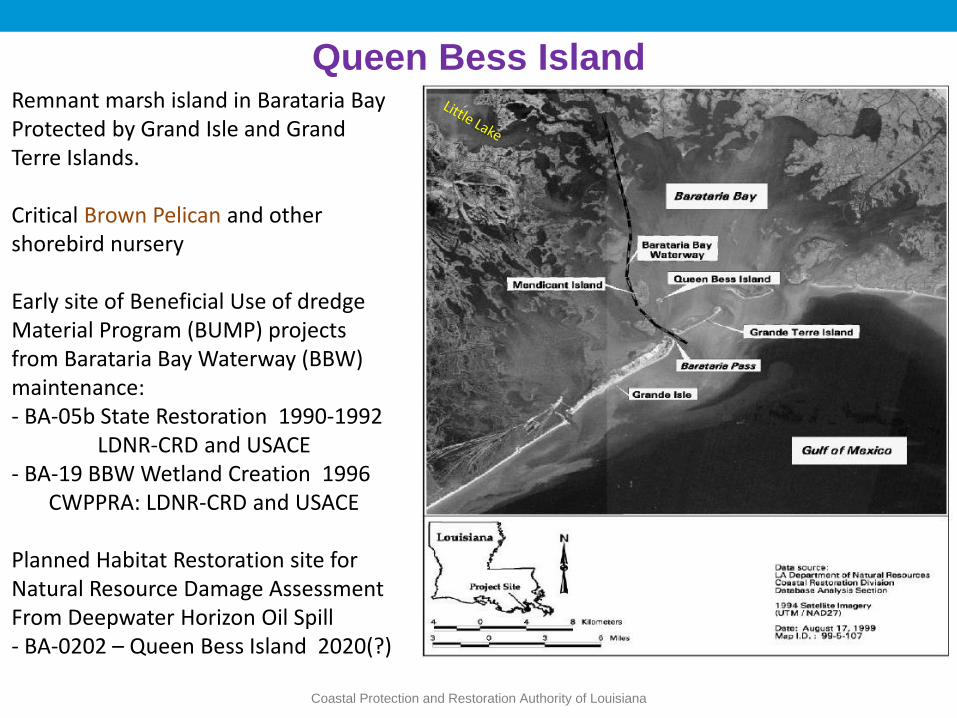
Queen Bess Island
Coastal Protection and Restoration Authority of Louisiana
Remnant marsh island in Barataria BayProtected by Grand Isle and Grand Terre Islands.
Critical Brown Pelican and other shorebird nursery
Early site of Beneficial Use of dredge Material Program (BUMP) projects from Barataria Bay Waterway (BBW) maintenance:- BA-05b State Restoration 1990-1992
LDNR-CRD and USACE- BA-19 BBW Wetland Creation 1996
CWPPRA: LDNR-CRD and USACE
Planned Habitat Restoration site for Natural Resource Damage AssessmentFrom Deepwater Horizon Oil Spill - BA-0202 – Queen Bess Island 2020(?)

Queen Bess Island (QBI) - Historical Background
Decline of Brown Pelicans and the need for restoring
habitat
• The population of 1,000s of brown pelicans reported in
1958 was extinct by 1962, attributed to the use of DDT.
• Juvenile brown pelicans were reintroduced from Florida in
the late 1960s and early 1970s.
• By 1989, QBI was 1 of only 4 remaining nesting sites in
Barataria Bay because of habitat loss.
• QBI eroded from 45 ac in 1956 to 17 ac in 1989.
• Elevation had reduced such that the island was over
washed by small storms.
• December 1989 Freeze killed all of the black mangroves.
Coastal Protection and Restoration Authority of Louisiana

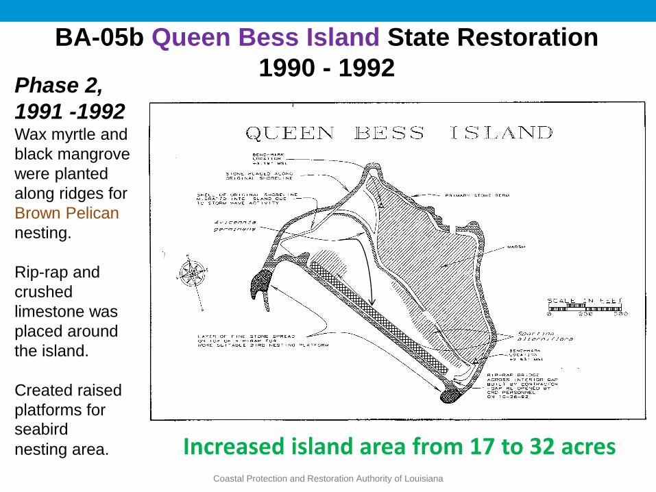
BA-05b Queen Bess Island State Restoration
1990 - 1992Phase 1, 1990A retainment dike was
constructed and dredged
material from the Barataria
Waterway was pumped inside
(75,000 yd3).
Nourished existing island to
the east.
Ridges/Dikes = 3.5 ft NVGD29
Fill Elevation = 2-3 ft NGVD29
Target Elev = ~1 ft NGVD29
Coastal Protection and Restoration Authority of Louisiana
Coastal Protection and Restoration Authority of Louisiana
Phase 2,
1991 -1992Wax myrtle and
black mangrove
were planted
along ridges for
Brown Pelican
nesting.
Rip-rap and
crushed
limestone was
placed around
the island.
Created raised
platforms for
seabird
nesting area.
BA-05b Queen Bess Island State Restoration
1990 - 1992
Increased island area from 17 to 32 acres
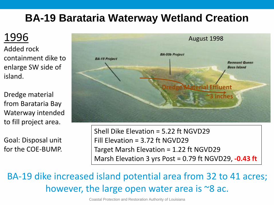
BA-19 Barataria Waterway Wetland Creation
Coastal Protection and Restoration Authority of Louisiana
August 1998
BA-19 dike increased island potential area from 32 to 41 acres; however, the large open water area is ~8 ac.
1996Added rock containment dike to enlarge SW side of island.
Dredge material from Barataria Bay Waterway intended to fill project area.
Goal: Disposal unit for the COE-BUMP.
Shell Dike Elevation = 5.22 ft NGVD29Fill Elevation = 3.72 ft NGVD29Target Marsh Elevation = 1.22 ft NGVD29Marsh Elevation 3 yrs Post = 0.79 ft NGVD29, -0.43 ft
Dredge Material Effluent
~3 inches

Queen Bess Island and Deepwater Horizon
Coastal Protection and Restoration Authority of Louisiana
Oil Boom
P.J. Mann, an employee of Plaquemines Parish, Louisiana, rescues a brown pelican from oil-filled waters on Queen Bess Island, Louisiana, June 5, 2010. Oil from the massive BP oil spill in the Gulf of Mexico has fouled the marshlands and injured wildlife. UPI/A.J. Sisco
2010
GoogleEarth

Coastal Protection and Restoration Authority of Louisiana
Courtesy: Darin Lee – CPRA TRO(Post Isaac, 2012)
Courtesy: Darin Lee – CPRA TRO (Post Isaac, 2012)

BA-0202 QBI Restoration Project• National Resources Damage Assessment (NRDA)
awarded $20,000,000
• - CPRA / LA Dept of Wildlife and Fisheries (LDWF)
• Goal: Restore suitable shorebird nesting and rearing habitat from < 5 acres to ~36 acres.
• The designed habitat breakdown:
• 9.2 acres for Terns & Skimmers
• 26.8 acres for Brown Pelicans and other colonial nesting water birds.
• Currently in Planning Stage
Coastal Protection and Restoration Authority of Louisiana
Coastal Protection and Restoration Authority of Louisiana
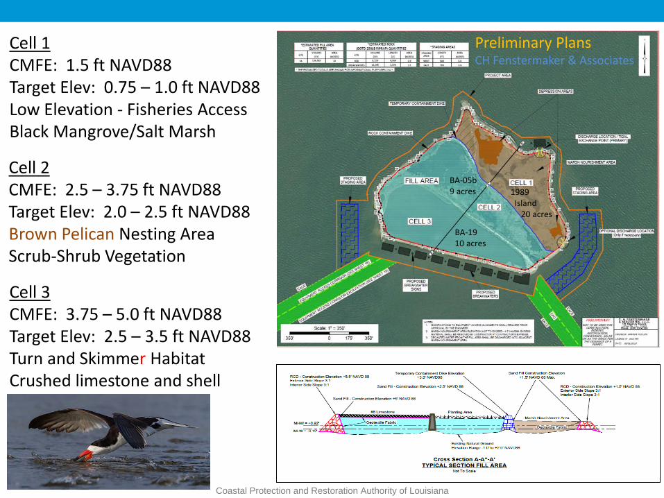
Cell 1CMFE: 1.5 ft NAVD88Target Elev: 0.75 – 1.0 ft NAVD88Low Elevation - Fisheries AccessBlack Mangrove/Salt Marsh
Cell 2CMFE: 2.5 – 3.75 ft NAVD88Target Elev: 2.0 – 2.5 ft NAVD88Brown Pelican Nesting AreaScrub-Shrub Vegetation
Cell 3CMFE: 3.75 – 5.0 ft NAVD88Target Elev: 2.5 – 3.5 ft NAVD88Turn and Skimmer HabitatCrushed limestone and shell
Preliminary PlansCH Fenstermaker & Associates
1989 Island
20 acres
BA-05b 9 acres
BA-19 10 acres

Coastal Protection and Restoration Authority of Louisiana
Relative Sea-Level Rise Rates (m/y) over 100 yrs (2000 – 2100)Scenarios 0.01-m = 1 meter of RSLR
0.015-m = 1.5 meters of RSLR
Coastal Protection and Restoration Authority of Louisiana
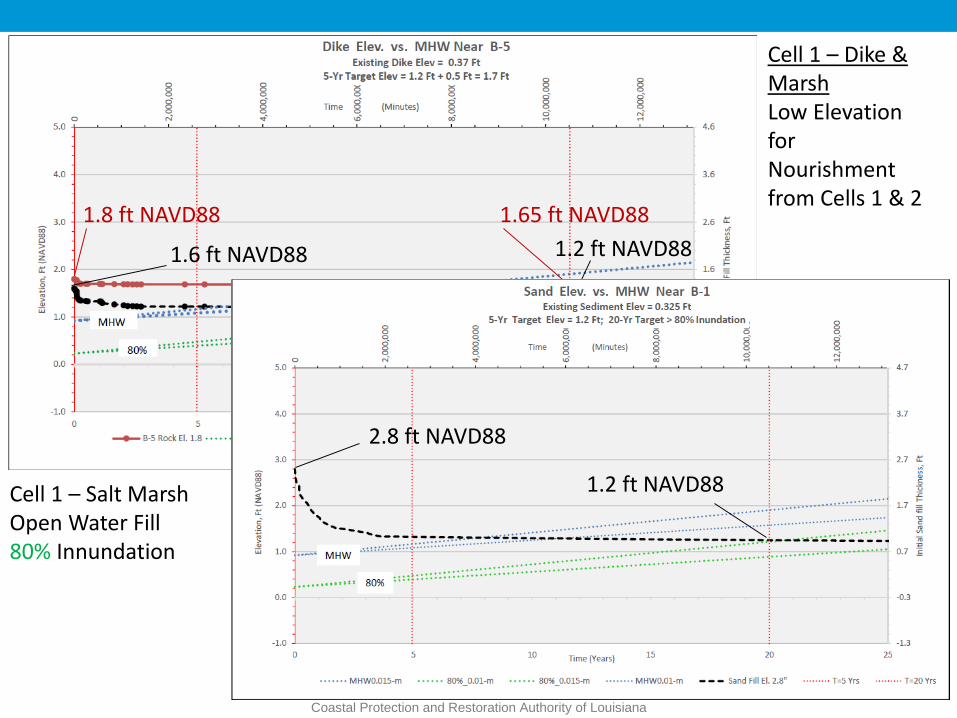
Cell 1 – Dike & MarshLow Elevation for Nourishment from Cells 1 & 2
1.8 ft NAVD88
1.6 ft NAVD88 1.2 ft NAVD88
1.65 ft NAVD88
Cell 1 – Salt MarshOpen Water Fill80% Innundation
2.8 ft NAVD88
1.2 ft NAVD88

Coastal Protection and Restoration Authority of Louisiana
Cell 2 – Scrub-Shrub for Brown Pelicans and other colonial nesting birds
10% Exceedance - chance of surface flooding in a given amount of time
1.95 ft NAVD88
2.6 ft NAVD88
3.6 ft NAVD88
4.1 ft NAVD88

Coastal Protection and Restoration Authority of Louisiana
Cell 3 –Dike and Loose Rock Pad for Skimmers and TurnsHigher Elevation to Simulate a Beach Ridge Habitat
MLW
4.8 ft NAVD88
5.3 ft NAVD88
3.3 ft NAVD88
4.25 ft NAVD88

CONNECT WITH US!
www.coastal.la.gov
@LouisianaCPRA
Thanks!!!Any
Questions?


