
PRICE $2,865,000
• 1.5172 +/- Acre site is improved with 21,787 sq. ft. operating motel built circa 1963. (Outlined in green)
• 1.5600 +/- Acre sites consist of four residential investment properties built circa 1930 - 1953. (Outlined in red)
• 3.0772 +/- Acres Commercial Enclave - Land assemblage comprising five (5) adjacent parcels.
• Interim use motel & residential home improvements to be demolished for Highest & Best Use potential.
• Zoning: Site 1 - (CBI) Commercial, Business, Industrial allows a wide range of commercial uses.
Sites 2-5 - (RS) Residential Suburban requires Commercial Re-Zoning.
• Gently rolling topography from north side (high elevation) to south side (low elevation).
• Ideal Uses(s): Retail shopping storefronts - Restaurant Park - Apartments - Convenience Gas&Go
Services Station - Senior Housing - Office - Hotel.
Property Highlights
contact
CEN
TERPOIN
T GRO
UP, LLC
• 1230 W. M
ore
hea
d St. C
harlo
tte, N
C 28208
Daryl M. Hayes | 704.804.4061 | [email protected]
1420 E. Innes St. & Faith Rd. Intersection (Adjoining Streets - E. Council St. & Kentwood Ave.)
Salisbury, North Carolina 28146
Development Opportunity
FOR SALE
Faith Rd.
Council St.
Kentwood Ave.
Innes St.

LOWESSITE
Aerial Site View - (proximity of major retailers)
List of Nearby Retailers/Users
LOWES HARDWARE – WALGREENS – FOOD LION – RITE AID – RADIO SHACK – T-MOBILE – FED EX –
MARSHALLS – VERIZON – OLD NAVY– SHOE DEPOT – STAPLES – ZAXBYS – APPLEBEES – PET SMART
CVS
FOOD LION
RITE AID
VERIZON
RADIO SHACKT- MOBILE
WALGREENS
APPLEBEE’S
contact
OLD NAVY
CEN
TERPOIN
T GRO
UP, LLC
• 1230 W. M
ore
hea
d St. C
harlo
tte, N
C 28208
Daryl M. Hayes | 704.804.4061 | [email protected]
SHOE DEPTSTAPLES
PET SMART
ZAXBY’S
SITE
Property Photos
contact
CEN
TERPOIN
T GRO
UP, LLC
• 1230 W. M
ore
hea
d St. C
harlo
tte, N
C 28208
Daryl M. Hayes | 704.804.4061 | [email protected]
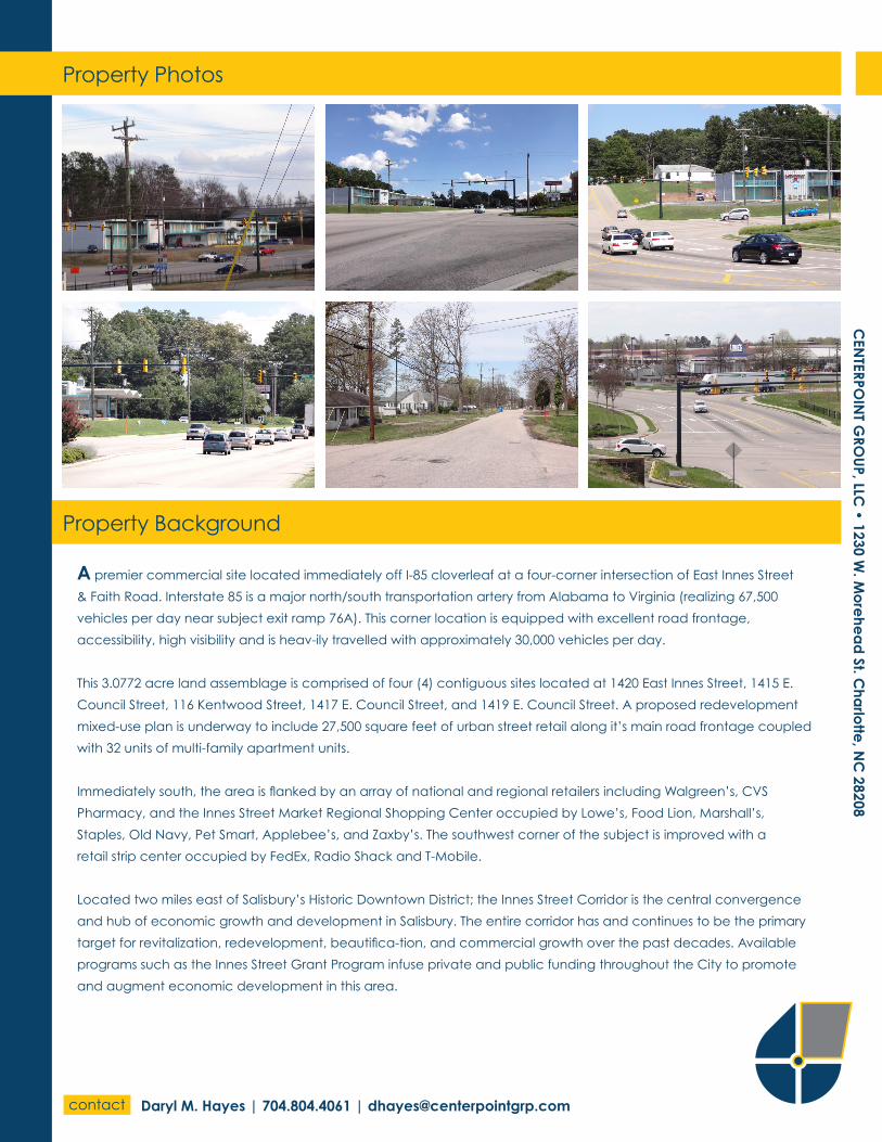
A premier commercial site located immediately off I-85 cloverleaf at a four-corner intersection of East Innes Street
& Faith Road. Interstate 85 is a major north/south transportation artery from Alabama to Virginia (realizing 67,500
vehicles per day near subject exit ramp 76A). This corner location is equipped with excellent road frontage,
accessibility, high visibility and is heav-ily travelled with approximately 30,000 vehicles per day.
This 3.0772 acre land assemblage is comprised of four (4) contiguous sites located at 1420 East Innes Street, 1415 E.
Council Street, 116 Kentwood Street, 1417 E. Council Street, and 1419 E. Council Street. A proposed redevelopment
mixed-use plan is underway to include 27,500 square feet of urban street retail along it’s main road frontage coupled
with 32 units of multi-family apartment units.
Immediately south, the area is flanked by an array of national and regional retailers including Walgreen’s, CVS
Pharmacy, and the Innes Street Market Regional Shopping Center occupied by Lowe’s, Food Lion, Marshall’s,
Staples, Old Navy, Pet Smart, Applebee’s, and Zaxby’s. The southwest corner of the subject is improved with a
retail strip center occupied by FedEx, Radio Shack and T-Mobile.
Located two miles east of Salisbury’s Historic Downtown District; the Innes Street Corridor is the central convergence
and hub of economic growth and development in Salisbury. The entire corridor has and continues to be the primary
target for revitalization, redevelopment, beautifica-tion, and commercial growth over the past decades. Available
programs such as the Innes Street Grant Program infuse private and public funding throughout the City to promote
and augment economic development in this area.
Property Background

Demographic Specific To Salisbury, NC
• Population (2012) 33,622 (27.1% increase since 2000)
• Median Household Income (2011): $33,257
• Median House or Condo Value (2011): $129,173
• Detached House Mean Value (2011): $175,800
• Townhouse Mean Value (2011): $124,301
• Estimated Per Capita Income (2011): $18,681
• Median Gross Rent (2011): $682
• Unemployment (7/2013): 10.1%
Pie Chart of Civilian Employment History
1. Manufacturing: 27%
2. Education/Health: 17%
3. Retail/Wholesale: 16%
4. Construction: 8%
5. Transportation/Warehousing: 6%
6. Professional: 5%
7. Finance/Real Estate: 5%
8. Arts/Entertainment: 5%
9. Others: 5%
10. Public Administration: 4%
1
2
3
4
5
6
7
8
910
contact
CEN
TERPOIN
T GRO
UP, LLC
• 1230 W. M
ore
hea
d St. C
harlo
tte, N
C 28208
Daryl M. Hayes | 704.804.4061 | [email protected]


