
D I S T R I C T D E P A R T M E N T O F T R A N S P O R T A T I O N
Penn
sylv
ania
Ave
nue
SE
E-�
PENNSYLVANIA AVENUE SE
GREAT STREETS FRAMEWORK PLAN
Government of District of ColumbiaAnthony A. Williams, Mayor
District Department of TransportationMichelle Pourciau, Director
G R E A T S T R E E T S F R A M E W O R K P L A N Pe
nnsy
lvan
ia A
venu
e SE
E-�
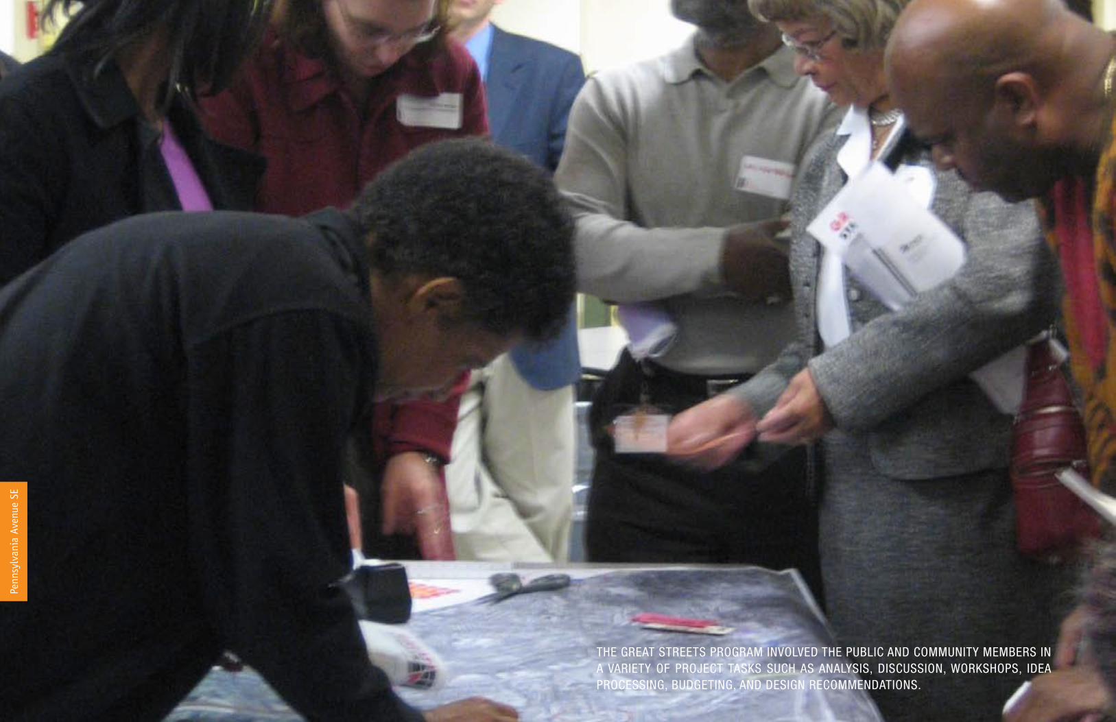
THE GREAT STREETS PROGRAM INVOLVED THE PUBLIC AND COMMUNITY MEMBERS IN A VARIETY OF PROJECT TASKS SUCH AS ANALYSIS, DISCUSSION, WORKSHOPS, IDEA PROCESSING, BUDGETING, AND DESIGN RECOMMENDATIONS.
Penn
sylv
ania
Ave
nue
SE

D I S T R I C T D E P A R T M E N T O F T R A N S P O R T A T I O N
Penn
sylv
ania
Ave
nue
SE
E-�
BUDGET - $14 million LENGTH - 1.7 miles
EXTENT - Sousa Bridge to
Southern Avenue
Sous
a Br
idge
South
ern Ave
nue
Table of ContentsPROGRAM GOALS E-2
PRINCIPLES E-2
A FRAMEWORK FOR CHANGE E-4
HISTORY AND CONTEXT E-6
EXISTING TRANSPORTATION ASSESSMENT E-7
OTHER INITIATIVES AND MARKET POTENTIALS E-8Summary of Planning/ Urban Design Study Recommendations ................................E-8Areas of Investment ..............................................................................................E-9
TRANSPORTATION RECOMMENDATIONS E-10Right-of-Way Configuration: ..................................................................................E-�0Pedestrian Facilities: ............................................................................................E-��Bike Facilities: .....................................................................................................E-��Transit Facilities: ..................................................................................................E-��Vehicle/Parking Facilities: .....................................................................................E-��
L’ENFANT SQUARE SEGMENT E-12I-�95 to �7th Street SE .........................................................................................E-��
PENN BRANCH SEGMENT E-1430th Street SE to Carpenter Street SE ....................................................................E-�4
ALABAMA AVENUE SEGMENT E-16Fort Davis Drive SE to Fort Davis Street SE .............................................................E-�6
STREETSCAPE TREATMENT E-18
ACTION PLAN E-20
ACTIONS PLANNED TO DATE E-21
ACKNOWLEDGEMENTS E-22
Pennsylvania Avenue SE

G R E A T S T R E E T S F R A M E W O R K P L A N Pe
nnsy
lvan
ia A
venu
e SE
E-�
Int
rodu
ctio
n
Great Streets is a multi-agency program that strategically uses public investments to improve local quality of life and toattract private investment to communities. The corridors that are identified as the first phase of the Great Streets Program are not only vital to the community development of local neighborhoods,but are also key to enhancing the District’s diversity and prosperity.
Program Goals�. Improve the quality of life in
neighborhoods along the corridors, including public safety, physical appearance, and personal opportunity;
�. Support local demand for goods and services through economic development;
3. Expand mobility choices and improve safety and efficiency of all modes of travel; and
4. Attract private investment through the demonstration of a public commitment to Great Streets communities.
PRINCIPLES
Strengthen businesses and other local services
Choices in how to travel
Safe, vibrant places that reflect local character
Increase community ownership and participation
CARE
ENERGIzE
REfRESh
MovE
DISTINGuISh
Integrate nature and create valuable open spaces

D I S T R I C T D E P A R T M E N T O F T R A N S P O R T A T I O N
Penn
sylv
ania
Ave
nue
SE
E-3
Int
rodu
ctio
n
US CAPITOL SEWARDSQUARE
EASTERNMARKET
BARNEYCIRCLE
L’ENFANTSQUARE
FORTDAVIS
PENNSYLVANIA AVENUE SE
East of the River
PENN BRANCH
G R E A T S T R E E T S F R A M E W O R K P L A N Pe
nnsy
lvan
ia A
venu
e SE
E-4
Int
rodu
ctio
n
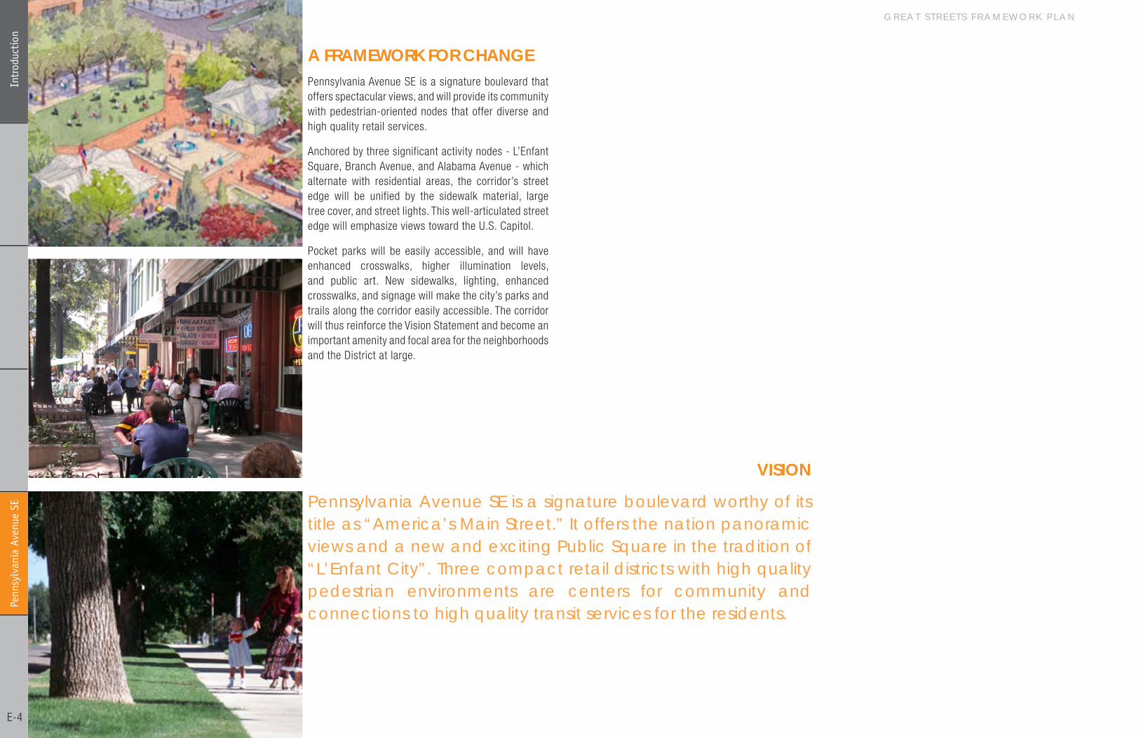
Pennsylvania Avenue SE is a signature boulevard worthy of its title as “America’s Main Street.” It offers the nation panoramic views and a new and exciting Public Square in the tradition of “L’Enfant City”. Three compact retail districts with high quality pedestrian environments are centers for community and connections to high quality transit services for the residents.
A fRAMEWoRK foR ChANGE
vISIoN
Pennsylvania Avenue SE is a signature boulevard that offers spectacular views, and will provide its community with pedestrian-oriented nodes that offer diverse and high quality retail services.
Anchored by three significant activity nodes - L’Enfant Square, Branch Avenue, and Alabama Avenue - which alternate with residential areas, the corridor’s street edge will be unified by the sidewalk material, large tree cover, and street lights. This well-articulated street edge will emphasize views toward the U.S. Capitol.
Pocket parks will be easily accessible, and will have enhanced crosswalks, higher illumination levels, and public art. New sidewalks, lighting, enhanced crosswalks, and signage will make the city’s parks and trails along the corridor easily accessible. The corridor will thus reinforce the Vision Statement and become an important amenity and focal area for the neighborhoods and the District at large.
D I S T R I C T D E P A R T M E N T O F T R A N S P O R T A T I O N
Penn
sylv
ania
Ave
nue
SE
E-5
Int
rodu
ctio
n
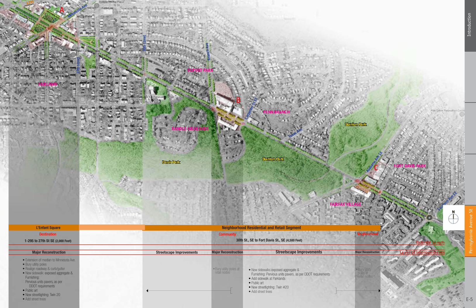
1.3 illustrative plan
A
B
C
I-295
Minnesota Ave
27th
stre
et
30th
stre
et
Bran
ch A
ve
Carp
enter
St SE
Texas Ave
Alabam
a Ave
SE
FAIRLAWN
RANDLE HIGHLANDS
DUPONT PARK
PENN BRANCH
FORT DAVIS PARK
FAIRFAX VILLAGE
Neighborhood Residential and Retail SegmentDestination
Major Reconstruction Streetscape Improvements
Community Neighborhood
Streetscape Improvements
1-295 to 27th St SE (2,000 Feet) 30th St., SE to Fort Davis St., SE (4,500 Feet)
• Bury utility poles at retail nodes
• Bury utility poles at retail nodes
L’Enfant Square
Major Reconstruction Major Reconstruction
Extents/ Length
Level of Improvements
Southern Ave
SE
• New sidewalks exposed aggregate & Furnishing: Pervious units pavers, as per DDOT requirements• Add sidewalk at Parklands• Public art• New streetlighting: Twin #20• Add street trees
• Extension of median to Minnesota Ave.• Bury utility poles• Realign roadway & curb/gutter• New sidewalk: exposed aggregate & Furnishing: Pervious units pavers, as per DDOT requirements• Public art• New streetlighting: Twin 20• Add street trees
Stanton Park
Stanton ParkDavis Park
G R E A T S T R E E T S F R A M E W O R K P L A N Pe
nnsy
lvan
ia A
venu
e SE
E-6
Exi
stin
g Co
ntex
t
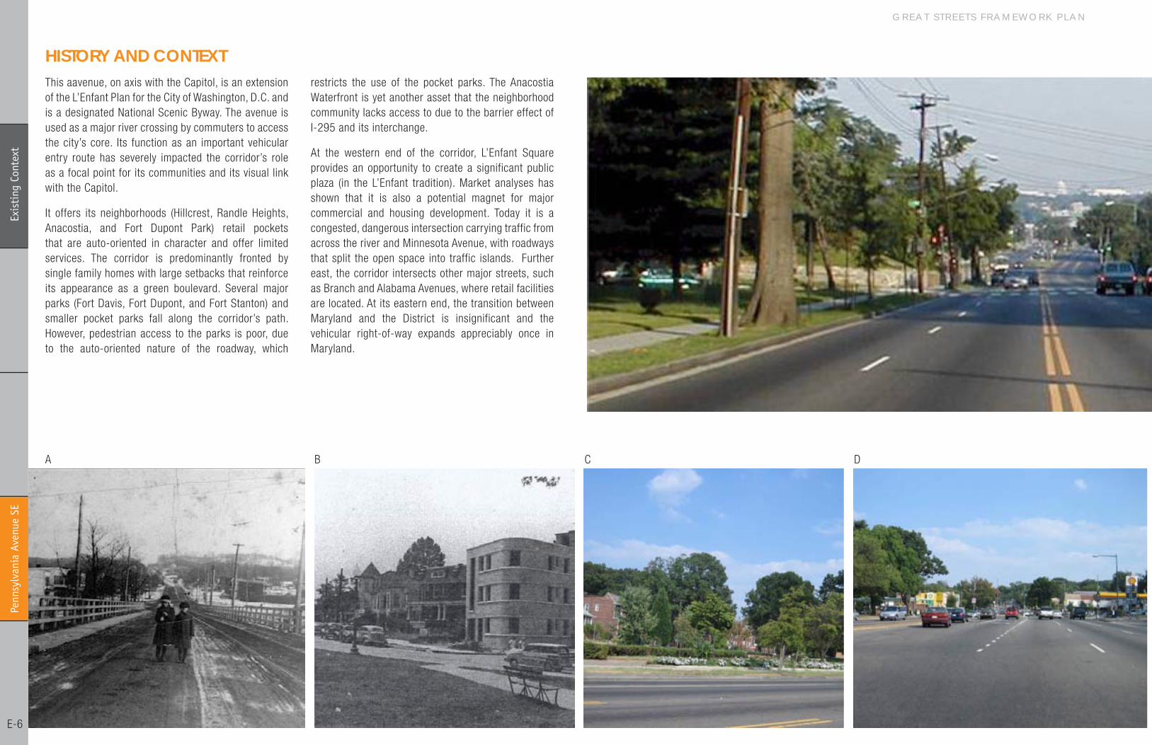
hISToRY AND CoNTEXTThis aavenue, on axis with the Capitol, is an extension of the L’Enfant Plan for the City of Washington, D.C. and is a designated National Scenic Byway. The avenue is used as a major river crossing by commuters to access the city’s core. Its function as an important vehicular entry route has severely impacted the corridor’s role as a focal point for its communities and its visual link with the Capitol.
It offers its neighborhoods (Hillcrest, Randle Heights, Anacostia, and Fort Dupont Park) retail pockets that are auto-oriented in character and offer limited services. The corridor is predominantly fronted by single family homes with large setbacks that reinforce its appearance as a green boulevard. Several major parks (Fort Davis, Fort Dupont, and Fort Stanton) and smaller pocket parks fall along the corridor’s path. However, pedestrian access to the parks is poor, due to the auto-oriented nature of the roadway, which
restricts the use of the pocket parks. The Anacostia Waterfront is yet another asset that the neighborhood community lacks access to due to the barrier effect of I-�95 and its interchange.
At the western end of the corridor, L’Enfant Square provides an opportunity to create a significant public plaza (in the L’Enfant tradition). Market analyses has shown that it is also a potential magnet for major commercial and housing development. Today it is a congested, dangerous intersection carrying traffic from across the river and Minnesota Avenue, with roadways that split the open space into traffic islands. Further east, the corridor intersects other major streets, such as Branch and Alabama Avenues, where retail facilities are located. At its eastern end, the transition between Maryland and the District is insignificant and the vehicular right-of-way expands appreciably once in Maryland.
A B C D

D I S T R I C T D E P A R T M E N T O F T R A N S P O R T A T I O N
Penn
sylv
ania
Ave
nue
SE
E-7
Exi
stin
g Co
ntex
t
EXISTING TRANSPoRTATIoN ASSESSMENTThe corridor is dominated by single-family residential density with clearly defined pockets of employment and retail activity. The following Pennsylvania Avenue cross-street locations are identified by the land use index as having the greatest interaction between households and employment: Minnesota Avenue, Branch Avenue, and Alabama Avenue.
The worst peak congestion occurs between Minnesota Avenue (including west, past the Sousa Bridge) and Branch Avenue. Daily traffic volumes range from ��,000 to 53,000 vehicles per day. Problems at Minnesota Avenue are exacerbated by missing I-�95 ramp movements from Kenilworth Avenue southbound to Pennsylvania Avenue toward the Capitol. Approximately 3�% of vehicles arriving eastbound at Minnesota Avenue are making a U-turn to travel back toward the Capitol.
Poor off-peak travel conditions are concentrated around Minnesota Avenue. No frequent bus service into the District is available for the length of the corridor. The highest concentrations of people walking to the bus,
with over �,500 per day, can be found in the blocks immediately adjacent to Minnesota Avenue. Westbound bus pull-offs at L’Enfant Square create considerable blockage of the travel lanes. Transit usage along the length of the corridor ranges from �5-�5%.
Pedestrian and bicycle travel to work is less than 5% across the entire corridor. The location of schools and residential activities between 30th Street and Branch Avenue necessitates heavy pedestrian crossings between households and activity centers. A review of high accident locations during �00�-�004 identified the intersections of Pennsylvania Avenue with �4th Street and Fairlawn Avenue as having �8 and �6 accidents per year, respectively. The highest accident location was at Minnesota Avenue with 4� per year. These locations were followed by 7th Street (�9), ��th Street (�8), and �3th Street (�8) with all other intersection averaging less than �6 accidents per year. Parking is permitted in the center of the corridor with restrictions at Southern Avenue where the roadway becomes narrow and the number of lanes is restricted to one in each direction during non-peak hours.
(opposite page)
Figure A: Pennsylvania Bridge, 1910
Figure B: Pennsylvania and Minnesota Avenues SE, August 6, 1949
Figure C: Pennsylvania Avenue SE is characterized by single-family houses with wide setbacks
Figure D: Pennsylania Avenue looking east, wide automobile lanes dominated right-of-way at L’Enfant
(current page)
Figure E: Retail facility at Pennsylvania dnd Branch Avenues SE
Figure F: Existing Transportation Infrastructure Map
E F
LEGEND
DC Zoning - CommercialOpen Space
Metro Entry Point
Bus Stops within 5 Minutes Walking Distance
Bike Lanes
G R E A T S T R E E T S F R A M E W O R K P L A N Pe
nnsy
lvan
ia A
venu
e SE
E-8
Exi
stin
g Co
ntex
t
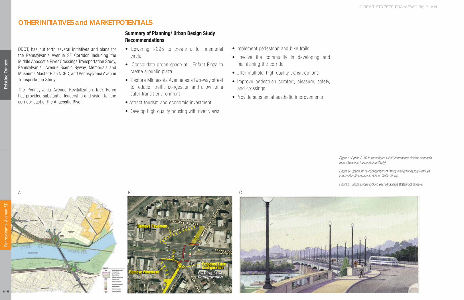
oThER INITIATIvES and MARKET PoTENTIALS
DDOT, has put forth several initiatives and plans for the Pennsylvania Avenue SE Corridor. Including the Middle Anacostia River Crossings Transportation Study, Pennsylvania Avenue Scenic Byway, Memorials and Museums Master Plan NCPC, and Pennsylvania Avenue Transportation Study.
The Pennsylvania Avenue Revitalization Task Force has provided substantial leadership and vision for the corridor east of the Anacostia River.
Summary of Planning/ Urban Design Study Recommendations
• Lowering I-295 to create a full memorial circle
• Consolidate green space at L’Enfant Plaza to create a public plaza
• Restore Minnesota Avenue as a two-way street to reduce traffic congestion and allow for a safer transit environment
• Attract tourism and economic investment
• Develop high quality housing with river views
Figure A: Option P-10 to reconfigure I-295 Interchange (Middle Anacostia River Crossings Transportation Study)
Figure B: Option for re-configuration of Pennsylvania/Minnesota Avenues intersection (Pennsylvania Avenue Traffic Study)
Figure C: Sousa Bridge looking east (Anacostia Waterfront Initiative)
A B C
• Implement pedestrian and bike trails
• Involve the community in developing and maintaining the corridor
• Offer multiple, high quality transit options
• Improve pedestrian comfort, pleasure, safety, and crossings
• Provide substantial aesthetic improvements
D I S T R I C T D E P A R T M E N T O F T R A N S P O R T A T I O N
Penn
sylv
ania
Ave
nue
SE
E-9
Exi
stin
g Co
ntex
t
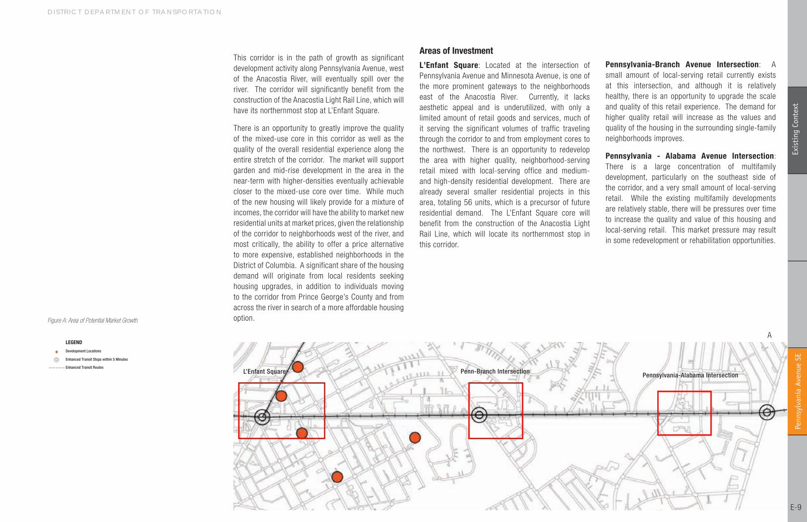
L’Enfant Square Penn-Branch Intersection Pennsylvania-Alabama Intersection
This corridor is in the path of growth as significant development activity along Pennsylvania Avenue, west of the Anacostia River, will eventually spill over the river. The corridor will significantly benefit from the construction of the Anacostia Light Rail Line, which will have its northernmost stop at L’Enfant Square.
There is an opportunity to greatly improve the quality of the mixed-use core in this corridor as well as the quality of the overall residential experience along the entire stretch of the corridor. The market will support garden and mid-rise development in the area in the near-term with higher-densities eventually achievable closer to the mixed-use core over time. While much of the new housing will likely provide for a mixture of incomes, the corridor will have the ability to market new residential units at market prices, given the relationship of the corridor to neighborhoods west of the river, and most critically, the ability to offer a price alternative to more expensive, established neighborhoods in the District of Columbia. A significant share of the housing demand will originate from local residents seeking housing upgrades, in addition to individuals moving to the corridor from Prince George’s County and from across the river in search of a more affordable housing option.
Areas of Investment
L’Enfant Square: Located at the intersection of Pennsylvania Avenue and Minnesota Avenue, is one of the more prominent gateways to the neighborhoods east of the Anacostia River. Currently, it lacks aesthetic appeal and is underutilized, with only a limited amount of retail goods and services, much of it serving the significant volumes of traffic traveling through the corridor to and from employment cores to the northwest. There is an opportunity to redevelop the area with higher quality, neighborhood-serving retail mixed with local-serving office and medium- and high-density residential development. There are already several smaller residential projects in this area, totaling 56 units, which is a precursor of future residential demand. The L’Enfant Square core will benefit from the construction of the Anacostia Light Rail Line, which will locate its northernmost stop in this corridor.
Pennsylvania-Branch Avenue Intersection: A small amount of local-serving retail currently exists at this intersection, and although it is relatively healthy, there is an opportunity to upgrade the scale and quality of this retail experience. The demand for higher quality retail will increase as the values and quality of the housing in the surrounding single-family neighborhoods improves.
Pennsylvania - Alabama Avenue Intersection: There is a large concentration of multifamily development, particularly on the southeast side of the corridor, and a very small amount of local-serving retail. While the existing multifamily developments are relatively stable, there will be pressures over time to increase the quality and value of this housing and local-serving retail. This market pressure may result in some redevelopment or rehabilitation opportunities.
Figure A: Area of Potential Market Growth
ALEGEND
Development Locations
Enhanced Transit Stops within 5 Minutes
Enhanced Transit Routes
G R E A T S T R E E T S F R A M E W O R K P L A N Pe
nnsy
lvan
ia A
venu
e SE
E-�0
Reco
mm
enda
tion
s
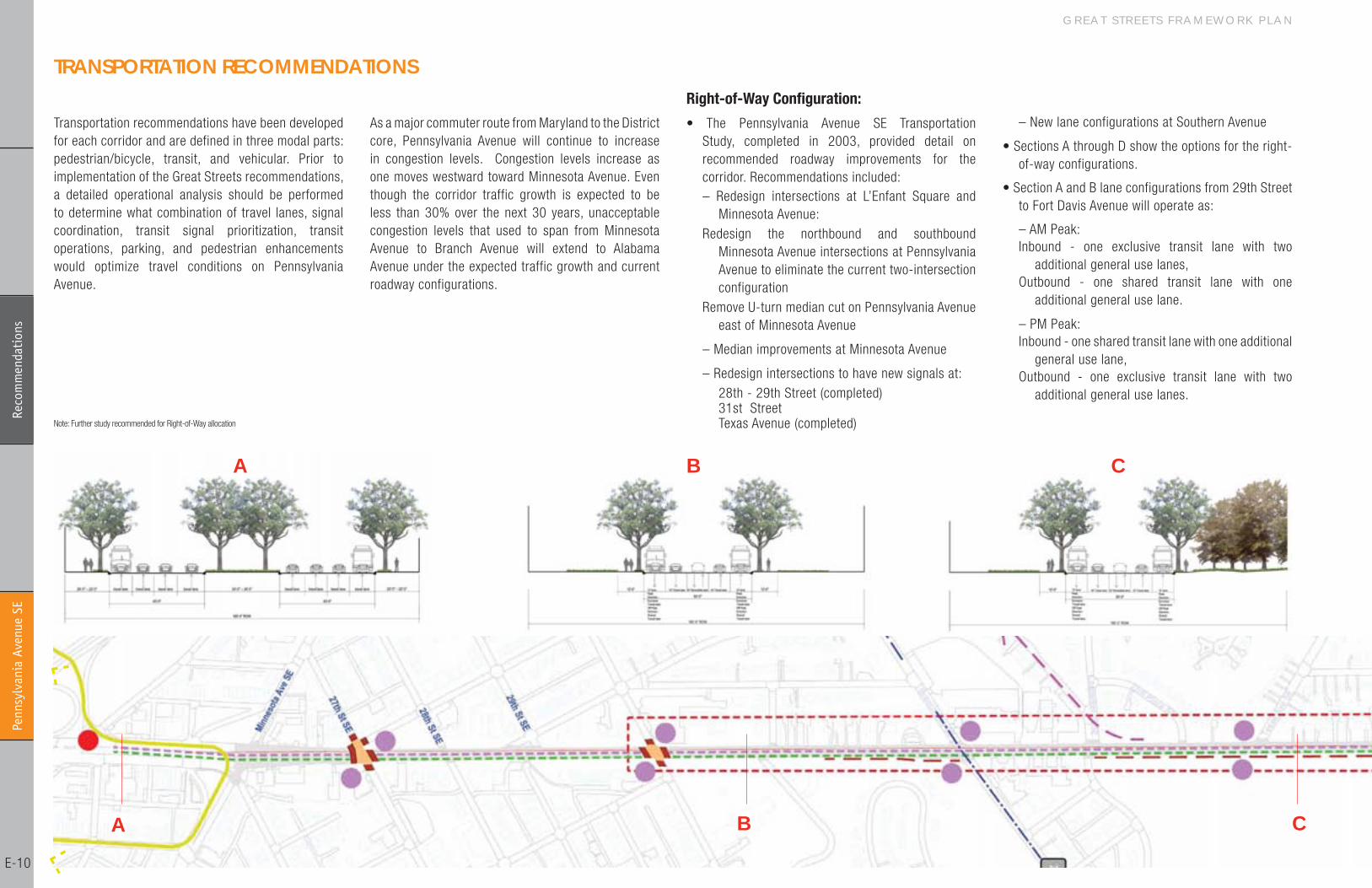
Right-of-Way Configuration:
• The Pennsylvania Avenue SE Transportation Study, completed in �003, provided detail on recommended roadway improvements for the corridor. Recommendations included: – Redesign intersections at L’Enfant Square and
Minnesota Avenue:Redesign the northbound and southbound
Minnesota Avenue intersections at Pennsylvania Avenue to eliminate the current two-intersection configuration
Remove U-turn median cut on Pennsylvania Avenue east of Minnesota Avenue
– Median improvements at Minnesota Avenue
– Redesign intersections to have new signals at: �8th - �9th Street (completed) 3�st Street Texas Avenue (completed)
TRANSPoRTATIoN RECoMMENDATIoNS
Transportation recommendations have been developed for each corridor and are defined in three modal parts: pedestrian/bicycle, transit, and vehicular. Prior to implementation of the Great Streets recommendations, a detailed operational analysis should be performed to determine what combination of travel lanes, signal coordination, transit signal prioritization, transit operations, parking, and pedestrian enhancements would optimize travel conditions on Pennsylvania Avenue.
As a major commuter route from Maryland to the District core, Pennsylvania Avenue will continue to increase in congestion levels. Congestion levels increase as one moves westward toward Minnesota Avenue. Even though the corridor traffic growth is expected to be less than 30% over the next 30 years, unacceptable congestion levels that used to span from Minnesota Avenue to Branch Avenue will extend to Alabama Avenue under the expected traffic growth and current roadway configurations.
– New lane configurations at Southern Avenue
• Sections A through D show the options for the right-of-way configurations.
• Section A and B lane configurations from �9th Street to Fort Davis Avenue will operate as:
– AM Peak: Inbound - one exclusive transit lane with two
additional general use lanes, Outbound - one shared transit lane with one
additional general use lane.
– PM Peak: Inbound - one shared transit lane with one additional
general use lane, Outbound - one exclusive transit lane with two
additional general use lanes.
CBA
A B C
Note: Further study recommended for Right-of-Way allocation
D I S T R I C T D E P A R T M E N T O F T R A N S P O R T A T I O N
Penn
sylv
ania
Ave
nue
SE
E-��
Reco
mm
enda
tion
s
Bike Facilities:
• Bike lanes are not recommended for Pennsylvania Avenue, but the roadway would be designated through signage as a Class � Bicycle Corridor.
• Branch Avenue is recommended as an alternative bicycle route.
Transit Facilities:
The WMATA Alternatives Analysis Report indicated that there would be 5,300 daily rapid transit boardings on Pennsylvania Avenue east of the Anacostia River that includes sections of this new WMATA route that extends into Maryland.
• Implement Rapid Bus service from a new park-and-ride facility in the vicinity of Southern Avenue at the Congressional Methodist Church connecting to the District’s core.
• Exclusive Rapid Bus travel lane in peak direction from Southern Avenue to downtown.
• Three bus stops are identified on the corridor including:
– L’Enfant Square
– Branch Avenue
– Alabama Avenue
• Additional stops outside the corridor include:
– Eastern Market Metro
– Independence Avenue at �nd Street
– East Capital at �nd Street
– Constitution Avenue at �nd Street
– D Street at �nd Street
• Buses would run every �0 minutes in the peak period.
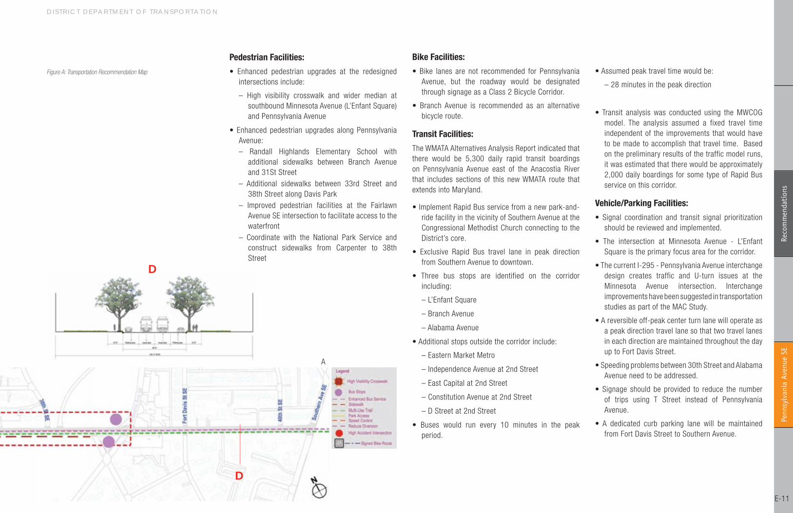
Pedestrian Facilities:
• Enhanced pedestrian upgrades at the redesigned intersections include:
– High visibility crosswalk and wider median at southbound Minnesota Avenue (L’Enfant Square) and Pennsylvania Avenue
• Enhanced pedestrian upgrades along Pennsylvania Avenue: – Randall Highlands Elementary School with
additional sidewalks between Branch Avenue and 3�St Street
– Additional sidewalks between 33rd Street and 38th Street along Davis Park
– Improved pedestrian facilities at the Fairlawn Avenue SE intersection to facilitate access to the waterfront
– Coordinate with the National Park Service and construct sidewalks from Carpenter to 38th Street
• Assumed peak travel time would be:
– �8 minutes in the peak direction
• Transit analysis was conducted using the MWCOG model. The analysis assumed a fixed travel time independent of the improvements that would have to be made to accomplish that travel time. Based on the preliminary results of the traffic model runs, it was estimated that there would be approximately �,000 daily boardings for some type of Rapid Bus service on this corridor.
Vehicle/Parking Facilities:
• Signal coordination and transit signal prioritization should be reviewed and implemented.
• The intersection at Minnesota Avenue - L’Enfant Square is the primary focus area for the corridor.
• The current I-�95 - Pennsylvania Avenue interchange design creates traffic and U-turn issues at the Minnesota Avenue intersection. Interchange improvements have been suggested in transportation studies as part of the MAC Study.
• A reversible off-peak center turn lane will operate as a peak direction travel lane so that two travel lanes in each direction are maintained throughout the day up to Fort Davis Street.
• Speeding problems between 30th Street and Alabama Avenue need to be addressed.
• Signage should be provided to reduce the number of trips using T Street instead of Pennsylvania Avenue.
• A dedicated curb parking lane will be maintained from Fort Davis Street to Southern Avenue.
Figure A: Transportation Recommendation Map
A
D
D
G R E A T S T R E E T S F R A M E W O R K P L A N Pe
nnsy
lvan
ia A
venu
e SE
E-��
Reco
mm
enda
tion
s
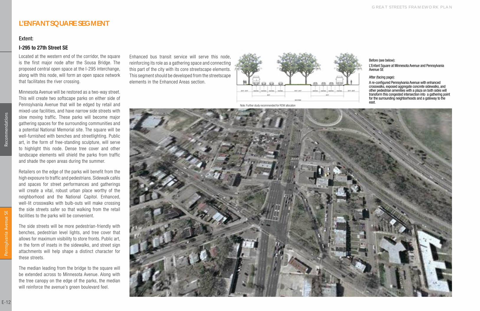
Extent:
I-295 to 27th Street SE
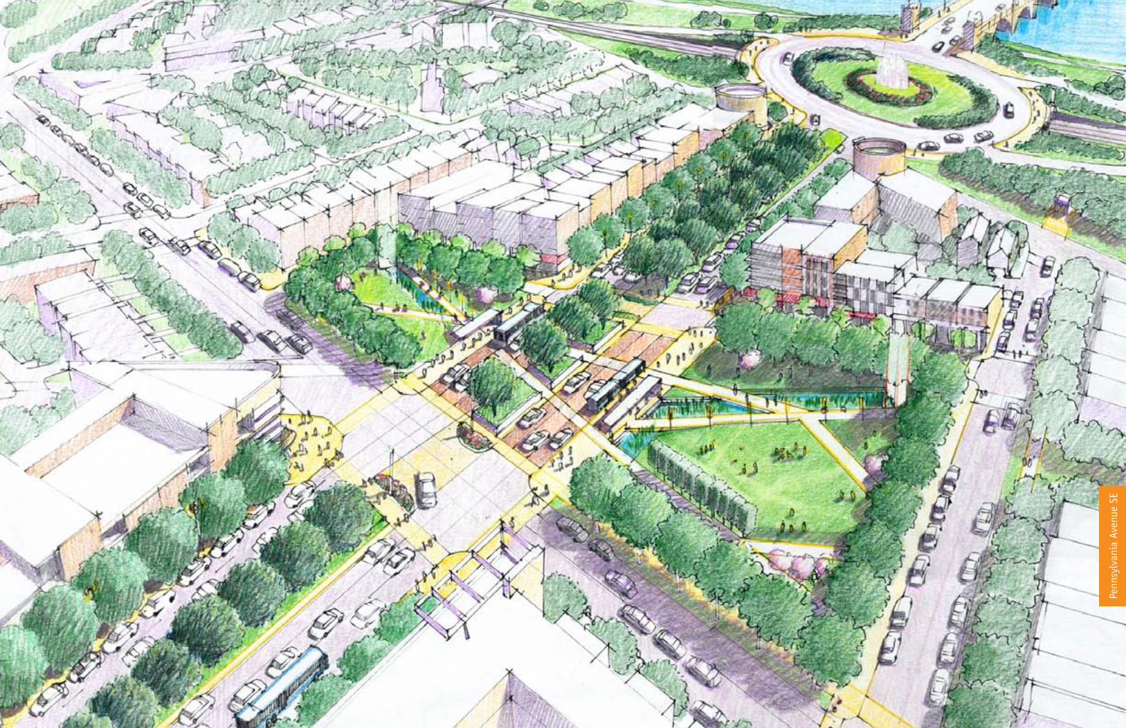
Located at the western end of the corridor, the square is the first major node after the Sousa Bridge. The proposed central open space at the I-�95 interchange, along with this node, will form an open space network that facilitates the river crossing.
Minnesota Avenue will be restored as a two-way street. This will create two softscape parks on either side of Pennsylvania Avenue that will be edged by retail and mixed-use facilities, and have narrow side streets with slow moving traffic. These parks will become major gathering spaces for the surrounding communities and a potential National Memorial site. The square will be well-furnished with benches and streetlighting. Public art, in the form of free-standing sculpture, will serve to highlight this node. Dense tree cover and other landscape elements will shield the parks from traffic and shade the open areas during the summer.
Retailers on the edge of the parks will benefit from the high exposure to traffic and pedestrians. Sidewalk cafés and spaces for street performances and gatherings will create a vital, robust urban place worthy of the neighborhood and the National Capitol. Enhanced, well-lit crosswalks with bulb-outs will make crossing the side streets safer so that walking from the retail facilities to the parks will be convenient.
The side streets will be more pedestrian-friendly with benches, pedestrian level lights, and tree cover that allows for maximum visibility to store fronts. Public art, in the form of insets in the sidewalks, and street sign attachments will help shape a distinct character for these streets.
The median leading from the bridge to the square will be extended across to Minnesota Avenue. Along with the tree canopy on the edge of the parks, the median will reinforce the avenue’s green boulevard feel.
L’ENfANT SQuARE SEGMENT
Enhanced bus transit service will serve this node, reinforcing its role as a gathering space and connecting this part of the city with its core streetscape elements. This segment should be developed from the streetscape elements in the Enhanced Areas section.
Note: Further study recommended for ROW allocation
After (facing page):A re-configured Pennsylvania Avenue with enhanced crosswalks, exposed aggregate concrete sidewalks, and other pedestrian amenities with a plaza on both sides will transform this congested intersection into a gathering point for the surrounding neighborhoods and a gateway to the east.
Before (see below):L’Enfant Square at Minnesota Avenue and Pennsylvania Avenue SE
D I S T R I C T D E P A R T M E N T O F T R A N S P O R T A T I O N
Penn
sylv
ania
Ave
nue
SE
E-�3
Reco
mm
enda
tion
sPe
nnsy
lvan
ia A
venu
e SE
G R E A T S T R E E T S F R A M E W O R K P L A N Pe
nnsy
lvan
ia A
venu
e SE
E-�4
Reco
mm
enda
tion
s
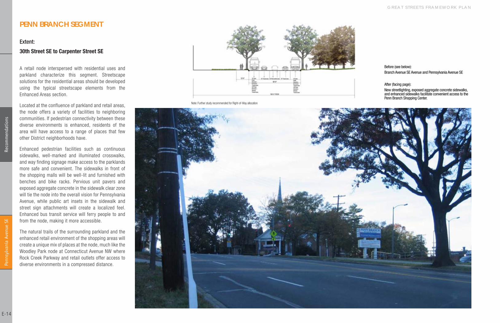
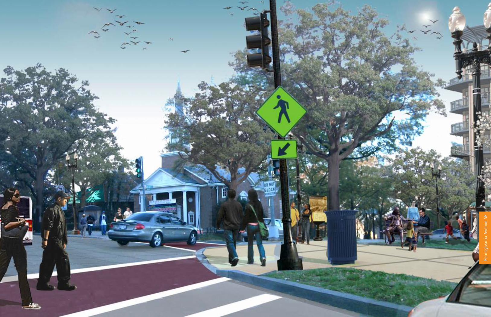
Extent:
30th Street SE to Carpenter Street SE
PENN BRANCh SEGMENT
A retail node interspersed with residential uses and parkland characterize this segment. Streetscape solutions for the residential areas should be developed using the typical streetscape elements from the Enhanced Areas section.
Located at the confluence of parkland and retail areas, the node offers a variety of facilities to neighboring communities. If pedestrian connectivity between these diverse environments is enhanced, residents of the area will have access to a range of places that few other District neighborhoods have.
Enhanced pedestrian facilities such as continuous sidewalks, well-marked and illuminated crosswalks, and way finding signage make access to the parklands more safe and convenient. The sidewalks in front of the shopping malls will be well-lit and furnished with benches and bike racks. Pervious unit pavers and exposed aggregate concrete in the sidewalk clear zone will tie the node into the overall vision for Pennsylvania Avenue, while public art insets in the sidewalk and street sign attachments will create a localized feel. Enhanced bus transit service will ferry people to and from the node, making it more accessible.
The natural trails of the surrounding parkland and the enhanced retail environment of the shopping areas will create a unique mix of places at the node, much like the Woodley Park node at Connecticut Avenue NW where Rock Creek Parkway and retail outlets offer access to diverse environments in a compressed distance.
Note: Further study recommended for Right-of-Way allocation
After (facing page):New streetlighting, exposed aggregate concrete sidewalks, and enhanced sidewalks facilitate convenient access to the Penn Branch Shopping Center.
Before (see below):Branch Avenue SE Avenue and Pennsylvania Avenue SE
D I S T R I C T D E P A R T M E N T O F T R A N S P O R T A T I O N
Penn
sylv
ania
Ave
nue
SE
E-�5
Reco
mm
enda
tion
s
After
Penn
sylv
ania
Ave
nue
SE
G R E A T S T R E E T S F R A M E W O R K P L A N Pe
nnsy
lvan
ia A
venu
e SE
E-�6
Reco
mm
enda
tion
s
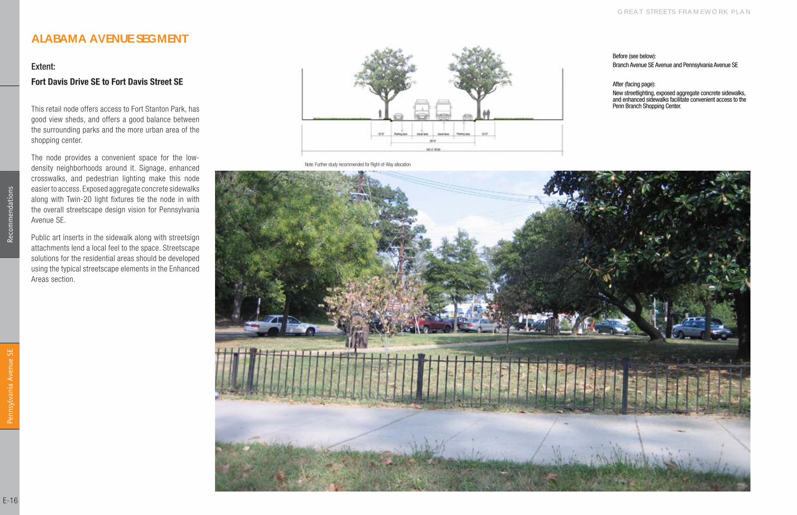
Extent:
Fort Davis Drive SE to Fort Davis Street SE
ALABAMA AvENuE SEGMENT
This retail node offers access to Fort Stanton Park, has good view sheds, and offers a good balance between the surrounding parks and the more urban area of the shopping center.
The node provides a convenient space for the low-density neighborhoods around it. Signage, enhanced crosswalks, and pedestrian lighting make this node easier to access. Exposed aggregate concrete sidewalks along with Twin-�0 light fixtures tie the node in with the overall streetscape design vision for Pennsylvania Avenue SE.
Public art inserts in the sidewalk along with streetsign attachments lend a local feel to the space. Streetscape solutions for the residential areas should be developed using the typical streetscape elements in the Enhanced Areas section.
Note: Further study recommended for Right-of-Way allocation
After (facing page):New streetlighting, exposed aggregate concrete sidewalks, and enhanced sidewalks facilitate convenient access to the Penn Branch Shopping Center.
Before (see below):Branch Avenue SE Avenue and Pennsylvania Avenue SE

D I S T R I C T D E P A R T M E N T O F T R A N S P O R T A T I O N
Penn
sylv
ania
Ave
nue
SE
E-�7
Reco
mm
enda
tion
s
After
Penn
sylv
ania
Ave
nue
SEPe
nnsy
lvan
ia A
venu
e SE

G R E A T S T R E E T S F R A M E W O R K P L A N Pe
nnsy
lvan
ia A
venu
e SE
E-�8
Reco
mm
enda
tion
s
a3.
a1 b1
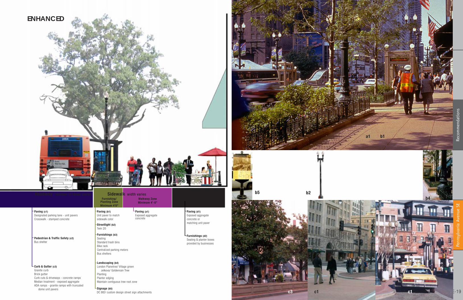
A well-designed, comfortable, and safe pedestrian environment will be a key to reposition Pennsylvania Avenue as a vital neighborhood resource. These streetscape guidelines are intended to promote a feel for the corridor that connects it in a compelling way with the L’Enfant plan for Washington, D.C. and creates vibrant, robust, local places.
These guidelines are written with careful consideration of the ongoing efforts of the city and private developers in the area. The goal is to build upon these and to integrate efforts for maximum and successful results. The streetscape materials and furnishing recommendations should be used as the building blocks to create a unique public environment in conformance with existing District standards.
The streetscape typology emphasizes commercial segments at neighborhood, community, and regional levels that will be treated with the streetscape elements for Enhanced Areas. The street environment along park residential areas will be treated in accordance with the Typical streetscape elements.
These elements should be used in residential, minor retail, and park areas. Where Historic District designation applies, these standards will be superceded by the District’s Historic District standards.
Walkway ZoneMinimum 4’0”
Furnishing/ Planting ZoneMinimum 4’0”
width varies
Paving (c1)Designated parking lane - unit paversCrosswalk - Thermo plastic “piano striping”
Curb & Gutter (c2)Granite curbBrick gutterMedian treatment Curb cuts & driveways - concrete ramps, contiguous sidewalk finishADA ramps - concrete ramps with truncated dome - Unit pavers
Paving (a1)Exposedaggregate concrete
Furnishings (a2)Access cover
Streetlight (b2)Twin �0
Paving (b1)Unit paver tomatch sidewalkcolor
Furnishings (b3)Trash bin
Landscaping(b4)Red MapleUnderstory plantingMulchContiguous tree root zone
STREETSCAPE TREATMENT TYPICAL
Private- Roadway - number of lanes variesSidewalk- width varies
c1
b2
c2
D I S T R I C T D E P A R T M E N T O F T R A N S P O R T A T I O N
Penn
sylv
ania
Ave
nue
SE
E-�9
Reco
mm
enda
tion
s
Spill Zone(optional)
Furnishing/ Planting ZoneMinimum 4’0”
Walkway ZoneMinimum 4’-0”
Sidewalk- width variesRoadway - number of lanes varies
Paving (d1)Exposed aggregateconcrete or matching unit paver
Paving (a1)Exposed aggregate concrete
Furnishings (d2)Seating & planter boxesprovided by businesses
Paving (c1)Designated parking lane - unit paversCrosswalk - stamped concrete
Signage (b5)DC BID/ custom design street sign attachments
Streetlight (b2)Twin �0
Curb & Gutter (c3)Granite curbBrick gutterCurb cuts & driveways - concrete ramps Median treatment - exposed aggregateADA ramps - granite ramps with truncated dome unit pavers
Paving (b1)Unit paver to match sidewalk color
Furnishings (b3)SeatingStandard trash binsBike rackCentralized parking metersBus shelters
Pedestrian & Traffic Safety (c2)Bus shelter
Landscaping (b4)London Planetree/ Village green zelkova/ Goldenrain TreePlantingPlanter edgingMaintain contiguous tree root zone
a1 b1
ENhANCED
c3
b5 b2b4
c1 c1
G R E A T S T R E E T S F R A M E W O R K P L A N Pe
nnsy
lvan
ia A
venu
e SE
E-�0
Reco
mm
enda
tion
s
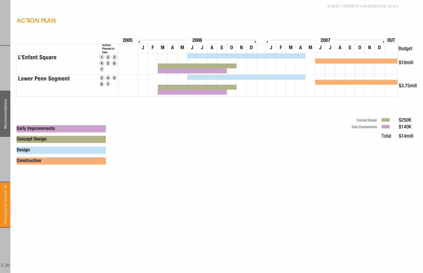
ACTIoN PLAN
J F M A M J J A S O N D J F M A M J J A S O N D
L’Enfant Square
Lower Penn Segment
Design
Construction
Concept Design
Early Improvements
2005 2006 2007 OUTActions Planned to Date
Budget
$10mill
$3.75mill
Total $14mill
$250K$140K
Concept Design
Early Improvements
1 2 3
4 5 6
7
3 4 5
6 7
D I S T R I C T D E P A R T M E N T O F T R A N S P O R T A T I O N
Penn
sylv
ania
Ave
nue
SE
E-��
Reco
mm
enda
tion
s
2 3
76
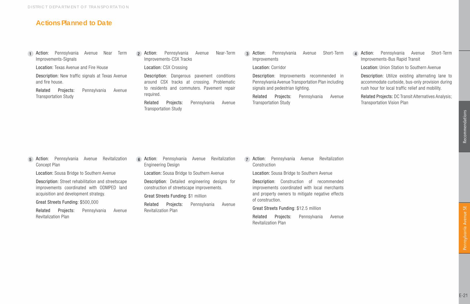
1 Action: Pennsylvania Avenue Near Term Improvements-Signals
Location: Texas Avenue and Fire House
Description: New traffic signals at Texas Avenue and fire house.
Related Projects: Pennsylvania Avenue Transportation Study
4
5
Actions Planned to Date
Action: Pennsylvania Avenue Near-Term Improvements-CSX Tracks
Location: CSX Crossing
Description: Dangerous pavement conditions around CSX tracks at crossing. Problematic to residents and commuters. Pavement repair required.
Related Projects: Pennsylvania Avenue Transportation Study
Action: Pennsylvania Avenue Short-Term Improvements
Location: Corridor
Description: Improvements recommended in Pennsylvania Avenue Transportation Plan including signals and pedestrian lighting.
Related Projects: Pennsylvania Avenue Transportation Study
Action: Pennsylvania Avenue Short-Term Improvements-Bus Rapid Transit
Location: Union Station to Southern Avenue
Description: Utilize existing alternating lane to accommodate curbside, bus-only provision during rush hour for local traffic relief and mobility.
Related Projects: DC Transit Alternatives Analysis; Transportation Vision Plan
Action: Pennsylvania Avenue Revitalization Concept Plan
Location: Sousa Bridge to Southern Avenue
Description: Street rehabilitation and streetscape improvements coordinated with ODMPED land acquisition and development strategy.
Great Streets Funding: $500,000
Related Projects: Pennsylvania Avenue Revitalization Plan
Action: Pennsylvania Avenue Revitalization Engineering Design
Location: Sousa Bridge to Southern Avenue
Description: Detailed engineering designs for construction of streetscape improvements.
Great Streets Funding: $� million
Related Projects: Pennsylvania Avenue Revitalization Plan
Action: Pennsylvania Avenue Revitalization Construction
Location: Sousa Bridge to Southern Avenue
Description: Construction of recommended improvements coordinated with local merchants and property owners to mitigate negative effects of construction.
Great Streets Funding: $��.5 million
Related Projects: Pennsylvania Avenue Revitalization Plan
G R E A T S T R E E T S F R A M E W O R K P L A N Pe
nnsy
lvan
ia A
venu
e SE
E-��
ACKNoWLEDGEMENTSCoRE GRouP
Karina Ricks: District Department of Transportation - Great Streets Program Manager
Derrick Woody: Office of the Deputy Mayor for Planning and Economic Development - Coordinator, Great Streets Initiative
Rosalynn Taylor: Office of Planning -Associate Director for Neighborhood Planning
Drew Becher: Office of Planning - Deputy Director
Tara Jones: Interim Director - Office of Neighborhood Services
John Deatrick: District Department of Transportation, IPMA-Deputy Director, IPMAChief Engineer
Kathleen Penney: District Department of Transportation, IPMA-Deputy City Engineer
Douglas E. Noble: District Department of Transportation, TSAAssociate Director, District Traffic Engineer
CoNSuLTANTSCoMMITTEE ADvISoRY TEAM
Adam Maier: Office of Councilmember Schwartz
James Slattery: Office of Councilmember Schwartz
Velda Bell: Office of Councilmember Barry
Dawn Slonneger: Office of Councilmember Gray
Rhonda Young: Office of Councilmember Gray
Skip Coburn: Office of Councilmember Ambrose
Dee Smith: Office of Councilmember Orange
Denise Johnson: National Trust for Historic Preservation
Dominic Moulden: Manna, CDC
Betty Newell: East Central Civic Association
Alexander Padro: Shaw Main Street/ANC �C
Paul Ruppert: Mt. Vernon Square Business Association
Armond Spikell: Roadside Development
Leroy Thorpe: ANC-�C, Chair
Maybelle Bennett: Howard University
Sinclair Skinner: Lower Georgia Avenue Business
Development Corp
Myla Moss: ANC�B-0�/LeDeroit Park Civic Assoc.
Ali Muhammad: ANC �A-Economic Dev
David Jannarone: Petworth Action Committee
Andrew McGilvray: United Neighborhood Coalition
Garrett Pressick: North Columbia Heights Civic Association
Timothy Jones: ANC4C08
Jourdinia Brown: ANC 4A, Chair
Tony Giancola: Gateway Coalition, Inc
Marc Loud: Gateway Georiga Avenue Revitalization Corporation
Artie Milligan: Georgia Avenue Gateway
Daniel Pernell: ANC 6C04, Commissioner
Cody Rice: ANC 6A, Commissioner
Anwar Saleem: Chairperson, H Street Main Street
Brenda Artis: Miner Elementary School
Kathy Henderson: 5B�0, Commissioner
Gladys Mack: ANC 6A, Commissioner
Bill Myers: 5B�, Commissioner
Frazier Walton: Kingman Park Neighborhood Association
Johnny Gaither: River Terrace Community Organization
Adrian Hasty: 7D04, Commissioner
Dorothy Douglass: 7D Chair, Commissioner
Cheryl Cort: Washington Regional Network for Livable
Communities
Graylin Presbury: Fairlawn Citizens Association
Carrie Thornhill: Marshall Heights Community Development Organization
Carl Cole: Anacostia Waterfront Corporation Board
Diane Fleming: Anacostia Garden Club
Butch Hopkins: Anacostia Economic Development
Corporation
Raymond Keith: ANC 7B, Chair
Phillip Panell: Anacostia Coordinating Council
Yavocka Young: Main Street Anacostia
Al Williams: Ward 8 Business Association
Vera Abbott: Bellevue Neighborhood Civic Association
Sandra Seegars: ANC 8E
Ian Tyndall: Washington Parks and People
Robin Marlin: 7B, Commissioner
Yvonne Moore: Pennsylvania Avenue Task Force
Harriette Hartmann: Small Business (East of the River
Travel)
Richard Hawkins: Penn Branch Civic Association
Barbara Morgan: Pennsylvania Avenue Task Force
Vincent Spaulding: 7B04, Commissioner
Akili Cooper: Fort Davis Civic Association
Maurice Perry: Hillcrest Civic Association/EOR CDC
Louise Brodnitz: Walter Reed Army Medical Center
Paul Savage: Pennsylvania Avenue Task Force
Skip Coburn: Office of Councilmember Ambrose
Wendy Rahim: Office of Councilmember Evans
Ronald Austin: Office of Councilmember Fenty
Kimberley Johnson: Office of Councilmember GrahamCONTACT
Karina Ricks, AICP
Great Streets Program Manager
District Department of Transportation
(202) 671-2542
Ehrenkrantz Eckstut & Kuhn ArchitectsLead, Urban Design and Public RealmHoward Decker, FAIA, Project Director
Matthew Bell, AIA, Principal-in-Charge
Kiran Mathema, Project Manager
Prashant Salvi, Urban Designer/ Planner
Liang Liang, Urban Designer/ Planner
Samar Maqusi, Urban Designer/ Planner Abbie Cronin, Urban Designer
Henry Asri, Urban Designer
Michael Baker Jr., Inc.Transportation and TrafficVictor Siaurusaitis, Principal
Tony Hofmann, Project Manager
Feng Liu, Technical Manager
Derek Miura, Planner
Rajan Paradkar, Web Site Designer
Jianyun Li, Computer Programmer Mark Makin, CADD Technician
Kim Leduc, Content Coordinator
Robert Charles LesserMarket AnalysisLen Bogorad, Managing Director
Marc McCauley, Vice President
Peter McLaughlin, Senior Associate
Michelle Loutoo, Associate
Timothy Wells, Illustrator


