Download - Daer Wind Farm Chapter 2
Daer Wind Farm
2-1 Environmental Impact Assessment Report
Chapter 2: Site Selection & Design Evolution
Issue Date Revision Details
1232095 A 16/02/2021 Released
Chapter 2 Site Selection & Design Evolution
Contents
2.1 INTRODUCTION 2
2.2 THE SITE SELECTION PROCESS 2
Policy Context 3
Wind Resource 3
Grid Connection 3
Access 3
Land Use 3
Proximity of Dwellings 3
Landscape and Visual 4
Ecology and Ornithology 4
Hydrology, Geology and Hydrogeology 4
Cultural Heritage 4
Existing Infrastructure and Aviation 4
Public Right of Way and Core Paths 4
2.3 DESIGN EVOLUTION 4
Scoping (2018) 5
Scoping Update (2019) 5
Design Workshop #1 5
Design Workshop #2 5
Design Workshop #3 – Turbine Design Freeze 6
Design Workshop #4 – Infrastructure 6
Section 36 Application Layout 7
2.4 SUMMARY 7
Glossary Term Definition
The Applicant The applicant is “RWE Renewables UK Developments Ltd”.
Proposed
Development
The proposed Daer Wind Farm
Proposed
Development
Area
The project development area within the site boundary
Daer Land
Portion
Scottish Water Land Ownership, comprising of land east and south of Daer Reservoir.
Wholly within the South Lanarkshire Local Authority Area (demarcated in Diagram 2.1 for
reference).
Daer Wind Farm
2-2 Environmental Impact Assessment Report
Chapter 2: Site Selection & Design Evolution
Term Definition
Kinnelhead
Land Portion
The Kinnelhead Land Portion is situated wholly within the Dumfries & Galloway Local
Authority Area (demarcated in Diagram 2.1 and several EIAR Figures incl. 7.5c).
Rivox Land
Portion
This Forestry and Land Scotland (formerly Forestry Commission) owned area of
commercial forestry sits to the east of the Daer Land Portion. Situated wholly within the
Dumfries & Galloway Local Authority Area (see Diagram 2.2 for reference). This area was
originally scoped but not pursued for wind turbine development.
List of Abbreviations Abbreviation Description
RWE RWE Renewables UK Developments Ltd, the Applicant
Natural Power Natural Power Consultants Limited
EIA Environmental Impact Assessment
EIAR Environmental Impact Assessment Report
AA Appropriate Assessment
MW Mega Watt
ECU Energy Consents Unit
SLC South Lanarkshire Council
DGC Dumfries & Galloway Council
LVIA Landscape & Visual Impact Assessment
SM Scheduled Monument
SAC Special Area of Conservation
SNH Scottish Natural Heritage (now NatureScot)
SSSI Site of Special Scientific Interest
2.1 INTRODUCTION
2.1.1 The purpose of this Chapter is to identify the steps that have been considered in the site selection and design
evolution of the proposed Daer Wind Farm (the Proposed Development). This Chapter demonstrates how the
site design and the layout of the turbines evolved through the initial site selection process, identification of
various constraints and site-specific factors, and highlights the key design criteria applied.
2.1.2 Planning Advice Note (PAN) 68: Design Statements explains the process of undertaking a design statement.
Design and Access statements are a statutory requirement for all National and Major Developments under the
terms of the Town and Country Planning (Development Management Procedures) (Scotland) Regulations 2013.
Although not a statutory requirement for a Section 36 application, this Chapter nevertheless explains the design
process which has been gone through in arriving at the final layout. It also fulfils the requirement of Regulation
5(2)(d) of the Electricity Works (Environmental Impact Assessment) (Scotland) Regulations 2017 to provide a
description of the reasonable alternatives considered and the main reasons for the option chosen by the
Applicant.
2.2 THE SITE SELECTION PROCESS
2.2.1 The Applicant has a portfolio of sites across Scotland that it has investigated over time for the potential for wind
energy development. Some are not progressed whilst others make it all the way to application stage and
constructed following consent. The area in the vicinity of Daer Reservoir has been investigated by the Applicant
for over 10 years. In that time, a wind monitoring campaign has been undertaken with data collected from two
temporary anemometer masts. Feasibility studies have been completed remotely and via site visits. Results
indicated that this site would be a technically and environmentally appropriate location to develop a wind farm. A
scoping report was originally submitted to the Scottish Government in 2011 by the Applicant (formerly known as
E.ON Climate & Renewables UK Developments Ltd). At this time, it was envisaged the wind farm would
comprise of approximately 22 wind turbines approximately 130.5 m in height to blade tip.
2.2.2 The Applicant did not progress the layout scoped in 2011 to application stage. Since then, there have been
significant changes in policies and market conditions for onshore wind. In 2018, Natural Power was
commissioned by the Applicant to investigate the new potential and suitability for a wind farm development here.
A new Scoping Report was issued to the ECU and consultees in December 2018 introducing turbines at 170 m
in height to blade tip and update to it made in 2019 which changed the site boundary and increased turbine tip
height to 180 m. The design evolution of this Proposed Development is presented in section 2.3.
2.2.3 The overarching aim of the selection process was to have a layout that maximised the efficiency of the Proposed
Development whilst limiting the potential environmental impacts. Factors influencing the suitability of the site
included:
• Suitable wind speeds;
• Suitable separation distance from dwellings and settlements;
• Proximity to sensitive landscape and visual receptors;
• Reasonably close proximity to viable grid connection;
• Willing landowner(s);
• Potential to use existing infrastructure, as far as practical;
• Suitable land area to accommodate generating capacity; and
• No significant constraints preventing development.
2.2.4 Initial feasibility studies of the above factors indicated that there was an opportunity for further wind energy
development east of Daer Reservoir between the operational Clyde Wind Farm to the north, and Harestanes
Wind Farm to the south. Figure 1.2 of the EIAR illustrates the regional context of the Proposed Development
Area against which strategic constraints have been considered.

Daer Wind Farm
2-3 Environmental Impact Assessment Report
Chapter 2: Site Selection & Design Evolution
Policy Context
2.2.5 Scottish Planning Policy (SPP) indicates that the Proposed Development is situated predominately within a
Group 3 area; one with potential for wind farm development. According to the NatureScot Carbon and Peatland
Map1, some parts of the Proposed Development Area have carbon rich soils and/or deep peat which under SPP,
classifies them as Group 2; areas of significant protection. The Applicant commissioned baseline survey work to
establish the actual extent of peat depth in the Proposed Development Area. A full review of legislation, national
and local planning policy has been provided in Chapter 4: Climate Change, Legislative and Policy Context of the
EIAR, and an assessment of such material is provided in the accompanying Planning, Design and Access
Statement, as well as in the individual EIAR chapters, in particular Chapter 8. The iterative design process
factored in such policy context, including avoiding Group 2 areas, where practicable, for example.
Wind Resource
2.2.6 Initial long-term wind resource estimates were derived from multiple sources including site measurements
collected on the Proposed Development Area. Early estimates used within an initial feasibility assessment of the
long-term wind speeds across the Proposed Development area are as follows:
2.2.7 Early indications for the Proposed Development are that the capacity factor will be good/above average at ~40%
for turbines up to 180 m to blade tip.
2.2.8 Although these values should be taken as indicative, they imply that the wind resource at the Proposed
Development has the potential to deliver an economically viable wind energy development.
2.2.9 Detailed assessments have been undertaken using state of the art VENTOS Computational Fluid Dynamics
(CFD) modelling in order to better understand the local wind regime. This has led to an improved understanding
of the specific complex flow regime, that results from the terrain and forestry surrounding the Proposed
Development. The turbulence intensity, wind shear, inflow angle and veer across the site were assessed in order
to inform the design process (along with all relevant physical, environmental and technical constraints). The
process was undertaken iteratively in order to arrive at the appropriate number, size and location of turbines for
the Proposed Development to minimise project risks (turbine performance / operational issues) and maximise
project efficiency and energy yield output. An anemometry monitoring campaign has been commenced, using
industry best practice monitoring techniques in order to capture detailed wind profiles and further refine the wind
resource on site.
Grid Connection
2.2.10 Securing a grid connection was another factor in delaying the progression of the EIA since original Scoping in
2011. Capacity in the network was acquired and a grid connection agreed with the network operator which led to
progressing the project again with Scoping in 2018. Capacity on the electricity grid for the Proposed
Development has been secured with a connection date of 2027.
Access
2.2.11 An access study was carried out in 2020 to determine the feasibility of the proposed public access route from
King George V Dock in Glasgow to the entrance of the Proposed Development Area using a Siemens Gamesa
155 wind turbine as a candidate model for the purposes of swept path analysis. The study assessed the delivery
of wind turbine components and general construction traffic including a site visit by an experienced engineer
from Pell Frischmann. The access study was used within the initial feasibility study of the Proposed
Development and as a result deemed that the site had good access given proximity to the M74. Use of existing
forestry roads and tracks built for other wind farms has also been identified and their use and upgrade proposed.
1 Available online: https://map.environment.gov.scot/Soil_maps/?layer=10 (last accessed 29/10/2020)
The potential effects on transport and access are fully assessed in the EIAR and the results presented in
Chapter 11.
Land Use
2.2.12 The Proposed Development is located in an area of moorland and semi-improved pasture, adjacent to Daer
Reservoir. Diagram 2.1 below illustrates the landownerships where the turbine infrastructure is proposed. The
green and yellow areas depict the different tenancies and combined form the Daer Land Portion, owned by
Scottish Water. The blue area is the Kinnelhead Land Portion.
Source: Natural Power
Diagram 2.1: Land Parcels
2.2.13 Scottish Water operates the Daer Reservoir which itself also generates some electricity to power the drinking
water plant. The Proposed Development compliments the existing renewable energy developed in this remote
location here. Furthermore, it is an asset which will significantly increase the renewable energy generated on
Scottish Water land and therefore accords with the Scottish Water Energy Programme. Hosting private
renewable energy investment is one of this utility’s four-pronged approach to energy management, stating it
hosts private investment in renewables on its land where it provides a good return for customers and is
compatible with providing high quality services2.
2.2.14 The landowners, including tenant farmers have been consulted during the EIA in particular with relation to
establishing appropriate areas for habitat management.
2.2.15 The route for the proposed private access from the public road is mostly on existing tracks on land used for
commercial forestry. As a result of some new track and widening/upgrading in existing forestry an assessment of
forestry has been provided in Chapter 12.
Proximity of Dwellings
2.2.16 The Proposed Development Area is relatively remote and distant from large numbers of potential receptors. It is
outwith any settlement which would otherwise class it in Group 2 as defined by SPP. Five dwellings have been
identified within 3 km of the Proposed Development as shown in Table 2.1.
2 Available online: https://docs.google.com/viewerng/viewer?url=www.scottishwater.co.uk/-/media/ScottishWater/Document-
Hub/Key-Publications/Energy-and-Sustainability/Scottish-Water-Energy-Programme.pdf (last accessed 23 November 2020)
Daer Wind Farm
2-4 Environmental Impact Assessment Report
Chapter 2: Site Selection & Design Evolution
Table 2.1: Dwellings within 3 km of the nearest proposed turbine
Property Direction from
Proposed Development
Distance to nearest
turbine (km)
Turbine no.
Sweetshaw Foot North 1.3 7
Kirkhope Cleuch Cottage West 1.3 8
Kirkhope South West 1.5 17
Crookburn South West 1.5 17
Blairmack South East 1.5 14
Source: Appendix A5.5: Residential Visual Amenity Assessment
2.2.17 Potential noise, shadow flicker and visual amenity impacts have been given consideration during the site design
iterations to ensure minimised effects on nearby residents. A detailed noise assessment is provided in Chapter
10: Noise. Shadow flicker is considered in Chapter 13. Residential visual amenity is considered fully in Chapter
5: Landscape and Visual Assessment, of the EIAR.
Landscape and Visual
2.2.18 Landscape and visual considerations were taken considered during the early stages of the project, as these
were understood to be key to the progression of the project. Several sources of information were used at the
time to inform the design. These include, but are not limited to, the following:
• Guidelines for Landscape and Visual Impact Assessment, Third Edition (GLVIA3) (Landscape Institute and
the Institute of Environmental Management, 2013);
• Siting and Designing Wind Farms in the Landscape, Guidance, Version 3a (SNH, 2017);
• South Lanarkshire Local Development Plan Supplementary Guidance: Renewable Energy (2015);
• South Lanarkshire Landscape Capacity Study for Wind Energy (South Lanarkshire Council, 2016);
• South Lanarkshire Landscape Character Assessment (South Lanarkshire Council, 2010);
• South Lanarkshire Tall Wind Turbines: Landscape CAPACITY, Siting and Design Guidance, Addendum to
Landscape Capacity Study for Wind Energy 2016 (South Lanarkshire Council, 2019);
• Dumfries & Galloway Council Local Development Plan 2, Wind Energy Development: Development
Management Considerations, Supplementary Guidance (Dumfries & Galloway Council, 2020);
• Dumfries & Galloway Council Local Development Plan 2, Part 1 Wind Energy Development: Development
Management Considerations, Appendix ‘C’ Dumfries & Galloway Wind Farm Landscape Capacity Study
(Dumfries & Galloway Council, 2020).
2.2.19 Chartered Landscape Architects have worked closely with the project team from the outset, reviewing the siting
and design of the wind turbines in order to minimise, as far as practical, the potential landscape and visual and
cumulative effects of the Proposed Development.
2.2.20 The relationship between the proposed turbines and existing turbines of operational wind farm sites in the area
has been a key consideration for the design of the Proposed Development in landscape and visual terms.
Consideration was also given to other wind farms that are consented or currently in planning and the potential for
cumulative effects. Consideration of the Proposed Development in relation to other constructed, under
construction, consented and submitted developments in the area is fundamental to fully assess the potential
landscape and visual effects.
Ecology and Ornithology
2.2.21 Desk based studies indicated that there were no designated ecological or ornithological constraints such as
Sites of Special Scientific Interest (SSSI), Special Protection Areas (SPA) or RAMSAR, within the Proposed
Development Area. Baseline survey work indicated potential suitability for wind energy development, subject to
further detailed assessment and survey data fed into the iterative design process. Potential effects upon ecology
and ornithology are fully assessed in the EIA and the findings are presented in Chapter 6 and Chapter 7.
Hydrology, Geology and Hydrogeology
2.2.22 The Proposed Development was always going to be within the catchment for Daer Reservoir but with experience
held by the Applicant, Natural Power and Scottish Water of other similar projects built on drinking water
catchments this was considered to be manageable through site design, best practice in construction and other
mitigation measures including a Pollution Prevention Plan. As part of the hydrology assessment all mapped
watercourses were marked as a hard constraint from the outset and a 50 m buffer was applied to them to protect
watercourses from disturbance and potential effects on water quality during construction and operation. In
cognisance of Scottish Water’s guidance, a 100 m buffer was also applied during the design process and
infrastructure located outwith this where possible. Desk based surveys indicated potential for carbon rich soils
and deep peat. The Proposed Development area was surveyed and such areas avoided where practical through
the design evolution. Ground Water Dependant Terrestrial Ecosystems (GWDTE) were also identified and
avoided where possible. A detailed assessment of hydrological elements is provided in Chapter 8.
Cultural Heritage
2.2.23 During the initial feasibility assessment, the presence of cultural heritage was investigated within and out with the
Proposed Development Area and results did not reveal any significant concerns. A baseline survey was
undertaken which identified cultural heritage assets in the Proposed Development Area. These were accounted
for during the design evolution and direct effects thus avoided. A full cultural heritage assessment is provided in
Chapter 9.
Existing Infrastructure and Aviation
2.2.24 The presence of existing infrastructure such as service pipes and cables, TV transmission, mobile telephone
networks and electromagnetic paths were considered. Geographic information systems (GIS) data used within
the initial feasibility study indicated there was existing infrastructure within the Proposed Development Area to
avoid in particular a high-pressure gas pipeline in the northern part of the Proposed Development Area. A
micropath link was identified bisecting the Proposed Development Area and a cautious 200 m buffer applied. A
study of unexploded ordnance (UXO) was undertaken which indicated a potential for UXO within the Proposed
Development Area. Whilst not a hard constraint to design, UXO surveying was undertaken in advance of
intrusive groundwork such peat probing and no UXO were discovered. Full details are provided in Chapter 13.
Public Right of Way and Core Paths
2.2.25 The Southern Upland Way passes through the Proposed Development Area in the north and was given a ‘topple
height’ distance buffer during the design process. There were no other such rights of way that travelled through
the Proposed Development Area that needed to be accounted for in design. More details are provided in
Chapter 13.
2.3 DESIGN EVOLUTION
2.3.1 This section describes the design evolution of the Proposed Development and discusses how the site design
and layout continued to evolve throughout the EIA process. The site design process was guided by the findings
of the baseline surveys and by issues raised by statutory and non-statutory consultees in line with Scottish
Planning Policy The layout evolved under the guidance, requirements and considerations of RWE including
Scottish Water’s own guidance, contributions from Natural Power and from other contributing specialist
consultants such as cultural heritage, aviation and transport advisors. Many of site constraints identified during
the process and taken into account for the design evolution are illustrated in Figure 1.3.
Daer Wind Farm
2-5 Environmental Impact Assessment Report
Chapter 2: Site Selection & Design Evolution
Scoping (2018)
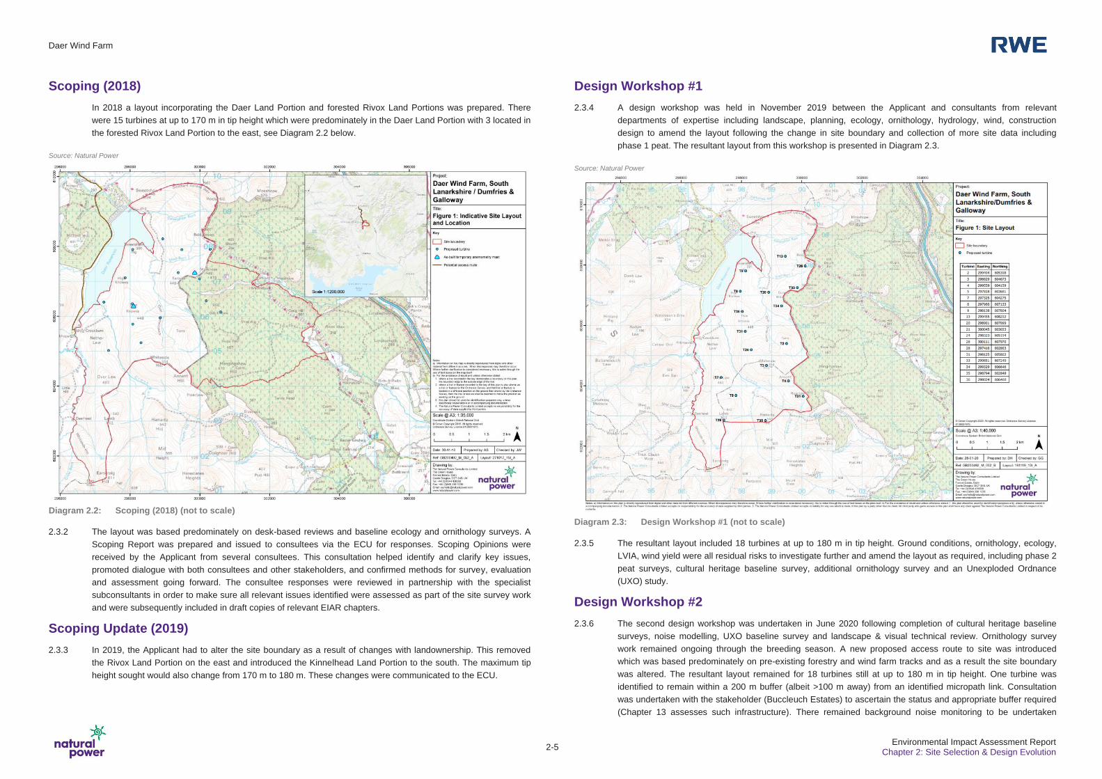
In 2018 a layout incorporating the Daer Land Portion and forested Rivox Land Portions was prepared. There
were 15 turbines at up to 170 m in tip height which were predominately in the Daer Land Portion with 3 located in
the forested Rivox Land Portion to the east, see Diagram 2.2 below.
Source: Natural Power
Diagram 2.2: Scoping (2018) (not to scale)
2.3.2 The layout was based predominately on desk-based reviews and baseline ecology and ornithology surveys. A
Scoping Report was prepared and issued to consultees via the ECU for responses. Scoping Opinions were
received by the Applicant from several consultees. This consultation helped identify and clarify key issues,
promoted dialogue with both consultees and other stakeholders, and confirmed methods for survey, evaluation
and assessment going forward. The consultee responses were reviewed in partnership with the specialist
subconsultants in order to make sure all relevant issues identified were assessed as part of the site survey work
and were subsequently included in draft copies of relevant EIAR chapters.
Scoping Update (2019)
2.3.3 In 2019, the Applicant had to alter the site boundary as a result of changes with landownership. This removed
the Rivox Land Portion on the east and introduced the Kinnelhead Land Portion to the south. The maximum tip
height sought would also change from 170 m to 180 m. These changes were communicated to the ECU.
Design Workshop #1
2.3.4 A design workshop was held in November 2019 between the Applicant and consultants from relevant
departments of expertise including landscape, planning, ecology, ornithology, hydrology, wind, construction
design to amend the layout following the change in site boundary and collection of more site data including
phase 1 peat. The resultant layout from this workshop is presented in Diagram 2.3.
Source: Natural Power
Diagram 2.3: Design Workshop #1 (not to scale)
2.3.5 The resultant layout included 18 turbines at up to 180 m in tip height. Ground conditions, ornithology, ecology,
LVIA, wind yield were all residual risks to investigate further and amend the layout as required, including phase 2
peat surveys, cultural heritage baseline survey, additional ornithology survey and an Unexploded Ordnance
(UXO) study.
Design Workshop #2
2.3.6 The second design workshop was undertaken in June 2020 following completion of cultural heritage baseline
surveys, noise modelling, UXO baseline survey and landscape & visual technical review. Ornithology survey
work remained ongoing through the breeding season. A new proposed access route to site was introduced
which was based predominately on pre-existing forestry and wind farm tracks and as a result the site boundary
was altered. The resultant layout remained for 18 turbines still at up to 180 m in tip height. One turbine was
identified to remain within a 200 m buffer (albeit >100 m away) from an identified micropath link. Consultation
was undertaken with the stakeholder (Buccleuch Estates) to ascertain the status and appropriate buffer required
(Chapter 13 assesses such infrastructure). There remained background noise monitoring to be undertaken
Daer Wind Farm
2-6 Environmental Impact Assessment Report
Chapter 2: Site Selection & Design Evolution
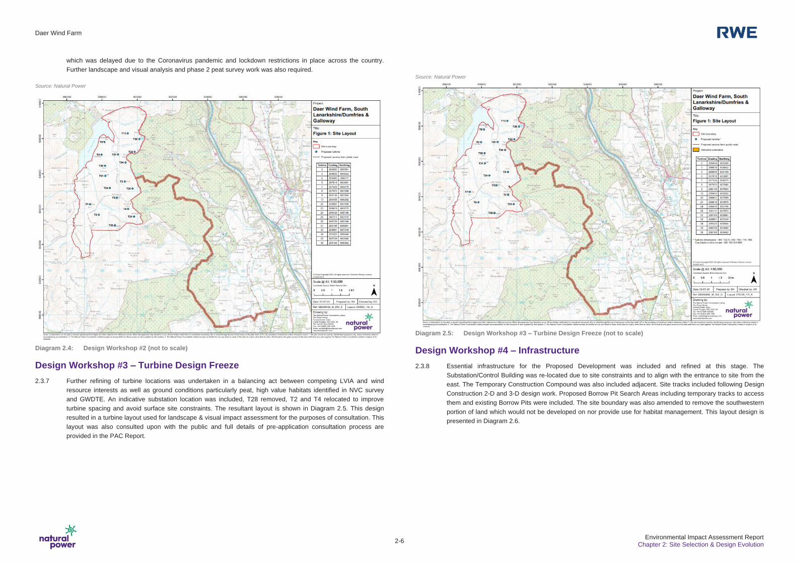
which was delayed due to the Coronavirus pandemic and lockdown restrictions in place across the country.
Further landscape and visual analysis and phase 2 peat survey work was also required.
Source: Natural Power
Diagram 2.4: Design Workshop #2 (not to scale)
Design Workshop #3 – Turbine Design Freeze
2.3.7 Further refining of turbine locations was undertaken in a balancing act between competing LVIA and wind
resource interests as well as ground conditions particularly peat, high value habitats identified in NVC survey
and GWDTE. An indicative substation location was included, T28 removed, T2 and T4 relocated to improve
turbine spacing and avoid surface site constraints. The resultant layout is shown in Diagram 2.5. This design
resulted in a turbine layout used for landscape & visual impact assessment for the purposes of consultation. This
layout was also consulted upon with the public and full details of pre-application consultation process are
provided in the PAC Report.
Source: Natural Power
Diagram 2.5: Design Workshop #3 – Turbine Design Freeze (not to scale)
Design Workshop #4 – Infrastructure
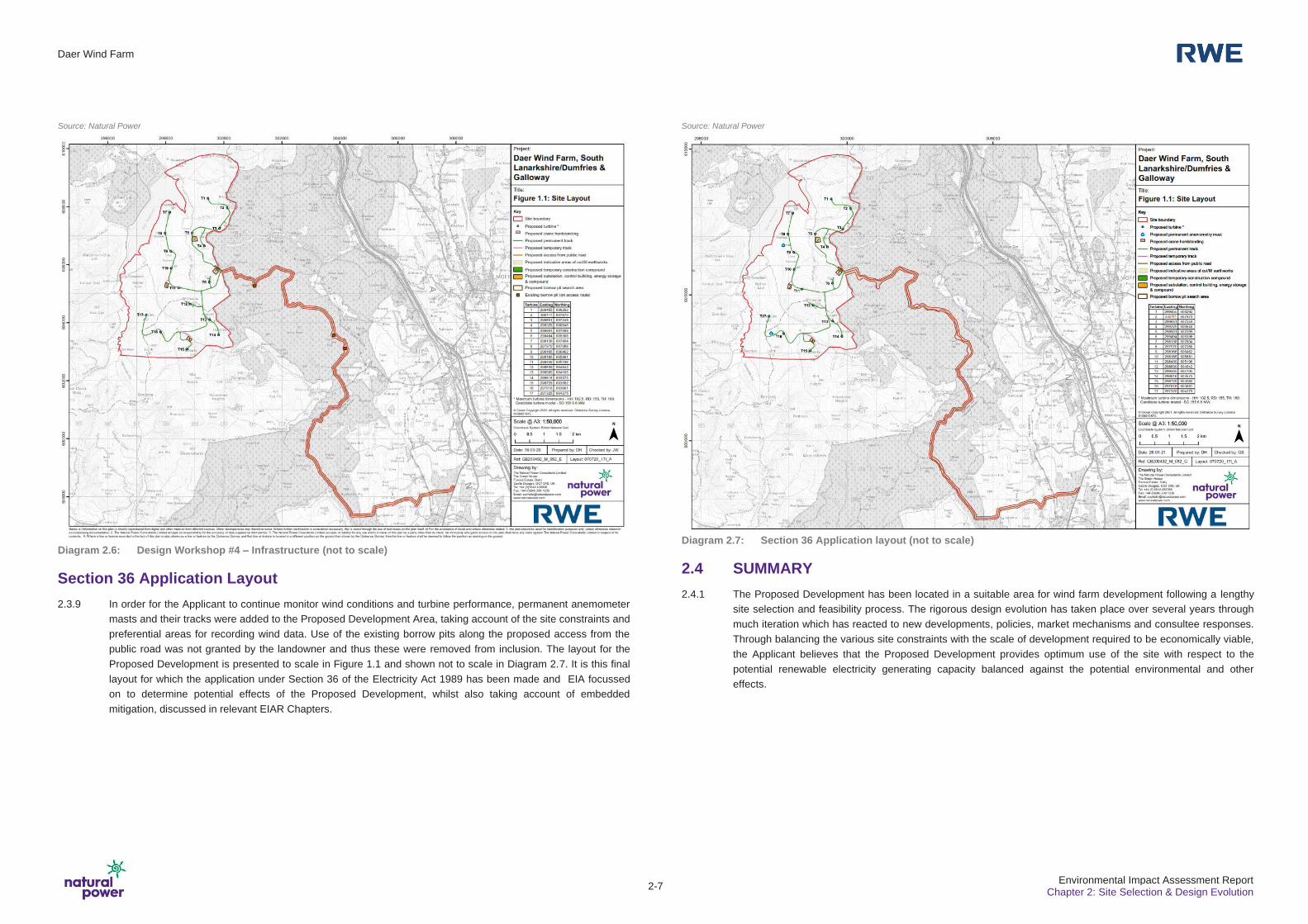
2.3.8 Essential infrastructure for the Proposed Development was included and refined at this stage. The
Substation/Control Building was re-located due to site constraints and to align with the entrance to site from the
east. The Temporary Construction Compound was also included adjacent. Site tracks included following Design
Construction 2-D and 3-D design work. Proposed Borrow Pit Search Areas including temporary tracks to access
them and existing Borrow Pits were included. The site boundary was also amended to remove the southwestern
portion of land which would not be developed on nor provide use for habitat management. This layout design is
presented in Diagram 2.6.
Daer Wind Farm
2-7 Environmental Impact Assessment Report
Chapter 2: Site Selection & Design Evolution
Source: Natural Power
Diagram 2.6: Design Workshop #4 – Infrastructure (not to scale)
Section 36 Application Layout
2.3.9 In order for the Applicant to continue monitor wind conditions and turbine performance, permanent anemometer
masts and their tracks were added to the Proposed Development Area, taking account of the site constraints and
preferential areas for recording wind data. Use of the existing borrow pits along the proposed access from the
public road was not granted by the landowner and thus these were removed from inclusion. The layout for the
Proposed Development is presented to scale in Figure 1.1 and shown not to scale in Diagram 2.7. It is this final
layout for which the application under Section 36 of the Electricity Act 1989 has been made and EIA focussed
on to determine potential effects of the Proposed Development, whilst also taking account of embedded
mitigation, discussed in relevant EIAR Chapters.
Source: Natural Power
Diagram 2.7: Section 36 Application layout (not to scale)
2.4 SUMMARY
2.4.1 The Proposed Development has been located in a suitable area for wind farm development following a lengthy
site selection and feasibility process. The rigorous design evolution has taken place over several years through
much iteration which has reacted to new developments, policies, market mechanisms and consultee responses.
Through balancing the various site constraints with the scale of development required to be economically viable,
the Applicant believes that the Proposed Development provides optimum use of the site with respect to the
potential renewable electricity generating capacity balanced against the potential environmental and other
effects.

Daer Wind Farm
2-8 Environmental Impact Assessment Report
Chapter 2: Site Selection & Design Evolution


