
1
CORPUSTY & SAXTHORPE
NEIGHBOURHOOD PLAN 2017-2036
This is a formal consultation document for the purpose of Statutory Consultation with the local authority,
statutory bodies, residents of Corpusty and Saxthorpe and with others having a significant interest in the
Neighbourhood Plan Area, including those who work in the villages but do not reside there.
This document will be used in the Statutory Consultation period which will last for six weeks from June 5th 2017.
When the statutory period of consultation is completed, emendations will be made to this draft as necessary and
these will then constitute part of the submission of the Neighbourhood Plan for Corpusty and Saxthorpe for
checking by the local authority and for formal inspection.
CORPUSTY & SAXTHORPE PARISH COUNCIL
Pre-Submission Consultation
June 2017
2

3
Contents 1 FOREWORD ............................................................................................................................................................... 6
SECTION 1 ......................................................................................................................................................................... 7
2 INTRODUCTION ......................................................................................................................................................... 8
2.1 WHAT IS A NEIGHBOURHOOD PLAN? .............................................................................................................. 8
2.1.1 How to comment on the pre-submission draft ........................................................................................ 8
2.2 PLAN CONTENT .............................................................................................................................................. 10
2.3 THE CONSULTATION PROCESS INFORMING THIS PLAN ................................................................................. 11
3 PLACE SETTING ........................................................................................................................................................ 13
4 HOW THE CORPUSTY & SAXTHORPE NEIGHBOURHOOD PLAN FITS INTO THE NATIONAL AND LOCAL PLANNING
FRAMEWORK AND LEGISLATION .................................................................................................................................... 14
4.1 CONDITIONS STATEMENT .............................................................................................................................. 15
4.1.1 Basic Requirements ................................................................................................................................. 15
5 VISION STATEMENT ................................................................................................................................................ 18
6 AIMS, OBJECTIVE AND CONSTRAINTS ..................................................................................................................... 19
6.1 AIMS OF THE NEIGHBOURHOOD PLAN .......................................................................................................... 19
6.1.1 To engender a vibrant, inclusive and caring community: ....................................................................... 19
6.1.2 To enhance and not devalue the architectural and landscape character of the villages and improve the
quality of the housing: ............................................................................................................................................ 20
6.1.3 To Increase the number of young families it is hoped that housing policies will help retain and attract
young families in the village. ................................................................................................................................... 20
6.1.4 To increase economic activity in the parish. ........................................................................................... 20
6.1.5 To take account of the nature and capacity of the roads within the parish........................................... 20
6.1.6 To take account of the effect of public transport on the village. ........................................................... 20
6.2 OBJECTIVES OF THE NEIGHBOURHOOD PLAN ............................................................................................... 21
1. People and Housing ................................................................................................................................................... 21
2.Natural Environment............................................................................................................................................ 21
3. Historic Environment ................................................................................................................................................. 21
4. Design and Character ................................................................................................................................................ 21
5. Making a living .......................................................................................................................................................... 21
6. Education ................................................................................................................................................................... 22
7. Wellbeing and Flourishing .......................................................................................................................................... 22
8. Getting around ........................................................................................................................................................... 22
6.3 CONSTRAINTS, CHALLENGES AND OPPORTUNITIES ...................................................................................... 23
6.3.1 Physical and geographical constraints .................................................................................................... 23
6.3.2 Challenges ............................................................................................................................................... 27
6.3.3 Opportunities .......................................................................................................................................... 29
SECTION 2 ....................................................................................................................................................................... 32
4
7 PLANNING POLICIES AND COMMUNITY ASPIRATIONS ........................................................................................... 33
Introduction ................................................................................................................................................................... 33
1. People and Housing ....................................................................................................................................... 35
7.1 OVERARCHING POLICY 1: THE NEW VILLAGE SETTLEMENT BOUNDARY (ALSO KNOWN AS THE “VILLAGE
ENVELOPE”) .................................................................................................................................................................... 35
Priority Development Areas ........................................................................................................................................... 37
7.2 OVERARCHING POLICY 2: PROTECTION OF GREEN SPACES WITHIN THE VILLAGE DEVELOPMENT BOUNDARY
40
7.3 OVERARCHING POLICY 3: RESIDENTIAL DENSITY .......................................................................................... 41
7.4 DETAILED POLICIES ......................................................................................................................................... 42
PLANNING POLICY H1. SCALE AND LOCATION OF NEW RESIDENTIAL DEVELOPMENT ............................... 42
PLANNING POLICY H2. AFFORDABLE HOUSING AND PLANNING OBLIGATIONS ......................................... 43
COMMUNITY ASPIRATION CA1 – AFFORDABLE HOUSING – LOCAL CONNECTIONS .................................... 44
PLANNING POLICY H3. MIX AND TYPE OF HOUSING .................................................................................... 44
PLANNING POLICY H4. FURTHER HOUSING WITHIN THE SETTLEMENT BOUNDARY .................................. 45
2. Natural Environment ............................................................................................................................................... 46
Policies ............................................................................................................................................................................ 46
PLANNING POLICY E1: AGRICULTURAL LAND ................................................................................................ 47
PLANNING POLICY E2: THE RIVER BURE AND VALLEY .................................................................................. 47
PLANNING POLICY E3: PROTECTION AND ENHANCEMENT OF LOCAL BIODIVERSITY ................................. 48
PLANNING POLICY E4: RENEWABLE ENERGY ................................................................................................ 48
PLANNING POLICY E5: ENCOURAGE SCHEMES FOR LOW CARBON DEVELOPMENT .................................... 49
COMMUNITY ASPIRATION CA3 – RENEWABLE ENERGY AND INSULATION ................................................. 49
3. Historic Environment .................................................................................................................................................. 50
Policies 50
PLANNING POLICY HE1: ARCHAEOLOGY ....................................................................................................... 50
PLANNING POLICY HE2: VIEWS OF THE CHURCHES ...................................................................................... 51
4. Design and Character .............................................................................................................................................. 52
PLANNING POLICY DC1. OVERALL CHARACTER ............................................................................................. 55
PLANNING POLICY DC2. OPEN SPACE ............................................................................................................ 55
5. Making a Living........................................................................................................................................................ 56
PLANNING POLICY B1. SMALL BUSINESSES AND LIGHT INDUSTRY .............................................................. 57
PLANNING POLICY B2. HEAVY GOOD VEHICLES ............................................................................................ 58
COMMUNITY ASPIRATION CA4. ULTRA-FAST BROADBAND AND MOBILE PHONE SERVICE ....................... 59
6. Education ....................................................................................................................................................... 59
PLANNING POLICY ED1. THE PRIMARY SCHOOL AND EDUCATION FACILITIES ............................................ 60
PLANNING POLICY ED2. TRAVELLING LIBRARY ............................................................................................. 60

5
COMMUNITY ASPIRATION CA6. PROMOTION OF ADULT EDUCATION & ENTERTAINMENT ..................... 61
7. Well-being and Flourishing ............................................................................................................................ 62
PLANNING POLICY W&F1: ST ANDREW’S CHURCH ....................................................................................... 62
PLANNING POLICY W&F3: ALLOTMENTS ....................................................................................................... 63
PLANNING POLICY W&F2: FOOTPATHS ......................................................................................................... 63
COMMUNITY ASPIRATIONS CA7: ST PETER’S CHURCH ................................................................................. 63
COMMUNITY ASPIRATION CA8: PLAY AREAS ............................................................................................... 63
8. Getting around ............................................................................................................................................... 64
PLANNING POLICY T1. TRAFFIC CALMING ..................................................................................................... 65
COMMUNITY ASPIRATION CA9: COMMUNITY AND VOLUNTARY TRANSPORT .......................................... 65
PLANNING POLICY T3. PUBLIC TRANSPORT .................................................................................................. 65
PLANNING POLICY T2. CAR PARKING ............................................................................................................ 65
8 SUSTAINABILITY APPRAISAL MATRIX ...................................................................................................................... 66
9 THE SUSTAINABILITY MATRIX ................................................................................................................................. 67
10 RISK ASSESSMENT ............................................................................................................................................... 71
11 MONITORING AND REVIEW ................................................................................................................................ 72
12 APPENDICES TO THIS REPORT: THE EVIDENCE BASE .......................................................................................... 73
6
1 FOREWORD
The two villages of Corpusty and Saxthorpe make up one thriving rural community. They share a primary school,
village stores, public house, gallery and two ancient churches. There are allotments, a well-used community centre
built largely with lottery funds, and many small businesses. These include electrical contractors, furniture makers,
vehicle and agricultural machinery repair workshops and many people who work from their homes offering a wide
range of skills and expertise.
The surrounding agricultural land is very actively cultivated by local farmers. The population of just under 700 people
is varied. It consists of families with young children, single person households, three generation households, “empty-
nesters”, people employed locally, others who commute to local towns such as Holt and Fakenham, to Norwich, and
further afield, and a significant number of the retired and elderly.
This Plan looks to preserve and enhance the vitality of our community. At the same time its intention is to make
good plans and policies for the future. These plans and policies rest on extensive consultation across the whole
community. Their aim is to assure the community’s future as one where diversity and vibrant changes are facilitated
in a way that takes forward the best of the old while grasping the opportunities and challenges of the new.
The plan is concerned with protecting what is distinctive about the two villages. Both are mentioned in The
Domesday Book of 1086, and Saxthorpe church (a grade 1 listed building) includes parts that are over nine hundred
years old. The garden of the Mill House has a national reputation. Over the centuries, the village green has been a
focal point for the community.
Corpusty and Saxthorpe will only thrive in the future if families with young children can afford to live here; if
employment opportunities are increased; if existing local businesses are encouraged and new ones attracted. This
has implications for the school and for the other facilities. There have been many and repeated consultations about
the issues addressed in the plan, and the responses clearly indicate a willingness to think positively and creatively
about the future of our villages.
In what follows, under the oversight of the Parish Council, community Objectives derived from wide consultation
have been translated into realistic Policies and Aspirations which can guide the process of change.
The Neighbourhood Plan aims to preserve what is best from the past, for the benefit of present and future
generations.

7
SECTION 1
All photographs in this Plan remain © Roger Last.
Text © Tony Barnett & Imogen Waterson

8
2 INTRODUCTION
2.1 WHAT IS A NEIGHBOURHOOD PLAN?
The Corpusty and Saxthorpe Neighbourhood Plan (the Plan) is a new type of planning document. It is part of central
Government’s new approach to planning. This approach claims to give local people more say about what goes on in
their area. The approach is described and set out in the Localism Act which came into force in April 20121.
Corpusty & Saxthorpe was designated a Neighbourhood Planning Area in December 2013. This designation made
Corpusty and Saxthorpe Parish Council the appropriate authority (see Appendix 1) to oversee and implement the
planning process and to follow up on its recommendations if the Plan is approved for adoption by a referendum in
the community.
The process leading to referendum is as follows:
1. Production of a pre-submission draft Neighbourhood Plan (this document);
2. Submission of the draft to North Norfolk District Council for comment and referral for emendation;
3. Statutory Consultation with the community, statutory consultees and others who have an interest in the
community (over a six-week period);
4. Any necessary revisions consequent to the Statutory Consultation;
5. Resubmission to North Norfolk District Council and submission of the final document for independent
examination by a properly appointed inspector, a process which may take several weeks;
6. Publication of the inspector’s report and, if positive, procedure to referendum;
7. Referendum to take place within 28 working days.
The referendum question would be:
"Do you want North Norfolk District Council to adopt the Neighbourhood Plan for Corpusty and Saxthorpe to help it
decide planning applications in the Neighbourhood Plan Area?"
Anybody registered to vote in the Neighbourhood Plan Area will be entitled to vote. A simple majority of votes cast
(over 50% of those voting) in favour of the Neighbourhood Plan is sufficient for it to succeed.
This Plan provides a vision for the future of our community. It sets out clear planning policies to realise this vision.
As required by the Localism Act, these policies are required to conform with higher level planning policy. An
important consideration is that the North Norfolk Core Strategy2 designated Corpusty and Saxthorpe as a “service
village”. National priorities to build more housing require that the village should provide a certain number of new
houses within its area. This requirement which is in line with national housing strategy makes a Neighbourhood Plan
particularly important because it will provide guidance for that development, enabling local residents to determine
what new developments should look like, where they should be built and what additional infrastructure is necessary
to cater for a growing population.
2.1.1 How to comment on the pre-submission draft
Anyone resident in the Neighbourhood Plan Area, or who has an interest in the area (works or carries on business in
the Neighbourhood Plan Area) may comment on this draft.
A copy of this document can be found at Corpusty and Saxthorpe website
(https://corpustyandsaxthorpeparishcouncil.wordpress.com), or a digital copy may be obtained by contacting either
1 https://www.gov.uk/government/publications/localism-act-2011-overview
2 https://www2.north-norfolk.gov.uk/planning/10538.asp

9
Tony Barnett or Imogen Waterson (to whom comments and questions may also be sent) at the following email
addresses: [email protected] or [email protected]
or by writing to Imogen Waterson, Chair or the Parish Council at: The Old Rectory, Saxthorpe, Norwich. NR11 7BJ
The statutory period is from June 5th 2017 for 6 weeks up to July 17th 2017 at 5.00pm.

10
2.2 PLAN CONTENT
The Neighbourhood Plan describes the Aims and Objectives developed through community consultation. It presents
them as practical Policies which form a framework for development of the village up to the year 2036 and beyond.
These Policies fall within the framework of planning legislation and regulation and concern housing development
and preservation and enhancement of green spaces. The Plan also contains Community Aspirations. These are
objectives the community has said it would like to achieve but which do not fall within the area of formal planning,
for example traffic calming in the centre of the village.
The Plan and its Policies affect many aspects of village life and the intention is to ensure that the village remains a
good place to live while responding to and, where possible, taking advantage of inevitable future changes.
In line with Policy in the adopted Local Plan for North Norfolk, the Neighbourhood Plan proposes some new housing
development. The Parish Council, acting in its capacity as a Neighbourhood Planning Authority, cannot reduce
proposed the number of houses below that proposed in the North Norfolk District Council Local Plan3. This allowed
for building approximately 26 new homes over its plan period to 2021, as set out in North Norfolk District Council’s
Priority Area Development Plan4.
This new Neighbourhood Plan can allow for more homes to be built. The proposal is for some areas of land to be
identified in the plan that would be suitable for new buildings and would allow approximately 50 new homes to be
built over the period up to 2036. This number of houses is considered necessary because the present demographic
structure (distribution of the village population by age and gender -see Appendix 4) of the village projected forward
to 20141 indicates progressive ageing of the population without significant balancing increase to the younger age
groups in the village . The present size and structure of the village would be compromised by a much larger
development because the total population of the village is 670. For this reason, the plan should try to provide
housing and employment for younger people to keep the village a lively and vital place with all age groups cared for
and looking to the future.
Although not a statutory requirement for Neighbourhood Plans, the sustainability appraisal for this Plan uses the
existing information from North Norfolk District Council’s Local Development Plan, which can be seen at:
https://www2.north-norfolk.gov.uk/planning/21416.asp
Following consultation, local people have indicated where they would like new homes; they have also suggested
where local employment may be encouraged by development of a small “business area” to the north of the village.
In addition to housing, the plan sets out a wide range of issues for the community including all the issues discussed in
the Objectives. How these Objectives, Policies and Community Aspirations were arrived at through consultation is
explained in the next section.
3 https://www.north-norfolk.gov.uk/tasks/planning-policy/view-the-current-local-plan
4 https://www2.north-norfolk.gov.uk/files/Site_Allocations_Plan_(Villages).pdf

11
2.3 THE CONSULTATION PROCESS INFORMING THIS PLAN
Community Plan 2009-2011
Summer 2009, Corpusty and Saxthorpe Parish Council resolved to undertake a Community Planning Exercise with grant assistance from Norfolk Rural Community Council.
Publicity in posters around the villages and in the Parish Magazine, followed by periodic updates by poster and in the Parish Magazine.
Autumn 2009, public consultation in the Village Hall, high attendance (105 people), group work on “what the village wants” – attended by more than 75 people, outputs include a list of aspirations for the community in terms of the themes: Values, Facilities and Future Developments.
Establishment of a Working Group, leading to development of a detailed survey with the aim of understanding structure, facilities and aspirations of the population.
July – September 2010, census and opinion survey of village by property and household, survey questionnaire was delivered by hand to all households in the village area, completed questionnaires were collected, with three recalls.
Transfer of all responses onto data sheets ready for analysis, done with community participation in data entry process; entry and analysis completed with research assistance from London School of Economics research assistant.
May/June 2011, Presentation of preliminary results to C&S Parish Council followed by presentation of survey results at public meeting attended by almost 100 people in the Village Hall, followed by development of a Vision for the Future of the community, led by the Working Group and accompanied by 8 small groups in discussions and further deliberations with different interest groups and constituencies in the villages.
August 2011, Publication and circulation of Community Plan Survey Report (see Appendix 2) to all households in the villages, followed by public working meetings to develop strategy for village development.
January 2012: Community Plan next steps discussed at open meeting in village hall 2012, attended by 72 people.
The Vision for the Future of the Community informed the Neighbourhood Plan process which followed.
Neighbourhood Plan 2012 – present time
July – September 2012: Corpusty & Saxthorpe Parish Council resolved to undertake Neighbourhood Planning process and initiate discussions with North Norfolk District Council (NNDC) Planning Department
Consultation with NNDC planning department about possibility of making a NP
May 2013 PC approval of the Neighbourhood Planning process
Designation of Corpusty and Saxthorpe as a Neighbourhood Planning Area by NNDC following additional NNDC on-line consultation in the required period up to December 13, 2013
Grant application to Locality successful December 2013
2013 NP Steering Committee develops outline Objectives for the Neighbourhood Plan, these to be subject of Community Consultation, see below.
2014 Objectives accepted by C&S Parish Council as appropriate framework for the NP process 2014
Community Consultation with all households in Corpusty and Saxthorpe by questionnaire to every household on their attitudes and suggested additions to Objectives via Parish Newsletter with follow up house visits to outliers; this was supplemented by an on-line consultation, see Appendix 13.
Analysis of replies from questionnaires spring 2014
31st May 2014 Village Green Open Day Consultation to establish areas for housing and industrial developments using extended open ended interviews, facility mapping and future planning mapping techniques, and recorded in still photos and some video5. More than 150 people visited the event and full records of the opinions are available in Appendix 9.
5 These video records are held on file but are not made available without permission of the person but anonymised
transcriptions appear at Appendix 9.

12
Analysis of open day interview qualitative responses by Rafael Barnett-Knights at that time of Reepham College (as part of a work placement), writing of consultation report which appears as Appendix 9.
Autumn 2014 Commissioning of experts to deliver reports on many aspects of the village e.g. heritage, environment, water and sewerage, demography. Additionally, completion of a traffic survey on (analysed by Lucy Johnson, at that time from Reepham College) key sites to identify speed infractions including diurnal frequency and mean and maximum speeds plus incidence. These reports appear at Appendices 4, 7, 8, 15, 16.
Consultation with over 60s tea at village hall 25 September 2014, Appendix 6.
Consultation with young families at the Duke’s Head 1st October 2014.
Individual discussion consultation with villagers on walks round the village September 2014-December 2014.
Consultation with landowners 2014-2016. Appendix 11.
Letters to Statutory Consultees- see separate list at Appendix 12 TO BE COMPLETED AFTER THIS CONSULTATION
Replies from statutory consultees – see Appendix 12 TO BE COMPLETED AFTER THIS CONSULTATION
Budget report to locality December 2014
On-going discussions with NNDC planning department throughout the process 2013-2016.
September – October 2015: Village envelope consultation by public notices around the village (30) plus in village shop with detailed mapping on a large poster in St. Andrew’s church plus confidential responses submitted by village people in the consultation period.
February-April 2016: Analysis of envelope consultation data with resulting adaptation and clarification about one area which villagers felt had been misclassified. This was reclassified because of the consultation, Appendix 3.
2015-2016 write up of the Neighbourhood plan with on-going consultations with NNDC planning department
2016: Grant from NNDC to continue the work on the NP
Commissioning of final draft of NP to take it to pre-submission phase September 2016
September 2016: Further grant application to NNDC for completion of NP.
December 2016-March 2017 preparation of draft for Parish Council and local community consultation.
April 28 2017: Public consultation in Corpusty & Saxthorpe Village Hall; this was preceded by distribution of 80 posters advertising the even over the preceding month, a notice in the Parish Newsletter, a press report in the North Norfolk News, a notice on the Parish Council website. The occasion lasted for four hours between 1700 and 2100 and was attended by 70 people; detailed information including all draft policies were exhibited and people submitted written comments; at 1930 there was a brief introduction to the event followed by a lively Q&A period lasting an hour, this was attended by 45 people. Simultaneously with this process, the same draft was made available on the C&S Parish Council website together with all draft appendices and went to comment from NNDC.
This version of the draft report was distributed at the public meeting on April 28 2017, was made available in printed form through the village shop, and remained available on the Parish Council website from March 2017-June 2017.
May 2017: extensive revision of draft report with advice from NNDC Planning Department, to produce Pre-Submission Draft.

13
3 PLACE SETTING The Neighbourhood Plan for Corpusty and Saxthorpe covers the whole of the civil parish. Its boundaries are clear
and well established. This forms the Neighbourhood Planning Area and is shown in Figure 1.
Areas within the designated Settlement Boundary of the Neighbourhood Plan Area have been defined as those
where development will be acceptable and is to be encouraged.
Figure 1: The boundary of the designated Neighbourhood Plan Area of Corpusty & Saxthorpe is indicated by the
red line on this map
14
4 HOW THE CORPUSTY & SAXTHORPE NEIGHBOURHOOD PLAN FITS INTO THE
NATIONAL AND LOCAL PLANNING FRAMEWORK AND LEGISLATION

15
4.1 CONDITIONS STATEMENT
This statement explains how the Corpusty and Saxthorpe Neighbourhood Plan meets the requirements of the
Neighbourhood Planning regulations.
Corpusty and Saxthorpe Parish Council applied to North Norfolk District Council in July 2013 for the Parish to be
designated a Neighbourhood Plan Area. After appropriate advertisement and consultations the whole of Corpusty
and Saxthorpe Parish was designated a Neighbourhood Planning Area by North Norfolk District Council in December
2013. Corpusty and Saxthorpe Parish Council is a 'relevant body' for the purposes of neighbourhood planning by
virtue of Section 61 G(2) of the Town and Country Planning Act 19906.
4.1.1 Basic Requirements
Neighbourhood Development Plans must meet the following basic requirements (Paragraph 8, Schedule 4B, 1990
Act):
(1) The examiner must consider the following—
(a) whether the draft Neighbourhood Development Plan meets the basic conditions (see sub- paragraph (2):
1. a) Corpusty and Saxthorpe Neighbourhood plan is for the period 2017 – 2036 and this period was
chosen to align with North Norfolk District Council’s future Local Development Framework Core
Strategy.
(b) whether the draft Neighbourhood Development Plan complies with the provision made by or under sections 61E(2), 61J and 61L, This is a reference to provisions of 38A and 38B.
(c) Corpusty and Saxthorpe Parish Council is a ‘relevant body’ for the purposes of neighbourhood planning by
virtue of Section 61 G(2) of the Town and Country Planning Act 1990.
(d) whether the neighbourhood plan policies relate solely to the Corpusty and Saxthorpe Parish area.
(e) that it does not include any provision for excluded development such as national infrastructure
(f) It does not relate to any other Neighbourhood Plan Area.
(g) There is no other neighbourhood plan in place in this area.
(h) It refers to process and consultation procedures.
(i) Corpusty and Saxthorpe Parish Council has submitted, as part of the Neighbourhood Plan, a Consultation
Statement detailing the consultations that have taken place.
(j) Corpusty and Saxthorpe Neighbourhood Plan will not affect European Sites (habitats).
(k) Whether the area for any referendum should extend beyond the Neighbourhood Plan Area to which the
draft Neighbourhood Development Plan relates.
(l) This Neighbourhood plan is only relevant to dwellings and developments within the villages of Corpusty
and Saxthorpe, and it would be inappropriate to extend it outside the boundaries of the Parish of Corpusty
and Saxthorpe.
(m ) Any such other matters as may be prescribed obtain. There are none.
6 http://www.legislation.gov.uk/uksi/2012/637/pdfs/uksi_20120637_en.pdf

16
(2) Thus, a draft Neighbourhood Development Plan meets the basic conditions if—
(a) having regard to national policies and advice contained in guidance issued by the Secretary of State, it is
appropriate to make the Neighbourhood Development Plan.
(b) The plan is consistent with the National Planning Policy Framework and in particular gives effect to its
policies on localism, local distinctiveness, heritage and conservation. As such it is appropriate to make it.
(c) Making the Neighbourhood Development Plan contributes to achievement of sustainable development.
(e) The plan aligns with the NPPF and the District Core Strategy in promoting sustainable development,
attempting to ensure that necessary future development enhances rather than detracts from the quality of
life of the residents of Corpusty and Saxthorpe in the future, maintains its valuable environment and
promotes appropriate economic development.
(f) The Neighbourhood Development Plan is in general conformity with the strategic policies contained in the
development plan for the area of the authority (or any part of that area), thus this Plan is in accordance with
the North Norfolk District Council Core Strategy and conforms to it in terms of strategy.
(g) The Neighbourhood Development Plan does not breach, and is otherwise compatible with, EU
obligations.
(h) Corpusty and Saxthorpe Parish Council has taken advice and, since it will have no significant
environmental effects and will not affect any European Sites, a Strategic Environmental Assessment is not
considered necessary.
(i) Prescribed conditions are met in relation to the Neighbourhood Development Plan and prescribed
matters have been complied with in connection with the proposal for the Neighbourhood Development
Plan. There are no prescribed conditions
The examiner is not to consider any matter that does not fall within sub-paragraph (1) (apart from considering
whether the draft Neighbourhood Development Plan is compatible with the Convention rights).
Neighbourhood Plans must not breach, and must be compatible with, EU and human rights obligations. The National
Planning Policy Framework makes clear that a sustainability appraisal should be an integral part of the plan
preparation process, but the particular assessment requirements need to respond to the scale, status and scope of
the plan being developed. Corpusty and Saxthorpe Neighbourhood plan is a small-scale Neighbourhood Plan and as
such a sustainability appraisal was not considered necessary.
Similarly, with regard to a Strategic Environmental Assessment and a Habitats assessment, Corpusty and Saxthorpe
Neighbourhood plan is largely concerned with the design and style of the houses to be built in our villages so will not
have any significant environmental effects, and because any development would come under the provisions of the
North Norfolk District Council Local Development Framework, it was felt that that these assessments would be
unnecessary. That this was so was confirmed by the Strategic Environmental Assessment Screening Opinion:
Corpusty & Saxthorpe Neighbourhood Plan, February 2017 (Appendix 19) which contains the result of consultation
with the Environment Agency, Historic England and Natural England.
This Pre-Submission Draft Neighbourhood Plan has been developed to support the social, environmental and
ecological qualities of this area; it is not an attempt to stop development but to ensure that any development that
takes place contributes to the future growth of our area in a sustainable manner.
The European Convention of Human Rights has been considered and there is nothing in this Pre-Submission Draft
Neighbourhood Plan that would conflict with any of its provisions.

17
It is considered that the Corpusty and Saxthorpe Parish Council Neighbourhood Plan meets the conditions set out in
Paragraph 8 of Schedule 4B of the 1990 Act.

18
5 VISION STATEMENT
“The two villages of Corpusty and Saxthorpe, united by the river Bure, will move
positively into the 21st Century, while preserving the agricultural, historical and
industrial character of the community by developing well designed new
dwellings appropriate to our significant heritage together with provision for
small scale local employment opportunities.”

19
6 AIMS, OBJECTIVE AND CONSTRAINTS The Neighbourhood Plan Steering Group referred to long and well-established standard methods for structuring the
planning consultations for work such as this7, namely:
1. Facilitate the community’s identification of its aims.
2. Develop these into feasible objective.
3. Explore the constraints and opportunities which might limit or facilitate achievement of those objectives.
6.1 AIMS OF THE NEIGHBOURHOOD PLAN The Aims of this Plan are firmly rooted in extensive discussion, consultation and deliberation within the community
as already described above.
The outcomes of initial consultations were considered by the Parish Council in May 2014 and distilled into the
following Aims, to:
1. Engender a vibrant, inclusive and caring community
2. Enhance and not devalue the architectural and landscape character of the villages and improve the quality
of the housing
3. Increase the number of young families
4. Improve and support services for an elderly population
5. Increase economic activity in the parish
6. Take account of the nature and capacity of the roads within the parish
7. Take account of the effect of public transport on the village
The meaning of these Aims is described and explained in more detail below:
6.1.1 To engender a vibrant, inclusive and caring community:
This takes account of one of the key pieces of quantitative information informing this Plan, the demographic
report, Appendix 4.
This report shows that as in so many rural communities in Norfolk and elsewhere in the UK, the Corpusty and
Saxthorpe population is getting older. Together with this, property prices are rising and as a result young
people find it hard to find housing and jobs within the area. The way that ageing is likely to affect the
community can be seen by looking at the demographic projections commissioned for this report (Appendix 4).
These give us a picture of the age and gender structure of the village looking into the future. In fact, these
“models” show us how the village population will look as far ahead as 2041. If the village is not to become
even more “unbalanced”, it would be sensible to encourage young families to move into or remain in the
village and to be able to find employment and affordable housing locally. The studies showed very clearly that
without new appropriate housing, in the future our village would consist mainly of the elderly which would
have long term consequences for the school and local businesses.
7Lefevre, Pierre; Kolsteren, Patrick; De Wael, Marie-Paule; Byekwaso, Francis; Beghin, Ivan (December 2000). "Comprehensive
Participatory Planning and Evaluation". Antwerp, Belgium: IFAD. Retrieved 2008-10-21. McTague, C. & Jakubowski, S. Marching to the beat of a silent drum: Wasted consensus-building and failed neighborhood participatory planning. Applied Geography 44, 182–191 (2013)]
Arnstein, Sherry R. (July 1969). "A Ladder Of Citizen Participation". Journal of the American Institute of Planners. 35 (4): 216.
Cowan, S. E. "Democracy, Technocracy and Publicity: Public Consultation and British Planning, 1939-1951. (2010).

20
6.1.2 To enhance and not devalue the architectural and landscape character of the villages and improve the
quality of the housing:
The way the villages look and how they are situated within the countryside form a backdrop to our day to day
lives. It is quite likely that we do not consciously notice how things look as we go about our daily routines. To
preserve the best of what we have around us, a Design Guide has been produced. This will help prospective
developers and builders to better understand what village people think would be in keeping with the way the
village looks. This Design Guide can be seen at Appendix 5 and page 52 of this Plan where various features of
the local architecture have been identified as characteristic of general appearance of the villages. Future
developments should be in keeping with this guide.
6.1.3 To Increase the number of young families it is hoped that housing policies will help retain and attract young
families in the village.
To improve and support services for an elderly population: The housing policies will help to address the
shortage of appropriate housing for the elderly (see Appendix 6).
6.1.4 To increase economic activity in the parish.
Changes to the village development boundary will allow provision of new business units within the envelope,
particularly on the Matlaske Road. The intention is to enhance the development of local employment
prospects within the village.
6.1.5 To take account of the nature and capacity of the roads within the parish.
The village wishes to have a traffic calming scheme in the centre of the village. This Aspiration will be
addressed by the Parish Council in the future.
6.1.6 To take account of the effect of public transport on the village.
This is an Aspiration. Unfortunately, most aspects of public transport are beyond the scope of the
Neighbourhood Plan. Nonetheless, the Parish Council will continue to press for improvements to public
transport provision, including where possible as part of policies within the Neighbourhood Plan.

21
6.2 OBJECTIVES OF THE NEIGHBOURHOOD PLAN
The Neighbourhood Plan Objectives described in the last section were grouped under the following seven Themes:
1. People and Housing
2. Environment: natural and historic
3. Design and Character
4. Making a Living: Facilities, Entrepreneurship, Businesses and Employment
5. Education
6. Wellbeing & Flourishing: Sport, Leisure and Communal Facilities
7. Getting Around: Communications, Transport and Rights of Way
From these Themes, the following detailed Objectives were developed in the light of consultation within the
community.
1. People and Housing
1.1 Increase the amount of housing available for young families and single people.
1.2 Increase the quantity of affordable housing.
1.3 Increase the quantity of appropriate housing for the elderly.
1.4 Allow infill housing where appropriate.
2.Natural Environment
2.1 Preserve agricultural land for food production.
2.2 Preserve the Bure valley and ensure no damage to the Environmentally Sensitive Area (ESA).
2.3 Preserve the wildlife of the village, its nature reserves, and its surrounding area.
2.4 Promote the use of renewable energy sources by encouraging micro-generation.
2.5 Encourage schemes for insulating properties and for low carbon development.
3. Historic Environment
3.1 Ensure that new housing takes account of the rich archaeological heritage of the parish
3.2 Enhance the architectural and landscape character of the parish and improve the quality of the housing.
4. Design and Character
4.1 Use existing examples of building types and features around the village as guides for future
developments.
4.2 Use NNDC Design Guidelines as a basis for development.
5. Making a living
5.1 Help local businesses to thrive.
5.2 Promote the installation of ultra-fast broadband.
5.3 Encourage development of businesses including some light industry as part of the proposed Business
Area - subject to its impact on neighbours.
5.4 Discourage industrial activities which involve the movement of heavy vehicles within and close to the
village.
5.5 Encourage existing and new agricultural and horticultural businesses.
5.6 Discourage the loss of agricultural land to semi-industrial purposes.

22
6. Education
6.1 Encourage development which secures the future of the Primary School.
6.2 Support plans for expansion of the school and other educational opportunities.
7. Wellbeing and Flourishing
7.1 Support St. Andrew’s Church as the centre of the Parish’s spiritual, cultural and community life.
7.2 Explore new uses for St. Peter’s Church.
7.4 Sport and leisure- maintain and enhance the appearance and upkeep of the village green.
7.4 Encourage healthy activities by keeping access to the countryside open on footpaths and promote the development of new permissive rights of way.
7.5 Preserve the play areas within the village.
7.6 Encourage the upkeep of allotments.
8. Getting around
8.1 Improve road safety by the introduction of traffic calming schemes.
8.2 Improve accessibility to local towns by trying to increase public transport.
8.3 Improve accessibility to medical and other services by supporting community volunteer schemes.

23
6.3 CONSTRAINTS, CHALLENGES AND OPPORTUNITIES
6.3.1 Physical and geographical constraints
Much of the land in the Neighbourhood Plan Area is agricultural, and most of this is Grade 3. Grades 1 and 2 are the
best and most versatile. There is a considerable amount of Grade 2 land. This is shown in Figure 2.
Figure 2: Corpusty and Saxthorpe: agricultural land classifications

24
The parish has some valuable environmentally sensitive land. This is shown in Figure 3.
Figure 3: Corpusty & Saxthorpe: Environmental Designations

25
The River Bure runs through the centre of the Parish, with the village of Corpusty on its south bank and Saxthorpe to
the north. The two villages form one administrative parish and thus the Neighbourhood Plan Area. The River Bure is
designated an Environmentally Sensitive Area. Thus, in accordance with the National Planning Policy Framework, the
overarching goal is to minimise pollution and other adverse effects on the local and natural environment and to
allocate land with the least environmental or amenity value, where consistent with other policies in the Local
Development Framework.
The river has a wide flood plain and building is not permitted on this. See Figures 4 and 5.
Figure 4: Flood Zone 2: Land Assessed as having between a 1 in 100 and 1 and 1,000 annual probability of river
flooding
Figure 5: Flood Zone 3: Land Assessed as having between a 1 in 100 or greater annual probability of river flooding

26
The sewage treatment system is owned and run by Anglian Water. It is situated at the east end of Saxthorpe
between Monks Lane and the River Bure. Treated sewage is discharged into the river. Consultation with Anglian
Water (see Appendix 7) ascertained that existing capacity allows for some further housing development. During
these investigations, it became apparent that prior to submitting plans any intending developer would be advised to
apply to Anglian Water for confirmation of capacity capabilities.
All mains sewage from Corpusty and Saxthorpe is channelled through a pump situated opposite the village shop. Silt
build up at this pump and also at that situated at Little London means that the entire system has to be cleared by
regular jetting. This is usually done once each year by the water management authority, Anglian Water.
Any new development would have to take account of this silt build up in the existing system and of course have
separate disposal for surface water.
Figure 6: Norfolk Heritage Explorer: Locations of Heritage Assets (Parish Wide)

27
6.3.2 Challenges
The demographic situation described earlier was identified first in Community Plan in 2012 (Appendix 2) and further
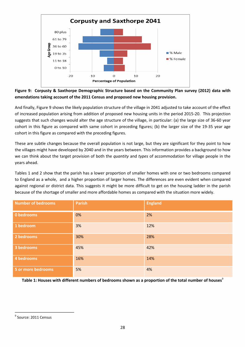
supported by results from the 2011 National Census8. The challenge is illustrated Figures 7, 8 and 9, where the red
sections are females and the blue sections males and the left-hand axis shows broad age groups.
Figure 7: Corpusty & Saxthorpe Community Plan Survey 2012
Figure 8 shows that in 2012 the villages had many people aged 61 and above and the younger age groups were less
well represented.
Figure 8: Corpusty & Saxthorpe Demographic Structure based on Community Plan (2012) data with updates
derived from the 2011 National Census.
Figure 9 is a projection – looking forward to the likely demographic structure of the villages in 2041 (see Appendix 4
to this Plan for the data from which this age gender pyramid is derived).
8 These data may be seen and explored in more detail at:
http://neighbourhood.statistics.gov.uk/dissemination/LeadAreaSearch.do?a=5&r=1&i=1001&m=0&s=1488994367207&enc=1&
areaSearchText=nr11+6qe&areaSearchType=16&extendedList=true&searchAreas=
-20 -10 0 10 20
1
2
3
4
5
6
Percentage of Population
Age
Gro
up
Corpusty and Saxthorpe Population 2041
Male
Female
28
Figure 9: Corpusty & Saxthorpe Demographic Structure based on the Community Plan survey (2012) data with
emendations taking account of the 2011 Census and proposed new housing provision.
And finally, Figure 9 shows the likely population structure of the village in 2041 adjusted to take account of the effect
of increased population arising from addition of proposed new housing units in the period 2015-20. This projection
suggests that such changes would alter the age structure of the village, in particular: (a) the large size of 36-60 year
cohort in this figure as compared with same cohort in preceding figures; (b) the larger size of the 19-35 year age
cohort in this figure as compared with the preceding figures.
These are subtle changes because the overall population is not large, but they are significant for they point to how
the villages might have developed by 2040 and in the years between. This information provides a background to how
we can think about the target provision of both the quantity and types of accommodation for village people in the
years ahead.
Tables 1 and 2 show that the parish has a lower proportion of smaller homes with one or two bedrooms compared
to England as a whole, and a higher proportion of larger homes. The differences are even evident when compared
against regional or district data. This suggests it might be more difficult to get on the housing ladder in the parish
because of the shortage of smaller and more affordable homes as compared with the situation more widely.
Number of bedrooms Parish England
0 bedrooms 0% 2%
1 bedroom 3% 12%
2 bedrooms 30% 28%
3 bedrooms 45% 42%
4 bedrooms 16% 14%
5 or more bedrooms 5% 4%
Table 1: Houses with different numbers of bedrooms shown as a proportion of the total number of houses9
9 Source: 2011 Census
29
Housing type Parish England
Detached 56% 22%
Semi-detached 30% 31%
Terraced 12% 24%
Flat, apartment or maisonette 2% 21%
Table 2: Proportion of different housing types
Table 3 shows that home ownership is relatively high and the proportion of people renting is rather low. The
availability of places to rent could make it difficult to attract younger people to live in the parish or for young people
to remain.
Tenure Parish England
Owned 74% 63%
Social renting 10% 18%
Private renting 14% 17%
Table 3: Proportion of households by tenure type.
These Tables show how the parish has a relatively high proportion of detached houses and a low proportion of
terraced houses or apartments. This seems to indicate a demand for smaller more affordable houses, especially in
view of the demographic profile.
Transport and traffic is a challenge in the parish. The No. 45 Sanders Bus service provides the opportunity to
commute into Norwich and back again at peak times for work or education purposes, although it is a 45 minute
journey. Otherwise, however, opportunities are limited by the timing or frequency of public transport. It is not
possible, for example, to commute to Holt, and buses are less than hourly. Residents therefore tend to be very
dependent for most journeys on the private car, as do most people in North Norfolk.
Traffic in the villages and through the Neighbourhood Plan Area can be substantial and often exceeds the speed
limit, as evidenced by our traffic surveys (Appendix 8). This, together with the often poor state of the roads, poses a
safety risk for all roads users, and can deter people from walking and cycling, thus adversely affecting the general
quality of life in the villages.
6.3.3 Opportunities
Within the proposed revised Village Development Boundary (also known as the “Village Envelope”) are areas which
could be considered for in-fill housing. Such micro developments would go some way towards meeting increased
demand for new residential properties.
With the prospect of new houses, an increase in the number of children in the village may lead to opportunities for
the school to expand. This possible increase in the number of children makes it important that the open area
outside the new Village Development Boundary is protected from any other development.

30
New development also brings the prospect of funds accruing from any developer in the form of “Section 106
allocations”.10 These are payments made by any developer to finance necessary improvement which could include
traffic calming schemes for the centre of the village, improvements to the existing school and other local
infrastructure.
Negotiations with landowners willing to sell their land for development will include a clear expectation for
improvements to the network of footpaths and bridleways in and around the village, a network which contributes in
many small but significant ways to the wellbeing of the community. Figure 10 shows some of the existing facilities.
Figure 10: Corpusty & Saxthorpe: public footpaths and bridleways
10
https://www.gov.uk/guidance/planning-obligations

31
Finally, renewable energy resources are considered. Experience in other parts of the country suggest that shared
renewable energy generation, as between landowners/developers and the community, could be a way of
encouraging such environmentally desirable developments. Future environmentally friendly energy generating
projects might well be encouraged were they to include some facility for benefit sharing with the community11,12.
11
Delivering community benefits from wind energy development: A Toolkit, A report for the Renewables Advisory Board, see:
https://www.cse.org.uk/downloads/toolkits/community-energy/planning/renewables/delivering-community-benefits-from-
wind-energy-tookit.pdf
12 Ejdemo, Thomas and Söderholm, Patrik, Wind power, regional development and benefit-sharing: The case of Northern
Sweden, Renewable and Sustainable Energy Reviews, (2015), 47;C; 476-485, https://ideas.repec.org/s/eee/rensus.html

32
SECTION 2

33
7 PLANNING POLICIES AND COMMUNITY ASPIRATIONS
Introduction
It is clear from the consultation and from the Community Plan that the parish has many concerns and priorities that
can be covered by planning policies. There is a distinction, however, between desirable changes and those issues
which are strictly planning matters. To focus in this Plan only on matters that are purely planning matters would only
present part of the picture of what the community wants. We have already noted that this Neighbourhood Plan
includes two distinct ways of presenting the community’s views on its future These are:
Policies that relate to planning matters; and
Community Aspirations, goals that the community can seek to take forward itself but which lie outside
planning matters.
Thus, the following definitions should be kept in mind when reading the next section of this Plan.
Planning Policies
These set out what will be considered when:
1. intending developers are making planning applications,
2. the Parish Council is commenting on such planning applications
3. North Norfolk District Council is determining such planning applications and deciding whether or not to
grant planning permission, and what conditions and obligations are required.
Only the Policies have any weight when determining planning applications; the supporting text is for explanation.
Only these Planning Policies are assessed against the Basic Conditions.
Community Aspirations
These cover issues about which the community feels strongly and wishes to see action, but which cannot be
addressed through the planning system, even though they may be related to planning. Key to most of these issues is
that they are matters for which the Parish Council and other groups within the Neighbourhood Plan Area can work
or lobby without waiting for or requiring new planning proposals. Community Aspirations are not Planning Policies
and are not required to be assessed against the Basic Conditions.
Evidence base for these policies and community aspirations
To inform this Plan, the following set of evidences was assembled over a period of several years. It derives from both
quantitative and qualitative research and consists of the following:
(a) Specially commissioned reports on specific matters prepared by experts;
(b) Rigorously derived quantitative evidence, for example about demography and the Community Plan Survey – both of which were advised by experts from the London School of Economics and Political Science (LSE);
(c) Rigorously collected qualitative material as well as material derived from less formal methods of data collection – as for example in the various qualitative consultations from 2014 onwards, the detailed interview material reported in Appendix 9.
(d) Material collated from the National Census provided by the Office of National Statistics and available on-line as Neighbourhood Statistics http://neighbourhood.statistics.gov.uk/
(e) The Community Plan Survey, reported in detail in Appendix 2.

34
These different types of data include:
(a) information about objective matters, by and large these are variables which can be easily counted, for
example numbers of people resident in the community at a specific time, and:
(b) information telling us about people’s opinions, goals and aspirations as well as their experience of living
in the community.
In each case the research method is described.
Further details about the consultations and the evidence base can be found in the Appendices to this report. These
are available on the Corpusty and Saxthorpe Parish Council website at:
https://corpustyandsaxthorpeparishcouncil.wordpress.com/community-led-plans-neighbourhood-plans/

35
1. People and Housing
Introduction
In the absence of more housing, the population is growing unevenly, rental prices are high, and there is an
inadequate supply of housing.
In recognition of the national shortage of housing and the changing needs of the community, and following village
consultations, the village agreed that more new houses will be needed, particularly to accommodate young couples
and new families.
All new development needs to meet the principles of sustainable development as defined within the National
Planning Policy Framework and National Planning Practice Guide. To achieve this, new housing will be of the right
type, scale and density and be proportional to the level of services and facilities on offer within the local area.
People who live in villages are the key to the viability and vitality of the services and facilities on offer. It is important
to ensure that future housing development provides for wide ranging needs, scales of accommodation and for the
full range from first time homes to lifetime homes.
This Plan encourages development appropriate to the Neighbourhood Plan Area, taking into consideration that:
(i) NNDC policy requires 50% affordable housing but recognising that lower percentages are often delivered.
(ii) It is desirable to ensure development is achievable by aiming for the maximum level of affordable housing up to 50% and never less than 25%, subject to a viability assessment.
(iii) for development to be guided in relation to scale and sustainable locations, this Plan encourages developers to recognise that the community has expressed the view that any proposed new housing development should be within the extended village settlement boundary and that this view was clearly expressed in consultations and reflects the community’s aspiration to retain a clear separation between the built environment and its rural setting.
For these reason, three Overarching Policies have been developed with regard to the new Village Settlement
Boundary.
7.1 OVERARCHING POLICY 1: THE NEW VILLAGE SETTLEMENT BOUNDARY (ALSO KNOWN AS
THE “VILLAGE ENVELOPE”)
The Overarching Policy framing this Plan recognises that the village is divided on its east side by the Link Road
and intentionally includes the built area along the Irmingland Road within the Village Settlement Boundary.
It is the intention of this Plan that housing will not be permitted adjacent to the Link Road or outside the new
Village Settlement Boundary, see Figure 11. The disused railway embankment forms a natural barrier to the
south of the village. This will be retained wherever possible. The proposed extension of the settlement
boundary is necessary because it facilitates appropriate infill development to meet a part of the identified
housing needs. Without this extension, new dwellings and industrial areas could not be accommodated within
the current settlement boundary. This might lead to a haphazard patchy development that could seriously
undermine the nature and beauty of the village within its rural setting.

36
After consultation (see Appendix 3), the village settlement boundary has been extended to allow extra
development in line with this Plan within the new boundaries - but not outside them. The consultation asked
residents whether they agreed to the new proposed boundary or not and whether they wanted any changes
made to the proposals. The new boundary was drawn to identify the built outskirts of the village as it exists in
2017 which is significantly larger than the previous envelope. There was overwhelming support for the new
development boundary with two exceptions:
(a) A wish to ensure full protection of the site to the south and west of the Village Hall: in response to very
strongly expressed opinion in the community, the Plan envisages that the area around the village hall should never be used for housing or other development save for one exception: possible use of an area to the south of the site, adjacent to the disused railway station, for a new school should funding become available for this purpose at some time in the future. Such provision could become necessary to cater for increased demand for school places consequent upon new housing and the planned attempt to reduce the age profile of the community in the years ahead.
(b) A wish to extend slightly the settlement boundary on the Matlaske Road in a northerly direction: This was rejected because it was outside the built edge of the village.
Figure 11: Corpusty & Saxthorpe: new Village Development Boundary approved by community consultation
October 2015 and in light of subsequent comments.

37
The following Objectives are served by the Overarching Policies
1.1 Increase the amount of housing available for young families and single people
1.4 Allow infill housing where appropriate
2.3 Preserve the wildlife of the village, its nature reserves, and its surrounding area.
3.2 Enhance the architectural and landscape character of the parish and improve the quality of the
housing
5.1 Help local businesses to thrive.
Priority Development Areas
After consultation, three Priority Development Areas have been selected as appropriate for infill
development Figure 13. Priority Development Areas 1 and 2 are for residential use. Priority Development
Area 3 is for mixed residential development and business use.
Priority Development Area 1 is designated by NNDC but has not yet been developed. This might be
because the site is small and by extending the area to include Priority Development Area 2 together the
plots would be more desirable as a development. NNDC has designated an area of open space in plot 1.
The Neighbourhood Plan relocates this area of open space to the north of the site where there is an
existing orchard.
OVERARCHING POLICY 1: FRAMING PROVISIONS
Proposals for development inside the settlement boundary will be encouraged provided they conform
with the subsequent policies as outlined below in this document.
Development will be particularly encouraged in the three priority areas identified in Figures 13 and 14
All sites should take into consideration existing sewage capacities.
This Policy also applies to Site 1 as previously designated by NNDC policy COR01 1.
Open space in site 1 should be provided in the north part of the site, providing 0.1 hectares of public
open space.
Sites 1 and 2 contain hedges which should be preserved or replaced by appropriate alternative
planting.

38
Figure 13: Priority Development Areas 1 and 2

39
Figure 14: Priority Development Area for Mixed Residential and Business Use

40
OVERARCHING POLICY 2: LOCAL GREEN SPACES WILL BE PROTECTED BY DESIGNATION
This designation applies to:
(a) the freehold green space surrounding the village hall;
(b) the village green, including the play area adjacent to the River Bure.
The sites were assessed as being available by consultation with the existing landowners -see Appendix 11 – and note
that:
All sites are above the flood zone
No tree preservation orders are in existence for these sites.
7.2 OVERARCHING POLICY 2: PROTECTION OF GREEN SPACES WITHIN THE VILLAGE
DEVELOPMENT BOUNDARY
This applies to the area to the south of the Village Hall and at the centre of Corpusty between The Street, the River
Bure and the Norwich Road, both as indicated in Figure 11.
Local Green Space (LGS) designation provides special protection against development for green areas of particular
importance to local communities. Local Green Space can be designated through the District Council’s Local Plan and
through a Neighborhood Plan. National policy states that any designation of Local Green Space should be consistent
with local planning for sustainable development in the district. It is not appropriate to seek such designation to
prevent development of land which has been accorded planning permission. National policy also states that
designation will not be appropriate for most green areas or open space. Within these conditions, the designation
may be used:
where the green space is in reasonably close proximity to the community it serves;
where the green area is demonstrably special to a local community and holds a particular local significance,
for example because of its beauty, historic significance, recreational value (including as a playing field),
tranquillity or richness of its wildlife; and
where the green area concerned is local in character and is not an extensive tract of land.
Within these provisions, two sites are put forward for designation in this Neighbourhood Plan. In line with the
requirements of the NPPF and national planning guidance an assessment has been undertaken. This may be seen in
see Appendix 18).
41
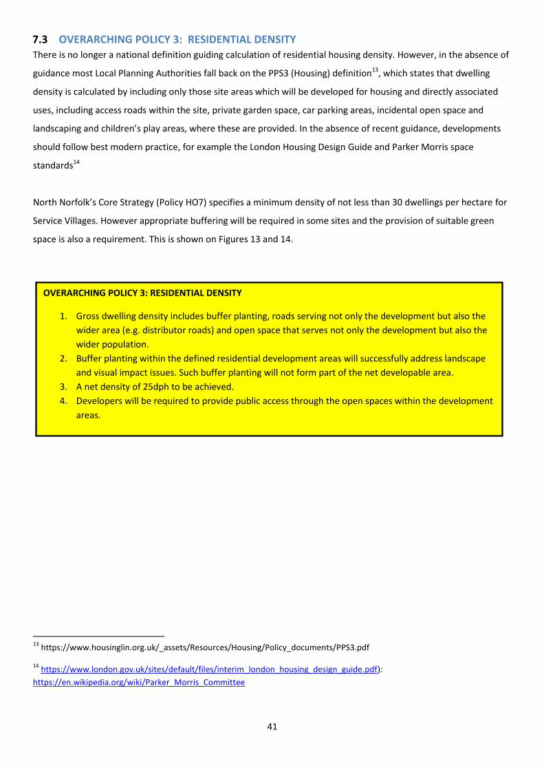
7.3 OVERARCHING POLICY 3: RESIDENTIAL DENSITY
There is no longer a national definition guiding calculation of residential housing density. However, in the absence of
guidance most Local Planning Authorities fall back on the PPS3 (Housing) definition13, which states that dwelling
density is calculated by including only those site areas which will be developed for housing and directly associated
uses, including access roads within the site, private garden space, car parking areas, incidental open space and
landscaping and children’s play areas, where these are provided. In the absence of recent guidance, developments
should follow best modern practice, for example the London Housing Design Guide and Parker Morris space
standards14
North Norfolk’s Core Strategy (Policy HO7) specifies a minimum density of not less than 30 dwellings per hectare for
Service Villages. However appropriate buffering will be required in some sites and the provision of suitable green
space is also a requirement. This is shown on Figures 13 and 14.
13
https://www.housinglin.org.uk/_assets/Resources/Housing/Policy_documents/PPS3.pdf
14 https://www.london.gov.uk/sites/default/files/interim_london_housing_design_guide.pdf):
https://en.wikipedia.org/wiki/Parker_Morris_Committee
OVERARCHING POLICY 3: RESIDENTIAL DENSITY
1. Gross dwelling density includes buffer planting, roads serving not only the development but also the
wider area (e.g. distributor roads) and open space that serves not only the development but also the
wider population.
2. Buffer planting within the defined residential development areas will successfully address landscape
and visual impact issues. Such buffer planting will not form part of the net developable area.
3. A net density of 25dph to be achieved.
4. Developers will be required to provide public access through the open spaces within the development
areas.

42
7.4 DETAILED POLICIES
Policies and Aspirations in this section will help meet the following Objectives:
1.1 Increase the quantity of housing available for young families and single people.
1.2 Increase the quantity of affordable housing.
1.3 Increase the quantity of appropriate housing for the elderly.
1.4 Allow infill housing up to three properties where appropriate.
PLANNING POLICY H1. SCALE AND LOCATION OF NEW RESIDENTIAL DEVELOPMENT
All new housing development will be expected to:
Respect the character of the area, type and styles of existing housing (see Appendix 13); and
Ensure that new housing takes account of the rich archaeological heritage of the parish by undertaking suitable archaeological investigations where required; and
Maintain the green spaces identified within this Plan (See Appendix 13); and
Be of an appropriate scale and density in relation to the village respecting existing sizes and scales of buildings.
Be broadly in keeping the best modern practice, for example the London Housing Design Guide (https://www.london.gov.uk/sites/default/files/interim_london_housing_design_guide.pdf) and the Parker Morris space standards (https://en.wikipedia.org/wiki/Parker_Morris_Committee).
Provide for cycle storage for each dwelling as well as adequate pedestrian facilities within a development.
Proposals for new residential development outside the settlement boundary will generally not be permitted unless:
Buildings are in general conformity with NNDC development policy SS2 for rural green space areas.
It is a rural exception site, as defined by NNDC policy and meets a specific local need.
It can be clearly shown that the benefits significantly and demonstrably outweigh any adverse impacts, especially any which affect the rural landscape and open countryside.
Further housing development which does not meet the above conditions will only be considered acceptable where;
It is of a scale and design appropriate to the settlement; and
Does not increase the size of the settlement by more than 10% of its existing size; and
The proposal results in a natural extension to the existing built form of the village; and
No development occurs within the important Local Green Spaces identified within this Plan.

43
PLANNING POLICY H2. AFFORDABLE HOUSING AND PLANNING OBLIGATIONS
The provision of all affordable housing will be expected to meet the planning definition of affordable housing.
No affordable housing provision or planning obligations will be required for schemes involving 10 or fewer dwellings, if the following conditions are met;
o The proposal conforms to the requirements of all relevant policies contained within this Plan; and
o At least 20% of the units meet standards for accessible and adaptable homes in line
with optional Building Regulations M4(2), Optional Technical Standards1 .
New homes must be designed and constructed such that they may be adapted to meet the
changing needs of their occupants over time.
At least 30%2 of all new homes are required to meet the optional Building Regulation Requirement M4(2) for accessible and adaptable dwellings’ which are suitable for many different age groups or provide for residential care or adapted living properties for the elderly, unless:
1. viability considerations dictate otherwise;
2. It is not practical given the physical characteristics of the site;
3. It would severely compromise the design and character of the area.
4. And The provision of 2 or 3 bedroom properties reflects the existing mix of houses.
For developments of 11 or more dwellings the aim is to achieve 50% affordable housing and as high a ratio as possible but never less than 25% affordable housing.
In addition to these affordable housing provisions, requirements relating to other planning obligations included within the Council’s local plan should be met.
1 https://www.gov.uk/guidance/housing-optional-technical-standards 2. see evidence in demographic projections, Appendix 4.

44
PLANNING POLICY H3. MIX AND TYPE OF HOUSING
On schemes of more than four dwellings, a mix of dwelling types and sizes should be provided. These should principally be in the form of two storey buildings including terraces with the outward appearance of cottages or houses. A small proportion of single storey buildings will be supported to provide a wide range of accommodation. Large areas of uniform types of dwellings will not be acceptable. Housing should meet the needs of residents over their lifetimes. Any new housing must meet the minimum requirements for the mix of homes set out in North Norfolk District Council Core strategy policy. This policy is intended to provide characterful development which avoids a plot by plot appearance as seen in many modern developments. See Design Guide, Appendix 5, for more details.
COMMUNITY ASPIRATION CA1 – AFFORDABLE HOUSING – LOCAL CONNECTIONS
The community and the Parish Council strongly believe that at least 50% of affordable housing within the plan area should be offered to people with a local connection, subject to compliance with equalities legislation. This means that people with a strong local connection to the Parish and whose needs are not met by the open market will be first to be offered the tenancy or shared ownership of the home. In this context “a strong local connection” means an applicant:
Has their principal home within the parish and has lived there for at least the last 2 years; or
Has lived in the Parish for 3 of the last 5 years; or
Has immediate family currently living within the Parish who have lived there for at least 3 continuous years; or
Has an essential need to live close to another person, due to a proven age or medical reason (such as essential care); or
Has worked within the parish for a continuous period of at least 2 years or has an essential or functional need to live close to their place of work in this parish or an adjoining parish.
However, national legislation requires that priority be given to those who have: an essential
housing need, such as statutory homelessness, being a member of the military, and other
statutory categories.

45
PLANNING POLICY H4. FURTHER HOUSING WITHIN THE SETTLEMENT BOUNDARY
Infill housing located inside the existing settlement boundary will be considered acceptable where:
It is appropriate and respects the rhythm and character of the street and is consistent with the existing form and character of surrounding buildings.
it consists of development of a site which has potential to provide houses which are suitably spaced compared with their neighbouring dwellings, and
are located between existing properties and non-greenfield sites; and
are not part of ‘green spaces’ identified within this Plan; and
where new buildings will either enhance the site and character of the area or conform to the surroundings and character of the area; and
they meet all other relevant policies contained within this Plan. Outside the settlement boundary, windfall housing will only be acceptable in accordance with national policy, guidance and permitted development rights and be compatible with national and local policy guidance

46
2. Natural Environment
Introduction
The Parish has a rich natural environment that can be protected and enhanced through the planning process. The
Parish is made up of a mosaic of natural and structural elements – the built-up areas of the villages both join with
the River Bure and its river valley habitat, and are surrounded by a patchwork of productive agricultural fields.
The Parish hosts a number of County Wildlife Sites and two Roadside Nature Reserves. During the late 1970s and
1980s, Corpusty resident Anne Brewster made detailed records of wildlife, documenting the distribution of animals
such as Harvest Mouse and amphibians, recording plant species and mapping hedgerows. Anecdotal evidence
suggests that, in common with other arable land in Britain, biodiversity has fallen in the parish since the middle of
the 20th century, largely due to the removal of biodiverse habitats for agricultural purposes. Despite these
depletions, it is likely that the parish retains more of its semi-natural habitats, albeit as small remnants, than many
similar areas in Norfolk.
Agriculture is almost entirely arable with most of the area classified as Grade 3 (good to moderate quality). An area
in the north-east of the parish and a somewhat smaller area in the south, together about 20% of the total area, are
designated Grade 2 (very good quality). About 5% of the total area, along the valley bottom to the west of the
village and along the tributary flowing from the south are designated Grade 4 (poor quality).
Policies Policies in this section will help to meet the following Objectives:
2.1 Preserve agricultural land for food production.
2.2 Preserve the Bure valley and ensure no damage to the Environmentally Sensitive Area, now known as
Agri-Environment Schemes
2.3 Preserve the wildlife of the village and its nature reserves.
2.4 Promote the use of renewable energy sources by encouraging micro-generation.
2.5 Encourage schemes for insulating properties.

47
PLANNING POLICY E1: AGRICULTURAL LAND
Developments which permanently reduce the area of Grade 2 or Grade 3a agricultural land (the
Parish contains no Grade 1 land) currently used for food production will only be permitted in
exceptional circumstances in line with policies in the Local Development plan including this
Neighbourhood Plan.
Proposals on land identified as Grade 3 agricultural land will be required to be accompanied by an
assessment identifying whether the land is Grade 3a or 3b to determine whether the land is
considered to be some of the best and most versatile agricultural land within the Neighbourhood
Plan Area,and in accordance with NPPF.
PLANNING POLICY E2: THE RIVER BURE AND VALLEY
The River Bure and its surrounding River Valley is identified as a key component of the Parish’s Green
Infrastructure Network. The habitats found within river valleys are identified within the Priority
Habitats and Species covered under Section 41 of the Natural Environment and Rural Communities
Act 2006. Development proposals within or adjacent to this important and sensitive habitat area will
only be permitted if:
The primary objective of the proposal is to conserve or enhance the habitat; or
The benefits of and need for the development in that particular location clearly outweighs the
loss.
Any development proposal that may have an impact on the aquatic or terrestrial ecology of the River
Bure and its river valley should be accompanied by an ecological assessment. Any mitigation and/or
compensation measures outlined in such assessments will be secured via planning conditions and/or
planning obligations.

48
PLANNING POLICY E3: PROTECTION AND ENHANCEMENT OF LOCAL BIODIVERSITY
Hedgerows in the Parish are already protected by the Hedgerow Regulations 1997. Thus, any
affected by development requiring consent should be protected and, wherever possible, enhanced.
Hedgerows in danger of removal as a result of development should be replaced within the site and
accompanied by an after care and management scheme secured by planning conditions.
Supplementary planting which strengthens the existing network of hedgerows and ecological
corridors will also be encouraged.
Proposals that may have an impact on any species or habitat within designated nature conservation
areas (including County Wildlife Sites, Roadside Natures Reserves) should be accompanied by an
ecological assessment and mitigation and/or compensation measures in accordance with NPPF
“mitigation hierarchy’ Any mitigation and/or compensation outlining measures in such assessments
will be secured via planning conditions and/or planning obligations.
Proposals that would lead to the enhancement of ecological network will be encouraged, particularly
where they would improve habitat connectivity or support the management of the County Wildlife
Sites, Roadside Nature Reserves and/or the Bure River Valley.
There is a wealth of mature trees in the village and proposals should respect these and seek to
incorporate them within a planning proposal wherever possible tree preservation orders must be
respected
PLANNING POLICY E4: RENEWABLE ENERGY
Development of renewable energy sources will be encouraged, where there are no significant
adverse effects or where they are outweighed by the benefits .
Proposal should demonstrate how they make effective use of land, using poorer quality land in
preference to higher grade land. All such applications should be accompanied by a Landscape and
Visual Impact Assessment, ecological assessment, and noise assessment (where relevant).
Where planning consent is required, the generation of electricity from solar panels and other
renewable energy technologies will he encouraged on new and existing industrial and farm buildings,
as well as on domestic buildings where this does not detract from the design of the building.

49
COMMUNITY ASPIRATION CA3 – RENEWABLE ENERGY AND INSULATION
The Parish will promote and seek the use of renewable energy sources by encouraging micro-
generation and encourage schemes for insulating properties.
Insulation of existing properties will be encouraged.
PLANNING POLICY E5: ENCOURAGE SCHEMES FOR LOW CARBON DEVELOPMENT
New buildings will comply with national guidelines for carbon neutrality and energy efficiency.
When assessing planning applications, development proposals for carbon neutrality or zero carbon
buildings will be encouraged in determining development proposals and must also comply with the
design policies (Appendix 5) and building regulations

50
3. Historic Environment
Introduction
Corpusty and Saxthorpe are ancient communities and host a wealth of historic and archaeological remains that
record the settlement’s heritage and evolution. The two churches are both listed, St Andrew’s is listed Grade 1 and
St. Peter’s is listed Grade 2*. These are the oldest and largest buildings in the villages and play a very important
cultural, historic and visual role in the Parish. There are several other important listed buildings in the villages which
contribute to the character and cultural heritage of the Parish.
The archaeology of the area is well documented through the Norfolk Historic Environmental Record; this cites over
120 sites and finds in the parish. The quantity and spread of remains dating from prehistoric times to the present day
across the Parish indicate that any proposed development may disturb archaeological material. Development
presents a great opportunity for further understanding the area’s cultural heritage and any information and material
gained will further enhance an understanding of the parish and its links with the wider world.
Policies
The policies in this section aim to meet the following Objectives:
3.1 Ensure that new housing takes account of the rich archaeological heritage of the parish.
3.2 Enhance the architectural and landscape character of the parish and improve the quality of the housing.
PLANNING POLICY HE1: ARCHAEOLOGY
Due to the number of find-spots and non-designated archaeological areas in the Parish, all applications within 250 metres of an existing Historic Environment Record should consult with the Norfolk Historic Environment Service as to whether a more detailed archeological survey is needed prior to determination of a proposal.

51
PLANNING POLICY HE2: VIEWS OF THE CHURCHES
The ancient views and settings of the two churches of St. Andrews and St Peters, are a vital part of
the village environment and should be maintained.
Development which might adversely affect the immediate or wider viewpoints of either of the two
churches should be accompanied by a Landscape and Visual Impact Assessment. Any adverse effects
on the views of the churches will be given great weight in determining planning applications.

52
4. Design and Character
Introduction
This Plan seeks to ensure that any new development is of a high quality and either conforms to the character, design
and scale of the surroundings or enhances it. Developments can incorporate specific design features, massing or an
overall character which is complementary to the surroundings.
This Plan provides an appraisal of the key characteristics of the village built environment. An example is the use of
flint and brick. Certain buildings were identified by the Parish Council as characteristic of the village. The rural
character of the village must be respected in new developments to ensure that the distinctiveness of the area is
maintained and enhanced. Examples of characteristic village buildings are shown in Figure 15 and 16.
Save in exceptional circumstances, for example of innovative architectural merit and appropriate scale,
new buildings will be in keeping with the architectural and landscape character of the Neighbourhood Plan
Area and comply with local and national guidelines for carbon neutrality and energy efficiency.
When assessing planning applications, development proposals for carbon neutral or zero carbon
development will be encouraged and given great weight in determining development

53
Figure 15: Showing the types of roofs, porches, doorways, window frames, walls, and types of housing and other
everyday features which would be very acceptable in new developments.
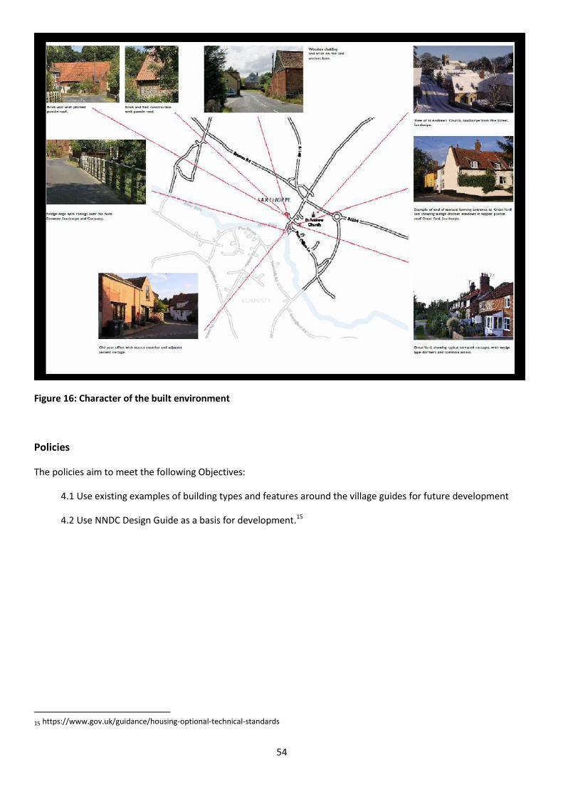
54
Figure 16: Character of the built environment
Policies
The policies aim to meet the following Objectives:
4.1 Use existing examples of building types and features around the village guides for future development
4.2 Use NNDC Design Guide as a basis for development.15
15
https://www.gov.uk/guidance/housing-optional-technical-standards

55
PLANNING POLICY DC2. OPEN SPACE
The provision of open space in relation to any proposal should be in line with National and Local Guidelines
PLANNING POLICY DC1. OVERALL CHARACTER
Proposals need to reflect the NNDC Design Guide1 with particular reference to building details and also reflect
the existing building types of the village as illustrated in the accompanying figures.
New residential development should have a density, scale, bulk and massing that is consistent and compatible
with the existing prevailing character within the immediate and surrounding area to reflect local
distinctiveness, character and appearance of the area. The only exception will be if a proposal results in a
visual enhancement to the character and appearance of the area.
To retain the rural and spacious character of the parish, development should in general be of low density of up
to 25 dwellings per hectare, unless a higher density is justified by the need to blend with the surrounding
character or through the provision of terraced housing/ yards, or because other material planning
considerations suggest a higher density.
Buildings of exceptional architectural merit which are of modern design will also be encouraged providing they
respect the scale and mood of the surrounding buildings.
1 https://www.gov.uk/guidance/housing-optional-technical-standards
56
5. Making a Living
Introduction
The Plan seeks to help local businesses thrive by enhancing provision of premises for existing and new small
businesses in and around the parish. Equally important goals are to protect the countryside, avoid potential loss of
high quality agricultural land, and support nature conservation.
New business premises and homes are needed, whilst ensuring that the impacts upon neighbours and the
countryside are not significant. The policies relating to residential development will mean that more people will be
living in the village. To ensure a sustainable community, it will be necessary to provide some low-key employment
opportunities. The key objectives are to encourage some light industrial developments in a discrete business area
and discourage noisy, large scale industrial activities which involve movement of heavy vehicles within the village,
thus facilitating and encouraging business and economic activity appropriate to the village surroundings.
It has been noticed that the number of heavy good vehicles has increased in recent years, both because of
development and economic activity within the Neighbourhood Plan Area and also elsewhere. This plan aims to
support commercial and industrial development because it will provide local employment, enabling people to work
locally and attracting working age families into the village. This needs to be balanced, however, against the safety
and amenity impact of any lorry traffic that will be generated by the new development. Many of the roads in the
parish are narrow and unsuitable for anything other than the occasional lorry or farm vehicle. This is especially the
case within the village, where many houses are very close to the roads and so to the traffic using them.
The Highways Authority should be consulted on any new development resulting in increased traffic.
The parish council considers all planning applications within the parish. Particular care will be taken when
considering applications likely to generate lorry traffic. The expectation will be that a transport statement will be
submitted with the application, but if this is not the case it will be requested via the district council. The parish
council will expect the transport statement to set out clearly what the impacts, if any, will be and how any adverse
impacts will be mitigated and made acceptable, especially in terms of highway safety and residential amenity. This
policy is not intended to apply to development, such as residential development, which might generate only the
occasional lorry (such as for a parcel delivery), but which is essentially incidental to the function of the development.
Policies
Policies and Aspirations in this section aim to meet the following Objectives:
5.1 Help local businesses to thrive.
5.2 Promote the installation of ultra-fast broadband internet.
5.3 Encourage the development of some light industry as part of the business area - subject to its impact
on neighbours.
5.4 Discourage industrial activities which involve the movement of heavy vehicles within the village.
5.5 Encourage existing and new agricultural and horticultural businesses.
5.6 Discourage loss of agricultural land to semi-industrial purposes.

57
PLANNING POLICY B1. SMALL BUSINESSES AND LIGHT INDUSTRY
New buildings for light industrial or other business use will be encouraged in the specific area identified within this Plan for employment use, see Area 3 in Figure 14. There will be an overriding preference for agricultural and horticultural uses, however other uses which are appropriate in a rural area will also be supported. Design criteria for new buildings for business use will be similar to those for housing. This is an agricultural community in a rural area and use of barns as a style for new business units will be encouraged. New buildings for light industrial or other businesses uses will be supported in principle, subject to the following conditions:
The buildings are located in the area identified within this plan
The proposal will be employment generating
The proposal will protect residential amenities and not result in a significant increase in heavy goods vehicles
The proposed buildings will be of an appropriate design and scale for the setting
Reasonable parking provision required to meet the needs of the business can be accommodated within the site or in an alternative suitable location
The proposal will not have any significant adverse environmental impacts
Non-agricultural land will be preferred rather than land currently used for food production.

58
PLANNING POLICY B2. HEAVY GOOD VEHICLES
Any proposed development that is expected to generate, by the nature of the development, increased heavy
traffic which is likely to have significant impact on the village will comply with the requirements to produce a
transport statement in line with national and local policy. Proposals should minimise conflict with other road
users and maximise highway safety. This should set out the volume of lorry traffic anticipated and the
measures that will be used to mitigate any adverse impacts, including proposals for which routes the traffic
will use. This requirement is in line with NNDC Core Strategy.

59
6. Education
Introduction
This Plan recognises that new homes are needed as well as businesses. This will increase the number of families
with small children in the Parish.
It is important to secure the future of the existing primary school and support appropriate plans for the expansion of
the school or the provision of other educational opportunities or facilities.
New development also brings the prospect of funds accruing from any developer in the form of Section 106
allocations. Possible uses of such finance will include traffic calming schemes for the centre of the village,
improvements to the existing school as well as the further provision of educational facilities or access to education.
This applies only when the mitigation is directly related to the development proposal.
Policies
Policies and aspirations in this section aim to meet the following Objectives:
6.1 Encourage development which secures the future of the Primary School.
6.2 Support plans for expansion of the school and other educational opportunities.
COMMUNITY ASPIRATION CA4. ULTRA-FAST BROADBAND AND MOBILE PHONE SERVICE
The Parish council will promote schemes that achieve or help to achieve ultra-fast broadband and improved
mobile phone services, provided that they do not result in unacceptable impacts to the character, amenity or
environment.
Both super-fast broadband and a dependable mobile phone signal are essential to business development in
the community.

60
PLANNING POLICY ED1. THE PRIMARY SCHOOL AND EDUCATION FACILITIES
Policy H1 will encourage new housing in the village which in time will increase the number of new families in the village and help secure the future of the school. This policy seeks to retain the school and existing educational facilities. Proposals which involve provision or enhancement of educational facilities will be supported subject to the following criteria:
The buildings are of a high-quality design, suitable scale, suitable in their location while taking account of the character and appearance of the area or enhancing it;
The proposal will have no significant detrimental impact upon residential amenities and neighbouring land uses.
Parking provision, required to meet the needs of the school will be accommodated within the site or in an alternative suitable location.
The proposal will not have any significant adverse environmental impacts
The proposal is within a central location within the Settlement Boundary in a reasonably accessible location.
PLANNING POLICY ED2. TRAVELLING LIBRARY
All developments that support the travelling library service will be encouraged

61
COMMUNITY ASPIRATION CA6. PROMOTION OF ADULT EDUCATION & ENTERTAINMENT
The Parish Council will encourage adult education as well as helping to identify suitable accommodation for a film club venue.

62
7. Well-being and Flourishing
Introduction
The core aim of any Neighbourhood Plan is to ensure that the planning process contributes to the well-being of the
community. Corpusty and Saxthorpe host a number of community assets such as allotments, a children’s play area
and a village green which enhance everyday community life in the Parish and therefore need to be protected from
any adverse impacts that may arise from development.
The two churches (St Peter’s and St Andrew’s) are key elements of the visual amenity of the Parish and therefore the
views and setting of these buildings should be protected from obstruction for community enjoyment and identity.
Finally, the Parish boasts a number of discrete segments of footpaths, but there is scope for these to be better joined
up into a circular route around the villages.
Policies
The Policies in this section aim to meet the following Objectives:
7.1 Support St. Andrew’s Church as the centre of the Parish’s spiritual, cultural and community life.
7.2 Explore new uses for St. Peter’s church.
7.3 Sport and leisure- maintain and enhance the appearance and upkeep of the village green.
7.4 Encourage healthy activities by keeping access to the countryside open on footpaths and promote the development of new permissive rights of way.
7.5 Preserve the play areas within the village.
7.6 Encourage the upkeep of allotments.
PLANNING POLICY W&F1: ST ANDREW’S CHURCH
Proposals for St. Andrew’s church which seek to extend the use of the church for cultural diversity and spiritual activities will be encouraged. Alterations to St. Andrew’s church that enable greater village participation in cultural and spiritual activities will also be encouraged, provided that they do not harm the overall significance of the Grade 1 listed building
and they meet other criteria required by of the Diocesan Advisory Board.

63
COMMUNITY ASPIRATIONS CA7: ST PETER’S CHURCH
Improvements to St. Peter’s churchyard and surroundings will be encouraged. The Parish Council will support and encourage the further restoration of the interior of St. Peter’s which would lead to better community use.
PLANNING POLICY W&F2: FOOTPATHS
The network of the existing footpaths and green infrastructure in the Parish should be safeguarded, retained
and enhanced.
Development proposals which include establishment of new permissive footpaths that would help to achieve a more circular route around the villages will be encouraged and will be considered to offer a significant community benefit when determining planning applications.
PLANNING POLICY W&F3: ALLOTMENTS
Development proposals resulting in loss of allotments will be permitted only if alternative land of
equal or greater size, not more than half a mile distant from the existing site, is made available and is
in a readily accessible location.
COMMUNITY ASPIRATION CA8: PLAY AREAS
The two play areas shall be preserved for these purposes and community resources will be regularly
allocated to their preservation, upkeep and enhancement.

64
8. Getting around
Introduction
Residents of the parish need to be able to access work, education and other facilities and services. The plan would
like to improve access to services, especially by sustainable means and in safety.
The evidence shows that the bus service is not very frequent, although it does enable journeys to be made at peak
times and so provides for some work and education related trips. Services and facilities within the village are only
sufficient to meet some daily needs. Combined, these factors at least partly explain why most journeys by residents
are undertaken by car, and very few, except for high school related trips, use the bus. Indeed, as with most rural
communities in Norfolk, there is a large degree of car dependency in the village which of course leads to a
considerable amount of traffic when combined with that of visitors and through traffic.
In addition, the evidence suggests that in places within the village the average traffic speed exceeds the 30mph
speed limit, whilst some vehicles have been recorded as travelling as fast as 95mph. The evidence shows that the
speed of traffic is a great concern. Traffic safety is therefore a community priority. Although some natural features of
the village restrict traffic speeds, such as the narrowness of some roads, observational evidence suggests that on
street car parking also tempers traffic speed by acting as an informal traffic calming scheme. The plan therefore
allows for on-street car parking, unless it is replaced by more formal traffic calming measures, where the natural
traffic speeds would exceed 20mph.
The plan also aims to make walking and cycling within the village more attractive, in part to reduce reliance on the
car for short journeys, but also for reasons of health and well-being. It is believed that lower traffic speeds will be
supportive of this.
Local bus services are infrequent and the destinations are limited. For some residents, especially our older and less
mobile residents, the use of public transport presents considerable difficulties. Evidence shows that some people
find it difficult even to leave the village. It is also clear that this will become a bigger issue as the population ages.
Community transport could have a role to play. There is many community transport schemes across Norfolk. These
provide people with access to services that otherwise would be inaccessible. The community will hold discussions
with the Norfolk Community Transport Association, an umbrella group set up to help community transport
operators, and will aim to ‘buddy’ with existing schemes to help determine whether a local scheme is viable.
Furthermore, proposals for such schemes will be considered very favourably, especially those that provide access to
healthcare, which the evidence suggests is particularly dependent on the car.
Policies
Policies and aspirations in this section aim to meet the following Objectives:
8.1 Improve road safety by the introduction of traffic calming schemes.
8.2 Improve accessibility to local towns by trying to increase public transport.
8.3 Improve accessibility to medical and other services by supporting community volunteer schemes.

65
PLANNING POLICY T1. TRAFFIC CALMING
New development promoting and protecting highway safety will be encouraged. It is expected that
traffic from new commercial/ industrial developments, and new residential developments comprising
five or more dwellings, will generally contribute to traffic calming measures within the settlement
boundary where the Parish Council deems it necessary.
PLANNING POLICY T2. CAR PARKING
Planning applications directly affecting roads that are not part of the County Council’s Route
Hierarchy and that make a lower provision for car parking than set out in the Core Strategy Car
Parking Standards may be acceptable if this results in safe on-street car parking which acts as an
informal traffic calming scheme.
PLANNING POLICY T3. PUBLIC TRANSPORT
New developments within 600m of a bus stop, that provide access to a bus service enabling journeys
to work or education at peak times, will be considered favourably. Such developments will be
expected to upgrade, where necessary, the nearest bus stops to make them more attractive to use
and more accessible.
To ensure improved use of the bus stops there will be an expectation that the nearest bus stops will be
brought up to a good standard.
COMMUNITY ASPIRATION CA9: COMMUNITY AND VOLUNTARY TRANSPORT
The community will investigate setting up and running a community transport scheme to provide
improved access to key services such as health care. Schemes which promote volunteer transport or
other appropriate initiatives will be encouraged.
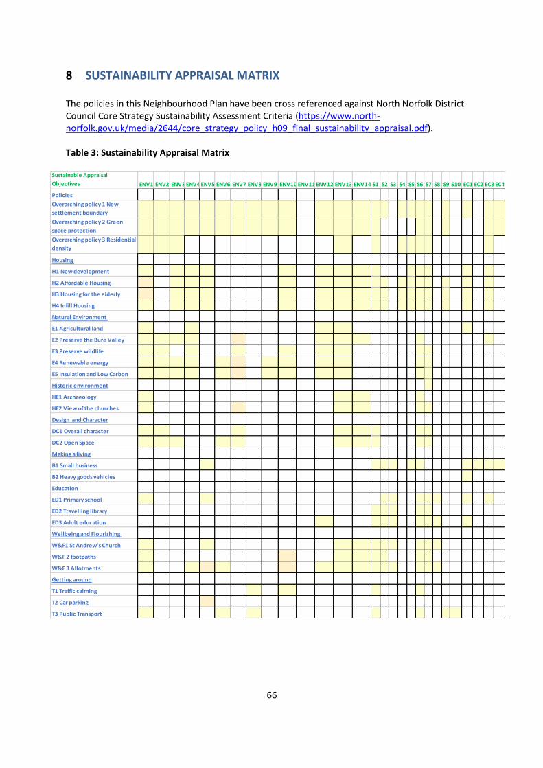
66
8 SUSTAINABILITY APPRAISAL MATRIX The policies in this Neighbourhood Plan have been cross referenced against North Norfolk District Council Core Strategy Sustainability Assessment Criteria (https://www.north-norfolk.gov.uk/media/2644/core_strategy_policy_h09_final_sustainability_appraisal.pdf). Table 3: Sustainability Appraisal Matrix
Sustainable Appraisal
Objectives ENV1 To maintain and enhance biodiversity, fauna and floraENV2 To improve water qualityENV3 To ensure that sources of water supply remain sustainableENV4 To conserve and improve soil resources and qualityENV5 To minimise the loss of undeveloped landENV6 To improve air qualityENV7 To minimise noise, vibration and light pollutionENV8 To reduce the effect of traffic on the environmentENV9 To minimise the production of waste and support recycling of waste productsENV10 To limit or reduce contributions to climate changeENV11 To reduce vulnerability to coastal changeENV12 To avoid, reduce and manage flood riskENV13 To maintain and enhance the quality of landscapes and townscapesENV14 To conserve and, where appropriate, enhance the historic environmentS1 To improve health of the population and promote a healthy lifestyleS2 To reduce poverty, inequality and social exclusionS3 To improve the education and skills of the populationS4 To provide everybody with the opportunity of a suitable and affordable homeS5 To provide opportunities for rewarding and satisfying employmentS6 To improve the quality of where people liveS7 To encourage a sense of community identity and welfareS8 To reduce anti-social behaviourS9 To improve accessibility to essential services and facilitiesS10 To improve accessibility for those most in needEC1 To encourage sustained economic growthEC2 To reduce disparities in economic performanceEC3 To enhance the image of the area as a business locationEC4 To encourage and accommodate both indigenous and inward investment
Policies
Overarching policy 1 New
settlement boundary
Overarching policy 2 Green
space protection
Overarching policy 3 Residential
density
Housing
H1 New development
H2 Affordable Housing
H3 Housing for the elderly
H4 Infill Housing
Natural Environment
E1 Agricultural land
E2 Preserve the Bure Valley
E3 Preserve wildlife
E4 Renewable energy
E5 Insulation and Low Carbon
Historic environment
HE1 Archaeology
HE2 View of the churches
Design and Character
DC1 Overall character
DC2 Open Space
Making a living
B1 Small business
B2 Heavy goods vehicles
Education
ED1 Primary school
ED2 Travelling library
ED3 Adult education
Wellbeing and Flourishing
W&F1 St Andrew's Church
W&F 2 footpaths
W&F 3 Allotments
Getting around
T1 Traffic calming
T2 Car parking
T3 Public Transport

67
9 THE SUSTAINABILITY MATRIX
Table 4 below shows a sustainability matrix for auditing the translation of original aims and
Objectives into Policies in a transparent manner. The purpose of this matrix is to demonstrate that
the community generated objectives and aims have been translated into policies in a transparent
manner.
Table 4: Sustainability matrix Policies and Original Aims Compared
Aims
a) Engender
a vibrant,
inclusive
and caring
community
b) Enhance
and not
devalue the
architectural
and
landscape
character of
the villages
and improve
the quality
of the
housing
c) Increase
the
number of
young
families
d) Improve
and
support
services
for an
elderly
population
e) Increase
economic
activity in
the parish
f) Take
account
of the
nature
and
capacity
of the
roads
within
the
parish
g) Take
account
of the
effect of
public
transport
on the
village
Policies
Overarching
Policy 1 the new
envelope
+ + + + + +
Overarching
policy 2 green
space
+ +
Overarching
policy3
residential
density
+ + + + +
Housing
H1 New
development
+ + + + + +
H2 Affordable
Housing
+ + + + + +

68
H3 Housing for
the elderly
+ + + + +
H4 Infill Housing + + + + + +
Natural
Environment
E1 Agricultural
land
+ + + +
E2 Preserve the
Bure Valley
+ + + +
E3 Preserve
Wildlife
+ + + +
E4 Renewable
energy
+ + + + + + +
E5 carbon
neutral new
properties
+ + + + +
HE1 Archaeology +
HE2 The views
and settings of
the churches
+ + +
Design DC1 Type
and Size of
dwellings
+ + + + + +
DC2 Open
Space
+ + + +
Making a living
B1 Development
of new sites for
light industry
+ + + + + +
B2 Increased
traffic from
heavy vehicles
will be
discouraged
+ + +

69
Education
Ed1 Primary
school
+ + + + +
Ed2 Travelling
library
+ + + + +
Wellbeing and
Flourishing
W&F1
St. Andrew’s
Church
+ + +
W&F 2
Footpaths
+ + + + + +
W&F 6
Allotments
+ + + + +
Getting around
T1 Traffic
calming schemes
+ + + + + +
T2 Car parking + + +
T3 Public
transport
+ + + + + +

70

71
10 RISK ASSESSMENT
The Plan has been subjected to a risk assessment by the Parish Council in order to identify threats that
could destabilise the Parish’s Vision for Corpusty & Saxthorpe and affect its delivery.
Most of these are outside the control of the Parish.
1. Changes in planning policies at national and district level before the end of the planning period in
2036.
2. Ad hoc changes to current national policy which prioritise development in determining plan
applications will over-ride local planning policies.
3. Inconsistent interpretation of national and local planning policy by decision makers.
4. The use of imprecise language leading to ambiguity in neighbourhood planning policies that
obscure the intentions of the Plan or allow unintended interpretation.
5. Failure to relate the Neighbourhood Plan adequately to the NNDC Local Development Framework,
County level plans and the National Planning Policy Framework.

72
11 MONITORING AND REVIEW
The Corpusty & Saxthorpe Neighbourhood Plan covers the period 2017 to 2036.
Development will take place during this time, both in the parish and outside it, and will have an impact on
the community, as well as on the physical fabric of the village.
Each new development will influence what happens next and where.
It is essential to the long-term success of the Plan that developments in Corpusty & Saxthorpe are
monitored and activities by neighbouring parishes are reviewed against the Plan’s objectives and against
the policies designed to implement them.
North Norfolk District Council will determine planning applications in the Neighbourhood Development
Area in accordance with the whole development plan
The Parish Council in its role as the executive agency for the Corpusty & Saxthorpe Neighbourhood Plan
will also make arrangements to monitor developments and carry out an Annual Review. Assistance will be
sought from parishioners and other interested parties in maintaining these review processes.

73
12 APPENDICES TO THIS REPORT: THE EVIDENCE BASE
All Appendices to this report are available on the Corpusty and Saxthorpe website at:
https://corpustyandsaxthorpeparishcouncil.wordpress.com/community-led-plans-neighbourhood-plans/
APPENDIX 1: DESIGNATION OF CORPUSTY & SAXTHORPE AS A NEIGHBOURHOOD PLAN AREA
APPENDIX 2: CORPUSTY AND SAXTHORPE COMMUNITY PLAN SURVEY REPORT
APPENDIX 3: VILLAGE ENVELOPE CONSULTATION
APPENDIX 4: DEMOGRAPHY
APPENDIX 5: DESIGN GUIDE
APPENDIX 6: OVER 60S FOCUS GROUP CONSULTATION
APPENDIX 7: WATER, DRAINAGE AND GREEN ISSUES
APPENDIX 8: CORPUSTY AND SAXTHORPE TRAFFIC SURVEYS
APPENDIX 9: COMMUNITY CONSULTATION
APPENDIX 10: SEA (STRATEGIC ENVIRONMENTAL ASSESSMENT) SCREENING REPORT 1 MARCH 2017
APPENDIX 11: CONSULTATION WITH LOCAL LARGE LANDOWNERS
APPENDIX 12: LIST OF PEOPLE AND ORGANISATIONS CONSULTED FOR THIS PLAN
APPENDIX 13: COMMUNITY CONSULTATION ON NEIGHBOURHOOD PLAN OBJECTIVE
APPENDIX 14: MINUTES FROM PROCEEDINGS OF CORPUSTY AND SAXTHORPE PARISH COUNCIL RELEVANT
TO DECISION TO PURSUE A NEIGHBOURHOOD PLAN
APPENDIX 15: ENVIRONMENT
APPENDIX 16: LOCAL ARCHAEOLOGY
APPENDIX 17: DIARY AND LIST OF CONSULTATIONS COMPLETED IN MAKING THE CORPUSTY AND
SAXTHORPE NEIGHBOURHOOD PLAN
APPENDIX 18: ASSESSMENT FOR GREEN SPACE DESIGNATION
APPENDIX 19: STRATEGIC ENVIRONMENTAL ASSESSMENT SCREENING OPINION

74


