
January 9, 2009
Prepared by the Genesee County Metropolitan Planning Commission
September 2008
Prepared by the Genesee County Metropolitan Planning Commission
Complete Streets
Technical Report

1
Genesee County Complete Streets Technical Report
Complete Streets Background……………………………………………………………. 2
Benefits of Complete Streets………………………………………………………………. 3
Context Sensitive Solutions (CSS)…………………………………………………………. 5
Complete Streets Goals, Objectives, and Action Steps…………………………….. 5
Guiding Principles of Complete Streets………………………………………………..... 6
Genesee County Complete Streets Policies…………………………………………… 7
Road Diet Study……………………………………………………………………………... 9
Genesee County Trends………………………………………………………………….. 25
Complete Streets 4 to 3 Lane Conversion Study…………………………………..… 26
List of Figures
Example of a Road Diet………..………………………………………………………..… 9
Intersection Safety Benefits Example……………………………...…………………… 10
Saginaw Street, Transition to 3-Lane Configuration……………………………….... 14
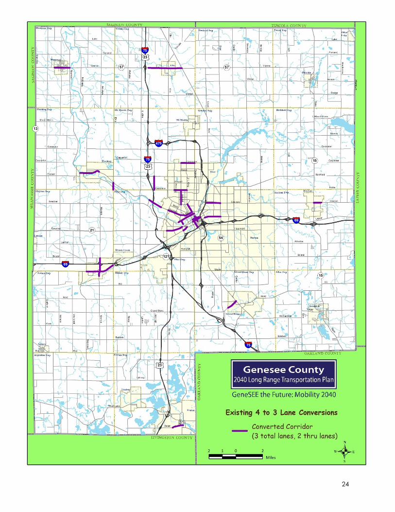
Existing 4 to 3 Lane Conversions Map……………………………………………..…… 24
VMT in Genesee County, 2005-2012………………………………………………….... 25
Non-Alcohol and Non-Deer Related Crashes in Genesee County, 2005-2012... 26
Total of 6 Crash Types, Genesee County, 2005-2012……………………………….. 26
4 to 3 Lane Conversion Study Corridors Map……………………………………….... 28
Appendix A List of all Genesee County 4-to-3 Lane Conversions
2
Genesee County Complete Streets Technical Report
A national movement is taking shape in communities across the country to complete the streets. The movement can be summed up in a simple statement: Streets are for people not just automobiles.
“The streets of our cities and towns ought to be for everyone, whether young or
old, motorist or bicyclist, walker or wheelchair user, bus rider or shopkeeper. But
too many of our streets are designed only for speeding cars, or worse, creeping
traffic jams. They’re unsafe for people on foot or bike — and unpleasant for
everybody.”
–National Complete Streets Coalition
States, cities and towns are asking
their planners, engineers and
designers to build road networks that
welcome all citizens. The Genesee
County Metropolitan Alliance wants to
create a transportation network that is
safe, accessible and efficient for all
the citizens of Genesee County.
The Complete Streets vision statement for Genesee County:
“Transportation improvements in Genesee County are planned, designed and
constructed to encourage walking, bicycling, and transit use while promoting
safety for all users.”
Complete Streets Background
By definition, Complete Streets are designed and operated to enable safe
access for all users. Pedestrians, bicyclists, motorists and transit riders of all ages
and abilities must be able to safely move along and across a complete street.
Complete Streets is a way of looking at the public right-of-ways in the
community as not just a place for cars to travel but a place for people to travel.
A Complete Street is a safe, comfortable and convenient street for travel via
automobile, foot, bicycle, and transit. There is not one particular best practice
for Complete Streets, since every community will have its own unique needs.
Complete Streets is a way of considering all the possible users of a street and
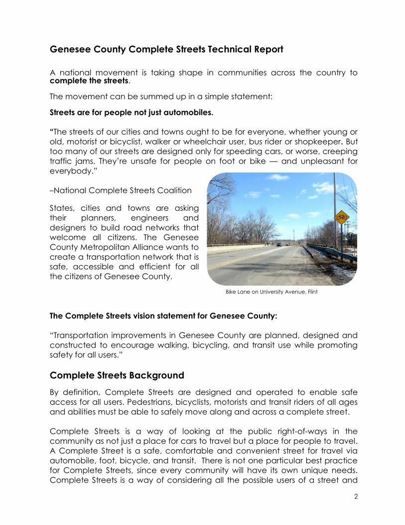
Bike Lane on University Avenue, Flint

3
accommodating them in the best way possible. Remember, every trip you take
in an automobile begins and ends with walking.
Some design elements of a complete street may include:
Sidewalks
Bike lanes
Non-motorized paths
ADA Accessible crosswalks
and ramps
ADA Accessible bus stops
and shelters
Dedicated Bus Lanes
Pedestrian crossings at
signalized intersections
Bridges with non-motorized
access
On-street parking
Road Diets
Things you may find on a Complete Street:
People of all ages and abilities walking or bicycling
Outside dining areas
Busy downtown pedestrian areas
Transit-Oriented Design
Complete Streets work well with other types of transportation projects including:
Traffic Safety Improvement Projects
Safe Routes to School Initiatives
Regional Trails and Greenway Systems
Downtown Development Projects
Corridor Improvement Projects
Streetscape Projects
Transit Projects
Benefits of Complete Streets
The complete streets movement is growing in popularity because projects have
potential benefits for all users of a street. In contrast, other projects such as a
road widening might have benefits for motorists, but that often comes with
negative impacts on non-motorized transportation. Complete Streets projects
can have positive impacts for everyone:
Photo courtesy of smartgrowthamerica.org
4
Pedestrians and Bicyclists
Improved safety and comfort due to signalized pedestrian crossings,
wider sidewalks.
Better accessibility for pedestrians means people have better ability to
lead a healthy lifestyle and walk or bike more places.
Bike Lanes can allow bicyclists to safely share the road with other vehicles
Children are given a safer way to walk or bike to school, helping them
stay physically active and gain independence.
Elderly and Mobility Challenged
Road diets can provide narrower streets that are less intimidating to cross
for people who move more slowly.
Complete streets designs offer wider sidewalks, ramps, and transit stops
that are accessible by everyone. Sidewalk bulb-outs, refuge medians,
and audible crossing signals for the visually impaired are just a few
complete street designs that can make pedestrian crossings easier.
People with limited mobility will have better access to fixed transit routes,
decreasing the need for specialized paratransit services.
Motorists
Complete streets can have a traffic
calming effect which reduces
vehicle crashes.
Complete streets encourage more
walking and biking, leading to less
traffic and congestion on the road.
Increased Transit Ridership
Cut-out transit stops allow busses
to safely stop without
interrupting traffic.
Shelters give transit riders a safe place
to wait.
Sidewalks and curb ramps connected to them make transit more
accessible.
A network of bike lanes and transit routes creates a harmonious complete
streets system.
Economic Benefits
A balanced transportation system can create economic growth by
providing accessible connections between residences, public
transportation, offices and retail destinations.
Better pedestrian facilities allow more people to access businesses,
especially people who lack access to transportation.
Complete streets can raise property values, as people are willing to pay
more to live in walkable communities.
Photo courtesy of FHWA
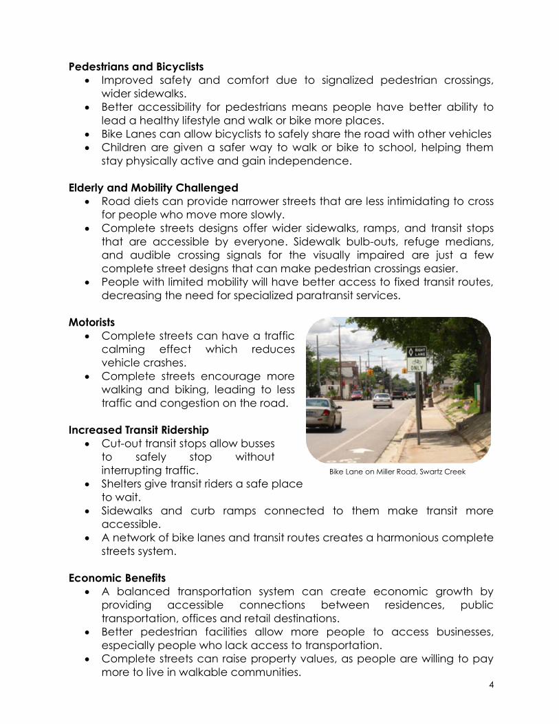
Bike Lane on Miller Road, Swartz Creek

5
Context Sensitive Solutions (CSS)
Context Sensitive Solutions is an approach to transportation projects that
involves all community stakeholders in the planning process. Defining the
context of a project is important to ensure transportation facilities meet the
needs of a community. These needs can vary greatly depending on the
character and landscape of the location. Complete Streets projects are a
good example of this. A complete street with pedestrian facilities might be very
compatible in an urban area where stakeholders would welcome such
changes. However, the same project would not be compatible on a rural
highway where pedestrian facilities are not needed. Later in this report, CSS is
demonstrated in the 4 to 3 Lane Conversion Study where recommendations are
made based on different characteristics of each corridor.
Complete Streets Goals, Objectives, and Action Steps
Goal: Complete the Streets in Genesee County
Objective: Inventory the need for Complete Streets
Action Steps: Complete a sidewalk inventory of Genesee County
Action Steps: Include questions about the need for Complete
Streets in future transportation surveys
Objective: Approve and follow the Complete Streets Policy for Genesee
County
Action Steps: Ensure that all road agencies agree to implement the
Complete Streets policy
Objective: Evaluate and select projects that fit complete streets policy
Action Steps: Utilize the Complete Streets Policy for Long Range
Transportation Plan (LRTP) and Transportation Improvement
Program (TIP) Projects
Objective: Implement road diets suggested in the Road Diet Study
Action Steps: Utilize the Complete Streets Policy for Long Range
Transportation Plan (LRTP) and Transportation Improvement
Program (TIP) Projects

6
Goal: Educate local officials and road agencies about Complete Streets
Objective: Provide resources and education about Complete Streets
Action Steps: Continue to keep a database of Complete Streets by
gathering information on conversion projects in Genesee County
Action Steps: Follow statewide and national trends in Complete
Streets
Action Steps: Provide technical assistance to road agencies when
needed about implementing Complete Streets in their communities
Objective: Advocate for Complete Streets when new road projects when
possible
Action Steps: Document and publicize success stories about
implementation of Complete Streets
Action Steps: Work with other organizations such as Safe and Active
Genesee for Everyone (SAGE), the Disability Network, and other
organizations to reach out to the community about the need for
Complete Streets
Guiding Principles of Complete Streets
Pedestrians, bicyclists, motorists and
transit riders of all ages and abilities must
be able to safely move along and
across a complete street. In order to
complete our streets in Genesee
County, changes in the policies and
practices of our transportation agencies
need to occur. A Complete Streets
policy ensures that the entire right of
way is routinely designed and operated
to enable safe access for all users.
Transportation agencies must ensure that all road projects result in a street that
is appropriate to local context and needs as determined by the transportation
agency.
Photo courtesy of completestreets.org

7
Genesee County Complete Streets Policies
Policy 1: Coverage Area
Complete Streets policies shall cover all roads in Genesee County that are part
of the Federal Aid Road System.
Policy 2: Design Guidelines
All transportation improvements shall be constructed in accordance with
prevailing ADA guidelines and AASHTO and existing MDOT standards.
Policy 3: Planning Documents
All Federal Aid Road Projects in the
Genesee County Metropolitan
Alliance Long Range Transportation
Plan (LRTP) and Transportation
Improvement Program (TIP) shall be
evaluated according to the
guiding principles of Complete
Streets.
Policy 4: Maintenance
Maintenance agreements with
clearly defined roles and
responsibilities shall be established for any non-motorized facilities before the
facilities are built.
Policy 5: New Development
Municipalities should consider adopting a Complete Streets policy and that all
new development site plans, residential and non-residential, should provide
non-motorized facilities:
Built to ADA guidelines and AASHTO standards
With adjacent connections to existing or future non-motorized facilities
Regardless of land use, location or National Functional Classification
At the minimum, along the road frontage Right-of-Way
Consultation with local road and transit agencies should occur during the
site plan review process
Road Diet on Vienna Street, Downtown Clio

8
The following exceptions are suggested:
Residential developments with one dwelling unit per more than five acres
If the cost of providing non-motorized facilities becomes burdensome to
the total infrastructure cost associated with the development
The provision of non-motorized facilities is environmentally unfeasible due
to natural resource constraints
Segments along or to a facility where pedestrians and bicycles are
prohibited (i.e. freeways)
Michigan’s Complete Streets Policies
On August 1, 2010, Michigan legislators signed Public Acts 134 and 135 in order
to encourage development of Complete Streets as appropriate to the context
and cost of a project. Public Act 135 allowed for the creation of a Complete
Streets Advisory Council which
provides education on the
development, implementation, and
coordination of Complete Streets
policies to government and non-
government stakeholders.
This new legislation also required the
State Transportation Commission to
adopt a Complete Streets policy for
the Michigan Department of
Transportation (MDOT). A statewide
policy was adopted and has been used as a model by local municipalities in
the creation of their own policies. These new laws do not require all
municipalities in the state to develop their own complete streets policies.
However, if a local agency proposes a project that falls under the jurisdiction of
another agency, those two agencies must consult each other and agree on
how to address their complete streets policies prior to project approval.
Local Complete Streets Policies
Many communities within Genesee County have adopted their own resolutions
to encourage the use of Complete Streets guidelines in future transportation
projects. At the time of this report, the following municipalities have adopted a
Complete Streets policy:
Atlas Township
Fenton Township
City of Flint
Genesee Township
Complete Street designs, Kearsley Street, Flint
9
Grand Blanc Township
City of Linden
Mundy Township
According to the National Complete Streets Coalition, complete streets policies
should apply to all phases of all projects, using the latest design standards. They
should allow for flexibility in balancing user needs, since not all road segments
have the same variety of users. Policies should specify any exceptions and
require high-level approval of them. Complete streets policies should also
include performance standards and specific steps for implementation.
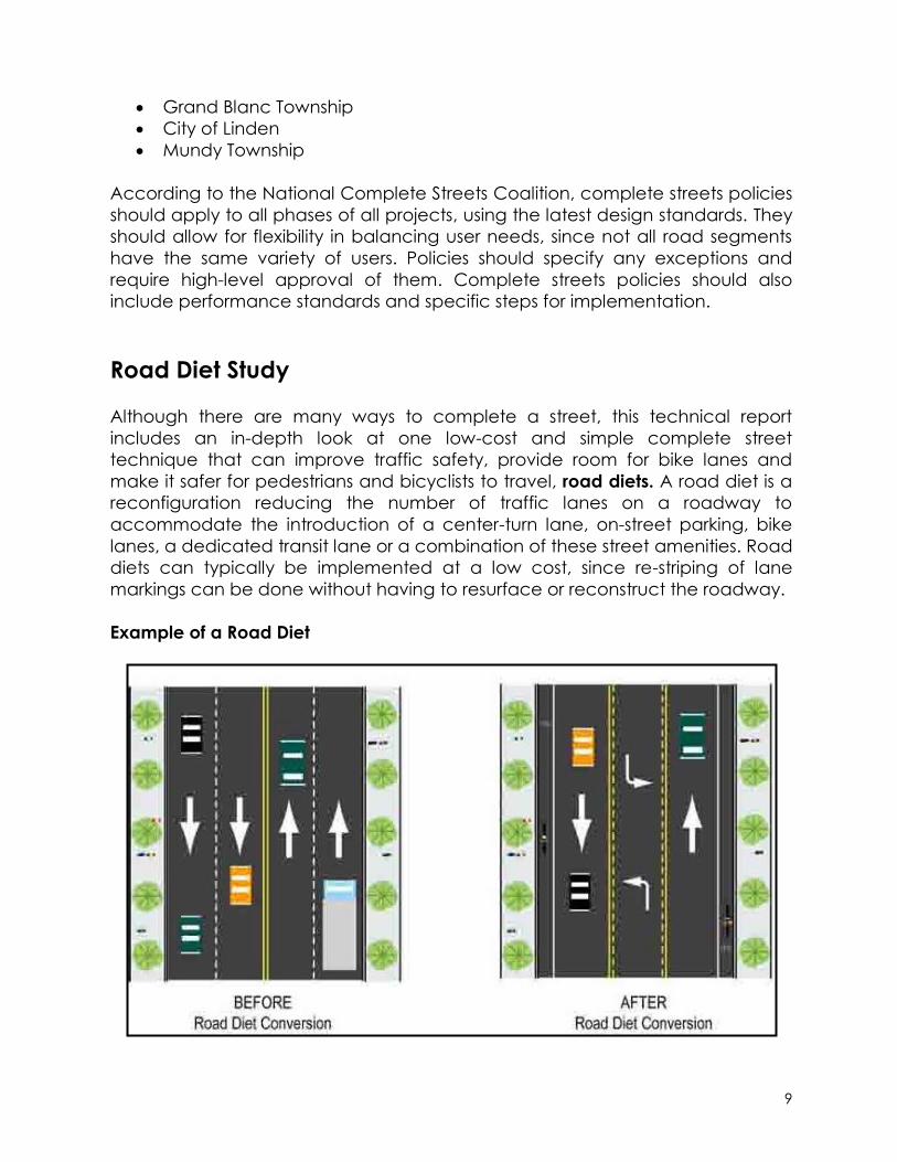
Road Diet Study
Although there are many ways to complete a street, this technical report
includes an in-depth look at one low-cost and simple complete street
technique that can improve traffic safety, provide room for bike lanes and
make it safer for pedestrians and bicyclists to travel, road diets. A road diet is a
reconfiguration reducing the number of traffic lanes on a roadway to
accommodate the introduction of a center-turn lane, on-street parking, bike
lanes, a dedicated transit lane or a combination of these street amenities. Road
diets can typically be implemented at a low cost, since re-striping of lane
markings can be done without having to resurface or reconstruct the roadway.
Example of a Road Diet
10
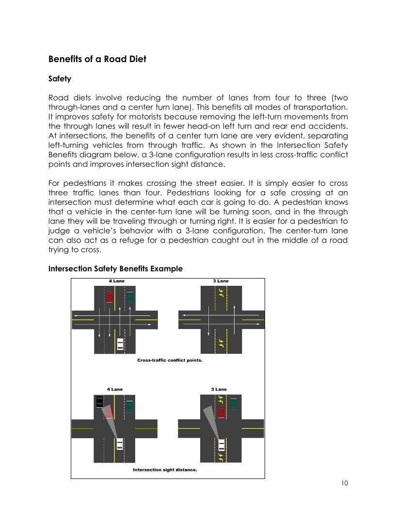
Benefits of a Road Diet
Safety
Road diets involve reducing the number of lanes from four to three (two
through-lanes and a center turn lane). This benefits all modes of transportation.
It improves safety for motorists because removing the left-turn movements from
the through lanes will result in fewer head-on left turn and rear end accidents.
At intersections, the benefits of a center turn lane are very evident, separating
left-turning vehicles from through traffic. As shown in the Intersection Safety
Benefits diagram below, a 3-lane configuration results in less cross-traffic conflict
points and improves intersection sight distance.
For pedestrians it makes crossing the street easier. It is simply easier to cross
three traffic lanes than four. Pedestrians looking for a safe crossing at an
intersection must determine what each car is going to do. A pedestrian knows
that a vehicle in the center-turn lane will be turning soon, and in the through
lane they will be traveling through or turning right. It is easier for a pedestrian to
judge a vehicle’s behavior with a 3-lane configuration. The center-turn lane
can also act as a refuge for a pedestrian caught out in the middle of a road
trying to cross.
Intersection Safety Benefits Example

11
Traffic Calming
This also produces a traffic calming effect. All of the vehicles move along the
street at about the same speed, which eliminates dangerous merge and
weave movements that can occur on a 4-lane roadway. Traffic calming
measures, especially in residential areas, school zones, and downtown
shopping areas can improve safety and comfortability for all users.
Bike Lanes
Removing a lane of travel can also provide room for bike lanes on the outside
of the travel lane, a simple way to get bicycle facilities for the community at low
cost. As average fuel costs continue to rise, more and more people are using
bicycles as a form of transportation. Additional bike lanes will allow even more
bicyclists to safely use our road network. In the City of Flint, all students living
within 1.5 miles of their school cannot use school bus service. They must walk,
bike or get a ride from an adult to school. Additional bike lanes in a community
like Flint can greatly help students get to school safely.
Parking
Some commercial areas are in need
of on-street parking. Where feasible,
the eliminated travel lane can be
used to accommodate on-street
parking, such as in downtown
shopping districts, and small mixed
residential/ commercial corridors,
near schools and churches.
Other Road Diet Benefits
Improves livability of a community and quality of life for residents
Great for increasing mobility and accessibility for elderly and disabled
Re-striping and signage is an inexpensive fix for roadway operations
Great for urban areas
Option for additional streetscape enhancements
Improves walkability
Road Diet on Flushing Road, Flint Township

12
Road Diet Pro’s Road Diet Con’s
Traffic Calming-Slows traffic, eliminates
speeding and merge-and-weave
driving. Slower traffic in downtown
shopping areas encourages window-
shopping and looking at stores.
Slows traffic- all through traffic needs
to travel in one lane and therefore is
limited by the speed of the slowest
driver
Improves safety- fewer accidents
because left-turning movements are
removed from the through travel lane
May cause difficulty in pulling out into
the roadway from a driveway or side-
street if traffic volumes are high
(above 15,000 vehicles per day)
especially during peak travel hours,
because of lack of breaks in the travel
lane for merging traffic.
Ability to utilize right-of-way for other
purposes such as bicycle lanes,
parking, or streetscape enhancements
Slight decrease in roadway capacity,
due to loss of a travel lane.
Inexpensive roadway design fix,
especially when implemented as part
of an existing repaving project.
If road diet is on a bus route, bus stops
can stop traffic.
Ability to improve lane width to
standard 12 ft wide lanes where roads
are too narrow and not meeting
standards.
Driver Expectations- People used to
driving on the road as a 4-lane will
have to get used to the 3-lane
configuration
When is a road diet appropriate?
Average Daily Traffic Count
(ADT) of under 10,000 is highly
likely as feasible. ADT of 10,000 to
20,000 may be feasible
depending on other factors. ADT
over 20,000 typically is not
appropriate for a road diet.
When narrow lane widths prohibit
correct use of 4-lane roadway.
12 ft lane width is standard, less
than 12 ft lane width can prohibit
cars from passing safely.
When land use on a corridor
produces lots of turning movements such as a block-style street grid,
shopping areas along a corridor, school zones, etc.
Road Diet on Fifth Avenue, Flint

13
When rates of traffic accidents for head on, head on – left turn, angle,
rear end, and rear end – left turn crashes are higher than average for
similarly functionally classified roadways.
When bike lanes are needed in the area.
When a parallel route exists with a higher capacity (5-lane road)
When traffic calming is needed
When on-street parking is needed
A common concern with 4-to-3-lane
road diet conversions is whether
significant traffic delays will occur as
a result. In most cases, traffic
calming increases safety with little or
no impact on traffic delay. 4-to-3
lane conversions have been
implemented successfully in
Genesee County on roads with an
ADT of up to 20,000. However, a
study by the Michigan Department
of Transportation (MDOT) suggests
that road diet conversions may not
be effective when ADT is greater
than 10,000. Road corridors need to
undergo a detailed operational analysis including turning movements and
cross-street traffic before conversion is implemented. Traffic delays can
become problematic on roads with especially high peak hour volumes of over
1,000.
Road Diet Transitions
For a road diet to be successfully implemented, it is important to consider the
transition between a new 3-lane road segment and segments with different
lane configurations. Transitions should be smooth, otherwise new traffic conflicts
can occur that didn’t exist prior to conversion. Choosing the transition location
for road diet projects needs thorough evaluation, avoiding major driveways
and intersections. Smaller intersections can be ideal transition locations to
reduce lanes. Transitions should occur in areas where the entire transition is
visible to drivers without sight distance constraints. Specific guidelines can be
found in the Manual on Uniform Traffic Control Devices (MUTCD), where
AASHTO recommends certain transition lengths to be used in conversion
projects.
Complete Street designs on University Avenue, Flint
14
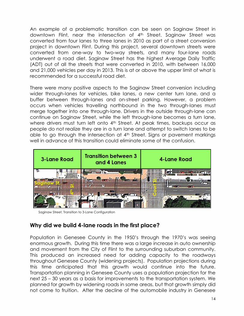
An example of a problematic transition can be seen on Saginaw Street in
downtown Flint, near the intersection of 4th Street. Saginaw Street was
converted from four lanes to three lanes in 2010 as part of a street conversion
project in downtown Flint. During this project, several downtown streets were
converted from one-way to two-way streets, and many four-lane roads
underwent a road diet. Saginaw Street has the highest Average Daily Traffic
(ADT) out of all the streets that were converted in 2010, with between 16,000
and 21,000 vehicles per day in 2013. This is at or above the upper limit of what is
recommended for a successful road diet.
There were many positive aspects to the Saginaw Street conversion including
wider through-lanes for vehicles, bike lanes, a new center turn lane, and a
buffer between through-lanes and on-street parking. However, a problem
occurs when vehicles travelling northbound in the two through-lanes must
merge together into one through-lane. Drivers in the outside through-lane can
continue on Saginaw Street, while the left through-lane becomes a turn lane,
where drivers must turn left onto 4th Street. At peak times, backups occur as
people do not realize they are in a turn lane and attempt to switch lanes to be
able to go through the intersection at 4th Street. Signs or pavement markings
well in advance of this transition could eliminate some of the confusion.
Why did we build 4-lane roads in the first place?
Population in Genesee County in the 1950’s through the 1970’s was seeing
enormous growth. During this time there was a large increase in auto ownership
and movement from the City of Flint to the surrounding suburban community.
This produced an increased need for adding capacity to the roadways
throughout Genesee County (widening projects). Population projections during
this time anticipated that this growth would continue into the future.
Transportation planning in Genesee County uses a population projection for the
next 25 – 30 years as a basis for improvements to the transportation system. We
planned for growth by widening roads in some areas, but that growth simply did
not come to fruition. After the decline of the automobile industry in Genesee
Saginaw Street, Transition to 3-Lane Configuration

15
County, we saw a loss of population and therefore less demand for wide roads.
At that time and up until the 1990’s the preferred roadway configuration was a
4-lane road, when a 2-lane road needed to be widened. Now, with the
additional safety measures taken into consideration, 3-lane and 5-lane roads
are the preferred design. The 4-lane road is becoming obsolete.
Analysis of Implemented Genesee County Road Diets
Methodology
There are many roads in Genesee County that have already undergone a road
diet. To measure the success of these road diets, traffic crash data was
collected for the most recent three-lane conversions using RoadSoft software.
Data was analyzed from the years 1996-2013, depending on the availability of
data for the converted road segment. Crash data for each available year prior
to and after conversion was analyzed, but not data from the year of the
conversion. Alcohol and deer-related crashes are removed from the study.
Crash data was collected for the entire converted portion of roadway, plus one
additional segment on both sides of the project limits. This was done to include
any effects a road diet might have had on areas immediately surrounding the
converted corridor.
Summary of Findings
Analysis of road diet corridors in Genesee County shows anywhere between a
6% increase and a 68% decrease in all crash types after conversion. The
average change before and after conversion for all corridors is a 32.1%
reduction in crashes. Of all crash types studied, the most significant reduction in
crashes occurred with head on-left turn, rear end-left turn, and side swipe-same
side types of crashes. While most crash types and corridors saw a crash
reduction, increases in crashes occurred on some segments. In some cases this
was because there were a minimal number of crashes to compare year-to-
year, such as on Chevrolet Avenue. In other cases, road agencies should
conduct further analysis to determine what caused an increase. The success of
a road diet is dependent on many roadway factors, and crash reduction can
vary. Detailed analysis of each converted corridor can be found on pages 17-
21.

16
Head On
Head On-
Left Turn Rear End
Rear End-
Left Turn
Side Swipe-
Same Side
Side Swipe-
Opposite
Side
All Non-Alcohol
and Non-Deer
Related
Crashes
1st (1,654) 0.0% 0.0% 16.7% 0.0% -100.0% 0.0% -68.5%
2nd (2,523) 0.0% 100.0% -100.0% 16.7% -100.0% 0.0% -43.8%
Chevrolet (N/A) 0.0% 250.0% 16.7% 0.0% -100.0% 0.0% 6.1%
Davison (8,094) 66.7% -68.1% -39.3% -75.0% -43.3% -82.1% -46.1%
Dupont (8,371) -24.9% -89.1% -66.5% -75.0% -76.9% -25.0% -66.7%
Elms (13,327) 100.0% -33.3% 14.3% 100.0% -33.3% 0.0% -23.6%
Flushing/5th (13,234) -28.6% -74.6% 22.2% -81.0% -57.1% -54.3% -14.8%
Grand Blanc (14,924) 133.3% -100.0% 25.0% -41.7% -100.0% 100.0% -15.2%
Grand Traverse (10,737) 133.3% 0.0% -33.3% 0.0% -87.7% 250.0% -49.7%
Kearsley (5,687) 100.0% 16.7% -6.7% 100.0% -6.7% -100.0% 1.4%
ML King (5,364) 25.0% -63.0% -33.3% -100.0% -73.7% 108.3% -58.3%
Miller- 2000 (14,650) 23.1% -40.2% -7.7% -38.5% -1.5% 53.8% -15.1%
Miller- 2010 (19,446) -100.0% -100.0% 63.3% 0.0% -100.0% 366.7% -8.7%
Morrish (8,045) -100.0% -100.0% 50.0% -100.0% -70.0% 0.0% -52.0%
Pasadena (8,850) -50.0% -81.3% -55.6% -100.0% 0.0% -100.0% -60.2%
Saginaw (20,865) 133.3% 211.1% 33.9% 100.0% -43.2% -100.0% 0.2%
University (7,967) -4.8% -79.6% -9.1% 0.0% -72.5% -42.9% -30.3%
Vienna (17,370) -79.0% -34.4% -29.2% -76.7% -52.0% -62.3% -32.9%
Average Change
Before-After: 18.2% -15.9% -7.7% -20.6% -62.1% 17.3% -32.1%
Converted Corridor
(High ADT):
Crash Type
Average Crash Reduction Rates After 3-Lane Conversion in Genesee County
Overall Crash Data Analysis of 3-Lane Conversions

17
Chevrolet Avenue
Changed to a 3-lane Road in 2010
ADT: N/A
Crash Type
Number of
Crashes
Years of
Data
Crashes
Per Year
Number
of Crashes
Years of
Data
Crashes
Per Year
Head On Crashes 0 7 0.000 0 3 0.000 0.0%
Head On -Left Turn Crashes 2 7 0.286 3 3 1.000 250.0%
Rear End Crashes 6 7 0.857 3 3 1.000 16.7%
Rear End -Left Turn Crashes 0 7 0.000 0 3 0.000 0.0%
Side Swipe -Same Side Crashes 4 7 0.571 0 3 0.000 -100.0%
Side Swipe -Opposite Side Crashes 0 7 0.000 0 3 0.000 0.0%
All Non-alcohol & Non-Deer Related Crashes 33 7 4.714 15 3 5.000 6.1%
University Avenue to the Flint River, City of Flint*
Before Conversion After Conversion Percent
Change per
Year
1st Street
Changed to a 3-lane road in 2010
ADT: High 1,654 (2013) - Low 1,304 (2013)
Crash Type
Number of
Crashes
Years of
Data
Crashes
Per Year
Number
of Crashes
Years of
Data
Crashes
Per Year
Head On Crashes 0 7 0.000 0 3 0.000 0.0%
Head On -Left Turn Crashes 0 7 0.000 0 3 0.000 0.0%
Rear End Crashes 2 7 0.286 1 3 0.333 16.7%
Rear End -Left Turn Crashes 0 7 0.000 0 3 0.000 0.0%
Side Swipe -Same Side Crashes 3 7 0.429 0 3 0.000 -100.0%
Side Swipe -Opposite Side Crashes 0 7 0.000 0 3 0.000 0.0%
All Non-alcohol & Non-Deer Related Crashes 37 7 5.286 5 3 1.667 -68.5%
S. Grand Traverse Street to Stevens Street, City of Flint*
Before Conversion After Conversion Percent
Change per
Year
2nd Street
Changed to a 3-lane Road in 2010
ADT: High 2,523 (2013) - Low 1,746 (2013)
Crash Type
Number of
Crashes
Years of
Data
Crashes
Per Year
Number
of Crashes
Years of
Data
Crashes
Per Year
Head On Crashes 0 7 0.000 0 3 0.000 0.0%
Head On -Left Turn Crashes 0 7 0.000 1 3 0.333 100.0%
Rear End Crashes 6 7 0.857 0 3 0.000 -100.0%
Rear End -Left Turn Crashes 2 7 0.286 1 3 0.333 16.7%
Side Swipe -Same Side Crashes 15 7 2.143 0 3 0.000 -100.0%
Side Swipe -Opposite Side Crashes 0 7 0.000 0 3 0.000 0.0%
All Non-alcohol & Non-Deer Related Crashes 83 7 11.857 20 3 6.667 -43.8%
Ann Arbor Street to I-475, City of Flint*
Before Conversion After Conversion Percent
Change per
Year
Corridor Crash Data Analysis of 3-Lane Conversions
* Crash data from RoadSoft includes one additional segment on either side of this corridor

18
Davison Road
Changed to a 3-lane Road in 2001
ADT: 8,094 (2010)
Crash Type
Number of
Crashes
Years of
Data
Crashes
Per Year
Number of
Crashes
Years of
Data
Crashes
Per Year
Head On Crashes 1 5 0.200 4 12 0.333 66.7%
Head On -Left Turn Crashes 30 5 6.000 23 12 1.917 -68.1%
Rear End Crashes 83 5 16.600 121 12 10.083 -39.3%
Rear End -Left Turn Crashes 5 5 1.000 3 12 0.250 -75.0%
Side Swipe -Same Side Crashes 25 5 5.000 34 12 2.833 -43.3%
Side Swipe -Opposite Side Crashes 7 5 1.400 3 12 0.250 -82.1%
All Non-alcohol & Non-Deer Related Crashes 300 5 60.000 388 12 32.333 -46.1%
Before Conversion After Conversion Percent
Change
Before-After
Lewis Place to N Dort Highway, City of Flint*
Dupont Street
Changed to a 3-lane Road in 2005
ADT: High 8,371 (2003) -Low 6,672 (2003)
Crash Type
Number of
Crashes
Years of
Data
Crashes
Per Year
Number of
Crashes
Years of
Data
Crashes
Per Year
Head On Crashes 3 9 0.333 2 8 0.250 -24.9%
Head On -Left Turn Crashes 93 9 10.333 9 8 1.125 -89.1%
Rear End Crashes 84 9 9.333 25 8 3.125 -66.5%
Rear End -Left Turn Crashes 9 9 1.000 2 8 0.250 -75.0%
Side Swipe -Same Side Crashes 39 9 4.333 8 8 1.000 -76.9%
Side Swipe -Opposite Side Crashes 9 9 1.000 6 8 0.750 -25.0%
All Non-alcohol & Non-Deer Related Crashes 510 9 56.667 151 8 18.875 -66.7%
Welch Boulevard to W Pasadena Avenue, City of Flint*
Before Conversion After Conversion Percent
Change
Before-After
Flushing Road / E. 5th Avenue
Changed to a 3-lane Road in 2006
ADT: High 13,234 (2004) - Low 11,585 (2004)
Crash Type
Number of
Crashes
Years of
Data
Crashes
Per Year
Number of
Crashes
Years of
Data
Crashes
Per Year
Head On Crashes 4 4 1.000 5 7 0.714 -28.6%
Head On -Left Turn Crashes 18 4 4.500 8 7 1.143 -74.6%
Rear End Crashes 72 4 18.000 154 7 22.000 22.2%
Rear End -Left Turn Crashes 3 4 0.750 1 7 0.143 -81.0%
Side Swipe -Same Side Crashes 24 4 6.000 18 7 2.571 -57.1%
Side Swipe -Opposite Side Crashes 5 4 1.250 4 7 0.571 -54.3%
All Non-alcohol & Non-Deer Related Crashes 224 4 56.000 334 7 47.714 -14.8%
N Ballenger Highway to M.L. King Avenue, City of Flint*
Before Conversion After Conversion Percent
Change
Before-After
Elms Road
Changed to a 3-lane Road in 2010
ADT: 13,327 (2013)
Crash Type
Number of
Crashes
Years of
Data
Crashes
Per Year
Number
of Crashes
Years of
Data
Crashes
Per Year
Head On Crashes 1 6 0.167 1 3 0.333 100.0%
Head On -Left Turn Crashes 12 6 2.000 4 3 1.333 -33.3%
Rear End Crashes 7 6 1.167 4 3 1.333 14.3%
Rear End -Left Turn Crashes 2 6 0.333 2 3 0.667 100.0%
Side Swipe -Same Side Crashes 3 6 0.500 1 3 0.333 -33.3%
Side Swipe -Opposite Side Crashes 2 6 0.333 1 3 0.333 0.0%
All Non-alcohol & Non-Deer Related Crashes 55 6 9.167 21 3 7.000 -23.6%
Flushing Road to Potter Road, Flushing Township*
Before Conversion After Conversion Percent
Change per
Year
* Crash data from RoadSoft includes one additional segment on either side of this corridor
19
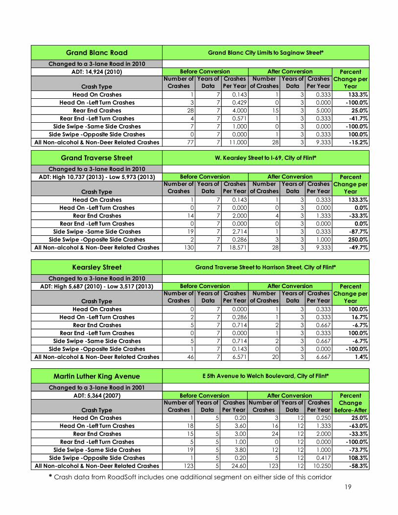
Martin Luther King Avenue
Changed to a 3-lane Road in 2001
ADT: 5,364 (2007)
Crash Type
Number of
Crashes
Years of
Data
Crashes
Per Year
Number of
Crashes
Years of
Data
Crashes
Per Year
Head On Crashes 1 5 0.20 3 12 0.250 25.0%
Head On -Left Turn Crashes 18 5 3.60 16 12 1.333 -63.0%
Rear End Crashes 15 5 3.00 24 12 2.000 -33.3%
Rear End -Left Turn Crashes 5 5 1.00 0 12 0.000 -100.0%
Side Swipe -Same Side Crashes 19 5 3.80 12 12 1.000 -73.7%
Side Swipe -Opposite Side Crashes 1 5 0.20 5 12 0.417 108.3%
All Non-alcohol & Non-Deer Related Crashes 123 5 24.60 123 12 10.250 -58.3%
E 5th Avenue to Welch Boulevard, City of Flint*
Before Conversion After Conversion Percent
Change
Before-After
Kearsley Street
Changed to a 3-lane Road in 2010
ADT: High 5,687 (2010) - Low 3,517 (2013)
Crash Type
Number of
Crashes
Years of
Data
Crashes
Per Year
Number
of Crashes
Years of
Data
Crashes
Per Year
Head On Crashes 0 7 0.000 1 3 0.333 100.0%
Head On -Left Turn Crashes 2 7 0.286 1 3 0.333 16.7%
Rear End Crashes 5 7 0.714 2 3 0.667 -6.7%
Rear End -Left Turn Crashes 0 7 0.000 1 3 0.333 100.0%
Side Swipe -Same Side Crashes 5 7 0.714 2 3 0.667 -6.7%
Side Swipe -Opposite Side Crashes 1 7 0.143 0 3 0.000 -100.0%
All Non-alcohol & Non-Deer Related Crashes 46 7 6.571 20 3 6.667 1.4%
Grand Traverse Street to Harrison Street, City of Flint*
Before Conversion After Conversion Percent
Change per
Year
Grand Blanc Road
Changed to a 3-lane Road in 2010
ADT: 14,924 (2010)
Crash Type
Number of
Crashes
Years of
Data
Crashes
Per Year
Number
of Crashes
Years of
Data
Crashes
Per Year
Head On Crashes 1 7 0.143 1 3 0.333 133.3%
Head On -Left Turn Crashes 3 7 0.429 0 3 0.000 -100.0%
Rear End Crashes 28 7 4.000 15 3 5.000 25.0%
Rear End -Left Turn Crashes 4 7 0.571 1 3 0.333 -41.7%
Side Swipe -Same Side Crashes 7 7 1.000 0 3 0.000 -100.0%
Side Swipe -Opposite Side Crashes 0 7 0.000 1 3 0.333 100.0%
All Non-alcohol & Non-Deer Related Crashes 77 7 11.000 28 3 9.333 -15.2%
Grand Blanc City Limits to Saginaw Street*
Before Conversion After Conversion Percent
Change per
Year
Grand Traverse Street
Changed to a 3-lane Road in 2010
ADT: High 10,737 (2013) - Low 5,973 (2013)
Crash Type
Number of
Crashes
Years of
Data
Crashes
Per Year
Number
of Crashes
Years of
Data
Crashes
Per Year
Head On Crashes 1 7 0.143 1 3 0.333 133.3%
Head On -Left Turn Crashes 0 7 0.000 0 3 0.000 0.0%
Rear End Crashes 14 7 2.000 4 3 1.333 -33.3%
Rear End -Left Turn Crashes 0 7 0.000 0 3 0.000 0.0%
Side Swipe -Same Side Crashes 19 7 2.714 1 3 0.333 -87.7%
Side Swipe -Opposite Side Crashes 2 7 0.286 3 3 1.000 250.0%
All Non-alcohol & Non-Deer Related Crashes 130 7 18.571 28 3 9.333 -49.7%
W. Kearsley Street to I-69, City of Flint*
Before Conversion After Conversion Percent
Change per
Year
* Crash data from RoadSoft includes one additional segment on either side of this corridor
20
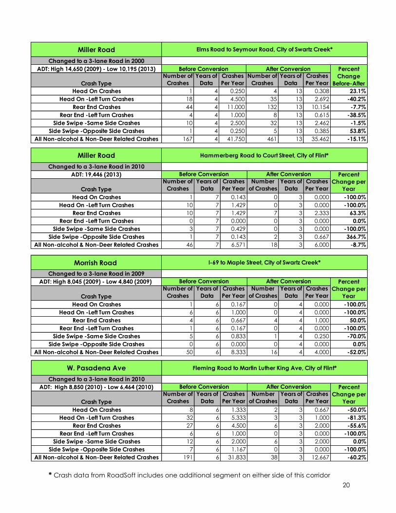
Miller Road
Changed to a 3-lane Road in 2000
ADT: High 14,650 (2009) - Low 10,195 (2013)
Crash Type
Number of
Crashes
Years of
Data
Crashes
Per Year
Number of
Crashes
Years of
Data
Crashes
Per Year
Head On Crashes 1 4 0.250 4 13 0.308 23.1%
Head On -Left Turn Crashes 18 4 4.500 35 13 2.692 -40.2%
Rear End Crashes 44 4 11.000 132 13 10.154 -7.7%
Rear End -Left Turn Crashes 4 4 1.000 8 13 0.615 -38.5%
Side Swipe -Same Side Crashes 10 4 2.500 32 13 2.462 -1.5%
Side Swipe -Opposite Side Crashes 1 4 0.250 5 13 0.385 53.8%
All Non-alcohol & Non-Deer Related Crashes 167 4 41.750 461 13 35.462 -15.1%
Elms Road to Seymour Road, City of Swartz Creek*
Before Conversion After Conversion Percent
Change
Before-After
Morrish Road
Changed to a 3-lane Road in 2009
ADT: High 8,045 (2009) - Low 4,840 (2009)
Crash Type
Number of
Crashes
Years of
Data
Crashes
Per Year
Number
of Crashes
Years of
Data
Crashes
Per Year
Head On Crashes 1 6 0.167 0 4 0.000 -100.0%
Head On -Left Turn Crashes 6 6 1.000 0 4 0.000 -100.0%
Rear End Crashes 4 6 0.667 4 4 1.000 50.0%
Rear End -Left Turn Crashes 1 6 0.167 0 4 0.000 -100.0%
Side Swipe -Same Side Crashes 5 6 0.833 1 4 0.250 -70.0%
Side Swipe -Opposite Side Crashes 0 6 0.000 0 4 0.000 0.0%
All Non-alcohol & Non-Deer Related Crashes 50 6 8.333 16 4 4.000 -52.0%
I-69 to Maple Street, City of Swartz Creek*
Before Conversion After Conversion Percent
Change per
Year
Miller Road
Changed to a 3-lane Road in 2010
ADT: 19,446 (2013)
Crash Type
Number of
Crashes
Years of
Data
Crashes
Per Year
Number
of Crashes
Years of
Data
Crashes
Per Year
Head On Crashes 1 7 0.143 0 3 0.000 -100.0%
Head On -Left Turn Crashes 10 7 1.429 0 3 0.000 -100.0%
Rear End Crashes 10 7 1.429 7 3 2.333 63.3%
Rear End -Left Turn Crashes 0 7 0.000 0 3 0.000 0.0%
Side Swipe -Same Side Crashes 3 7 0.429 0 3 0.000 -100.0%
Side Swipe -Opposite Side Crashes 1 7 0.143 2 3 0.667 366.7%
All Non-alcohol & Non-Deer Related Crashes 46 7 6.571 18 3 6.000 -8.7%
Hammerberg Road to Court Street, City of Flint*
Before Conversion After Conversion Percent
Change per
Year
W. Pasadena Ave
Changed to a 3-lane Road in 2010
ADT: High 8,850 (2010) - Low 6,464 (2010)
Crash Type
Number of
Crashes
Years of
Data
Crashes
Per Year
Number
of Crashes
Years of
Data
Crashes
Per Year
Head On Crashes 8 6 1.333 2 3 0.667 -50.0%
Head On -Left Turn Crashes 32 6 5.333 3 3 1.000 -81.3%
Rear End Crashes 27 6 4.500 6 3 2.000 -55.6%
Rear End -Left Turn Crashes 6 6 1.000 0 3 0.000 -100.0%
Side Swipe -Same Side Crashes 12 6 2.000 6 3 2.000 0.0%
Side Swipe -Opposite Side Crashes 7 6 1.167 0 3 0.000 -100.0%
All Non-alcohol & Non-Deer Related Crashes 191 6 31.833 38 3 12.667 -60.2%
Fleming Road to Martin Luther King Ave, City of Flint*
Before Conversion After Conversion Percent
Change per
Year
* Crash data from RoadSoft includes one additional segment on either side of this corridor
21
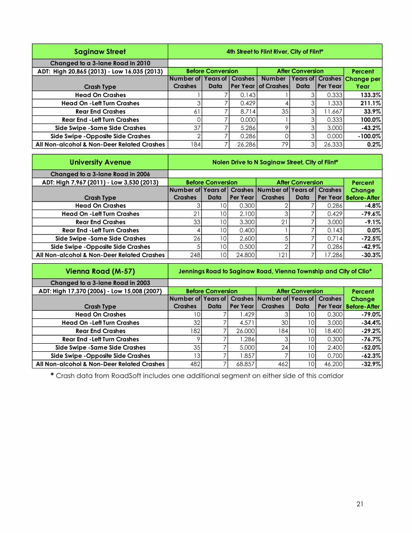
University Avenue
Changed to a 3-lane Road in 2006
ADT: High 7,967 (2011) - Low 3,530 (2013)
Crash Type
Number of
Crashes
Years of
Data
Crashes
Per Year
Number of
Crashes
Years of
Data
Crashes
Per Year
Head On Crashes 3 10 0.300 2 7 0.286 -4.8%
Head On -Left Turn Crashes 21 10 2.100 3 7 0.429 -79.6%
Rear End Crashes 33 10 3.300 21 7 3.000 -9.1%
Rear End -Left Turn Crashes 4 10 0.400 1 7 0.143 0.0%
Side Swipe -Same Side Crashes 26 10 2.600 5 7 0.714 -72.5%
Side Swipe -Opposite Side Crashes 5 10 0.500 2 7 0.286 -42.9%
All Non-alcohol & Non-Deer Related Crashes 248 10 24.800 121 7 17.286 -30.3%
Nolen Drive to N Saginaw Street, City of Flint*
Before Conversion After Conversion Percent
Change
Before-After
Vienna Road (M-57)
Changed to a 3-lane Road in 2003
ADT: High 17,370 (2006) - Low 15,008 (2007)
Crash Type
Number of
Crashes
Years of
Data
Crashes
Per Year
Number of
Crashes
Years of
Data
Crashes
Per Year
Head On Crashes 10 7 1.429 3 10 0.300 -79.0%
Head On -Left Turn Crashes 32 7 4.571 30 10 3.000 -34.4%
Rear End Crashes 182 7 26.000 184 10 18.400 -29.2%
Rear End -Left Turn Crashes 9 7 1.286 3 10 0.300 -76.7%
Side Swipe -Same Side Crashes 35 7 5.000 24 10 2.400 -52.0%
Side Swipe -Opposite Side Crashes 13 7 1.857 7 10 0.700 -62.3%
All Non-alcohol & Non-Deer Related Crashes 482 7 68.857 462 10 46.200 -32.9%
Jennings Road to Saginaw Road, Vienna Township and City of Clio*
Before Conversion After Conversion Percent
Change
Before-After
Saginaw Street
Changed to a 3-lane Road in 2010
ADT: High 20,865 (2013) - Low 16,035 (2013)
Crash Type
Number of
Crashes
Years of
Data
Crashes
Per Year
Number
of Crashes
Years of
Data
Crashes
Per Year
Head On Crashes 1 7 0.143 1 3 0.333 133.3%
Head On -Left Turn Crashes 3 7 0.429 4 3 1.333 211.1%
Rear End Crashes 61 7 8.714 35 3 11.667 33.9%
Rear End -Left Turn Crashes 0 7 0.000 1 3 0.333 100.0%
Side Swipe -Same Side Crashes 37 7 5.286 9 3 3.000 -43.2%
Side Swipe -Opposite Side Crashes 2 7 0.286 0 3 0.000 -100.0%
All Non-alcohol & Non-Deer Related Crashes 184 7 26.286 79 3 26.333 0.2%
4th Street to Flint River, City of Flint*
Before Conversion After Conversion Percent
Change per
Year
* Crash data from RoadSoft includes one additional segment on either side of this corridor
22
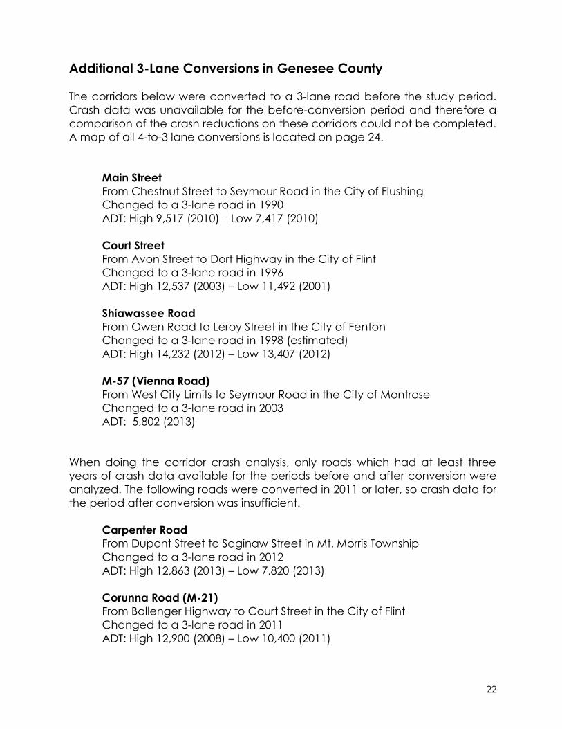
Additional 3-Lane Conversions in Genesee County
The corridors below were converted to a 3-lane road before the study period.
Crash data was unavailable for the before-conversion period and therefore a
comparison of the crash reductions on these corridors could not be completed.
A map of all 4-to-3 lane conversions is located on page 24.
Main Street
From Chestnut Street to Seymour Road in the City of Flushing
Changed to a 3-lane road in 1990
ADT: High 9,517 (2010) – Low 7,417 (2010)
Court Street
From Avon Street to Dort Highway in the City of Flint
Changed to a 3-lane road in 1996
ADT: High 12,537 (2003) – Low 11,492 (2001)
Shiawassee Road
From Owen Road to Leroy Street in the City of Fenton
Changed to a 3-lane road in 1998 (estimated)
ADT: High 14,232 (2012) – Low 13,407 (2012)
M-57 (Vienna Road)
From West City Limits to Seymour Road in the City of Montrose
Changed to a 3-lane road in 2003
ADT: 5,802 (2013)
When doing the corridor crash analysis, only roads which had at least three
years of crash data available for the periods before and after conversion were
analyzed. The following roads were converted in 2011 or later, so crash data for
the period after conversion was insufficient.
Carpenter Road
From Dupont Street to Saginaw Street in Mt. Morris Township
Changed to a 3-lane road in 2012
ADT: High 12,863 (2013) – Low 7,820 (2013)
Corunna Road (M-21)
From Ballenger Highway to Court Street in the City of Flint
Changed to a 3-lane road in 2011
ADT: High 12,900 (2008) – Low 10,400 (2011)

23
E. Flint Street
From M-15 to the East City Limits in the City of Davison
Changed to a 3-lane road in 2011
ADT: High 24,007 (2010) – Low 16,295 (2010)
Flushing Road
From Mill Road to Eldorado Drive in Flint Township
Changed to a 3-lane road in 2013
ADT: 8,983 (2013)
Jennings Road
From W. Pierson Road to W. Pasadena Avenue in Mt. Morris Township
Changed to a 3-lane road in 2012
ADT: 6,089 (2013)
24
25
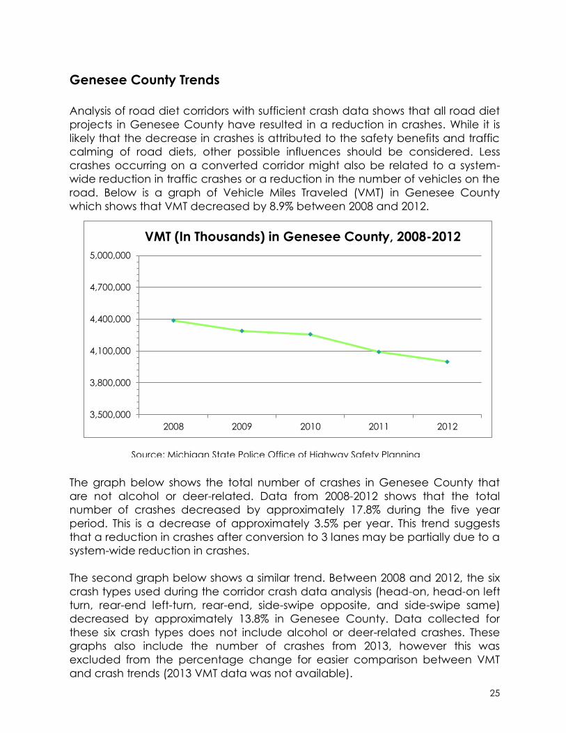
Source: Michigan State Police Office of Highway Safety Planning
3,500,000
3,800,000
4,100,000
4,400,000
4,700,000
5,000,000
2008 2009 2010 2011 2012
VMT (In Thousands) in Genesee County, 2008-2012
Genesee County Trends
Analysis of road diet corridors with sufficient crash data shows that all road diet
projects in Genesee County have resulted in a reduction in crashes. While it is
likely that the decrease in crashes is attributed to the safety benefits and traffic
calming of road diets, other possible influences should be considered. Less
crashes occurring on a converted corridor might also be related to a system-
wide reduction in traffic crashes or a reduction in the number of vehicles on the
road. Below is a graph of Vehicle Miles Traveled (VMT) in Genesee County
which shows that VMT decreased by 8.9% between 2008 and 2012.
The graph below shows the total number of crashes in Genesee County that
are not alcohol or deer-related. Data from 2008-2012 shows that the total
number of crashes decreased by approximately 17.8% during the five year
period. This is a decrease of approximately 3.5% per year. This trend suggests
that a reduction in crashes after conversion to 3 lanes may be partially due to a
system-wide reduction in crashes.
The second graph below shows a similar trend. Between 2008 and 2012, the six
crash types used during the corridor crash data analysis (head-on, head-on left
turn, rear-end left-turn, rear-end, side-swipe opposite, and side-swipe same)
decreased by approximately 13.8% in Genesee County. Data collected for
these six crash types does not include alcohol or deer-related crashes. These
graphs also include the number of crashes from 2013, however this was
excluded from the percentage change for easier comparison between VMT
and crash trends (2013 VMT data was not available).

26
Complete Streets 4 to 3 Lane Conversion Study
Methodology
The 4 to 3 Lane Conversion Study analyzed select 4-lane road segments in
Genesee County, in order to assess whether or not they were good candidates
Source: RoadSoft
Source: RoadSoft
7,500
8,000
8,500
9,000
9,500
10,000
2008 2009 2010 2011 2012 2013
Non-Alcohol and Non-Deer Related Crashes in
Genesee County, 2008-2013
2,500
3,000
3,500
4,000
4,500
2008 2009 2010 2011 2012 2013
Total of 6 Crash Types, Genesee County, 2008-2013 (Head-on, Head-on Left-turn, Rear-end Left-turn, Rear-end, Side-
Swipe opposite, Side-Swipe same)
27
for 3-lane conversions. All 4-lane roads in the Genesee County federal aid road
network were identified. 4-lane roads that were congested or in areas
anticipated to see future traffic congestion based on current land use trends
were removed from the study before further data collection. Field investigation
of each corridor was conducted and a database was compiled of relevant
road attributes for an assessment of the overall suitability of each corridor for a
road diet.
Some of the data collected in order to determine lane conversion suitability
includes:
2008-2013 crash data
Lane width
Speed Limits
Surface type
Average Daily Traffic Count (ADT)
Number of traffic signals
Land use
Photographs were taken and the road width was measured along each
corridor. In places where the road width changed along the corridor, additional
measurements were taken. Some segments of road were split after data
collection, when the corridor was very long and only partially recommended for
a road diet (i.e. Beecher Road). All of the data collected was utilized when
making recommendations for each corridor.
A 4-scale rating system was developed for measuring the compatibility of each
segment for a road diet.
Road Diet Rating Scale:
* Not recommended for a road diet
** Not recommended unless some other factor on the roadway is adjusted
*** A good candidate for a road diet
**** A very good candidate for a road diet
These recommendations will be shared with the local road agencies in
Genesee County. The GCMA staff will work with the local road agencies on
strategies for implementing the findings of this study which are at the discretion
of the local road agencies for implementation.

28

29
Complete Streets 4 to 3 Lane Conversion Study
12th Street / S. Ballenger Hwy
From: Miller Rd
To: Grand Traverse St
Number of Signals: 6
Driveways and Side Streets: Few
Land Use: School, Residential, Industrial
Left Turn Lane: Miller, Van Slyke,
Grand Traverse
Speed Limit: 30-45
Width Inside Lane: 11
Width Outside Lane: 12
Total Width: 46
Bus Route: No
High ADT: 11710
Low ADT: 4305
2008-2013 Crash Data
Rear End Crashes: 48
Read End – Left Turn Crashes: 2
Head On – Left Turn Crashes: 28
Side-Swipe Crashes: 27
Total All Crash Types: 223
Crashes per mile per year: 11.26
Recommendations * * * This is a good candidate for a road diet. The corridor has a high crash rate and narrow
widths. ADT is low and capacity issues should not be a problem. Around the curve at S.
Ballenger Hwy is an area with a lot of crashes, having the lanes reconfigured as a 3-
lane with a center-turn lane will provide a buffer between the two directions of traffic
and help with limiting head-on collisions and side-swipes. Adding a bike lane will
provide a connection to the Grand Traverse Greenway Trail which crosses 12th Street
between Fenton and Grand Traverse and a connection to Southwestern Academy.
30
Complete Streets 4 to 3 Lane Conversion Study
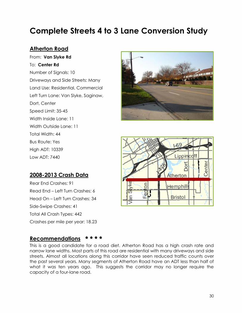
Atherton Road
From: Van Slyke Rd
To: Center Rd
Number of Signals: 10
Driveways and Side Streets: Many
Land Use: Residential, Commercial
Left Turn Lane: Van Slyke, Saginaw,
Dort, Center
Speed Limit: 35-45
Width Inside Lane: 11
Width Outside Lane: 11
Total Width: 44
Bus Route: Yes
High ADT: 10339
Low ADT: 7440
2008-2013 Crash Data
Rear End Crashes: 91
Read End – Left Turn Crashes: 6
Head On – Left Turn Crashes: 34
Side-Swipe Crashes: 41
Total All Crash Types: 442
Crashes per mile per year: 18.23
Recommendations * * * * This is a good candidate for a road diet. Atherton Road has a high crash rate and
narrow lane widths. Most parts of this road are residential with many driveways and side
streets. Almost all locations along this corridor have seen reduced traffic counts over
the past several years. Many segments of Atherton Road have an ADT less than half of
what it was ten years ago. This suggests the corridor may no longer require the
capacity of a four-lane road.

31
Complete Streets 4 to 3 Lane Conversion Study
Averill Avenue
From: Davison Rd
To: Lapeer Rd
Number of Signals: 5
Driveways and Side Streets: Few
Land Use: School, Park, Industrial
Left Turn Lane: Lapeer, Court,
Robert T Longway, Davison
Speed Limit: 30-40
Width Inside Lane: 11
Width Outside Lane: 11
Total Width: 44
Bus Route: No
High ADT: 4310
Low ADT: 4310
2008-2013 Crash Data
Rear End Crashes: 6
Read End – Left Turn Crashes: 0
Head On – Left Turn Crashes: 4
Side-Swipe Crashes: 5
Total All Crash Types: 46
Crashes per mile per year: 4.67
Recommendations * * * This is a good candidate for a road diet. This is mainly an industrial area, there are not
many driveways and traffic volumes are low. One of the major industrial complexes has
closed on this street so traffic volumes should continue to go down in the future. The
street would work well for a road diet and would be one of the best candidates for a
north-south bike lane in the east side of the City of Flint.

32
Complete Streets 4 to 3 Lane Conversion Study
Beecher Road
From: Linden Rd
To: Ballenger Hwy
Number of Signals: 6
Driveways and Side Streets: Some
Land Use: Residential, Commerical
Left Turn Lane: Linden, Ballenger
Speed Limit: 45
Width Inside Lane: 12
Width Outside Lane: 12
Total Width: 50
Bus Route: Yes
High ADT: 15502
Low ADT: 8661
2008-2013 Crash Data
Rear End Crashes: 39
Read End – Left Turn Crashes: 15
Head On – Left Turn Crashes: 16
Side-Swipe Crashes: 22
Total All Crash Types: 207
Crashes per mile per year: 13.58
Recommendations * This corridor is not recommended for a road diet. ADT on this corridor is over the
recommended limit for a 3-lane conversion. A limiting factor for this road is that the
inside lanes are asphalt, and the outside lanes are concrete. When restriping fades
over time, the contrasting colors of pavement will show a different driving pattern than
the restriping. This can create a difficult situation for drivers, especially at night.

33
Complete Streets 4 to 3 Lane Conversion Study
Beecher Road
From: Ballenger Hwy
To: Court St
Number of Signals: 2
Driveways and Side Streets: Many
Land Use: Residential
Left Turn Lane: Ballenger
Speed Limit: 35
Width Inside Lane: 11
Width Outside Lane: 12
Total Width: 46
Bus Route: Yes
High ADT: 8694
Low ADT: 8694
2008-2013 Crash Data
Rear End Crashes: 6
Read End – Left Turn Crashes: 1
Head On – Left Turn Crashes: 3
Side-Swipe Crashes: 12
Total All Crash Types: 60
Crashes per mile per year: 17.86
Recommendations * * * * This is a good candidate for a road diet. The corridor has a high number of crashes per
mile. Traffic counts are low enough for a road diet to be appropriate. The area is
residential with lots of turning movements due to the many side streets and driveways.
A 3-lane road configuration would have a traffic calming effect. The addition of a bike
lane with the road diet is also recommended.

34
Complete Streets 4 to 3 Lane Conversion Study
Bristol Road
From: Saginaw St
To: Laurel Ave
Number of Signals: 2
Driveways and Side Streets: Many
Land Use: Residential, Commercial
Left Turn Lane: Saginaw
Speed Limit: 35-40
Width Inside Lane: 11
Width Outside Lane: 11
Total Width: 44
Bus Route: No
High ADT: 15269
Low ADT: 11713
2008-2013 Crash Data
Rear End Crashes: 13
Read End – Left Turn Crashes: 1
Head On – Left Turn Crashes: 3
Side-Swipe Crashes: 5
Total All Crash Types: 72
Crashes per mile per year: 18.46
Recommendations * * The corridor may be good for a road diet in the future. Traffic volumes here have
decreased in the past several years. If this trend continues, a road diet might be
appropriate. However, Bristol Road becomes five lanes on each side of this segment,
which could cause problems as drivers transition between a five-lane and three-lane
road. There are existing left turn lanes at Saginaw Street.

35
Complete Streets 4 to 3 Lane Conversion Study
Carpenter Road
From: Clio Rd
To: Fleming Rd
Number of Signals: 1
Driveways and Side Streets: Some
Land Use: Residential, Commercial
Left Turn Lane: Clio
Speed Limit: 35
Width Inside Lane: 12
Width Outside Lane: 12
Total Width: 50
Bus Route: Yes
High ADT: 8713
Low ADT: 6752
2008-2013 Crash Data
Rear End Crashes: 5
Read End – Left Turn Crashes: 0
Head On – Left Turn Crashes: 0
Side-Swipe Crashes: 1
Total All Crash Types: 10
Crashes per mile per year: 3.33
Recommendations * * * * This is a good candidate for a road diet. The traffic count is within the range
appropriate for a road diet. Two high schools are located on this corridor, so it would
benefit from traffic calming and bike lanes. The section of Carpenter Road between
Dupont and Saginaw was recently converted to a three-lane road, and it would be
good to convert the rest of the corridor.
36
Complete Streets 4 to 3 Lane Conversion Study
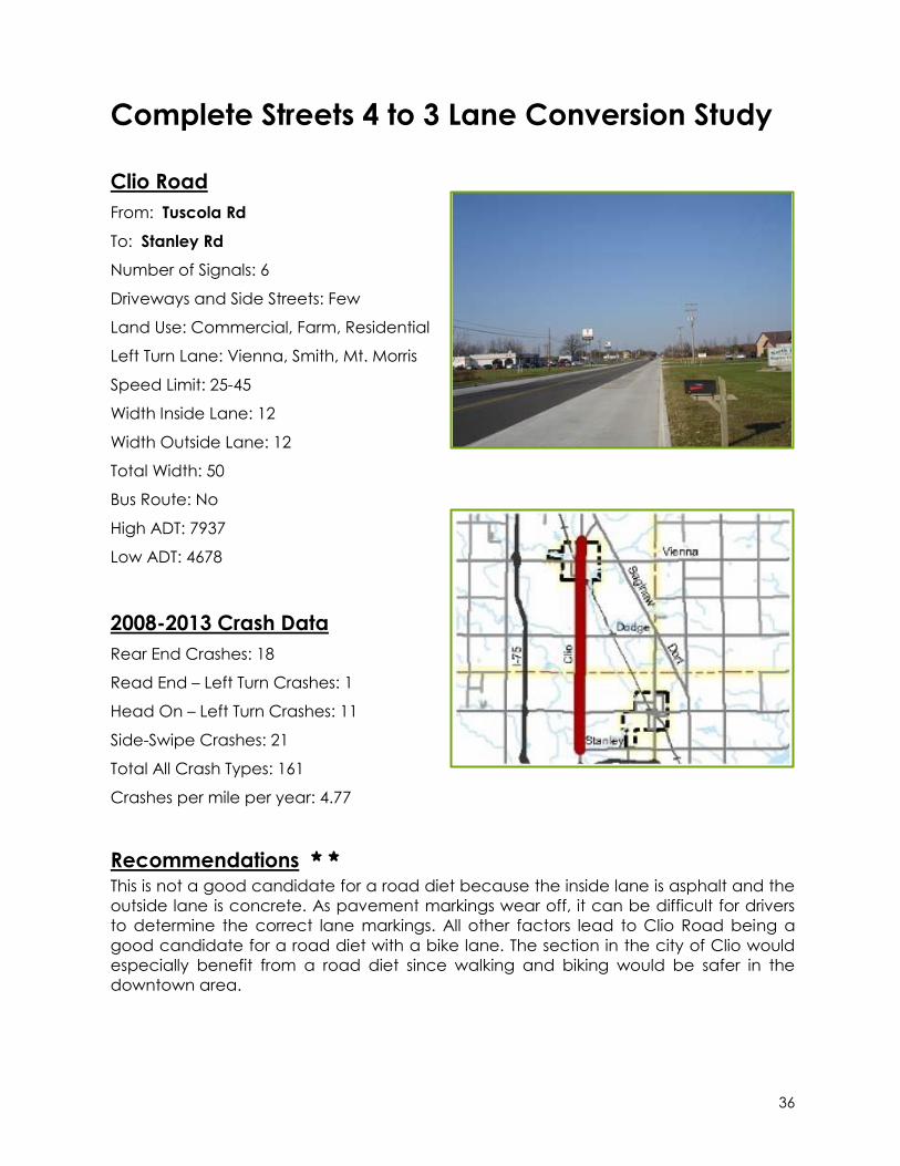
Clio Road
From: Tuscola Rd
To: Stanley Rd
Number of Signals: 6
Driveways and Side Streets: Few
Land Use: Commercial, Farm, Residential
Left Turn Lane: Vienna, Smith, Mt. Morris
Speed Limit: 25-45
Width Inside Lane: 12
Width Outside Lane: 12
Total Width: 50
Bus Route: No
High ADT: 7937
Low ADT: 4678
2008-2013 Crash Data
Rear End Crashes: 18
Read End – Left Turn Crashes: 1
Head On – Left Turn Crashes: 11
Side-Swipe Crashes: 21
Total All Crash Types: 161
Crashes per mile per year: 4.77
Recommendations * * This is not a good candidate for a road diet because the inside lane is asphalt and the
outside lane is concrete. As pavement markings wear off, it can be difficult for drivers
to determine the correct lane markings. All other factors lead to Clio Road being a
good candidate for a road diet with a bike lane. The section in the city of Clio would
especially benefit from a road diet since walking and biking would be safer in the
downtown area.
37
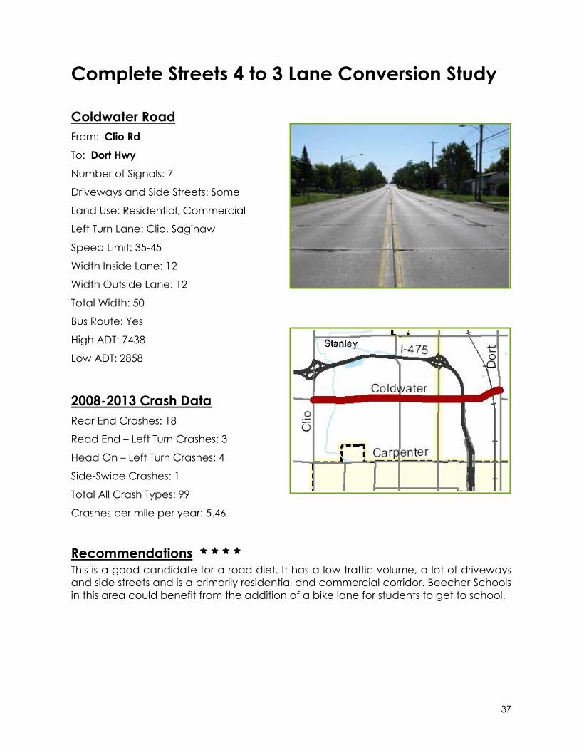
Complete Streets 4 to 3 Lane Conversion Study
Coldwater Road
From: Clio Rd
To: Dort Hwy
Number of Signals: 7
Driveways and Side Streets: Some
Land Use: Residential, Commercial
Left Turn Lane: Clio, Saginaw
Speed Limit: 35-45
Width Inside Lane: 12
Width Outside Lane: 12
Total Width: 50
Bus Route: Yes
High ADT: 7438
Low ADT: 2858
2008-2013 Crash Data
Rear End Crashes: 18
Read End – Left Turn Crashes: 3
Head On – Left Turn Crashes: 4
Side-Swipe Crashes: 1
Total All Crash Types: 99
Crashes per mile per year: 5.46
Recommendations * * * * This is a good candidate for a road diet. It has a low traffic volume, a lot of driveways
and side streets and is a primarily residential and commercial corridor. Beecher Schools
in this area could benefit from the addition of a bike lane for students to get to school.

38
Complete Streets 4 to 3 Lane Conversion Study
Court Street
From: Ballenger Hwy
To: Corunna Rd
Number of Signals: 3
Driveways and Side Streets: Many
Land Use: Residential, Commercial
Left Turn Lane: None
Speed Limit: 35
Width Inside Lane: 9
Width Outside Lane: 9
Total Width: 38
Bus Route: Yes
High ADT: 13145
Low ADT: 6277
2008-2013 Crash Data
Rear End Crashes: 24
Read End – Left Turn Crashes: 0
Head On – Left Turn Crashes: 17
Side-Swipe Crashes: 13
Total All Crash Types: 119
Crashes per mile per year: 17.4
Recommendations * * * * This is a good candidate for a road diet. At 38 feet, the roadway is too narrow to
function properly as a 4-lane road. The narrow lane widths make it very difficult for
vehicles to pass one another. A bike lane connection to the proposed Genesee Valley
Trail and Beecher Road will also help in creating an interconnected bike system for the
area.

39
Complete Streets 4 to 3 Lane Conversion Study
Court Street
From: Dort Hwy
To: Center Rd
Number of Signals: 3
Driveways and Side Streets: Some
Land Use: Commercial
Left Turn Lane: Dort, Center
Speed Limit: 40
Width Inside Lane: 11
Width Outside Lane: 11
Total Width: 44
Bus Route: Yes
High ADT: 13541
Low ADT: 13541
2008-2013 Crash Data
Rear End Crashes: 33
Read End – Left Turn Crashes: 0
Head On – Left Turn Crashes: 3
Side-Swipe Crashes: 36
Total All Crash Types: 148
Crashes per mile per year: 24.67
Recommendations * * * This is a good candidate for a road diet to add a bicycle lane in this area. After
crossing Dort Highway, the residential side streets along Court Street can make a good
bicycle connection to the cultural center and the Applewood Trail at Mott Community
College. The number of crashes per mile per year are very high along this segment,
and a road diet could improve this.
40
Complete Streets 4 to 3 Lane Conversion Study
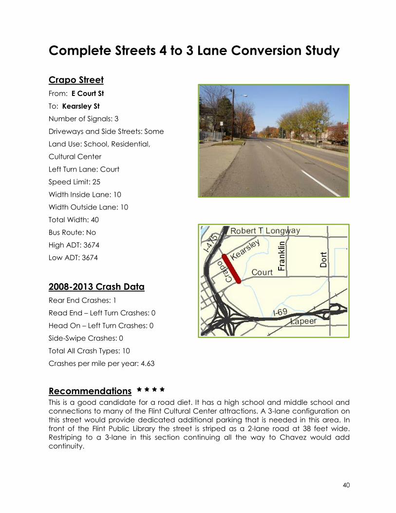
Crapo Street
From: E Court St
To: Kearsley St
Number of Signals: 3
Driveways and Side Streets: Some
Land Use: School, Residential,
Cultural Center
Left Turn Lane: Court
Speed Limit: 25
Width Inside Lane: 10
Width Outside Lane: 10
Total Width: 40
Bus Route: No
High ADT: 3674
Low ADT: 3674
2008-2013 Crash Data
Rear End Crashes: 1
Read End – Left Turn Crashes: 0
Head On – Left Turn Crashes: 0
Side-Swipe Crashes: 0
Total All Crash Types: 10
Crashes per mile per year: 4.63
Recommendations * * * * This is a good candidate for a road diet. It has a high school and middle school and
connections to many of the Flint Cultural Center attractions. A 3-lane configuration on
this street would provide dedicated additional parking that is needed in this area. In
front of the Flint Public Library the street is striped as a 2-lane road at 38 feet wide.
Restriping to a 3-lane in this section continuing all the way to Chavez would add
continuity.
41
Complete Streets 4 to 3 Lane Conversion Study
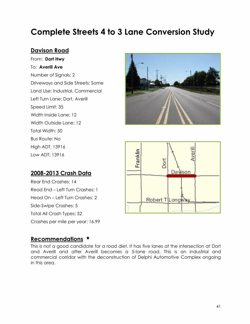
Davison Road
From: Dort Hwy
To: Averill Ave
Number of Signals: 2
Driveways and Side Streets: Some
Land Use: Industrial, Commercial
Left Turn Lane: Dort, Averill
Speed Limit: 35
Width Inside Lane: 12
Width Outside Lane: 12
Total Width: 50
Bus Route: No
High ADT: 13916
Low ADT: 13916
2008-2013 Crash Data
Rear End Crashes: 14
Read End – Left Turn Crashes: 1
Head On – Left Turn Crashes: 2
Side-Swipe Crashes: 5
Total All Crash Types: 52
Crashes per mile per year: 16.99
Recommendations * This is not a good candidate for a road diet. It has five lanes at the intersection at Dort
and Averill and after Averill becomes a 5-lane road. This is an industrial and
commercial corridor with the deconstruction of Delphi Automotive Complex ongoing
in this area.

42
Complete Streets 4 to 3 Lane Conversion Study
Davison Road
From: Center Rd
To: Belsay Rd
Number of Signals: 4
Driveways and Side Streets: Some
Land Use: Residential, Commercial
Left Turn Lane: Center, Genesee, Belsay
Speed Limit: 45-50
Width Inside Lane: 11
Width Outside Lane: 11
Total Width: 44
Bus Route: Yes
High ADT: 12619
Low ADT: 12619
2008-2013 Crash Data
Rear End Crashes: 44
Read End – Left Turn Crashes: 3
Head On – Left Turn Crashes: 3
Side-Swipe Crashes: 13
Total All Crash Types: 136
Crashes per mile per year: 11.28
Recommendations * This is not a good candidate for a road diet. It has five lanes on either side of this
segment, which might cause more crashes as drivers transition between the five-lane
and three-lane segments of roadway. This corridor should be monitored in the future to
see if a road diet becomes more appropriate. For-Mar Nature Preserve is located
along this segment and might benefit from sidewalks and bike lanes.
43
Complete Streets 4 to 3 Lane Conversion Study
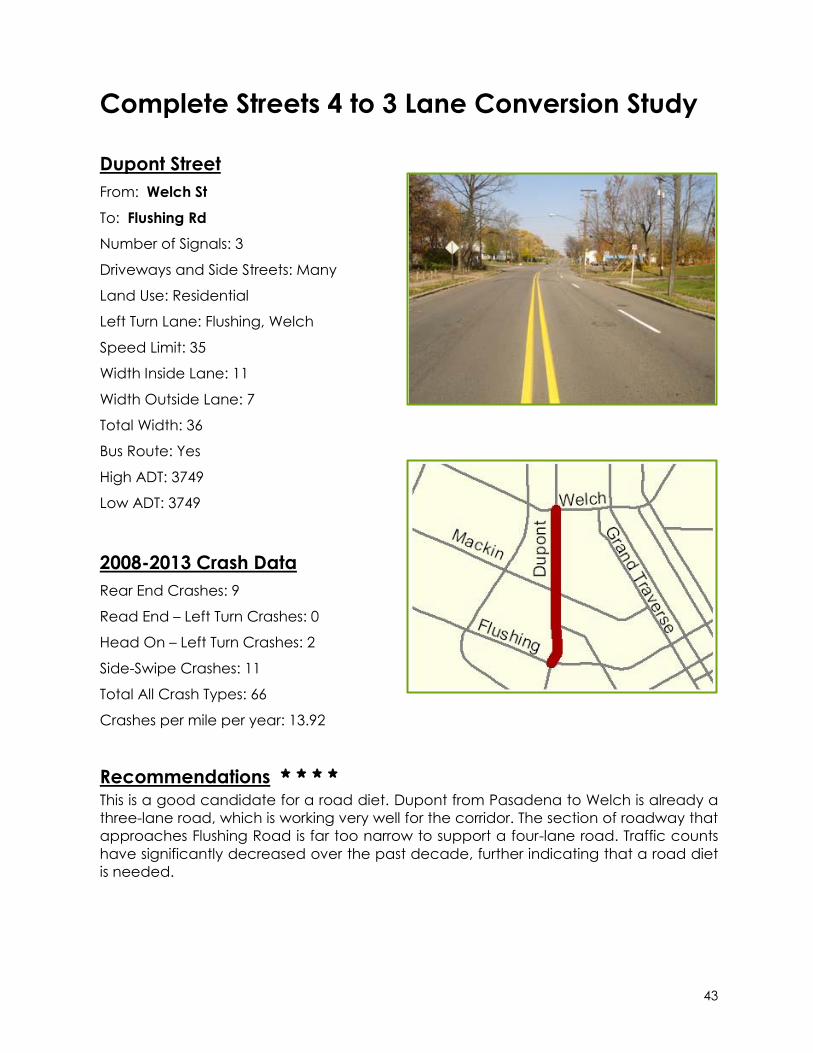
Dupont Street
From: Welch St
To: Flushing Rd
Number of Signals: 3
Driveways and Side Streets: Many
Land Use: Residential
Left Turn Lane: Flushing, Welch
Speed Limit: 35
Width Inside Lane: 11
Width Outside Lane: 7
Total Width: 36
Bus Route: Yes
High ADT: 3749
Low ADT: 3749
2008-2013 Crash Data
Rear End Crashes: 9
Read End – Left Turn Crashes: 0
Head On – Left Turn Crashes: 2
Side-Swipe Crashes: 11
Total All Crash Types: 66
Crashes per mile per year: 13.92
Recommendations * * * * This is a good candidate for a road diet. Dupont from Pasadena to Welch is already a
three-lane road, which is working very well for the corridor. The section of roadway that
approaches Flushing Road is far too narrow to support a four-lane road. Traffic counts
have significantly decreased over the past decade, further indicating that a road diet
is needed.
44
Complete Streets 4 to 3 Lane Conversion Study
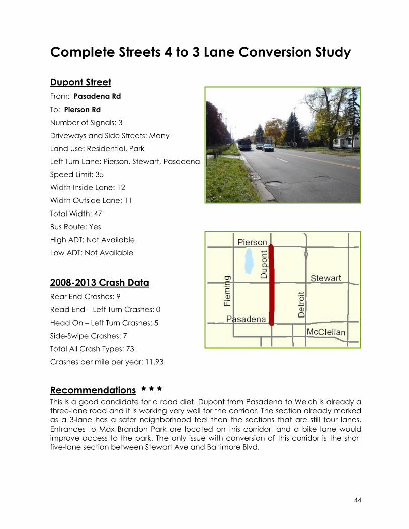
Dupont Street
From: Pasadena Rd
To: Pierson Rd
Number of Signals: 3
Driveways and Side Streets: Many
Land Use: Residential, Park
Left Turn Lane: Pierson, Stewart, Pasadena
Speed Limit: 35
Width Inside Lane: 12
Width Outside Lane: 11
Total Width: 47
Bus Route: Yes
High ADT: Not Available
Low ADT: Not Available
2008-2013 Crash Data
Rear End Crashes: 9
Read End – Left Turn Crashes: 0
Head On – Left Turn Crashes: 5
Side-Swipe Crashes: 7
Total All Crash Types: 73
Crashes per mile per year: 11.93
Recommendations * * * This is a good candidate for a road diet. Dupont from Pasadena to Welch is already a
three-lane road and it is working very well for the corridor. The section already marked
as a 3-lane has a safer neighborhood feel than the sections that are still four lanes.
Entrances to Max Brandon Park are located on this corridor, and a bike lane would
improve access to the park. The only issue with conversion of this corridor is the short
five-lane section between Stewart Ave and Baltimore Blvd.

45
Complete Streets 4 to 3 Lane Conversion Study
Fenton Road
From: Grand Blanc Rd
To: Hemphill Rd
Number of Signals: 5
Driveways and Side Streets: Many
Land Use: Residential, Commercial
Left Turn Lane: Bristol, Maple, Hill,
Grand Blanc
Speed Limit: 35-45
Width Inside Lane: 11
Width Outside Lane: 12
Total Width: 46
Bus Route: Yes
High ADT: 14390
Low ADT: 10217
2008-2013 Crash Data
Rear End Crashes: 85
Read End – Left Turn Crashes: 23
Head On – Left Turn Crashes: 26
Side-Swipe Crashes: 55
Total All Crash Types: 412
Crashes per mile per year: 14.99
Recommendations *
This is not a good candidate for a road diet. Traffic counts are high with lots of through
traffic. Left-turn lanes have been added at the major intersections.
46
Complete Streets 4 to 3 Lane Conversion Study
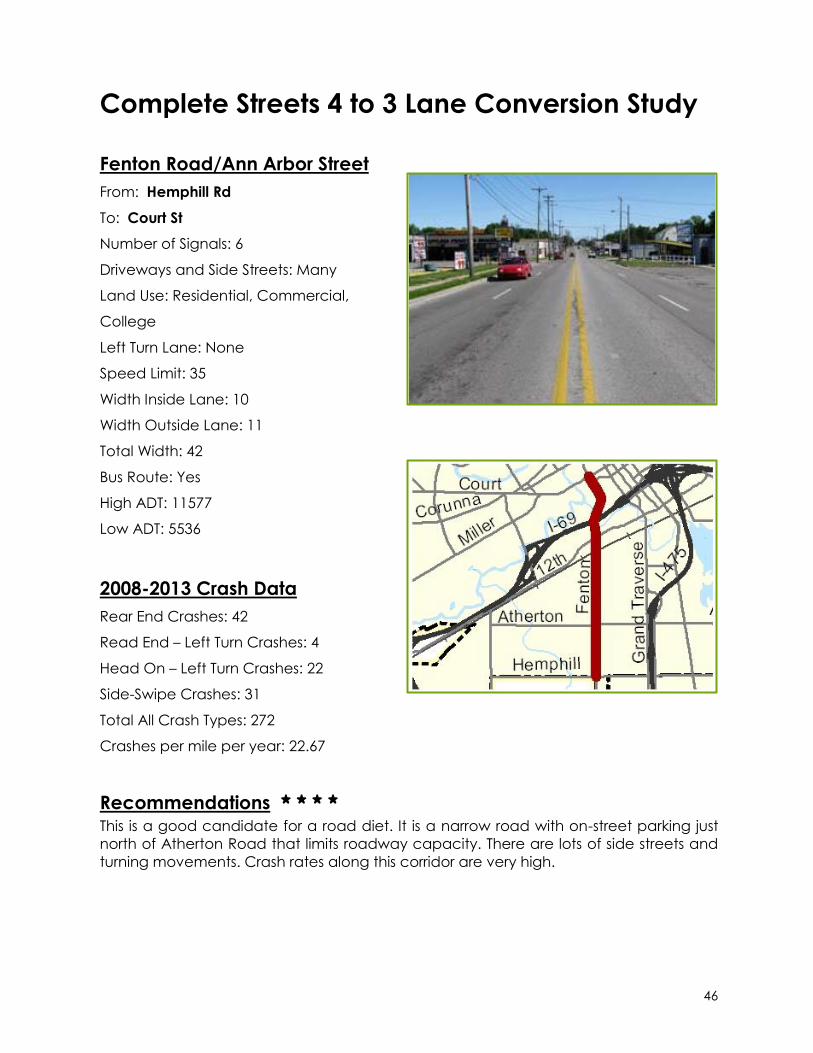
Fenton Road/Ann Arbor Street
From: Hemphill Rd
To: Court St
Number of Signals: 6
Driveways and Side Streets: Many
Land Use: Residential, Commercial,
College
Left Turn Lane: None
Speed Limit: 35
Width Inside Lane: 10
Width Outside Lane: 11
Total Width: 42
Bus Route: Yes
High ADT: 11577
Low ADT: 5536
2008-2013 Crash Data
Rear End Crashes: 42
Read End – Left Turn Crashes: 4
Head On – Left Turn Crashes: 22
Side-Swipe Crashes: 31
Total All Crash Types: 272
Crashes per mile per year: 22.67
Recommendations * * * *
This is a good candidate for a road diet. It is a narrow road with on-street parking just
north of Atherton Road that limits roadway capacity. There are lots of side streets and
turning movements. Crash rates along this corridor are very high.
47
Complete Streets 4 to 3 Lane Conversion Study
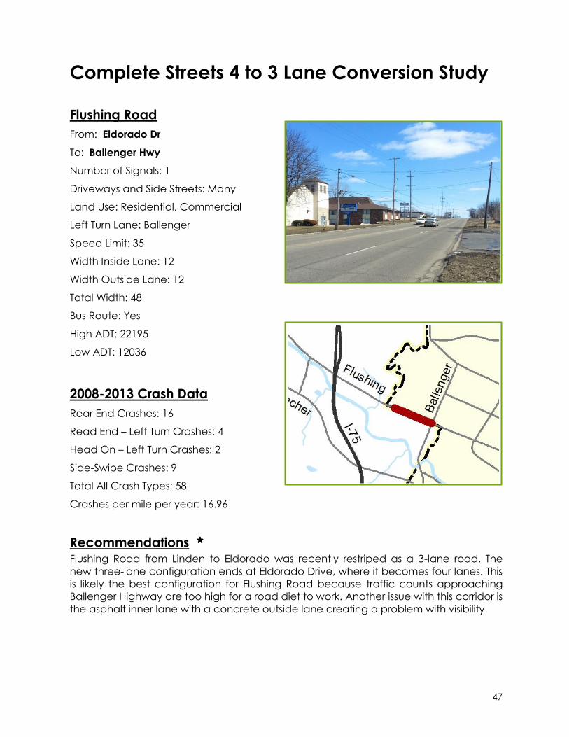
Flushing Road
From: Eldorado Dr
To: Ballenger Hwy
Number of Signals: 1
Driveways and Side Streets: Many
Land Use: Residential, Commercial
Left Turn Lane: Ballenger
Speed Limit: 35
Width Inside Lane: 12
Width Outside Lane: 12
Total Width: 48
Bus Route: Yes
High ADT: 22195
Low ADT: 12036
2008-2013 Crash Data
Rear End Crashes: 16
Read End – Left Turn Crashes: 4
Head On – Left Turn Crashes: 2
Side-Swipe Crashes: 9
Total All Crash Types: 58
Crashes per mile per year: 16.96
Recommendations *
Flushing Road from Linden to Eldorado was recently restriped as a 3-lane road. The
new three-lane configuration ends at Eldorado Drive, where it becomes four lanes. This
is likely the best configuration for Flushing Road because traffic counts approaching
Ballenger Highway are too high for a road diet to work. Another issue with this corridor is
the asphalt inner lane with a concrete outside lane creating a problem with visibility.

48
Complete Streets 4 to 3 Lane Conversion Study
Flushing Road
From: Elms Rd
To: Mill Rd
Number of Signals: 3
Driveways and Side Streets: Some
Land Use: Residential
Left Turn Lane: Linden
Speed Limit: 45
Width Inside Lane: 12
Width Outside Lane: 12
Total Width: 48
Bus Route: No
High ADT: 7462
Low ADT: 4872
2008-2013 Crash Data
Rear End Crashes: 10
Read End – Left Turn Crashes: 2
Head On – Left Turn Crashes: 4
Side-Swipe Crashes: 13
Total All Crash Types: 81
Crashes per mile per year: 4.34
Recommendations * *
This is not a good candidate for a road diet. All other factors would make it a great
candidate with the exception of the pavement type. This is an asphalt inner lane with a
concrete outside lane. It would only make a good candidate if the pavement were
reconstructed to be all the same across the entire roadway. A bike lane is really
needed in this area as a connection to the Flint River Trail.
49
Complete Streets 4 to 3 Lane Conversion Study
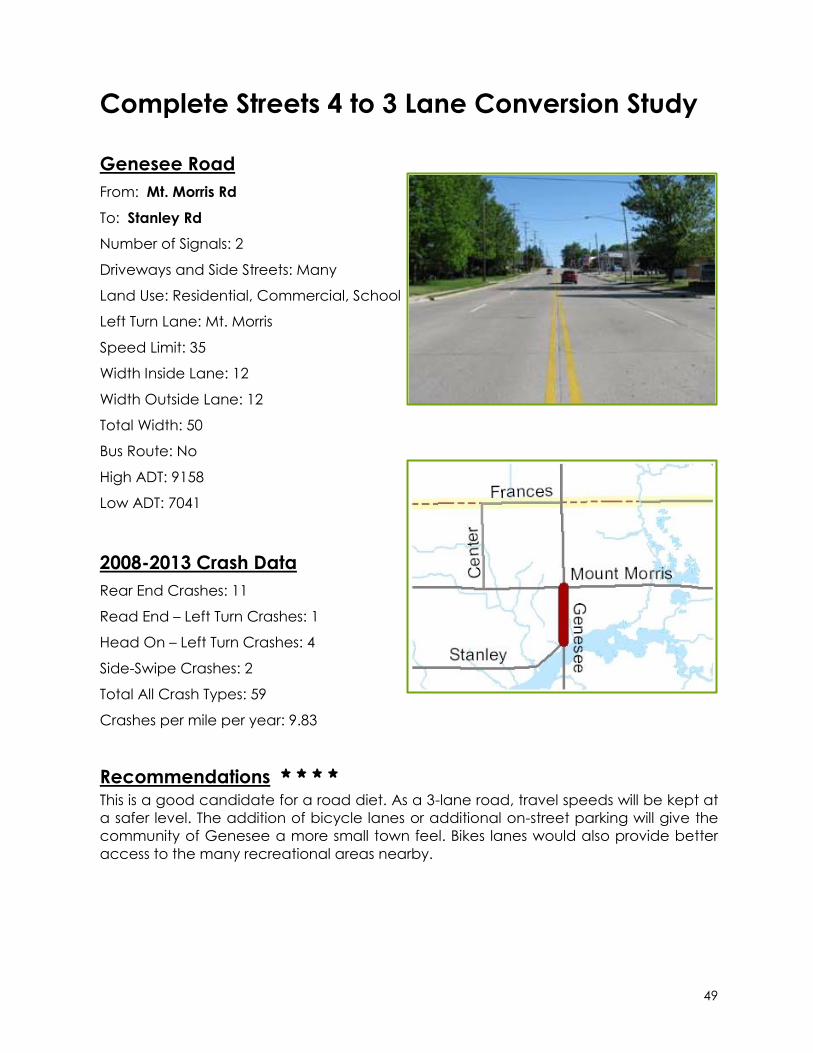
Genesee Road
From: Mt. Morris Rd
To: Stanley Rd
Number of Signals: 2
Driveways and Side Streets: Many
Land Use: Residential, Commercial, School
Left Turn Lane: Mt. Morris
Speed Limit: 35
Width Inside Lane: 12
Width Outside Lane: 12
Total Width: 50
Bus Route: No
High ADT: 9158
Low ADT: 7041
2008-2013 Crash Data
Rear End Crashes: 11
Read End – Left Turn Crashes: 1
Head On – Left Turn Crashes: 4
Side-Swipe Crashes: 2
Total All Crash Types: 59
Crashes per mile per year: 9.83
Recommendations * * * *
This is a good candidate for a road diet. As a 3-lane road, travel speeds will be kept at
a safer level. The addition of bicycle lanes or additional on-street parking will give the
community of Genesee a more small town feel. Bikes lanes would also provide better
access to the many recreational areas nearby.
50
Complete Streets 4 to 3 Lane Conversion Study
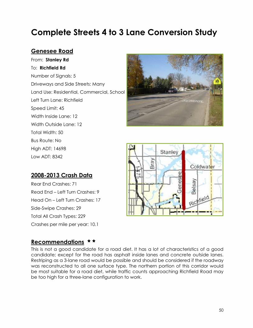
Genesee Road
From: Stanley Rd
To: Richfield Rd
Number of Signals: 5
Driveways and Side Streets: Many
Land Use: Residential, Commercial, School
Left Turn Lane: Richfield
Speed Limit: 45
Width Inside Lane: 12
Width Outside Lane: 12
Total Width: 50
Bus Route: No
High ADT: 14698
Low ADT: 8342
2008-2013 Crash Data
Rear End Crashes: 71
Read End – Left Turn Crashes: 9
Head On – Left Turn Crashes: 17
Side-Swipe Crashes: 29
Total All Crash Types: 229
Crashes per mile per year: 10.1
Recommendations * *
This is not a good candidate for a road diet. It has a lot of characteristics of a good
candidate; except for the road has asphalt inside lanes and concrete outside lanes.
Restriping as a 3-lane road would be possible and should be considered if the roadway
was reconstructed to all one surface type. The northern portion of this corridor would
be most suitable for a road diet, while traffic counts approaching Richfield Road may
be too high for a three-lane configuration to work.

51
Complete Streets 4 to 3 Lane Conversion Study
Grand Traverse Street
From: One-Way pairs near I-475
To: Church St
Number of Signals: 2
Driveways and Side Streets: Many
Land Use: Residential, Commercial
Left Turn Lane: 12th
Speed Limit: 35
Width Inside Lane: 11
Width Outside Lane: 11
Total Width: 44
Bus Route: No
High ADT: Not Available
Low ADT: Not Available
2008-2013 Crash Data
Rear End Crashes: 4
Read End – Left Turn Crashes: 0
Head On – Left Turn Crashes: 1
Side-Swipe Crashes: 2
Total All Crash Types: 25
Crashes per mile per year: 5.34
Recommendations * * * This is a good candidate for a road diet. The section of Grand Traverse from I-69 to
Kearsley Street underwent a road diet and became a 3-lane, two-way road in 2010.
The only issue would be finding a smooth transition where Grand Traverse splits and
becomes a one-way just north of 12th Street.

52
Complete Streets 4 to 3 Lane Conversion Study
Grand Traverse Street
From: Kearsley St
To: 8th Ave
Number of Signals: 4
Driveways and Side Streets: Many
Land Use: Residential, Commercial,
Hospital
Left Turn Lane: Kearsley
Speed Limit: 30
Width Inside Lane: 11
Width Outside Lane: 11
Total Width: 44
Bus Route: No
High ADT: 10847
Low ADT: 6871
2008-2013 Crash Data
Rear End Crashes: 23
Read End – Left Turn Crashes: 0
Head On – Left Turn Crashes: 10
Side-Swipe Crashes: 14
Total All Crash Types: 116
Crashes per mile per year: 26.85
Recommendations * * * * This is a good candidate for a road diet. Grand Traverse St between I-69 and Kearsley
was reconfigured to a two-way street in 2010 as a three-lane road with some on-street
parking. Grand Traverse between Kearsley and 8th Ave should also be reconfigured to
a three-lane road. On-street parking is recommended near Hurley Medical Center. A
bike lane is recommended for the rest of this corridor to connect this area with the
Grand Traverse Greenway and Genesee Valley Trail.

53
Complete Streets 4 to 3 Lane Conversion Study
Hamilton Avenue
From: ML King Ave
To: Saginaw St
Number of Signals: 3
Driveways and Side Streets: Some
Land Use: Residential, Schools
Left Turn Lane: Saginaw
Speed Limit: 25-35
Width Inside Lane: 11
Width Outside Lane: 11
Total Width: 44
Bus Route: No
High ADT: 8598
Low ADT: 6269
2008-2013 Crash Data
Rear End Crashes: 4
Read End – Left Turn Crashes: 0
Head On – Left Turn Crashes: 4
Side-Swipe Crashes: 4
Total All Crash Types: 37
Crashes per mile per year: 11.21
Recommendations * *
This is a good candidate for a road diet if additional on-street parking is needed in this
area for the nearby schools, churches and parks. This is a short section of roadway and
a bike lane would not provide much of a connection.

54
Complete Streets 4 to 3 Lane Conversion Study
Hemphill Road
From: Fenton Rd
To: Dort Hwy
Number of Signals: 5
Driveways and Side Streets: Some
Land Use: Residential, Commercial, School
Left Turn Lane: Saginaw, Dort
Speed Limit: 35
Width Inside Lane: 12
Width Outside Lane: 12
Total Width: 48
Bus Route: No
High ADT: 9894
Low ADT: 5532
2008-2013 Crash Data
Rear End Crashes: 7
Read End – Left Turn Crashes: 1
Head On – Left Turn Crashes: 11
Side-Swipe Crashes: 8
Total All Crash Types: 128
Crashes per mile per year: 10.56
Recommendations * * * *
This is a good candidate for a road diet with a bike lane. The addition of a center-turn
lane at Fenton Road would help in mitigating the many accidents that occur there
due to the lack of a dedicated turn lane on all approaches to the intersection. A bike
lane would provide a connection to the proposed Grand Traverse Greenway. In
comparison to parallel roads such as Bristol and Atherton, Hemphill has lower traffic
counts and would be the best candidate for conversion to three lanes.

55
Complete Streets 4 to 3 Lane Conversion Study
James P Cole Boulevard
From: Garfield Ave
To: E. 5th Ave
Number of Signals: 3
Driveways and Side Streets: Few/None
Land Use: Industrial, Vacant, Park
Left Turn Lane: Hamilton, 5th
Speed Limit: 35
Width Inside Lane: 11
Width Outside Lane: 11
Total Width: 44
Bus Route: No
High ADT: 1196
Low ADT: 1031
2008-2013 Crash Data
Rear End Crashes: 0
Read End – Left Turn Crashes: 0
Head On – Left Turn Crashes: 2
Side-Swipe Crashes: 0
Total All Crash Types: 13
Crashes per mile per year: 1.82
Recommendations * * * *
This is a good candidate for a road diet. It is a narrow roadway with a very low traffic
volume. This road once carried higher traffic volumes due to nearby industrial buildings,
many of which are now vacant. A bike lane in this area would provide new
connections to the Flint River Trail, which runs adjacent to this road.

56
Complete Streets 4 to 3 Lane Conversion Study
Lapeer
From: Court St
To: Center Rd
Number of Signals: 6
Driveways and Side Streets: Many
Land Use: Commercial, Industrial
Left Turn Lane: Court, 6th, 7th, 8th, 9th,
Belmont, Dort, Averill, Center
Speed Limit: 35
Width Inside Lane: 12
Width Outside Lane: 12
Total Width: 48
Bus Route: Yes
High ADT: 9174
Low ADT: 6122
2008-2013 Crash Data
Rear End Crashes: 29
Read End – Left Turn Crashes: 1
Head On – Left Turn Crashes: 10
Side-Swipe Crashes: 21
Total All Crash Types: 176
Crashes per mile per year: 11.69
Recommendations * * *
This is a good candidate for a road diet. It has a low traffic volume and many side
streets and driveways that would benefit from a center-turn lane. A bike lane is also
recommended along this corridor.

57
Complete Streets 4 to 3 Lane Conversion Study
Lippincott Blvd
From: Dort Hwy
To: Wood Ln
Number of Signals: 1
Driveways and Side Streets: Some
Land Use: Residential, Commercial
Left Turn Lane:
Speed Limit: 40
Width Inside Lane: 11
Width Outside Lane: 12
Total Width: 46
Bus Route: Yes
High ADT: Not Available
Low ADT: Not Available
2008-2013 Crash Data
Rear End Crashes: 2
Read End – Left Turn Crashes: 0
Head On – Left Turn Crashes: 2
Side-Swipe Crashes: 4
Total All Crash Types: 19
Crashes per mile per year: 5.76
Recommendations * * *
This is a good candidate for a road diet. This is a short four-lane segment where the
roadway on either side becomes two lanes. Traffic counts on Lippincott are low
enough that a three-lane configuration would work well. A center-turn lane and a bike
lane would be beneficial for this roadway.

58
Complete Streets 4 to 3 Lane Conversion Study
M-15 (N. State Road)
From: Flint St
To: Potter Rd
Number of Signals: 2
Driveways and Side Streets: Many
Land Use: Commercial
Left Turn Lane: Flint
Speed Limit: 35-55
Width Inside Lane: 12
Width Outside Lane: 10
Total Width: 46
Bus Route: No
High ADT: 18240
Low ADT: 14546
2008-2013 Crash Data
Rear End Crashes: 28
Read End – Left Turn Crashes: 4
Head On – Left Turn Crashes: 21
Side-Swipe Crashes: 10
Total All Crash Types: 134
Crashes per mile per year: 16.42
Recommendations * * *
This is a good candidate for a road diet. It is a state trunkline and the main arterial
through the city of Davison, but north of Flint Street traffic is lower and there are many
places where a center-turn lane would help with the large number of turning
movements in this area. The three-lane road configuration should extend north to
Potter Road, which would involve widening the two-lane section of M-15 north of the
Davison city limits.

59
Complete Streets 4 to 3 Lane Conversion Study
Miller Road
From: Ballenger Hwy
To: Hammerberg Rd
Number of Signals: 3
Driveways and Side Streets: Many
Land Use: Residential, Schools
Left Turn Lane: Ballenger, Hammerberg
Speed Limit: 35
Width Inside Lane: 11
Width Outside Lane: 12
Total Width: 46
Bus Route: Yes
High ADT: 20401
Low ADT: 9901
2008-2013 Crash Data
Rear End Crashes: 22
Read End – Left Turn Crashes: 3
Head On – Left Turn Crashes: 8
Side-Swipe Crashes: 7
Total All Crash Types: 97
Crashes per mile per year: 11.55
Recommendations * *
This is not a good candidate for a road diet, mainly due to the high traffic count.
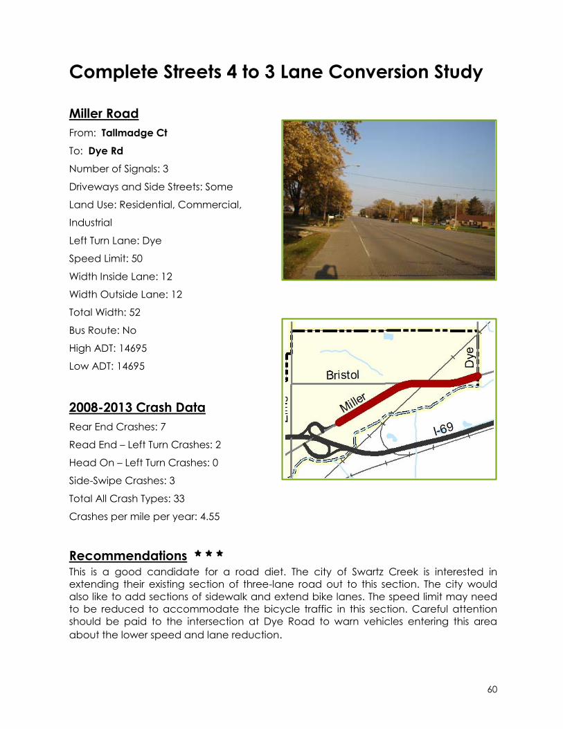
60
Complete Streets 4 to 3 Lane Conversion Study
Miller Road
From: Tallmadge Ct
To: Dye Rd
Number of Signals: 3
Driveways and Side Streets: Some
Land Use: Residential, Commercial,
Industrial
Left Turn Lane: Dye
Speed Limit: 50
Width Inside Lane: 12
Width Outside Lane: 12
Total Width: 52
Bus Route: No
High ADT: 14695
Low ADT: 14695
2008-2013 Crash Data
Rear End Crashes: 7
Read End – Left Turn Crashes: 2
Head On – Left Turn Crashes: 0
Side-Swipe Crashes: 3
Total All Crash Types: 33
Crashes per mile per year: 4.55
Recommendations * * *
This is a good candidate for a road diet. The city of Swartz Creek is interested in
extending their existing section of three-lane road out to this section. The city would
also like to add sections of sidewalk and extend bike lanes. The speed limit may need
to be reduced to accommodate the bicycle traffic in this section. Careful attention
should be paid to the intersection at Dye Road to warn vehicles entering this area
about the lower speed and lane reduction.
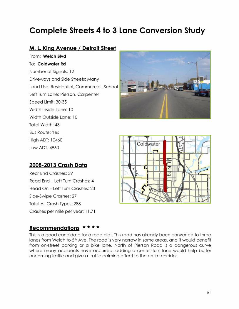
61
Complete Streets 4 to 3 Lane Conversion Study
M. L. King Avenue / Detroit Street
From: Welch Blvd
To: Coldwater Rd
Number of Signals: 12
Driveways and Side Streets: Many
Land Use: Residential, Commercial, School
Left Turn Lane: Pierson, Carpenter
Speed Limit: 30-35
Width Inside Lane: 10
Width Outside Lane: 10
Total Width: 43
Bus Route: Yes
High ADT: 10460
Low ADT: 4960
2008-2013 Crash Data
Rear End Crashes: 39
Read End – Left Turn Crashes: 4
Head On – Left Turn Crashes: 23
Side-Swipe Crashes: 27
Total All Crash Types: 288
Crashes per mile per year: 11.71
Recommendations * * * *
This is a good candidate for a road diet. This road has already been converted to three
lanes from Welch to 5th Ave. The road is very narrow in some areas, and it would benefit
from on-street parking or a bike lane. North of Pierson Road is a dangerous curve
where many accidents have occurred; adding a center-turn lane would help buffer
oncoming traffic and give a traffic calming effect to the entire corridor.

62
Complete Streets 4 to 3 Lane Conversion Study
Mt. Morris Road
From: Clio Rd
To: Dort Hwy
Number of Signals: 6
Driveways and Side Streets: Many
Land Use: Residential, School, Farm
Left Turn Lane: Saginaw, Dort
Speed Limit: 25-45
Width Inside Lane: 11
Width Outside Lane: 11
Total Width: 46
Bus Route: No
High ADT: 7349
Low ADT: 4727
2008-2013 Crash Data
Rear End Crashes: 27
Read End – Left Turn Crashes: 2
Head On – Left Turn Crashes: 8
Side-Swipe Crashes: 15
Total All Crash Types: 146
Crashes per mile per year: 8.28
Recommendations * * * *
This is a good candidate for a road diet. The roadways narrows to one through lane at
Saginaw Rd in downtown Mt. Morris, where the inside lane becomes a left-turn lane.
The reconfiguration as a three-lane road will calm traffic through the city; two schools
are located on Mt. Morris Road that could benefit from an additional bike lane
incorporated into the design.
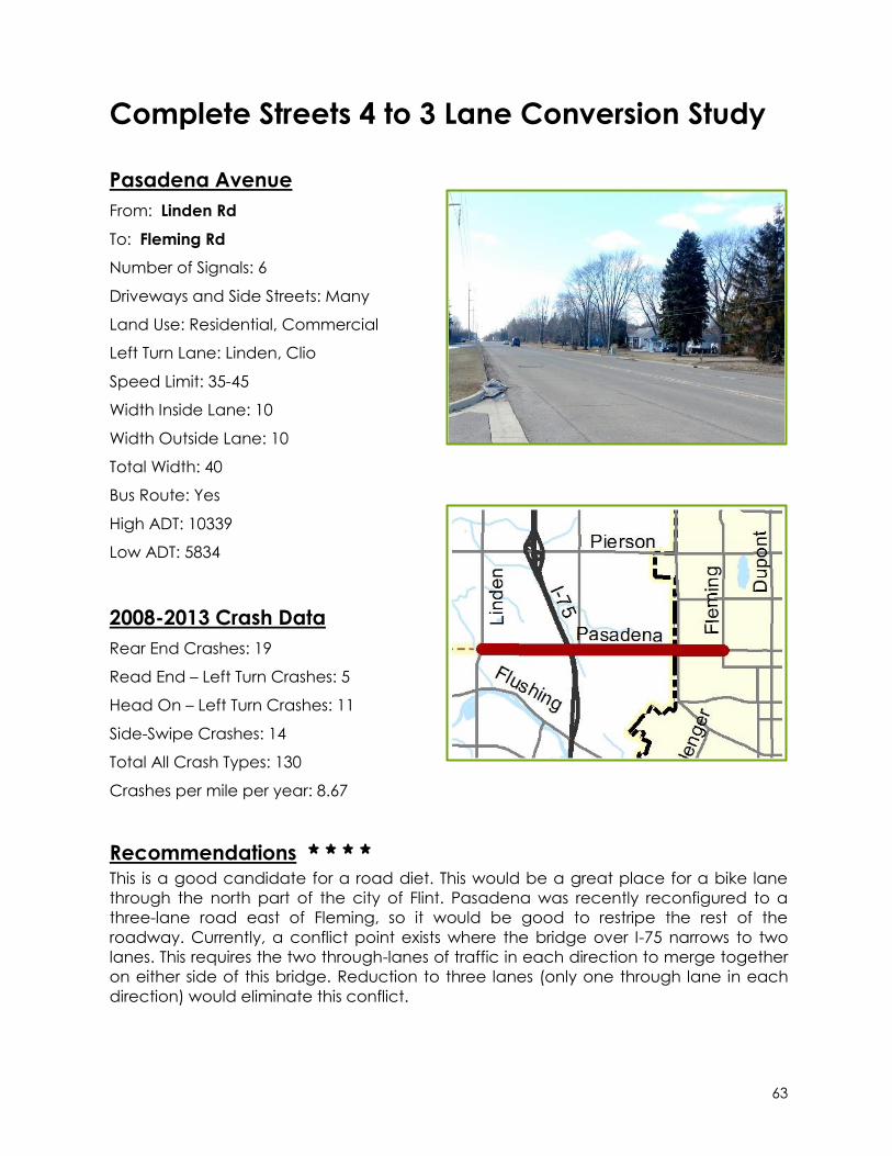
63
Complete Streets 4 to 3 Lane Conversion Study
Pasadena Avenue
From: Linden Rd
To: Fleming Rd
Number of Signals: 6
Driveways and Side Streets: Many
Land Use: Residential, Commercial
Left Turn Lane: Linden, Clio
Speed Limit: 35-45
Width Inside Lane: 10
Width Outside Lane: 10
Total Width: 40
Bus Route: Yes
High ADT: 10339
Low ADT: 5834
2008-2013 Crash Data
Rear End Crashes: 19
Read End – Left Turn Crashes: 5
Head On – Left Turn Crashes: 11
Side-Swipe Crashes: 14
Total All Crash Types: 130
Crashes per mile per year: 8.67
Recommendations * * * *
This is a good candidate for a road diet. This would be a great place for a bike lane
through the north part of the city of Flint. Pasadena was recently reconfigured to a
three-lane road east of Fleming, so it would be good to restripe the rest of the
roadway. Currently, a conflict point exists where the bridge over I-75 narrows to two
lanes. This requires the two through-lanes of traffic in each direction to merge together
on either side of this bridge. Reduction to three lanes (only one through lane in each
direction) would eliminate this conflict.
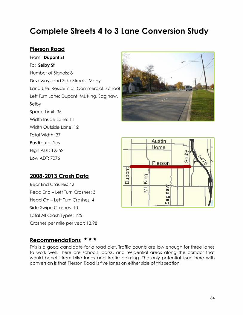
64
Complete Streets 4 to 3 Lane Conversion Study
Pierson Road
From: Dupont St
To: Selby St
Number of Signals: 8
Driveways and Side Streets: Many
Land Use: Residential, Commercial, School
Left Turn Lane: Dupont, ML King, Saginaw,
Selby
Speed Limit: 35
Width Inside Lane: 11
Width Outside Lane: 12
Total Width: 37
Bus Route: Yes
High ADT: 12552
Low ADT: 7076
2008-2013 Crash Data
Rear End Crashes: 42
Read End – Left Turn Crashes: 3
Head On – Left Turn Crashes: 4
Side-Swipe Crashes: 10
Total All Crash Types: 125
Crashes per mile per year: 13.98
Recommendations * * *
This is a good candidate for a road diet. Traffic counts are low enough for three lanes
to work well. There are schools, parks, and residential areas along the corridor that
would benefit from bike lanes and traffic calming. The only potential issue here with
conversion is that Pierson Road is five lanes on either side of this section.

65
Complete Streets 4 to 3 Lane Conversion Study
Richfield Road
From: Franklin Ave
To: Victoria Station
Number of Signals: 9
Driveways and Side Streets: Some
Land Use: Industrial, Commercial, Farm,
Residential
Left Turn Lane: Genesee, Irish
Speed Limit: 40-55
Width Inside Lane: 12
Width Outside Lane: 12
Total Width: 50
Bus Route: Yes
High ADT: 13971
Low ADT: 5943
2008-2013 Crash Data
Rear End Crashes: 94
Read End – Left Turn Crashes: 14
Head On – Left Turn Crashes: 31
Side-Swipe Crashes: 56
Total All Crash Types: 410
Crashes per mile per year: 10.03
Recommendations * * * *
This is a good candidate for a road diet. It has a low traffic count and with re-striping,
this road can become a bike lane connection from the Flint River Trail to M-15 just north
of Davison and eventually connect into the proposed non-motorized pathway in
Davison on M-15. A potential issue with this corridor is the seasonal congestion that
occurs near Irish Road and Gale Road due to the Outdoor Adventures Lake Shore
Resort. Further study is needed to determine the seasonal impact of the resort on a
three-lane road.

66
Complete Streets 4 to 3 Lane Conversion Study
Saginaw Road
From: Willard Rd
To: Dort Hwy
Number of Signals: 4
Driveways and Side Streets: Some
Land Use: Residential, Commercial
Left Turn Lane: Vienna
Speed Limit: 45-55
Width Inside Lane: 10
Width Outside Lane: 9
Total Width: 39
Bus Route: No
High ADT: 11401
Low ADT: 5409
2008-2013 Crash Data
Rear End Crashes: 33
Read End – Left Turn Crashes: 6
Head On – Left Turn Crashes: 18
Side-Swipe Crashes: 22
Total All Crash Types: 219
Crashes per mile per year: 6.62
Recommendations *
This is not a good candidate for a road diet. Part of this road is a state trunkline
highway with a lot of through traffic. The road is four lanes north of the Genesee
County border and five lanes on the south end where Saginaw Rd splits from Dort Hwy.
This corridor has a mostly rural character and would not benefit much from bike lanes
or on-street parking, with the only exception being the intersection at Vienna Road.
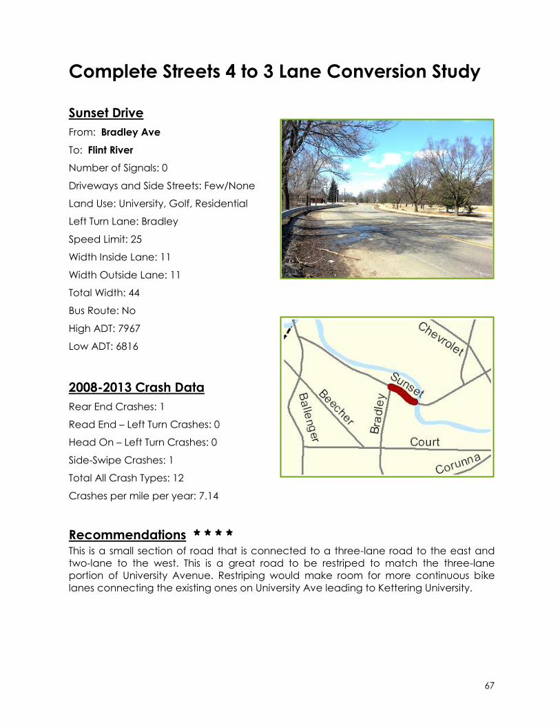
67
Complete Streets 4 to 3 Lane Conversion Study
Sunset Drive
From: Bradley Ave
To: Flint River
Number of Signals: 0
Driveways and Side Streets: Few/None
Land Use: University, Golf, Residential
Left Turn Lane: Bradley
Speed Limit: 25
Width Inside Lane: 11
Width Outside Lane: 11
Total Width: 44
Bus Route: No
High ADT: 7967
Low ADT: 6816
2008-2013 Crash Data
Rear End Crashes: 1
Read End – Left Turn Crashes: 0
Head On – Left Turn Crashes: 0
Side-Swipe Crashes: 1
Total All Crash Types: 12
Crashes per mile per year: 7.14
Recommendations * * * *
This is a small section of road that is connected to a three-lane road to the east and
two-lane to the west. This is a great road to be restriped to match the three-lane
portion of University Avenue. Restriping would make room for more continuous bike
lanes connecting the existing ones on University Ave leading to Kettering University.

Appendix A
List of All Genesee County 4-to-3 Lane Conversions


List of All Genesee County 4-to-3 Lane Conversions
During the process of updating the Genesee County Long Range Transportation Plan, the Genesee County Metropolitan Planning Commission requested information from local units of governments regarding road diets. The following is a list of known road diets that have been implemented to date. Staff will continue to request updates on road diet projects in the future to maintain a database of these projects.
1st Street S. Grand Traverse Street to Stevens Street City of Flint Changed to a 3-lane road in 2010 On-street parking added Length: 0.46 mi 2nd Street Ann Arbor Street to I-475 City of Flint Changed from a One-Way 4-Lane road to a Two-Way 3-Lane in 2010 On-street parking and bike lanes added Length: 0.65 mi Carpenter Road
Dupont Street to Saginaw Street Mt. Morris Township
Changed to a 3-lane road in 2012 Length: 1.00 mi Chevrolet Avenue University Avenue to the Flint River
City of Flint Changed from a 4 and 5-Lane road to a 3-Lane road in 2010 Length: 0.30 mi Corunna Road (M-21) Ballenger Highway to Court Street
City of Flint Changed to a 3-lane road in 2011 Length: 1.21 mi

Court Street Avon Street to Dort Highway
City of Flint Changed to a 3-lane road in 1996 Length: 1.20 mi Davison Road Lewis Place to N. Dort Highway
City of Flint Changed to a 3-lane Road in 2001 Length: 1.00 mi Dupont Street Welch Boulevard to W. Pasadena Avenue
City of Flint Changed to a 3-lane road in 2005 Length: 1.12 mi
E. Flint Street M-15 to the East City Limits
City of Davison Changed to a 3-lane road in 2011 Bike lanes added Length: 0.55 mi
Elms Road Flushing Road to Potter Road
Flushing Township Changed to a 3-lane road in 2010 Length: 0.52 mi Flushing Road Mill Road to Eldorado Drive
Flint Township Changed to a 3-lane road in 2013 Length: 1.05 mi Flushing Road / E. 5th Avenue N. Ballenger Hwy to M.L. King Avenue
City of Flint Changed to a 3-lane road in 2006 New Sidewalks upgraded to ADA-Compliant Length: 1.92 mi
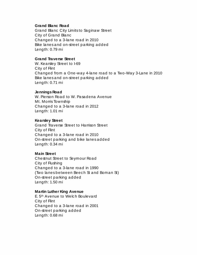
Grand Blanc Road Grand Blanc City Limits to Saginaw Street
City of Grand Blanc Changed to a 3-lane road in 2010 Bike lanes and on-street parking added Length: 0.79 mi Grand Traverse Street W. Kearsley Street to I-69
City of Flint Changed from a One-way 4-lane road to a Two-Way 3-Lane in 2010 Bike lanes and on-street parking added Length: 0.71 mi
Jennings Road W. Pierson Road to W. Pasadena Avenue
Mt. Morris Township Changed to a 3-lane road in 2012 Length: 1.01 mi Kearsley Street Grand Traverse Street to Harrison Street
City of Flint Changed to a 3-lane road in 2010 On-street parking and bike lanes added Length: 0.34 mi Main Street Chestnut Street to Seymour Road
City of Flushing Changed to a 3-lane road in 1990
(Two lanes between Beech St and Boman St) On-street parking added
Length: 1.50 mi Martin Luther King Avenue E. 5th Avenue to Welch Boulevard
City of Flint Changed to a 3-lane road in 2001 On-street parking added Length: 0.68 mi
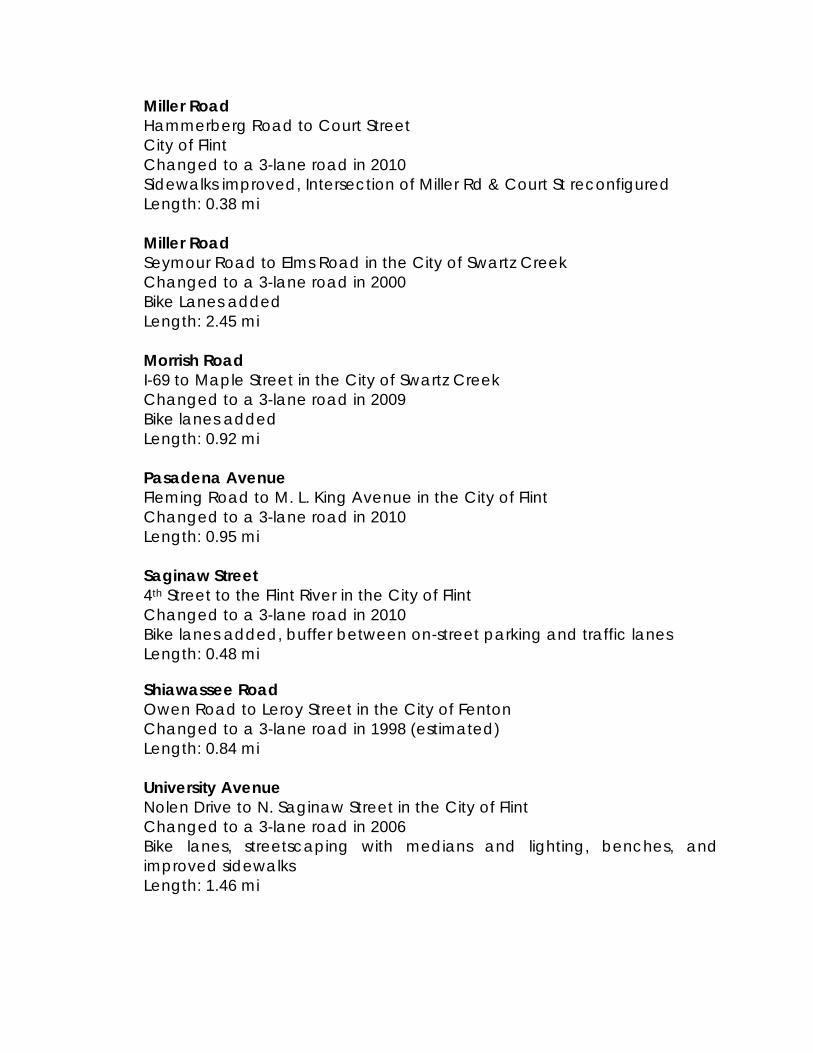
Miller Road Hammerberg Road to Court Street
City of Flint Changed to a 3-lane road in 2010 Sidewalks improved, Intersection of Miller Rd & Court St reconfigured Length: 0.38 mi Miller Road Seymour Road to Elms Road in the City of Swartz Creek Changed to a 3-lane road in 2000 Bike Lanes added Length: 2.45 mi Morrish Road I-69 to Maple Street in the City of Swartz Creek Changed to a 3-lane road in 2009 Bike lanes added Length: 0.92 mi Pasadena Avenue Fleming Road to M. L. King Avenue in the City of Flint Changed to a 3-lane road in 2010 Length: 0.95 mi Saginaw Street 4th Street to the Flint River in the City of Flint Changed to a 3-lane road in 2010 Bike lanes added, buffer between on-street parking and traffic lanes Length: 0.48 mi
Shiawassee Road Owen Road to Leroy Street in the City of Fenton Changed to a 3-lane road in 1998 (estimated) Length: 0.84 mi University Avenue Nolen Drive to N. Saginaw Street in the City of Flint Changed to a 3-lane road in 2006 Bike lanes, streetscaping with medians and lighting, benches, and improved sidewalks Length: 1.46 mi
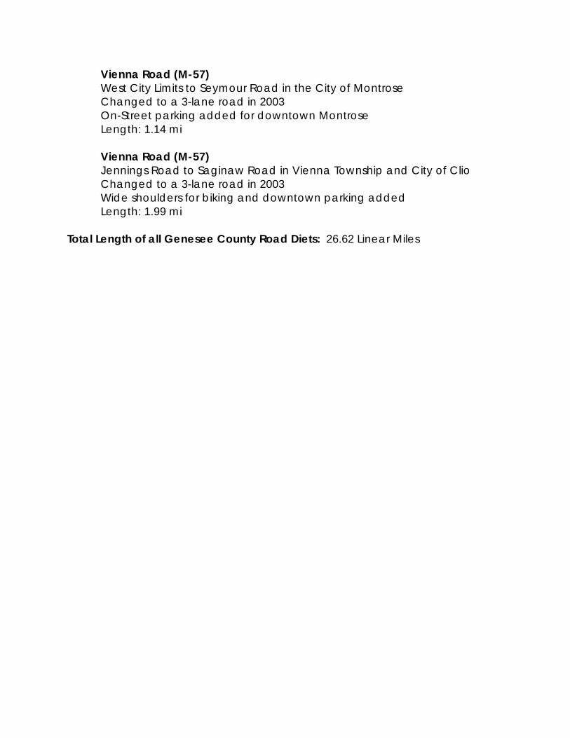
Vienna Road (M-57) West City Limits to Seymour Road in the City of Montrose Changed to a 3-lane road in 2003 On-Street parking added for downtown Montrose Length: 1.14 mi Vienna Road (M-57) Jennings Road to Saginaw Road in Vienna Township and City of Clio Changed to a 3-lane road in 2003 Wide shoulders for biking and downtown parking added Length: 1.99 mi Total Length of all Genesee County Road Diets: 26.62 Linear Miles


