
CAPACITY BUILDING FOR DISASTER
MANAGEMENT SUPPORT
Dr. Y.V.N. Krishna Murthy,
Director, Indian Institute of Remote Sensing ISRO,
and CSSTEAP(UN Affiliated Centre), Dehradun
iirs SSTDM 2014, IISc. Bengaluru
CANEUS SSTDM 2014

Indian sub-continent is one of the world‟s most Disaster-prone areas.
50 million people affected annually due to disaster
LandslidesFloods
Cyclones
Drought Forest Fires
Earthquakes
INDIA-Disaster Statistics
Affected Area
Floods ~40 M ha of total area
Cyclones ~8% of total area
(5700 km long coastline)
Drought ~68% of total area (116 districts
Landslides ~8% of total area
(Himalayan/ Western Ghats)
Earthquakes ~55% of area in Seismic Zone
III- & IV
Forest Fires ~65% of total forests under
potential threat
Tsunami East Coast, part of West Coast,
A & N Islands
CANEUS SSTDM 2014

Space Technology in Disaster Management
Relief / Rehabilitation
Damage Assessment
Supply / Logistic
Communication
Pre-Disaster Phase During Disaster
Risk Evaluation
Mitigation
Early Warning
Monitoring/ Tracking
Post-Disaster
Preparedness
CANEUS SSTDM 2014

Disaster Management
Seamless Integration
‘Last Mile’ Outreach
New Tools & Methods
Real Time Services
Database
Standards
Institutional
Arrangements
Regulation
Restriction
Accountability
Technological
Policies
Operational
GAPS
C
A
P
A
C
I
T
Y
B
U
I
L
D
I
N
G
Functionaries
NGOs & Self help groups
Administrators &
Policy/Decision makers
Organizations & Academia
International
Cooperation
% of reported people affected
by disaster type- INDIA
(1980-2009)
CANEUS SSTDM 2014

Satellite, Aerial & Ground Systems
Ground basedAWS DWR
Products & Services –Damage Assessment, Monitoring, .. NDEM, Hazard Zonation, Risk
Assessment, …
Networking, Early Warning [CWDS, IOTWS, INFRAS, ..]
MHA, NDMA, MoA, PMO, CabSectt [CMG], State Agencies
Decision
Support Centre
(DSC) NRSC
CWC, IMD, GSI, MOES/ DOD, DST, FSI, ..
Emergency Communication Network - VPN; Support - MSS Type-D, WLL VSAT, …
Technology Development & Research Forecasting/ Simulation Models, ..
Capacity Building Int. Commitments (Int. Charter, Sentinal Asia, UN-SPIDER)
Disaster Management Support (DMS) Programme of
ISRO: Assets and Infrastructure
CANEUS SSTDM 2014

FACTORS leading to Disasters
Increasing population & Urbanisation
Construction on ecologically sensitive sites
Depletion and Improper management of resources
Deforestation
Non conformity to bye-laws and standards (Eg: Rainwater
Harvesting and Seismic Proof building norms …..)
Changing minds- from societal cause to economic and
monetary benefits
Ignorance and lack of responsible behavior
Climate Change Impacts
CANEUS SSTDM 2014

IIRS Major Contributions
Transfer technology through Capacity Building & Research in the field of RS & GIS technology and applications
Training
&
Education Research
Outreach
B U I L D I N G
CAPACITY
Major Highlights (until Feb. 2014)
o Professionals trained in IIRS: 9184
o Foreign professionals trained in IIRS: 906 from 91 Countries (excluding CSSTEAP)
o Professionals trained in CSSTEAP-1275 from 34 countries in Asia-Pacific Region
and 29 from 18 (outside AP)
o M.Tech. students: 169 and M.Sc. Students:160 (since 2002)
o Tailor Made Courses: 2854 and Certificate 4432
o Distance Learning (EDUSAT based Program): >10,000 from 120 Institutes/ Colleges/Univ.
Training Programmes :
– PG Diploma (10 months, 9 Specializations)
– Certificate (8 weeks, Sponsored by ITEC, Govt. of India)
– Certificate Course for Univ. Faculty (8 weeks, NNRMS–ISRO Sponsored)
– Decision Makers Course (1 week)
– Special /Tailor made Courses(1-8 weeks)
Education Programmes:– M .Tech. in RS & GIS
(24 months and 8 Specializations; Affiliated to AU, Vishalkapatnam)
– M.Sc. in Geo-Informatics and Natural Hazards & Disaster Risk Management
(18 months JEP with ITC, Twente University, The Netherlands)
CANEUS SSTDM 2014

EDUSAT Based Outreach & E-Learning Programs
11 Courses conducted with 123 University Network
8 courses on „Basics of RS, GIS & GPS‟
1 course on „Advances in Geoinformatics‟
1 Course on „Advances in Hyperspectral RS‟
1 Course on „ Geo-web Services‟
e-Learning program on technology
2023 participants in 11th course : 2014
1 No of Classrooms2 - do -3 - do -6 - do -
Special Courses
• Geoinformatics for Disaster Response – National Disaster Response Force
• Managements of Forests - Forest Range Officers
• Geoinformatics Application in Disaster Management Support
• “Data Assimilation” in association with University of Reading.
• Indian Technical and Economic Cooperation (ITEC)CANEUS SSTDM 2014

‒ Flood Risk Mapping, Modeling & Assessment using Space
Technology [Funded by IWMI, UNOOSA &UNESCAP]
(19 Participants,11 countries)
‒ Sub-regional training on Development of Geo-referenced Disaster
Risk Management Information systems for SAARC countries
[Funded by UNESCAP]
(16 Participants, 9 SAARC countries)
CSSTEAP (UN Affiliated Centre) Contributions
Total Student Output : 1275 from 34 countries in Asia-Pacific Region and 29 from 18 (outside AP)
CSSTEAP (Centre for Space Science & Technology Education in Asia- Pacific – Affiliated to
UN) conduct Educational programs (PGD / M. Tech. & Short Courses) in four disciplines :
Remote Sensing & GIS (RS & GIS) at IIRS, Dehradun (18 )
338(PG), 419 (SC) from 24 & 39 countries
Satellite Meteorology (SATMET) at SAC, Ahmedabad ( 8)
134(PG), 25 (SC) from 22 & 10 countries
Satellite Communication (SATCOM) at SAC, Ahmedabad ( 8)
126(PG), 141 (SC) from 20 & 31 countries
Space & Atmospheric Science (SAS) at PRL, Ahmedabad (8)
86(PG), 26(SC) from 15 & 04 countries
Navigation and Satellite Positioning System (NAVSAT)at SAC, Ahmedabad ( 2)
33 from 10 countries
Small Satellite Mission (SSM) at ISAC, Bangalore & IIRS, Dehradun (2)
31 from 15 countries
CANEUS SSTDM 2014

Interdisciplinary Research Project: Monitoring & Assessment
of Ecosystem Processes in North-Western Himalaya (NWH)
Sub Themes: Geodynamics & Seismicity Investigations; Vulnerability assessment of Forest
Ecosystems due to Climate change; Sustainable Mountain Agriculture; Water Resources Status
and Availability; Modeling Temporal & Spatial Growth of Cities & Towns; Rainfall Retrieval Using
MW RS Data & Study of Extreme Rainfall Events
Preliminary Results:
Climate change impact on Maize Productivity
Climate change appears to affect productivity of food grain crops (Rice, wheat
and Maize) in Doon Valley. Marginal decline in crop yields by 2050s and
drastic reduction in 2080s under moderate & extreme CO2 scenario. Decline
in crop yields in 2080s without CO2 fertilization: Wheat (40%), Rice(20%), and
Maize(14%)
Analysis in Potential shift in Agapetis serpens species
Ecological niche modeling shows shift in species range from subtropical
broadleaved to temperate broad leaved for probability range between 0.9-1.0
Soil Erosion & SOC sequestration Modelling
GEPIC model simulated quite well for soil erosion rate and SOC sequestration
in the agricultural landscape of Doon Valley under current and future climate
change scenarios
Snow-melt Runoff Modeling (SRM)SRM was carried out in Pindar basin following Temperature index using
temporal RS & met. data. Model computed runoff volume compared well with
CWC measured data.
iirs
CANEUS SSTDM 2014

Modeling LULC Dynamics
Kappa = 87.1%
iirs
CANEUS SSTDM 2014

Kantamal
0
50
100
150
200
250
300
350
1 2 3 4 5 6 7 8 9 10 11 12
S imulated
obs erved
Sundergarh
0
50
100
150
200
1 2 3 4 5 6 7 8 9 10 11 12
S imulated
obs erved
Simga
0
20
40
60
80
100
120
140
160
1 2 3 4 5 6 7 8 9 10 11 12
S imulated
obs erved
Baminidihi
0
50
100
150
200
250
300
350
400
1 2 3 4 5 6 7 8 9 10 11 12
S imulated
obs erved
Andhiarkore
0
50
100
150
200
250
1 2 3 4 5 6 7 8 9 10 11 12
S imulated
Obs erved Mundali
0
50
100
150
200
250
300
1 2 3 4 5 6 7 8 9 10 11 12
S imulated
obs erved
Basin scale hydrological modeling(Mahanadi Basin: Area=1.41 lakh sq.km.)
Objectives:
1. Calibrate VIC model at outlet of Mahanadi river for the observed flow data of 2003
2. Validate the model on other five sub-basins of Mahanadi river basin
3. Simulate the runoff at six sites for 1972 (based on LULC of 1972)
4. Assess the impact of landuse change on runoff during 1972 to 2003
Model Inputs:
1. Resourcesat Awifs
2. Landsat MSS
3. Modis LAI
4. Modis albedo
5. GTOPO 30 DEM
6. NBSSLUP soil map
7. Daily Rainfall IMD gridded data
8. NCDC temperature data
9. Discharge from CWC
Results:
1. Simulation found to be reasonably accurate With R2 :0.836, Ns:0.821 and RE:8.5%
2. An increase of surface runoff by 4.53% (24.44 mm) in 2003 compared with 1972 ( 351.4 million m3 ). This may
be attributed to loss of forest by 5.71%.
iirs
CANEUS SSTDM 2014

THE RESPONSE OF HYDROLOGICAL PROCESSES TO CLIMATE
CHANGE IN MAHANADI BASIN OF INDIA USING A MACROSACLE
VIC MODEL
150
200
250
300
350
400
450
500
1 2 3 4
Ra
infa
ll (m
m)
Month
Rainfall (2008)
Rainfall (2050)
Precipitation Change
0
50
100
150
200
250
300
1 2 3 4
MonthR
un
off
(m
m)
Runoff (2008)
Runoff (2050)
Runoff Change
0
5
10
15
20
25
30
35
40
45
1 2 3 4
Month
Ba
se
flo
w (
mm
)
Baseflow (2008)
Baseflow (2050)
Baseflow Change
60
70
80
90
100
110
120
130
140
150
1 2 3 4
Month
Ev
ap
oa
tio
n (
mm
)
Evaporation(2008)
Evaporation(2050)
Evaporation Change
Climate change: based on
IPCC 4th report 2007 on
climate change
Temperature; (2050 year):
Winter; 3 .25˚C, Summer;
2.19˚C
Precipitation: (2050 year) :
Winter; -2.1% , Summer;
6.6%
Results:
Surface runoff and
ET will increase as
predicted rainfall
and temperature is
high in 2050.
However, base flow
will decrease. This
is attributed to
increased ET.
iirs
CANEUS SSTDM 2014

National Scale: IIRS Initiatives
• 15 years Runoff potential
maps of India(1991-2005)
• Wet year and dry years
are visible
• Runoff can be estimated
on daily basis
• ET and soil moisture can
also be simulated
Aggarwal, S.P., Garg, V., Gupta, P.K., Nikam, B.R., Thakur, P.K. and Roy P.S. (2013). Runoff potential
assessment over Indian landmass: A macro-scale hydrological modeling approach. Current Science, in press.
iirs
CANEUS SSTDM 2014

Flood Simulation (Daya River, Odisha)
Sisumatha Kushabhadra River ProfileCross section at Sisumatha Gauge Station
Software
• HEC HMS
• HEC RAS
Output
• Flow wave progression
• Inundation Area
iirs
CANEUS SSTDM 2014

Pre-monsoon GRACE gravity based
TWS Anomaly (March, 2003-12)
Dwarka
Udyog Vihar1
Central Delhi
Dwarka
Udyog
Vihar1
Central Delhi
L-band ALOS PALSAR Differential Interferograms of 2008-2010 showing suspected land subsidence fringes in Delhi
Space borne GRACE Gravity Observation showing TWS
Anomaly & DInSAR showing possible Land Subsidence
iirs
CANEUS SSTDM 2014

Support to Uttarakhand Disaster- Rescue & Relief Activities
In the aftermath of devastating floods & landslides in Uttarakhand in June
this year, IIRS in association with ISRO HQ, SAC, Ahmedabad and
NRSC, Hyderabad, provided possible support to State on priority.
Satellite Communication Support: INSAT MSS-Type-D terminals (12
no.) - 1007 calls made during 20th June 2013 to 9th July 2013; 6 DMS
hub & user nodes using CExt. 1.8m VSAT for Telephony voice
communications ,Video conferencing and Data communication
Satellite Image Support: Pre & post event Satellite image maps
annotated with details on landslides, trekking route, potential landslide
and settlement locations on 1:10,000 scale - From Bhuvan
Other Supports: GPS instruments to state Police Dept. to aid in rescue
and relief operations.
iirs
CANEUS SSTDM 2014

Team IIRS : Capacity Building Team NRSC : Technology
Team SOI : Support
• Development of appropriate
tools for field data collection
& integration with Bhuvan
geoportal data
• Capacity Building for field data
collection in disaster affected
areas of Uttarakhand
(Char-Dham & Pinder Valley)
by student and teacher
community (WIHG, KU,HNBGU)
Crowdsourcing / VGI for Disaster Management - MANU
(Map the Neighborhood in Uttarakhand)Department of Science & Technology, GOI, Initiative
CANEUS SSTDM 2014

Mobile Device with App
GPS
GPRS GPRS
Fir
ew
all
Internetusers
Internet
Bhuvan Portal
Server • Multi-sensor time-series satellite data;
• Satellite data Download;
• Thematic Services;• User response and
discussions;• VGI data and
information;• Terrain profile and
other data and information services
Mobile Device with Application developed by NRSC
Primary Mode of Field Data Collection
Visualisation on Bhuvan @ Client end
MANU App on Bhuvan
CANEUS SSTDM 2014

Structure of Field Data Collection Proforma through Mobile App
Disclaimer: This proforma has been designed to collect data for the scientific analysis of
damage caused due to disaster and is not intended to be used for making claims or for any legal
purpose, whatsoever.
• Damage to buildings and infrastructure
1a. Damage to Buildings
1b. Damage to Infrastructure
1b1. Roads
1b2. Bridges and Culverts
1b3. Other Infrastructure
• Landslides
• River Bank Erosion
• Damage to Land-cover and Natural Resources
• Points of Interest
CANEUS SSTDM 2014

1st Batch of Training Prog. :
27-29 September, 2013
2nd Batch of Training Prog. : 3-5 October, 2013
Students
HNB Garhwal University 65
Kumaun University 35
Wadia Institute of Himalayan Geology 49
Total 149
1st Batch of Training Prog.
27-29 September, 2013
(Collaborators: WIHG + KU)
2nd Batch of Training Prog.
3-5 October, 2013
(Collaborators: WIHG + HNBGU)
MANU Training iirs
CANEUS SSTDM 2014
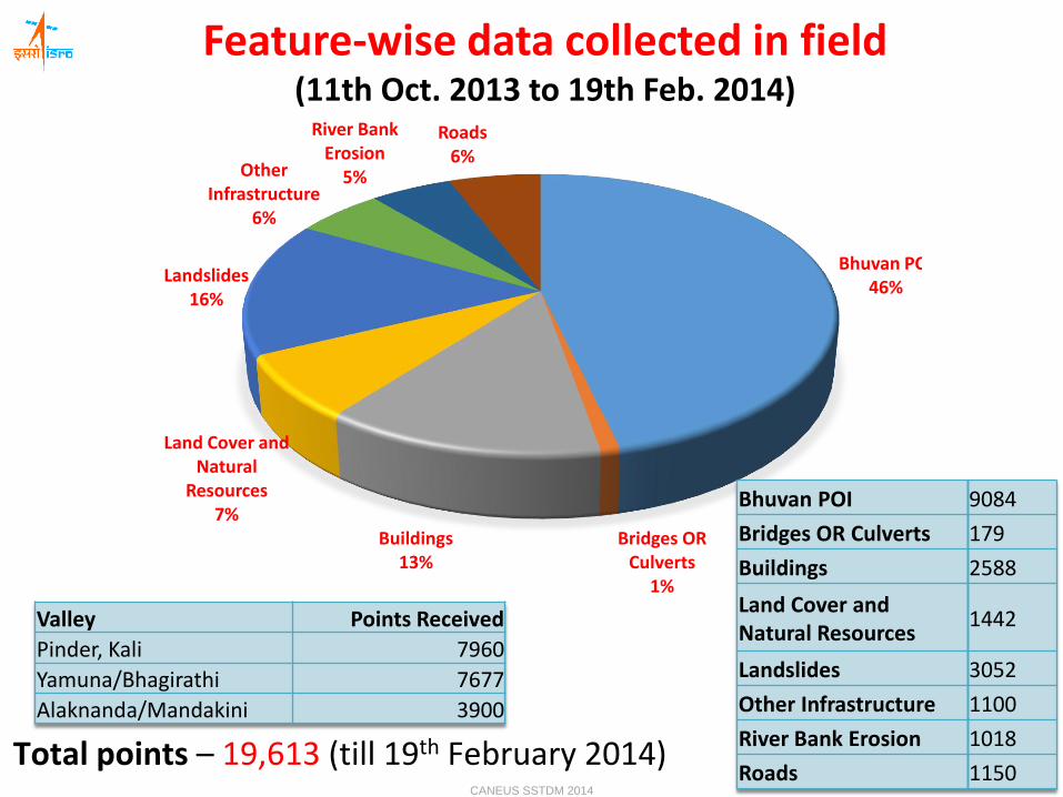
Bhuvan POI46%
Bridges OR Culverts
1%
Buildings13%
Land Cover and Natural
Resources7%
Landslides16%
Other Infrastructure
6%
River Bank Erosion
5%
Roads6%
Feature-wise data collected in field (11th Oct. 2013 to 19th Feb. 2014)
Valley Points Received
Pinder, Kali 7960
Yamuna/Bhagirathi 7677
Alaknanda/Mandakini 3900
Total points – 19,613 (till 19th February 2014)
Bhuvan POI 9084
Bridges OR Culverts 179
Buildings 2588
Land Cover and Natural Resources
1442
Landslides 3052
Other Infrastructure 1100
River Bank Erosion 1018
Roads 1150CANEUS SSTDM 2014

Reported Landslide Locations
Total Landslide points – 3052Out of total points – 19,613
(till 19th February 2014)CANEUS SSTDM 2014

Changing Emphasis
… from 2-D description to 4-D interaction
Past
2-D flat map displays
User as observer from 2-D description to 4-D interaction
Future
Effective 3-D visualization
4-D incorporation of time: “The time has come for time.”
Via agent-based modeling / cellular automata? Or how?
agents (e.g. vehicles, fires or people) interacting over time in a raster (cell)-based environment according to established rules
5, 6 and 7-D incorporation of touch (pressure, texture, temperature), sound andsmell into modeling/simulation environment)
User as participant
Users (researchers, professionals, the public) interact with the model;
Participatory Information Systems: the public as the planner .
iirs
CANEUS SSTDM 2014

Technological Support – EO & Insitu observations
Constitutional Amendments – 73rd & 74th
Remote sensing Data Policy, Map Policy, Geospatial Data
Policy, National GIS
NNRMS, NRDB, NSDI, NDEM, BHUVAN…
Developmental Programs/Schemes of Govt:
IWMP, MGNREGYA, PMGSY, NLRMP, HADP, IAP…..
Crop Insurance, Other Insurance, Health, Infrastructure Development
& Management, Facility Management….
Capacity Building
iirs
CANEUS SSTDM 2014

iirs
www.iirs.gov.in
THANK YOU
CANEUS SSTDM 2014


