
Parks Victoria is implementing new boating and swimming zones to improve safety across Port Phillip and Western Port.
Boating and Swimming Zones are Changing for the Better
June 2015

Phillip Island
DromanaMt Martha
Blairgowrie
St KildaElwood
Werribee River
Portarlington
Williamstown
Port Melbourne
Geelong
Flinders
French Island
Mornington
Frankston
Patterson River
Queenscliff
Hastings
Tooradin
JUNE 20152
Stage 1 – Completed 2010
Stage 2 – Completed 2012-13
Stage 3 – Completed 2014-15
Stage 4 – Proposed 2015-16
Stage 5 – Future stage
Port Phillip and Western Port

3
Boating and Swimming Zones UpgradePort Phillip and Western Port
Parks Victoria is implementing new boating and swimming zones to improve safety across Port Phillip and Western Port. The new boating and swimming zones are being introduced in stages with new aids to navigation and clear signage installed prior to each new zone coming into effect.
Boating and swimming zones are prepared under the Marine Safety Act 2010 with the primary aim of providing a safe environment for water users. They apply conditions of operation and prohibit incompatible uses for safety reasons.
In 2009 Parks Victoria completed a comprehensive two-year review of all boating and swimming zones across Port Phillip and Western Port. The review found that the existing boating and swimming zones could be difficult to understand from the water or land. There were a large number of different types of zones that made it overly complex to interpret. They also did not reflect changing trends in boating and swimming activity.
Parks Victoria as the Local Port Manager of Port Phillip and Western Port, jointly with Maritime Safety Victoria who oversee the management of recreational boating across Victoria, reviewed the existing boating and swimming zones. The review was to determine what zone types are required in each local area around Port Phillip and Western Port to allow safe access and use of the coast and waterways.
Following extensive community consultation a standard set of zones and criteria for application was devised. Parks Victoria has worked in partnership with Maritime Safety Victoria and in consultation with the local community to apply these zones across Port Phillip and Western Port.
The principles that have been applied during review of the recommendations are that the boating and swimming zones should be:
• Safe;
• Practical;
• Easy to identify;
• Easy to comply with and regulate;
• Responding to current and anticipated future water uses.
Some of the general and more significant changes as a result of reviewing each local area include:
• The realignment and simplification of zones to provide a more user-friendly arrangement;
• The consistent application of ‘Swimming Only’ zones in front of Life Saving Clubs to provide increased swimmer safety;
• The introduction of ‘Shared Wind Sport’ areas to allow for the safe operation of the increasingly popular sport;
• The removal of ‘No Sailboard, ‘Sailboards Only’ and ‘PWC Only’ zones to reflect changing water uses and duplication with other zones; and
• The adjustment of the ‘5 Knot’ zone between Safety Beach and Blairgowrie from 760m from shore to 500m from shore.
A simpler set of new zones will replace the previous zones. These are:
• Boating Only – swimming is not permitted in this zone.
• Swimming Only – all vessels, including personal watercraft, powered and non-powered vessels, are not permitted in this zone.
• Shared Wind Sport Area – this zone provides an area for kiteboarding, sail boarding and other wind based boating which may exceed 5 knots except within 50m proximity to other vessels and swimmers. Other vessels are permitted in this area.
• 5 Knot Speed Limit – all vessels, applicable either:
– as a zone extending to 200m from shore. Swimming and boating are permitted within 200m of the shore subject to defined areas above. All vessels must adhere to the 5 knot speed limit in this zone; or
– as a zone extending to 500m from shore on the Mornington Peninsula from Martha Cove, Dromana to Sullivan Bay, Sorrento. Swimming and boating are permitted within 500m of the shore subject to defined areas above. All vessels must adhere to the 5 knot speed limit in this zone.
• In some areas with exceptional circumstances two pre-existing zones will be retained. These are:
– No Wind Sports – sailboarding and kiteboarding is not permitted;
– No Personal Watercraft – personal watercraft (including jetskis) are prohibited in this zone.
Parks Victoria has commenced implementation of the endorsed zones and is installing buoys, piles and signage as part of the upgrade work. Implementation will continue as weather conditions, materials and contractor availability allow.
The new zones have been prioritised and are being implemented in stages, with Stages 1, 2 and 3 now complete. Proposed zones may change prior to implementation.
As works progress Parks Victoria will undertake local and general education campaigns for waterway users. Notices to Mariners will also be issued to advise of revised zone arrangements and works occurring on the water.
For further information and to keep updated of when the boating and swimming zones will be rolled out in your local area, please contact the Parks Victoria Information Centre on 13 1963 or email [email protected].

SwimmingOnly
EASTERN BEACH
RIPPLESIDE
NORTHGEELONG
Cunningham PierCunningham Pier
Bellerine St JettyBellerine St Jetty
St Helens JettySt Helens Jetty
Rippleside PierRippleside Pier
Rippleside JettyRippleside Jetty
Griffins Gully Jetty
Griffins Gully Jetty
Eastern BeachSwim EnclosureEastern BeachSwim Enclosure
200m
200m
200m
200m
200m
PRINCES HWY
PRINCES HWY
MA
CK
EY
ST
SW
INB
UR
NE
ST
BE
LL P
DE
THE ESPLANADE
BELLERINE ST
RY
RIE
ST
LATROBE TCE
North Cardinal (BYB)North Cardinal (BYB)
Limeburners PointLimeburners Point
Corio QuayCorio Quay
4
Swimming OnlyAll vessels including personal watercraft, powered and non-powered vessels are not permitted in this zone
Shared Wind Sports AreaThis area is set aside for kiteboarding and sailboarding which may exceed 5 knots, other vessels permitted
No Wind Sports AreaKiteboarding and sailboarding are not permitted in this zone
200m from shoreSwimming and boating are permitted within 200m of the shore. All vessels must adhere to the 5 knot speed limit within 200m of the shore
Special Mark
Special Mark Buoy
Shore Signs
Starboard Lateral Mark
Port Lateral Mark
North Cardinal / West Cardinal
Boat Ramp
KEYSt Helens Jetty and Point HenryBoating and Swimming Zones
The new St Helens Jetty and Point Henry zone changes will come into effect in 2015-16.
The changes include:
• New Swimming Only zone at St Helens Jetty, extending approximately 100m offshore.
• Retain the No Wind Sports zone, incorporating the waters within 100m around Point Henry Pier.
• New Shared Wind Sports zone at Point Henry, extending approximately 2km south-west, as per previous trial zone.
• Improved visibility of aids to navigation and easier to understand regulatory signage.
Disclaimer: THIS IS NOT A NAVIGATION CHART. This map is indicative only and not intended for navigational use. For navigation of Port Phillip, Chart AUS 143 should be consulted. Notices to Mariners issued by Parks Victoria are published on www.parks.vic.gov.au

200m
200m
100m
100m
200m
200m
Shared WindSports AreaShared WindSports Area
Shared WindSports Area
No Wind Sports Area
POINT HENRY
POINT HENRY RD
Point HenryPoint Henry
SwimmingOnly
EASTERN BEACH
RIPPLESIDE
NORTHGEELONG
Cunningham PierCunningham Pier
Bellerine St JettyBellerine St Jetty
St Helens JettySt Helens Jetty
Rippleside PierRippleside Pier
Rippleside JettyRippleside Jetty
Griffins Gully Jetty
Griffins Gully Jetty
Eastern BeachSwim EnclosureEastern BeachSwim Enclosure
200m
200m
200m
200m
200m
PRINCES HWY
PRINCES HWY
MA
CK
EY
ST
SW
INB
UR
NE
ST
BE
LL P
DE
THE ESPLANADE
BELLERINE ST
RY
RIE
ST
LATROBE TCE
North Cardinal (BYB)North Cardinal (BYB)
Limeburners PointLimeburners Point
Corio QuayCorio Quay
5

SwimmingOnly
200m
200m
BAYSHORE AVE
JET
TY
RD
CLIFTON SPRINGS
Shared WindSports Area
SwimmingOnly
PORTARLINGTON
PortarlingtonJetty
PortarlingtonJetty
JettyJetty
Point Richards
PortarlingtonSailing Club
PortarlingtonSailing Club
Portarlington Holiday Park
Portarlington Holiday Park
Flora and FaunaReserve
No PersonalWater Craft (PWC)
200m
200m
200m
BOAT RD
PO
INT
RIC
HA
RD
S R
D
PO
RTA
RLI
NG
TO
N –
QU
EE
NS
CLI
FF R
D
NEWCOMBE ST
ST LEONARDS
INDENTED HEAD
SwimmingOnly
LEVIENS RD
MURRADOC RD
FIRST AVE
DUDLEY PDE
THE
ESPL
AN
AD
E
St Leonards Pier
Indented Head JettyIndented Head Jetty
Salt Lake
200m
200m
200m
200m
200m
200
m
200m
SwimmingOnly
WALPOLE AVE
JUBILEE AVE
McDONALD ST
TH
E ESPLA
NA
DE
North Cardinal (BYB)North Cardinal (BYB)
6
Boating Only Swimming is not permitted in this zone
Swimming OnlyAll vessels including personal water craft, powered and non-powered vessels are not permitted in this zone
Shared Wind Sports AreaThis area is set aside for kiteboarding and sailboarding which may exceed 5 knots, other vessels permitted
200m from shoreSwimming and boating are permitted within 200m of the shore. All vessels must adhere to the 5 knot speed limit within 200m of the shore
Special Mark
Special Mark Buoy
Shore Signs
Port Lateral Mark
Boat Ramp
KEYClifton Springs and PortarlingtonBoating and Swimming Zones
The new Clifton Springs and Portarlington zone changes will come into effect in 2015-16.
The changes at Clifton Springs include:
• New Swimming Only zone at Clifton Springs Boat Harbour extending 200m offshore.
The changes at Portarlington include:
• New Shared Wind Sports zone at Point Richards, west of Portarlington Sailing Club adjacent to the eastern Point Richards Boat Ramp breakwater, extending 200m offshore.
• Revised No Personal Watercraft zone at Portarlington Pier, extending 200m offshore.
• Revised Swimming Only zone opposite Portarlington Bowling Club between Portarlington Pier and Stewart Grove extending 200m offshore.
Disclaimer: THIS IS NOT A NAVIGATION CHART. This map is indicative only and not intended for navigational use. For navigation of Port Phillip, Chart AUS 143 should be consulted. Notices to Mariners issued by Parks Victoria are published on www.parks.vic.gov.au

Shared WindSports Area
SwimmingOnly
PORTARLINGTON
PortarlingtonJetty
PortarlingtonJetty
JettyJetty
Point Richards
PortarlingtonSailing Club
PortarlingtonSailing Club
Portarlington Holiday Park
Portarlington Holiday Park
Flora and FaunaReserve
No PersonalWater Craft (PWC)
200m
200m
200m
BOAT RD
PO
INT
RIC
HA
RD
S R
D
PO
RTA
RLI
NG
TO
N –
QU
EE
NS
CLI
FF R
D
NEWCOMBE ST
ST LEONARDS
INDENTED HEAD
SwimmingOnly
LEVIENS RD
MURRADOC RD
FIRST AVE
DUDLEY PDE
THE
ESPL
AN
AD
E
St Leonards Pier
Indented Head JettyIndented Head Jetty
Salt Lake
200m
200m
200m
200m
200m
200
m
200m
SwimmingOnly
WALPOLE AVE
JUBILEE AVE
McDONALD ST
TH
E ESPLA
NA
DE
North Cardinal (BYB)North Cardinal (BYB)
7
Indented Head to St LeonardsBoating and Swimming Zones
The new Indented Head to St Leonards zone changes will come into effect in 2015-16.
The changes from Indented Head to St Leonards include:
• Revised Swimming Only zone between Jubilee Ave and Walpole Ave, extending 200m offshore.
• Revised Swimming Only zone between St Leonards Pier and First Ave, extending 200m offshore.
• Improved visibility of aids to navigation and easier to understand regulatory signage.
• Removal of Waterski Access Lanes at Point George and St Leonards.
Disclaimer: THIS IS NOT A NAVIGATION CHART. This map is indicative only and not intended for navigational use. For navigation of Port Phillip, Chart AUS 143 should be consulted. Notices to Mariners issued by Parks Victoria are published on www.parks.vic.gov.au

WERRIBEE SOUTH
WERRIBEE RIVER
Werribee JettyGraham’sWetlandReserve
DIG
GE
RS
R
D
BE
AC
H
RD
ALTONA
Altona Pier
WilliamstownHospital
BotanicGardens
Gloucester Res.
PG.SaddlerReserve
HattReserve
GH.RansomReserve
ApexPark
MA
IDS
TO
NE
S
T
GR
IEV
E
PD
E
ESPLAN
ESPLANADE
OSBORNE ST
PARKER ST
OSBORNE
HANMER STRAILWAY CRES
BLYTH ST
WE
BB
RO
MA
WI
RO
SE
PIE
R
ST
MO
UN
T
MIL
LER
S
RO
AD
STQUEEN
RAILWAY ST NTH.RAILWAY ST STH.
BLYTH ST
ADE
WILLIAMSTOWN
VIC
TO
RIA
S
T
GIF
FAR
D
ST
CO
LE
ST
MORRIS ST
BA
YV
IEW
S
T
WilliamstownLife Saving Club
50m forBoat Berthing
200m
200m
200m
200m
200m
FraserReserve
SwimmingOnly
SwimmingOnly
BoatingOnly
SharedWind Sports
Area
Cyril CurtainReserve
Cyril CurtainReserve
BA
Y S
T
TODD ROAD
Princes Pier Station
Pier
Webb Dock East
Kerferd RoadPier
St Kilda Pier
St Kilda Harbour
LagoonPier
Sandridge Beach
PIC
KLE
S S
T
SandridgeLife Saving
Club
Shared WindSports Area
BrooksJetty
PORT MELBOURNE MIDDLEPARK
ST KILDA
PortMelbourneLife Saving
Club
SouthMelbourneLife Saving
Club
St KildaLife Saving
Club
Catani Gardens
St Kilda Beach
WR
IGH
T S
T
KE
RFE
RD
RD
VIC
TO
RIA
AV
E
AR
MS
TR
ON
G S
T
LA
NG
RID
GE
ST
200m
200m200m
SwimmingOnly
SwimmingOnly
SwimmingOnly
SwimmingOnly
St Kilda MarinaSouth Cardinal (YB)
8
Werribee River to Williamstown
Disclaimer: THIS IS NOT A NAVIGATION CHART. This map is indicative only and not intended for navigational use. For navigation of Port Phillip, Chart AUS 143 should be consulted. Notices to Mariners issued by Parks Victoria are published on www.parks.vic.gov.au
Boating Only Swimming is not permitted in this zone
Swimming OnlyAll vessels including personal watercraft, powered and non-powered vessels are not permitted in this zone
Shared Wind Sports AreaThis area is set aside for kiteboarding and sailboarding which may exceed 5 knots, other vessels permitted
200m from shoreSwimming and boating are permitted within 200m of the shore. All vessels must adhere to the 5 knot speed limit within 200m of the shore
Special Mark
Special Mark Buoy
Shore Signs
Starboard Lateral Mark
Port Lateral Mark
Boat Ramp
KEY

BA
Y S
T
TODD ROAD
Princes Pier Station
Pier
Webb Dock East
Kerferd RoadPier
St Kilda Pier
St Kilda Harbour
LagoonPier
Sandridge Beach
PIC
KLE
S S
T
SandridgeLife Saving
Club
Shared WindSports Area
BrooksJetty
PORT MELBOURNE MIDDLEPARK
ST KILDA
PortMelbourneLife Saving
Club
SouthMelbourneLife Saving
Club
St KildaLife Saving
Club
Catani Gardens
St Kilda Beach
WR
IGH
T S
T
KE
RFE
RD
RD
VIC
TO
RIA
AV
E
AR
MS
TR
ON
G S
T
LA
NG
RID
GE
ST
200m
200m200m
SwimmingOnly
SwimmingOnly
SwimmingOnly
SwimmingOnly
St Kilda MarinaSouth Cardinal (YB)
9
Port Melbourne to St Kilda
KEYBoating Only Swimming is not permitted in this zone
Swimming OnlyAll vessels including personal watercraft, powered and non-powered vessels are not permitted in this zone
Shared Wind Sports AreaThis area is set aside for kiteboarding and sailboarding which may exceed 5 knots, other vessels permitted
200m from shoreSwimming and boating are permitted within 200m of the shore. All vessels must adhere to the 5 knot speed limit within 200m of the shore
Special Mark
Special Mark Buoy
Shore Signs
South Cardinal
Disclaimer: THIS IS NOT A NAVIGATION CHART. This map is indicative only and not intended for navigational use. For navigation of Port Phillip, Chart AUS 143 should be consulted. Notices to Mariners issued by Parks Victoria are published on www.parks.vic.gov.au

MORNINGTONPENINSULA
FWY
EE
L R
AC
E
AR
MST
RON
GS
Brooks
Jetty
St K
ilda M
arin
a
Black
Rock
Jett
y
Black
Rock
Jett
y
Beaum
aris
Bay
Beaum
aris
Bay
Ricket
t’s P
oint
Ricket
t’s P
oint
Ricket
t’s P
oint
Mar
ine S
anct
uary
Ricket
t’s P
oint
Mar
ine S
anct
uary
200m
200m
200m
200m
200m
200m
200m
200m
200m
Elw
ood Life
Sav
ing C
lub
Elw
ood Life
Sav
ing C
lub
Royal B
righto
n Yac
ht Clu
b
Royal B
righto
n Yac
ht Clu
b
Sandrin
gham Y
acht C
lub
Sandrin
gham Y
acht C
lub
Hampto
n Sai
ling C
lub
Hampto
n Sai
ling C
lub
Volunte
er C
oast G
uard H
Q
Volunte
er C
oast G
uard H
Q
Mid
dle B
righto
n Bat
hs
Mid
dle B
righto
n Bat
hsBrig
hton
Life S
avin
g Clu
b
Half M
oon Bay
Life
Sav
ing C
lub
Half M
oon Bay
Life
Sav
ing C
lub
Beaum
aris
Life S
avin
g Clu
b
Men
tone L
ife S
avin
g Clu
b
Men
tone L
ife S
avin
g Clu
b
Picn
ic Po
int
Picn
ic Po
int
Cerber
us Wre
ck
Wes
t Car
dinal
(YBY)
Red B
luff
Hampto
n Pie
r
Hampto
n Pie
r
Green
Poin
t
Green
Poin
t
Poin
t Orm
ond
Mid
dle B
righto
n Pie
r
Hampto
n Life
Sav
ing C
lub
Hampto
n Life
Sav
ing C
lub
Sandrin
gham
Life S
avin
g Clu
b
Sandrin
gham
Life S
avin
g Clu
b
Black
Rock
Yac
ht Clu
b
Black
Rock
Yac
ht Clu
b
Beaum
aris
Yacht C
lub
Beaum
aris
Yacht C
lub
Black
Rock
Life
Sav
ing C
lub
Black
Rock
Life
Sav
ing C
lub
Aspen
dale L
ife S
avin
g Clu
b
Aspen
dale L
ife S
avin
g Clu
b
Mord
iallo
c
Life S
avin
g Clu
b
Mord
iallo
c
Life S
avin
g Clu
b
Edith
vale
Life
Sav
ing C
lub
Edith
vale
Life
Sav
ing C
lub
Chelse
a Life
Sav
ing C
lub
Chelse
a Life
Sav
ing C
lub
Bonbeach
Life
Sav
ing C
lub
Bonbeach
Life
Sav
ing C
lub
Carru
m S
ailin
g Clu
b
Carru
m S
ailin
g Clu
b
Patt
erso
n Riv
er M
otor B
oat C
lub
Patt
erso
n Riv
er M
otor B
oat C
lub
Carru
m Li
fe S
avin
g Clu
b
Carru
m Li
fe S
avin
g Clu
b
Riggin
g
Area
Mord
iallo
c Pie
r
Patte
rson
River
ST KIL
DA
ELWOOD
NORTH BRIG
HTON
MID
DLE B
RIGHTON
BRIGHTON B
EACH
HAMPTON
SANDRINGHAM
BEAUMARIS
BLACK R
OCK
MENTONE
PARKDALE
MORDIA
LLOC
ASPENDALE
EDITHVALE
CHELSEA
BONBEACH
CARRUM
PATTERSON
LAKES
Shar
ed
Win
d Sports
Area
South
Car
dinal
(YB)
South
Car
dinal
(YB)
South
Car
dinal
(YB)
East
Car
dinal
(BYB)
East
Car
dinal
(BYB)
South
Cardin
al (Y
B)
NEPEAN HWY NEPEAN HWY
BAY ST
RENNISON ST
PARKERS RD
WARRIGAL RD
BIRDWOOD ST
NAPLES RDMUNDY ST M
CLE
OD
R
D
ED
ITH
VA
LE
RD
TH
AM
ES
PR
OM
AV
ON
DA
LE
TH
E A
VE
NU
E
NEPEAN HWY
SIN
CL
AIR
AV
E
EE
L R
AC
E
AR
MST
RON
GS
RD
COLE
MAN R
D
GNOTUK A
VE
FOSTER L
N
NO
RTH RD
SOUTH R
D
BEACH RD
BEACH RD
BEACH RD
ORMOND ESPL
BAY RD
BALC
OM
BE R
D
NEPEAN HWY
GLE
NH
UN
TLY R
D
SH
AK
ES
PE
AR
E G
R
ST KILDA ST
NEW ST
NEW ST
BARKLY ST
MARINE
BLUFF RD
RESERVE RD
CHARMAN RD
HAMPTON ST
ELIZ
A ST
SMA
LL
ST
ORLA
ND
O S
T
NO
RWO
OD A
VE
PARK S
T
HEA
D S
T
PDE
SEA PDE
Wes
t Car
dinal
(YBY)
Swim
min
g
Only
Wat
ersk
i
Acces
s Lan
e
Swim
min
g
Only
Swim
min
g
Only
Swim
min
g
Only
Swim
min
g
Only
Swim
min
g
Only
Swim
min
g
Only
Swim
min
g
OnlySw
imm
ing
Only
Swim
min
g
Only
Swim
min
g
Only
Swim
min
g
Only
No Pers
onal
Wat
er C
raft
(PW
C)
No Pers
onal
Wat
er C
raft
(PW
C)
Swim
min
g
Only
Boatin
g
Only
Shar
ed
Win
d Sports
Area
Shar
ed
Win
d Sports
Area
Shar
ed
Win
d Sports
Area
Swim
min
g
Only
10
Elwood to Seaford

MORNINGTONPENINSULA
FWY
EE
L R
AC
E
AR
MST
RON
GS
Brooks
Jetty
St K
ilda M
arin
a
Black
Rock
Jett
y
Black
Rock
Jett
y
Beaum
aris
Bay
Beaum
aris
Bay
Ricket
t’s P
oint
Ricket
t’s P
oint
Ricket
t’s P
oint
Mar
ine S
anct
uary
Ricket
t’s P
oint
Mar
ine S
anct
uary
200m
200m
200m
200m
200m
200m
200m
200m
200m
Elw
ood Life
Sav
ing C
lub
Elw
ood Life
Sav
ing C
lub
Royal B
righto
n Yac
ht Clu
b
Royal B
righto
n Yac
ht Clu
b
Sandrin
gham Y
acht C
lub
Sandrin
gham Y
acht C
lub
Hampto
n Sai
ling C
lub
Hampto
n Sai
ling C
lub
Volunte
er C
oast G
uard H
Q
Volunte
er C
oast G
uard H
Q
Mid
dle B
righto
n Bat
hs
Mid
dle B
righto
n Bat
hsBrig
hton
Life S
avin
g Clu
b
Half M
oon Bay
Life
Sav
ing C
lub
Half M
oon Bay
Life
Sav
ing C
lub
Beaum
aris
Life S
avin
g Clu
b
Men
tone L
ife S
avin
g Clu
b
Men
tone L
ife S
avin
g Clu
b
Picn
ic Po
int
Picn
ic Po
int
Cerber
us Wre
ck
Wes
t Car
dinal
(YBY)
Red B
luff
Hampto
n Pie
r
Hampto
n Pie
r
Green
Poin
t
Green
Poin
t
Poin
t Orm
ond
Mid
dle B
righto
n Pie
r
Hampto
n Life
Sav
ing C
lub
Hampto
n Life
Sav
ing C
lub
Sandrin
gham
Life S
avin
g Clu
b
Sandrin
gham
Life S
avin
g Clu
b
Black
Rock
Yac
ht Clu
b
Black
Rock
Yac
ht Clu
b
Beaum
aris
Yacht C
lub
Beaum
aris
Yacht C
lub
Black
Rock
Life
Sav
ing C
lub
Black
Rock
Life
Sav
ing C
lub
Aspen
dale L
ife S
avin
g Clu
b
Aspen
dale L
ife S
avin
g Clu
b
Mord
iallo
c
Life S
avin
g Clu
b
Mord
iallo
c
Life S
avin
g Clu
b
Edith
vale
Life
Sav
ing C
lub
Edith
vale
Life
Sav
ing C
lub
Chelse
a Life
Sav
ing C
lub
Chelse
a Life
Sav
ing C
lub
Bonbeach
Life
Sav
ing C
lub
Bonbeach
Life
Sav
ing C
lub
Carru
m S
ailin
g Clu
b
Carru
m S
ailin
g Clu
b
Patt
erso
n Riv
er M
otor B
oat C
lub
Patt
erso
n Riv
er M
otor B
oat C
lub
Carru
m Li
fe S
avin
g Clu
b
Carru
m Li
fe S
avin
g Clu
b
Riggin
g
Area
Mord
iallo
c Pie
r
Patte
rson
River
ST KIL
DA
ELWOOD
NORTH BRIG
HTON
MID
DLE B
RIGHTON
BRIGHTON B
EACH
HAMPTON
SANDRINGHAM
BEAUMARIS
BLACK R
OCK
MENTONE
PARKDALE
MORDIA
LLOC
ASPENDALE
EDITHVALE
CHELSEA
BONBEACH
CARRUM
PATTERSON
LAKES
Shar
ed
Win
d Sports
Area
South
Car
dinal
(YB)
South
Car
dinal
(YB)
South
Car
dinal
(YB)
East
Car
dinal
(BYB)
East
Car
dinal
(BYB)
South
Cardin
al (Y
B)
NEPEAN HWY NEPEAN HWY
BAY ST
RENNISON ST
PARKERS RD
WARRIGAL RD
BIRDWOOD ST
NAPLES RDMUNDY ST M
CLE
OD
R
D
ED
ITH
VA
LE
RD
TH
AM
ES
PR
OM
AV
ON
DA
LE
TH
E A
VE
NU
E
NEPEAN HWY
SIN
CL
AIR
AV
E
EE
L R
AC
E
AR
MST
RON
GS
RD
COLE
MAN R
D
GNOTUK A
VE
FOSTER L
N
NO
RTH RD
SOUTH R
D
BEACH RD
BEACH RD
BEACH RD
ORMOND ESPL
BAY RD
BALC
OM
BE R
D
NEPEAN HWY
GLE
NH
UN
TLY R
D
SH
AK
ES
PE
AR
E G
R
ST KILDA ST
NEW ST
NEW ST
BARKLY ST
MARINE
BLUFF RD
RESERVE RD
CHARMAN RD
HAMPTON ST
ELIZ
A ST
SMA
LL
ST
ORLA
ND
O S
T
NO
RWO
OD A
VE
PARK S
T
HEA
D S
T
PDE
SEA PDE
Wes
t Car
dinal
(YBY)
Swim
min
g
Only
Wat
ersk
i
Acces
s Lan
e
Swim
min
g
Only
Swim
min
g
Only
Swim
min
g
Only
Swim
min
g
Only
Swim
min
g
Only
Swim
min
g
Only
Swim
min
g
OnlySw
imm
ing
Only
Swim
min
g
Only
Swim
min
g
Only
Swim
min
g
Only
No Pers
onal
Wat
er C
raft
(PW
C)
No Pers
onal
Wat
er C
raft
(PW
C)
Swim
min
g
Only
Boatin
g
Only
Shar
ed
Win
d Sports
Area
Shar
ed
Win
d Sports
Area
Shar
ed
Win
d Sports
Area
Swim
min
g
Only
11

MORNINGTONPENINSULA
FWY
EE
L R
AC
E
AR
MST
RON
GS
Brooks
Jetty
St K
ilda M
arin
a
Black
Rock
Jett
y
Black
Rock
Jett
y
Beaum
aris
Bay
Beaum
aris
Bay
Ricket
t’s P
oint
Ricket
t’s P
oint
Ricket
t’s P
oint
Mar
ine S
anct
uary
Ricket
t’s P
oint
Mar
ine S
anct
uary
200m
200m
200m
200m
200m
200m
200m
200m
200m
Elw
ood Life
Sav
ing C
lub
Elw
ood Life
Sav
ing C
lub
Royal B
righto
n Yac
ht Clu
b
Royal B
righto
n Yac
ht Clu
b
Sandrin
gham Y
acht C
lub
Sandrin
gham Y
acht C
lub
Hampto
n Sai
ling C
lub
Hampto
n Sai
ling C
lub
Volunte
er C
oast G
uard H
Q
Volunte
er C
oast G
uard H
Q
Mid
dle B
righto
n Bat
hs
Mid
dle B
righto
n Bat
hsBrig
hton
Life S
avin
g Clu
b
Half M
oon Bay
Life
Sav
ing C
lub
Half M
oon Bay
Life
Sav
ing C
lub
Beaum
aris
Life S
avin
g Clu
b
Men
tone L
ife S
avin
g Clu
b
Men
tone L
ife S
avin
g Clu
b
Picn
ic Po
int
Picn
ic Po
int
Cerber
us Wre
ck
Wes
t Car
dinal
(YBY)
Red B
luff
Hampto
n Pie
r
Hampto
n Pie
r
Green
Poin
t
Green
Poin
t
Poin
t Orm
ond
Mid
dle B
righto
n Pie
r
Hampto
n Life
Sav
ing C
lub
Hampto
n Life
Sav
ing C
lub
Sandrin
gham
Life S
avin
g Clu
b
Sandrin
gham
Life S
avin
g Clu
b
Black
Rock
Yac
ht Clu
b
Black
Rock
Yac
ht Clu
b
Beaum
aris
Yacht C
lub
Beaum
aris
Yacht C
lub
Black
Rock
Life
Sav
ing C
lub
Black
Rock
Life
Sav
ing C
lub
Aspen
dale L
ife S
avin
g Clu
b
Aspen
dale L
ife S
avin
g Clu
b
Mord
iallo
c
Life S
avin
g Clu
b
Mord
iallo
c
Life S
avin
g Clu
b
Edith
vale
Life
Sav
ing C
lub
Edith
vale
Life
Sav
ing C
lub
Chelse
a Life
Sav
ing C
lub
Chelse
a Life
Sav
ing C
lub
Bonbeach
Life
Sav
ing C
lub
Bonbeach
Life
Sav
ing C
lub
Carru
m S
ailin
g Clu
b
Carru
m S
ailin
g Clu
b
Patt
erso
n Riv
er M
otor B
oat C
lub
Patt
erso
n Riv
er M
otor B
oat C
lub
Carru
m Li
fe S
avin
g Clu
b
Carru
m Li
fe S
avin
g Clu
b
Riggin
g
Area
Mord
iallo
c Pie
r
Patte
rson
River
ST KIL
DA
ELWOOD
NORTH BRIG
HTON
MID
DLE B
RIGHTON
BRIGHTON B
EACH
HAMPTON
SANDRINGHAM
BEAUMARIS
BLACK R
OCK
MENTONE
PARKDALE
MORDIA
LLOC
ASPENDALE
EDITHVALE
CHELSEA
BONBEACH
CARRUM
PATTERSON
LAKES
Shar
ed
Win
d Sports
Area
South
Car
dinal
(YB)
South
Car
dinal
(YB)
South
Car
dinal
(YB)
East
Car
dinal
(BYB)
East
Car
dinal
(BYB)
South
Cardin
al (Y
B)
NEPEAN HWY NEPEAN HWY
BAY ST
RENNISON ST
PARKERS RD
WARRIGAL RD
BIRDWOOD ST
NAPLES RDMUNDY ST M
CLE
OD
R
D
ED
ITH
VA
LE
RD
TH
AM
ES
PR
OM
AV
ON
DA
LE
TH
E A
VE
NU
E
NEPEAN HWY
SIN
CL
AIR
AV
E
EE
L R
AC
E
AR
MST
RON
GS
RD
COLE
MAN R
D
GNOTUK A
VE
FOSTER L
N
NO
RTH RD
SOUTH R
D
BEACH RD
BEACH RD
BEACH RD
ORMOND ESPL
BAY RD
BALC
OM
BE R
D
NEPEAN HWY
GLE
NH
UN
TLY R
D
SH
AK
ES
PE
AR
E G
R
ST KILDA ST
NEW ST
NEW ST
BARKLY ST
MARINE
BLUFF RD
RESERVE RD
CHARMAN RD
HAMPTON ST
ELIZ
A ST
SMA
LL
ST
ORLA
ND
O S
T
NO
RWO
OD A
VE
PARK S
T
HEA
D S
T
PDE
SEA PDE
Wes
t Car
dinal
(YBY)
Swim
min
g
Only
Wat
ersk
i
Acces
s Lan
e
Swim
min
g
Only
Swim
min
g
Only
Swim
min
g
Only
Swim
min
g
Only
Swim
min
g
Only
Swim
min
g
Only
Swim
min
g
OnlySw
imm
ing
Only
Swim
min
g
Only
Swim
min
g
Only
Swim
min
g
Only
No Pers
onal
Wat
er C
raft
(PW
C)
No Pers
onal
Wat
er C
raft
(PW
C)
Swim
min
g
Only
Boatin
g
Only
Shar
ed
Win
d Sports
Area
Shar
ed
Win
d Sports
Area
Shar
ed
Win
d Sports
Area
Swim
min
g
Only
12
Boating Only Swimming is not permitted in this zone
Swimming OnlyAll vessels including personal watercraft, powered and non-powered vessels are not permitted in this zone
Shared Wind Sports AreaThis area is set aside for kiteboarding and sailboarding which may exceed 5 knots, other vessels permitted
200m from shoreSwimming and boating are permitted within 200m of the shore. All vessels must adhere to the 5 knot speed limit within 200m of the shore
Waterski Access Lane – No Swimming Permitted
Special Mark
Special Mark Buoy
Shore Signs
Starboard Lateral Mark
Port Lateral Mark
South Cardinal / East Cardinal / West Cardinal
Isolated Danger
Boat Ramp
KEY
Disclaimer: THIS IS NOT A NAVIGATION CHART. This map is indicative only and not intended for navigational use. For navigation of Port Phillip, Chart AUS 143 should be consulted. Notices to Mariners issued by Parks Victoria are published on www.parks.vic.gov.au
CA
RR
UM
Patt
erso
nR
iver
THE GLA
DE
Rig
gin
gA
rea M
orn
ing
ton
Pie
r
Sch
nap
per
Po
int
Lin
ley
Poin
tLi
nle
y Po
int
Mar
ina
Co
veM
arin
a C
ove
Sco
ut
Bea
ch
Mo
rnin
gto
n L
ife
Savi
ng
Clu
bM
orn
ing
ton
Lif
e Sa
vin
g C
lub
Mill
s B
each
Swim
min
gO
nly
Aq
uac
ult
ure
Mt
Mar
tha
Life
Sav
ing
Clu
b
Mt
Mar
tha
Yach
t C
lub
MT
MA
RT
HA
Art
ific
ial R
eef
MT
ELI
ZA
SE
AFO
RD
Seaf
ord
Lif
e Sa
vin
g C
lub
Seaf
ord
Lif
e Sa
vin
g C
lub
STA
TIO
N S
T
FRANKSTON FWY
NEPEAN HWY
MO
RN
ING
TO
N
WIL
SON
S R
D
MA
IN S
T
BEN
TON
S R
D
CR
AIG
IE R
D
WIL
LIA
MS
RD
NEPEAN HWY
200m
200m
Wo
ole
y R
eef
Wes
t C
ard
inal
(Y
BY
)
Dav
eys
Bay
Can
adia
n B
ay
Dav
ey P
oin
t
Ran
elag
h B
each
FRA
NK
ST
ON
Fran
ksto
n Y
ach
t C
lub
Fran
ksto
n Y
ach
t C
lub
Fran
ksto
n L
ifes
avin
g C
lub
Fran
ksto
n L
ifes
avin
g C
lub
Fran
ksto
n P
ier
WE
LLS
ST
DA
VY
ST
200m
Swim
min
gO
nly
Swim
min
gO
nly
Mar
tha
Poin
tM
arth
a Po
int
KILBURN GR
Bal
com
be
Cre
ek
Bal
com
be
Poin
tB
alco
mb
e Po
int
DO
MIN
ION
RD
BA
Y R
D
THE ESPLANADE
200m
AR
MST
RO
NG
S R
D
200m
NEPEAN HWY
EE
L R
AC
E R
D
Shar
edW
ind
Sp
ort
sA
rea
200m
Swim
min
gO
nly
Bo
atin
g O
nly
Bo
n B
each
Lif
e Sa
vin
g C
lub
Bo
n B
each
Lif
e Sa
vin
g C
lub
Car
rum
Lif
e Sa
vin
g C
lub
Car
rum
Lif
e Sa
vin
g C
lub
Car
rum
Sai
ling
Clu
bC
arru
m S
ailin
g C
lub
Patt
erso
n R
iver
Mo
torb
oat
Clu
bPa
tter
son
Riv
erM
oto
rbo
at C
lub
McLEOD RD
No
Per
son
alW
ater
Cra
ft (
PWC
)
200m
200m
PEN
INSU
LA L
INK
Swim
min
gO
nly
No
Per
son
alW
ater
Cra
ft (
PWC
)
Seaf
ord
Pie
r
Wes
t C
ard
inal
(Y
BY
)
CAN
AD
IAN
BA
Y R
D
KU
NY
UN
G R
D
SUN
NY
SID
E R
D
Fish
erm
ans
Bea
chFi
sher
man
s B
each
Swim
min
gO
nly
Swim
min
gO
nly
Swim
min
gO
nly
OV
ER
TO
N R
D
ALL
AW
AH
AV
E
Wes
t C
ard
inal
(Y
BY
)
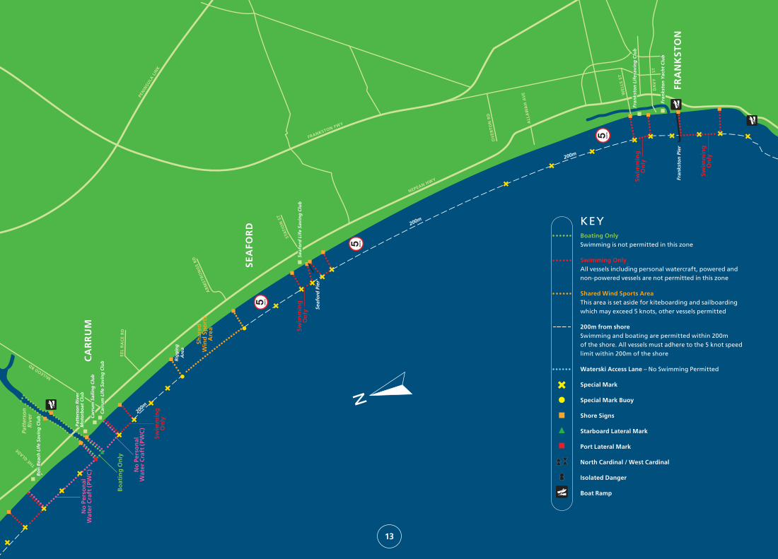
13
Boating Only Swimming is not permitted in this zone
Swimming OnlyAll vessels including personal watercraft, powered and non-powered vessels are not permitted in this zone
Shared Wind Sports AreaThis area is set aside for kiteboarding and sailboarding which may exceed 5 knots, other vessels permitted
200m from shoreSwimming and boating are permitted within 200m of the shore. All vessels must adhere to the 5 knot speed limit within 200m of the shore
Waterski Access Lane – No Swimming Permitted
Special Mark
Special Mark Buoy
Shore Signs
Starboard Lateral Mark
Port Lateral Mark
North Cardinal / West Cardinal
Isolated Danger
Boat Ramp
KEY

CA
RR
UM
Patt
erso
nR
iver
THE GLA
DE
Rig
gin
gA
rea M
orn
ing
ton
Pie
r
Sch
nap
per
Po
int
Lin
ley
Poin
tLi
nle
y Po
int
Mar
ina
Co
veM
arin
a C
ove
Sco
ut
Bea
ch
Mo
rnin
gto
n L
ife
Savi
ng
Clu
bM
orn
ing
ton
Lif
e Sa
vin
g C
lub
Mill
s B
each
Swim
min
gO
nly
Aq
uac
ult
ure
Mt
Mar
tha
Life
Sav
ing
Clu
b
Mt
Mar
tha
Yach
t C
lub
MT
MA
RT
HA
Art
ific
ial R
eef
MT
ELI
ZA
SE
AFO
RD
Seaf
ord
Lif
e Sa
vin
g C
lub
Seaf
ord
Lif
e Sa
vin
g C
lub
STA
TIO
N S
T
FRANKSTON FWY
NEPEAN HWY
MO
RN
ING
TO
N
WIL
SON
S R
D
MA
IN S
T
BEN
TON
S R
D
CR
AIG
IE R
D
WIL
LIA
MS
RD
NEPEAN HWY
200m
200m
Wo
ole
y R
eef
Wes
t C
ard
inal
(Y
BY
)
Dav
eys
Bay
Can
adia
n B
ay
Dav
ey P
oin
t
Ran
elag
h B
each
FRA
NK
ST
ON
Fran
ksto
n Y
ach
t C
lub
Fran
ksto
n Y
ach
t C
lub
Fran
ksto
n L
ifes
avin
g C
lub
Fran
ksto
n L
ifes
avin
g C
lub
Fran
ksto
n P
ier
WE
LLS
ST
DA
VY
ST
200m
Swim
min
gO
nly
Swim
min
gO
nly
Mar
tha
Poin
tM
arth
a Po
int
KILBURN GR
Bal
com
be
Cre
ek
Bal
com
be
Poin
tB
alco
mb
e Po
int
DO
MIN
ION
RD
BA
Y R
D
THE ESPLANADE
200m
AR
MST
RO
NG
S R
D
200m
NEPEAN HWY
EE
L R
AC
E R
D
Shar
edW
ind
Sp
ort
sA
rea
200m
Swim
min
gO
nly
Bo
atin
g O
nly
Bo
n B
each
Lif
e Sa
vin
g C
lub
Bo
n B
each
Lif
e Sa
vin
g C
lub
Car
rum
Lif
e Sa
vin
g C
lub
Car
rum
Lif
e Sa
vin
g C
lub
Car
rum
Sai
ling
Clu
bC
arru
m S
ailin
g C
lub
Patt
erso
n R
iver
Mo
torb
oat
Clu
bPa
tter
son
Riv
erM
oto
rbo
at C
lub
McLEOD RD
No
Per
son
alW
ater
Cra
ft (
PWC
)
200m
200m
PEN
INSU
LA L
INK
Swim
min
gO
nly
No
Per
son
alW
ater
Cra
ft (
PWC
)
Seaf
ord
Pie
r
Wes
t C
ard
inal
(Y
BY
)
CAN
AD
IAN
BA
Y R
D
KU
NY
UN
G R
D
SUN
NY
SID
E R
D
Fish
erm
ans
Bea
chFi
sher
man
s B
each
Swim
min
gO
nly
Swim
min
gO
nly
Swim
min
gO
nly
OV
ER
TO
N R
D
ALL
AW
AH
AV
E
Wes
t C
ard
inal
(Y
BY
)
Carrum to Mt Martha14

CA
RR
UM
Patt
erso
nR
iver
THE GLA
DE
Rig
gin
gA
rea M
orn
ing
ton
Pie
r
Sch
nap
per
Po
int
Lin
ley
Poin
tLi
nle
y Po
int
Mar
ina
Co
veM
arin
a C
ove
Sco
ut
Bea
ch
Mo
rnin
gto
n L
ife
Savi
ng
Clu
bM
orn
ing
ton
Lif
e Sa
vin
g C
lub
Mill
s B
each
Swim
min
gO
nly
Aq
uac
ult
ure
Mt
Mar
tha
Life
Sav
ing
Clu
b
Mt
Mar
tha
Yach
t C
lub
MT
MA
RT
HA
Art
ific
ial R
eef
MT
ELI
ZA
SE
AFO
RD
Seaf
ord
Lif
e Sa
vin
g C
lub
Seaf
ord
Lif
e Sa
vin
g C
lub
STA
TIO
N S
T
FRANKSTON FWY
NEPEAN HWY
MO
RN
ING
TO
N
WIL
SON
S R
D
MA
IN S
T
BEN
TON
S R
D
CR
AIG
IE R
D
WIL
LIA
MS
RD
NEPEAN HWY
200m
200m
Wo
ole
y R
eef
Wes
t C
ard
inal
(Y
BY
)
Dav
eys
Bay
Can
adia
n B
ay
Dav
ey P
oin
t
Ran
elag
h B
each
FRA
NK
ST
ON
Fran
ksto
n Y
ach
t C
lub
Fran
ksto
n Y
ach
t C
lub
Fran
ksto
n L
ifes
avin
g C
lub
Fran
ksto
n L
ifes
avin
g C
lub
Fran
ksto
n P
ier
WE
LLS
ST
DA
VY
ST
200m
Swim
min
gO
nly
Swim
min
gO
nly
Mar
tha
Poin
tM
arth
a Po
int
KILBURN GR
Bal
com
be
Cre
ek
Bal
com
be
Poin
tB
alco
mb
e Po
int
DO
MIN
ION
RD
BA
Y R
D
THE ESPLANADE
200m
AR
MST
RO
NG
S R
D
200m
NEPEAN HWY
EE
L R
AC
E R
D
Shar
edW
ind
Sp
ort
sA
rea
200m
Swim
min
gO
nly
Bo
atin
g O
nly
Bo
n B
each
Lif
e Sa
vin
g C
lub
Bo
n B
each
Lif
e Sa
vin
g C
lub
Car
rum
Lif
e Sa
vin
g C
lub
Car
rum
Lif
e Sa
vin
g C
lub
Car
rum
Sai
ling
Clu
bC
arru
m S
ailin
g C
lub
Patt
erso
n R
iver
Mo
torb
oat
Clu
bPa
tter
son
Riv
erM
oto
rbo
at C
lub
McLEOD RD
No
Per
son
alW
ater
Cra
ft (
PWC
)
200m
200m
PEN
INSU
LA L
INK
Swim
min
gO
nly
No
Per
son
alW
ater
Cra
ft (
PWC
)
Seaf
ord
Pie
r
Wes
t C
ard
inal
(Y
BY
)
CAN
AD
IAN
BA
Y R
D
KU
NY
UN
G R
D
SUN
NY
SID
E R
D
Fish
erm
ans
Bea
chFi
sher
man
s B
each
Swim
min
gO
nly
Swim
min
gO
nly
Swim
min
gO
nly
OV
ER
TO
N R
D
ALL
AW
AH
AV
E
Wes
t C
ard
inal
(Y
BY
)
15
Disclaimer: THIS IS NOT A NAVIGATION CHART. This map is indicative only and not intended for navigational use. For navigation of Port Phillip, Chart AUS 143 should be consulted. Notices to Mariners issued by Parks Victoria are published on www.parks.vic.gov.au

LON
SD ALE
HUGHES
STRINGER
ST JO
HN’S W
OO
D RD
CA
NT
ER
BU
RY
J
ET
TY
MU
RR
AY
FOR
DT
YR
ON
E
CE
NT
RE
DU
ND
AS
WE
RO
ON
A
GO
VE
RN
ME
NT
TRU
EMA
NS
MO
RR
IS
ELI
ZA
BE
TH
BO
NE
O
RD
JET
TY
RD
MA
RSH
ALL
EASTBOURNE ROAD
GUEST
POINT NEPEAN RD
VICTORIA
PICKINGSLINK
BALMORAL
MASON
PIERARTH
UR
McC
ULL
OC
H
BROADWAY
NEPEAN HWY
MO
RNINGTON PENINSULA NATIO
NAL PARK
POINT NEPEAN ROAD
R O S E B U DF O R E S H O R E
Dromana Pier
McCraeYachtClub
Anthony’sNose
RyePier
Martha Cove
Rye Sea Scouts
500m offshore
500m offshore
Martha Point
MORNINGTON
PENIN
SULA
FREEWAY
Rosebud Pier
BlairgowrieSafe HarbourThe Sisters
Dromana Life Saving Club
Rosebud LifeSaving Club
McCRAE
DROMANA
SAFETY BEACH
ROSEBUD
BLAIRGOWRIE
TOOTGAROOKRYE
EasternLight(not in use)
500m
500m
500m
Waterski Access Lane
Version 2 2012
16
Mornington Peninsula
Boating Only Swimming is not permitted in this zone
Swimming OnlyAll vessels including personal watercraft, powered and non-powered vessels are not permitted in this zone
Shared Wind Sports AreaThis area is set aside for kiteboarding and sailboarding which may exceed 5 knots, other vessels permitted
500m from shoreSwimming and boating are permitted within 500m of the shore. All vessels must adhere to the 5 knot speed limit within 500m of the shore (or as marked)
Waterski Access Lane – No Swimming Permitted
Special Mark
Special Mark Buoy
Shore Signs
Starboard Lateral Mark
Port Lateral Mark
Boat Ramp
KEY
Disclaimer: THIS IS NOT A NAVIGATION CHART. This map is indicative only and not intended for navigational use. For navigation of Port Phillip, Chart AUS 143 should be consulted. Notices to Mariners issued by Parks Victoria are published on www.parks.vic.gov.au

50m for Boat Landing
Cowes Jetty
200m 200mErehwon
Point
COWES
CHURCH ST CHURCH ST
SETTLEMENT RDSETTLEMENT RDSETTLEMENT RD
THE ESPLANADE
TH
OM
PS
ON
A
VE
ST
EE
LE
ST
DU
NS
MO
RE
R
D
CO
GH
LAN
R
D
PH
ILLI
P
I
SLA
ND
R
D
JUS
TIC
E
RD
RE
D
RO
CK
S
RD
OS
BO
UR
NE
AV
E
BEACH ST STCHAPEL
CowesGolf Club
DunsmorePark
Saltwater Creek
SILVERLEAVES
VENTNOR
17
Phillip Island Swimming OnlyAll vessels including personal watercraft, powered and non-powered vessels are not permitted in this zone
200m from shoreSwimming and boating are permitted within 200m of the shore. All vessels must adhere to the 5 knot speed limit within 200m of the shore
Special Mark Buoy
Shore Signs
KEY
50m for Boat Landing
Cowes Jetty
200m
COWESCHAPEL
THE ESPLANADE
TH
OM
PS
ON
ST
EE
LE
ST
OS
BO
UR
NE
ST
ErehwonPoint
Disclaimer: THIS IS NOT A NAVIGATION CHART. This map is indicative only and not intended for navigational use. For navigation of Western Port, Chart Aus 150, 151 and 152 should be consulted. Notices to Mariners issued by Parks Victoria are published on www.parks.vic.gov.au

Victoria is lucky enough to be home to some of the world’s most spectacular bays and waterways. In particular, Port Phillip and Western Port hold some of the most unique and interesting marine plants and animals which are often found no where else in the world.
Parks Victoria is the local port and waterway manager for Port Phillip, Western Port, Yarra and Maribyrnong Rivers. Parks Victoria’s role includes:
• Facilitating more than 50 million bays and river visits.
• Overseeing commercial activities such as berthing and mooring.
• Managing more than $300 million worth of maritime infrastructure including piers, jetties and navigation aids.
• Looking after Victoria’s precious Marine National Parks and Sanctuaries.
• Coordinating hundreds of marine and river based events per year.
• Assisting other government agencies with emergency response on the bays and waterways.
For more information call 13 1963 or visit www.parks.vic.gov.au


