
Benefit-Cost Ratios of Certain Corps of Engineers
Flood Risk Management Projects
Project Name City/State State Project Description Date (1) BCR (2)
Dillingham Snag Point Dilingham, AK AK Bank control erosion '1997N/A
Homer Spit Homer, AK AK Rock revetment 1994/1998N/A
Navigation Improvements, Diomede, AK Little Diomede,
AKAK
Breakwater
8/10/2015 0.2
False Pass Harbor, Alaska False Pass, AK AK
Construction of two breakwaters
12/29/2000 1.2
Haines, AK Haines, AK AK
Breakwater construction
12/20/2004 1.2
Craig, AK, Navigation Improvements Project Craig, AK AK
Breakwater
3/16/2016 1.2
Unalaska Harbor, Alaska Unalaska, AK AKConstruction of three breakwaters
12/22/2004 1.3
Port Lions, AK Port Lions, AK AKBreakwater construction
6/14/2006 1.4
May Branch, Fort Smith, AR Fort Smith, AR AR
A new channel to convey flood waters
12/19/2006 1.1
Rio de Flag, Flagstaff, Arizona Flagstaff, AZ AZ
Channel modifications, construction of a
detention basin, modification of river crossings,
and construction of berms and floodwalls
12/29/2000 1.3
Tres Rios, Arizona Phoeniz, AZAZ
Environental restoration and a flood control levee 12/12/20002.2
Tanque Verde Creek, Pima County, AZ Tucson, AZAZ
Bank erosion control and riparian habitat 7/22/20032.4
Santa Cruz River, Paseo de las Iglesias, AZ Paseo de las
Iglesias, AZAZ
Water harvesting basins,
modification of channel banks, revegetation, and
an irrigation system
3/28/2006
N/A
Copyright 2018 Warwick Group Consultants LLC
which paid is solely responsible for its contents 1 of 21 IMPORTANT: See Notes on last page

Benefit-Cost Ratios of Certain Corps of Engineers
Flood Risk Management Projects
Project Name City/State State Project Description Date (1) BCR (2)
Salt River (Rio Salado Oeste), Maricopa
County, AZ
Phoenix, AZ
AZ
Grade control structures,
vegetation, storm water outfall modification, water
supply and distribution system, invasive species
removal, and multi-use recreation features.
12/19/2006
N/A
Salt River (Va Shly'ay Akimel), Maricopa
County, AZ
Mesa, AZ
AZ
Channel modification; new
drainage channels, irrigation diversions and
pipelines, and/or spillways; groundwater well;
grade control structure; and passive recreation
1/3/2005
N/A
Channel Islands Harbor Oxnard, CA
CA
Navigational maintenance dredging 1959
1.2
Ventura - Pierpont Area Ventura, CA
CA
Beach nourishment and groin construction 1962
2.2
Surfside-Sunset Orange County,
CA
CA
Beach nourishment and groin construction 1964
3.3
Coast of California, Point Mugu to San Pedro Los Angeles
County, CA
CA
Beach widening, groin construction, storm drainage
structures extension, and breakwater rehabilitation
1968
4.3
Oceanside Oceanside, CA
CA
Beach nourishment and groin extension 1961
2.2
Santa Barbara Streams, Lower Mission
Creek, California
Santa Barbara,
CACA
Channel improvements,
replacement of bridges, an overflow culvert,
construction of vertical walls and riprap sideslope,
and vegetation
12/29/2000 1.2
Copyright 2018 Warwick Group Consultants LLC
which paid is solely responsible for its contents 2 of 21 IMPORTANT: See Notes on last page

Benefit-Cost Ratios of Certain Corps of Engineers
Flood Risk Management Projects
Project Name City/State State Project Description Date (1) BCR (2)
Whitewater River Basin, CaliforniaThousand Palms,
CACA
Levees
12/29/2000 1.3
Orestimba Creek, West Stanislaus County,
CANewman, CA CA
Levee
9/25/2013 1.4
San Clemente Shoreline, Orange County,
CA
San Clemente,
CACA
Beach fill and berm4/15/2012 1.4
Encinitas - Solana Beach Shoreline Coastal
Storm Damage Reduction, San Diego
County, CA
Encinitas and
Solana, CACA
Beach fill and berm
4/26/2016 1.4
Silver Strand Shoreline, Imperial Beach, CA
(not constructed)
Imperial Beach,
CACA
Beach nourishment
12/30/2003 1.7
Hamilton City, Glenn County, CA Hamilton City, CA CA
Setback levee to reconnect the river with its
historic
floodplain12/22/2004 1.8
Sutter Basin, CA Yuba City, CA CA
Strengthening existing levee
3/12/2014 2.6
West Sacramento General Reevaluation
Report, CA
West
Sacramento, CACA
Cutoff walls, rock bank protection, cutoff walls,
slope stabilization, sheet pile wall, setback levee,
seepage berms, and relief wells 4/26/2016 3.2
American River Common Features General
Reevaluation Report, CASacramento, CA CA
Slurry cutoff walls, rock bank
protection, slope stabilization, levee raising and
extension, and weir and bypass modification 4/26/2016 4.6
Los Angeles Harbor, California Los Angeles, CA CA
Deepening the existing navigation channels
12/29/2000 4.7
American River Watershed (Common
Features) Project, Natomas Basin,
Sacramento and Sutter Counties, CA
Sacramento, CA CA
Levee widening, installation
of cutoff walls and seepage berms, and bridge
remediation12/30/2010 6.0
South San Francisco Bay Shoreline, Santa
Clara County, CAAlviso, CA CA
Levee, tidal marsh habitat restoration
12/18/2015 9.6
Copyright 2018 Warwick Group Consultants LLC
which paid is solely responsible for its contents 3 of 21 IMPORTANT: See Notes on last page
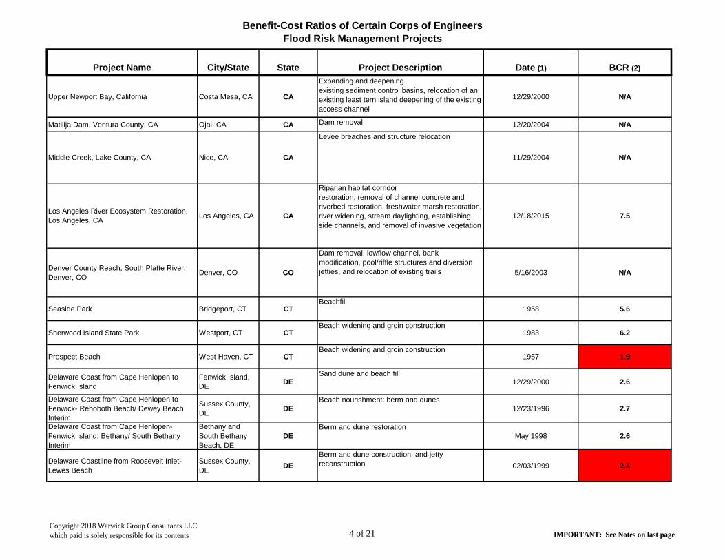
Benefit-Cost Ratios of Certain Corps of Engineers
Flood Risk Management Projects
Project Name City/State State Project Description Date (1) BCR (2)
Upper Newport Bay, California Costa Mesa, CA CA
Expanding and deepening
existing sediment control basins, relocation of an
existing least tern island deepening of the existing
access channel
12/29/2000 N/A
Matilija Dam, Ventura County, CA Ojai, CA CA Dam removal 12/20/2004 N/A
Middle Creek, Lake County, CA Nice, CA CA
Levee breaches and structure relocation
11/29/2004 N/A
Los Angeles River Ecosystem Restoration,
Los Angeles, CALos Angeles, CA CA
Riparian habitat corridor
restoration, removal of channel concrete and
riverbed restoration, freshwater marsh restoration,
river widening, stream daylighting, establishing
side channels, and removal of invasive vegetation
12/18/2015 7.5
Denver County Reach, South Platte River,
Denver, CODenver, CO CO
Dam removal, lowflow channel, bank
modification, pool/riffle structures and diversion
jetties, and relocation of existing trails 5/16/2003 N/A
Seaside Park Bridgeport, CT CTBeachfill
1958 5.6
Sherwood Island State Park Westport, CT CTBeach widening and groin construction
1983 6.2
Prospect Beach West Haven, CT CTBeach widening and groin construction
1957 1.9
Delaware Coast from Cape Henlopen to
Fenwick Island
Fenwick Island,
DEDE
Sand dune and beach fill12/29/2000 2.6
Delaware Coast from Cape Henlopen to
Fenwick- Rehoboth Beach/ Dewey Beach
Interim
Sussex County,
DEDE
Beach nourishment: berm and dunes
12/23/1996 2.7
Delaware Coast from Cape Henlopen-
Fenwick Island: Bethany/ South Bethany
Interim
Bethany and
South Bethany
Beach, DE
DE
Berm and dune restoration
May 1998 2.6
Delaware Coastline from Roosevelt Inlet-
Lewes Beach
Sussex County,
DEDE
Berm and dune construction, and jetty
reconstruction 02/03/1999 2.4
Copyright 2018 Warwick Group Consultants LLC
which paid is solely responsible for its contents 4 of 21 IMPORTANT: See Notes on last page

Benefit-Cost Ratios of Certain Corps of Engineers
Flood Risk Management Projects
Project Name City/State State Project Description Date (1) BCR (2)
Delaware Coast Protection: Sand Bypass
Plant, Indian River Inlet
Indian River Inlet,
Sussex County,
DE
DE
Construction of sand bypassing plant for periodic
renourishment of a feeder beach 1990 22.7
Broadkill Beach
Broadkill Beach,
Sussex County,
DE
DE
Beach nourishment: berm and dunes
08/17/1998 3.6
Port MahonDelaware Bay,
Kent County, DEDE
Beach nourishment and ecosystem restoration
(for horseshoe crab and shorebird habitat), raising
State Road 89 and placing riprap along 1,200 ft of
road to protect wetlands, and wetland restoration 09/28/1998 N/A
Duval County Shore Protection Project Duval County, FL FLBeach renourishment and dune construction
1978 1.6
St. Johns CountySt. John's
County, FlFL
Berm extension, dune maintenance, and beach
nourishment 08/08/2017 1.9
Fort Pierce Fort Pierce, FL FLBeach nourishment
1971 2.5
Brevard County - Cape CanaveralCape Canaveral,
FLFL
Beach nourishment1975 1.7
Brevard County - North ReachBrevard County,
FLFL
Beach nourishment2001 1.9
Brevard County - Indialantic/Melbourne Melbourne, FL FL
Beach nourishment, artificial reef construction
1981 3.4
Martin CountyHutchinson
Island, FlFL
Beach nourishment, dune construction. 1996 5.0
Palm Beach County - Jupiter/CarlinPalm Beach
County, FLFL
Beach nourishment, dune restoration1995 2.2
Palm Beach County -Lake Worth Inlet to
South Lake Worth Inlet
Palm Beach
Harbor, FLFL
Navigational dredging and maximizing beneficial
use of sediment1958 1.6
Palm Beach County - Ocean Ridge Ocean Ridge, FL FLBeach renourishment, dune maintenance
1998 2.3
Copyright 2018 Warwick Group Consultants LLC
which paid is solely responsible for its contents 5 of 21 IMPORTANT: See Notes on last page

Benefit-Cost Ratios of Certain Corps of Engineers
Flood Risk Management Projects
Project Name City/State State Project Description Date (1) BCR (2)
Palm Beach County - Delray Beach Segment Delray, FL FLBeach renourishment
1973 2.7
Palm Beach County - Boca Raton Segment Boca Raton, FL FLBeach renourishment, inlet dredging.
1988 2.0
Broward County -Segment 3
Port Eveglades
South Jetty-
Miami Dade
FL
Beach nourishment
1978 2.5
Broward County - Segment 2
Hillsboro Inlet-
Port Everglades
Inlet
FL
Beach nourishment
1970 3.2
Broward County - Segment 1 (not
constructed)
North County
Line- Hillsboro
Inlet
FL
Beach nourishment
1970 3.7
Dade County Dade County, FL FLBeach nourishment
1975 3.7
Lee County - Captiva SegmentCaptiva Island,
FLFL
Beach nourishment1989 1.6
Manatee County
Anna Maria
Island/ entrance
to Tampa Harbor
FL
Beach nourishment
1993 2.3
Pinellas County - Treasure Island SegmentTreasure Island,
FLFL
Beach nourishment1969 1.6
Pinellas County - Long Key Segment Long Key, FL FLBeach nourishment
1980 2.0
Pinellas County - Sand Key Segment Sand Key FLBeach nourishment
1993 3.6
Sarasota County - Venice Segment Venice, FL FLBeach nourishment
1993 N/A
Sarasota County - Lido Key (not yet
constructed)Sarasota, FL FL
Beach nourishment and revetment1999 N/A
Panama City Beaches Storm Damage
Reduction ProjectPanama City, FL FL
Beach nourishment1997 2.8
Miami Harbor, Miami-Dade County, FL Miami, FL FL
Deepening and widening the existing federal
navigation
channel4/25/2005 1.4
Copyright 2018 Warwick Group Consultants LLC
which paid is solely responsible for its contents 6 of 21 IMPORTANT: See Notes on last page

Benefit-Cost Ratios of Certain Corps of Engineers
Flood Risk Management Projects
Project Name City/State State Project Description Date (1) BCR (2)
Jacksonville Harbor Mile Point Navigation
Study, Duval County, FLJacksonville, FL FL
Relocate/reconfigure the existing training wall4/30/2012 1.4
Port Sutton, Florida Tampa, FL FLDeepening and widening the existing non-federal
channel 12/29/2000 1.6
Walton County, FL, Hurricane and Storm
Damage Reduction (not yet constructed)
Walton County,
FLFL
Beach nourishment
7/16/2013 1.6
Flagler County, FL, Hurricane and Storm
Damage Reduction ProjectFlagler Beach, FL FL
Beach nourishment
12/23/2014 1.9
Canaveral Harbor Section 203 (WRDA 1986)
Navigation Study, Brevard County, FL
Cape Canaveral,
FLFL
Modification of the existing navigation project
2/25/2013 2.0
Lake Worth Inlet, Palm Beach Harbor,
Navigation Improvements Project, Palm
Beach County, FL
West Palm
Beach, FLFL
Modification of the existing navigation project
4/16/2014 2.0
Jacksonville Harbor Navigation Study Final
Integrated General Reevaluation Report II
and Supplemental Environmental Impact
Statement, Duval County, FL
Jacksonville, FL FL
Modification of the existing navigation project
4/16/2014 2.7
Port Everglades Navigation Improvements
Project, Broward County, FL
Fort Lauderdale,
FLFL
Modification of the existing federal navigation
channel
6/25/2015 2.9
Central and Southern Florida, Indian River
Lagoon-SouthStuart, FL FL
Reservoirs, stormwater
treatment areas, natural storage and treatment
areas and floodplain restoration, diversion, and
muck removal and habitat Improvement 8/6/2004 N/A
Copyright 2018 Warwick Group Consultants LLC
which paid is solely responsible for its contents 7 of 21 IMPORTANT: See Notes on last page

Benefit-Cost Ratios of Certain Corps of Engineers
Flood Risk Management Projects
Project Name City/State State Project Description Date (1) BCR (2)
Comprehensive Everglades Restoration
Plan, Picayune Strand Restoration Project,
Collier County, FL
Naples, FL FL
Spreader channels and pump stations, degrade
roads and fill ditches, canal plugs, flood protection
levees, and culverts 9/15/2005 N/A
Comprehensive Everglades Restoration
Plan, Central and Southern Florida, Site 1
Impoundment Project, Palm Beach County,
FL
West Boca
Raton, FLFL
Impoundment structure with
an inflow pump station, discharge gated culvert,
spillways, and a seepage canal 12/19/2006 N/A
Comprehensive Everglades Restoration
Plan, Central and Southern Florida,
Caloosahatchee River (C-43) West Basin
Storage Reservoir Project, Hendry County,
FL
Hendry County,
FLFL
Storage reservoir
1/6/2011 N/A
C-111 Spreader Canal Western Project,
Comprehensive Everglades Restoration
Plan, Central and Southern Florida Project,
Miami-Dade County, FL
Miami, FL FL
Creation of a hydraulic ridge
1/30/2012 N/A
Central Everglades Planning ProjectEveglades
National Park, FLFL
Increasing storage, treatment, and conveyance of
water south of Lake Okeechobee, removal of
canals and levees, retaining and diverting water
flows 12//23/2014 1.6 (recreation )
Biscayne Bay Coastal Wetlands Phase I
Project, Comprehensive Everglades
Restoration Plan, Central and Southern
Florida Project, Miami-Dade County, FL
Miami, FL FL
Redirection of freshwater to coastal wetlands
5/2/2012 N/A
Broward County Water Preserve Areas
Project, Comprehensive Everglades
Restoration Plan, Central and Southern
Florida Project, Broward and Miami-Dade
Counties, FL
Miami, FL FL
Features to capture and store excess surface
water runoff
5/21/2012 N/A
Savannah Harbor Expansion Project, GA and
SCSavannah, GA GA and SC
Modification of the existing navigation project8/17/2002 5.5
Tybee Island Tybee Island, GA GA Beach nourishment, seawall and groin
construction 1975/2000 5.7
Copyright 2018 Warwick Group Consultants LLC
which paid is solely responsible for its contents 8 of 21 IMPORTANT: See Notes on last page

Benefit-Cost Ratios of Certain Corps of Engineers
Flood Risk Management Projects
Project Name City/State State Project Description Date (1) BCR (2)
Cedar River, Cedar Rapids, IA Cedar Rapids, IA IA
Floodwall, levee, closure structures, and pumping
stations 1/27/2011 1.2
Des Moines and Raccoon Rivers, Des
Moines, IADes Moines, IA IA
Levee and retaining wall and modification of
pump stations 3/28/2006 2.7
Casino Beach Chicago, IL IL
Jetty repair
1995 N/A
Upper Des Plaines River and Tributaries, IL
and WIRiverside, IL IL
Levees, floodwalls, floodwater storage reservoirs,
elevating structures, dry flood- proofing, filling
basements in combination
with dry flood-proofing, wet flood proofing,
constructing engineered low-level ring levees,
evacuating portions of floodplains, and stream
restoration
6/8/2015 1.8
Wood River Levee System Reconstruction,
Madison County, ILWood River, IL IL
Replacement of existing relief wells and
installation of new relief wells 7/18/2006 3.1
East St. Louis and Vicinity, IL St. Louis, IL IL
Restoration of bottomland
forest habitat, prairie wetland habitat, marsh and
shrub swamp habitat, lake habitat, and riparian
forest; stream restoration; and earthen
embankments
12/22/2004 N/A
Peoria Riverfront Development, IL Peoria, IL IL
Aquatic and island habitat
creation by dredging and dredged material
management 7/28/2003 N/A
Chicago Shoreline Project Chicago, IL IL
Park expansion and revetment replacement
1999 N/A
Indiana ShorelineLake Michigan
shorelineIN
Erosion Control
1966 1.7
Upper Turkey Creek Basin Flood Risk
Management Study, Merriam, KSMerriam, KS KS
Levee, floodwalls, bridge
modification, stormwater detention pond 12/22/2015 2.1
Copyright 2018 Warwick Group Consultants LLC
which paid is solely responsible for its contents 9 of 21 IMPORTANT: See Notes on last page

Benefit-Cost Ratios of Certain Corps of Engineers
Flood Risk Management Projects
Project Name City/State State Project Description Date (1) BCR (2)
City of Manhattan, KS Flood Risk
Management StudyManhattan, KS KS
Levee raising, under seepage control measures
including relief wells and control berms,and
drainage structure replacement 4/30/2015 3.5
Topeka Flood Risk Management Project,
Topeka, KSTopeka, KS KS
Levee modifications8/24/2009 13.2
John Myers Lock And Dam, Indiana And
KentuckyUniontown, KY KY
Lock modifcations for improved navigation
efficiency and reliability12/29/2000 1.8
Greenup Lock And Dam, Kentucky And Ohio Greenup, KY KY
Lock modifcations for improved navigation
efficiency and reliability 12/29/2000 2.5
Licking River Basin, Cynthiana, KY Cynthiana, KY KYDry bed detention basins
10/24/2006 3.1
Ohio River Shoreline, Paducah, KY
ReconstructionPaducha, KY KY
Reconstruction of
deteriorated mechanical, electrical, and structural
components and construction of a pumping plant 5/16/2012 4.6
Grand Isle and Vicinity Grand Isle, LA LA
Dune maintenance, jetty construction, and an offshore
breakwater system.
1985 1.5
Green River Locks and Dams 3, 4, 5 and 6
and Barren River Lock and Dam 1, KY (this
project is not yet authorized for construction)
Bowling Green,
KYKY
Disposition of locks and dams
4/30/2015 N/A
Calcasieu Lock, LA, Modifications for
Navigation ImprovementLake Charles, LA LA
Sluice gate structure and bypass channel12/2/2014 1.2
Morganza to the Gulf of Mexico, LATerrebonne
Parish, LALA
Modification of the existing
hurricane and storm damage risk reduction
project as a result of applying design and
modeling standards developed subsequent to
Hurricane Katrina
7/8/2013 1.4
Morganza, LA, to the Gulf of Mexico,
Mississippi River and TributariesMorganza, LA LA
Modification and construction of levees,
floodgates, a lock structure, pump stations,
culverts, marsh habitat, and a canal 7/22/2003 1.7
Copyright 2018 Warwick Group Consultants LLC
which paid is solely responsible for its contents 10 of 21 IMPORTANT: See Notes on last page

Benefit-Cost Ratios of Certain Corps of Engineers
Flood Risk Management Projects
Project Name City/State State Project Description Date (1) BCR (2)
Port of Iberia, LA Iberia, LA LAModification of the existing navigation channel
12/31/2006 2.2
West Shore Lake Pontchartrain, LA,
Hurricane and Storm Damage Risk
Reduction Study
St. Charles, St.
John the Baptist,
and St. James
Parishes, LA
LA
Levees, floodwalls,
floodgates, a drainage canal, flood-side ditch,
drainage structures, pump stations, berms, flap
gates to existing culverts, and elevation of
residential structures
6/12/2015 2.9
Southwest Coastal Louisiana
Cameron,
Calcasieu, and
Vermilion
Parishes, LA
LA
Raising residential structures, flood-proofing non-
residential structures, earthen berms, tidal
wetland restoration, shoreline erosion protection,
and revegetation 7/29/2016 5.6
Bayou Sorrel Lock, LA Bayou Sorrel, LA LAA new lock and two approach channels
1/3/2005 19.2
Louisiana Coastal Area, LA, Ecosystem
Restoration, Six Projects Authorized by
Section 7006(e)(3) of Water Resources
Development Act of 2007
Coastal LA LA
Diversion canal modification; water conveyence;
multipurpose lock operation; a new diversion
canal; and barrier shoreline restoration 12/30/2010 N/A
Louisiana Coastal Area (LCA), Barataria
Basin Barrier Shoreline Restoration Project,
Lafourche, Jefferson, and Plaquemines
Parishes, LA
New Orleans, LA LA
Dune and marsh restoration
6/22/2012 N/A
Revere Beach Revere, MA MA
Beach nourishment
1996 1.6
Quincy Shore Beach Quincy, MA MA
Beach nourishment
1950 2.1
Winthrop Beach Winthrop, MA MA
Beach nourishment
1956 1
Boston Harbor Navigation Improvement
Project, MABoston, MA MA
Modification of the existing navigation project9/30/2013 7.2
Atlantic Coast of Maryland, Ocean City Ocean City, MD MDBeach nourishment, bulkhead, and dune
1990 1.5
Smith Island, Somerset County, MD Smith Island, MD MDBreakwaters
10/29/2001 N/A
Copyright 2018 Warwick Group Consultants LLC
which paid is solely responsible for its contents 11 of 21 IMPORTANT: See Notes on last page

Benefit-Cost Ratios of Certain Corps of Engineers
Flood Risk Management Projects
Project Name City/State State Project Description Date (1) BCR (2)
Mid-Chesapeake Bay Island Ecosystem
Restoration Project, Chesapeake Bay,
Dorchester County, MD
James and
Barren Islands,
MD
MD
Beneficial use of dredged
material to restore wetland and upland remote
island habitat. 8/24/2009 N/A
Assateague Island Restoration Assateague
Island, MDMD
Beach nourishment, sand bypassing
1998 N/A
Roseau River, Roseau, MN Roseau, MN MN
Diversion channel, levees, a
flow restriction structure, an inlet control structure,
highway bridges and a railroad bridge 12/19/2006 3.0
Minnesota River, Marsh Lake Ecosystem
Restoration Project, MNAppleton, MN MN
River realignment to its
historic channel; dam modification for fish
passage; construction of a drawdown water
control structure; gated culverts; and dike
breaching
12/30/2011 N/A
Swope Park Industrial Area, Blue River,
Kansas City, MOKansas City, MO MO
Floodwall, earthen levee, and an interior drainage
system 12/30/2003 1.5
Monarch-Chesterfield, Missouri Chesterfield, MO MO
Levee raising; seepage control structures,
including relief wells; a sheet pile cutoff; and
seepage berms 12/29/2000 2
Jordan Creek Flood Risk Management
Study, Springfield MOSpringfield, MO MO
Regional detention basins and channel widening
8/26/2013 2.7
Armourdale and Central Industrial District
Levee Units, Missouri River and Tributaries
at Kansas Citys, MO and KS
Kansas Citys,
MO
& KS
MO & KS
Increasing the height of existing levees and
floodwalls1/27/2015 3.4
Argentine, East Bottoms, Fairfax-Jersey
Creek, and North Kansas City Levee Units,
Missouri River and Tributaries at Kansas
Cities, MO and KS
Kansas Cities,
MO & KSMO & KS
Levee and flood wall raises, sheetpile walls,
modification of drainage structures, replacement
or modification of pump stations, and pressure
relief wells12/19/2006 7.9
Copyright 2018 Warwick Group Consultants LLC
which paid is solely responsible for its contents 12 of 21 IMPORTANT: See Notes on last page

Benefit-Cost Ratios of Certain Corps of Engineers
Flood Risk Management Projects
Project Name City/State State Project Description Date (1) BCR (2)
Harrison CountyGulfport Harbor:
Gulfport, MSMS
Channel dredging
1952 N/A
Mississippi Coastal Improvements Program,
Hancock, Harrison, and Jackson Counties,
MS, Comprehensive Plan Report
Hancock,
Harrison, and
Jackson
Counties, MS
MS
Barrier island restoration,
beach front protection, wetland restoration, and
floodplain evacuation 9/15/2009 N/A
Fort Macon Atlantic Beach, NC NC
Beach nourishment, sand dune and jetty
maintenance. 1961 2.5
Wrightsville BeachWrightsville Beach,
NCNC
Dune and berm construction
1965 2.9
Princeville, NC, Flood Risk Management
StudyPrinceville, NC NC
Levee, flap gates on culverts, and road raising2/23/2016 0.5
Dare County Beaches, North Carolina
Kitty Hawk, Kill
Devil Hills, &
Nags Head, NC
NCSand fill dune and berm
12/29/2000 1.9
Carolina Beach and VicinityNew Hanover
County, NCNC
Dune/ berm construction and rock
revetment1965 2.5
Kure Beach Kure Beach, NC NCBeach nourishment
1996 1.8
Fort FisherNew Hanover
County, NCNC
Rock revetment and beach nourishment1980 3.3
Bogue Banks, Carteret County Bogue Banks, NC NC
Dune and beach fill
12/23/2014 2.5
Ocean Isle, Brunswick County BeachesOcean Isle
Beach, NCNC
Beach nourishment, groin construction2001 1.6
West Onslow Beach and New River Inlet
(Topsail Beach), NC
Topsail Beach,
NCNC
Dune and berm
9/28/2009 3.0
Surf City and North Topsail Beach, NC
Coastal Storm Damage Reduction Report
Surf City and
North Topsail
Beach, NC
NC
Dune and berm
12/30/2010 3.7
Copyright 2018 Warwick Group Consultants LLC
which paid is solely responsible for its contents 13 of 21 IMPORTANT: See Notes on last page

Benefit-Cost Ratios of Certain Corps of Engineers
Flood Risk Management Projects
Project Name City/State State Project Description Date (1) BCR (2)
Neuse River Basin, Ecosystem Restoration
Project, NCDurham, NC NC
Rock sills, regrading, modification of a low-head
dam for fish passage, and creation of oyster reef 4/23/2013 N/A
Fargo-Moorhead Metropolitan Area Flood
Risk Management Project, ND and MNFargo, ND ND
Diversion channel
12/19/2011 1.8
Western Sarpy and Clear Creek, Nebraska
Saunders &
Sarpy Counties,
NE
NE
Improvement of existing non- federal levees, new
levees, ring levee, a levee/weir, and structure
elevation 12/29/2000 1.1
Antelope Creek, Lincoln, Nebraska Lincoln, NE NE
Channel improvements, labyrinth weir control
structure, bridge replacements, bridge
modification, new bridges, railroad bridge
modification, and recreation trails 12/29/2000 1.3
Sand Creek Watershed, Wahoo, Nebraska Wahoo, NE NE
Lake creation and wetland restoration
12/29/2000 N/A
Hampton BeachHampton Beach,
NHNH
Beach nourishment
1966 1.7
Wallis Sands State Beach Rye, NH NH
Beach nourishment
1983 0.9
Raritan Bay and Sandy Hook Bay, Madison
and Matawan Townships
Madison and
Matawan, NJNJ
Beach nourishment, tieback levee, and interior
drainage facilities for Madison, beach
nourishment for Matawan1965 1.9
Raritan Bay and Sandy Hook Bay,
Keansburg & E. Keansburg
Keansburg and
E. Keansburg, NJNJ
Beach nourishment, tieback levees, interior
drainage structures, and three groins1968 1.7
Raritan Bay and Sandy Hook Bay, Port
Monmouth, New Jersey
Port Monmouth,
NJNJ
Levees, floodwalls, closure structures, interior
drainage structures, and a dune and beach fill
12/29/2000 1.1
Copyright 2018 Warwick Group Consultants LLC
which paid is solely responsible for its contents 14 of 21 IMPORTANT: See Notes on last page

Benefit-Cost Ratios of Certain Corps of Engineers
Flood Risk Management Projects
Project Name City/State State Project Description Date (1) BCR (2)
New York and New Jersey Harbor Navigation
Study
New York, NY
and Newark, NJNJ/NY
Modification of the existing New York and New
Jersey Harbor anchorages and channels.
5/2/2000 1.6
New Jersey Shore Protection Study,
Barnegat Inlet to Little Egg Inlet (Long Beach
Island), New Jersey, Interim
Long Beach
Island, NJNJ
Sand dune and beach berm construction
7/26/2000 1.6
Raritan Bay and Sandy Hook Bay, Union
Beach, NJUnion Beach, NJ NJ
Levees, floodwalls, road raising, relocations, and
closure structures, sector gates and pump
stations, and a dune and beachfill1/4/2006 1.9
Sandy Hook to Barnegat Inlet (Asbury Park
to Manasquan)
Monmouth
County, NJNJ
Beach nourishment
1997 1.6
Sandy Hook to Barnegat Inlet (Sea Bright to
Ocean Township
Monmouth
County, NJNJ
Beach nourishment
1959 1.6
New Jersey Shore Protection Study,
Manasquan Inlet to Barnegat Inlet
Ocean County,
NJNJ
Dune and berm
12/30/2003 1.5
New Jersey Shore Protection, Lower Cape
May Meadows- Cape May Point
Cape May
County, NJNJ
Beach nourishment, restore wetlands
2007 N/A
South River, Raritan River Basin, NJMiddlesex
County, NJNJ
A levee and floodwall system with an upstream
storm surge barrier and wetland restoration
7/22/2003 2.2
New Jersey Shore Protection, Hereford Inlet
to Cape May Inlet, NJCape May, NJ NJ
Dune and berm1/23/2015 1.9
Great Egg Harbor Inlet to Towsends/Ludlam
BeachStrathmere, NJ NJ
Dune and Berm2006 1.8
Copyright 2018 Warwick Group Consultants LLC
which paid is solely responsible for its contents 15 of 21 IMPORTANT: See Notes on last page

Benefit-Cost Ratios of Certain Corps of Engineers
Flood Risk Management Projects
Project Name City/State State Project Description Date (1) BCR (2)
Hudson Raritan Estuary, NJ, Liberty State
ParkJersey City, NJ NJ
Salt marsh and tidal creek,
upland berm, freshwater wetlands, and buffer
construction8/25/2006 N/A
Oakwood Beach
Elsinborough
Township, Salem
County
NJ
Dune and berm
12/06/1999 1.8
Villas and VicinityCape May
County, NJNJ
Beach nourishment and ecosystem restoration
4/21/1999 N/A
Reeds Beach - Pierces PointCape May
County, NJNJ
Beach nourishment and ecosystem restoration
8/13/1999 N/A
Great Egg Harbor Inlet and Peck Beach
Cape May and
Atlantic Counties,
NJ
NJ
Beach nourishment, inlet dredging, drain pipe
extension 1992 6.6
Cape May Inlet to Lower Township Cape May County NJ
Beach nourishment, storm water outfalls extension,
groin construction and reconstruction, and shoreline
monitoring program
1989 3.5
Brigantine Inlet to Great Egg Inlet (Absecon
Island) Atlantic City area
Atlantic County,
NJNJ
Berm, dunes, and bulkhead construction
2004 2.8
New Jersey Shore Protection - Townsends
Inlet to Cape May InletCape May County NJ
Beach berm, seawall construction, ecosystem
restoration2002 2.5
Southwest Valley, Bernalillo County, NM Albuquerque, NM NM
Widening existing drains, providing a gravity
outfall,
and wetland enhancement11/29/2004 1.4
Copyright 2018 Warwick Group Consultants LLC
which paid is solely responsible for its contents 16 of 21 IMPORTANT: See Notes on last page

Benefit-Cost Ratios of Certain Corps of Engineers
Flood Risk Management Projects
Project Name City/State State Project Description Date (1) BCR (2)
Truckee Meadows, NV Reno, NV NV
Floodwalls, levees, floodplain terracing, and
basic recreation features 4/11/2014 2.2
Hamlin Beach State Park Hamlin, NY NYBreakwater
1974 1.9
Rockaway Inlet to Norton Point (Coney
Island)
Queens and
Brooklyn, NYNY
Berm, terminal groin, and extension of existing
outfalls. 1994 1.9
E. Rockaway Inlet to Rockaway Inlet and
Jamaica BayQueens, NY NY
Beach nourishment, seawall and groin construction
1975 2.7
Atlantic Coast of Long Island to Fire Island
and Shore Westerly to Jones InletLong Island, NY NY
Dredging and sand dike construction
1974 1.9
Montauk Point, NYMontauk Point,
NYNY
Revetment3/31/2006 1.9
Fire Island Inlet to Montauk Point
(Westhampton Interim)Long Island, NY NY
Beach nourishment and widening, dune elevation,
grass planting on dunes, and construction of
interior drainage structures1996 2.6
Fire Island Inlet to Montauk Point (Moriches
to Shinnecock Reach)Long Island, NY NY
Beach nourishment, dune elevation, and groin
construction 1965 1.7
Fire Island Inlet to Montauk Point,
Southampton to Beach HamptonLong Island, NY NY
Groin construction and beach nourishment1965 2.5
Lakeview Park Cooperative Lorain, OH OHBeach renourishment
1977 2.9
Reno Beach Reno Beach, OH OHDike repair
1966 3.1
Point Place Toledo, OH OH
Levee rehab, dike construction, seawall
construction 1977 1.2
Maumee Bay Maumee, OH OHBeach nourishment, breakwaters, revetment
1991 2.4
Hocking River Basin, OH Monday Creek Sub-
basin
Monday Creek,
OHOH
Open limestone channels,
low head dams, limestone leach beds, slag leach
beds, aerobic wetlands and limestone dispensers 8/25/2006 N/A
Copyright 2018 Warwick Group Consultants LLC
which paid is solely responsible for its contents 17 of 21 IMPORTANT: See Notes on last page

Benefit-Cost Ratios of Certain Corps of Engineers
Flood Risk Management Projects
Project Name City/State State Project Description Date (1) BCR (2)
Willamette River Floodplain Restoration
Project, Lower Coast Fork and
Middle Fork, OR
Eugene, OR OR
Excavation of connection
channels, restoration of gravel-mined ponds,
installation of large wood and engineered logjams,
removal of invasive plant species, revegetation,
and installation of culverts1/6/2014 N/A
Lower Willamette River Environmental
Dredging and Ecosystem Restoration
Project, OR
Portland, OR OR
Stream restoration, riparian revegetation, invasive
species removal, floodplain reconnection, off-
channel habitat development, and fish barrier
removal12/14/2015 N/A
Presque Isle Erie, PA PA
Beach nourishment and breakwater
1956 1.3
Town of Bloomsburg, Columbia County, PA Bloomsburg, PA PA
Levee, floodwalls, drainage structures, road
raises, and closure structures 1/25/2006 1.4
Upper Ohio Navigation Study, PA
Allegheny and
Beaver Counties,
PA
PA
New lock chambers
9/12/2016 3.7
Cliff Walk Newport, RI RI
Beach nourishment, dumped riprap, stone
mounds, slope revetment, breakwaters, toe wall,
seawalls and parapet walls1950 2.1
Myrtle Beach Myrtle Beach, SC SC
Beach nourishment
1990 7.1
Folly Beach Folly Beach, SC SC
Berm, groin rehab
1993 1.6
Pawleys Island, SC (not constructed)Pawleys Island,
SCSC
Dune and berm12/19/2006 1.6
Copyright 2018 Warwick Group Consultants LLC
which paid is solely responsible for its contents 18 of 21 IMPORTANT: See Notes on last page

Benefit-Cost Ratios of Certain Corps of Engineers
Flood Risk Management Projects
Project Name City/State State Project Description Date (1) BCR (2)
Edisto Beach, Colleton County, SC, Coastal
Storm Damage Reduction Edisto Beach, SC SC
Dune and berm, groin lengthening
9/5/2014 2.3
Charleston Harbor Post 45 Navigation Study,
Charleston, SCCharleston, SC SC
Modification of the existing federal navigation
channel 9/8/2015 3.9
Mill Creek Flood Risk Management Study,
Nashville, TNNashville, TN TN
Storm water detention basin, bridge modification,
creek widening, raising residential structures, and
removing residential structures 10/16/2015 1.9
Wolf River, Memphis, Tennessee Memphis, TN TN
Construction of weirs, berms
a hiking trail system, a wildlife corridor, and boat
ramps 12/29/2000 N/A
Galveston Seawall Galveston, TX TX
Seawall
1963 1.6
Corpus Christi BeachCorpus Christi,
TXTX
Beach nourishment
1978 3.1
Sabine-Neches Waterway Channel
Improvement Project, Southeast TX and
Southwest LA
Beaumont, Port
Arthur, and
Orange, Texas
TX
Modification of the existing navigation project
7/22/2011 1.3
Gulf lntracoastal Waterway, Brazos River to
Port O'Connor, Matagorda Bay Re-Route, TXMatagorda, TX TX
Rerouting of the existing navigation project
12/24/2002 1.4
Leon Creek Watershed, San Antonio, TX San Antonio, TX TX
Levee, channel modification, and permanent
evacuation of structures6/30/2014 1.7
Copyright 2018 Warwick Group Consultants LLC
which paid is solely responsible for its contents 19 of 21 IMPORTANT: See Notes on last page

Benefit-Cost Ratios of Certain Corps of Engineers
Flood Risk Management Projects
Project Name City/State State Project Description Date (1) BCR (2)
Lower Colorado River Basin Phase I, TXAustin &
Wharton, TXTX
Acquisition and removal of
residential structures and construction of levees,
floodwalls, channel modifications, and interior
drainage features12/31/2006 1.9
Freeport Harbor Channel Improvement
Project, Brazoria County, TXFreeport, TX TX
Modification of the existing navigation project
1/7/2013 1.9
Corpus Christi Ship Channel, TX, Channel
Improvement Project
Corpus Christi,
TXTX
Modification of the existing navigation project and
ecosystem restoration near the navigation
channel 6/2/2003 2.4
Gulf Intracoastal Waterway, High Island to
Brazos River, TXHigh Island, TX TX
Modification of the existing navigation project
4/16/2004 2.4
Brazos Island Harbor Channel Improvement
Project, TXBrownsville, TX TX
Channel deepening
11/3/2014 6.5
Atlantic Intracoastal Waterway Bridge
Replacement at Deep Creek, Chesapeake,
VA
Chesapeake, VA VA
Bridge replacement
3/3/2003 2.2
Virginia BeachVirginia Beach,
VAVA
Beach nourishment
1964 3.2
SandbridgeVirginia Beach,
VAVA
Beach nourishment
1998 1.3
Craney Island Eastward Expansion, Norfolk
Harbor and Channels, Hampton Roads, VA
Hampton Roads,
VAVA
Expansion of an existing dredged material
management area
10/24/2006 4.4
Lynnhaven River Basin Ecosystem
Restoration Project, VA
Virginia Beach,
VAVA
Restoration of wetlands and submerged aquatic
vegetation, reintroduction of bay scallop, and
construction of artificial reef habitat
3/27/2014 N/A
Copyright 2018 Warwick Group Consultants LLC
which paid is solely responsible for its contents 20 of 21 IMPORTANT: See Notes on last page

Benefit-Cost Ratios of Certain Corps of Engineers
Flood Risk Management Projects
Project Name City/State State Project Description Date (1) BCR (2)
Centralia, Chehalis River, Lewis County, WALewis County,
WAWA
Levees, dam modification, and raising structures
9/27/2004 1.3
Duwamish/Green, Washington King Co, WA WA
Channel improvements,
levee modification, riparian revegetation, stream
rehabilitation, gravel replenishment, and system-
wide plantings.12/29/2000 N/A
Stillagumaish River Basin, WashingtonSnohomish Co,
WAWA
Channel modification, revegetation
12/29/2000 N/A
Skokomish River Basin Ecosystem
Restoration, WASkokomish, WA WA
Levee removal, installation
of large woody debris and engineered logjams,
reconnection of an historical side channel,
wetland restoration12/14/2015 N/A
Puget Sound Nearshore Ecosystem
Restoration, WA
Brinnon, Lummi
Nation,and La
Conner, WA
WA
Removal of causeways and
bridges, construction of elevated roadways,
relocation of roadways, removal of dikes and
berms, excavation of channels, set back levees,
stream restoration, structure relocations, and
water control structures9/16/2016 N/A
Jackson Hole, WyomingJackson Hole,
WYWY
Construction of sediment
traps and fisheries habitat, river training
structures, and a rock grade-control structure12/29/2000 N/A
Notes:
(2) BCR: N/A means that the BCR is either not applicable or has not been found in publicly available documents. In some cases its an ecosystem restoration and
(1) DATE - Dates in this column usually refer to either the date of the Chief's Report or the date of initial construction
BCR numbersmay not be current and may not reflect the OMB-imposed discount rate of 7% as opposed to the current rate imposed by Congress of 2.875%. The
higher OMB discount rate usually lowers the BCR. Check with your local Corps District for the current BCR for your project.
Copyright 2018 Warwick Group Consultants LLC
which paid is solely responsible for its contents 21 of 21 IMPORTANT: See Notes on last page


