
TRAFFIC IMPACTSTUDY –FINAL REPORT
AVIANO RESIDENTIAL ANTIOCH, CA
February17,2015
Preparedfor:CityofAntioch,CAPreparedby:

WARNING!
The electronic data files ("Files") furnished by Kimley-Horn and Associates, Inc. to the intended receiver of the Files("Receiving Party") are provided only for the convenience of Receiving Party and only for its sole use.
In the case of any defects in the Files or any discrepancies between the electronic Files and the hardcopy of the Filesprepared by Kimley-Horn, the hardcopy shall govern. Only printed copies of documents conveyed by Kimley-Horn may berelied upon. Any use of the information obtained or derived from these electronic files will be at the Receiving Party's solerisk. Because data stored in electronic media format can deteriorate or be modified inadvertently or otherwise withoutauthorization of the data's creator, the Receiving Party agrees that it has 60 days to perform acceptance tests, after which itshall be deemed to have accepted the data transferred. Receiving Party accepts the Files on an "as is" basis with all faults.There are no express warranties made by Kimley-Horn with respect to the Files, and any implied warranties are excluded.

Traffic Impact Study – Final ReportAviano Residential, Antioch, CA
Aviano2013UpdateEIR07.FinalReport.v3.doc i February 2015
TABLE OF CONTENTS
Traffic Impact Study – Final Report ............................................................................. 1
LIST OF FIGURES.......................................................................................................... ii
LIST OF TABLES .......................................................................................................... iii
INTRODUCTION ............................................................................................................. 1Study Methodology.............................................................................................................................. 1Study Intersections Included in Analysis .............................................................................................. 4
EXISTING (2014) CONDITIONS ..................................................................................... 5Existing Site Uses ............................................................................................................................... 5Existing Uses in Vicinity of Site ............................................................................................................ 5Existing Roadway Network .................................................................................................................. 5Existing Site Access ............................................................................................................................ 8Existing (2014) Lane Configurations and Traffic Control....................................................................... 8Existing (2014) Peak Hour Turning Movement Volumes ...................................................................... 8Existing Transit Facilities ..................................................................................................................... 8Existing Bicycle and Pedestrian Facilities .......................................................................................... 10Existing (2014) Levels of Service at Study Intersections .................................................................... 10
AVIANO RESIDENTIAL DEVELOPMENT PROJECT ................................................. 11Proposed Site Uses ........................................................................................................................... 11Project Trip Generation ..................................................................................................................... 12Internal Capture ................................................................................................................................ 12Project Trip Pass-By .......................................................................................................................... 12Project Trip Distribution and Assignment ........................................................................................... 13Project Roadway Improvements ........................................................................................................ 13
EXISTING (2014) PLUS PROJECT TRAFFIC CONDITIONS ...................................... 14
NEARBY ROADWAY AND DEVELOPMENT PROJECTS .......................................... 16Planned Roadway Projects in Vicinity of Site ..................................................................................... 16Approved & Pending Development Projects in Vicinity of Site ............................................................ 16
NEAR-TERM (2015) TRAFFIC CONDITIONS .............................................................. 17Near-Term Intersection Level of Service ............................................................................................ 17Near-Term Plus Project Intersection Level of Service ........................................................................ 18
LONG-TERM (2030) CONDITIONS .............................................................................. 20Long-Term Lane Configurations and Traffic Control ........................................................................... 20Year 2030 Forecast Model Volumes .................................................................................................. 21

Traffic Impact Study – Final ReportAviano Residential, Antioch, CA
Aviano2013UpdateEIR07.FinalReport.v3.doc ii February 2015
LONG-TERM TRAFFIC CONDITIONS ......................................................................... 21Long-Term Intersection Level of Service ............................................................................................ 22Long-Term (2030) Plus Project Intersection Level of Service ............................................................. 22
VEHICLE QUEUING FOR ALL SCENARIOS .............................................................. 24
DELAY INDEX FOR ALL SCENARIOS ....................................................................... 25
POTENTIAL EFFECTS ON TRANSIT, BICYCLE, AND PEDESTRIAN MOBILITY .... 26
SITE ACCESS AND CIRCULATION ............................................................................ 27
SUPPLEMENTAL ANALYSIS ...................................................................................... 27Sand Creek Road Lane Geometry ..................................................................................................... 28Intersection Operations of Lone Tree Way and Hillcrest Avenue if Sand Creek Road Is NotConstructed....................................................................................................................................... 28
SUMMARY OF IMPACTS AND RECOMMENDED MITIGATION ................................ 28
LIST OF FIGURES
Figure 1 – Project Location and Study Intersections ..................................................... 29Figure 2 – Site Plan ....................................................................................................... 30Figure 3 – Existing (2014) Lane Geometry and Traffic Control ..................................... 31Figure 4 – Existing (2014) Peak Hour Turning Movement Volumes .............................. 32Figure 5 – Near-term Project Trip Distribution ............................................................... 33Figure 6 –Project Generated Peak Hour Turning Movement Volumes in Near-term ..... 34Figure 7 – Long-term Project Trip Distribution ............................................................... 35Figure 8 –Project Generated Peak Hour Turning Movement Volumes in Long-termFigure 9 – Existing Plus Project Peak Hour Turning Movement Volumes ..................... 36Figure 10 – Near-term (2015) Lane Geometry and Traffic Control ................................ 38Figure 11 – Approved Project Locations ....................................................................... 39Figure 12 – Approved and Pending Development Generated Traffic Volumes ............. 40Figure 13 – Near-term (2015) Peak Hour Turning Movement Volumes ........................ 41Figure 14 – Near-term (2015) Plus Project Peak Hour Turning Movement Volumes .... 42Figure 15 – Long-term (2030) Lane Geometry and Traffic Control................................ 43Figure 16 – Long-term (2030) Peak Hour Turning Movement Volumes ........................ 44Figure 17 – Long-term (2030) Plus Project Peak Hour Turning Movement Volumes .... 45
Traffic Impact Study – Final ReportAviano Residential, Antioch, CA
Aviano2013UpdateEIR07.FinalReport.v3.doc iii February 2015
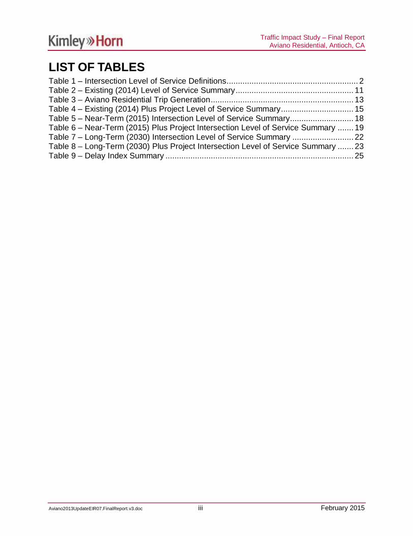
LIST OF TABLESTable 1 – Intersection Level of Service Definitions .......................................................... 2Table 2 – Existing (2014) Level of Service Summary .................................................... 11Table 3 – Aviano Residential Trip Generation ............................................................... 13Table 4 – Existing (2014) Plus Project Level of Service Summary ................................ 15Table 5 – Near-Term (2015) Intersection Level of Service Summary............................ 18Table 6 – Near-Term (2015) Plus Project Intersection Level of Service Summary ....... 19Table 7 – Long-Term (2030) Intersection Level of Service Summary ........................... 22Table 8 – Long-Term (2030) Plus Project Intersection Level of Service Summary ....... 23Table 9 – Delay Index Summary ................................................................................... 25

Traffic Impact Study – Final ReportAviano Residential, Antioch, CA
Aviano2013UpdateEIR07.FinalReport.v3.doc 1 February 2015
INTRODUCTION
Kimley-Horn and Associates, Inc. was retained by the City of Antioch to prepare a trafficstudy for the proposed Aviano Residential in Antioch, CA. The proposed project wasoriginally analyzed in 2008 as a 533-unit senior residential development. It is nowproposed to be a 533-unit single-family residential development. The development isproposed to be constructed on the property to the southwest of the intersection ofPrewett Ranch Drive and Hillcrest Avenue. The property is bordered by the DozierLibbey Medical High School to the west, Sand Creek Road (future roadway extension)to the south, and Hillcrest Avenue (future roadway extension) to the east.
Figure 1 illustrates the location of the project site in relation to the City of Antioch.
This traffic study was prepared based on discussions with, and criteria set forth by, theCity of Antioch and Contra Costa Transportation Authority (CCTA). This studyaddresses the traffic and transportation effects of the proposed development to assistthe project applicant and the City in project planning and determining conditions ofapproval for the project.
Study MethodologyDevelopment ConditionsThe Aviano Residential traffic study was based on the following developmentconditions:
· Existing (2014) conditions – Based on current traffic counts in 2013 and existingroadway geometry and traffic control.
· Existing (2014) Plus Project conditions – Based on current traffic counts andexisting roadway geometry and traffic control, plus the traffic generated by theAviano residential development.
· Near-term (2015) conditions – Based on traffic volumes and traffic added bypending and approved (but not yet completed) developments anticipated to occurat the time the project is constructed. Also includes programmed roadwayprojects which are scheduled to be in place at the same time the project isanticipated to be completed in 2015.
· Near-term (2015) Plus Project conditions – Based on existing traffic volumes,traffic added by approved and pending (but not yet completed developments),and traffic generated by the Aviano residential development, as well asprogrammed roadway projects anticipated to be in place at the same time theproject is to be completed.
· Long-term (2030) conditions – Based on future year traffic forecasts from theContra Costa Transportation Authority (CCTA) 2030 model. Future year

Traffic Impact Study – Final ReportAviano Residential, Antioch, CA
Aviano2013UpdateEIR07.FinalReport.v3.doc 2 February 2015
corresponds with the approximate buildout of the City’s General Plan. Includesroad projects anticipated to be in place under the long-term condition.
· Long-term (2030) Plus Project conditions – Based on CCTA traffic forecasts andtraffic generated by the Aviano residential development. Future yearcorresponds with the approximate buildout of the city’s General Plan. Includesroad projects anticipated to be in place under the long-term condition.
Operating Conditions and CriteriaAnalysis of project effects at intersections is based on the concept of Level of Service(LOS). The LOS of an intersection is a qualitative measure used to describeoperational conditions. LOS ranges from A (best), which represents minimal delay, to F(worst), which represents heavy delay and a facility that is operating at or near itsfunctional capacity. Levels of Service for this study were determined using methodsdefined in the Highway Capacity Manual, 2010 (HCM) and appropriate traffic analysissoftware.
The HCM included procedures for analyzing side-street stop-controlled (SSSC), all-waystop-controlled (AWSC), and signalized intersections. The SSSC procedure definesLOS as a function of average control delay for each minor street approach movement.Conversely, the AWSC and signalized intersection procedures define LOS as a functionof average control delay for the intersection as a whole. Table 1 relates the operationalcharacteristics associated with each LOS category for signalized and unsignalizedintersections.
Table 1 – Intersection Level of Service Definitions
Level ofService Description
Signalized(Avg. control
delay pervehicle
sec/veh.)
Unsignalized(Avg. control
delay pervehicle
sec/veh.)
A Free flow with no delays. Users are virtually unaffectedby others in the traffic stream [ 10 [ 10
B Stable traffic. Traffic flows smoothly with few delays. $ 10 – 20 $ 10 – 15
C Stable flow but the operation of individual usersbecomes affected by other vehicles. Modest delays. $ 20 – 35 $ 15 – 25
DApproaching unstable flow. Operation of individualusers becomes significantly affected by other vehicles.Delays may be more than one cycle during peak hours.
$ 35 – 55 $ 25 – 35
E Unstable flow with operating conditions at or near thecapacity level. Long delays and vehicle queuing. $ 55 – 80 $ 35 – 50
FForced or breakdown flow that causes reducedcapacity. Stop and go traffic conditions. Excessivelong delays and vehicle queuing.
$ 80 $ 50
Sources: Highway Capacity Manual 2010, National Research Council, 2010

Traffic Impact Study – Final ReportAviano Residential, Antioch, CA
Aviano2013UpdateEIR07.FinalReport.v3.doc 3 February 2015
According to the CCTA requirements, there are multiple routes of regional significancewithin the project study area. These include Lone Tree Way, Hillcrest Avenue (north ofLone Tree Way), and Deer Valley Road. Sand Creek Road is a future route of regionalsignificance when it extends from State Route 4 to Dallas Ranch Road. Routes ofregional significance are governed by the CCTA Technical Procedures, which has alevel of service requirement of LOS D or better. These requirements would apply to allstudy intersections on routes of regional significance.
For study intersections in the City of Antioch and not associated with routes of regionalsignificance, the City has a level of service requirement of LOS “High D” or better.
Project impacts are determined by comparing conditions with the proposed project tothose without the proposed project. The following criteria were used for determiningimpacts:
· A study intersection not identified as a route of regional significance wouldworsen from operating at an acceptable LOS “High D” or better to anunacceptable LOS E or worse with the addition of proposed project traffic.
· A study intersection identified as a route of regional significance would worsenfrom operating at an acceptable LOS “Mid D” or better to an unacceptable LOS“High D” or worse with the addition of proposed project traffic.
· A study intersection operating unacceptably without the proposed project trafficadded would experience an increase in delay due to the proposed project.
· A study intersection experiences an increase in queue of one or more vehiclesthat exceeds the turn pocket length.
It should be noted that CCTA does not have a threshold criteria for delay index andtherefore the delay index is used for comparison purposes only.
Mitigation may be required when traffic from the project causes the intersection tooperate below acceptable levels of traffic operation.
The effects of vehicle queuing were also analyzed and the 95th percentile queue isreported for all study intersections. The 95th percentile queue length represents acondition where 95 percent of the time during the peak period, traffic volumes andrelated queuing will be at, or less, than the queue length determined by the analysis.This is referred to as the “95th percentile queue.” Average queuing is generally less.Queuing is considered a potentially significant impact since queues that exceed the turnpocket length can create potentially hazardous conditions by blocking or disruptingthrough traffic in adjacent travel lanes. However, these potentially hazardous queuesare generally associated with left-turn movements. Locations where the right turnpocket storage is exceeded are not considered potentially hazardous because the rightturn movement may go at the same time as the through movement and the additionalvehicles that spill out over the turn pocket will not be hindering or disrupting the adjacent

Traffic Impact Study – Final ReportAviano Residential, Antioch, CA
Aviano2013UpdateEIR07.FinalReport.v3.doc 4 February 2015
through traffic as would be the case in most left turn pockets. Thus, for purposes of thisanalysis, a queuing impact was considered to occur under conditions where projecttraffic causes the queue in a left turn pocket to extend beyond the turn pocket by 25 feetor more (i.e., the length of one vehicle) into adjacent traffic lanes that operate (i.e.,move) separately from the left turn lane. Where the vehicle queue already exceeds thatturn pocket length under pre-project conditions, a project impact would occur if projecttraffic lengthens the queue by 25 feet or more.
Study Intersections Included in AnalysisThe proposed project will generate new vehicular trips that will increase traffic volumeson the nearby street network. To assess changes in traffic conditions associated withthe project, the following intersections, illustrated in Figure 1, were selected forevaluation in this traffic study:
1. Lone Tree Way/Dallas Ranch Road2. Lone Tree Way/Black Diamond Drive3. Lone Tree Way/Country Hills Drive4. Country Hills Drive/Deer Valley Road5. Lone Tree Way/Deer Valley Road6. Lone Tree Way/Prewett Park7. Prewett Ranch Drive/Deer Valley Road8. Sand Creek Road/Deer Valley Road9. Sand Creek Road/Kaiser Way10. Sand Creek Road/High School Driveway (future)11. Sand Creek Road/South Project Driveway (future)12. Sand Creek Road/Hillcrest Avenue (future)13. Sand Creek Road/Heidorn Ranch Road (future)14. Sand Creek Road/SB SR-4 Ramps (future)15. Sand Creek Road/NB SR-4 Ramps (future)16. East Project Driveway/Hillcrest Avenue (future)17. Prewett Ranch Drive/Heidorn Ranch Road (future)18. Prewett Ranch Drive/Hillcrest Avenue19. Lone Tree Way/Hillcrest Avenue20. Country Hills Drive/Hillcrest Avenue21. Laurel Road/Hillcrest Avenue22. Lone Tree Way/Vista Grande Drive23. Lone Tree Way/Heidorn Ranch Road24. Lone Tree Way/Canada Valley Road25. Lone Tree Way/SR-426. Lone Tree Way/Jeffrey Way

Traffic Impact Study – Final ReportAviano Residential, Antioch, CA
Aviano2013UpdateEIR07.FinalReport.v3.doc 5 February 2015
EXISTING (2014) CONDITIONS
Existing Site UsesThe Aviano residential development is proposed to be built on the property to thesouthwest of the intersection of Prewett Ranch Drive and Hillcrest Avenue.
Existing Uses in Vicinity of SiteThe proposed project site is surrounded by residential homes to the north, vacant lots tothe east and south, and the Dozier Libbey Medical High School on the west.
Existing Roadway NetworkBelow is a description of the principal roadways included in this study.
State Route 4 (SR-4) BypassState Route 4 Bypass is a highway between Vasco Road in Brentwood and the existingState Route 4 in Antioch. The highway is still undergoing construction, but is currently atwo-lane highway between Lone Tree Way and Balfour Road. North of Lone Tree Way,SR-4 is divided and has four to six lanes. Currently, a freeway interchange is being builtat Sand Creek Road. SR-4 provides access to West Contra Costa County, Interstate680, and Interstate 80 to the west. SR-4 also provides access to Brentwood andInterstate 580 to the south. The speed limit on SR-4 is 65 mph.
Black Diamond DriveBlack Diamond Drive is a two-lane, undivided local street with turn lanes and bike lanesserving residential areas south of Lone Tree Way. There is no on-street parking alongBlack Diamond Drive. The posted speed limit is 30 mph.
Canada Valley RoadCanada Valley Road is a two-lane, undivided collector roadway with no turn lanesserving residential areas north of Country Hills Drive. Canada Valley Road is a fourlane, divided roadway between Lone Tree Way and Country Hills Drive with a raisedmedian, bike lanes, and no on-street parking. The posted speed limit is 40 mph. Southof Lone Tree Way the roadway is four lanes, undivided, with turn lanes serving the LoneTree Plaza which includes the Home Depot store.
Country Hills DriveCountry Hills Drive is a two-lane roadway serving residential areas, commercial areas,Carmen Dragon Elementary School, and Jack London Elementary School north of LoneTree Way. Country Hills Drive is divided with a raised median and has turn lanes eastof Hillcrest Avenue. There are also bike lanes on either side, but no on-street parking.Country Hills Drive is undivided with no turn lanes to the west of Hillcrest Avenue.

Traffic Impact Study – Final ReportAviano Residential, Antioch, CA
Aviano2013UpdateEIR07.FinalReport.v3.doc 6 February 2015
There are no bike lanes west of Hillcrest Avenue, but there is on-street parking. Theposted speed limit is 25 and 30 mph along Country Hills Drive.
Dallas Ranch RoadDallas Ranch Road is a four-lane, divided roadway with a raised median and turn lanesserving residential areas, commercial areas, and Dallas Ranch Middle School south ofLone Tree Way. There is no on-street parking, but bike lanes exist along Dallas RanchRoad. The posted speed limit is 45 mph outside the school zone of 25 mph.
Deer Valley RoadDeer Valley Road is currently a four-lane, divided arterial roadway with a raised medianand turn lanes serving mostly residential areas. There are bike lanes on either side, butno on-street parking. South of Sand Creek Road, the street becomes a two lane,undivided roadway and provides access to rural areas. The posted speed limit is 45mph. Deer Valley Road is designated as a Route of Regional Significance.
Heidorn Ranch RoadHeidorn Ranch Road is a four-lane, divided arterial with a raised median and turn lanes.There are bike lanes on either side, but no on-street parking. The posted speed limit onHeidorn Ranch Road is 45 mph. The roadway serves residential and commercial usesand is planned to be extended to the south to connect with Sand Creek Road. North ofLone Tree Way, the street is named Fairside Way. Fairside Way is a two-lane roadwaywith on-street parking, but no bike lanes and serves residential areas.
High School Access Road (HSAR)The High School Access Road (HSAR) will be built by Aviano and will extend along thewestern edge of the Dozier Libby Medical High School and extend from Sand CreekRoad to the temporary road that has been constructed to serve the school. The road willserve the Dozier Libby Medical High School. A temporary road has been constructedfrom the eastern terminus of Sand Creek Road east to intersect the HSAR and willtemporarily provide access to the school until the HSAR is constructed by the Avianodeveloper.
Hillcrest AvenueHillcrest Avenue is a four-lane, divided roadway with a landscaped median and left turnbays. There are bike lanes on either side, but no on-street parking. The roadwayserves mostly residential uses and SR-4 to the north. The speed limit on HillcrestAvenue is posted at 45 mph in the study area. As part of the Aviano project, HillcrestAvenue will be extended to the south to connect with Sand Creek Road and willextended farther to the south in the future. Hillcrest Avenue is designated as a Route ofRegional Significance.
Jeffery WayJeffery Way is a two-lane, divided roadway with a raised median and left turn bays.There is no marked bike lane, but there is a wide shoulder where on-street parking is

Traffic Impact Study – Final ReportAviano Residential, Antioch, CA
Aviano2013UpdateEIR07.FinalReport.v3.doc 7 February 2015
prohibited. The posted speed limit is 25 mph. Jeffrey Way is connected to thenorthbound ramps for the SR-4 Bypass that was completed in 2007. Existingconditions were analyzed in 2006 before the bypass was completed.
Laurel RoadLaurel Road is a four lane, divided roadway with a raised median and turn lanes servingresidential areas. There are bike lanes on either side of Laurel Road, but no on-streetparking. Laurel Road currently ends at Canada Valley Road, but is still underconstruction and may be extended for future residential development. Laurel Road hasa posted speed limit of 45 mph. West of Hillcrest Avenue, Laurel Road is namedSterling Hill Drive. Sterling Hill Drive is a two-lane, undivided local street servingresidential areas and Black Diamond Middle School west of Hillcrest Avenue. There areno bike lanes, but on-street parking on Sterling Hill Drive. The posted speed limit is 25mph.
Lone Tree WayLone Tree Way is an arterial roadway that that connects Antioch with the City ofBrentwood. Through the project study area, Lone Tree Way is a four- to six-lane,divided roadway with a landscaped median, left turn bays, no bike lanes, and no on-street parking. The speed limit on Lone Tree Way is posted at 45 mph in the studyarea. Lone Tree Way is designated as a Route of Regional Significance. Deer ValleyHigh School is located on Lone Tree Way east of Deer Valley Road. Traffic from thehigh school represents a large portion of traffic during the AM peak period.
Mokelumne DriveMokelumne Drive is a two-lane, undivided local street with no left turn bays servingresidential areas, commercial areas, and Lone Tree Elementary School south of LoneTree Way. There are bike lanes on either side of Mokelumne Drive, but no on-streetparking between Lone Tree Way and Prewett Ranch Drive. There is on-street parking,but no bike lanes along Mokelumne Drive between Prewett Ranch Drive andSouthwood Way. The posted speed limit is 30 mph.
Prewett Ranch DrivePrewett Ranch Drive is a two-lane collector street with turn lanes at major intersections.Portions of Prewett Ranch Drive are divided with a landscaped median and turn lanes.There are bike lanes and on-street parking along portions of Prewett Ranch Drive. Theposted speed limit on Prewett Ranch Drive is 35 mph near Deer Valley Road and 25mph near Hillcrest Avenue. Diablo Vista Elementary School is located on PrewettRanch Drive east of Deer Valley Road. Traffic from the elementary school represents alarge portion of traffic during the AM peak period.
Sand Creek RoadSand Creek Road is a planned four-lane arterial with turn lanes at major intersections.The roadway is designated as a Route of Regional Significance. In the near-term, Sand

Traffic Impact Study – Final ReportAviano Residential, Antioch, CA
Aviano2013UpdateEIR07.FinalReport.v3.doc 8 February 2015
Creek Road will be extended from the SR-4 Bypass to Heidorn Ranch Road as well asfrom Hillcrest Avenue west to the western edge of the Dozier Libby Medical HighSchool. In the long-term, Sand Creel Creek road will connect from Dallas Ranch Roadin Antioch to Sand Creek Road in Brentwood. The posted speed limit on Sand CreekRoad will be 45 mph. Sand Creek Road is designated as a future Route of RegionalSignificance.
Vista Grande DriveVista Grande Drive is a two-lane street with turn lanes at major intersections. There is alandscaped median along portions of Vista Grande Drive. There are bike lanes oneither side of Vista Grande Drive, but no on-street parking south of Country Hills Drive.North of Country Hills Drive, there are no bike lanes, but there is on-street parking. Thespeed limit on Vista Grande is 25 mph.
Existing Site AccessThere are currently no driveways for access to the site as shown in Figure 2. HillcrestAvenue and Sand Creek Road will be extended along the proposed project frontagesand access to the residential development will be constructed on both streets.
Existing (2014) Lane Configurations and Traffic ControlExisting intersection lane configurations and traffic controls are illustrated in Figure 3.The two proposed project accesses will need to be controlled by traffic signals and willbe full access intersections. It should be noted that the two proposed project accessstreets do not exist as current intersections and were therefore not analyzed in thewithout project condition.
Existing (2014) Peak Hour Turning Movement VolumesWeekday intersection turning movement volumes were collected at project study areaintersections in January 2014. Volumes were collected during the AM (7:00 AM to 9:00AM) and PM (4:00 PM to 6:00 PM) peak periods of a typical weekday. These volumeswere collected during a typical weekday when school was in session and not near anymajor holidays.
AM and PM peak one-hour volumes are shown in Figure 4. Traffic volume data sheetsare shown in the Appendix.
Existing Transit FacilitiesTri-Delta Transit provides bus service in Antioch. Routes 379, 380, 383, 385, 388, 392,and 395 operate within the study area. Currently there are no bus routes that passdirectly adjacent to the proposed project site because there is no roadway access to thevacant lot for the project site. However, routes 379, 388, and 392 operate on SandCreek Road to the Kaiser Permanente, which is west of the proposed project site. Tri-

Traffic Impact Study – Final ReportAviano Residential, Antioch, CA
Aviano2013UpdateEIR07.FinalReport.v3.doc 9 February 2015
Delta Transit connects passengers to the Antioch Park and Ride (Hillcrest), KaiserMedical Center, Pittsburg/Bay Point BART Station, Tri Delta Transit Station, variouslocal schools, Brentwood Park and Ride, the Streets of Brentwood and convenientconnections to many locations in the City and connections to other local and regionaltransit routes.
Route 379 operates between the Antioch Park and Ride (Hillcrest) to the Kaiser MedicalCenter. This route runs along Hillcrest Avenue, Deer Valley Road, and Sand CreekRoad within the study area. This route operates only on Antioch Unified School Districtdays only from 7:28 AM to 7:40 AM and 3:05 PM to 3:23 PM.
Route 380 operates between the Pittsburg/Bay Point BART Station to the Tri DeltaTransit station. This route runs along Lone Tree Way, Canada Valley Road, LaurelRoad, and Hillcrest Avenue within the study area. This route operates on weekdaysfrom 3:04 AM to 11:33 PM on a frequency of 10-minute to 120-minute headways.
Route 383 operates between the Antioch Park and Ride (Hillcrest) to Freedom HighSchool. This route runs along Deer Valley Road and Lone Tree Way within the studyarea. This route operates on weekdays from 7:12 AM to 5:23 PM on a frequency of 60-minute to 125-minute headways.
Route 385 operates between the Antioch Park and Ride (Hillcrest) to the BrentwoodPark and Ride. This route runs along Hillcrest Avenue, Lone Tree Way, Sand CreekRoad, and the SR-4 bypass within the study area. This route operates on weekdaysfrom 6:39 AM to 7:17 PM on a frequency of 25-minute to 145-minute headways.
Route 388 operates between the Pittsburg/Bay Point BART Station to Kaiser MedicalCenter. This route runs along Lone Tree Way, Dallas Ranch Road, Prewett RanchRoad, Deer Valley Road, and Sand Creek Road within the study area. This routeoperates on weekdays from 5:29 AM to 11:28 PM on a frequency of 30-minute to 74-minute headways.
Route 392 operates between the Pittsburg/Bay Point BART Station to the Antioch Parkand Ride (Hillcrest). This route runs along Lone Tree Way, Hillcrest Avenue, DeerValley Road, and Sand Creek Road within the study area. This route operates onweekends from 5:23 AM to 1:28 AM on a frequency of 49-minute to 120-minuteheadways.
Route 395 operates between the Antioch Park and Ride (Hillcrest) to the Streets ofBrentwood. This route runs along the SR-4 bypass and Sand Creek Road within thestudy area. This route operates on weekends from 9:40 AM to 8:03 PM on a frequencyof 60-minute headways.
Traffic Impact Study – Final ReportAviano Residential, Antioch, CA
Aviano2013UpdateEIR07.FinalReport.v3.doc 10 February 2015
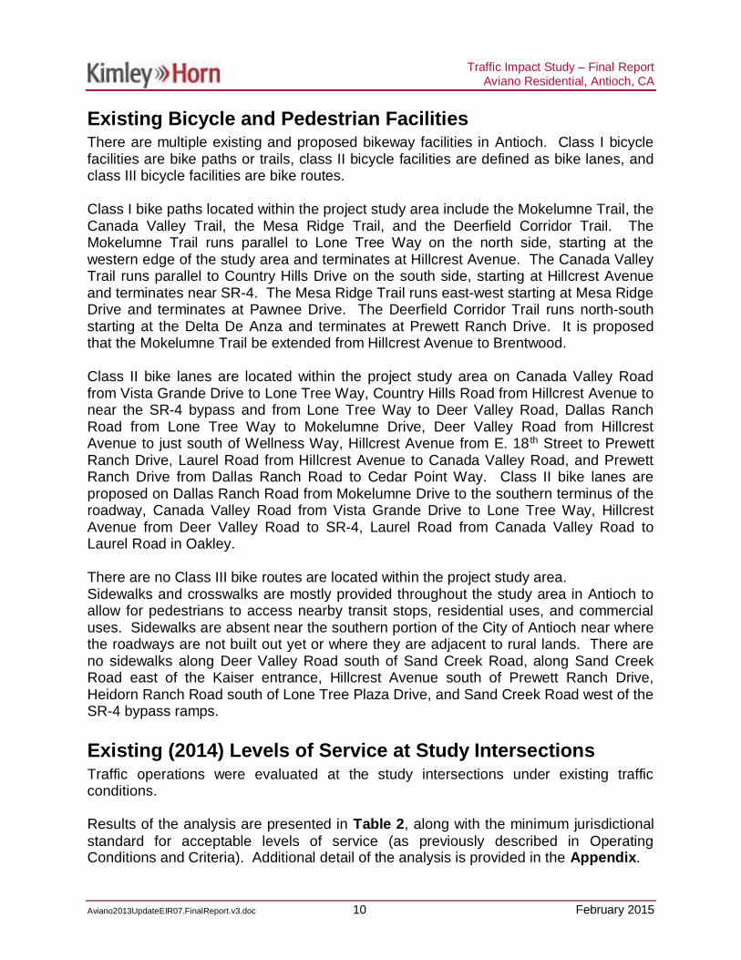
Existing Bicycle and Pedestrian FacilitiesThere are multiple existing and proposed bikeway facilities in Antioch. Class I bicyclefacilities are bike paths or trails, class II bicycle facilities are defined as bike lanes, andclass III bicycle facilities are bike routes.
Class I bike paths located within the project study area include the Mokelumne Trail, theCanada Valley Trail, the Mesa Ridge Trail, and the Deerfield Corridor Trail. TheMokelumne Trail runs parallel to Lone Tree Way on the north side, starting at thewestern edge of the study area and terminates at Hillcrest Avenue. The Canada ValleyTrail runs parallel to Country Hills Drive on the south side, starting at Hillcrest Avenueand terminates near SR-4. The Mesa Ridge Trail runs east-west starting at Mesa RidgeDrive and terminates at Pawnee Drive. The Deerfield Corridor Trail runs north-southstarting at the Delta De Anza and terminates at Prewett Ranch Drive. It is proposedthat the Mokelumne Trail be extended from Hillcrest Avenue to Brentwood.
Class II bike lanes are located within the project study area on Canada Valley Roadfrom Vista Grande Drive to Lone Tree Way, Country Hills Road from Hillcrest Avenue tonear the SR-4 bypass and from Lone Tree Way to Deer Valley Road, Dallas RanchRoad from Lone Tree Way to Mokelumne Drive, Deer Valley Road from HillcrestAvenue to just south of Wellness Way, Hillcrest Avenue from E. 18 th Street to PrewettRanch Drive, Laurel Road from Hillcrest Avenue to Canada Valley Road, and PrewettRanch Drive from Dallas Ranch Road to Cedar Point Way. Class II bike lanes areproposed on Dallas Ranch Road from Mokelumne Drive to the southern terminus of theroadway, Canada Valley Road from Vista Grande Drive to Lone Tree Way, HillcrestAvenue from Deer Valley Road to SR-4, Laurel Road from Canada Valley Road toLaurel Road in Oakley.
There are no Class III bike routes are located within the project study area.Sidewalks and crosswalks are mostly provided throughout the study area in Antioch toallow for pedestrians to access nearby transit stops, residential uses, and commercialuses. Sidewalks are absent near the southern portion of the City of Antioch near wherethe roadways are not built out yet or where they are adjacent to rural lands. There areno sidewalks along Deer Valley Road south of Sand Creek Road, along Sand CreekRoad east of the Kaiser entrance, Hillcrest Avenue south of Prewett Ranch Drive,Heidorn Ranch Road south of Lone Tree Plaza Drive, and Sand Creek Road west of theSR-4 bypass ramps.
Existing (2014) Levels of Service at Study IntersectionsTraffic operations were evaluated at the study intersections under existing trafficconditions.
Results of the analysis are presented in Table 2, along with the minimum jurisdictionalstandard for acceptable levels of service (as previously described in OperatingConditions and Criteria). Additional detail of the analysis is provided in the Appendix.

Traffic Impact Study – Final ReportAviano Residential, Antioch, CA
Aviano2013UpdateEIR07.FinalReport.v3.doc 11 February 2015
As shown in Table 2, all of the study intersections function within acceptable standardsunder this analysis scenario.
Table 2 – Existing (2014) Level of Service Summary
LOS Delay LOS Delay1 Lone Tree Way and Dallas Ranch Road D City Signal C 25.2 C 20.72 Lone Tree Way and Black Diamond Drive D City Signal A 5.1 A 3.73 Lone Tree Way and Country Hills Drive D City Signal C 25.3 B 18.24 Country Hills Drive and Deer Valley Road D City Signal B 15.4 B 11.15 Lone Tree Way and Deer Valley Road D City Signal D 44.0 C 25.16 Lone Tree Way and Prewett Park D City Signal C 29.5 B 13.27 Prewett Ranch Drive and Deer Valley Road D City Signal B 19.6 B 15.38 Sand Creek Road and Deer Valley Road D City Signal C 24.8 A 6.7
Sand Creek Road and Kaiser Way B 13.1 A 1.6Worst Approach D 31.0 A 9.2
Sand Creek Road and High School DrivewayWorst Approach
11 Sand Creek Road and South Project Driveway D City Signal12 Sand Creek Road and Hillcrest Avenue D City Signal13 Sand Creek Road and Heidorn Ranch Road D City Signal14 Sand Creek Road and SB SR-4 Ramp D City Signal A 1.2 A 0.715 Sand Creek Road and NB SR-4 Ramp D City Signal A 8.4 A 9.716 East Project Driveway and Hillcrest Avenue D City Signal17 Prewett Ranch Drive and Heidorn Ranch Road D City Signal18 Prewett Ranch Drive and Hillcrest Avenue D City Signal (AWSC)* A 9.8 A 9.819 Lone Tree Way and Hillcrest Avenue D City Signal C 22.1 B 18.020 Country Hills Drive and Hillcrest Avenue D City Signal C 28.7 C 20.421 Laurel Road and Hillcrest Avenue D City Signal B 14.4 B 13.822 Lone Tree Way and Vista Grande Drive D City Signal A 8.7 A 8.323 Lone Tree Way and Heidorn Ranch Road D City Signal A 3.0 A 3.624 Lone Tree Way and Canada Valley Road D City Signal B 13.6 B 14.425 Lone Tree Way and SB SR-4 D City Signal B 13.3 A 8.826 Lone Tree Way and Jeffrey Way D City Signal B 11.2 A 7.9
Note: Intersections that are operating below acceptable levels are shown in
Future Intersection
ControlLOS
CriteriaIntersection
*Prewett Ranch Drive and Hillcrest Avenue is a signalized intersection, however it operates as an All Way Stop Control
Future IntersectionFuture Intersection
Future Intersection
9 D City SSSC
Existing
Future Intersection
AM Peak PM PeakJurisdiction
D City SSSC10 Future Intersection
AVIANO RESIDENTIAL DEVELOPMENT PROJECT
Proposed Site UsesAs noted previously, the proposed Aviano residential development will be on theproperty to the southwest of the intersection of Prewett Ranch Drive and HillcrestAvenue. The proposed development will consist of 533 single family residential homes.

Traffic Impact Study – Final ReportAviano Residential, Antioch, CA
Aviano2013UpdateEIR07.FinalReport.v3.doc 12 February 2015
Project Trip GenerationTrip generation for residential development projects is typically calculated based onrates contained in the Institute of Transportation Engineer’s publication, Trip Generation9th Edition1. Trip Generation is a standard reference used by jurisdictions throughoutthe country for the estimation of trip generation potential of proposed developments.
A trip is defined in Trip Generation as a single or one-directional vehicle movement witheither the origin or destination at the project site. In other words, a trip can be either “to”or “from” the site. In addition, a single customer visit to a site is counted as two trips(i.e., one to and one from the site).
For purposes of determining the worst-case impacts of traffic on the surrounding streetnetwork, the trips generated by a proposed development are typically estimatedbetween the hours of 7:00-9:00 AM and 4:00-6:00 PM. This methodology is in harmonywith the City’s standard for the preparation of traffic impact studies.
The proposed single family residential development is most appropriately classified asSingle-Family Detached Housing (ITE Land Use 210).
Internal CaptureInternal capture reductions were considered, but since the project site will only be usedfor the residential homes and no other land uses, no internal capture reductions weretaken.
Project Trip Pass-ByThe Aviano residential development is unlikely to create any pass-by trips. Pass-bytrips are typically calculated based on data published in ITE’s Trip GenerationHandbook, 2nd Edition2 which includes weekday AM and PM information. Thisreference assumes no pass-by trips for this specific land use.
Trip generation was calculated based on the previous discussions and is reported inTable 3. Additional trip generation calculations are contained in the Appendix.
As noted in Table 3, the project will generate approximately 400 new peak AM trips andapproximately 533 new peak PM trips.
1 Trip Generation, 9th Edition, Institute of Transportation Engineers, 2012.2Trip Generation Handbook, 2nd Edition, Institute of Transportation Engineers, June 2004.

Traffic Impact Study – Final ReportAviano Residential, Antioch, CA
Aviano2013UpdateEIR07.FinalReport.v3.doc 13 February 2015
Table 3 – Aviano Residential Trip Generation
TIMEPERIOD LAND USE Trip Rate Trips
In Out Total In Out Total
AMPeak
Single-FamilyDetachedHousing(533 DU)
0.1875 0.5625 0.75 100 300 400
PMPeak
Single-FamilyDetachedHousing
(533 DU)
0.63 0.37 1.00 336 197 533
Project Trip Distribution and AssignmentThe Aviano residential development project trip distribution is based on the City’s trafficmodel provided by the City from the previous traffic study published in 2008 and as wellas existing traffic patterns and field observations. Figure 5 shows the traffic distributionassumed in this traffic report for the Existing and Near-term plus Project scenarios.Based on the assumed trip distribution, new vehicle trips generated by the Avianoresidential development were assigned to the street network as shown in Figure 6.
It was also assumed that in the Existing and Near-term plus Project scenarios, the tripdistribution for the Dozier Libbey Medical High School would redistribute to utilize theHillcrest Road extension and Sand Creek Road extension to get to school. It wasassumed that trips coming from the east would utilize the Hillcrest Road and SandCreek Road extension instead of traveling along Lone Tree Way and Deer Valley Road(which is to the west of the school). The distribution of trips coming from the east andthe west was based off of the future travel demand model’s distribution in the Long-Term scenario.
Due to the future roadways being completed only in the Long-term scenario, the tripdistribution is different in the Near-term than the Long-term. When compared, the Long-term trip distribution is higher in the southern portions of the City along Sand CreekRoad, Deer Valley Road, Hillcrest Avenue, and the SR-4 bypass. Figure 7 shows thetraffic distribution assumed in this traffic report for the Long-term plus Project scenario.Based on the assumed trip distribution, new vehicle trips generated by the Avianoresidential development were assigned to the street network as shown in Figure 8.
Project Roadway ImprovementsAs part of the proposed project, Hillcrest Avenue will be extended from Prewett RanchDrive to the future extension of Sand Creek Road. Sand Creek Road will also beextended from the Dozier Libbey Medical High School to the Hillcrest Avenue extension.The project also proposes to add sidewalk along the frontage of the project. Bicycle

Traffic Impact Study – Final ReportAviano Residential, Antioch, CA
Aviano2013UpdateEIR07.FinalReport.v3.doc 14 February 2015
lanes will be added along Hillcrest Avenue and Sand Creek Road. The project alsoproposes to add an access intersection on the Hillcrest Avenue extension, which isplanned to be signalized. An access intersection on the Sand Creek Road extension isalso planned, which is signalized. It is important to note that the project intersectionsare only analyzed under the plus Proposed Project conditions, as they will not existwithout the construction of the project.
EXISTING (2014) PLUS PROJECT TRAFFICCONDITIONS
Project traffic was added to the existing volumes at the study intersections and thevolumes are shown in Figure 9. Traffic operations were evaluated under the Existing(2014) Plus Project Traffic Conditions. Results of the analysis are presented in Table 4.Additional detail is provided in the Appendix.
As shown in Table 4, all the study intersections function within acceptable standardsunder this analysis scenario.

Traffic Impact Study – Final ReportAviano Residential, Antioch, CA
Aviano2013UpdateEIR07.FinalReport.v3.doc 15 February 2015
Table 4 – Existing (2014) Plus Project Level of Service Summary
LOS Delay LOS Delay LOS Delay Var LOS Delay Var1 Lone Tree Way and Dallas Ranch Road D City Signal C 25.2 C 20.7 C 25.0 -0.2 C 20.7 0.02 Lone Tree Way and Black Diamond Drive D City Signal A 5.1 A 3.7 A 5.0 -0.1 A 3.6 -0.13 Lone Tree Way and Country Hills Drive D City Signal C 25.3 B 18.2 C 25.1 -0.2 B 18.2 0.04 Country Hills Drive and Deer Valley Road D City Signal B 15.4 B 11.1 B 15.5 0.1 B 11.2 0.15 Lone Tree Way and Deer Valley Road D City Signal D 44.0 C 25.1 D 42.6 -1.4 C 25.1 0.06 Lone Tree Way and Prewett Park D City Signal C 29.5 B 13.2 C 29.9 0.4 B 13.8 0.67 Prewett Ranch Drive and Deer Valley Road D City Signal B 19.6 B 15.3 B 19.8 0.2 B 16.1 0.88 Sand Creek Road and Deer Valley Road D City Signal C 24.8 A 6.7 C 23.5 -1.3 A 7.7 1.0
Sand Creek Road and Kaiser Way B 13.1 A 1.6 B 12.9 -0.2 A 2.5 0.9Worst Approach D 31.0 A 9.2 D 29.3 -1.7 A 9.6 0.4
Sand Creek Road and High School Driveway A 8.9 - A 2.2 -Worst Approach B 12.6 - A 8.6 -
11 Sand Creek Road and South Project Driveway D City Signal A 7.6 - A 7.8 -12 Sand Creek Road and Hillcrest Avenue D City Signal B 19.1 - C 21.7 -13 Sand Creek Road and Heidorn Ranch Road D City Signal14 Sand Creek Road and SB SR-4 Ramp D City Signal A 1.2 A 0.7 A 1.2 0 A 0.7 0.015 Sand Creek Road and NB SR-4 Ramp D City Signal A 8.4 A 9.7 A 8.4 0 A 9.8 0.116 East Project Driveway and Hillcrest Avenue D City Signal A 8.9 - C 20.2 -17 Prewett Ranch Drive and Heidorn Ranch Road D City Signal18 Prewett Ranch Drive and Hillcrest Avenue D City Signal (AWSC)* A 9.8 A 9.8 B 11.3 1.5 B 13.2 3.419 Lone Tree Way and Hillcrest Avenue D City Signal C 22.1 B 18.0 C 23.7 1.6 C 25.2 7.220 Country Hills Drive and Hillcrest Avenue D City Signal C 28.7 C 20.4 C 28.3 -0.4 B 19.8 -0.621 Laurel Road and Hillcrest Avenue D City Signal B 14.4 B 13.8 B 14.2 -0.2 B 13.6 -0.222 Lone Tree Way and Vista Grande Drive D City Signal A 8.7 A 8.3 A 7.9 -0.8 A 7.5 -0.823 Lone Tree Way and Heidorn Ranch Road D City Signal A 3.0 A 3.6 A 2.7 -0.3 A 3.4 -0.224 Lone Tree Way and Canada Valley Road D City Signal B 13.6 B 14.4 B 12.9 -0.7 B 13.8 -0.625 Lone Tree Way and SB SR-4 D City Signal B 13.3 A 8.8 B 13.4 0.1 A 9.2 0.426 Lone Tree Way and Jeffrey Way D City Signal B 11.2 A 7.9 A 9.2 -2 A 8.1 0.2
Note: Intersections that are operating below acceptable levels are shown in
Existing + ProjectPM PeakJurisdiction PM Peak AM Peak
*Prewett Ranch Drive and Hillcrest Avenue is a signalized intersection, however it operates as an All Way Stop Control (AWSC) with flashing red lights.
9 D City SSSC
10
Intersection LOSCriteria
D City Future Intersection
Future Intersection
Future Intersection
Future Intersection
Future IntersectionFuture IntersectionFuture Intersection
Future Intersection
SSSC
AM PeakControlExisting Existing + Project

Traffic Impact Study – Final ReportAviano Residential, Antioch, CA
Aviano2013UpdateEIR07.FinalReport.v3.doc 16 February 2015
NEARBY ROADWAY AND DEVELOPMENT PROJECTS
Planned Roadway Projects in Vicinity of SiteThere are roadway improvements planned in the study area for the Near-term (2015) asidentified by the City. The following summarizes the future intersection improvementsand roadway improvements that will affect the study area:
· Intersection 5 – The intersection of Deer Valley Road and Lone Tree Way isanticipated to add a second southbound left turn lane.
· Intersection 14 – The west leg of Sand Creek Road and SB SR-4 Ramps will bestriped to have a westbound left turn lane and two westbound through lanes. Asouthbound right turn lane will be added as well.
· Intersection 18 – The intersection of Hillcrest Avenue and Prewett Ranch Drivecurrently has new traffic signal equipment constructed, but is set on flashing allred. However, when the project is constructed and the south leg is built with theproject, it is anticipated that the traffic signal will be fully operational. In additionto the traffic signal being fully operational, a southbound through lane will beadded, and the southbound right turn will be converted to a shared through-rightturn lane.
· Intersection 19 – The intersection of Lone Tree Way and Hillcrest Avenue isanticipated to add a second southbound left turn lane.
· Intersection 24 – The intersection of Lone Tree Way and Canada Valley Roadwill be restriped on the eastbound and southbound approaches. The eastboundapproach will be restriped to have dual left turns. The southbound approach willbe restriped to be dual left turn lanes and a through-right lane.
The extension of Hillcrest Avenue and Sand Creek Road will be completed as part ofthe proposed project and therefore will not be assumed in the Near-term (2015) withoutproject scenario.
Figure 10 illustrates the intersection geometry and traffic control assumed in the Near-term (2015) analysis.
Approved & Pending Development Projects in Vicinity of SiteKimley-Horn coordinated with the City of Antioch, City of Brentwood, and City of Oakleyto determine if there were any development projects in the vicinity of the project site thatare in various stages of planning, approval, or development. These projects wereidentified and included in the Near-term (2015) conditions. Available trip generation andtrip distribution was used to assign vehicle trips to the study area. Since there are asignificant number of large residential developments, the number of residential unitsassumed to generate traffic was limited to 263 units per year. This number wasdetermined based on data provided by the cities showing the number of building permits

Traffic Impact Study – Final ReportAviano Residential, Antioch, CA
Aviano2013UpdateEIR07.FinalReport.v3.doc 17 February 2015
pulled annually in previous years. This average number of permits pulled annually wasused for the future years.
Figure 11 shows the pending and approved projects considered in this study for theNear-term scenario. The pending and approved project trips were assigned to the studyarea and are shown in Figure 12.
NEAR-TERM (2015) TRAFFIC CONDITIONS
Traffic operations were evaluated under the following development conditions:
· Near-Term (2015) Conditions· Near-Term (2015) plus Project Conditions
Near-term (2015) volumes were calculated by using the list of pending and approveddevelopment projects and determining trip generation, trip distribution, and tripassignment for each project. Vehicle trips were then assigned to the project study area.Figure 13 illustrates the Near-term (2015) volumes.
Near-Term Intersection Level of ServiceNear-term (2015) volumes were evaluated at the study intersections. Results arepresented in Table 5. Analysis sheets are provided in the Appendix. As shown inTable 5, all study intersections function within acceptable standards under this analysisscenario, except the intersection of Sand Creek Road and Kaiser Way. Thisintersection operates at LOS F in the AM peak during the Near-term without Projectscenario.
The intersection mentioned above would operate below acceptable thresholdsregardless of the proposed project. Analysis sheets are provided in the Appendix.

Traffic Impact Study – Final ReportAviano Residential, Antioch, CA
Aviano2013UpdateEIR07.FinalReport.v3.doc 18 February 2015
Table 5 – Near-Term (2015) Intersection Level of Service Summary
LOS Delay LOS Delay1 Lone Tree Way and Dallas Ranch Road D City Signal C 25.0 C 20.52 Lone Tree Way and Black Diamond Drive D City Signal A 4.8 A 3.33 Lone Tree Way and Country Hills Drive D City Signal C 24.1 C 21.84 Country Hills Drive and Deer Valley Road D City Signal B 17.5 B 13.05 Lone Tree Way and Deer Valley Road D City Signal D 48.4 D 43.46 Lone Tree Way and Prewett Park D City Signal C 31.8 B 15.07 Prewett Ranch Drive and Deer Valley Road D City Signal C 23.0 B 17.38 Sand Creek Road and Deer Valley Road D City Signal D 44.5 A 10.0
Sand Creek Road and Kaiser Way F 65.4 A 0.9Worst Approach F 193.1 B 10.0
Sand Creek Road and High School DrivewayWorst Approach
11 Sand Creek Road and South Project Driveway D City Signal12 Sand Creek Road and Hillcrest Avenue D City Signal13 Sand Creek Road and Heidorn Ranch Road D City Signal14 Sand Creek Road and SB SR-4 Ramp D City Signal B 19.5 C 31.815 Sand Creek Road and NB SR-4 Ramp D City Signal B 12.1 B 15.216 East Project Driveway and Hillcrest Avenue D City Signal17 Prewett Ranch Drive and Heidorn Ranch Road D City Signal18 Prewett Ranch Drive and Hillcrest Avenue D City Signal B 15.4 B 14.819 Lone Tree Way and Hillcrest Avenue D City Signal C 30.0 C 26.220 Country Hills Drive and Hillcrest Avenue D City Signal C 29.3 C 22.621 Laurel Road and Hillcrest Avenue D City Signal B 15.2 B 15.422 Lone Tree Way and Vista Grande Drive D City Signal A 7.6 A 7.723 Lone Tree Way and Heidorn Ranch Road D City Signal A 2.5 A 3.124 Lone Tree Way and Canada Valley Road D City Signal A 9.5 B 12.625 Lone Tree Way and SB SR-4 D City Signal B 13.2 B 12.526 Lone Tree Way and Jeffrey Way D City Signal B 10.7 A 8.9
Note: Intersections that are operating below acceptable levels are shown in BOLD.
AM Peak PM Peak
City SSSC
10 D City SSSC
9 D
It should be noted that calculations of delay at saturated conditions (i.e., LOS F) are less reliable than at LOS E or better.Therefore, delay in excess of 80 seconds is reported in the table to allow a relative comparison of without and with projectconditions and should not be interpreted as an exact representation of actual delay.
Intersection LOSCriteria Jurisdiction Control
Near-Term
Future Intersection
Future IntersectionFuture IntersectionFuture Intersection
Future IntersectionFuture Intersection
Near-Term Plus Project Intersection Level of ServiceNear-Term plus project traffic conditions were evaluated at the study intersections andare shown in Figure 14. As noted earlier, locations operating unacceptably that havean increase in delay are considered to be subject to a significant impact.
As shown in Table 6, all study intersections function within acceptable standards underthis analysis scenario, except the intersection of Sand Creek Road and Kaiser Way.This intersection operates at LOS F in the AM peak during the Near-term plus Projectscenario. Although the intersection operated at LOS F without the project, the delaydecreased with the addition of project trips and redistribution of school trips andtherefore is not a significant impact.

Traffic Impact Study – Final ReportAviano Residential, Antioch, CA
Aviano2013UpdateEIR07.FinalReport.v3.doc 19 February 2015
Table 6 – Near-Term (2015) Plus Project Intersection Level of Service Summary
LOS Delay LOS Delay LOS Delay Var LOS Delay Var1 Lone Tree Way and Dallas Ranch Road D City Signal C 25.0 C 20.5 C 24.9 -0.1 C 20.7 0.22 Lone Tree Way and Black Diamond Drive D City Signal A 4.8 A 3.3 A 4.7 -0.1 A 3.2 -0.13 Lone Tree Way and Country Hills Drive D City Signal C 24.1 C 21.8 C 23.9 -0.2 C 21.9 0.14 Country Hills Drive and Deer Valley Road D City Signal B 17.5 B 13.0 B 17.6 0.1 B 13.1 0.15 Lone Tree Way and Deer Valley Road D City Signal D 48.4 D 43.4 D 47.7 -0.7 D 45.7 2.36 Lone Tree Way and Prewett Park D City Signal C 31.8 B 15.0 D 34.4 2.6 B 15.7 0.77 Prewett Ranch Drive and Deer Valley Road D City Signal C 23.0 B 17.3 C 23.4 0.4 B 18.3 1.08 Sand Creek Road and Deer Valley Road D City Signal D 44.5 A 10.0 D 39.2 -5.3 B 11.2 1.2
Sand Creek Road and Kaiser Way F 65.4 A 0.9 F 64.3 -1.1 A 1.5 0.6Worst Approach F 193.1 B 10.0 F 183.1 -10.0 B 10.5 0.5
Sand Creek Road and High School Driveway A 8.9 - A 2.2 -Worst Approach B 12.6 - A 8.6 -
11 Sand Creek Road and South Project Driveway D City Signal B 13.0 - B 18.7 -12 Sand Creek Road and Hillcrest Avenue D City Signal B 15.9 - B 18.3 -13 Sand Creek Road and Heidorn Ranch Road D City Signal14 Sand Creek Road and SB SR-4 Ramp D City Signal B 19.5 C 31.8 B 19.6 0.1 C 32.1 0.315 Sand Creek Road and NB SR-4 Ramp D City Signal B 12.1 B 15.2 B 12.0 -0.1 B 15.8 0.616 East Project Driveway and Hillcrest Avenue D City Signal A 8.8 - C 20.2 -17 Prewett Ranch Drive and Heidorn Ranch Road D City Signal18 Prewett Ranch Drive and Hillcrest Avenue D City Signal B 15.4 B 14.8 B 19.0 3.6 C 20.5 5.719 Lone Tree Way and Hillcrest Avenue D City Signal C 30.0 C 26.2 C 28.2 -1.8 C 27.8 1.620 Country Hills Drive and Hillcrest Avenue D City Signal C 29.3 C 22.6 C 28.9 -0.4 C 22.3 -0.321 Laurel Road and Hillcrest Avenue D City Signal B 15.2 B 15.4 B 15.1 -0.1 B 15.2 -0.222 Lone Tree Way and Vista Grande Drive D City Signal A 7.6 A 7.7 A 7.1 -0.5 A 7.4 -0.323 Lone Tree Way and Heidorn Ranch Road D City Signal A 2.5 A 3.1 A 2.4 -0.1 A 3.1 0.024 Lone Tree Way and Canada Valley Road D City Signal A 9.5 B 12.6 A 9.1 -0.4 B 12.7 0.125 Lone Tree Way and SB SR-4 D City Signal B 13.2 B 12.5 B 14.3 1.1 B 19.8 7.326 Lone Tree Way and Jeffrey Way D City Signal B 10.7 A 8.9 B 10.8 0.1 A 9.2 0.3
Note: Intersections that are operating below acceptable levels are shown in BOLD.
Near-Term + ProjectNear-TermControlJurisdictionLOS
Criteria
SSSCCityD
PM PeakAM PeakPM PeakAM Peak
It should be noted that calculations of delay at saturated conditions (i.e., LOS F) are less reliable than at LOS E or better. Therefore,delay in excess of 80 seconds is reported in the table to allow a relative comparison of without and with project conditions and shouldnot be interpreted as an exact representation of actual delay.
9
10
Intersection
SSSC
Future IntersectionFuture Intersection
Future Intersection
Future Intersection
CityD Future Intersection
Future IntersectionFuture IntersectionFuture Intersection

Traffic Impact Study – Final ReportAviano Residential, Antioch, CA
Aviano2013UpdateEIR07.FinalReport.v3.doc 20 February 2015
LONG-TERM (2030) CONDITIONS
Long-Term Lane Configurations and Traffic ControlThere are roadway improvements planned in the study area for the Long-term (2030) asidentified by the City. In the Long-term (2030) scenario, Lone Tree Way, west ofHillcrest Road, will be restriped to have three through lanes in each direction. SandCreek Road is planned to be extended from the Dozier Libbey Medical High School tothe SR-4 bypass, regardless of whether the proposed Aviano residential developmentoccurs or not. It is assumed that there will be other development that occurs to warrantthe construction of the Sand Creek Road extension. Sand Creek Road is alsoanticipated to be extended from Deer Valley Road to the Dozier Libbey Medical HighSchool. The extension of Hillcrest Avenue is also planned regardless of the proposedAviano residential development, and will extend to Balfour Road.
The following summarizes the future intersection improvements and roadwayimprovements that will affect the study area:
· Intersection 5 – The intersection of Lone Tree Way/Deer Valley Road will beupdated. The eastbound right turn lane will be restriped as an eastbound sharedthrough-right turn lane. The westbound approach will be restriped to include twoleft turn lanes, a through lane, and a shared through-right turn lane.
· Intersection 8 – The intersection of Sand Creek Road/Deer Valley Road will beupdated. An additional through lane will be added to the southbound, eastbound,and westbound approaches. The southbound approach will also include dual leftturns.
· Intersection 9 – The intersection configuration for the intersection of Sand CreekRoad/Kaiser Way will be altered due to the realignment of Sand Creek Road.Sand Creek Road will be two lanes in each direction. The eastbound approachwill be a left turn lane and two through lanes. The westbound approach will betwo through lanes, and a right turn lane. The southbound approach will be a leftturn lane and two right turn lanes.
· Intersection 10 – The intersection configuration for the intersection of Sand CreekRoad/Dozier Libby Medical High School will be altered due to the realignment ofSand Creek Road. Sand Creek Road will now run east-west and be two lanes ineach direction. The eastbound approach will be a left turn lane and two throughlanes. The westbound approach will be one through lane and a shared through-right turn lane. The southbound approach will be a left turn lane and a right turnlane.
· Intersection 13 – The intersection of Sand Creek Road/Heidorn Ranch Road willbe a newly constructed intersection. The eastbound approach will be a left turnlane and two through lanes. The westbound approach will be one through laneand a shared through-right turn lane. The southbound approach will be a left turnlane and a right turn lane.

Traffic Impact Study – Final ReportAviano Residential, Antioch, CA
Aviano2013UpdateEIR07.FinalReport.v3.doc 21 February 2015
· Intersection 15 – The intersection of Sand Creek Road/NB SR-4 Ramps will beslightly altered. The eastbound approach will be a left turn lane and two throughlanes. The westbound approach will be two through lanes, and a right turn lane.The southbound approach will be a shared left-through lane and a right turn lane.
· Intersection 17 – The intersection of Prewett Ranch Drive/Heidorn Ranch Roadwill be a newly constructed intersection. The eastbound approach will be a leftturn lane and a right turn lane. The northbound approach will be a left turn laneand two through lanes. The southbound approach will be a future left turn lane, athrough lane, and a shared through-right turn lane.
· Intersection 19 – The intersection of Lone Tree Way and Hillcrest Avenue will beupdated. The eastbound right turn lane will be restriped as an eastbound sharedthrough-right turn lane. The westbound approach will be restriped to include twoleft turn lanes, two through lanes, and a right turn lane.
· Intersection 24 – The intersection of Lone Tree Way and Canada Valley Roadwill be restriped on the eastbound and southbound approaches. The eastboundapproach will be restriped to have dual left turns. The southbound approach willbe restriped to be dual left turn lanes and a shared through-right lane.
Figure 15 illustrates the intersection geometry and traffic control assumed in the Long-term (2030) analysis.
Year 2030 Forecast Model VolumesYear 2030 roadway link volumes from the CCTA Travel Demand Forecast model wereobtained from the County. The model was used to plot bi-directional AM and PM peak-hour traffic volumes on each segment along roadways within the study area. Modeloutput was used to compare 2010 base year volumes and year 2040 future modelforecasts to determine the annual incremental growth in traffic volumes at studyintersections. Year 2030 turning movement volumes were calculated by adding thegrowth increment to the current year (2014) traffic count to calculate the final adjustedroadway link forecast volume. Final adjusted forecast volumes were then converted toLong-term (2030) intersection turning movement volumes using a traffic modelingstandard process commonly referred to as the Furness method. The Furness methoduses an iterative process to derive future turning movement volumes based on futureyear roadway link volumes and an initial estimate of turning percentages (obtained fromthe 2014 intersection turning movement counts).
LONG-TERM TRAFFIC CONDITIONS
Traffic operations were evaluated under the following long-term conditions:
· Long-Term (2030) Conditions· Long-Term (2030) plus Project Conditions

Traffic Impact Study – Final ReportAviano Residential, Antioch, CA
Aviano2013UpdateEIR07.FinalReport.v3.doc 22 February 2015
Long-Term Intersection Level of ServiceLong-term (2030) traffic volumes were evaluated at study intersections and arepresented in Figure 16. As shown in Table 7, all the intersections function withinacceptable standards under this analysis scenario. Analysis sheets are provided in theAppendix.
Table 7 – Long-Term (2030) Intersection Level of Service Summary
LOS Delay LOS Delay1 Lone Tree Way and Dallas Ranch Road D City Signal D 36.7 D 52.22 Lone Tree Way and Black Diamond Drive D City Signal A 4.6 A 3.23 Lone Tree Way and Country Hills Drive D City Signal C 30.3 C 26.84 Country Hills Drive and Deer Valley Road D City Signal C 21.4 B 15.15 Lone Tree Way and Deer Valley Road D City Signal D 48.4 D 48.06 Lone Tree Way and Prewett Park D City Signal C 29.1 B 14.67 Prewett Ranch Drive and Deer Valley Road D City Signal C 24.8 B 18.08 Sand Creek Road and Deer Valley Road D City Signal D 39.3 B 12.29 Sand Creek Road and Kaiser Way D City Signal B 10.0 B 10.3
Sand Creek Road and High School Driveway A 6.8 A 1.4Worst Approach B 11.2 B 10.1
11 Sand Creek Road and South Project Driveway D City Signal12 Sand Creek Road and Hillcrest Avenue D City Signal C 28.2 C 27.513 Sand Creek Road and Heidorn Ranch Road D City Signal B 19.5 B 15.614 Sand Creek Road and SB SR-4 Ramp D City Signal B 14.6 C 28.715 Sand Creek Road and NB SR-4 Ramp D City Signal B 17.9 B 17.916 East Project Driveway and Hillcrest Avenue D City Signal17 Prewett Ranch Drive and Heidorn Ranch Road D City Signal B 10.5 A 8.118 Prewett Ranch Drive and Hillcrest Avenue D City Signal B 18.0 B 17.419 Lone Tree Way and Hillcrest Avenue D City Signal C 33.1 C 25.520 Country Hills Drive and Hillcrest Avenue D City Signal C 28.7 C 22.921 Laurel Road and Hillcrest Avenue D City Signal B 16.0 B 15.522 Lone Tree Way and Vista Grande Drive D City Signal A 8.1 A 8.123 Lone Tree Way and Heidorn Ranch Road D City Signal A 2.7 A 3.924 Lone Tree Way and Canada Valley Road D City Signal A 9.8 B 12.625 Lone Tree Way and SB SR-4 D City Signal B 13.6 B 17.726 Lone Tree Way and Jeffrey Way D City Signal B 12.9 A 8.9
Note: Intersections that are operating below acceptable levels are shown in BOLD.
10 D City SSSC
Future Intersection
Future Intersection
Intersection LOSCriteria Jurisdiction Control
Long-Term (2030)AM Peak PM Peak
Long-Term (2030) Plus Project Intersection Level of ServiceLong-Term (2030) plus project traffic conditions were evaluated at the studyintersections and are shown in Figure 17. As shown in Table 8, all the intersectionsfunction within acceptable standards under this analysis scenario.

Traffic Impact Study – Final ReportAviano Residential, Antioch, CA
Aviano2013UpdateEIR07.FinalReport.v3.doc 23 February 2015
Table 8 – Long-Term (2030) Plus Project Intersection Level of Service Summary
LOS Delay LOS Delay LOS Delay Var LOS Delay Var1 Lone Tree Way and Dallas Ranch Road D City Signal D 36.7 D 52.2 D 36.6 -0.1 D 53.5 1.32 Lone Tree Way and Black Diamond Drive D City Signal A 4.6 A 3.2 A 4.5 -0.1 A 3.1 -0.13 Lone Tree Way and Country Hills Drive D City Signal C 30.3 C 26.8 C 30.1 -0.2 C 26.8 0.04 Country Hills Drive and Deer Valley Road D City Signal C 21.4 B 15.1 C 21.5 0.1 B 15.2 0.15 Lone Tree Way and Deer Valley Road D City Signal D 48.4 D 48.0 D 50.5 2.1 D 49.8 1.86 Lone Tree Way and Prewett Park D City Signal C 29.1 B 14.6 C 29.9 0.8 B 14.5 -0.17 Prewett Ranch Drive and Deer Valley Road D City Signal C 24.8 B 18.0 C 25.2 0.4 B 17.5 -0.58 Sand Creek Road and Deer Valley Road D City Signal D 39.3 B 12.2 D 41.1 1.8 B 13.7 1.59 Sand Creek Road and Kaiser Way D City Signal B 10.0 B 10.3 B 10.1 0.1 B 10.3 0.0
Sand Creek Road and High School Driveway A 6.8 A 1.4 A 6.6 -0.2 A 1.2 -0.2Worst Approach B 11.2 B 10.1 B 11.5 0.3 B 10.5 0.4
11 Sand Creek Road and South Project Driveway D City Signal A 8.4 - B 11.4 -12 Sand Creek Road and Hillcrest Avenue D City Signal C 28.2 C 27.5 C 30.4 2.2 C 30.3 2.813 Sand Creek Road and Heidorn Ranch Road D City Signal B 19.5 B 15.6 B 18.6 -0.9 B 15.8 0.214 Sand Creek Road and SB SR-4 Ramp D City Signal B 14.6 C 28.7 B 15.9 1.3 C 27.9 -0.815 Sand Creek Road and NB SR-4 Ramp D City Signal B 17.9 B 17.9 B 17.8 -0.1 B 18.2 0.316 East Project Driveway and Hillcrest Avenue D City Signal A 7.6 - B 14.1 -17 Prewett Ranch Drive and Heidorn Ranch Road D City Signal B 10.5 A 8.1 B 10.5 0.0 A 8.1 0.018 Prewett Ranch Drive and Hillcrest Avenue D City Signal B 18.0 B 17.4 B 19.0 1.0 B 17.2 -0.219 Lone Tree Way and Hillcrest Avenue D City Signal C 33.1 C 25.5 C 33.8 0.7 C 27.1 1.620 Country Hills Drive and Hillcrest Avenue D City Signal C 28.7 C 22.9 C 28.5 -0.2 C 22.7 -0.221 Laurel Road and Hillcrest Avenue D City Signal B 16.0 B 15.5 B 16.0 0.0 B 15.4 -0.122 Lone Tree Way and Vista Grande Drive D City Signal A 8.1 A 8.1 A 7.9 -0.2 A 7.9 -0.223 Lone Tree Way and Heidorn Ranch Road D City Signal A 2.7 A 3.9 A 2.7 0.0 A 3.9 0.024 Lone Tree Way and Canada Valley Road D City Signal A 9.8 B 12.6 A 9.5 -0.3 B 12.6 0.025 Lone Tree Way and SB SR-4 D City Signal B 13.6 B 17.7 B 14.6 1.0 C 23.2 5.526 Lone Tree Way and Jeffrey Way D City Signal B 12.9 A 8.9 B 13.1 0.2 A 8.7 -0.2
Note: Intersections that are operating below acceptable levels are shown in BOLD and significant impacts are highlighted.
PM PeakLong-Term (2030) + Project
AM Peak PM Peak
10 D City SSSC
Future Intersection
Future Intersection
Intersection LOSCriteria Jurisdiction Control
Long-Term (2030)AM Peak
Traffic Impact Study – Final ReportAviano Residential, Antioch, CA
Aviano2013UpdateEIR07.FinalReport.v3.doc 24 February 2015
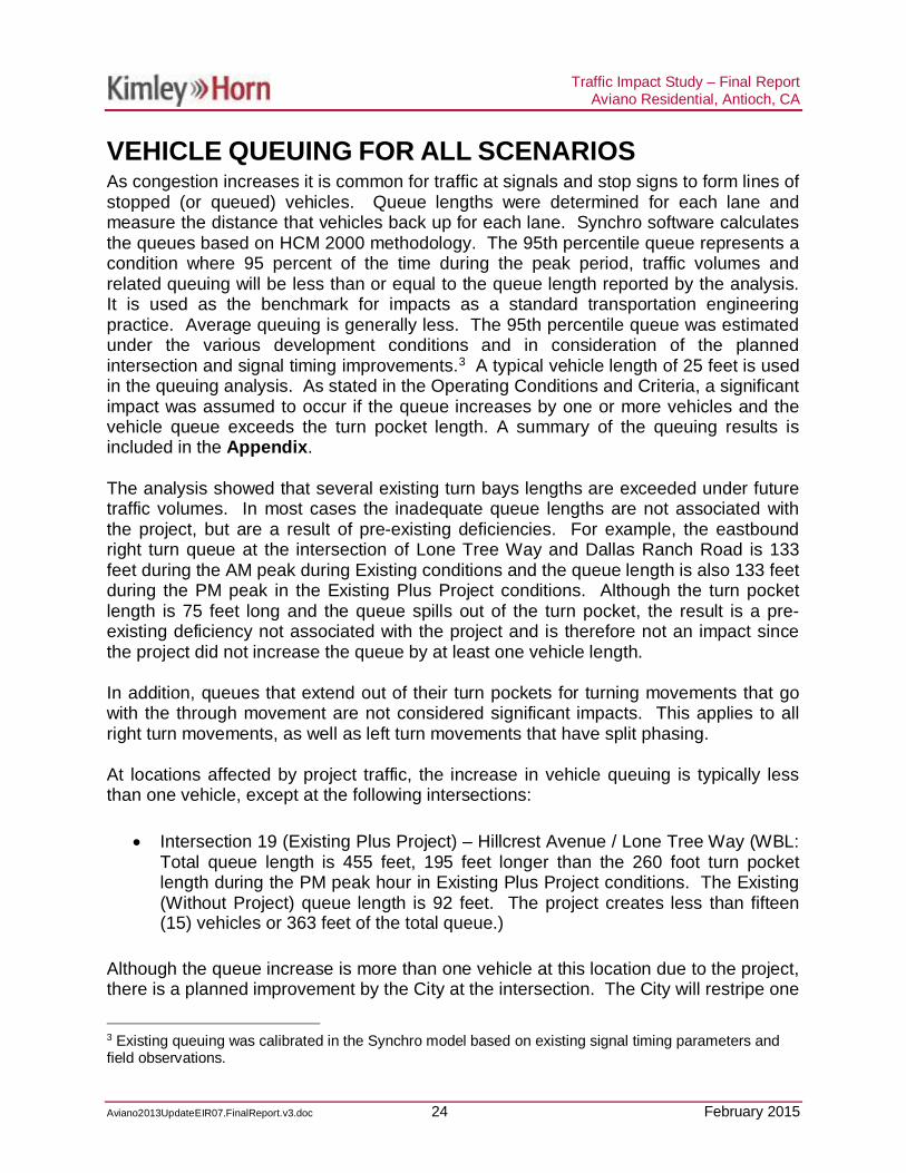
VEHICLE QUEUING FOR ALL SCENARIOSAs congestion increases it is common for traffic at signals and stop signs to form lines ofstopped (or queued) vehicles. Queue lengths were determined for each lane andmeasure the distance that vehicles back up for each lane. Synchro software calculatesthe queues based on HCM 2000 methodology. The 95th percentile queue represents acondition where 95 percent of the time during the peak period, traffic volumes andrelated queuing will be less than or equal to the queue length reported by the analysis.It is used as the benchmark for impacts as a standard transportation engineeringpractice. Average queuing is generally less. The 95th percentile queue was estimatedunder the various development conditions and in consideration of the plannedintersection and signal timing improvements.3 A typical vehicle length of 25 feet is usedin the queuing analysis. As stated in the Operating Conditions and Criteria, a significantimpact was assumed to occur if the queue increases by one or more vehicles and thevehicle queue exceeds the turn pocket length. A summary of the queuing results isincluded in the Appendix.
The analysis showed that several existing turn bays lengths are exceeded under futuretraffic volumes. In most cases the inadequate queue lengths are not associated withthe project, but are a result of pre-existing deficiencies. For example, the eastboundright turn queue at the intersection of Lone Tree Way and Dallas Ranch Road is 133feet during the AM peak during Existing conditions and the queue length is also 133 feetduring the PM peak in the Existing Plus Project conditions. Although the turn pocketlength is 75 feet long and the queue spills out of the turn pocket, the result is a pre-existing deficiency not associated with the project and is therefore not an impact sincethe project did not increase the queue by at least one vehicle length.
In addition, queues that extend out of their turn pockets for turning movements that gowith the through movement are not considered significant impacts. This applies to allright turn movements, as well as left turn movements that have split phasing.
At locations affected by project traffic, the increase in vehicle queuing is typically lessthan one vehicle, except at the following intersections:
· Intersection 19 (Existing Plus Project) – Hillcrest Avenue / Lone Tree Way (WBL:Total queue length is 455 feet, 195 feet longer than the 260 foot turn pocketlength during the PM peak hour in Existing Plus Project conditions. The Existing(Without Project) queue length is 92 feet. The project creates less than fifteen(15) vehicles or 363 feet of the total queue.)
Although the queue increase is more than one vehicle at this location due to the project,there is a planned improvement by the City at the intersection. The City will restripe one
3 Existing queuing was calibrated in the Synchro model based on existing signal timing parameters andfield observations.
Traffic Impact Study – Final ReportAviano Residential, Antioch, CA
Aviano2013UpdateEIR07.FinalReport.v3.doc 25 February 2015
of the westbound through lanes to be a left turn lane. This will result in two westboundleft turn lanes at this intersection. The improvement is expected to be completed by2017, before the project is built. The improvement will reduce the queue to becontained in the left turn storage and therefore, there is no significant impact.
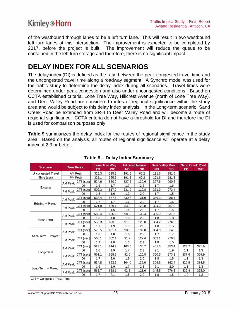
DELAY INDEX FOR ALL SCENARIOSThe delay index (DI) is defined as the ratio between the peak congested travel time andthe uncongested travel time along a roadway segment. A Synchro model was used forthe traffic study to determine the delay index during all scenarios. Travel times weredetermined under peak congestion and also under uncongested conditions. Based onCCTA established criteria, Lone Tree Way, Hillcrest Avenue (north of Lone Tree Way),and Deer Valley Road are considered routes of regional significance within the studyarea and would be subject to this delay index analysis. In the Long-term scenario, SandCreek Road be extended from SR-4 to Deer Valley Road and will become a route ofregional significance. CCTA criteria do not have a threshold for DI and therefore the DIis used for comparison purposes only.
Table 9 summarizes the delay index for the routes of regional significance in the studyarea. Based on the analysis, all routes of regional significance will operate at a delayindex of 2.3 or better.
Table 9 – Delay Index Summary
EB WB NB SB NB SB EB WB325.3 325.3 191.6 60.2 191.6 181.5 293.9 293.9325.1 325.3 191.6 60.2 191.6 181.5 294.1 294.1
CTT (sec) 524.6 550.9 327.6 130.6 327.6 290.6 0.0 0.0DI 1.6 1.7 1.7 2.2 1.7 1.6 0.0 0.0
CTT (sec) 502.3 517.2 331.9 119.8 331.9 273.4 0.0 0.0DI 1.5 1.6 1.7 2.0 1.7 1.5 0.0 0.0
CTT (sec) 538.4 557.6 330.3 131.9 330.3 288.4 0.0 0.0DI 1.7 1.7 1.6 2.2 1.7 1.6 0.0 0.0
CTT (sec) 521.8 529.1 83.3 120.8 324.0 267.9 0.0 0.0DI 1.6 1.6 1.4 2.0 1.7 1.5 0.0 0.0
CTT (sec) 583.4 596.6 98.2 132.4 336.9 331.6 0.0 0.0DI 1.8 1.8 1.6 2.2 1.8 1.8 0.0 0.0
CTT (sec) 555.3 623.8 91.3 120.0 354.2 276.5 0.0 0.0DI 1.7 1.9 1.5 2.0 1.8 1.5 0.0 0.0
CTT (sec) 575.5 601.1 98.9 132.8 334.8 314.5 0.0 0.0DI 1.8 1.8 1.6 2.2 1.7 1.7 0.0 0.0
CTT (sec) 566.1 582.1 91.7 127.4 352.1 270.3 0.0 0.0DI 1.7 1.8 1.5 2.1 1.8 1.5 0.0 0.0
CTT (sec) 529.1 614.9 103.5 135.7 401.5 353.4 323.7 371.9DI 1.6 1.9 1.7 2.3 2.1 1.9 1.1 1.3
CTT (sec) 561.1 658.1 92.6 120.8 350.5 273.2 337.6 369.9DI 1.7 2.0 1.5 2.0 1.8 1.5 1.1 1.3
CTT (sec) 534.8 623.1 104.0 136.0 396.6 362.4 329.9 384.5DI 1.6 1.9 1.7 2.3 2.1 2.0 1.1 1.3
CTT (sec) 568.7 668.1 92.8 121.6 345.5 276.3 339.4 378.0DI 1.7 2.1 1.5 2.0 1.8 1.5 1.2 1.3
CTT = Congested Travel Time
Sand Creek Road
Long-TermAM Peak
PM Peak
Long-Term + ProjectAM Peak
PM Peak
Near-TermAM Peak
PM Peak
Near-Term + ProjectAM Peak
PM Peak
ExistingAM Peak
PM Peak
Existing + ProjectAM Peak
PM Peak
Scenario Time Period Lone Tree Way Hillcrest Avenue Deer Valley Road
Uncongested TravelTime (sec)
AM PeakPM Peak

Traffic Impact Study – Final ReportAviano Residential, Antioch, CA
Aviano2013UpdateEIR07.FinalReport.v3.doc 26 February 2015
POTENTIAL EFFECTS ON TRANSIT, BICYCLE, ANDPEDESTRIAN MOBILITY
The project was evaluated to determine if it would likely conflict with adopted policies,plans, or programs supporting alternative transportation (e.g., bus turnouts, bicycleracks) or generate pedestrian, bicycle, or transit travel demand that would not beaccommodated by transit, bicycle, or pedestrian facilities and plans.
Residents to the Aviano residential development have the option of driving, takingtransit, walking or bicycling. For those taking transit, they can reach the site via futurebus routes of the Tri-Delta Transit system.
According to the 2008-2012 U.S. Census4, five percent of Antioch residents use transitto travel to work. This typically represents the highest level of transit ridership duringthe day. If it is conservatively assumed that five percent of the residents associatedwith the Aviano residential development will use transit during the peak hours of theday, it represents approximately 20 passengers in the weekday AM and 27 passengersin the weekday PM peak periods.
Data was not readily available for peak hour ridership levels on the Tri-Delta Transitsystem but during the weekday periods, the routes operate as often as every 10minutes and observations indicate that sufficient capacity exists on the buses toaccommodate the potential additional transit demand. Furthermore, dispersion of theproject-generated riders to the bus routes would result in a minimal effect on transitcapacity. Thus the project impact on transit service is determined to be less thansignificant.
There are adequate pedestrian walkways from the project site to the existing sidewalkson Hillcrest Avenue. The project proposes to extend Hillcrest Avenue from PrewettRanch Road to Sand Creek Road, adjacent to the proposed project, and constructsidewalks along either side. Although, the project proposes to construct sidewalk alongSand Creek Road fronting the southern edge of the project, there is still no sidewalkalong Sand Creek Road between the Dozier Libbey Medical High School and the KaiserPermanente access intersection. Pedestrians can walk along Hillcrest Avenue toPrewett Ranch Drive and walk west to access Deer Valley Road.
Cyclists will be able to access the residential development using the bike lane alongDeer Valley Road to just south of Wellness Way. There is a gap between the bike laneand the proposed project. There are no bicycle facilities along Sand Creek Roadbetween Deer Valley Road and the proposed project. Cyclists will also be able toaccess the project site via the bike lanes along Hillcrest Avenue to Prewett Ranch Drive.
4 American Factfinder, U.S. Census Bureau, 2013.

Traffic Impact Study – Final ReportAviano Residential, Antioch, CA
Aviano2013UpdateEIR07.FinalReport.v3.doc 27 February 2015
There is a gap between the bike lane and the proposed project. There are no bicyclefacilities planned along Hillcrest Avenue south of Prewett Ranch Drive. There are alsono bicycle facilities along Sand Creek Road east to the SR-4 bypass. This extensivebicycle network allows residents and visitors living within biking distance to travel to andfrom the project.
There are adequate transit facilities adjacent to the project site with continuoussidewalks and ramps to the transit stop locations. Therefore the Aviano residentialdevelopment’s impact on transit, pedestrian, or bicycle facilities is determined to be lessthan significant.
SITE ACCESS AND CIRCULATION
On-site circulation was evaluated at the project’s two access streets and within theproject site. Figure 2 shows the project site plan.
The two access points to the project are along the Hillcrest Avenue extension and theSand Creek Road extension. Each of these intersections will be signalizedintersections with full access.
The proposed project access street depths are as follows:
· Sand Creek Road/South entrance – 400 feet· Hillcrest Avenue/East entrance – 400 feet
Blocked parking aisles can generate on-site congestion and inhibit efficient parking lotcirculation. An analysis of on-site queuing with the Aviano residential developmentindicates that vehicles are not expected to queue up beyond the depth of the accessstreets.
SUPPLEMENTAL ANALYSIS
A supplemental evaluation was completed to determine if Sand Creek Road will need tobe four lanes or six lanes in the Long-term (2030) scenario. In addition, a supplementalevaluation was completed to determine the level of traffic that can be accommodated atthe intersection of Lone Tree Way and Hillcrest Avenue if Sand Creek Road is notconstructed between Deer Valley Road and Hillcrest Avenue as part of the Avianoproject. The results are discussed below.

Traffic Impact Study – Final ReportAviano Residential, Antioch, CA
Aviano2013UpdateEIR07.FinalReport.v3.doc 28 February 2015
Sand Creek Road Lane GeometryIt was determined that Sand Creek Road can operate with only four lanes in the Long-term scenario. The intersections along Sand Creek Road between SR-4 and DeerValley Road all operate acceptably, with the exception of the intersection of Sand CreekRoad and Deer Valley Road. However, this intersection operates poorly in the AM peakbecause of the insufficient number of turn lanes at the intersection. Sand Creek Roadoperates at a delay index of 1.3 or better in both direction and the AM and PM peaks, asshown in Table 9. This delay index is well below the County’s threshold of 2.0.Therefore, Sand Creek Road can operate as a four lane roadway, and does not needsix lanes.
Intersection Operations of Lone Tree Way and HillcrestAvenue if Sand Creek Road Is Not ConstructedIt was determined that the intersection of Lone Tree Way and Hillcrest Avenue willoperate acceptably if the Sand Creek Road extension was not constructed.
The project trips were rerouted to use only Hillcrest Avenue and not Sand Creek Road.A majority of the project trips would go through the intersection of Lone Tree Way andHillcrest Avenue to reach their final destinations. A portion of the project trips turned offHillcrest Avenue at the intersection Hillcrest Avenue and Prewett Ranch Drive. Afterrerouting the project trips, the project trips were added to the Long-term without projectvolumes in the AM and PM peaks to determine the worst case scenario for theintersection.
The intersection of Hillcrest Avenue and Prewett Ranch Drive operates at LOS C in theAM and PM peaks with a delay of 30.1 seconds and 30.9 seconds, respectively. Sincethe intersection operates at LOS C in the Long-term plus Project scenario, which isbetter than the LOS D threshold, the full project can be accommodated even if SandCreek Road between Deer Valley Road and Hillcrest Avenue is not built with theproject.
SUMMARY OF IMPACTS AND RECOMMENDEDMITIGATION
Based on the results of the traffic analysis and evaluation of the proposed site plan,there are no significant impacts.

4
Lone Tree Way
Hill
cres
tAve
nue
Hei
dorn
Ran
chR
oad
Jeffr
eyW
ay
Sha
dyW
illow
Lane
Em
pire
Aven
ue
Sla
ten
Ran
chR
oad
Prewett Ranch Drive
Sage
brus
hD
rive
Dee
rVal
ley
Roa
d
Mok
elum
neDr
ive
Lone Tree Way
Dee
r Val
ley
Hig
hSc
hool
Deer Valley Road
Deer
Valle
y Pla
za
MaritaDrive
Indian Hill Drive
Will
iam
son
Ran
chPl
aza
Can
ada
Val
ley
Roa
d
Vis
taG
rand
eD
rive
Country Hills Drive
Sterling Hill Drive
Laur
elR
oad
Dal
las
Ran
chR
oad
Blac
kD
iam
ond
Driv
e Coun
try
HillsDrive
Sand Creek Road
Sand Creek Road
Prew
ett
Park
Sand Creek Road
Kai
serW
ay
FIGURE 1PROJECT LOCATION AND STUDY INTERSECTIONS
FEBRUARY 2015BH-097037024 ANTIOCH AVIANO RESIDENTIAL TRAFFIC IMPACT STUDY
1
3
2
5
6
7
89
10*11* 12*
13*
14
16*
17*18
19
20
4
PROJECT SITE
X
LEGEND
N
NOT TO SCALE
EXITING STUDY AREAINTERSECTIONS
15
21
22 23 24 25 26
FUTURE ROAD
X* FUTURE STUDY AREAINTERSECTIONS

FIGURE 2SITE PLAN
ANTIOCH AVIANO RESIDENTIALBH-097037024
SOURCE: CARLSON, BARBEE & GIBSON, INC.
FEBRUARY 2015

4
Lone Tree Way
Hillc
rest
Ave
nue
Hei
dorn
Ran
chR
oad
Jeffr
eyW
ay
Sha
dyW
illow
Lane
Sla
ten
Ran
chR
oad
Prewett Ranch Drive
Sag
ebru
shD
rive
Dee
rVal
ley
Roa
d
Mok
elum
neDr
ive
Dee
r Val
ley
Hig
hS
choo
l
Deer Valley Road
Deer
Valle
yPl
aza
MaritaDrive
Indian Hill Drive
Will
iam
son
Ran
chP
laza
Can
a da
Val
ley
Roa
d
Vis
t aG
ran d
eD
rive
Country Hills Drive
Sterling Hill Drive
Laur
elR
oad
Dal
las
Ran
chR
oad
Bla
ckD
iam
ond
Driv
e Coun
tryHills
Drive
Sand Creek Road
Pre
wet
tP
ark
Sand Creek Road
Kai
serW
ay
13 14
1 2 3
4 5 6
12
7 8 9
15
1110
FIGURE 3EXISTING (2014) LANE GEOMETRY AND TRAFFIC CONTROL
N
NOT TO SCALE
LEGEND
TRAFFIC SIGNAL
STOP SIGN
STORAGE LENGTHXX'
100'
200'
190'
160'
155'
145'
150'
140'
120'
145'
170'
145'
175'
120'
115'
120'
150'
535'
180'
190'
100'
145'
145'
140'
80'
140'
155'
540'
DROP
70'
DR
OP
FUTUREINTERSECTION
WITHPROJECT
FUTUREINTERSECTION
WITHPROJECT
FUTUREINTERSECTION
WITHPROJECT
FUTUREINTERSECTION
70'
190'
75'
75'
75'
70'
75'
75'
75' 180'
100'
115'
1
3
2
5
6
7
89
10*11* 12*
13*
14
16*
17*18
19
20
4
15
21
22 23 24 25 26
ANTIOCH AVIANO RESIDENTIAL TRAFFIC IMPACT STUDY
PROJECT SITE
X EXITING STUDY AREAINTERSECTIONS
FUTURE ROAD
X* FUTURE STUDY AREAINTERSECTIONS
BH-097037024 FEBRUARY 2015

4
Lone Tree Way
Hillc
rest
Ave
nue
Hei
dorn
Ran
chR
oad
Jeffr
eyW
ay
Sha
dyW
illow
Lane
Sla
ten
Ran
chR
oad
Prewett Ranch Drive
Sag
ebru
shD
rive
Dee
rVal
ley
Roa
d
Mok
elum
neDr
ive
Dee
r Val
ley
Hig
hS
choo
l
Deer Valley Road
Deer
Valle
yPl
aza
MaritaDrive
Indian Hill Drive
Will
iam
son
Ran
chP
laza
Can
a da
Val
ley
Roa
d
Vis
t aG
ran d
eD
rive
Country Hills Drive
Sterling Hill Drive
Laur
elR
oad
Dal
las
Ran
chR
oad
Bla
ckD
iam
ond
Driv
e Coun
tryHills
Drive
Sand Creek Road
Pre
wet
tP
ark
Sand Creek Road
Kai
serW
ay
16 17 18
19 20 21
22 23 24
2625
FIGURE 3EXISTING (2014) LANE GEOMETRY AND TRAFFIC CONTROL (CONTINUED)
FUTUREINTERSECTION
WITHPROJECT
230'
115'
130'
95'
615'
260'
225'
600'
180'
90'
150'
125'
585'
175'
165'
75'
120'
200'
130'
200'
50'
410'
215'
200'
160'
240'
70'
300'
340'
140' 280'
195'
DR
OP
860'
290'
DROP
260'
175'
DR
OP
200'
DR
OP
245'
DR
OP
DR
OP
325'
620'
320'
140'350'
ANTIOCH AVIANO RESIDENTIAL TRAFFIC IMPACT STUDY
N
NOT TO SCALE
LEGEND
TRAFFIC SIGNAL
STOP SIGN
STORAGE LENGTHXX'
PROJECT SITE
X EXITING STUDY AREAINTERSECTIONS
FUTURE ROAD
X* FUTURE STUDY AREAINTERSECTIONS
210'
165'
195'
1
3
2
5
6
7
13*
14
19
20
4
15
21
22 23 24 25 26
18 17*
9
BH-097037024
8
FUTUREINTERSECTION
FRE
E*
*There is a free northbound right by-pass road onHillcrest Road, south of the intersection
10*11* 12*
16*
FEBRUARY 2015
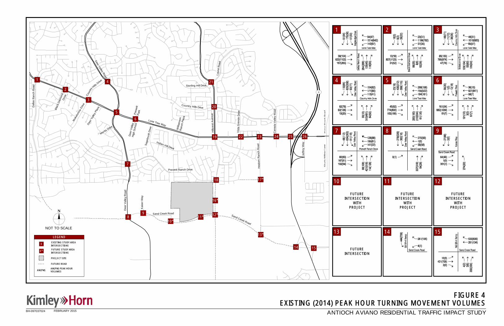
4
Lone Tree Way
Hillc
rest
Ave
nue
Hei
dorn
Ran
chR
oad
Jeffr
eyW
ay
Sha
dyW
illow
Lane
Sla
ten
Ran
chR
oad
Prewett Ranch Drive
Sag
ebru
shD
rive
Dee
rVal
ley
Roa
d
Mok
elum
neDr
ive
Dee
r Val
ley
Hig
hS
choo
l
Deer Valley Road
Deer
Valle
yPl
aza
MaritaDrive
Indian Hill Drive
Will
iam
son
Ran
chP
laza
Can
a da
Val
ley
Roa
d
Vis
t aG
ran d
eD
rive
Country Hills Drive
Sterling Hill Drive
Laur
elR
oad
Dal
las
Ran
chR
oad
Bla
ckD
iam
ond
Driv
e Coun
tryHills
Drive
Sand Creek Road
Pre
wet
tP
ark
Sand Creek Road
Kai
serW
ay
ANTIOCH AVIANO RESIDENTIAL TRAFFIC IMPACT STUDY
AM(PM) PEAK HOURVOLUMESAM(PM)
FIGURE 4EXISTING (2014) PEAK HOUR TURNING MOVEMENT VOLUMES
PROJECT SITE
X
LEGEND
N
NOT TO SCALE
EXISTING STUDY AREAINTERSECTIONS
FUTURE ROAD
X* FUTURE STUDY AREAINTERSECTIONS
1
3
2
5
6
7
13*
14
19
20
4
15
21
22 23 24 25 26
18 17*
9
BH-097037024
FUTUREINTERSECTION
WITHPROJECT
FUTUREINTERSECTION
WITHPROJECT
FUTUREINTERSECTION
WITHPROJECT
FUTUREINTERSECTION
1 2 3
4 5 6
7 8 9
10 11 12
13 14 15
810*
11* 12*
16*
FEBRUARY 2015

4
Lone Tree Way
Hillc
rest
Ave
nue
Hei
dorn
Ran
chR
oad
Jeffr
eyW
ay
Sha
dyW
illow
Lane
Sla
ten
Ran
chR
oad
Prewett Ranch Drive
Sag
ebru
shD
rive
Dee
rVal
ley
Roa
d
Mok
elum
neDr
ive
Dee
r Val
ley
Hig
hS
choo
l
Deer Valley Road
Deer
Valle
yPl
aza
MaritaDrive
Indian Hill Drive
Will
iam
son
Ran
chP
laza
Can
a da
Val
ley
Roa
d
Vis
t aG
ran d
eD
rive
Country Hills Drive
Sterling Hill Drive
Laur
elR
oad
Dal
las
Ran
chR
oad
Bla
ckD
iam
ond
Driv
e Coun
tryHills
Drive
Sand Creek Road
Pre
wet
tP
ark
Sand Creek Road
Kai
serW
ay
ANTIOCH AVIANO RESIDENTIAL TRAFFIC IMPACT STUDY
FIGURE 4EXISTING (2014) PEAK HOUR TURNING MOVEMENT VOLUMES (CONTINUED)
AM(PM) PEAK HOURVOLUMESAM(PM)
PROJECT SITE
X
LEGEND
N
NOT TO SCALE
EXISTING STUDY AREAINTERSECTIONS
FUTURE ROAD
X* FUTURE STUDY AREAINTERSECTIONS
1
3
2
5
6
7
13*
14
19
20
4
15
21
22 23 24 25 26
18 17*
9
BH-097037024
FUTUREINTERSECTION
WITHPROJECT
16 17 18
19 20 21
22 23 24
25 26
8
FUTUREINTERSECTION
10*11* 12*
16*
FEBRUARY 2015

4
Lone Tree Way
Hill
cres
tAve
nue
Hei
dorn
Ran
chR
oad
Jeffr
eyW
ay
Sha
dyW
illow
Lane
Em
pire
Aven
ue
Sla
ten
Ran
chR
oad
Prewett Ranch Drive
Sage
brus
hD
rive
Dee
rVal
ley
Roa
d
Mok
elum
neDr
ive
Lone Tree Way
Dee
r Val
ley
Hig
hSc
hool
Deer Valley Road
Deer
Valle
y Pla
za
MaritaDrive
Indian Hill Drive
Will
iam
son
Ran
chPl
aza
Can
ada
Val
ley
Roa
d
Vis
taG
rand
eD
rive
Country Hills Drive
Sterling Hill Drive
Laur
elR
oad
Dal
las
Ran
chR
oad
Blac
kD
iam
ond
Driv
e Coun
try
HillsDrive
Sand Creek Road
Sand Creek Road
Prew
ett
Park
Sand Creek Road
Kai
serW
ay
PROJECT SITE
X
LEGEND
FIGURE 5NEAR-TERM PROJECT TRIP DISTRIBUTION
N
NOT TO SCALE
ANTIOCH AVIANO RESIDENTIAL TRAFFIC IMPACT STUDY
EXISTING STUDY AREAINTERSECTIONS
1
3
2
5
6
7
13*
14 15
17*18
19
20
4 21
22 23 24 25 26
FUTURE ROAD
X* FUTURE STUDY AREAINTERSECTIONS
AM(PM)TRIP DISTRIBUTION
9
BH-097037024
810*
11* 12*
16*
FEBRUARY 2015

4
Lone Tree Way
Hillc
rest
Ave
nue
Hei
dorn
Ran
chR
oad
Jeffr
eyW
ay
Sha
dyW
illow
Lane
Sla
ten
Ran
chR
oad
Prewett Ranch Drive
Sag
ebru
shD
rive
Dee
rVal
ley
Roa
d
Mok
elum
neDr
ive
Dee
r Val
ley
Hig
hS
choo
l
Deer Valley Road
Deer
Valle
yPl
aza
MaritaDrive
Indian Hill Drive
Will
iam
son
Ran
chP
laza
Can
a da
Val
ley
Roa
d
Vis
t aG
ran d
eD
rive
Country Hills Drive
Sterling Hill Drive
Laur
elR
oad
Dal
las
Ran
chR
oad
Bla
ckD
iam
ond
Driv
e Coun
tryHills
Drive
Sand Creek Road
Pre
wet
tP
ark
Sand Creek Road
Kai
serW
ay
ANTIOCH AVIANO RESIDENTIAL TRAFFIC IMPACT STUDY
AM(PM) PEAK HOURVOLUMESAM(PM)
FIGURE 6PROJECT GENERATED PEAK HOUR TURNING MOVEMENT VOLUMES IN NEAR-TERM
PROJECT SITE
X
LEGEND
N
NOT TO SCALE
EXISTING STUDY AREAINTERSECTIONS
FUTURE ROAD
X* FUTURE STUDY AREAINTERSECTIONS
1
3
2
5
6
7
13*
14
19
20
4
15
21
22 23 24 25 26
18 17*
9
BH-097037024
FUTUREINTERSECTION
1 2 3
4 5 6
7 8 9
10 11 12
13 14 15
810*
11* 12*
16*
FEBRUARY 2015

4
Lone Tree Way
Hillc
rest
Ave
nue
Hei
dorn
Ran
chR
oad
Jeffr
eyW
ay
Sha
dyW
illow
Lane
Sla
ten
Ran
chR
oad
Prewett Ranch Drive
Sag
ebru
shD
rive
Dee
rVal
ley
Roa
d
Mok
elum
neDr
ive
Dee
r Val
ley
Hig
hS
choo
l
Deer Valley Road
Deer
Valle
yPl
aza
MaritaDrive
Indian Hill Drive
Will
iam
son
Ran
chP
laza
Can
a da
Val
ley
Roa
d
Vis
t aG
ran d
eD
rive
Country Hills Drive
Sterling Hill Drive
Laur
elR
oad
Dal
las
Ran
chR
oad
Bla
ckD
iam
ond
Driv
e Coun
tryHills
Drive
Sand Creek Road
Pre
wet
tP
ark
Sand Creek Road
Kai
serW
ay
ANTIOCH AVIANO RESIDENTIAL TRAFFIC IMPACT STUDY
AM(PM) PEAK HOURVOLUMESAM(PM)
PROJECT SITE
X
LEGEND
N
NOT TO SCALE
EXISTING STUDY AREAINTERSECTIONS
FUTURE ROAD
X* FUTURE STUDY AREAINTERSECTIONS
1
3
2
5
6
7
13*
14
19
20
4
15
21
22 23 24 25 26
18 17*
FIGURE 6PROJECT GENERATED PEAK HOUR TURNING MOVEMENT VOLUMES IN NEAR-TERM (CONTINUED)
9
BH-097037024
16 17 18
19 20 21
22 23 24
25 26
8
FUTUREINTERSECTION
10*11* 12*
16*
FEBRUARY 2015

4
Lone Tree Way
Hill
cres
tAve
nue
Hei
dorn
Ran
chR
oad
Jeffr
eyW
ay
Sha
dyW
illow
Lane
Em
pire
Aven
ue
Sla
ten
Ran
chR
oad
Prewett Ranch Drive
Sage
brus
hD
rive
Dee
rVal
ley
Roa
d
Mok
elum
neDr
ive
Lone Tree Way
Dee
r Val
ley
Hig
hSc
hool
Deer Valley Road
Deer
Valle
y Pla
za
MaritaDrive
Indian Hill Drive
Will
iam
son
Ran
chPl
aza
Can
ada
Val
ley
Roa
d
Vis
taG
rand
eD
rive
Country Hills Drive
Sterling Hill Drive
Laur
elR
oad
Dal
las
Ran
chR
oad
Blac
kD
iam
ond
Driv
e Coun
try
HillsDrive
Sand Creek Road
Sand Creek Road
Prew
ett
Park
Sand Creek Road
Kai
serW
ay
PROJECT SITE
X
LEGEND
FIGURE 7LONG-TERM PROJECT TRIP DISTRIBUTION
N
BH-097037024
NOT TO SCALE
ANTIOCH AVIANO RESIDENTIAL TRAFFIC IMPACT STUDY
EXISTING STUDY AREAINTERSECTIONS
1
3
2
5
6
7
13*
14 15
17*18
19
20
4 21
22 23 24 25 26
FUTURE ROAD
X* FUTURE STUDY AREAINTERSECTIONS
AM (PM)TRIP DISTRIBUTION
98
10*11* 12*
16*
FEBRUARY 2015

4
Lone Tree Way
Hillc
rest
Ave
nue
Hei
dorn
Ran
chR
oad
Jeffr
eyW
ay
Sha
dyW
illow
Lane
Sla
ten
Ran
chR
oad
Prewett Ranch Drive
Sag
ebru
shD
rive
Dee
rVal
ley
Roa
d
Mok
elum
neDr
ive
Dee
r Val
ley
Hig
hS
choo
l
Deer Valley Road
Deer
Valle
yPl
aza
MaritaDrive
Indian Hill Drive
Will
iam
son
Ran
chP
laza
Can
a da
Val
ley
Roa
d
Vis
t aG
ran d
eD
rive
Country Hills Drive
Sterling Hill Drive
Laur
elR
oad
Dal
las
Ran
chR
oad
Bla
ckD
iam
ond
Driv
e Coun
tryHills
Drive
Sand Creek Road
Pre
wet
tP
ark
Sand Creek Road
Kai
serW
ay
ANTIOCH AVIANO RESIDENTIAL TRAFFIC IMPACT STUDY
AM(PM) PEAK HOURVOLUMESAM(PM)
FIGURE 8PROJECT GENERATED PEAK HOUR TURNING MOVEMENT VOLUMES IN LONG-TERM
PROJECT SITE
X
LEGEND
N
NOT TO SCALE
EXISTING STUDY AREAINTERSECTIONS
FUTURE ROAD
X* FUTURE STUDY AREAINTERSECTIONS
1
3
2
5
6
7
13*
14
19
20
4
15
21
22 23 24 25 26
18 17*
9
BH-097037024
8
1 2 3
4 5 6
7 8 9
10 11 12
13 14 15
10*11* 12*
16*
FEBRUARY 2015
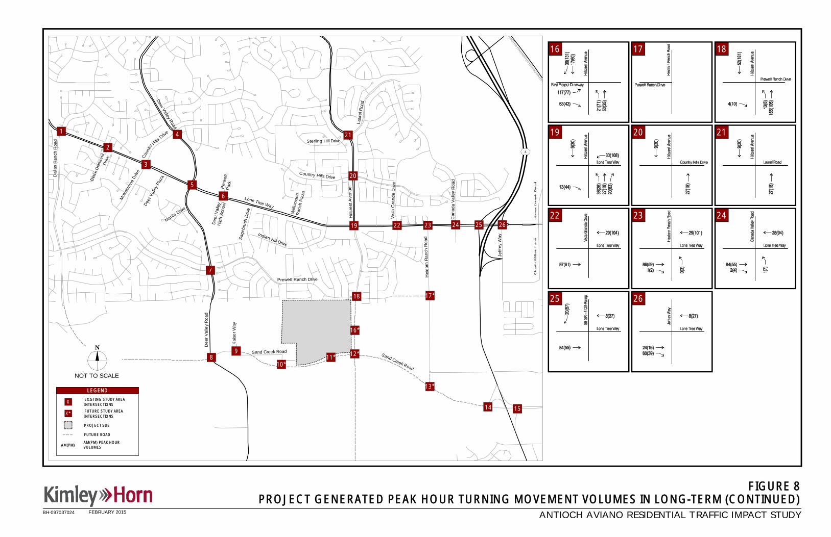
4
Lone Tree Way
Hillc
rest
Ave
nue
Hei
dorn
Ran
chR
oad
Jeffr
eyW
ay
Sha
dyW
illow
Lane
Sla
ten
Ran
chR
oad
Prewett Ranch Drive
Sag
ebru
shD
rive
Dee
rVal
ley
Roa
d
Mok
elum
neDr
ive
Dee
r Val
ley
Hig
hS
choo
l
Deer Valley Road
Deer
Valle
yPl
aza
MaritaDrive
Indian Hill Drive
Will
iam
son
Ran
chP
laza
Can
a da
Val
ley
Roa
d
Vis
t aG
ran d
eD
rive
Country Hills Drive
Sterling Hill Drive
Laur
elR
oad
Dal
las
Ran
chR
oad
Bla
ckD
iam
ond
Driv
e Coun
tryHills
Drive
Sand Creek Road
Pre
wet
tP
ark
Sand Creek Road
Kai
serW
ay
ANTIOCH AVIANO RESIDENTIAL TRAFFIC IMPACT STUDY
AM(PM) PEAK HOURVOLUMESAM(PM)
PROJECT SITE
X
LEGEND
N
NOT TO SCALE
EXISTING STUDY AREAINTERSECTIONS
FUTURE ROAD
X* FUTURE STUDY AREAINTERSECTIONS
1
3
2
5
6
7
13*
14
19
20
4
15
21
22 23 24 25 26
18 17*
FIGURE 8PROJECT GENERATED PEAK HOUR TURNING MOVEMENT VOLUMES IN LONG-TERM (CONTINUED)
9
BH-097037024
8
16 17 18
19 20 21
22 23 24
25 26
10*11* 12*
16*
FEBRUARY 2015

4
Lone Tree Way
Hillc
rest
Ave
nue
Hei
dorn
Ran
chR
oad
Jeffr
eyW
ay
Sha
dyW
illow
Lane
Sla
ten
Ran
chR
oad
Prewett Ranch Drive
Sag
ebru
shD
rive
Dee
rVal
ley
Roa
d
Mok
elum
neDr
ive
Dee
r Val
ley
Hig
hS
choo
l
Deer Valley Road
Deer
Valle
yPl
aza
MaritaDrive
Indian Hill Drive
Will
iam
son
Ran
chP
laza
Can
a da
Val
ley
Roa
d
Vis
t aG
ran d
eD
rive
Country Hills Drive
Sterling Hill Drive
Laur
elR
oad
Dal
las
Ran
chR
oad
Bla
ckD
iam
ond
Driv
e Coun
tryHills
Drive
Sand Creek Road
Pre
wet
tP
ark
Sand Creek Road
Kai
serW
ay
ANTIOCH AVIANO RESIDENTIAL TRAFFIC IMPACT STUDY
AM(PM) PEAK HOURVOLUMESAM(PM)
FIGURE 9EXISTING PLUS PROJECT PEAK HOUR TURNING MOVEMENT VOLUMES
PROJECT SITE
X
LEGEND
N
NOT TO SCALE
EXISTING STUDY AREAINTERSECTIONS
FUTURE ROAD
X* FUTURE STUDY AREAINTERSECTIONS
1
3
2
5
6
7
13*
14
19
20
4
15
21
22 23 24 25 26
18 17*
9
BH-097037024
8
FUTUREINTERSECTION
13
1 2 3
4 5 6
7 8 9
10 11 12
14 15
10*11* 12*
16*
FEBRUARY 2015

4
Lone Tree Way
Hillc
rest
Ave
nue
Hei
dorn
Ran
chR
oad
Jeffr
eyW
ay
Sha
dyW
illow
Lane
Sla
ten
Ran
chR
oad
Prewett Ranch Drive
Sag
ebru
shD
rive
Dee
rVal
ley
Roa
d
Mok
elum
neDr
ive
Dee
r Val
ley
Hig
hS
choo
l
Deer Valley Road
Deer
Valle
yPl
aza
MaritaDrive
Indian Hill Drive
Will
iam
son
Ran
chP
laza
Can
a da
Val
ley
Roa
d
Vis
t aG
ran d
eD
rive
Country Hills Drive
Sterling Hill Drive
Laur
elR
oad
Dal
las
Ran
chR
oad
Bla
ckD
iam
ond
Driv
e Coun
tryHills
Drive
Sand Creek Road
Pre
wet
tP
ark
Sand Creek Road
Kai
serW
ay
ANTIOCH AVIANO RESIDENTIAL TRAFFIC IMPACT STUDY
AM(PM) PEAK HOURVOLUMESAM(PM)
PROJECT SITE
X
LEGEND
N
NOT TO SCALE
EXISTING STUDY AREAINTERSECTIONS
FUTURE ROAD
X* FUTURE STUDY AREAINTERSECTIONS
1
3
2
5
6
7
13*
14
19
20
4
15
21
22 23 24 25 26
18 17*
FIGURE 9EXISTING PLUS PROJECT PEAK HOUR TURNING MOVEMENT VOLUMES (CONTINUED)
9
BH-097037024
8
FUTUREINTERSECTION
1716 18
19 20 21
22 23 24
25 26
10*11* 12*
16*
FEBRUARY 2015

4
Lone Tree Way
Hillc
rest
Ave
nue
Hei
dorn
Ran
chR
oad
Jeffr
eyW
ay
Sha
dyW
illow
Lane
Sla
ten
Ran
chR
oad
Prewett Ranch Drive
Sag
ebru
shD
rive
Dee
rVal
ley
Roa
d
Mok
elum
neDr
ive
Dee
r Val
ley
Hig
hS
choo
l
Deer Valley Road
Deer
Valle
yPl
aza
MaritaDrive
Indian Hill Drive
Will
iam
son
Ran
chP
laza
Can
a da
Val
ley
Roa
d
Vis
t aG
ran d
eD
rive
Country Hills Drive
Sterling Hill Drive
Laur
elR
oad
Dal
las
Ran
chR
oad
Bla
ckD
iam
ond
Driv
e Coun
tryHills
Drive
Sand Creek Road
Pre
wet
tP
ark
Sand Creek Road
Kai
serW
ay
13
1 2 3
4 5 6
12
7 8
15
1110
FIGURE 10NEAR-TERM (2015) LANE GEOMETRY AND TRAFFIC CONTROL
LEGEND
TRAFFIC SIGNAL
STOP SIGN
STORAGE LENGTHXX'
100'
200'
190'
160'
155'
145'
150'
140'
120'
145'
170'
145'
175'
120'
115'
120'
100'
145'
145'
140'
80'
140'
155'
540'
DROP
70'
70'
190'
75'
75'
75'
70'
75'
100'
1
3
2
5
6
7
13*
14
17*18
19
20
4
15
21
22 23 24 25 26
ANTIOCH AVIANO RESIDENTIAL TRAFFIC IMPACT STUDY
PROJECT SITE
X EXITING STUDY AREAINTERSECTIONS
FUTURE ROAD
X* FUTURE STUDY AREAINTERSECTIONS
9
BH-097037024
150'
535'
180'
190'
75'
75' 180'
9
DR
OP
115'
WITH THE ADDITION OF THE PROJECT*NOTE: SHADED INTERSECTIONS REFLECT UNCHANGED CONDITIONS FROM EXISTING CONDITIONS.
100'
100'
100'
100'
140'
FUTUREINTERSECTION
8
14
100'
100'
N
NOT TO SCALE 10*11* 12*
16*
FEBRUARY 2015

4
Lone Tree Way
Hillc
rest
Ave
nue
Hei
dorn
Ran
chR
oad
Jeffr
eyW
ay
Sha
dyW
illow
Lane
Sla
ten
Ran
chR
oad
Prewett Ranch Drive
Sag
ebru
shD
rive
Dee
rVal
ley
Roa
d
Mok
elum
neDr
ive
Dee
r Val
ley
Hig
hS
choo
l
Deer Valley Road
Deer
Valle
yPl
aza
MaritaDrive
Indian Hill Drive
Will
iam
son
Ran
chP
laza
Can
a da
Val
ley
Roa
d
Vis
t aG
ran d
eD
rive
Country Hills Drive
Sterling Hill Drive
Laur
elR
oad
Dal
las
Ran
chR
oad
Bla
ckD
iam
ond
Driv
e Coun
tryHills
Drive
Sand Creek Road
Pre
wet
tP
ark
Sand Creek Road
Kai
serW
ay
16 17
20 21
22 23 24
2625
FIGURE 10NEAR-TERM (2015) LANE GEOMETRY AND TRAFFIC CONTROL (CONTINUED)
180'
90'
150'
125'
585'
175'
165'
75'
120'
200'
130'
200'
50'
410'
215'
200'
160'
240'
70'
300'
340'
140' 120'
195'
175'
FRE
E*
DR
OP
200'
245'
DR
OP
DR
OP
325'
620'
320'
140'350'
ANTIOCH AVIANO RESIDENTIAL TRAFFIC IMPACT STUDY
N
NOT TO SCALE
LEGEND
TRAFFIC SIGNAL
STOP SIGN
STORAGE LENGTHXX'
PROJECT SITE
X EXITING STUDY AREAINTERSECTIONS
FUTURE ROAD
X* FUTURE STUDY AREAINTERSECTIONS
210'
245'
195'
1
3
2
5
6
7
13*
14
17*18
19
20
4
15
21
22 23 24 25 26
9
BH-097037024
18
230'
115'
130'
95'
WITH THE ADDITION OF THE PROJECT*NOTE: SHADED INTERSECTIONS REFLECT UNCHANGED CONDITIONS FROM EXISTING CONDITIONS.
100'
FUTUREINTERSECTION
8
300'
160'
*There is a free northbound right by-pass road onHillcrest Road, south of the intersection
10*11* 12*
16*
FEBRUARY 2015
19
615'
260'
225'
600'
860'
290'
DROP
260'

Deer
Valley
Road
Lone Tree Way
James Donlon Boulevard
Somer
svilleRoa
d
Buchanan Road
Con
traLo
ma
Boule
vard
Lo neTre e
Way
Dee r Valley Road
Hilcrest Avenue
Lone Tree Way
Sand Creek Road
Fairv
iew
Aven
ue
Empire
Mine
Road
Laurel Road
Main Street
4
4
4
4
4
Balfour Road
Chestnut Street
Wal
nutB
oule
vardFa
irvie
wAv
enue
Sel
lers
Aven
ue
Sunset Road
Bre
ntw
ood
Bou
leva
rd
Dainty Avenue
O'H
ara
Aven
ue
Em
pire
Ave
nue
Neroly Road
Mai
nS
treet
Tuolumne Way
Cypress Road
Bet
helI
slan
dR
oad
Sel
lers
Aven
ue
Main Street
Live
Oak
Aven
ue
Oakley Road
Wild
Horse Roa
d
Hidden Glen
Drive
N
NOT TO SCALE
1
32
56
7
8 910* 11* 12*
13*14 15
16*
17*18
19
20
214
FIGURE 11
DEVELOPMENT SITE
PROJECT SITE
X
LEGEND
STUDY AREAINTERSECTIONS
APPROVED PROJECT LOCATIONSANTIOCH AVIANO RESIDENTIAL TRAFFIC IMPACT STUDY
22 23 24 25 26
BH-097037024 FEBRUARY 2015

4
Lone Tree Way
Hillc
rest
Ave
nue
Hei
dorn
Ran
chR
oad
Jeffr
eyW
ay
Sha
dyW
illow
Lane
Sla
ten
Ran
chR
oad
Prewett Ranch Drive
Sag
ebru
shD
rive
Dee
rVal
ley
Roa
d
Mok
elum
neDr
ive
Dee
r Val
ley
Hig
hS
choo
l
Deer Valley Road
Deer
Valle
yPl
aza
MaritaDrive
Indian Hill Drive
Will
iam
son
Ran
chP
laza
Can
a da
Val
ley
Roa
d
Vis
t aG
ran d
eD
rive
Country Hills Drive
Sterling Hill Drive
Laur
elR
oad
Dal
las
Ran
chR
oad
Bla
ckD
iam
ond
Driv
e Coun
tryHills
Drive
Sand Creek Road
Pre
wet
tP
ark
Sand Creek Road
Kai
serW
ay
FUTUREINTERSECTION
WITHPROJECT
FUTUREINTERSECTION
WITHPROJECT
FUTUREINTERSECTION
WITHPROJECT
FUTUREINTERSECTION
ANTIOCH AVIANO RESIDENTIAL TRAFFIC IMPACT STUDY
AM(PM) PEAK HOURVOLUMESAM(PM)
PROJECT SITE
X
LEGEND
N
NOT TO SCALE
EXISTING STUDY AREAINTERSECTIONS
FUTURE ROAD
X* FUTURE STUDY AREAINTERSECTIONS
1
3
2
5
6
7
13*
14
19
20
4
15
21
22 23 24 25 26
18 17*
9
APPROVED AND PENDING DEVELOPMENT GENERATED TRAFFIC VOLUMES
1 2 3
4 5 6
7 8 9
10 11 12
13 14 15
FIGURE 12
BH-097037024
810*
11* 12*
16*
FEBRUARY 2015

4
Lone Tree Way
Hillc
rest
Ave
nue
Hei
dorn
Ran
chR
oad
Jeffr
eyW
ay
Sha
dyW
illow
Lane
Sla
ten
Ran
chR
oad
Prewett Ranch Drive
Sag
ebru
shD
rive
Dee
rVal
ley
Roa
d
Mok
elum
neDr
ive
Dee
r Val
ley
Hig
hS
choo
l
Deer Valley Road
Deer
Valle
yPl
aza
MaritaDrive
Indian Hill Drive
Will
iam
son
Ran
chP
laza
Can
a da
Val
ley
Roa
d
Vis
t aG
ran d
eD
rive
Country Hills Drive
Sterling Hill Drive
Laur
elR
oad
Dal
las
Ran
chR
oad
Bla
ckD
iam
ond
Driv
e Coun
tryHills
Drive
Sand Creek Road
Pre
wet
tP
ark
Sand Creek Road
Kai
serW
ay
FUTUREINTERSECTION
WITHPROJECT
ANTIOCH AVIANO RESIDENTIAL TRAFFIC IMPACT STUDY
AM(PM) PEAK HOURVOLUMESAM(PM)
PROJECT SITE
X
LEGEND
N
NOT TO SCALE
EXISTING STUDY AREAINTERSECTIONS
FUTURE ROAD
X* FUTURE STUDY AREAINTERSECTIONS
1
3
2
5
6
7
13*
14
19
20
4
15
21
22 23 24 25 26
18 17*
9
FIGURE 12APPROVED AND PENDING DEVELOPMENT GENERATED TRAFFIC VOLUMES (CONTINUED)
16 17 18
19 20 21
22 23 24
25 26
BH-097037024
8
FUTUREINTERSECTION
10*11* 12*
16*
FEBRUARY 2015

4
Lone Tree Way
Hillc
rest
Ave
nue
Hei
dorn
Ran
chR
oad
Jeffr
eyW
ay
Sha
dyW
illow
Lane
Sla
ten
Ran
chR
oad
Prewett Ranch Drive
Sag
ebru
shD
rive
Dee
rVal
ley
Roa
d
Mok
elum
neDr
ive
Dee
r Val
ley
Hig
hS
choo
l
Deer Valley Road
Deer
Valle
yPl
aza
MaritaDrive
Indian Hill Drive
Will
iam
son
Ran
chP
laza
Can
a da
Val
ley
Roa
d
Vis
t aG
ran d
eD
rive
Country Hills Drive
Sterling Hill Drive
Laur
elR
oad
Dal
las
Ran
chR
oad
Bla
ckD
iam
ond
Driv
e Coun
tryHills
Drive
Sand Creek Road
Pre
wet
tP
ark
Sand Creek Road
Kai
serW
ay
FUTUREINTERSECTION
WITHPROJECT
FUTUREINTERSECTION
ANTIOCH AVIANO RESIDENTIAL TRAFFIC IMPACT STUDY
AM(PM) PEAK HOURVOLUMESAM(PM)
PROJECT SITE
X
LEGEND
N
NOT TO SCALE
EXISTING STUDY AREAINTERSECTIONS
FUTURE ROAD
X* FUTURE STUDY AREAINTERSECTIONS
1
3
2
5
6
7
13*
14
19
20
4
15
21
22 23 24 25 26
18 17*
9
NEAR-TERM (2015) PEAK HOUR TURNING MOVEMENT VOLUMESFIGURE 13
BH-097037024
8
FUTUREINTERSECTION
WITHPROJECT
11
FUTUREINTERSECTION
WITHPROJECT
12
13
10
1 2 3
4 5 6
7 8 9
14 15
10*11* 12*
16*
FEBRUARY 2015

4
Lone Tree Way
Hillc
rest
Ave
nue
Hei
dorn
Ran
chR
oad
Jeffr
eyW
ay
Sha
dyW
illow
Lane
Sla
ten
Ran
chR
oad
Prewett Ranch Drive
Sag
ebru
shD
rive
Dee
rVal
ley
Roa
d
Mok
elum
neDr
ive
Dee
r Val
ley
Hig
hS
choo
l
Deer Valley Road
Deer
Valle
yPl
aza
MaritaDrive
Indian Hill Drive
Will
iam
son
Ran
chP
laza
Can
a da
Val
ley
Roa
d
Vis
t aG
ran d
eD
rive
Country Hills Drive
Sterling Hill Drive
Laur
elR
oad
Dal
las
Ran
chR
oad
Bla
ckD
iam
ond
Driv
e Coun
tryHills
Drive
Sand Creek Road
Pre
wet
tP
ark
Sand Creek Road
Kai
serW
ay
FUTUREINTERSECTION
WITHPROJECT
ANTIOCH AVIANO RESIDENTIAL TRAFFIC IMPACT STUDY
AM(PM) PEAK HOURVOLUMESAM(PM)
PROJECT SITE
X
LEGEND
N
NOT TO SCALE
EXISTING STUDY AREAINTERSECTIONS
FUTURE ROAD
X* FUTURE STUDY AREAINTERSECTIONS
1
3
2
5
6
7
13*
14
19
20
4
15
21
22 23 24 25 26
18 17*
9
NEAR-TERM (2015) PEAK HOUR TURNING MOVEMENT VOLUMES (CONTINUED)FIGURE 13
BH-097037024
8
16
FUTUREINTERSECTION
17 18
19 20 21
22 23 24
25 26
10*11* 12*
16*
FEBRUARY 2015

4
Lone Tree Way
Hillc
rest
Ave
nue
Hei
dorn
Ran
chR
oad
Jeffr
eyW
ay
Sha
dyW
illow
Lane
Sla
ten
Ran
chR
oad
Prewett Ranch Drive
Sag
ebru
shD
rive
Dee
rVal
ley
Roa
d
Mok
elum
neDr
ive
Dee
r Val
ley
Hig
hS
choo
l
Deer Valley Road
Deer
Valle
yPl
aza
MaritaDrive
Indian Hill Drive
Will
iam
son
Ran
chP
laza
Can
a da
Val
ley
Roa
d
Vis
t aG
ran d
eD
rive
Country Hills Drive
Sterling Hill Drive
Laur
elR
oad
Dal
las
Ran
chR
oad
Bla
ckD
iam
ond
Driv
e Coun
tryHills
Drive
Sand Creek Road
Pre
wet
tP
ark
Sand Creek Road
Kai
serW
ay
FUTUREINTERSECTION
ANTIOCH AVIANO RESIDENTIAL TRAFFIC IMPACT STUDY
AM(PM) PEAK HOURVOLUMESAM(PM)
PROJECT SITE
X
LEGEND
N
NOT TO SCALE
EXISTING STUDY AREAINTERSECTIONS
FUTURE ROAD
X* FUTURE STUDY AREAINTERSECTIONS
1
3
2
5
6
7
13*
14
19
20
4
15
21
22 23 24 25 26
18 17*
9
NEAR-TERM (2015) PLUS PROJECT PEAK HOUR TURNING MOVEMENT VOLUMESFIGURE 14
BH-097037024
8
13
1 2 3
4 5 6
7 8 9
10 11 12
14 15
10*11* 12*
16*
FEBRUARY 2015

4
Lone Tree Way
Hillc
rest
Ave
nue
Hei
dorn
Ran
chR
oad
Jeffr
eyW
ay
Sha
dyW
illow
Lane
Sla
ten
Ran
chR
oad
Prewett Ranch Drive
Sag
ebru
shD
rive
Dee
rVal
ley
Roa
d
Mok
elum
neDr
ive
Dee
r Val
ley
Hig
hS
choo
l
Deer Valley Road
Deer
Valle
yPl
aza
MaritaDrive
Indian Hill Drive
Will
iam
son
Ran
chP
laza
Can
a da
Val
ley
Roa
d
Vis
t aG
ran d
eD
rive
Country Hills Drive
Sterling Hill Drive
Laur
elR
oad
Dal
las
Ran
chR
oad
Bla
ckD
iam
ond
Driv
e Coun
tryHills
Drive
Sand Creek Road
Pre
wet
tP
ark
Sand Creek Road
Kai
serW
ay
ANTIOCH AVIANO RESIDENTIAL TRAFFIC IMPACT STUDY
AM(PM) PEAK HOURVOLUMESAM(PM)
PROJECT SITE
X
LEGEND
N
NOT TO SCALE
EXISTING STUDY AREAINTERSECTIONS
FUTURE ROAD
X* FUTURE STUDY AREAINTERSECTIONS
1
3
2
5
6
7
13*
14
19
20
4
15
21
22 23 24 25 26
18 17*
9
NEAR-TERM (2015) PLUS PROJECT PEAK HOUR TURNING MOVEMENT VOLUMES (CONTINUED)FIGURE 14
FUTUREINTERSECTION
BH-097037024
8
1716 18
19 20 21
22 23 24
25 26
10*11* 12*
16*
FEBRUARY 2015

4
Lone Tree Way
Hillc
rest
Ave
nue
Hei
dorn
Ran
chR
oad
Jeffr
eyW
ay
Sha
dyW
illow
Lane
Sla
ten
Ran
chR
oad
Prewett Ranch Drive
Sag
ebru
shD
rive
Dee
rVal
ley
Roa
d
Mok
elum
neDr
ive
Dee
r Val
ley
Hig
hS
choo
l
Deer Valley Road
Deer
Valle
yPl
aza
MaritaDrive
Indian Hill Drive
Will
iam
son
Ran
chP
laza
Can
a da
Val
ley
Roa
d
Vis
t aG
ran d
eD
rive
Country Hills Drive
Sterling Hill Drive
Laur
elR
oad
Dal
las
Ran
chR
oad
Bla
ckD
iam
ond
Driv
e Coun
tryHills
Drive
Sand Creek Road
Pre
wet
tP
ark
Sand Creek Road
Kai
serW
ay
13
1 2 3
4 5 6
12
7 8
1110
FIGURE 15LONG-TERM (2030) LANE GEOMETRY AND TRAFFIC CONTROL
LEGEND
TRAFFIC SIGNAL
STOP SIGN
STORAGE LENGTHXX'
100'
200'
190'
160'
155'
145'
150'
140'
120'
145'
170'
145'
175'
120'
115'
120'
100'
145'
145'
140'
80'
140'
155'
540' DROP
70'
190'
100'
1
3
2
5
6
7
13*
14
17*18
19
20
4
15
21
22 23 24 25 26
ANTIOCH AVIANO RESIDENTIAL TRAFFIC IMPACT STUDY
PROJECT SITE
X EXITING STUDY AREAINTERSECTIONS
FUTURE ROAD
X* FUTURE STUDY AREAINTERSECTIONS
9
BH-097037024
150'
535'
180'
190'
180'
WITH THE ADDITION OF THE PROJECT*
100'
100'
100'
100'
140'
NOTE: SHADED INTERSECTIONS REFLECT UNCHANGED CONDITIONS FROM NEAR-TERM CONDITIONS.
9
115'
100'
100'
100'
100'
14
100'
100'
15
100'
100'
8NOT TO SCALE
N
540'
10*11* 12*
16*
FEBRUARY 2015

4
Lone Tree Way
Hillc
rest
Ave
nue
Hei
dorn
Ran
chR
oad
Jeffr
eyW
ay
Sha
dyW
illow
Lane
Sla
ten
Ran
chR
oad
Prewett Ranch Drive
Sag
ebru
shD
rive
Dee
rVal
ley
Roa
d
Mok
elum
neDr
ive
Dee
r Val
ley
Hig
hS
choo
l
Deer Valley Road
Deer
Valle
yPl
aza
MaritaDrive
Indian Hill Drive
Will
iam
son
Ran
chP
laza
Can
a da
Val
ley
Roa
d
Vis
t aG
ran d
eD
rive
Country Hills Drive
Sterling Hill Drive
Laur
elR
oad
Dal
las
Ran
chR
oad
Bla
ckD
iam
ond
Driv
e Coun
tryHills
Drive
Sand Creek Road
Pre
wet
tP
ark
Sand Creek Road
Kai
serW
ay
16 17
20 21
22 23
2625
FIGURE 15LONG-TERM (2030) LANE GEOMETRY AND TRAFFIC CONTROL (CONTINUED)
180'
90'
150'
125'
585'
175'
165'
75'
120'
200'
130'
200'
50'
410'
215'
200'
340'
140' 120'
195'
175'
FRE
E*
DR
OP
200'
320'
140'350'
ANTIOCH AVIANO RESIDENTIAL TRAFFIC IMPACT STUDY
N
NOT TO SCALE
LEGEND
TRAFFIC SIGNAL
STOP SIGN
STORAGE LENGTHXX'
PROJECT SITE
X EXITING STUDY AREAINTERSECTIONS
FUTURE ROAD
X* FUTURE STUDY AREAINTERSECTIONS
210'
245'
195'
1
3
2
5
6
7
13*
14
17*18
19
20
4
15
21
22 23 24 25 26
9
BH-097037024
18
230'
115'
130'
95'
WITH THE ADDITION OF THE PROJECT*NOTE: SHADED INTERSECTIONS REFLECT UNCHANGED CONDITIONS FROM NEAR-TERM CONDITIONS.
100'
100'
100'
8
24
160'
240'
70'
300'
DR
OP
DR
OP
325'
620'
300'
160'
*There is a free northbound right by-pass road onHillcrest Road, south of the intersection
10*11* 12*
16*
245'
FEBRUARY 2015
19
615'
260'
225'
600'
860'
290'
DROP

4
Lone Tree Way
Hillc
rest
Ave
nue
Hei
dorn
Ran
chR
oad
Jeffr
eyW
ay
Sha
dyW
illow
Lane
Sla
ten
Ran
chR
oad
Prewett Ranch Drive
Sag
ebru
shD
rive
Dee
rVal
ley
Roa
d
Mok
elum
neDr
ive
Dee
r Val
ley
Hig
hS
choo
l
Deer Valley Road
Deer
Valle
yPl
aza
MaritaDrive
Indian Hill Drive
Will
iam
son
Ran
chP
laza
Can
a da
Val
ley
Roa
d
Vis
t aG
ran d
eD
rive
Country Hills Drive
Sterling Hill Drive
Laur
elR
oad
Dal
las
Ran
chR
oad
Bla
ckD
iam
ond
Driv
e Coun
tryHills
Drive
Sand Creek Road
Pre
wet
tP
ark
Sand Creek Road
Kai
serW
ay
FUTUREINTERSECTION
WITHPROJECT
ANTIOCH AVIANO RESIDENTIAL TRAFFIC IMPACT STUDY
AM(PM) PEAK HOURVOLUMESAM(PM)
PROJECT SITE
X
LEGEND
N
NOT TO SCALE
EXISTING STUDY AREAINTERSECTIONS
FUTURE ROAD
X* FUTURE STUDY AREAINTERSECTIONS
1
3
2
5
6
7
13*
14
19
20
4
15
21
22 23 24 25 26
18 17*
9
LONG-TERM (2030) PEAK HOUR TURNING MOVEMENT VOLUMESFIGURE 16
BH-097037024
11
8
1 2 3
4 5 6
7 8 9
10 12
13 14 15
10*11* 12*
16*
FEBRUARY 2015

4
Lone Tree Way
Hillc
rest
Ave
nue
Hei
dorn
Ran
chR
oad
Jeffr
eyW
ay
Sha
dyW
illow
Lane
Sla
ten
Ran
chR
oad
Prewett Ranch Drive
Sag
ebru
shD
rive
Dee
rVal
ley
Roa
d
Mok
elum
neDr
ive
Dee
r Val
ley
Hig
hS
choo
l
Deer Valley Road
Deer
Valle
yPl
aza
MaritaDrive
Indian Hill Drive
Will
iam
son
Ran
chP
laza
Can
a da
Val
ley
Roa
d
Vis
t aG
ran d
eD
rive
Country Hills Drive
Sterling Hill Drive
Laur
elR
oad
Dal
las
Ran
chR
oad
Bla
ckD
iam
ond
Driv
e Coun
tryHills
Drive
Sand Creek Road
Pre
wet
tP
ark
Sand Creek Road
Kai
serW
ay
FUTUREINTERSECTION
WITHPROJECT
ANTIOCH AVIANO RESIDENTIAL TRAFFIC IMPACT STUDY
AM(PM) PEAK HOURVOLUMESAM(PM)
PROJECT SITE
X
LEGEND
N
NOT TO SCALE
EXISTING STUDY AREAINTERSECTIONS
FUTURE ROAD
X* FUTURE STUDY AREAINTERSECTIONS
1
3
2
5
6
7
13*
14
19
20
4
15
21
22 23 24 25 26
18 17*
9
LONG-TERM (2030) PEAK HOUR TURNING MOVEMENT VOLUMES (CONTINUED)FIGURE 16
BH-097037024
16
8
17 18
19 20 21
22 23 24
25 26
10*11* 12*
16*
FEBRUARY 2015

4
Lone Tree Way
Hillc
rest
Ave
nue
Hei
dorn
Ran
chR
oad
Jeffr
eyW
ay
Sha
dyW
illow
Lane
Sla
ten
Ran
chR
oad
Prewett Ranch Drive
Sag
ebru
shD
rive
Dee
rVal
ley
Roa
d
Mok
elum
neDr
ive
Dee
r Val
ley
Hig
hS
choo
l
Deer Valley Road
Deer
Valle
yPl
aza
MaritaDrive
Indian Hill Drive
Will
iam
son
Ran
chP
laza
Can
a da
Val
ley
Roa
d
Vis
t aG
ran d
eD
rive
Country Hills Drive
Sterling Hill Drive
Laur
elR
oad
Dal
las
Ran
chR
oad
Bla
ckD
iam
ond
Driv
e Coun
tryHills
Drive
Sand Creek Road
Pre
wet
tP
ark
Sand Creek Road
Kai
serW
ay
ANTIOCH AVIANO RESIDENTIAL TRAFFIC IMPACT STUDY
AM(PM) PEAK HOURVOLUMESAM(PM)
PROJECT SITE
X
LEGEND
N
NOT TO SCALE
EXISTING STUDY AREAINTERSECTIONS
FUTURE ROAD
X* FUTURE STUDY AREAINTERSECTIONS
1
3
2
5
6
7
13
14
19
20
4
15
21
22 23 24 25 26
18 17
9
LONG-TERM (2030) PLUS PROJECT PEAK HOUR TURNING MOVEMENT VOLUMESFIGURE 17
BH-097037024
8
1 2 3
4 5 6
7 8 9
10 11 12
13 14 15
10*11* 12*
16*
FEBRUARY 2015

4
Lone Tree Way
Hillc
rest
Ave
nue
Hei
dorn
Ran
chR
oad
Jeffr
eyW
ay
Sha
dyW
illow
Lane
Sla
ten
Ran
chR
oad
Prewett Ranch Drive
Sag
ebru
shD
rive
Dee
rVal
ley
Roa
d
Mok
elum
neDr
ive
Dee
r Val
ley
Hig
hS
choo
l
Deer Valley Road
Deer
Valle
yPl
aza
MaritaDrive
Indian Hill Drive
Will
iam
son
Ran
chP
laza
Can
a da
Val
ley
Roa
d
Vis
t aG
ran d
eD
rive
Country Hills Drive
Sterling Hill Drive
Laur
elR
oad
Dal
las
Ran
chR
oad
Bla
ckD
iam
ond
Driv
e Coun
tryHills
Drive
Sand Creek Road
Pre
wet
tP
ark
Sand Creek Road
Kai
serW
ay
ANTIOCH AVIANO RESIDENTIAL TRAFFIC IMPACT STUDY
AM(PM) PEAK HOURVOLUMESAM(PM)
PROJECT SITE
X
LEGEND
N
NOT TO SCALE
EXISTING STUDY AREAINTERSECTIONS
FUTURE ROAD
X* FUTURE STUDY AREAINTERSECTIONS
1
3
2
5
6
7
13
14
19
20
4
15
21
22 23 24 25 26
18 17
9
LONG-TERM (2030) PLUS PROJECT PEAK HOUR TURNING MOVEMENT VOLUMES (CONTINUED)FIGURE 17
BH-097037024
8
16 17 18
19 20 21
22 23 24
25 26
10*11* 12*
16*
FEBRUARY 2015


