Clark County Stormwater Manual 2015
Appendix 1-J
Abbreviated Construction SWPPP
v. January 7, 2016

v. January 7, 2016

Appendix 1-J – Abbreviated Construction SWPPP
Clark County Stormwater Manual 2015 Page J-1 Book 1 – Applicability, BMP Selection, and Submittals
The Abbreviated Construction SWPPP is a form designed to fulfil Minimum Requirement #2 of the Clark County Stormwater Manual. This form may be revised by the Responsible Official.
Table of Contents
Section 1 — Submittal Requirements ............................................................................................................. 1
Section 2 — Project Overview ........................................................................................................................ 2
Section 3 — Project Narrative ......................................................................................................................... 3
Section 4 — Erosion and Sediment Control Site Plan .............................................................................. 16
The Abbreviated Construction SWPPP may be used for projects that are required to submit a Construction SWPPP under Minimum Requirement #2 and that disturb less than 1 acre. See the Clark County Stormwater Manual (CCSM), Section 1.8.4 to confirm eligibility to use this form.
Section 1 — Submittal Requirements
The Abbreviated Construction SWPPP (SWPPP) shall be prepared and stamped by a licensed engineer in the state of Washington or, if preparation of the SWPPP does not involve the practice of engineering, by a person who holds a valid Certified Erosion and Sediment Control Lead (CESCL) certification. Submittal timing differs based on the type of permit or application and should be discussed with the Responsible Official. In all cases, the SWPPP shall be submitted prior to any land-disturbing activity. The following submittals are required:
• Completed Abbreviated Construction SWPPP form (Sections 2 – 3) • Erosion and Sediment Control Site Plan (see Section 4) • Standard details of Best Management Practices (BMPs), when required (see Section 3E) • Engineering drawings and calculations of BMPs, when required (see Section 3E)
Purpose
Release of sediment, mud, and muddy stormwater from construction sites is prohibited. The SWPPP describes how erosion, sediment, and stormwater will be controlled during construction. The document lists and shows all erosion and sediment control (ESC) best management practices (BMPs) selected for the site. The SWPPP must be updated if conditions or plans change or if the ESC BMPs are found to be ineffective.
Abbreviated Construction Stormwater Pollution Prevention Plan (SWPPP)
v. January 7, 2016

Page J-2 Clark County Stormwater Manual 2015 Book 1 – Applicability, BMP Selection, and Submittals
Section 2 — Project Overview
County Permit
Development Case or Building Permit Number(s): ___________________________________
Property Info
Project Address: _____________________________________________________________
Parcel Number ____________________________ Size of Parcel (acres or sq. ft.): _________
Applicant Info
Name: _____________________________________________________________________
Address: ___________________________________________________________________
Phone Number: ___________________________ E-mail: ___________________________
Property Owner Info
Name: _____________________________________________________________________
Address: ___________________________________________________________________
Phone Number: ___________________________ E-mail: ___________________________
Erosion Control Inspector / CESCL
Designate an erosion control inspector who has the skills to assess the site conditions and construction activities that could impact stormwater quality and the effectiveness of ESC BMPs. The inspector must be on-site or on-call at all times. If construction is carried out by a licensed contractor, then the inspector must be a Certified Erosion and Sediment Control Lead (CESCL). ☐ Inspector identified below will be on-site or on-call at all times. Name: ______________________________________ CESCL # (if needed): ____________
Address: ___________________________________________________________________
Phone Number: ___________________________ Emergency Phone: ___________________
v. January 7, 2016
Appendix 1-J – Abbreviated Construction SWPPP
Clark County Stormwater Manual 2015 Page J-3 Book 1 – Applicability, BMP Selection, and Submittals
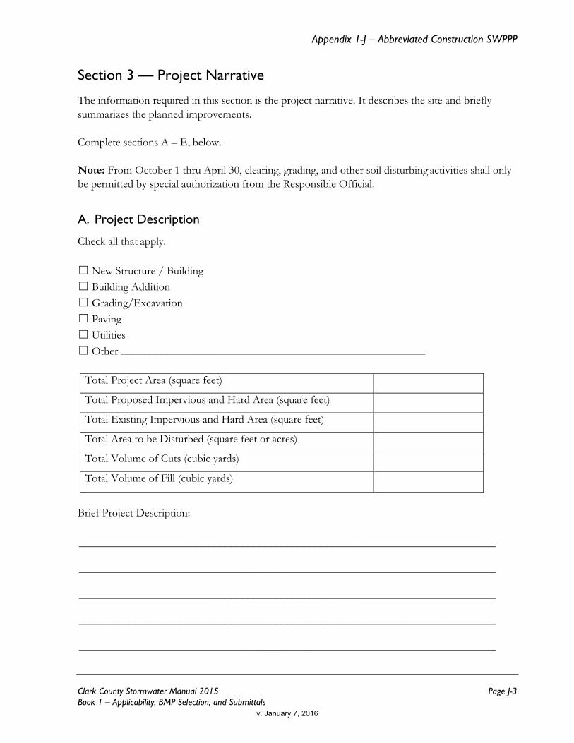
Section 3 — Project Narrative
The information required in this section is the project narrative. It describes the site and briefly summarizes the planned improvements. Complete sections A – E, below.
Note: From October 1 thru April 30, clearing, grading, and other soil disturbing activities shall only be permitted by special authorization from the Responsible Official.
A. Project Description
Check all that apply. ☐ New Structure / Building ☐ Building Addition ☐ Grading/Excavation ☐ Paving ☐ Utilities ☐ Other ______________________________________________________
Total Project Area (square feet) Total Proposed Impervious and Hard Area (square feet) Total Existing Impervious and Hard Area (square feet) Total Area to be Disturbed (square feet or acres) Total Volume of Cuts (cubic yards) Total Volume of Fill (cubic yards)
Brief Project Description: __________________________________________________________________________
__________________________________________________________________________
__________________________________________________________________________
__________________________________________________________________________
__________________________________________________________________________
v. January 7, 2016

Page J-4 Clark County Stormwater Manual 2015 Book 1 – Applicability, BMP Selection, and Submittals
B. Existing Site Conditions
Describe the existing site conditions. If there are multiple choices, check all that apply. The icon means that information requested may be found on Clark County Maps Online.
Describe the existing site conditions. 1.
☐ Forest ☐ Prairie ☐ Pasture ☐ Pavement ☐ Landscaping ☐ Brush ☐ Trees ☐ Other
Describe how surface water (stormwater) drainage flows across/from the site. 1.
☐ Overland ☐ Gutter ☐ Catch Basin ☐ Ditch/Swale ☐ Storm sewer pipes ☐ Stream/Creek ☐ Other
Are sensitive and/or critical areas present on the site? 2.
☐ Streams ☐ Lakes/Ponds ☐ Wetlands ☐ Steep Slopes/Geohazard ☐ Floodplain ☐ Springs ☐ Habitat ☐ Critical Aquifer Recharge Area
Existing utilities and underground objects? 3.☐Storm ☐ Water ☐ Sewer ☐ Other ☐Fuel tanks ☐ Septic systems ☐ Groundwater wells
C. Adjacent Areas
Check any adjacent off-site areas that may be affected by site disturbance and describe 1.below (check all that apply):
☐ Streams ☐ Lakes ☐ Wetlands ☐ Steep Slopes/Geohazards ☐ Residential Areas ☐ Roads ☐ Ditches, pipes, culverts ☐ Other __________________________________________________________________
__________________________________________________________________________
__________________________________________________________________________
__________________________________________________________________________
v. January 7, 2016

Appendix 1-J – Abbreviated Construction SWPPP
Clark County Stormwater Manual 2015 Page J-5 Book 1 – Applicability, BMP Selection, and Submittals
Describe how and where surface water enters the site from upstream properties: 2. __________________________________________________________________________
__________________________________________________________________________
__________________________________________________________________________
__________________________________________________________________________
__________________________________________________________________________
Describe the downstream drainage path leading from the site to adjacent property, 3.drainage system, or water body. If water is held on-site, describe it:
__________________________________________________________________________
__________________________________________________________________________
__________________________________________________________________________
__________________________________________________________________________
D. Soils Information
If the project is proposing construction on or near slopes 15% or greater or proposing to infiltrate construction site stormwater runoff, the County may require soils information to be submitted before allowing construction on these sites. Permanent infiltration facilities shall not be used during construction unless approved in writing by the Responsible Official.
Does the project propose construction on or near slopes 15% or greater? 1.☐ Yes ☐ No
Does the project propose to infiltrate construction stormwater? 2.☐ Yes ☐ No
☐ If yes, obtain and attach approval letter from the Responsible Official.
E. Thirteen Elements of a Construction SWPPP
The following 13 elements are required for each SWPPP. For each element that applies to the project, at least one BMP must be selected and used on the site. If an element does not apply to the project site describe why the element does not apply.
v. January 7, 2016

Page J-6 Clark County Stormwater Manual 2015 Book 1 – Applicability, BMP Selection, and Submittals
Instructions for using and installing each BMP are given in CCSM Book 2, Chapter 8. An index of standard details of many BMPs is given on the Clark County Public Works web site.
Instructions
1. Review the 13 elements of a construction SWPPP, below.
2. Select at least one BMP for each element (review BMP descriptions in CCSM Book 2, Chapter 8, if needed).
3. For any BMP you select, follow the instructions in the table for including the BMP in the Abbreviated Construction SWPPP.
a. If instructed to draw the BMP on the site plan, see Section 4 for instructions.
b. If instructed to submit the standard detail, find the BMP’s standard detail using the Clark County Public Works web site, and then print and submit the detail.
c. If instructed to submit a detailed drawing and/or calculations, then have an engineer provide a detailed drawing of the proposed BMP in plan and profile views with dimensions and calculations described in the design criteria.
4. If the element does not apply to the project, check “N/A” and describe why.
For phased construction plans, clearly indicate erosion control methods to be used for each phase of construction.
Element #1 – Preserve Vegetation and Mark Clearing Limits
Retain the duff layer, native topsoil, and natural vegetation in an undisturbed state to the maximum extent practicable. If it is not practicable to retain the duff layer in place, it should be stockpiled onsite, covered to prevent erosion, and replaced immediately upon completion of the ground-disturbing activity. All construction projects must clearly mark any clearing limits, sensitive areas and their buffers, and any trees that will be preserved prior to beginning any land disturbing activities. Clearly mark the limits both in the field and on the plans. Limits shall be marked in such a way that any trees or vegetation to remain will not be harmed.
v. January 7, 2016

Appendix 1-J – Abbreviated Construction SWPPP
Clark County Stormwater Manual 2015 Page J-7 Book 1 – Applicability, BMP Selection, and Submittals
The BMP(s) being proposed to meet this element are:
Check to Select
If Selected Draw Location(s)
on Site Plan Submit Standard
Detail Submit Detailed
Drawing*
☐ C101 Preserving Native Vegetation x
☐ C102 Buffer Zones x
☐ C103 High Visibility Fence x
☐ C233 Silt Fence x x
* Requires Engineering OR ☐ Element is N/A:
Element #2 – Establish Construction Access
All construction projects subject to vehicular traffic shall provide a means of preventing vehicle “tracking” of soil from the site onto streets or neighboring properties. Limit vehicle ingress and egress to one route if possible. All access points shall be stabilized with a rock pad construction entrance in accordance with BMP C105. The applicant should consider placing the entrance in the area for future driveway(s), as it may be possible to use the rock as a driveway base material. The entrance(s) must be inspected weekly, at a minimum, to ensure no excess sediment buildup or missing rock. If sediment is tracked offsite, it shall be swept or shoveled from the paved surface immediately. Keep streets clean at all times. Street washing for sediment removal is not allowed as it can transport sediment to downstream water courses and clog the downstream stormwater system. The proposed construction entrance must be identified on the site plan. The BMP(s) being proposed to meet this element are:
Check to Select
If Selected Draw Location(s)
on Site Plan Submit Standard
Detail Submit Detailed Drawing/Calcs*
☐ C105 Stabilized Construction Entrance x x
☐ C106 Wheel Wash x
☐ C107 Construction Road/Parking Area Stabilization
x
* Requires Engineering OR ☐ Element is N/A:
v. January 7, 2016

Page J-8 Clark County Stormwater Manual 2015 Book 1 – Applicability, BMP Selection, and Submittals
Element #3 – Control Flow Rates
Protect properties and waterways downstream of the development site from erosion due to increases in volume, velocity, and peak flow of stormwater runoff from the project site. Permanent infiltration facilities shall not be used for flow control during construction unless specifically approved in writing by Environmental Services. Sediment traps can provide flow control for small sites by allowing water to pool and allowing sediment to settle out of the water. The BMP(s) being proposed to meet this element are:
Check to Select
If Selected Draw Location(s)
on Site Plan Submit Standard
Detail Submit Detailed Drawing/Calcs*
☐ C240 Sediment Trap x x
☐ C203 Water Bar x
☐ C207 Check Dams x x
☐ C235 Wattles x x
* Requires Engineering OR ☐ Element is N/A:
Element #4 – Install Sediment Controls
Prior to leaving a construction site, runoff from disturbed areas must pass through a sediment removal device. Sediment barriers are used to slow sheet flow of stormwater and allow the sediment to settle out behind the barrier. Install/construct the sediment control BMP before site grading. The BMP(s) being proposed to meet this element are:
Check to Select
If Selected Draw Location(s)
on Site Plan Submit Standard
Detail Submit Detailed Drawing/Calcs*
☐ C231 Brush Barrier x
☐ C232 Gravel Filter Berm x x x
☐ C233 Silt Fence x x
☐ C234 Vegetated Strip x
☐ C235 Wattles x x
☐ C240 Sediment Trap x x
* Requires Engineering OR ☐ Element is N/A:
v. January 7, 2016
Appendix 1-J – Abbreviated Construction SWPPP
Clark County Stormwater Manual 2015 Page J-9 Book 1 – Applicability, BMP Selection, and Submittals
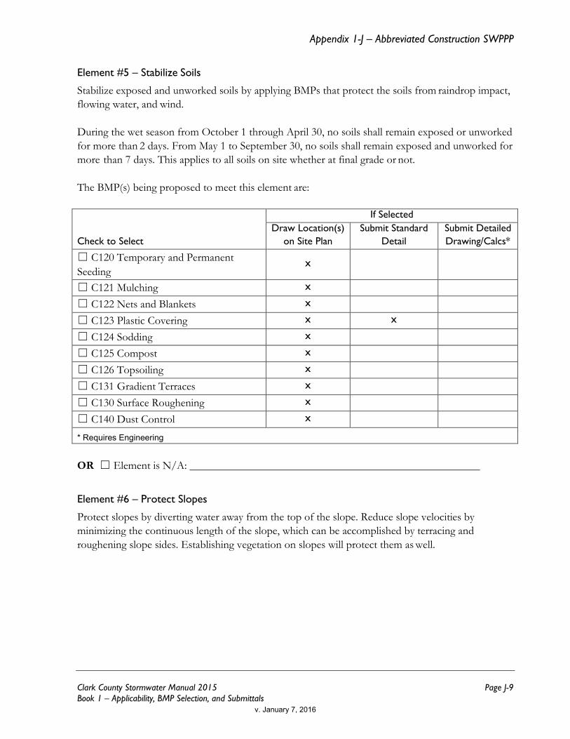
Element #5 – Stabilize Soils
Stabilize exposed and unworked soils by applying BMPs that protect the soils from raindrop impact, flowing water, and wind. During the wet season from October 1 through April 30, no soils shall remain exposed or unworked for more than 2 days. From May 1 to September 30, no soils shall remain exposed and unworked for more than 7 days. This applies to all soils on site whether at final grade or not. The BMP(s) being proposed to meet this element are:
Check to Select
If Selected Draw Location(s)
on Site Plan Submit Standard
Detail Submit Detailed Drawing/Calcs*
☐ C120 Temporary and Permanent Seeding
x
☐ C121 Mulching x
☐ C122 Nets and Blankets x
☐ C123 Plastic Covering x x
☐ C124 Sodding x
☐ C125 Compost x
☐ C126 Topsoiling x
☐ C131 Gradient Terraces x
☐ C130 Surface Roughening x
☐ C140 Dust Control x
* Requires Engineering OR ☐ Element is N/A:
Element #6 – Protect Slopes
Protect slopes by diverting water away from the top of the slope. Reduce slope velocities by minimizing the continuous length of the slope, which can be accomplished by terracing and roughening slope sides. Establishing vegetation on slopes will protect them as well.
v. January 7, 2016
Page J-10 Clark County Stormwater Manual 2015 Book 1 – Applicability, BMP Selection, and Submittals
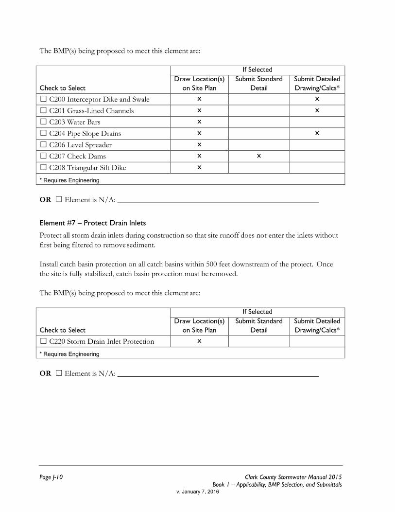
The BMP(s) being proposed to meet this element are:
Check to Select
If Selected Draw Location(s)
on Site Plan Submit Standard
Detail Submit Detailed Drawing/Calcs*
☐ C200 Interceptor Dike and Swale x x
☐ C201 Grass-Lined Channels x x
☐ C203 Water Bars x
☐ C204 Pipe Slope Drains x x
☐ C206 Level Spreader x
☐ C207 Check Dams x x
☐ C208 Triangular Silt Dike x
* Requires Engineering OR ☐ Element is N/A:
Element #7 – Protect Drain Inlets
Protect all storm drain inlets during construction so that site runoff does not enter the inlets without first being filtered to remove sediment. Install catch basin protection on all catch basins within 500 feet downstream of the project. Once the site is fully stabilized, catch basin protection must be removed. The BMP(s) being proposed to meet this element are:
Check to Select
If Selected Draw Location(s)
on Site Plan Submit Standard
Detail Submit Detailed Drawing/Calcs*
☐ C220 Storm Drain Inlet Protection x
* Requires Engineering OR ☐ Element is N/A:
v. January 7, 2016

Appendix 1-J – Abbreviated Construction SWPPP
Clark County Stormwater Manual 2015 Page J-11 Book 1 – Applicability, BMP Selection, and Submittals
Element #8 – Stabilize Channels and Outlets
Stabilize all temporary and permanent conveyance channels and their outlets. The BMP(s) being proposed to meet this element are:
Check to Select
If Selected Draw Location(s)
on Site Plan Submit Standard
Detail Submit Detailed Drawing/Calcs*
☐ C122 Nets and Blankets x
☐ C202 Channel Lining x
☐ C207 Check Dams x x
☐ C209 Outlet Protection x
* Requires Engineering OR ☐ Element is N/A:
Element #9 – Control Pollutants
Handle and dispose of all pollutants, including demolition debris and other solid wastes, to keep them out of rain and stormwater. Provide cover and containment for all chemicals, liquid products (including paint), petroleum products, and other materials. Apply fertilizers and pesticides following manufacturers’ instructions for application rates and procedures. Handle all concrete and concrete waste appropriately The BMP(s) being proposed to meet this element are:
Check to Select
If Selected Draw Location(s)
on Site Plan Submit Standard
Detail Submit Detailed Drawing/Calcs*
☐ C150 Materials on Hand x
☐ C151 Concrete Handling x
☐ C152 Sawcutting and Surface Pollution Prevention
x
☐ C153 Materials, Delivery, Storage, and Containment
x
☐ C154 Concrete Washout Area x x
* Requires Engineering OR ☐ Element is N/A:
v. January 7, 2016
Page J-12 Clark County Stormwater Manual 2015 Book 1 – Applicability, BMP Selection, and Submittals
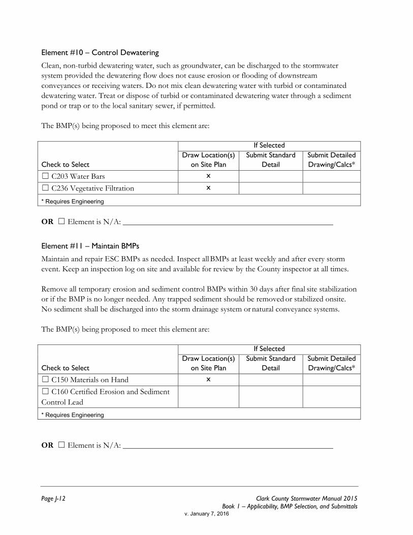
Element #10 – Control Dewatering
Clean, non-turbid dewatering water, such as groundwater, can be discharged to the stormwater system provided the dewatering flow does not cause erosion or flooding of downstream conveyances or receiving waters. Do not mix clean dewatering water with turbid or contaminated dewatering water. Treat or dispose of turbid or contaminated dewatering water through a sediment pond or trap or to the local sanitary sewer, if permitted. The BMP(s) being proposed to meet this element are:
Check to Select
If Selected Draw Location(s)
on Site Plan Submit Standard
Detail Submit Detailed Drawing/Calcs*
☐ C203 Water Bars x
☐ C236 Vegetative Filtration x
* Requires Engineering OR ☐ Element is N/A:
Element #11 – Maintain BMPs
Maintain and repair ESC BMPs as needed. Inspect all BMPs at least weekly and after every storm event. Keep an inspection log on site and available for review by the County inspector at all times. Remove all temporary erosion and sediment control BMPs within 30 days after final site stabilization or if the BMP is no longer needed. Any trapped sediment should be removed or stabilized onsite. No sediment shall be discharged into the storm drainage system or natural conveyance systems. The BMP(s) being proposed to meet this element are:
Check to Select
If Selected Draw Location(s)
on Site Plan Submit Standard
Detail Submit Detailed Drawing/Calcs*
☐ C150 Materials on Hand x
☐ C160 Certified Erosion and Sediment Control Lead
* Requires Engineering OR ☐ Element is N/A:
v. January 7, 2016
Appendix 1-J – Abbreviated Construction SWPPP
Clark County Stormwater Manual 2015 Page J-13 Book 1 – Applicability, BMP Selection, and Submittals
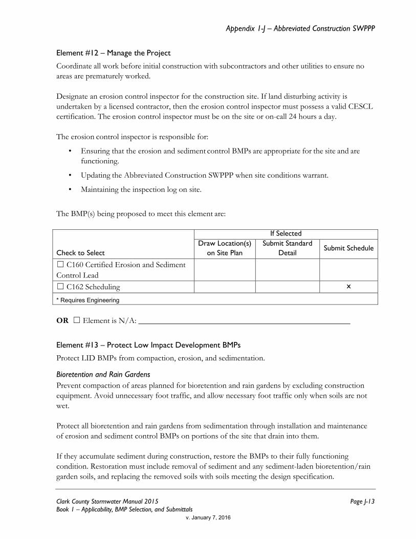
Element #12 – Manage the Project
Coordinate all work before initial construction with subcontractors and other utilities to ensure no areas are prematurely worked. Designate an erosion control inspector for the construction site. If land disturbing activity is undertaken by a licensed contractor, then the erosion control inspector must possess a valid CESCL certification. The erosion control inspector must be on the site or on-call 24 hours a day. The erosion control inspector is responsible for:
• Ensuring that the erosion and sediment control BMPs are appropriate for the site and are functioning.
• Updating the Abbreviated Construction SWPPP when site conditions warrant.
• Maintaining the inspection log on site.
The BMP(s) being proposed to meet this element are:
Check to Select
If Selected Draw Location(s)
on Site Plan Submit Standard
Detail Submit Schedule
☐ C160 Certified Erosion and Sediment Control Lead
☐ C162 Scheduling x
* Requires Engineering OR ☐ Element is N/A:
Element #13 – Protect Low Impact Development BMPs
Protect LID BMPs from compaction, erosion, and sedimentation.
Bioretention and Rain Gardens Prevent compaction of areas planned for bioretention and rain gardens by excluding construction equipment. Avoid unnecessary foot traffic, and allow necessary foot traffic only when soils are not wet. Protect all bioretention and rain gardens from sedimentation through installation and maintenance of erosion and sediment control BMPs on portions of the site that drain into them. If they accumulate sediment during construction, restore the BMPs to their fully functioning condition. Restoration must include removal of sediment and any sediment-laden bioretention/rain garden soils, and replacing the removed soils with soils meeting the design specification.
v. January 7, 2016
Page J-14 Clark County Stormwater Manual 2015 Book 1 – Applicability, BMP Selection, and Submittals
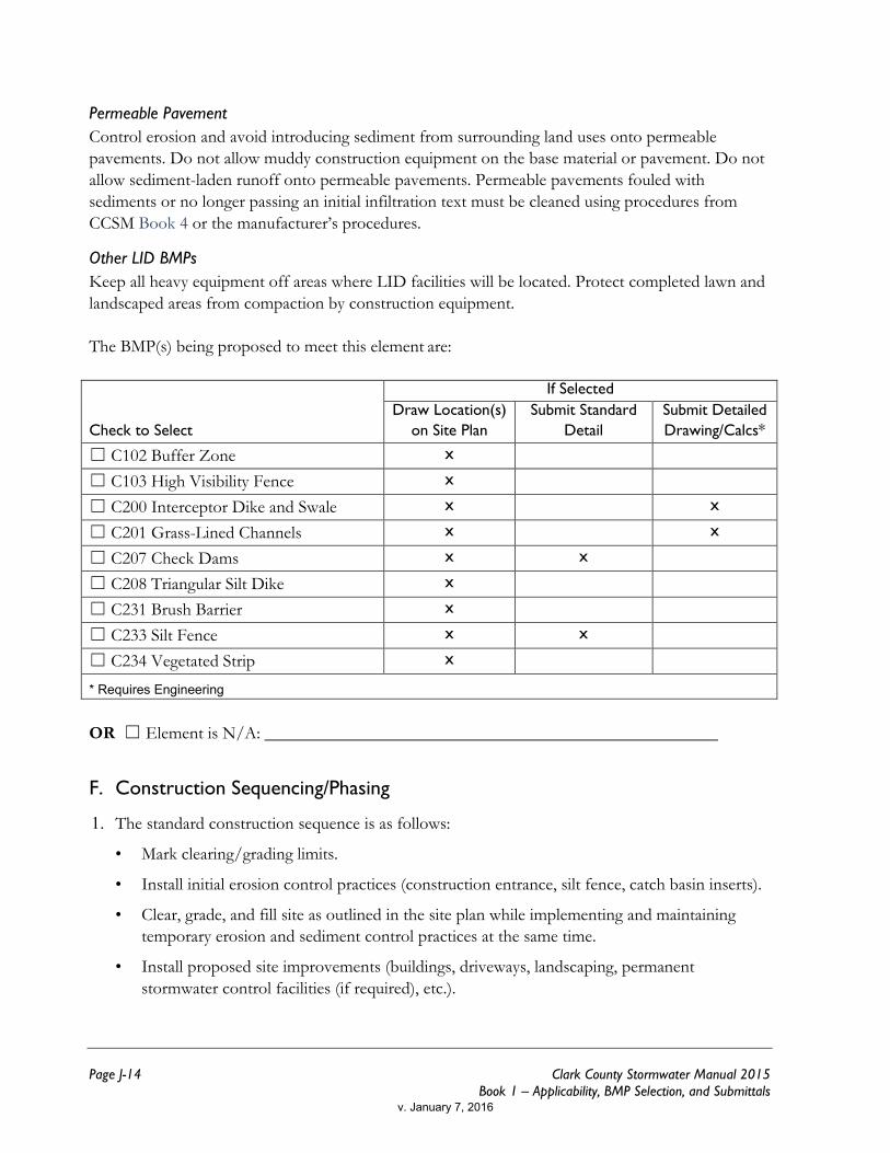
Permeable Pavement Control erosion and avoid introducing sediment from surrounding land uses onto permeable pavements. Do not allow muddy construction equipment on the base material or pavement. Do not allow sediment-laden runoff onto permeable pavements. Permeable pavements fouled with sediments or no longer passing an initial infiltration text must be cleaned using procedures from CCSM Book 4 or the manufacturer’s procedures.
Other LID BMPs Keep all heavy equipment off areas where LID facilities will be located. Protect completed lawn and landscaped areas from compaction by construction equipment. The BMP(s) being proposed to meet this element are:
Check to Select
If Selected Draw Location(s)
on Site Plan Submit Standard
Detail Submit Detailed Drawing/Calcs*
☐ C102 Buffer Zone x
☐ C103 High Visibility Fence x
☐ C200 Interceptor Dike and Swale x x
☐ C201 Grass-Lined Channels x x
☐ C207 Check Dams x x
☐ C208 Triangular Silt Dike x
☐ C231 Brush Barrier x
☐ C233 Silt Fence x x
☐ C234 Vegetated Strip x
* Requires Engineering OR ☐ Element is N/A:
F. Construction Sequencing/Phasing
The standard construction sequence is as follows: 1.
• Mark clearing/grading limits.
• Install initial erosion control practices (construction entrance, silt fence, catch basin inserts).
• Clear, grade, and fill site as outlined in the site plan while implementing and maintaining temporary erosion and sediment control practices at the same time.
• Install proposed site improvements (buildings, driveways, landscaping, permanent stormwater control facilities (if required), etc.).
v. January 7, 2016
Appendix 1-J – Abbreviated Construction SWPPP
Clark County Stormwater Manual 2015 Page J-15 Book 1 – Applicability, BMP Selection, and Submittals
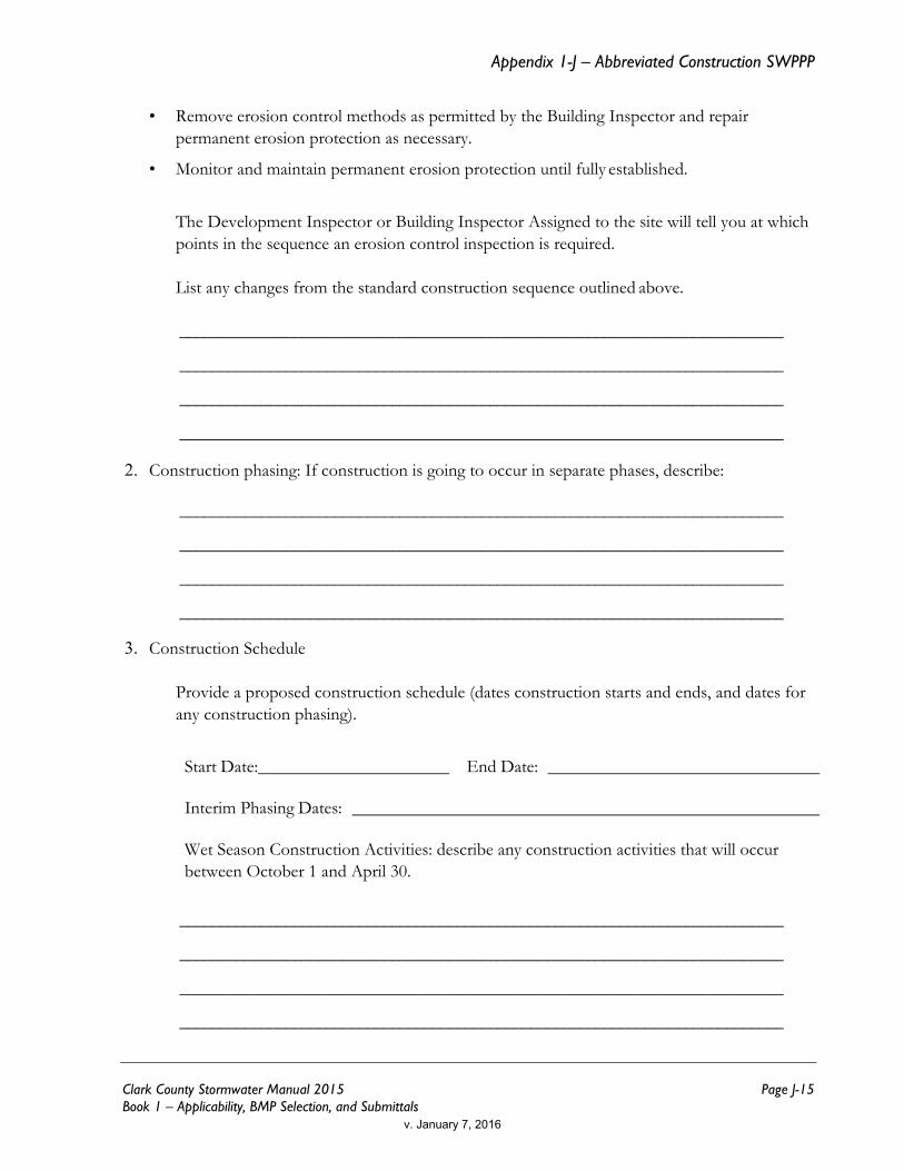
• Remove erosion control methods as permitted by the Building Inspector and repair permanent erosion protection as necessary.
• Monitor and maintain permanent erosion protection until fully established.
The Development Inspector or Building Inspector Assigned to the site will tell you at which points in the sequence an erosion control inspection is required. List any changes from the standard construction sequence outlined above.
__________________________________________________________________________
__________________________________________________________________________
__________________________________________________________________________
__________________________________________________________________________
Construction phasing: If construction is going to occur in separate phases, describe: 2.
__________________________________________________________________________
__________________________________________________________________________
__________________________________________________________________________
__________________________________________________________________________
Construction Schedule 3.
Provide a proposed construction schedule (dates construction starts and ends, and dates for any construction phasing).
Start Date: End Date:
Interim Phasing Dates:
Wet Season Construction Activities: describe any construction activities that will occur between October 1 and April 30.
__________________________________________________________________________
__________________________________________________________________________
__________________________________________________________________________
__________________________________________________________________________
v. January 7, 2016

Page J-16 Clark County Stormwater Manual 2015 Book 1 – Applicability, BMP Selection, and Submittals
Section 4 — Erosion and Sediment Control Site Plan
The erosion and sediment control site plan is a drawing which shows the location of the proposed BMPs.
Submit an erosion and sediment control site plan on 8½ x 11 or 11 x 17 paper.
For projects meeting Minimum Requirements #1 - #5, the site plan may be either drawn by hand or drafted electronically. Blank graph paper is provided below. For projects meeting Minimum Requirements #1 - #9, the plan must be drafted electronically.
The erosion and sediment control site plan must show the location of improvements, grading, filling, and construction stormwater and erosion control BMPs. Show the following listed items on
the site plan. The icon means that information may be found using Clark County Maps Online
• Address, Parcel Number, and Street names
• North Arrow
• Boundaries of existing vegetation (e.g. tree lines, grass, pasture, fields, etc.)
• On-site or adjacent critical areas and associated buffers (e.g. wetlands, steep slopes, streams, etc.)
• Existing and proposed contours
• Areas that are to be cleared and graded
• Cut and fill slopes, indicating top and bottom of slope catch lines
• Locations where upstream run-on enters the site and locations where runoff leaves the site
• Existing surface water flow direction(s)
• Label final grade contours and indicate proposed surface water flow direction and surface water conveyance systems (e.g. pipes, catch basins, ditches, etc.)
• Grades, dimensions, and direction of flow in all (existing and proposed) ditches, swales, culverts, and pipes
• Locations and outlets of any dewatering systems (usually to sediment trap)
• Identify and locate all erosion control techniques to be used during and after construction
• Finish floor elevations of all structures
v. January 7, 2016

Appendix 1-J – Abbreviated Construction SWPPP
Clark County Stormwater Manual 2015 Page J-17 Book 1 – Applicability, BMP Selection, and Submittals
v. January 7, 2016


