
2 January 2002
ANNEX D. ANALYSIS OF THREATS TO WETLAND BIODIVERSITY AND THEIR ROOT CAUSES
THREATS FACING WETLANDS IN ASIA
The Asia Pacific Migratory Waterbird Conservation Strategy 2001-2005 recognizes the major threats to wetlands in this region, identified in Scott & Poole (1989): 85% of important wetlands were under some form of threat and 50% were reported to be under moderate to severe threat.
More recent official information is available from the Ramsar Convention database (up to December 1995): in Asia, 27 Ramsar sites had suffered ecological change as a result of agricultural impacts, 26 due to water regulation, 22 due to habitat effects, 18 due to faunal effects and 18 due to pollution. In Eastern Europe (including the whole of Russia for administrative purposes), the corresponding figures are: 33 sites suffered habitat impacts, 29 sites agricultural impacts, 25 sites pollution, 20 sites waste disposal impacts and 20 sites water regulation impacts (Frazier 1996). Given that Ramsar sites usually enjoy some form of national protection, and represent the member countries’ most important wetlands, these statistics provide an indication of the scale of pressures on wetlands as a whole.
Information on the threats affecting wetlands at the national level is described in the relevant national biodiversity assessments and national biodiversity strategies and action plans.
THREATS FACING MIGRATORY WATERBIRDS IN ASIA
The Asia Pacific Migratory Waterbird Conservation Strategy 2001-2005 notes that some 40 species of migratory waterbirds in the Asia Pacific region are globally threatened. It describes five categories of threat directly affecting migratory waterbirds in the region: loss of habitat, degradation of habitat, invasive species impacts, harvesting of waterbirds, and effects of climate change. Many of these threats refer to impacts on the wetland habitats that support these species at different stages of their migration cycles.
THREATS FACING THE SIBERIAN CRANE
The CMS MoU Concerning Conservation Measures for the Siberian Crane acknowledges that: “hunting and loss of wetlands, particularly in Southern Asia, are thought to have been responsible for the decline in number of Siberian Cranes”. While hunting has been identified as one of the main causes of the decline of the western and central populations of the Siberian Crane, in reality a whole array of threats are faced by both these populations and the larger eastern population. The diversity of threats is apparent from the national threat analysis tables (see below). The IUCN/SSC Status Review and Conservation Action Plan (Meine & Archibald, 1996) also lists a range of threats to the Siberian Crane, including hunting, loss and degradation of wetland habitats, oil exploration impacts and dam construction. Different threats, however, have more or less significance at different stages of the life cycle, and on breeding, staging and wintering sites. In general, hunting is the most severe threat for the Western population, while habitat degradation is the greatest threat for the Eastern population. Fortunately, human
D -1
2 January 2002
population pressures are least on the breeding grounds, where the Siberian Crane needs the most freedom from disturbance, but here oil exploration has greatest potential for future impact.
INTRODUCTION TO THE NATIONAL THREAT ANALYSIS TABLES
The root causes underlying the above threats are described in the main text, and it is these root causes that the project will seek to address. The following tables summarise the root causes for broad categories of threat affecting the project sites in each of the four participating countries. The activities required to mitigate the threats are listed against each root cause, identifying the sites concerned.
NATIONAL SOCIO-ECONOMIC CONTEXT
The high rural population density at the project sites in NE China and the central Yangtze valley (national average of 681.9/km2, 1995) and their dependence on subsistence agriculture and wetland resources exert pressure on wetland ecosystems and biodiversity. Average annual income at the NE China sites is only US$125-150 per capita, largely derived from crops, aquaculture and fishing, while annual revenue from reed collection at these sites totals almost US$3 million. Over 8.6 million people live in Poyang Lake Basin (PLB) (2,284,300 ha), including three cities. PLB contributes significantly to the economic production of Jiangxi Province (28.2%), including agricultural production (33.3%) and aquaculture (431,800 tonnes in 1997).
In Iran, the project is focusing on wetlands in the South Caspian lowlands, in the provinces of Gilan and Mazandaran. This narrow coastal plain is used intensively for agriculture, including large areas of rice fields, but still retains some significant wetlands and is an outstanding area for wintering waterfowl. The rural population density is relatively high (139/km2, 1995) and rising at 1.7% per annum (1999). Coastal urban development is placing pressure on both natural wetlands and agricultural land, and human pressures are causing declines in coastal fisheries, stocks of wintering waterfowl and other wetland resources. Local people in many areas undertake traditional forms of waterfowl trapping or shooting in winter to supplement their incomes.
The project sites in Kazakhstan include some of the major freshwater lake systems in the north of the country. They are quite remote, and human pressures are relatively low. The economy in northern Kazakhstan is based on agriculture, which developed mainly within the last 40-50 years for intensive grain production. After the collapse of the USSR, such large-scale grain production was no longer supported and cultivated areas have dramatically decreased. Many farming villages and cattle-breeding complexes were abandoned, and human pressure on natural wetlands has decreased. Harvesting of wetland resources, primarily waterfowl, has been dramatically reduced. The present time is, therefore, a window of opportunity for conservation efforts.
In Russia, the project sites are located in Western and Eastern Siberia. The breeding grounds in the Arctic and boreal taiga zones are remote and have low human populations. The main economic activities of local populations in these areas are fishing, hunting, and collection of berries and mushrooms and reindeer husbandry. The three sites in Tyumen Oblast (Western Siberia), however, lie in the most important oil and gas regions in the Russian Federation (more than 95% of Russia gas and 80% of oil production), where continued exploration and development is an economic priority. Other economic interests include mining and forestry.
D -2

2 January 2002
The staging areas in the south of Western Siberia are located in the forest-steppe zone, characterised by its rich black soil. This region was a major agricultural area before the collapse of the former USSR, with intensive sheep and cattle grazing stations and cereal production. As in Kazakhstan, agriculture here has undergone dramatic decline in recent years, creating a window of opportunity for conservation. Any future upturn in the agricultural sector will increase pressure on wetland resources in this region, which are very sensitive to drainage owing to their position at the head of a major drainage basin. Recent changes in land tenure (from state and collective to private farms) have been accompanied by increasing conflicts due to crop damage by waterbirds.
NATIONAL WETLANDS POLICIES, STRATEGIES & PLANS
The four participating countries have taken significant steps towards addressing the threats and underlying causes that are described in this Annex. These include the following major policies, strategies and plans, although it should be noted that this summary is not exhaustive.
All four participating countries have completed national biodiversity strategy and action plans (NBSAPs) that highlight the importance of the conservation of wetlands and migratory waterbirds. These plans are integrated into national policies and legislation to varying degrees.
CHINAChina has increasingly recognized the importance of conserving its nationally and globally significant wetland biodiversity. In 1994, China approved its national Agenda 21 and launched the National Biodiversity Conservation Action Plan (BCAP). The BCAP highlights four objectives with particular relevance to wetlands conservation:
the need for an improved and expanded protected area system; improved personnel training; integration of biodiversity conservation into sustainable development planning; and establishment of nationwide information networks and monitoring systems.
In addition, the BCAP commits China to “establishing regional economic demonstration models for coordinating biodiversity conservation and sustainable utilization” and “establishing demonstration sites in nature reserves”.
China has a strong national legal and policy framework for wetland conservation, including the State Environmental Protection Agency Notice on Strengthening Wetland Conservation (1994) and the National Wetland Conservation Action Plan (NWCAP), published in 2000 and implemented through official notification by SFA. The government has established a national Wetlands Coordinating Committee involving 17 Ministries and other government agencies. The NWCAP includes a government commitment to:
specific demonstrations of sustainable use and better protection at its important wetland sites; increasing the number of designated Ramsar sites; and a reform of government policies relating to wetland protection.
D -3
2 January 2002
Many wetlands and most of the globally significant areas within China are represented in a protected area system of national and provincial nature reserves. By 1996, a total of 152 wetland protected areas, covering over 1.13 million hectares, had been established. The current and proposed protection status of the project sites is given in Table 1 of Annex B. At key sites, and with significant international assistance, China has embarked on major environmental projects to restore physical and ecological characteristics of degraded wetlands. The BCAP contains specific recommendations for Poyang Lake, to be implemented by this project, and the project sites in NE China are also listed for priority action.
In the light of recent (May 1998) catastrophic flooding in the Yangtze and Songhua river basins, the Government of the PRC has recently pledged further support, based on the 32 Character Policy. All project site activities in China lie within these basins, and link to these initiatives.
The government also recognizes the importance of involving communities in the sustainable use of biodiversity and in integration of conservation with development, as stressed in both the BCAP and the NWCAP. Poverty alleviation and development in rural areas is a priority of government, and many large sustainable development programmes have been launched at national, provincial and county levels. Both national and local governments have expressed the desire to cooperate with international agencies on the activities planned for this project, in order to design appropriate poverty alleviation techniques, develop new micro-financing mechanisms, and create demonstration models.
IRANThe Islamic Republic of Iran has played a leading role in the international wetland conservation movement by hosting the international conference that adopted the Ramsar Convention on Wetlands in the Caspian city of Ramsar in 1971, and championing the development and implementation of the Convention (which now has over 100 member countries) in the intervening period. Scott (1995) listed 286 wetlands in Iran, of which 63 were identified as meeting the Ramsar Convention criteria for designation as ‘Wetlands International Importance’. So far, the Government of Iran has designated 20 such wetlands. Iran has also concluded bilateral water management agreements concerning trans-boundary rivers shared with Afghanistan, Azerbaijan, Iraq and Turkmenistan.
In March 1997, the Islamic Republic of Iran began to formulate a National Biodiversity Strategy and Action Plan with assistance from GEF, due for completion in 2001. Iranian government policy formulation and implementation has been guided by a series of Five-year Development Plans. The Third Five-year National Socio-Economic Development Plan was initiated in March 2000 and gives more prominence to environmental issues than the preceding two plans since the establishment of the Islamic Republic. Great efforts have been made to ensure the implementation of the National Biodiversity Strategy and Action Plan in the Third National Socio-economic Development Plan.
Under the guidance of the Third Five-year Plan, DoE is giving priority to extending the protected area system from 5% to 10% of the country’s land area, and ensuring that the system is comprehensive, adequate and representative in relation to Iran’s biodiversity assets. DoE is also preparing management plans firstly for Biosphere Reserves, secondly for other protected areas and
D -4
2 January 2002
thirdly for wetlands in general. As a first step, in the case of wetlands, DoE has gathered together information on 76 internationally important wetlands (based on the Directory of Wetlands of the Middle East).
GEF supported projects for wetlands conservation in Iran and Kazakhstan will assist the preparation of national wetlands policies, strategies, and plans. This project will be closely integrated with the national wetlands projects; project activities will provide demonstration sites for these broader initiatives.
KAZAKHSTANIn Kazakhstan, the National Strategy for Biodiversity Conservation, formulated in 1998, proposed to establish a National Coordination Committee (NCC) to coordinate intra-governmental efforts for wetland conservation, but this proposal has yet to be implemented due to the frequent organizational changes in governmental Ministries. In the Kazakhstan National Environmental Action Plan (NEAP) the preservation of water resources and aquatic systems is listed as one of the country’s top environmental priorities.
The Kazakhstan National Biodiversity Action Plan (NBAP) draws significant attention to the importance of the nation’s wetland resources. Wetlands rank as one of the top priorities for biodiversity conservation (in addition to forests and combating desertification). The NBAP includes several specific actions to be undertaken on behalf of wetlands, with the following to be addressed in part by this project:
Kazakhstan’s membership of the Ramsar and Bonn Conventions conservation of priority wetlands as habitat for migratory waterbirds international cooperation in the study and conservation of wetlands training of specialists in wetland management monitoring of waterfowl and other wetland-depending birds
In addition, the NBAP specifically calls for improved collaboration with Russia and China for biodiversity cooperation, an objective that will be met in part by this project.
RUSSIAIn Russia, the National Biodiversity Conservation Strategy and Action Plan was prepared in 1998 with support from the GEF Project on Conservation of Biodiversity, which will also be supporting specific actions on the National Strategy implementation for five years.
The first National Report to CBD (1997) states that the freshwater basins of Russia are undergoing drastic anthropogenic impacts of pollution, transformation and flow withdrawal. Their ecosystems, flora and fauna are being dramatically altered and a number of species are becoming extinct (especially fish species such as sturgeon and salmon).
A major international mechanism for wetland protection has been the Convention on Wetlands of International Importance Especially as Waterfowl Habitat (Ramsar Convention), under which Russia has designated 35 Wetlands of International Importance with a total area of 10,700,000 sq
D -5
2 January 2002
km. Up to 35 million waterfowl are annually concentrated on these 35 wetlands during autumn migration (12% of the Russian population).
From 1994-1997, the State Committee for Environment Protection, in cooperation with international organizations Wetlands International and Ramsar Convention Secretariat, generated the legal protection mechanisms and informational base on the status of all 35 Ramsar sites. Regulations on conservation of 12 Ramsar territories have been developed to control human activities. Twenty-six territories have been outlined and mapped. Efforts towards the protection of the 35 Ramsar wetlands are only the first steps in solving this problem - it is necessary to generate a network that would provide protection to highly valuable wetlands and encompass no less than 400 sites in the long term. At present a specific list comprising 77 wetlands is already available. This long-term effort needs a specific program to be developed for the whole country. The information base is now largely in place for extending this network of protected wetland areas, following the publication of site accounts for all 35 Ramsar Sites (Krivenko 1999), 51 important peatland areas (Botsch 1999) and a Ramsar Shadow List of 166 internationally important wetlands (Krivenko 2000). In addition a database on wetland experts, managers and relevant authorities has been compiled under the Wetlands International – Russia Programme.
A National Wetland Strategy for Russia was published in 1999 including a draft Action Plan. Development of a National Wetland Charter, National Wetland Policy and analysis of existing legislation in relation to this policy, wetland inventories and waterbird monitoring (International Waterbird Census database for Russia, Arctic Waterfowl database, colonial breeding waterbirds), development of EIA guidelines for wetlands, and other activities are continuing with assistance from Wetlands International and the Netherlands Government. Activities under this project will be coordinated with the above initiatives, and contribute toward their achievement in a number of specific ways: establishment and upgrading of protection status for several internationally important wetlands, designation of new locations as Ramsar sites, collection and dissemination of information about wetlands and migratory waterbirds, training of personnel to manage protected wetlands, public awareness activities, and enhancement of international linkages and cooperation for protection of wetlands and migratory waterbirds.
National Protected Area Systems
The following additional information supports the text on national biodiversity strategies and action plans and protected areas systems in the main text of the project brief.
In 1997, the China National Program for Nature Reserve Development (1996-2010) was approved. This program aims to strengthen the PAS, in view of problems identified in the Biodiversity Conservation Action Plan, including inadequate protected land area, lack of management capacity and scientific personnel, and inadequate funding.
Iran has a relatively strong PAS. The network of nationally designated sites under the Department of Environment covers 5% of its territory (8.5 million ha). Management capacity, however, varies considerably among sites. There is also no legal requirement for PAs to have management plans, but management planning is being given priority under the Third National Socio-economic Development Plan.
D -6

2 January 2002
In Kazakhstan, the Law on Specially Protected Areas (SPAs) (1997) sets up categories and types of protected areas. The new SPA establishment procedure is multi-level and protracted, and some reserves exist only on paper. Wetlands in general are under-represented in Kazakhstan’s existing network of protected areas, and there is no indication in the existing baseline scenario that this situation will change. Since the 1990s, financing of the PAS has dropped and there remains a need for a State programme of SPA activities. Despite the lack of financial resources, significant human and institutional resources remain for SPA management. In addition, a new NGO has been established to provide capacity building support for SPAs.
Russia has traditionally relied upon its extensive protected area system for biodiversity conservation. As of November 1997, the PAS covered about 2% of the country’s total area, and is currently under a dramatic programme of expansion under Presidential Decree No. 1155 (1992) which aims to increase the area to 3%. The PAS has also been linked to regional networks including the Circumpolar Protected Areas Network under CAFF, for which a Strategy and Action Plan was approved in 1996, and the UNESCO Man and Biosphere (MAB) Programme. The First National Report to the CBD (1997) notes that in view of the insufficient representative range of biota and landscapes in protected areas, the development of this system and regional networks remains urgent. This network includes 35 wetlands (out of a total goal of 400) that have been designated under the Ramsar Convention.
D -7
2 January 2001
ANALYSIS OF THREATS
COUNTRY: CHINA
ROOT CAUSES OF THREAT ACTIVITIES TO MITIGATE THREAT SITES AFFECTED
THREAT 1: Unsustainable Use of Biological Resources
Root Cause 1: Lack of an integrated approach to wetland conservation and development planning
Develop and implement an integrated wetland management plan for each of the project sites
Strengthen and integrate protected area operations at all project sites
Establish community-based participatory management at all project sites
Strengthen and develop cooperative enforcement among the management agencies and local communities at project sites
Develop waterbirds conservation action plan for China
Include fisheries in site management plans
Undertake wetland restoration initiatives to convert areas of farmland to wetlands
Conduct ecology restoration project to mitigate impacts of 301 highway
Assess impacts of oil exploration and recommend mitigation measures
1,2,3,4,5
1,2,3,4,5
1,2,3,4,5
1,2,3,4,5
National
1,2
1
2
4Root Cause 2: Lack of capacity and financial resources for protected area management and species protection
Increase management capacity of all project sites through improvements in facilities, equipment and human resources
Strengthen capacity of staff of Forest County Bureaus and Forestry police in Poyang Lake Basin to carry out enforcement
Establish and/or increase the number of police stations for enforcement of regulations
Strengthen the capacity of management teams and protection staff at all five sites, including training based on assessment of needs
1,2,3,4,5
1
1
1,2,3,4,5
Root Cause 3: Inadequate legal protection for sites and national legislation on the conservation and sustainable use of wetland resources
Develop and publicise regulations pertaining to the management of the five project sites
Improve and publicise protection regulations on rare and endangered species
National
National
D - 9

2 January 2001
Develop and test regulations with regards to conversion of wetlands for agricultural use
Expand the network of protected areas within Poyang Lake Basin
National
1
Root Cause 4: Lack of sustainable alternative economic opportunities for communities that depend on wetland resources
Develop alternative livelihood schemes for communities in and around the wetland areas, including ecologically sustainable agriculture
Develop and implement eco-tourism activities for the local community
1,2,3,4,5
1
Root Cause 5: Lack of information available for conservation management
Develop a monitoring program to study the relationship between water level, vegetation and waterbirds
Carry out targeted research on grazing impacts and recommend management options
Carry out targeted research on impacts of agriculture (including reclamation and polders) and recommend management options
Carry out targeted research on impacts of reed harvesting and recommend management options
Implement socio-economic and environment assessment of ongoing relocation of people living within the wetland sites and recommend management options
Strengthen national capacity for coordination of waterbird monitoring and data management
Conduct monitoring programme for Siberian Cranes, including aerial surveys of Poyang Lake Basin
Conduct biodiversity surveys of Poyang Lake Basin as basis for extending protected area system, and establish database / GIS
1,2,3,4,5
1,3,5
1,3,5
2,3,4,5
1,2,3,4,5
National
1
1
Root Cause 6: Lack of awareness of the importance of the functions and values of wetlands and their biodiversity
Enhance public awareness on conservation of migratory birds (including hunting laws)
Develop materials on environmental education
Initiate awareness and environmental education programmes
Implement activities for visitors to the sites – e.g. guided tours on wetland or migratory bird species
Construct or improve the displays for public education centers
National, 1,2,3,4,5
National, 1,2,3,4,5
National, 1,2,3,4,5
1,2,3,4,5
1,2,3,4,5
D - 10

2 January 2001
Develop field programmes to enable students to study wetland biodiversity
Establish network for information exchange
1,2,3,4,5
1,2,3,4,5
THREAT 2: Unsustainable Use of Water Resources
Root Cause 1: Lack of integrated approach to water resource management, including consideration of biodiversity conservation interests
Develop water management plans for all project sites, based on hydrological monitoring data
Assess water transfer proposals for Xianghai NNR, Momoge NNR and Zhalong NNR in relation to water management plans
1,2,3,4,5
1,2,3,4,5
2,3,4Root Cause 2: Lack of coordination between relevant agencies regarding water resource management
Improve inter-agency coordination on wetland conservation at national level, in cooperation with GEF China Wetlands Conservation project
Develop national regulation on wetland conservation which is linked to water resource management policies
Establish coordination with the agency responsible for Three Gorges Dam to quantify impacts on Poyang Lake Basin and develop mitigation
Develop coordination mechanisms between related agencies for water resource management, including the Rivers, Lakes and Mountains Office
Initiate negotiations with Songhuajiang-Liaohe Rivers Water Management Committee for water supply to Zhalong NNR
National
National
1
1,2,3,4,5
2
Root Cause 3: Lack of capacity for water pollution control
Increase capacity for water quality monitoring and pollution control, based on assessment of needs and inter-agency cooperation
1,2,3
THREAT 3: Global and Regional Environmental ChangesRoot Cause 1: Impacts of climate change on wetland ecosystems
Conduct targeted research as part of regional project to assess likely impacts of climate change on wetlands and apply results to site management strategies
International, National
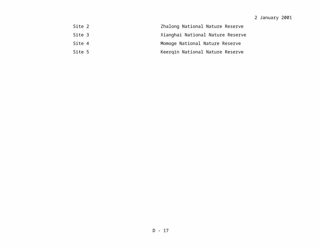
Key to Sites: Number Name
Site 1 Poyang Lake Basin
Site 2 Zhalong National Nature Reserve
Site 3 Xianghai National Nature Reserve
Site 4 Momoge National Nature Reserve
Site 5 Keerqin National Nature Reserve
D - 11

2 January 2001
ANALYSIS OF THREATS
COUNTRY: IRAN
ROOT CAUSES OF THREAT ACTIVITIES TO MITIGATE THREAT SITES AFFECTED
THREAT 1: Unsustainable Use of Biological Resources
Root Cause 1: Lack of an integrated approach to wetland conservation and development planning
Preparation and implementation of management plans for the project sites, including extended site areas as necessary
Development and application of guidelines for environmentally sensitive agriculture
Development and application of guidelines for new developments at or near project sites
Establish community-based participatory management at all project sites
Integration of tourism development with site management considerations
Extension of non-shooting areas to include buffer zones around damgahs and also other areas, based on identification of areas used by cranes
Provide input to Caspian Environment Programme Biodiversity and Coastal Area Management thematic centres on wetland biodiversity in the South Caspian lowlands
1,2,3
National, 1,2,3
National, 1,2,3
1,2,3
1
1
National
Root Cause 2: Lack of capacity and financial resources for protected area management and species protection
Upgrade facilities, equipment and manpower for protected area management including enforcement
Increase level of participation and voluntary activities of local community organizations to assist in site management
Train site management staff in community liaison, public education and visitor management as well as wetland ecology and management.
1,2,3
1,2,3
1,2,3
Root Cause 3: Inadequate legal protection for sites and national legislation on the conservation and sustainable use of wetland resources
Review species protection legislation and upgrade as necessary (e.g. increase penalties for illegal killing of protected species)
Upgrade legal protection status of project sites and other wetlands as appropriate (especially in relation to hunting pressure), in consultation with local communities
Designate wetlands under international treaties such as the Ramsar Convention, and consider extensions to existing Ramsar Sites
National
National, 1,2,3
National, 1,2,3
D - 12

2 January 2001
Develop and publicize regulations for the management of project sites
Ensure that EIA s are compulsory for new developments affecting project sites and other protected wetlands, including assessment of risk to large waterbirds from future power line developments
Terminate end of season shoot-out at damgahs, through negotiation between DoE and local communities for establishment of non-shooting areas
Identify and license (or at least list) existing aerial net use and control this method of duck-trapping in and around project sites
1,2,3
National
National
1,2,3
Root Cause 4: Lack of sustainable alternative economic opportunities for communities that depend on wetland resources
Develop alternative livelihood schemes for communities in and around the wetland areas and contribute towards addressing sustainable local development needs
Review socio-economic aspects of waterfowl trapping and recommend management options
1,2,3
National, 1,2,3
Root Cause 5: Lack of information available for conservation management
Monitor use of project sites and other South Caspian wetlands by Siberian Cranes and other migratory waterbirds, in cooperation with International Waterfowl Census and CEP
Strengthen national capacity for coordination and data management in relation to monitoring migratory waterbirds
Ensure good coordination and information exchange with Caspian Environment Programme, especially on Caspian Biodiversity Strategy, Oil Sensitivity Mapping of coastal wetlands, and CZM planning
Targeted research to assess feasibility of increasing the abundance of preferred food plants for the Siberian Crane (habitat manipulation)
National
National
National
1
Root Cause 6: Lack of awareness of the importance of the functions and values of wetlands and their biodiversity
Public awareness on conservation importance of Siberian Cranes and their habitats targeted at local duck trappers, hunters and farmers
Public awareness programme on wetland values and biodiversity conservation targeting national and local decision-makers
Education and public awareness on the impacts of use of fertilizers and pesticides targeted at local farming communities, in cooperation with Min of Agriculture
Establish local community organizations in support of Siberian Cranes conservation
Exchange visits and study tours to encourage information exchange
1,2,3
National, 1,2,3
1,2,3
1,2,3
National, 1,2,3
D - 13

2 January 2001
Develop visitor information facilities at sites
Education and public awareness programmes for sites
1,2,3
1,2,3THREAT 2: Unsustainable Use of Water ResourcesRoot Cause 1: Lack of integrated approach to water resource management, including consideration of biodiversity conservation interests
Integrate site management with regional water management planning and coastal zone management planning
Review water management requirements in site management plans
National, 1,2,3
1,2,3
Root Cause 2: Lack of capacity for water pollution control
Assess impacts of aquatic pollution on wetland habitats and biodiversity at project sites, in cooperation with CEP
Increase capacity for monitoring water quality at project sites, in accordance with management plan requirements and training needs assessment, in cooperation with CEP
1,2,3
1,2,3
THREAT 3: Global and Regional Environmental ChangesRoot Cause 1: Impacts of climate change on wetland ecosystems
Assess likely impacts of climate change on wetlands in South Caspian through international targeted research project and cooperation with CEP, and apply results to site management strategies
International, National
Root Cause 2: Impacts of Caspian Sea level change on wetland ecosystems
Cooperate with CEP to obtain information on trends in local climatic conditions and sea level fluctuations in support of strategic approach for site management plans
Integrate site management with Coastal Area Management Strategy and Caspian Biodiversity Strategy being developed under CEP
National, 1,2,3
National, 1,2,3
Key to Sites: Number Name
Site 1 Fereydoon Kenar/ Ezbaran/ Sorkhe Rud Damgahs
Site 2 Amirkelayeh / Rud Posht
Site 3 Bujagh / Sefid Rud Delta
D - 14

2 January 2001
ANALYSIS OF THREATS
COUNTRY: KAZAKHSTAN
ROOT CAUSES OF THREAT ACTIVITIES TO MITIGATE THREAT SITES AFFECTED
THREAT 1: Unsustainable Use of Biological Resources
Root Cause 1: Lack of an integrated approach to wetland conservation and development planning
Develop and implement an integrated wetland management plan for each of the six sites
Assess carrying capacity for tourism activities and recommend management options
Develop and implement a fire control and prevention plan for project sites
Establish community-based participatory management
Assess the impacts of salt mining and recommend management options
1,2,3,4
1,2,3,4
1,2,3,4
1,2,3,4
2Root Cause 2: Lack of capacity and financial resources for protected area management and species protection
Conduct training to strengthen the capacity of management staff
Increase capacity of staff to carry out enforcement at project sites
Improve the effectiveness of the anti-fire service
To establish ranger posts during Crane migration and stopover periods to curb illegal hunting (of birds and fish) activities
1,2,3,4
1,2,3,4
1,2,3,4
2,3,4
Root Cause 3: Inadequate legal protection for sites and national legislation on the conservation and sustainable use of wetland resources
Take measures to establish parts of Kulagol, Kulykol and Tontegir-Zhanshura Lakes as Special Protected Areas
Take measures to establish Sonkebay and Zharsor-Urkash lakes as seasonal nature reserves (zakaznik)
Develop regulations pertaining to the management of the six project sites
3,4
2
National
Root Cause 4: Lack of sustainable alternative economic opportunities for communities that depend on wetland resources
Develop demonstration projects on sustainable alternative livelihood schemes for communities in and around the wetland areas
1,2,3,4
Root Cause 5: Lack of information available for conservation management
Carry out targeted research on grazing impacts and recommend management options
Extend monitoring of Siberian Cranes and other migratory waterbirds at project sites and other wetlands
1,2,4
National, 1,2,3,4
National
D - 15

2 January 2001
Increase national capacity for coordination and data management in relation to monitoring migratory waterbirds
Root Cause 6: Lack of awareness of the importance of wetlands
Enhance public awareness on conservation of migratory birds (including hunting laws) and the importance of wetlands
Develop and implement an education and awareness program for schools in the vicinity of the project sites
1,2,3,4
1,2,3,4
THREAT 2: Unsustainable Use of Water Resources
Root Cause 1: Lack of integrated approach to water resource management, including consideration of biodiversity conservation interests
Carry out targeted research on the unstable hydro-regime in Naurzum lakes and recommend management options
1
Root Cause 2: Lack of capacity for water pollution control
Implement a training program for management staff on aspects of monitoring water quality
2
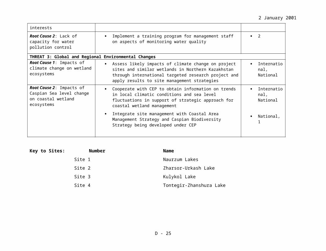
THREAT 3: Global and Regional Environmental ChangesRoot Cause 1: Impacts of climate change on wetland ecosystems
Assess likely impacts of climate change on project sites and similar wetlands in Northern Kazakhstan through international targeted research project and apply results to site management strategies
International, National
Root Cause 2: Impacts of Caspian Sea level change on coastal wetland ecosystems
Cooperate with CEP to obtain information on trends in local climatic conditions and sea level fluctuations in support of strategic approach for coastal wetland management
Integrate site management with Coastal Area Management Strategy and Caspian Biodiversity Strategy being developed under CEP
International, National
National, 1
Key to Sites: Number Name
Site 1 Naurzum Lakes
Site 2 Zharsor-Urkash Lake
Site 3 Kulykol Lake
Site 4 Tontegir-Zhanshura Lake
D - 16
2 January 2001
ANALYSIS OF THREATS
COUNTRY: RUSSIA
ROOT CAUSES OF THREAT ACTIVITIES TO MITIGATE THREAT SITES AFFECTED
THREAT 1: Unsustainable Use of Biological Resources
Root Cause 1: Lack of an integrated approach to wetland conservation and development planning
Upgrade or develop and implement an integrated wetland management plans for each of the five sites
Establish or expand buffer zones for nature reserves (including regulations to control specified activities such as oil exploration, timber extraction, hunting, fishing, agricultural practices, fires and development projects)
Develop site management committees as mechanisms for participation of local communities in site management and regulation of buffer zones
Create management zones inside reserves in order to meet different site management objectives
Improve integration of nature conservation with sectoral agencies at district (rayon) and provincial (oblast) levels, especially in relation to oil, gas & mineral exploration, forestry operations and agricultural development.
Ensure that EIAs are conducted for oil, gas & mineral exploitation and forestry operations in or adjacent to protected areas, followed by monitoring and environmental management of these operations and mitigation of impacts.
1,2,3,4
1,2,3,4
1,2,3,4
1,2,3,4
National, 1,2,3,4
National, 1,2,3,4
Root Cause 2: Lack of capacity and financial resources for protected area management and species protection
Increase control over timber extraction, fishing and hunting in adjacent unprotected areas through increased enforcement capacity
Increase the capacity of site management staff for environmental monitoring & data management, community participation, conflict management, site protection, hunting regulation and fire control
1,2,3,4
1,2,3,4
Root Cause 3: Inadequate legal protection for sites and national legislation on the conservation and sustainable use of wetland resources
Increase legal protection of sites by creating new protected areas, upgrading existing reserves and expanding extent of protected areas
Increase control over timber extraction, fishing and hunting in adjacent unprotected areas through improved regulations and enforcement
Improve long term security of Kytalyk by designating as a Ramsar site
National,
1,2,3,4
1,2,3,4
D - 17

2 January 2001
Harmonize legislation on specially protected areas, endangered species and native peoples of Yakutia Republic with federal law
Prohibit spring hunting in Tyumen – Kurgan region
National, 4
National, 4
3
Root Cause 4: Lack of sustainable alternative economic opportunities for communities that depend on wetland resources
Improve sustainability of land uses and develop alternative livelihood options for communities in and around the wetland areas
Develop compensation scheme for local farmers in relation to crop damage by waterbirds and develop alternative feeding sites for waterbirds in cooperation with local communities
Consult with local communities to improve sustainability of reindeer herding
Consult with local communities and other relevant stakeholders concerning sustainability of fisheries
1,2,3,4
3
4
2,3
Root Cause 5: Lack of information available for conservation management
In relation to management plan objectives, monitor harvesting of natural resources at project sites, focusing on impacts of reindeer harvesting (4), fishing (2,3), hunting (all sites)
Collect additional information on status of natural resources and human uses of sites as necessary to support development of management plans.
1,2,3,4
1,2,3,4
Root Cause 6: Lack of awareness of the importance of wetlands
Enhance support for reserves from local communities through education & public awareness programmes on values and benefits of reserves
Improve community relations with reserve management on disturbance, hunting, fishing, forest produce collection, agriculture and reindeer herding issues through public awareness campaigns
1,2,3,4
1,2,3,4
THREAT 2: Unsustainable Use of Water Resources
Root Cause 1: Lack of integrated approach to water resource management
Improve coordination between agencies responsible for monitoring of water quality and nature conservation
Improve coordination between agencies responsible for agricultural development, water resource management and nature conservation
Monitor and control pollution from upstream industries on the lower Ob (1) and upper Khroma (4)
1,2,3,4
3
1,4
Root Cause 4: Lack of capacity for water pollution control
Develop capacity of site management staff to monitor water quality, in collaboration with relevant national agencies.
1,3,4
THREAT 3: Global and Regional Environmental Changes
D - 18

2 January 2001
Root Cause 1: Impacts of climate change on wetland ecosystems
Monitor ecological conditions at sites in relation to climatic variations and assess likely impacts of climate change on wetlands through international targeted research project, and apply results to site management strategies
International, National
Key to Sites: Number Name
Site 1 Kunovat River Basin Wetlands
Site 2 Konda Alymka River Basin Wetlands (Uvat)
Site 3 Tyumen-Kurgan Trans-boundary Wetlands
Site 4 Kytalyk Wetlands
D - 19

2 January 2001
ANNEX E. PROJECT IMPLEMENTATION ARRANGEMENTS AND STAKEHOLDER PARTICIPATION SUMMARY
STAKEHOLDER LISTS AND PARTICIPATION PLANS FOR THE PROJECT SITES
INTRODUCTION TO STAKEHOLDER PARTICIPATION PLANS
The following section contains stakeholder participation plans for each project site in the four countries. Each stakeholder participation plan has been prepared to a standard format, including the main management issues causing conflict between conservation interests and local communities, the purposes and principle for stakeholder participation, a list of the main stakeholders, the principal activities required for implementation of the plans, coordination mechanisms for stakeholder participation and procedures for monitoring and evaluation.
These plans are preliminary and will be further developed for each site during the initial stages of project implementation, during Phase 1 for priority sites and during Phase 2 for the others. The development of detailed and complete stakeholder plans was beyond the capacity of the PDF-B phase. In particular, many local staff need intensive training and assistance from consultants before they can successfully complete appropriate plans for their sites.
The stakeholder participation plans are integral to the overall project and are closely linked to other project components, including the preparation of site management plans and implementation of training and awareness programmes.
The summary of project activities (Annex B1) lists a number of activities that are closely linked to the stakeholder participation plans. In particular, most project sites will begin their work on this project with development of management plans or revision and strengthening of current plans. In keeping with current protected area management philosophy, these site management plans will be developed through a process of consultation with stakeholders, include formal mechanisms for stakeholder input to management decision-making processes, and stakeholder participation in site management activities (according to the specific circumstances at each site). ICF’s experience has shown that stakeholder involvement is a long-term process that requires mutual learning and development of trust, especially in the initial stages. Active contributions and a positive approach are required from all sides in order to develop concrete and detailed plans, a process that must be reinforced by regular communication, review and adjustments.
The project training strategy (Annex L) indicates that training will be provided in all countries at the site level in community participation methods (this training will include practical exercises). The development of the stakeholder participation plans will need to be closely linked to training activities, so that the protected area staff involved have a full understanding of the goals and methods for stakeholder participation before plans are fully developed. This process will be assisted by the use of consultants specializing in community participation (e.g., PRA) for site activities in each country (see the international short term consultants listed elsewhere in Annex E). For some countries, such as China, national consultants will be used for these activities, specialists who can talk directly to local staff and local stakeholders. In addition, ICF’s annual project evaluations will include site visits by staff highly experienced in community participation methods. The International Technical Advisor
E - 20

2 January 2001
(ITA), who will provide guidance to national project staff, will have community participation experience within Asia.
The project awareness strategy (Annex K) includes a section on Site Level Action. At the site level, awareness activities will be carefully targeted to local stakeholder groups, responding to their practical resource needs and contributing to resolution of resource issues identified as important for their sites. This section emphasizes the importance of designing training and awareness strategies to sensitize nature reserve staff to understanding, respecting and acting upon the basis of stakeholder perspectives. Awareness strategies will thus build up two-way communication between reserve staff and local communities, and rely on community members to develop and deliver local programming (e.g., teachers from local schools will help to create and disseminate youth education materials).
At sites where intense pressure is being exerted by local communities on wetland resources, for instance in China where large populations live within and around the national nature reserves, the project will undertake pilot projects on the development of alternative livelihood options. These projects will directly involve selected groups of local communities and other relevant stakeholders and seek to address priority resource use issues and conflicts between reserve management and local communities. The lessons learned from such pilot projects should assist the reserves in applying such approaches on a wider scale and in gradually resolving long-term resource use challenges. These pilot projects should be incorporated into site stakeholder participation plans as the plans are developed.
While the stakeholder plans will specifically address the activities to be undertaken by this project, an important purpose of these plans (and of the stakeholder committees for each site) is to assist the staff of protected areas to improve relations with local communities. This project cannot directly address or solve every resource issue mentioned in the plans within a six-year (Phase 1 sites) or three-year (Phase 2 sites) period. But by developing site-specific stakeholder participation plans and by providing training and practical experience to protected area staff, the project should substantially assist the sites in addressing resource conflicts and local community needs beyond the scope of this project's activities and time period.
E - 21

2 January 2001
STAKEHOLDERS’ PARTICIPATION PLAN FOR POYANG LAKE BASIN, CHINA
Main Conflicts Between Nature Conservation and Development of the CommunitiesFishery: The residents have been depending on wild fish resources since before the foundation of People’s Republic of China, and then gradually turned to artificial aquaculture; in recent years, most of the fish production has come from aquaculture. The main reasons for the reduction of the fish resource are: 1) polder and reclamation, which lead to the reduction of the area and volume of lake and to the development of closed lakes; 2) illegal fishing equipment such as electrical net, stable net and dense net; 3) illegal fishing practices such as digging channels to drain the water and harvest fish (mostly in late autumn and winter).
Illegal hunting: For years, waterfowl has been the object of illegal hunting. In recent years, even with the increased enforcement of laws and regulations, it has not yet been controlled to a desired level. The main possible reasons are: 1) poor living standards around Poyang Lake; 2) insufficient legislation and law enforcement system that does not regulate and monitor hunting and wildfowl market; 3) lack of efficient vehicles for wardens and information blockage.
Grass collection and grazing: Excessive grass collection brings degradation and desertification to natural habitats, and increases disturbance to wintering waterbirds. So far, specific information about the distribution and intensity of grazing is not available. Further investigation is requested for assessment of the impacts of grazing on natural wetland habitats and on the use of areas by waterbirds and other wildlife.
Over-utilization of natural resources: In recent years, public demand for Artemisia selengensis, of which tender shoots and young plants have been harvested from natural wetlands, has increased providing considerable economic benefit for local communities. This practice results in the desertification of the wetland habitats and increased disturbance to the migratory birds.
Purposes1. Involve stakeholders in developing of the management plan for Poyang Lake.2. Create an environment for all stakeholders to work together.3. Supervise the management activities of Poyang Lake.4. Reduce the struggle between the local community and natural resource management agencies.5. Conduct educational programs for the local community to raise the environmental awareness of
the local people.6. Create sustainable development opportunities for the local community, and exercise co-
development with the local community.
PrinciplePromote participation by various stakeholders in development and conservation activities at Poyang Lake.
Stakeholder List
E - 22

2 January 2001
1. Villagers and villagers’ committee: Villagers are the basic stakeholders who have lived in the lake area for generations. They hold some meadows, lakes and farmland and have the right to conduct farming and fishery activities. Illegal fishing instruments and methods play negative effects on the migratory birds roosting and foraging. To protect migratory birds and habitats, they are the most important stakeholders.
2. Fishermen: Local people fish in two types of wetland: man-made and natural.3. Governmental departments at all levels of villages and towns: They are more concerned about
development of local economics than about conservation of migratory birds. Once the incomes of farmers, local revenue and finance have been ensured, the governments will be more willing to protect the migratory birds.
4. Other stakeholder agencies: Wildlife Conservation Departments, Fishery Departments, Industrial and Commercial Management Departments, Public Security Departments, Traffic Departments, Agriculture Development Departments, and Environment Protection Departments. Also, the Construction Committee of Three Gorges Dam.
Activities1. Establish the Committee of Stakeholders of the Poyang Lake. The functions of the committee
will be: 1) participate in development of the management plan for the reserve; 2) participate in decision making about important matters of the reserve; 3) supervise the management work of the reserve; 4) negotiate with stakeholders if any conflict occurs.
2. Hold a meeting once a year for the discussion of: annual management plan; suggestions and comments from stakeholders; any problems and resolutions the lake’s natural resource management is facing.
3. Hold training workshop annually for the members of the committee.
Coordination Mechanism for Stakeholder Participation
Provincial LevelProvince: Jiangxi Wildlife Conservation and Management Bureau (JWCMB) will be the leader responsible for holding consultation meetings each year during the period of project implementation with related agencies and departments, including fishery agencies, public security agencies, industrial and commercial agencies, water agencies, land management agencies, traffic agencies, environment protection agencies, related scientific research institutes, colleges and universities, and specialists. In certain situations, JWCMB will separately communicate and consult with the related departments. JWCMB will be responsible to report problems and recommendations, if any, from the consultation meetings to the provincial government.
County: The local forest bureau will be the leader for holding consultation meeting each year during the period of project implementation with related agencies and departments, including fishery agencies, public security agencies, industrial and commercial agencies, water agencies, land management agencies, traffic agencies, environment protection agencies, some related villages and towns, some large-scale factories and some specialists. In some special conditions, the local forest bureau will separately communicate and consult with the related agencies.
Protected Areas (PA): The PA will be the leader for holding two consultation meetings each year during the period of project implementation with local fishery agency, public security agency, industrial and commercial management agency, water agency, land management agency, traffic
E - 23

2 January 2001
agency, environment protection agency, villages and towns, and local residents. Jiangxi Wetland Public Education Center will be responsible for the stakeholders’ training and public education materials publishing. Jiangxi Wildlife Conservation and Management Bureau (JWCMB) will be responsible for working with NBBC to determine provincial training requirements and to conduct analysis of specialists’ requirements, identifying specific training requirements and developing related training plans.
National Level The State Forestry Administration (SFA) will be the leader for holding consultation meetings during the years of project implementation, including Ministry of Agriculture, Bureau of Industrial and Commercial Management, Ministry of Public Security, Ministry of Transportation, and State Environmental Protection Administration. Issues regarding our project include fishery management, commercial activities (processing and marketing) management, dealing with the legal cases involving wildlife; traffic management; the overall plan and arrangements for agriculture development; and environmental protection. All of the involved agencies are expected to develop cooperative relationships and coordinate with each other on the regular basis.
Procedures for Project Monitoring and EvaluationRepresentatives for the co-management committee will be handed to the JWCMB for ratification by every county and the three nature reserves. Responsibilities of the site management committee are: to find the best methods to resolve the conflicts between nature protection and utilization; to help monitor and evaluate specific projects, including project planning in the initial phase, project evaluation in the middle phase and appraisal in the closing phase.
E - 24
2 January 2001
STAKEHOLDERS’ PARTICIPATION PLAN FOR KEERQIN NATIONAL NATURE RESERVE, CHINA
Main Conflicts Between Nature Conservation and Development of the CommunitiesOver-grazing: Over-grazing of grassland and wetland by livestock causes degradation and desertification of the breeding and stopover habitats of waterbirds. The current information about the extensity and intensity of grazing is not available. Further investigation is requested for assessment of the impacts of grazing on natural wetland habitats and assessment of the impacts of grazing on the use of areas by waterbirds and other wildlife.
Water shortage: Not enough water has been available to supply for the wetland, because water from the mail source, the Huolin River, has been diverted for human uses.
Illegal hunting: Grassland game birds and mammals are the object of illegal hunting conducted mainly by local governmental officials both for food and recreation.
Purposes1. Encourage stakeholders to be involved in the management and development of the reserve.2. Involve stakeholders in development of the management plan for the reserve.3. Supervise the management activities of the reserve.4. Reduce the struggle between the local community and the reserve.5. Conduct educational programs for the local community to raise environmental awareness of the
local people.6. Create sustainable development opportunities for the local community, and exercise co-
development with the local community.
PrincipleThe plan will include stakeholders from different concerned organizations. The stakeholders will be considered important partners for the management of the reserve.
Stakeholder List1. Villagers in the local communities (villages): they own and use most of the reserve’s land.
Although they do not have ownership for core areas in the reserve they often use these areas for livestock grazing. Their farming and livestock grazing activities have direct and indirect impacts on waterbirds and their habitats.
2. Keyouzhongqi Water Bureau: Keerqin Reserve is facing a water shortage problem. Water projects conducted by the water bureau should be well assessed to reduce impact of each project on waterbirds and their habitats.
3. The governmental departments at all levels of villages and towns: they are the people who have daily interactions with local villagers. Improving livelihood of local people is the main task of the governments. Responsible use of natural resources should help improve living standard for local people as well as maintain habitat quality for waterbirds.
4. Other stakeholder agencies: Water Conservancy Bureau of Keyouzhongqi County, Land Management Bureau of Keyouzhongqi County, Environment Protection Bureau of Keerqin County, Agriculture Bureau of Keerqin County, Xinjiamu Township Government, Zhuntaiben Township Government, and Keerqin Stud Farm.
E - 25

2 January 2001
Activities1. Establish the Committee of Stakeholders of the Keerqin National Nature Reserve. The
functions of the committee will be: 1) participate in development of the management plan of the reserve; 2) participate in decision making about important matters of the reserve; 3) supervise the management work of the reserve; 4) negotiate with stakeholders if any conflict occurs.
2. Hold a meeting at the end or beginning of a year for discussion of: annual management plan; suggestions and comments from stakeholders; any problems and resolutions the reserve is facing.
3. Help to work out the detailed components of the Management Regulations for Keerqin NNR. 4. Help to edit environmental education materials.5. Hold a training workshop annually for the members of the committee.
Coordination Mechanism for Stakeholder Participation
Provincial LevelProvince: Inner Mongolia Environmental Protection Bureau will be the leader responsible for holding consultation meetings each year during the period of project implementation with related agencies and departments at the provincial level, including fishery agencies, public security agencies, industrial and commercial agencies, water conservation agencies, land management agencies, transportation agencies, forestry, related scientific research institutes, colleges and universities, and specialists. In certain situations, Inner Mongolia Environmental Protection Bureau will separately communicate and consult with the related governmental departments.
Protected Areas: The Keerqin National Nature Reserve will be the leader for holding two consultation meetings each year during the period of project implementation. The meetings will be attended by representatives from local villages and from county and township governmental agencies such as Water Conservancy Bureau of Keyouzhongqi County, Land Management Bureau of Keyouzhongqi County, Agriculture Bureau of Keyouzhongqi County, Xinjiamu Township Government, Zhuntaiben Township Government, and Keyouzhongqi Stud Farm.
National LevelState Forestry Administration will be the leader for holding consultation meetings during the years of project implementation, including Ministry of Agriculture, Bureau of Industrial and Commercial Management, Ministry of Public Security, Ministry of Transportation, and State Environmental Protection Administration. Issues regarding our project include fishery management, commercial activities (processing and marketing) management, dealing with the legal cases involving wildlife; traffic management; the overall plan and arrangements for agriculture development; and environmental protection. All of the involved agencies are expected to develop cooperative relationships and coordinate with each other on the regular basis.
Procedures for Project Monitoring and EvaluationResponsibilities of the site management committee are: to find the best methods to resolve the conflicts between nature protection and utilization; to help monitor and evaluate specific projects, including project planning in the initial phase, project evaluation in the middle phase and appraisal in the closing phase.
E - 26

2 January 2001
STAKEHOLDERS’ PARTICIPATION PLAN FOR XIANGHAI NATURE RESERVE, CHINA
Main Conflicts Between Nature Conservation and Development of the CommunitiesWater shortage: There is no sufficient water supply for the wetland. The main water source, Huolin River, was dammed in the past. Several water diversion projects have been proposed or are likely to be proposed.
Excessive cultivation and grazing: Over-cultivation and over-grazing of grassland and wetland by livestock cause degradation and desertification of the breeding and stopover habitat of waterbirds. Over-grazing has led to an action undertaken by the local government to fence the core area of the reserve. Current information about the extent and intensity of grazing is not available. Further investigation is needed for assessment of the impacts of grazing on natural wetland habitats and on the use of affected areas by waterbirds and other wildlife.
Extensive reed cutting: Extensive reed cutting has directly and indirectly disturbed habitats of breeding waterbirds.
Purposes1. Encourage stakeholders to be involved in the management and development of the reserve.2. Involve stakeholders in working out the management plan for the reserve.3. Supervise the management activities of the reserve.4. Reduce the struggle between the local community and the reserve.5. Conduct educational programs for the local community to raise environmental awareness of the
local people.6. Create sustainable development opportunities for the local community, and exercise co-
development with the local community.
PrincipleThe plan will involve stakeholders from different concerned organizations. Stakeholders will be considered active and important partners for the management of the reserve.
Stakeholder List1. Villagers in the local communities (villages): they own and use most of the reserve’s land.
Although they do not have ownership for core areas in the reserve they used to use these areas for livestock grazing. Their farming and livestock grazing activities produce direct and indirect impacts on waterbirds and their habitats.
2. Xianghai Reservoir and Tongyu Water Bureau: Xianghai reserve is facing a water shortage problem. Water projects conducted by the water bureau should be well assessed to reduce impact of each project on waterbirds and their habitats.
3. Governmental departments at all levels of villages and towns: they are the people who daily interact with local villagers. Improving livelihood of local people is the main task of the governments. Responsible use of natural resources should help improve living standards for local people as well as maintain habitat quality for waterbirds.
4. Other stakeholder agencies: Water Conservancy Bureau of Tongyu County, Land Management Bureau of Tongyu County, Xianghai Reservoir Management Office (managed by Tongyu
E - 27

2 January 2001
Water Conservancy Bureau), Environment Protection Bureau of Tongyu County, Agriculture Bureau of Tongyu County, Xianghai Township Government, Sijinzi Township Government, Wulanhua Township Government, Xinglongshan Township Government, Tongfa Husbandry Farm, and Xianghai Reed Farm.
Activities1. Establish the Committee of Stakeholders of the Xianghai National Nature Reserve. The
functions of the committee will be: 1) participate in working out the management plan of the reserve; 2) participate in making decisions about important matters of the reserve; 3) supervise the management work of the reserve; 4) negotiate with stakeholders if any conflict occurs.
2. Hold a meeting at the end or the beginning of each year for the discussion of: annual management plan; suggestions and comments from stakeholders; any problems and resolutions the reserve is facing.
3. Help to work out the detailed components of the Management Regulations for Xianghai National Nature Reserve.
4. Help to edit environmental education materials.5. Hold a training workshop annually for the members of the committee.6. Establish a “farmer volunteer guards” system: Villagers will choose about 50 farmers, who are
living around the core areas of the reserve, as volunteer guards for the reserve. This activity aims to encourage local residents to be involved in the management of the reserve and try to deal with conflicts with the local communities. Guard responsibilities will be to help the reserve stop all illegal activities within the protected territory and monitor the migration and breeding of cranes and other waterbirds in the reserve.
Coordination Mechanism for Stakeholder Participation
Provincial LevelProvince: Jilin Forestry Department will be the leader responsible for holding consultation meetings each year during the period of project implementation with related agencies and departments at the provincial level, including fishery agencies, public security agencies, industrial and commercial agencies, water conservation agencies, land management agencies, transportation agencies, environmental protection agencies, related scientific research institutes, colleges and universities, and specialists. In certain situations, Jilin Forestry Department will separately communicate and consult with the related governmental departments.
Protected Areas: The Xianghai National Nature Reserve will be the leader for holding two consultation meetings each year during the period of project implementation. The meetings will be attended by representatives from local villages and from county and township government agencies such as Water Conservancy Bureau of Tongyu County, Land Management Bureau of Tongyu County, Xianghai Reservoir Management Office, Environmental Protection Bureau of Tongyu County, Agriculture Bureau of Tongyu County, Xianghai Township Government, Sijinzi Township Government, Wulanhua Township Government, Xinglongshan Township Government, Tongfa Husbandry Farm, and Xianghai Reed Farm.
E - 28

2 January 2001
National LevelThe State Forestry Administration will be the leader for holding consultation meetings during the years of the project implementation, including Ministry of Agriculture, Bureau of Industrial and Commercial Management, Ministry of Public Security, Ministry of Transportation, and State Environment Protection Administration. Issues regarding our project include fishery management, commercial activities (processing and marketing) management, dealing with the legal cases involving wildlife; traffic management; the overall plan and arrangements for agriculture development; and environmental protection. All of the involved agencies are expected to develop cooperative relationships and coordinate with each other on the regular basis.
Procedures for Project Monitoring and EvaluationResponsibilities of the site management committee are: to find the best methods to resolve the conflicts between nature protection and utilization; to help monitor and evaluate specific projects, including project planning in the initial phase, project evaluation in the middle phase and appraisal in the closing phase.
E - 29
2 January 2001
STAKEHOLDERS’ PARTICIPATION PLAN FOR MOMOGE NATIONAL NATURE RESERVE, CHINA
Main Conflicts Between Nature Conservation and Development of the CommunitiesOver-grazing: Over-grazing of grassland and wetland by livestock causes degradation and desertification of the breeding and stopover habitats of waterbirds. Current information on the extent and intensity of grazing is not available. Further investigation is needed for assessment of the impacts of grazing on natural wetland habitats and on the use of affected areas by waterbirds and other wildlife.
Oil extraction: Oil extraction affects the water quality and is not well coordinated with nature protection.
Water shortage: Water resources are being diverted for other uses such as irrigation, aquaculture and industry, reducing the amount available to maintain the wetland ecosystem.
Purposes1. Encourage stakeholders to be involved in the management and development of the reserve.2. Involve stakeholders in working out the management plan for the reserve.3. Supervise the management activities of the reserve.4. Reduce the struggle between the local community and the reserve.5. Conduct educational programs for the local community to raise environmental awareness of
local people.6. Create the sustainable development opportunities for the local community, and exercise co-
development with the local community.
PrincipleThe establishment of the Committee of Stakeholders for the management of the reserve will encourage stakeholders to participate in management activities of the reserve.
Stakeholder List1. Villagers in the local communities (villages): they own and use most of the reserve’s land.
Although they do not have ownership for core areas in the reserve they often use these areas for livestock grazing. Their farming and livestock grazing activities produce direct and indirect impacts on waterbirds and their habitats.
2. Zhenlai Water Bureau: Momoge Reserve is facing a water shortage problem. Water projects planned and conducted by the water bureau should be well assessed to reduce impact on waterbirds and their habitats.
3. Yingtai Oil Extraction Group, Jilin Oil Company Ltd. Oil extraction in and around the reserve should be carefully assessed and controlled.
4. Governmental departments at all levels of villages and towns: they are the people who daily interact with local villagers. Improving livelihood of local people is the main task of the governments. Responsible use of natural resources should help improve living standards for local people as well as maintain habitat quality for waterbirds.
5. Other stakeholder agencies: Land Management Bureau of Zhenglai County, Environment Protection Bureau of Zhenglai County, Agriculture Bureau of Zhenglai County, Forestry Bureau of Zhenglai County, Stud Management Bureau of Zhenglai County, Committee of Economic Planning of Zhenglai County, Momoge Forestry Farm, Dongfanghong Agriculture Farm, Momoge
E - 30

2 January 2001
Township Government, Wukeshu Township Government, Dandai Township Government, Datun Township Government, Yanjiang Township Government, and Chatai Township Government.
Activities1. Establish the Committee of Stakeholders of the Momoge National Nature Reserve. The
functions of the committee will be: 1) participate in working out the management plan for the reserve; 2) participate in making decision about important matters of the reserve; 3) supervise the management work of the reserve; 4) negotiate with stakeholders if any conflict occurs.
2. Hold a meeting at the end or beginning of each year for the discussion of: annual management plan; suggestions and comments from stakeholders; any problems and resolutions the reserve is facing.
3. Help to work out the detailed components of the Management Regulations for Momoge National Nature Reserve.
4. Help to edit environmental education materials.5. Hold training workshops annually for the members of the committee.6. Train the stakeholders.
Coordination Mechanism for Stakeholder Participation
Provincial LevelProvince: Jilin Forestry Department will be the leader responsible for holding consultation meetings each year during the period of project implementation with related agencies and departments at the provincial level, including fishery agencies, public security agencies, industrial and commercial agencies, water conservation agencies, land management agencies, transportation agencies, environmental protection agencies, related scientific research institutes, colleges and universities, and specialists. In certain situations, Jilin Forestry Department will separately communicate and consult with the related governmental departments.
Protected Areas: The Momoge National Nature Reserve will be the leader for holding two consultation meetings per year during the period of the project implementation. The meetings will be attended by representatives from local villages and from forestry agencies,county and township government agencies such as Land Management Bureau of Zhenglai County, Environment Protection Bureau of Zhenglai County, Agriculture Bureau of Zhenglai County, Forestry Bureau of Zhenglai County, Yingtai Oil Extraction Group, Stud Management Bureau of Zhenglai County, Committee of Economic Planning of Zhenglai County, Momoge Forestry Farm, Dongfanghong Agriculture Farm, Momoge Township Government, Wukeshu Township Government, Dandai Township Government, Datun Township Government, Yanjiang Township Government, and Chatai Township Government.
National LevelThe State Forestry Administration will be the leader for holding consultation meetings during the years of project implementation, including Ministry of Agriculture, Bureau of Industrial and Commercial Management, Ministry of Public Security, Ministry of Transportation, and State Environmental Protection Administration. Issues regarding this project include fishery management, commercial activities (processing and marketing) management, dealing with the legal cases involving wildlife; traffic management; the overall plan and arrangements for agriculture development; and environmental
E - 31

2 January 2001
protection. All of the involved agencies are expected to develop cooperative relationships and coordinate with each other on the regular basis.
Procedures for Project Monitoring and Evaluation Responsibilities of the site management committee are: to find the best methods to resolve the conflicts between nature protection and utilization; to help monitor and evaluate specific projects, including project planning in the initial phase, project evaluation in the middle phase and appraisal in the closing phase.
E - 32

2 January 2001
STAKEHOLDERS’ PARTICIPATION PLAN FOR ZHALONG NATIONAL NATURE RESERVE, CHINA
Main Conflicts Between Nature Conservation and Development of the CommunitiesWater shortage: There is no sufficient water supply for the wetland. The original main water source, Wuyuer River, has been dammed. Several water diversion projects have been proposed.
Extensive reed cutting: Extensive reed cutting has directly and indirectly disturbed habitats of breeding waterbirds.
Over–fishing: Excessive fishing has led to the reduction in fish stocks and food resources for waterbirds.
Water pollution: Industrial wastes, chemical fertilizers, and pesticides are major causes of water pollution.
Purposes1. Encourage all stakeholders to get involved in the conservation and management of the Zhalong
wetlands. 2. Help to enforce local and national laws and regulations concerning nature conservation.3. Help to draw and implement plans for the wetland use and conservation.4. Negotiate for the reasonable use of wetland resources.5. Supervise the management activities conducted by the nature reserve.6. Monitor and supervise the use of wetland resources.7. Help to develop conservative regulations for the conservation of Zhalong wetlands.
Principle The plan will include stakeholders from different concerned organizations. The stakeholders will be considered important partners for the management of the reserve.
Stakeholder List1. Villagers in the local communities (villages): they own and use most of the reserve’s land.
Although they do not have ownership for core areas in the reserve they often use these areas for livestock grazing. Their farming and livestock grazing activities produce direct and indirect impacts on waterbirds and their habitats.
2. Governmental departments at all levels of villages and towns: they are the people who daily interact with local villagers. Improving livelihood of local people is the main task of the governments. Responsible use of natural resources should help improve living standards for local people as well as maintain habitat quality for waterbirds.
3. Other stakeholder agencies include: water conservation bureaus of Qiqihar and Daqing cities and local counties’ water conservancy bureaus; land management bureaus of Qiqihar and Daqing cities and local counties’ land management bureaus; environmental protection bureaus of Qiqihar and Daqing cities and local counties’ environmental protection bureaus; agriculture bureaus of Qiqihar and Daqing cities and local counties’ agriculture bureaus; counties’ and townships’ governments (responsible for community management around Zhalong Wetlands); Tourist Bureau of Qiqihar City, Qiqihar Husbandry Farm, Lindian Reed Farm, and reed processing companies around Zhalong Wetlands.
E - 33

2 January 2001
Activities1. Establish the Committee of Stakeholders of the Zhalong National Nature Reserve. The functions of
the committee will be: 1) participate in working out the management plan for the reserve; 2) participate in making decisions about important matters of the reserve; 3) supervise the management work of the reserve; 4) negotiate with stakeholders if any conflict occurs.
2. Hold a meeting at the end or beginning of each year for the discussion of: annual management plan; suggestions and comments from stakeholders; any problems and resolutions the reserve is facing.
3. Help to work out the detailed components of the Management Regulations for Zhalong National Nature Reserve.
4. Help to edit environmental education materials.5. Hold training workshops annually for the members of the committee.
Coordination Mechanism for Stakeholder Participation
Provincial LevelProvince: Heilongjiang Forestry Department will be the leader responsible for holding consultation meetings each year during the period of project implementation with related agencies and departments at the provincial level, including Qiqihar City Government, Daqing City Government, fishery agencies, public security agencies, industrial and commercial agencies, water conservation agencies, land management agencies, transportation agencies, environmental protection agencies from these two cities, and some related scientific research institutes, colleges and universities. In certain situations, Heilongjiang Forestry Department will separately communicate and consult with the related governmental departments.
Protected Areas: The Zhalong National Nature Reserve will be the leader for holding two consultation meetings each year during the period of project implementation. The meetings will be attended by representatives from local villages and townships, county and city governmental agencies such as water conservation bureaus of Qiqihar and Daqing cities and local counties’ water conservancy bureaus; land management bureaus of Qiqihar and Daqing cities and local counties’ land management bureaus; environmental protection bureaus of Qiqihar and Daqing cities and local counties’ environmental protection bureaus; agriculture bureaus of Qiqihar and Daqing cities and local counties’ agriculture bureaus; counties’ and townships’ governments (responsible for community management around Zhalong Wetlands); Tourist Bureau of Qiqihar City, Qiqihar Husbandry Farm, Lindian Reed Farm, and reed processing companies around Zhalong Wetlands.
National LevelThe State Forestry Administration will be the leader responsible for holding consultation meetings during the years of project implementation, including Ministry of Agriculture, Bureau of Industrial and Commercial Management, Ministry of Public Security, Ministry of Transportation, and State Environment Protection Administration. Issues regarding this project include fishery management, commercial activities (processing and marketing) management, dealing with the legal cases involving wildlife; traffic management; the overall plan and arrangements for agriculture development; and environmental protection. All of the involved agencies are expected to develop cooperative relationships and coordinate with each other on the regular basis.
E - 34

2 January 2001
Procedures for Project Monitoring and EvaluationResponsibilities of the site management committee will be: to find the best methods to resolve the conflicts between nature protection and utilization; to help monitor and evaluate specific projects, including project planning in the initial phase, project evaluation in the middle phase and appraisal in the closing phase.
E - 35

2 January 2001
STAKEHOLDERS’ PARTICIPATION PLAN FOR FEREYDOON KENAR/EZBARAN/SORKHE RUD, IRAN
Main Conflicts Between Nature Conservation and Development of the CommunitiesEnd of Season Shoot-out: Towards the end of each season, when duck-netting becomes unprofitable, the area is opened up to hunting with guns in a massive “shoot-out.” There is a potential threat that Siberian Cranes could be shot accidentally. This is the single greatest threat to the surviving flock of Siberian Cranes in Iran. In March 2000, the end of season “shoot out “ happened whilst the Siberian Cranes were still present. This was an extremely dangerous situation and it is very fortunate that no cranes were shot. They were still seriously disturbed by the shoot-out, and were forced to leave the site early (being subsequently located at Ardabil). It is a top priority that the shoot-out should not be permitted until the Siberian Cranes have departed from the site. There is strong local feeling that DoE should have a permanent presence in the area so that shooting can be effectively controlled. Then this matter should be discussed with the local community in order to obtain their agreement. The more sensitive matter of prohibiting the end of season shoot out also needs to be discussed with the local community, perhaps in the context of a trade off: DoE would prevent shooting by other people at the end of winter if the local trappers forgo the shoot out.
Aerial nets: The local community has maintained the damgah for the purposes of trapping ducks. The local duck-trappers are concerned at the level of human disturbance and prevent shooting in the area, which is probably the main reason the Siberian Cranes have survived. The traditional use of captive ducks and baited ponds with clap-nets is legal. Illegal aerial nets used around the damgah represent a problem. The options are to register the nets (with a license from DoE, under negotiated conditions), or to phase them out over a period of time with the full agreement of the trappers. Some compensation or other benefits would be necessary for the second option. However, there are no reports of Siberian Cranes being caught or injured by aerial nets.
Rapid urban and industrial development: The encroachment of urban and industrial development on to agricultural land is occurring mainly in the area from Fereydoon Kenar town to the trapping area (damgah). The damgah at Sorkhe Rud is immediately adjacent to the town buildings as a result of such encroachment.
Purposes1. Encourage stakeholders to be involved in the management and development of the Non-Shooting
Area (NSA).2. Participate in developing the Management Plan for the NSA.3. Supervise the management activities of the NSA.4. Reduce and resolve conflicts between the local community and the NSA.5. Conduct educational programs for the local community to raise the environmental awareness of
nearby residents and other stakeholders.6. Create sustainable development opportunities for the local community, and help the reserve
achieve co-development with the local community.
PrincipleThe plan will include stakeholders from different concerned organizations and interest groups. The stakeholders will be considered important partners for the management of the area.
E - 36

2 January 2001
Stakeholder List1. Mazandaran Provincial Offices of Environment, Agriculture, Planning, Water, Education, Natural
Resources and Justice.2. Babol City Offices of Environment, Agriculture, Planning, Water, Education, Natural Resources
and Justice.3. Fereydoon Kenar Town Offices of Agriculture, Planning, Water, Education, Natural Resources and
Justice.4. Provincial governor’s office5. Fereydoon Kenar mayor, city council6. Local district councils around project site7. Village committees for Suteh, Mehleban, Ezbaran, and Sorkhe Rud8. Fereydoon Kenar Islamic Council9. Fereydoon Kenar Rice Farmers Association10. Local farmers/duck trappers from Fereydoon Kenar Town, and Suteh, Mehleban, Ezbaran, and
Sorkhe Rud11. Local schools12. University of Mazandaran
Activities1. Establish the Site Management Committee for Fereydoon Kenar. The functions of the committee
will be: 1) participate in preparing the Management Plan for the Non Shooting Area and its buffer zone; 2) participate in making decisions about important matters for conservation and management of wild birds; 3) supervise the management work of the NSA; 4) negotiate with stakeholders to resolve any conflicts that occur.
2. Hold a meeting at least once a year for the discussion of: annual Management Plan; collect suggestions and comments from stakeholders regarding any problems and activities facing the wetlands or waterbirds. Discussion on possible mutual cooperation between DoE and local stakeholders.
3. Help to prepare the detailed management rules for the project area.4. Help to prepare environmental education materials.5. Hold training workshop annually for the members of the committee.
Coordination Mechanism for Stakeholder ParticipationThe Site Management Committee will be chaired by the National Project Manager and/or Director General of DoE’s Mazandaran Province. The Site Management Committee will be coordinated with the DoE’s National and Provincial Office operations as described below.
Provincial LevelNational Coordination Unit (NCU) with assistance of DoE Mazandaran Province (DoE, MP) will be responsible for holding consultations and meetings during the project period with related governmental and non-governmental organizations. The NCU (with assistance of DoE, MP) will be responsible for establishing the Site Management Committee including local stakeholders. The Site Management Committee will secure agreement and approval of the stakeholders for the Site Management Plan. Site Management Committee will discuss implementation of the Management Plan during meetings each year.
E - 37

2 January 2001
National LevelThe National Coordination Unit (NCU) will be the leader for holding consultations and meetings during the period of project implementation with related governmental and non-governmental organizations, local stakeholders, scientific institutions and protected territories at national level. The NCU will be responsible for holding project meetings during the project and also for monitoring and assessing project implementation. The NCU will work closely with DoE, MP.
Procedures for Project Monitoring and EvaluationThe Site Management Committee will report the proceedings of its meetings to the National Project Advisory Group and National Project Management Group. The National Coordination Unit (NCU) with the assistance of DoE Mazandaran Province (DoE, MP) will establish the Site Management Committee, which is responsible to secure agreement and approval of the Site Management Plan, to control implementation of the Management Plan, to determine the best approaches to solve conflicts between nature protection and nature resources usage, and to provide regular reports to the National Project Management Group. The NCU will also be responsible to give regular reports to National Project Advisory Group (NPAG). The frequency of reporting will be determined during year 1 of the project.
E - 38

2 January 2001
STAKEHOLDERS’ PARTICIPATION PLAN FOR AMIRKELAYEH/RUD POSHT, IRAN
Main Conflicts Between Nature Conservation and Development of the CommunitiesIllegal waterbird hunting (Amir Kelayeh site): Common practice - local population is engaged in waterfowl poaching for food and/or profit.
Use of illegal aerial nets (Amir Kelayeh site): Common practice - illegal aerial nets used in this site represent a problem. The options are to register the nets (with a license from DoE, under negotiated conditions), or to phase them out over a period of time with the full agreement of the trappers. Some compensation or other benefits would be necessary for the second option. However, there are no reports of Siberian Cranes being caught or injured by aerial nets.
Encroachment onto the reserve by farmers (Amir Kelayeh site): Occurs frequently. Negotiations with farmers are needed.
Agrochemical pollution from surrounding rice fields (Amir Kelayeh site): Fish dies out en mass in June/July due to eutrophication, which is attributed to high usage of fertilizers and other agrochemicals in the surrounding rice fields.
Risk of cranes being shot in and around the site (Rud Posht site): This damgah has no legal protection but local duck trappers provide sufficient level of protection. Widespread shooting across suitable habitats in the Caspian lowlands poses a potential threat in the areas surrounding the damgah.
Purposes 1. Encourage stakeholders to be involved in the management and development of the wildlife refuge.2. Participate in developing the Management Plan for the wildlife refuge.3. Supervise the management activities of the wildlife refuge.4. Reduce and resolve conflicts between the local community and the wildlife refuge.5. Conduct educational programs for the local community to raise the environmental awareness of
nearby residents and other stakeholders.6. Create sustainable development opportunities for the local community, and help the reserve
achieve co-development with the local community.
PrincipleThe plan will involve stakeholders from different organizations and all pertinent interest groups in the area. Stakeholders will be considered active and important partners for the management and sustainable use of the wildlife refuge.
Stakeholder List1. Gilan Provincial Offices of Environment, Agriculture, Planning, Water, Education, Natural
Resources and Justice.2. Lahigan City Offices of Environment, Agriculture, Planning, Water, Education, Natural
Resources and Justice.3. Gilan Provincial governor’s office4. Village committees for Hasan Bekandeh and Rud Posht, 5. Hasan Bekandeh and Rud Posht Islamic Councils.6. Rice Farmers Associations
E - 39

2 January 2001
7. Local farmers, fishermen, duck trappers and villagers8. Local schools9. Gilan University
Activities1. Establish the Site Management Committee for Amirkelayeh/Rud Posht. The functions of the
committee will be: 1) participate in preparing the Management Plan for the wildlife refuge and buffer zone; 2) participate in making decisions about important matters for conservation and wild birds management; 3) supervise the management work of the wildlife refuge; 4) negotiate with stakeholders to resolve any conflicts that occur.
2. Hold a meeting at least once a year for the discussion of: annual Management Plan; suggestions and comments from stakeholders; problems and activities the wetlands or waterbirds are facing; possible mutual cooperation between DoE and local stakeholders.
3. Help to prepare detailed management rules for the protected areas.4. Help to prepare environmental education materials.5. Hold training workshops annually for the members of the committee.
Coordination Mechanism for Stakeholder ParticipationThe Site Management Committee will be chaired by the National Project Manager and/or Director General of DoE’s Gilan Province. The Site Management Committee will be coordinated with the DoE’s National and Provincial Office operations as described below.
Provincial LevelThe National Coordination Unit (NCU) with the assistance of DoE Gilan Province (DoE, GP) will be responsible for holding consultations and meetings during the project implementation period with related governmental and non-governmental organizations. The NCU (with assistance of DoE, GP) will be responsible for establishing the Site Management Committee including local stakeholders. The Site Management Committee will secure agreement and approval of the Site Management Plan. Site Management Committee will discuss the Management Plan implementation during meetings each year.
National LevelNational Coordination Unit (NCU) will be the leader for holding consultations and meetings during the each year of period of project implementation with related governmental and non-governmental organizations, local stakeholders, scientific institutions and protected territories on national level. The NCU will be responsible for holding project meetings during the project duration, and also responsible for monitoring and assessing project implementation. The NCU will work closely with DoE, GP.
Procedures for Project Monitoring and EvaluationThe Site Management Committee should report the proceedings of meeting procedures to the National Project Advisory Group and National Project Management Group. The National Coordination Unit (NCU) with assistance of DoE Gilan Province (DoE, GP) will establish the Site Management Committee, which is responsible to secure agreement and approval of the Site Management Plan, to control implementation of the Management Plan, to determine the best approaches to solve conflicts between nature protection and nature resources usage, and to provide regular reports to National Project Management Group. NCU is also responsible to give regular reports to National Project Advisory Group (NPAG). The frequency of reporting will be determined during year 1 of the project.
E - 40
2 January 2001
STAKEHOLDERS’ PARTICIPATION PLAN FOR BUJAK/SEFID RUD DELTA, IRAN
Main Conflicts Between Nature Conservation and Development of the CommunitiesFisheries company: 100 fishermen work at the Fishery Company at the mouth of the Oshmak River.
Illegal fishery: Local population is practicing lucrative fishery, mostly on sturgeon and white fish (mullet), for food and/or profit. Rice fields within the NHA: The farmers work in the rice fields from April to September and do other jobs for the rest of the year. Chemical use is low (use organic methods?). The government is promoting biological pest control (Trichodrama). There are approximately 120 rice farmers at Bujak, up to 1ha each, total 200ha. The rice fields were established about 18 years ago (after the revolution), when the emphasis was on social support. No further expansion of agriculture will be allowed. One area of rice fields is not well legally defined – used for 4 months / year by 4 farmers.
Grazing: There is very little control over grazing at present (the site is heavily grazed in summer, ~10,000 animals). But only a few horses graze in the area during the winter.
Duck trapping: Four shelters used for duck netting occur inside the NHA on this land – with permission of the DoE. They trap for 3 days per week, limited to 6 birds per day (often catch less than this). These farmers also prevent other people from shooting in this area.
Illegal hunting: Local population is engaged in waterfowl poaching in NHA for food and/or profit.
Army Camp: Army camp located next to the site. This has caused disturbance of waterfowl.
Purposes1. Encourage stakeholders to be involved in the management and development of the non-
hunting area (NHA)2. Participate in developing the Management Plan of the NHA3. Supervise the management activities of the NHA.4. Reduce and resolve conflicts between the local community and the NHA.5. Conduct educational programs for the local community to raise the environmental awareness of
nearby residents and other stakeholders.6. Create sustainable development opportunities for the local community, and help the NHA achieve
co-development with the local community.
PrincipleThe plan will include stakeholders from different concerned organizations and interest groups. The stakeholders will be considered important partners for the management of the NHA.
E - 41
2 January 2001
Stakeholder List1. Gilan Provincial Offices of Environment, Agriculture, Fisheries, Planning, Water, Education,
Natural Resources and Justice.2. Kia Shahr City Offices of Agriculture, Planning, Water, Education, Natural Resources and
Justice.3. Gilan Provincial governor’s office4. Local district councils around project site5. Local village committees6. Local Islamic Councils 7. Rice Farmers Association8. Local farmers, fishermen, and villagers9. Local schools10. Gilan University, Rasht11. Shaheed Beheshti University, Tehran12. DoE13. Fishermens’ Co-operative Company14. Ministry of Defense (army camp)
Activities1. Establish the Site Management Committee for Bujak/Sefid Rud Delta. The functions of the
committee will be: 1) participate in preparing the Management Plan for the reserve; 2) participate in making decisions about important matters for conservation and wild birds management; discussion on possible mutual cooperation between DoE and local stakeholders. 3) supervise the management work of the NHA; 4) negotiate with stakeholders to resolve any conflicts that occur.
2. Hold a meeting at least once a year for the discussion of: annual Management Plan; collect suggestions and comments from stakeholders regarding any problems and activities facing the wetlands or waterbirds.
3. Help to prepare the detailed management rules for the protected areas.4. Help to prepare environmental education materials.5. Hold training workshop annually for the members of the committee.
Coordination Mechanism for Stakeholder ParticipationSame as for Amirkelayeh / Rud Posht site.
Procedures for Project Monitoring and EvaluationSame as for Amirkelayeh / Rud Posht site.
E - 42

2 January 2001
STAKEHOLDERS’ PARTICIPATION PLAN FOR NAURZUM-KULAGOL LAKE SYSTEM, KAZAKHSTAN
Main Conflicts Between Nature Conservation and Development of the CommunitiesFishing and hunting: Although there are no human settlements closer than in 40 km from the Naurzum lakes and only five small villages and settlements within 30-km radius from the Kulagol Lake (1280 people total population), unregulated fishing and waterbird hunting (poaching) is common on almost every lake within the project site. Widespread economic depression provokes the locals to help themselves and violate the reserve regime fishing and hunting for food and additional income.
Grassfires: Grassfires represent one of the most typical and serious threats to the biodiversity of Naurzum-Kulagol lake system. Most often grassfires are caused by irresponsible humans or by lightning during thunderstorms that frequently occur in this area. Other causes of grassfire are use of agricultural machinery near reserve’s buffer zone and cattle breeders’ tradition to burn old vegetation for faster pasture upgrade (a harmful practice that should be eliminated). Due to the lack of finances the reserve’s administration is not able to conduct fire-preventing activities such as firebreaks or control burnings. Sometimes grassfires are also caused by hunters or fishermen visiting lakes in the buffer or peripheral zones of the reserve. The lakes that suffer from grassfires most often are located within the western part of the project site and include lakes that Siberian Cranes use as stopovers: Zharkol, Sary-Moin, Aksuat, Chushkaly, and Kulagol. Most often grassfires occur during the second half of summer killing or injuring non-flight young and molting birds. In dry years, grassfires are frequent in early summer as well, destroying practically all nests and eggs in the area.
Grazing: Due to the recent decrease in cultivated field acreage and decline in human population in neighboring settlements, numbers of cattle have decreased correspondingly. Nevertheless, threats and disturbances caused by grazing cattle are significant in the reserve’s buffer zone. Herds of cattle enter the reserve territory, especially during the second half of summer and fall, when grasses in pastures dry out while the shore vegetation becomes more diverse. Many cattle owners leave their herds without supervision so they roam at loose for 2-3 days and often break into reserve. Grazing cattle take away waterbirds’ habitat, crashing their eggs and broods.
Unorganized tourism and visitation: Since the local communities are properly informed about the reserve’s significance their unorganized visitation is quite rare. More often curious teenagers enter reserve to watch rare species in the protected territory, and occasionally adult birdwatchers break in, to observe rare birds such as White-headed Duck, Little Bustard, and Saker Falcon. Although this area is very remote from Kostanay city and other urban territories, number of tourists and visitors is slowly growing. The reserve has limited facilitates to start organized tourism program on its territory and more infrastructure is needed to make such a program successful. Trails and roads inside the reserve are poorly designed; there are no tour guides and services.
Purposes1. Encourage stakeholders to get involved in the sustainable management of water and land
resources as well as in protection of the unique forest, steppe, and wetland area around Naurzum and Kulagol lake system.
2. Participate in implementation of activities to maintain optimal water regime and prevent disturbance and destruction of wetlands (due to wildfires, overgrazing, poaching, and unorganized tourism) in major waterbird habitats.
E - 43
2 January 2001
3. Assist in species and habitat management activities of the Naurzum Reserve.4. Participate in implementation of the alternative livelihood programme for local communities
(ecotourism, regulated commercial fishing).5. Participate in development of programmes for conservation of globally significant species and
their habitats.6. Develop and participate in programmes to train local farmers in “biodiversity-friendly” land-
and water-use practices to prevent wild grassfires, overgrazing, over-fishing, etc.7. Improve and develop relationships between the local communities and the Naurzum Reserve.8. Develop and conduct educational programme for local communities, to increase public
awareness on the present project goals and objectives and global significance of specially protected species, the Siberian Crane in particular.
9. Regulate hunting and fishing pressure on project sites and ensure effective management of fish and game resources.
10. Gain the stakeholders’ understanding and support on a project to extend the Naurzum Nature Reserve by 280 ha by adjoining the Kulagol Lake.
PrincipleThe plan will involve stakeholders from different organizations and all pertinent interest groups in the area. The stakeholders will be considered active and important partners for the management and sustainable land use of the project site.
Stakeholder List1. Akimat (Administration) of Naurzum District2. Kostanay Oblast Agricultural Agency3. Kostanay Oblast Union of Fishermen and Hunters4. Naurzum State Zapovednik (Nature Reserve) and its Research Department5. Naurzum District Hunters and Fishermen Society6. Kostanay Oblast Department for Public Education7. Naurzum District Educational Institutions (schools, technical colleges)8. NGO “Naurzum”9. WWF-Sweden10. NGO “Young Generation for Ecological Safety and Sustainable Development”11. Local volunteers (ranger’s assistants) 12. Local land and water users of Naurzum District (41 state-owned and 60 private businesses and
farms, including commercial fishery structures)13. Residents of Karamende (form. Dokuchayevka) town located in 40 km from the Naurzum lakes
(5326 people) and residents of five villages and towns within 30-km radius from Kulagol Lake (1280 people)
Activities1. Establish a Site Management Committee of Naurzum-Kulagol Lake System. The functions of
the Committee will be: 1) participate in the development of a Management Plan for the crane areas; 2) participate in making decisions about important issues for conservation and wildlife (especially waterbirds) management; 3) supervise and assist management work of the Naurzum Reserve; 4) negotiate with stakeholders if any tension occurs.
E - 44

2 January 2001
2. Hold a meeting once a year for the discussion of: annual Management Plan; suggestions and comments from stakeholders; problems and threats that wetlands or/and waterbirds may be facing.
3. Help to work out detailed management rules for the protected areas.4. Help to prepare and publish environmental education materials.5. Create groups for complex field research, and conduct waterbird studies and habitat
monitoring, with participation of the Kostanay State University and local students and volunteers, under the guidance of the Research Department of Naurzum Reserve.
6. Hold training workshops annually for the members of the committee.7. Develop and approve a special agreement between Naurzum Reserve administration and local
communities concerning joint activities to protect Siberian Cranes in the area.8. Conduct an outreach work with local communities to ensure their support to the expansion of
the reserve territory and to increase the efficiency of the 2-km buffer zone regime.9. Develop guidelines and tentative timetable for ecotourism activities based on the site
Management Plan and local residents’ involvement, in cooperation with WWF-Sweden and NGO “Naurzum”.
1. Establish a volunteer grassfire control brigade at Karamende town, improve fire prevention methods, and provide necessary equipment to plow firebreaks.
1. Negotiate with the parties concerned for an agreement to demolish the existing dams to increase spring water flow into the Naurzum area lakes.
2. Develop a curriculum for students about the rare waterbirds inhabiting Naurzum and Kulagol lake system.
3. Develop and implement a programme of activities for NGO Naurzum.
Coordination Mechanism for Stakeholder ParticipationThe Site Management Committee will be chaired by the National Project Manager. The Site Management Committee will be coordinated with the Head of Kostanay Oblast Department of Forests and Bioresources and Kostanay Oblast Akimat, Director of Naurzum Nature Reserve, National Coordination Unit (NCU), and Oblast Office operations as described below.
Oblast LevelProject implementation group, with support of the Environmental Protection Department of Oblast Department of Forests and Bioresources, will be responsible for consultation and meeting arrangements during the project implementation, as well as for cooperation between Kostanay Oblast governmental and non-governmental organizations. The National Coordination Unit (NCU), with the assistance of Kostanay Oblast Akimat and Department on Forests and Bioresources, will be responsible for establishing the Site Management Committee including local stakeholders. The Site Management Committee will secure agreement and approval of the Site Management Plan by stakeholders. Site Management Committee will discuss implementation of the Management Plan during annual meetings.
National LevelThe NCU will be the leader for arranging consultations and meetings during the period of project implementation with related governmental and non-governmental organizations, local stakeholders, scientific institutions and protected territories at national level. The NCU will be also responsible for
E - 45
2 January 2001
monitoring and assessing the progress in project implementation. The NCU will work closely with Kostanay Oblast Department on Forest and Bioresources.
Procedures for Project Monitoring and EvaluationKostanay Oblast Department on Forests and Bioresources will coordinate site level activities with NCU and give regular reports to NCU (regularity will be determined by the year 1). The Site Management Committee will report the proceedings of its meetings to the National Project Advisory Group and National Project Management Group. The Site Management Committee will monitor implementation process of the Management Plan, determine optimal approaches to resolve conflicts between protection and utilization of natural resources, and provide regular reports to the National Project Management Group. The NCU will be responsible for giving regular reports to National Project Advisory Group (NPAG). The frequency of reporting will be determined during year 1 of the project.
E - 46

2 January 2001
STAKEHOLDERS’ PARTICIPATION PLAN FOR URKASH AND ZHARSOR LAKE SYSTEM, KAZAKHSTAN
Main Conflicts Between Nature Conservation and Development of the CommunitiesFishing: Fishing in this area is occurring periodically, starting with the years when the extensive spring flooding triggers rapid growth of freshwater fish populations in the lakes. During the following 3-5 years a small-scale licensed fishing is allowed (organized groups receive certain privileges) but even this limited activity negatively influences the watershed biodiversity.
Hunting: Hunting impact is also quite noticeable in this area. In spring and fall, people from neighboring settlements (Zholshara, Urkash, Tauksor, Bestau), as well as from remote larger towns (Razdolnoye and Svobodny), visit these lakes for hunting. Several recent acts of crane poaching are known, committed by hunters from large cities (Rudny, Zhidigora, and Lissakovsk).
Salt extraction at Urkash Lake: Limited salt extraction has been conducted at Urkash Lake for many decades. This activity does not affect most of the waterfowl species and their habitats; however, people and working equipment create extremely high level of disturbance for cranes concentrated on the lake, including Siberian Cranes. Salt extraction is conducted without taking into consideration post-nesting concentration and fall migration season. Some of the workers involved in salt extraction are hunters.
Uncontrolled use of water resources by farmers: Irrigation of melon and gourd farms is possible only at several lakes (located near Druzhba settlement) within the Urkash and Zharsor lake system. These lakes are fed by underground springs. Territories occupied by melon and gourd farms are quite vast and their irrigation requires huge amounts of water, especially during dry periods, when lakes’ water table is very low. Due to these irrigation activities migrating waterfowl cannot use important wetland stopovers.
Grazing: There are no large farms on this territory. Local families bring their cattle to graze by the lakes and the number of animals per family is small. However total amount of grazing cattle is significant. Grazing animals destroy vegetation around the lake and contribute to soil erosion.
Purposes1. Encourage stakeholders to be involved in the sustainable, integrated management of water and
land resources as well as in protection of the steppe and wetland area around Urkash and Zharsor lakes.
2. Participate in implementation of activities to maintain optimal water regime and prevent disturbance and destruction of wetlands in major waterbird habitats.
3. Participate in implementation of the alternative livelihood programme for local communities (ecotourism, sustainable farming, and game and fish management).
4. Assist in species and habitat management activities of the Zharsor/Urkash Seasonal Zakaznik (Game Refuge).
5. Improve relationships between local community and seasonal game refuge staff.6. Participate in development of programmes for conservation of globally significant species and
their habitats.7. Develop and participate in programmes to train local farmers in “biodiversity-friendly” land-
use practices.
E - 47

2 January 2001
8. Develop and conduct educational programme for local communities, to increase public awareness on the present project goals and objectives and global significance of specially protected species, the Siberian Crane in particular.
9. Develop a curriculum for students about the rare waterbirds inhabiting the lake system.10. Regulate grazing, hunting and fishing pressure on project site and ensure effective management
of fish and game resources.
PrincipleThe plan will involve stakeholders from different organizations and all pertinent interest groups in the area. The stakeholders will be considered active and important partners for the management and sustainable land use of the project site.
Stakeholder List1. Akimat (Administration) of Naurzum District2. Akimat of Kamystinsk District3. Kostanay Oblast Agricultural Agency4. Kostanay Oblast Union of Fishermen and Hunters5. Naurzum District Hunters and Fishermen Society6. Naurzum Nature Reserve7. Kostanay Oblast Department for Public Education8. Naurzum District Educational Institutions (schools, technical colleges)9. NGO “Naurzum”10. NGO “Young Generation for Ecological Safety and Sustainable Development”11. Local volunteers (ranger’s assistants) 12. Local land and water users of Naurzum District (41 state-owned and 60 private businesses and
farms, including a salt mine and Korean settlers-gardeners) 13. Residents of seven settlements located within 30 km radius from the Zharsor-Urkash lake
system: 4025 people
Activities1. Establish a Site Management Committee of Zharsor-Urkash lake system. The functions of the
committee will be: 1) participate in working out the Management Plan for the crane areas; 2) participate in making decisions about important matters for conservation and management of waterbirds; 3) supervise and assist management work of the Seasonal Game Refuge Office under the guidance of the Naurzum Reserve staff; 4) negotiate with stakeholders if any tension occurs.
2. Hold a meeting once a year for the discussion of: annual Management Plan; suggestions and comments from stakeholders; problems and threats that wetlands or/and waterbirds may be facing.
3. Help to work out detailed management rules for the protected areas.4. Hold training workshop annually for the members of the committee.5. Organize and ensure attendance of a series of project site tours led by a group of lectors for
farm managers, community leaders, and high school students in order to increase public awareness on global significance of the project site among residents of six settlements (Druzhba, Zholshra, Urkash, Tauksor, Bastau, and Svobodny) and to exclude disturbance and habitat destruction during summer concentration of Siberian Cranes.
E - 48
2 January 2001
6. Help to enforce strict hunting ban within the project site and to regulate water use by vegetable growers in the Druzhba settlement area.
7. Help to establish a seasonal patrol post for the period of crane concentration on the project site territory (July-September).
8. Help to develop and implement environmentally friendly farming practices on the territories adjacent to the project site.
9. Include the Zharsor-Urkash lake system in an ecotourism programme to provide alternative source of income for local residents.
Coordination Mechanism for Stakeholder ParticipationSame as for Naurzum-Kulagol Lake System, with one addition (participation of the Kamystinsk Rayon Akimat). Procedures for Project Monitoring and EvaluationSame as for Naurzum-Kulagol Lake System, with one addition (participation of the Kamystinsk Rayon Akimat).
E - 49

2 January 2001
STAKEHOLDERS’ PARTICIPATION PLAN FOR KULYKOL LAKE, KAZAKHSTAN
Main Conflicts Between Nature Conservation and Development of the CommunitiesHunting: This territory is the most popular site for waterfowl (mostly geese) hunting in Kazakhstan. During the official spring and, especially, fall hunting seasons, great numbers of hunters from the nearest settlements, Kostanay Oblast cities, the city of Kostanay, as well as from other regions and countries (such as Russia and Ukraine), visit this watershed. The official protected status of the Kulakol Lake area is a Non-Hunting Zone. Hunting is prohibited on the lake and within the 500-meter buffer zone. Nevertheless, the existing game management offices are unable to provide efficient control and poaching is rather common. During the period of project implementation, the Kostanay Oblast Hunters’ Union, which recently was given an authority to carry out hunting control and wildlife protection measures, will significantly strengthen its activities, setting up additional warden stations as well as designating and marking specific hunting sites. Kamystinsk Rayon Hunters’ Union will contribute to this activity by arranging actions to raise public awareness on lake’s global significance.
Fishing: Fishing activity on the lakes intensifies after years with significant spring water flow, when groups of fishermen can be observed on the lake until first frosts. They use nets and traditional fish traps. Fishing activity creates significant disturbance to birds during their nesting and migration seasons. In dry periods, when the lake water table is low, water salinity rises and fish populations drop to the minimal level. At that point fishing becomes non-beneficial and fishermen leave this area till the next flooding.
Grassfires: Both hunters and fishermen cause grassfires due to the careless use of fire when camping. There are no properly equipped and designated camping sites for hunters and fishermen in the area. These people also set intentional fires, to clean the lakeshores from old vegetation. Working farm machinery can cause grassfires occasionally (most often on the south Kulykol Lake shore, where crops are grown for cattle feed).
Purposes1. Encourage stakeholders to be involved in the sustainable management of water and land
resources as well as in protection of the steppe and wetland area around Kulykol Lake.2. Participate in implementation of activities to maintain optimal water regime and prevent
disturbance and destruction of wetlands in major waterbird habitats. 3. Assist in species and habitat management activities of the Kulykol Lake Non-hunting Area
Office and participate in a campaign to increase its status to “state zakaznik” (=game refuge).4. Improve relationships between local communities and the Non-hunting Area Office.5. Participate in development of programmes for conservation of globally significant species and
their habitats.6. Develop and participate in programmes to train local farmers in “biodiversity-friendly” farming
and fishing practices.7. Participate in implementation of the alternative livelihood programme for local communities
(ecotourism, game and fish management).8. Develop and conduct educational programme for local communities, to increase public
awareness on the present project goals and objectives and global significance of specially protected species, the Siberian Crane in particular.
9. Develop a curriculum for students about the rare waterbirds inhabiting the lakes.
E - 50

2 January 2001
10. Regulate grazing, hunting and fishing pressure on project site and ensure effective management of fish and game resources.
PrincipleThe plan will involve stakeholders from different organizations and all pertinent interest groups in the area. The stakeholders will be considered active and important partners for the management and sustainable land use of the project site.
Stakeholder List1. Akimat (Administration) of Kamystinsk District2. Kostanay Oblast Agricultural Agency3. Kostanay Oblast Union of Fishermen and Hunters4. Kamystinsk District Hunters and Fishermen Society5. Kostanay Oblast Department for Public Education6. Kamystinsk District Educational Institutions (schools, technical colleges)7. NGO “Young Generation for Ecological Safety and Sustainable Development”8. WWF-Finland9. Local land and water users of Kamystinsk District (53 state-owned and 60 private businesses
and farms, Krasno-Oktyabrski Bauxite Mine being the largest)10. Local residents within 30 km radius around Kulykol Lake basin: 8 settlements, 3396 people
Activities1. Establish a Site Management Committee of Kulykol Lake area. The functions of the committee
will be: 1) participate in working out the Management Plan for the crane areas; 2) participate in making decisions about important matters for conservation and wild bird management; 3) supervise and assist the management work of the Non-hunting Area Office; 4) negotiate with stakeholders if any tension occurs.
2. Hold a meeting once a year for the discussion of: annual Management Plan; suggestions and comments from stakeholders; problems and threats that wetlands or/and waterbirds may be facing.
3. Help to work out the detailed management rules for the protected areas.4. Help to develop and implement a public awareness programme and education materials for
members of Kamystinsk District Hunters and Fishermen Society, especially residents of seven settlements within and around the project site, with an emphasis on non-regulated hunting and fishing impact on cranes.
5. Hold training workshop annually for the members of the committee.6. Include this site into the integrated research and monitoring programme and ecotourism
programme.7. Participate in implementation of an ecotourism programme in cooperation with the WWF-
Finland, to provide alternative jobs for local residents.
Coordination Mechanism for Stakeholder ParticipationThe Site Management Committee will be chaired by the National Project Manager. The Site Management Committee will be coordinated with the Head of Kostanay Oblast Department on Forests and Bioresources and Kostanay Oblast Akimat, Oblast Hunters and Fishermen Union, which is authorized to manage the project site territory, Kamystinsk Rayon Akimat, National Coordination Unit (NCU), and Oblast Office operations as described below.
E - 51

2 January 2001
Oblast LevelProject implementation group, with support from Oblast Department on Forests and Bioresources, Oblast Environmental Protection Department, Oblast Agricultural Department, Oblast Land Use Agency, Oblast Water Resource Committee, and Oblast Hunters and Fishermen Union, will be in charge for consultation and meeting arrangements during the project implementation, as well as for negotiations between Kostanay Oblast governmental and non-governmental organizations. Administrative issues will be resolved in conjunction with Kostanay Oblast Akimat. The NCU (with the assistance of Kostanay Oblast Akimat and Department on Forests and Bioresources) will be responsible for establishing the Site Management Committee including local stakeholders. The Site Management Committee will secure agreement and approval of the Site Management Plan. Site Management Committee will discuss implementation of the Management Plan at special meetings each year.
National LevelSame as for Urkash and Zharsor site.
Procedures for Project Monitoring and EvaluationSame as for Urkash and Zharsor site.
E - 52

2 January 2001
STAKEHOLDERS’ PARTICIPATION PLAN FOR TONTEGIR AND ZHANSHURA LAKES, KAZAKHSTAN
Main Conflicts Between Nature Conservation and Development of the CommunitiesHunting: Like Kulykol Lake, these lakes are popular for waterfowl (mostly geese) hunting. During the official spring and, especially, fall hunting seasons, great numbers of hunters from the nearest settlements (Karasu, Tontegir, Kozubay, Raka Myrza) visit this watershed. These lakes don’t have any official protected status. Hunting is allowed anywhere, even from the boats and on the islands. During the period of project implementation, the Kostanay Oblast Hunters’ Union, which recently was given an authority to carry out hunting control and wildlife protection measures, will significantly strengthen its activities, setting up additional warden stations as well as designating and marking specific hunting sites. Karasyisky Rayon Hunters’ Union will contribute to this activity by arranging actions to raise public awareness on the lakes’ global significance.
Fishing: Fishing activity on the lakes intensifies after years with significant spring water flow, when groups of fishermen can be observed on the lake until first frosts. Fishing activity creates significant disturbance to birds during their nesting and migration seasons. In dry periods, when the lake water table is low, water salinity rises and fish populations drop to the minimal level. At that point fishing becomes non-beneficial and fishermen leave this area till the next flooding.
Grassfires: Grassfires are most frequent on the small and middle size reed beds in these lakes and are caused by both hunters and fishermen who use fire carelessly when camping on the lakes. Sometimes they burn vegetation around the lake on purpose, to clean the shores from old grass. Another reason for grassfires is lack of specially equipped campsites for hunters and fishermen.
Grazing: Among all project sites this is the only one located close to the group of large cities and settlements, such as Karasu, Tontegir, Kozubay, Raka Myrza. In these settlements, in addition to several large farms, there are great numbers of privately owned cattle. Herdsmen use lakeshores as main and preferred pastures. Grazing herds create disturbance to nesting birds, consume lakeshore vegetation, and contribute to soil erosion. Herdsmen often burn dry vegetation to promote new grass growth on the pastures.
Purposes1. Encourage stakeholders to be involved in the sustainable management of water and land
resources as well as in protection of the meadows and wetlands around Tontegir and Zhanshura lakes.
2. Participate in implementation of activities to maintain optimal water regime and prevent disturbance and destruction of wetlands in major waterbird habitats.
3. Assist in species and habitat management activities of the Tontegir Hollow – Zhanshura Lake Seasonal Game Refuge and help in a campaign to increase its status to “state nature reserve”.
4. Improve and develop relationships between the local communities and the Seasonal Game Refuge.
5. Participate in development of programmes for conservation of globally significant species and their habitats.
6. Develop and participate in programmes to train local farmers, hunters, and fishermen in “biodiversity-friendly” land- and water-use practices.
E - 53

2 January 2001
7. Participate in implementation of the alternative livelihood programme for local communities (such as cattle breeding, commercial fishing and geese hunting, and ecotourism).
8. Develop and conduct educational programme for local communities, to increase public awareness on the present project goals and objectives and global significance of specially protected species, the Siberian Crane in particular.
9. Develop a curriculum for students about the rare waterbirds inhabiting the lakes.10. Regulate grazing, hunting and fishing pressure on project site and ensure effective management
of fish and game resources.
PrincipleThe plan will involve stakeholders from different organizations and all pertinent interest groups in the area. The stakeholders will be considered active and important partners for the management and sustainable land use of the project site.
Stakeholder List 1. Akimat (Administration) of Karasyisk District2. Kostanay Oblast Agricultural Agency3. Kostanay Oblast Union of Fishermen and Hunters4. Karasyisk District Hunters and Fishermen Society5. Kostanay Oblast Department for Public Education6. Karasyisk District Educational Institutions (schools, technical colleges)7. Tontegir Hollow – Zhanshura Lake Seasonal Zakaznik (=Game Refuge)8. NGO “Young Generation for Ecological Safety and Sustainable Development”9. Local land and water users of Karasyisk District (83 state-owned and 112 private businesses
and farms)10. Local residents of seven settlements located within 30-km radius around the Tontegir-
Zhanshura lake system: 11,049 people
Activities1. Establish a Site Management Committee of Tontegir-Zhanshura lake system. The functions of
the committee will be 1) participate in working out the Management Plan for the crane areas; 2) participate in making decisions about important matters for waterbird conservation and management; 3) assist the management work of the Seasonal Game Refuge Office; 4) negotiate with stakeholders if any tension occurs.
2. Hold a meeting once a year for the discussion of: annual Management Plan; suggestions and comments from stakeholders; problems and threats that wetlands or/and waterbirds may be facing.
3. Help to work out the detailed management rules for the protected areas, with an emphasis on wild grassfire prevention and hunting regulation.
4. Help to develop environmental education materials and programmes for Karasyisk District residents.
5. Hold training workshops annually for the members of the committee.6. Include the Tontegir-Zhanshura lake system into the ecotourism programme, to provide
alternative income source to local residents.
E - 54

2 January 2001
Coordination Mechanism for Stakeholder ParticipationThe Site Management Committee will be chaired by the National Project Manager. The Site Management Committee will be coordinated with the Head of Kostanay Oblast Department on Forests and Bioresources and Kostanay Oblast Akimat, Oblast Hunters and Fishermen Union, which is authorized to manage the project site territory, Karasyisky Rayon Akimat, National Coordination Unit (NCU), and Oblast Office operations as described below.
Oblast LevelSame as for Kulykol Lake site.
National LevelSame as for Kulykol Lake site.
Procedures for Project Monitoring and EvaluationSame as for Kulykol Lake site, but with participation of Karasyisk (instead of Kamystinsk) Rayon Akimat.
E - 55
2 January 2001
Stakeholders’ Participation Plan for Kunovat River Basin Wetlands, Russian Federation
Main Conflicts Between Nature Conservation and Development of the CommunitiesFishing and hunting: Hunting and fishing are traditional forms of nature use in the region. Importance of these activities increases when the economy is depressed. Federal and local hunting regulations provide certain privileges for indigenous (Khanty) people. Federal regulations allow limited (in time and bag) waterbird hunting and fowling in spring and autumn. Commercial and noncommercial fishing is allowed around the year. There are limitations on game quantity, species, and hunting area for all people, except indigenous. Indigenous people are banned from hunting for endangered species only. In Kunovatskiy Zakaznik (Game Refuge), Khanty people traditionally hunt in winter (for fur, elk, bear, and some taiga birds). During this period, Khanty live in small communities (usually less than 100 people) along the Kunovat River and its tributaries. After the spring ice drifting, Khanty people boat down the Kunovat River and spend the summer on Ob River to catch fish and preserve it for winter. This traditional, tribe-regulated system of nature use is very auspicious for waterbirds, as long as they don’t feel pressured at nesting territories. Fowling on this species is carried out within short period of time during spring and autumn migration. Hunting, fishing and picking berries and mushrooms represent main threats to the Siberian Crane and other waterbirds. The majority of hunters, fishermen, and gatherers are local residents from settlements around Kunovatskiy Zakaznik (Gorki, Lopkhari, Samgymgort); the rest of them are visitors from the district center Muzhi and city of Salekhard. Traditionally, local men are involved in hunting and fishing, and their women pick berries and mushrooms. There are several hundred local people participating in these activities. Greatest disturbance is happening right outside the Kunovatskiy Zakaznik and, in particular, in Dvuobje area. In recent years, due to the declining economy, Khanty traditional way of life has been seriously threatened. Many Khanty people have moved from the tribal land to Russian settlements and towns, turned to different occupations, and stopped observing traditional rules on hunting and fishing.
Logging: Logging also produces serious disturbance to Kunovat Basin wildlife, especially the spring timber rafting down the Kunovat River. Every year 2 to 4 logging teams equipped with land and water transportation work in Kunovat River Basin. As a result, the taiga ecosystem in Kunovat Basin is undergoing serious changes. Logging had drastically changed water table and regime on huge territories. Use of heavy caterpillar machinery is highly destructive for topsoil, which needs a long time to recover, and use heavy cutters (motorboats) for rafting causes riverbank erosion.
Oil drilling: Oil drilling causes transformation of habitats on a territory of ~1 km2, bringing deforestation, heavy soil degradation, pollution, and accumulation of industrial wastes in the central part of drilling site and general soil degradation in the peripheral area. Oil pollution represents the most serious threat to the lower Ob River basin, due to numerous accidents along pipelines and imperfection of oil extraction, processing, storing, and transportation technologies. Oil pollution threat is higher in spring, waterbirds’ nesting season. Ob River water pollution 120 times exceeding the allowed standard concentration was recorded repeatedly during the last five years within the project sites.
Purposes1. Encourage stakeholders to be involved in the sustainable management of water and land resources
as well as in protection of wildlife, forest, and wetlands in the Kunovat Basin.
E - 56

2 January 2001
2. Help the Khanty people to maintain their traditional way of land use through the development and implementation of the alternative livelihood programme (ecotourism, traditional handicraft, regulated fishery).
3. Assist in species and habitat management activities of the Kunovatskiy Zakaznik.4. Improve and develop relationships between local communities and the game refuge.5. Continue develop and conduct educational programmes for local communities, to increase public
awareness on the project goals and objectives and global importance of the Siberian Crane.6. Develop and conduct training programme for oil drilling and logging companies management and
staff, to minimize habitat pollution and destruction.7. Regulate hunting, fishing, and gathering pressure on project site and ensure effective management
of fish and game resources.
PrincipleThe plan will involve stakeholders from different organizations and all pertinent interest groups in the area. Stakeholders will be considered active and important partners for the management and sustainable use of the project site.
Stakeholder List
Governmental Agencies1. Yamalo-Nenetskiy Autonomous Oblast (YNAO) Administration (responsible for natural
resources management legislation and protection of all project sites in the region)2. YNAO Hunting Department (protection and use of game resources, management of
Kunovatskiy Zakaznik; key role in the project)3. YNAO State Committee for Environmental Protection (protection of diversity of animals and
plants, management of protected territories; key role)4. YNAO Fishing Department (protection and use of fish resources; key role)5. YNAO Forest Committee (protection and use of forests)6. YNAO Department for the Administration of Indigenous People (political, economic, and
social issues of indigenous people; key role)7. YNAO Committee for the Coordination of Scientific Research (coordination and funding of
research in YNAO)8. Shuryshkarskiy Region Administration (efficient management of project site)9. Gorki Municipality Administration (efficient management of part of project site)10. Lopkhari Municipality Administration (efficient management of part of project site)11. Zakaznik (=game refuge) “Kunovatskiy” (protection of the site territory at zakaznik’s border;
key role)
Private Companies and NGOs1. Association «Yamal For Generations To Come» (area of expertise: political, economic, and
social issues of indigenous people)2. Association for Spiritual Fulfillment of Indigenous People (political, economic, and social
issues of indigenous people)3. Oil & Gas Company “YamalNefteGazGeologiya” (oil and gas extraction activities on the
territory of project site)4. STERKH Foundation (protection of rare and endangered animals and their habitats; key role)
E - 57

2 January 2001
5. Ag-company “Gorkovsky” (fishery,husbandry, and logging activities on the territory of project site; key role)
6. Fish-processing factory «Gorkovsky» (fish-processing and logging on the project site territory; key role)
7. Gorkovsky Logging Company (controls logging on the project site territory; key role)
Indigenous Khanty Tribes1. Lopkhari Tribe (fishery, reindeer husbandry, gathering berries and mushrooms on the project site
territory; key role)2. Samgymgort Tribe (fishery, reindeer husbandry, gathering berries and mushrooms on the project
site territory; key role)3. Poshtygort Tribe (fishery, reindeer husbandry, gathering berries and mushrooms on the project site
territory; key role)4. Soromlogas’ Tribe (fishery, reindeer husbandry, gathering berries and mushrooms on the project
site territory; key role)
Activities1. Establish a Site Management Committee for Kunovat Basin under the leadership of the West
Siberian Regional Coordination Unit (WSRCU). The functions of the committee will be: 1) conduct consultations and meetings during the each year of project implementation with related governmental and non-governmental agencies, industrial and commercial organizations, scientific institutions, and protected territories; 2) participate in development of Kunovat Biosphere Nature Reserve (which will include the game refuge territory) Management Plan and secure the stakeholders’ agreement and approval of the plan; 3) assist in management work of the game refuge and, in the future, biosphere reserve; 4) negotiate with stakeholders if any conflict occurs and find optimal solutions; 5) provide regular reports to WSRCU.
2. Hold meetings once a year to discuss: the Management Plan implementation progress; suggestions and comments from stakeholders; problems and threats that wetlands or/and waterbirds may be facing.
3. Develop and implement a programme on stakeholder training that will include hiring requirements and a comprehensive staff-training manual (WSRCU).
4. Develop and produce educational materials for local communities (WSRCU).5. Participate in development of procedures for project monitoring and evaluation on Kunovat site.6. Develop an alternative livelihood programme (ecotourism, traditional handicraft, regulated fishery)
for local communities, especially the Khanty tribe.
Coordination Mechanism for Stakeholder ParticipationThe Site Management Committee will be chaired by the National Project Manager. The Site Management Committee will be coordinated with the WSRCU, National Coordination Unit (NCU), and Provincial Office operations as described below.
Provincial (Oblast) LevelWSRCU will be the leader for conducting consultations and meetings (annually during the period of project implementation) with related governmental and non-governmental organizations, industrial and commercial agencies, scientific agencies and protected territories. WSRCU will be responsible for establishing the Site Management Committee including local stakeholders. The Committee will
E - 58

2 January 2001
achieve the agreement among stakeholders on the Biosphere Nature Reserve Management Plan and coordinate the process of its approval. The Committee will discuss the Management Plan implementation process and progress during its annual meetings.
National LevelNational Coordination Unit (NCU) will be the leader for holding annual consultations and meetings during the period of project implementation with related governmental and non-governmental organizations, industrial and commercial agencies, scientific agencies and protected territories on national level. The NCU will be responsible for holding 3 project meetings - at the starting time of the project, in the middle, and in the end, to discuss and evaluate the project implementation progress. NCU will work closely with WSRCU.
Procedures for Project Monitoring and EvaluationWSRCU will coordinate site level activities with NCU and give regular reports to NCU (the regularity will be determined by the year 1). The Site Management Committee will report the proceedings of its meetings to the National Project Advisory Group and National Project Management Group. The National Coordination Unit (NCU), with the assistance of the YNAO Administration, will establish the Site Management Committee, which is responsible for: securing the agreement and approval of the Site Management Plan; monitoring of the Management Plan implementation progress; finding the best approaches to resolve conflicts between protection and usage of natural resources; and for providing regular reports to the National Project Management Group. The NCU will also be responsible for providing regular reports to National Project Advisory Group (NPAG). The frequency of reporting will be determined during year 1 of the project.
E - 59

2 January 2001
KONDA AND ALYMKA RIVER BASIN WETLANDS, RUSSIAN FEDERATION
Main Conflicts Between Nature Conservation and Development of the CommunitiesFishing and Hunting: Fishing for food and/or profit is practiced on a number of larger lakes. The annual catch dominated by the Crucian Carp (Carassius carassius) and whitefish (Coregonus peled) is not huge (tens of tons) but important to the local population as a supplemental food source under the widespread economic depression in the region. Fishery activity is expected to grow considerably following the replenishment of the declining fish stock with the hatched fry of whitefish, which will be transplanted from the Abalakovsky Fish Hatchery (Tobol'sk city). Federal hunting regulations allow spring and autumn fowling, with an exception of rare species, on non-protected territories. Hunting is banned in two regional zakazniks (game refuges) - “Stershinyi–1” and “Stershinyi-2.” In present, total number of hunters around the project site is several dozens and hunting pressure is insignificant. Fishing, hunting and gathering of berries and mushrooms can represent the main threat to Siberian Cranes and other waterbirds in this area. There are no settlements in direct nearness to the project site, but visitation by people living in 40-80 km from the site should be expected (Achyry settlement in 40 km southwest; district center Uvat with adjacent small settlements in 60 km along the Irtysh River; Tyumen city; and another district center Kondinskoye to the north). Total number of people that can visit the project site is several hundreds.
Drilling and mining (potential threat): If plans for industrial drilling and mining are implemented it will lead to transformation of habitats on a territory of ~1 km2 around each exploration site, causing deforestation, heavy soil degradation, pollution, and accumulation of industrial wastes in the central part of drilling/mining site and general soil degradation in the peripheral area.
Oil pollution (potential threat): This project site is located at a watershed. No pollution has been recorded so far. If plans for industrial drilling will be carried out oil pollution is expected to skyrocket.
Purposes1. Encourage stakeholders to be involved in the sustainable management of water and land resources
and protection of wildlife, forest, and wetlands in the project site. 2. Develop and implement an alternative livelihood programme (ecotourism, regulated fishery).3. Assist in species and habitat management activities of the “Stershinyi–1” and “Stershinyi-2” game
refuges.4. Improve and develop relationships between local communities and the game refuges.5. Continue develop and conduct educational programmes for local communities, to increase public
awareness on the project goals and objectives and global importance of the Siberian Crane.6. Develop and conduct training programme for future oil drilling and mining companies
management and staff, to minimize habitat pollution and destruction.7. Regulate hunting, fishing, and gathering pressure on project site and ensure effective management
of fish and game resources.
PrincipleThe plan will involve stakeholders from different organizations and all pertinent interest groups in the area. Stakeholders will be considered active and important partners for the management and sustainable use of the project site.
E - 60
2 January 2001
Stakeholder List
Governmental Agencies1. Tyumen Oblast (TO) Administration (responsible for natural resources management legislation
and protection of all project sites in the oblast; key role in the project)2. Uvat District TO (UDTO) Administration (district level management of a part of project site
territory; key role)3. Tobol District TO (TDTO) Administration (district level management of a part of project site
territory)4. Khanty-Mancy Autonomous District (KhMAD) Administration (natural resources management
legislation and protection of all project sites in the autonomous region)5. Kondinskoye town KhMAD Administration (district level management of a part of key site
territory)6. TO Hunting Department (protection and use of game resources, management of zakaznik
“Stershinyi”; key role).7. TO Nature Protection Committee (protection of animal and plant diversity, management of
protected territories in the Tyumen Oblast; key role)8. UDTO Agriculture Company (fishery and logging)9. UDTO Forest Company (fishery, logging, and wild plants gathering)10. Abalakovsky town TDTO Fish Factory (fishery and fish-hatchery)11. TyumenNefteGazGeofizika (oil extraction)
Private Companies and NGOs1. Oil companies - Tyumen Oil Company, Yukos, UvatNeft’, Radonezh-Petroleum and other (oil
extraction and trade; key role)2. UvatService Joint-stock Company (commercial aviation, fishery, oil trade)
Indigenous Tribe (Key Role in the Project1. Achiry Tatar Tribe (hunting and fishing)
ActivitiesEstablish a Site Management Committee of Konda and Alymka site under the leadership of the West Siberian Regional Coordination Unit (WSRCU). The functions of the committee will be (1) conduct consultations and meetings during the each year of project implementation with related governmental and non-governmental organizations, industrial and commercial agencies, scientific agencies and protected territories; (2) participate in development of Management Plans for local zakazniks and secure the stakeholders’ agreement and approval of the plans; (3) supervise and assist in management work of the zakazniks; (4) negotiate with stakeholders if any conflict occurs and find optimal solutions; (5) provide regular reports to WSRCU.
Hold meetings once a year to discuss: the Management Plans implementation progress; suggestions and comments from stakeholders; problems and threats that wetlands or/and waterbirds may be facing.
Develop and implement a programme on stakeholders training that will include hiring requirements and a comprehensive staff-training manual (WSRCU).
Develop and produce educational materials for local communities (WSRCU).
E - 61

2 January 2001
Participate in development of procedures for project monitoring and evaluation on Konda and Alymka site.
Develop an alternative livelihood programme (ecotourism, regulated fishery) for local communities.
Coordination Mechanism for Stakeholder ParticipationThe Site Management Committee will be chaired by the National Project Manager. The Site Management Committee will be coordinated with the WSRCU, National Coordination Unit (NCU), and Provincial Office operations as described below.
Provincial (Oblast) LevelWSRCU will be the leader for conducting consultations and meetings (annually during the period of project implementation) with related governmental and non-governmental agencies, industrial and commercial organizations, scientific institutions, and protected territories. WSRCU will be responsible for establishing the Site Management Committee for zakazniks (game refuges) in Tyumen Oblast and for a zakaznik in Khanty-Mancy Autonomous District. The Committee will work towards the agreement among stakeholders on the zakazniks’ Management Plans and coordinate the process of their approval. The Committee will discuss the Management Plans’ implementation during its annual meetings.
National LevelSame as for the Kunovat River basin.
Procedures for Project Monitoring and EvaluationSame as for the Kunovat River basin, but with participation of the Tymen Oblast Administration (instead of YNAO Administration).
E - 62

2 January 2001
TRANS-BOUNDARY TYUMEN AND KURGAN OBLASTS’ WETLANDS, RUSSIAN FEDERATION
Main Conflicts Between Nature Conservation and Development of the CommunitiesFishing and Hunting: Fishing and Hunting are traditional forms of land use in this region. Due to the widespread economic depression in the region, the weight of this human activity is currently increasing. Hunting, fishing and farming activities (planting, haymaking and harvesting) represent the main threat to the Siberian Crane and other waterbirds. Several settlements (total population ~3 000 people) are located in close vicinity to the project site. Spring and fall fowling seasons bring hunters from adjacent districts and Tyumen project site. Total estimated number of hunters is several hundred people. Local people catch the Crucian Carp in all larger lakes within the project site, and in some of the lakes whitefish have been introduced by a local fish hatchery. Fishery occurs during warm season only and involves several hundreds of people. Currently commercial fishery is insignificant (total estimated catch from the project site area - ~ 30 tons) but there are plans for its increase in the near future. Violations of hunting and fishing code are recorded regularly at this site. Land tenure changes (from state and collective to private farms) have resulted in more negative reaction to waterbirds (such as cranes, geese and ducks) feeding on agricultural fields as well as to fish-eating birds (Dalmatian Pelican Pelicanus crispus and Common Cormorant Phalocrocorax carbo). Farmers began to scare away waterbirds from their fields and fishponds.
Agricultural activities: Crop cultivation and husbandry are main occupations in this region. In the past (when there were only collective and/or state farms), the government compensated losses of crops due to birds and other natural causes. Now there is no compensation system and farmers may start killing birds to protect their crops. Major causes of habitat damage are intentional grassfires, grazing, and land reclamation, grassfires being the biggest threat. Chemical pollution is caused by limited use of pesticides and herbicides and by chemicals and wastes being washed down into the lakes from agriculture fields and animal farms, which leads to eutrophication of wetlands. In present, chemical pollution pressure is not too significant but should agricultural activities have increased (which is a high probability), chemical pollution may become a serious threat.
Purposes1. Encourage stakeholders to get involved in the sustainable management of water and land resources
and protection of wildlife, forest, and wetlands at the project site. 2. Develop and implement an alternative livelihood programme (ecotourism, sustainable farming,
regulated fishery and hunting) for local communities.3. Supervise and assist in species and habitat management activities of the Belozerskiy and
Chastozerskiy Zakazniks (game refuges).4. Continue develop and conduct educational programmes for local communities, to increase public
awareness on the project goals and objectives and global importance of the Siberian Crane.5. Develop and conduct training programme for farmers, fishermen and hunters, to minimize habitat
pollution and destruction.6. Regulate hunting, fishing, and farming pressure on project site and ensure effective management of
fish and game resources.
PrincipleThe plan will involve stakeholders from different organizations and all pertinent interest groups in the area. Stakeholders will be considered active and important partners for the management and sustainable use of the project site.
E - 63

2 January 2001
Stakeholder List
Governmental Agencies1. Tyumen Oblast (TO) Administration (responsible for natural resources management legislation
and protection of all project sites in the oblast; key role in the project)2. Armizonski District (ADTO) Administration (district level management of part of project site;
key role)3. TO Hunting Department (protection and use of game resources, management of the
“Belozerskiy” Zakaznik; key role)4. TO Nature Protection Committee (protection of plant and animal biodiversity, management of
protected territories; key role)5. TO Department of Agriculture (agriculture management)6. Kurgan Oblast (KO) Administration (responsible for natural resources management legislation
and protection of all project sites in the oblast)7. Chastozerskiy District (ChDKO) Administration (protection of plant and animal biodiversity,
management of strictly protected territories)8. KO Nature Protection Committee (protection of plant and animal biodiversity, management of
protected territories; key role)9. ChDKO Hunting Administration (protection and use of game resources, management of the
Chastozerskiy Zakaznik; key role)10. Orlovo town Administration (agriculture, fishery, hunting)11. Kalmakskoye town Administration (agriculture, fishery, hunting)12. Zaboshino town Administration (agriculture, fishery, hunting)13. Zhiryaki town Administration (agriculture, fishery, hunting)14. Armizonskiy Fish Company ADTO (fishery and fish hatchery)15. Zakaznik “Belozerskiy” (protection of part of project site within this zakaznik’s borders; key
role)16. Zakaznik “Chastozerskiy” (protection of part of project site within this zakaznik’s borders)
Private Companies1. Ag-Company “Kalmakskoye” ADTO (ag-activities; key role)2. Orlovo Municipal Farms (ag-activities; key role)3. Kalmakskoye Municipal Farms (ag-activities; key role)4. Ag-Company “Zhiryaki” ADTO (ag-activities; key role)5. Zhiryaki Municipal Farms (ag-activities; key role)
Activities1. Establish a Site Management Committee of Trans-boundary Tyumen and Kurgan Oblasts’
Wetlands site under the leadership of the West Siberian Regional Coordination Unit (WSRCU). The functions of the committee will be: 1) conduct consultations and meetings during the each year of project implementation with related governmental and non-governmental organizations, industrial and commercial agencies, scientific agencies and protected territories; 2) participate in development of Management Plans for local zakazniks (game refuges) and secure the stakeholders’ agreement and approval of the plans; 3) supervise and assist in management work of the zakazniks; 4) negotiate with stakeholders if any conflict occurs and find optimal solutions; 5) provide regular reports to WSRCU.
E - 64

2 January 2001
2. Hold a meeting once a year to discuss: the Management Plan implementation progress; suggestions and comments from stakeholders; problems and threats that wetlands or/and waterbirds may be facing.
3. Develop and implement a programme on stakeholders training that will include hiring requirements and a comprehensive staff-training manual (WSRCU).
4. Develop and produce educational materials for local communities (WSRCU).5. Participate in development of procedures for project monitoring and evaluation on Trans-
boundary Tyumen and Kurgan Oblasts’ Wetlands site.6. Develop an alternative livelihood programme (ecotourism, regulated fishery, sustainable
farming) for local communities.
Coordination Mechanism for Stakeholder ParticipationThe Site Management Committee will be chaired by the National Project Manager. The Site Management Committee will be coordinated with the WSRCU, National Coordination Unit (NCU), and Provincial Office operations as described below.
Provincial LevelWSRCU will be the leader for conducting consultations and meetings (annually during the period of project implementation) with related governmental and non-governmental agencies, industrial and commercial organizations, scientific institutions, and protected territories. WSRCU will be responsible for establishing the Site Management Committee for the project site. The Committee will work towards the agreement among stakeholders on the Belozersky and Chastozersky Zakazniks’ Management Plans and coordinate the process of their approval. The Committee will discuss the Management Plan implementation progress during its annual meetings.
National LevelSame as for the Kunovat River basin.
Procedures for Project Monitoring and EvaluationSame as for the Kunovat River basin, but with participation of the Tymen and Kurgan Oblasts’ Administrations (instead of YNAO Administration).
E - 65

2 January 2001
KYTALYK WETLANDS IN THE REPUBLIC OF YAKUTIA/SAKHA, RUSSIAN FEDERATION
Main Conflicts Between Nature Conservation and Development of the CommunitiesFishing, hunting and reindeer husbandry are traditional activities in this region involving people from three indigenous tribes. Total number of people who participate in these activities is about 100 or less. Under currently widespread economic depression significance of such activities for local economy will increase.
Fishing and hunting: Fishery is allowed in lower stream of Khroma River and in some lakes within the project site. Even though the volume of fish harvest has declined during the last decade this human activity represents a serious threat to waterbirds, especially at spring arrival of migrants and during nesting season. Wild reindeer hunting is main negative factor. The Siberian Crane numbers inside the Resource Reservation in places where hunting is allowed is lower than average. Fowling is allowed in spring and autumn but only outside the Resource Reservation territory. Violations of hunting regulations are common.
Reindeer husbandry: During the last decade numbers of domestic reindeer had declined and total herd is currently under 10,000 heads. The most hazardous period for waterbirds is spring driving of reindeer to the northern pastures. Herdsmen with dogs follow reindeer herds bringing about great disturbance to waterbirds’ nesting (there are documented cases of direct and indirect damages to Siberian Crane nests caused by domestic reindeer herding; i.e., reindeer scare cranes from their nests and gulls destroy the eggs). Grazing of domestic reindeer for a long time at same places, combined with the mechanical damage from heavy transport in spring and summer, led to the topsoil degradation. Fires turned out to be detrimental for lichens growing in tundra and forest tundra, which, in its turn, caused the disappearance of the wild reindeer. The abundance of lichens is decreasing at a rate of 2,5 –4 % per year on the pastures.
Industrial pollution: Ore (casseterite) mining and processing enterprise “Deputatsky” situated in Upper Khroma River represents a serious threat to the entire Khroma River basin. Casseterite extraction is an important part of the district’s economy. Insufficient technology of extraction, enrichment, and transportation of ore and waste utilization can lead to serious pollution of the project site.
Purposes1. Encourage stakeholders to get involved in the sustainable management of water and land
resources and protection of wildlife, tundra, and wetlands in the Kytalyk Wetlands. 2. Help the Allakhaiski tribe to maintain their traditional way of land use through the development
and implementation of the alternative livelihood programme (ecotourism, traditional handicraft, regulated fishery).
3. Assist in species and habitat management activities of the Kytalyk Resource Reservation.4. Improve and develop relationships between local communities and the resource reservation.5. Continue develop and conduct educational programmes for local communities, to increase
public awareness on the project goals and objectives and global importance of the Siberian Crane.
6. Develop and conduct training programmes for “Deputatskiy” company management and staff and for reindeer herdsmen, to minimize habitat pollution and destruction.
E - 66

2 January 2001
7. Regulate hunting, fishing, and reindeer husbandry pressure on project site and ensure effective management of fish and game resources.
PrincipleThe plan will involve stakeholders from different organizations and all pertinent interest groups in the area. Stakeholders will be considered active and important partners for the management and sustainable use of the project site.
Stakeholder List
Governmental Agencies1. Ministry for Nature Protection (MNP) of Yakutia/Sakha Republic (responsible for protection
and use of monitored natural resources and management of protected territories in the Yakutia Republic of Russian Federation; key role in the project)
2. Yakutia Department for Biological Resources (protection and use of monitored biological resources and management of protected territories in the Yakutia Republic of Russian Federation; key role in the project)
3. MNP Department of Protected Territories (management of protected territories in Yakutia)4. Allaikhovskiy Ulus (District) Committee for Nature Protection (AUCNP) (protection and use
of monitored natural resources at project site, management of Kytalyk Resource Reserve; key role)
5. Institute of Biological Problems of the Permafrost Zone, Siberian Branch of the Russian Academy of Sciences (provides scientific justification and support to biodiversity conservation projects)
6. Ore mining and processing enterprise “Deputatskiy” (ore mining and processing)
NGO1. Association of the Indigenous People (political, economic, and social issues of the indigenous
people)
Indigenous Tribe1. Allaikhovski Tribe (hunting, fishing, reindeer husbandry, wild plant gathering; key role in the
project)
Activities1. Establish a Site Management Committee of Kytalyk Wetlands site under the leadership of the
Yakutia Regional Coordination Unit (YRCU). The functions of the committee will be: 1) conduct consultations and meetings during the each year of project implementation with related governmental and non-governmental organizations, industrial and commercial agencies, scientific agencies and protected territories; 2) participate in development of Management Plan for Kytalyk Resource Reservation and secure the stakeholders’ agreement and approval of the plan; 3) supervise and assist in management work of the resource reservation; 4) negotiate with stakeholders if any conflict occurs and find optimal solutions; 5) provide regular reports to YRCU.
E - 67

2 January 2001
2. Hold a meeting once a year to discuss: the Management Plan implementation progress; suggestions and comments from stakeholders; problems and threats that wetlands or/and waterbirds may be facing.
3. Develop and implement a programme on stakeholders training that will include hiring requirements and a comprehensive staff-training manual (YRCU).
4. Develop and produce educational materials for local communities (YRCU).5. Participate in development of procedures for project monitoring and evaluation on Kytalyk
Wetlands site.6. Develop an alternative livelihood programme (ecotourism, regulated fishery, traditional
handicraft) for Allaikhovskiy tribe.7. Develop and participate in grassfire control and prevention programme.
Coordination Mechanism for Stakeholder ParticipationThe Site Management Committee will be chaired by the National Project Manager. The Site Management Committee will be coordinated with the YRCU, National Coordination Unit (NCU), and Provincial Office operations as described below.
Provincial LevelYRCU will coordinate site level activities with NCU and give regular reports to NCU (the regularity will be determined by the year 1). YRCU will be a leader for conducting consultations and meetings (annually during the period of project implementation) with related governmental and non-governmental agencies, industrial and commercial organizations, scientific institutions, and protected territories. YRCU will be responsible for establishing the Site Management Committee including local stakeholders. The Committee will achieve the agreement among stakeholders on the Kytalyk Resource Reservation Management Plan and coordinate the process of its approval. The Committee will discuss the Management Plan implementation progress during its annual meetings.
National LevelSame as for the Kunovat River basin, but NCU will work closely with YRCU (instead of WSRCU).
Procedures for Project Monitoring and EvaluationYRCU will coordinate site level activities with NCU and give regular reports to NCU (the regularity will be determined by the year 1). The Site Management Committee will report the proceedings of its meetings to the National Project Advisory Group and National Project Management Group. The National Coordination Unit (NCU), with the assistance of the Yakutia Ministry for Nature Protection, will establish the Site Management Committee, which will be responsible for: securing the agreement and approval of the Site Management Plan; monitoring implementation of the Management Plan; finding the best approaches to resolve conflicts between protection and usage of natural resources; and for providing regular reports to the National Project Management Group. The NCU will be also responsible for providing regular reports to National Project Advisory Group (NPAG). The frequency of reporting will be determined during year 1 of the project.
E - 68

2 January 2001
TERMS OF REFERENCE FOR KEY COMMITTEES, ADVISORY GROUPS, AND PROJECT POSITIONS
TERMS OF REFERENCE FOR THE PROJECT STEERING COMMITTEE
The Project Steering Committee (PSC) will consist of fourteen people. Participating members will be permanent representatives from the following institutions. Representatives from other institutions may be invited as observers or advisors. The Project Director (Chairperson) The Director of the Project’s Regional Coordination Unit The International Technical Advisor of the Project The National Project Directors from China, Russia, Kazakhstan, and Iran One other appointed national representative from China, Russia, Kazakhstan, and Iran One ICF representative One CMS representative One UNEP/GEF Coordination Office Representative
The PSC will meet once each year, rotating between participating countries. PSC meetings will be held back-to-back with CMS MoU meetings every alternate year. Teleconferences and e-mail will be used at other times to maintain a high level of communication.
The primary activities of the PSC are to: Establish guidelines, methods and criteria for general project supervision. Review and approve the annual operational or work plans. Review and approve annual technical reports. Supervise the evaluation, monitoring and reporting aspects of the project. Review and approve project outputs.
The CMS Secretariat will establish, convene, and service all PSC meetings, including recording of minutes and distribution of the minutes at least two weeks in advance of the next meeting to all participants and invited observers.
The PSC meeting will be presided over by the Project Director with assistance of the International Technical Advisor, who jointly should issue a preliminary agenda to all members at least two weeks prior to the meeting.
TERMS OF REFERENCE FOR PROJECT ADVISORY GROUP
The Project Advisory Group (PAG) will be established by the Project Steering Committee. It will consist of international experts with experience in the components or activities of the project, representatives of international organizations that are active in the same technical or geographical areas, and flyway coordination specialists.
Separate National Project Advisory Groups (NPAG) will be established by the National Executing Agency (NEA) in each participating country.
E - 69

2 January 2001
The members of the PAG will be informed and consulted by the Project Director (PD), International Technical Advisor (ITA), Director of the Project's Regional Coordination Unit (DRCU) and Project Steering Committee (PSC) in order to ensure that the project is fully coordinated with other relevant initiatives and to gain external opinion during the process of project development and implementation.
The members of the PAG will communicate via teleconference or email to review, discuss and provide recommendations on topics such as: Annual operational plans Collaboration opportunities Resource mobilization strategy Communications, public awareness and education activities Development of region-wide strategies for component/thematic parts of the flyway project (e.g.,
protected areas, corridors, ecological restoration) Proposals for economic instruments Identification of monitoring and evaluation indicators and criteria Advice on technical issues such as wetland hydrology, ecology or management Other activities, as appropriate
At the request of the PD, ITA, DRCU or the PSC, PAG members may be asked to assist in support missions, conflict resolution, and review of documents, agreements or policy proposals.
Members of the PAG may be invited to participate as observers at PSC meetings.
Confirmed Members of Project Advisory GroupThe confirmed members of the Project Advisory Group are listed below:
Tim Boyle, UNDP (for China / Iran) [email protected]
Nick Remple, UNDP (for Kazakhstan / Russia) [email protected]
Simba Chan, North East Asia Crane Site [email protected]
Ellis, Colorado State University [email protected]
Mike Crosby, Birdlife International [email protected]
Richard Grimmett, BirdLife International [email protected]
Ward Hagemeijer, Wetlands International [email protected]
Najam Khurshid, Ramsar Convention Bureau [email protected]
Shashi Kumaran, wetlands education / communications [email protected]
Kathy MacKinnon, World Bank [email protected]
E - 70

2 January 2001
Taej Mundkur, Wetlands International – Asia Pacific [email protected]
Don Woodward, US Department of Agriculture [email protected]
Christoph Zockler, UNEP-WCMC [email protected]
E - 71
2 January 2001
TERMS OF REFERENCE FOR NATIONAL PROJECT ADVISORY GROUPS
National Project Advisory Groups (NPAG) will be established by the National Executing Agency (NEA) in each participating country. It is suggested that they consist of:
Cooperating national government agencies National UNDP offices National UNEP offices National World Bank offices National offices of international conservation non-governmental organizations (e.g., WWF,
Wetlands International, IUCN, etc.) National conservation non-governmental organizations National technical experts Representatives of indigenous peoples’ and community organizations Recognized national experts on wetland ecology and management, waterbirds, protected area
management, community development, socio-economics, environmental education. Interested business organizations, foundations, etc.
The members of the NPAGs will be informed and consulted by the National Project Directors (NPD) and National Project Managers (NPM) in order to ensure that each national component of the project is fully coordinated with other relevant initiatives and to gain external opinion during the process of project development.
The members of the NPAGs will communicate and meet as appropriate to review, discuss and provide recommendations on topics such as:
Annual operational plans Site survey and assessment Inter-agency coordination mechanisms for integrated management of sites Participation of local stakeholders in site management Collaboration opportunities for site and national-level activities Communications, public awareness and education activities Proposals for demonstration activities and cost-recovery mechanisms Identification of monitoring and evaluation indicators and criteria Advice on technical issues such as wetland hydrology, ecology or management Other activities, as appropriate
At the request of the NPD, NPAG members may be asked to assist in support missions, conflict resolution, and review of documents, agreements or policy proposals.
Members of the NPAGs may be invited to participate as observers at Project Steering Committee meetings.
Proposed Membership of NPAGs
CHINA Ministry of Agriculture
E - 72
2 January 2001
Ministry of Water Resources State Environmental Protection Agency State Forestry Administration WWF- China Wetlands International China Programme Chanchun Institute of Geography
ISLAMIC REPUBLIC OF IRAN Caspian Environment Programme International Institute for Caspian Studies Mazandran Crane Conservation Association National Heritage Foundation Natural History Museum
REPUBLIC OF KAZAKHSTANProject implementation persons and group advisors responsible for:
Activities for improvement of legislation, and political and institutional structures: Ecology and Environmental Resource Use Committee of Kazakhstan, Mazhilis-Parliament of
RK, Mr. T. Y. Suzdykov Justice Department of Ministry of Natural Resources and Environmental Protection of Republic
of Kazakhstan (MNREP of RK), Mr. A. N. Miroshnichenko Ecological Low Chair of Kazakh National State University, Mr. D. L. Baydeldinov Justice NGO “Kazakhstan Ecological Society,” Mr. K. F. Yelkin
Activities for Special Protected Area (SPA) implementation: Nature Protection Department of MNREP of RK Order for Special Protected Areas of Forest, Fish and Hunting Committee (FFHC) of MNREP,
Mr. T. S. Kerteshev Land Resources Committee of Ministry of Agricultural Water Management Committee of MNREP, Mr. T. M. Ramazanov Akimat of Kostanay Oblast Government of Kazakhstan, Mr. M. Ch. Musatayev Administration of Naurzum Nature Reserve National Nature Reserve NGO “Koryk,” Mr. I. Ch. Myrkhoshimov
Activities for Biodiversity Complex Scientific Research Programme and Eco-monitoring Programme: Forest, Fish and Hunting Committee of MNREP, Mr. I. A. Koval Department of Natural and Medical Sciences of Ministry Education and Science RK, Mr. K.
T. Tashenov Scientific Council of Institute of Zoology, Mr. S. A. Matmuratov Kazakhstan-Central Asian Zoological Society, Prof. A. F. Kovshar Administration of Naurzum Natural Reserve, Dr. E. A. Bragin
Activities for biodiversity management in productive landscapes around the SPA. Fishing and Hunting Sustainable Management:
Department of State Control for Protection and Use of Biodiversity, Mr. B. S. Yeleushev Wildlife Resources Department of FFHC of MNREP RK, Mr. K.O. Yelubauev Fish Resources Department of FFHC of MNREP RK Kostanay Oblast Department of State Control for Protection and Use of Biodiversity
E - 73
2 January 2001
NGO “Kazakhstan Fishers and Hunters Unity” Ministry of Agricultural RK, Mr. B. Utkelov
Activities for Western Flyway cooperation and research at new key sites for Siberian Cranes and other global significance species:
Department of International Ecological Conventions, Dr. M. Sh. Ishankulov Laboratory of Ornithology of Institute of Zoology MES RK, Prof. A. F. Kovshar Chair of Zoology of Petropavlosk Oblast State University, Dr. V. V. Drobovtsev Chair of Zoology of Kostanay Oblast State University, Mr. G. M. Postavnoi Chair of Zoology of Atyrau Oblast State University Director of Kurgaldzhin State Natural Reserve, Mr. M. S. Aitshanov Crane Working Group of Eurasia, Mrs. E. Ilyashenko
Activities for increasing ecological public awareness levels: Department of Information and Public Communication of MNREP RK, Mrs. N. Shafirova Zoological NPO “Tetis,” Dr. R.N. Yachenco Ecological NGO “Tabigat,” Mr. M. Yeleusizov NGO “Naurzum,” Dr. T. M. Bragina Karagandy Ecological Unity, Mr. M. Y. Bucetov Kazkhstan TV Programme ‘Chabar,” Mr. A. Z. Dzhatkanbauev
Activities for development of alternative livelihoods for local communities and ecotourism development: Sport, Culture and Tourism Committee of the Government RK Economical Strategy Agency of the Ministry of Economics RK Kostanay Oblast Akimat Committee for Employment Private Company “Jibek Joly” Private Company “Khan Tengry” NGO “Naurzum,” Dr. T. M. Bragina
RUSSIAN FEDERATION Caspian Environment Programme Eurasian Crane Working Group IUCN – Moscow Ministry of Agriculture Ministry of Economy Ministry of Natural Resources of Russian Federation Programme for the Conservation of Arctic Flora and Fauna Russian Union for Bird Protection Wetlands International – Moscow
E - 74

2 January 2001
TERMS OF REFERENCE FOR MEMBERS OF THE NORTH EAST ASIA CRANE SITE NETWORK, CRANE WORKING GROUP (CWG)
Structure of the CWGThe CWG will consists of up to 12 members, including: One representative from each country in the region. Experts from breeding ground, wintering ground and the International Crane Foundation
(representing the IUCN Crane Specialist Group)
The desired skills of the CWG members include: Regional expertise Government/non-government representation Technical strength, breadth of skills National and regional influence Network site representation Link to other IUCN Species Working Groups
The CWG members will keep in close communication with each other, including holding meetings when necessary to discuss the progress and problems regarding crane conservation and research. This communication can be done through visits of the Crane Flyway Officer (CFO) to the region countries, or when representatives attend other international symposiums. A six-monthly report will be circulated by the CFO.
The CWG are advisors on crane conservation and they are not to direct the work of other organizations on crane research or conservation. They may initiate projects but this should be well coordinated with other agencies and organizations.
Roles of the CWG To develop and monitor implementation of the Action Plan To assist in identification and securing of resources To review the annual work program of the Flyway Officer To provide advice and assistance to the Flyway Officer To promote acceptance of the Action Plan through networking with appropriate governmental and
non-governmental organizations To review candidate site nominations To establish links with related activities To provide reports to the Migratory Waterbird Conservation Committee
National Working GroupsEach range country should have its own national working group on planning for the conservation of cranes and their habitats. Views from these national working groups should be represented by the members of the CWG from the same country.
E - 75

2 January 2001
Eastern Crane Flyway Officer
The Eastern Crane Flyway Officer (ECFO) is the coordinator of the activities within the Crane Network. The roles of the ECFO include:
Assist in the identification of internationally important sites for the conservation of cranes Promote recognition of the importance of these sites for the conservation of cranes Liaise with site managers on matters relating to crane management and other wetland issues Maintain a database on Network Sites Assist to provide training opportunities for site managers Facilitate communication and information exchange among site managers, researchers and other
relevant agencies in the Network and other global networks Help site managers to locate funding for the management of sites Assist in the implementation of the Asia-Pacific Migratory Crane Action Plan and the Asia- Pacific
Migratory Waterbird Conservation Strategy Prepare an annual report and an annual work program for consideration of the CWG
E - 76

2 January 2001
TERMS OF REFERENCE FOR MEMBERS OF THE WESTERN FLYWAY COORDINATION GROUP (WFCG)
Structure of the WFCGThe members of the WFCG should fulfill at least some of the following criteria: Regional expertise Government/non-government representation Technical strength, breadth of skills National and regional influence Flyway site representation Link to other species Working Groups
The WFCG should consist of one government representative and one scientific expert (cranes and/or wetlands) from each flyway country, one representative from the International Crane Foundation, one representative from the Convention on Migratory Species, and the Flyway Officer. National membership should include the same people as for the CMS MoU, as far as possible.
Representatives of other organizations can be invited to meetings as observers at their own expense. The WFCG can appoint recognized experts on cranes or wetlands as advisors to the group through consensus agreement.
The WFCG members should meet once each year. Every second year, this meeting would coincide with the larger CMS MoU meetings (i.e., Year 2, 4, and 6 during this project). Combining these meetings will cover the cost of one participant per country in Years 2, 4, and 6. In addition, WFCG members should keep in close communication with each other between annual meetings to discuss the progress and problems regarding crane conservation and research. This communication will occur in part through visits of the WFO to the relevant countries, or when representatives attend other international symposiums.
The WFCG members are advisors on crane conservation and they are not to direct the work of other organizations on crane research or conservation. They may initiate projects but this should be well coordinated with other agencies and organizations.
Roles of the WFCG To develop and promote an annual Action Plan for the conservation of the flyway To ensure that activities are coordinated with those of the CMS MoU on Conservation of the
Siberian Crane and to report annually to CMS To assist in identification and securing of resources To review the annual report and financial report of the WFO To provide advice and assistance to the WFO To establish links with related activities
E - 77

2 January 2001
Western Crane Flyway OfficerThe Western Flyway Officer will have overall responsibility for coordination of the conservation of the Western Flyway of the Siberian Cranes. The roles of the WCFO include: Prepare an annual Action Plan (or work plan) for conservation of the flyway, in close consultation
with members of the Western Flyway Coordination Group (WFCG) Maintain regular communication with members of the WFCG Organize annual meetings of the WFCG Prepare an annual report for the consideration of the WFCG Maintain financial records and prepare an annual financial report for the WFCG Produce and distribute an electronic newsletter on activities in the flyway every 6 months Oversee the establishment of a Website on the WFCG Establish and maintain a database on sites in the Flyway Establish and maintain a database on relevant experts and contacts Facilitate communication and information exchange among managers, researchers and other
relevant agencies in the WFCG and other international networks, including the Crane Working Group of Eurasia and NE Asia Crane Site Network
Coordinate activities of the WFCG with those of the Convention on Migratory Species MoU on the Siberian Crane
Coordinate activities of the WFCG with related initiatives such as the Central Asian-Indian Flyway (CAIF) project (i.e., monitoring, information exchange, education and public awareness, and capacity building)
Assist in the identification of important sites for the conservation of Siberian Cranes (i.e., shadow list, rapid assessment, and certification through governments)
Promote recognition of the importance of these sites for the conservation of Siberian Cranes, other waterbirds, and wetland biodiversity in general
Liaise with site managers on matters relating to crane management and other wetland issues Facilitate training opportunities for site managers Facilitate the location of funds for site management and other flyway conservation activities Provide guidance on the implementation of the Flyway Network Development Programme
E - 78

2 January 2001
SUMMARIES OF PROJECT MANAGEMENT STAFF POSITIONS
These position summaries for the members of the Regional and National Coordinating Teams based in the four countries (China, Islamic Republic of Iran, Kazakhstan, and Russian Federation) provide a general indication of the various responsibilities for each position. All these positions are planned for the duration of the GEF project (6 years), except the International Technical Advisor (5.5 years).
Project Director (PD)The Project Director will provide overall direction for technical and administrative aspects of the project. The PD will be appointed by the International Executing Agency (ICF) and is accountable to UNEP for the achievement of project objectives, results, and all fundamental aspects of project execution. The PD will maintain regular communication with the Project Steering Committee (PSC) and supervise the work of the International Technical Advisor (ITA). The TOR are based on those approved for this position during the PDF B phase. The PD will also supervise the Flyway Coordination activities.
International Technical Advisor (ITA)The International Technical Advisor will coordinate technical aspects of project implementation at the international level and provide technical support to the National Project Coordination Units. The TOR are based on those approved for this position (Regional Coordinator) during the PDF B phase. The ITA would report to the PD.
Director of the Regional Coordination Unit (DRCU)The Director of the RCU will be responsible for the day-to-day management and administration of the project at the international level, provide administrative support to the NPCUs, reporting to the PD.
National Project Director (NPD)The NPD will be appointed by each of the four National Executing Agencies. The NPD will carry out activities as directed by the National Project Management Group, and will also be responsible for monitoring adherence to the overall project work plan, that forms the basis for project execution. The NPD, with the assistance of the National Project Manager, will lead the National Project Management Group.
National Project Manager (NPM)Reporting to the NPD will be the NPM who will be responsible for executing direct management of project staff. The NPM will be a full-time employee of the project and will be chosen in an open and fair competitive basis following standard hiring procedures. The NPM will be responsible for daily administration and management, including effective and timely implementation of the project, and constant communication between the project staff and other involved structures.
E - 79

2 January 2001
SELECTED POSITION DESCRIPTIONS
Project Director (PD) FUNDINGThe entire cost of this position will be donated by ICF.
RELATIONSHIPSThe Project Director (PD) will: Be accountable to the United Nations Environment Programme (International Implementing
Agency), for the achievement of project objectives, results, and all fundamental aspects of project execution
Maintain regular communication with the Project Steering Committee (PSC), with the UNEP/GEF Coordination Office, and with CMS
Supervise the work of the International Technical Advisor (ITA) Supervise the work of the Director of the Regional Coordination Unit (DRCU) Supervise the work of the Western Flyway Crane Officer (WFCO) Monitor and coordinate activities with Eastern Flyway Crane Officer (EFCO)
ROLE OF PD Provide overall direction for technical and administrative aspects of project Coordinate recruitment of international project management staff positions Supervise the performance of the ITA and DRCU and communicate with UNEP/GEF in this
respect Organize and chair activities during the PSC meetings and prepare and distribute documents at
least two weeks prior to meeting Ensure that project activities are effectively coordinated with the CMS Secretariat, including
organization of PSC meetings and GEF project input to CMS MoU meetings Ensure that members of the Project Advisory Group (PAG) are effectively involved in project
implementation, including invitation to PSC meetings as observers Assist ITA to implement the following activities:
Monitoring and evaluation of NPCU activities Ensure that project results are published in a professional and timely manner
Assist DRCU to implement the following activities: Annual audit Preparation of financial and technical reports Monitoring and evaluation of NPCU activities
Assist NPCUs and WFCO with the following activities: Purchase and data retrieval arrangements for satellite telemetry research programmes Technical support on use of voice printing as monitoring tools for Siberian Cranes Review of publications and grant proposals Development of training workshops and courses Approve and submit an annual operational plan to the PSC and UNEP Approve and submit budget revisions to UNEP Approve and submit quarterly and annual technical reports to the PSC and UNEP Approve and submit quarterly and annual financial reports to UNEP Ensure that UNEP/GEF norms and standards for project monitoring and reporting including
logframe and incremental cost analysis are properly met
E - 80

2 January 2001
Coordinate internal and external project reviews as required Oversee public relations for the project
OUTPUTS International project management staff recruited ITA supervised DRCU supervised & RCU functions efficiently WCFO supervised and western flyway coordination functions efficiently Eastern Flyway activities monitored and coordinated One PSC meeting held each year Project implementation fully coordinated with CMS Secretariat PAG actively involved in project implementation Annual operational plan submitted to PSC for approval Annual operational plan including budget approved and submitted to UNEP Quarterly and annual technical reports approved and submitted to PSC and UNEP Quarterly and annual financial reports approved and submitted to UNEP Transfers of GEF funds efficiently accomplished National Inception, Mid Term and Project Completion Workshops convened Mid Term Evaluation Report and Final Evaluation Report submitted to UNEP Project objectives successfully met UNEP/GEF norms applied for monitoring and evaluation Project is well publicized
International Technical Advisor (ITA)FUNDINGThe position will be financed through GEF funds. The contract will be for 5.5 years.
RELATIONSHIPSThe International Technical Advisor (ITA) will: Report directly to the IEA Project Director (PD). Maintain regular communication with the PD and DRCU Be accountable to the PD for the achievement of project objectives, results and all fundamental
aspects of project execution Provide technical assistance to the Regional Coordination Unit (PCU), the National Project
Coordination Units (NPCUs), and flyway coordination centres
QUALIFICATIONS Advanced university degree (Ph.D. or Master’s) in any discipline related to the natural sciences Minimum of five years experience in administration/management of protected areas and/or
biological diversity in Asia Proven experience in project management and administrative management Proven experience in facilitating meetings or discussions Experience with GEF policies and procedures including logframe and similar project planning
tools Willingness and ability to travel frequently to all four participating countries and the USA Ability to work with varying groups of people including governmental officials, non-governmental
E - 81

2 January 2001
organizations (NGOs), and local communities, etc. Proven ability to work with stakeholder interest groups Proven experience with participatory planning models Proven ability to manage budgets Fluency in written and spoken English and strong communication skills
ROLE OF ITA Assist PD in technical aspects of Steering Committee (PSC) meetings, including preparing and
distributing documents at least two weeks prior to meeting Provide overall coordination of technical aspects of project Coordinate the technical implementation of the project with the National Project Directors (NPDs)
and National Project Managers (NPMs) Provide technical assistance to the National Project Coordination Units (NPCUs) Provide technical assistance to the flyway coordination centres Coordinate technical activities with collaborating organizations including consultation with
members of the Project Advisory Group (PAG) as appropriate Publish and present project results on international level in a professional and timely manner Assist NPCUs with the following activities:
Publication and presentation of national level project results Provide technical assistance for development of training workshops and courses, participate
in training as appropriate Satellite telemetry research programmes, especially ground surveys and habitat assessment Design and evaluation of effective participatory management strategies Design and evaluation of effective awareness strategies Review of site management plans Ramsar site designation Technical advice on wetland and waterbird monitoring strategies Participate in monitoring and evaluation missions Supervise implementation of the project’s regional activities Supervise the work of other international contracted technical consultants
Assist the DRCU by formulating technical aspects of the annual operational plan, including budget revisions, in consultation with regional and national project management staff
Apply UNEP/GEF norms and standards to project monitoring and reporting including logframe and incremental cost analysis
OUTPUTS One PSC meeting held each year Project implementation well coordinated internally Project implementation well coordinated with external organizations Scheduled regional project activities completed successfully NCUs and flyway coordination centres received necessary technical assistance Quarterly and annual technical reports prepared and submitted to IEA, completely and timely UNEP/GEF norms applied to monitoring and evaluation National Inception, Mid Term and Project Completion Workshops convened International contracted consultants supervised
E - 82

2 January 2001
Director of Regional Coordination Unit (DRCU)FUNDINGThe position will be financed through GEF funds. The contract will be for a six-year period.
RELATIONSHIPSThe Director of the RCU (DRCU) will: Report directly to the IEA Project Director (PD) Maintain regular communication with the PD Be accountable to the PD for the functioning of the RCU Coordinate and supervise the performance of the National Project Directors (NPDs) and National
Project Managers (NPMs) and communicate with national authorities in this respect Provide administrative assistance to the National Coordination Units (NCUs) and flyway
coordination centres
QUALIFICATIONS Advanced university degree (Ph.D. or Master’s) in natural sciences, economics or business
administration Minimum of five years experience in administration/management of international conservation or
development projects Proven experience in project management and administrative management Proven experience in facilitating meetings or discussions Experience with GEF policies and procedures including logframe and similar project planning
tools Willingness and ability to travel frequently to all four participating countries and the USA Ability to work with senior government officials, non-governmental organizations (NGOs), and
local communities, etc Proven ability to manage budgets Fluency in written and spoken English and strong communication skills
ROLE OF DRCU Assist PD in administrative aspects of Project Steering Committee (PSC) meetings, including
preparing and distributing documents at least two weeks prior to meeting Provide overall coordination of administrative and financial aspects of project Coordinate the operations of the RCU, and its links with the NCUs and ICF Coordinate the RCU’s activities with collaborating organizations including consultation with
members of the Project Advisory Group (PAG) as appropriate Conduct annual audit of project accounts Participate in monitoring and evaluation missions Evaluate progress of RCU and NPCUs Supervise implementation of the project’s regional activities Formulate an annual operational plan, including budget revisions, in consultation with regional and
national project management staff Formulate quarterly and annual financial and technical (activity) reports for the IEA based on
reports from the NPDs for the IEA Apply UNEP/GEF norms and standards to project monitoring and reporting including logframe
and incremental cost analysis
E - 83

2 January 2001
OUTPUTS One PSC meeting held each year Project implementation well coordinated internally Project implementation well coordinated with external organizations Scheduled regional project activities completed successfully RCU functions effectively Annual operational plan including budget prepared and submitted to IEA on a timely basis Quarterly and annual financial reports prepared and submitted to IEA, completely and timely UNEP/GEF norms applied to monitoring and evaluation National Inception, Mid Term and Project Completion Workshops convened International contracted consultants supervised
National Project Director (NPD) – National Positions in Four Countries FUNDINGAll four National Project Directors (NPDs) will primarily be financed through national government funds (co-financing).
RELATIONSHIPSThe NPDs will be: Responsible to the DRCU Accountable to the DRCU, ITA, the National Executing Agency (NEA), and the International
Executing Agency (IEA) for the achievement of objectives and results in the assigned Project
SELECTION The NPDs will be legal residents of countries where they will be working. The NEA, in consultation with the IEA, should choose the NPD for each country
QUALIFICATIONS
Advanced university degree (Ph.D. or Master’s) in a field related to the natural sciences, geography, development economics or other areas related to the establishment and management of protected areas
Minimum of five years work experience in their respective country in work related to the administration and management of protected areas, natural resources or sustainable wetland use and/or participatory work in rural development
Excellent communication skills to advance the strategic goals for the project at the national level Fluency in written and spoken English is preferred
ROLE OF THE NPD Serve as member of Project Steering Committee (PSC) Represent country on relevant flyway committees Supervise compliance with objectives, activities, results, and all fundamental aspects of project
execution in each country Coordinate technical and administrative aspects of national project activities Provide agreed-upon technical assistance to the ITA as defined at the first PSC meeting Elaborate and implement annual operational plans at the national level Select and supervise personnel, advisors, consultants, and experts to carry out national project
E - 84

2 January 2001
activities within budget Procure equipment and other necessary goods and services for national level project execution
within budget Coordinate with other organizations and institutions that will conduct related conservation
activities at project sites or participate in flyway coordination Ensure active involvement of National Project Advisory Groups (NPAGs) in project
implementation Ensure establishment and participation of Site Management Committees in project implementation Prepare quarterly project advance reports for monitoring and evaluation exercises according to
UNEP regulations Participate in project evaluation, testing, and monitoring missions Apply all UNEP and GEF regulations to project execution including logframe and incremental cost
analysis on national level Provide DRCU with quarterly and annual activity and budget reports for submission to IEA,
UNEP, CMS, and PSC Coordinate with national governmental representatives on legal and financial aspects of project
activities Work closely with ITA to coordinate national and flyway level activities
OUTPUTS National representation in PSC meetings National support for flyway coordination Quarterly and annual budget reports prepared and submitted to DRCU Quarterly and annual activity (technical) reports prepared and submitted to DRCU Project activities successfully completed on national level National annual operational plans prepared, approved in country, and submitted to ITA and SRCU National Inception, Mid Term and Project Completion Workshops convened All appropriate national stakeholders involved in project activities Clear government support of project implementation
International Short-Term Consultancy Personnel A limited number of short-term consultants will be hired during the full project. Preference will be given to Asian nationals. Whenever possible, expertise will be sought through collaborating organizations. The PD, ITA and DRCU will develop detailed Terms of Reference.
RCU / INTERNATIONAL1. GIS / data management2. Hydrologist3. Management planner4. Wetland training expert5. Flyway biologist6. Community development specialist7. Education / public awareness specialist
CHINA1. Wetland ecologist2. Hydrologist
E - 85

2 January 2001
3. Community Development Specialist4. Livestock Management Specialist5. Ecotourism Management Specialist
IRAN1. Project management specialist2. Management planner3. Community development specialist4. Education / public awareness specialist
KAZAKHSTAN1. Ecosystems Monitoring Specialist2. Community Development Specialist3. Reserve Management Specialist4. Public Education Specialist
RUSSIAN FEDERATIONWill only use national consultants.
E - 86

2 January 2001ANNEX E1. ORGANIZATIONAL DIAGRAMS FOR PROJECT IMPLEMENTATION
Figures 1 and 2 a-d indicate organizational arrangements for implementation of the project.
E1 - 87

2 January 2001
E1 - 88

2 January 2001
E1 - 89

2 January 2001
E1 - 90
2 January 2001
ANNEX F. SUMMARY OF THE INTERNATIONAL AND NATIONAL BUDGETS AND COMPONENT FINANCING
TABLE 1. REGIONAL COORDINATION
US$ (thousands)
Project Activities GEF Co-Financing Sources Total
Phase 1 Phase 2 GEF Total Govern-ments
Other Sources
Component 1 Output 1.1 - Output 1.2 - Output 1.3 - Output 1.4 - Output 1.5 - Output 1.6 - Output 1.7 - Subtotal - Component 1 - - - - - - Component 2 Output 2.1 - Output 2.2 - Output 2.3 - Output 2.4 - Output 2.5 - Output 2.6 - Subtotal - Component 2 - - - - - - Component 3 Output 3.1 161.70 111.80 273.50 284.40 557.90 Output 3.2 13.30 17.70 31.00 19.00 50.00 Subtotal - Component 3 175.00 129.50 304.50 - 303.40 607.90 National project management - - - - - Regional project management 855.00 840.50 1,695.50 895.00 2,590.50 UNDP administrative charges - - - - - - Subtotal – Management and Administrative Costs 855.00 840.50 1,695.50 - 895.00 2,590.50 Project Total 1,030.00 970.00 2,000.00 - 1,198.40 3,198.40 PDF B Phase 172.00 - 156.00 328.00 GRAND TOTAL 2,172.00 - 1,354.40 3,526.40
F - 91

2 January 2001
TABLE 2. CHINA
US$ (thousands)
Project Activities GEF Co-Financing Sources Total
Phase 1 Phase 2 GEF Total Govern-ments
Other Sources
Component 1 Output 1.1 49.00 30.00 79.00 188.00 - 267.00 Output 1.2 156.00 94.00 250.00 88.00 - 338.00 Output 1.3 88.00 132.00 220.00 830.00 - 1,050.00 Output 1.4 160.00 284.00 444.00 186.20 - 630.20 Output 1.5 133.00 255.50 388.50 55.00 - 443.50 Output 1.6 183.00 377.00 560.00 1,107.00 - 1,667.00 Output 1.7 28.00 117.00 145.00 2,231.00 - 2,376.00 Subtotal - Component 1 797.00 1,289.50 2,086.50 4,685.20 - 6,771.70 Component 2 Output 2.1 - - - - Output 2.2 115.50 146.00 261.50 90.00 - 351.50 Output 2.3 136.00 204.00 340.00 160.00 - 500.00 Output 2.4 230.00 255.00 485.00 190.00 - 675.00 Output 2.5 - 355.00 - 355.00 Output 2.6 3.00 12.00 15.00 5.00 - 20.00 Subtotal - Component 2 484.50 617.00 1,101.50 800.00 - 1,901.50 Component 3 Output 3.1 - - - - - - Output 3.2 - - - - - - Subtotal - Component 3 - - - - - - National project management 411.50 400.50 812.00 453.00 - 1,265.00 Regional project management - - - - - - UNDP Overheads - - - - - - Subtotal - Management and Administrative Costs
411.50 400.50 812.00 453.00 - 1,265.00
Project Total 1,693.00 2,307.00 4,000.00 5,938.20 - 9,938.20 PDF B Phase 80.00 22.00 - 102.00 GRAND TOTAL 4,080.00 5,960.20 - 10,040.20
F - 92

2 January 2001
TABLE 3. IRAN
US$ (thousands)
Project Activities GEF Co-Financing Sources Total
Phase 1 Phase 2 GEF Total Govern-ments
Other Sources
Component 1 Output 1.1 3.00 20.00 23.00 64.20 - 87.20 Output 1.2 15.80 35.60 51.40 35.00 - 86.40 Output 1.3 - - - 15.00 - 15.00 Output 1.4 6.40 43.40 49.80 45.00 - 94.80 Output 1.5 - - - 52.00 - 52.00 Output 1.6 54.50 160.50 215.00 796.50 - 1,011.50 Output 1.7 13.60 153.50 167.10 25.00 - 192.10 Subtotal - Component 1 93.30 413.00 506.30 1,032.70 - 1,539.00 Component 2 Output 2.1 - - - 7.50 - 7.50 Output 2.2 11.60 - 11.60 25.00 - 36.60 Output 2.3 11.70 4.50 16.20 15.00 - 31.20 Output 2.4 7.00 - 7.00 36.00 - 43.00 Output 2.5 101.00 25.00 126.00 - - 126.00 Output 2.6 8.00 22.00 30.00 32.50 - 62.50 Subtotal - Component 2 139.30 51.50 190.80 116.00 - 306.80 Component 3 Output 3.1 - - - - - - Output 3.2 - - - - - - Subtotal - Component 3 - - - - - - National project management 180.02 93.75 273.77 261.10 - 534.87 Regional project management - - - - - - UNDP administrative charges 12.38 16.75 29.13 - - 29.13 Subtotal - Management and Administrative Costs
192.40 110.50 302.90 261.10 - 564.00
Project Total 425.00 575.00 1,000.00 1,409.80 - 2,409.80 PDF B Phase 23.00 12.00 - 35.00 GRAND TOTAL 1,023.00 1,421.80 - 2,444.80
F - 93

2 January 2001
TABLE 4. KAZAKHSTAN
US$ (thousands)
Project Activities GEF Co-Financing Sources Total
Phase 1 Phase 2 GEF Total Govern-ments
Other Sources
Component 1 Output 1.1 5.95 14.05 20.00 511.50 - 531.50 Output 1.2 40.53 60.80 101.33 338.97 - 440.30 Output 1.3 - - - 25.20 - $25.20 Output 1.4 9.80 18.68 28.48 229.00 - 257.48 Output 1.5 8.10 15.90 24.00 120.00 15.53 159.53 Output 1.6 47.23 68.77 116.00 313.82 - 429.82 Output 1.7 17.72 33.58 51.30 137.85 - 189.15 Subtotal - Component 1 129.33 211.78 341.11 1,676.34 15.53 2,032.98 Component 2 Output 2.1 - - - 151.20 - 151.20 Output 2.2 43.32 39.78 83.10 288.00 - 371.10 Output 2.3 4.80 7.20 12.00 15.00 - 27.00 Output 2.4 4.00 3.00 7.00 42.00 - 49.00 Output 2.5 82.64 73.96 156.60 - - 156.60 Output 2.6 20.76 39.44 60.20 19.00 - 79.20 Subtotal - Component 2 155.52 163.38 318.90 515.20 - 834.10 Component 3 Output 3.1 - - - - - - Output 3.2 - - - - - - Subtotal - Component 3 - - - - - - National project management 125.54 185.32 310.86 341.50 - 652.36 Regional project management - - - - - - UNDP administrative charges 14.61 14.52 29.13 - - 29.13 Subtotal - Management and Administrative Costs
140.15 199.84 339.99 341.50 - 681.49
Project Total 425.00 575.00 1,000.00 2,533.04 15.53 3,548.57 PDF B Phase 18.00 10.00 - 28.00 GRAND TOTAL 1,018.00 2,543.04 15.53 3,576.57
F - 94
2 January 2001
TABLE 5. RUSSIAN FEDERATION
US$ (thousands)
Project Activities GEF Co-Financing Sources Total
Phase 1 Phase 2 GEF Total Governments Other Sources
Component 1 Output 1.1 17.50 7.50 25.00 328.44 16.00 369.44 Output 1.2 17.00 16.70 33.70 30.00 14.00 77.70 Output 1.3 17.00 5.00 22.00 23.50 - 45.50 Output 1.4 94.00 114.00 208.00 169.00 198.00 575.00 Output 1.5 10.20 82.30 92.50 61.00 8.00 161.50 Output 1.6 147.80 254.70 402.50 129.00 - 531.50 Output 1.7 6.00 45.50 51.50 225.50 71.00 348.00 Subtotal - Component 1 309.50 525.70 835.20 966.44 307.00 2,108.64 Component 2 - Output 2.1 - - - 210.00 - 210.00 Output 2.2 2.40 3.60 6.00 10.00 - 16.00 Output 2.3 6.50 1.50 8.00 8.50 - 16.50 Output 2.4 4.80 34.00 38.80 24.40 22.00 85.20 Output 2.5 28.80 28.20 57.00 14.00 - 71.00 Output 2.6 4.00 11.00 15.00 39.00 - 54.00 Subtotal - Component 2 46.50 78.30 124.80 305.90 22.00 452.70 Component 3 - Output 3.1 - - - - - - Output 3.2 - - - - - - Subtotal - Component 3 - - - - - - National project management 455.00 525.00 980.00 301.74 118.32 1,400.06 Regional project management - - - - - UNDP administrative charges 24.00 36.00 60.00 - - 60.00 Subtotal - Management and Administrative Costs
479.00 561.00 1,040.00 301.74 118.32 1,460.06
Project Total 835.00 1,165.00 2,000.00 1,574.08 447.32 4,021.40 PDF B Phase 57.00 18.00 - 75.00 GRAND TOTAL 2,057.00 1,592.08 $ 447.32 4,096.40
F - 95

2 January 2001
TABLE 6. PROJECT TOTAL
US$ (thousands)
Project Activities GEF Co-Financing Sources Total
Phase 1 Phase 2 GEF Total Govern-ments
Other Sources
Component 1 Output 1.1 75.45 71.55 147.00 1,092.14 16.00 1,255.14 Output 1.2 229.33 207.10 436.43 491.97 14.00 942.40 Output 1.3 105.00 137.00 242.00 893.70 - 1,135.70 Output 1.4 270.20 460.08 730.28 629.20 198.00 1,557.48 Output 1.5 151.30 353.70 505.00 288.00 23.53 816.53 Output 1.6 432.53 860.97 1,293.50 2,346.32 - 3,639.82 Output 1.7 65.32 349.58 414.90 2,619.35 71.00 3,105.25 Subtotal - Component 1 1,329.13 2,439.98 3,769.11 8,360.68 322.53 12,452.32 Component 2 Output 2.1 - - - 368.70 - 368.70 Output 2.2 172.82 189.38 362.20 413.00 - 775.20 Output 2.3 159.00 217.20 376.20 198.50 - 574.70 Output 2.4 245.80 292.00 537.80 292.40 22.00 852.20 Output 2.5 212.44 127.16 339.60 369.00 - 708.60 Output 2.6 35.76 84.44 120.20 95.50 - 215.70 Subtotal - Component 2 825.82 910.18 1,736.00 1,737.10 22.00 3,495.10 Component 3 Output 3.1 161.70 111.80 273.50 - 284.40 557.90 Output 3.2 13.30 17.70 31.00 - 19.00 50.00 Subtotal - Component 3 175.00 129.50 304.50 - 303.40 607.90 National project management 1,172.06 1,204.57 2,376.63 1,357.34 118.32 3,852.29 Regional project management 855.00 840.50 1,695.50 - 895.00 2,590.50 UNDP administrative charges 50.99 67.27 118.26 - - 118.26 Subtotal - Management and Administrative Costs
2,078.05 2,112.34 4,190.39 1,357.34 1,013.32 6,561.05
Project Total 4,408.00 5,592.00 10,000.00 11,455.12 1,661.25 23,116.37 PDF B Phase - - 350.00 62.00 156.00 568.00 GRAND TOTAL 10,350.00 11,517.12 1,817.25 23,684.37
F - 96

2 January 2002
ANNEX G. DATASHEETS FOR PROJECT SITES
This annex contains data sheets for each of the project sites. The Ramsar data sheets were used as a format. The form was simplified for inclusion in this project brief, due to the length of the original forms. Some sheets are more complete and contain more detailed information based on the status of the official Ramsar designation. During the proposed Full Project, all sheets will be completed in standardized format and submitted to the Ramsar Convention. All sites selected qualify as Ramsar sites and official designation is a stated goal for the participating governments.
Maps of all project sites are available on request.
EASTERN ASIAN FLYWAY
The Eastern Asian Flyway defined in this project falls within the wider geographical scope of the Eastern Asian-Australasian Flyway (see Asia Pacific Migratory Waterbird Conservation Strategy: 2001-2005). The entire Eastern Asian Flyway also falls within the scope of the NE Asia Crane Site Network, a component of the aforementioned strategy. This flyway lies outside the scope of the Agreement on the Conservation of African-Eurasian Migratory Waterbirds. The flyway falls within two of the project countries – Russia and China, and includes part of Mongolia (e.g., Daurian Steppe region). The following text describes the flyway in terms of its importance for the Siberian Crane, although it should be noted that the sites mentioned here are also of great importance for a wide range of other migratory waterbirds (refer to Tables 1 and 2 in this annex for details).
The eastern population of Siberian Cranes contains 2600-3000 birds, more than 99% of the world’s total population. The main breeding grounds cover 82,000 km2 in the Yakutia region of northeastern Siberia, south of the East Siberian Sea between the Yana and Kolyma Rivers. This area is also a breeding ground of immense importance for a wide range of other migratory waterbirds. Non-breeding individuals range widely, and have occasionally been observed during the breeding season in the Russia-Mongolia-China border region. The population migrates along a 5100 km migration route following the Yana, Indigirka, and Kolyma River valleys, and then into eastern China, with several resting areas and longer-term stopover points (see Figures 1 and 3 in Annex B2).
The population winters in a limited number of wetlands along the middle Yangtze River in south-central China. Approximately 95% of the population winters in one area - Poyang Lake Basin in northern Jiangxi Province. The Poyang Lake Nature Reserve protects some of the most important wintering sites in this area, but the birds also use many sites outside the reserve. The remainder of the known population, perhaps a hundred or more birds, winters at Dongting Lake in Hunan Province. The population may use other as yet unknown wintering sites in China.
The existence of this population had been noted in historical records, but there were no modern reports until ornithologists in China discovered the wintering birds at Poyang Lake in 1980. The population was thought to number only a few hundred until a larger flock of over 800 birds was reported in 1984. Subsequent surveys, using improved techniques, have allowed estimates of the total number to be revised upward, but size of the population is not precisely known.
G -97

2 January 2002
The breeding grounds of this population are relatively undisturbed. Oil, however, has been discovered in and near the breeding grounds, and oil exploration and development pose a significant threat. Loss and degradation of habitat is of greatest concern at critical staging areas, migration stopover, and wintering grounds. Although several of the eastern population’s major staging areas in eastern China are protected by nature reserves (principally Zhalong, Momoge, Xianghai and Keerqin), many others in the flyway remain unprotected. At the same time, there is limited available information about the migration route on which to base future protection efforts. Moreover, Siberian Cranes may use different migration routes in the spring and fall. The threat to migration habitats is greatest in China’s eastern provinces. Further research is needed to define better the most critical areas.
Conservation of this population depends on preserving its known breeding habitats from potential disturbance of oil exploration, protecting additional staging areas and stopover points along migration routes, and strengthening management of the wintering grounds in China. Many of the species’ key habitats, both within and beyond existing protected areas, are subject to increasing human population pressures, and are situated in areas conducive to intensive agricultural development. A sound approach, therefore, must be pursued to integrate conservation and development throughout staging and wintering areas in China.
Special attention should be given to Poyang Lake, where most Siberian Cranes spend their winter. Currently Poyang Lake NNR accounts for only 4% of the total lake basin, and Siberian Cranes increasingly move outside the reserve. Additional wetlands in the basin must be protected through expansion of the existing reserve, the establishment of new reserves, and capacity building for county government wildlife managers. In recent years, more Siberian Cranes have been observed in Dongting Lake. Monitoring and habitat assessment for Siberian Cranes should be undertaken at Dongting Lake.
The conservation work at Poyang and Dongting Lakes must be coordinated with activities along the Yangtze River. Development activities in the upper parts of the Yangtze River may pose special threats to the survival of Siberian Cranes along with other wetland-dependent species. For example, construction of the Three Gorges Dam on the Yangtze River may have profound impacts on the eastern population of Siberian Cranes (as well as wintering populations of White-naped, Hooded, and Eurasian Cranes) by disrupting the hydrology of the floodplain wetlands along the middle Yangtze, including those at Poyang Lake, by artificially maintaining reduced water levels during the summer flood season and raising water levels in the winter (when the cranes are present). These changes in the river basin’s hydrological processes would in turn result in changes in the wetland plant communities upon which cranes depend. While water control structures have the potential to mitigate some of the more direct and short-term impacts on the wetlands associated with the Yangtze, basic ecological studies of these areas should be conducted, and the longer-term impacts assessed.
WESTERN/CENTRAL ASIAN FLYWAY
The Western / Central Asian Flyway defined in this project falls within the wider geographical scope of the Central Asian-Indian Flyway (see Asia Pacific Migratory Waterbird Conservation Strategy: 2001-2005). The entire Western / Central Asian Flyway also falls within the scope of
G -98

2 January 2002
the Agreement on the Conservation of African-Eurasian Migratory Waterbirds. The flyway falls within three of the project countries – Russia, Kazakhstan and Iran, and also includes Azerbaijan (see Figure 2, Annex B2). The Western / Central Asian Flyway covers the entire migration route for the Western Population of the Siberian Crane (described in detail below), and also a portion of the migration route of the central population within Russia and Kazakhstan, which overlaps with the former. This flyway does not cover the southern portion of the central population’s migration route between Kazakhstan and northern India, as these areas are outside the scope of this GEF project.
The following text describes the flyway in terms of its importance for the Siberian Crane, although it should be noted that the same sites mentioned here are also of great importance for a wide range of other migratory waterbirds (refer to Tables 1 and 2 in this annex for details).
The western population of Siberian Cranes breeds in a wilderness area of Tyumen Oblast (Region), Russian Federation within the basin of the River Ob. The breeding area may extend into Khanty-Mansiyskiy District, which borders northern areas of Tyumen Oblast. Collaboration involving authorities from both districts is important for conserving the entire wetland complex where Siberian Cranes breed. The breeding area is so extensive and the numbers of cranes so low, that the local people are not familiar with Siberian Cranes. The breeding grounds of the central population lie further to the north in the Kunovat River Basin, a tributary of the Ob, just south of the Arctic Circle. It is possible that there are other, as yet unidentified, breeding areas. The main pressures on the breeding grounds mainly concern oil and mineral exploitation, best countered through ensuring adequate legal protection of the most important habitats.
The migration route extends from the breeding area in a south-westerly direction to the northern shore of the Caspian Sea. The cranes rest on migration at wetlands in southern Tyumen Oblast, and at the Naurzum wetlands and other sites in northern Kazakhstan, where it appears that the two populations share the same migratory route. The western population birds then follow a more westerly route to the Astrakhan Nature Reserve in Russia at the mouth of the Volga River at the northwest corner of the Caspian Sea. Their migration continues south along the west side of the Caspian over Chechnya and Azerbaijan, then east along the south side of the Caspian to flooded rice fields used for duck trapping near the villages of Fereydoon Kenar and Esbaran in the Islamic Republic of Iran. They usually arrive on the wintering grounds in October and remain until late February or early March.
The main pressures on the staging areas concern agriculture, hunting and water resource management (much of the region is semi-arid). The most intense pressures on wetland habitats occur in the South Caspian Lowlands of northern Iran, where the large human population is exerting a strong trend for urbanization of the coastal belt, conversion of wetlands for agricultural use, and all the associated problems of pollution and disturbance. This area is of huge importance for wintering waterfowl, and waterbirds have traditionally been exploited through an array of ingenious trapping methods. These techniques have given way in recent years to use of shotguns, except for a few isolated sites, where trappers jealously guard their areas from shooters. The raising of public awareness, and public participation in site management in this region, is of central importance to the success of conservation efforts.
G -99

2 January 2002
Satellite telemetry units (i.e., Platform Terminal Transmitters: PTTs) placed on birds on both the wintering and breeding grounds have identified a route that overlaps significantly with the route of the central population. This suggests that genetic mixing between the two populations occurs. Unmated birds from one population (i.e., juveniles, divorced birds, or birds that lose a mate) might pair with birds from the other population during migration or on summering areas of juveniles and non-breeding birds. Further PTT and related studies (e.g., voice-printing) are required to clarify these questions.
Counts of the western population of Siberian Cranes at Fereydoon Kenar and Esbaran in Iran have ranged between 9 and 11 individuals during the past decade. In November 1998, 14 Siberian Cranes were reported at the waterfowl trapping station near Fereydoon Kenar. Each of the three pairs resident at Fereydoon Kenar during the winter of 1998-1999 was territorial and drove other cranes away from their feeding areas on flooded rice fields. Presumably, the duck trapping area is capable of supporting only three territorial pairs. The other cranes, including the majority of the colour-marked cranes, are wintering elsewhere. Identifying these other locations, and protecting the cranes and the wetlands on which they depend, is of top priority for the restoration of the western population.
Conservation of this population depends on reducing mortality during migration and on the wintering grounds, and enhancing the numbers and genetic diversity. A range of species conservation actions is planned under the CMS MoU on the Siberian Crane to help restore this population back to viable levels. This effort needs to be accompanied by habitat protection measures under this GEF project.
G -100

2 January 2002
TABLE 1: PROTECTION STATUS AND INTERNATIONAL SIGNIFICANCE OF WETLANDS SELECTED AS PROJECT SITES
Country Site Name International Recognition & Designations
National Protection Status
IUCN Protected Area Category
Selected List of Rare or Threatened Species of International Importance
China Poyang Lake Basin (Jiangxi)
Ramsar (part), NEACSN, Global 200 Ecoregion, AWI
NNR (part), MAB network site
IV (part) Oriental White Stork, Black-faced Spoonbill, Lesser White-fronted Goose, Swan Goose, Mandarin Duck, Baer’s Pochard, Siberian Crane, Hooded Crane, White-naped Crane, Swinhoe’s Rail, Grey-headed Lapwing, Saunders’s Gull, Great Bustard (Otis tarda), Japanese Marsh Warbler (Megalurus pryeri)
China Zhalong Nature Reserve (Heilongjiang)
Ramsar, AWINEACSN (proposed)
NNR IV Oriental White Stork, Black-headed Ibis, Swan Goose, Baer’s Pochard, Siberian Crane, Hooded Crane, Red-crowned Crane, White-naped Crane, Grey-headed Lapwing, Far Eastern Curlew, Asian Dowitcher, Japanese Marsh Warbler
China Xianghai Nature Reserve (Jilin)
Ramsar, AWINEACSN (proposed)
NNR, MAB network site
IV Oriental White Stork, Swan Goose, Baer’s Pochard, Siberian Crane, Hooded Crane, Red-crowned Crane, White-naped Crane, Grey-headed Lapwing, Far Eastern Curlew, Asian Dowitcher, Great Bustard, Jankowski’s Bunting (Emberiza jankowski)
China Momoge Nature Reserve (Jilin)
AWI NNR IV Oriental White Stork, Swan Goose, Baer’s Pochard, Siberian Crane, Hooded Crane, Red-crowned Crane, White-naped Crane, Grey-headed Lapwing, Far Eastern Curlew, Asian Dowitcher, Great Bustard
China Keerqin Nature Reserve (Inner Mongolia)
AWI NNR, MAB network site
IV Oriental White Stork, Swan Goose, Baer’s Pochard, Siberian Crane, Hooded Crane, Red-crowned Crane, White-naped Crane, Grey-headed Lapwing, Far Eastern Curlew, Asian Dowitcher, Great Bustard
Iran Fereydoon Kenar, Ezbaran & Sorkhe Rud Damgahs
IBA, MIWE, Ramsar nomination in preparation
Protected Area (small part), NSA in preparation
IV (part) Dalmatian Pelican and Pygmy Cormorant (occasional visitors), Siberian Crane, Lesser White-fronted Goose, Red-breasted Goose, White-tailed Eagle, Imperial Eagle, Greater Spotted Eagle, Great Snipe
Iran Amirkelayeh & Rud Posht Ramsar, IBA, MEWI Wildlife Refuge (part)
1a (part) Pygmy Cormorant, Marbled Teal, Ferruginous Duck, White-tailed Eagle
Iran Bujagh / Sefid Rud Delta Ramsar, IBA, MEWI NHA (part) IV (part) Dalmatian Pelican?, Pygmy Cormorant, Siberian Crane?, Lesser White-fronted Goose?, Red-breasted Goose, White-headed Duck, White-tailed Eagle, Imperial Eagle.Fish species – Sturgeon
Kazakhstan Naurzum Lake System (including Sarykopa Lake
Nominated Ramsar Site
Zapovednik 1a Siberian Crane, Dalmatian Pelican, Lesser White-fronted Goose, Red-breasted Goose, White-headed Duck, Ferruginous Duck,
G - 101

2 January 2002
System and Lake Kulagol) White-tailed Eagle, Imperial Eagle, Little Bustard (Tetrax tetrax)Kazakhstan Kulykol Lake Local NHA IV Siberian Crane, Lesser White-fronted Goose, Red-breasted
Goose, White-headed Duck, Sociable Lapwing, Little BustardKazakhstan Zharsor and Urkash Lakes None - Siberian Crane?, Lesser White-fronted Goose, Red-breasted
Goose, Ferruginous Duck, Little Bustard, Sociable Lapwing, White-tailed Eagle, Imperial Eagle
Kazakhstan Tantegir Hollow – Zhanshura Lake
None - Siberian Crane, Lesser White-fronted Goose, Red-breasted Goose, Little Bustard
Russia Kytalyk Resource Reserve NEACSN Resource Reservation, incl. 2 Nature Reserves (zakazniks)
VI, IV (part) Siberian Crane, Lesser White-fronted Goose, Baikal Teal, Spectacled Eider, Steller’s Eider, White-tailed EagleMammal species – Polar Bear (Ursus maritimus)Fish species –Siberian Sturgeon, Stenodus leucichthys, Coregonus lavaretus, C. nasus, C. peled
Russia Kunovat River Basin Wetlands
Ramsar 3 Nature Reserves (zakazniks)
VI, IV Siberian Crane, Lesser White-fronted Goose, Red-breasted Goose
Russia Konda and Alymka Rivers Basin (Uvat Region)
Ramsar 2 Nature Reserves (zakazniks)
VI, IV Siberian Crane, Lesser White-fronted Goose, Red-breasted Goose, Slender-billed Curlew, Great Snipe, White-tailed Eagle, Imperial Eagle, Aquatic Warbler
Russia Trans-boundary Wetlands in Tyumen and Kurgan Regions
Ramsar 5 Nature Reserves (zakazniks), 1 Nature Monument, temp. Wildlife Refuges
IV, III (part) Dalmatian Pelican, Siberian Crane, Lesser White-fronted Goose, Red-breasted Goose, White-headed Duck, Corncrake, Sociable Lapwing
Key - AWI: Asian Wetlands Inventory; IBA: Important Bird Area; MEWI: Middle East Wetlands Inventory; NEACSN: NE Asia Crane Site Network; Ramsar: Ramsar Site; NHA Non Hunting Area; NSA Non Shooting Area; NNR National Nature Reserve; MAB Man & Biosphere Reserve. Latin names are given only for species not listed in Table 2.
G - 102

2 January 2002
Table 2: Globally significant migratory waterbird species occurring at project sitesSpecies1 English Name Category of
Threat 2
Status3 Global (G) / Regional (R) Population estimate4
Pelecanus crispus Dalmatian Pelican VU M 10,000-13,000 (R)
Phalacrocorax pygmaeus Pygmy Cormorant LR/nt M <5,000 (R)
Ixobrychus eurhythmus Schrenck's Bittern Nt M <100,000 (G)
Ciconia boyciana Oriental Stork EN M 2,500 (G)
Threskiornis melanocephalus Black-headed Ibis Nt MR <100,000 (G)
Platalea minor Black-faced Spoonbill EN M 700 (G)
Anser cygnoides Swan Goose EN M 30,000-50,0005 (G)
Anser erythropus Lesser White-fronted Goose VU M 14,000-16,0005 (R)
Branta ruficollis Red-breasted Goose VU M 88,0005 (G)
Aix galericulata Mandarin Duck Nt MR 70,000 (G)
Anas formosa Baikal Teal VU M 210,0005 (G)
Marmaronetta angustirostris Marbled Teal VU M 5,000 (R)
Aythya baeri Baer's Pochard VU M 10,000-20,0005 (G)
Aythya nyroca Ferruginous Duck LR/nt M 15,000 (R)
Polysticta stellerii Steller's Eider VU? M 150,000-250,0005 (R)
Somateria fischeri Spectacled Eider VU? M <200,0005 (G)
Mergus squamatus Scaly-sided Merganser VU M 3,600-4,5005 (G)
Oxyura leucocephala White-headed Duck EN M 300 (R)
Grus monacha Hooded Crane VU M 9,1505 (G)
Grus japonensis Red-crowned Crane EN MR 2,2005 (G)
Grus vipio White-naped Crane VU M 5,500-6,500 (G)
Grus leucogeranus Siberian Crane CR M 2,500-3,0005 (G)
Coturnicops exquisitus Swinhoe’s Rail VU M 2,500-10,0005 (G)
Crex crex Corncrake VU M (R) ?
Vanellus gregarius Sociable Lapwing VU M <1,000 (R)
Vanellus cinereus Grey-headed Lapwing nt MR <100,000 (G)
Charadrius placidus Long-billed Plover Nt M <25,000 (G)
Numenius tenuirostris Slender-billed Curlew CR M <50 (G)
Numenius madagascariensis Far Eastern Curlew LR/nt M 21,000 (G)
Gallinago media Great Snipe LR/nt M 15,000-110,000 (G)
Limnodromus semipalmatus Asian Dowitcher LR/nt M 15,000-20,000 (G)
Larus saundersi Saunder's Gull VU M 7,0005 (G)
Notes:1. Species list adapted from Collar et al. (1994) and Perennou et al. (1994). The list covers species and
populations that breed and migrate within the Asia-Pacific region. In addition, it includes two "globally threatened" species Crex crex and Numenius tenuirostris that breed within the region and migrate outside.
G - 103

2 January 2002
2. Categories of threat follow Threatened Birds of the World (2000) and the IUCN/Species Survival Commission (1996). Information provided below is abstracted from the publication, which provides detailed information on the criteria used for the classification.
CRITICALLY ENDANGERED (CR). A taxon is Critically Endangered when it is facing an extremely high risk of extinction in the wild in the immediate future, as defined in any of the criteria.ENDANGERED (EN). A taxon is Endangered when it is not Critically Endangered but is facing a very high risk of extinction in the wild in the medium-term future, as defined in any of the criteria.VULNERABLE (VU). A taxon is Vulnerable when it is not Critically Endangered or Endangered but is facing a high risk of extinction in the wild in the medium-term future, as defined in any of the criteria.LOWER RISK (LR). A taxon is Lower Risk when it has been evaluated, does not satisfy the criteria for any of the categories Critically Endangered, Endangered or Vulnerable. Taxa included in the Lower Risk category can be separated into three subcategories:1. Conservation Dependent (CD). Taxa that are the focus of a continuing taxon-specific or
habitat-specific conservation programme targeted towards the taxon in question, the cessation of this conservation programme would result in the taxon qualifying for one the threatened categories above within a period of five years.
2. Near Threatened (nt). Taxa, which do not qualify for Conservation Dependent but which are close to qualifying for Vulnerable.
3. Least Concern (lc). Taxa that do not qualify for Conservation Dependent or Near Threatened.
3. Status of species follows Anon (1996): M - Migratory species, MR - migratory species with resident populations
4. Populations estimates are adapted from Perennou et al. (1994), Rose and Scott (1997) and 5.BirdLife International (2000). Global (G) population estimate is provided for species that are restricted to the Asia-Pacific region. For species that have an extended distribution beyond the Asia-Pacific region, a regional (R) population estimate is provided. Question mark (?) indicates lack of information. Additional details of population sizes of populations of species will be covered in species/species-group Action Plans.
5. The population estimated only refers to the population in the Asia-Pacific region for a species that has an extended range.
6. UPDATED POPULATION ESTIMATES BASE ON BIRDLIFE INTERNATIONAL (2000).
SEE SITE DATASHEETS FOR DETAILS OF SPECIES OCCURRING AT INDIVIDUAL SITES.
Source: Asia Pacific Migratory Waterbird Conservation Strategy (2000).
G - 104

2 January 2002
DATASHEETS FOR PROJECT SITES IN CHINA
Compiled by:National Bird Banding Center of ChinaChinese Academy of ForestryP.O. Box 1928Beijing, 100091P.R.CHINATel: 86-10-62889530Fax: 86-10-62889528
E-mail: bird. [email protected]
DATASHEET FOR POYANG LAKE NATIONAL NATURE RESERVE OF JIANGXI PROVINCE, PEOPLE'S REPUBLIC OF CHINA
OverviewThe Poyang Lake National Nature Reserve (NNR) is composed of the largest fresh water lakes in China, marshes, wet grassland and alluvial floodplains. The site is very famous for its great fauna and flora diversities as well as for over 100,000 waterbirds including several endangered species, such as Siberian Crane, Hooded Crane, Eurasian Crane, Great Bustard, Oriental Stork, White Spoonbill, and Bar-headed Goose. The reserve area is 22,400 ha (entire Poyang Lake wetland area is ~ 390,000 ha).
Geographic LocationThe Poyang Lake NNR is located at 29o 05’ – 29o 15’ N; 115o 55’ – 116o 03’ E, 12-37 m above sea level, by Wucheng Town of Yongxiu County, 50 km northeast of the Nanchang City, the northern part of the Jiangxi Province.
Physical FeaturesGeology and geomorphology: The site is located in the middle and down stream of the Yangtze River. There are nine lakes and some grassland in the zone with elevations within the range of 12-19.5 m above sea level, where flooding occurs almost every year. Hills and hillocks are located where elevation ranges from 19.5-37 m.
Origins: The site is a natural wetland ecosystem, modified by some human activities such as grazing, fishing, medicinal plants collection and poaching.
Hydrology: The Five Rivers (Gan, Xin, Fu, Rao, and Xiu) flow into Poyang Lake Basin with respective inflow of 55%, 14.4%, 12.1%, 9.3% and 9.2%; Yangtze River during most part of the year flows out of Poyang Lake. However, during the high flood of the Yangtze River, its waters flow back into Poyang Lake. The total drainage area is 10,815ha, 9% of the drainage area of the Yangtze River. The storage capacity of the Poyang Lake is 2520 million m3, which is 1.5 times greater than of Dongting Lake, 5.9
G - 105

2 January 2002
times than of Tai Lake, 10.6 times than of Hongze Lake, and 14.4 times than of Chao Lake.
Soil type and chemistry: Soil types in the site are: meadow soil, meadow-peat soil, submerged silt, yellow-brown clay soil, and paddy soil.
Water quality: Poyang Lake is one of important flood discharge areas in China. Five Rivers that flow into the lake are moderately polluted. However, Yangtze River water is heavily polluted by the industrial and agricultural wastes; its annual flood brings great volume of sewage infected with Schistosome and other desease-producing microorganisms into the lake. No serious reports on water pollution of Poyang Lake are published.
Depth, fluctuation and permanence of water: In flood season, the average highest monthly water level in the reserve is 18.34 m in July; the normal water level is 17.20 m in August. The average water level of January is 11.62 m, which is the lowest water level in a year; the water level in December is 11.76m. The project site area with the elevation of 12-19.5 m is flooded every summer.
Catchments and downstream area: The total flood area of Poyang Lake is 10,815 ha, 9% of the floodplain of the Yangtze River. It affects water table within the floodplain area including farmlands in the middle and low stream of the Yangtze River.
Climate: Average annual temperature at the project site is 24.6oC, July being the warmest and January the coolest months of the year. Rainfall is abundant but unevenly distributed by seasons. The average annual rainfall is 1,474.2mm, June being the month with maximal precipitation (310mm) and December with a minimum of 25.8mm. The average annual relative humidity is 78.6%, with high humidity from March to June. The site is dominated by northern winds with average annual wind velocity 3.9m/sec.
Hydrological Values The lake contributes greatly to groundwater recharge affecting farmlands within flood area, and to the flood control in the middle and low stream of the Yangtze River.
Ecological FeaturesThe reserve’s vegetation includes plant communities on terrace with sand dune and diluvial soils, which consist of brushwood, bamboo forest, broad-leaved deciduous forest, broad-leaved evergreen forest, mingled evergreen broad-leaved and deciduous forest, and wetland vegetation composed of bushes and herbs. There are 3 bryophyte species of 2 families, 12 pteridophyte species of 11 families, 14 gymnosperm species of 5 families, and 430 angiosperm species of 80 families identified. Fifty phytoplankton species from 34 genera and 14 orders have been recorded. Wetland herb community composition changes significantly with the seasonal fluctuations of water level. Sedge community changes twice during the late autumn and winter and in early March; in April-May it changes into grass-dominated community. During the flood season, the herbaceous plants go into dormancy.
G - 106

2 January 2002
Noteworthy FloraSome special plant species have been identified including Tsachna hisuta var. yongxiunensis and Trapa quadrispinosa Roxb. var. yongxiuensis. The predominant water plants are Chlorophyceae, Cyanophyceae, Vallisneria spiralis, and Potamogeton distinctus. The herbaceous plant community mainly consists of wetland and marsh plants and plays an important role in wetland ecosystem self-maintenance.
Noteworthy FaunaThe reserve is quite rich with wildlife. Among birds, 310 species of 17 orders, 55 families have been recorded; 40% are represented by waterbirds. There are 10 bird species of 1st
order of the national conservation code, which include the Siberian Crane, Hooded Crane, Great Bustard, Oriental White Stork, Black Stork, Chinese Merganser, White-winged Sea Eagle, Golden Sea Eagle, White-tailed Eagle and Relict Gull, and 42 species of 2nd order of the national conservation code. The site regularly supports over 100,000 waterbirds.
About 95% of the world population of the Siberian Crane is wintering in Poyang Lake Basin; other endangered species, such as White-napped Crane, Hooded Crane, Oriental White Stork and numerous waterbirds, use Poyang Lake as their main wintering ground. The reserve has rich pelogenous and fish fauna that provide sufficient food resource for waterbirds.
Among other animals, 48 species of reptiles, 30 amphibians, 122 fish of 21 families (such important food species as Carp and Crucian Carp spawn and breed in Poyang Lake), 40 shellfish of 7 families (19 species are listed in the national protected species list), 227 insects of 63 families, and 46 pelogenous species have been recorded. The reserve boasts six endemic insect species: Cicindela hybrida transbaicalica Motschulsky, Anisodactylus tricuspidatus Morawitz, Calosoma maderae chinense Kirby, Calothsanis amata recompt Prout, Gastropacha thibetana Lajonquiere, and Celeerio lineata livornica Esper.
Social and Cultural ValuesFishery, grazing, and medicinal plants collection are of high social value for the inhabitants. The site is famous for the largest freshwater fish production area and one of the four largest ancient towns in Jiangxi Province. When the water level drops, a large marsh wetland is formed as a vast expanse of grassland that supports adequate food source for livestock. Farming and fishery represent important economic activities of local people. The rich plant resource provides them with additional income opportunities.
In recent years, the reserve put an emphasis on the development of tourism, environmental education and bird watching, which stimulates development of local economy and raises public awareness, although there are few adequate facilities to conduct such programs.
Another social value of the site is related to the scientific research of fauna, flora, and biological characteristics of wetland ecosystems.
G - 107

2 January 2002
Land Tenure/OwnershipSite: State-owned, but used by reserve and local people for grazing, fishing, and agricultural purposes.Surrounding area: state owned, but used by the local government, communities and families.
Current Land UseSite: There are about 60 villages in the reserve. The main current land use activities include fishery, grazing, medicinal plant collection, nature conservation, scientific research, and tourism.Surrounding and catchments: The main present land use activities are fishery, grazing, agriculture; the remaining land is residential area.
Factors Adversely Affecting the Site's Ecological CharacterAt the site: Over-fishing and over-grazing seriously affect food supplies for wintering waterbirds and wetland ecosystem. Illegal poaching has a significant effect on wintering bird populations, possibly resulting in decline of Swan Geese and other Anatidae species. Another important adverse factor is land reclamation (drainage facilities). Numerous polders play adverse effect on the water quality and wetland ecosystem self-maintenance. In addition, the effect of Three Gorge Dam cannot be assessed yet, but a long-term monitoring project should be carried out on the site.
Around the site: Over-fishing, land reclamation, tree planting, changes in flow volume of the rivers that feed the lake, cumulative impacts of numerous water projects along the five rivers feeding the Poyang Lake, and the Three Gorge Dam project.
Conservation Measures TakenThe nature reserve was established at a provincial level in 1983, and with the approval of the state council, it was set up as a national nature reserve in 1984. The implemented conservation measures are:1. Set up a United Committee on Conservation with related governmental units
around the reserve.2. Set up a police station to enforce conservation laws and regulations, protect the
wildlife and wetland ecosystem, and stop illegal poaching around the lake.3. Conducted public awareness and education activities to improve public awareness
on wildlife conservation, especially on bird conservation.4. Increased eco-tourism to support environmental education and public awareness
improvement.5. Reduced human activities in the core area of the reserve, especially at the bird
wintering sites, and organized water table monitoring.
Conservation Measures ProposedConservation measures proposed but not yet implemented include:1. Expand the Poyang Lake NNR boundaries since the existing territory is
inadequate to protect waterbirds.
G - 108
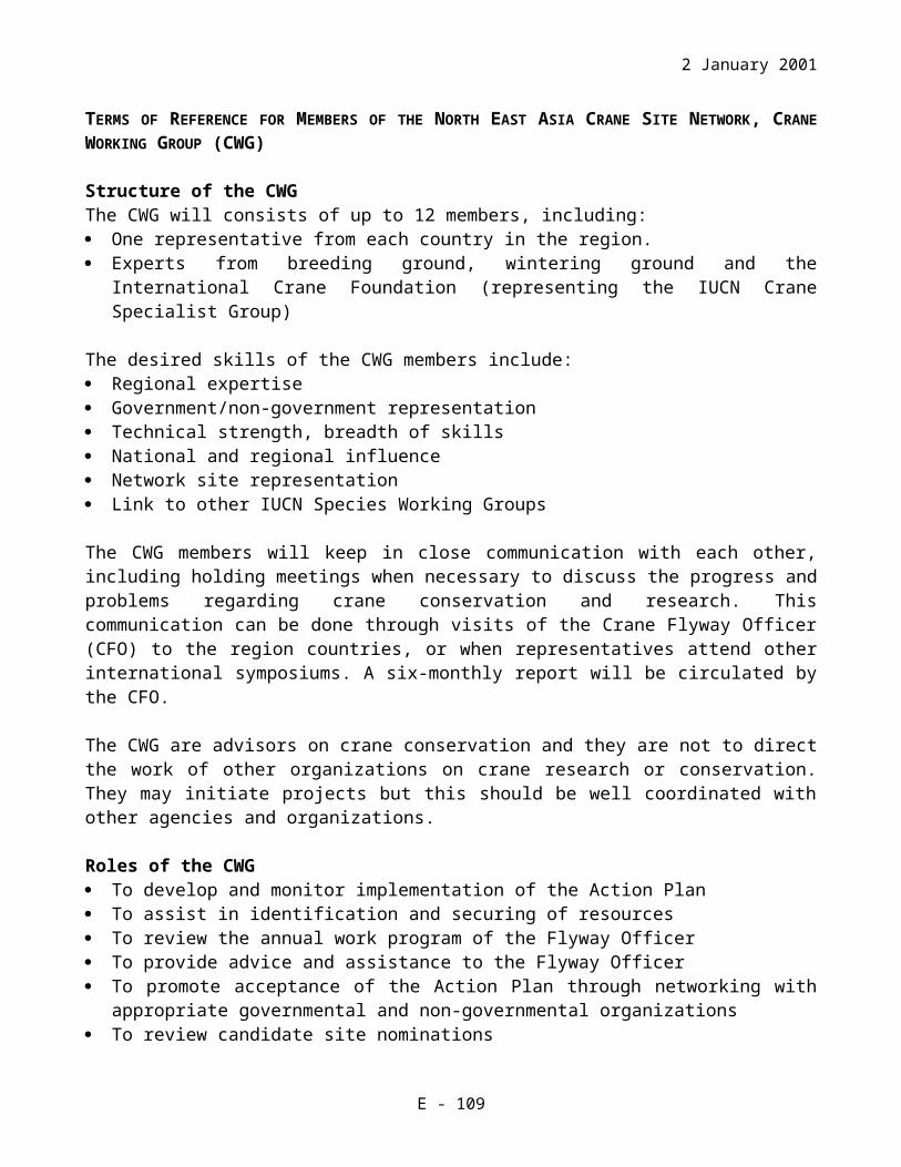
2 January 2002
2. Establish a monitoring network to protect waterbirds in Poyang Lake (to be set up in the near future).
3. Develop a long-term water table monitoring project within the reserve.4. Develop methods to reduce human activities, including over-fishing and over-
grazing.
Current Scientific Research and FacilitiesThe site has been approved as the priority site in Bio-diversity Conservation Action Plan for China, and was added to the Northeast Asian Crane Site Network by the State Forest Administration in 1997.The reserve has carried out an overall research of biological resources in 1996 and 1997 with the fund of GEF project of China Nature Reserve Management.
One of the five sites in GEF funded Nature Reserve Management Project. Existing project only covers 5% of total wetland area and focuses on strengthening capacity building of the staff. The project focuses on establishing a scientific wildlife management plans for Poyang Lake NNR within the variable and threatened hydrology of a large wetland basin.
International Crane Foundation has started a project in 1999 on the research of the relationship between crane population distribution and fluctuation and water level and vegetation, and on the building of staff capacity.
Current Conservation EducationA simple building for visitors, no hides, few other facilities for conservation education, and specimen collection rooms at the reserve’s headquarters. The reserve’s leadership and staff understand that eco-tourism, public awareness and conservation education programs are important tools to improve conservation of the Poyang Lake ecosystems.
Current Recreation and TourismOnly some part of the wetland is used for recreation or tourism purposes. Visitation amounts to about 10,000 people a year, including several hundred bird watchers and researchers from other countries.
Jurisdiction and Management AuthorityThe areas of Dahu Pond and Shahu Lake are under the jurisdiction of the reserve, while other lakes and land in the reserve are under the jurisdiction of the local governments. Functional jurisdiction lies within the administration of the reserve, local departments of agriculture and water resource, and the local governments.
The Poyang National Nature Reserve is directly responsible for managing the wetland.Contact information:
Administration of the Poyang National Nature ReserveWucheng Town, Yongxiu CountyJiangxi Province, 330325.P. R. of CHINA
G - 109

2 January 2002
Tel.: +86-0792-3280435Fax: +86-0792-3280435
List of References
Harris, J., O. Goroshko, Y. Labutin, A. Degtyarev, N. Germogenov, J. Zhao, N. Zeng, and H. Higuchi. 1995. Results of Chinese-Russian-American investigation of cranes wintering at Poyang Lake Nature Reserve, China. Pages 57-72 in Cranes and storks of the Amur River, eds. C. Halvorson, J. Harris, and S. Smirenski. Moscow: Arts Literature Publishers, Russia.
Jiangxi Forestry Administration. 2000. Jiangxi wetland. Beijing: China's Forestry
Publishing House.
Liu, Ch. X. et al. 1990. The state land resource of Jiangxi. Nanchang: Jiangxi Science and Technology Publishing House, China.
Song, X., J. Zhao, and X. Huang. 1995. Crane and stork counts and conservation measures at Poyang Lake Nature Reserve. Pages 73-80 in Cranes and storks of the Amur River, eds. C. Halvorson, J. Harris, and S. Smirenski. Moscow: Arts Literature Publishers, Russia.
Wang, Z., B. Chen, Z. Liu, Y. Wu, X. Ding, X. Zhou, and T. Ding. 1987. Investigation report on the wintering ecology of rare birds in Poyang Lake Nature Reserve. Nanchang: Jiangxi Science and Technology Publishing House, China.
Yan L., and T. Ding. 1988. Siberian crane wintering survey at Poyang Lake. Pages 34-36 in Chinese Journal of Zoology 23(4).
Zhang, B., Z. Lu, and H. Zhu. 1988. Study on the Poyang Lake. Shanghai: Shanghai Science and Technology Publishing House.
Zhu, H. 1995. Structure, function and protection of wetland of Poyang Lake. Pages 182-189 in Study of wetlands in China, eds. Y. Chen et al. Changchun: Jilin Sciences Technology Press, China.
DATASHEET FOR JIANGXI POYANG LAKE BASIN, PEOPLE'S REPUBLIC OF CHINA
OverviewThe site is composed of the largest fresh water lakes in a near-natural state in China, marshes, wet grassland and alluvial floodplains. The site is very famous for its great fauna and flora diversities as well as for over 100,000 waterbirds including several endangered species, such as Siberian Crane, Hooded Crane, Eurasian Crane, Great
G - 110

2 January 2002
Bustard, White Stork, Chinese Merganser, and Bar-headed Goose. Entire wetland area of the Poyang Lake Basin covers ~390,000 ha.
Geographic LocationThe site is located at 28o 11’ – 29o 51’ N; 115o 49’ – 116o 46’ E, 12-18 m above the sea level, on the south shore of Yangtze River, in the northern part of the Jiangxi Province.
Physical FeaturesGeology and geomorphology: The site is located in the middle and down stream of the Yangtze River. The entire ecosystem, where flooding occurs almost every year, includes wetlands, alluvial floodplains with the area of ~31,300 ha, and 41 islands of ~10,300 ha. Alluvial floodplains are located where elevation ranges from 12-18 m.
Origins: The site is a natural wetland ecosystem, modified by some human activities such as grazing, fishing, medicinal plant collection, and poaching.
Hydrology: Same as for the previous site (Poyang Lake National Nature Reserve, or Poyang Lake NNR).
Soil Type and Chemistry: The soil types in the site are represented by: meadow soils distributed at elevations from16-18 m; meadow-peat bog soils distributed at 14.5-16 m; peat bog soils (transition zone) mainly distributed at 14-14.5 m, and submerged silt at 14 m above the sea level and lower.
Water quality: Same as for Poyang Lake NNR.
Depth, fluctuation and permanence of water: Poyang Lake Basin wetlands at the elevation below 13.6 m are usually flooded around the year; wetlands at higher elevations can be flooded periodically. According to the records kept by Wucheng Town Office from 1953 to 1984, the average annual water level is 14.64 m, the average highest annual water level is 17.6 m, and the average lowest annual water level is 12.05m.
Catchments and downstream area: Same as for Poyang Lake NNR.
Climate: Average annual temperature in the Poyang Lake Basin is 17.1o C, July being the warmest (maximum of 29.1oC) and January the coolest (minimum of 4.5oC) months of the year. The average annual rainfall is 1426.4 mm. April to June is the period with highest amount of precipitation (47.4% of annual rainfall). The main roosting period of the migratory birds occurs during the season with lowest precipitation. The average annual frost-free period is 273 days. The period of high humidity lasts from March to June. The site is dominated by northern winds in winter and southern winds in summer with average annual wind velocity ~3.5m/sec.
Hydrological ValuesSame as for Poyang Lake NNR.
G - 111

2 January 2002
Ecological FeaturesMain vegetation types in the entire Poyang Lake Basin include hydrophytes, emerged macrophytes, floating macrophytes, and submerged macrophytes. About 600 species of higher (vascular) plants have been identified in Poyang Lake Basin, including 71 Cyperaceae species, 67 Gramineae, 40 Compositae, 25 Labiatae, 28 Polygonaceae, 10 Ranunculaceae, 15 Trapaceae, 12 Potamogetonaceae, and 10 species of Hydrocharitaceae. Also 154 phytoplankton species of 54 families and 8 orders have been recorded. Wet herbaceous plant community changes distinctively with the seasonal water level fluctuations. Sedge community changes twice (during the late autumn and winter and in early March); during April and May it turns into a grass-dominated community. During the flood season, the herbaceous plants are in the period of dormancy.
Noteworthy FloraWetland higher plants are the primary biomass producers in Poyang Lake Basin and the main food source for fish, birds and herbivorous mammals. During the dry season, hydrophyte community is dominated by Carex spp. and emerged macrophyte community is dominated by Phragmites and Miscanthus sacchariflorus. During the flood, floating-leaved macrophytes are dominated by Trapa spp. and Nymphoides pelteatum, and submergent macrophyte community is dominated by Potamogeton spp., Hydrilla verticillata, and Vallisnenia spiralis.
Noteworthy FaunaFauna of the Poyang Lake Basin is rich and diverse. Its bird list consists of 310 species of 17 orders and 55 families; 40% are represented by waterbirds. There are 10 bird species of 1st order of the national conservation code, which include the Siberian Crane, Hooded Crane, Great Bustard, Oriental White Stork, Black Stork, Chinese Merganser, White-winged Sea Eagle, Golden Sea Eagle, White-tailed Eagle and Relict Gull, and 42 species of 2nd order of the national conservation code. The site regularly supports over 100,000 waterbirds.
About 95% of the world population of the Siberian Crane winter in Poyang Lake Basin; other endangered species, such as White-naped Crane, Hooded Crane, Oriental White Stork, and numerous waterbirds use the lake as their main wintering ground. The site has rich pelogenous and fish fauna that provide adequate food resource for waterbirds.
Among other animals, 48 species of reptiles, 30 amphibians, 139 fish (the lake is the spawning and breeding place for Carp and Crucian Carp), 87 shellfish (19 endemics), 227 insects, and 47 species of mammals have been recorded. Six endemic insect species (see the Poyang Nature Reserve fauna description) new to the list of the Jiangxi Province were recently recorded; the site also represents an important habitat for Neophocaenaas iaeorientalis and Lipotes vexillifer.
Social and Cultural ValuesSame as for Poyang Lake NNR.
G - 112

2 January 2002
Land Tenure/OwnershipSite: State-owned, but used by reserve, Water Resource Departments, Fishery Departments, Land Management Departments and Agriculture Departments along the Poyang Lake at all levels, and local people for farming, grazing, and fishing.Surrounding area: State owned, but used by the local government, communities and privates.
Current Land UseSite: Some 6,332,000 people live inside the Poyang Lake Basin, in 11 counties, 256 towns and 3171 villages (total area of about 1,982,300 ha). The main current land use activities include fishery, grazing, farming, nature conservation, scientific research, and tourism. With the expansion of islets and mudflats and the development of farming and land reclamation, the lake is shrinking year by year. The research conducted in 1927-1988 demonstrates that during this period the Poyang Lake water surface has been reduced by 33.5%, a reduction rate of 522 ha/year.Surrounding and catchments: The main present land use activities are fishery, farming, grazing; the remaining land is under residential area.
Factors Adversely Affecting the Site's Ecological CharacterAt the site: Over-fishing and over-grazing seriously affect food resources and breeding and roosting habitats for waterbirds as well as the entire wetland ecosystem, and represent serious disturbance factor for wildlife. Illegal poaching affects bird populations, possibly resulting in reduction of Swan Geese and other Anatidae species. Farming activities lead to reduction of the available habitat for the Siberian Crane and other migratory birds. Expansive land reclamation affects water quality and wetland ecosystem ability to self-maintenance. Human population pressure and poor education add to the negative impact on the migratory birds and their habitats, making difficult wildlife protection and management activities. The current Poyang Lake National Nature Reserve area is insufficient, covering only 5% of the whole Poyang Lake Basin. Two recently organized protected territories (Nanjishan and Qinglanhu Provincial Nature Reserves, or PNRs) are still not operating. The effect of the Three Gorge Dam cannot be assessed yet, but a long-term monitoring project should be carried out on this site.Around the site: Over-fishing, land reclamation, tree planting, changes in flow volume of the rivers that feed the lake, cumulative impacts of numerous water projects on the Five Rivers and on the main channel of the Yangtze River, with the largest projected negative factor to the Poyang Lake ecosystem being the Three Gorge Dam project.
Conservation Measures TakenThe Jiangxi Provincial Government and local leadership of all levels in the Poyang Lake Basin are very supportive to the ideas of wildlife protection and wetland management. Practically every department head at all levels has taken part in the stakeholders consultation meetings and provided valuable comments and suggestions. Good cooperation exists among the local Police Department, Forestry Office, industrial and commercial agencies in environmental law enforcement, patrolling, and education issues.
G - 113

2 January 2002
1. Most of the counties have established a Wildlife Protection and Management Station creating a chain of such stations around the Poyang Lake.
2. Since 1999, the Jiangxi Legal Affairs Bureau has been working on the Regulations for Poyang Lake Protection that put emphasis on tourism, fishery, water resource usage including navigation, and ecosystem protection.
3. The Jiangxi Provincial government is implementing the integrated program for economic development and conservation of Poyang Lake, investing several billion RMB. The program goal is to restore farmland for wetland moving the farmers outside the flood area. In 2000, area of restored wetland was 59,929 ha with 117,000 households to be moved. The program is expected to have significant impact on the wetland ecosystem of Poyang Lake.
4. Qingluanhu and Nanjishan PNRs were established in 1997 by the approval of the People's Government of Jiangxi.
5. Poyang Lake NNR acts as “the dragon head” to lead patrolling, research, education, and public awarness activities. In recent years, they have been expanding their work to the entire Plyang Lake Basin.
6. Poyang Lake NNR is one of 40 A-category Protected Areas approved by the former State Forestry Ministry (now State Forestry Administration) and WWF in February of 1992.
7. Poyang Lake NNR was listed among globally important wetlands in Wetland Convention which was ratified by the State Council in 1992.
8. The site was approved by the State Environmental Commission as a Priority Site in the Biodiversity Conservation Action Plan for China in 1994, and was added to the Northeast Asian Crane Network by the State Forest Administration in 1997.
Conservation Measures Proposed Same as for Poyang Lake NNR.
Current Scientific Research and Facilities1. The Wild Fauna and Flora Management Bureau of Jiangxi Province has
conducted an integrated research around the Poyang Lake in 1998.2. The Jiangxi Provincial Forestry Administration has drafted a Construction Project
on Ecological Shelter Belt for the Water System of the Poyang Lake. The preliminary deadline for the project implementation is from 2001 to 2005.
3. An international project between ICF and Poyang Lake NR has been conducted since 1999 to study the relationship among waterbirds, water table, and vegetation. Poyang Lake NR has received about $10,000 for this research from ICF.
4. The Poyang Lake NNR has carried out an overall research of biological resources in 1996 and 1997 funded by the Nature Reserve Management GEF Project. (Only one of the five sites in the Siberian Crane GEF Project is funded by the Nature Reserve Management Project, which represents 5% of total wetland area and focuses on strengthening capacity building of staff. This new GEF project focuses on managing wildlife resources within the variable and threatened hydrology of a large wetland basin.)
G - 114
2 January 2002
5. Chain of Wildlife Protection and Management Stations established around the Poyang Lake by the majority of Jiangxi Province counties.
Current Conservation EducationSame as for Poyang Lake NNR.
Current Recreation and TourismSame as for Poyang Lake NNR. Also, Shahushan Town of Xingzi County is preparing to develop an eco-tourism program.
Jurisdiction and Management AuthorityJurisdiction - same as for Poyang Lake NNR.
The provincial Wild Fauna and Flora Protection and Management Bureau is directly responsible for the wildlife protection and management stations at all levels and for three nature reserves to protect and manage migratory birds and their habitats. Contact information:
Wild Fauna and Flora Protection and Management BureauSouth of Dongsan Road, Compound of the Provincial GovernmentNanchang City, Jiangxi Province, 330046P. R. of CHINATel.: +86-0791-6350037Fax: +86-0791-6350064
List of References
Harris, J., O. Goroshko, Y. Labutin, A. Degtyarev, N. Germogenov, J. Zhao, N. Zeng, and H. Higuchi. 1995. Results of Chinese-Russian-American investigation of cranes wintering at Poyang Lake Nature Reserve, China. Pages 57-72 in Cranes and storks of the Amur River, eds. C. Halvorson, J. Harris, and S. Smirenski. Arts Literature Publishers, Moscow, Russia.
Jiangxi Forestry Administration. 2000. Jiangxi wetland. Beijing: China's Forestry
Publishing House.
Liu, Ch. X. et al. 1990. The state land resource of Jiangxi. Nanchang: Jiangxi Science and Technology Publishing House, China.
Song, X., J. Zhao, and X. Huang. 1995. Crane and stork counts and conservation measures at Poyang Lake Nature Reserve. Pages 73-80 in Cranes and storks of the Amur River, eds. C. Halvorson, J. Harris, and S. Smirenski. Arts Literature Publishers, Moscow, Russia.
Wang, Z., B. Chen, Z. Liu, Y. Wu, X. Ding, X. Zhou, and T. Ding. 1987. Investigation report on the wintering ecology of rare birds in Poyang Lake Nature Reserve. Nanchang: Jiangxi Science and Technology Publishing House, China.
G - 115

2 January 2002
Yan L., and T. Ding. 1988. Siberian crane wintering survey at Poyang Lake. Pages 34-36 in Chinese Journal of Zoology 23 (4).
Zhang, B., Z. Lu, and H. Zhu. 1988. Study on the Poyang Lake. Shanghai: Shanghai Science and Technology Publishing House, China.
Zhu, H. 1995. Structure, function and protection of wetland of Poyang Lake. Pages 182-189 in Study of wetlands in China, eds. Y. Chen et al. Changchun, China: Jilin Sciences Technology Press.
G - 116

2 January 2002
DATASHEET FOR ZHALONG NATIONAL NATURE RESERVE OF HEILONGJIANG PROVINCE, PEOPLE'S REPUBLIC OF CHINA
OverviewThe Zhalong NNR territory is composed of permanent and seasonal freshwater marshes with numerous shallow lakes and ponds and extensive (4,000 ha) reed beds made of Phragmites spp. in the lower drainage basin of the Wuyuer River. Grassland, reed thickets, farmland, and fish farms surround the site. Due to the combined effects of low rainfall, high evaporation rate and poor drainage, all lowland areas have become heavily charged with salt that in some places prevents vegetation from growing. Total site area is ~210,000ha.
Geographic LocationThe site is located between 46o 52’ and 47o 32’ N, and 123o 47’ and 124o 37’ E, at 140-146m above sea level, in Heilongjiang Province, 26km east of Qiqihar City. It lies in the western part of the Songnen Plain and marshes and lakes of the downstream of the Wuyuer River. It encompasses Tiefeng Region, Angangxi Region, Fuyu County and Tailai County of Qiqihar City, Lindian County of Daqing City, and Autonomous County of Duerbaite Menggu Nationality. Human population within the site amounts to 60,507 people.
Physical FeaturesGeology and geomorphology: Western part of the Songnen Plain, where the Zhalong NNR is located, is a sunken basin developed after the Mesozoic era. Its topography is generally flat, with the highest elevation being only 137.9 m. The site consists of slow-flowing river channels and valleys, with numerous reed marshes and aeolian sand dunes. The geological structure is made mainly of riparian and limnetic alluvial soil types, a result of being one of the main deposition sites for the Xinhua river system.
Origins: The site is a natural wetland landscape with rich resources for cranes; it has been modified, however, by human activities.
Hydrology: The watershed of the reserve is composed by Wuyuer River, Shuangyang River, Xinnenjiang Canal, and Bayi Xinfu Canal. Of these, the Wuyuer River is the most important for maintaining the entire wetland ecosystem and meeting the human population water needs in the district. This wetland can be divided into three zones: Lindian Reed Farm in the northeast, the Qiqihar area in the northwest, and the Taikong area in the south. Lindian Reed Farm and Taikong buy water from the District Water Bureau to release it into the area and the wetlands here are flourishing. Qiqihar, however, does not buy water and water levels have dropped in this part of the marsh. About 10 × 108 m3 of water is consumed at the site through evaporation and reed transpiration; another 4.6×10⁸m3 is spent through percolation and for irrigation, while 2×10⁸m3 of water is being recharged by Lianhuan Lake. Extensive flooding of the marshes and surrounding lands also occurs during the rainy season in spring and summer.
G - 117

2 January 2002
Soil type and chemistry: The soil is mostly of the non-zonal type, which is composed mostly of aquatic (riparian, limnetic, and peat-bog) and halogenic (sodium-saline soil, yellow and black sodium-sandy soils, and bog-meadow saline soil). The soil-forming materials consist mainly of lake sediments and fine sandy sediment of the Quaternary Period. The sediments are thick and clay-like, with low percolation capacity and often dry on the surface. Most of the soils in the south of the site are of alkaline-saline type.
Water quality: Wuyuer River is polluted to some extent by industrial sewage, chemical fertilizers and pesticides; its water chemical reaction is neutral (pH=7).
Depth, fluctuations and permanence of water: The river channels are usually shallow, with depths ranging between 1-2 m, and connected with reed ponds and lakes. Water level in these river channels changes with seasons and from year to year, depending on precipitation.
Catchments area: Water retention capacity of the Dongsheng Reservoir is 0.264×10⁸m3, which is insufficient to maintain the watertable except in years with unusually high rainfall.
Downstream area: There are about 228 large and small lakes scattered along the downstream of the Wuyuer River, with total area of 40,750 ha.
Climate: The site is located in the continental and semi-desert climatic zones; its evaporation capacity far exceeds its average annual rainfall of 402.7 mm. Summer is the wettest season, with the average rainfall of ~67% of the total annual precipitation. The site receives most rainfall in July, which is also the warmest month in the year. The average annual temperature is 3.9oC, with November being the coolest month. Spring is noted for its powerful southern winds (average spring wind velocity 4.8 m/sec), with a maximum of 24 m/sec in April; in winter, lighter western and northwestern winds blow mostly in January (average winter wind velocity 2.8m/sec).
Hydrological ValuesThe Wuyuer River is dammed where it enters the wetland. It represents the major water source for the wetland ecosystem. Xinnenjiang Canal also plays a major role in the water recharge upstream. Many other water projects were undertaken in the late 1950s to recharge water downstream and to retain water for irrigation. Among them are the Xinnenjiang Canal, Dongsheng Reservoir, Lanhuan Lake channel, and Longhu Lagoon.
Ecological FeaturesThere are different vegetation zones within the site. The types of vegetation found here are meadow-prairie, wet meadow, marshy, and aquatic vegetation. Meadow-prairie, a type of zonal vegetation, is found mainly in the downstream area of the Wuyuer River; it covers 80% of the area with the main plant species being Aneurolepid jumchinense, Argyi lanciniata, Sanguisorba officinalia, Vicia amoena, Vicia geminiflora, Hemerocallis minr, Carex spp., and Phagmites cemminis. Wet meadow can be found in the flat and low land with seasonal ponds and main plant species represented by Calamagrostis epigeos and
G - 118

2 January 2002
Ipuccinellia lenniflora. In the lowland, where permanent ponds exist throughout the year, marshy vegetation dominates with plant species such as Surpus tabernaemontani, Typha anqustifoia and Cyprus spp. The aquatic vegetation is found mainly in the freshwater lakes and marshes and represented by Trapa spp., Ceratophynum denerum, and Ticulana inlermedia. There is no real forest with tall trees within the site; only some groves exist near the villages on higher elevations.
Noteworthy FloraA total of 67 families and 468 plant species have been identified at the site. Reed marshes are the most dominant vegetation form along the Wuyuer River. There have been no recordings of any noteworthy flora, but the plant species all play an important role in the wetland ecosystem.
Noteworthy FaunaZhalong NNR is famous for its birds. It supports a diverse avifauna, serving not only as a wintering or stopover site for migratory birds but also as a breeding site for rare and endangered bird species. A total of 266 bird species have been recorded at the site, most of them are migratory birds dominated by Anatidae, Scolopacidae and Fringillidae. The site regularly supports over 20,000 waterbirds. Some forest bird species also stopover at the site during migration.
Breeding species include Red-crowned Crane, White-naped Crane, Great Bustard and Oriental White Stork. An aerial survey in May of 1996 produced a record number of 346 Red-crowned Cranes at Zhalong. Breeding population of the White-naped Crane at the site is between 30-50 individuals. Migratory species list includes Siberian Crane, Hooded Crane and a number of waterbirds. The highest number of 1,018 Siberian Cranes was recorded during the spring migration in May 1987, average numbers in recent years - 400-600 birds. For Hooded Cranes, the highest number of 418 birds was recorded during spring migration in1992; average numbers in recent years was between 100-400 individuals.
The site is rich with insects that provide food for the birds and other animals. A total of 11 orders, 65 families and 277 insect species have been identified in the reserve. The vast water surface and abundant food supply have also provided good breeding, growing, roosting and wintering grounds for fish. A total of 9 families and 46 fish species are known for the reserve. Eight species of amphibians and reptiles - Salamandrella keyserlingi, Bufo bufo, B. raddei, Hyla arbores immaculata Boettger, Rana nigromaculata, Rana amuredsis, T. sinensis, and Eremias argus Peters have been recorded in the area. Among mammal fauna, 21 species were recorded, including inhabitants of dry grasslands, wetlands and farmlands.
Social and Cultural ValuesThe marsh supports a major reed-cutting industry - the reeds are used for producing high quality paper. Lakes within the reserve are valuable for fisheries. Vast grasslands on the edge of the marshes also provide good conditions for livestock. Rich wildlife of the marshes, especially the cranes, are also attracting an ever increasing number of visitors,
G - 119

2 January 2002
both from China and abroad, and creating a significant tourist industry in the region. In 1982, the reserve was selected by the state forest administration as the first eco-tourism scenery for bird watching and environmental education. Facilities such as living quarters for visitors and office blocks for staff have been set up. Another social value of the site is related to the scientific research on fauna, flora and biotic features of the wetland ecosystem.
Land Tenure/Ownership Site: Land within the reserve where the administration structures have been established (13.33 ha) is owned by the reserve. The administration of the reserve has the right to use and manage the area. The ecological resource at the site has been managed by the governments of local counties and towns, and divided between the departments of water resource, fishery, grazing, and light consumers’ industry.Surrounding area: The land is owned by the state, but is being used by the local government, communities and private agencies, companies, and families.
Current Land UseSite: There are many villages living in the reserve. Most of the dry land, except the area with alkaline-saline soils, has been used by the locals for fishery, reed collection, grazing and as farmland. Villagers are involved in agriculture and cattle breeding. Fishing press is heavy on numerous shallow lakes. About 80% of the land area is under reed marshes, most of which have been reclaimed for fishing ponds. Some water projects have also been established since the 1950s to provide water for the downstream areas and for farmland irrigation. It is a popular eco-tourism area, especially for bird watching, providing valuable income for the reserve.Surroundings/catchments: The main land uses in the catchment area are agriculture, fisheries, reed collections, and grazing. Hunting is prohibited in the reserve but takes place all around it. The area is economically backward with a low average income per capita.
Factors Adversely Affecting the Site's Ecological CharacterAt the site: The Zalong NNR continues to be threatened by uncontrolled exploitation of the entire ecosystem. Poaching onf birds that breed and roost at the site and collection of their eggs are still carried out. Unlimited and excessive fishing has caused a decline in the size of the individual fish and in the harvest. Excessive clearing of reeds by fire is also thought to have an adverse effect on wildlife while over-grazing, over-reclamation and reed collection lead to habitat deterioration and degradation. Human disturbance, whether in the form of settlements or of villagers pursuing agricultural and fishing activities, keep the wildlife populations below the area’s maximum carrying capacity. The failure of Qiqihar region to purchase water from the Dung Sheng Reservoir is resulting in a lowering of water levels in the reserve. The discharge of industrial sewage and the use of chemical fertilizers and pesticides added up to water pollution.Around the site: Adverse factors include further reclamation for agricultural purposes, overfishing, overgrazing, and discharge of the industrial sewage into the upstream waters of Wuyuer River. An increased disturbance factor, caused by growing production and large-scale development activities, is also affecting the area.
G - 120

2 January 2002
Conservation Measures TakenA nature reserve was first established on 42,000 ha in 1979. In 1982, the reserve was upgraded to a status of national nature reserve with the approval of the state council, and its area was increased to 210,000 ha. The present conservation measures taken are as follows:
1. Conducted environmental education and public awareness activities (e.g. bulletin boards, signs, art exhibits, films and workshops) to disseminate information on national laws and regulations for nature reserve protection and increase awareness of the importance of wetland conservation.
2. Enforced the laws protecting the nature reserve (for example, new police stations have been set up to stop hunting in the nature reserve).
3. Set up a Committee of Conservation Association with related units around the nature reserve.
4. Engaged volunteers for management and protection of the nature reserve, especially for conservation of waterbirds.
5. Set up breeding and feeding stations for cranes.6. Enforced the non-fishing period every year between May and June.
A preliminary management plan, prepared by the State Forest Administration and local authorities, has been operating at the site since 1997. There are six parts in the plan - general situation, formulating policies and limits of participation, management scheme, action plan, evaluation of the management scheme and budgetary resources. Duties and responsibilities of the staff and the recommended management measures are appended. Priority actions in the plan include defining the boundary and establishing the laws and regulations regarding the management and usage of nature resources at the site; setting up the Committee of Conservation Association for resources along the Wuyuer River; carrying out a water management study; conducting a fishery management study; and evaluation of the current land use and principles of sustainable development.
The plan have four aims: 1) to protect roosting and breeding waterbirds through scientifically sound activities and community participation; 2) to employ the use of laws and regulations to stop the unsustainable exploitation of natural resources; 3) to study the evolution trends of wetlands by monitoring dynamic changes; 4) to use natural resources sustainably; and 5) to integrate bio-diversity conservation with social development.
Conservation Measures Proposed Conservation measures proposed but not yet implemented include:
1. Improve the law enforcement regarding exploitation of resources within the reserve.2. Limit reed collection during winter to ensure food resources for cranes and other
waterbirds.3. Clarify management arrangements for specific natural resources in the reserve.4. Establish coordination between nature reserve activities and regional water
management or development plans.5. Monitor the relationship between bird populations and water table fluctuations.
G - 121

2 January 2002
Current Scientific Research and FacilitiesThere are two larger buildings at the Zhalong NNR (an education center and a laboratory/ administrative center), several small buildings for staff, and a crane breeding facility where the Red-crowned Crane Grus japonensis has been successfully bred in captivity.
The reserve conducted three aerial surveys in May 1990, 1996 and 2000 and its staff have started a bird-banding programme and monitor crane migration patterns every spring. Several international activities have taken place at the reserve: the International Crane Foundation (ICF) has organized 14 birding trips to Zhalong since 1982; ICF has also held a workshop in the reserve in May 1987; a joint bird banding project with Japan in June 1987; ongoing cooperation with Khingansky Nature Reserve in Russia since 1991; research staff at the reserve have participated in scientific expeditions and academic exchange programmes with USA, Japan, Russia, and Hongkong.
Current scientific facilities include: tents, training facilities; research equipment (binoculars and a telescope); a research office; an observation tower; a Museum of Specimen Collection and an audio-visual education room.
Current Conservation EducationEducation and public awareness activities include special publications on wetland conservation, videotapes, guided tours and workshops with inhabitants at the site, schools and the public. Researchers from domestic and foreign institutions and universities have also visited the reserve in recent years.
Current Recreation and TourismThe main attractions for tourists are natural wetlands and rich waterbird watching opprtunities. A bird-watching area was set up in 1982 with the approval of the State Forest Administration. The number of people visiting the site has increased dramatically in recent years; about 250,000 domestic tourists have frequented the site between 1982 and 1992. The reserve has also hosted over 3,000 bird-watchers and scientific expedition personnel from more than 40 countries and regions. There is a hotel with 60 beds within the reserve. The reserve is linked by ~40 km of tarmac road to Qiqihar city, which has many hotels.
Jurisdiction and Management AuthorityTerritorial jurisdiction over the site lies mostly with the state while coordination responsibilities belong to the forest department of Heilongjiang Province in collaboration with the local departments of water resource, fishery, husbandry, and light industry.
The administration of Zhalong NNR is directly responsible for conservation of its wetlands. The management is guided by a joint committee presided by the State Forest Administration. Contact information:
Zhalong National Nature Reserve Bureau,Qiqihar, Heilongjiang Province, 161002P. R. of CHINATel.: +86-0452-2561340
G - 122

2 January 2002
List of References
Fei, D. 1989. An observation and investigation of the breeding situation of Oriental white storks in Qiqihar suburban district. Pages 263-270 in Zoological Research 10 (3).
Song, S., and K. Feng. 1987. Report on the bird investigation of Zhalong National Nature Reserve in Heilongjiang Province. Pages 36-60 in Northern Environment: (2).
State Forestry Adiministration. 1997. Management plan of the Zhalong National Nature Reserve. Beijing: China’s Forest Publishing House.
Su L., J. Ma, J. Xu, X. Jiang, and C. Wu. 1987. Preliminary study on bird fauna of Zhalong Nature Reserve. Pages 62-73 in Journal of Northeast Forestry University 15 (2).
Wu, C., and T. Xu. 1982. Ecological habits and characteristics of white spoonbills. In Chinese Wildlife: (3).
Xu, J. 1985. Endangered species: Siberian Crane. In Chinese Wildlife: (3).
G - 123

2 January 2002
DATASHEET FOR XIANGHAI NATIONAL NATURE RESERVE OF JILIN PROVINCE, PEOPLE'S REPUBLIC OF CHINA
OverviewThe area is composed of freshwater lakes and marshes, small freshwater ponds, inland hydrographic net and surrounding saline marshes, artificial lakes and seasonal flooded meadows, and grassland. It supports more than 600 wild plants and 353 wild animals, of which there are more than 200 medicinal plant, 10 bird species of China National Importance Species List I and 42 bird species of National Importance Species List II. Total site area is 105,467 ha.
Geographic LocationThe site is located between 44o 55’ - 45 o 09’ N and 122 o 05’ - 122 o 31 E in Jilin Province, at the altitudes between 156-192 m, 67 km northwest of Tongyu County, 310km west of Changchun City. The Administration of the Xianghai NNR is situated in this area, including Xianghai Reservoir Administrative Office, Xianghailianying Papermaking Forestry Station, Xianghai Reed Station, Xianghai Forest Police, and Xinglong Reservoir.
Physical FeaturesGeology and geomorphology: The site is located in the transition region of Mongolian Prairie and Northeast Plain, in a western sedimentation zone formed by sunken Songliao Plain. Its surface sunk deeply since Mesozoic Era and has formed deep Mesozoic and Neozoic deposits. The site geomorphology bears signs of desertification and salinization of the Songliao Plain and its topography leans slightly eastward.
Origins: It is a natural ecosystem, modified by some human activities such as reclamation, grazing, building Reservoir and fishing.
Hydrology: The average precipitation is 400mm/year; the average evaporation capacity is 1945mm/year. There are three main water systems within the site, which connect with each other providing water for fishing, grazing, irrigation, and domestic use.
Soil type and chemistry: Dominant soil types are chestnut, meadow, alkaline-saline soils and drifting sands. Humus layer is thin; its salinization is rather high, pH range 7.5-8.5.
Water quality: The water of the site has not been polluted; it may be rich with organic matter that stimulated the growth of planktonic orgamisms.
Depth, fluctuations and permanence of water: Average water depth is in the range of 0.5-1.5 m with a maximum of over 10 m. Main rainfall comes in July and August leading to a rise in water level and even flooding. The wetland does not retain water and dries up after the rainy season. There is no tidal variation since the site is an inland wetland.
G - 124
Map of Zhalong Nature Reserve
2 January 2002
Catchments area: The total water area of the site is 12,441 hm2. The normal catchments area of Xianghai Reservoir is 6650 hm2, the largest lake surface is 7100 hm2, and its tributaries connect with Xinglong Reservoir. Data for downstream area is not available.
Climate: The site is located in northern temperate zone with continental and monsoon climate, in semi-deserts and plains of Jilin Province. Spring is a windy and dry season, summer is the warmest season, and winter is very cold, with little snowfall. Average annual temperature is 5.1oC, average maximum 37 oC, and the average minimum -32 oC. Average annual precipitation is 400 mm, and average annual evaporation capacity 1945mm. Average annual wind velocity 8.0-13.8 m/sec, maximum wind velocity 28.5-32.6 m/sec, and average annual number of days with winds over 13.9-17.1 m/sec is 35. The site is dominated by the southwestern wind all year. Average annual duration of the sunshine is 1876 hours. The average annual frost-free period is about 150 days.
Hydrological ValuesHuolin River flows from east to west in the south of the site, Emutai River has formed grassland marshes in the middle of the site, and Yaoer River provides water for irrigation in the north of the area. These three rivers consist of 22 big lagoons and marshes. Among them, Daxianghai and Erchang lagoon have been turned into the Xianghai Reservoir; its water is not polluted (PH=7.6). This reservoir is connected with the Xinglong Reservoir 0.5-1.5 m deep (maximum over 10 m), which prevents water level from rising too high and overflowing the wetland. The reserve has abundant groundwaters of fairly good quality.
Ecological FeaturesThe Reserve consists of meadow and grassland landscape. It hosts an important diversity of habitats and a great variety of bird species. More than 600 plant species has been identified at the site, of which more than 200 species are medicinal plants.
Noteworthy FloraThe plant community is dominated by Ulmus macrocarpa var. mongolica that creats a forest - a unique well-growing original community in the semi-desert area of China. It has a great significance protecting the reserve from winds, providing stability of soils, beautifying the environment, and protecting the wildlife. Other tree species are Ulmus propinqua, Ulmus pumila, Populus simonii, etc. Relict plants at the desert edge of the shrub and forest have important botanical significance. Reed community is mainly composed of Phragmites communit and Typha orientalis, sedge marshes are mostly dominated by Carex montana and Juncus effusus, meadows and grasslands mainly consist of Aneurolepidium chinense, Calamagrostis epigeios, Setaria viridis and Glycyrrhiza uralensis. Other original forest stands still remailing in sandhill and ridge landscape are dominated by Ulmus macrocarpa, Ulmus pumila and Morus alba; under the canopy grow Salix matsudana, Prunus armeniaca, Kobresia vidua, Sophora and Glycyrrhiza uralensis. Main phytoplankton species are Nelumbo nucifera, Potamogetonaveae, and Myriophyllum verticillatum. Plankton is present in 70% of the reserve waters.
G - 125

2 January 2002
Noteworthy FaunaThe reserve has high wildlife diversity, including 27 fish species (from 2 orders and 7 families); 13 species of reptiles and amphibians (3 orders, 6 families); 35 mammals (6 orders, 13 families); and 293 species of birds (17 orders, 53 families, 132 genera). It is especially well known for its diverse avifauna serving not only as a breeding but also as a stopover for migratory birds, including 10 bird species of the 1st order of the national conservation code and 42 bird species of 2nd order. The site regularly supports over 20,000 waterbirds. It is one of the most important breeding sites for such rare and endangered birds as Red-crowned, White-naped, Demoiselle Cranes, the Oriental Whire Stork, and Great Bustard as well as some other waterbirds. In addition, it remains one of the most important stopover sites for Siberian, Hooded, and Eurasian Cranes.
In spring of 2000, the Reserve has conducted a count of migrating cranes and received the following numbers: 190 Red-crowned Cranes, 24 White-naped Crane, 3 Demoiselle Cranes, 85 Siberian Cranes, 60 Eurasian Cranes, and 1 Hooded Crane.
Social and Cultural ValuesAgriculture productction, grazing, fishery, reed collection and forestry are of high social values in the area, potentially creating 125 million, 1.4 million, 4 million, 0.9 million and 0.14 million Yuan income for the local residents. Another social value of the area is related to scientific research of fauna, flora and biological features of the wetland ecosystem.
Land Tenure/OwnershipSite: Local government owns land tenure of the site.Surrounding area: Agricultural lands and grassland owned by local government and/or privately.
Current Land UseSite: About 20,000 people are living within the site. Area of cultivated land is 12,000 hm2 with 25,000 tons grain crop production each year. Fishing area is 12,400 hm2
annually providing 100,000 tons of fish. Grazing is widespread (mainly sheep and cattle, a potential income of 1,4 million Yuan). Reed collection yield is ~10,000 tons/year (900,000 Yuan income) and use of local forest provides the local residents with ~140,000Yuan income.Surroundings/catchments: 29.1% of the population around the site is of Mongolian origin and their main land use practices include grazing, fishing, reed collection, and crop farming.
Factors Adversely Affecting the Site's Ecological CharacterAt the site: Xianghai Reservoir was established in 1971, its retaining water volume is 13,000,000m3. Because of many years of drought, the river water level is very low and flow-break is a common phenomenon. In the core area, ~12,000hm2 is cultivated; six villages and over 20 stations for reed collection, grazing and hunting are located there. The most common farming practice is extensive cultivation so over-grazing and breaking
G - 126

2 January 2002
of virgin land represent another threat, which is addressed in the latest GEF Project (clean-up of the reserve core area). Other negative factors are over-fishing and use of chemicals by farmers that affects the quality of water.Around the site: Same as at the site, but human population here is very low and impoverished. To improve public awareness for nature conservation, the government of the county has been operating a set of measures.
Conservation Measures TakenThe reserve was established in 1981 and approved by the State Council as National Nature Reserve (NNR) in 1986. Since then, the Xianghai NNR has taken a number of protective measures:1. Set up a local police station and organized forestry rangers to protect the wildlife
and plants within the reserve;2. Published and distributed a special governmental newsletter to protect the wildlife
within the Reserve by the local government;3. A conservation program was launched in the reserve in 1997, which significantly
reduced land use activities within the Reserve, human disturbances in the bird breeding area in the core zone, developed and carried out several environmental projects (such as planting a 50 m wide Hippopbae rbamnoides shelterbelt), and proposed to build a reservoir on Huolin River to control the water volume of the wetland.
4. Set up a bulletin board for conservation laws propaganda.5. Set up a Museum of Specimen Collection to educate tourists and creat public
awareness.6. Conducted resource inventories of birds, mammals, amphibian and reptile species,
plants, insects and plankton.7. Applied for a nomination with the Northeast Asian Crane Site Network.8. Conducted counts and dynamic monitoring of crane populations every year.
Conservation Measures Proposed To maintain wetland ecosystem stability and save the habitat for rare birds, efforts will be made to manage the water resources in the best possible way. The measures wil include:1. Control the flow of flood diversion to wetland by constructing gates in 62 m
upstream of Tongfa Bank.2. Increase retaining water volume of Xianghai by 10,000,000 m3, for better control
of the recharge and discharge of the reservoir, it is imperative to build three more water gates.
3. In 2000, the Academy of Forest has initiated an Inventory and Planning Project. It has three goals: 1) construction of the conservation infrastructure, mainly for protection of waterbirds, their habitats, and of the unique original forest; 2) construction of the research facilities, mainly for basic scientific research and public conservation education; and 3) construction of the management infrastructure, mainly for eco-tourism. The Project basically meets the needs of conservation, monitoring, scientific research, education and tourism of international community and local population.
G - 127
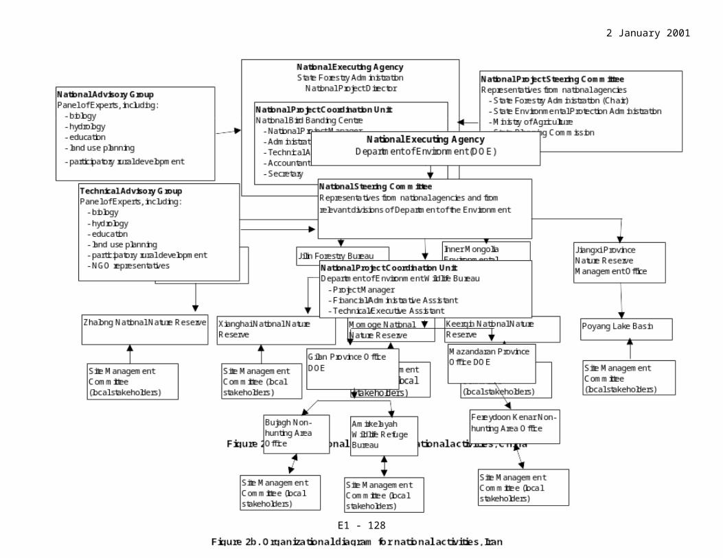
2 January 2002
Current Scientific Research and FacilitiesThe only existing field facility is the observation tower. Museum of Specimen Collection is located at the reserve’s headquarters. The Academy of Forest Inventory and Planning (AFIP) of the State Forest Administration have completed a Practicable Research Report on Building Project in April of 2000. The project includes two stages: from 2000-2002 and from 2003-2005. Priority actions include construction of a dormitory, an office building, a weather station, an observation tower, wetland ecology training facilities, and a first aid center. The project implementation will facilitate and improve research and management work, staff training, core area clean up, water recharge project, original forest conservation, and improvement of the existing infrastructure.
Current Conservation EducationIn the Museum of Specimen Collection visitors can receive information and some education in nature protection. Eco-tourism program promotes the tourists’ awareness for the importance of nature conservation. In the field, the Observation Tower can be used for bird watching and forest fire control. Specific actions and public awareness program include distributing a brochure on wildlife protection and posting the legislation on wildlife conservation on the bulletin board.
Current Recreation and TourismCurrently the wetland is used for seasonal tourism, mostly bird watching. Tourists can visit the reserve’s Museum of Specimen Collection as well as the Electric Power Training Center, Agriculture Bank Cadre Training Center, and stay in Yinghe Hostel and Tobacco and Petroleum Hostel, all located near the reserve’s administration building. Management authorities of these facilities have sufficient funds to offer training, accommodation, and recreation, and could host visitors at different comfort levels in a beautiful natural setting. Nests of some rare birds and natural forest of Ulmus macrocarpa var. mongolica located close to the headquarters attract even more visitors. Though exact numbers are not available, the visitation has dramatically increased in recent years, when people start showing interest in eco-tourism.
Jurisdiction and Management AuthorityTerritorial jurisdiction over the site belongs to the central government. The functional jurisdiction lies with different local departments coordinated by the Forestry Department of Jilin Province.
Forestry Department of Jilin Province is a coordinating and supervising authority for the reserve, providing general coordination of the reserve’s functions and overall planning and management.
Administration of Xianghai National Nature Reserve (located in Xianghaimengguzu Town) is responsible for the direct management and conservation of the wetland. The Administration is responsible for specific projects and daily management, organization, implementation and coordination of the reserve’s activities. Under the current
G - 128

2 January 2002
Administration the reserve has founded six wetland-monitoring stations. Contact information:
Administration of the Xianghai National Nature ReserveTongyu County, Jilin Province, 105467P.R. of CHINATel.: 86-0436-4588528Fax: 86-0436-4588392
List of References
Academy of Forest Inventory and Planning. 2000. Feasibility study on infrastructure construction projects (2000-2005) at Xianghai National Nature Reserve. Unpublished report. Chanchun, China.
Lang, H., Y. Song, and C. He. 2001. Report on spring crane migration at Xianghai in 2000. Pages 134-161 in 2000 China project reports, ed. F. Li. Baraboo, USA: International Crane Foundation.
G - 129

2 January 2002
DATASHEET FOR MOMOGE NATIONAL NATURE RESERVE, PEOPLE'S REPUBLIC OF CHINA
OverviewThe site is composed of a complex of meandering marshy rivers and streams, old river courses, small freshwater to brackish lakes up to 2 m deep, marshes, and wet grassland. Parts of the site are still forested, and the land has been cleared for cultivation and oil extraction. Wetlands cover more than 90% of the site. This typical wetland ecosystem is rich with natural resources. It has become an important roosting and breeding ground for birds migrating through northeast Asia. Total site area is ~144,000 ha.
Geographic LocationThe site is located between 45 o 45’ - 46 o 10’ N and 122 o 27’ - 124 o 04’ E, at 128-167.7 m above the sea level, in the Zhenlai County, northwest of Jilin Province and in ~70 km from Da’an. The administration of the reserve is situated on an island, which is 4 km away from Momoge Town and stretches by 1.2 km along the driveway from Baicheng city to Qiqihar city.
Physical FeaturesGeology and geomorphology: The site is situated in the north of the Songliao sediment zone and the western edge of the Songnen Plain, which is formed by Nenjiang River and its tributaries. The elevation of the northwest section of the site is higher than the southeast section. The topography within the site is relatively flat with a surmount of 2-10m. The general slope is 5o with a maximum of 15 o.
Origins: The site is a natural wetland ecosystem that has been modified by human activities such as cultivation, grazing and oil extraction.
Hydrology: The site has a rich water resource, which comes from the Nenjiang River system. The drainage area of the Nenjiang River is more than 30,000ha and its average annual flow is 647.36m3/sec. The Yaoer River flows along the southern boundary of the site, and this river originates in the Suoerqi Mountain of Daxinganling. Its drainage area covers more than 70,000 ha and it has an average annual flow rate of 14.47 m3/sec. The Erlongtao and Huerda Rivers are seasonal rivers that flow within the site.
Soil type and chemistry: There are seven types of soil in the reserve. Along the southeast bank and its surrounding lakes, the area is dominated by marshy soil. Meadow soil, chernozem and alluvial soil represent the main soil types along the southeast river; they are quite rich with humus (average content of organic matter is 2%, maximum 5%). In the middle and western parts of the reserve, the soils are mainly composed of chernozem and wind-eroded sandy soils. Saline and alkaline soils and other soil types are distributed in a mosaic pattern.
Water quality: Parts of the grassland habitat suffer from alkaline waters (pH 10-12), which is believed to be caused by overgrazing and other human disturbances. Water in
G - 130

2 January 2002
the reserve is also polluted by oil extraction and the development of agriculture and industries.
Depth, fluctuations and permanence of water: These data are currently unavailable. Although the annual supply might be adequate, the monthly distribution is less predictable. In the rainy season, floods due to the overflowing of the Erlongtao and Huerda Rivers may affect the natural hydrology of the wetland.
Catchments and downstream area: The total catchment area is 139,000 ha, about 21.6% of which feeds into the Nenjiang River, 50% feeds into the Yaoer River, 25.2% the Yueliang Lake and 3% feed into the Haerrao Reservoir. There are currently no plans to recharge and discharge water within the system to protect the natural wetland ecosystem.
Climate: The climate here is semi-arid continental with an average annual rainfall of 391.8 mm. Most of the rain falls during the months of June, July and August. Summers are warm (maximum 38 oC) and winters extremely cold (-32 oC). July is the hottest month (average temperature is 23.5oC), while the coldest month is January (average temperature is -17.4 oC). Average annual frost-free period is 137 days. Average annual wind velocity is 3.5m/sec. Months with milder winds are June, July and August with average wind velocity of 2.8-2.9 m/sec. Months with high winds are March, April and May, with average wind velocity over 4.1 m/sec. Hydrological ValuesHearrao Reservoir provides water mainly for irrigation, while the Nenjiang and Yaoer Rivers provide water for industry, fishery and for maintaining the wetland ecosystem. There are currently no projects to control flood and prevent water pollution.
Ecological FeaturesThe site is the largest wetland in Jilin Province with an important diversity of habitats and a great variety of bird species. The vegetation includes mainly Phragmites communis, T. claviclii, Trapa spp., Lemna minor, L. peduncnlata, and Zannichellia pedunculata in lakes; marshes are dominated by Deyeuxia angusrifolia, Carex spp., Juncus decpiens, Alismaorieutale, and Phragmitesecmmunis. Sand dune areas mainly consist of Ulmus pumila, Setaria viridis, and Artemisia scoparia, and grassland species include Aneurolepidium chinense, Calamagrostisepigeios, and Thcarvillea sinensis. Artificial forests are dominated by Populus sp., and farmlands mainly consist of Sonchus brachyotus, Chenopodiumalbum, and Setaria viridis.
Noteworthy FloraA total of 600 spermatophyte species have been identified in the reserve, of which 359 species have been classified as economically important plants. Deyeuxia angusrifolia and Carex spp. have a high conservation value and have been found in the wetland. There are also 11,000 ha of artificial forests at the site, planted for different purposes: to protect crop fields and pastures from winds and elements, preserve water and soils, fix the sands, as well as forestry and logging. The main tree species are Populus spp.
G - 131
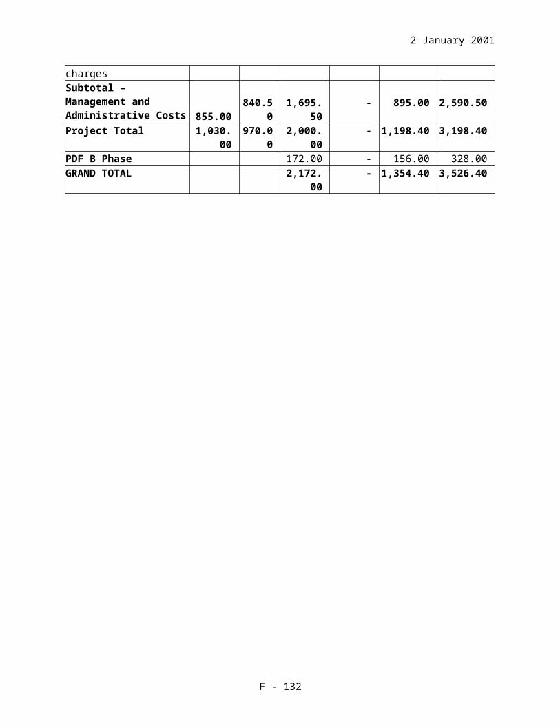
2 January 2002
Noteworthy FaunaThe reserve is known for its ornithological significance. It serves as an important wintering site for migratory birds and also as breeding grounds for some rare and endangered bird species. A total of 193 bird species have been identified in the reserve, of which 74 species are Passerines, 29 Charadriiformes and 90 waterbirds. The reserve is also famous for migratory birds (174 species). The number of nationally protected species recorded at the site is 32, including the Red-crowned Crane, Oriental White Stork and Siberian Crane. There are some game birds in the reserve, such as geese, ducks, Great Bustard and pheasants. The site regularly supports over 20,000 waterbirds, including six species of cranes. Of the total of 191 non-passerine birds in Jilin Province, 119 species have been recorded in the reserve. Migratory birds include the Siberian and Common Cranes, charadriiformes, and some geese and ducks; among breeding birds – the Oriental White Storks, Red-crowned Crane and Great Bustard. In the spring of 2000, a total of 577 Siberian Cranes were recorded in one day, a record number for northeast China. The rivers and the great number of lakes within and around the site have plenty of fish. About 52 fish species have been identified in the reserve, of which economically most important are Cypiuns carpio, Carassius auratus, Peseudorasbora parva, Missurnus anguillicaudata, and Abbottina rivularis. Some aquatic non-vertebrates serve as food for waterbirds, such as Belostoma, Cybister, Gyrinus, Aydrophilus and Stratiomyia.
Only five amphibian species have been found in the reserve, of which Bufo gargrizans and B. braddei are not consumed by waterbirds. The populations of Rana chensinensis and Ayla arborea are rare. R. migromaculata has a stable population here and represents one of the food items for cranes and storks at the site. Seven reptile species have been identified in the reserve including Lacertidae and Colubridae, with small populations serving as food for the cranes.
A total of 25 mammal species have been recorded in the reserve, among them some carnivores (Canis lupus, Vulpes vupes, M. sibirica, and M. putorius).
Social and Cultural ValuesThese wetlands support an important fishery and are becoming popular for eco-tourism opportunity. There are currently few facilities at the reserve, but the site is being promoted for eco-tourism, environment education and bird watching. Reed cutting is also an important economic activity in the area; there are plans to develop reed processing industry, poultry farming, and forestry activities. The exploitation of petroleum at the reserve has had a positive impact on the economic status of the residents in the area. Improved road systems as a result of the oil exploitation activities have also increased accessibility to the site.
G - 132

2 January 2002
Land Tenure/OwnershipSite: Parts of the reserve are state-owned (the reserve administration controls this territory, the exact area of which is unknown) and the local governments manage most of the reserve area. Surrounding area: The surrounding areas are under a mixture of state and collective ownership.
Current Land UseSite: About 102,500 villagers live in the reserve using its open water (19%), marshes (54%), wet grasslands (10%), and forests (8%). The remaining 9% of the reserve is used for other activities such as aquaculture ponds, crop farms, pastures, and oil extraction fields.Surroundings/catchments: Mostly used as farmland and oil extraction.
Factors Adversely Affecting the Site's Ecological CharacterAt the site: Water resources at the site are currently diverted for other uses such as irrigation, aquaculture, and industries thus reducing the amount of water available to maintain the wetland ecosystem. Flooding during the rainy season is also a problem because there is no system to absorb the access water and release it slowly during dry periods. Some human activities (grazing, crop cultivation, reed burning) create disturbances, which seriously affect breeding and roosting sites for birds and lead to habitat deterioration. Development of oil fields is also causing some disturbance and water pollution but there is little coordination between the oil exploration activities and site management. In April 1998, the Academy of Forest Inventory and Planning of Jilin Province completed a Practicable Research Report on the construction of the Momoge NNR. According to procedures listed in this document, all future projects will be examined by a joint committee to halt further loss and degradation of the site and to reduce human disturbance.Around the site: Industrial and agricultural development, too many aquaculture ponds, over-reclamation, and oil extraction activities. These activities result in polluting the water and reducing the area of wetlands.
Conservation Measures TakenThe Momoge Nature Reserve was established in 1981 by the government of Jilin Province and was upgraded to a status of national nature reserve in 1997, with the approval of the State Council. Current conservation activities are as follows:1. Patrolling and monitoring, wildlife observation, captive breeding and training. These
activities are underfunded so any additional resources would be effective.2. Setting up a Museum of Specimen Collection, establishing archives and bulding
cages for captive breeding of endangered waterbirds, to bereleased into the wild.3. Eco-tourism and scientific expeditions to educate visitors and inhabitants at the site
and to increase awareness among the public of the importance of wetland conservation.
4. Waterfowl hunting is prohibited and restrictions on land use in the Momoge NNR were introduced.
G - 133

2 January 2002
Conservation Measures Proposed The fundamental objectives of the Practicable Research Report on the Construction Project at Momoge NNR are: to ensure overall protection of natural resources; develop scientific research; carry out captive breeding of endangered birds; restore and increase populations of the endangered species; strengthen international exchange and cooperation between the various agencies; and to develop a program for sustainable utilisation of wetland resources. Conservation measures proposed for the Momoge NNR but not yet implemented are:
1. Increase the core area from 46,500 ha to 69,500 ha and establish three protection stations within the reserve.
2. Minimise water pollution by collaborating with the development agency for oil fields.
3. Improve water quality through providing sewage treatment facilities for the site and surrounding area.
4. Manage water resources at the site by monitoring the hydrology of the reserve and maintaining the supply of water for wetland system.
5. Develop sustainable projects on aquaculture and farming. 6. Develop and conduct education activities to raise public awareness for wetland
protection and management.
Current Scientific Research and FacilitiesThe research office of the Momoge NNR conducts a study on crane migration every spring to monitor the crane population and analyse reasons for population changes. Regular wildlife research and inventory are also carried out. Research activities on endangered species and wetland habitat conservation are conducted in collaboration with specialists from the Jilin Academy of Forest, Northeast Normal University and Jilin Research Institute of Environment Protection. There are no specific research facilities as yet, but there are plans to construct an office block, an information centre, three protection stations, an observation tower and other facilities for scientific research.
Current Conservation EducationThere is a Museum of Specimen Collection at the site that is regularly visited by school groups from the neighbouring areas. Scientific expeditions to the site and other education activities are also carried out regularly.
Current Recreation and TourismThe site has recently been promoted for eco-tourism, particularly for bird watching, and various recreational activities. Jurisdiction and Management AuthorityJurisdiction over the site belongs mostly to the state. The reserve’s Administration has functional jurisdiction of the site, and it works with the county government, various local departments, and the Forest Department of Jilin Province. The administration of the Momoge National Nature Reserve is directly responsible for managing the wetlands.
G - 134

2 January 2002
Contact information:Administration of the Momoge National Nature ReserveZhenlai County, Jilin Province, 137300P.R. of CHINATel.: 86-0436-7811545
List of References
Academy of Forest Investigation and Planning of Jilin Province. 1998. Feasibility study on infrastructure construction projects at Momoge National Nature Reserve. Unpublished report. Chanchun, China.
Forest Department of Jilin Province and Momoge National Nature Reserve. 1992. A comprehensive report on wild fauna and flora resources of Momoge National Nature Reserve in Jilin Province. Chanchun, China.
Lang, H., Y. Song, and C. He. 2001. Report on spring crane migration at Momoge in 2000. Pages 125-133 in 2000 China project reports, ed. F. Li. Baraboo, USA: International Crane Foundation.
Sun, X., and P. Sun. 2000. Migration Trends of Siberian cranes from Momoge National Nature Reserve. China Crane News 4 (2).
Tong, Y. et al. 1989. Impact assessment of the development and construction of the Yingtai Oilfield – effects on the ecological environment of Momoge National Nature Reserve. Chanchun, China: Jilin Institute of Environmental Conservation.
G - 135

2 January 2002
DATASHEET FOR KEERQIN NATIONAL NATURE RESERVE OF INNER MONGOLIA, PEOPLE'S REPUBLIC OF CHINA
Overview
The reserve is composed of brackish lagoons, fresh water rivers, meadows and marshes, river valleys and flats, depressions, natural secondary forest, brushwood, and salinized lands. The protection is needed for Keerqin grassland and wetland ecosystems and rare waterbirds, especially cranes and storks. Huolin River, Emute River and Tuqian River are connected with each other forming a water system for the reserve. Total site area ~126,987 ha.
Geographic LocationThe reserve is located between 44 o 51’ - 45 o 17’ N and 121 o 40’ - 122 o 14’ E, at 167-261 m above the sea level, in the Middle Banner of the right-Keerqin in Xingan League of Inner Mongolia, 27 km west from Bayanhushu Town (where the government of the Banner is situated).
Physical FeaturesGeology and geomorphology: The general configuration of the lanscape is composed of undulatory hills and sand dunes, terraces, depressions, alluvial plain and floodland. Low mountains and hills are distributed in the northwest of the reserve with the maximum elevation of 261 m. Middle and western parts of the reserve are dominated by the sand dunes. In the east, its territoty is mostly composed of river valleys, depressions, and alluvial plains with minimal elevation of 167 m. There are sand dunes, low wetlands and floodland in the middle and south of the reserve where average elevation is ~200 m.
Origins: Natural grassland and wetland ecosystem modified by activities of local human population.
Hydrology: The reserve has rich underground and surface water resources. Three rivers flow across its territory - Huolin, Emute and Tuqian, Huolin River being the largest river in the site with annual runoff capacity 291 mln m3. Vast wetland plays an important role in regulation of the groundwater level and purifying the water quality. The average water level is in the range of 0.5-1.0 m in the river valleys and lowland. Soil type and chemistry: The zonal soil type in the reserve is chestnut soil formed in the semi-desert climate and mainly distributed is in the north and west of the site. Wind-eroded sandy soil is dominated in the middle and south of the site. In the east of the reserve characterized by lowlands, river valleys and terraces, the soil types are mainly meadow and marsh soils.
Water quality: The groundwater level and its mineralisation are high causing some degree of salinization. Vast wetland contributes greatly to purification of the water quality. The main water resource is Huolin River, but power stations and coalmines along
G - 136

2 January 2002
the upstream, together with industries and other human activities along the middle and downstream, have developed potential threats to the water quality.
Depth, fluctuations and permanence of water: The large wetland capacity to regulate the groundwater level of the site is truly great. There are permanent rivers and lakes, seasonal lakes and rivers, and wet meadow. All of those play important roles in maintaining the water level and wetland ecosystem. The depth of the water depends on topography and seasonal rainfall.
Catchments and downstream area: The exact data on the catchment and downstream areas are not available. The reserve has previously built some water structures to ensure the water supply to the core zone, but a 1998 flood has destroyed these constructions. The southern river was dammed in the past, mainly for the flood control and irrigation, but it cannot provide adequate water supply for the city.
Climate: The reserve is located in semi-desert and continental climate within the temperate zone. Spring is windy, summer is warm, autumn is short and cool, and winter is long and cold. The average annual sunshine period is 3,132.5 hours. The hottest month is July with average monthly temperature 23.1oC; the coldest month is January with average monthly temperature -13.7 oC. The first frost comes in late September and the last - in late April. The average annual frost-free period is ~140 days. The average annual rainfall is 383.0 mm, of which 75% happen in July. The average annual evaporation capacity is 2390 mm, six times over the avarage rainfall. The northwest wind dominates in the site all over the year; the average annual wind velocity is 4.5 m/sec. Winter winds are strong but April and May are months of the highest wind velocity.
Hydrological ValuesThere are more than forty lagoons within the site that support good habitats for waterbirds. The reserve has built several water-control structures to bring the water to the core zone but the 1998 flood has destroyed these devices. The southern river was dammed in the past, mainly for the flood control and irrigation, but it still cannot provide an adequate water supply for the city.
Ecological FeaturesThe site holds an important diversity of habitats and a great variety of birds. Main vegetation types include open elm forest, bushwoods of Ulmus macrocarpa hauce and Armeniaca sibirica Lam. communities, grassland with bushes (Armeniaca sibirica Lam. and Stipa gigantea Link.), and wet meadows. The Siberian, Hooded, and Common Cranes are migratory birds and the Red-crowned, White-napped and Demoiselle Cranes are breeding species of the Keerqin NNR. The site is situated on the edge of the sand land of Keerqin with semi-desert climate. Due to edge effect, the very environmental factor is constantly changing, which greatly affects local animals and plants. Areas of intact natural vegetation create a unique natural landscape and comprehensive habitats. It is a combination of natural and semi-natural ecosystems and a precious natural Zoo and botanical garden.
G - 137

2 January 2002
Noteworthy Flora452 seed plants species have been identified in the site, of which 24.8% are wild medicinal plants, 44.2% feed plants, 19.5% are important economically otherwise (for paper making, weaving, and recreation). Vegetation on dunes and wet marshes create a lacy mosaic, which is typical and representative of Keerqin grassland. Open elm forest and bushwood of Ulmus macrocarpa hauce and Armeniaca sibirica Lam. play important role in keeping together the sandy soil. Grasslands with bushwoods of Armeniaca sibirica Lam. and Stipa gigantea Link. are mainly distributed in the chestnut soil areas; wet marshes are mostly composed of Carex spp., Scirpus tabernaemontani, Puccinella distans, and Aneurolepidium chinenses.
Noteworthy FaunaThe site is famous mostly for its ornithological significance. So far 167 bird species have been identified for the site, six of which are cranes – three migratory (Siberian, Hooded, Common Cranes) and three breeding species (Red-crowned, White-napped, and Demoiselle Cranes). Waders represent 46.3% of the reserve’s avifauna and among waterfowl Anatidae and Scolopacidae are most abundant groups. In addition, there are 18 species of birds of prey. The site regularly supports over 20,000 waterbirds. About 100 bird species have economic value (mainly pheasants, geese, and ducks). Research on other animal groups (insects, reptiles and amphibians) have not been yet conducted.
Social and Cultural ValuesThe site fish resources are rich, estimated average annual catch is 25 tons. Fishery has enormous developing potential if the reserve participates in management and transformation of wetlands. According to the statistics, average annual production rates of ephedra, wild apricot and reed are respectively 2000 tons, 250 tons, and 10,000 tons. All economically important plants (medicinal plants, high-quality pastures and reeds) offer important additional income to local communities. Grazing is of high social value and the pasture area is 74,700 ha. The reserve is making full use of its good situations and doing its best to develop several sustainable demonstration pastures.
Land Tenure/OwnershipSite: The reserve Administration controls 30% of the reserve area. The rest of the reserve territory belongs to the state (central government) and the reserve management does not have a say in it.Surrounding area: Land owned by the local government, communities and private companies and persons/families.
Current Land UseSite: Grazing, aquaculture, poaching, crop cultivation, plant collecting. It was calculated recently that people living in the reserve raised 45,982 heads of livestock on 74,770 ha of pastures. Fishery is occurring in the lagoons located within the site; on top of that, the villagers have developed several man-made lagoons. Illegal hunting has been controlled to an acceptable level. Crop cultivation area has been reduced from the initial 666.7 ha to the present 133.3 ha. No grazing and cultivation are permitted inside the reserve’s core
G - 138
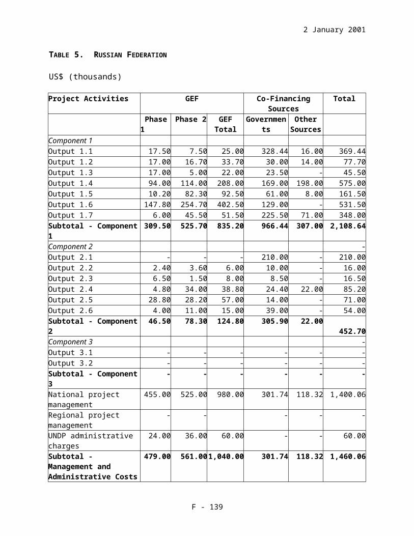
2 January 2002
zone. Average annual production of ephedra, wild apricot and reed are respectively 2000 tons, 250,000 tons, and 10.000 tons.Surroundings/catchments: Mainly grazing, aquaculture, poaching, and crop cultivation.
Factors Adversely Affecting the Site's Ecological CharacterAt the site: Grazing leads to habitat degradation and lost and to soil desertification. Crop cultivation is considered as another source of pressure, which has been reduced by 80% since the reserve established. A program has been developed for the management of agricultural activities, with a plan to return all cultivated lands to nature by 2005. Hunting pressure is high, however, it has been controlled to an acceptable level. Collecting plants of high economic value has destroyed natural forests, bushwood and grassland habitats leading to habitat fragmentation, deterioration, and soil desertification. Fishery activities may have little affect on natural ecosystems because the reserve has developed a sustainable project to maintain the fish resource. All of the above activities have increased disturbances to all waterbirds. There is not enough water to ensure water supply to the wetland. The southern river was dammed in the past, and though it contributes to flood control it cannot provide enough water for the local residents. Wastes from coalmines, power station, industries and pesticides pollute the water.Around the site: Further reclamation for agricultural purposes, overfishing, overgrazing, water pollution, and increasing disturbances caused by agricultural and economic development on a large scale.
Conservation Measures TakenThe nature reserve was established in February of 1985 with the approval of the government office of Xingan League, and was upgraded to a status of autonomous nature reserve in May of 1994. In November of 1995, with the approval of the state council, the reserve was upgraded again and became a Keerqin National Nature Reserve (NNR). The conservation measures taken by the reserve are:
1. By setting up a bulletin board and colorful signs, distributing educational materials, holding workshops and other public events, the reserve has launched propaganda and education programs in order to publicize national laws and regulations of nature protection and the significance of the conservation of wetlands and waterbirds.
2. Improved management and protection of the natural resources according to the laws, raising public awareness for conservation.
3. Hunting in Nature Reserve has been legally forbidden.4. Produced and show a videofilm about the Keerqin NNR for the public education
of visitors and local residents.5. Reduced the area of cultivated land from the past 666.7 ha to the present 133.3 ha.
The reclamation of the land has been halted and currently cultivated land will be restored to grassland by 2005.
6. The Environmental Protection Bureau (EPB) of Inner Mongolia has drafted a 15-year overall plan (years 1996-2010) for the Keerqin NNR, with the help from the Environment Monitoring Center Station of Inner Mongolia, Environment Bureau
G - 139

2 January 2002
of City Construction of Xingan League. Operational plans for each year have been also drafted.
Conservation Measures Proposed According to the overall planning, with the co-financing of the state, autonomous and local governments, some projects have been planned but not yet completed: 1. Projects for water resource management (the reserve has planned to dam the
Keerqin River at the upstream). 2. Environment assessment and program planning.3. Build observation towers and guard posts within the site. Towers are imperative
for the reserve to monitor population dynamics of cranes and other waterbirds, control hunting, and provide birdwatching opportunity for ecotourism.
4. Develop programs for flexible grazing management based on experimental zones and different grazing conditions. The reserve should also have strong control over grazing within its core zone.
Current Scientific Research and FacilitiesA CIDA project will be undertaken in seven sites covering six nature reserves in Inner Mongolia including Keerqin NNR. It will start in October of 2000 and run for five years. The project will focus on poverty alleviation, public education, ectourism, etc. The reserve has an administration office, boundary posts, one jeep, some photo materials, binoculars and a telescope, a Museum of Specimen Collection, and some office furniture. The observation post provides an opportunity for research and birdwarching.
Current Conservation EducationActivities for public environmental education include such means and activities as a bulletin board, videotapes, workshops and ecotourism by adult visitors and school groups. Many researchers from domestic and foreign institutes and universities have visited the site during the last years.
Current Recreation and TourismThere are quite a few tourism and recreation activities conducted in the site. Most often visitors come by themselves and are gathered in groups to observe the reserve’s natural attractions. Scientific expeditions are another category of visitors. In near future the reserve has planned to start a serious eco-tourism program.
Jurisdiction and Management AuthorityThe reserve has the jurisdiction over its territory. The Administration of the Keerqin NNR is directly responsible for managing the wetland, but they need to establish cooperation with the local governments and local communities (it is especially important since many villagers live in the reserve), to successfully protect the reserve ecosystems. Contact information:
Horpin National Nature Reserve Administrative BureauBayanshu, Inner Mongolia, 029400P. R. China.Tel.: 86-0482-4124198
G - 140

2 January 2002
List of References
Environment Protection Bureau of Inner Mongolia. 1996. An overall planning of the Keerqin National Nature Reserve. Unpublished report. Huhuhot, China.
Research Division of Keerqin National Nature Reserve. 1991. A preliminary observation on the breeding white stork Ciconia ciconia. Chinese Wildlife: (2).
G - 141

2 January 2002
DATASHEETS FOR PROJECT SITES IN IRAN
Compiled by:Sadegh Sadeghi-Zadegan, Ornithological ExpertWildlife & Aquatic Affairs BureauIran Department of EnvironmentP.O. Box 15875-5181, TehranISLAMIC REPUBLIC OF IRANTel. c/o +(98 21) 826-9293 Fax: c/o +(98 21) 826-7993Email: [email protected]
DATASHEET FOR FEREYDOON KENAR, EZBARAN AND SORKHE RUD DAMGAHS, ISLAMIC REPUBLIC OF IRAN
Overview A complex of shallow freshwater impoundments developed for irrigation purposes and as a duck-hunting area and surrounded by rice paddies, in the southeast caspian lowlands; of outstanding importance as the winter quarters of the entire western population of the Siberian Crane (Grus leucogeranus), but also extremely important as a wintering area for many other species of waterfowl, notably dabbling ducks (Anas spp.) and geese (Anser spp.). Total numbers of waterfowl using the site in winter may exceed 700,000 with 100,000 at any one time. Fereidoonkenar marshes are critically important as the regular wintering grounds of the known western population of Grus leucogeranus (7-14 birds, see Table 1). Other endangered species using the site include Branta ruficollis, Anser erythropus, Pelecanus crispus and Phalacrocorax pygmaeus (occasional visitors), wintering raptors such as Falco spp. and Haliaeetus albicilla. The site is a particularly important area for migratory waterfowl, regularly supporting large numbers of birds and over 30 species. It is therefore of importance for conservation of the region’s biodiversity. The site regularly holds well in excess of 20,000 waterfowl in winter, with up to 100,000 birds at any one time. Based on current information, the site appears to support the entire western population of Siberian Cranes Grus leucogeranus in winter. However, it is possible that there are other, as yet undiscovered, wintering sites in the South Caspian lowlands. Total site area is ~1,000 ha (150 ha core trapping area and 850 ha surrounding areas). A small part of the territory is under protection as a Protected Area.
Geographic LocationThe site is located at 36o40' N, 52o33' E, 23 m below sea level, on the coastal plain of the Southeast Caspian lowlands, 5 km south of the village of Fereydoon Kenar (Fereydun Kenar) and 13 km southwest of Babolsar, Mazandaran.
Physical FeaturesFereydoon Kenar Damgah is a system of small circular or strip forests including ponds and channels surrounded by flooded rice paddies designed by villagers to catch ducks. The damgah contains several duck-trapping units named “dooma” (up to 180 units). Rice fields are under cultivation activities during spring and summer (April-August), and
G - 142

2 January 2002
become flooded in autumn and winter (October-March) in order to establish an artificial wetland to decoy waterfowl. Rice paddies provide excellent feeding habitat for ducks, geese, shorebirds and the Siberian Cranes. However, trapping activities are operated from small forests, which act as focal points for the trappers.
Hydrological ValuesNo data available.
Ecological FeaturesThe shallow impoundments support abundant floating and submerged aquatic vegetation and some fringing reed-beds of Phragmites australis and Typha sp. Cyperus rotundus (the principal food of the wintering cranes) is common. The surrounding plains are under rice cultivation.
Noteworthy FloraNo data available.
Noteworthy FaunaThe artificially-maintained shallow impoundments and extensive rice fields at Fereydoon Kenar provide excellent feeding and roosting habitat for large numbers of wintering waterfowl, notably Phalacrocorax carbo (maximum 1,560), dabbling ducks (maximum 200,000), Anser albifrons (maximum 1,700), A. anser (maximum 6,000), Vanellus vanellus (maximum 16,000) and Limosa limosa (maximum 5,000). Peak counts of dabbling ducks showed 14,500 Anas penelope, 20,000 A. strepera, 80,000 A. crecca, 80,000 A. platyrhynchos, 60,000 A. acuta and 12,000 A. clypeata. A small flock of 11 Anser erythropus was present in January 1992. Other wintering waterfowl have included up to 500 Aythya ferina, 330 A. fuligula, 900 Fulica atra, 15 Pluvialis apricaria and 40 Gallinago gallinago. These large concentrations of waterbirds attract a variety of wintering raptors including Haliaeetus albicilla (maximum 4), Aquila heliaca, A. clanga and Falco peregrinus. Large concentrations of Philomachus pugnax (maximum 2,800) have been recorded on spring migration. The wetland gained international fame in 1978 when ornithologists from the Iran Department of the Environment (DoE) discovered a tiny wintering population of the endangered Siberian Crane (Grus leucogeranus) at the site. The local duck-hunters were very familiar with the cranes, and reported that they had been coming to this area for many years. The cranes arrive in October and depart in mid-March. Since the discovery of the cranes in mid-January 1978, their numbers have fluctuated between 7 and 14. At least 11 cranes were present in January 1992, including two juveniles. Thus the alarming rumours in early 1991 that four or fives cranes had been shot or captured for zoos were clearly erroneous, as nine of the ten birds present in the winter of 1990/1991 could still be accounted for. Eleven cranes were present in the winter of 1992/93, and nine in the winter of 1993/94. The rediscovery of Grus leucogeranus in the South Caspian, after an absence of records for 60 years, has been described by Ashtiani (1987).
G - 143
2 January 2002
Numbers of the Siberian Cranes wintering in Iran (Fereydoon Kenar):
Year (winter) NUMBER Year (winter) NUMBER1977-78 11-14 1990-91 91981-82 8 1991-92 101982-83 5 1992-93 111983-84 7 1993-94 101984-85 10 1994-95 8-101985-86 11 1995-96 91986-87 11 1996-97 7-81987-88 10-11 1997-98 7-91988-89 11-14 1998-99 6-14*1989-90 8-10 1999-2000 7
* According to various reports.
Social and Cultural ValuesA very important traditional duck-trapping area, one of the few remaining sites in the South Caspian Lowlands where this practice has not been replaced by hunting with guns. The area is used for rice farming outside the wintering period for waterfowl.
Land Tenure/OwnershipBoth project site and surrounding area are privately owned by local farmers, with the exception of the Fereydoon Kenar Wildlife Refuge nearby, which is owned by the Department of the Environment.
Current Land UseSite: Duck-hunting for local consumption and export. The duck hunting was originally developed as market hunting and provided many local people with a livelihood throughout the winter months, but in recent years, the primary interest of many hunters has been for sport. The hunters operate from trapping stations set on the embankment surrounding the main ab-bandan (reservoir), and use live decoy Mallard (Anas platyrhynchos) to lure other ducks (principally Mallard, but also occasionally Teal A. crecca) into flight nets. The duck-netting is carried out under licence from the Department of the Environment, each of the 100 or so trapping stations (each manned by two men) being permitted to capture up to five birds a day throughout the hunting season. The ab-bandans also provide a supply of water for irrigation during the dry summer months. The damgah contains several duck-trapping units named ‘dooma’ (up to 180 units). Each dooma consists of a pond with two semi-circular channels leading from them. One channel connects the pond with the main flooded field where most of the waterfowl and cranes spend their day. The other channel ends blindly at a pen. During the trapping procedure, domestic ducks are thrown into the air in the direction of the pond. Heavy, poorly-flying ducks just manage to clear the patch of thorny brush planted around their cage and land noisily in the pond where they find the water strewn with floating grain. The sight and sound of these flying and feeding ducks arou se the curiosity of wild ducks in the main flooded field. They swim up the narrow channel to the pond where they cached by trappers. Because of the height of the brush
G - 144
2 January 2002
surrounding the pond and the narrowness of the channel, the wild ducks are unable to take flight and quickly trapped.
Surroundings/catchments: Agricultural activities (mainly rice farming).
Factors Adversely Affecting the Site's Ecological CharacterAt the site: Fereydoon Kenar is not among the protected areas network. This problem is an underlying cause of most threats to the wintering population of Siberian Cranes, including:
1. End of Season Shoot-out. Towards the end of each season, when duck netting becomes unprofitable, the area is opened up to hunting with guns in a massive “shoot-out”. There is a potential threat that Siberian Cranes could be shot accidentally. This is the single greatest threat to the surviving flock of Siberian Cranes. In March 2000, the end of season “shoot-out “ happened whilst the Siberian Cranes were still present. This was an extremely dangerous situation and it is very fortunate that no cranes were shot. They were still seriously disturbed by the shoot-out, and were forced to leave the site early (being subsequently located at Ardabil). It is a top priority that the shoot-out should not be permitted until the Siberian Cranes have departed from the site. There is strong local feeling that DoE should have a permanent presence in the area so that shooting can be effectively controlled. Then this matter should be discussed with the local community in order to obtain their agreement. The more sensitive matter of prohibiting the end of season shoot out also needs to be discussed with the local community, perhaps in the context of a trade off: DoE would prevent shooting by other people at the end of winter if the local trappers forgo the shoot out.
2. Aerial nets. The damgah has been maintained by the local community for the purposes of trapping ducks. Local duck-trappers are concerned at the level of human disturbance and prevent shooting in the area, which is probably the only reason the Siberian Cranes have survived. Traditional use of captive ducks and baited ponds with clap-nets is legal. Aerial nets used around the damgah present more of a problem because they are illegal. The options are to register them (under licence from DoE, with negotiated conditions), or to phase them out over a period of time with the full agreement of the trappers. Some compensation or other benefits would be necessary for the second option. However, there is no report about accident of Siberian Cranes with aerial nets.
Around the site: Widespread shooting and the use of aerial nets in the surrounding area represent a threat to the Siberian Cranes and other endangered species using the area. The incidence of lead poisoning in waterfowl is poorly known, but may be significant. Overhead power cables pose a hazard to large waterbirds in flight, including the Siberian Cranes.
Conservation Measures TakenTo ensure that the waterfowl are not disturbed, the duck trappers enforce a very strict ban not only on shooting activities in the area, but also on all other unnecessary human activity.
G - 145

2 January 2002
As a result, the damgah wetland and surrounding paddies constitute one of the best protected and least disturbed wetlands in the South Caspian lowlands. Few birds other than Anas platyrhynchos and A. crecca are trapped, and thus for the many thousands of other ducks, geese and shorebirds and for the cranes, conditions are ideal. The site has been identified as an "Important Bird Area" by BirdLife International (Evans, 1994). The site has become as a Non Shooting Area since June 2001, covering Fereydoon Kenar damgah (trapping area) and Fereydoon Kenar Wildlife Refuge including more than a 1-km buffer zone (approximately) around each of these areas. Fereydoon Kenar Wildlife Refuge is situated 2 km to the NE of the site
Conservation Measures ProposedPreparatory activities have been undertaken in order to receive a 8ha block of land from the Office of Natural Resources. It is currently covered by degraded forest and lies immediately adjacent to the south end of the area used by the Siberian Cranes. This would allow consideration of the establishment of a monitoring/guard station and a small reservoir under the GEF project on Siberian Crane Wetlands. Shooting is also resented by the duck-trappers, who operate in winter at Fereydoon Kenar and other damgahs, because it disturbs the ducks they want to trap.
Current Scientific Research and FacilitiesAnnual mid-winter waterfowl censuses have been carried out by the Ornithology Unit, Department of the Environment, since 1974. During the annual mid-January waterfowl census in 1978, ornithologists of the Department of Environment discovered a flock of about 11 Siberian cranes near the southeast Caspian town of Fereydoon Kenar. It was the first sighting after 60 years. According to the local villagers, these cranes were yearly visitors to the flooded fields near the town and, like their conspecifics in India, spent their time wading in shallow water and digging plant roots. This population has been monitored closely since its discovery in 1978, and the Department of the Environment has established a long-term research and conservation project on the cranes, through:
Memorandum of Understanding (MoU): Iran and nine countries “range states” have joined an international effort through the adoption, in 1993, of a memorandum of understanding concerning conservation measures for the siberian crane (mou) under the auspices of the convention on the conservation of migratory species of wild animals (cms) to help further protect and conserve this important endangered species. Under the CMS MoU (updated in 1998), the participating range states have committed to identify and conserve wetland habitats essential to the survival of siberian cranes, to co-operate with international organizations and other range states and to develop a long-term Conservation Plan. The following activities concerning Fereydoon Kenar were assigned to the I.R. Iran under the Conservation Plan, to be undertaken in 1999-2000:
1. Establish an education centre/bird garden with Babolsar municipality; Russian Federation (Oka) to provide a pair of Siberian cranes for this purpose.
2. Establish new NGOs.3. Provide information by e-mail to Azerbaijan about start of spring migration in
order to facilitate Azerbaijan planning for monitoring.
G - 146
2 January 2002
4. Attach a PTT to a wild chick on the wintering ground in order to locate and protect the region in which sub-adult cranes spend the summer.
5. Organize a guard system through NGOs to keep intruders away from the cranes at Fereydoon Kenar.
6. Work towards the objective of obtaining long-term leases of suitable crane habitat.
7. Study possible construction of an observation tower at Fereydoon Kenar in collaboration with NGOs and Finish sponsors.
GEF project on Wetlands for Siberian Cranes: Following a period of intensive preparation led by the International Crane Foundation (ICF), a Global Environment Facility (GEF) project on the Conservation of the Globally Significant Wetlands and Migratory Corridors required by Siberian Cranes and other Globally Significant Migratory Water birds began in March 2000. Project proposal discussed at the third Siberian Crane range country meeting held at Ramsar, I.R. Iran in December 1998, and a preliminary draft of work plan approved by the meeting and appended to the proposal. The PDF B phase of the project, which covers China, the Islamic Republic of Iran, Kazakhstan and the Russian Federation, will be completed in March 2001 with the submission of a comprehensive five-year Full Project proposal. The project is being implemented through UNEP, and is being coordinated by ICF and the Convention on Migratory Species. The Project aims to conserve the critical sites that are used by Siberian Cranes for breeding (in Russia), staging during migration (all four countries), and the main wintering grounds (in China and Iran). National experts are carrying out the work in each of these countries. The damgah complex at Fereydoon Kenar, Ezbaran and Sorkhe Rud is one of the selected project sites.
Current Conservation EducationLocal school children participated in wildlife conservation competition organized by Mazandaran Provincial DoE Office in early 2001. Consultations were held with local people throughout the Ramadan period in December 2000. The GEF project will establish education and public awareness programmes at the site in due course.
Current Recreation and TourismRandom informal visits by local and overseas birdwatchers.
Jurisdiction and Management AuthorityTerritorial jurisdiction: Fereydoon Kenar local government. Functional jurisdiction: local farmers and duck trappers. There is no management authority per se, as local farmers and duck trappers manage the area.
List of References
Archibald, G. 1992. Ron Sauey and the Siberian Cranes. In Journal of Ecological Society, Vol. 5.
G - 147

2 January 2002
Archibald, G. W., and S. Landfried. 1993. Conservation measures for the Siberian crane. Pages 85-87 in Wetland and waterfowl conservation in South and West Asia, eds. M. E. Moser and J. van Vessem. Slimbridge, UK: IWRB.
Farhadpour, H. 1985. Capturing Common Crane with Alpha-chloralose. In First meeting of the Working Group on European Cranes. (Oroshaza-Kardoskut, Hungary 21-26 October 1985). Department of Environment, I.R. Iran.
GEF Project on Siberian Cranes. 1999. Proposal for a PDF block B grant. (Conservation of the Globally Significant Wetlands and Migratory Corridors required by Siberian Cranes and other Globally Significant Migratory Water birds in Asia).
Maguire, K. 1998. Project “Sterkh”: Summary of Siberian Crane Reintroduction Program 1983-1998. International Crane Foundation, Baraboo, Wisconsin, USA.
Mile Stones. 1978. In The ICF Bugle (International Crane Foundation Quarterly Newsletter), 4 (2), Baraboo, Wisconsin, USA.
Mirande, C., and C. Prentice. 2000. New GEF Project Begins on Wetlands for Siberian Cranes. In: CMS Bulletin. No. 11, August 2000. UNEP/CMS Secretariat, Bonn, Germany.
Prentice, C. 2000. Trip Report, Islamic Republic of Iran, 1-9 June 2000. GEF Siberian Cranes Wetlands Project.
Sadeghi-Zadegan, S. 1998. An Overview to the Historical Situation of the Siberian Crane and Common Crane in Iran. In Report of the Third Meeting of Siberian Crane Range States, 8-13 December 1998, Ramsar, I.R. Iran.
———. 2000. Status of Siberian Crane in the Islamic Republic of Iran and activities to restore the western population. Proposed paper to the IVth European Crane Workshop. 11-13 November 2000, Verdun, France.
Scott, D.A. 1995. A Directory of Wetlands in the Middle East, IUCN, Gland, Switzerland and IWRB. Slimbridge, UK.
The Mystery of the Missing Siberians. 1996. In The ICF Bugle (International Crane Foundation Quarterly Newsletter) 22 (4), Baraboo, Wisconsin, USA.
UNEP/CMS. 1999. Conservation Measures for the Siberian Crane. In CMS Technical Series Publication, No.1. UNEP/CMS Secretariat, Bonn, Germany.
Vuosalo-Tavakoli, E. 1989. Some observation on the Siberian Crane wintering at Fereydoon Kenar. In Crane Research and Protection in Europe, Proceeding of the Palaearctic Crane Workshop, Tallin, Estonia.
G - 148

2 January 2002
———1991. The Siberian Crane in Iran. Pages 341-347 in Proceedings 1987 International Crane Workshop, ed. James T. Harris. Baraboo, Wis.: International Crane Foundation.
G - 149

2 January 2002
DATASHEET FOR AMIRKELAYEKH AND RUD POSHT, ISLAMIC REPUBLIC OF IRAN
OverviewA permanent freshwater lake with extensive reed-beds in the southwest Caspian lowlands, important for passage and wintering waterfowl, notably Phalacrocorax pygmaeus and Netta rufina. The lake is protected as a Wildlife Refuge, and has been designated as a Ramsar Site. Total site area is 1,830 ha including Amir Kelayeh (1,230 ha) and Rud Posht (600 ha).
Geographic LocationThe site is located at 37o18'N, 50o10'E, 20-25 m below sea level, on the coastal plain of the Caspian Sea, about 10 km north of Lahigan, Gilan.
Physical FeaturesAmirkelayekh Lake is a permanent, eutrophic, freshwater lake with rich growth of floating and submergent vegetation, extensive fringing reed-beds of Typha and Phragmites and some willow thickets. The lake is about 4.5 km long by up to 1.7 km wide; the water is extremely clear, with an average depth of about 3-4 m and maximum depth of 6 m. It is fed by springs and local run-off.
Rud Posht consists of 600ha of wetlands and 200ha of ricefields immediately to the West of Amirkelayeh. It is a damgah (duck-trapping area) with no legal protection, but effective protection by local duck trappers.
Hydrological ValuesAmirkelayeh Lake lies on the coastal plain of the Caspian Sea. It has an average depth of 3-4 m and a maximum depth of 6 m. The water of the lake is extremely clear. It originates from springs, local run-off and rainfall. The bottom of the lake is muddy. Flooding occurs in autumn and winter, but the fluctuations in the water level are slight. At high water levels the lake drains to the northwest through a small stream into a channel of the Sefid Rud, some 1.5 km away. It is situated sufficiently high above the level of the Caspian Sea to be unaffected by the recent rise in sea level.
Ecological FeaturesAmirkelayekh Lake / Rud Posht site is a good representative example of a natural wetland characteristic of the South Caspian Lowlands. It provides important wintering habitat for Phalacrocorax pygmaeus (a globally threatened species), and regularly holds over 20,000 waterfowl in winter, including over 1% of the regional populations of Netta rufina, Aythya ferina and Fulica atra.
Noteworthy FloraThe open water areas support abundant submerged and floating vegetation, including species of Nelebium, Lemna, Potamogeton, Hydrilla, Miriophyllum and Ceratophyllum.
G - 150

2 January 2002
The surrounding emergent marshes are dominated by extensive Phragmites communis reedbeds, with some reedmace Typha and willows Salix.
Noteworthy FaunaA very important wintering area for diving ducks, notably Netta rufina (maximum 2,500) and Aythya ferina (maximum 4,200), and Fulica atra (maximum 45,000), and a wintering area for up to 100 Phalacrocorax pygmaeus. Other wintering waterfowl have included up to five Podiceps auritus, 100 Tachybaptus ruficollis, 200 Cygnus olor, 25 C. cygnus, 16 C. columbianus, 1,300 Anas strepera, 4,560 A. crecca, 1,220 A. platyrhynchos, 910 Aythya fuligula, five A. nyroca, small numbers of Rallus aquaticus and 200 Larus minutus. Some 700 swans Cygnus spp. were present on neighbouring ab-bandans in November 1993. Passage migrants in spring and autumn have included up to 140 Egretta alba, 20 Ardea purpurea, 300 Anas querquedula, three Porzana parva and 30 Gallinago gallinago. A single Marmaronetta angustirostris was observed in November 1969. Several pairs of Porphyrio porphyrio breed in the reedbeds, along with large numbers of Gallinula chloropus, Acrocephalus melanopogon and A. arundinaceus, and Panurus biarmicus has been recorded (a party of five in October 1970). Pandion haliaetus is regular on passage, and a pair of Haliaeetus albicilla nested in a tree close to the lake in the 1970s. Circus aeruginosus is a common winter visitor (maximum 20), and Falco peregrinus is an occasional winter visitor. At least 101 species of birds have been recorded in the Wildlife Refuge. Mammals known to occur in the refuge include Golden Jackal (Canis aureus), Jungle Cat (Felis chaus) and Wild Boar (Sus scrofa). Although there are no confirmed records of Common or Siberian Cranes at Rud Posht, there are some local reports based on observations of birds that looked like the Siberian Crane. During the mid-winter waterfowl census (2001), a total of 36,000 waterbirds have been counted at the site.
Social and Cultural CaluesRud Posht area is an important traditional duck hunting area.
Land Tenure/OwnershipAmir Kelayeh Lake: Public (Government).Rud Posht: Private. Used as rice fields in summer and as duck trapping area in winter.
Current Land UseRud Posht: Duck-hunting for local consumption and export. The hunters use their traditional clap-netting technique, with the clap-nets set on poles in shallow water and operated from hides (blinds) in the nearby reed-beds.
Amir Kelayeh: The lake provides a source of water for irrigation during the dry summer months. There are several small villages in the area, and an all-weather road passes close to the eastern side of the lake.
Factors Adversely Affecting the Site's Ecological CharacterThere are no major threats to the habitat, and the ecological character of the site has remained unchanged since the establishment of the Wildlife Refuge in 1971. Prior to its designation as a Wildlife Refuge, the lake had been an important waterfowl hunting and
G - 151

2 January 2002
fishing area for local villagers, who employed a traditional clap-netting technique to trap ducks and coots for the market. During the revolution, local villagers burned down the DoE's Game Guard Station and Watch Tower, and re-assumed control of the lake. Duck-trapping re-commenced, and by 1992 there were some 60 teams of duck-netters operating at the lake. However, the DoE re-established control of the lake area in 1994, and hunting has again been prohibited.
Conservation Measures TakenThe lake and marshes were designated as a Protected Region in 1970 and upgraded to Wildlife Refuge (1,230 ha) in 1971. This Wildlife Refuge of 1,230 ha was designated as a Ramsar Site on 23 June 1975. A Ramsar Monitoring Procedure Mission to Gilan in January 1992 recommended that the DoE should seek to re-establish its authority at the site (Scott & Smart, 1992). Considerable progress has been made since then; the Iran DoE was able to re-establish control of the area in 1994, and duck hunting was stopped. Another Ramsar Monitoring Procedure was a Mission to Gilan in April 1997 (D’Cruze, Sadeghi Zadegan & Smart, 1992). The lake has been identified as an "Important Bird Area" by BirdLife International (Evans, 1994).
Conservation Measures ProposedDesignation of Rud Posht as a Ramsar Site is due during the GEF Full Project Period.
Current Scientific Research and FacilitiesAnnual mid-winter waterfowl censuses have been carried out by the DoE Ornithology Unit since 1968. Many ornithological surveys have been undertaken during other seasons, including comprehensive waterfowl censuses in mid-November in 1972, 1973 and 1974. In 1968, the Ornithology Unit initiated a duck-ringing programme. The Department of the Environment has also carried out some investigations on duck-hunting techniques and harvesting levels at the lake.
Current Conservation EducationNo current activity. The GEF project will establish education and public awareness programmes at the site in due course.
Current Recreation and TourismLimited use of site for birdwatching at present.
Jurisdiction and Management Authority Lake area: Iran DoE. Rud Posht: Managed by a local Council.
Source: Iran’s Department of Environment, Derek A. Scott, Ramsar Bureau and PDF-B Siberian Crane GEF Progect. List of References
Carp, E. 1980. Directory of wetlands of international importance in the Western Palearctic. Gland, Switzerland: IUCN.
G - 152
2 January 2002
Division of Research and Development. 1972. Status of Wetlands of International Importance in Iran: 1970. Pages 217-220 in Carp, E. (ed.), Proceedings of International Conference on Conservation of Wetlands and Waterfowl, Ramsar, Iran: IWRB, Slimbridge, U.K.
Evans, M.I., ed. 1994. Important Bird Areas in the Middle East. Pages 1-410 in BirdLife Conservation Series (2). BirdLife International, Cambridge, U.K.
Ferguson, D.A. 1972. Waterfowl wintering, resting and breeding areas of the south-west Caspian lowlands. Pages 5-24 in Wildfowl (23).
Prentice, C. and S. Sadeghi Zadegan. 2000 and 2001. Field survey on Gilan Province, Siberian Crane GEF Progect, PDF-B.
Ramsar Convention Bureau. 1993. Iran. In Directory of Wetlands of International Importance: Sites Designated for the List of Wetlands of International Importance. Prepared by IWRB for the Ramsar Convention Bureau, Gland, Switzerland.
Scott, D.A. 1976. A List of the Wetlands of Iran. Internal report. Department of the Environment, Tehran, Iran.
———. 1976a. The Avifauna of the Department's Reserves. Internal report. Department of
the Environment, Tehran, Iran.
———. 1976b. Iran National Report. Pages 27-33 in Smart, M. (ed.), Proc. International Conference on Conservation of Wetlands and Waterfowl, Heiligenhafen, Germany, 2-6 December 1974: IWRB, Slimbridge, U.K.
Scott, D.A. and M. Smart. 1992. Wetlands of the Seistan Basin, South Caspian and Fars, Islamic Republic of Iran. Pages 1-53 in Ramsar Convention Monitoring Procedure Report No.26. Ramsar Convention Bureau, Gland, Switzerland.
Vahedi, M. 1982. Iran National Report. Pages 741-747 In Spagnesi, M. (ed.), Proc. Conference on the Conservation of Wetlands of International Importance especially as Waterfowl Habitat, Cagliari, Italy, 24-29 November 1980. Supplemento alle Ricerche di Biologia della Selvaggina. 3 (1).
WCMC. 1990. Iran. Pages 310-337 in Directory of Wetlands of International Importance: Sites Designated for the List of Wetlands of International Importance. Prepared by the World Conservation Monitoring Centre for the Ramsar Convention Bureau, Gland, Switzerland.
G - 153

2 January 2002
DATASHEET FOR BUJAGH / SEFID RUD DELTA, ISLAMIC REPUBLIC OF IRAN
OverviewA shallow sea bay (formerly brackish lagoon), associated with freshwater marshes and the nearby riverine marshes at the mouth of the Sefid Rud in the southwest Caspian, important as spawning and nursery grounds for fish and as breeding, staging and wintering area for a wide variety of waterfowl. The wetlands have been designated as a Ramsar Site but are otherwise unprotected. Total site area is 2,460 ha (500 ha Kiashahr lagoon and 1,960 ha Bujagh Non-Hunting Area).
Geographic LocationThe site is located at 37o20'N, 49o55'E, 20-25 m below sea level, in about 40 km east of Bandar Anzali, Gilan. Bandar Kiashar Lagoon lies immediately to the east of the mouth of the Sefid Rud River and Bujagh Non-Hunting area lies to the west of the mouth of the Sefid Rud River.
Physical FeaturesThe wetland complex comprises a shallow sea bay (formerly an enclosed lagoon), the nearby mouth of the main channel of the Sefid Rud, and the associated fresh to brackish marshes. The Sefid Rud is the second largest river in Iran; it has a catchment area of over 54,000 sq.km in the western Alborz Mountains, and a natural flood discharge of 3,400 to 4,200 cubic metres per second. This diminishes to a minimum flow of less than 20 cubic metres per second during late summer. The river divides into several distributary channels on the plains of Gilan, the main channel entering the Caspian at Bandar Kiashar. Bandar Kiashahr Lagoon (formerly Bandar Farahnaz Lagoon) is situated in an area of coastal sand dunes and grassland about 1.5 km east of the mouth of the Sefid Rud. In the 1960s and 1970s, this wetland was a shallow, brackish coastal lagoon, 3.75 km long by 1.5 km wide, with fringing Juncus marshes and about 140 ha of Phragmites and Typha reed-beds at its west end. The lagoon was fed by two streams from the Sefid Rud and local run-off, and drained northeast through a narrow channel into the Caspian Sea. The bottom was a mixture of sand and mud, and the waters were predominantly oligotrophic, except towards the marshy western extremity. The lagoon had been formed as recently as 1960 as a result of the falling level of the Caspian Sea and development of coastal sand spits. The 1.8 m rise in the level of the Caspian Sea since 1978 has obliterated the sand barrier between the lagoon and the sea, with the result that the wetland now constitutes a sea bay with broad entrance to the sea (similar to the situation in the 1950s). The marshy grassland and sand dune areas at the mouth of the Sefid Rud have, however, remained more or less unchanged, while new wetland habitats have been created to the west of the river mouth. Bujagh Non-Hunting Area (NHA) covers the area the western side of the Sefid Rud Delta between the Oshmak River and the Sefid Rud River– it does not include land to the east of the Sefid Rud. A road makes the southern boundary of the NHA. According to the GIS map (from satellite imagery), the NHA has an area of 1960 ha, of which 200 ha are ricefields. Much of the site is coastal grassland – a typical habitat in Gilan (also occurs at Anzali). The site has a potential for use by Siberian Cranes, as it is a large and relatively
G - 154

2 January 2002
undisturbed open area. There are also ricefields within the NHA, which could provide a potential feeding area. There were reports by a local farmer some years ago of strange large waterbirds seen in February-March. Eurasian Cranes have been reported “frequently” by DoE staff at the site.
Hydrological ValuesBandar Kiashahr Lagoon was formed in 1960 as a result of the decreasing level of the Caspian Sea. Between 1960 and 1978, Bandar Kiashahr used to be a real lagoon, with fresh to brackish water and a very narrow opening to the sea. Since 1978, a rise back in sea level has obliterated the sand barrier between the lagoon and the sea, and now the wetland once again constitutes a bay with broad entrance to the sea. Marshy grasslands and sand dune areas at the mouth of Sefid Rud have remained more or less unchanged, while new wetland habitats have been created west of the river mouth. The Sefid Rud is the second largest river in Iran, with a catchment area of 54,000 sq. km. The main channel of the river enters the Caspian Sea at Bandar Kiashahr.
Ecological FeaturesBandar Kiashar Lagoon and the mouth of the Sefid Rud are good representative examples of natural wetlands characteristic of the South Caspian lowlands. The lagoon is an important breeding and nursery grounds for various fish species, and supports large breeding colonies of several species of waterfowl. The wetlands also provide important wintering habitat for Phalacrocorax pygmaeus (a globally threatened species), and, formerly, supported a wintering flock of Pelecanus crispus. The wetlands regularly support over 1% of the regional breeding population of Phalacrocorax carbo, and over 1% of the regional wintering populations of Podiceps nigricollis, Anas platyrhynchos and Larus ridibundus.The lagoon supports relatively little vegetation other than algae. Freshwater marshes at the extreme west end of the lagoon support some reed-beds (Phragmites and Typha), while the southern and eastern shores are dominated by Juncus sp. and grasses. Sandy areas to the west and northwest are covered in scrub and grassland which give way to sand dune vegetation near the Caspian shore. Grassland along the banks of the Sefid Rud is subject to seasonal flooding. Land to the south of the wetland is mostly under cultivation, although there are some relict patches of Alnus woodland near the wetland. The Sefid Rud is extremely important for fish biodiversity, with 51 species recorded to date, and possibly up to 64 species pending identification of some specimens.
Bujagh part of the site has a potential for use by Siberian Cranes, as it is a large and relatively undisturbed open area. There are also ricefields within the NHA, which could provide a potential feeding area. There were reports by a local farmer some years ago of strange large waterbirds seen in February-March. Eurasian Cranes have been reported “frequently” by DoE staff at the site.
Noteworthy FloraBandar Kiashahr Lagoon is a large bay that supports relatively little other vegetation than algae. Freshwater marshes at the extreme west end of the lagoon have some beds of Phragmites and Typha, while the southern and eastern shores are dominated by Juncus
G - 155

2 January 2002
and grasses. In the marshes around the mouth of Sefid Rud beds of Phragmites, Typha, Juncus and different kinds of grasses can be found.
Noteworthy FaunaThe lagoon is an important staging and wintering area for a wide variety of migratory waterbirds, especially grebes, cormorant Phalacrocorax pygmaeus (up to 300 birds), ducks, shorebirds, gulls and terns, and for the raptors Circus aeruginosus and Falco columbarius. A flock of Pelecanus crispus (usually 30-40 birds) wintered at the mouth of the Sefid Rud in the 1970s but apparently disappeared by about 1980, probably because of increased disturbance. Anser erythropus was also an occasional winter visitor to the area in the 1970s, with a maximum of 10 in January 1973, but none has been seen in recent years. The open grassy areas and dunes near the river mouth provide breeding habitat for 20-30 pairs of Glareola pratincola and a few pairs of Sterna hirundo, while a small patch of woodland to the south of the lagoon supports a large breeding colony of Phalacrocorax carbo (1,000 pairs), Nycticorax nycticorax (200 pairs) and other Ardeidae. Peak counts of some waterfowl are given in Table 9. Scarce winter visitors and vagrants have included Botaurus stellaris, Branta ruficollis (one in January 1973), Oxyura leucocephala (three in February 1972), Phalaropus fulicarius and Rissa tridactyla. Haliaeetus albicilla is present year-round and breeds locally (up to five have been observed at one time), while Circus aeruginosus (maximum 20) and Falco peregrinus (maximum 4) are regular winter visitors. Aquila heliaca, Buteo lagopus, Falco cherrug, F. columbarius and Asio flammeus have also been recorded. As for mammals, the Golden Jackal (Canis aureus) is common in the area.
Social and Cultural ValuesDuring weekends and holidays the wetland is used for recreation. Land to the south of the wetland is mostly under cultivation by people from fishermen villages.
Land Tenure/OwnershipPublic (government), except for 200 ha of rice fields that belong to local rice farmers.
Current Land UseKiashahr: The lagoon with the adjacent coastal waters is an important centre for commercial fishing. Activities at the site include livestock grazing, reed-cutting and wildfowl hunting in the marshes. There is a large fisheries station with a fish-processing warehouse on the south shore of the lagoon.Bujagh: 100 fishermen work at the Fishery Company at the mouth of the Oshmak River. DoE intend to buy them out, so that the area can be left for nature. The fishermen are prepared for this and would relocate elsewhere. As well, there are approximately 120 rice farmers at Bujak, working on the fields up to 1 ha each, total 200 ha. The ricefields were established about 18 years ago (after the revolution), when the emphasis was on social support. No further expansion of agriculture will be allowed.
Factors Adversely Affecting the Site's Ecological CharacterKiashahr Lagoon: There is heavy hunting pressure on waterfowl throughout the winter months, and the lagoon is subjected to high levels of disturbance from fishing activities and
G - 156

2 January 2002
the passage of boats to and from the fish-processing warehouse on the south side. There is also considerable disturbance from recreation activities at weekends and holidays. The disappearance of the wintering flock of Pelecanus crispus in the late 1970s and great decrease in the numbers of other wintering waterfowl during the last decade have been attributed to the increasing disturbance from fishing activities and heavy hunting pressure. Bujagh: There is very little control over grazing at present (the site is heavily grazed in summer by ~10,000 animals).
Conservation Measures TakenBandar Kiashahr Lagoon: No legal protection. Bandar Kiashahr Lagoon and the mouth of Sefid Rud were designated as a Ramsar Site on 23 June 1975. The Ramsar Site (500 ha) includes the whole of the lagoon area, its associated marshes and the marshes and sand flats at the mouth of the Sefid Rud to the west. The site has been identified as an "Important Bird Area" by BirdLife International (Evans, 1994). Besides Ramsar status there are no other national or international designations applicable to this wetland. The site was visited by Ramsar Management Guidance Procedure Missions in January 1992 and May 1997. They advised to conduct further assessment of the ecological changes that were brought about by the changing sea levels, and to try reducing disturbance to waterfowl by fishing activities.Bujagh: Non-Hunting Area. There are two guard stations, one rather temporary in nature, with a complement of 14 seasonal guards (for waterbird protection) and 8 full time guards (fisheries protection). The site has an excellent communications system with a radio at one guard station, through which all staff can communicate with each other by walkie-talkie. Staff can use landrover and motorbike for transportation.
Conservation Measures Proposed Further investigations are required to assess ecological changes, which have occurred at the wetland, and to identify ways of reducing the disturbance to waterfowl from fishing activities. At present Kiashahr Lagoon is proposed for inclusion to the Non-Hunting Area; next step for the entire area will be the establishment of a protected area and expansion of Ramsar site to the western part of Sefid Rud River.
Scientific Research and FacilitiesA considerable amount of fishery research has been carried out by the National Fisheries Organization (Shilot). Annual mid-winter waterfowl censuses have been carried out by the DoE Ornithology Unit since 1968. Many ornithological surveys have been undertaken at other times of the year, including comprehensive waterfowl censuses in mid-November in 1972, 1973 and 1974.
Current Conservation EducationNo current activity. The GEF project will establish education and public awareness programmes at the site in due course.
Current Recreation and TourismVery limited local use of site for recreation at present.
G - 157

2 January 2002
Jurisdiction and Management AuthorityRamsar Site and Non-Hunting Area are administered by the Iran DoE.
Source: Iran’s Department of Environment, Derek A. Scott, Ramsar Bureau and PDF-B Siberian Crane GEF Progect.
List of References
Carp, E. 1980. Directory of wetlands of international importance in the Western Palearctic. Gland, Switzerland: IUCN.
Evans, M. I., ed. 1994. Important Bird Areas in the Middle East. Pages 1-410 in BirdLife Conservation Series (2). BirdLife International, Cambridge, U.K.
Ferguson, D.A. 1972. Waterfowl wintering, resting and breeding areas of the south-west Caspian lowlands. Pages 5-24 in Wildfowl (23).
Firouz, E., and D. Ferguson. 1970. Status of the Main Wildfowl Resorts in Iran. Pages 325-327 in Isakov, Y.A. (ed.), Proceedings of Int. Regional Meeting on Conservation of Wildfowl Resources, 1968. Leningrad & Moscow.
Prentice, C. and S. Sadeghi Zadegan. 2000 and 2001. Field survey on Gilan Province, Siberian Crane GEF Progect, PDF-B.
Ramsar Convention Bureau. 1993. Iran. In Directory of Wetlands of International Importance: Sites Designated for the List of Wetlands of International Importance. Prepared by IWRB for the Ramsar Convention Bureau, Gland, Switzerland.
Scott, D.A. 1976. A List of the Wetlands of Iran. Internal report. Department of the Environment, Tehran, Iran.
———.1976a. Iran National Report. Pages 27-33 in Smart, M. (ed.), Proc. International
Conference on Conservation of Wetlands and Waterfowl, Heiligenhafen, Germany, 2-6 December 1974: IWRB, Slimbridge, U.K.
———.1978. Colonial Breeding Birds in Iran. Unpublished report.
Scott, D.A., and M. Smart. 1992. Wetlands of the Seistan Basin, South Caspian and Fars, Islamic Republic of Iran. Pages 1-53 in Ramsar Convention Monitoring Procedure Report No.26. Ramsar Convention Bureau, Gland, Switzerland.
Summers, R.W., L.G. Underhill, D.J. Pearson, and D.A. Scott. 1987. Wader migration systems in southern and eastern Africa and western Asia. Pages 15-34 in Wader Study Group Bulletin No.49 Supplement and IWRB Special Publication No.7. IWRB.
G - 158

2 January 2002
Vahedi, M. 1982. Iran National Report. Pages 741-747 In Spagnesi, M. (ed.), Proc. Conference on the Conservation of Wetlands of International Importance especially as Waterfowl Habitat, Cagliari, Italy, 24-29 November 1980. Supplemento alle Ricerche di Biologia della Selvaggina. 3 (1).
WCMC. 1990. Iran. Pages 310-337 in Directory of Wetlands of International Importance: Sites Designated for the List of Wetlands of International Importance. Prepared by the World Conservation Monitoring Centre for the Ramsar Convention Bureau, Gland, Switzerland.
G - 159

2 January 2002
DATASHEETS FOR PROJECT SITES IN KAZAKHSTAN
Compiled by:Sergey YerokhovInstitute of Zoology National Academy of SciencesAcademgorodok, Almaty, 480060KAZAKHSTAN
Email: [email protected]
DATASHEET FOR NAURZUM-KULAGOL LAKE SYSTEM, KAZAKHSTAN
OverviewNaurzum-Kulagol lake system is a natural wetland highly representative of Northern Kazakhstan - small lakes scattered in the steppe zone This site supports an appreciable assemblage of rare, vulnerable or endangered species of plants and animals and is important for maintaining the general and ecological diversity of a region because of the quality and peculiarities of its flora and fauna. It is especially valuable as a habitat for a row of rare bird species in spring and autumn migration periods. The site is regularly supporting 20 000 waterbirds. The site area is 22,000 ha.
Geographic LocationThe lakes are located at 5125N, 6427E, at 90-170 m above sea level, in Naurzum rayon (=district), near to Karamende village, 180 km from Oblast (=province) capital, Kostanay city. The nearest railway station Amankaragay is in 70 km from lake, the nearest airport is in Kostanay city.
Physical FeaturesThe lakes are on cyclic hydro regime and fed by floods and precipitation. Minor cycles of water level fluctuation are 8-12 years, major cycles are 70-100 years. Currently the lake system is undergoing a peak of dry period; in 1998 the lakes practically dried out completely.
Hydrological ValuesNaurzum system of lakes is located in the ancient valley of Turgay River between Tobol and Turgay Rivers. The lakes are filled up by the water from melting snow and therefore either dry out or fill up according to climatic changes. Slightly to the north a group of salty lakes is located called Sarymoin. From the west and southwest Naurzum-karasu River flows into the Naurzum lake. The Naurzum lake bottom is of irregular shape stretching for ~3 km from south to north; it is 11 km wide in the middle part. The water depth is about 1,5-2 m with a maximum of 4 m. Shoreline is indented with bays, small islands and shallow water areas.
G - 160
2 January 2002
Ecological FeaturesShallow lakes (1,5 m - 2,5 m depth) with greatly indented coastline and numerous channels, bays and spits. The coasts and shallow parts of the lakes are covered with hydrofilic vegetation, mostly rush, reed and reed mace. The thickets are of border type, in some parts - border-mosaic. The main waterfowl nesting habitats are located on the islands or on the shores covered with reed and rush. Migratory birds occupy the open water basin while the moulting birds stay in the areas covered with submerged vegetation.
Noteworthy FloraWetland flora in Naurzum-Kulagol lake system is presented by 43 species of macrophytes, including 18 emerged species and 25 submerged water plant species; among those, 21 are represented by higher (vascular) plants and 6 by seaweeds (Chara sp.). Microphytes are represented by 68 species, varieties and forms of micro algae (25 diatom species, 20 green, 18 blue-green, 3 Euglene spp, 1 species of Pyrophytes). The lakes are surrounded by reed thickets (Phragmites australis), alternating with areas covered with rush (Scirpus angustifolia) and Bolboschoenus maritimus. On the shores of Aksuat lake, apart from reed, two species of algae are widespread - Najas marina and Myriophyllum verticillatu, with the latter obviously prevailing. On the water surface there are Potamogeton pectinatus, P. perfoliatus, P. zosterifolius, Najas, from time to time Myriophyllum verticillatum. The bottom is covered by seaweeds (Chara canescens, Ch. fischeri, Ch. neglecta, Ch. vulgaris, Ch. kirgisorum). Along the shoreline, green “nets” of Spirogyra, Maugeotia, Cladophora, and Enteromorpha species are abundant. On Zharkol lake, the entire water surface is covered by algae (P. macrocarpus, P. natans, and P. fresii) completely wrapped by such “green nets.” Near the shore, dying algae are accumulating. Water flora includes rare species such as Drosera rotundifolia, Thelypteris palustris, Marsilia aegiptiaca, M. strigosa, Chara neglecta, Damasonium alisma; endemic species Potamogeton macrocarpusm and P. zosteriformis, and relict species Lemna minor, Nymphae candida, and Utricularia vulgaris. There are also plants that are used by humans for cattle feed (reed mace Typha angustifolia, reed Phragmites australis, grass Butomus umbellatus); as medicinal plants (some algae, water reed Menyanthes trifoliata, Alisma plantago-aquatica, and pure-white water lily Nymphae candida); as food supplements (Sagittaria sagittafolia, Butomus umbellatus); and also as technical (reed, Butomus umbellatus, Poligonum amphibium) and decorative (Nymphae candidae) plants.
Noteworthy FaunaNo special ichthyologic research was conducted in the lakes but it is known that at least 9 fish species inhabit the lakes. The numbers and species diversity of fish in different lakes greatly depends on salinity and depth of water and scale of overgrowth. Most numerous fish species are Roach, Perch, and Crucian Carp. Fish caught at the site can only be used for the local community’s needs but not for sale. Among amphibians are Green Toad Bufo viridis, Common Toad Bufo bufo, Marsh Frog Rana arvalis. Mammals are especially numerous near the lakes: Musk-rat Ondatra zibetica, Vole Rat Arvicola terrostris, Ermine Mustela erminea, Russian Polecat Mustela eversmanni, Badger Meles meles, Fox Vulpes vulpes, Wolf Canis lupus. Eighty nine species of waterbirds known for
G - 161
2 January 2002
the site include 2 species of loons, 4 grebes, 3 pelicans, 4 herons, 30 ducks, 32 waders, 12 gulls, 5 water rails. Eighteen species regularly breed - grebes, two species of swans, Greylag Goose, Shelduck, 5 species of surface-feeding ducks and 6 species of diving ducks, including 2 protected species - White-headed Duck and Ferruginous Duck (Gordiyenko, 1980). Up to 15 species spend their moulting period here, primarily Mute Swan, Gadwall, Shoveler, Garganey, Mallard, and Pochard. In favorable years, when lakes fill up with water, numbers of moulting birds reach 35-40 thousands during the peak of moulting period (late July – mid-August). Spring migrations are especially intensive, when up to 60,000 of swans, geese and ducks concentrate on the lakes; there are no significant concentrations of waterfowls in the fall due to the seasonal draught. Most abundant migratory and moulting species are: Mute Swan - 2000 birds, Whooper Swan 500, White-fronted goose 10,000, Greylag Goose 2000, Mallard 8000; Wigeon 3000; Pochard 2000; Golden eye 5000; Tufted Duck 2000; Common Coot - 5000 birds. Waterbirds counted within the protected areas: breeding species - Whooper Swan 500 birds, White-headed Duck 50, Red-breasted Goose 2000, Great Black-headed Gull 300, Sociable Plover 100; non-breeding species - Bewick Swan 50, Lesser White-fronted Goose 1000, Ferruginous Duck 50 birds. In general, species composition of waterbirds in Naurzum-Kulagol lake system is stable, but during different phases of short- and long-term climate and water table fluctuations status and numbers of most species undergo considerable variation.
Social and Cultural ValuesThe region is scarcely populated, total number of people 23,300. District center Dockuchaevka village accounts for 5,500 people. Traditional activities are crop cultivation, sheep, pig and horse breeding, cattle husbandry for meat.
Land Tenure/Ownership Part governmental, part communal property.
Current Land UseAgricultural activities on 87,700 ha including 6,800 ha of forests, 8,000 ha of meadows and 36,600 ha of wetlands.
Factors Adversely Affecting the Site’s Ecological CharacterGrassfires (the most serious and typical threat), over-grazing, unorganized tourism, over-fishing, poaching.
Conservation Measures TakenThe wetland was put under protection as a State Zapovednik (Federal Nature Reserve) in 1938.
Conservation Measures Proposed 1. Improve the water supply system for the lakes. 2. Extend the protected territory. 3. Increase the efficiency of wildlife protection services (rangers and wardens).
G - 162

2 January 2002
Current Scientific Research and FacilitiesThe reserve has a research department with two full-time staff (an ornithologist and an entomologist). Birds of prey inhabiting the Naurzumski Zapovednik (Naurzum Nature Reserve) are being studied regularly. From 1996 - 1998, regular waterbird counts were conducted until the lakes completely dried out in 1998. Technical background for serious scientific research is lacking.
Current Conservation EducationIn cooperation with international organizations (WWF-Finland, RGG – Russia), several posters and badges dedicated to protection of the Lesser White-fronted Goose and its habitats were produced. The GEF project will establish a comprehensive education and public awareness programme in due course.
Current Recreation and TourismVery limited local use of site for recreation. No current eco-tourism activity.
Jurisdication and Management Authority
Jurisdiction: The Ministry of Natural Resources and Environmental Protection of Kazakhstan (MNREP). the site management is conducted by the Kostanay Oblast Department on Forestry, Fishery and Hunting of MNREP (this Department is located in Kostanay city). On a lease, naurzum lake is assigned to the Kamystinsk District Society of Hunters and Fishermen based in local center Kamysty. MNREP directly supervises the management of the Naurzum wetland. contact information:
Ministry of Natural Resources and Environmental Protection 81 Karl Marx St., Kokshetau, 475000REPUBLIC OF KAZAKHSTAN
List of References
Dolgushin, I. A., M. N. Korelov, and A. F. Kovshar (eds.). 1960-1974. Birds of Kazakhstan, Volumes 1-5. Almaty, USSR. (In Russian.)
Filonetz, O. O., and A. A. Omarov. 1974. Lakes of the Northern, Western and Eastern Kazakhstan. Leningrad, USSR. (In Russian.)
Gvozdyov, Ye. V., and V. P. Mitrofanov (eds.). 1986, 1988. Fishes of Kazakhstan. Volumes 1-3. Almaty, USSR. (In Russian.)
Lavrov, V. V. 1948. Quarterly history and morphology of Northern Turgay valley. Almaty, USSR. (In Russian.)
Muravlev, G.G. 1960. On dissemination and types of lakes. Pages 22-56 in Lakes of the Northern Kazakhstan. Almaty, USSR. (In Russian.)
G - 163

2 January 2002
———. 1960a. Lakes of the northern part of Kostanay Oblast . Pages 156-202 in Lakes of the Northern Kazakhstan. Almaty, USSR. (In Russian.)
Sludskiy, A. A., E. V. Gvozdyov, and Ye. I. Strautman (eds.). 1969-1985. Mammals of Kazakhstan, volumes 1-4. Almaty, USSR. (In Russian.)
Starikov, K.Z. 1960. Morphometrics of lakes. Pages 5-21 in Lakes of the Northern Kazakhstan. Almaty, USSR. (In Russian.)
Vertebrates. 1989. Genetic Fund Data Book for Fauna of the Kazakh SSR. Part 1. Almaty, USSR. (In Russian.)
Vertebrates. 1996. Kazakhstan Red Data Book 1 (1). Almaty, Republic of Kazakhstan. (In Russian.)
Yerokhov, S. N. 1999. Preliminary results of geese numbers monitoring in autumn migration period through Kostanay Oblast (Northern Kazakhstan). Pages 64-65 in Problems of Kazakhstan’s wildlife biodiversity protection and sustainable use. Almaty, Republic of Kazakhstan. (In Russian.)
Yevstifeyev, Yu. G. 1966. Soils of Kostanay Oblast. Almaty, USSR. (In Russian.)
G - 164

2 January 2002
DATASHEET FOR URKASH AND ZHARSOR LAKES, KAZAKHSTAN
OverviewTwo salty lakes with 15 km stretch of virgin and fallow land in between. This territory is representative of Northern Kazakhstan natural wetlands and creates a valuable wetland as a habitat for a number of rare bird species during spring and autumn migration. It is a mass crane roosting ground during the fall and, apparently, spring migration seasons. The steppe between the lakes serves as nesting place for such rare bird species as Little Bustard, Demoiselle Crane, and Sociable Plover. Endemic species of Kazakh steppe also inhabit this site, such as Black and White-winged Larks. Total site area ~15 000 ha.
Geographic LocationThis site is located at 51о22' 35'' N and 62о48'46'' E, 240 m above sea level, in Kamyshinsk Rayon (Disrtict), 15 km to the west from Druzhba village, 250 km to the southwest from the oblast capital city Kostanay.
Physical FeaturesNatural water reservoir located in Sypsyn-Agash hollow in the northern part of Turgay Plateau. Soils types are alluvial sandy loam and saline soil. Climate is dry, continental, annual average precipitation 200-250 mm.
Hydrological ValuesZharsor is a salty lake located in the deep hollow with banks of sediment origin. It is filled up with the melting snow water in the spring and is prone to dry out like the neighboring larger Urkash Lake, which is now a place of salt mining. A small spring in a southeastern corner of Zharsor prevents it from drying out completely. In September and October 1998, brightly white salty bottom of Zharsor Lake was covered only in the middle with salty water (virtually, a brine) 10-15 cm deep. Maximum and average water depths are not known. The depth of remaining water in early October 1998 was about 0,1 m. There are no exact data on the lake mineralization but even in years of Zharsor highest water level the water tasted bitter and very salty.
Ecological FeaturesThe lakes are located in grassy steppe. Cyclic changes in water regime leads to complete drying out of Urkash Lake and almost complete drying out of Zharsor Lake every summer.
Noteworthy FloraThere is no water vegetation in these lakes due to the extreme salinity. Zharsor Lake shores are open, there are no reed, rush and reed mace growth. The lakes are surrounded by the feather-grass steppe, in some places with bushes. In autumn, the lake bottom is covered with dry balls of Baby’s Breath (Gypsophila paniculata); some of them get caught in brine and become covered with salty crust looking like snow hillocks or snow-balls. Urkash Lake shores look similar but in part covered with thickets of Achnatherum and Lasiagrostis up to 1.5 m tall.
G - 165

2 January 2002
Noteworthy FaunaApparently in years of extreme draught there is no fish in the lakes. Fish fauna in the years of highest water level should be studied. Nesting waterbirds are not known. During the fall census (September-October), 29 bird species were found: 2 species of Grebes (Podicipi formes and an unidentified species), 1 Pelicaniformes, 12 Anatinae (Anseriformes), 5 waders, 4 gulls, and 3 species of cranes. Most probably that in spring, during the periods of Zharsor maximum fill-up, the diversity of migrants is much higher, and in the summer some other species can be found in this area. A few specially protected species are known for this area, such as the Whooper Swan, Bewick Swan, Red-breasted Goose, Lesser White-fronted Goose, Ferruginous Duck, Common Crane, and Demoiselle Crane. Depending on ecological situation, the numbers and species composition of the waterfowl and shore birds may change significantly. Steppe between the lakes is the nesting place for rare bird species: Little Bustard, Demoiselle Crane, and Sociable Plover. Black and White-winged Larks, endemics of Kazakhstan steppes, also inhabit this area. Zharsor and Urkash lakes are especially significant for migrating Common Cranes and Demoiselle Cranes that roost here in September and October in thousands (documented early October censuses of 1998 and 1999).
Social and cultural valuesNot determined.
Land Tenure/Ownership
Governmental estate, part of which is annually rented by private farmers for watermelon plantations.
Current Land Use Steppe between the lakes is used for cattle grazing and in recent years also for watermelon growing. Part of the steppe is under fallow land. Salt mining has been carried out on Urkash Lake for many years.
Factors Adversely Affecting the Site’s Ecological CharacterIn the past, main negative impact was created by farming activities (plowing, pesticides use, cattle grazing) and hunting; currently, poaching is the biggest threat. A particular type of poaching has been developed in this area - hunting for cranes in their roosting places during autumn migration. With further watermelon cultivation development, danger of water and soil contamination with pesticides and fertilizers is growing.
Conservation Measures TakenNo special conservation measures have been undertaken on this project site.
Conservation Measures Proposed A special ornithological refuge (zakaznik) is proposed for this wetland, with a year-round or seasonal (April-May and August-September) protection of the lakes and the steppes
G - 166

2 January 2002
between the lakes. The seasonal protection can be carried out through activities of special field brigades organized within local Wildlife Protection Inspection.
Current Scientific Research and FacilitiesFlora and fauna inventories are required as well as the annual monitoring of migrating waterbirds.
Current Conservation EducationEnvironmental education in the rayon (district) is carried out by Naurzumski Zapovednik and NGO “Naurzum.” The newly established Zharsor-Urkash Zakaznik should become involved in this program. The GEF project will establish a comprehensive education and public awareness programme in due course.
Current Recreation and TourismNo current activity. Ornithological excursions during autumn bird migration are possible.
Jurisdiction and Management Authority Kostanay Oblast Administration and Kostanay Oblast Department of Ecology and Environmental Protection.
List of References
Birmagambetov, A. 1998. Turgay Plateau. In Kazakh SSR. Brief Encyclopedia. Vol. 2. Almaty, Republic of Kazakhstan. (In Russian.)
Bragin, E. A., and T. M. Bragina. 1999. Nesting bird fauna in Naurzum Zapovednik. Pages 8-15 in Site aspects of bird protection in Central Asia and Kazakhstan. Moscow, Russia. (In Russian.)
Bragin, E. A., N. M. Smetana, N. G. Smetana, and N. S. Gordiyenko. 1983. Naurzum. Almaty, USSR. (In Russian.)
Gordiyenko, N. S. 1980. Current status of waterfowl populations and dissemination on Naurzum lakes. Pages 127-156 in Biology of the Naurzum Zapovednik Birds. Almaty, USSR. (In Russian.)
Gordiyenko, N. S., and G. V. Postavnoy. 1980. Migration of waterbirds over Naurzum lakes. Pages 157-164 in Biology of the Naurzum Zapovednik Birds. Almaty, USSR. (In Russian.)
Kovshar, A.F. 1999. Observations on migration of the Siberian Crane and other cranes over Kostanay Oblast in autumn of 1998. Pages 70-72 in Problems of Kazakhstan’s fauna biodiversity conservation and sustainable use. Almaty, Republic of Kazakhstan. (In Russian.)
G - 167

2 January 2002
Nazarchuk, M. K. 1998. Sypsyn-Agash hollow. Page 495 in Kazakh SSR. Brief Encyclopedia. Vol. 2. Almaty, Republic of Kazakhstan. (In Russian.)
Ryabov, B. F. 1964. Trends and nature of some changes in ornithological fauna of Northern Kazakhstan. Pages 57-74 in Problems of Ornithology. L’vov, USSR. (In Russian.)
———. 1982. Avifauna of North Kazakhstan Steppes. Moscow, USSR. (In Russian.)
Smetana, N. G., and N. M. Smetana. 1990. Naurzumski Zapovednik. Pages 57-67 in Zapovedniks of Central Asia and Kazakhstan. Moscow, USSR. (In Russian.)
G - 168
2 January 2002
DATASHEET FOR KULYKOL LAKE, KAZAKHSTAN
OverviewA steppe lake representative of the steppe zone of Northern Kazakhstan, important for maintaining the general and ecological diversity of a region because of the quality and peculiarities of its flora and fauna. Represents a valuable habitat for a number of rare bird species in spring and autumn migration periods, regularly supporting ~20,000 waterfowl. According to the data of the total population census, this wetland supports 1 % of western population of the Siberian Crane during migration seasons. Total project site area 3,365 ha.
Geographic LocationLocated at 51o20’N, 61o45’E, 246 m above sea level, in Kamystinsk Rayon of Kostanay Oblast, in southwestern part of Sypsyn hollow of Tobol and Ubagan rivers watershed, in 4 km south from "Sakharovka - Urkash" highway and in 5 km west of Taldykol village.
Physical Features The lake is located near the Zauralskoye (Trans-Ural) Plateau southeast border characterized by plain relief. Around the lake, hilly valleys prevail separated by narrow fluvial valleys and dense network of small ravines and gullies. Climate is continental typical of the Central-Asian steppes, i.e. with quite hot, and long summer and cold and long winter.
Hydrological ValuesKulykol Lake is filled by melting snow waters, mainly from the stocked snow in the lake hollow during the winter. Because this lake is deeper than other steppe lakes it never dries out completely. In years of highest water level the lake’s depth reaches 4 m with the water volume of ~64 mln m3. During such periods the water becomes almost fresh but with drying out the salinity increases significantly.
Ecological FeaturesSaline soils and salty marshes along the shoreline usually become overgrown with white wormwood, various grasses (feather-grass is common on dry spots). The relief of the lake bottom rises with the high water level forming a network of small islands, which serve as nesting sites for colonial and other birds. Vast shallow water areas, numerous spits and bays are favorable habitats for moulting, resting and feeding of waterbirds during summer and autumn migrations.
Noteworthy FloraSignificant part of lake water basin, especially in the northern half, is covered mostly with Phragmites australus, with some rush (Typha angustirostris), reed (Scirpus lacustris), and Alisma gramineum. Open water basin is overgrown with Ceratophyllum demersum. Typical algae species are Potamogeton lucens, P.perfoliatus and Myriophyllum spicatum. Among the algae, 22 macrophytes are known with one relict species, Lemna trisulca. Plant associations are dominated by Ceratophyllum demersum,
G - 169
2 January 2002
Water-bean (Nuphar luteum), Poligonum amphibium, and different species of algae. Among these water plants, 7 species can be used as indicators of water contamination, 12 species – as cattle feed, 5 species as medicinal plants, 4 species as technical plants, and 1 species is edible.
Noteworthy FaunaThe largest fish stock is represented by the Golden Carp - up to 100 tons are obtained in favorable years. Total number of fish species inhabiting the lake is about 10. Ninety nine species of waterbirds inhabit the area, including protected Bewick’s Swan (20 birds), Lesser White-fronted Goose (10,000), Red-breasted Goose (30,000), White-headed Duck (50), Sociable Plover (15). Habitats of the Little Bustards (20 birds) are found in close proximity to the lake. Among game species most numerous are: Greylag Goose (30,000 birds), White-fronted Goose (150,000), Mallard (75,000), Pintail (50,000), Common Coot (30,000). Up to 60 species of birds nest here, the main nesting waterfowl species are: Mute Swan - 40 couples, Grey-lag Goose - 50 couples, Mallard - 200 couples, Common Coot - 500 couples, Great Grebe - 200 couples. The lake is the key stopover place for migrating northern species: Bewick’s Swan, Whooper Swan, White-fronted Goose, Lesser White-fronted Goose, Red-breasted Goose, 17 species of surface-feeding and diving ducks, 22 species of waders, 7 species of gulls and terns. Total numbers of waterfowl stopping over here in autumn period is 500 000 individuals per one calculation. Among the mammals inhabiting the lake area, there are Muskrat, Vole Rat (Arvicola terrostris) and Water Shrew (Neomus fodiens); typical shore species are Badger, Fox, Corsac Fox (Vulpes corsac), in some years, Wild Boar.
Social and Cultural Values Not determined.
Land Tenure/Ownership State property, currently the wetland is leased out to Kamystinsky District Society of Hunters and Fishermen (NGO, local center - Kamysty village).
Current Land UseLand suitable for growing grain crops on the lakeshore had been under wheat for a long time. Within last 2-3 years arable areas have decreased significantly, and now crop fields are located not closer than in 3-5 km from the shore.
Factors Adversely Affecting the Site’s Ecological CharacterConsidering current land use activities on the lake and its shores and the entire economic situation in the area, it can be presumed that grain crop cultivation will continue to decrease. More and more arable land will be left as fallow or abandoned fields. Nevertheless, the pressure on natural resources will be growing due to other forms of farming as well as to hunting and fishing, unless additional protection measures will be taken. The number of cattle grazing on the lakeshore will possibly increase. Threats to the biological diversity of Kulykol Lake are of both natural and human origin. The natural factor is the periodic drying of the lake and a resulting deterioration of the habitat for fish and birds. Main man-created factors are hunting, fishing, haymaking and grazing. Due to
G - 170

2 January 2002
frequent human presence and careless handling of fire by locals and visitors, a significant amount of vegetation that serves as nesting places for waterbirds is being destroyed by wildfires.
Conservation Measures Taken1. The wetland is enlisted as one of the most important reserves for waterbirds in
Kostanay Oblast and entire Kazakhstan. 2. During official hunting season, there is a ban on shooting on the water and within
500-m zone around the water. 3. Currently there are two warden posts on the lake.
Conservation Measures Proposed 1. Establish a seasonal nature refuge (zakaznik) where any kind of activities on the lake
in periods of waterbirds nesting and moulting will be prohibited and only limited activities will be permitted in during the fall and spring migration periods.
2. Hunting on the water and in 1-km zone around the lake will be permanently prohibited.
3. Establish three-season (spring, summer, and fall) permanent warden posts (3) on the northern, eastern and southern shores of the lake.
Current Scientific Research and FacilitiesIn the middle of 1960th, the Kulykol Lake and many other wetlands in Kostanay Oblast were visited by the hydrological expedition from the Kazakhstan Academy of Science. No specific research on biodiversity has been undertaken. Since 1997, regular observations on migrating waterfowl have been carried out on the lake. Because this lake is especially significant as habitat for waterbirds, detailed studies should be planned and conducted in this project site.
Current Conservation EducationIn cooperation with international organizations (WWF-Finland, RGG – Russia) several posters and badges dedicated to the protection of Lesser White-fronted Goose and its habitats were published. The GEF project will establish a comprehensive education and public awareness programme in due course.
Current Recreation and TourismVery limited local use of site for recreation. No current ecotourism activity but development in this area is possible.
Jurisdication and Management AuthorityJurisdiction: Ministry of Natural Resources and Environmental Protection (MNREP) of Kazakhstan (81 Karl Marx St., 475000 Kokshetau, Republic of Kazakhstan). The site management is carried out by the Kostanay Oblast Department on Forestry, Fishery and Hunting of MNREP located in Kostanay. On a lease basis, the lake is assigned to Kamystinsk District Society of Hunters and Fishermen located in the district capital Kamysty.
G - 171

2 January 2002
List of References
Dolgushin, I. A., M. N. Korelov, and A. F. Kovshar (eds.). 1960-1974. Birds of Kazakhstan, Volumes 1-5. Almaty, USSR. (In Russian.)
Filonetz, O. O., and A. A. Omarov. 1974. Lakes of the Northern, Western and Eastern Kazakhstan. Leningrad, USSR. (In Russian.)
Gvozdyov, Ye. V., and V. P. Mitrofanov (eds.). 1986, 1988. Fishes of Kazakhstan. Volumes 1-3. Almaty, USSR. (In Russian.)
Lavrov, V. V. 1948. Quarterly history and morphology of Northern Turgay valley. Almaty, USSR. (In Russian.)
Muravlev, G.G. 1960. On dissemination and types of lakes. Pages 22-56 in Lakes of the Northern Kazakhstan. Almaty, USSR. (In Russian.)
———. 1960a. Lakes of the northern part of Kostanay Oblast . Pages 156-202 in Lakes of the Northern Kazakhstan. Almaty, USSR. (In Russian.)
Sludskiy, A. A., E. V. Gvozdyov, and Ye. I. Strautman (eds.). 1969-1985. Mammals of Kazakhstan, volumes 1-4. Almaty, USSR. (In Russian.)
Starikov, K.Z. 1960. Morphometrics of lakes. Pages 5-21 in Lakes of the Northern Kazakhstan. Almaty, USSR. (In Russian.)
Vertebrates. 1989. Genetic Fund Data Book for Fauna of the Kazakh SSR. Part 1. Almaty, USSR. (In Russian.)
Vertebrates. 1996. Kazakhstan Red Data Book 1 (1). Almaty, Republic of Kazakhstan. (In Russian.)
Yerokhov, S. N. 1999. Preliminary results of geese numbers monitoring in autumn migration period through Kostanay Oblast (Northern Kazakhstan). Pages 64-65 in Problems of Kazakhstan’s wildlife biodiversity protection and sustainable use. Almaty, Republic of Kazakhstan. (In Russian.)
Yevstifeyev, Yu. G. 1966. Soils of Kostanay Oblast. Almaty, USSR. (In Russian.)
G - 172

2 January 2002
DATASHEET FOR TONTEGIR AND ZHANSHURA LAKES, KAZAKHSTAN
OverviewThese two natural water reservoirs that periodically merge into one larger lake are located on the northern Ubagan slope of Turgay Depression, typical small lakes for steppe zone of Northern Kazakhstan. Tontegir (north-western part of merged lakes) and Zhanshura (south-eastern part) lakes are regularly supporting ~20,000 waterbirds. Site area ~54 300 ha.
Geographic LocationLocated at 52o41’N, 65o50’E, 239 m above sea level. The lakes are situated near Tontegir (Tymtauir) village, Karasussk (Karasusskiy) Rayon, Kostanay Oblast, Republic of Kazakhstan, on the border between Kostanay and Northern Kazakhstan Oblasts. Nearest settlements are in 190 km from Kostanay, 18 km east from rayon (district) center Karasu. This territory represents the Ishim and Turgay rivers watershed, the lakes lie on the eastern edge of Turgay Depression and in northeastern part of Tontegir Hollow.
Physical FeaturesThe bottoms of the lakes are paved mostly with the deposits of Mesozoic and Kainozoic origin, consisting mainly of continental and marine clay, sandstone and aleurolith deposits. Climate is continental with hot and quite long summer and cold but usually almost snowless winter. Annual average precipitation amounts to 319 mm. Significant spring floods that fill up the lake happen every 8-12 years.
Hydrological Values The lake has a cyclic hydrological regime. Only its southeastern part named separately Zhanshura dries out completely. The landscape surrounding the lakebed is mostly plain, divided by quite narrow valleys of the rivers flowing into the lake; the rivers flow only while the snow melts. The only constantly flowing-in river is Tontegir River that runs into the lake from the south. The average lake depth is 1.6 m, maximal depth is 3 m and the shoreline length is 27,4 km. The shore consists of clays and loamy soils while the surrounding territories are built mostly of southern chernozem (black soils) typical of the dry steppe.
Ecological FeaturesShallow, mostly fresh water lakes with slightly indented coastline. Numerous small islands are spread all over the water surface. Patches of submerged vegetation cover a significant part of the lake surface. Reed and rush are prevailing. The lakes serve as a nesting, moulting and stopover grounds for migratory birds.
Noteworthy FloraIn the southeastern part of the lake, vast reed and rush thickets of border-mosaic type grow that serve as important nesting places for waterbirds. In the rest of the water basin, thin-mosaic type of overgrowth prevails; in the northwestern part of the lake there are practically no emerged plants. Relevant hydrofilic types are reeds and Butomus umbellatus. Immersed water vegetation forms vast floating mats.
G - 173

2 January 2002
Noteworthy FaunaReed thickets are favorable for broods of surface-feeding and diving ducks; grebes and terns build their nests on the floating vegetation mats. During seasonal migrations, waterbirds concentrate in great numbers on the entire water surface, but their major concentrations can be observed in the southern part of the lake where a number of large bays and coastal spits create favorable sheltered conditions for the birds. Fish fauna is quite reach (13 species) and since the lake is shallow it creates rich feeding ground for fish-eating waterbirds, such as Mute Swan (Cygnus olor), Greylag Goose, and surface-feeding and diving ducks.
Social and Cultural ValuesThese values have not been determined but according to preliminary evaluation are not significant.
Land Tenure/Ownership The governmental estate assigned to Kostanay Oblast Department on Forestry, Fishery and Hunting of MNREP RK.
Current Land UseLand adjacent to the lakes is widely developed (plowed), meadows and virgin lands are found only on the southern and southwestern banks. Quite large cattle-breeding farms are located on the northeastern and southern coasts; the cattle are grazed directly on the lake coasts where cattle-breeders set up their summer shacks. Human population of the coastal Tontegir village use water from the lake for technical needs, watering of cattle, and to a limited extent for watering their fields; in the summer, the water basin adjacent to village is used for recreation purposes.
Factors Adversely Affecting the Site’s Ecological CharacterThe major threats to biodiversity of Tontegir area are cattle-breeding, fishing, and hunting. If all laws, regulations and norms are appropriately observed, these factors would drop to the minimal level. Currently, however, the pressure from cattle breeding and fishing is constantly increasing and the fish stock is significantly undermined. As a result of trampling down and mowing, the coastal area, which represents major waterfowl habitats, is being gradually destroyed. Negative impact of hunting is crucial since hunting is allowed on the water. The local community practices scorching of the coastal vegetation on these and other lakes and these wildfires negatively influence the entire ecological situation in the area.
Conservation Measures TakenCurrently the rayon (district) Hunting and Fishing Inspections are abolished, although they were quite efficient in the past. Inspectors from Kostanay Oblast Game Protection Service make periodical raids on the lake, but without visible success.
Conservation Measures Proposed 1. Establish a seasonal ornithological refuge (zakaznik) at Tontegir.
G - 174
2 January 2002
2. Introduce ban on hunting on the lake surface and within a 1-km coastal zone around it during the periods of birds’ migration: late April - early July and early September - early November.
3. Designate a part of Tontegir-Zhanshura isthmus to the traditional geese hunting (mid September - late October).
4. Conduct special research and establish special resting zones and ban fishing at the southeastern and southern coasts during waterfowl nesting and moulting periods.
Current Scientific Research and FacilitiesDuring the years of virgin land development campaign, biologists have studied the lakes during a number of complex field expeditions. In the last 30 years, no target researches were undertaken. Since autumn 1996, monitoring of game waterfowl species populations have been conducted on the lake during seasonal migrations. General studies of the current status of the lake’s hydro-biological complex should be planned and conducted.
Current Conservation EducationIn 1998, in cooperation with Finnish colleagues, a booklet on a globally endangered Lesser White-fronted Goose was published in Russian and Kazakh languages and distributed among hunters in Karasussk Rayon. Environmental protection activity of Kostanay Society of Hunters and Fishermen is suspended due to well-known reasons, although it was quite active before. The GEF project will establish a comprehensive education and public awareness programme in due course.
Current Recreation and TourismVery limited local use of site for recreation. During the fall geese hunting, season numerous hunters from Chelyabinsk and Kurgansk Oblasts of Russia visit the lake. There is no current ecotourism activity but the lakes have good perspectives for ecological tourism development. Summer recreation facilities for local communities may be planned and established. The site can be included into the tourist routes for Central and Northern Kazakhstan.
Jurisdiction and Management AuthorityJurisdiction: Kostanay Oblast Department on Forests and Bioresources, Kostanay. The wetland is managed by Kostanay Oblast Akimat and Karassusk Rayon Akimat.
List of References
Dolgushin, I. A., M. N. Korelov, and A. F. Kovshar (eds.). 1960-1974. Birds of Kazakhstan, Volumes 1-5. Almaty, USSR. (In Russian.)
Filonetz, O. O., and A. A. Omarov. 1974. Lakes of the Northern, Western and Eastern Kazakhstan. Leningrad, USSR. (In Russian.)
Gvozdyov, Ye. V., and V. P. Mitrofanov (eds.). 1986, 1988. Fishes of Kazakhstan. Volumes 1-3. Almaty, USSR. (In Russian.)
G - 175

2 January 2002
Lavrov, V. V. 1948. Quarterly history and morphology of Northern Turgay valley. Almaty, USSR. (In Russian.)
Muravlev, G.G. 1960. On dissemination and types of lakes. Pages 22-56 in Lakes of the Northern Kazakhstan. Almaty, USSR. (In Russian.)
———. 1960a. Lakes of the northern part of Kostanay Oblast . Pages 156-202 in Lakes of the Northern Kazakhstan. Almaty, USSR. (In Russian.)
Sludskiy, A. A., E. V. Gvozdyov, and Ye. I. Strautman (eds.). 1969-1985. Mammals of Kazakhstan, volumes 1-4. Almaty, USSR. (In Russian.)
Starikov, K.Z. 1960. Morphometrics of lakes. Pages 5-21 in Lakes of the Northern Kazakhstan. Almaty, USSR. (In Russian.)
Vertebrates. 1989. Genetic Fund Data Book for Fauna of the Kazakh SSR. Part 1. Almaty, USSR. (In Russian.)
Vertebrates. 1996. Kazakhstan Red Data Book 1 (1). Almaty, Republic of Kazakhstan. (In Russian.)
Yerokhov, S. N. 1999. Preliminary results of geese numbers monitoring in autumn migration period through Kostanay Oblast (Northern Kazakhstan). Pages 64-65 in Problems of Kazakhstan’s wildlife biodiversity protection and sustainable use. Almaty, Republic of Kazakhstan. (In Russian.)
Yevstifeyev, Yu. G. 1966. Soils of Kostanay Oblast. Almaty, USSR. (In Russian.)
G - 176

2 January 2002
DATASHEETS FOR PROJECT SITES IN RUSSIA
Compiled (except for the site in Yakutia) by:Alexander Sorokin and Anastasia ShilinaAll-Russian Research Institute for Nature Protection and ReservesMinistry of Natural ResourcesZnamenskoye-Sadki, Moscow, 113682RUSSIAN FEDERATION
DATASHEET FOR KUNOVAT RIVER BASIN, RUSSIAN FEDERATION
OverviewKunovatsky project site (total area 147,000 ha) is a unique valley network that includes an extended pseudo-delta area. This wetland that covers part of Kunovat and Logasjegan rivers’ catchments is one of the world richest waterbird habitats. The area is extremely important as breeding and moulting ground for waterbirds, especially ducks and swans, and as a stopover during the migration seasons. This wetland is also an important feeding area for sturgeon and whitefish.
Geographic LocationThe site is located at 65o05’N, 66o40’E, maximal elevation 70 m above sea level, in Yamalo-Nenetsky Autonomous Oblast (Area).
Physical FeaturesRelief and Hydrography: Geological evolution of the West Siberian Plain has created a vast floodplain in the Ob’ River valley that exceeds such of any other great rivers in northern Eurasia (e.g. Lena, Yenisei, Amur and Volga). This vast floodplain was formed with the predominance of negative tectonic movements during modern geological era. Thickness of the alluvial deposits reveals very long duration of the process. River flow is very slow due to the extremely low slope gradient (1,5 m per 100 km), causing rather rapid accumulation of alluvium and extensive of lateral erosion.
Ob’ River floodplain is dissected by a series of river channels of different sizes. The main river channel called the Great Ob is 2-3 km wide in its eastern part. Many smaller channels, ranging in width from several meters to several hundreds of meters, cut through the floodplain in various directions, dividing it into numerous islands of different sizes. Shores of these islands are usually more elevated and irregular than island central part. As a result, inside each island round or oblong lakes and temporary wetlands, called “sors” by the locals, are formed, ranging in size from several dozens to several thousands of hectares. The bottoms of such lakes are flat with thick layer of muddy deposits. The depth of permanent lakes varies from a maximum of 2-3 m during floods to a minimum of 0.3-0.7 m between floods. Most “sors” dry out completely between floods.
The Kunovatsky site is situated at the natural border between the Lower Ob’ lowland and Poluyskaya Highland, on the first and third fluvial terraces above the Ob’ floodplain. The
G - 177

2 January 2002
landscape is predominantly a slightly dissected plain. The catchments area of the meandering rivers Kunovat and Logasjegen is covered with mires.
Climate: Severely continental type; winter lasts for 6-6.5 months with average January temperatures –18 or even –20oC; spring is usually short (30 days) and cold, with sudden weather changes and frequent returns of light frosts; growing period for vegetation 130 days. Average temperatures during the warmest month (July) 14-15oC. Autumn is warm and short, with sharp temperature changes and frequent early frosts (Alisov, 1969). Average annual precipitation 450 mm (amount of precipitation is 2-2,5 times higher in summer than in winter).
Soils: Seasonal flooding and alluvial activity of the river have played a major role in the evolution of the soils. Repeated accumulation of large amounts of alluvium on any particular area results in the interruption of soil formation, effecting soil stratification and resulting in indistinct genetic horizons (Rodnjanskaya, 1973). Sod soil layer is formed in areas with high hypsometric levels, while in areas with medium levels meadow soils predominate. Throughout vast areas of the central floodplain depressions, soil formation appears to be in its early stages of evolution. This phenomenon can be explained by the harsh nature of the climate, poor vegetation and suppressed microorganism activity. Bog soils are not widespread, and are restricted to oxbow lakes covered with vegetation. Coniferous forests of the Kunovat site grow on taiga gley soils. Podzolic soils are developed on lighter deposits.
Hydrological ValuesAverage annual flow of the Ob’ River is 394 km3. Hydrological regime is characterized by significant variations in annual flow, which impact spring-summer water levels and the extent of flooding on the floodplain. Different portions of the floodplain are inundated for different periods during the flood. The highest parts of the floodplain are covered with water for an average of 20 days, while lower areas may be flooded for as long as 90 days.
Ecological FeaturesDvuobje (meaning Two-Ob’ basin) is covered in a series of sedge-willow fens, associations of so-called “sor” vegetation, swamp and peat meadows, groves, and shrubby willows. Most important feature of the vast floodplain islands is the presence of temporary lakes, or “sors,” in their central parts. Mosaic of river channels and islands was divided by Williams (1946) into three major zones - rivers, river terraces, and central islands parts. Alternatively, zoning scheme of the Ob’ River floodplain can be based on different ecological levels, or altitudinal zones, by the extent to which these are affected by the flood regime (Shennikov, 1941).
Low-level floodplain consists of the vast “sor” depressions in the northern part of the area. Absolute elevations do not exceed five meters, and “sors” are flooded for 80-100 days (Baryshnikov, 1961; Petrov, 1979). Mid-level floodplain in the central portions of the Dvuobje area is mostly 5-8 meters high, with a few ridges rising to 11 meters. These areas are flooded for 70-75 days (Petrov, 1979). The high–level floodplain covers areas with natural levees along large river channels, and the peaks and upper parts of ridge
G - 178

2 January 2002
slopes. The lower, gentler slopes of the ridges have an elevation of about 8-10 m; the elevation of the natural levees and upper parts of the higher ridges reaches 13 m. In some areas, older river terraces rise up to 26 m. These are covered with birch-larch and birch-fir forests.
Each of the three ecological levels has specific successions of plant associations. Most of the low-level floodplain is occupied by “sors” that are covered with “sor” meadow vegetation on different stages of development. After recession of the flood waters, sparse groups of Arctophila fulva, Eleocharis acicularis, E. palustris, Beckmania eruciformis appear on the lowest parts of the floodplain. As the area dries out, these develop into Arctophjla, Eleocharis and Beckmania meadows; the largest areas, however, are covered with Agrostis stolonifera meadows. Among less abundant species are Beckmania erusiformis, Equisetum sp., Stachys palustris, Ranunculus acris, Galium palustre, Inula britannica, Alisma sp., and Myosotis palustris. Low-level floodplains account for about 20% of the total wetland area.
Mid-level floodplain is characterized by a series of sedge, reed and grass meadows and groves of shrubby willows, combined with the “sor” meadows along depressions. The central plant association of the series is hummock sedge. Hummocks 20-30 cm high cover about 30% of the area. Herbs grow up to 100 cm tall with ~90% coverage. Carex aquqtilis predominates, with the addition of Galium palustre, Cardamine pratensis and Agrostis sp. in small quantities. Hummocky reed-grass meadows occur in similar habitats. These are dominated by Calamagrostis langsdorffii, Carex aquatilis, and Poa pratensis. Largest areas in this zone, however, are covered by low, hummocky, swampy sedge-reed-grass meadows (Iljina, 1985). Mid-level floodplains account for about 35% of the total wetland area.
Noteworthy FloraNo data available.
Noteworthy FaunaDvuobje is located on an important migration route for waterfowl breeding on the vast floodplains of the Ob’ River and its tributaries, the Yamal tundra and the Taz Peninsulla, and wintering in the Western Europe, southwest Asia and Africa. Under normal conditions, spring migration is rapid, with most birds stopping only briefly at Dvuobje, but if cold weather returns in spring, there may be some reversed migration. Total number of waterbird migration through the area in spring has been estimated at 300-500 thousand (Molochaev, 1983). Spring migration begins in late April and continues until the end of May. Ducks are the most numerous waterfowl migrating through the Dvuobje area. Dabbling ducks - Pintail (Anas acuta), Wigeon (A. penelope), Teal (A. crecca), Mallard (A. platyrhynchos), Garganey (A. quequedula), Shoveler (A. clypeata) - account for 80-85% of the total, and diving ducks - Tufted Duck (Aythya fuligula), Scaup (Aythya marila), Goldeneye (Bucephala clangula), Velvet Scoter (Melanitta fusca) and Black Scoter (M. nigra) - for 10%. The remaining 5-10 % are swans (Whooper Swan Cygnus cygnus, Bewick’s Swan C. columbianus) and geese (Bean Goose Anser fabalis, White-
G - 179

2 January 2002
fronted Goose A. albifrons, Lesser White-fronted Goose A. erythrophus, Greylag Goose A. anser), and Red–breasted Goose Branta ruficolis).
Autumn migration of waterbirds begins in mid August with the departure of male dabbling ducks that have completed moulting, and continues until mid October. Species composition is the same as in the spring, but migration is less intense. Birds usually pass through the area quickly.
Lower Dvuobje is an extremely important breeding and moulting area for waterfowl. The number of breeding birds fluctuates by 3-4 times from year to year and is inversely correlated with the maximum water level on the floodplain. Numbers of non-breeding and moulting birds are less dependent on water level. In favorable years, the density of breeding waterfowl in the Ob’ floodplain ranges from 370 birds per 10 km2 in early June to 2,000 birds per 10 km2 in early August, as birds arrive to moult (Stopalov & Pokrovskaya, 1983). In years with medium water levels (e.g. 1976, 1980, 1982 and 1984), breeding conditions for waterfowl are optimal, and in years with high flood levels (e.g. 1978, 1979, 1981 and 1983) breeding conditions are the worst. At the same time, in high-flood years numbers of birds at the Kunovatsky site increase due to mass migration from the Ob’ floodplain.
In recent years, average numbers of waterfowl breeding in Lower Dvuobje area were 700,000 dabbling ducks, 85,000 diving ducks, 200 geese and 6,000 Whooper Swans. Total number of waterfowl after breeding and moulting seasons is between two and three millions birds (Krivenko et al., 1980). In the first half of summer, birds are distributed rather evenly over the floodplain. During the moulting period, they gather on wetlands with variable water level, and in the second half of summer they move to permanent wetlands. By late summer, they are widely distributed over the oxbow lakes and main lakes.
As to the rare and endangered species, these wetlands provide habitat for five species of birds currently listed in the Russian Red Data Book: transit migrants Bewick’s Swan and Red-breasted Goose and such rare breeding species as Osprey (Pandion halietus ), White-tailed Eagle (Haliaeetus albicilla ), and the Siberian Crane (Grus leucogeranus), which is also known as an occasional transit migrant for this area. Red-breasted Goose and Siberian Crane are listed as globally threatened in the IUCN Red Data Book.
Among other fauna, mammals of economic importance include Muskrat (Ondatra zibethicus), Stoat (Mustela erminea), Red fox (Vulpes vulpes) and migrating Arctic Fox (Alopex lagopus).
Fish include Coregonus nasus, C. peled, C. lavaretus, C. muksun, Stenodus leucicthys, Esox lucius, Lota lota, Gymnocephalus cernuus, Perca fluviatilis, Lenciscus lenciscus, L. idus, Rutilus rutilus, Acipenser baeri, and A. ruthenus.
G - 180

2 January 2002
Social and Cultural ValuesDvuobje area represents important feeding grounds for young sturgeon and whitefish, which are one of the principal food sources for Khants (one of the aboriginal peoples of West Siberia).
Land Tenure/Ownership State owned.
Current Land UseSome cattle-grazing and haymaking take place in the higher areas along riverbanks. White fish, sturgeon and other smaller fish are harvested commercially. There is some trapping of Muskrat (Ondatra zibethicus), Stoat (Mustela erminea), Red Fox (Vulpes vulpes), and Arctic Fox (Alopex lagopus) for fur. The trapping, however, is thought not to have any negative impact on populations.Large-scale logging takes place in the area adjacent to the Kunovatsky site.
Factors Adversely Affecting the Site’s Ecological CharacterDisturbance during breeding season (people visiting the Siberian Crane nesting grounds), habitat deterioration due to hunting, oil pollution and industrial wastes originating from upper and middle Ob’ River produce negative effect on all aquatic ecosystems in the Dvuobje basin. High floods can considerably reduce breeding success of waterbirds but catastrophic floods are rare.
Conservation Measures TakenThe project site is protected by the status of “zakaznik” (wildlife refuge).
Conservation Measures Proposed 1. Update Kunovatsky Zakaznik regulations to provide required lavel of protection as
soon as possible. 2. Create a complex Biosphere Nature Reserve with a core zone on the territory of the
existing Kunovatsky Zakaznik (150,000 ha), a Biosphere Polygon (300,000 ha) with a Nature Park, and a buffer zone (up to 200,000 ha).
3. Optimize traditional land use on the part of the future Biosphere Nature Reserve (polygon and buffer zones).
Current Scientific Research and FacilitiesSome ornithological researches have been carried out, but not on a regular basis (Vengerov, 1970; Braude, 1972; Stopalov & Pokrovskaya, 1983). Molochaev (1990) investigated the dynamics of waterfowl populations, and Maksimov and Merzlyakova (1990) provided a hydrological analysis. Censuses of waterfowl are carried out in the area annually.
Since 1981, when breeding pairs of Siberian Cranes were discovered in Kunovat area (Sorokin and Kotyukov, 1987), regular monitoring of Siberian Crane and Common Crane populations has begun as well as research and field work on releases of isolated and cross-foster raised Siberian Crane chicks. This work has been conducted by the All
G - 181

2 January 2002
Russian Research Institute for Nature Protection in cooperation with the Oka State Biosphere Nature Reserve, STERKH Foundation, and the Administration of the Yamalo-Nenetski Autonomous Area.
Current Conservation EducationA significant amount of publicity has been given to the area through the publication of articles in newspapers and magazines and through radio and television broadcast. This GEF project will establish a comprehensive education and public awareness programme in due course.
Current Recreation and TourismVery limited local use of site for recreation. No current ecotourism activity but development in this area is possible. A feasibility study for eco-tourism including infrustructure requirements, legal requirements, and a pilot study will be conducted during the GEF Full Project phase.
Jurisdication and Management AuthorityTerritorial jurisdiction: Administration of the Yamalo-Nenetsky Autonomous Area (72 Respubliki St., Salekhard 626600, Russian Federation) and Administration of Khanty-Mansi Autonomous Okrug (District) (5 Mira St., Khanty-Mansiysk 626200, Russia). Functional jurisdiction: Ministry of Natural Resources (4/6 Bolshaya Grusinskaya St., Moscow, 123812, Russian Federation).
Management authority: Regional Committee for Environmental Protection of Yamalo-Nenetsky Autonomous Area (Yamalskaya Street, 12, Salekhard 626600, Russian Federation) and Hunting Management Department, Administration of Khanty-Mansi Autonomous Okrug (District) (212 Gagarina St., Khanty-Mansiysk 626200, Russian Federation).
List of References
Alisov, B. P. 1969. Climate of the USSR. Moscow, “Vysshaya Shkola” Publishing House, USSR. (In Russian.)
Baryshnikov, M. K. 1961. Medows of the Ob’ low stream, their characteristics and prospective for exploitation. In Proceedings of the Research Institute of the Extreme North agriculture. Vol. 10. Norilsk, USSR. (In Russian.)
Braude, M. I. 1972. Waterfowl hunting in Low Ob’ River floodplain. In Waterfowl Resources in the USSR. No. 2. (In Russian.)
Braude, M. I., and V. A. Bakhmutov. 1986. An estimate of the waterfowl population numbers in low stream of Ob’ River before migration. In Vertebrate fauna of the Ural Mountains and Adjacent Territories. Sverdlovsk, USSR. (In Russian.)
G - 182

2 January 2002
Elenevski, R. A. 1936. Problems of Research and Development of Floodplains. All-Union Academy of Agricultural Sciences, Moscow, USSR. (In Russian.)
Iliyna, I. S. 1985. Vegetation of River Valleys. In Vegetation of the West Siberian Plain. “Nauka” Publishing House, Novosibirsk, USSR. (In Russian.)
Maksimov, A. M., and E. P. Merzlyakova. 1972. Description of floods in Ob’ River floodplain. In Biological Resources of Ob’ River Floodplain. Novosibirsk, USSR. (In Russian.)
Molochayev, A. V. 1983. Dates of spring hunting season in the north of West Siberia. In Ecology and Rational Exploitation of Game Birds in the Russian Federation. Moscow, USSR. (In Russian.)
———. 1990. Waterfowl number dynamics in the low stream of Ob’ River. In Biological Grounds for Censuses of Game Animals. Moscow, Russia. (In Russian.)
Petrov, I. B. 1979. Ob’-Irtysh Floodplain (categorization and evaluation of lands). “Nauka” Publishing House, Novosibirsk, USSR. (In Russian.)
Rodnyanskaya, E. Ya. 1973. Landscapes and food resources of Ob’ River. In Geographical Zoning of the Tyumen Region. Tyumen, USSR. (In Russian.)
Stopalov, V. S., and I. V. Pokrovskaya. 1983. Spatial and temporal dynamics of summer population of waterfowl in Low Ob’ River floodplain. In Ecology and Rational Exploitation of Game Birds in the Russian Federation. Moscow, USSR. (In Russian.)
Shennikov, N. P. 1941. Studies of Meadows. Leningrad State University Publishing House, Leningrad, USSR. (In Russian.)
Sorokin, A. G., and Yu. V. Kotyukov. 1987. Discovery of the nesting ground of the Ob’ River Population of the Siberian Crane. In: Proceedings of the 1983 International Crane Workshop: ed. G. F. Archibald, R.F. Rasquer. Baraboo, Wis.: International Crane Foundation, p. 209-211. (In English.)
Vengerov, M. P., and M. I. Braude. 1971. Numbers of game waterfowl in low stream of Ob’ River during the spring migration of 1963. Proceedings of the Third Conference of Game Managers of Siberia, part 1. Irkutsk, USSR. (In Russian.)
G - 183
2 January 2002
DATASHEET FOR THE AREA BETWEEN KONDA AND ALYMKA RIVERS, RUSSIAN FEDERATION
OverviewThis wetland is a unique nesting place for many birds including rare species and an important waterbird staging area during migrations. Total site area ~ 157,000 ha.
Geographic LocationThe wetland lies between: northernmost point 59o 25'N, 68o 30'E; southernmost point 58o
20'N, 67o 50'E; easternmost point 59o 15'N, 68o 04'E; and westernmost point 59o 16'N, 67o
00'E; at the altitude of 30-50 m above sea level (highest point 70 m). It is located in the southwestern part of the West Siberian Lowland (Konda and Alymka River basins on the left side of the Irtysh River, between 58o 20'N and 59o 25'N). It occupies vast territories of the Kondinsky Rayon (District), Khanty-Mansi Autonomous Okrug (District), and Uvatsky and Tobol'sky rayons in Tyumen Oblast (Province).
Physical FeaturesRelief and hydrography: Low and slightly dissected territory of the site is part of a vast alluvial plane underlain with stratified sand and clay deposits. Predominantly flat relief is occasionally interrupted by low narrow ridges produced by the combined action of water and wind erosion. The ridges stretch in latitudinal and sub-latitudinal direction. Some of them are composed of sand and sandy loam. Other elevations are formed by residual rocks that resisted the erosion. The territory is rich in lakes and bogs. The majority of mires are of the hummock-ridge, hummock-ridge-hollow, hummock-ridge-lacustrine, swampy, and grass-swampy type. On the whole, the territory is wet or waterlogged; only steeper slopes of river and stream valleys are properly drained. Abundance of water can be referred to the flat relief of the site and the generally low altitude of the province landscape.
Climate: Continental climate, with average annual amount of precipitation up to 500 mm and a minimum of 60-75 mm in July. Summer is moderately warm; mean July temperature 17oC. Warm period with temperatures above 10oC is normally established after 21 May. Annual sum of positive temperatures above 10oC is 1300-1600o. Temperatures above zero stay for 100-110 days. Winters are cold, with mean January temperature -18oC. Snow cover is 80-100 cm deep. Spring is protracted and cool. Mean daily temperatures above 0oC first occur in mid-April when snowmelt begins and the uninterrupted (during the winter months) snow cover undergoes fragmentation. Last mild frosts can occur as late as in early July. Period with mean daily temperatures above 10 oC arrives in late May - early June and the period with mean daily temperatures below 10oC starts in early September. Mean air temperature in July is 17oC, coinciding with mean relative humidity of 60% (at noon). Period with mean daily temperatures below zero is normally established by 20 October and the permanent (for winter) snow cover - in the end of October.
G - 184
2 January 2002
Soils: Peat-gley soils predominate over the site territory. Here and there, they give rise to peat-gley complexes rich in humus materials and highly saturated with water (50%). The valley of the Alymka River features light soddy-podzolic-gley loams with the second humus horizon. The Vai River valley is dominated by light peat-gley-podzolic loams.
Hydrological ValuesThe site territory supports numerous small and large lakes. Together with streams and rivers, they give rise to an intricate network of wetlands and channels cutting through the territory in various directions. Meandering is a characteristic feature of all local rivers. Climatic factors, especially various combinations of high temperature and humidity, are the main contributors to the formation of superficial run-off and the entire hydrological regime of the territory. Predominantly plain relief with numerous depressions is responsible for the very slow surface run-off and considerable retention of ground water. Annual run-off is 100-125 mm; it is especially intense from May through October.
Rivers and lakes are fed by swamp and ground waters and rainfall. Maximal annual evaporation from water surface is 625 mm, largely between May and October. Rivers freeze over in early November and remain ice-bound for 5-6 months. The period between the ice-break and complete melting of ice may last up to 1.5 months. Ice drifting lasts for 2-3 days. Rivers are usually free from ice between 30 April and 5 May. Mean annual temperature of river water is 12oC or less.
The northern part of the site is located on the territory of Khanty-Mansi Autonomous District with cold climate and high humidity even in dry and moderately dry years. The southern part (Tyumen Oblast) lies in the zone with an optimal for wildlife combination of warmth and humidity in dry and moderately dry years.
Ecological FeaturesA peculiar combination of physical geographic and geo-morphological features (precipitation patterns, low evaporation rate, flattened watersheds, poor run-off, high prevalence of clay sediments, etc.) has greatly contributed to development of bogs in poorly drained interfluves areas. This resulted in a retreat of the typical for this zone vegetation, with forest stands being primarily located along relatively well-drained marginal portions of watersheds and river valleys. In contrast, the palustrial intra-zonal vegetation is widespread and dominating.
Upper reaches of river tributaries undergo water logging and support patches of mires with chains of secondary lakes. Such lakes are also formed in interfluves areas. Stunted woody vegetation persists on the highest ridges and erosion-residual rocks. Major tree species are patches of spruce, birch, and pine. Closer to river valleys, mixed stands of these species tend to merge with aspen and Siberian cedar forests with highly productive berry clearings.
High rate of natural regeneration after wildfires results in rapid restoration of forest stands on burned areas. These are not significantly different from the primary stands in terms of tree species composition or may exhibit a minor admixture of young birch
G - 185

2 January 2002
growth. Successful regeneration of tree stands should be credited to the early development of undergrowth under intact forest canopy before the fire damages it. On the whole, however, the tree growth is hampered by high soil humidity.
Noteworthy FloraNo available data.
Noteworthy Fauna The fauna of the site numbers four amphibian and three reptilian species, 200 birds, and 35 mammals. The site is a breeding area of such rare and endangered species as Black Stork Ciconia nigra, White-tailed Eagle Haliaeetus albicilla, Imperial Eagle Aquila heliaca, Siberian Crane Grus leucogeranus and (possibly) Slender-billed Curlew Numenius tenuirostris and Aquatic Warbler Acrocephalus paludicola. The area supports an unusually high density of breeding Common Cranes Grus grus (Sorokin and Markin, 1996). Other nesting species are Whooper Swan Cygnus cygnus and Bean Goose Anser fabalis. Among other nesting birds that are listed in the IUCN Red Data Book and Annexes to the Bonn and CITES Conventions are Red-Breasted Goose Branta rufucollis, Lesser White-fronted Goose Anser erythropus, White-fronted Goose A. albifrons, Mallard Anas plathyrhynchos, Wigeon A. penelope, Teal A. crecca, Garganey A. querquedulla, Pintail A. acuta, Shoveler A. clypeata, Tufted Duck Aythya fuligula, Scaup A. marila, Common Scoter Melanita nigra, Goldeneye Bucephala clangula, Red-breasted Merganser Mergus serrator, Smew M. albellus, Osprey Pandion haliaetus, Black Kite Milvus migrans, Marsh Harrier Circus aeruginosus, Hen Harrier C. cyaneus, Sparrow Hawk Accipiter nisus, Goshawk A. gentiles, Golden Eagle chrysaetos, Hobby Falco subbuteo, Merlin F. columbaris, Red-Footed F. falco vespertinus, Little Stint Calidris minuta, Ruff Philomachus pugnax, Snipe Gallinago gallinago, Great Snipe G. media, Jack Snipe Lymnocryptes minimus, Bar-Tailed Godwit Limosa lapponica, Whimbrel N. phaeopus, Greenshank Tringa nibularia, Wood Sandpiper T. glareola, Green Sandpiper T. ochropus, Common Sandpiper Actitis hypoleucos, Tengmalm’s Owl Aegolius funereus, Eagle Owl Bubo bubo, Short-Eared Owl Asio flammeus, Hawk Owl Surnia ulula, Great Grey Owl Strix nibulosa, Ural Owl Strix uralensis, Siberian Rubythroat Luscinia calliope, Bluethroat Luscinia svecica, Fieldfare Turdus pilarus, and Black-throated Thrush T. atrogularis.
The site is of primary importance as a staging area for migratory birds such as Red-breasted Goose, Lesser White-fronted Goose, Black Kite, Golden Eagle, Merlin, Little Stint, Bar-tailed Godwit, and Whimbrel.
Social and Cultural ValuesAmong animals of economic value, the Crucian Carp (Carassius carassius) is harvested in large lakes during the warm season and in late autumn. Traditional trapping of Muskrat (Ondatra zibethicus) is practiced in the territory within the borders of Khanty-Mansi Autonomous District.
G - 186

2 January 2002
Land Tenure/OwnershipState-owned.
Current Land UsePrevailing forms of human activities within the project site include seasonal fishing, muskrat trapping, sport hunting, and collection of medicinal and edible plants. Principal land users are Kondinskoye, Uvatskoye, Alymskoye, and Achirskoye municipalities, the city of Tobolsk, Kondinsky Forest Office, and Tyumen Provincial Union of Hunters and Fishermen. Currently, no major economic projects are being implemented within the borders of the project site but since it is located in the area containing large oil deposits, there is a potential for oil exploration and development.
Factors Adversely Affecting the Site’s Ecological CharacterDisturbance to breeding birds and staging migrants is a major threat. This can be especially detrimental to such endangered species as the Siberian Crane. Permanent disturbance at nesting sites caused by hunting, fishing, and exploration for oil and other mineral resources may force the birds to leave their territories. Among companies that may be expected to start geological exploration of the site are the Closed Joint-Stock Company "Tura Petroleum" and Joint Stock Companies "Tyumenneftegaz," "Radonezh Petroleum," and "Novosibirskgeologiya."
Conservation Measures TakenTwo oblast-level (provincial) zakazniks (Stershinyi-1 and Stershinyi-2) on part of the project site situated in the Tyumen Oblast have been set up by the Decree No 703-р of the Administration of Tyumen Oblast on 8 August 1998 and the Decree No 952-р of the Administration of Tyumen Oblast on 7 December 1998.
Conservation Measures Proposed 1. Strengthen and enforce the existing regime of two zakazniks (Stershinyi-1 and
Stershinyi-2).2. Organize an oblast level zakaznik (~100,000 ha) in Kondinskiy District of Khanty-
Mansi Autonomous Area on a territory adjacent to Stershinyi-1 and Stershinyi-2.3. Enforce existing laws on use of natural resources (forest, wildlife, fish) on the
territories adjacent to pretected areas.4. Enforce ecological control over oil and gas exploration on the territories adjacent to
protected areas and develop and enforce penalties and compensations when oil and gas exploration laws are broken.
Current Scientific Research and FacilitiesNo special scientific researches were carried out on the territory prior to 1996. Regular monitoring of the Siberian Crane and Common Crane populations was initiated in 1996 and is currently underway (All-Russia Research Institute for Nature Conservation, Oka State Biosphere Nature Reserve, Tyumen Administration for Game Conservation, Control and Management).
G - 187

2 January 2002
Current Conservation EducationA significant amount of publicity has been given to the area through the publication of articles in popular literature, and through radio and television programs. The GEF project will establish a comprehensive education and public awareness programme in due course.
Current Recreation and TourismLocal residents use the site for unorganized outdoor recreation, mainly along riverbanks and lakeshores, causing some disturbance to birds. Ecotourism is a new activity in the area and requires further research and promotion.
Jurisdiction and Management AuthorityJurisdiction: Administration of Tyumen Oblast (ul. Vodoprovodnaya, 45, 625004 Tyumen, Russian Federation); Administration of Khanty-Mansi Autonomous Okrug (District) (ul. Mira, 5, 626200 Khanty-Mansiysk, Russian Federation); and Ministry of Natural Resources (ul. Bol'shaya Gruzinskaya, 4/6, 123812 Moscow, Russian Federation). Management authority: Tyumen Administration for Game Conservation, Control and Management (ul. Dzerzhinskogo, 31, 625003 Tyumen; tel. 46-20-20-29); Committee for Natural Resorces of Tyumen Oblast (ul. Malygina, 48, 625000 Tyumen, Russian Federation; tel. 24-53-26); and Committee for Natural Resources of Khanty-Mansi Autonomous District (ul. Mira, 129, 6262000 Khanty-Mansiysk, Russian Federation; tel. 4-28-19).
List of References
Ecological status of the exploitation of natural resources and environmental protection. 1999. Tyumen, Russia. (In Russian.)
Petrova, O. A. 2000. Cadastre of the Specially Protected Natural Territories of the Tymen Region (without specifying the districts). (In Russian.)
Sorokin, A. G, and Yu. M. Markin. 1996. New nesting site of Siberian Cranes. Page 7 in Newsletter of the Russian Bird Conservation Union, 2 (5). Moscow, Russia. (In English.)
G - 188

2 January 2002
DATASHEET FOR THE TRANS-BOUNDARY AREA OF TYUMEN AND KURGAN OBLASTS (REGIONS), RUSSIAN FEDERATION
OverviewThe Tobol-Ishim forested steppe comprises of birch and aspen forests interspersed with meadows and steppes, most of which are under farmlands, as well as with salty meadows, fens, and reed thickets. In the depressed areas, there are numerous lakes and marshes overgrown with emergent, floating and submerged aquatic plants (Phragmites, Typha, Carex, Scirpus, etc.). The project site is important for migrating and breeding populations of waterfowl and colonial shore birds. Total site area ~ 360 000 ha.
Geographic LocationThe project site is located between 55 50N, 67 20E; 55 50N, 68о 10’E; 55 25N, 67 25E; and 55 55N, 67 30E, at ~100 m above sea level (max. 158 m), in the Ishim province of the forest-steppe zone on the West Siberian Plain, 200-250 km south of the Tyumen City in the Tyumen Oblast (“Armizonsky site”) and adjacent territory in the Kurgan Oblast.
Physical FeaturesRelief and hydrography: The Tobol-Ishim forest-steppe is a flat plain with an average elevation of 100 m above sea level. Characteristic features of the landscape include lakes, linear formations such as gently sloping ridges or old dry riverbeds, depressions, and wide river valleys. Depressions are usually highly inundated and contain extensive wetlands. The wetlands consist mainly of lakes and small rivers with marshy catchments. Two largest rivers, Ishim and Emets, belong to the catchments area of the Irtysh River. These are typically meandering rivers with slow stream, low gradient, wide floodplains, and a great number of oxbow lakes. The lakes are predominantly freshwater and generally small, with littoral belts of reeds and marshy shores. Bogs cover extensive areas, especially in the northern part of the forest-steppe. To the south, peat lands become less extensive, mosses give way to communities dominated by sedges and, further south, to communities dominated by herbs and reeds.
Hydrology: Hydrological regime of lakes is characterized by cyclical changes in inundation regulated by climatic variations. The highest levels of inundation occur with intervals of 20 to 50 years. Against the background of these prolonged ‘intra-century’ cycles, shorter five-year cycles develop (Lezin 1972). These cyclical changes in hydrology and climate result in marked changes in water level, hydrochemistry, size, and shape of lakes. The lakes are fed by surface runoff, underground water and precipitation (Shnitnikov 1950; Lezin 1972, 1982). During periods of low inundation and high summer temperatures, water level in the lakes drops and concentration of minerals rises. Freshwater lakes sometimes become brackish; medium-sized and small lakes dry out or become marshes, salty marshes or meadows. As the humidity increases, the reverse transformations occur. Increasing inundation together with high ground water level favor the formation of wetlands.
G - 189
2 January 2002
Climate: The area has temperate continental climate with mean annual air temperatures of 0.5-0.7C (-18.9C in January, 18.6C in July). Sudden changes in weather are quite frequent, especially in spring and autumn, due to the unobstructed passage of cold air masses from the north, and hot, dry air masses from Central Asia and Kazakhstan. The summers are warm and short, and the winters are severe with strong winds. The growing period lasts for about 160 days. Annual precipitation is between 450 and 475 mm, with more than half of this falling during the summer months. The area is subject to drought, with extremely dry periods occurring one to three times each decade.
Hydrological ValuesThe mosaic of wetlands within the forest-steppe supports a rich and significant diversity of habitats and species. Lakes and other wetlands are very important reserves of fresh water. A natural floodwater storing system helps to regulate water flow in the rivers. A specific microclimate formed in the area under the influence of vast water surfaces and wetland vegetation reduces the effects of droughts and dry winds.
Ecological FeaturesWetlands of the Tobol-Ishim forested steppe, together with its floodplains, meadows, agricultural fields, and patches of steppe and forest, support a great number of waterbirds that use these habitats during different seasons and/or at different stages of their life cycles. Lakes, which cover 95,000 ha, are the most important habitats for waterbirds and can be divided into three major types: 1) sub-glacial channel lakes that are usually oblong and arranged in chains and present, in turn, six habitat types (floodplain meadow-type lakes, lakes with extensive littoral belts of reeds, barrier-type lakes with poor vegetation, lakes with mats of vegetation developing along the shores, lakes with drifting islands of vegetation located in their central portions, and temporary lakes); 2) endorheic lakes round or oval in shape that are located in flat-bottom depressions developed on the plains between the river channels and can be divided into two types of habitats (freshwater lakes and bitter-saline lakes with high concentrations of sulphates); and 3) wetlands of other types representing five types of habitat, which are of particular importance for waterfowl (peat bogs with Carex and Hypnum; forested peat bogs with communities dominated by Hypnum and birch, sedges and willows in small insular groves of birch and hillock bogs with birch; sphagnum bogs with pine trees; lowland marshy areas with communities dominated by Phragmites, Carex, and Calamagrostis; and salty marshes.
The most important waterbird breeding habitats include subglacial channel lakes of floodplain-meadow type, lakes with extensive littoral belts of reeds, and lakes with mats of vegetation developing along the shoreline. Among wetlands of other kinds, mires dominated by Phragmites are most suitable for nesting waterbirds.
Forested areas (total area 243,800 ha), dry meadows, and steppe meadows represent other types of habitats important for breeding waterbirds within this project site. There are three main forested habitat types: 1) pine forests; 2) pine-birch forests with Calamagrostis and various herbs; and 3) birch and aspen-birch forests with grasses. Dry meadows provide important staging, nesting and feeding grounds for birds, and are represented by two types: 1) dry meadows with dense herb and grass cover in
G - 190

2 January 2002
combination with wet shrub meadows and sedge-willow mires; 2) dry meadows with dense herb and grass cover in combination with reed beds and sedge fens. Among steppe meadows, there are two main habitat types: steppe meadows and crop fields. Migrating birds use these habitats as stopovers and feeding grounds.
Noteworthy FloraSpecies listed in the Red Data Book of the Russian Federation include Cypripedium calceolus, C. macranthon, Epipogium aphyllum, Liparis loeselii, Neottianthe eucullata, Orchis militaris, Stipa pennata, S. pulherrima and S. pennata zalesskii. Diverse communities of wetland plants in the Tobol-Ishim area act as breeding centres for distribution of many species to scarce wetlands in the adjacent arid regions.
Noteworthy FaunaFish fauna comprises endemic populations of Carassius carassius, C.auratus gibelio, and Phoxinus percnurus; among other native species are Perca fluviatilis, Rutilus rutilus, Gobio gobio and Esox lucius; introduced species include Cyprinus carpio, Coregonus peled and Hypophthalmichthys molitrix. Amphibians include frogs, toads (Bufo spp.), Common Newt (Triturus vulgaris) and Siberian Salamander (Salamandrella). The most typical reptiles are Common Lizards (Lacerta agilis). The Common Viper (Vipera berus) and Grass Snake (Natrix natrix) occur in the northern part of the area.
Avifauna is dominated by waterbirds (100 species out of total 190 found in the area). The project site stretches along the northern edge of the breeding range of Dalmatian Pelican (Pelecanus crispus) and Cormorant (Phalacrocorax carbo). These species nest in Belozersky and Okunevsky Wildlife Refuges. In 1986-1987, 100 pairs of Dalmatian Pelicans and 130 pairs of Cormorants were recorded nesting at Bolshoye Beloye Lake (Asarov 1994) and some other lakes, and their numbers have increased since then. The numbers of Grey Herons also have been increasing. White-headed Duck (Oxyura leucocephala), Avocet (Recurvirostra avosetta), and Black-winged Pratincole (Clareola nordmanni) are also common.
Tobol-Ishim forested steppe is situated along a major migration route which is used by millions of waterbirds each spring and autumn. These birds breed in West Siberia and winter in Western Europe, Africa, the Mediterranean region, Central and Southwest Asia and the Indian subcontinent. Spring migration is rapid, with most waterbirds passing quickly through the area, or staying for only a short time in the marshes around the lakes. Total estimated number of migrants passing through the area in spring is three to five million individuals. Spring migration begins in March and early April and lasts from 39 to 70 days, depending on weather conditions. The most abundant ducks, Mallard (Anas platyrhynchos) and Pintail (A.acuta) arrive in the area in early April. Other common species, such as Wigeon (Anas penelope), Common Pochard (Aythya ferina) and Tufted Duck (A. fuligula) migrate through the area between late April and mid-May. Velvet Scoters (Melanitta fusca) pass through the area in late May - early June. Greylag Geese (Anser anser) (mostly from the local population) appear at the end of March or beginning of April. White-fronted Geese (A. albifrons), the most numerous goose species in the area, pass through the area during the first 20 days of May. The Lesser White-fronted
G - 191

2 January 2002
Goose (A. erythropus) and Red-breasted Goose (Branta ruficollis) occur in much lesser amounts. Whooper Swans (Cygnus cygnus) pass through the area in large flocks between late March and early May, occasionally until 20 May.
Species composition of autumn migrants is similar to that in spring. During the main period of migration, most birds pass through the area quickly, although Whooper Swan, Mallard, Tufted Duck and sometimes White-fronted Goose and Goldeneye (Bucephala clangula) may stay longer. An increase in the number of birds is observed in the first half of September, and mass migration usually occurs during the first half of October, although in some years the largest numbers of migrants are seen in late September or late October. Diurnal migration of birds through the area is characteristic for the White-fronted, Lesser White-fronted, and Red-breasted Geese. The total number of migrating birds varies from year to year, from an estimated 5.0-6.0 million individuals in most years to as many as ten million individuals in some years.
Numbers of breeding waterbirds show cyclical changes with intervals of 7-12 years. Numbers of most waterbird species, however, have shown a marked decline over the past 30 years. The total number of breeding waterbirds has decreased by six times between 1970 and 1989. Most noticeable decline was recorded for populations of Common Porchard, Velvet Scoter, Common Coot, Teal, Garganey, Pintail, and Northern Shoveler. On the other hand, numbers of breeding Mute Swan (Cygnus olor) and Tufted Duck have increased in the last 25 years. Also since 1970, increases have been reported in numbers of Greylag Goose and Lesser White-fronted Goose.
In recent few years, grebes (Black-necked Grebe Podiceps nigrocollis, Great Crested Grebe P. cristatus, Red-necked Grebe P. griseigena and sometimes Slavonian Grebe P. auritus) have nested in small numbers near lakes in forested steppe while the Red-throated Diver Gavia stellata and Velvet Scoter have become endangered species in the area.
The Tobol-Ishim forest-steppe is an important moulting area for dabbling ducks and Greylag Geese breeding over an extensive area of West Siberia. In 1970, when the highest water levels were recorded, about one million individuals moulted in the area; in 1978, when many wetlands had dried out, only about 190,000 moulting birds were counted. As the level of flooding increased in 1979, the number of moulting birds rose to 280,000. In recent years, the importance of the site for moulting waterbirds has been decreasing.
At least 20 rare and endangered species of birds occur in the area. Species listed as globally threatened in the IUCN Red Data Book include Dalmatian Pelican, Lesser White-fronted Goose, Red-breasted Goose, White-headed Duck (Oxyura leucocephala), Imperial Eagle, Siberian Crane, Corncrake (Crex crex), and Sociable Lapwing (Vanellus gregarious). Species listed in the Red Data Book of the Russian Federation include Black Stork, Bewicks Swan, Osprey, White-tailed Eagle, Golden Eagle, Saker Falcon (Falco cherrug), Peregrine Falcon, Black-winged Stilt (Himantopus himantopus), Avocet (Recurvirostra avosetta), Great Black-headed Gull (Larus ichthyaetus).
G - 192

2 January 2002
Mammals which occur commonly in the area include Elk (Alces alus), Roe Deer (Capreolus pygargus), Wild Boar (Sus scrofa), Muskrat (Ondatra zibethicus), Alpine Hare (Lepus timidus), Red Fox (Vulpes vulpes), Siberian Weasel (Mustela sibirica), Stoat (M. erminea), and Great Jerboa (Allactaga major). The Eurasian Badger (Meles meles), Least Weasel (Mustela nivalis), Steppe Polecat (M. eversmanni), Racoon Dog (Nyctereutes procyonoides), Pine Marten (Martes martes), Lynx (Felis lynx) and Wolf (Canis lupus) are also represented in small numbers. Other mammals recorded in the area include Corsac Fox (Vulpes corsac), Brown Hare (Lepus europaeus), and European Beaver (Castor fiber). Thirty of the 50 species of mammals that occurr in the area depend on the wetlands.
Social and Cultural ValuesThe wetlands of the Tobol-Ishim forested steppe support a number of commercially valuable species, in particular fish. Recreation potential of the area is very high.
Land Tenure/OwnershipThere are two major forms of land ownership at the site: state (state agricultural and forestry farms) and copperative (cooperative farms, joint-stock companies, etc.).
Current Land UseGrain and fodder crop production and vegetable gardens are well developed. Cattle grazing take place in areas adjacent to human settlements, on lakeshores, on floodplains and in some lightly forested areas. Fishing is carried out on most lakes in the region throughout the year. Commercially valuable species of fish, especially plankton-eating species (mostly Coregonus) and carps Cyprinus carpio, have been introduced into the local lakes and ponds. Waterfowl hunting is allowed for a period of two months in the fall and for 2-3 days in the spring.
Factors Adversely Affecting the Site’s Ecological CharacterIn recent years, the trend has been towards decreasing inundation of the forest-steppe. This has resulted in a decrease in the extent of habitat suitable for breeding, moulting and migrating populations of waterbirds, which is likely to result in a considerable decline in waterbird populations. There also have been some increases in human impacts from increased economic activities, hunting and poaching, fishing, transformation of lakeshores into hay fields, and recreational pressure. These are likely to continue into the future. Crazing and hay cutting have a negative effect on waterbirds during the breeding period, especially during hot and dry climatic conditions. The negative impact of grazing, however, is likely to decrease because of a reduction in livestock numbers. Agricultural runoff containing pesticides and fertilizers is the main cause of pollution of natural wetland ecosystems. Increasing concentrations of phosphorus and nitrogen cause rapid algae growth and deoxygenated conditions in wetlands. As a result, eutrophication has become a common condition, and mass die-outs of fish occur both in winter and in summer. Pesticides are also being used in forestry adding to this problem. Burning of hay fields in spring results in wildfires that destroy vast areas of waterbird habitats.
G - 193

2 January 2002
Harvesting of reeds with heavy machinery not only eliminates the reeds thickets, but also disturbs breeding birds and destroys their nests.
Introduction of new species of fish caused great reduction in zooplankton and benthos biomasses that serve as main food sources for many species of waterbirds. At the same time, population of Carassius carassius has decreased, as juveniles are being caught along with the adult carps. The increasing population of muskrat, which was introduced into the area in he 1940s, also has a negative effect on populations of waterbirds and their habitats. Fishing also creates a major cause of disturbance to birds and other animals; besides, frequent deaths of young birds in fishing nets have been reported. Amphipod crustaceans are harvested in small quantities in a several lakes causing some reduction in food resources for fish and waterbirds. Despite all restrictions, shooting (especially in spring) creates a considerable negative effect on resident and migrating populations of waterbirds.
Conservation Measures TakenA number of protected areas were established at this project site.
1. Belozersky State Wildlife Refuge (zakaznik) in Armizonsky District with a core area of 17,850 ha and a buffer zone of 600 ha. All human activities affecting natural ecosystems, including fishery, recreation, etc., are prohibited or limited in Belozersky.
2. In Berdyuzhsky District, two state wildlife refuges are established: Okunevsky Zakaznik (1,930 ha) and Pesochny Zakaznik (930 ha). Temporary wildlife refuges are established in this district every year during the hunting season.
3. In Sladkovsky District, two wildlife refuges were organized: Kabansky Zakaznik (22,400 ha) and Tavolzhan Zakaznik (2,720 ha), and also a Natural Monument at Brusnichnoye. Seasonal wildlife refuges are established on several lakes in this district.
4. A network of natural monuments and “green belts” around towns is being developed.
Conservation Measures Proposed 1. Expand the territory of wildlife refuges in all administrative districts by 30%. 2. Provide protection status for the following lakes: Chernoye, Tavolzhannoe, Siverga,
Bolshoi Kushluk, and Yakush. 3. A number of measures to limit certain economic activities: restriction on grazing, on
fishing during the spawning period of Carassius carassius and breeding season of waterbirds, and on using of fishing nets fixed on river banks.
4. Establish buffer zone belts around the lakes and carry out measures for the restoration of trees and shrubs in these zones, as well as on riverbanks and levees.
5. Prohibit waterfowl hunting during the spring.
Current Scientific Research and FacilitiesField studies have been conducted since the second half of the 18th century, and detailed studies have been carried out on a regular basis since the 1950s.
G - 194

2 January 2002
Current Conservation EducationA significant amount of publicity has been given to the area through the publication of articles in popular literature, and through radio and television programs. The GEF project will establish a comprehensive education and public awareness programme in due course.
Current Recreation and ToursimLocal residents use the site for unorganized outdoor recreation, mainly along riverbanks and lakeshores, which causes some disturbance to birds. Ecotourism is a new activity in the area and requires further promotion.
Jurisdiction and Management Authority Territorial jurisdiction: Administration of Tyumen Region (45 Volodarsky Street, Tyumen 625004, Russian Federation). Functional jurisdiction: Ministry for Natural Resources of the Russian Federation (4/6 Bolshaya Gruzinskaya Street, Moscow 123812, Russian Federation). Management authority: Regional Committee for Natural Resources (48 Malygin Street, Tyumen 625000, Russian Federation).
List of References
Azarov, V.I. 1984. Numbers of waterfowl on the lakes of the Tobolo-Ishimskaya forest-steppe. Pages 119-121 in Current status of waterfowl resources. Moscow, USSR. (In Russian.)
Krivenko, V. G., V. I. Azarov, G. K. Ivanov, et al. 1980. Summer migration and number of waterfowl in the Middle Region of the USSR. Pages 46-64 in Ecology and protection of game birds. Moscow, USSR. (In Russian.)
———. 1980a. Peculiarities of spring migration, distribution and number of waterfowl in the Middle Region of the USSR. Pages 65-96 in Ecology and protection of game birds. Moscow, USSR. (In Russian.)
Korsakov, G.K., and A.A. Smirensky. 1956. Overgrown wetlands and their importance for Muskrat breeding. Khlebizdat, Moscow, USSR. (In Russian.)
G - 195

2 January 2002
DATASHEET FOR THE KYTALYK RESOURCE RESERVE, REPUBLIC SAKHA/YAKUTIA, RUSSIAN FEDERATION
Compiled by:
G.V. Bel'chusova Administration of Specially Protected Natural SitesMinistry of Environmental Protection, Republic Sakha/YakutiaUl. Dzerzhinskogo, 3/1677000 YakutskRUSSIAN FEDERATIONTel./fax: (4112) 24-1290E-mail: [email protected])
Nikolai I. Germogenov Institute of Biological Problems of Cryolithozone (Permafrost Zone)Siberian Branch of the Russian Academy of Sciences41 Prospekt Lenina, 677891 YakutskRUSSIAN FEDERATION
OverviewSedge and cotton grass swamps, polygonal mires with shallow wet hollows surrounded by low dry ridges and hummock-hollow tundra bog complexes. The site comprises important breeding and moulting areas of waterfowl. It is also a nesting place for the Siberian Crane. The territory is located on a migration route of Wild Reindeer and provides summer habitats for this species. Total area ~1,608,000 ha (northern maritime territory: 800,625 ha, central zonal territory: 800,800 ha, southern territory: 6,750 ha). This area supports large migrating, moulting, and breeding populations of waterbirds. The Indigirka Delta and the territory between the Khroma and Sundrun Rivers provide favorable habitats for rare animals, such as Brent Goose (up to 3,000 birds), Bewick's Swan (160 birds), Spectacled Eider (50,000 birds), Steller's Eider (42,000 birds), Siberian Crane (up to 400 birds), and Ross's Gull (up to 8,000 birds) along with economically important species, Long-tailed Duck (30,000 birds) and Northern Pintail (15,000 birds). The area supports a population of 40,000 Wild Reindeer.
Geographic LocationBetween 70o 30' and 72o 35' N and 143o 00' and 152o 30' E in the Yano-Kolymskaya Lowland, 0.4-71 m above sea level, in Indigirka River Delta and area between Khroma and Sundrin rivers, on the territory of Allaikhovsky Ulus, Republic Sakha/Yakutia. This area encompasses coastal territory between the Khromskaya Guba (Bay) and the Sundrun River mouth.
Physical FeaturesGeology and geomorphology: The site is a lowland with numerous large and small thermocarst lakes connected by channels and rivers fringed with grassy vegetation and tundra bogs alternating with elevations in the form of plateaus and narrow ridges rising a few meters above the adjacent low-lying wetland. The most spectacular landforms in the
G - 196
2 January 2002
area are “bulugunnyakhs” (ice-covered circular hills of up to 20-30 m in height). On the whole, it is dominated by arctic tundra alluvial, deltaic, and typical tundra lacustrine-alluvial and lacustrine landscapes of the sub-arctic zone. The territory is accumulative, lacustrine lowland underlain with loose tertiary and quaternary loess loams. Subterranean glaciations account for the peculiar meso- and microforms of the relief, influencing water supply and other features. The underground ice is up to 30-40 m thick and occurs in 50-60% of bedrock deposits.
Climate: The site is situated in tundra zone, in the Arctic climatic belt. Continental climate is moderated by the proximity to the ocean. Annual variation of the air temperature is around 40oC (compared with 100oC for the entire territory of Yakutia). Mean July temperature is 11oC (maximum 32), and mean January temperature is -36oC (minimum -52). The climate is dry with mean annual precipitation 188 mm. In 82% of the winter seasons the maximum depth of snow cover is 30 cm (mean maximum 20 cm). Snow cover is normally established by 8 October and lasts as long as till 15 May. East winds prevail in summer and west winds - in winter.
Hydrological ValuesThe river network is largely formed by the basins of two main rivers, Indigirka and Khroma. The Indigirka River is the fourth longest river in Yakutia (1790 km) and has the third largest catchments area. Major flooding occurs during springtime (mid-June) and is followed by high water periods in July, August, and September. The rivers are mostly fed by rainfall (by 78.6%) and snowmelt (16.9%). Floods produce considerable impact on the hydrological regime of low-lying lakes (“laidas”) on the floodplains, which undergo inundation long before river ice breaks up. Lacustrine-bog complexes, the habitat of choice for Siberian Cranes, are interconnected by narrow channels (“viskas”) and more independent hydrologically. The wetland network in the area is basically formed by numerous lakes of different size and origin. Thermokarst and pseudokarst lakes are predominant type of wetlands here. They are created by melting ice-saturated permafrost layer. The melting of subterranean ice, along with rainwater and snowmelt, remains a major source feeding these lakes. The ice cover on the lakes appears earlier and disappears later than on the rivers. Khroma River is 6 m deep in its lower reaches, thermokarst lakes are equally deep. Lake and river water is neutral or slightly alkaline and only slightly mineralized (29.2-124.4 mg/l). In terms of ionic composition, it is of a hydrocarbonate-calcium type, usually soft or very soft.
Ecological FeaturesA distinctive feature of sub-arctic tundra is predominance or extensive development of placor-grown hypo-arctic shrubs and subshrubs as characteristic components of the vegetation cover. The primary role in such placor associations is played by the birch (Betula nana), willow (Salix pulchra), cowberry (Vaccinium vitis-idaea), bog bilberry (Vaccinium uliginosum), and Labrador tea (Ledum palustre). Also important are boreal grasses and subshrubs (Comarum palustre, Equisetum arvense, Andromeda polifolia, Menyanthes trifoliata, etc.). Arctic sedges (Arctagrostis sp. and Arctophila sp.) are equally common. Birch is widespread in the southern subzone of sub-arctic tundra giving rise to a well-developed tier in the overwhelming majority of plant communities. The
G - 197

2 January 2002
same species occurs sporadically on placor northern sub-arctic tundra where it is usually represented by a creeping form. Salix pulchra and S. fuscescens also fail to produce a prominent tier in this subzone. Sedge and cotton grass swamps, complexes of flat hummock-hollow tundra bogs and polygonal mires occupy almost 70% of the territory. Sedge swamps are dominated by Carex concolor and C. chordorrhiza (5 to 25%). Cotton grass associations are composed of the same sedges supplemented by Eriophorum angustifolium and E. scheuchzeri. Topsoil cover is usually formed by several Sphagnum species that overgrow from 10 to 60% of the soil surface. Locally, Drepanocladus sp. occupies as much as 15% of the topsoil layer.
Flat hilltops and well-drained gentle slopes support hummocky tundra occupying about 20% of the total sub-arctic tundra area. Their characteristic micro relief is created by numerous cotton grass tussocks (Eriophorum vaginatum) 20-30 cm both in height and diameter; these tussocks cover 20-40% of hummocky tundra area. Banks of numerous rivers, streams, and lakes are densely covered by Arctophila fulva (5-10% coverage). Narrow strips of willow growth are especially well developed on the lower slopes and near river shores. They are largely constituted by Salix pulchra, S. hastata, and S. glauca reaching 0.5-1.2 m in height, with the canopy density of 30-60%. Under the canopy of woody and shrubby willow, a few rare species of grasses and herbs occur while the topsoil is overgrown by green mosses (projective cover 50-80%) dominated by Aulacomnium turgidum.
Noteworthy FloraThe area harbors a total of 239 species of higher (vascular) plants, 161 Foliose moss species, 56 Fruticose moss species, and 51 species of lichens. Rare species listed in the Red Data Book of Yakutia include Parnassia kotzebuei, Saxifraga kotzebuei, and Chrysosplenium tetrandum. P. kotzebuei occurs in willow groves, watery mires along stream channels, and “baidjarakhs” (found near the settlement of Chokurdakh). Specimens of C. tetrandum have been collected on the Laptev Sea coast.
Noteworthy FaunaKytalyk Resource Reservation numbers over 120 vertebrate species including 1 amphibian, 30 fish, 90 birds (4 Gaviiformes, 18 Anseriformes, 10 Falconiformes, 2 Galliformes, 2 Gruiformes, 31 Charadriiformes, 2 Strigiformes, and 21 Passeriformes), and 16 mammalian species.
Waterbirds listed in the Red Data Book of the Russian Federation: White-billed Diver (Gavia adamsii), Brent Goose (Branta bernicla), Lesser White-fronted Goose (Anser erythropus), Bewick's Swan (Cygnus columbianus), Baikal Teal (Anas formosa), and Sibertian Crane (Grus leucogeranus). Waterbirds listed in the Red Data Book of Yakutia (1987): Whooper Swan (Cygnus cygnus), Spectacled Eider (Somateria fisheri), Steller's Eider (Polysticta stelleri), Ross's Gull (Rhodostethia rosea), and Sandhill Crane (Grus canadensis). Five of these species (Lesser White-fronted Goose, Baikal Teal, Steller's and Spectacled Eiders, and Siberian Crane) are also listed in the IUCN Red Data Book.
G - 198

2 January 2002
A total of 55 species of waterbirds have been sighted at the project site including four diver species, 22 waders, nine gulls, two cranes, two swans, and 20 species of ducks and geese: Common Teal (Anas crecca), Baikal Teal (A. formosa), Garganey (A. querquedulla), Pintail (A. acuta), Eurasian Widgeon (A. penelope), Shoveler (A. clypeata), Velvet Scoter (Melanita fusca), Scaup (Aythya marila), Long-tailed Duck (Clangula hyemalis), King Eider (Somateria spectabilis), Spectacled Eider (S. fisherii) , Steller's Eider (Polysticta stelleri), Red-breasted Merganser (Branta rufucollis), Brent Goose (B. bernicla), White-fronted Goose (Anser albifrons), Lesser White-fronted Goose (A. erythropus), and Bean Goose (A. fabalis). The most important staging areas for spring migrants are situated outside the Kytalyk State Resource Reservation in the Indigirka Delta (50 km upstream from Chokurdakh).
The site gives home to almost 8,000 White-throated (Gavia pacifica) and Red-throated (G. stellata) Divers (northern territory), 500 Siberian Cranes, 100 Sandhill Cranes, up to 50,000 Spectacled Eiders (Indigirka Delta), 42,000 Steller's Eiders (northern territory), up to 30,000 Long-tailed Ducks, almost 20,000 White-fronted and Bean Geese (northern territory), almost 15,000 Pintails (northern territory), 2,000-3,000 Brent Geese (Indigirka Delta), 160 Bewick's Swans (northern part of the Kytalyk Reservation), almost 8,000 Ross's Gulls (northern territory), almost 12,000 Herring (Larus argentatus) and Glaucous Gulls (L. hyperboreus) (northern territory).
The largest moulting area of White-fronted and Bean Geese in Yakutia (about 30,000 birds) is still preserved within the bounds of the lowland some 140 km north-east of the Yana Delta. A part of the Lowland (~ 8,145,000 ha) provides home to the eastern population of the Siberian Crane. Main breeding areas occupy the left shores of Khroma, Indigirka (Berelyakh basin), and Alazeya Rivers. In the 1980s, total number of nesting birds amounted to 800, which accounted for 35% of the population wintering in southeast China.
The site is also inhabited by Gyrfalcon (Falco rusticolis), Peregrine Falcon (F. peregrinus), White-tailed (Haliaeetus albicilla) and Golden Eagles (Aquila chrysaetos) listed in the Red Data Book of the Russian Federation.
Among mammals, Wild Reindeer (Rangifer tarandus) and Arctic Fox (Alopex lagopus), are hunted commercially and the Polar Bear (Ursus maritimus) is listed in the Red Data Book of the Russian Federation.The site provides calving grounds and summer pastures for a Wild Reindeer population numbering almost 40,000 individuals. In addition, it is used for grazing domestic reindeer throughout the summer season.
The Indigirka Delta with its extensive network of channels and shallow marine waters is the most important area for fish. Lower part of the delta provides important feeding grounds for 13 fish species, of which Coregonus autumnalis, C. albula, C.nasus, and Stenodus leucichthys are of commercial importance. Rare aquatic species are the Arctic Sea Lamprey, Siberian Sturgeon, S. leucichthys, C. lavaretus, C. nasus, C. peled, and Brachymystax lenok (Kirillov, 1972).
G - 199

2 January 2002
Social and Cultural ValuesSocial and cultural status of the site is conditioned by the traditional nature use and management strategies of the local communities (Berelekh, Byyangnyr, Olenegorsky, Oiotung, Allaikha, and Russkoye Ustie) based chiefly on fishing, hunting, and reindeer herding.
Land Tenure/OwnershipState-owned (federal land).
Current Land UseSix tribal nomadic communities living on the territory of the Allaikhovsky Ulus (District) practice traditional land-use activities, which include reindeer herding (11,000 domestic animals), hunting for wild reindeer, trapping Arctic foxes, and fishing during the fall and winter when the lakes are under ice.
Factors Adversely Affecting the Site’s Ecological CharacterNo serious changes in the use of terrestrial and aquatic resources are expected in the near future. No major economic projects that might cause considerable damage to the territory are being elaborated. Mining and processing activities based at the Deputatsky tin ore deposit had adverse effect on the ecological situation in the Khroma River and Khromskaya Guba (Bay). Local fish stocks were seriously depleted through over-fishing. Similarly, overgrazing by domestic and wild reindeer combined with the mechanical damage to the topsoil and fires turned out to be detrimental for lichens growing in the tundra and forest tundra and caused the disappearance of the reindeer moss. The abundance of lichens has been decreasing at a rate of 4-5% per year on the pastures jointly exploited by domestic and wild reindeer in sub-arctic tundra. Poaching for game animals and fish is another matter of concern.
Conservation Measures TakenThe Kytalyk State Resource Reservation was designated by the Decree No 337 of the Government of Republic Sakha (Yakutia) on 12 August 1996. It was established on the territories of two existing zakazniks (game refuges) - Elon' and Khroma. The territory of the Reservation is under special protective and management regime is enforced by the law on “Specially protected nature sites of Republic Sakha (Yakutia)” and the Statute of the Kytalyk Resource Reservation. Four rangers carry out practical protection of the Reservation. The entire territory of the Resource Reservation is divided into several functional zones differing in terms of protective regime and use and management of natural resources: seasonally closed zones, "sacred grounds," traditional land-use zones, licensed reindeer hunting zones, and commercial fishing zones. Shooting waterfowl is prohibited in all of these zones. Moreover, hunting for all game birds and wild reindeer as well as fishing with nets are banned between 15 May and 30 September in the seasonally closed zones. During this period, no visits to the zone are permitted either by land or water except for the personnel of the Resource Reservation. Also, aircrafts of all types are not allowed to cross the air space over the zone at an altitude below 500 m.
G - 200

2 January 2002
Conservation Measures Proposed A proposal has been made to expand the territory of the Reservation by 877,600 ha within the administrative borders of the Berelyakhsky and Russko-Ust'insky districts by placing under protection a portion of the Indigirka Delta 50 km upstream from Chokurdakh and a wetland area 30 km west of the same settlement. The former territory is important as a large moulting ground of Whooper Swans and a place of congregation of migratory birds in spring. The latter, which incorporates lakes Krugloye, Lebedinoye, and Arylaakh, is known to harbor at least 10 pairs of the Siberian Crane. The necessary documentation has been submitted for consideration by the Government of Republic Sakha (Yakutia).
Current Scientific Research and FacilitiesResearch activities in the Indigirka river basin under the auspices of the Russian Academy of Sciences date back to the early 20th century. During the last decades, extensive studies have been carried out by the Russian Research Institute of Nature Protection (Moscow); Institute of Biological Problems of Cryolithozone, Siberian Branch of the Russian Academy of Sciences; and the Biogeographic Faculty, Yakutsk State University. The results of these studies provided a rationale for the establishment of the Kytalyk Resource Reservation. A joint research project on the migration and ecology of Siberian Crane, Steller's and Spectacled Eiders has recently been launched by the Institute of Biological Problems of Cryolithozone, National Biological Service, Alaska, USA, and Wild Birds Society Scientific Centre, Japan.
Current Conservation EducationAdministration of the Reservation and the Ulus (District) Committee for Nature Protection promote conservation education in the framework of school ecological curricula. The greatest emphasis is laid on the protection and preservation of the Yakutian populations of rare and endangered species of plants and animals. A museum of natural history, hunting, and fishery is located in the settlement of Chokurdakh, administrative center of the region; there is also a similar open-air museum in the area. The GEF project will establish a comprehensive education and public awareness program in due course.
Current Recreation and TourismSystematic recreational activities and tourism are virtually non-existent, but the area has a good potential for the development of national and international (Arctic) ecotourism. The visitors would have an opportunity to see unique natural complexes and their constituent elements (plant and animal life, mammoth bones, etc.), traditional ways of life and culture patterns of indigenous nomadic populations of the region.
Jurisdiction and Management AuthorityJurisdiction: Government of Republic Sakha/Yakutia (ul. Kirova, 11, 677001 Yakutsk, Russian Federation). Management authority: Administration of the Kytalyk State Resource Reservation, Ulus Committee for Nature Protection of the Ministry of Environmental Conservation, Republic of Sakha/Yakutia (Naberezhnaya, 9, 678800 Chokurdakh, Russian Federation) and Ministry of Environmental Protection, Republic of Sakha/Yakutia (ul. Dzerzhinskogo, 3/1, 67700 Yakutsk, Russian Federation).
G - 201
2 January 2002
List of References
Agro-climatic Reference Book for the Autonomous Republic of Yakutia. 1963. Gidrometeoizdat, Leningrad, USSR. (In Russian.)
Aleksandrova, V. D. 1961. Impact of snow cover on vegetation in the sub-arctic tundra of Yakutia. Leningrad, USSR. (In Russian.)
———. 1977. Geobotanical zoning of the Arctic and the Antarctic. “Nauka” Publishing House, Leningrad, USSR. (In Russian.)
Andreev, V. N., T. V. Galaktionova, V. I. Perfilieva, and I. P. Shcherbakov. 1987. Main characteristics of vegetation in the Autonomous Republic of Yakutia. Yakutian Branch of the USSR Academy of Sciences, Yakutsk, USSR. (In Russian.)
Degtyarev, A. G., and Yu. V. Labutin. 1991. The Siberian Crane Grus leucogeranus in Yakutia: home range, migrations, and population number. Pages 63-75 in Zoologicheski Zhournal (Zool. J.) 70 (1). (In Russian; abstract in English.) (In Russian.)
Egorov, O. V. 1965. Population status of waterfowl and some other birds in Lena River delta and Yano-Indigirka tundra according to aerial count data. Pages 124-127 in Nature and nature protection in Yakutia. Yakutsk, USSR. (In Russian.)
Egorova, G. N. 1976. On some developmental processes of the modern landscape of the Yano-Indigirka Lowland. Pages 55-65 in Natural Resources of the North-East of the USSR. Vladivostok, USSR. (In Russian.)
Flint, V. E. 1987. The Siberian Crane. Pages 313-326 in Birds of the USSR. Galliformes and Gruiformes. “Nauka” Publishing House, Leningrad, USSR. (In Russian.)
Isachenko, A. G. 1985. Landscapes of the USSR. Leningrad State University Publishing House, Leningrad, USSR. (In Russian.)
Karpov, N. S. 1991. Impact of the Reindeer grazing on vegetation of the sub-arctic tundra pastures in Yakutia. Yakutian Branch of the USSR Academy of Sciences, Yakutsk, USSR. (In Russian.)
Kirillov, F. N. 1972. Fish of Yakutia. “Nauka” Publishing House, Moscow, USSR. (In Russian.)
Northern Yakutia (Physical Geography), vol. 236. 1960. Research Institute for Arctic and Antarctic. Leningrad, USSR. (In Russian.)
G - 202

2 January 2002
Perfiliev, V. I. 1971. On the birds of prey diet in the tundra of northeast Yakutia. Pages 209-217 in Nature Protection in Yakutia. Irkutsk, USSR. (In Russian.)
———. 1976. New data on distribution of birds of the northeast of Yakutia. Pages 53-57 in Natural Resources: Use and Protection in Yakutia. Yakutsk, USSR. (In Russian.)
Rusanov, V. S., Z. F. Borodenkova, V. F. Goncharov, et al. 1967. Geomorphology of Eastern Yakutia. Yakutsk, USSR. (In Russian.)
Savvinov, D. D. 1976. Hydrothermal regime of soils in the permafrost zone. “Nauka” Publishing House, Novosibirsk, USSR. (In Russian.)
Tyaptirgyanov, M. M. 1980. Fish of the northeast of Yano-Indigirka Lowland. “Nauka” Publishing House, Moscow, USSR. (In Russian.)
———. 1988. Anthropogenic succession of the water ecosystem of Khroma River. Yakutsk, USSR. (In Russian.)
Vorobiev, K. A. 1963. Birds of Yakutia. USSR Academy of Sciences Publishing House, Moscow, USSR. (In Russian.)
G - 203

2 January 2002
ANNEX H. LINKS TO RELATED PROJECTS, PROGRAMMES, NBSAPS AND OTHER INITIATIVES
Name of Project/programme/initiative LinksInternational ProjectsCaspian Environment Programme Includes regional thematic centres on Biodiversity and Integrated Trans-boundary
Coastal Area Management Planning, among other subjects. Will contribute towards conservation of wetlands in Caspian coastal zones of Iran, Kazakhstan and Russia through activities including development of Caspian Biodiversity Strategy, biodiversity monitoring plan, sensitive areas map of Caspian, coastal area management plans and public participation programme.
Ramsar Convention on Wetlands of International Importance
All sites chosen for the UNEP/GEF project qualify as Ramsar sites. The UNEP/GEF project will support the official designation of project sites not currently listed and improve data quality provided for designated sites (eg for monitoring ecological change). This mechanism will be used to enhance international recognition of site values. The UNEP/GEF project will also assist the four countries to meet their obligations for wise use of wetlands and training of wetland managers.
UNESCO World Heritage Programme World Heritage Site status will be pursued for the Kytalyk Resource Reserve and the Naurzum Nature Reserve in collaboration with WWF.
Wetlands International’s International Waterbird Census (IWC)
The UNEP/GEF project will coordinate census techniques and timing to contribute data to the Asian Waterbird Census component of the IWC. It will also utilize data collected during the IWC for key wetlands along the two project flyways. This information is of particular importance for the project sites in Iran and central China, which remain unfrozen in winter. The project will also strengthen capacity for waterbird census work through its training activities in waterbird monitoring and data management. The establishment of links among the coordinators of these initiatives is under development.
Asian Wetlands Inventory Project Wetlands International is developing a long term wetlands inventory project for Asia, including development and testing of harmonized inventory methodologies at different scales of application. The UNEP/GEF project will take note of these methods and apply them for wetland assessments at appropriate selected sites.
Asian Important Bird Areas (IBA) Project Contact will be maintained with BirdLife International through the Project Advisory Group and information exchanged in relation to IBAs (all project sites qualify as IBAs).
Regional Ecological Center (Central Asia) The Central Asian Ministers of Environment reached an agreement to establish this center in Almaty, Kazakhstan. The UNEP/GEF project will stay in close communication and coordinate with staff of this center as it begins to function.
GEF Project on Biodiversity Conservation and Sustainable Livelihood Options in the Grasslands of Eastern Mongolia
The UNEP/GEF project will address conservation issues at important non-breeding sites through collaboration with these two trans-boundary projects. They address complementary conservation activities underway in the internationally important Daurian Steppe Ecoregion located at the confluence of the Russian, Mongolian and Chinese borders, which supports 5 species of cranes including the Siberian Crane.
UNDP/GEF PDF A Project on Conservation of the Wetland-Steppe Complex in the Daurian Steppe EcoregionAsia Pacific Migratory Waterbird Conservation Strategy 2001-2005
The strategy for the UNEP/GEF project was developed in close consultation with the coordinators of the APMWCS, and has been designed to fall under this wider framework for flyway conservation (especially in relation to the Action Plan for Conservation of Migratory Cranes in the NE Asian Flyway 2001-2005). Russia, China, and ICF have representatives on the Crane Working Group of the NE Asia Crane Site Network established under this strategy.
Central Asian-Indian Flyway Project (Dutch funded, in progress)
See Addendum following in this Annex.
Agreement on the Conservation of African-Eurasian Migratory Waterbirds
See Addendum following in this Annex.
CMS Memorandum of Understanding Concerning Conservation Measures for the Siberian Crane (MoU)
The UNEP/GEF project will implement components of the Conservation Plan developed by the Range States under the MoU. The CMS MoU enlisted UNEP and ICF to initiate this GEF project. Biennial meetings under MoU will review progress against the Conservation Plan and ensure coordination with the GEF project.
H - 204

2 January 2002
ChinaUNDP/GEF China Wetlands Conservation Project
The UNDP/GEF project covers 4 wetlands including Dongting Lake, a site used by Siberian Cranes and not included in the UNEP/GEF project. In addition to major site interventions, the UNDP/GEF project has a national component aiming to strengthen capacity for wetland conservation through training and awareness programmes, economic assessment of wetland benefits, policy guidance recommendations, and publication of guidelines, technical workshops, etc. Coordination between the Project Management Unit for the UNDP/GEF Project and the UNEP/GEF project will be maintained through the NEA, which is the same for both projects (SFA). Links will include coordination of policy interventions, exchange of information, and exchange of participants for appropriate meetings and training programs. The inclusion of UNDP/GEF sites in flyway network development will be also promoted through the UNEP/GEF project.
WB/GEF Nature Reserve Management Project (including Poyang Lake NNR as 1 of 5 sites)
The UNEP/GEF project will build on the results of the WB/GEF project at Poyang Lake NNR, which is due for completion in 2001. These include: purchase of equipment, development of tourism infrastructure, community development pilot project, staff training, education and awareness programmes, research on water plants and historic Siberian Crane population trends, and development of a management plan for the NNR (4% of Poyang Lake Basin). We will apply the lessons learned at Poyang Lake under the WB/GEF project to our other project sites. Links will be strengthened between the Wildlife Conservation Division (the UNEP/GEF project) and the Nature Reserve Management Division (WB/GEF project) of SFA.
ADB/GEF Songhua River, Flood, Wetland and Biodiversity Management Project
The UNEP/GEF project’s site level management activities in the Songhua River Basin will be integrated with the basin-wide approach of the ADB/GEF project (in preparation), which will focus on integrating wetland / biodiversity conservation into water resource management policies and management structures for the Songhua Basin in relation to flood control.
China’s 32 Character Policy In light of the May 1998 catastrophic flooding in the Yangtze and Songhua river basins, the government of the PRC recently pledged substantial financial support for wetland restoration and flood mitigation based on the 32 Character Policy. The five UNEP/GEF project sites in China lie within two major river basins (Yangtze and Songhua), and link to initiatives under this policy for the restoration of wetlands from empoldered agricultural land.
WWF China Living Yangtze Programme Linked to 32 Character Policy. WWF is working on polder restoration issues and development of alternative livelihood strategies for communities living in these wetland areas. The UNEP/GEF project will actively cooperate with WWF on a programme to restore polders to wetlands in the Poyang Lake Basin, focusing on promoting alternative livelihoods compatible with wetland conservation.
IranUNDP/GEF PDF B Project on Conservation of Iranian Wetlands
The UNEP/GEF project has been developed in close consultation with the UNDP/GEF Project on Iranian Wetlands (now in PDF B phase), which is also being developed by DoE. The three sites selected under the UNEP/GEF project will complement those of the UNDP/GEF project. In addition, there will be close coordination of national-level activities within DoE in order to ensure that inputs to legislation and policies are synergistic, and that opportunities for sharing training and awareness activities are maximized. The inclusion of UNDP/GEF sites in flyway network development will be also promoted through the UNEP/GEF project.
KazakhstanUNDP/GEF Project on Kazakhstan Wetlands Conservation
The UNEP/GEF project has been developed in close consultation with the UNDP / GEF project, especially through the NEA which is implementing both projects. The four sites selected under the UNEP/GEF project will complement the three sites selected for the Full Project on Kazakhstan Wetlands and will benefit from national activities in the wetlands programme (similar to national projects for China and Iran). The inclusion of UNDP/GEF sites in flyway network development will be also promoted through the UNEP/GEF project.
WWF supported projects on the conservation of the Lesser White-fronted Goose (LWFG) in Kazakhstan and conservation of Naurzum wetlands
The UNEP/GEF project will provide data collected at project sites on LWFG to WWF and utilize data collected as part of the WWF programme. Site activities will be designed to monitor and reduce threats to this threatened waterbird species. National coordination with these projects will be achieved through the NPAG.
H - 205

2 January 2002
Russian FederationUNDP/ GEF PDF B Project on Conservation of Wetland Biodiversity in the Lower Volga Region
This site was originally considered for inclusion in the UNEP/GEF project since the Astrakhan Nature Reserve and the Ilmeni Steppe region is a vital migratory resting area for Siberian Cranes. Instead, the UNEP/GEF project will support and coordinate activities with the UNDP/GEF project through Wetlands International and MNR with an emphasis on waterbird monitoring, capacity building and education/awareness activities. The site’s inclusion in flyway network development will also be actively promoted through the UNEP/GEF project.
BirdLife International Programme on Asian Important Bird Areas
The UNEP/GEF project will collaborate closely with BirdLife International and the Russian Bird Conservation Union on gathering information on project sites near the Khonda and Alymka Rivers Basin and the Trans-boundary Wetlands in Tyumen and Kurgan Regions.
WWF supported project on education and awareness activities in the Kytalyk Resource Reserve
The UNEP/GEF project will build on previous work by WWF-Russia in this region. It was designed in consultation with WWF to take advantage of lessons learned in their previous work and to fill key funding needs. WWF will continue to provide co-financing.
Programme on the Conservation of Arctic Flora and Fauna
The UNEP/GEF project will share data and communicate with CAIFF staff on activities at the project sites in the Siberian tundra and taiga of Russia.
Working Programme on Nature Management and Environmental Cooperation 2001-2003 between the Russian Federation and the Netherlands
This programme includes activities integrated with Wetlands International – Russia Programme, including development of a National Wetland Strategy, support to international conventions and programmes, conservation of migratory waterbird flyways, conservation of threatened species, wise use of the Volga Delta wetlands, conservation of Lakes Chany and Kulundinskoye in SW Siberia, and a workshop on integrated water management and stakeholder participation.
ADDENDUM: COORDINATION OF WESTERN FLYWAY ACTIVITIES WITH THE AFRICA-EURASIA MIGRATORY WATERBIRD AGREEMENT AND CENTRAL ASIAN-INDIAN FLYWAY PROJECT
The UNEP/GEF project forms part of a larger programme for flyway wetlands for the Siberian Crane, in conjunction with a wide range of smaller scale activities within the framework of the CMS MoU on Measures for the Conservation of the Siberian Crane, the IUCN SSC Crane Action Plan and the Action Plan for the Conservation of Migratory Cranes in the NE Asian Flyway 2001-2005. It also contributes towards a larger system of broader regional waterbird flyway conservation strategies (especially the Asia-Pacific Migratory Waterbird Conservation Strategy 2001-2005), and has been developed in close coordination with the Wetlands International offices responsible for coordinating these initiatives.
There is a developing framework of regional waterbird flyway conservation networks in Central Asia based around the Agreement on the Conservation of African – Eurasian Migratory Waterbirds (AEWA) under CMS which has nearly 30 contracting parties (GEF PDF B project in progress) and the project Towards a Strategy for Waterbird and Wetland Conservation in the Central Asian-Indian Flyway (Netherlands Government - funded project in progress). Most recently, options for the international coordination of waterbird and wetland conservation in the Central Asian – Indian Flyway were discussed at a workshop hosted by the Uzbekistan Government and organized by Wetlands International on 18-20 August 2001. The delegates to this meeting called for the development of an Action Plan covering this entire flyway, and requested the secretariats of AEWA and CMS to develop a proposal with the assistance of WI on how this action plan could be linked to AEWA and the AP MWCS.
H - 206

2 January 2002
The UNEP/GEF project does not aim to establish full regional waterbird flyway conservation networks for West / Central Asia. This need is being addressed by Wetlands International (WI) through the Central Asian-Indian Flyway (CAIF) project (Netherlands Programme International Nature Management project in progress), and the Africa Eurasia Waterbird Agreement (AEWA) (GEF PDF B in progress). The UNEP/GEF project will link closely and contribute towards these broader initiatives. WI is represented in our Project Advisory Group. Our Regional Coordination Unit and Western Flyway Officer will be liaising closely with staff coordinating the CAIF and AEWA initiatives.
The UNEP/GEF project has been designed in collaboration with WI to complement, but not duplicate, the larger waterbird flyway conservation network initiatives. Because the sites identified are important to threatened migratory birds, survey results and other useful information will be provided to the larger network initiatives. Databases developed under the UNEP/GEF project will be accessible, and ultimately linked, to the broader network. The UNEP/GEF project will function under the umbrella of the broader flyway programmes (i.e., CAIF and AEWA) and strengthen the cumulative network of waterbird sites encompassed by these programmes. Our site certification programme will be harmonized with those of these other waterbird flyway strategies.
Capacity building is urgently needed for the staff at the selected project sites. It is important for site staff to meet and understand each other’s problems and to develop relevant expertise (i.e., wetland ecology, waterbird and wetland monitoring techniques, community participation). Therefore, training programmes are being coordinated with WI and CMS for location, time, and content to ensure complementary design and accessibility for participants of the three projects.
INTERNATIONAL STRATEGIC AND POLICY CONTEXT
1. There is a developing framework of regional waterbird flyway conservation networks, based around the Agreement on the Conservation of African – Eurasian Migratory Waterbirds (AEWA) under CMS which has nearly 30 contracting parties (See AEWA Action Plan 2000, UNEP/GEF PDF B), Asia Pacific Migratory Waterbird Conservation Strategy 2001-2005 coordinated by Wetlands International (WI), the project Towards a Strategy for Waterbird and Wetland Conservation in the Central Asian-Indian Flyway (Netherlands Government - funded project being implemented by WI) and Integrated Ecosystem Approach to Conserve Biodiversity and Minimize Habitat Fragmentation in the Russian Arctic: Phase 1 (UNEP/GEF PDF B). A North East Asian Crane Site Network and Crane Working Group were established under the APMWCS in 1997, in addition to site networks for shorebirds (1996) and Anatidae (1999). See Annex H for details.
2. The Caspian Environment Programme includes regional thematic centres on Biodiversity and Integrated Trans-boundary Coastal Area Management Planning. These countries will contribute towards the conservation of wetlands in the Caspian coastal zones of Iran, Kazakhstan and Russia through development of a Caspian Biodiversity Strategy,
H - 207

2 January 2002
biodiversity monitoring plan, sensitive areas map of the Caspian, coastal area management plans and public participation programme, etc.
3. Regional cooperation on migratory bird habitat conservation among the Central Asian countries is a priority for Kazakhstan, through the programme “Conservation of Bird Biodiversity in Central Asia” (1994). The Central Asian Ministers of Environment reached an agreement to establish a Regional Ecological Center in Almaty, Kazakhstan to work in part on wetland conservation issues. Central Asian states have also developed a Regional Environment Action Plan.
4. International NGOs such as Wetlands International (WI), BirdLife International (BLI) and ICF currently play an important role in stimulating and coordinating regional activities, such as programmes on threatened bird species in Asia (BLI), Asian Important Bird Areas (BLI), Wetlands of International Importance (Ramsar Convention Bureau/WI), and the International Waterbird Census (WI). An Asian Wetland Inventory programme is currently under development to collect standardized information on wetlands of international importance across Asia (WI-AP).
5. An international framework for cooperative action was established through the adoption, in 1993, of a Memorandum of Understanding Concerning Conservation Measures for the Siberian Crane (MoU) under CMS (see Annex J). Under this MoU, the participating countries* have committed to identify and conserve wetland habitats essential to the survival of Siberian Cranes, to cooperate with international organizations and other Range States, and to implement a long-term Conservation Plan (most recently updated in May 2001). To date, resources allocated for implementation of the Conservation Plan have been inadequate to include the broader aspects of wetland ecosystem management, a shortfall that this project seeks to address.
* All 4 project countries have signed this MoU, but the Russian Federation must re-sign it.
6. The IUCN SSC Crane Specialist Group publication The Cranes: Status Survey and Conservation Action Plan (Meine & Archibald, 1996) identified the management of ecosystems inhabited by the Siberian Crane and other migratory species as a high priority and recommended an integrated approach to management of wetlands inhabited by particular migratory species.
PROJECT LINKAGE TO NBSAPS
7. In 1994, China approved its national Agenda 21 and launched the National Biodiversity Conservation Action Plan (BCAP). Four objectives have particular relevance to wetlands conservation: the need for an improved and expanded protected area system; improved personnel training; integration of biodiversity conservation into sustainable development planning; and establishment of nationwide information networks and monitoring systems. In addition, the BCAP commits China to “establishing regional economic demonstration models for coordinating biodiversity conservation and sustainable utilization” and “establishing demonstration sites in nature reserves.” This project responds to the above-mentioned BCAP objectives
H - 208
2 January 2002
through strengthening and expanding the network of wetland PA’s, undertaking a training programme, linking site conservation with regional planning, building capacity for site network development and migratory waterbird monitoring, and supporting pilot projects on alternative livelihood activities. The BCAP places priority on Poyang Lake and the project sites in NE China, to be addressed by this project. In addition, following catastrophic flooding in the Yangtze and Songhua river basins, the Government of the PRC has recently provided further support for wetland restoration, based on the 32 Character Policy. All project site activities in China lie within these basins, and the project will conduct restoration demonstration activities at Lake Poyang.
8. In 1997, Iran began the formulation of a National Biodiversity Strategy and Action Plan with assistance from GEF, due for completion in 2001. Iranian government policy formulation and implementation have been guided by a series of Five-year Development Plans. The Third Five-year Development Plan was initiated in March 2000 and gives more prominence to environmental issues than the preceding two plans. Under the guidance of this Plan, DOE is giving priority to extending the PA system from 5% to 10% of the country’s land area, and ensuring that the system is comprehensive, adequate and representative. DoE is also preparing management plans firstly for Biosphere Reserves, secondly for other PA’s and thirdly for wetlands in general. This project will contribute substantially towards the upgrading of PA’s at the three project sites, designation of Fereydoon Kenar as a Ramsar Site, the development of management plans for these sites, stakeholder participation in site management, and education and awareness programmes. The project will also contribute towards the wise use of wetlands, especially in the South Caspian region, through improvements to legislation, wider public awareness measures, monitoring of migratory waterbirds and networking of wetland sites.
9. In Kazakhstan, the National Strategy for Biodiversity Conservation, formulated in 1998, proposed a National Coordination Committee to coordinate intra-governmental efforts for wetland conservation, but this proposal has yet to be implemented due to frequent organizational changes. In the National Environmental Action Plan, the preservation of water resources and aquatic systems is a top priority. The National Biodiversity Action Plan identifies wetland resources as one of the top priorities for biodiversity conservation, which will be addressed in part by this project as follows: Kazakhstan’s membership in the Ramsar and Bonn Conventions, conservation of priority wetlands as habitat for migratory waterbirds, international cooperation in the study and conservation of wetlands, training of specialists in wetland management, monitoring of waterfowl and other wetland-dependent birds, and improved collaboration with Russia and China on biodiversity conservation.
10. In Russia, the National Biodiversity Conservation Strategy and Action Plan (NBCSAP) was prepared in 1998 with support from the GEF Project on Conservation of Biodiversity. Key elements of the NBCSAP relevant to this project are: increasing the extent of the PA system, international cooperation on biodiversity conservation (especially CIS states), strengthening legislation, monitoring rare and endangered
H - 209

2 January 2002
species, creation of sectoral conservation strategies and action plans, improvement of Russian international activities in biodiversity conservation and fulfilment of Russia’s obligations under international conventions such as CBD, Ramsar and WHC and joining CMS, promotion of applied research in support of conservation (especially through ARRINP), and development of centralized information management systems. Priority has been given to the development of a national network of protected wetlands of international importance, based on the provisions of the Ramsar Convention, encompassing no less than 400 sites in the long term. Further to the NBCSAP, a National Wetland Strategy for Russia was published in 1999 including a draft Action Plan. Development of a National Wetland Charter, National Wetland Policy and analysis of existing legislation are in progress with assistance from WI and the Netherlands Government.
11. Activities under this project will be coordinated with the above initiatives in Russia, and contribute toward their achievement through: establishment and upgrading of protection status for several internationally important wetlands, designation of new locations as Ramsar sites, collection and dissemination of information about wetlands and migratory waterbirds, training of personnel to manage protected wetlands, public awareness activities, and enhancement of international linkages and cooperation for protection of wetlands and migratory waterbirds.
H - 210

2 January 2002
ANNEX I. EXPANDED INSTITUTIONAL PROFILES
PEOPLE’S REPUBLIC OF CHINA
INSTITUTION ROLE IN PROJECTGOVERNMENTAL AGENCIES
National Government:1. The State Forestry Administration (SFA) is the national governmental organization responsible for the conservation and management of wildlife including cranes in China. It signed the Ramsar Convention in 1992 on behalf of the Chinese Government and has legal responsibility to conserve and manage the wetlands in China. 2. National Bird Banding Center of China (NBBC): Established in 1982 with the approval from the former Ministry of Forestry, NBBC is responsible for organizing bird banding work in China. It also functions as the research institution on bird migration and delivers suggestions to SFA on the conservation of migratory birds.
The SFA will be the national executing agency for the Siberian Crane GEF project, accountable to ICF/UNEP for the delivery of agreed outputs.
The NBBC will be the supporting agency with personnel and office space and equipment for the project.
Provincial Governments:3. The Forestry Department of Jiangxi Province is the provincial governmental organization responsible for wildlife conservation and management in Jiangxi.4. The Wildlife Management Bureau is the responsible entity for wildlife conservation and management under the Forestry Department of Jiangxi Province.5. The Forestry Department of Jilin Province is the provincial governmental organization responsible for wildlife conservation and management in Jilin.6. The Management Bureau of Xianghai National Nature Reserve is responsible for the conservation and management of wildlife and ecosystems within the protected area.7. The Management Bureau of Momoge National Nature Reserve is responsible for the conservation and management of wildlife and ecosystems within the protected area.8. The Forestry Department of Heilongjiang Province is the provincial governmental organization responsible for wildlife conservation and management in Heilongjiang.9. The Management Bureau of Zhalong National Nature Reserve is responsible for the conservation and management of wildlife and ecosystems within the protected area.10. The Environment Protection Bureau (EPB) of Inner Mongolia Autonomous Region is the provincial governmental organization responsible for wildlife conservation and management in Inner Mongolia.11. The Management Bureau of Keerqin National Nature Reserve is responsible for the conservation and management of wildlife and ecosystems within the protected area.
The Forestry Department of Jiangxi Province will be the responsible governmental organization for implementation of the GEF project at Poyang Lake.The Wildlife Management Bureau will be responsible for implementation of the GEF project at Poyang Lake.
The Forestry Department of Jilin Province will be the responsible governmental organization for implementation of the GEF project in Xianghai and Momoge reserves.The Management Bureau will be the executing agency for the project to be conducted in Xianghai Nature Reserve.The Management Bureau will be the executing agency for the project to be conducted in Momoge Nature Reserve.
The Forestry Department of Heilongjiang Province will be the responsible governmental organization for implementation of the GEF project in Zhalong Nature Reserve.The Management Bureau will be the executing agency for the project to be conducted in Zhalong Nature Reserve.
The EPB of Inner Mongolia will be the responsible governmental organization for implementation of the GEF project in Keerqin Nature Reserve.
The Management Bureau will be the executing agency for the project to be conducted in Keerqin Nature Reserve.
Local Governments:12. Local county governments around the five project sites could give official support according to the needs of the activities of the project.
I - 211

2 January 2002
NON-GOVERNMENTAL AGENCIES13. The World Wide Fund for Nature is an international NGO for the promotion of nature conservation and environmental protection as a basis for sustainable and equitable development. WWF-China is a regional office engaging in nature conservation and sustainable development in China.14. Wetlands International is an international NGO engaging in worldwide preservation of wetlands. The Wetlands International-China Office is a regional NGO for the sustainable use and restoration of wetlands in China.
WWF China is now conducting a nature conservation project titled “Recover a Living Yangtze” which is focusing on the sustainable use of wetlands and equitable development of local communities. This program will be a model and partner for the Siberian Crane GEF project.Wetlands International-China is now quite active in China for conservation and information exchange about wetlands, and will provide technical support to the Siberian Crane GEF project.
ISLAMIC REPUBLIC OF IRAN
INSTITUTION ROLE IN PROJECTGOVERNMENTAL AGENCIES
National Government:1. The Department of the Environment (DoE) is the national governmental organization responsible for the conservation and management of endangered species including cranes in Iran. DoE signed the Ramsar Convention on behalf of the Iranian Government and bears legal responsibility to preserve and manage wetlands in Iran. 2. Natural History Museum (NHM) is administered by the DoE and is involved in implementation of several GEF projects in Iran. 3. National Heritage Foundation (NHF) is a national governmental organization engaging in preservation of historic, cultural, and natural treasures of Iran.
The DoE will be the national executing agency for the Siberian Crane GEF project, accountable to ICF/UNEP for the delivery of agreed outputs.
The NHM will be the supporting agency with personnel and office space and equipment for the project.
NHF can become involved in implementation of the GEF Siberian Crane project in Iran (several members of this organization are active supporters of the project’s cause).
Provincial Governments:4. The Mazandaran Provincial Office of DoE is the provincial governmental organization responsible for wildlife conservation and management in the Mazandaran Province of Iran.5. The Gilan Provincial Office of DoE is the provincial governmental organization responsible for wildlife conservation and management in the Gilan Province of Iran.
The Mazandaran DoE Office has been involved in Siberian Crane research and protection since 1996 and will actively participate in implementation of the GEF project in Mazandaran Province.The Gilan DoE Office will actively participate in implementation of the GEF project in Gilan Province.
Local Governments:6. Local district governments around the project sites are expected to provide official support according to the needs of the activities of the project.
NON-GOVERNMENTAL AGENCIES7. Mazandaran Crane Conservation Association (MCCA) is dedicated to the conservation of Siberian Cranes and their habitats in Iran.8. International Institute for Caspian Studies (IICS) is a non-governmental research and consulting agency promoting academic studies in politics, economics, and cultural, social and legal issues in the Caspian Sea region.
MCCA will provide an active partnership and ties with local waterfowl trappers for the GEF Siberian Crane project. IICS has expressed vivid interest in cooperation with MCCA and may become a participant and supporter for the Siberian Crane GEF project in Iran.
I - 212

2 January 2002
REPUBLIC OF KAZAKHSTAN
INSTITUTION ROLE IN PROJECTGOVERNMENTAL AGENCIES
National Government:1. The Ministry of Natural Resources and Environmental Protection (MNREP) is the national governmental organization responsible for the conservation and management of wildlife including cranes in Kazakhstan. It signed the Ramsar Convention on behalf of the Kazakhstan Government and has legal responsibility to conserve and manage the wetlands in Kazakhstan.
The MNREP will be the national executing agency for the Siberian Crane GEF project, accountable to ICF/UNEP for the delivery of agreed outputs. It will coordinate this project with other national projects and programs.
Provincial (Oblast) Governments:2. The Forestry, Fishery, and Hunting Committee (FFHC) of the Kostanay Oblast (Region) is the provincial governmental organization responsible for wildlife conservation and management in the Kostanay Region.3. The Kostanay Department of Forest and Biological Resources is the responsible entity for wildlife conservation and management under the FFHC of the Kostanay Region.
4. The Naurzum State Reserve Administration is the entity responsible for the conservation and management of wildlife and ecosystem within the protected area.
The FFHC will be the responsible governmental organization for implementation of the GEF project in Kazakhstan GEF sites (all four sites are located in the Kostanay Region).
The Department of Forest and Biological Resources is the responsible executing agency for the GEF project to be implemented on the territories of Naurzum Reserve and Tawnsorsk Zakaznik within GEF sites in Kazakhstan.
The Naurzum Reserve Administration will be the managing agency for the project to be conducted in Naurzum State Reserve.
Local Governments:5. Local district (raion) governments around the four project sites, under the leadership of their Akimats (representatives of federal and provincial, or oblast, authorities in each district) will give official support according to the needs of the activities of the project.
NON-GOVERNMENTAL AGENCIES6. NGO “Naurzum” exists to assist the Naurzum Reserve and other local conservation organizations in their wildlife conservation and environmental protection activities.7. Kostanay Hunters and Fishermen Society is a provincial NGO engaging in protection and sustainable use of wildlife in Kostanay Region. 8. Local Hunters and Fishermen Societies of Kamystinsk, Naurzum, and Karassusk Districts are local NGOs engaging in sustainable management of game resources in corresponding districts of Kostanay Region.9. NGO “Young Generation For Ecological Safety And Sustainable Development” is a provincial NGO engaging in conservation of the biodiversity, environmental projects, and educational programs in the Kostanay Region of Kazakhstan.
NGO “Naurzum” will participate in implementation of the Siberian Crane GEF project in Naurzum, developing programs for effective species and habitat management and increasing community awareness.This Society will participate in project implementation to improve protection and game and fish management at GEF sites in Kostanay Region.These three NGOs will participate in GEF project implementation in relevant territories.
This NGO will participate in component development to implement programs for the effective management of the Siberian Crane and its habitats, for increase of public awareness and involvement, development of ecotourism, etc.
I - 213

2 January 2002
RUSSIAN FEDERATION
Institution ROLE IN PROJECTGOVERNMENTAL AGENCIES
National Government:1. The Ministry for Natural Resources (MNR) is the national governmental organization responsible for the conservation and management of wildlife including cranes in Russia. It signed the Ramsar Convention on behalf of the Russian Government and has legal responsibility to conserve and manage wetlands in Russia. 2. The All-Russian Research Institute for Nature Protection (ARRINP) is responsible for conservation research work in Russia, especially in regard to the strictly protected territories (“zapovedniks”). It delivers suggestions to MNR on conservation of wildlife and, in particular, of migratory birds.
The MNR will be the national executing agency for the Siberian Crane GEF project, accountable to ICF/UNEP for the delivery of agreed outputs.
The ARRINP will be the agency responsible for coordination and field implementation of the project.
Provincial Governments:3. The Committee on Natural Resources of the Tyumen Oblast (Region) is the provincial governmental organization responsible for wildlife conservation and management in the Tyumen Region.4. The Tyumen Oblast Department of Environment is the responsible entity for wildlife conservation and management under the Committee on Natural Resources of the Tyumen Region.
5. The Hunting (Game Management) Department of the Yamalo-Nenetsky Autonomous District within the Tyumen Region is the district governmental organization responsible for wildlife management in the Yamalo-Nenetsky Autonomous District.6. Departments of Game Resources of the Khanty-Mansy Autonomous District and the Tyumen Oblast are the district and regional governmental organizations responsible for game management within the protected area.7. Department of Game Resources of the Tyumen Oblast (Region) is the provincial governmental organization responsible for game management in the territory between the Tyumen and Kurgan Oblasts.
8. The Ministry of Nature Protection of Sakha/Yakutia Republic is the provincial governmental organization responsible for wildlife conservation and management in Sakha/Yakutia.9. The Kytalyk Resource Reserve Administration is responsible for conservation and management of wildlife and ecosystems within the protected area.
The Committee on Natural Resources of the Tyumen Oblast will be the responsible governmental organization for implementation of the GEF project in all three GEF sites located in the Tyumen Region.The Tyumen Department of Environment is the responsible executing agency for the GEF project to be implemented in Kunovat Wetlands, Konda-Alymka River Basin Wetlands, and Trans-boundary Wetlands between Tyumen and Kurgan Regions.The Hunting Department of the Yamalo-Nenetsky Autonomous District will be the responsible governmental organization for the implementation of the GEF project in Kunovat Wetlands.
These Departments of Game Resources will be the executing agencies for the project to be conducted in Konda-Alymka River Basin Wetlands.
Department of Game Resources of the Tyumen Oblast will be the responsible governmental organization for the implementation of the GEF project in Trans-boundary Wetlands between Tyumen and Kurgan Regions.The Yakutia Ministry of Nature Protection will be the responsible governmental organization for implementation of the GEF project in Kytalyk Resource Reserve.The Reserve Administration will be the executing agency for the project to be conducted in Kytalyk Resource Reserve.
Local Governments:10. Local raion (district) governments around the four project sites will give official support according to the needs of the activities of the project.Non-governmental Agencies11. The World Wide Fund for Nature is an international NGO for the promotion of nature conservation and environmental protection as a basis for sustainable and equitable development. WWF-Russia is a regional office engaging in nature conservation and sustainable development in Russia.
WWF Russia is now conducting a number of nature conservation projects in Russia that are focusing on the sustainable use of wetlands and equitable development of local communities. It will be a partner for the Siberian Crane GEF project.
I - 214

2 January 2002
12. Wetlands International is an international NGO engaging in worldwide wetlands preservation. The Wetlands International- Russia Office is a regional NGO for the sustainable use and restoration of wetlands in Russia.13. Russian Union for Bird Protection (RUBP) is a national NGO engaging in nationwide protection of birds. Established in 1989, it provides technical expertise and helps to raise funds for any feasible bird conservation projects in Russia.14. STERKH Foundation is a provincial NGO engaging in conservation of the Siberian Crane and its wetlands in the Tyumen Oblast (Region) of Russia.
15. Crane Working Group of Eurasia (CWGE): established in 1979, CWGE is an international NGO uniting crane researchers and lovers in Russia and 14 other former republics of the USSR. Its members are actively involved in crane research, conservation, and information exchange.
Wetlands International-Russia is now quite active in Russia promoting and conducting projects on wetland conservation and information exchange. The Siberian Crane GEF project may receive technical support from this NGO.RUBP will be a valued partner in the Siberian Crane GEF project (many project leaders are active members of RUBP).
STERKH Foundation is a very active NGO in Tyumen Oblast that provides financial and technical support to the Siberian Crane conservation work in the region. It is already actively involved in the preparation of the Siberian Crane GEF project brief.CWGE will provide technical and other support to the Siberian Crane GEF project (the majority of the project participants in Russia and Kazakhstan are active members of CWGE).
I - 215

2 January 2002
ANNEX J. CMS MOU CONCERNING CONSERVATION MEASURES FOR THE SIBERIAN CRANE
AMONG
The Chairman, State Committee on Ecology and Nature Utilization Control, AzerbaijanThe Director General, State Forestry Administration, ChinaThe Secretary, Ministry of Environment and Forests, IndiaThe Head of the Department of Environment, Islamic Republic of IranThe Minister of Ecology and Natural Resources, KazakhstanThe Minister of Environment, Local Government and Rural Development, PakistanThe Chairman, State Committee on Environmental Protection, Russian FederationThe Minister of Natural Resource Use and Environmental Protection, TurkmenistanThe Chairman, State Committee for Nature Protection, UzbekistanThe appropriate authority (to be specified upon signature) of Afghanistan
The undersigned, acting on behalf of the respective authorities named above,
Aware that the western and central populations of the Siberian Crane, Grus leucogeranus, have been reduced to the brink of extinction, and that the status of the eastern population is threatened;
Recognizing that the Siberian Crane has the longest migration route of all crane species, ranging from breeding areas in the Arctic regions of Asia to wintering grounds in southern Asia, and that the species is highly dependent on the conservation of shallow wetland for its survival;
Concerned that hunting and loss of wetlands, particularly in southern Asia, are thought to have been responsible for the decline in the numbers of Siberian Cranes;
Conscious that concerted, co-coordinated action must be taken immediately to prevent the disappearance of the remaining populations;
Acknowledging their shared responsibility for conservation and wise management of the Siberian Crane and the wetland habitats on which the species depends, and the desirability of involving all Range States of the western, central and eastern populations of the species in common initiatives;
AGREE to work closely together to improve the conservation status of the Siberian Crane throughout its breeding, migrating and wintering range.
To that end, in a spirit of mutual understanding and co-operation, they shall:
1. Provide strict protection for Siberian Cranes and identify and conserve the wetland habitats essential for their survival;
J - 216
2 January 2002
2. Subject to availability of resources, implement in their respective countries the provision of the Conservation Plan annexed to this memorandum as a basis for conserving the western, central and eastern populations of the species. The Conservation Plan shall aim to reduce mortality, increase numbers and genetic diversity, and enhance international co-operation, and shall include inter alia: measure to protect the traditional breeding, staging and wintering areas of the Siberian Crane; provisions for the identification of key sites for breeding, migrating and wintering Siberian Cranes and the preparation of national action plans; detailed proposals for monitoring, research and practical measures for the rehabilitation of the Siberian Crane populations; and proposals for the establishment of a funding mechanism for these conservation measures. Implementation of the Memorandum, including the Conservation Plan, shall be assessed at regular meetings to be attended by representatives of each of the Governments concerned and persons or agencies technically qualified in the conservation of Siberian Cranes. Such meetings shall be convened by the Secretariat of the Convention on the Conservation of Migratory Species of Wild Animals (1979), and shall be hosted by and organized in collaboration with one of the Range States or Co-operating Organizations.
3. Facilitate the expeditious exchange of scientific, technical and legal information needed to co-ordinate conservation measures; and co-operate with recognized scientists of international organizations and other Range States in order to facilitate their work conducted in relation to the Conservation Plan;
4. Designate a competent authority to serve as a contact point for the other Parties and communicate without delay the name and contact details of this authority (and any changes thereto) to the Secretariat of the Convention on Migratory Species;
5. Provide to the Secretariat of the Convention on Migratory Species, by 31 March of each year, a report on implementation of this Memorandum of Understanding in each of the respective countries. The Secretariat shall transmit to each of the Range States all of the reports received, together with an overview report, which it shall compile on the basis of information at its disposal.
BASIC PRINCIPLES
1. This Memorandum of Understanding shall be considered an agreement under Article IV, paragraph 4, of the Convention on the Conservation of Migratory Species of Wild Animals. It supercedes the Memorandum of Understanding of the same name adopted at Kushiro in June 1993. The Memorandum shall take effect on 1 January 1999 for those two or more Range States that have signed it. It shall remain open for signature indefinitely, and shall become effective for all other signatory States on the first day of the first month following the date on which they sign. The Memorandum of Understanding shall remain in effect indefinitely subject to the right of any Party to terminate its participation by providing one year’s written notice to all of the other Parties.
J - 217

2 January 2002
2. The Memorandum of Understanding, including the Conservation Plan, may be amended by a consensus of all the signatory States.
3. The working language for all matters related to this Memorandum of Understanding shall be English.
J - 218

2 January 2002
ANNEX K. AWARENESS STRATEGY
BACKGROUND Many of the threats to specific wetland sites and to populations of migratory waterbirds on a national and flyway scale arise from lack of awareness among relevant stakeholder groups of wetlands, migratory waterbirds, and the impacts of seemingly unrelated development activities. This project has been designed to increase awareness among stakeholder groups through a variety of activities at site, national, and international levels. The project proponents expect that much of the increased awareness will occur as a by-product of other activities:
participation by diverse groups in project planning and implementation at local, national, and international levels, via the Flyway Coordination Groups, International Project Steering Committee and Advisory Group, the four National Project Steering or Management Committees and Advisory Groups, and the Site Management Committees;
provision of training to project personnel in communications, public education, and public participation methods;
implementation of project activities, including development of participatory management plans; and
demonstration of many project activities at site, national, and international levels.
In addition, this project will include specific awareness building activities that will complement other project activities. This annex briefly outlines the strategic and targeted approach that will be taken to increasing awareness as an integral part of the project alternative.
Overall Approach
Project personnel at site, national, and international levels will design awareness-building activities to occur as part of the project intervention. These activities will address specific key groups, including resource users, decision-makers, and communication focal points (such as mass media at local, national, and international scales) on awareness issues that have been identified during the threat analysis.
Given the limited resources available, awareness activities will be designed to address identified needs for information or for attitude change that will enable the project interventions to be implemented successfully or to be sustained past the six-year period of this project. At the site level, for example, awareness activities will emphasize the critical role that water supply plays in the productivity of Zhalong wetlands in northeast China. In turn, wetland productivity determines the levels of fish populations or growth of reed beds that underlie fishing and reed harvesting, economic activities critical to local
K - 219

2 January 2002
villages, and at the same time determines the suitability of wetland habitats for Siberian Cranes and other migratory waterbirds. At the international level, increased awareness of the dependence of globally significant migratory waterbird populations on wetlands throughout the long crane flyways is essential for increased international cooperation in sharing information and in jointly protecting wetlands along the flyway through international mechanisms such as CMS and the Ramsar Convention.
Development of Awareness Action Plans
During the first year of the project, project personnel will develop an International Awareness Action Plan and work with the National Project Coordination Units (NCU) to develop National Awareness Action Plans that are closely integrated with the international plan. These plans will characterize specific needs, objectives, activities, and measures of impact.
NCU staff will in turn work with site personnel to develop awareness-building components of the site management plans during the first phase of the project for those sites which have been identified as priorities, while this will be done during the second phase for other sites.
Development of these action plans, as well as their implementation, will depend upon two-way flow of information and learning. For example, the national awareness action plans will address awareness building among decision-makers from the diverse national level agencies that impact wetland protection and utilization along the flyways. For the national executing agency to be effective, its project personnel must learn about attitudes, needs, and constraints affecting the other agencies, and also gain feedback from these agencies at all stages of project implementation.
Action plans will include a component on measurements of awareness among stakeholders. If not already available, baseline measurement should occur at local and national levels during the beginning of the project, to allow for comparison with measurements taken at later stages of project implementation. Such measurement will rely on attitude surveys but should also include behavioral measures as appropriate. For example, information on types of fish traps used at a site may provide a better indicator than verbal responses by fishermen to survey questions.
Awareness Action Plans will be integrated with Training Strategies and Plans so that project personnel gain the appropriate skills.
Site Level Action
At the site level, action plans will be guided by the analysis of specific threats identified for that site, and be designed to support specific activities outlined in the site management plans and the site intervention portions of the Project Brief.
K - 220

2 January 2002
Awareness activities will be most effective if they are integrated with planning and implementation of activities designed to provide benefits to local communities, or to resolve resource conflicts, and where the information has practical utility to local stakeholders. Awareness activities will therefore be designed on the basis of needs and perspectives of these stakeholders. For the same example of Zhalong Nature Reserve in China, this project will attempt to increase community awareness of the connections between water supply and wetland productivity by focusing primarily on relevant community economic activities rather than on conservation needs of migratory waterbirds. Awareness actions will be targeted to specific stakeholder groups. For example, Zhalong fishermen will learn about how increased water flows into the wetland can increase fish harvests, and how specific fishing methods can enhance the fish resource, resulting in larger harvests over the long term. For county water and fishery agencies, the project strategy will be to teach agency staff that restoring natural flows of water into the wetland will lead to increased fish and reed harvests for the county as well as healthier wetlands and bird populations.
At the site level, awareness strategies can only be effective if based on realistic understanding of stakeholder perspectives and needs. A core element of both training and awareness strategies will be preparing reserve staff so that they can understand, respect, and act upon the basis of stakeholder perspectives.
National Level Action
To be effective, national level awareness activities must be tightly focused to support activities and desired outcomes of the project. Accordingly, awareness action plans will begin by identifying target groups, that will include relevant decision-makers and implementers within the executing agencies, key staff members among other relevant agencies at the national level, and representative of media that operate at the national level. In addition, national level awareness plans will take full account of the awareness components of related projects, such as the national GEF wetland conservation projects in China, Iran and Kazakhstan and Wetlands International’s Russia Programme. Capacity for implementing awareness programs varies among the participating countries, but notable strengths that can be identified include the Sterkh Foundation’s substantial role in conducting education and awareness activities in Western Siberia to date; the Iranian Department of Environment’s awareness activities on the annual World Wetland Day (February 2) and World Environment Day as well as in producing posters and films on wetlands; awareness raising among hunters of the endangered Lesser White-fronted Goose in Kazakhstan, and children’s programmes at Poyang Lake NNR in China.
A major element of the national action plans will be to utilize the demonstration nature of site activities to influence awareness about wetland and waterbird issues and relevant policy development and implementation. Many of the issues addressed by site activities have national implications – for example, the significance of water inflows for maintaining economic values of a wetland as well as its ecological values. As another example, demonstration agricultural activities that protect soil and water resources have significance for promoting sustainable agriculture for buffer areas of protected wetlands
K - 221
2 January 2002
throughout the country and for agricultural policy more generally. Co-management activities for fish resources, involving reserve staff and fishing communities, will demonstrate fisheries management approaches of wide significance where fish stocks are declining.
Another important element of the national awareness action plans will be the flyway nature of the project and of waterbird conservation. The dramatic linkage among sites demonstrated by the satellite tracking of migratory Siberian Cranes – research that has been undertaken in preparation for this project, and that will continue so that additional important sites can be identified – has already proven effective at inspiring considerable understanding and support at the national level for flyway activities. The information gathered from multiple sites along the flyway, when presented together, gives a clear picture of threats, needs, and solutions for conservation of migratory waterbirds and wetlands. The charismatic cranes lead people to a heightened level of concern and understanding, to a degree difficult to accomplish through presentations about the wetlands themselves – muddy, soggy places often considered wastelands of little value.
National awareness strategies will link national level resource policies and management with local outcomes as embodied by the Siberian Crane and project sites. Such linkages can be especially effective because a flagship species and specific examples of local people working for successful conservation can be highly inspiring and catalyze action, in a way that amorphous discussions of water and other resources can not.
The Siberian Cranes and other waterbirds of this project, as well as the sites they inhabit, have already generated much national media attention. To date, much of this publicity has focused on ecology of the birds themselves and of the dire threats these species face. Media strategies of this project will focus on the solutions as they are implemented in the four countries, and on the strong benefits realized when people work together. Human cooperation, on behalf of these beautiful birds, has particular appeal and engenders more enthusiasm and support for conservation action.
An important aspect of national level awareness action will be to create governmental and public support that will ensure continuation and expansion of successful intervention strategies beyond the project period.
The timing of national awareness activities will be linked to the phased approach to project implementation – priority sites and planning activities will be implemented during Phase 1, while many of the awareness activities on the ground will only take place during Phase 2.
International Level Action
In many respects, international awareness activities will resemble national level activities in that they will promote flyway-scale understanding and action and the demonstration value of project activities. Project personnel at the international level will gather and disseminate information from multiple countries to generate understanding of the
K - 222

2 January 2002
international nature of flyway problems and solutions. International project staff will work to enhance perspectives within the participating countries of the international implications of their work. This project will thus attempt to increase national level awareness and participation in international agreements and in international mechanisms for ensuring conservation of waterbirds and their habitats. As such, the Western Flyway Coordination Group and the Northeast Asia Crane Site Network will have an extremely important role in expanding such awareness and in conducting awareness activities on an international scale.
ICF, the International Executing Agency, has had considerable experience in involving and working with film companies and other international media on wildlife and wetlands and conservation in Asia. As the project proceeds, ICF expects extensive newspaper and television coverage within the countries and internationally, so that our activities will attract interest of film-makers. ICF fully expects that film coverage for project activities, including the international and flyway aspects that are among the most distinctive and exciting features of this project, to be developed by filmmakers with independent financing.
The international awareness action plan will identify educational tools and approaches that will enhance local-national-international linkages and perspectives for stakeholders and for the public. As one example, posters will be developed that express the flyway aspect to wetland conservation and reflect the multiple cultures and languages involved in one continent-wide effort. As another example, the exchange of crane artwork, created by children living near the cranes and wetlands, can provide for direct people-to-people connections and bypass the barriers of distance and of language. A powerful and moving message arises out of the coming together of many local and diverse communities, of such different life circumstances, in one common cause.
At the international level, awareness activities will stress linkages between this project and other flyway and wetland initiatives. In this way, the demonstration aspects to this project at all levels can be disseminated beyond the bounds of these two crane flyways. At the same time, project participants and sites can learn from experiences and strategies applied elsewhere. Project staff will take full advantage of other international awareness efforts, such as the Ramsar Convention’s Outreach Programme.
It is expected that international awareness activities will target current and potential donors, so that continued international support will be available as GEF funding phases out during the later stages of this project. ICF, with a long-term stake in these flyways and project sites, will continue to inform and cultivate sources of international funding after completion of this six-year project.
K - 223
2 January 2002
ANNEX L. TRAINING STRATEGY
BACKGROUND
Training and education for different levels of professional staff and stakeholders around the key wetland sites forms an integral part of the GEF Project’s strategy to conserve globally significant wetlands and migratory waterbirds. The analysis of problems and needs conducted during the PDF B phase has demonstrated the necessity to improve the level of professional knowledge and to strengthen capacity for administrative management at both local and national levels.
The GEF project will support both domestic and overseas training. Training will be specifically tailored to the needs of the project and to increase the capacity of the project management agencies at all levels of the project. A comprehensive training needs analysis will be conducted in the initial stages of project implementation to define these needs in more detail. The training needs analysis will be led by the National Project Directors and International Technical Advisor, with support from national training specialists. The training needs analysis during the initial stages of the full project would involve additional consultation with the management agencies and main stakeholders for each site in order to determine the level and content of training courses, participation from different groups, how this training should be delivered (for instance how training would be associated with other project activities, what scope is there for combining training for different sites, links to other projects, etc.), how the sustainability of training efforts can be achieved through links with higher learning institutes, providing modules for vocational training programmes run by the NEAs, etc. The international dimension to training is also important, and we will be planning staff exchanges between sites, study tours, international technical workshops and placements on recognized international courses.
TRAINING STRATEGY
The training strategy for this project has been designed with effectiveness, innovation and sustainability in mind. Based on the preliminary assessment in this project brief, the training needs analysis during the preliminary stage of the project will clearly define the following:
Who needs the training? Exactly what training is required to fulfill these needs? Where can the training take place? For how long should the training take place?
The sustainability of training efforts will be considered during the training needs analysis. This will include the approach of training for trainers (for example, training on wetland management for trainers at a national training institute, who then train site staff). The development of training materials or modules that can be used repeatedly in the future
L - 224

2 January 2002
will also be considered. The development of links between nature reserves and local universities or institutes is another means of developing a long-term basis for training.
PRELIMINARY ASSESSMENT OF EXISTING CAPACITY
This preliminary assessment is required to establish the rationale and budget estimates for training. It is directly related to the functions of the target groups and what they have to achieve under the GEF Project. Results are summarized in Table 1 in each country section.
TRAINING ACTIVITIES
Based on the preliminary assessment of training needs, the basic training activities that should be implemented by the project are summarized in Table 2 in each country section. These will be elaborated during the Training Needs Analysis during the initial stages of the full project. As a primary means of building capacity for implementation of other project activities, the majority of training activities will be undertaken during Phase 1 of the project, following the national training needs analyses.
BUDGET FOR TRAINING ACTIVITIES
Please refer to Table 3 in each country section for a summary of the estimated costs of training activities.
INTERNATIONAL TRAINING ACTIVITIES
The preliminary training needs have been determined for each country at three principal levels: project sites, provincial agencies and national agencies. Whilst much of the training will be conducted in-country, a proportion will be at international level in order to provide opportunities for increased cooperation between countries and between project sites along the flyways. This will take the form of international training courses, workshops, study tours and exchanges.
International technical workshops will be convened to discuss issues which are common to all project countries, or which often require coordinated international action. These include wetland assessment and monitoring methodologies, waterbird monitoring, river and lake basin management, integration of wetland conservation and water resource management, protected area system management, and trans-boundary wetland management.
Overseas study tours will be designed to benefit policy and decision-makers (and thus project implementation and sustainability) by providing examples of integrated wetland management for biodiversity conservation and sustainable use in other countries. Study tours should be targeted towards specific needs such as demonstrating effective river basin management practices, trans-boundary wetland management approaches, ecotourism case studies, and wetland centres and education programmes. These study
L - 225
2 January 2002
tours will be of short duration (maximum 3 weeks) and may include short-term opportunities such as international workshops, seminars or courses. Potential destinations include Kakadu National Park in Australia (protected area management, wetland monitoring), Murray Darling River Authority in Australia (integrated river basin management), The Broads Authority in UK (lake management, tourism and recreation management), Mai Po Marshes in Hong Kong SAR (wetland management, education and interpretation), Kushiro International Wetland Centre in Japan (public awareness), Wadden Sea in Netherlands/Germany/Denmark (trans-boundary wetland management), Danube Delta in Romania/Ukraine (integrated wetland management planning).
In addition, it is proposed that the management staff of project sites should undertake exchange visits to other project sites, preferably along the same flyways. Thus, pending consideration of feasibility and cost, exchanges should be undertaken between the sites in Iran, Kazakhstan and W Siberia; and between sites in Central China, NE China and E Siberia. Such exchanges would be designed to build stronger links among sites along the flyways through increased personal interaction and exposure, as well as to share experiences in the management of protected areas. This will be particularly valuable where problems are similar (e.g. over-grazing and agricultural encroachment issues at the different sites in China; water management in Kazakhstan and China; agricultural issues in Kazakhstan and SW Siberia).
A number of international training courses on various aspects of wetland management are run on a regular basis by organizations such as the Institute for Inland Water Management and Waste Water Treatment (RIZA) in the Netherlands, WWF Hong Kong at Mai Po Marshes, Wetlands International – Russia Programme in Moscow, international wetland management course in Armenia (in collaboration with RIZA), and the Asia Pacific Wetland Managers Training Program at Northern Territory University in Darwin, Australia.
Objective 4 of the Ramsar Convention’s Strategic Plan 1997-2002 includes a number of actions concerning training for implementation by the Contracting Parties, partner organizations and the Convention Bureau. These include: identifying the training needs in the countries concerned, identifying current training opportunities, developing new training activities and modules with wide application, and providing opportunities for training wetland managers through various measures. The project will contribute towards this objective through exchanging information on training opportunities and collaborating on training initiatives, and will make use of the Convention Bureau’s information service in locating suitable courses and opportunities for training staff under this project (such as the international courses listed above).
NATIONAL TRAINING ACTIVITIES
Training activities for each country are presented in the national sections below. Each national section consists of an introduction, describing initial considerations for delivery of training activities and relationships with other relevant projects, followed by the three tables referred to above.
L - 226

2 January 2002
NATIONAL TRAINING STRATEGY FOR CHINA
The Training Needs Analysis at the beginning of the project will be supported by a domestic Training Needs Analysis Specialist and a National Training Specialists Group, organized by the National Project Coordination Unit.
There is one major national wetlands project (GEF China Wetlands Conservation Project) that includes a substantial training programme on wetlands management. Depending on the suitability and availability of training opportunities under the national project (in terms of subject content, timing and financial arrangements), participants in the regional project will be included in these activities as far as possible. This will be determined during the Training Needs Analysis. Note that the selected sites for the two projects are different, and in most cases distant from each other (Poyang Lake Basin and East Dongting Lake in the Central Yangtze Valley being the exception).
The development of links between nature reserves and local universities or institutes is potential means of developing a long-term basis for training in China. For Poyang Lake Basin, Nanjing Geology Institute, Nanchang University, and WWF Living Yangtze Programme are sources of training expertise, while the Northeast Forestry University, Changchun Geology Institute, and Northeast Normal University will provide training for project sites in Northeast China. Mai Po Marshes Nature Reserve (and Ramsar Site) in Hong Kong (managed by WWF Hong Kong) is an excellent training base for the management of wetland nature reserves, and already runs regular international courses on wetland management.
KEY TO SITES:
NUMBER NAMESite 1: Poyang Lake BasinSite 2: Zhalong National Nature ReserveSite 3: Xianghai National Nature ReserveSite 4: Momoge National Nature ReserveSite 5: Keerqin National Nature Reserve
L - 227

2 January 2002
TABLE 1: ASSESSMENT OF EXISTING CAPACITY TO ACHIEVE WETLAND CONSERVATION GOALS UNDER THE GEF PROJECT FOR CHINA
NO TARGET GROUP FUNCTION EXISTING CAPACITY SITES AFFECTED CHANGES REQUIRED(TRAINING NEEDS)
1. Site Level1.1 Administrative and
management staff of Nature Reserves
Overall management of Nature Reserves, including development and implementation of integrated management plans and defining development objectives
Coordination with relevant agencies and communities
Adequate, but additional knowledge of advanced wetland management is required
Limited abilities to work with relevant agencies and communities
Limited capacity, including lack of skills for analysis and evaluation
1,2,3,4,5
1,2,3,4,5
Training in advanced protected area and wetland management methods, including wetland evaluation and management, and management planning.
Training management staff in community participation, coordination with related agencies, conflict resolution, watershed management, etc.
1.2 Scientific research staff of Nature Reserves
Wetland monitoring and evaluation
Information exchange and dissemination
Limited technology and skills to conduct monitoring projects
Poor basic knowledge about use of computers
Poor English language ability
1,2,3,4,5
1,2,3,4,5
1,2,3,4,5
Training in wetland monitoring and evaluation techniques
Training in use of word processing, database software, and Internet, etc.
Basic English language training 1.3 Public education
staff of Nature Reserves
Design public education program and conduct related activities
Interaction with the public
Lack of skills to design public education programs
Limited ability to work with local communities
1,2,3,4,5
1,2,3,4,5
Training on how to design public education programs for wetland and nature protection
Training in community education & participation, visitor management, interpretation, etc.
1.4 Patrolling staff and public security officers of Nature Reserves
Enforcement of nature protection regulations
Regular patrolling duties
Limited capacity for enforcement (due in part to lack of stable reserve budgets)
4,5 Training in knowledge and application of basic nature protection regulations and identification of protected animal species
Visitor management1.5 Site management
stakeholders Integrated wetland
management Lack of experience of multi-sectoral
management1,2,3,4,5 Training in integrated management /
co-management methods, conflict resolution
L - 228

2 January 2002
2. Provincial Level2.1 Provincial nature
management agencies
Overall management of provincial wetlands
Consultation with other agencies regarding provincial policies, plans and programmes
Establishment and enforcement of nature protection regulations
Lack of provincial level information on unprotected important wetlands
Lack of effective and cooperative working approaches with relevant agencies
Good capacity for enforcement
1
1,2,3,4,5
1,2,3,4,5
Train existing staff in data management and analysis
Training on integrated natural resource management for SFA and related agencies
No changes required
3.National Level3.1 National protection
and management agency of wild fauna and nature
Development of nature protection policies and legislation
Enforcement of legislation at national level
Development of conservation plans and strategies
Implementation of international conventions & agreements
National environmental assessments
Strong capacity
Weak enforcement capacity
Weak communication with other relevant agencies
Lack of staff to collect information required for reports to conventions
Strong capacity
No change needed
Improvement through other projects (GEF China Wetlands Conservation Project)
Establish better communication and coordination methods through joint training with other related agencies
Staff of Conservation Department of SFA trained to service convention requirements, including info collecting and editing
No change required
3.2 National GEF Project Coordination Unit
Overall management, implementation and coordination of the GEF project
Handling of project reports and activities, and info exchange with foreign staff and organizations
Strong capacity, but not enough experience on GEF project management
Good capacity, but training in advanced English language is required
Training on UNEP/GEF management procedures
Study tours to visit relevant projects or wetlands
Workshops on relevant projects or wetlands
Training in advanced English
L - 229
2 January 2002
TABLE 2: SUMMARY OF TRAINING ACTIVITIES FOR CHINANote: For each training workshop/study tour, 1-3 staff of national GEF office will be involved.
TYPE OF TRAINING UNIT
TRAINING NEED CONTENTS TARGETED TRAINEES
SITES AFFECTED
NO. OF TRAINEES
NO. OF TRAINING UNITS
EXPECTED ACHIEVEMENTS
1. Site LevelDomestic TrainingTraining course Computer and
InternetWord processing; database software; basic GIS software; basic Internet knowledge
Scientific research staff, management staff and public education staff of project sites
1,2,3,4,5 2 persons×5 project sites×2 units = 20
2 units (in the first two years)
Develop skills to operate relevant software and Internet
Training course English Basic skill of listening, speaking, reading and writing English
Scientific research staff, management staff and public education staff of nature reserves
1,2,3,4,5 2 persons×5 project sites×2 units = 20
2 units (in the first two years)
To develop basic skills of listening, speaking, reading and writing English
Training workshop / domestic field trip
Wetland monitoring and evaluation
Basic methods and principles of field data collection; introduction to functions of wetlands; how to design and conduct monitoring projects
Scientific research staff and management staff of nature reserves
1,2,3,4,5 4 persons×5 project sites×2 units = 40
2 units (in year 1 and 3)
To develop basic skills of wetland monitoring and evaluation; and conduct regular wetland monitoring and evaluation projects
Training workshop / study tour (perhaps to Mai Po Marshes Reserve, Hong Kong SAR)
Designing education and interpretation programme for nature conservation
How to conduct public education activities; how to design education & interpretation programs and plans
Public education staff of project sites
1,2,3,4,5 2 persons×5 project sites×2 units = 20
2 units (in year 1 and 2)
To develop capacity to design and conduct public education programs within protected areas in line with local situation
Training workshop / domestic field trip
Management of wetland Protected areas
How to design wetland management strategies; how to put these policies and decisions
Management staff of project sites
1,2,3,4,5 2 persons×5 project sites×3 units = 30
3 units (in year 1 and 3 and 5)
To develop capacity to conduct successful and appropriate management programs
L - 230

2 January 2002
TYPE OF TRAINING UNIT
TRAINING NEED CONTENTS TARGETED TRAINEES
SITES AFFECTED
NO. OF TRAINEES
NO. OF TRAINING UNITS
EXPECTED ACHIEVEMENTS
into practice and conserve wetland resources
Training workshop / domestic field trip (linked to solving management issues at project sites)
Community co-management
To introduce community co-management approaches (RRA and PRA); how to resolve conflicts between nature protection and community development
Scientific research staff, management staff and public education staff of project sites
1,2,3,4,5 3 persons×5 project sites×2 units = 30Advanced: 4 persons× 5 project sites× 1 unit = 20
2 units (in year 1 or 2)
Advanced: 1 unit (in year 3 or 4)
To understand methods of community participatory management and design program to resolve/ mitigate conflicts
Training workshop GEF Project management*
How to manage Project to GEF requirements, incl. financial and technical reporting, etc.
Management staff and accountants of project sites
1,2,3,4,5 3 persons×5 project sites×2 units = 30
2 units (in the first two years)
To understand GEF project management and financial requirements
Overseas TrainingOverseas study tour
Inter-agency cooperation for integrated wetland management
How to solve the issues of shared wetland resources; how to deal with problems related to joint management and jurisdiction over wetlands
Management staff of project sites
1,2,3 2 persons×3 project sites×1 unit = 6
1 unit (in year 1 or 2)
To recognize experience and achievements of integrated wetland management and apply lessons to relevant project sites
International fellowships training
Management of Protected area Systems
Training on management of fauna and flora; Protected area management
Management staff of project sites
1,2,3 2 persons×3 project sites×1 unit = 6
1 unit (in year 2 or 3)
To understand advanced Protected area System management
2. Provincial LevelDomestic TrainingTraining workshop / domestic field trip
Management of wetland Protected areas
How to design wetland protection strategy; how to put policies &
Administrative staff of nature reserves and
1,2,3,4,5 2 persons×5 project sites×2 units
2 units (in year 1 and 3)
To increase capacity for PAS development, based on best international practice
L - 231

2 January 2002
TYPE OF TRAINING UNIT
TRAINING NEED CONTENTS TARGETED TRAINEES
SITES AFFECTED
NO. OF TRAINEES
NO. OF TRAINING UNITS
EXPECTED ACHIEVEMENTS
decisions into practice to conserve wetland resources
provincial offices responsible for management / wildlife management and protection
= 20 examples
Training workshop GEF Project management*
How to manage Project to GEF requirements, incl. financial and technical reporting, etc.
Administrative staff of nature reserves and provincial officials responsible for GEF project implementation
1,2,3,4,5 1 persons×4 provinces×2 units =8
2 units (in the first two years)
To understand GEF project management and financial system
Overseas TrainingOverseas study tour
Integrated wetland management & inter-agency cooperation
How to solve the issues of shared wetland resources; how to deal with the problems related to joint management and jurisdiction over wetlands
Administrative staff of nature reserves and provincial officials responsible for wildlife management and protection
1,2,3 2 persons×3 provinces×1 units = 6
1 units (in the middle phase of project)
To recognize related experience of wetland management protection and management
3. National LevelDomestic TrainingTraining workshop GEF Project
management*How to manage project to GEF requirements, incl. financial statements and reports, project progress reports, etc.
All staff of national GEF project office
5 persons×2 units = 10
2 units (in the first two years)
To effectively manage and implement GEF project and achieve GEF requirements
L - 232
2 January 2002
TYPE OF TRAINING UNIT
TRAINING NEED CONTENTS TARGETED TRAINEES
SITES AFFECTED
NO. OF TRAINEES
NO. OF TRAINING UNITS
EXPECTED ACHIEVEMENTS
Overseas TrainingTraining study tour
Improvement of staff capacity for project organization & management
To improve experience and skills through exchange with international organizations
Staff of national GEF project office
1 person×2 units = 2
2 units (in the first two years)
To improve organizational ability for GEF project management
GEF project management training will be provided by UNEP as part of normal project management procedures.
TABLE 3: GEF PROJECT TRAINING BUDGET FOR CHINA
TRAINING NEED LEVELNO. TRAINING UNITS
NO. TRAINEES/UNITCOST PER UNIT(US$)
TOTAL BUDGET (US$)
BUDGET (US$)GEF FUND CO-FINANCE
Domestic TrainingComputer and Internet
Site 2 units 20 persons (15 days/1unit) 12,500 25,000 18,000 7,000
English skills Site 2 units 20 persons (40 days/1unit) 20,000 40,000 0 40,000Wetland monitoring and evaluation
Site 2 units 40 persons (7 days/1unit) 22,500 45,000 37,000 8,000
Designing education and interpretation programme for conservation
Site 2 units 20 persons (7 days/1unit) 12,500 25,000 20,000 5,000
Systematic management of wetland protected areas
Site /Province
5 units 46 persons (7 days/1unit) 11,000 55,000 50,000 5,000
Community co-management
Site 2 units 30 persons (7 days/1unit) 15,000 30,000 25,000 5,000
L - 233

2 January 2002
TRAINING NEED LEVELNO. TRAINING UNITS
NO. TRAINEES/UNITCOST PER UNIT(US$)
TOTAL BUDGET (US$)
BUDGET (US$)GEF FUND CO-FINANCE
Community co-management (advanced)
Site 1 unit 20 persons (7 days/1 unit) 10,000 10,000 10,000 0
Sub-total 16 units 216 persons 230,000 160,000 70,000Overseas TrainingIntegrated wetland management
Site / Province
2 units 12 persons (7 days/1unit) 25,000 50,000 37,000 13,000
Management of Protected area Systems
Site 1 unit 6 persons (7 days/1unit) 40,000 40,000 25,000 15,000
Improvement of staff capacity for project organization
National 2 units 2 persons (30 days/1unit) 5,000 10,000 8,000 2,000
Sub-total 5 units 18 persons 100,000 70,000 30,000Total 20 units 214 persons 320,000 220,000 100,000
L - 234

2 January 2002
NATIONAL TRAINING STRATEGY FOR IRAN
A domestic Training Needs Analysis Specialist, under the coordination of the National Project Coordination Unit, will support the training needs analysis during the first year of the project.
There is one major national wetlands project (GEF Iranian Wetlands Conservation Project) that includes a substantial training programme on wetlands management. Depending on the suitability and availability of training opportunities under the national project (in terms of subject content, timing and financial arrangements), participants in the regional project will be included in these activities as far as possible. Note that the selected sites for the two projects are different, and in most cases distant from each other (Miankaleh being the only national project site in the Caspian Lowlands). Detailed collaborative arrangements will be established during the Training Needs Analysis.
The Department of Environment (DoE) has a Bureau for Education and Training, located close to Tehran. This provides a training service to the staff of the department, including nature reserves. In addition, the development of links between nature reserves and local universities or institutes is potential means of developing a long-term basis for training in Iran. In Gilan Province, Gilan University’s Ecology Dept in Rasht has already been involved in conducting GIS mapping and plant surveys at Bujagh.
PROJECT SITES:
NUMBER NAMESite 1: Fereydoon Kenar Complex* Site 2: Amirkelayeh Wildlife Refuge and Rud PoshtSite 3: Bujagh Non-Hunting Area
* Fereydoon Kenar Complex is not a reserve, but is managed by staff of the adjacent Fereydoon Kenar Wildlife Refuge.
L - 235

2 January 2002
TABLE 1: ASSESSMENT OF EXISTING CAPACITY TO ACHIEVE WETLAND CONSERVATION GOALS UNDER THE GEF PROJECT FOR IRAN
NO TARGET GROUP
FUNCTION EXISTING CAPACITY SITES AFFECTED CHANGES REQUIRED(TRAINING NEEDS)
1. Site Level1.1 Administrative
and management staff of nature reserves
Overall management of nature reserves, including hunting control, development and implementation of management plans and defining development objectives
Coordination with relevant agencies and communities
Adequate, but additional knowledge of advanced wetland management is required
Limited abilities to work with relevant agencies and communities
Limited capacity, including lack of skills for analysis and evaluation
1,2,3
1,2,3
1,2,3
Training in advanced protected area and wetland management methods, including wetland conservation, evaluation, management, and management planning
Training management staff in community participation, coordination with related agencies, conflict resolution, watershed management, etc.
1.2 Scientific research staff of nature reserves
Wetland monitoring and evaluation
Information exchange and dissemination
Limited technology and skills to conduct monitoring projects
Basic knowledge about use of computers
Basic English language ability
1,2,3
1,2,3
1,2,3
Training in wetland monitoring and evaluation techniques
Training in advanced knowledge about computer including word processing, database software, and Internet, etc.
Advanced English language training
1.3 Public education staff of nature reserves
Design public education program and conduct related activities
Interaction with the public
Basic skills to design public education programs
Limited ability to work with local communities
1,2,3
1,2,3
Training on how to design public education programs for wetland and nature protection
Training in community education & participation, visitor management, interpretation, etc.
1.4 Guard staff of nature reserves
Enforcement of nature protection regulations
Regular patrolling duties
Limited capacity for enforcement (due in part to lack of stable reserve status)
1 Training in knowledge and application of basic nature protection regulations and identification of protected animal species
Visitor management
L - 236

2 January 2002
NO TARGET GROUP
FUNCTION EXISTING CAPACITY SITES AFFECTED CHANGES REQUIRED(TRAINING NEEDS)
1.5 Site management stakeholders
Participatory wetland management
Lack of experiences on integrated/ participatory management
1,2,3 Visitor management training on integrated management / co-management methods, conflict resolution
2. Provincial Level2.1 Provincial DoE
Offices Overall management of
provincial wetland/reserves
Consultation with other agencies regarding environment policies, plans, projects and programmes
Enforcement of environmental protection regulations
Lack of official protection status for unprotected important wetlands; limited capacity for enforcement
Effective cooperation with relevant agencies
Good capacity for enforcement
1
1,2,3
2,3
Train existing staff in data management and analysis
Training on integrated management plans
No changes required
L - 237

2 January 2002
3. National Level3.1 DoE Development of
environmental protection policies and legislation
Enforcement of legislation at national level
Development of conservation plans and strategies
Implementation of international conventions & agreements
National environmental assessments
Prepare and implement national environmental projects
Reasonable capacity on legislation and policy making
Reasonable enforcement capacity, but need to strengthen
Good communication with other relevant agencies
High capacity staff to collect information required for reports to international treaty and conventions
Good capacity to prepare and implement national environmental projects
Improvement of legislation through preparation of up-to-date action plans
Evaluate the best methods of enforcement with attention to cultural and social status through improved socio-economic studies
Establish better-coordinated cooperation through joint training with other related agencies
DoE’s experts trained to service convention requirements, and work at international level
Exchange information/experts, joint technical cooperation and expertise between GEF project countries, under coordination of CMS, ICF and GEF
3.2 National GEF Project Coordination Unit
Overall management, implementation and coordination of the GEF project
Handling of project reports and activities
Coordination with other related organizations such as foreign affairs ministry
Strong capacity, but not enough experience on GEF project management
Good capacity, but training in advanced English language is required
Strong capacity
Training on UNEP/GEF management procedures
Study tours to visit relevant projects or wetlands
Workshops on relevant projects or wetlands
Training in advanced English
L - 238

2 January 2002
TABLE 2: SUMMARY OF TRAINING ACTIVITIES FOR IRANNote: For each training workshop/study tour, 1-2 staff of national GEF office will be involved.
TYPE OF TRAINING UNIT
TRAINING NEED
CONTENTS TARGETED TRAINEES
SITES AFFECTED
NO. OF TRAINEES NO. OF TRAINING UNITS
EXPECTED ACHIEVEMENTS
1. Site LevelDomestic TrainingTraining course
Computer, Internet and GIS
Basic computer processing; database software; basic GIS software; basic Internet knowledge
Scientific research staff, management staff and public education staff of project sites
1,3 1persons×2 project sites×2 units = 4
2 units (in the first two years)
Develop skills to operate relevant software and Internet
Training course
English Basic skill of listening, speaking, reading, and writing English
Scientific research staff, management staff and public education staff of nature reserves
1,3 1persons×2 project sites×2 units = 4
2 units (in the first two years)
To develop basic skills of listening, speaking, reading, and writing English
Training workshop /domestic field trip
Wetland monitoring and evaluation
Basic methods and principles of field data collection; introduction to functions of wetlands; How to design and conduct monitoring projects
Scientific research staff and management staff of nature reserve
1,2,3 3 persons×3 project sites×2 units = 18
2 units (in year 1 and 3)
To develop basic skills of wetland monitoring and evaluation; and conduct regular wetland monitoring and evaluation projects
Training workshop / domestic field trip
Management of wetland Protected areas
How to design wetland management strategies; how to put these policies and decisions into practice and conserve wetland resources
Management staff of project sites
1,2,3 2 persons×3 project sites×3 units = 12
3 units (in year 1 and 3 and 5)
To develop capacity to conduct successful and appropriate management programs
L - 239
2 January 2002
TYPE OF TRAINING UNIT
TRAINING NEED
CONTENTS TARGETED TRAINEES
SITES AFFECTED
NO. OF TRAINEES NO. OF TRAINING UNITS
EXPECTED ACHIEVEMENTS
Training workshop /study tour
Designing education and interpretation programme for nature conservation
How to conduct public education activities; how to design education & interpretation programs and plans
Public education staff of project sites
1,2,3 2 persons×3 project sites×2 units = 12
2 units (in year 2 and 4)
To develop capacity to design and conduct public education programs within protected areas in line with local situation
Training workshop /domestic field trip(linked to solving manage-ment issues at project sites)
Community co-management
To introduce community co-management approaches & how to resolve conflicts between nature protection and community development
Scientific research staff, management staff and public education staff of project sites
1,2,3 2 persons×3 project sites×2 units = 12
2 units (in year 2 and 4)
To understand methods of community participatory management and design program to resolve/ mitigate conflicts.
Training workshop
GEF Project management*
How to manage Project to GEF requirements, incl. financial and technical reporting, etc.
Management staff and accountants of project sites
1,2,3 3 persons×3 project sites×2 units = 18
2 units (in the first two years)
To understand GEF project management and financial requirements.
Overseas TrainingInterna-tional fellowships training
Management of wetlands, protected areas and biodiversity
Training on management of fauna and flora; protected areas management
Management staff of project sites
1,2,3 1persons×3 project sites×1unit = 3
1 unit (in year 2 or 3)
To understand advanced protected area system management
Training study tour
Integrated wetland management & Inter-agency cooperation
How to solve the issues of shared wetland resources; how to deal with problems related to joint management
Management staff of project sites
1,3 1persons×2 project sites×1unit = 2
1 unit (in year 1 or 2)
To recognize experience and achievements of integrated wetland management and apply lessons to relevant project sites
L - 240

2 January 2002
TYPE OF TRAINING UNIT
TRAINING NEED
CONTENTS TARGETED TRAINEES
SITES AFFECTED
NO. OF TRAINEES NO. OF TRAINING UNITS
EXPECTED ACHIEVEMENTS
and jurisdiction over wetlands
2. Provincial LevelDomestic Training
Training course
Computer, Internet and GIS
Word processing; database software; GIS software; Internet knowledge
Scientific research staff, management staff and public education staff of project provinces
1,2,3 2 persons×2 provinces ×2 units = 8
2 units (in the first two years)
Develop skills to operate relevant software and Internet
Training course
English Advanced skill of listening, speaking, reading and writing English
Scientific research staff, management staff and public education staff of project provinces
1,2,3 2 persons×2 provinces ×2 units = 8
2 units (in the first two years)
To develop basic skills of listening, speaking, reading and writing English
Training workshop / domestic field trip
Wetland monitoring and evaluation
Advanced methods and principles of field data collection; functions of wetlands; design and conduct monitoring projects
Scientific research staff and management staff of project provinces
1,2,3 3 persons/Gilan+2 persons/Mazandaran) ×2 units = 10
2 units (in year 1 and 3)
To develop basic skills of wetland monitoring and evaluation; and conduct regular wetland monitoring and evaluation projects
Training workshop /domestic field trip
Management of wetlands and Protected areas
Integrated management of wetlands, design wetland protection strategy; policies & decisions into practice to conserve wetland resources
Administrative staff of provincial offices responsible for management / wildlife management and protection
1,2,3 3 persons/Gilan+2 persons/Mazandaran) ×2 units = 10
2 units (in year 2 and 4)
To increase capacity for PAS development, based on best international practice examples
Training workshop
GEF Project management*
How to manage Project to GEF requirements, incl. financial and technical reporting, etc.
Administrative staff of nature reserves and provincial officials responsible for GEF project implementation
1,2,3 (2 persons/ Gilan + 1person/Mazandaran)×2 units =6
2 units (in the first two years)
To understand GEF project management and financial system
L - 241

2 January 2002
TYPE OF TRAINING UNIT
TRAINING NEED
CONTENTS TARGETED TRAINEES
SITES AFFECTED
NO. OF TRAINEES NO. OF TRAINING UNITS
EXPECTED ACHIEVEMENTS
Overseas TrainingInternational fellowships training
Management of wetlands, protected areas and biodiversity
Training on management of fauna and flora; protected area management
Management staff of project sites
1,2,3 (2 persons/ Gilan + 1person/Mazandaran)×1unit =3
1 unit(in year 2or 3)
To understand advanced protected area system management
Training study tour
Integrated wetland management & inter-agency cooperation
How to solve the issues of shared wetland resources; how to deal with the problems related to joint management and jurisdiction over wetlands
Administrative staff of nature reserves and provincial officials responsible for management / wildlife management and protection
1,2,3 1person×2 provinces×1units = 2
1 units (in year 1 or 2)
To recognize related experience of wetland management protection and management
3. National LevelDomestic TrainingTraining course
Computer and Internet and GIS
Databases Management software; GIS software; Internet knowledge
Staff of National Coordination Unit
2 persons× ×2 units = 4
2 units (in the first two years)
Develop skills to operate relevant software and Internet
Training course
English Advanced skill of listening, speaking, reading and writing English
Staff of National Coordination Unit
2 persons× ×2 units = 4
2 units (in the first two years)
To develop basic skills of listening, speaking, reading and writing English
Training workshop
GEF Project management*
How to manage project to GEF requirements, incl. financial statements and reports, project progress reports etc.
Staff of NPMG and NPCU
5 persons×2 units = 10
2 units (in the first two years)
To effectively manage and implement GEF project and achieve GEF requirements
Overseas TrainingInterna-tional
Integrated management
Training on management of fauna
Staff of National Coordination Unit
2 person×1 units = 2 3 units (in year 1 and 3 and 5)
To understand advanced protected area system
L - 242

2 January 2002
TYPE OF TRAINING UNIT
TRAINING NEED
CONTENTS TARGETED TRAINEES
SITES AFFECTED
NO. OF TRAINEES NO. OF TRAINING UNITS
EXPECTED ACHIEVEMENTS
fellowships training
plan of wetlands and biodiversity strategies
and flora; protected area management
management
Training study tour
Improvement of staff capacity for project organization & management
To improve experience and skills through exchange with international organizations
Staff of NPMG and NPCU
2 person×2 units = 4 2 units (in year 2 and 4)
To improve organizational ability for GEF project management
GEF project management training will be provided by UNEP as part of normal project management procedures.
TABLE 3: GEF PROJECT TRAINING BUDGET FOR IRAN
TRAINING NEEDSLEVEL
NOTRAINING UNITS
NO.TRAINEES TOTAL: TRAINEES/UNIT
COST PER UNIT (US$) TOTAL
BUDGET (US$)
BUDGET (US$)GEF FUND CO-FINANCE
Domestic TrainingComputer and Internet and GIS
Site/Prov./National
2 units 8 persons 16 persons (15 days/1unit) 1,000 2,000 1,500 500
English skills Site/Prov./National
2 units 8 persons 16 persons (60 days/1unit) 4,000 8,000 0 8,000
Wetland monitoring and evaluation
Site/Prov./National
2 units 16 persons 32 persons (14 days/1unit) 10,000 20,000 18,000 2,000
Wetland and protected areas management
Site/Prov./National
2 units 16 persons 32 persons (14 days/1unit) 10,000 20,000 18,000 2,000
Designing education and interpretation prorgamme for conservation
Site 2 units 6 persons 12 person s(14 days/1unit) 4,000 8,000 6,000 2,000
L - 243

2 January 2002
TRAINING NEEDS LEVELNOTRAINING UNITS
NO.TRAINEES TOTAL: TRAINEES/UNIT
COST PER UNIT (US$)
TOTAL BUDGET (US$)
BUDGET (US$)GEF FUND CO-FINANCE
Community co-management
Site 2 units 6 persons 12 person s(14 days/1unit) 4,000 8,000 6,000 2,000
Sub-total 12 units 120 persons 64,000 47,500 16,500Overseas TrainingIntegrated wetland management and inter-agency cooperation
Site/Prov. and National
1 unit 6 persons 6 persons (14 days/1unit) 36,000 36,000 37,000 13,000
Management of protected area systems
Site and Provincial
1 unit 6 persons 6 persons (14 days/1unit) 36,000 36,000 25,000 15,000
Improvement of staff capacity for project organization
National 2 units 2 persons 4 persons (30 days/1unit) 16,000 32,000 8,000 2,000
Sub-total 4 units 16 persons 88,000 66,000 22,000Total 20 units 214 persons 152,000 113,500 38,500
L - 244

2 January 2002
NATIONAL TRAINING STRATEGY FOR KAZAKHSTAN
The national GEF Project on Kazakhstan Wetlands Conservation includes educational and training activities on integrated wetland management. This will include a number of workshops and seminars on major wetland management issues in the legislative, professional-technical, administrative and informational fields. Training and education will be arranged for both local and national level specialists as well as for a range of local stakeholders. In the initial stages of project implementation, training and educational activities will be arranged to strengthen protected area management at the three demonstration sites (Ural River Delta, Lake Tengiz-Kurgaldzin and Lake Alakol). After that, utilizing the experience at these sites, similar training and seminars will be conducted for all interested bodies at other key wetland sites. These will include the four globally significant wetland sites selected for this regional project.
Based on the above, throughout the implementation of the regional GEF project, professional education and training activities will be continued in accordance with the needs of each project site. Since the regional project’s training programme is a logical extension of activities in the framework of National Wetland project, the component on education and training of specialists will be prolonged in accordance with needs and specific tasks, obstacles, and threats discovered at the regional project sites. During Block B development and analysis of existing capacity it was determined that the following groups of stakeholders require education and training:
Specialists directly participating in project implementation - project personnel; Specialists at each project site, participating in the protection and management of
species and habitats (rangers, hunting inspectors, wildlife specialists, inspectors on environment protection, responsible farmers, local NGO, SPT administrations);
Administration officers - Rayon Akimat officers responsible for overall management of social and economic activities in the regions where project wetland sites are located;
Local community leaders, workers of farms, specialists of raion (district) commissions on employment and labor issues, responsible for providing livelihood resources to local population.
Education and training for the listed groups can be arranged at the oblast center, Kostanay City, based on the structural subdivisions of MNREP RK - Oblast Forestry and Biodiversity Department and Oblast Environment Protection Department.
Oblast (provincial) level specialists responsible for economic activities in the regions where wetland sites occur, and in particular specialists whose responsibilities are directly linked to the exploitation of natural resources (fishing, hunting, recreation);
Kostanay Oblast Akimat officers responsible for administrative management of the regions included in the project and for designing local territorial policy with regard to the wetland project sites and their resources;
L - 245

2 January 2002
Managers of FFHC and MNREP responsible for territorial and local coordination regarding issues of biodiversity conservation and utilization, specially protected areas establishment and operation, dissemination of required knowledge among public, increase of awareness for key wetlands importance and globally protected species of waterbirds.
It is planned that training for these groups of specialists will be based upon MNREP structures at Kokshetau City and will involve participation of relevant national and international consultants and experts.
In Kazakhstan, due to the lack of specialists with required qualification to perform work in the area of wetland biodiversity management, especially rare species and their habitat management, there is a need to arrange education and training of such specialists at the overseas training centers. Some options for this training are Russia, India, Slovenia, and Japan.
KEY TO SITES:
NUMBER NAMESite 1: Naurzum lake systemSite 2: Urkash and Zharsor lakesSite 3: Kulykol LakeSite 4: Tontegir and Zhanshura lakes
L - 246

2 January 2002
TABLE 1: ASSESSMENT OF EXISTING CAPACITY TO ACHIEVE WETLAND CONSERVATION GOALS UNDER THE KAZAKHSTAN SECTION OF GEF PROJECT
NO TARGET GROUP FUNCTION EXISTING CAPACITY SITES AFFECTED CHANGES REQUIRED(TRAINING NEEDS)
1. Site Level1.1 Administrative and
technical staff of Naurzum Nature Reserve and seasonal specially protected territories
Overall management of nature reserves, including development and implementation of integrated management plans and defining development objectives
Coordination with relevant agencies and communities
Adequate, but additional knowledge of advanced wetland management is required
Limited abilities to work with relevant agencies and communities
Limited capacity, including lack of skills for analysis and evaluation
1,2,3,4
1,2,3,4
Training in advanced protected area and wetland management methods, including wetland evaluation and management, and management planning
Training management staff in community participation, coordination with related agencies, confliction resolution, watershed management, etc.
1.2 Scientific research staff of Naurzum Nature Reserve and special scientific group for seasonal specially protected territories
Wetland monitoring and evaluation
Information exchange and dissemination
Limited technology and skills to conduct monitoring projects
Poor basic knowledge about use of computers
Poor English language ability
1,2,3,4
1,2,3,41,2,3,4
Training in wetland monitoring and evaluation techniques
Training in use of word processing, database software, and Internet, etc.
Basic English language training
1.3 Public education staff of Naurzum Nature Reserve and seasonal specially protected territories
Design public education program and conduct related activities
Interaction with the public
Lack of skills to design public education programs
Limited ability to work with local communities
1,2,3,4
1,2,3,4
Training on how to design public education programs for wetland and nature protection
Training in community education & participation, visitor management, interpretation, etc.
1.4 Inspectors staff of Naurzum Nature Reserve and seasonal specially protected territories
Enforcement of nature protection regulations
Regular patrolling duties
Limited capacity for enforcement (due in part to lack of stable reserve budgets)
1,2,3,4 Training in knowledge and application of basic nature protection regulations and identification of protected animal species
Visitor management1.5 Site management
stakeholders Integrated wetland
management Lack of experience of multi-sectoral
management1,2,3,4 Training in integrated management /
co-management methods, conflict resolution
L - 247

2 January 2002
NO TARGET GROUP FUNCTION EXISTING CAPACITY SITES AFFECTED CHANGES REQUIRED(TRAINING NEEDS)
2. Oblast Level2.1 Oblast nature
management agencies
Overall management of oblast wetlands
Consultation with other agencies regarding oblast policies, plans and programmes
Establishment and enforcement of nature protection regulations
Lack of oblast level information on unprotected important wetlands
Lack of effective and cooperative working approaches with relevant agencies
Good capacity for enforcement
2
2,3,4
1,2,3,4
Train existing staff in data management and analysis
Training on integrated natural resource management for oblast Forestry and Bioresources Committee as well as raion substructures
No changes required
3. National Level3.1 National protection
and management agency of environment and biodiversity
Development of nature protection policies and legislation
Enforcement of legislation at national level
Development of conservation plans and strategies
Implementation of international conventions & agreements
National environmental assessments
Strong capacity
Weak enforcement capacity
Weak communication with other relevant agencies
Lack of staff to collect information required for reports to conventions
Strong capacity
No change needed
Improvement through other projects (Government of Kazakhstan /GEF Wetlands Conservation Project)
Establish better communication and coordination methods through joint training with other related agencies
Staff of SPT department trained to service convention requirements, including info collecting and editing
No change required
3.2 National GEF Project Management Committee
Overall management, implementation and coordination of the GEF projects
Handling of project reports and activities, and info exchange with foreign staff and organizations
Strong capacity, but not enough experience on GEF projects management
Good capacity, but training in advanced English language is required
Training on UNDP/GEF management procedures
Study tours to visit relevant projects or wetlands
Workshops on relevant projects on wetlands
Training in advanced English
L - 248

2 January 2002
TABLE 2: SUMMARY OF TRAINING ACTIVITIES FOR KAZAKHSTANNote: For each training workshop/study tour, 1-3 National Project Group members of national GEF office will be involved.
TYPE OF TRAINING UNIT
TRAINING NEED CONTENTS TARGETED TRAINEES
SITES AFFECTED
NO. OF TRAINEES
NO. OF TRAINING UNITS
EXPECTED ACHIEVEMENTS
1. Site LevelDomestic TrainingTraining course Computer and
InternetWord processing; database software; basic GIS software; basic Internet knowledge
Scientific research staff, management staff and public education staff of project sites
1 5 persons×1 site×1unit = 5
1 unit (in the first two years)
Develop skills to operate relevant software and Internet
Training course English Basic skill of listening, speaking, reading and writing English
Scientific research staff, management staff and public education staff of Naurzum Nature Reserve and seasonal specially protected territories
1,2,3,4 2 persons×4 project sites×1unit= 8
1 unit (in the first two years)
To develop basic skills of listening, speaking, reading and writing English
Training workshop / domestic field trip
Wetland monitoring and evaluation
Basic methods and principles of field data collection; introduction to functions of wetlands; how to design and conduct monitoring projects
Scientific research staff and management staff of Naurzum Nature Reserve and seasonal specially protected territories
1,2,3,4 4 persons ×1project site×1unit and 2 persons x3 project sites x 1unit = 10
1 units (in year 1 and 3)
To develop basic skills of wetland monitoring and evaluation; and conduct regular wetland monitoring and evaluation projects
Training workshop / study tour (perhaps to Mai Po Marshes Reserve, Hong Kong SAR)
Designing education and interpretation programme for nature conservation
How to conduct public education activities; how to design education & interpretation programs and plans
Public education staff of project sites
1,2,3,4 2 persons for all project sites = 2
1 units (in year 1 and 2)
To develop capacity to design and conduct public education programs within protected areas in line with local situation
L - 249

2 January 2002
TYPE OF TRAINING UNIT
TRAINING NEED CONTENTS TARGETED TRAINEES
SITES AFFECTED
NO. OF TRAINEES
NO. OF TRAINING UNITS
EXPECTED ACHIEVEMENTS
Training workshop / domestic field trip
Management of wetland Protected areas
How to design wetland management strategies; how to put these policies and decisions into practice and conserve wetland resources.
Management staff of project sites
1,2,3,4 5 persons ×1project site×1unit and 2 persons ×3 project sites × 1unit= 11
1 unit (in year 1 and 3 and 5)
To develop capacity to conduct successful and appropriate management programs
Training workshop / domestic field trip(linked to solving management issues at project sites)
Community co-management
To introduce community co-management approaches (RRA and PRA); how to resolve conflicts between nature protection and community development
Scientific research staff, management staff and public education staff of project sites
1,2,3,4 2 persons ×4 project sites×1unit = 8
1 unit (in year 1 or 2)
To understand methods of community participatory management and design program to resolve/ mitigate conflicts
Training workshop GEF project management
How to manage GEF project to achieve GEF requirements, including financial and technical reporting, etc.
Management staff and accountants of project sites
1,2,3,4 4 persons for all project sites =4
1 unit (in the first two years)
To understand GEF project management and financial requirements
Overseas TrainingOverseas study tour Inter-agency
cooperation for integrated wetland management
How to solve the issues of shared wetland resources; how to deal with the problems related to joint management and jurisdiction over wetlands
Management staff of project sites
1-4 4 persons for all project sites =4
1 unit (in year 1 or 2)
To recognize experience and achievements of integrated wetland management and apply lessons to relevant project sites
L - 250

2 January 2002
TYPE OF TRAINING UNIT
TRAINING NEED CONTENTS TARGETED TRAINEES
SITES AFFECTED
NO. OF TRAINEES
NO. OF TRAINING UNITS
EXPECTED ACHIEVEMENTS
International fellowships training
Management of protected area systems
Training on management of wild fauna and flora; protected area management
Management staff of project sites
1-4 4 persons for all project sites=4
1 unit (in year 2 or 3)
To understand advanced protected area system management
2. Oblast LevelDomestic TrainingTraining workshop / domestic field trip
Management of wetland protected areas
How to design wetland protection strategy; how to put these policies and decisions into practice and conserve wetland resources
Administrative staff of nature reserves and oblast offices responsible for management / wildlife management and protection
1,2,3,4 7 persons for all project sites=7
1 unit (in year 1 and 3)
To increase capacity for PAS development, based on best international practice examples
Training workshop GEF project management
How to manage GEF project to achieve GEF requirements, including financial and technical reporting, etc.
Administrative staff of nature reserves and oblast officials responsible for GEF project implementation
1,2,3,4 2 persons for all project sites=2
1 unit (in the first two years)
To understand GEF project management and financial system
Overseas TrainingOverseas study tour Integrated wetland
management & inter-agency cooperation
How to solve the issues of shared wetland resources; how to deal with the problems related to joint management and jurisdiction over wetlands
Administrative staff of nature reserves and provincial officials responsible for management / wildlife management and protection
1,3,4 2 persons for all project sites=2
1 unit (in the middle phase of project)
To recognize related experience of wetland management protection and management
L - 251

2 January 2002
TYPE OF TRAINING UNIT
TRAINING NEED CONTENTS TARGETED TRAINEES
SITES AFFECTED
NO. OF TRAINEES
NO. OF TRAINING UNITS
EXPECTED ACHIEVEMENTS
3. National LevelDomestic TrainingTraining workshop GEF project
managementHow to manage GEF project to achieve GEF requirements, which include financial statement and report, project progress report, etc.
All staff of national GEF project office
2 persons 1 unit (in the first two years)
To effectively manage and implement GEF project and achieve GEF requirements.
Overseas TrainingTraining study tour Improvement of
staff capacity for project organization and management
To improve work experience and skills through exchange with international organizations
Staff of national GEF project office
1 person 1 unit To improve organizational ability for GEF project management
TABLE 3: REGIONAL GEF PROJECT TRAINING BUDGET FOR KAZAKHSTAN
TRAINING NEEDS LEVELNO. TRAINING UNITS
NO. TRAINEES/UNITCOST PER UNIT(US$)
TOTAL BUDGET (US$)
BUDGET (US$)GEF FUND CO-FINANCE
Domestic TrainingComputer and Internet Site 1 unit 5 persons (15 days/1unit) 6,250 6,250 4,250 2,000English skills Site 1 unit 8 persons (40 days/1unit) 10000 10 000 0 10000Wetland monitoring and evaluation
Site 1 unit 10 persons (7 days/1unit) 12,000 12,000 11,000 1,000
Designing education and interpretation programme for nature conservation
Site 1 unit 2 persons (7 days/1unit) 6,250 6,250 5,250 1,000
Systematic Management of wetland protected areas
Site/Oblast
1 unit 11 persons (7 days/1unit) 11,000 11,000 10,000 1,000
Community co-management
Site 1 unit 8 persons (7 days/1unit) 15,000 15,000 13,000 2,000
L - 252

2 January 2002
TRAINING NEEDS LEVELNO. TRAINING UNITS
NO. TRAINEES/UNITCOST PER UNIT(US$)
TOTAL BUDGET (US$)
BUDGET (US$)GEF FUND CO-FINANCE
Sub-total 6 units 44 persons 60,500 60,500 43,500 17,000Overseas TrainingIntegrated wetland management
Site / Provincial
1 unit 4 persons (7 days/1unit) 25,000 25,000 20,000 5,000
Management of Protected area Systems
Site 1 unit 4 persons (7 days/1unit) 40,000 40,000 30,000 10,000
Improvement of Staff Capacity for Project Organization
National 1 units 1person (30 days/1unit) 5, 000 5,000 4,000 1,000
Sub-total 3 units 9 persons 70,000 70,000 54,000 16,000Total 9 units 53 persons 130,500 130,500 97,500 33,000
L - 253

2 January 2002
NATIONAL TRAINING STRATEGY FOR THE RUSSIAN FEDERATION
The Training Needs Analysis at the beginning of the project will be supported by a domestic Training Needs Analysis Specialist under the coordination of the National Project Coordination Unit.
Training courses at national level will be provided at the All Russian Research Institute for Nature Protection, the National Executing Agency. For training activities in Western Siberia, the Tyumen State University and the Salekhard Zoo Veterinarian College, can be used as bases. The Institute of Biological Problems of the Cryolithozone in Yakutsk will host training courses for Yakutia.
There is no national wetland project underway in the Russian Federation at present. However, national NGOs such as WWF Russia Programme, Wetlands International – Russia Programme, the Russian Bird Conservation Union and IUCN have capacity to organize and provide input to training activities.
KEY TO SITES:
NUMBER NAME
Site 1 Kunovat River WetlandsSite 2 Konda and Alymka Rivers Basin Wetlands Site 3 Trans-boundary territories between Tyumen and Kurgan OblastsSite 4 Kytalyk Resource Reserve
L - 254

2 January 2002
TABLE 1. ASSESSMENT OF EXISTING CAPACITY TO ACHIEVE WETLAND CONSERVATION GOALS UNDER THE GEF PROJECT IN THE RUSSIAN FEDERATION
NO. TARGET GROUP FUNCTION EXISTING CAPACITY SITES AFFECTED CHANGES REQUIRED (TRAINING NEEDS)
1. Site Level1.1. Administration and
management staff of protected areas
Overall management of nature (resource) reserves and zakazniks (game refuges)
Coordination with relevant agencies and communities
Limited capacity in protected areas and wetland management
Lack of experience in coordination with relevant agencies and communities
1, 2, 3, 4
Training in the fields of legislation and protected areas & wetland management
1.2. Scientific research staff Biodiversity and ecological monitoring and evaluation
Lack of scientific personnel at nature reserves at present
Performing of scientific functions by rangers
1, 2, 3, 4
Hiring additional scientific personnel with previous basic training
Enhancing scientific capacity of acting personnel by training in ecological monitoring & evaluation techniques and information exchange & dissemination
1.3. Public education staff of protected areas
Design public education program and conduct related activities
Lack of public education personnel at nature reserves at present
Performing of public education function by untrained officers
1, 2, 3, 4 Hiring additional public
education personnel with previous basic training
Enhancing capacity of acting personnel by training in program designing & work plans and community education & visitor management
1.4. Rangers Enforcement of nature protection regulations
Lack of knowledge and experience in performing enforcement procedures 1, 2, 3, 4
- Training in legislation, use of field equipment (vehicle, boat, weapon, snowmobile) and survival in wilderness
1.5. Site management stakeholders
Usage and management of protected areas and wetlands resources
Lack of knowledge of sustainable use of natural resources
Limited capacity to lead sectoral activity at the site with nature
1, 2, 3, 4
Training in integrated management / co-management methods, conflict resolution
L - 255

2 January 2002
NO. TARGET GROUP FUNCTION EXISTING CAPACITY SITES AFFECTED CHANGES REQUIRED (TRAINING NEEDS)
conservation and ecological sustainability
2. National Level2.1. National project
Coordination Unit Overall project
implementation management
Project activity, reporting and supervision
Strong capacity, but not enough experience in project cycle implementation and international project management procedures
Training in project management procedures
Workshop on relevant projects
Study tours to visit relevant projects
2.2. Personnel of Department of Environmental Protection and Ecological Safety of Ministry of Nature Resources
Development of nature protection policies and legislation
Enforcement of the legislation at national level
Development of conservation plans and strategies
National environmental assessment
Strong capacity
Weak enforcement capacity
Weak communication with other relevant agencies
Lack of analysis of information coming from sites
No change needed Improvement through other
projects
Establish better communication and coordination methods through joint training with other related agencies
Training in methodology of information analysis and management
TABLE 2: SUMMARY OF TRAINING ACTIVITIES FOR RUSSIAN FEDERATION
TYPE OF TRAINING UNIT
TRAINING NEED CONTENTS TARGETED TRAINEES
SITE AFFECTED
NO. OF TRAINEES
NO. TRAINING UNITS
EXPECTED ACHIEVEMENTS
1. Site Level Domestic Training Training courses
Vehicle, boat, weapon, snowmobile & radio usage
Basic skill and developing of vehicle, boat, weapon, snowmobile and radio usage
Rangers staff of protected areas
1, 2, 3, 4 5 persons x 4 project sites = 20
2 units (in year 1 and 3)
Develop skills to operate auto-, boat, weapon, snowmobile and radio
Survival in conditions Camping, basic Rangers 1, 2. 3, 4 5 person x 4 5 persons x Develop skills of
L - 256
2 January 2002
TYPE OF TRAINING UNIT
TRAINING NEED CONTENTS TARGETED TRAINEES
SITE AFFECTED
NO. OF TRAINEES
NO. TRAINING UNITS
EXPECTED ACHIEVEMENTS
of wilderness medicine, orientation in wilderness, procuring food
project sites =20
4 project sites x 2 units = 40
surviving in conditions of wilderness
Ecological monitoring and evaluation techniques
Basic principles and methods of data collection, how to evaluate this data, the methods and principles of data analysis
Scientific staff 1, 2, 3, 4 2 persons x 4 project sites = 8
1 unit in the 1-1,5 year
Develop skills of the ecology monitoring and evaluation technique
Information exchange and Dissemination
Institutional framework for monitoring, communication methods, application of results to management
Scientific staff 1, 2, 3, 4 1persons x 4 projects sites = 4
2 units in the year 1 and 3)
Develop basic information of the monitoring program results usage and develop communication between scientific staff, creating the base for establishing of W/CCSN
Training workshop
Legislation Nature protection legislation and enforcement of legislation
Rangers, Administration staff 1, 2, 3, 4
2 persons x 4 = 8
2 units in the year 1 and 3
Develop the knowledge and skills in legislation field
Training workshop/ study tour
Community education and visitor management
The methodology and principles of community nature protection, education and visitor management
Education staff 1, 2, 3, 4 2 persons x 4 = 8
3 unit in the years 1, 3 and 5
Develop community education and visitor management and create the information base for education program developing; prepare the grounds to involve local people in biodiversity conservation and wetland management
L - 257

2 January 2002
TYPE OF TRAINING UNIT
TRAINING NEED CONTENTS TARGETED TRAINEES
SITE AFFECTED
NO. OF TRAINEES
NO. TRAINING UNITS
EXPECTED ACHIEVEMENTS
Training workshop /study tour
Design programs and work plans
Principles and examples of program and work design
Education staff 1, 2, 3, 4 2 persons x 4 project sites =8
2 units in the year 1 and 3
Develop the skills of education program design
Training workshop
Protected areas and wetland management; preparation of management plan
Principles of wetland and protected areas management Involving stakeholders and local people in wetland management and biodiversity conservation; preparation and design of management plans
Protected area administration & staff; education & scientific staff; local administration, stakeholders & communities
1, 2, 3, 4 6 persons x 4 = 24
3 units in the years 1, 3 and 5
Develop the skills of site management plan preparation; develop wetlands management skills; involve local people and stakeholders in wetlands management
Integrated management / co-management methods, conflict resolution
Preparing complex management plan for inter-boundary protected territories; methods and principles of sustainable use of wetlands; how to solve conflicts between management of inter-boundary protected territories
5 persons x 4 = 20
3 units in the years 1, 3 and 5
Develop management plans for inter-boundary protected territories
2. National Level Workshop, possibly overseas
GEF Project Management Procedures*
Project design & management skills
NCU, RCU, Representatives from MNR
15 persons 2 unit in year 1 and 3
Develop skills in project management and project design
Study tour, maybe overseas training
Visit relevant project* Project management experience exchange
NCU, RCU, Representatives from MNR
2 persons 3 unit in year 1, 3, 5
Develop skills in project management; establish better communication and coordination methods through joint training with other related agencies
* GEF project management training will be provided by UNEP as part of normal project management procedures.
L - 258

2 January 2002
TABLE 3. GEF TRAINING BUDGET FOR RUSSIAN FEDERATION
TRAINING NEEDS LEVEL NO TRAINING UNITS
NO TRAINEES/UNIT
COST PER UNIT
($ US)
TOTAL BUDGET ($ US)
BUDGET
GEF FUND CO-FINANCE
Vehicle, boat, weapon, snowmobile & radio use
Site 2 20 persons 9,000 18,000 12,400 5,600
Survival in conditions of wilderness
Site 2 20 persons 9,000 18,000 12,400 5,600
Ecology monitoring and evaluation technique
Site 1 8 persons 3,600 3,600 2,600 1,000
Information exchange and dissemination
Site 2 4 persons 1,600 3,200 2,200 1,000
Legislation Site 2 8 persons 3,200 6,400 4,400 2,000Community education and visitor management
Site 3 8 persons 5,133 15,400 10,400 5,000
Design programs and work plans
Site 2 8 persons 3,200 6,400 4,400 2,000
Protected areas and wetland management including preparing management plan
Site3 20 persons 8,000 24,400 18,000 6 000
Integrated mgt / co-management methods, conflict resolution
Site 3 12 persons 5,400 16,200 10,400 5,800
Total 20 units 111,200 77,200 34,000.
L - 259
2 January 2002
ANNEX M. LIST OF REFERENCES
Adyasuren T., T. Mundkur, and A. Namkhai. 1998. Proceedings of International Workshop on Wetland Conservation in Mongolia and North-East Asia. Ulaanbaatar, Mongolia, 16-19 September 1997. Ulaanbaatar, Kuala Lumpur: Development & Environment NGO, and Wetlands International.
Anonymous. 1996. Asia-Pacific migratory waterbird conservation strategy: 1996-2000. Kuala Lumpur: Wetlands International – Asia Pacific, and International Waterfowl and Wetlands Research Bureau, Japan Committee. See website: www.environment.gov.au/bg/environm/wetlands/mwp/apstrat.htm
Anonymous. 2000. Action Plan for the Agreement on the Conservation of African-Eurasian Migratory Waterbirds (AEWA) as adopted at the 1st Session of the Meeting of the Parties to AEWA, 6-9 November 1999, Cape Town, South Africa. Bonn, Germany: Secretariat of the African-Eurasian Waterbird Agreement.
Asia-Pacific Migratory Waterbird Conservation Committee. 2001. Asia-Pacific migratory waterbird conservation strategy: 2001-2005. Kuala Lumpur: Wetlands International – Asia Pacific. See website: http://www.wetlands.org/ap/mwbird.htm. Overview of waterbird Initiatives at Wetlands International - Asia Pacific under the AP Migratory Waterbirds Strategy: ap.htmbird.htm
Beintema, A., and J. van Vessem. 1999. Strategies for conserving migratory waterbirds: proceedings of Workshop 2 of the 2nd International Conference on Wetlands and Development, held in Dakar, Senegal, 8-14 November 1998. Wetlands International Publication, no. 55. Wageningen, The Netherlands: Wetlands International.
Bhushan, B., G. Fry, A. Hibi, T. Mundkur, D. M. Prawiradilaga, K. Sonobe, and S. Usui. 1993. A field guide to the waterbirds of Asia. Tokyo, Kuala Lumpur: Wild Bird Society of Japan, Tokai Foundation, and Asian Wetland Bureau.
BirdLife International 2001. Threatened birds of Asia: the BirdLife International Red Data Book. Cambridge, UK: BirdLife International.
Botch, M.S. (ed.). 1999. Wetlands in Russia, volume 2: important peatlands. Wetlands International Publication No. 49 (in Russian). Moscow: Wetlands International.
Chan, S. 1999. Atlas of key sites for cranes in the North East Asian Flyway. Tokyo, Japan: Wetlands International Japan.
Collar, N. J., ed. 2001. Threatened birds of Asia: the BirdLife International RedData Book. Cambridge: BirdLife International.
Collar, N. J, M. J. Crosby, and A. J. Stattersfield. 1994. Birds to watch 2, the world list of threatened birds: the official source for birds on the IUCN red list. BirdLife Conservation Series, no. 4. Cambridge, Washington, D.C: BirdLife International.
M - 260

2 January 2002
Convention on Biological Diversity. 1998. Joint Work Plan with the Convention on Wetlands of International Importance. COP 4, Resolution VII.4 (Annex I).
Convention on Migratory Species. 1999. Conservation measures for the Siberian Crane. CMS Technical Series Publication, 1. Bonn, Germany: UNEP/CMS Secretariat.
Crane Working Group 2000. Action Plan for the Conservation of Migratory Cranes in Asia Pacific: 2001-2005. [A component of the Asia-Pacific Migratory Waterbird Conservation Strategy: 2001-2005]. See website: http://www.wetlands.org/ap/mwbird.htm
Evans, M.I. 1994. Important Bird Areas in the Middle East. BirdLife International, Cambridge.
Finlayson, C.M., Chuikov, Y.S., Prentice, R.C. & Fischer. W. Biogeography of the Lower Volga, Russia: An Overview. IWRB Special Publication No. 28. Slimbridge, UK.
Flint, V. Ye. And Krivenko, V.G. 1990. The present status and trends of waterfowl in the USSR. Pp. 23-26 In: Matthews, G.V.T. (ed) 1990. Managing Waterfowl Populations. IWRB Special Publication No. 12. Slimbridge, UK.
Frazier, S. 1996. An overview of the world' s Ramsar sites. Wageningen, Netherlands: Wetlands International.
———. 1999. Ramsar sites overview: a synopsis of the world's wetlands of international importance. Newbury, Berkshire, UK: Wetlands International.
Heredia, B., L. Rose, and M. Painter (eds.). 1996. Globally threatened birds in Europe: action plans. Strasbourg, France: Council of Europe Publishing. See website: http://europa.eu.int/comm/environment/ nature/directive/birdspriority.htm
Hilton-Taylor, C. and R. A. Mittermeier (eds.). 2000. 2000 IUCN red list of threatened species. Gland, Switzerland: IUCN--The World Conservation Union in collaboration with Conservation International.
Ichida, N. 1994. The proposed international wetland nature reserve network. Pages 176-181 in The future of cranes and wetlands: proceedings of the international symposium , eds. H. Higuchi, and J. Minton. Tokyo: Wild Bird Society of Japan.
IUCN/Species Survival Commission. 1996. 1996 IUCN red list of threatened animals. Gland, Switzerland: IUCN.
Kanai, Y., Ueta, M., Germogenov, N., Nagendran, M., Higuchi, H. & Mita, N. In prep. (a). Migration routes and important areas of Siberian Cranes migrating satellite tracked from northeastern Siberia.
Kanai, Y., Nagendran, M., Ueta, M., Markin, Y., Rinne, J., Sorokin, A.G., Higuchi, H. & Archibald, G.W. In prep. (b). New summer range of western population of Siberian Cranes Grus leucogeranus from satellite telemetry.
M - 261

2 January 2002
Krivenko, V.G. (ed.). 1999. Wetlands in Russia, Volume 1: wetlands of international importance. Wetlands International Publication No. 47 (in Russian) and Wetlands International – AEME Publ. 52 (in English). Moscow: Wetlands International.
Krivenko, V.G. (ed.). 2000. Wetlands in Russia, Volume 3: wetlands on the Ramsar shadow list. Wetlands International Global Series No.6. Moscow: Wetlands International.
Krivonosov, G.A & Rusanov, G.M. 1990. Wintering waterfowl in the northern Caspian. Pp. 27-31, In: Matthews, G.V.T. (ed) 1990. Managing Waterfowl Populations. IWRB Special Publication No. 12. Slimbridge, UK.
Meine, C. D., and G. W. Archibald. 1996. The cranes: status survey and conservation action plan. Gland, Switzerland: IUCN.
Moser, M. E., R. C. Prentice, and J. Van Vessem (eds.). 1993. Waterfowl and wetland conservation in the 1990s: a global perspective: proceedings of an IWRB symposium. IWRB Special Publication, No. 26. Gloucester, UK: International Waterfowl and Wetlands Research Bureau.
Moser, M. E., and J. van Vessem (eds.). 1993. Wetland and waterfowl conservation in South and West Asia: Proceedings International Symposium, Karachi, Pakistan, 14-20 December 1991. IWRB Special Publication no. 25; AWB Publication no. 85. Kuala Lumpur, Malaysia: Asian Wetland Bureau.
Mundkur, T., K. Matsui, S. Chan, Y. Miyabayashi, and D. Watkins. 1999. Promoting migratory waterbird conservation in the Asia-Pacific. Pages 6-12 in Strategies for conserving migratory waterbirds - Proceedings of Workshop 2 of the 2nd International Conference on Wetlands and Development held in Dakar, Senegal, 8-14 November 1998, eds. A. Beintema & J. van Vessem. Publication No. 55. Wageningen, the Netherlands: Wetlands International.
North East Asian Crane Site Network website: http://www.wing-wbsj.or.jp/english/newsletter/crane_net/crane_news_eng.html
Perennou, C., T. Mundkur, D.A. Scott, A. Follestad, and L. Kvenild. 1994. The Asian Waterfowl Census 1987-91: distribution and status of Asian waterfowl. AWB Publication No. 86. IWRB Publication No. 24. Kuala Lumpur, Tokyo: Asian Wetland Bureau and IWRB.
Ramsar Convention Bureau. 1996. Strategic plan 1997-2002. Proceedings of the 6th Meeting of the Conference of the Contracting Parties. Brisbane, Australia, 19-27 March 1996. Gland, Switzerland: Ramsar Convention Bureau. Available on-line at: www.ramsar.org
Ramsar Convention Bureau. 2000a. The Convention work plan 2000-2002. Gland, Switzerland: Ramsar Convention Bureau.
Ramsar Convention Bureau. 2000b. Ramsar handbooks for the wise use of wetlands. (9 handbooks). Gland, Switzerland: Ramsar Convention Bureau.
M - 262
2 January 2002
Rose, P. M., and D. A. Scott. 1997. Waterfowl population estimates. 2nd ed. Wetlands International Publication, 44. Wageningen, the Netherlands: Wetlands International.
Sauey, R.T. 1985. The range, status and winter ecology of the Siberian Crane (Grus leucogeranus). Unpublished PhD Thesis, Cornell University.
Scott, D. A. 1989. A directory of Asian wetlands. Gland, Switzerland: IUCN, The World Conservation Union.
Scott, D. A. (ed.). 1995. A directory of wetlands in the Middle East. Gland, Switzerland: IUCN and International Waterfowl and Wetlands Research Bureau.
Scott, D. A. 1998. Global overview of the conservation of migratory arctic breeding birds outside the Arctic. Wetlands International Publication No. 45 and CAFF Technical Report No. 4. Iceland: Conservation of Arctic Flora and Fauna (CAFF).
Scott, D.A., and C.M. Poole. 1989. A status overview of Asian wetland. Kuala Lumpur, Malaysia: Asian Wetland Bureau.
Stattersfield, A. J., D. R. Capper, and G. C. Dutson. 2000. Threatened birds of the world: the official source for birds on the IUCN red list. Cambridge, Barcelona: BirdLife International, Lynx Edicions.
UNEP/CMS (ed.). 1999a. Conservation measures for the Siberian Crane. CMS Technical Series Publication No.1. Bonn, Germany: UNEP/CMS Secretariat.
UNEP/CMS, 1999b. Proceedings of the Sixth Meeting of the Conference of the Parties. Cape Town, South Africa, 10-16 Nov. 1999. Vols.1 and II. Bonn, Germany: UNEP/CMS Secretariat.
van Vessem, J. (ed.). 1997. Determining priorities for waterbird and wetland conservation. Proceedings of Workshop 4 of the International Wetlands and Development Conference, Kuala Lumpur, 9-13 October 1995. Kuala Lumpur, Malaysia: Wetlands International.
Weaver, K. 1997. Conservation planning for migratory waterbirds in the Asia Pacific Flyways: bilateral and multilateral approaches. Pages 29-46 in Determining priorities for waterbird and wetland conservation. Proceedings of Workshop 4 of the International Wetlands and Development Conference, Kuala Lumpur, 9-13 October 1995, ed. J. van Vessem. Kuala Lumpur, Malaysia: Wetlands International.
Wells, D. R., and T. Mundkur, (eds.). 1996. Proceedings of the International Workshop on Conservation of Migratory Waterbirds and their Wetland Habitats in the East Asian-Australasian Flyway. Publication No.116. Kuala Lumpur, Malaysia: Wetlands International and International Waterfowl and Wetlands Research Bureau, Japan Committee.
M - 263
2 January 2002
World Bank, July 2000 – World Development Indicators Database. See World Bank website: http://www.worldbank.org/
M - 264
2 January 2002
ANNEX N. LETTERS CONFIRMING CO-FINANCING (Due to enormous size of this Annex, letters can be provided on request.)
COUNTRY CO-FINANCING SOURCE/PDF FILE NAME AMOUNT OF CO-FINANCING, US$$CO-FINANCING TOTAL CASH IN-KINDCHINA Jiangxi Wild Animal and Plant Protection and Management
Bureau/China - Poyang 175,000 -- 75,000
Poyang Lake National Nature Reserve/China – Poyang 2 90,000 -- 90,000Forestry Bureau of Jiangxi Province/China – Poyang 3 860,000 750,000 110,000Zhalong National Nature Reserve/China - Zhalong 1 90,000 -- 90,000Zhalong National Nature Reserve/China - Zhalong-2 637,500 487,000 150,500Heilongjiang Water Resource Department/Qiqihar City Government/China – Zhalong 3
450,000 450,000 --
Headquarters of Qiqihar-Daqing Highway Construction Ltd./China – Zhalong 41
300,000 300,000 --
Finance Bureau of Qiqihar City/China – Zhalong 5 2 22,500 22,500 --Xianghai National Nature Reserve/China – Xianghai 1 100,000 100,000 --Xianghai National Nature Reserve/China Xianghai 2 30,000 30,000 --Xianghai National Nature Reserve/China – Xianghai 3 60,000 -- 60,000Xianghai National Nature Reserve/China – Xianghai 4 350,000 350,000 --Momoge National Nature Reserve/China – Momoge 1 93,000 -- 93,000Momoge National Nature Reserve/China – Momoge 2 319,200 319,200 --Momoge National Nature Reserve/China – Momoge 3 600,000 600,000 --JilinYingtai Oil Company/China – Momoge 4 60,000 40,000 20,000Bureau of Finance of Zhenlai County Government/China – Momoge 5
75,000 75,000 --
Keerqin National Nature Reserve/China – Keerqin 1 75,000 -- 75,000Nei Mongol Environmental Protection Bureau/China – Keerqin 2
250,000 250,000 --
National Bird Banding Center/China - NBBC 3 1,483,500 162,000 1,321,500China Endorsement Letter/China – Endorsement -- -- -- Subtotal 4 6,020,700 3,935,700 2,085,000
1 The commitment letter indicates a total cost for the highway project of US$3,000,000. Only $300,000 of this total is for activities within the wetland and Zhalong Nature Reserve, and included as co-financing.2 Poor quality original; this co-financing agency was requested to send a replacement.3 This letter’s commitment of US$1,483,500 includes $1,423,500 for China’s portion of the project and $60,000 (in-kind) for the project’s regional component.4 China subtotal includes US$60,000 (in-kind) that is co-financing for the project’s regional component.
N - 265

2 January 2002
IRAN Department of Environment – Iran/Iran-DoE 1,410,000 -- 1,410,000 Subtotal 1,410,000 -- 1,410,000
KAZAKHSTAN World Wide Fund for Nature/Kazakhstan - WWF 15,530 -- 15,530Kostanay Region Society of Hunters and Fishermen/Kazakhstan – Hunters Society
36,000 -- 36,000
Ministry of Natural Resources and Environmental Protection/Kazakhstan - MNREP
2,533,000 -- 2,533,000
MNREP Endorsement Letter/Kazakhstan - Endorsement -- -- -- Subtotal 2,584,530 -- 2,584,530
RUSSIA Russian Bird Conservation Union/Russia - RBCU 30,000 -- 30,000Sterkh Foundation/Russia – Sterkh Fndn 244,000 -- 244,000Wetlands International/Russia – Wetlands Intl 30,000 -- 30,000Oka Biosphere State Nature Reserve/Russia-Oka Reserve 60,000 -- 60,000Migratory Animals of Eurasia Research Center/Russia – Migratory Animals Center
60,000 -- 60,000
WWF Russian Programme Office/Russia-WWF 30,000 -- 30,000Yakut Institute of Biological Problems of Criolitozone/Russia – Yakut Institute
92,000 -- 92,000
Ministry of Natural Resources/Russia - MNR 1,356,570 -- 1,356,570All-Russian Research Institute for Nature Protection/Russia - ARRINP
118,840 -- 118,840
MNR Endorsement Letter/Russia - Endorsement _ _ _ Subtotal 5 2,021,410 -- 2,021,410
INTERNATIONAL
Convention on the Conservation of Migratory Species of Wild Animals/Intl - CMS
156,000 120,000 36,000
International Crane Foundation/Intl - ICF 740,500 122,500 618,000North East Asia Crane Site Network/Intl - NEASCN 26,000 18,000 8,000Bernhard Wessling – Germany/Intl - Wessling 20,000 -- 20,000Cracid Breeding and Conservation Center – Belgium/Intl – Cracid Center
186,000 156,000 30,000
Moscow Zoo - Russia/Intl – Moscow Zoo 14,400 -- 14,400 Subtotal 1,142,900 416,500 726,400 TOTAL 13,179,540 4,352,200 8,827,340
5 The total amount of Russian co-financing and total project co-financing do not include all co-financing from Russia. Additional letters are expected.N - 266


