
Ashland Fire and Rescue Tel: 541-482-2770
455 Siskiyou Blvd. Fax: 541-488-5318
Ashland, Oregon 97520 TTY: 800-735-2900
www.ashland.or.us
An Analysis of Fuels Reduction Treatment Effectiveness
During and After the 2009 Siskiyou Fire
Chris Chambers
Forest Resource Specialist
Ashland Fire & Rescue
This report reflects the findings of the author only, and does not necessarily reflect opinions and
observations of other reviewers or their affiliated agencies or organizations.
The Siskiyou Fire On Monday, September 21
st, 2009 a wildfire ignited on the hillside near 3500 Siskiyou Boulevard, just
above Interstate 5. Strong winds from the east that day (National Weather Service Red Flag conditions)
quickly fanned the fire despite the timely arrival of fire suppression resources including engines,
helicopters, and retardant planes. Coincidentally, crews from Oregon Department of Forestry (ODF), the
U.S. Forest Service (USFS), Ashland Fire & Rescue and Fire District 5 were reviewing actions taken on
the Hot Springs Fire (September 14th
) when the Siskiyou Fire call came in. Also, the ODF contracted
retardant plane in Medford was already warming up on the runway to return to Redmond and they
responded directly to the fire. Within 2 hours of the ignition, 5 retardant planes and three helicopters
were providing aerial support for many engine crews who protected structures and attacked the fire. The
fire advanced throughout the morning and afternoon, causing evacuations of approximately 150 homes
and ultimately consumed one structure and several outbuildings. Fireline was constructed by bulldozer
and hand crews primarily along the east and west flanks of the fire. Crews used the Talent Irrigation
Ditch as an anchor for fireline along the north and northeast sides of the fire and a dirt driveway
(sometimes called Diehl Road) along most of the southern flank, although the fire did “slop” over the
driveway and irrigation ditch in several spots. In nearly all locations where the fire was controlled,
vegetation had been managed through either an ODF sponsored National Fire Plan grant program, or a
similar program coordinated by the City of Ashland through Ashland Fire & Rescue. These treatments
included either mulching done by a small machine on tracks, or cut, piled and burned by hand by ODF
employees, Community Justice crews, or Lomakatsi Restoration Project workers between 2006 and
2008. Exactly 80 acres within the 188 acres fire perimeter were thinned under these programs and to
varying degrees altered the fire’s behavior and intensity and provided opportunities for suppression via
air or ground. Suppression was not effective in a small percent of fuels reduction areas, but fire behavior
and ecosystem effects were altered over the vast majority of fuels reduction zones.
Through a combination of factors, the fire was controlled before it crossed Tolman Creek Road, where it
would have threatened many more homes and advanced toward the Ashland Watershed, source of the
City’s municipal water supply.

Ashland Fire and Rescue Tel: 541-482-2770
455 Siskiyou Blvd. Fax: 541-488-5318
Ashland, Oregon 97520 TTY: 800-735-2900
www.ashland.or.us
Field Visits and Fire Mapping On October 16
th, 2009 a small group including Marty Main (City of Ashland forestry consultant),
Darren Borgias (Regional Ecologist, The Nature Conservancy), Chris Chambers (Forest Resource
Specialist, Ashland Fire & Rescue), Steve Bridges (retired ODF forest officer) and Don Boucher (US
Forest Service, Environmental Planner) toured a portion of the fire area to look at the fire severity and
reconstruct fire behavior in relation to the fuels reduction work completed between 2006 and 2009.
Both Steve and Chris coordinated fuels reduction within the fire area prior to the fire.
Starting at the Coyle residence at 2003 Tolman Creek Road, the group covered primarily the eastern 2/3
of the fire area out to the TID ditch, returning to the primary driveway (Diehl Road) between 2003 and
1999 Tolman Creek Road. Later, Chris Chambers alone covered the western portion of the fire except
for the lower finger extending down toward Siskiyou Blvd, which was covered on November 6th
. A fire
severity map was created and field checked for accuracy.
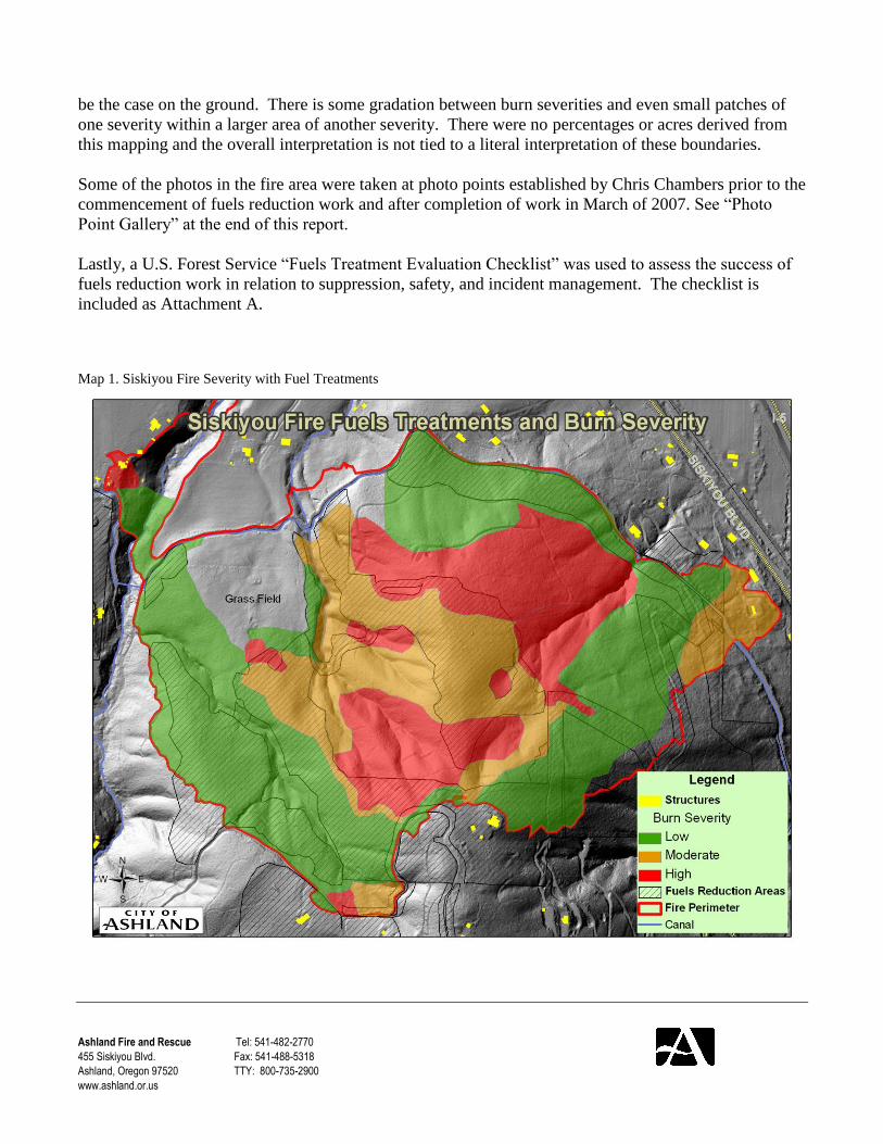
Mapping Methods
Detailed maps of the area, including the GIS perimeters of fuels reduction project areas (mapped in
2006-2008), were created for the field visits. Burn severity was mapped according to a table taken from
an article by Jon E. Keeley (International Journal of Wildland Fire, 2009) and shown below in Table 1.
Burn severity was assigned a value ranging from 1-5 with 1 being Unburned and 5 being Crown Fire
using the descriptions in Table 1. The majority of the fire area was field mapped using this approach to
get a roughly accurate assessment of how fire severity and suppression effectiveness was affected by the
fuels reduction work. Field maps were digitized into a GIS database in order to see the relationship
between fire severity, fire boundaries, topography, and locations of the fuels reduction projects (see Map
1). Although there are hard and fast divisions on the map between severity classes, that may or may not
Ashland Fire and Rescue Tel: 541-482-2770
455 Siskiyou Blvd. Fax: 541-488-5318
Ashland, Oregon 97520 TTY: 800-735-2900
www.ashland.or.us
be the case on the ground. There is some gradation between burn severities and even small patches of
one severity within a larger area of another severity. There were no percentages or acres derived from
this mapping and the overall interpretation is not tied to a literal interpretation of these boundaries.
Some of the photos in the fire area were taken at photo points established by Chris Chambers prior to the
commencement of fuels reduction work and after completion of work in March of 2007. See “Photo
Point Gallery” at the end of this report.
Lastly, a U.S. Forest Service “Fuels Treatment Evaluation Checklist” was used to assess the success of
fuels reduction work in relation to suppression, safety, and incident management. The checklist is
included as Attachment A.
Map 1. Siskiyou Fire Severity with Fuel Treatments

Ashland Fire and Rescue Tel: 541-482-2770
455 Siskiyou Blvd. Fax: 541-488-5318
Ashland, Oregon 97520 TTY: 800-735-2900
www.ashland.or.us
Conclusions
Fire Severity Mapping
Throughout the fire area, fuels reduction work altered the fire behavior and post-fire ecological effects,
and significantly aided in the protection of structures and successfully containing the fire east of Tolman
Creek Road.
Due to the differing vegetation communities in the area, it was challenging to map fire severity
represented by vegetation effects. For example, crown scorch without needle/leaf consumption was
common but represents a vastly different heat output (severity) in white oak woodland than in a mature
mixed conifer stand, not to mention differing ecosystem effects. White oak canopy tops are 15 to 25 feet
from the ground while the conifer canopies ranged from 20 to 100 feet and greater from the ground, so it
takes a lot more heat in mixed conifer to cause the same scorching and drying through the canopy as in
an oak woodland setting. It may also be possible that different species are less or more susceptible to
heat damage. As a result, the oak woodland with browned leaves received a lower severity rating (3)
than the mixed conifer stand (4) with the same effects. Bole scorch heights were a more reliable aid in
determining severity. In the end, this mapping deviated from a strict interpretation of the descriptors and
assigned values in Table 1 in order to more accurately reflect the actual fire severity regardless of
vegetation type.
Fuels Treatment Effects on Fire Behavior
There were several areas of crown fire (See Map 2) that spread directly into fuels treatment zones. In all
cases except one, the fuels treatment areas caused the crown fire to become an intense ground fire, and
particularly on the western and southern flanks, the crown fire became a low severity underburn. One
particularly narrow fuels reduction zone (85-350 feet wide) did burn as an intense crown fire, likely due
to the narrow width and proximity to a core area of untreated fuels on steep slopes where significant
crown fire originated and advanced into this narrow lateral ridge treatment zone (Photo 1). Just down the
same ridge where this fuels treatment zone expanded in width, the crown fire did penetrate, but dropped
to the ground across the width of the treatment zone, resulting in a severe ground fire with bole
scorching up to 40 to 50 feet, but not crown consumption. Most of the areas mapped as category 4 or
severe surface burns, showed no green foliage left on trees, but with brown foliage still largely intact.
Bole scorch was often 30 or more feet from the base of the tree (Photo 2). Areas mapped as category 3,
or light severity, had large portions of the crowns still intact with green foliage. These areas tended to be
where the fire was backing or flanking, the slope was less steep, wind wasn’t direct or continuous,
suppression was effective, and/or where fuels reduction work had been completed. It would be difficult
to know which of these factors most significantly influenced fire behavior and likely they were working
in concert. However, where fuels reduction areas were directly adjacent to high intensity flames in
otherwise similar topography, timing, and vegetation, the change in severity was pronounced.

Ashland Fire and Rescue Tel: 541-482-2770
455 Siskiyou Blvd. Fax: 541-488-5318
Ashland, Oregon 97520 TTY: 800-735-2900
www.ashland.or.us
Photo 1. Crown fire burned through narrow fuels treatment zone in foreground,
but not downslope where treatment was wider and continuous
Photo 2. Looking into Class 4 severity area where canopy is dried and likely dead, but not consumed.

Ashland Fire and Rescue Tel: 541-482-2770
455 Siskiyou Blvd. Fax: 541-488-5318
Ashland, Oregon 97520 TTY: 800-735-2900
www.ashland.or.us
Ecological Effects Fuels treatments are often thought of as a means to stop a fire, yet the intended or unintended effects on
the pre and post fire ecosystem can be beneficial. Work done on one property (38.5 acre project area)
under the City of Ashland grant intentionally involved ecological restoration objectives for forest health
as well as wildfire suppression. Although post fire ecosystem benefits were not outlined as a goal
during fuels reduction planning, the resulting landscape shows specific examples of positive ecological
outcomes in treated and burned areas as well as negative ecological outcomes in non-treated areas.
In mixed conifer stands that were thinned and then burned at moderate intensity (needles intact but
brown--class 4), there is a chance that enough conifer trees may survive to contribute seeds to adjacent
severely burned areas. Perhaps most notable in these areas is the post fire needle fall that is creating
“effective ground cover”, which quells erosion and contributes to the organic component of soil that was
largely burned off (see photos below, taken at the same time). Conversely, in Class 5 severity areas,
there is little to no contribution of leaves or needles, leaving soils subject to rainfall impact and setting
back long term soil recovery.
Fallen needles in class 4 severity Adjacent bare soil in class 5 severity
An unfortunate result in Class 4 settings is the expected mortality of the vast majority, if not all, of the
maturing conifers. Despite the lack of ladder fuels and crown fire, nearly all the crown foliage was
desiccated, making survival of individual trees unlikely—except for basal sprouting of hardwoods. Had
the fire not occurred during late season (low live fuel moisture) and red flag conditions (humidity 5-10
percent), the effects may not have been as severe in class 4 severity stands where thinning was
completed. See conclusion for more on fuels treatment design.
Where the fire was less severe (class 3 severity), trees survived in significant numbers and the soil duff
and litter were largely intact (photo below).
Assuming that this low elevation site (ranges from 2260 feet to 2950 feet) would have historically been
adapted to frequent and low intensity fire, the high severity areas could be seen as a departure from the
historical fire regime. The loss of mid-seral ponderosa pine dominated stands in particular, suggests that
the progression toward an open forest type more characteristic of historic conditions was interrupted by
an infrequent, high intensity fire which will set back the clock to early seral vegetation dominated by

Ashland Fire and Rescue Tel: 541-482-2770
455 Siskiyou Blvd. Fax: 541-488-5318
Ashland, Oregon 97520 TTY: 800-735-2900
www.ashland.or.us
brush and hardwoods for many years to come.
Without management intervention, brush and
hardwood dominated stands will develop to an
elevated level of high intensity fire potential for
decades to come, creating the conditions for a high
intensity re-burn. This type of vegetation
development is readily apparent in the area burned
by the 1959 Ashland Watershed fire and the 1973
Hillview fire. In high intensity portions in the older
burned areas, the re-establishment of an open, mixed
conifer forest and low intensity fire regime has been
difficult or impossible and certainly cost and labor
intensive. The older burned areas continue to be
some of the most hazardous areas in the Ashland interface zone, and the 1959 fire area in particular. The
replacement of open forest conditions by early seral species and structure is very undesirable for
protecting homes and adjacent values, soil conservation, land value, and perhaps carbon storage.
Implications for Fuels Reduction Planning
Fuels and forest managers often plan fuels reduction projects to be effective during all but the worst fire
weather conditions. While this is wise, it does leave the door open for severe effects (to homes,
infrastructure, and ecosystem) when a fire burns during severe weather conditions. Yet, most fires-and
especially wind driven fires, are not uniformly severe even under severe conditions. The Siskiyou Fire
experience confirms that a fire can be controlled under severe conditions, pointing to the importance of
strategic treatments in a variety of landscape and vegetation conditions in a project area or area of
concern. Differences in topography, vegetation communities, and suppression access will produce
different fire severity outcomes. A variety of settings create opportunities where all fire behavior
elements (fuels, topography, weather) are not in alignment. Although reserve (untreated) areas were left
on steep slopes and densely crowded stands where fire was likely to be severe, the geographic locations
of reserves minimized exposure to homes and were surrounded by treatment areas that ultimately aided
in the fire’s control. Smaller (1/4 acre or less) untreated areas were left for habitat diversity and
economic reasons, and in all cases, these patches burned at high intensity. The patches included white-
leaf manzanita clumps, and dense reproduction of incense cedar. Again, placement of leave patches
should be taken seriously with the assumption that they can burn at high intensity and affect anything
adjacent.
Ashland Fire & Rescue has maintained a Tactical Opportunities Fire Suppression Map since 2004,
which outlines all fuels reduction work in strategic or tactical landscape locations. This map was
valuable during Siskiyou Fire operations and allowed for suppression planning, contingency planning on
the west side of Tolman Creek Road, as well as a quickly accessible, pre-printed, large format map for
basic operations such a structure locations, transportation routes, and water sources.

Ashland Fire and Rescue Tel: 541-482-2770
455 Siskiyou Blvd. Fax: 541-488-5318
Ashland, Oregon 97520 TTY: 800-735-2900
www.ashland.or.us
Photo Point Gallery
High Intensity Pre-Treatment, Post-Treatment, and Post-Fire

Ashland Fire and Rescue Tel: 541-482-2770
455 Siskiyou Blvd. Fax: 541-488-5318
Ashland, Oregon 97520 TTY: 800-735-2900
www.ashland.or.us
Low Intensity-- Post Fuels Reduction and Post Fire
Ashland Fire and Rescue Tel: 541-482-2770
455 Siskiyou Blvd. Fax: 541-488-5318
Ashland, Oregon 97520 TTY: 800-735-2900
www.ashland.or.us
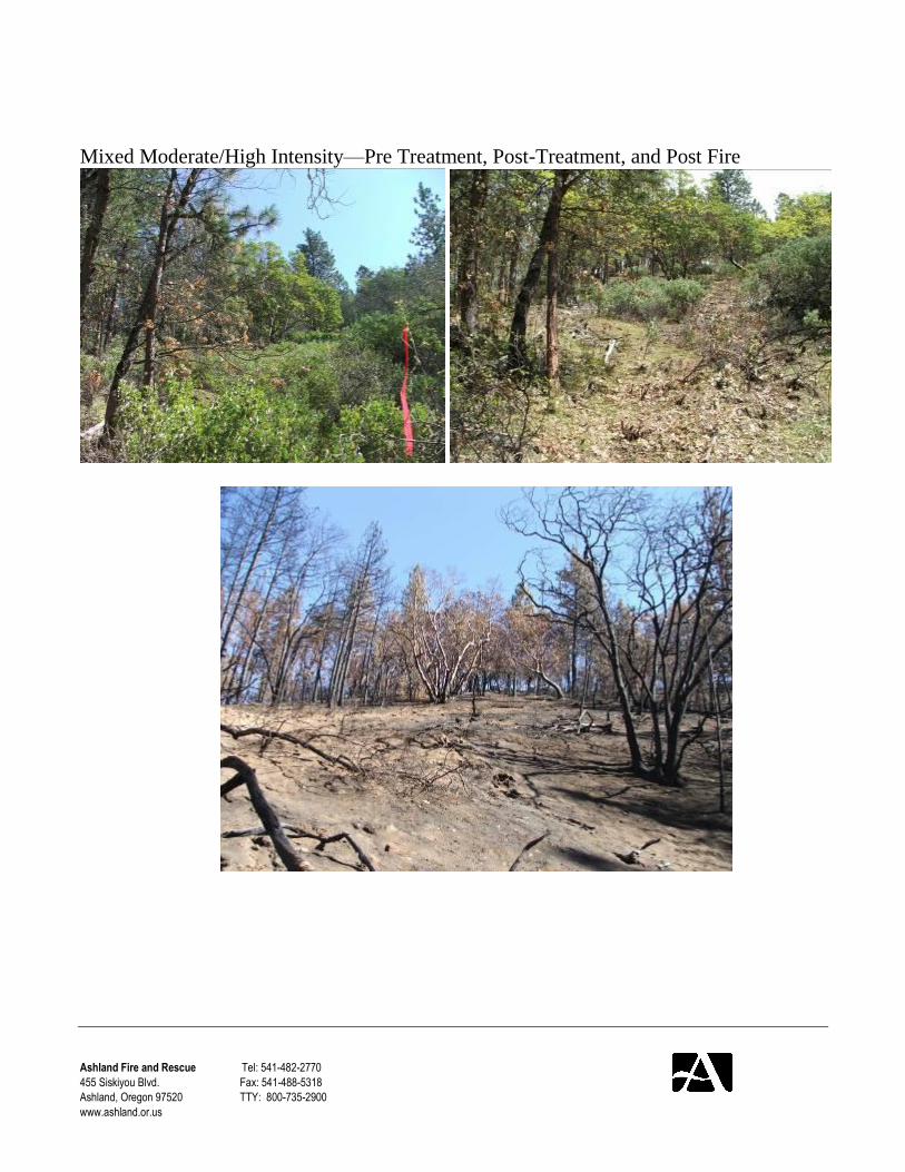
Mixed Moderate/High Intensity—Pre Treatment, Post-Treatment, and Post Fire

Ashland Fire and Rescue Tel: 541-482-2770
455 Siskiyou Blvd. Fax: 541-488-5318
Ashland, Oregon 97520 TTY: 800-735-2900
www.ashland.or.us
Appendix Attachment A: U.S. Forest Service Fuels Treatment Evaluation Checklist

Ashland Fire and Rescue Tel: 541-482-2770
455 Siskiyou Blvd. Fax: 541-488-5318
Ashland, Oregon 97520 TTY: 800-735-2900
www.ashland.or.us


